Direction. Measuring Direction Four Point CompassEight Point Compass.
26
Direction
-
Upload
osborne-cole -
Category
Documents
-
view
219 -
download
0
Transcript of Direction. Measuring Direction Four Point CompassEight Point Compass.

Direction
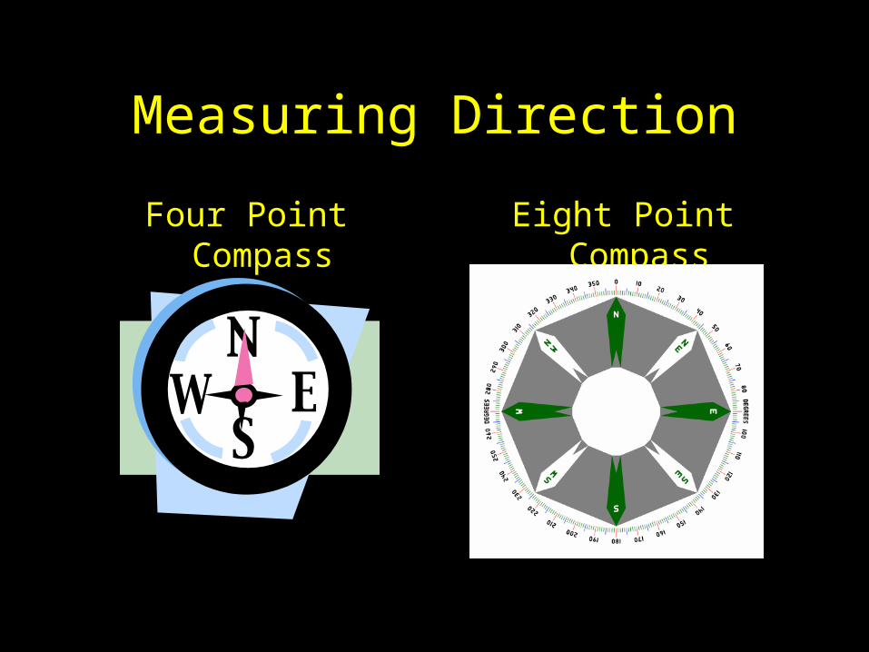
Measuring Direction
Four Point Compass Eight Point Compass

Compass Rose
N
S
EW
NW NE
SESW
How can we remember the points of the compass?‘Naughty Elephants Squirt Water’, or ‘Never Eat Slimy Worms’ Think of your own slogan!

e
ab
c
d
What direction would I need to travel if I wanted to go from :-1) b to d? 2) d to e?3) a to d? 4) c to a?

OS Map Symbols
You will have a key for any OS map that you need to use in your
exams

Scale

The scale on a map can be written in different ways:
A scale line
Use ‘ : ’which means represents 1 : 25000
This means 1 cm/metre/kilometre on the map represents 25000 cms/metres/kilometres on land
1km0

What do you notice about these two maps of the same area in North Wales?
Map ‘A’ covers a smaller area (1:25000 OS map) than map ‘B’ (1:50000 OS map).
A BReproduced from the Ordnance Survey 1:50 000 Landranger raster data with the permission of HM Stationary Office © Crown copyright
Reproduced from the Ordnance Survey 1:25 000 Outdoor Leisure maps with the permission of HM Stationary Office © Crown copyright

Four Figure Grid References

What is the 4-figure grid reference of the hat?
1st
2nd
Flower = 01 62
4-Figure Grid References

Six Figure Grid References

6-Figure Grid References
The 6-figure grid reference of the church with a spire is 253 762.
3
2
1st
2nd

N
0 1km
32
31
3013 14 15 16 17 18
34
35
33
a) Public House?
b) Post Office?
c) Youth Hostel?
d) Telephone?
What is the 6-figure grid reference for :-

41
41 42 43
42
43
44
What is the 6 figure grid reference of…
Reproduced from the Ordnance Survey 1:50 000 Landranger raster data with the permission of HM Stationary Office © Crown copyright
?
?
Relief


Relief means the shape of the land.
There are three ways to show relief on a map.
Can you think of any?

1. Spot Heights
2. Layer Colouring
3. Contours
10 20
30
0-10m11-20m21-30m

How to identify features on an O.S. map…

Compare the relief of these two map extracts.
Map BMap A

Latitude and Longitude

A system of lines is used to find the location of any place on the surface of the Earth. Lines of latitude run in an east-west direction. Lines of longitude run in a north-south direction.
Latitude and longitude

North Pole
Equator
South Pole
Latitude

International Date Line at 180o
Greenwich Meridian
Longitude

Latitude and longitude

The latitude of ‘a’ is 20ºS…’a’ is 20º south of the Equator.The longitude of ‘a’ is 20ºW…’a’ is 20º west of the Greenwich Meridian.Therefore we write the latitude and longitude of ‘a’ as 20ºS 20ºW.
ALWAYS write these first
These are lines of longitude
a
N
These are lines of latitude
Latitude and longitude


![[Compass point] module#1 collegeselection](https://static.fdocuments.us/doc/165x107/54b5f8cc4a7959a3098b4632/compass-point-module1-collegeselection-5584a77d56500.jpg)