Digital soil mapping and groundnut cultivation a case study of kano state,nigeria
27
DIGITAL SOIL MAPPING FOR GROUNDNUT CULTIVATION.ACASE STUDY OF KANO STATE,NIGERIA In recent years, geo-spatial technologies have emerged as useful tools in diverse range of application traditionally catered for by soil surveys. These are used to record, store, manipulate and retrieve data from many soil observations including their location and elevation on the ground. By Egwim Michael.U.
-
Upload
egwim-michael-uche -
Category
Documents
-
view
231 -
download
0
description
In recent years, geo-spatial technologies have emerged as useful tools in diverse range of application traditionally catered for by soil surveys. These are used to record, store, manipulate and retrieve data from many soil observations including their location and elevation on the ground. The purpose of this study is to produce a digital soil map suitable for groundnut cultivation based on surface soil texture for Kano state. The resulting geodatabase is expected to be linked to an already existing central database
Transcript of Digital soil mapping and groundnut cultivation a case study of kano state,nigeria
DIGITAL SOIL MAPPING FOR
GROUNDNUT CULTIVATION.ACASE
STUDY OF KANO STATE,NIGERIA
In recent years, geo-spatial technologies have emerged as useful tools in
diverse range of application traditionally catered for by soil surveys.
These are used to record, store, manipulate and retrieve data from many
soil observations including their location and elevation on the ground.
By
Egwim Michael.U.

1
A REASEARCH ARTICLE
ON
DIGITAL SOIL MAPPING FOR GROUNDNUT CULTIVATION
A CASE STUDY OF KANO STATE.
BY EGWIM UCHECHUKWU MICHAEL
FEB.22ND, 2014

2
PREFACE I have great satisfaction in introducing this study on 'Digital Soil Mapping. A case study of Kano state' to policy makers,academicians,government funtionaries,NGOs,International agencies and every institution interested in improving and maintaining soil data in Nigeria. This work was initiated by a weekly GIS meeting organized by the GIS department of eHealth Africa, Usually called 'Arc Meeting'. The study, which has been conducted and completed within a record time of three months, is an excellent example of cooperative endeavor among group members of ehealth Africa. It was quite an ambitious task to undertake such a massive study amid several office activities within same period. The tenacity, motivation and enthusiasm among the research team helped in the completion of this work without insurmountable obstacles. The ultimate goal for all that participated in the research was to add valuable contribution to a serious gap in this particular field of study and equally motivate others to do more. Profound gratitude and appreciation goes to Frank Salet our adorable GIS Manager for his inspiration
and Motivation during the course of this research.
Others include Nazeef Ahmad, Oladipo Akinpelumi, Adanna Obioha, Tosin Ilesanmi, Oroghene Adia and
Festus Olusola for their support to this work.
3
ABSTRACT
Soil, a valuable natural resource can be said to play a part across the range of human existence and its
knowledge is fundamental to its utilization and management. Soil maps provide a means of gaining
understanding about the soil, but limitations in accuracy, revision and mode of presentation– relating to
graphics or digits–of such maps seem to stimulate lack of soil data in many places.
However, much of the human activity has been treated with significant uncertainties, and many
environmental processes relating to soil are poorly understood. Digital soil mapping seems to hold a
strong prospect for addressing these challenges, with an interesting flexibility for utilizing many recent
technologies.
In recent years, geo-spatial technologies have emerged as useful tools in diverse range of application
traditionally catered for by soil surveys. These are used to record, store, manipulate and retrieve data
from many soil observations including their location and elevation on the ground.
The purpose of this study is to produce a digital soil map suitable for groundnut cultivation based on
surface soil texture for Kano state. The resulting geodatabase is expected to be linked to an already
existing central database.
This research espouses the concepts behind building a functional Database management system that is
flexible, and user-friendly.
An ISO data which represents just one property of soil (Texture) serves as the primary Non-spatial
attribute table that will be linked with other spatial attribute table to develop the soil geodatabase.
Choropleth maps were used to provide visual view of potential areas within Kano state that will support
the cultivation of groundnut.
The developed geodatabase has the ability to upload a soil map of the study area, perform spatial
queries by attribute or using a query builder, and performs suitability analysis on three different soil
textures for groundnut cultivation.
ESRI ArcGIS, Microsoft excel and AutoCAD are essential software applications that will be used for this
research.
Keywords: ArcGIS, AutoCAD, Digital Soil Map, Database, Groundnut, Correlation and regression analysis,
thematic maps.
4
INTRODUCTION
Groundnut is the 13th most important food crop of the world. It is the world’s 4th most important source
of edible oil and the 3rd most important source of vegetable protein. Groundnut seeds contain high
quality edible oil (50%), easily digestible protein (25%) and carbohydrate (20%). Groundnut attracts
revenue, no wonder it is dubbed a “cash-crop”.
The groundnut pyramids used to be landmarks around Kofar Mazugal, Brigade, Bebeji and Dawakin
Kudu in Kano State where sacks of groundnuts were packed and piled one upon another with systematic
expertise that forms a triangular shape much like the pyramids in Egypt, thus making it the second
pyramid in Africa and the world in general. Unfortunately this pride is lost as a result of neglect on
Agriculture and fundamentally lack of understanding about soil.
Due to soils complexity and the vast amount of data associated with it, an information system capable of
handling its storage, retrieval, manipulation, processing and display is highly crucial to its management.
In the last 30 years or so, new technologies have been developed to quantitatively map the soil in the
form of soil classes or soil properties. This approach is now widely known among soil scientist as digital
soil mapping (DSM).Lagacherie & Mcbratney (2007) defined DSM as the processes involved with “the
creation and population of spatial soil information systems by the use of field observational methods
coupled with spatial and non-spatial soil inference systems”. An efficient and effective tool for managing
and mapping soil alongside its vast and robust database is GIS.
A Geographic Information System or GIS is a computer system that allows you to map, model, query,
and analyze large quantities of data within a single database according to their location. GIS gives you
the power to create maps, integrate information, visualize scenarios, present powerful ideas, and
develop effective solutions.
Digital soil mapping is a task towards optimizing the usefulness of soils in terms of suitability for crop
production. Several studies (Hengl et al., 2003; Kempen et al., 2012) have shown that such operations
are effective ways of ensuring steady availability of soil data. They tend to guarantee regular update of
soil data and remove limitations in their uses. New sets of data often result from further analysis of data
obtained by such operations (Zhu et al., 1997 and Zhu et al., 2001), and they tend to help overcome the
limitations placed by traditional soil maps. With these benefits associated with such soil mapping
technology, its implementation remains unaccomplished in many places in Nigeria and much
environmental issues are still unresolved.
The distribution of soil components in a particular soil is influenced by the five factors of soil formation:
parent material, time, climate, organisms, and topography (Jenny 1941). Each one of these factors plays
a direct and overlapping role in influencing the suitability of a soil for agriculture.
For the purpose of this study, Topography in relation to spot heights is considered a primary factor for
the distribution of soil components.
This research will equally espouse the database model and design adopted.

5
STATEMENT OF THE PROBLEM
Nigeria is among countries with poor National geo-database infrastructure, yet rich in soil surveys. The
inventory of soil data dated back in the late colonial to early post independent period. The first
provisional soil map of Nigeria was published by survey department, Lagos in 1952.This was followed by
the publication of the CCTA soil map of Africa(FAO,1964) and the FAO soil map of the world(FAO-
UNESCO,1974). Since then there is hardly any serious efforts towards a national/local scale soil
inventory. Most of these data are old and obsolete. Many of them are stored in analogue formats
thereby making them less accessible and suitable for this research. Global interpolation methods were
used to produce most of the soil maps hence cannot be reliable considering the accuracy and details
required for the study area (Kano State) .This condition makes it almost impossible to work with the
available data within agencies responsible for soil data in the country.
Another major setback is lack of a National Geospatial Database Infrastructure (NGDI). A NGDI provides a base or structure of practices and relationships among data producers and users that facilitate data sharing and use. Nigeria has started developing her own (NGDI), and standards have been set on how NGDI should be managed. Yet a major challenge has been getting all the major players in the GIS community both public and private sectors commit to this development. A National Geospatial Data Infrastructure is therefore necessary to facilitate the harmonious production, usage and dissemination of geographic data in a country. A functional NGDI will facilitate: . A successful Development of Cadastral Database for the Country
.Then Creation of a large pool of current digital topographic and thematic Databases for the Country .Increased funding for Geospatial Infrastructural activities in the country
. Increased efforts at capacity building, training and research AIM AND OBJECTIVES
The aim of this project is to produce a digital soil map suitable for groundnut cultivation based on
surface soil texture.
Research question: Is there a relationship between Slope and the distribution of Soil-particle size of a
place?
This endeavor will further facilitate the following;
Determining the relationship between Heights(slope) and soil particle distribution
Production of qualitative soil thematic maps for the state
Estimation of percentage area coverage of the different types of soil available within the state.
Determining the most suitable location for the cultivation of ground-nut
Developing a choropleth map that is able to provide a visual view of all potential areas within
Kano state were groundnut can be can be grown.

6
METHODOLOGY
Requirements for this study include; Satellite Imageries soil standard, Topographic Map, ArcGIS 10.1,
AutoCAD
Kano consist of soils having horizons that are similar in soil color, soil texture, soil structure, soil size, coarseness, mineral and chemical composition, and arrangement in the soil profile. A few findings revealed that Groundnuts grow best in well-drained, red-coloured, yellow-red and red, fertile, sandy to sandy loam soils with a pH range of 5, 5 to 7, 0. Saline soils are not suitable because groundnuts have a very low salt tolerance. Soils with more than 20% clay and stones will result in poor yield and make harvesting difficult. Shallow and compacted soils are not preferred as the taproot of groundnuts can penetrate to the soil to a depth of about 2 m. The most suitable soil forms are Avalon, Bainsvlei, Clovelly,Hutton, Pinedene and Glencoe. Attributes of soils are depth, texture, drainage, pH, course, fragments, slope, base saturation and climatic conditions such as rainfall, temperature and length of dry season etc.
However like earlier said, this study is based on only texture. The international standard organization
(ISO) data on soil texture will serve as the secondary soil data for this research.
Kano state boundary was broken into parcels by a gridding system of an area of (10,000 Square
meters) representing hectares using AutoCAD.
Figure 01.

7
CARTOGRAPHIC MODELING AND METHODOLOGICAL WORKFLOW
Figure 02.
8
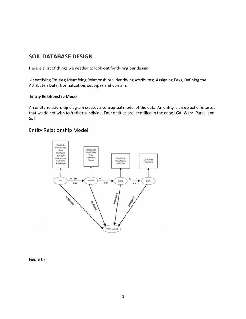
SOIL DATABASE DESIGN
Here is a list of things we needed to look-out for during our design;
-Identifying Entities; Identifying Relationships; Identifying Attributes; Assigning Keys, Defining the Attribute's Data, Normalization, subtypes and domain.
Entity Relationship Model
An entity-relationship diagram creates a conceptual model of the data. An entity is an object of interest that we do not wish to further subdivide. Four entities are identified in the data: LGA, Ward, Parcel and Soil.
Entity Relationship Model
Figure 03

9
Relationship Table
Figure 04
The key field in the origin class of a relationship is called the primary key and is often abbreviated as PK. Unlike a true primary key, the values in the primary key field in a relationship are not required to be unique for every object.
The key field in the destination class is called the foreign key and is often abbreviated as FK. It contains
values that match those of the primary key field in the origin class. Again, the key field values do not
need to be unique for each row.
Primary and Foreign Keys
Figure 05

10
DATA NORMALIZATION
Data Normalization creates a logical view of the data as it will be laid out in tables and map layers.
As a first principle, there will be a table or map layer for each entity.
In this case the soil map unit and the LGA ward is a map layer, while parcel entities are tables.
The attribute table for the soil map has identifier columns for area, perimeter, and columns for description, parcel, ward and LGA.
The land parcel table has columns for the land parcel identifier and for the ward identifier(s) that indicate which ward the land parcels belongs.
A Simplified database system environment
Figure 06
11
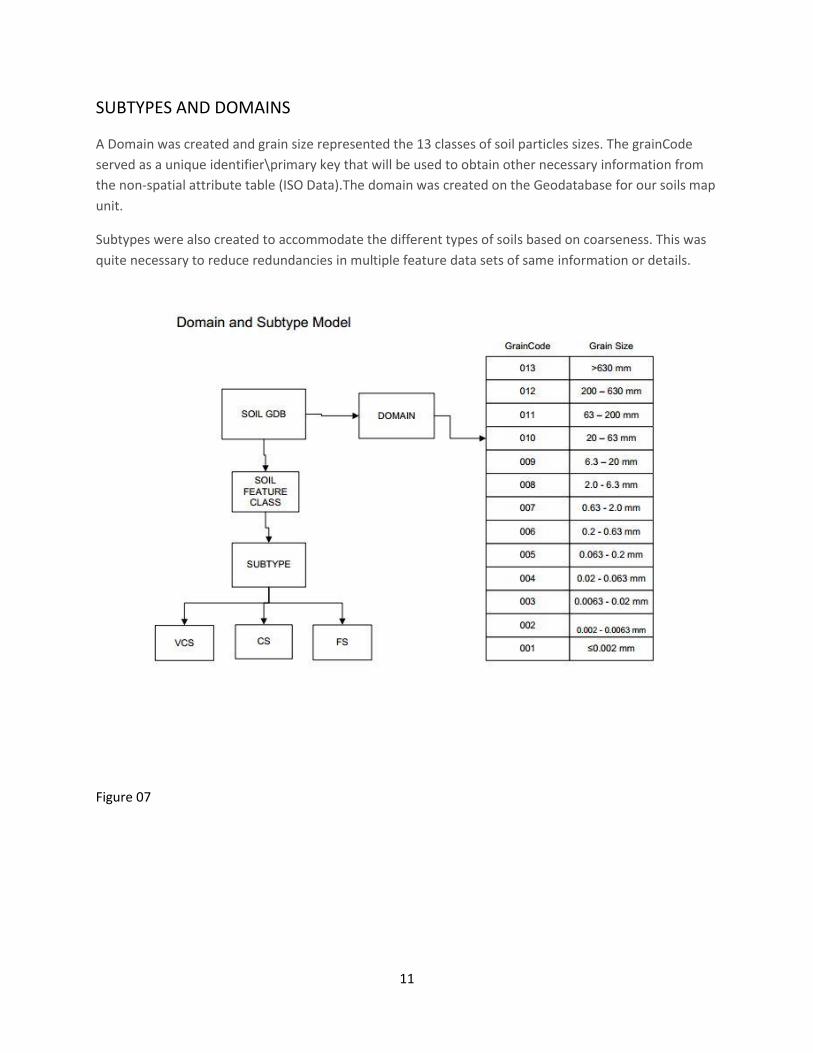
SUBTYPES AND DOMAINS
A Domain was created and grain size represented the 13 classes of soil particles sizes. The grainCode
served as a unique identifier\primary key that will be used to obtain other necessary information from
the non-spatial attribute table (ISO Data).The domain was created on the Geodatabase for our soils map
unit.
Subtypes were also created to accommodate the different types of soils based on coarseness. This was
quite necessary to reduce redundancies in multiple feature data sets of same information or details.
Figure 07
12
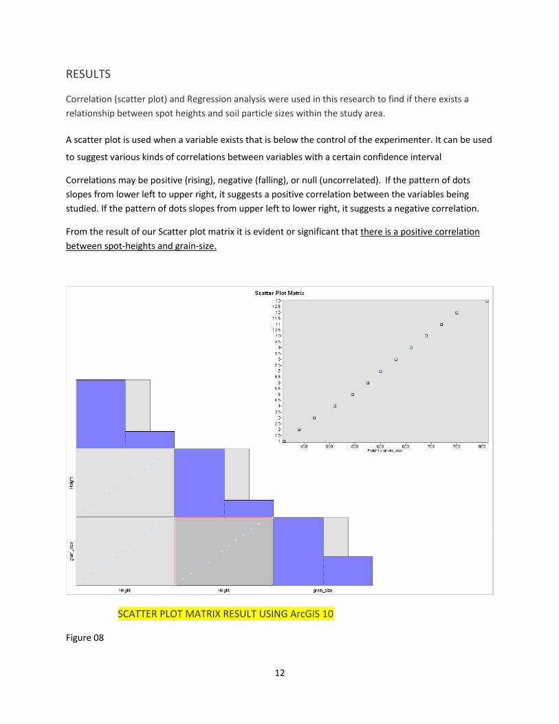
RESULTS
Correlation (scatter plot) and Regression analysis were used in this research to find if there exists a
relationship between spot heights and soil particle sizes within the study area.
A scatter plot is used when a variable exists that is below the control of the experimenter. It can be used
to suggest various kinds of correlations between variables with a certain confidence interval
Correlations may be positive (rising), negative (falling), or null (uncorrelated). If the pattern of dots
slopes from lower left to upper right, it suggests a positive correlation between the variables being
studied. If the pattern of dots slopes from upper left to lower right, it suggests a negative correlation.
From the result of our Scatter plot matrix it is evident or significant that there is a positive correlation
between spot-heights and grain-size.
SCATTER PLOT MATRIX RESULT USING ArcGIS 10
Figure 08

13
Exploratory Regression evaluates all possible combinations of the input candidate explanatory variables,
looking for OLS (Ordinary Least Squares) models that best explain the dependent variable within the
context of user-specified criteria.
Illustration of Explanatory Regression Analysis
Figure 09

14
The result of our exploratory regression analysis shows that there is a very high level of significance
100%. It further explains the direct relationship between the dependent variable-Grain-Size and
independent variable-Spot-Heights
EXPLORATORY REGRESSION ANALYSIS RESULT USING ArcGIS 10.1
Figure 10
15
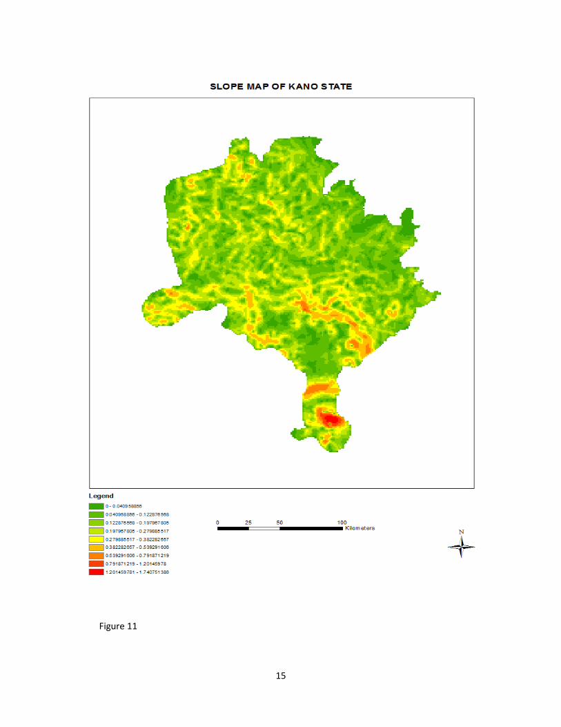
Figure 11

16
Figure 12

17
Figure 13

18
Figure 14
19
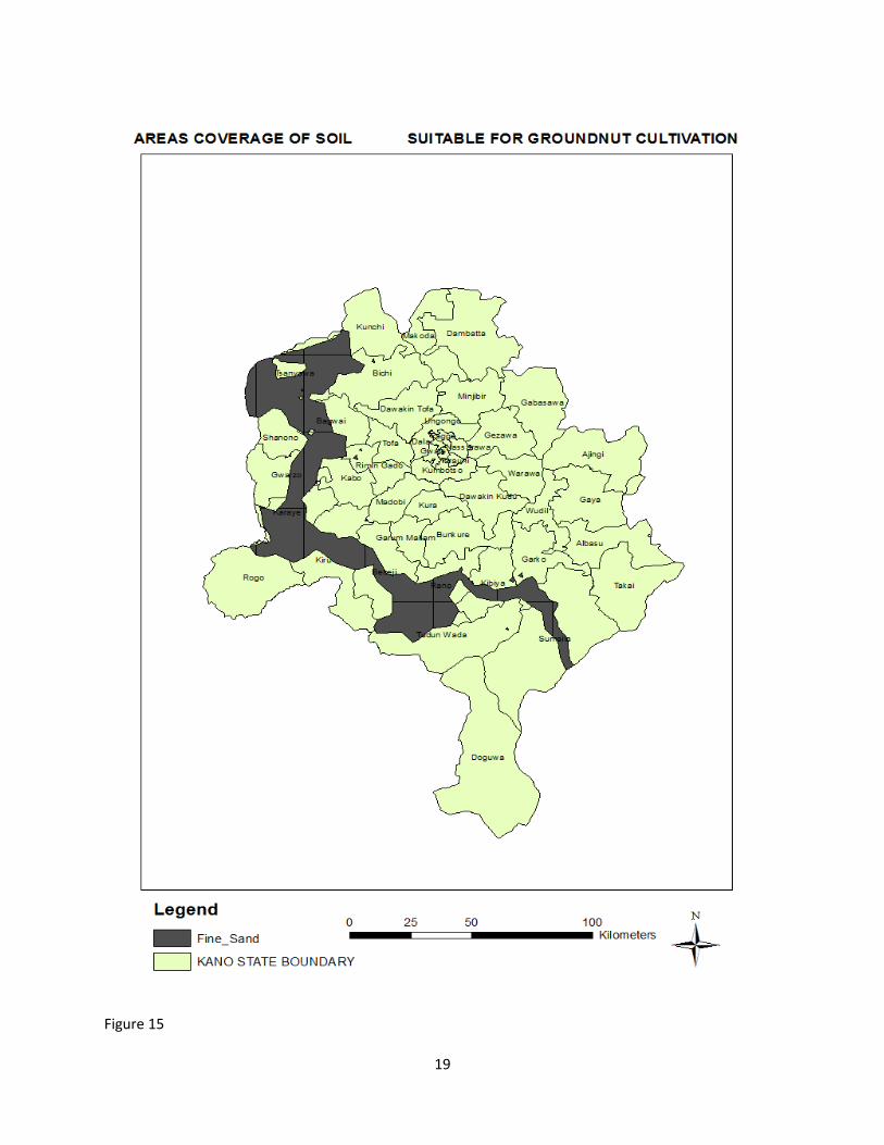
Figure 15

20
Figure 16

21
AREA AND PERCENTAGE COVERAGE OF SUITABILE LAND
Figure 17
Figure 18
About 305916 hectares of land is considered suitable for ground –nut cultivation in Kano state.
That represents 14.4% of the total land mass of the state.
Most suitable location for ground-nut cultivation will be determined by the highest area coverage of fine
sandy soil.
22
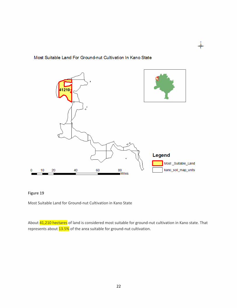
Figure 19
Most Suitable Land for Ground-nut Cultivation in Kano State
About 41,210 hectares of land is considered most suitable for ground-nut cultivation in Kano state. That
represents about 13.5% of the area suitable for ground-nut cultivation.

23
Figure 20

24
Conclusion
This research and other studies demonstrate new mapping incentives and stimulate new ideas to make
digital soil mapping practicable from local to national and ultimately global scales.
Building on these results, future research should focus on building a functional soil information system
(SIS) in order to provide a comprehensive approach to deal with cultivation of multiple crops for within
state level.
We conclude that the resulting prediction maps were not only accomplished for the sake of comparison.
The results of this study will be given to the responsible authorities in Kano State for further assessment,
especially in those LGAs regarded most suitable for groundnut cultivation. The information provided by
these maps shall also help planners, farmers, Local and foreign investors, national and state government
agencies in making vital decisions

25
References
http://www.moanr.kano.gov.ng/
http://www.freedomradionig.com/index.php/39-icetheme/editorials/159-groundnut-pyramids-lost-
pride-of-the-north
http://www.nrcs.usda.gov/Internet/FSE_DOCUMENTS/nrcs142p2_052933.pdf
Jenny 1941
Hengl et al., 2003; Kempen et al., 2012
Zhu et al., 1997 and Zhu et al., 2001
Egwim Uchechukwu Michael. ADVANCEMENTS IN GIS: PROSPECTS AND CHALLENGES. PAPER
PRESENTATION ON WORLD GIS DAY CONFERENCE 2013

26