Development of International Standards and Certification ...
27
The sole responsibility for the content of this deliverable lies with the authors. It does not necessarily reflect the opinion of the European Union. Neither the EACI nor the European Commission are responsible for any use that may be made of the information contained therein. Project No. 2S01-020 With the financial support of met de steun van Development of International Standards and Certification schemes for Marine Energy Technologies D.2.2.3 Site Data and Environmental Monitoring Report [PTEC/Tocardo]
Transcript of Development of International Standards and Certification ...

The sole responsibility for the content of this deliverable lies with the authors. It does not necessarily reflect the opinion of the European Union. Neither the EACI nor the European Commission are responsible for any use that may be made of the information contained therein.
Project No. 2S01-020
With the financial support of
met de steun van
Development of International Standards and Certification schemes for Marine Energy Technologies D.2.2.3
Site Data and Environmental Monitoring Report [PTEC/Tocardo]

MET-CERTIFIED | Deliverable 2.2.3. | Site Data and Environmental Monitoring Report (PTEC)
The sole responsibility for the content of this deliverable lies with the authors. It does not necessarily reflect the opinion of the European Union. Neither the Interreg 2 Seas Programme nor the European Commission are responsible for any use that may be made of the information contained therein. 2
Author
NAME ORGANISATION
Mark Francis PTEC
Thijs Mandersloot (co-author) Tocardo
Revision history
REVISION DATE AUTHOR ORGANISATION DESCRIPTION
Draft 12/06/2017 Mark Francis PTEC First version
Draft 19/06/2017 Thijs Mandersloot Tocardo Second version

MET-CERTIFIED | Deliverable 2.2.3. | Site Data and Environmental Monitoring Report (PTEC)
The sole responsibility for the content of this deliverable lies with the authors. It does not necessarily reflect the opinion of the European Union. Neither the Interreg 2 Seas Programme nor the European Commission are responsible for any use that may be made of the information contained therein. 3
Table of Contents
1. Introduction .............................................................................................................. 52. PTEC Site & Site Data ................................................................................................... 5
2.1. Project Location ............................................................................................................ 52.2. Project Parameters ......................................................................................................... 62.3. Considerations and Constraints of Development Site ................................................................. 72.4. Acquired Data ............................................................................................................... 8
2.4.1. Bathymetry ............................................................................................................ 82.4.1. Seabed ................................................................................................................. 92.4.2. Tidal Current Velocities ........................................................................................... 10
2.5. Resource Assessment ..................................................................................................... 123. Environmental .......................................................................................................... 12
3.1. Environmental and Physical Considerations .......................................................................... 133.1.1. Marine Conservation Areas ........................................................................................ 143.1.2. Vessels (RIR) ........................................................................................................ 153.1.3. Disposal Sites ....................................................................................................... 153.1.4. Traffic Lanes ........................................................................................................ 16
3. Environmental Impacts and Monitoring ............................................................................ 163.1. Environmental Impact Assessment (EIA) .............................................................................. 163.2. Environmental Impacts .................................................................................................. 16
3.2.1. Physical Processes .................................................................................................. 183.2.2. Geology, Hydrogeology and Non-Marine Water Quality ...................................................... 183.2.3. Marine Water and Sediment Quality ............................................................................ 183.2.4. Ornithology .......................................................................................................... 193.2.5. Terrestrial Ecology ................................................................................................. 193.2.6. Benthic and Intertidal Ecology ................................................................................... 193.2.7. Marine Mammals .................................................................................................... 203.2.8. Fish and Shellfish ................................................................................................... 203.2.9. Commercial Fisheries .............................................................................................. 203.2.10. Onshore Seascape and Landscape Visual Impact Assessment ............................................... 213.2.11. Offshore Seascape and Landscape Visual Impact Assessment ............................................... 213.2.12. Traffic and Transport .............................................................................................. 223.2.13. Shipping .............................................................................................................. 223.2.14. Onshore Archaeology and Cultural Heritage ................................................................... 233.2.15. Offshore Archaeology and Cultural Heritage ................................................................... 233.2.16. Onshore Noise and Vibration ..................................................................................... 243.2.17. Socio-Economics .................................................................................................... 243.2.18. Tourism and Recreation ........................................................................................... 243.2.19. Military Activity and UXO ......................................................................................... 24
3.3. Stakeholder Consultations ............................................................................................... 253.4. Monitoring Requirements ................................................................................................ 26

MET-CERTIFIED | Deliverable 2.2.3. | Site Data and Environmental Monitoring Report (PTEC)
The sole responsibility for the content of this deliverable lies with the authors. It does not necessarily reflect the opinion of the European Union. Neither the Interreg 2 Seas Programme nor the European Commission are responsible for any use that may be made of the information contained therein. 4
Table of Figures Figure 1 PTEC Site Location ..................................................................................................... 5Figure 2 Onshore Site Location ................................................................................................. 6Figure 3 Schematic ............................................................................................................... 7Figure 4 Bathymetry Depths .................................................................................................... 8Figure 5 Bathymetry Slope ...................................................................................................... 9Figure 6 Geophysical Survey Images ........................................................................................... 9Figure 7 Modelled Tidal Resource ............................................................................................. 10Figure 8 Flow Directionality .................................................................................................... 11Figure 9 Shear Profile ........................................................................................................... 11Figure 10 Mike3D Mesh Model .................................................................................................. 12Figure 11 Resource Model Extraction Points ................................................................................. 12Figure 12 Flow Speed Mapping at Specific Tide Time ...................................................................... 13Figure 12 Environmental site selection ....................................................................................... 14Figure 13 Vessel movements ................................................................................................... 15Figure 14 Disposal sites ......................................................................................................... 15Figure 15 Traffic lanes .......................................................................................................... 16
Table of Tables Table 1 Project Parameters ..................................................................................................... 7

MET-CERTIFIED | Deliverable 2.2.3. | Site Data and Environmental Monitoring Report (PTEC)
The sole responsibility for the content of this deliverable lies with the authors. It does not necessarily reflect the opinion of the European Union. Neither the Interreg 2 Seas Programme nor the European Commission are responsible for any use that may be made of the information contained therein. 5
1. Introduction
This report presents the details of the Perpetuus Tidal Energy Centre’s Site Data and Environmental Monitoring requirements as delivered for MET-CERTIFIED deliverable D.2.2.3.
The Perpetuus Tidal Energy Centre (PTEC) is a tidal stream energy project with a planned electrical generation capacity of 30MW. Different tidal turbine technologies will be used, deployed across berths of 5-10MW capacity.
The project comprises an onshore site with substation/control room building and an offshore development site for the deployment of tidal devices, with the two sites being connected by a subsea cable corridor along which the power cables pass.
A key objective of PTEC will be to commercially demonstrate the long term running, management and monitoring of arrays of proven tidal devices (previously tested at EMEC or equivalent sites). Maintenance work for these proven tidal devices is expected to be less than for the earlier prototypes, and is expected to focus on the management and monitoring aspects of arrays, paving the way for larger commercial deployment of proven tidal devices elsewhere.
2. PTEC Site & Site Data
2.1. Project Location
The PTEC offshore site is an area of approximately 5km2 located around 2.5km south of St. Catherine’s Point off the southern tip of the Isle of Wight. A map showing the development site in relation to the Isle of Wight is shown in Figure 1 .
Figure 1 PTEC Site Location
The offshore site is approximately 7km long in the West-East direction, and 1.5km wide. It is around 2km from the closest nearby shore.
MET-CERTIFIED | Deliverable 2.2.3. | Site Data and Environmental Monitoring Report (PTEC)
The sole responsibility for the content of this deliverable lies with the authors. It does not necessarily reflect the opinion of the European Union. Neither the Interreg 2 Seas Programme nor the European Commission are responsible for any use that may be made of the information contained therein. 6
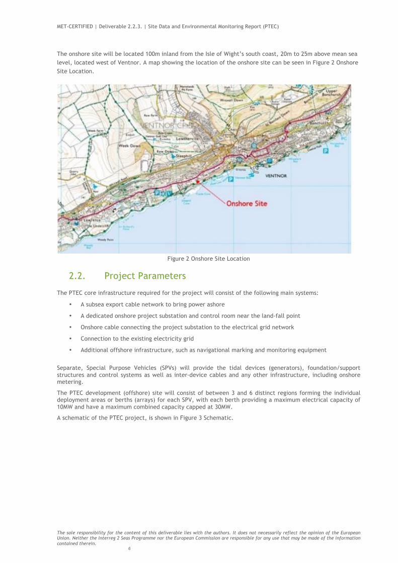
The onshore site will be located 100m inland from the Isle of Wight’s south coast, 20m to 25m above mean sea level, located west of Ventnor. A map showing the location of the onshore site can be seen in Figure 2 Onshore Site Location.
Figure 2 Onshore Site Location
2.2. Project Parameters
The PTEC core infrastructure required for the project will consist of the following main systems:
• A subsea export cable network to bring power ashore
• A dedicated onshore project substation and control room near the land-fall point
• Onshore cable connecting the project substation to the electrical grid network
• Connection to the existing electricity grid
• Additional offshore infrastructure, such as navigational marking and monitoring equipment
Separate, Special Purpose Vehicles (SPVs) will provide the tidal devices (generators), foundation/support structures and control systems as well as inter-device cables and any other infrastructure, including onshore metering.
The PTEC development (offshore) site will consist of between 3 and 6 distinct regions forming the individual deployment areas or berths (arrays) for each SPV, with each berth providing a maximum electrical capacity of 10MW and have a maximum combined capacity capped at 30MW.
A schematic of the PTEC project, is shown in Figure 3 Schematic.

MET-CERTIFIED | Deliverable 2.2.3. | Site Data and Environmental Monitoring Report (PTEC)
The sole responsibility for the content of this deliverable lies with the authors. It does not necessarily reflect the opinion of the European Union. Neither the Interreg 2 Seas Programme nor the European Commission are responsible for any use that may be made of the information contained therein. 7
Figure 3 Schematic
The site is designed for the following project parameters:
TABLE 1 PROJECT PARAMETERS
The site uses a “Rochdale Envelope” which states the limits for technology developers and construction/operational parameters. A significant advantage of this method of consenting is that it allows for multiple technology types and technology developers do not need to apply for specific consenting procedures.
2.3. Considerations and Constraints of Development Site
The development site was selected by PTEC Ltd based on the following combined parameters:
• Tidal current velocities;

MET-CERTIFIED | Deliverable 2.2.3. | Site Data and Environmental Monitoring Report (PTEC)
The sole responsibility for the content of this deliverable lies with the authors. It does not necessarily reflect the opinion of the European Union. Neither the Interreg 2 Seas Programme nor the European Commission are responsible for any use that may be made of the information contained therein. 8
• Bathymetry and site depth;
• Environmental constraints;
• Socio-economic influences and physical constraints; and
• Accessibility.
2.4. Acquired Data
2.4.1. Bathymetry The development site provides optimum variation in depth (between 35 and 75m; Figure 4), which makes PTEC suitable for deployment of a number of different tidal technologies and device types.
The development site was selected from within a much wider area of search / survey; within the surveyed area it has the least gradient variation from ridges and troughs, with many ‘flat’ areas suitable for deployment of a range of tidal device types. These gradient characteristics (Figure 5) should minimise the need for preparation works on the seabed.
The bathymetry in the area is well suited to deployment of a range of device types including moored floating/buoyant devices and/or seabed mounted devices.
Figure 4 Bathymetry Depths

MET-CERTIFIED | Deliverable 2.2.3. | Site Data and Environmental Monitoring Report (PTEC)
The sole responsibility for the content of this deliverable lies with the authors. It does not necessarily reflect the opinion of the European Union. Neither the Interreg 2 Seas Programme nor the European Commission are responsible for any use that may be made of the information contained therein. 9
Figure 5 Bathymetry Slope
It can be seen that there are a couple ridges along the site, running in the same direction as the flow. These edges are of great importance for the location of bottom mounted structures and/or anchors, and for the power cable planning.
2.4.1. Seabed The geophysical survey showed primarily rocky seabed surfaces around the sites and corridors.
Figure 6 Geophysical Survey Images

MET-CERTIFIED | Deliverable 2.2.3. | Site Data and Environmental Monitoring Report (PTEC)
The sole responsibility for the content of this deliverable lies with the authors. It does not necessarily reflect the opinion of the European Union. Neither the Interreg 2 Seas Programme nor the European Commission are responsible for any use that may be made of the information contained therein. 10
2.4.2. Tidal Current Velocities The initial selection process studied the tidal resource around the whole of the Isle of Wight and identified the area to the south of St. Catherine’s Point as the most viable for full scale and array demonstrations.
Surveys of tidal velocities were carried out over a 40km2 area to the south of the Isle of Wight, using vessel mounted Acoustic Doppler Current Profilers (ADCP) and swath bathymetry. This combined data was used to select the optimum location for the 5km2 development site. Figure 7 Modelled Tidal Resource provides a snapshot of the flow velocities moving from east to west.
Figure 7 Modelled Tidal Resource
Tidal stream surveying was completed using ADCPs within the development site at three locations (one at either end, and one in the centre of the development site) for a period of 42 days, from September 2012 to October 2012. These measurements show the development site to have relatively low turbulence, especially in comparison to nearer shore areas.
The channel, which the site overlays, has prime ‘directionality’ (as shown in Figure 8, below), meaning that the ebb and flood flow directions are very close to 180 degrees phase difference; a key consideration for tidal turbines to reduce or prevent yaw in the tidal devices deployed.

MET-CERTIFIED | Deliverable 2.2.3. | Site Data and Environmental Monitoring Report (PTEC)
The sole responsibility for the content of this deliverable lies with the authors. It does not necessarily reflect the opinion of the European Union. Neither the Interreg 2 Seas Programme nor the European Commission are responsible for any use that may be made of the information contained therein. 11
Figure 8 Flow Directionality
From the ADCP surveys, the approximate mean spring peak (MSP) and mean neap peak (MNP) surface flow rates have been estimated at between 2.6 and 2.9m/s and 1.4 and 1.6m/s respectively (Figure 9). The maximum surface velocity recorded during the static survey was 3.2m/s.
Figure 9 Shear Profile
MET-CERTIFIED | Deliverable 2.2.3. | Site Data and Environmental Monitoring Report (PTEC)
The sole responsibility for the content of this deliverable lies with the authors. It does not necessarily reflect the opinion of the European Union. Neither the Interreg 2 Seas Programme nor the European Commission are responsible for any use that may be made of the information contained therein. 12
2.5. Resource Assessment
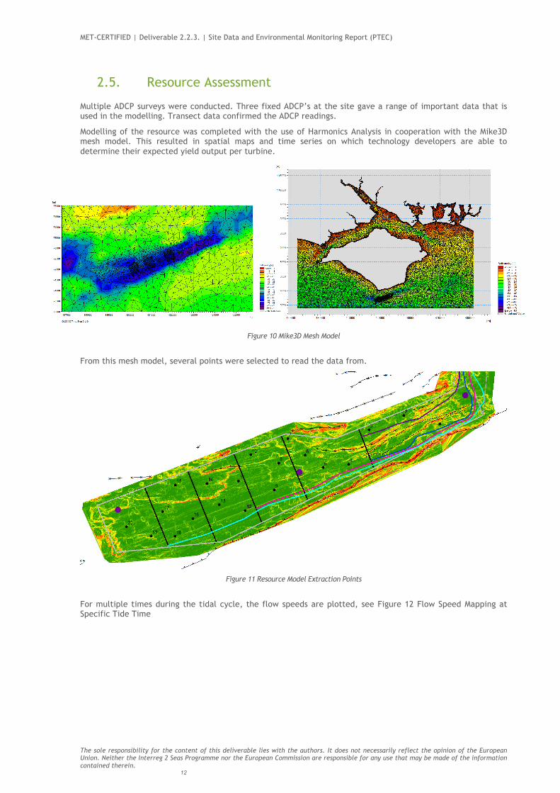
Multiple ADCP surveys were conducted. Three fixed ADCP’s at the site gave a range of important data that is used in the modelling. Transect data confirmed the ADCP readings.
Modelling of the resource was completed with the use of Harmonics Analysis in cooperation with the Mike3D mesh model. This resulted in spatial maps and time series on which technology developers are able to determine their expected yield output per turbine.
3. Environmental
Figure 10 Mike3D Mesh Model
From this mesh model, several points were selected to read the data from.
Figure 11 Resource Model Extraction Points
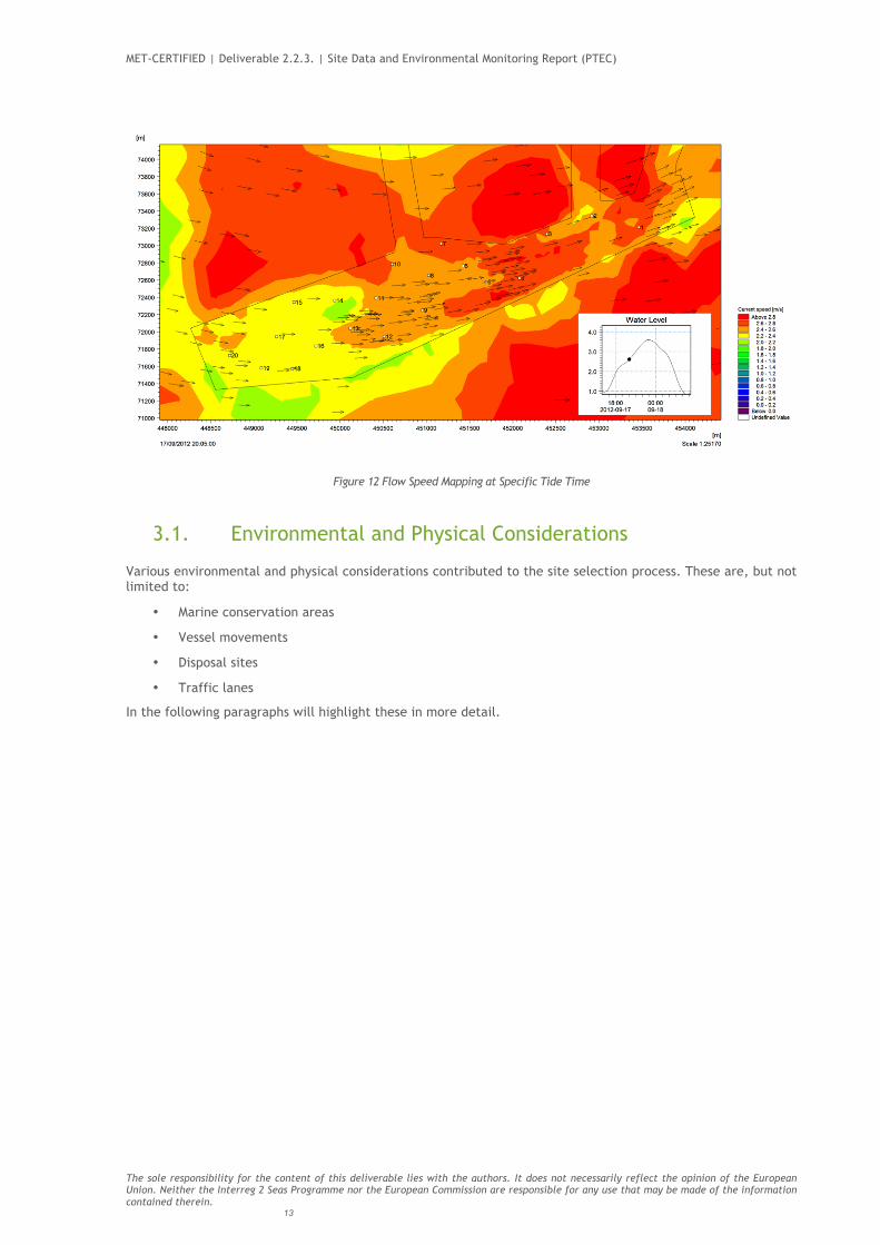
For multiple times during the tidal cycle, the flow speeds are plotted, see Figure 12 Flow Speed Mapping at Specific Tide Time
MET-CERTIFIED | Deliverable 2.2.3. | Site Data and Environmental Monitoring Report (PTEC)
The sole responsibility for the content of this deliverable lies with the authors. It does not necessarily reflect the opinion of the European Union. Neither the Interreg 2 Seas Programme nor the European Commission are responsible for any use that may be made of the information contained therein. 13
Figure 12 Flow Speed Mapping at Specific Tide Time
3.1. Environmental and Physical Considerations
Various environmental and physical considerations contributed to the site selection process. These are, but not limited to:
• Marine conservation areas
• Vessel movements
• Disposal sites
• Traffic lanes
In the following paragraphs will highlight these in more detail.

MET-CERTIFIED | Deliverable 2.2.3. | Site Data and Environmental Monitoring Report (PTEC)
The sole responsibility for the content of this deliverable lies with the authors. It does not necessarily reflect the opinion of the European Union. Neither the Interreg 2 Seas Programme nor the European Commission are responsible for any use that may be made of the information contained therein. 14
3.1.1. Marine Conservation Areas
Figure 13 Environmental site selection
The South Wight Maritime Special Area of Conservation is North of the project site. Only part of the subsea cable corridor runs through it.

MET-CERTIFIED | Deliverable 2.2.3. | Site Data and Environmental Monitoring Report (PTEC)
The sole responsibility for the content of this deliverable lies with the authors. It does not necessarily reflect the opinion of the European Union. Neither the Interreg 2 Seas Programme nor the European Commission are responsible for any use that may be made of the information contained therein. 15
3.1.2. Vessels (RIR) In the following plot, the ‘Round the Island Race’ vessel movements on the 21st of June 2014 were plotted. This gives a reasonable view of the interference to Mariners. Other vessel movements were also surveyed.
Figure 14 Vessel movements
3.1.3. Disposal Sites
Figure 15 Disposal sites

MET-CERTIFIED | Deliverable 2.2.3. | Site Data and Environmental Monitoring Report (PTEC)
The sole responsibility for the content of this deliverable lies with the authors. It does not necessarily reflect the opinion of the European Union. Neither the Interreg 2 Seas Programme nor the European Commission are responsible for any use that may be made of the information contained therein. 16
All disposal sites are suitably distant from the site.
3.1.4. Traffic Lanes Shipping lanes do not interfere with the site.
Figure 16 Traffic lanes
3. Environmental Impacts and Monitoring
3.1. Environmental Impact Assessment (EIA)
A full Environmental Impact Assessment (EIA) was carried out and, subsequently, an Environmental Statement (ES) submitted as part of the consent application for the project, as required under European and UK legislation. The EIA was undertaken by working closely with two lead Regulators, the Marine Management Organisation (MMO), and their advisor, Natural England for the marine or offshore part of the application, and the Local Planning Authority (LPA) – the Isle of Wight Council, for the onshore planning application.
The project successfully achieved consent under the following legislation:
• Marine Licence under the Marine Coastal and Access Act (2009);
• S36 licence under the Electricity Act (1989); and
• Planning permission under the Town and Country Planning Act 1990.
Under the EC Directive on the conservation of natural habitats and of wild fauna and flora (also known as the ‘Habitats Directive’), it is necessary for a Habitats Regulation Assessment (HRA) to be carried out for a development which has potential to impact on European designated sites - Special Areas of Conservation (SAC) or Special Protection Areas (SPA) / Ramsar Sites. A document of supporting information was provided to accompany the consent applications for the project and to inform the HRA process.
3.2. Environmental Impacts
In order to assess the likely impacts of the project, it is important to understand the baseline environmental conditions at the site. PTEC Ltd invested in a wide range of surveys and data analysis which have been carried out by specialists, including;

MET-CERTIFIED | Deliverable 2.2.3. | Site Data and Environmental Monitoring Report (PTEC)
The sole responsibility for the content of this deliverable lies with the authors. It does not necessarily reflect the opinion of the European Union. Neither the Interreg 2 Seas Programme nor the European Commission are responsible for any use that may be made of the information contained therein. 17
• Marine mammals and seabird surveys;
• Intertidal survey;
• Underwater noise modelling;
• Offshore geophysical survey and seabed ecology (benthic) survey;
• Offshore geophysical data analysed to assess the potential for unexploded ordinance;
• Offshore geophysical data analysed to assess the potential for large archaeological features;
• Marine physical processes modelling;
• Assessment of potential impacts on marine water and sediment quality;
• Seascape Landscape and Visual Impact Assessment for the onshore and offshore PTEC infrastructure;
• Onshore Archaeology site visit;
• Terrestrial (onshore) ecology surveys, including:
o Habitat mapping (Phase 1)
o Dormouse
o Bats
o Red squirrel
o Reptiles
o Invertebrate
o Badgers
o Vegetation
o Trees
• Assessment of potential impacts on land and non-marine water quality;
• Shipping and navigation survey and modelling;
• Traffic impact assessment;
• Onshore noise assessment;
• Commercial fisheries assessment and consultation; and
• Tourism and socio-economics review.
Baseline information has been considered alongside experience gained from other offshore renewable energy tests centres, such as the European Marine Energy Centre (EMEC), Wave Hub and the National Renewable Energy Centre (NAREC).
The Environmental Statement, which reports the findings of the EIA process, is composed of introductory chapters and 19 technical chapters where the environmental impact assessments are presented. Each impact assessment followed a procedure which considered the magnitude of the impact, based on extent and longevity, as well as the sensitivity of the receptor. The impact is then given a significance rating of major, moderate, minor or negligible. The process of EIA is intended to identify and consider those environmental impacts which may be significant (under the terms of the appropriate EIA regulations).
Where possible, mitigation is suggested to avoid, offset or reduce the potential impact, particularly if the impact is predicted to be of major or moderate significance. The assessment is ultimately informed by judgement of impartial experts in each field.
At the end of each assessment, a judgement is made as to whether the impact assessed is significant or not significant (non-significant), both before and after application of any appropriate mitigation.
The EIA carried out assessed the potential impacts for the following elements of the project during the construction, operation and maintenance, repowering, and decommissioning stages:
• Offshore; o Tidal devices o A subsea cable network, including:
! Subsea export cable(s) to shore; ! Cable protection measures (where necessary); and

MET-CERTIFIED | Deliverable 2.2.3. | Site Data and Environmental Monitoring Report (PTEC)
The sole responsibility for the content of this deliverable lies with the authors. It does not necessarily reflect the opinion of the European Union. Neither the Interreg 2 Seas Programme nor the European Commission are responsible for any use that may be made of the information contained therein. 18
! Inter-array cables within each berth to connect devices to one another and / or an electrical hub
o Possible use of electrical hubs or connectors as a means to allow multiple devices to export power through the berth’s export cable; o Site monitoring equipment; and o Surface floating navigation buoys.
• Onshore; o Landfall works (where the export cable crosses the foreshore); o Possible transition pit(s) where the marine and onshore electricity cables are connected; o Cable installation from landfall to the project substation; o A dedicated project substation and control room; o Parking area; o Possible private road/access track alterations to ensure access is maintained; o Possible levelling works; o Temporary closure and/or diversions to the public rights of way and coastal path through Flowers Brook and Castle Cove; o Temporary laydown and construction area; o Enabling works, including security fencing and possible tree / scrub clearance.
3.2.1. Physical Processes The project has the potential to impact upon three aspects of the physical processes environment, namely:
• Hydrodynamic regime (tidal currents and wave climate); • Sediments and sedimentary processes; and • Geological and geomorphological formations.
The potential effects have been assessed using a range of approaches, including project specific data collection and analysis, expert geomorphological assessment, application of empirical theory and detailed numerical modelling.
These assessment approaches have identified that the greatest potential changes to the hydrodynamic regime are expected to be related to the operation stage of the project. In particular wake effects (on tidal regime) and physical blockage effects (on waves) will occur in the area immediately around tidal devices, although this will result in negligible impact on the seabed geomorphology within the near-field. There will be no wider-scale effects on tidal and wave regimes and no change to the seabed or shoreline geomorphology.
The greatest potential changes to the sediments and sedimentary processes will occur during the construction, repowering and decommissioning stages of the project. In particular sediment plumes and sediment deposition arising from the dredged spoil will be the greatest effect. However, due to the temporary nature and extremely low magnitude of both of these effects, the resulting impact on the seabed geomorphology will not be significant and there will be no change to the shoreline geomorphology.
It is during the operational stage of the project that the greatest effects on the geological and geomorphological formations will arise. This will be associated with the loss of seabed due to the direct footprint of the installed infrastructure. However, the resulting impacts will be not significant, and will only arise in those areas of seabed geomorphology that are directly covered by the installed infrastructure and there will be no change to the wider seabed or shoreline geomorphology.
Potential cumulative impacts with other plans and projects in the region were considered. As with the project specific impacts, cumulative impacts were all considered to be not significant.
3.2.2. Geology, Hydrogeology and Non-Marine Water Quality The potential impacts posed by the onshore development relate to removal of rock by trenching or directional drilling for installation of the onshore cables; loss of structure and/or erosion of site soils and geology through construction activities; and changes to surface water or groundwater flow patterns, potential releases of polluting materials via spillage or mobilisation of existing contamination and the potential for flooding, as a result of the construction and operation of the onshore infrastructure.
Due to the small scale of the onshore works and through following normal best practice measures during construction and throughout the life of the project, these impacts are not expected to result in significant impacts.
3.2.3. Marine Water and Sediment Quality The existing marine water and sediment quality within the development site was established through a review of available literature and from site survey work carried out for other projects. The assessment of marine sediment contamination, and the implications for water quality, was based on accepted sediment guidelines and action levels.

MET-CERTIFIED | Deliverable 2.2.3. | Site Data and Environmental Monitoring Report (PTEC)
The sole responsibility for the content of this deliverable lies with the authors. It does not necessarily reflect the opinion of the European Union. Neither the Interreg 2 Seas Programme nor the European Commission are responsible for any use that may be made of the information contained therein. 19
Sediment and water quality throughout the offshore site and subsea cable corridor is considered to be generally good. The assessment has considered the impacts associated with the disturbance and re-suspension of sediments and their associated contaminants as well as from accidental releases and spills of polluting substances across the life of the project.
The extent and severity of the impacts associated with the project’s construction, operation and maintenance, repowering and decommissioning phases are not significant enough to have an adverse impact on the marine water and sediment quality. Through the implementation of the PTEC Environmental Management Plan (EMP) and the proposed mitigation, the impacts of the proposed PTEC project on marine water and sediment quality are anticipated as not significant.
3.2.4. Ornithology The birds using the offshore development site were characterised by undertaking a one-year programme of boat-based surveys. The surveys were conducted between August 2013 and July 2014. The survey area comprised the development site, with a surrounding 4km buffer, with survey transects covering a total length of 107km. A total of 12 surveys were undertaken at approximately monthly intervals over the year.
The surveys showed that the survey area generally has low importance for seabirds, with all species present in low or very low numbers relative to their population size and densities recorded elsewhere in their ranges. The range of species and numbers present in the survey area were particularly low during the breeding season, reflecting the paucity and small size of breeding seabird colonies in the English Channel. A total of 12 seabird species were regularly recorded and very small numbers of 12 other species of seabird were recorded occasionally.
Impacts assessed considered all phases of the development and covered disturbance, accidental contamination, displacement and collision risk with tidal devices, In the case of collision mortality, PTEC has been shown to have the theoretical potential to kill small numbers (in the context of the relevant receptor population size) of guillemot (breeding and wintering populations) and razorbill (wintering population only), and is shown to have negligible potential to affect other species including gannet. Given the small numbers of birds and scale of impact both spatially and temporally it is considered that impacts on birds are not significant.
Potential cumulative impacts with other plans and projects in the region were considered. As with the project specific impacts, cumulative impacts were also not significant.
Onshore ornithology was not considered to be an issue for the EIA as the onshore development is of such small scale and lacks suitable habitat.
3.2.5. Terrestrial Ecology The terrestrial ecology chapter covers all onshore ecology at the PTEC onshore site and immediate surrounds. Many different surveys were undertaken to identify which habitats and species were present within the onshore site, including surveys for:
• Dormouse; • Bats; • Red squirrels; • Terrestrial invertebrates; • Reptiles; • Badgers; • Vegetation; • Trees; and • Habitat types.
The impact assessment identified that the main potential impacts of PTEC on onshore ecology were temporary and permanent habitat loss, and potential direct impacts on protected and notable species during the construction phase of the project.
Potential impacts during the construction phase, without mitigation, were considered to include both significant and non-significant impacts at the county level. At a bigger scale (i.e. greater than county) there are no significant impacts.
Following the adoption of the recommended best practice guidance and mitigation measures, the residual impacts to ecological receptors from construction of PTEC will be nonsignificant at the county level.
3.2.6. Benthic and Intertidal Ecology

MET-CERTIFIED | Deliverable 2.2.3. | Site Data and Environmental Monitoring Report (PTEC)
The sole responsibility for the content of this deliverable lies with the authors. It does not necessarily reflect the opinion of the European Union. Neither the Interreg 2 Seas Programme nor the European Commission are responsible for any use that may be made of the information contained therein. 20
The marine species and sea bed habitat that exits across the PTEC project and surrounding area were identified using data collected from numerous survey. These surveys, which were both site specific (commissioned by PTEC) and covering the development site and a number of potential cable routes to the Isle of Wight for electricity transmission, or had been completed for other projects in the area, and in particular to collect data for the marine Special Area of Conservation. The data collected and utilised encompassed a range of techniques including: underwater video, sediment sampling and acoustic data, all of which allowed maps of seabed conditions and habitats to be produced. An ecological survey was also carried out on the seashore, between low and high watermarks at the location where the subsea export cables from the PTEC project will come ashore.
The impact assessment uses information available from the Marine Life Information Network and experience from a number of seabed ecologists to identify the sensitivity of the species and habitats which may be affected by the PTEC project. The main impacts on seabed and seashore ecology relate to habitat loss and disturbance due to construction and repowering activities. However, all impacts are considered to be at worst of minor adverse significance, with many impacts likely to only be of negligible significance. The impact assessment concludes that it is unlikely that the PTEC project will interact with any other project or plan to produce cumulative impacts on seabed or seashore species or habitats.
3.2.7. Marine Mammals In order to estimate how many marine mammals (which include whales, dolphins, porpoises and seals) are using the PTEC site and surrounding area, surveys were conducted by qualified marine mammal observers in parallel with the ornithology surveys. The surveys, which were conducted on a monthly basis over one year, indicate that the PTEC offshore site is not an important breeding or foraging ground for any species of marine mammal and these findings were supported by other available wider studies.
The potential impacts identified in the assessment for marine mammals were the effects of underwater noise, collision with vessels and devices and indirect impacts from a depletion of their food resource. Due to the low marine mammal use of the site, the relatively small size of the project, and the fact that the area is already heavily used by vessels, impacts to marine mammals arising from the PTEC project are predicted to have no significant impacts. The assessment concludes that PTEC will also have no significant cumulative impacts with other projects in the area.
3.2.8. Fish and Shellfish PTEC is located in a region with a high diversity of marine and coastal habitats, however, the development site itself contains limited habitat diversity, largely comprising of exposed bedrock, cobbles and boulders. This, coupled with its tidally exposed conditions, makes it unlikely to be used as a nursery or spawning ground. Some migratory species including Atlantic salmon, sea lamprey and European eel do pass through the waters around the site, but there are no rivers near PTEC which are used by these species for important parts of their life cycle, such as breeding.
Potential impacts are predicted which are associated with underwater noise during installation, particularly drilling of foundations, and removal of infrastructure at repowering phases or on final decommissioning. However, these impacts will be highly localised, temporary in nature and unlikely to greatly exceed background underwater noise levels. No significant impacts are predicted as the result of any physical disturbance to, or loss of, benthic habitats during the project lifetime. This is largely due to the small project footprint and an abundance of alternative, similar habitat surrounding the PTEC offshore site. Coastal process modelling predicted that any change to suspended sediment levels will fall within the bounds of natural variation and any change to sediment deposition to be immeasurable.
PTEC is not expected to act as a barrier to fish or shellfish movements or migration due to its small spatial extent, open nature and the ample alternative passages offered by the surrounding open water. Collision risk has been considered and no significant impact was identified. The potential for anthropogenic electromagnetic fields (EMF) to impact fish and shellfish remains unknown, as it is unclear exactly what response is invoked through exposure. Therefore, predicting effects remains complex and challenging, and despite adopting a precautionary approach, it was concluded that there would be no significant impact from EMF. No significant cumulative impacts on fish and shellfish receptors were identified.
3.2.9. Commercial Fisheries A diverse array of fish and shellfish species is found in the coastal and offshore waters of the study area. These are targeted by a number of commercial fisheries as well as charter and recreational angling vessels. The Isle of Wight has a significant brown crab and lobster fishery that operates year-round; other commercially exploited species include various flatfishes and cuttlefish. The PTEC offshore site overlaps with some of these fishing grounds, in particular part of the crab and lobster fishery. Therefore, an extensive consultation-led data collection phase was undertaken to inform this impact assessment.

MET-CERTIFIED | Deliverable 2.2.3. | Site Data and Environmental Monitoring Report (PTEC)
The sole responsibility for the content of this deliverable lies with the authors. It does not necessarily reflect the opinion of the European Union. Neither the Interreg 2 Seas Programme nor the European Commission are responsible for any use that may be made of the information contained therein. 21
The fishing fleet operating in the vicinity of PTEC is typical of most inshore fishing fleets across Europe and, as such, competition for space and access to the fishery is high and influenced by the spatial extent of target species and the type of fishing vessel. At a fleet level, across the study area, all impacts on commercial, charter and recreational fishing vessels have been assessed as not significant. However, two impacts; ‘loss of access, or restricted access, to traditional fishing grounds or marks’ and ‘displacement of fishing effort to adjacent fishing grounds’ have potential to be significant for some vessels which traditionally fish within or adjacent to the PTEC development site. PTEC, as a responsible developer, is committed to ongoing consultation and working with the fishers who have traditionally fished the area of the proposed offshore site. A Joint Operating Agreement is proposed as a mechanism to develop mitigation plans and work towards co-existence. No significant cumulative impacts on commercial, charter or recreational receptors were identified.
3.2.10. Onshore Seascape and Landscape Visual Impact Assessment This assessment has examined the potential impacts of the onshore elements of PTEC on seascape, landscape and visual amenity. The onshore SLVIA has considered the potential direct impacts on the landscape, as well as the potential impacts on the perception of landscape character. The assessment has also considered the potential impacts of the onshore elements of PTEC on visual amenity.
The scope of and approach to the assessment has been informed by consultation with the Isle of Wight Council, the Isle of Wight AONB Partnership and Natural England.
The onshore site is positioned towards the western edge of Ventnor. Parts of the surrounding area are recognised for their scenic beauty through the AONB and Heritage Coast designations that apply to much of this part of the Isle of Wight. In addition, the coastline, including Ventnor, is a popular tourist destination. There are a range of potential visual receptors located within the surrounding area, including residents and visitors, road users, and people engaged in both land and sea based recreation.
The SLVIA has considered the likely worst-case scenario in terms of the likely scale, extent and nature of the onshore elements of the project, with the key element that has the potential to affect seascape/landscape character and visual amenity being the construction and operation of a small new substation and control room.
The potential substation locations that were considered would have variable effects on seascape and landscape character and visual amenity.
It was concluded that changes to local landscape character from the introduction of the substation/control room would not be significant. There are several relevant designations in the area surrounding the onshore site, including the Isle of Wight AONB, Tennyson Heritage Coast and a Conservation Area in Ventnor. Consistent with the evaluation of potential physical effects on landscape character, no significant effects on these designations are predicted.
3.2.11. Offshore Seascape and Landscape Visual Impact Assessment This assessment has examined the potential impacts of the offshore elements of PTEC on seascape, landscape and visual amenity within the study area. The offshore SLVIA has considered the potential direct impacts on the seascape and the potential impacts on the perception of seascape and landscape character. The assessment has also considered the potential impacts of PTEC on visual amenity for a range of sensitive receptors.
The assessment focussed on a study area that extends 5km from the edge of the development site. However, it also includes viewpoints beyond this area to provide an indication of how the offshore elements of PTEC would be seen from locations along the south coast of the Isle of Wight. The scope of and approach to the SLVIA has been informed by consultation with the Isle of Wight Council, the Isle of Wight AONB Partnership and Natural England.
The seascape/landscape setting of the offshore development site is a dramatic and large-scale coastline. This coastline is recognised for its scenic beauty through the AONB and Heritage Coast designations that apply to much of the study area. In addition, the coastline is a popular tourist destination, including several settlements and numerous dispersed residential properties. There is a range of potential visual receptors located within the surrounding area, including residents and visitors, road users, as well as land and sea based recreation.
The arrays of tidal devices will potentially be seen from a number of locations and have the potential to affect the perception of seascape and landscape character. The high value placed on much of the study area is reflected in its designation as an Area of Outstanding Natural Beauty (AONB) and Heritage Coast.
Overall, the SLVIA has identified that there will be some adverse impacts as result of the installation and operation of the offshore elements of PTEC, but in most cases, these are not significant. The tidal devices will be visible along the coastline and will comprise part of the open views that can be seen over the English Channel. The structures will typically comprise relatively small elements in the context of key components of the character types/units and therefore will not become a defining feature. There are predicted to be some locally significant impacts in relation to the seascape/landscape at St Catherine’s point. However, beyond this the predicted impacts on seascape/landscape character are not significant.

MET-CERTIFIED | Deliverable 2.2.3. | Site Data and Environmental Monitoring Report (PTEC)
The sole responsibility for the content of this deliverable lies with the authors. It does not necessarily reflect the opinion of the European Union. Neither the Interreg 2 Seas Programme nor the European Commission are responsible for any use that may be made of the information contained therein. 22
Impacts on seascape as a result of the offshore elements of PTEC can be reversed on decommissioning of PTEC at the end of the project life.
Consistent with the evaluation of potential impacts on character units, there will be some impacts on Conservation Areas in Ventnor and St. Lawrence, but these are typically not significant.
Some significant impacts are predicted in relation to the AONB and Heritage Coast, although, with the exception of the landfall point, there would not be any further physical impacts on landscape elements within these designations. Localised significant impacts in relation to the character of these designations have been identified (associated with the area in the vicinity of St Catherine’s Point). However, in the context of the AONB and Heritage Coast, as a whole, the potential impacts will be limited and not significant, in relation to both their overall extent and special qualities.
No significant, cumulative seascape, landscape or visual impacts are predicted.
3.2.12. Traffic and Transport The main potential transport impact will be caused by construction traffic associated with the onshore site. The construction phase however is expected to generate no more than 20 heavy goods vehicles and 44 light vehicle two-way trips per day, whilst the traffic requirements of the operational, repowering and decommissioning phases will be much less.
The impact of the proposed development has been considered in terms of the following environmental effects:
• Severance;
• Driver delay;
• Pedestrian delay;
• Pedestrian amenity;
• Fear and intimidation; and
• Highway safety
In each phase of the project the impact has been found to be negligible. In terms of mitigation, a Construction Traffic Management Plan will be produced in liaison with the Isle of Wight Council. This will ensure that the construction traffic, specifically heavy goods vehicles, will avoid causing disruption to sensitive routes, in particular during peak tourism periods and during the council’s planned road improvement schemes if applicable.
3.2.13. Shipping The existing (baseline) environment has been reviewed and a Navigational Risk Assessment (NRA) for PTEC has been undertaken for the development site and subsea export cable corridor. The assessment has included allision (a ship colliding with a structure), collision (a collision between two ships), risk modelling (including the Under Keel Clearance), and a formal safety assessment for all phases of the development, as well as an assessment of cumulative and in-combination effects.
The NRA was prepared in accordance with the guidance of the Maritime and Coastguard Agency (MCA) and other examples of best practice from both regulators and the maritime sector. This includes the satisfactory completion of the Marine and Coastguard Agency MGN 371 Checklist.
Consultation on the issues of navigation and safety has taken place with both national regulators and stakeholders; this included the regular operators (identified by investigation of the traffic operating in proximity to the site) and further local stakeholders.
Data for the navigation assessment was collated from a variety of relevant sources. Specific survey data was also gathered for the development site. Both a winter survey (14 days) and summer survey (14 days) took place which recorded AIS (Automatic Identifications System), radar and visual observations of the traffic operating in proximity to the development site. The summer survey was scheduled to ensure that it included the ‘Round the Island Race’, determining the peak traffic experienced at the south of the Isle of Wight during this event.
The surveys enabled the marine traffic to be quantified. This allowed the identification of traffic from key receptors (merchant shipping, commercial fishing and recreational vessels). It also highlighted the behaviour of the traffic transiting in proximity to the offshore site, where these vessels were heading, and the purpose of their presence. Models were run to establish the base case probability of allision and collision risk and the subsequent future case based on the worst-case utilisation of the development site.
A Formal Safety Assessment was carried out. This combined expert opinion, local knowledge and a Hazard Workshop. Following identification of both future case impacts and the outcomes of the Formal Safety

MET-CERTIFIED | Deliverable 2.2.3. | Site Data and Environmental Monitoring Report (PTEC)
The sole responsibility for the content of this deliverable lies with the authors. It does not necessarily reflect the opinion of the European Union. Neither the Interreg 2 Seas Programme nor the European Commission are responsible for any use that may be made of the information contained therein. 23
Assessment, an impact assessment in line with EIA guidance was undertaken. This impact assessment screened the identified impacts and the established mitigation measures, determining the residual risk.
After consideration of over 30 potential impacts relevant to navigation and shipping, all impacts are considered to be either ‘tolerable’ or ‘broadly acceptable’, and therefore not significant. PTEC, as a responsible developer, is committed to ongoing dialogue with shipping regulators and stakeholders and will refine mitigation measures as the project is designed in detail prior to construction.
3.2.14. Onshore Archaeology and Cultural Heritage A desk-based assessment of Cultural Heritage Assets was undertaken within a 1km study area around the extent of the onshore site, above Mean High Water Spring (MHWS) tide (the ‘onshore site study area’). The potential for both direct and indirect impacts on Cultural Heritage Assets has been considered. Direct impacts consist of physical disturbance of assets due to construction works, while indirect impacts result from changes to the setting of Cultural Heritage Assets. Setting consists of the surrounding within which a Cultural Heritage Asset can be experienced and is not limited to visual perceptions. Whilst previous engineering works within the onshore site mean that some areas have already been impacted, a review of available data suggests that there is still potential for archaeological remains in some areas below the previous construction depths. Previous investigations identified early medieval and post-medieval settlement as well as a large number of late Saxon or early medieval burials and a trackway still in use in the Victorian period. Part of the onshore site was developed into a recreational ground and pleasure garden in the early and mid-20th century.
Consideration of the known archaeological resource within the onshore site study area suggests a potential for remains from the medieval, post-medieval and 19th century to be present, as well as some potential for earlier Iron Age remains. Taking a precautionary approach, potential impacts upon archaeological remains within the onshore site there is potential for significant impacts.
Cultural heritage is a non-renewable resource and physical impacts upon Cultural Heritage Assets will be permanent. Impacts upon currently unknown Cultural Heritage Assets within the proposed development footprint will be mitigated through a programme of works to be defined in consultation with statutory stakeholders. This may include a combination of geophysical survey, archaeological evaluation and archaeological monitoring during construction works as appropriate.
The potential for impacts upon the setting of selected Cultural Heritage Assets from the development has been considered in line with relevant guidance and potential visual impacts are only anticipated in relation to the substation and control room. Furthermore, any potential construction impacts will be temporary in nature.
Only two designated Cultural Heritage Assets were identified as potential sensitive receptors to impacts arising at the onshore site. Detailed assessment of the significant aspects of their setting as well as comparison of actual views available during the site visit concluded that any impacts arising from the proposed development would be not significant.
No significant potential cumulative impacts in respect of onshore archaeology and cultural heritage are anticipated.
3.2.15. Offshore Archaeology and Cultural Heritage A desk-based assessment of the archaeological and cultural heritage assessment has been undertaken within a 1km study area around the extent of the offshore site, below Mean High Water Springs (MHWS). The assessment includes the intertidal zone and cable route and is referred to as the offshore site study area.
There are no known Cultural Heritage Assets within or adjacent to the offshore site study area that are currently subject to statutory protection. There are no known accurately-located Cultural Heritage Assets within the intertidal part of the offshore site study area. Following an assessment of geophysical data it was determined that there are no known submerged prehistoric sites within the offshore site study area. There are no known maritime or aviation wrecks within the offshore site and three recorded maritime wrecks within the offshore site study area. However, eight anomalies of uncertain origin, but of possible archaeological interest were identified within the offshore site and a further five within the offshore site study area. As well as the known Cultural Heritage Assets, a potential for further currently unknown maritime, aviation, and intertidal cultural heritage receptors to be present across the development footprint has been established.
The potential for both direct and indirect impacts on Cultural Heritage Assets has been considered. Impacts upon all known Cultural Heritage Assets within the Offshore Site, including shipwrecks and intertidal features, will be avoided through the establishment of archaeological exclusion zones. The scope of these works will be defined in consultation with statutory stakeholders.
Impacts upon currently unknown Cultural Heritage Assets within the proposed development footprint will be mitigated through a programme of works to be defined in consultation with statutory stakeholders. This may include monitoring of construction activities by professional archaeologists where appropriate. A reporting protocol will be established to ensure that any currently unknown cultural heritage material encountered during seabed disturbance is reported and archaeologically recorded.

MET-CERTIFIED | Deliverable 2.2.3. | Site Data and Environmental Monitoring Report (PTEC)
The sole responsibility for the content of this deliverable lies with the authors. It does not necessarily reflect the opinion of the European Union. Neither the Interreg 2 Seas Programme nor the European Commission are responsible for any use that may be made of the information contained therein. 24
The potential for impacts upon the setting of selected Cultural Heritage Assets from the development has been considered in line with English Heritage’s setting guidance with specific regard to the cultural heritage sensitivity of the Assets. A Zone of Theoretical Visibility was digitally generated to identify Cultural Heritage Assets at risk of setting impacts. Twelve Cultural Heritage Assets were subsequently identified as potential sensitive receptors to potential impacts. In all of these cases the impacts to their setting arising from the proposed development is considered to be not significant.
No cumulative impacts in respect offshore archaeology and cultural heritage are anticipated.
3.2.16. Onshore Noise and Vibration A computer model was used to predict the levels of noise which would be created by construction, operation, repowering and decommissioning of the onshore elements of PTEC.
The impact assessment identified the potential for noise and vibration impacts to arise from construction of the control room, cable trenching activities and Horizontal Directional Drilling (HDD) if used. Impacts during the construction and decommissioning phases, without mitigation, were considered to range from negligible to major adverse significance.
Following the adoption of the recommended best practice guidance and mitigation measures, such as the erection of close-boarded fences during construction and around the transformer compound, the residual impacts to humans from onshore noise associated with PTEC, both during construction and operation was predicted as not significant.
3.2.17. Socio-Economics A desk-based socio-economic impact assessment was undertaken for the project which considered impacts upon the value of the Isle of Wight economy as a whole (in terms of Gross Value Added, GVA), direct and indirect impacts upon the labour market, wider qualitative impacts on the economy (these include attracting new industries to the Isle of Wight and improvements to education and skills base) and impacts upon other sectors such as commercial fisheries, tourism and recreation activities. It is considered that the most significant impacts will be those during construction where there is likely to be the largest single investment of capital (with a significant beneficial impact) and with beneficial impacts upon employment due to both direct and indirect job creation. During operation and the repowering phase it is difficult to predict what the impacts will be in terms of inward investment and job creation and therefore these are assessed as being beneficial, although it should be noted that O&M port operations are excluded from the assessment and experience from the European Marine Energy Centre (EMEC) in Orkney suggests that this may be a conservative under-estimate. With regard to wider qualitative impacts these are again seen as beneficial throughout the project phases, which again may be underestimating the potential for wider benefits.
With regard to impacts upon other on-going activities, it is considered that whilst there may be in some cases impacts upon individual receptors (i.e. fishing or dive operators) displaced by PTEC, these impacts are not significant at the wider scale of the Isle of Wight economy.
Cumulative impacts with other major developments in the region are not significant, largely because some of the potentially most significant impacts (i.e. long-term investment in O&M facilities) cannot be factored in because decisions on locations of these have not been made. However, it is likely that if these projects do go ahead much of this investment is likely to be in the Isle of Wight & Solent and South East England regions.
3.2.18. Tourism and Recreation The tourism and recreation baseline was informed through consultation with local business and amenities and through desk-based research using national and regional studies.
The seas off the south coast of the Isle of Wight are used for a variety of water sports activities including: diving, sailing kayaking, surfing and sea angling, however the PTEC project is not located in a hot spot for these activities. The onshore elements of the project are located near to a number of tourist and recreational facilities including the Ventnor Botanical Gardens and the Ventnor Cricket Ground. Furthermore, the Isle of Wight Coastal path runs to the south of where the onshore infrastructure would be located.
It is predicted that impacts to tourism and recreation would include effects on diving at five dive sites within and around the PTEC project and some disruption to water sports, sea angling and recreational sailing. A possible temporary closure of a footpath and the Isle of Wight coastal path could also impact on recreational users, however, any closures would be kept to minimum and would be implemented during the winter months where possible.
Overall impacts to tourism and recreation are considered to be not significant, once mitigation measures are put in place and it is possible that visitors may be attracted to the area by the presence of PTEC.
3.2.19. Military Activity and UXO

MET-CERTIFIED | Deliverable 2.2.3. | Site Data and Environmental Monitoring Report (PTEC)
The sole responsibility for the content of this deliverable lies with the authors. It does not necessarily reflect the opinion of the European Union. Neither the Interreg 2 Seas Programme nor the European Commission are responsible for any use that may be made of the information contained therein. 25
This covers the existing environment with regard to military activity and unexploded ordnance (UXO) and assesses the potential impacts upon them from the PTEC project. Military activity is considered in terms of potential impacts upon vessel movements and upon practice or exercise areas (PEXAs). There is some usage of the offshore site by military vessels and this was picked up in the marine traffic surveys. The offshore site is located within PEXA X5028, a site which is listed as a general practice and general submarine practice area. The PEXA covers an area of 371km2 of which the PTEC offshore site covers 1.7% and the development site 1.3%. Given the scale of the overlap and the level of military traffic, it is expected that any impacts from PTEC would be minimal, however as there has been no substantive feedback from the Ministry of Defence (MoD) to date it has not been possible to assign sensitivity or magnitude in this assessment. Given that PTEC and ongoing military activities will overlap, it is therefore considered that there is potential for impact and therefore a requirement for PTEC Ltd to agree suitable mitigation if appropriate with the MOD.
Given the extent of military and naval activity on and in close proximity to the PTEC offshore site, and the possibility of UXO migration in the PTEC offshore site due to tidal currents, the desk study concluded that the UXO hazard level on the offshore site is potentially significant. The modelling study and geophysical data analysis did not identify clear zones of high UXO risk, although it was possible to identify areas with an elevated magnetic response, which are likely to contain high concentrations of ferrous metal. One of these areas is outside the offshore site boundary, and two overlap (around the landfall area of the subsea cable corridor and the eastern end of the development site). These areas may include wrecks or areas where significant amounts of scrap metal have been dumped, and cannot be ruled out as having an elevated UXO risk.
It will be necessary to undertake further detailed risk assessment works in the development site and the subsea cable corridor once the final positions of infrastructure is known in order to identify any potential UXO and ascertain the requirements for any further survey and micro-siting of infrastructure.
3.3. Stakeholder Consultations
Significant consultation was undertaken by PTEC Ltd and its specialist advisors throughout the scoping, EIA and consenting stages. This included consultation with statutory consultees, local interest groups and the local community. A Stakeholder Management Plan and Public Engagement Plan were developed to ensure consultation with all statutory and non-statutory interest occurred in a timely and thorough manner.
Following the initial scoping stage, pre-application engagement consisted of public, statutory and stakeholder interests.
Key elements of public consultation undertaken prior to consent submission included:
• Public request for scoping opinion – January 2013;
• Meeting with Ventnor Haven Fishery – June 2013;
• Meeting with Recreation and Charter Anglers – June 2013;
• Meeting with RYA – July 2013;
• Project briefing to Isle of Wight Council Members – February 2014;
• Project briefing to Town and Parish Councillors - February 2014;
• Public exhibition – March 2014;
• Meetings with local fishermen – March 2014;
• Website questionnaire – February to April 2014;
• Meetings with fishermen – throughout 2014 to submission in November; and
• Interviews to media including 2 x BBC television and 1 x radio Solent.
A public exhibition was held and advertised through:
• Local and national media release;
• Advert in Isle of Wight County Press;
• Flyer hand delivered to 2600 homes;
• PTEC project website; and
• Posters distributed to public venues (pubs, shops and public notice boards within 12 miles of project).
The consent application was also advertised through the following media outlets:
• County Press;

MET-CERTIFIED | Deliverable 2.2.3. | Site Data and Environmental Monitoring Report (PTEC)
The sole responsibility for the content of this deliverable lies with the authors. It does not necessarily reflect the opinion of the European Union. Neither the Interreg 2 Seas Programme nor the European Commission are responsible for any use that may be made of the information contained therein. 26
• Portsmouth News;
• Southampton Echo;
• The Independent;
• Lloyds List;
• Fishing Weekly; and
• London Gazette
Stakeholders were divided into interest or user groups to whom information was tailored and presented appropriately. Some of the specific groups consulted included:
• Commercial fisheries;
• Recreational and charter angling;
• Recreational boating;
• Diving; and
• Shipping and navigation.
Other stakeholder groups were consulted as part of the cumulative impact assessment.
Thorough consultation was undertaken with several statutory consultees, including:
• Marine Management Organisation;
• Local Planning Authority;
• Natural England;
• Cefas;
• Environment Agency;
• MOD;
• Trinity Lighthouse;
• MCA;
• AONB Partnership;
• County Ecologist;
• County Archaeologist;
• Council Tree Officer; and
• Council Rights of Way Officer;
Following submission of the consent applications, thorough consultation continued with all relevant groups until a positive consent determination was made by the regulators. As the project progresses through to the construction and operation phases, consultation will continue as part of the consent condition and monitoring requirements.
3.4. Monitoring Requirements
Following project consenting and engagement with the relevant stakeholder groups and key regulators, the monitoring requirements are as follows:
Offshore:
• Creation of a Joint Operation Agreement with commercial fishery stakeholders, to include a strategy for the monitoring of fishery performance;
• Pre-construction (baseline) monitoring plan;
• Construction and post-construction monitoring plan covering: underwater noise; benthic ecology; fishery performance; export cable burial depths and cable burial risk assessment;
• Pre-construction survey to determine the location, sensitivity and abundance of Annex I habitat and Habitats of Principal Importance (HPI) in the vicinity of the site and export cable corridor;

MET-CERTIFIED | Deliverable 2.2.3. | Site Data and Environmental Monitoring Report (PTEC)
The sole responsibility for the content of this deliverable lies with the authors. It does not necessarily reflect the opinion of the European Union. Neither the Interreg 2 Seas Programme nor the European Commission are responsible for any use that may be made of the information contained therein. 27
• Substantive review of the South Wight Maritime SAC monitoring data after 5-years post-construction;
• Noise communication and monitoring protocol relating to potential noise impacts on onshore receptors; and
• Continual monitoring of key receptors, including birds, marine mammals and marine archaeology, in consultation with the relevant statutory consultees.
Onshore:
• Noise and vibration / auditing programme, especially during any piling operations; and
• Monitoring of onsite archaeological works.
All environmental monitoring requirements will be included within an overarching Environmental Monitoring Plan, which will be developed as part of the consent condition discharge and pre-construction process.