Desalination plant - sa.gov.au · PDF file146 Chapter 5: Desalination plant (Sept 2011)...
56
Desalination plant Chapter 5
Transcript of Desalination plant - sa.gov.au · PDF file146 Chapter 5: Desalination plant (Sept 2011)...

Desalination plant
Chapter 5

Chapter 5: Desalination plant (Sept 2011) 145
Chapter 5: Desalination plant
5.1 General
5.1.1 Site and locality
BHP Billiton Olympic Dam Corporation Pty Ltd’s (BHPB) proposed desalination plant to supply water for mineral processing at Olympic Dam would be located at Port Bonython near Point Lowly, approximately 35km north-east of Whyalla. Access to the site from Whyalla is from the Port Bonython Rd, off the Lincoln Highway. The adjoining land at Port Bonython supports industrial activities, including the Santos-operated Port Bonython hydrocarbon processing plant, jetty and terminal facilities, and Clean Seas Aquaculture Pty Ltd’s kingfish farming plant. The Point Lowly area is also a recreational destination for locals and tourists, with attractions including the historic Point Lowly Lighthouse, and snorkelling and diving opportunities. There are 55 residential properties on the coast near Point Lowly, 1–1.5km from the proposed site of the desalination plant, with the nearest residential properties 600m from the site boundary. There is a sealed road to Point Lowly from Whyalla, and the area includes a breakwater and boat ramp, playground, barbecue, toilet and shower, surf lifesaving facility, lighthouse and some visitor accommodation (DEIS Plate 19.9).
5.1.2 Existing environment
5.1.2.1 Terrestrial environment
The terrestrial environment of the EIS Study Area is described in this Assessment Report (AR) in Chapter 13: ‘Effects on the environment’, as the descriptions are common across the various components of the proposed expansion of Olympic Dam. The descriptions are not repeated in the individual project component chapters, except for the following description of non-Indigenous cultural heritage and surface water and drainage. Non-Indigenous cultural heritage
Point Lowly Lighthouse
The Point Lowly Lighthouse was built in 1883 and increased in height in 1909. The lighthouse complex, which included the lighthouse, two keepers’ cottages, the power house, oil store, signal flag mast and 2.14ha of reserve, is listed in the South Australian Heritage Register as a State Heritage Place. It is also listed in the Register of the National Estate. Historic shipwrecks
Three historic shipwrecks are listed on the SA Historic Shipwrecks Register as being in the vicinity and due south of Point Lowly - the Sarah (1876), Parara (1882) and Angler (1913). Records indicate the Parara was salvaged soon after wrecking in 1882, however, the remains of the Sarah and Angler are suspected to remain in situ and are protected under the Historic Shipwrecks Act 1981.

146 Chapter 5: Desalination plant (Sept 2011)
Surface water and drainage
Point Lowly is part of the Tent Hill land system, which was characterised by steep escarpments and plateaus separated by alluvial plains, and intersected by well-defined drainage paths (DEIS Section 11.3.2). Minor creeks from elevated areas joined to form large incised creeks as they entered the broad, flat floodplains. Water levels were high during storms, and overland and creek flows were often highly turbid and of low salinity. Myall Creek was the most extensive catchment in this part of the study area, terminating in a broad floodplain that discharged into the sea via a floodway across the Point Lowly access road.
5.1.2.2 Marine environment
General
Spencer Gulf is a large and relatively shallow semi-enclosed water body 100km west of Adelaide. At 300km long, 60km wide, and with a mean depth of 22 m, its key area of interest for the Environmental Impact Study (EIS) was Upper Spencer Gulf (USG), broadly defined as being north of a line between Port Pirie and Whyalla (DEIS). The USG is an embayment (broad bay) that becomes more narrow and shallow as it extends north towards Port Augusta. Its mean depth of 13m drops to 7m north of Point Lowly. The region is dominated by large areas of tidal flats, deep water channels and seagrass habitats and, where conditions allow, rocky macroalgal reef or sponge communities dominate. The warm to hot climate, low rainfall, minimal terrestrial run-off and high evaporation result in the gulf being progressively more saline, approaching 48 g/L towards Port Augusta in autumn. Seawater circulation and exchange in the gulf is relatively limited, particularly north of Point Lowly, though there is significant exchange with the Southern Ocean in winter. The principal mechanisms for water exchange are a combination of tidal, wind driven and density driven currents. USG is the only location in southern Australia where shape and depth profiles result in significantly greater than expected tides, with ranges of more than 4m occurring at Port Augusta and 3m at Point Lowly, compared with less than 2m at the mouth of the gulf at Port Lincoln. USG’s relatively uncommon tidal patterns include ‘dodge tides’, periods where neap (weak) tides are quite pronounced resulting in a period where the tidal currents are reduced for one to two days (twice monthly). Spencer Gulf (& St Vincent Gulf) is one of the few places in the world where such a periodic lack of tidal movement takes place. An extreme dodge tide occurs every six months when both the semi-diurnal and diurnal tidal constituents cancel one another simultaneously, making the effect more pronounced. Monitoring showed that in the USG, this phenomenon occurs in late May and November. The combination of small tidal ranges and the longer duration of the diurnal tide during dodge tides typically results in limited water movement for short periods. The ambient salinity of southern ocean seawater is typically 35 – 36 g/L. Previous work in the region has shown that the annual salinity range at Point Lowly is 40 – 43 g/L depending on the time of year, with late autumn being the peak. In winter, thermohaline (density) currents created by the stratification of Gulf waters result in the flow of ‘slugs’ of higher salinity water along the seafloor towards the mouth of the Gulf along the eastern shore. Oceanographic research suggests that this is the principal means by which the more saline water in the northern reaches moves out of the Gulf. In summer, these density gradients reverse and the movement of salt from the Gulf in this way is reduced. Nutrient concentrations are typically low throughout Spencer Gulf, with only limited inputs from terrestrial runoff, small townships, wastewater treatment plants and stormwater flows. There is some evidence of nutrient impacts on marine habitats throughout the gulf but these are generally centred on coastal towns and near industrial or aquaculture activities.
Chapter 5: Desalination plant (Sept 2011) 147
Water clarity is fundamental for plants and algae to photosynthesize. Clear water could also influence behavioural cues in some organisms which could be important for mating, predation and avoidance. Turbidity and suspended solids are measures of water clarity. The water clarity of a region can vary depending on a number of factors, including riverine or freshwater input, stormwater or industrial runoff, nutrient loads supporting phytoplankton blooms, water currents and depth, and natural variability in water clarity due to wind and wave action and re-suspension of sediments. Monitoring of the Point Lowly region suggested naturally elevated turbidity levels because of strong currents and tidal action. The DEIS stated that turbidity varied with water depth and offshore locations were less turbid than inshore. Spencer Gulf has a very high proportion of marine species endemic to the region and the relatively warm water, high salinity and sheltered conditions has resulted in the unusual presence of some communities with tropical and subtropical affinities. State and nationally listed species occur or potentially occur in USG, including whale species, the Australian Sea Lion, Great White shark, dolphin species seahorses and pipefish. The region supports lucrative commercial and recreational fisheries and significant aquaculture. It is home to the Southern Bluefin Tuna aquaculture industry which is worth between $100-million and $300-million a year depending on market forces. Within 5km from Point Lowly in Fitzgerald Bay there is the valuable sea-cage aquaculture for Yellowtail Kingfish. The Point Lowly region is generally recognised to be the world’s largest-known breeding aggregation of Australian Giant Cuttlefish (Sepia apama). The ecological significance was recognised in 2004 when the SA Government declared a permanent fishing closure for all cephalopods in the False Bay to Point Lowly region. The region has also become a significant tourist attraction in South Australia, being visited and studied by scientists and scuba divers from around the world. The closest Aquatic Reserve under the Fisheries Management Act 2007 to the proposed Point Lowly desalination plant is the Blanche Harbor–Douglas Bank Aquatic Reserve, located 20km to the north. The area around Point Lowly is in the Upper Spencer Gulf Marine Park, part of South Australia's marine park network established under the Marine Parks Act 2007. Ten sanctuary zones have been proposed for the marine park, with one located near Point Lowly to include part of the cuttlefish spawning area. Sanctuary zones are being established by the government so that specific areas within marine parks can be managed to provide protection and conservation for habitats and biodiversity, especially by prohibiting the removal or harm of plants, animals and marine products. Marine park sanctuary zones, management plans and the Marine Parks (Zoning) Variation Regulations 2011 are expected to come into force by mid-2012 when the consultation and submission process are finalised. Ecological surveys undertaken in the region for the DEIS and SEIS identified distinct marine habitat types or communities in the vicinity of Point Lowly, comprising: ▪ Sandy intertidal; ▪ Rocky intertidal; ▪ Rocky subtidal reef; ▪ Sparse seagrass; ▪ Silt/sand; ▪ Dense sponge; and ▪ Jetty pile.

148 Chapter 5: Desalination plant (Sept 2011)
The DEIS stated that the distribution and extent of each of the marine communities at Point Lowly are influenced primarily by the substratum type, water depth and water movement. A more detailed schematic profile of the communities inhabiting the seafloor, from the reef habitat near the shore at Point Lowly to the deepwater channel habitat 750m off-shore is shown in the DEIS Figure 16.8. Fisheries
Spencer Gulf supports commercial and recreational fisheries of economic and social significance, with the zone between Port Pirie and Whyalla being recognised as being particularly productive. The main species caught are Snapper (Chysophrys auratus), King George Whiting (Sillaginodes punctata), Blue Swimmer Crab (Portunus pelagicus), Western King Prawn (Melicertus latisulcatus) and Southern Calamari (Sepioteuthis australis). Many of these species use the seagrass meadows and/or mangroves within part of their life cycle and many are caught within or near the seagrass areas. Two important species, Snapper and the Western King Prawn, use and are caught in the deep water channels. Aquaculture
The sheltered and relatively clean waters of Spencer Gulf provided ideal conditions for aquaculture, with commercial species including the Yellowtail Kingfish and the Pacific Oyster. The economic value of the Yellowtail Kingfish industry on Eyre Peninsula - grouped with abalone, mussel and other aquaculture, excluding tuna and oysters - was reported to be $29-million in 2008-09. Leases for the culture of Pacific Oysters have been established 50km south of Point Lowly off Cowell and Port Broughton. The economic value of the Pacific Oyster industry on Eyre Peninsula was reported to be $32-million in 2008-09.
5.2 Project description – key elements
5.2.1 General
BHPB would mainly source water for the operation of the proposed expanded mine from the proposed desalination plant. It would be supplemented by saline groundwater extraction for dust suppression and water from the Great Artesian Basin (GAB) under existing approvals from the SA Government (DEIS Section 5.7). BHPB considered a coastal desalination plant to be the best water-supply option. Alternatives to a coastal desalination plant that were considered and rejected (DEIS Section 4.10) included: ▪ A third wellfield in the GAB; ▪ Using River Murray water; or ▪ Adelaide treated wastewater Further, the plant could also potentially create a new water supply option for the USG and Eyre Peninsula (DEIS Section 4.8) BHPB chose the Point Lowly site (DEIS Section 4.9) over potential sites in the USG and at Ceduna, based on a set of criteria that included: ▪ Length of water supply pipeline; ▪ Distance to a water depth >20m; and ▪ Suitable available land and infrastructure.
Chapter 5: Desalination plant (Sept 2011) 149
The SEIS analysed a substantially expanded range of alternative sites in Spencer Gulf, lower Eyre Peninsula and the West Coast against an expanded list of criteria. The analysis confirmed Point Lowly as the preferred site because: ▪ Dispersion of return water would be greater there than at any of the other alternative sites due
to the high average current speed; ▪ Costs would be lower and there were fewer logistical issues than at most of the alternative sites;
and ▪ Alternative sites provided limited net environmental benefit. BHPB also determined that discharging return (waste) water into the gulf was the best option, compared with land-based discharge to evaporation ponds or an inland salt lake, or injection into underground aquifers. The reasons for not discharging return water onto the land involved cost and adverse environmental impacts, including having to clear 12,000ha to create evaporation ponds and the need for lining to prevent leakage into the groundwater (SEIS Section 4.3.2). The response to suggestions raised in public submissions that BHPB should source its additional water from the River Murray and/or SA Water’s sewage treatment plants in Adelaide was provided in SEIS Section 4.3.3. BHPB has sought approval for a 280 ML/d desalination plant at Point Lowly. Of that, 200 ML/d would be needed as supply for the proposed new open-pit mine pit, metallurgical plant and associated infrastructure, and 80 ML/d could potentially be made available to another user for supply. The water would be pumped 320km through an underground pipeline to Olympic Dam. Construction of the plant would occur in stages, increasing capacity over time to match the needs of the mine expansion up to full production capacity of 200 ML/d. The proposed plant would use reverse-osmosis (RO) technology to produce water from seawater taken from the Spencer Gulf. Seawater would be pumped through fine membranes to produce low-salinity supply water and high-salinity return water. The return water would be a combination of brine with twice the salt content of seawater, and small quantities of anti-scalant chemicals used on the membranes of the plant. The return water would be discharged through a diffuser, where it would be mixed with seawater by the strong currents experienced off Point Lowly. A conceptual layout of the proposed desalination plant was shown in DEIS Figure 5.27.

150 Chapter 5: Desalination plant (Sept 2011)
DEIS Figure 5.27 Conceptual layout of the proposed coastal desalination plant
While BHPB would not determine detailed design and construction methodology for the intake and outfall pipelines until it appointed the construction contractor, the conceptual layout provided in the SEIS allowed for the outfall pipe to be buried for its full length or buried in the land-based sections and laid on the seabed in the deeper waters. This could involve blasting, depending the strength of the underlying rock. In response to concerns raised in submissions on the DEIS, and geotechnical and engineering investigations conducted after the DEIS was released, BHPB proposed in the SEIS that: ▪ The outfall pipeline would be installed by means of tunnelling rather than trenching; and ▪ The total length of the outfall pipeline would be extended by 200m to reduce potential impacts of
return water to a regionally significant sponge community. The intake pipeline would be installed by way of seabed trenching as originally proposed.
5.2.2 Desalination Plant
5.2.2.1 Construction
The design for the plant’s foundations would be based on the geotechnical investigations of the site and construction methods to be employed by the preferred contractor. Options could include bored piles, driven piles or strip footings. The desalination plant would require reinforced concrete tanks cast on-site, lined earth storage areas, and mechanical components such as pumps, pressure vessels, filter elements and chemical dosing systems. Specialised components would be imported and assembled on-site or pre-assembled overseas and erected on-site. Construction would take approximately 33 months and would require 400 workers who would live in existing accommodation at Whyalla and be taken to and from the work site by bus. On-site lunch rooms and basic sanitation facilities would be provided.

Chapter 5: Desalination plant (Sept 2011) 151
5.2.2.2 Operation
The operation of the plant would require seawater to be pumped to a number of membrane elements, with around 45% of the water passing through the membranes, to produce low-salinity product water. The remaining water and the salt rejected by the membranes would form a concentrate stream with a salinity double that of the seawater. The low-salinity water (300 mg/L salt) would be treated with chemicals and stored ready to be pumped to Olympic Dam.
DEIS Figure 5.32 Proposed desalination process
The RO membranes would be cleaned every three to four months using agents such as acids, bases and surfactants (chemicals that stabilise mixtures of oil and water), and the wastewater discharged into managed evaporation lagoons. Membranes would typically need replacing after 3-7 years of operation.
5.2.2.3 Intake/outfall structures
Intake pipeline
The intake pipeline would be 3m in diameter, 1.5km long and extend 400m offshore. It was proposed that the end of the pipe would be fitted with a bar-screen and intake structure. The latter would be designed to limit flow velocities to 0.2 m/s and the inflow rate would average about 560 ML/d, with 650 ML/d at peak demand. The average salinity of the intake water was expected to be between 38 g/L and 42 g/L, depending on the season. The proposed location of the intake pipeline is shown on SEIS Figure 1.7. Outfall pipeline
The outfall pipe tunnel would start from a launch shaft 87m below ground level at the desalination plant and follow an alignment close to the Port Bonython Rd, under the rocky foreshore just north of the Point Lowly Lighthouse, and into the sea 1.1km south-east of Point Lowly (SEIS Figure 1.7). It would run at between 87m and 35m below ground level. Tunnelling and excavation of the launch shaft was predicted to produce up to 53,000 tonnes of spoil and water at the desalination plant site. The spoil would be used on or close to the site, or taken away. Water would be used to remove spoil from the head of the tunnel and would be stored temporarily, treated and reused for tunnelling before being discharged into Spencer Gulf.

152 Chapter 5: Desalination plant (Sept 2011)
Diffuser
BHPB initially proposed discharging return water under pressure through a 200m-long diffuser on the sea floor in at least 20m of water and orientated at right angles to the prevailing currents. For the purpose of hydrodynamic modelling it was proposed that 50 risers would be used along the diffuser to discharge the return water 2-7m above the diffuser ports. It would be carried by the currents before falling to the sea floor between 11m and 47m from the diffuser. On subsequently deciding to tunnel the outfall pipe BHPB determined that rosette diffusers were better suited than the linear arrangements considered initially. The optimal diffuser design shown in the SEIS (Drawing No ODP3672-D0-0023), involved four 5-port rosettes spaced at 50m intervals along the alignment of the proposed original linear diffuser but 200m further offshore.
5.3 Summary of submissions
Concerns about the discharge from the proposed desalination plant at Point Lowly was the most prominent issue raised in public submissions on the DEIS. More than 95 per cent, or 3800 submissions, commented about the desalination plant proposal. Of those, 90 per cent (3400 submissions) were based on the Australian Conservation Foundation (ACF) and Wilderness Society form letters, with the latter focusing solely on desalination issues.
5.3.1 Public submissions
The concerns and requirements of the public included: ▪ Site selection and consideration of alternative locations to Point Lowly, including greater
consideration of sites along active coast lines, including the West Coast; ▪ The threat posed by return water discharge to marine life, including the Australian Giant
Cuttlefish and aquaculture/fishing in Upper Spencer Gulf (USG); ▪ USG was an unsuitable location because of existing salinity levels, warmer water and dodge
tides; ▪ BHPB needed to consider alternative brine-disposal methods, including pumping it into salt
lakes such as Lake Torrens; ▪ Property owners and property values could be adversely affected by noise, vibration, visual
impacts and discharges affecting swimming beaches; ▪ USG already had naturally elevated salinity, and it was predicted that climate change could
increase it. Desalination plant discharges could compound the predicted increase; ▪ Contingency plans if the gulf was adversely impacted, including potential to close the
desalination plant during cuttlefish breeding; ▪ Uncertainty about the effects of dissolved oxygen levels on marine organisms due to the saline
return water discharge; ▪ Adverse water quality impacts from blasting to install intake and outfall pipelines; ▪ Accuracy of modelling, especially around dodge tides; ▪ Extent of baseline water quality and marine ecology data; ▪ The intake pipe could suck up significant quantities of marine life from USG; ▪ Ecotoxicity testing results and methods used to estimate a safe dilution factor to protect marine
species ▪ Potential for upwelling to occur, with adverse impacts on cuttlefish; ▪ Quality of the equipment used for salinity measurement and the potential errors this could have
introduced in the modelling’; ▪ Further surveys/future monitoring would be required; and ▪ Clarification of whether the pumping of desalinated water would use renewable energy.

Chapter 5: Desalination plant (Sept 2011) 153
5.3.2 Government submissions
The concerns and requirements of the SA governments included: ▪ Insufficient consideration of alternative water-supply options, including use of treated
wastewater from Adelaide; ▪ Adequacy of marine surveys of existing habitats and species that could be adversely impacted
by the desalination plant discharge; ▪ Duration of continuous water quality and hydrodynamic monitoring used to validate the
hydrodynamic model and model outputs; ▪ BHPB should undertake further ecotoxicity testing using brine that was representative of the
final effluent from the proposed desalination plant. All testing needed to be either chronic or sub-chronic and carried out using a consistent salinity throughout all tests;
▪ Problems with the Australian Giant Cuttlefish ecotoxicity tests and results; ▪ Different diffuser designs and configurations needed to be modelled to try to improve the near-
field mixing/dilution and avoid re-entrainment (carried by currents) of the discharge brine; ▪ Greater documentation was required to justify the rationale for not pursuing alternative sites for
the desalination plant, including west coast sites; ▪ Far-field modelling needed to be run over a much longer period than five years to review the
potential build-up of salt in the USG; ▪ Greater consideration required to minimising impacts on the sponge community located near
the proposed point of discharge; ▪ Site-specific risk assessment required to assess the risk of entrainment of species that spawned
in the area ▪ Preference should be given to under-seabed tunnelling of intake and outfall pipelines versus
trenching to avoid adverse water quality impacts and damage to rocky foreshore areas; ▪ Further clarity required on whether BHPB’s commitment to using renewable energy to power
the desalination plant extended to Scope 3 emissions and pumping energy; ▪ Evidence was required that the desalination plant, pumping and pipeline would be designed and
assessed against best-practice standards for minimising greenhouse gas emissions; and ▪ Expert advice was required to ensure that proposed blasting techniques would not pose a threat
to the Point Lowly lighthouse complex.
5.4 Key environmental, social and economic issues
The key environmental, social and economic issues associated with the proposed desalination plant include: ▪ Site selection and consideration of alternatives; ▪ Ecotoxicity testing and suitable dilution factors; ▪ Hydrodynamic modelling; ▪ Mixing and dispersion of return water and potential ecological effects; ▪ Listed/significant species and commercial species; ▪ Ecological monitoring and water quality; ▪ Pipeline construction impacts; ▪ Entrainment/entrapment of marine life; ▪ Hazard and risk; ▪ Air quality; ▪ Terrestrial impacts; ▪ Surface water; ▪ Noise and vibration; ▪ Heritage impacts;
154 Chapter 5: Desalination plant (Sept 2011)
▪ Social impacts; ▪ Visual amenity and landscape character; ▪ Waste management; ▪ Greenhouse gases and sustainability; and ▪ Traffic impacts. The issues, assessment and recommendations are provided under each of these headings.
5.4.1 Site selection and consideration of alternative sites
5.4.1.1 Issues
Of the 391 unique submissions (not form letters) made on the DEIS, 154 or 39 per cent raised concerns about the proposed siting of the desalination plant in Upper Spencer Gulf (USG) and its close location to the Australian Giant Cuttlefish breeding grounds. Most wanted BHPB to investigate alternative locations on active coastlines such as the west coast of Eyre Peninsula. The Friends of the Earth and the Spencer Gulf & West Coast Prawn Fisherman’s Association were concerned that the DEIS only considered sites in the USG, where all such sites would present similar conditions with unsuitably low flushing rates. University of Adelaide researchers Associate Professor Bronwyn Gillanders et al15 were concerned that the criteria used to assess the six locations focused on infrastructure and cost factors, such as the length of water supply pipeline, distance to deepwater, suitable available land and infrastructure, and not on the most ecologically sound option for the region. Hon Mark Parnell MLC was concerned that the sensitivity of the area around Point Lowly and impact on the marine environment was not one of the criteria used to assess the appropriate location of the plant. The August 2009 Environment, Resources and Development (ERD) Committee of Parliament Report on Port Bonython Desalination Plant, which was received as a submission on the DEIS, recommended the need for BHPB to conduct further investigations into alternative sites for the desalination plant because of the high potential risk to the marine environment at Point Lowly. Flinders University researchers Dr Kirsten Benkendorff et al suggested that alternatives to discharging waste brine into the gulf, such as directing the brine into evaporation pans on land and harvesting the salt product, should also have been considered further. Further, the SA Government submission said the DEIS provided insufficient discussion about why the potential locations of Ceduna and south of Port Pirie or any other site in the general vicinity were excluded, as these could present lower risk options for impacts on the marine environment. In particular, further detail was requested on the rationale for not pursuing alternative West Coast sites, based on data to assess the likely ecological and economic impacts. The SA Government questioned the conclusion that a desalination plant located at Point Lowly was the only one that met the criteria necessary for return water dispersion, particularly as data had only been presented for two sites in the DEIS. In response to the issued raised, BHPB conducted a further review of the previously identified potential sites, including Point Lowly, Port Augusta, Whyalla, south of Whyalla, south of Port Pirie and Ceduna, against the following assessment criteria: ▪ Proximity to Olympic Dam, with clean, deep and fast flowing water to adequately dilute and
disperse return water. This criterion also included consideration of pipeline construction costs, the number of pump stations, ongoing energy requirements and greenhouse gas emissions;
15 A/Professor Gillander’s views are her own and do not represent those of the University of Adelaide.

Chapter 5: Desalination plant (Sept 2011) 155
▪ Accessibility and ability to construct the water pipeline taking account of land ownership, land use, vegetation clearance, terrain and soils; and
▪ Availability of land and utilities such as power, roads and telecommunication infrastructure. The assessment was extended to a further 14 locations, bringing the total number of potential sites assessed to 20, comprising: Upper Spencer Gulf
▪ Port Augusta ▪ Point Lowly ▪ Fitzgerald Bay Yorke Peninsula
▪ Port Victoria ▪ Hardwicke Bay ▪ Corny Point West Coast
▪ Fowlers Bay ▪ Ceduna ▪ Laura Bay ▪ Streaky Bay ▪ Elliston ▪ Point Drummond ▪ Port Lincoln (Cathedral Rocks) Eastern Spencer Gulf (south of Port Pirie)
▪ Wood Point ▪ Tickera ▪ Wallaroo Eastern Eyre Peninsula
▪ Arno Bay ▪ Whyalla ▪ Cowleds Landing ▪ Lucky Bay The sites and the potential alignment of pipelines to carry water to Olympic Dam were shown in the SEIS Figure 4.5. A detailed comparative analysis of the sites against the selection criteria was provided in the SEIS Tables 4.1, 4.2, 4.3 and 4.4. On the basis of this analysis, BHPB concluded that the alternative locations did not provide any additional benefit over Point Lowly and the constraints associated with the alternative sites would pose the potential for greater environmental impact and greatly increased capital and operating costs. The average speed of the currents off Point Lowly (48 cm/sec) was more than double that predicted for most of the other locations, including sites on the west coast. This meant the dispersion of return water provided by the currents at Point Lowly was much greater than at any of the alternative sites evaluated.
156 Chapter 5: Desalination plant (Sept 2011)
Many of the alternative sites would have a greater environmental footprint than the Point Lowly site based on an assessment of inherent environmental values at each site and the consideration of mitigation measures to reduce impacts on these values. Many of the evaluated sites elsewhere in Spencer Gulf required the construction of very long return water outfall pipelines - typically two or more kilometres - to get into deep water (>20m). The cost of under-seabed tunnelling over such a distance was prohibitive, and trenching would require increased clearance of mangrove and/or seagrass which would have adverse impacts on ecology and water quality. With the exception of the Port Augusta, Fitzgerald Bay and Whyalla sites, the capital and ongoing operating expenses and environmental impacts associated with running a pipeline from a desalination plant were greater for all the sites evaluated that for Point Lowly. BHPB said that if it obtained electricity to operate the desalination plant and associated pumping stations from traditional non-renewable sources, all of the alternative sites bar Port Augusta would generate considerably greater greenhouse gas emissions over the life of Olympic Dam project. However, given BHPB’s commitment to using renewable sources of energy drawn from the National Electricity Market (NEM) to power the proposed desalination plant and pump water to Olympic Dam (SEIS Section 2), such arguments in support of the Point Lowly site were only relevant if renewable sources of energy were unavailable.
5.4.1.2 BHPB EM Program and commitments
▪ Environmental Management Program (EMP): No specific EMP provided for this issue. ▪ Commitments: No specific commitments have been made by BHPB in either the DEIS or
Supplementary Environmental Impact Statement (SEIS) about the location of the desalination plant.
5.4.1.3 Assessment
The AR considers that the SEIS presented a comprehensive evaluation of alternative sites for the desalination plant which included consideration of an appropriately wide range of environmental, financial and logistical considerations. The AR concludes that the Point Lowly site had been justified as the preferred location for the desalination plant because it: ▪ Provided for a greater level of dispersion for return water into the marine environment than at
any of the alternative sites evaluated; ▪ Reduced potential environmental impacts compared to many of the alternative sites, particularly
those elsewhere in Spencer Gulf; ▪ Reduced logistical issues, including zoning, land ownership, land-use constraints, workforce
availability and power supply capacity, compared to most of the alternative sites; and ▪ Reduced capital expenses, including pipeline, road and power supply construction, and
operating expenses, including pumping costs, compared to most of the alternative sites. While the AR is satisfied with the rationale for the choice of Point Lowly as the preferred location of the proposed desalination plant, the EIS process was also required to demonstrate that there were unlikely to be significant environmental impacts on the marine environment. To achieve this BHPB undertook detailed toxicity studies of key species to determine safe dilution levels for return water discharge from the desalination plant. In parallel, it developed a hydrodynamic model to determine if the dilution levels could be achieved at the cuttlefish breeding ground and other marine communities potentially affected by the discharge. In this regard, the following chapter sections provide an assessment of BHPB’s EIS studies and conclusions.
Chapter 5: Desalination plant (Sept 2011) 157
5.4.2 Ecotoxicity testing and suitable dilution factor
5.4.2.1 Issues
The toxicity of the proposed discharge needs to be assessed in conjunction with a well-validated hydrodynamic model to assess the likelihood of a biological or ecological effect. These factors are pertinent in assessing whether: ▪ Ecological communities would be exposed to brine from a desalination plant; and ▪ Concentration of the brine would exceed the species sensitivity to brine. This section considers the results of testing undertaken to determine the brine concentration, measured as dilution, where an effect could be seen. The process follows the methodologies described in the 2000 ANZECC/ARMCANZ ‘Guidelines for Fresh and Marine Water Quality’ (ANZECC/ARMCANZ). A desalination plant discharge contains saline water twice as salty as seawater and a mixture of chemicals that do not pass through the RO membranes or are not otherwise removed from the effluent before it is discharged. Other chemicals in the discharge will typically include chemicals designed to prevent the build-up of precipitates, such as anti-scalants and acids, which can reduce the efficiency of the plant and cause blockages. Biocides such as chlorine are also commonly used to kill biofouling of the intake pipes or in the pre-treatment processes. When chlorine is used, sodium metabisulphide (SBS) is added to neutralise the chlorine in the pre-treatment process to avoid damaging the RO membranes. Cleaning chemicals are commonly used at varying frequencies (anywhere from daily to monthly) depending on the need of each individual plant. These chemicals can be toxic to a receiving environment. The 2000 ANZECC/ARMCANZ details the process that needs to be followed to assess the potential impact of a complex mix of chemicals in an effluent to be discharged. This approach takes into account complex processes that could aggregate or add toxicity of the mixture that single-constituent testing often overlooks, therefore more closely resembling the situation in the natural environment. A further method is to include as many-site specific test variables as possible, including test species that inhabit the discharge location and test water sourced from the discharge area. This is particularly important in USG because of its inherently higher ambient salinity. Unfortunately test species selection is often limited by the species and test protocol availability at commercial laboratories. The toxicity of a mixture or threshold where a biological effect could occur is not outlined by a concentration of pollutant, as with single-toxicant criteria, but a dilution factor from the effluent’s starting concentration. A dilution factor of 1:50 means that the effluent needs to be diluted at a ratio one part effluent with 50 parts clean seawater. This discharge dilution factor would be used, by way of hydrodynamic model, in determining the potential for areas of possible impact and proximity to sensitive habitats. The process of calculating a dilution factor that would be protective of the receiving environment is outlined in the 2000 ANZECC/ARMCANZ Guidelines (Chapter 8.3.4-6). The guidelines say that the minimum number of test organisms should be five species from a minimum of four different taxonomic groups. They also recommend chronic tests using ecologically relevant end-points in preference to acute tests which would require the use of arbitrary acute to chronic ratios. The USG has a higher ambient salinity than lower gulf waters or open southern marine waters, which will affect the toxicity threshold within the tests undertaken. Therefore, the starting salinity of the test dilutions are of upmost importance, particularly as previous testing has shown that salt in desalination plant effluent is the major contributor to toxicity.

158 Chapter 5: Desalination plant (Sept 2011)
The rigor of the ecotoxicology studies was raised as a concern, though the methodology was generally considered to be appropriate and reliable. In this regard, BHPB has stated it would undertake additional ecotoxicological studies in the event that return water chemical characteristics changed, in conjunction with the establishment of pre-construction and pre-operational monitoring programs.
5.4.2.2 BHBP EM Program and commitments
BHPB has set the following objective and criteria as part of its Environmental Management Program (EMP) which is detailed in DEIS Appendix U, ID 4.1: ▪ Objective: No significant adverse impacts to specified marine environmental values of the USG
from the construction of, or as a result of discharges from, the desalination plant at Point Lowly. ▪ Criteria:
– No long-term adverse impacts on the breeding success of Australian Giant Cuttlefish as a result of construction or operation of the desalination plant; and
– Maintain return water dilution at aquaculture leases greater than the species protection level identified by ecotoxicology tests.
▪ Management/monitoring plan: Undertaking the following monitoring programs: – A new Marine Water Quality Monitoring Program; and – A new Marine Flora and Fauna Monitoring Program.
▪ Commitments: BHPB made the following commitments (SEIS Table 2.1 - commitments, pgs 50-51): – The return water diffuser would be designed and operated to deliver, as a minimum, the
dilution predicted in the DEIS at 100m from the diffuser and the dilution required to mitigate significant impacts at the nearest cuttlefish breeding habitat;
– BHPB would ensure that chlorine was neutralised prior to discharge or disposal of on land, with only traces of common water treatment chemicals being present in the return water and within compliance limits;
– BHPB would undertake appropriate monitoring to identify significant changes to marine flora and fauna communities and water quality and
– If the return water discharge did not meet agreed regulatory thresholds for return water dispersion or monitoring identified unacceptable impacts, BHPB would cease discharging return water from the desalination plant into the USG until the issue was resolved.
5.4.2.3 Assessment
The DEIS outlined the results of ecotoxicity testing performed on 15 species of marine flora and fauna, including the Australian Giant Cuttlefish (Sepia apama), using a simulated brine with a salinity of 79 parts per thousand (ppt) including the anti-scalant NALCO PC-1020T dosed at 3.6 milligrams per litre (mg/L), which concentrated to approximately 7mg/L through the RO process. Chlorine was not included because it would be neutralised and other chemicals were not included as they would be disposed of on land, such as ferric chloride. The SEIS detailed the development of an ecotoxicity test using a species of sponge (Aplysina lendenfeldi) to assess the possible impacts on the sponge community close to the proposed outfall site. This brought the total number of test species to 16. The testing undertaken was a combination of chronic, sub-chronic and acute tests and test diluent water ranged in salinities between 35–45ppt. BHPB engaged Dr Michael Warne of the CSIRO to undertake a critical review of the data that highlighted a ‘primary data set’ based on the site relevance for species, chronic or sub-chronic tests, quality of test results and endpoint relevance (DEIS Appendix O10.5). The primary data set was the result of ecotoxicity testing for 7 of the 16 species tested, which were deemed to provide the best dataset to generate a dilution factor according to the ANZECC/ARMCANZ Guidelines (2000) (Table 1).
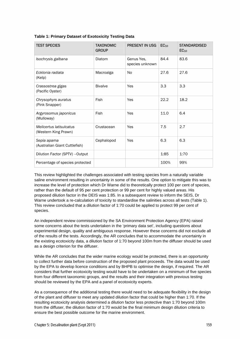
Chapter 5: Desalination plant (Sept 2011) 159
Table 1: Primary Dataset of Exotoxicity Testing Data
TEST SPECIES TAXONOMIC GROUP
PRESENT IN USG EC10 STANDARDISED EC10
Isochrysis galbana Diatom Genus Yes, species unknown
84.4 83.6
Ecklonia radiata (Kelp)
Macroalga No 27.6 27.6
Crassostrea gigas (Pacific Oyster)
Bivalve Yes 3.3 3.3
Chrysophyrs auratus (Pink Snapper)
Fish Yes 22.2 18.2
Argyrosomus japonicus (Mulloway)
Fish Yes 11.0 6.4
Melicertus latisulcatus (Western King Prawn)
Crustacean Yes 7.5 2.7
Sepia apama (Australian Giant Cuttlefish)
Cephalopod Yes 6.3 6.3
Dilution Factor (SPTV) –Output 1:85 1:70
Percentage of species protected 100% 99%
This review highlighted the challenges associated with testing species from a naturally variable saline environment resulting in uncertainty in some of the results. One option to mitigate this was to increase the level of protection which Dr Warne did to theoretically protect 100 per cent of species, rather than the default of 95 per cent protection or 99 per cent for highly valued areas. His proposed dilution factor in the DEIS was 1:85. In a subsequent review to inform the SEIS, Dr Warne undertook a re-calculation of toxicity to standardise the salinities across all tests (Table 1). This review concluded that a dilution factor of 1:70 could be applied to protect 99 per cent of species. An independent review commissioned by the SA Environment Protection Agency (EPA) raised some concerns about the tests undertaken in the ‘primary data set’, including questions about experimental design, quality and ambiguous response. However these concerns did not exclude all of the results of the tests. Accordingly, the AR concludes that to accommodate the uncertainty in the existing ecotoxicity data, a dilution factor of 1:70 beyond 100m from the diffuser should be used as a design criterion for the diffuser. While the AR concludes that the wider marine ecology would be protected, there is an opportunity to collect further data before construction of the proposed plant proceeds. The data would be used by the EPA to develop licence conditions and by BHPB to optimise the design, if required. The AR considers that further ecotoxicity testing would have to be undertaken on a minimum of five species from four different taxonomic groups, and the results and their integration with previous testing should be reviewed by the EPA and a panel of ecotoxicity experts. As a consequence of the additional testing there would need to be adequate flexibility in the design of the plant and diffuser to meet any updated dilution factor that could be higher than 1:70. If the resulting ecotoxicity analysis determined a dilution factor less protective than 1:70 beyond 100m from the diffuser, the dilution factor of 1:70 would be the final minimum design dilution criteria to ensure the best possible outcome for the marine environment.

160 Chapter 5: Desalination plant (Sept 2011)
RECOMMENDATION
While the AR concludes that the wider marine ecology would be protected, there is an opportunity to collect further data before construction of the proposed plant proceeds. The data would be used by the EPA to develop licence conditions and by BHPB to optimise the design, if required. Accordingly the following conditions are recommended: ▪ To demonstrate that the final design of the return water diffuser and alignment are optimised at
the time of construction, the proponent must undertake further ecotoxicity testing on at least five (5) species from at least four (4) taxonomic groups (one of which must be the Australian Giant Cuttlefish Sepia apama) using simulated effluent representative of the effluent that will be discharged from the operational desalination plant (i.e. including all water treatment chemicals and anti-scalants that will be discharged from the final plant). As part of the work to be undertaken the proponent must undertake the following: – Prior to commencing further ecotoxicity testing, a panel of ecotoxicity experts (approved by
the SA EPA, but at the cost of BHPB) must provide recommendations on the appropriateness of the species selected, the necessary experimental design to be used, and acceptable criteria for quality assurance/control for those species tests that do not have existing standards or, where an existing standard test is being used, they must confirm that the accompanying quality assurance/control criteria are adequate.;
– A copy of the expert panel recommendations must be provided to the SA EPA and the laboratory or laboratories that will conduct the ecotoxicity testing prior to testing commencing;
– The required ecotoxicity tests must be conducted by a commercial and/or research laboratory that has experience in conducting ecotoxicity tests on, or laboratory-based experiments with, Giant Cuttlefish or similar species;
– Immediately on completion of the additional ecotoxicity test, the panel (approved by the SA EPA, but at cost to BHPB) must review the data and the quality of procedures adopted to ensure the experimental design and data acceptability criteria have been met. The ecotoxicity data must be analysed, a dilution factor calculated to theoretically protect 99% of species and a report written by a scientist employed (or contracted) by BHPB; and
– The report required and the raw data generated by the ecotoxicity testing must be provided to the SA EPA for independent review.
▪ The proponent must design and construct the outfall infrastructure in general accordance with
SEIS figure 17.13 within the zone shown on SEIS Figure 1.7 (unless modified by the EPA through licensing conditions). The return water discharge diffuser must be designed to achieve the following: – A dilution of 1:70 beyond 100 metres from the diffuser as demonstrated by nearfield
modelling; – The discharge plume must not interact with the water surface at any time and dilution of the
plume is maximized when it reaches the seabed; – The use of bypass flows or other measures to ensure the achievement of the approved
dilution factor, particularly under low discharge flow rates; and – Shall be capable of being extended and modified to achieve the approved dilution rates.
Chapter 5: Desalination plant (Sept 2011) 161
5.4.3 Hydrodynamic modelling
5.4.3.1 Issues
The DEIS and the SEIS considered two proposed diffuser configurations. The first was a 200m-long, 50-port linear arrangement which was modelled to be perpendicular to the current. The second was the Computational Fluid Dynamic (CFD) model that incorporated four rosettes, each with five ports, spaced 50m apart along the same geometry as the linear diffuser but located 200m further offshore. This was the preferred diffuser design as a result of the decision to tunnel the outfall pipeline. To demonstrate that a hydrodynamic model would be well validated, comparisons must be made to monitored data to show that the model adequately represented the ‘real world’. The closeness of the modelled results to the monitored data would determine how well the model could describe the possible dispersion in a real-world situation.
5.4.3.2 BHPB EM Program and commitments
▪ EM Program: as per section 5.6.2.1.2 above. In addition the following BHPB commitment is considered relevant.
▪ Commitments: BHPB commits to retrieving operational monitoring data in real-time (using live telemetry) enabling appropriate management responses to be initiated should dilution targets be exceeded (SEIS Table 2.1, page 51).
5.4.3.3 Assessment
Near-field modelling
BHPB presented three different models which though linked, need to be assessed separately. The first model was the ‘near-field’ model which described how water was ejected from the individual diffuser jets, rose through the water column and then fell to the seabed, and the resulting dilution during the process. The near-field model was useful to describe the initial mixing from the diffuser structure to approximately 100-150m either side of the diffusers. The model presented in the SEIS used CFD modelling to describe the complex fluid flows from the discharge of brine from the diffusers. The set-up of the flow domain and computational mesh in the CFD model paid particular attention to the area near the diffuser risers where a refined mesh increased resolution. Single-port diffuser model results were validated against other model outputs, including Roberts & Toms (1987) (hereafter RT87) and Roberts et. al, (1997) (hereafter RFD97). Together with the qualitative agreement between the CFD simulation and the experimental results, the validation of the CFD model against the experiments reported in RT87 and RFD 97 indicated that the results of the CFD simulations captured the true dynamics qualitatively and that quantitative agreement was good, with an estimated average discrepancy of 10 per cent. The results also indicated that the CFD model had been adequately validated against results from the CORMIX modelling package. The AR concludes that the CFD model is well validated for a single-port diffuser. This finding would allow the implementation of the CFD modelling to a complex multi-port diffuser configuration with confidence that the results would be qualitatively similar to the real flow situation. The CFD modelling presented in the SEIS represented state-of-the-art modelling for complex negatively buoyant plumes and the validation process had been done adequately to understand the inherent uncertainty. Re-entrainment of brine is a natural consequence of the behaviour of negatively buoyant plumes. Re-entrainment occurs where the dilution of the discharge is reduced because the discharge is pulled back into water that has already been discharged. Re-entrainment is exacerbated when there is a low flow and low throw heights and/or a stagnant bottom layer of mixed brine. The CFD

162 Chapter 5: Desalination plant (Sept 2011)
modelling for Point Lowly showed that re-entrainment was possible, but the brine layer on the seabed would naturally form a bottom density current that would accelerate the flow away from the diffuser and increase dilution within the near-field. This suggested that re-entrainment should decrease or, in a worst-case scenario, attain a steady state over time. Accordingly, this AR concludes that the near-field model is adequately presented and validated to represent the likely real flow situation. Mid-field modelling
The ‘mid-field’ model is a separate model but inherently linked to the near-field model, described as the likely footprint of water from the near-field to approximately 4km from the diffuser. This model showed whether there were likely to be any interactions with nearby sensitive communities and how the footprint size and extent changed with various wind and tidal factors. Comparison with ecotoxicity data allows for assessment of potential biological impacts to be quantified. For a model to be useful in prediction, it needs to be robust and validated against real marine data. SARDI Aquatic Sciences reviewed the model developed by BHPB’s consultant and concluded that it appeared to be robust and showed good predictive capability for tidal and monthly averaged currents, and both low and high-pass filtered temperature variations. The former is an important result because tidal currents would likely be the primary mechanism by which mixing and dispersion of the discharged brine occurred. However, it should be noted that the comparison was made with 40 and 70 day data sets (SEIS Section 17.5.3). SARDI found that the model’s in-ability to predict long term (40 day) background salinity changes of about 1 ppt could be attributed to a number of factors. Salinity is determined by currents, mixing, and dispersal and the tidal currents have been well validated. However, model salinity also depends on the initial values adopted, which were obtained from historical data sets, rather than immediately prior to the year of simulation, as such data was not available. In addition, evaporation is also very important to determining salinity but can be difficult to accurately estimate. SARDI also found that the while the model was able to get the timing of salinity variability correct, the amplitudes underestimated the observations by about 60 per cent (or 0.3 ppt) under spring tide conditions. SARDI’s explanation for this was that the salinity gradients along the gulf were under-represented in the model. The AR notes however that better results were achieved under critical neap/dodge tide conditions. This underlined the need to collect 12 months of additional data for further model validation studies.
RECOMMENDATION
The AR considers that the mid-field model has been validated for currents and temperature, and sufficiently robust to assess the impact of modelled brine dilution on the marine environment to enable prediction of potential impacts on significant species. Further, the AR acknowledges BHPB’s commitment to collect further data before construction of the proposed desalination plant and to installing real-time monitoring systems and plant controls to ensure the required dilutions would be achieved. Accordingly, the AR recommends BHPB undertakes additional modelling incorporating a minimum of 12 months of salinity, temperature and current data from the Point Lowly region, before any plant commissioning, with the aim of refining the model and optimising the diffuser design should it be required. The AR also recommends BHPB install a live telemetry observing system, to allow appropriate management response to any unexpected salinity events. The following conditions are recommended:
Chapter 5: Desalination plant (Sept 2011) 163
▪ To demonstrate that the final design of the return water diffuser is optimised the proponent must undertake further near-field and mid-field modelling to describe dispersion and mixing of return water under a range of flow scenarios with each of the production stages (e.g. 70ML/d, 135ML/d and 200ML/d). If the 1st percentile exceeds the dilution factors described in condition 5, mitigation measures must be included in the final design that improved dilution to meed the approved dilution factor. The outputs from this work and associated mitigation measures must be approved by the Indenture Minister with the concurrence of the EPA prior to the outfall infrastructure being constructed.
▪ The proponent must establish a salinity and current monitoring system at Point Lowly and in the
Upper Spencer Gulf to collect a minimum of 12 months continuous data in order to further refine the near-field and mid-field hydrodynamic models.
Far-field modelling
The issue of the overall salt balance of the gulf was addressed through the ‘far-field’ model, which was designed to look at regional-scale effects of a desalination plant discharge. The model incorporates three main gulf processes: ▪ Gravity currents which provide the mechanism for salt ejection; ▪ Annual salt exchange across the model’s ocean boundary; and ▪ Gulf flushing time. The salt balance of the Spencer Gulf is mediated by a flow of slightly more dense and saline water flowing along the seabed south and east down the gulf exiting between Cape Spencer and Wedge Island. The far-field model adequately reproduced this dense water flow during late autumn and early winter, consistent with field studies documented in literature including Lennon et al (1987) & Nunes-Vaz, (1990). The efficacy and seasonal nature of the salt ejection mechanisms in Spencer Gulf were also reflected in salt balance equations presented in the DEIS Appendix O11.4. This described the average salinity increases over summer through evaporation, with an average 1.09 gigatonnes per annum of salt entering the system at the mouth, replacing fresh water lost through evaporation, predominantly in the northern reaches of the Gulf. The SEIS made the assumption that the annual seasonal cycle of the salt-ejection mechanism and the salt balances over the same time scales implied that Spencer Gulf flushed annually. To validate this, BHPB’s consultants used the far-field model to test e-folding (a modelling method to show water exchange) and water retention times, to examine how long it took water to exchange in the northern gulf. Both methods returned a flushing time of less than 12 months and both exhibited the same salt-ejection mechanism. Calculations in the DEIS suggested that annually 78 per cent of water north of Point Lowly would need to be exchanged with water from further south to maintain salinity gradients. Calculation of water exchange in the SEIS suggested that on an annual basis 90 per cent of the water would be exchanged north of Point Lowly and between 66–80 per cent of water would be exchanged in 2-4 months.
RECOMMENDATION
Accordingly, the AR considers it unlikely there would be any long-term increases in salinity in the northern Spencer Gulf as a result of a desalination plant. To provide ongoing data to demonstrate this finding, long-term accurate in-situ monitoring of salinity and temperature would be required. The monitoring would also need to take climate change into account. Such monitoring requirements would likely be a condition of any licence under the Environment Protection Act 1993 to operate the proposed desalination plant. The AR recommends the following outcome as a condition: ▪ No change to the long term salinity in the USG attributable to the desalination plant beyond that
predicted in the Final EIS (DEIS and SEIS).

164 Chapter 5: Desalination plant (Sept 2011)
5.4.4 Mixing and dispersion of return water and potential ecological effects
5.4.4.1 Issues
The mixing and dispersion of return water from a desalination plant outfall is paramount in assessing potential environmental impact and risk. Ecotoxicity testing describes the concentration of brine that may cause an effect to different representative biota. A well-validated hydrodynamic model will predict the likely footprint of a brine discharge under various tidal and weather scenarios in order to show whether sensitive habitats or communities will be exposed to brine above the dilution factor predicted to cause an effect. This section assesses the possible impact of a desalination plant discharge over various wind and tide scenarios on nearby marine biological communities around Point Lowly. This assessment is made using the ecotoxicity testing data and the hydrodynamic model results provided in the DEIS and SEIS to infer possible impacts. The assessment assumes a species protection design dilution factor of 1:70 and that the hydrodynamic model is accurate (see sections 5.4.2 and 5.4.3 of this AR).
5.4.4.2 BHPB EM Program and commitments
As per the EM Program and commitments outlined in section 5.4.2.2 above.
5.4.4.3 Assessment
Ecotoxicity testing uses a range of representative species that are likely to inhabit the region or can be used as a surrogate for local species. Using the recommended dilution factor of 1:70, the model outputs can be interrogated to see whether the discharge footprint would intersect with any communities and possibly have an effect. Given the diversity of species tested the dilution factor can be seen as being protective of a sub-lethal effect (e.g. growth) for 99 per cent of species. Numerous possible diffuser designs were considered in the DEIS and the SEIS. Modelling has shown that some would be effective in dispersing and diluting the brine while others would be less effective. Diffuser design is critical in the assessment of the possible brine dispersion footprint and, therefore possible ecological impacts. The SEIS showed significant modelling undertaken to optimise the diffuser design to achieve the best dilution in the smallest area. Under zero current conditions the preferred rosette-style diffuser would achieve a worst-case scenario of brine mixing at a dilution of 1:107 using Roberts (1997) equations; or 1:97 using the CFD model at 100m (SEIS Table 17.7). CFD modelling showed that near-field dilutions greater than 1:70 at 100m from the diffuser would be achieved under all tidal scenarios (SEIS Table 17.8). Modelling showed that the Western King Prawn was unlikely to be adversely impacted by return water discharge, as larval prawns were known to occur in areas of significantly higher salinity of up to 55ppt (SEIS Appendices H7.2 and H7.3). Additionally, the juvenile prawn EC10 was 53.9 per cent brine or a dilution factor of 1:1.85, indicating a very high tolerance to elevated salinities. The adult prawns were shown to be more sensitive than the juvenile prawns, with a chronic EC10 of 11.8 per cent brine or 1:8.5. However, the modelling showed that this dilution would be achieved at all times, even in close proximity to the diffusers. The modelling presented in the SEIS stated that the nearest Kingfish aquaculture facilities in Fitzgerald Bay would not be affected, with a minimum dilution of 1:274 and 1:285 for the 4.3 m3/sec (280 ML/d scale plant) and 3.1 m3/sec (200 ML/d scale plant) flow scenarios respectively.

Chapter 5: Desalination plant (Sept 2011) 165
The maximum footprint of the plume (0th percentile) was estimated from the mid-field model over a full 12 month modelling scenario and outputs compared to a base case run without a desalination plant discharge, to compare the increase in brine the desalination plant discharge would cause. The maximum footprint (0th percentile) of the proposed discharge at 4.3 m3/sec was large at approximately 10.5km2, but the direction of the plume dispersion indicated that it would be unlikely to intersect with any particularly sensitive habitats, other than the sponge garden. The closest cuttlefish habitat located on the point of Point Lowly had a minimum dilution, or worst-case scenario, of 1:107 or 0.33ppt above background. 95 per cent of the time the dilution would be better than 1:258 or 0.14ppt above background, giving a significant safety margin from the predicted 99 per cent protection value of 1:70 (0.51ppt above background) and the predicted EC10 for Giant Cuttlefish of 1:55 (0.64ppt above background). The AR considers that adequate return-water dilution at the rocky reef areas supporting cuttlefish, among other species, would be vital for the ongoing biodiversity and ecological value of the USG. The AR concludes that a dilution factor of 1:85 at all cuttlefish breeding areas during all tidal conditions (including dodge tides) and all operating conditions, including under low discharge flow rates. The modelling indicated that the sponge garden would be exposed to brine above the 1:70 dilution threshold for between 1-5 per cent of the time under the 4.3 m3/s scenario and between 10-25 per cent of the time under the 3.1 m3/s scenario. The toxicity testing undertaken on the sponge was unreliable and no conclusions have been drawn from this work. However, the SEIS presented evidence of sponge gardens in the northern Spencer Gulf at Two Hummock Point which are naturally exposed to significantly higher salinities than Point Lowly, suggesting a high tolerance to elevated salinity. Anecdotal reports of sponges of similar species have been observed growing on the diffusers of the Cockburn Sound desalination plant in WA which were likely to be exposed to much higher brine concentrations. There was also concern for any other organisms using the sponge garden for food or shelter as they might not be as tolerant to the elevated salinities as sponges. This AR concludes that in order to determine whether the desalination plant discharge was having a detrimental effect on the sponge garden, BHPB would have to implement a BACI monitoring program before construction began. This program should not only focus on sponges, but diversity and abundance of other biota. Conditions have been recommended to this effect. Comparisons of the different diffuser configurations (SEIS Table 17.6) revealed that high return water flows delivered better near field dilutions than low flows because higher exit speeds provided more dilution due to the larger distance the water was ejected from the ports. The table provided an analysis of a number of combinations of parameters affecting dispersion, including the number of ports, port diameter exit velocity and discharge volume. The discharge volumes tested included 4.3m3/sec, 3.1m3/sec and 2.2 m3/sec, but there was no information provided on discharge volumes lower than these figures, such as 25 per cent and 50 per cent peak discharge flows which would be possible under low water demand or start-up scenarios. Analysis indicated that at higher flows dispersion could be effective but little information was provided on dispersion during low-flow scenarios where dispersion could be poor. BHPB propose a number of measures to mitigate poor dilution, including duckbill valves and, for longer-term low flows, potential capping of a number of ports to increase discharge exit speed.
166 Chapter 5: Desalination plant (Sept 2011)
RECOMMENDATION
Accordingly, the AR considers that the dilution and dispersion at low flows is a critical issue in demonstrating that a desalination plant discharge at Point Lowly would not affect the marine ecology of the area. The AR recommends the following conditions: ▪ An operational dilution factor of 1:85 to be achieved at all cuttlefish breeding areas during all
tidal conditions (including dodge tides) and all operating conditions, including under low discharge flow rates.
▪ No significant decline in the condition and extent of known native species or their associated
ecological communities attributable to the desalination plant beyond 100m of the diffuser. ▪ The proponent must develop contingency plans to increase dilution from the diffusers at 100m
to ensure diffuser performance remained acceptable under all conditions. Contingencies must include measures to shut down all discharges to the marine environment if dilution factors were exceeded at EPA-specified locations.
▪ A condition has been recommended in section 5.4.2.3 of this chapter that sets dilution rates and
requires the design of the outfall infrastructure to be capable of being extended and modified to achieve the approved dilution rates and to shut down if not in compliance.
5.4.5 Listed/significant species and commercial species
5.4.5.1 Issues
Australian Giant Cuttlefish
The area around Point Lowly attracts the only known mass aggregation of spawning cuttlefish in the world. At the peak of the breeding season between May and September, the density of the species can reach more than one cuttlefish per square metre. The rocky substrate provides the appropriate environment for the females to lay their eggs, which hatch four months later. It is believed that while the cuttlefish grow rapidly, they reproduce only once in a lifetime. Cuttlefish have a low tolerance to changing environmental variables, including salinity, making it likely to be more vulnerable to the impacts of desalination plant return water. Impacts could occur through affecting eggs or acute mortality to the juveniles or adults in the deeper water channels during the migration to Point Lowly. BHPB has committed to continue annual surveys of cuttlefish, and to construct the intake pipeline during the period 1 November to 1 May to minimise the impacts on cuttlefish breeding during construction Sponge community
Sponge fauna of Spencer Gulf are largely unknown. Sponges are filter feeders that rely on water movement. Two locations in northern Spencer Gulf have dense communities of sponge, Point Lowly and Two Hummock Point, 30km north of Point Lowly. Both areas are characterised by high current speeds and exposed rocky substrates that enabled the dense growth. The Point Lowly sponge community is considered to be of regional importance. BHPB has committed to place the final outfall pipe location to minimise impacts on the sponge communities.

Chapter 5: Desalination plant (Sept 2011) 167
Australian and SA Government listed species
Forty-five species of listed flora and fauna have been identified as potentially occurring in the USG, including eight species classified as threatened. Sixteen of the listed species have never been recorded in or near the USG. Of 29 recorded species, 12 are highly mobile and 17 are sessile or less mobile. The sessile or less-mobile species would be considered to be the most at risk from a desalination plant discharge because they would be less able to move away from unsuitable water. These species comprise the seagrass Zostera mucronata and 16 species of seahorse and pipefish sygnathid. Commercial/recreational fishing and aquaculture
The discharge of desalination brine has the potential to affect fish populations through acute toxicity on eggs, larvae or mature fish, as well as chronic effects on reproduction, growth and behaviour. Spencer Gulf supports important commercial and recreational fisheries, with the zone between Port Pirie and Whyalla recognised as being particularly productive (refer DEIS Appendix O6 for full details of fishery). Many species use the seagrass meadows and/or mangroves during their lifecycle and many are caught within or near the seagrass areas. Two important species, Snapper and the Western King Prawn, frequented the deep water channels, which raised questions about increased risk to these species from a desalination plant discharge. Over the past 20 years the aquaculture industry in Spencer Gulf has expanded rapidly to become a significant export market for SA. The northern Spencer Gulf is particularly important for Yellowtail Kingfish (Seriola lalandi) and the Pacific Oyster (Crassostrea gigas), with sea-cage fish farms at Port Augusta and Fitzgerald Bay and oyster farms at Cowell and Port Broughton.
5.4.5.2 BHPB EM Program and commitments
▪ EM Program: as per section 5.4.2.2 above. In addition the following BHPB commitments are considered relevant.
▪ Commitments: – BHPB has committed to undertaking an annual survey of the Australian Giant Cuttlefish
population at Point Lowly to establish a suitable baseline for the population before construction and operation of the desalination plant.
– BHPB has committed to financing surveys of cuttlefish abundance and biomass, which would continue to improve the understanding of natural population variability.
– BHPB would undertake appropriate monitoring to identify significant changes to marine flora and fauna communities and water quality, which would include: - A detailed marine monitoring and management plan, incorporating habitat maps, would
be developed in liaison with relevant stakeholders; - Future monitoring of salinity levels would be undertaken for comparison against species
protection trigger values (SPTV); - Monitoring would occur two years before the start of construction; - Monitoring would occur during the construction period; and - Monitoring would occur during operations to verify the return water dispersion modelling
results, and this would include times of dodge tides (SEIS Table 2.1, page 51).
5.4.5.3 Assessment
Australian Giant Cuttlefish
The conservation significance of the Australian Giant Cuttlefish in the USG is recognised by a total ban on cephalopod fishing in the Point Lowly/-Whyalla region under the Fisheries Management Act 2007. The rocky substrate provides the appropriate environment for females to lay their eggs, and there is a lack of other suitable such habitats in the region. The only similar area of rocky substrate is 10km north of Point Lowly at Backy Point, which is also a dense cuttlefish breeding habitat.

168 Chapter 5: Desalination plant (Sept 2011)
The SEIS stated that the interaction of return water with the shallow cuttlefish breeding habitat was expected to be minimal as the more-dense return water plume from the diffuser would tend to fall to the seafloor and be entrained by tidal currents, which would take the plume away from Point Lowly. During periods of no current, gravity would take the return water away from the near-shore reef habitat toward the deeper sections of the gulf. Throughout the ecotoxicity testing the most sensitive test was the Australian Giant Cuttlefish post hatch survival endpoint which demonstrated a 10 per cent sub-chronic effect at 1.86 per cent brine (1:55 dilution) (DEIS Table 16.8). Although the data was generated using an unrealistically high salinity of 45 ppt, and therefore likely to overestimate the toxicity, the results were similar to those reported in independent studies conducted by Dupavillion & Gillanders (2009). During the worse-case conditions of a dodge tide the minimum dilution in the closest cuttlefish habitat (SEIS Figure 17.15) would be 1:107, which was equivalent to a salinity increase of 0.3 g/L. At Backy Point, 10km north, where the density of cuttlefish was very high during the breeding season, the salinity was on average 0.35 g/L higher than Point Lowly, suggesting that cuttlefish could tolerate this level of salinity increase. However, there could be large differences between the hatching success from eggs incubated at a constantly higher salinity and the hatching success of eggs exposed to sudden fluctuations of salinity. The ecotoxicity testing focused on the survival and condition of eggs and post-hatch juveniles as these were considered the most sensitive stages of the life cycle. Adult cuttlefish are likely to be exposed to higher concentrations of brine, including those naturally occurring, while migrating into the breeding habitats along the deepwater channels. The SEIS stated that cuttlefish also bred further north, where salinity was elevated, and that the natural saline plumes that moved down the gulf at the start of the breeding season were more likely to be significant than the plumes modelled to be associated with the desalination plant discharge. The SEIS concluded that the discharge plumes would not interfere with migration, and the AR agrees with this finding. The Final EIS documented the variability in cuttlefish populations at Pont Lowly and Backy Point and the apparent decline in abundance since 2001. Neither the documents nor other researchers could account for the apparent decline, and the AR supports the BHPB commitment to continue the ongoing monitoring of cuttlefish abundance and biomass.
RECOMMENDATION
Accordingly, the AR considers there should be no impact of return-water discharge on the Australian Giant Cuttlefish. However, it recommends that BHPB implement an annual BACI-designed monitoring program to assess the biomass and abundance of cuttlefish throughout the Point Lowly region, including Backy Point. The following conditions are recommended: ▪ No measurable adverse impacts on the abundance and distribution of the Australian Giant
Cuttlefish as a result of construction and operation of the desalination plant. ▪ The proponent must continue to undertake an annual survey of the Giant Cuttlefish during the
breeding season to record numbers and distribution between Black Point and Backy Point. ▪ All monitoring required by conditions must be designed in accordance with the principles of a
Beyond BACI sampling methodology, or as approved by the EPA.

Chapter 5: Desalination plant (Sept 2011) 169
Sponge community
The AR considers that the nearby sponge community, extending over 2ha of the channel 200-300m from the outfall pipe, would be unlikely to be affected by water above the specified dilution factor for a significant period of time during plant operation. Following release of the DEIS the positioning of the outfall pipe was realigned and extended an extra 200m by BHPB to ensure protection of the sponge community. BHPB stated that further attention would be paid to minimising impacts on this community during detailed design phase and when selecting the ultimate location of the outfall pipe. There was considerable uncertainty in the salinity tolerance of sponges within this sponge community. BHPB provided information in the SEIS on a trial ecotoxicity test using the local sponge Aplysina lendenfeldi. While the test had limitations and could not be used in calculating the dilution factor, it did suggest that the sponge community was reasonably tolerant to changes in salinity. The SEIS also showed the presence and diversity of sponges on the diffuser pipes of the Cockburn Sound Desalination plant in Western Australia (WA), and a second regionally significant dense sponge community at Two Hummock Point, north of Backy Point, which would be exposed to higher ambient salinities than the Point Lowly population would experience from the proposed desalination plant. This indicated that sponges were likely to have a high tolerance to elevated salinity.
RECOMMENDATION
Accordingly, the AR considers that while it was likely that the sponge community located close to the outfall diffuser pipe would be exposed to elevated salinities, it was likely that sponges were tolerant to increases in salinity and it was unlikely they would be affected. To ensure this, the following conditions are recommended: ▪ For at least three years prior to operation of the desalination plant, the proponent must
undertake an annual quantitative and qualitative survey of marine ecology within the sponge garden community near the proposed return water outfall.
▪ All monitoring required by conditions must be designed in accordance with the principles of a
Beyond BACI sampling methodology, or as approved by the EPA. Australian and SA Government listed species
Threatened marine species have been recorded in the USG, however they are highly mobile and it is considered they would move away from the discharge point and construction impacts to other abundant suitable habitat areas in and beyond the USG. BHPB stated in the DEIS that it considered the risk to these species from a desalination discharge would be low. BHPB has committed to make an SEB payment into the Native Vegetation Fund to offset the loss of 1.5ha of seagrass (DEIS Section 15.5.1) The nearest recorded community of the seagrass Zostera mucronata occurred at least 15km from the proposed outfall, well beyond the zone where effects on water quality would be detectable. With the exception of the Tiger Pipefish, syngnathids (seahorses etc) generally occurred within relatively low-energy seagrass environments, such as Fitzgerald Bay and False Bay, which modelling indicated were well beyond the zone where effects on water quality would be detected. The Tiger Pipefish inhabits sandy/muddy substrate adjacent to channels. The species had been recorded in very low numbers in USG and it was considered that only a very small proportion of its habitat would exceed the specified dilution factor. The Tiger Pipefish was widely distributed in USG so any impacts at the desalination plant site would affect only a very small proportion of their population.
170 Chapter 5: Desalination plant (Sept 2011)
RECOMMENDATION
The AR considers that the effects of any reverse-water discharge on listed species are unlikely to be significant. Commercial/recreational fisheries and aquaculture
Spencer Gulf supported one of the largest prawn fisheries in Australia and commercial trawling occurred within 1km of Point Lowly. Much of the USG was considered a prawn nursery area. Very high densities of prawn larvae occurred between Whyalla and Germein Bay, and high densities of juvenile prawns occurred on tidal flats, such as at False Bay (DEIS Table 16.5). The BHPB hydrodynamic model and SEIS demonstrated that at the nearest prawn trawling grounds (SEIS Table 17.9 ‘u, m’) would be exposed to a maximum (0th percentile) brine dilution of 1:72. The ecotoxicity testing of adult and juveniles of the Western King Prawn (Melicertus latisulcatus) indicated that adult prawns were less tolerant of salt changes than juveniles and had an EC10 (10 per cent effect on growth over 28 days) of 11.8 per cent brine (1:14) compared to 53.9 per cent brine (1:1.86) for juveniles. This indicated that adult and juvenile prawns had a substantial protective buffer from the brine discharge at the two modelled locations. Even at locations 100m from the outfall (Table 17.9 ‘x, b, c & d’), it would be unlikely the prawn EC10 value would be exceeded. The Pacific Oyster farms located at Cowell and Port Broughton were more than 50km from Point Lowly and would be highly unlikely to be impacted by any brine discharge. The southern-most Kingfish farms located in Fitzgerald Bay are approximately 3.5–4km from the proposed outfall location. Ecotoxicity testing using Yellowtail Kingfish indicated an EC10 of 10.6% brine or 1:9. However, this was tested with a lower than desired salinity (EC10 recalculated by Dr Warne SEIS Appendix H4.3) and as such is in the ‘second best’ data set. The hydrodynamic modelling undertaken for the SEIS indicated that the worst case brine dilution at the nearest Kingfish farm is 1:272 which is significantly higher than the individual Kingfish EC10. The SEIS detailed the logKOW for the anti-scalant in the brine mixture to assess whether there was any likelihood of chemical residue accumulation as a result of the brine discharge. The assessment indicated that the anti-scalant in the proposed brine had a logKOW of 0.54, which was significantly lower than the ANZECC/ARMCANZ Guidelines recommended investigation level of 4, making it unlikely that the Kingfish aquaculture farms would be affected by the brine discharge. The Point Lowly area had historically provided the largest and most consistent commercial catch of Snapper up until the 2003-04 season. Since then the southern Spencer Gulf region had surpassed the northern region. Rather than a drop in fish biomass, it appeared that this trend reflected a change in fishing area by the commercial sector not by a reduction in fish biomass as the Fisheries Assessment report for Snapper detailed (Fowler et al, 2010). Only small recreational and commercial quantities of Mulloway (Argyrosomus japonicus) were caught in the USG, and no larvae of the wild Mulloway and Kingfish had been recorded in the USG. The ecotoxicity testing undertaken by BHPB demonstrated that the Snapper (Chrysophrys auratus) was reasonably tolerant to elevated salinities with a chronic EC10 (10 per cent effect on larval growth over 7 days) of 22.2 per cent brine or 1:5. Similarly, Kingfish and Mulloway test results showed EC10 values of 11.6 per cent and 11.1 per cent brine respectively, corresponding to 1:8.6 and 1:9. The hydrodynamic modelling indicated that this dilution factor would be exceeded at all locations modelled, including right next to the diffuser. Impacts on fish from a brine discharge at Point Lowly would be extremely unlikely.
Chapter 5: Desalination plant (Sept 2011) 171
RECOMMENDATION
The AR considers that the effects of any reverse-return water discharge on commercial or recreational fisheries are unlikely to be significant.
5.4.6 Ecological monitoring and water quality
5.4.6.1 Issues
Monitoring
Submissions on monitoring and water quality were received from groups such as the SA Recreational Fishing Advisory Council, Spencer Gulf & West Coast Prawn Fishermen’s Association; Australian Conservation Foundation, Field Naturalists Society SA, Cuttlefish Coast Coalition, Friends of the Earth, Port Augusta Coastal Homes Association and SARDI. The DEIS and SEIS provided some monitoring data appropriate for the basis of an impact assessment, however it was not a suitable baseline on which to assess future potential changes and should be further developed. Dissolved oxygen
Dissolved oxygen is critical to marine life for respiration and critical chemical and biological processes. Long-term depletion leads to behavioural changes, such as mobile species avoiding certain areas, impacts on sessile species and changes in biological and chemical processes such as nitrification/denitrification and metal solubility in sediments. There is limited data assessing ambient dissolved oxygen in the Point Lowly region.
5.4.6.2 BHPB EM Program and commitments
As per the EM Program and commitments outlined in section 5.4.2.2 above.
5.4.6.3 Assessment
Monitoring
Marine communities are extremely variable through space as well as time. Numerous biotic factors, such as type of organism and predation/prey relationships, and abiotic factors such as water movement, light availability and substrate, influence where and how successful a marine community might be in a given area. Monitoring marine communities is difficult due to this variability and assessing change over time needs to take this variability into account in order to differentiate between natural variability and changes because of an anthropogenic input, such as a desalination plant discharge. The best scientific method to undertake this assessment is known as ‘Beyond BACI’ (Underwood, 1991, 1992, & 1994). Fundamental in any assessment of potential impact is a comprehensive baseline assessment (Before) which details the natural variability so that changes can be compared to this baseline over time (After). Additionally, communities need to be assessed at multiple sites, not only the site in question to be able to account for regional scale variability or site specific differences (Controls versus Impact). Most of the monitoring undertaken and presented in the FEIS could contribute to the existing ‘Before’ data for Point Lowly and Spencer Gulf. However, it is not sufficient in both temporal and spatial resolution to be considered ‘Before’ data. BHPB has committed to undertake considerable further monitoring before construction. All monitoring recommended in this AR would need to take into account, and adhere to, where practical, the methodologies of Underwood and others who describe the advantages of a Beyond BACI approach.

172 Chapter 5: Desalination plant (Sept 2011)
Throughout all monitoring programs developed for the BHPB desalination plant, trigger levels and contingencies must be developed and implemented in the event that it was considered the desalination plant construction or operation was having an adverse effect on a specified receptor. These contingencies would need to rectify the observed adverse impacts to the extent that was reasonable and practical. Dissolved oxygen
The proposed desalination plant would discharge effluent which was aerated most of the time. However, there would be short periods when there was zero dissolved oxygen while chlorine dosing was occurring. Chlorine added into the intake pipes as a biocide would subsequently be neutralized with sodium metabisulphite, resulting in periods of zero dissolved oxygen in the effluent stream. The DEIS proposed to re-aerate the effluent stream using weirs but, because of the hypersalinity and slightly elevated temperature, while the percentage saturation could be raised the actual oxygen concentration would still be lower than ambient conditions. There is limited information regarding ambient dissolved oxygen concentrations in the waters around Point Lowly, particularly near the seabed in deepwater channels. The DEIS detailed extensive sediment oxygen-demand calculations based on research undertaken for aquaculture in the region. The calculations indicated that consumption from sediment-dwelling organisms was unlikely to reduce oxygen levels in the water. However, the DEIS stated that extreme natural conditions had previously caused dissolved oxygen levels in deepwater channels in Cockburn Sound, WA, to fall below Kwinana desalination plant regulatory thresholds, and there was convincing evidence to suggest that this could not be attributed to the desalination plant. There was also a lack of good baseline dissolved oxygen concentrations in these areas before the desalination plant became operational. Spencer Gulf waters are naturally susceptible to stratification because of the north-south salinity and temperature gradients. BHPB undertook a simulation of the duration, severity and extent of oxygen depletion associated with return-water discharge, using a three-dimensional Estuary and Lake Computer Model (ELCOM) coupled with the Computational Aquatic Ecosystem Dynamics Model (CAEDYM). Dissolved oxygen concentrations, without desalination (base case) and with the desalination plant operating (desalination case), were found to be virtually the same on the seafloor and at mid-depth during the normal tide components of the 10-day simulation (SEIS Figures 17.26a and b).
RECOMMENDATION
Accordingly, the AR considers that BHPB must establish a good baseline of dissolved oxygen monitoring in deepwater channels possibly affected by any desalination plant discharge before construction of the proposed plant, to provide a comparison of return-water effects to the baseline condition. The following condition is recommended: ▪ The proponent must monitor dissolved oxygen at the seabed in natural bathymetric depressions
close to the proposed return water discharge diffuser to adequately establish a minimum 12 month baseline condition for dissolved oxygen in these locations prior to any construction work commencing on the desalination plant.

Chapter 5: Desalination plant (Sept 2011) 173
5.4.7 Pipeline construction impacts
There are two pipelines associated with construction of the desalination plant – return water outfall pipe and intake pipe. The return water outfall pipe will be tunnelled under Pont Lowly while the intake pipe will be laid in a trench and covered.
5.4.7.1 Issues
Turbidity
Construction of the intake pipe will require dredging which will cause localised turbidity. Turbid waters are caused by high levels of suspended and/or dissolved materials in the water column which can be made up of sediment discharged from dredging activities or discharges such as from dewatering (the natural, chemical, or mechanical removal of water from sludge). There are often naturally elevated suspended solids in some areas due to re-suspension of sediment from the sea floor by wind, currents and wave action. Turbid waters result in a reduction of light penetrating the water column and can cause sedimentation on seagrasses, reefs and other benthic habitats. Turbid waters have been highlighted as a possible factor in seagrass loss in the nearshore environment of Adelaide (Westphalen 2005) and other locations (Longstaff & Dennison 1999; Ruiz & Romero 2003). Sedimentation can result in smothering of seagrass (Shepherd et al. 1989) or coating leaves with silt, reducing photosynthetic ability (Duarte et al. 1997). Elevated turbidity in the water column or sedimentation coating algal fronds can reduce the photosynthetic ability of macroalgae (Turner & Cheshire 2002). Macroalgal reefs can be adversely affected by sedimentation through competition with algal spores for space on a substrate, or the spore settling on sand, with both actions likely to result in recruitment failure on a reef (Turner & Cheshire 2002). In extreme cases, sedimentation can smother macroalgal species and cause a decrease in recruitment, growth and survival rates (Eriksson & Johansson 2005; Umar et al. 1998). Turfing algae, small tuft-like algae usually more than 5mm tall, can withstand large sediment deposits. Reefs affected by high sedimentation can change to a spatial dominance by turf-forming algae, which can exclude canopy-forming species (Gorgula & Connell 2004). Turbid waters can also have adverse effects on higher organisms, particularly fisheries where turbidity can reduce feeding (Benfield & Minello 1995). Studies have shown that fish may avoid turbid areas (Boubee et al. 1997; Bisson & Bilby 1982) and turbidity could potentially affect visual spawning cues (Engström-Öst & Candolin 2006). Vibration and blasting
Building the intake and return water pipelines involve some inherently noisy processes, such as tunnelling, blasting, drilling, dredging, rock removal and pile-driving. The FEIS stated that a number of marine animals, including whales and dolphins, could be in the vicinity of the proposed desalination plant construction site. Marine animals rely on sound for almost all aspects of their life, including reproduction, feeding, predator and hazard avoidance, communication and navigation (Ocean Studies Board 2003; Weilgart 2007). These aspects could be affected by rapid pressure changes associated with loud noises. Studies had demonstrated that sudden pressure changes were generally at the root of injury or mortality in marine fauna, especially affecting gas-filled organs such as lungs, sinuses, ears and swim bladders (SA Water 2009).

174 Chapter 5: Desalination plant (Sept 2011)
Noise could mask environmental sounds that marine animals relied on for identification, communication and navigation purposes. The masking could lead to behavioural changes as man-made noise could interfere with detection of calls, echolocation sounds, and environmental sounds at frequencies similar to the noise. Construction is likely to generate the greatest noise impact on marine fauna, specifically pile-driving associated with construction of the intake pipe trench. Noise from blasting had the capacity to injure and kill marine mammals, fishes and even invertebrates. Broad-band pulsed sounds, from pile driving and blasting, compared to continuous pure tones, had a greater impact on fish behaviour (WSDOT, 2006 in SA Water, 2009). Drilling, dredging and tunnel-boring could mask important sounds and induce behavioural changes which could still be defined as an impact in certain circumstances. Sensitive habitats
Building the desalination plant pipelines would result in the clearance of a small proportion of some marine habitats. The trenching of the intake pipeline would remove a section of intertidal reef and an area of seagrass habitat, though the change to tunnelling of the outfall pipe would reduce habitat disturbance. Invasive species
The introduction of invasive marine species through ballast water or biofouling on vessels or in construction equipment has the potential to impact the regional marine ecology of the USG. The sources could include dredges and associated equipment, support boats, monitoring vessels, jack-up and dumb barges. Invasive species such as Caulerpa taxifolia could dominate local native species which in turn could alter food webs, biodiversity, productivity and fishery production.
5.4.7.2 BHPB EM Program and commitments
BHPB has set the following objective and criteria as part of its Environmental Management Program (EMP) which is detailed in DEIS Appendix U, ID 1.2: ▪ Objective: No significant adverse impacts to specified marine environmental values of the USG
from the construction of, or as a result of discharges from, the desalination plant at Point Lowly. ▪ Criteria: No long-term adverse impacts on the breeding success of Australian Giant Cuttlefish
as a result of construction or operation of the desalination plant. ▪ Management plan: To prepare a new Marine Silt and Sediment Management Plan and a new
Marine Blasting Management Plan for the construction of the intake and outfall pipes. ▪ Commitments: as per the commitments outlined in section 5.6.2.1.2 above
5.4.7.3 Assessment
Turbidity
BHPB originally proposed two potential methods for installing the intake and outfall pipelines, detailed in the DEIS. The first was trenching, where the pipe would be buried under the seabed, and the second method involved burying the pipe where it crossed the tidal zone and laying the rest on the seabed with adequate armouring. In the SEIS it proposed to tunnel the outfall pipe using a tunnel-boring machine which would result in minimal dredging during the installation. The 400m intake pipeline, to be located north of Point Lowly in Fitzgerald Bay, would be trenched as originally proposed.

Chapter 5: Desalination plant (Sept 2011) 175
The DEIS stated that the trenching method would be finalised when a construction contractor had been selected, but the likely method would be to use a clamshell bucket operated by a crane on a floating barge or a temporary jetty. The pipes would then be laid and the trench backfilled with excavated material from a 250m3 hopper. This would create a sediment plume and reduced light penetration, which has been modelled using the ELCOM and CAEDYM packages (Appendix O12). Modelling showed that sediment plumes could reach up to 2km north of the intake pipe but were likely to be focused on a relatively small area down-current of the pipe. Within 1-2km of construction activities the sediment plume would be more than 2mg/L higher than ambient for a cumulative total of approximately 24 hours per fortnight - for minutes 2km from the construction site, to hours or possibly days within 100m. Suspended solid levels would typically be higher in the inshore areas than offshore. Modelling sediment deposition indicated that within 200m of the construction site there was likely be sediment deposition of 10mm over two weeks, though wave re-suspension (not modelled) was likely to resuspend fine sediment deposited in rocky habitats. The AR considers that the proposed trenching method could result in significant turbidity plumes 1-2km in length in the water column and sediment deposition on shallow subtidal reefs down-current of the intake pipe construction activities. Excessive sediment deposition in rocky reef habitats would result in potential short-term smothering of algae. Importantly, sediment deposition has the potential to fill cracks and crevices in the reef which would inhibit macroalgal recruitment (Turner & Cheshire, 2002). There was also the potential for sediment plumes from the intake pipeline to interact with the significant Kingfish aquaculture fishery. BHPB modelling showed that the southern-most aquaculture lease was located within the modelled zone of increased suspended solids. Limitations within the model were that the scenarios had been modelled to show an increase from background levels, while BHPB’s monitoring in the region, though limited in quantity and quality, showed that there was significant suspended solid load in the water column to start with (median 7.7 & 8.9 mg/L). This high ambient load suggested that a 2 mg/L increase would not be significant. However, it was likely that there were plants and organisms that were under light stress due to the elevated loads and a relatively minor increase could exceed their threshold for light dependence. This AR considers that the proposed method of trenching is acceptable subject to BHPB using the best available practice to minimise release of suspended solids, particularly fine particles. Additionally, extensive ‘before’, ‘during’ and ‘after’ turbidity and total suspended solids monitoring needed to be undertaken, acknowledging that this would be a condition of any EPA dredging licence. Vibration and blasting
BHPB stated in the DEIS that the proposed dredging, trenching, possible blasting and pipe-laying processes would result in elevated noise and vibration levels in the marine environment. If blasting was required the charges would be set in holes drilled 1.5-2.0m into the seabed to dampen the concussive effect. Numerous small charges would be used rather than fewer larger charges, reducing effects on marine fauna to ‘marginally detectable’ 600m from the blast site (DEIS Appendix O12). BHPB used trained personnel to observe dolphins in the vicinity of the proposed desalination plant. The study was incomplete and there were limitations that affected dolphin observations, particularly around the proposed intake pipe. From the limited data set it was observed that dolphins not only frequented the Point Lowly region but often remained in the area feeding, resting, socialising, milling and transiting. Observers also concluded that all life stages of dolphins were present in the area, including calves which could be more susceptible to underwater noise than the adults (SEIS Appendix H9.4).

176 Chapter 5: Desalination plant (Sept 2011)
It was also critically important to ensure that divers, both recreational and those servicing aquaculture sites, were not adversely affected by any blasting. There had to be coordination among recreational divers, aquaculture farms and marine-blasting operations. BHPB stated in the DEIS that marine blasting would not occur in the cuttlefish breeding season or if whales or dolphins were observed in the area. Prior to each blast a 600m exclusion zone would be established and monitored to minimise the risk of marine mammals or listed species entering the blast zone. It also committed to preparing a blast management plan to minimise the concussive effects of blasting and the potential for sediment mobilisation. Such a plan should be approved by the EPA prior to finalisation and should include marine mammal surveys by trained personnel from a significantly elevated position to ensure that no marine mammals are located within an exclusion zone from the blast zone of 600m for whales and other marine mammals. The AR recommends a condition that there are no adverse impacts from noise on cetaceans, including the establishment of a marine mammal exclusion zone of no less than 600m from significant underwater noise. Sensitive habitats
BHPB had stated that the construction activities would likely result in the loss of 1.5ha of seagrass from the area of the proposed intake pipeline, constituting a small proportion of the total seagrass communities in the region. Their intention to off-set this through the SEB package is noted, and would require the approval of the Native Vegetation Council. Invasive species
Although there is some risk of invasive marine species being introduced into Upper Spencer Gulf through ballast water or biofouling on vessels or within equipment used for construction work in the marine environment, the AR considers that such risks are low and can be further minimised through good operational practice adopted by contractors and suitable monitoring and reporting by BHPB.
RECOMMENDATION
The AR recommends that impacts from construction can be adequately managed subject to compliance with BHPB commitments and the following recommended conditions, including the requirement for further monitoring, and the preparation and implementation of a Construction Environment Monitoring and Management Plan (CEMMP): ▪ The proponent must monitor light levels, turbidity, and suspended solids concentrations in
waters near the proposed intake pipeline at the nearest down current shallow subtidal reef habitat for a minimum three (3) month period (outside of the Giant Cuttlefish breeding season), prior to construction commencing on the desalination plant.
▪ The proponent must annually survey the intertidal and subtidal reef condition in the area of the
proposed intake pipeline at least three years prior to construction. ▪ The proponent must prepare a Construction Environmental Management and Monitoring Plan
(CEMMP) which must be developed in consultation with the SA EPA and approved by the Indenture Minister with the concurrence of the EPA before the commencement of construction activities. The CEMMP must be implemented by the proponent and include measures that at a minimum address the following: – Groundwater management and monitoring, including storage, treatment and disposal of
groundwater if dewatering is required during construction. – Trenching or blasting in the marine environment must not occur during the 1 May to
31 October period as this is the Giant Cuttlefish breeding period. Should any areas of Australian Giant Cuttlefish breeding habitat be disturbed during construction activities, they must be reinstated following construction activities.
Chapter 5: Desalination plant (Sept 2011) 177
– An update on intake pipeline construction methods, including an analysis of construction techniques using best available technology and management methods to avoid adverse ecological impacts, including potential impacts on nearby aquaculture operations and Giant Cuttlefish breeding grounds.
– Management of noise and vibration, including: - Identification of all construction activities with the potential to have an adverse noise or
vibration impact on nearby sensitive receivers; - Identification and details of noise mitigation measures, preventative maintenance
programs and operational protocols proposed to secure compliance with the requirements for construction noise as outlined in Part 6 of the Environment Protection (Noise) Policy 2007 (Noise EPP);
- Identification and details of how vibration impacts arising from construction of the proposed facility and associated pipeline infrastructure will be managed to meet the requirements of the following standards: - Integrity of buildings: DIN 4150 - Human Exposure: AS 2670.2-1990;
– Management of underwater noise to ensure that there are no adverse impacts on cetaceans and other marine fauna. Management must use the best available information and include a marine mammal exclusion zone of no less than 600m from significant underwater noise sources; and
– A communication plan identifying how all nearby sea cage aquaculture operators, local dive shops and affected residents will be notified prior to and during construction and how concerns raised will be addressed and managed.
▪ Management of soil erosion and drainage, including:
– Minimising areas disturbed; – Rainfall landing upstream of disturbed areas to be diverted around the site; – Installation and maintenance of erosion control measures; and – Progressive rehabilitation and stabilisation of disturbed areas.
▪ Dust and odour management, including:
– Minimising the area and extent of earthworks required and ensuring disturbed areas are protected and revegetated in a timely manner;
– Specific measures to manage dust and limit emissions, including covered construction vehicles to prevent any loss of load; and
– Management of any odours from any organic and other sources. ▪ Minimisation and management of wastes, including: management of spoil generated from the
outfall shaft/tunnel and intake pipeline trench construction, including: – Suitable location and design of spoil stockpiling areas to avoid pollution of surface water
and/or groundwater; – Use of a suitably qualified and experienced environmental consultant to sample and classify
spoil as it is generated to enable appropriate stockpiling, reuse and/or disposal; – Suitable sampling and analysis program (including laboratory analysis) to assess the extent
and nature of any contaminants within the stockpiled spoil; and – Details of stockpile management and characterisation of spoil should be specified in
accordance with the SA EPA Standard for the production of Waste Derived Fill and the EPA Guideline for Stockpile Management: Waste and Waste Derived Products for Recycling.
Note 1: Spoil from construction of the outfall and intake pipelines has the potential to be contaminated or to contain acid sulphate material. Such materials will need to be contained, classified, treated and/or disposed of in accordance with relevant SA EPA standards and guidelines. In preparing the CEMMP, the proponent should consider the following:

178 Chapter 5: Desalination plant (Sept 2011)
– Mixed construction and demolition wastes should be stored in an undercover area or within skip bins with removable lids capable of preventing the infiltration and ponding of stormwater within that waste and timeframes for removal to an appropriately licensed waste depot;
– Describe the on-site waste storage facilities; – Identify waste loading and offloading areas; – Describe routes taken by waste disposal vehicles; – Identify locations for off-site waste disposal; and – Describe steps taken to minimise waste generation and maximise reuse and recycling. Note 2: Waste oil to be stored and any other substance that may have the potential to pollute surface or groundwater must be stored in accordance with the SA EPA Guidelines for Bunding and Spill Management.
▪ Identification of exclusion zones for construction in order to protect areas of high conservation
value and/or high erosion potential. Additionally the AR recommends the following outcome as a condition: ▪ No introduction of marine invasive organisms attributable to the construction, operation or
maintenance of the desalination plant. ▪ Avoidance of any trenching or blasting in the marine environment during 1 May to 31 October
as this is the Giant Cuttlefish breeding period. The following note is also recommended: Note: The discharge of any excess water associated with construction of the outfall pipeline tunnel must comply with the Environment Protection (Water Quality) Policy 2003.
5.4.8 Entrainment/entrapment of marine life
5.4.8.1 Issues
Entrapment was where larger organisms could become trapped and held against the mesh of the intake structure through the velocity and force from the water drawn through the screen. Species potentially affected would vary depending on mesh screen size, intake location and water intake velocity. Survival of the organisms would also vary depending on the use of collection structures. Generally survival of entrapped organisms was low. Entrainment occurred when smaller organisms passed through the intake screen and into the treatment facility with the intake water. Species that were entrained would vary depending on intake velocity and the individual organisms’ ability to swim away from the water intake. Organisms most at risk from entrainment were non-motile (no power of movement) larval stages of nearby communities because they could not swim away from the intake water stream. Entrained organisms could not survive. Options to reduce entrainment included very low intake velocities, very fine mesh screens and intake structure location. Significant entrainment of larval stages could result in a reduction in recruitment of nearby populations and potentially reduce longer-term survival.

Chapter 5: Desalination plant (Sept 2011) 179
5.4.8.2 BHPB EM Program and commitments
BHPB has set the following objective and criteria as part of its Environmental Management Program (EMP) which is detailed in DEIS Appendix U: ▪ Objective: No significant adverse impacts to specified marine environmental values of the USG
from the construction of, or as a result of discharges from, the desalination plant at Point Lowly. ▪ Criteria: No criteria provided for this issue. ▪ Management plan: No management plan provided for this issue. ▪ Commitments:
– To design the intake structure to avoid fish and larvae entrainment; and – To undertake monitoring during the first year of operation to determine the effectiveness of
the measures.
5.4.8.3 Assessment
Entrapment
The DEIS stated that a number of operators of established power stations had assessed entrapment and concluded that occurrences for fish and crustaceans were small and affected relatively few economically important species. An intake velocity of less than 0.6 m/sec would minimise the effects. BHPB had proposed an intake velocity is 0.2 m/sec that would reduce the potential for entrapment on the intake structure. However, the same report stated that intake structures with an intake velocity of 0.1 m/sec also did not entrap larger fish and animals. Entrainment
The most critical factor in managing and minimising entrainment is the appropriate siting of intake structures. The DEIS provided an indicative location for the intake pipe. The SEIS stated it would be located in Fitzgerald Bay in 13-14m of water in a channel dominated by sand and silt habitat, away from seagrass and in-shore rocky reef habitats. BHPB used particle-tracking models and seasonal monitoring of fish and crustacean larvae to determine that the proposed intake location was no more susceptible to larval entrainment than other nearby locations sampled. The most frequent species found in the larval monitoring was the Australian Anchovy (Engraulis australis) which accounted for 69 per cent of all larvae collected. The Australian Anchovy spawned throughout the shelf, gulfs and bays, with highest concentrations in Gulf St Vincent and Spencer Gulf (SEIS Appendix H10.2). The Australian Anchovy populations competed with the Sardine (Sardinops sagax) resulting in lower anchovy numbers when the sardine population was high, and vice-versa. Sardines were limited to lower gulf and shelf waters and the northern gulf regions were critical for Anchovy egg production. While the area was critical the region was nevertheless large and the desalination plant was likely to entrain 0.05 - 0.07 per cent of larvae originating from the waters north of Port Broughton. The potential impact on the Western King Prawn was highlighted as a concern. An estimated 0.2 per cent of prawns would be entrained during their larval life of 40 days resulting in one in 1500 not reaching adulthood. The SEIS considered this a negligible impact. Particle modelling undertaken for the SEIS predicted that strong gradients of larval pathways existed in the region of the intake pipe, particularly just inshore of the proposed intake, and slight changes in the intake pipe location or the larval pathways could reduce the presented predictions. Given this conclusion, and only one sampling event, the AR considers that further monitoring should be required to look at the seasonal variability of larvae and its relationship with intake structure distance from shore.
180 Chapter 5: Desalination plant (Sept 2011)
Intake velocity was a key factor in the number of organisms that could be entrained. The speed at which larvae could avoid the intake was fundamental to whether they would be entrained. The AR considers that the lowest possible intake velocity should be used to minimise entrapment and entrainment.
RECOMMENDATION
The AR concludes that if design controls aimed at minimising impingement and entrainment were fully adopted the impact of the proposed desalination plant on entrapment and entrainment would not likely be significant. However, as construction of the desalination plant is not expected for some years there is an opportunity for BHPB to collect further data to use in optimising the design and location of the intake pipe, including further site specific quantitative monitoring of marine organisms. The results of this work would be used by the EPA to develop licence conditions, and by BHPB to optimise design and location of the intake if required. The following condition is recommended: ▪ The proponent must design and construct the intake structure in general accordance with DEIS
Appendix F2 Drawing Nos ODP3672-D0-0022 and ODP3672-D4-0004 within the location shown in DEIS Figure 5.30. To demonstrate that the final design and alignment are optimised at the time of construction, the proponent must undertake: – Further site specific quantitative monitoring of marine organisms (particularly planktonic
larvae) and habitats in the proposed water intake area with the aim of optimising the intake location to minimise impingement and entrainment of marine organisms;
– An updated analysis of best available technology to achieve the lowest practically possible flow rates between the bars and into the intake pipeline to minimise entrainment and entrapment; and
– The results of this work must be provided to the EPA to inform licensing.
5.4.9 Hazard and risk
5.4.9.1 Issues
Storing and transporting hazardous materials
Building and operating the proposed desalination plant would require BHPB to transport and store explosives and large quantities of Class 8 dangerous goods (corrosive and acidic solutions) requiring licences from SafeWork SA. The explosives may be used in the construction of the intake trench and the solutions in the daily maintenance of the plant. Construction and operation of the plant would be undertaken by a contractor (SEIS Section 29.1.11) and BHPB said it would ensure the contractor complied with EPA requirements and appropriate legislation, and ensure all personnel would be trained, spillage control kits would be available and emergency response plans developed. Chemicals that could be required for operation of the desalination plant, included: ▪ Anti-scalants (organophosphonate compounds or other, sulphuric acid); ▪ Biocides (chlorine, sodium metabisulphite); ▪ Coagulants/flocculants (cationic polymer, ferric chloride); ▪ Lime; ▪ Ammonia; ▪ Hydrofluosilicic acid; and ▪ Carbon dioxide.

Chapter 5: Desalination plant (Sept 2011) 181
This list is indicative only and could change as a result of ongoing testing and design modifications before detailed design of the plant was completed. The chemicals would be kept in a bunded storage facility or, in the case of chlorine, carbon dioxide and ammonia, in a purpose-designed building. Blasting
Submissions by the SA Government and public expressed concern about the potential noise and vibration hazard impacts to houses, commercial divers and marine life from blasting required for construction of the intake and outfall system. As well, flying rock could harm people and cause damage to nearby homes, industrial facilities and sea-going vessels. Potential vibration impacts were assessed by a blasting expert who concluded that adverse affects were unlikely (DEIS). Impacts could be readily managed by BHPB monitoring blast patterns to ensure compliance with air-blast and vibration criteria, and applying sequential blasting techniques limiting the maximum explosive charge size to 10kg per day. In relation to human health and safety issues associated with any blasting, the SEIS stated that the following measures would be adopted to mitigate risks: ▪ Test blasts would be undertaken to ensure that charge sizes were the minimum required to
facture the rock; and ▪ There would be close liaison with aquaculture operators and commercial divers to ensure that
divers were not in the water during blasting. BHPB identified an unacceptable level of risk of sea-going vessels entering the blast exclusion zone. To lower the risk to an acceptable level BHPB would: ▪ Patrol the area two hours before blasting to ensure it was clear; ▪ Increase the number of vessels patrolling the exclusion zone perimeter to four at time of
blasting; and ▪ Position additional surveillance vessels up-current from the blast to cover a wider area. Further measures proposed by BHPB to mitigate the impacts included: ▪ To minimise airblast, overpressure and vibration impacts and comply with all legislative
requirements; ▪ To conduct blasting only during daylight hours, and not on Sundays or public holidays; ▪ To outline specific controls in a blasting management plan including, exclusion zones and
maximum charge sizes; and ▪ To not conduct blasting during the Australian Giant Cuttlefish breeding season, or if whales or
dolphins were observed in the area. Tunnel construction
In its existing Olympic Dam operations BHPB complies with safe working procedures and explosives legislation and undertakes geotechnical evaluation of tunnel condition before and after blasting. However, as constructing the proposed outfall pipeline would involve tunnelling under the seafloor, there were additional risks associated with the potential inrush of water and mud.

182 Chapter 5: Desalination plant (Sept 2011)
5.4.9.2 BHPB EM Program and commitments
Storing and transporting hazardous materials
BHPB has set the following objective and criteria as part of its Environmental Management Program (EMP) which is detailed in DEIS Appendix U, ID 1.2: ▪ Objective: No significant contamination to soils, surface water or groundwater as a result of the
storage, transport or handling of hazardous materials by BHPB during expansion activities. ▪ Criteria: No lasting significant contamination arising from uncontrolled loss of chemicals to the
natural environment. ▪ Management plan: To prepare emergency response, hazardous materials management and
operational Health Safety Environment and Community (HSEC) plans that ensured all storage, transport or handling of hazardous materials requirements for the expansion were incorporated.
▪ Commitments: No specific commitments have been made by BHPB in relation to the desalination plant.
Blasting
BHPB has set the following objective and criteria as part of its Environmental Management Program (EMP) which is detailed in DEIS Appendix U, ID 1.2: ▪ Objective: No significant adverse impacts to specified marine environmental values of the USG
from constructing the desalination plant at Point Lowly. ▪ Criteria: No long-term adverse impacts on the breeding success of the Australian Giant
Cuttlefish as a result of construction or operation of the desalination plant. ▪ Management plan: To prepare a marine blasting management plan. ▪ Commitments: No specific commitments have been made by BHPB in relation to the
desalination plant (refer to the measures proposed in the DEIS and summarised in section 5.4.9.1).
Tunnel construction
BHPB has set the following objective and criteria as part of its Environmental Management Program (EMP) which is detailed in DEIS Appendix U: ▪ Objective: No significant adverse impacts to specified marine environmental values of the
Upper Spencer Gulf from constructing the desalination plant at Point Lowly. ▪ Criteria: No long-term adverse impacts on the breeding success of the Australian Giant
Cuttlefish as a result of construction or operation of the desalination plant. ▪ Management plan: To prepare a marine construction management plan before any
construction began (SEIS 17.15.3). ▪ Commitments: No specific commitments made on this issue.
5.4.9.3 Assessment
Storing and transporting hazardous materials
The desalination plant would be located next to the Santos Port Bonython facility which is a potential Major Hazard Facilities (MHF) site. The AR considers that BHBP would need to review the storage quantity of hazardous chemicals with regard to the threshold quantity of current MHF National Standard Schedule 1 Chemicals. In addition, the strategic location of the hazardous chemical storage facility on site would need to be reviewed with respect to the consequential risk assessment of the proposed location either affecting or being affected by the neighbouring Santos facility. A note to BHPB to this effect has been recommended for inclusion in any development approval.
Chapter 5: Desalination plant (Sept 2011) 183
The SEIS (Section 29.1.11) acknowledged that the SA Government regulates such activities and BHPB and all builders, plant operators and other contractors are required to hold government-issued licences for the transport and storage of explosives and dangerous goods, and licensees are required to comply with associated statutory regulations and conditions of licence. Because the proposed desalination plant would be located next to another potential MHF site, subject to a regulatory assessment by SafeWork SA, an aggregate threshold quantity exceeding 10 per cent could be a trigger point for the plant as a MHF site pursuant to the current MHF National Standard Schedule 1 Chemicals. The AR considers that a flow-on action would be required from BHPB to conduct an internal and external consequential risk analysis of the desalination plant in consultation with Santos Pt Bonython and SafeWork SA. In relation to environmental risks associated with chemical handling and storage, the AR considers that the desalination plant could be designed, constructed and operated to ensure compliance with environmental standards. Accordingly, the AR recommends the following condition: ▪ The desalination plant site infrastructure must be designed to provide:
– all loading/unloading of bulk chemicals to be carried out within an impervious bunded area designed to contain any spills;
– lining of the sludge and evaporative lagoons in accordance with the EPA’s Guidelines for Wastewater Lagoons or more recent equivalents; and
– any chemicals used at the desalination plant to be stored within a bunded area which has a capacity of at least 120% of the volume of the greatest container to be stored within the bund and which is designed and constructed to prevent the escape of material into surface or underground water resources.
The AR also recommends the following note to BHPB: ▪ As the proposed desalination plant is located next to the Santos Port Bonython oil and gas
facility which is a Major Hazard Facilities (MHF) site, BHPB needs to review the storage quantity of hazardous chemicals with regard to the threshold quantity of current MHF National Standard Schedule 1 Chemicals. In addition, the strategic location of the hazardous chemical storage facility on desalination plant site needs to be reviewed with respect to the consequential risk assessment of the location factor either affecting or being affected by the neighbouring Santos facility. As a consequence, the proponent should conduct an internal and external consequential risk analysis of the desalination plant in consultation with Santos and SafeWork SA.
Blasting
The shotfirer conducting any blasts must hold a Blaster’s Licence under the Occupational Health, Safety & Welfare Act 1986 (SA) and must carry out an assessment of all risks and implement measures to prevent or minimise the risk of injury to persons and damage to plant. The AR recommends that blasting hazards including fly rock, vibration and noise should be addressed in such a risk assessment. Accordingly, the following note is recommended: ▪ The shotfirer who conducts and blasting associated with construction of the desalination plant
and associated intake pipeline is legally required to hold a Blaster’s Licence under the SA Occupational Health, Safety and Welfare Act 1986. They must carry out an assessment of all risks (including fly rock, vibration and noise) and implement measures to prevent or minimise the risk of injury to persons and damage to plant.
184 Chapter 5: Desalination plant (Sept 2011)
Tunnel construction
Before BHPB began tunnel construction it should conduct a geotechnical evaluation and assessment of risks associated with tunnelling, and address the risks of mud and water inrush into the tunnel. Accordingly, the following note is recommended: ▪ Before tunnel construction commences, an appropriate geotechnical evaluation and
assessment of risks associated with tunnelling should be undertaken by the proponent. Such a risk assessment should address the risks of mud and water inrush into the tunnel.
Health and safety
BHPB should assess the downstream operational hazards and risks associated with the construction and operational management of the desalination plant and conduct a safety review during the construction, commissioning and operational phases in consultation with SafeWork SA. Accordingly, the following note is recommended: ▪ The operational hazards and risks associated with the construction and operational
management of the desalination plant should be assessed and a safety review conducted during the construction, commissioning and operational phases in consultation with SafeWork SA.
RECOMMENDATION
Accordingly, the AR considers that management of hazards and risks can be managed appropriately subject to compliance with the above condition and compliance with legislative requirements, as advised in the recommended notes.
5.4.10 Air quality
5.4.10.1 Issues
The main air pollution issue associated with the proposed desalination plant would likely be dust generated during construction, particularly as much of the 19.5ha site would need to be cleared to make way for site developments, including lagoons, tanks and buildings, and a further 10ha would need to be cleared for the proposed lay-down area required during construction. Operation of the plant could also give rise to the stench of decomposing organic matter from various sources, including intake screenings, pre-treatment waste cake and backwash lagoons. However, as the plant would be 500m from the nearest residential development and 1–1.5km from most of the residents at Point Lowly, this was considered adequate separation distance for odour-control purposes. To manage air quality issues during construction and operation, BHPB has proposed the following measures: ▪ To rehabilitate areas disturbed during construction of off-site infrastructure and no longer
required, to minimise ongoing dust impacts; and ▪ To periodically remove backwash solids from the lagoons and dispose of them at a licensed
landfill facility, to minimise the potential for odour.
5.4.10.2 BHPB EM Program and commitments
▪ EM Program: No specific EM Program in relation to the desalination plant. ▪ Commitments: No specific commitments provided in relation to the desalination plant (refer
section 5.4.10.1 for a summary of the management measures proposed by BHPB).

Chapter 5: Desalination plant (Sept 2011) 185
5.4.10.3 Assessment
Dust would be generated in the construction of the proposed desalination plant. However, the AR concludes, any dust could be kept within appropriate levels because of the relatively large distance to the nearest residents, and provided dust controls were implemented in accordance with a CEMMP, which would have to be approved by the Indenture Minister, with the concurrence of the EPA, before construction of the plant could start. Accordingly a condition has been recommended requiring the preparation of a CEMPP, that amongst other matters would require the management of dust and odour, including: ▪ Minimising the area and extent of earthworks required and ensuring disturbed areas are
protected and revegetated in a timely manner; ▪ Specific measures to manage dust and limit emissions, including covered construction vehicles
to prevent any loss of load; and ▪ Management of any odours from any organic and other sources.
RECOMMENDATION
As the operation of the plant would have to be licensed under the Environment Protection Act 1993, the AR considers that control of any unpleasant smells from the plant could be managed and controlled by the EPA through ongoing licensing.
5.4.11 Terrestrial impacts
5.4.11.1 Issues
Impacts on vegetation and fauna
No significant terrestrial vegetation or fauna issues were identified for the proposed desalination plant site. An assessment of potential impacts on terrestrial ecology of the proposed mine expansion is provided in this AR in Chapter 13: ‘Effects on the environment’. Topography, soil and site contamination
The Point Lowly area was assessed in the DEIS as having medium soil erosion potential (Chapter 10, Figure 10.6) which meant that standard management practices could be used to minimise soil erosion during construction. However, BHPB stated that it would develop additional erosion-control measures and a site-specific Erosion and Sediment Control Plan (ESCP) for the desalination plant before disturbance works began, to ensure that sediment generated from construction activities did not enter the ecologically sensitive marine waters.
5.4.11.2 BHPB EM Program and commitments
Refer to Chapter 13: ‘Effects on the environment’ of this AR for a summary of the EM Program and commitments.
5.4.11.3 Assessment
The AR considers that measures proposed by BHPB should minimise soil erosion and sediment from entering marine waters during construction. It also planned to monitor erosion and erosion-control structures until disturbed areas were stabilised, particularly after heavy rain or high winds. Measures to promote the speedy re-establishment of vegetative cover, where appropriate, should be a priority (DEIS 10.5.1 / SEIS 10.1).
RECOMMENDATION
If activities were carried out as described in the FEIS, the AR considers that there would be no adverse impacts on natural land systems or the marine environment. No conditions are considered necessary.

186 Chapter 5: Desalination plant (Sept 2011)
5.4.12 Surface water
5.4.12.1 Issues
BHPB stated in the DEIS that the construction of the proposed desalination plant would have negligible effects on local catchments and flow paths. The plant would be located in the Tent Hill land formation which is characterised by short and well-defined, drainage paths that discharge onto land adjacent to the coast. However, as the plant would be located on relatively flat land approximately 1km from the coast, such drainage features would not be intersected. Stormwater Control Plans would be developed for the plant which would be designed so that: ▪ Rainfall on disturbed areas of the site would be collected, treated and channelled to an onsite
detention basin sized to accommodate a 100-year Average Recurrence Interval (ARI) event (1-in-100-year downpour);
▪ Discharges from the detention basin would match pre-development flows; and ▪ Rain landing upstream of disturbed areas would be diverted around the site and discharged
downstream of the detention basin. Concept designs for the desalination plant that include the stormwater detention basin were provided in the DEIS Figures 5.27 and 5.32.
5.4.12.2 BHPB EM Program and commitments
BHPB has set the following objective and criteria as part of its Environmental Management Program (EMP) which is detailed in the DEIS Appendix U, ID 4.4: ▪ Objective: No significant adverse impacts to environmental receptors as a result of stormwater
discharges to soil, surface water or groundwater associated with BHPB’s expansion activities. ▪ Criteria: All contact stormwater maintained within designated stormwater management areas. ▪ Management plan: BHPB has proposed a Stormwater Management Plan for the desalination
plant. ▪ Commitments: No specific commitment provided in relation to this issue.
5.4.12.3 Assessment
As construction of the desalination plant would involve clearing a considerable amount of vegetation from the site, rainfall and runoff would need to be carefully managed to minimise soil erosion and water pollution. The AR considers that such risks could be managed through good planning and implementation of site works by the construction contractor. It supports in principle BHPB’s commitment to prepare as Stormwater Management Plan, and the management measures proposed for controlling stormwater during ongoing operation of the plant.
RECOMMENDATION
With the location and nature of the soils and topography at the site, together with the proposed stormwater management design measures, the AR concludes that the surface water impacts associated with construction and operation would be acceptable subject to the following conditions: ▪ The proponent must prepare a Construction Environmental Management and Monitoring Plan
(CEMMP) which must be developed in consultation with the SA EPA and approved by the Indenture Minister with the concurrence of the EPA before the commencement of construction activities. The CEMMP must be implemented by the proponent and include measures that at a minimum address the management of soil erosion and drainage, including: – Minimising areas disturbed; – Rainfall landing upstream of disturbed areas to be diverted around the site; – Installation and maintenance of erosion control measures; and – Progressive rehabilitation and stabilisation of disturbed areas.

Chapter 5: Desalination plant (Sept 2011) 187
▪ The desalination plant site infrastructure must be designed to provide: – Maintenance of pre-development stormwater flows off the desalination plant site; and – Any off-site stormwater discharges to comply with the Environment Protection (Water
Quality) Policy 2003 or more recent equivalents.
5.4.13 Noise and vibration
5.4.13.1 Issues
Background noise levels at the closest residential properties to the proposed plant were recorded to be as low as 33-35 dB(A) LAeq during a two-day period in July 2007 (DEIS Appendix M). Industrial noise sources were limited to the Santos Port Bonython oil storage and processing plant and a kingfish processing facility. The DEIS and SEIS stated that industrial noise from both facilities was inaudible at potential noise-sensitive receivers during on-site surveys. The construction and operation of the plant would provide an additional source of noise at Point Lowly, with electric pumps and energy recovery systems operating continuously (DEIS Section 14.5.1). The proposed plant would be located between 500m and 1.5km from the nearest housing. BHPB undertook acoustic modelling under both neutral and adverse weather conditions, generating noise contours for the construction and operation phases of the desalination plant. Modelling took into account attenuation resulting from enclosing the desalination plant in a standard warehouse-type shed, and fully enclosing the seawater pumps associated with the intake pipe (DEIS Section 14.5.2). To manage increased noise during construction, BHPB proposed to inform the local community before any significant noise generating activities and install temporary noise attenuation barriers, if required. Details of the barriers would be included in environmental management specifications to be developed as part of BHPB’s Environmental Management Framework.
5.4.13.2 BHPB EM Program and commitments
BHPB has set the following objective and criteria as part of its Environmental Management Program (EMP) which is detailed in DEIS Appendix U, ID 3.2: ▪ Objective: No adverse impacts to public health as a result of noise emissions from BHPB
expanded operations. ▪ Criteria: Maintain noise from the expanded operations at the desalination plant to less than
30 dBLAeq (24 hour) within residential dwellings. ▪ Management plan: To prepare a noise management plan. ▪ Commitments: No specific commitments made on this issue.
5.4.13.3 Assessment
Acoustic modelling demonstrated that noise from the operation and construction of the desalination plant and associated infrastructure would comfortably meet the requirements of the Environment Protection (Noise) Policy 2007, taking into account the recommended noise mitigation measures. Since the modelling was undertaken, BHPB has decided to install the proposed outfall pipeline by deep underground/undersea tunnelling. The SEIS stated that the outfall pipeline would be aligned along Port Bonython Rd very close to many residential properties but buried at a depth of between 87m and 35m below ground level. Although noise associated with operation of the outfall pipeline was likely to be negligible, the AR considers that there is potential for noise and/or vibration impacts associated with construction of the pipelines, depending on the method of construction adopted and the distance from residential properties.
188 Chapter 5: Desalination plant (Sept 2011)
The CEMMP should take into account any predicted vibration effects from construction of the outfall tunnel by maximising the separation distance between noise and vibration sources and nearby houses and other buildings. Potentially noisy construction activities should also be undertaken in such a way as to minimise noise impact on residents.
RECOMMENDATION
The AR concludes that the proposed desalination plant could comply with the required construction and operational noise criteria contained in the Environment Protection (Noise) Policy 2003, subject to the following conditions: ▪ The proponent must prepare a Construction Environmental Management and Monitoring Plan
(CEMMP) which must be developed in consultation with the SA EPA and approved by the Indenture Minister with the concurrence of the EPA before the commencement of construction activities. The CEMMP must be implemented by the proponent and include measures that address the management of noise and vibration, including: – Identification of all construction activities with the potential to have an adverse noise or
vibration impact on nearby sensitive receivers; – Identification and details of noise mitigation measures, preventative maintenance programs
and operational protocols proposed to secure compliance with the requirements for construction noise as outlined in Part 6 of the Environment Protection (Noise) Policy 2007 (Noise EPP);
– Identification and details of how vibration impacts arising from construction of the proposed facility and associated pipeline infrastructure will be managed to meet the requirements of the following standards: - Integrity of buildings: DIN 4150 - Human Exposure: AS 2670.2-1990;
– Management of underwater noise to minimise adverse impact on marine fauna according to the best available information. Management must include a marine mammal exclusion zone of no less than 600m from significant underwater noise sources and notification of all nearby sea cage aquaculture operators and local dive shops; and
– A communication plan identifying how affected residents will be contacted prior to construction and how concerns raised will be addressed and managed.
▪ The desalination plant site infrastructure must be designed to provide enclosure of the following
plant/equipment within buildings to minimise noise: – The seawater pumps associated with the intake pipeline; and – The reverse osmosis component of the desalination plant and associated water pump
station.
5.4.14 Heritage impacts
5.4.14.1 Issues
Point Lowly Lighthouse
The Point Lowly Lighthouse complex, which is entered in the South Australian Heritage Register as a State Heritage Place and on the Register of the National Estate, is 2.5km from the proposed desalination plant. The return-water outfall pipe could be routed past the Point Lowly Lighthouse complex but would be buried and avoid any heritage structures (DEIS Figure 5.30). Any visual impact would be restricted to the construction period. The most likely cause of impacts to the heritage lighthouse complex would be the possible use of land-based and underwater blasting for the intake and outfall pipe trenches. An assessment of the possible impacts of this activity provided in the DEIS concluded that blasting would comply with the recommended building damage criteria for sensitive sites, based on Australian and international standards. BHPB has proposed management measures to further reduce and monitor potential impacts on the site (DEIS Section 18.5).

Chapter 5: Desalination plant (Sept 2011) 189
The proposal for the outfall pipeline was amended in the SEIS to tunnelling instead of blasting, and concluded there would be no impacts to the heritage lighthouse. Three potential tunnelling methods were outlined in the SEIS Appendix A6.2 . Historic shipwrecks
The remains of two historic shipwrecks south of Point Lowly, which have not been found, are protected under the Historic Shipwrecks Act 1981. Any proposed actions involving contact with the seabed, or operations close to the seabed, that could potentially damage, destroy or interfere with historic shipwrecks or relics, should ensure unfound historic shipwrecks are not disturbed. BHPB stated in DEIS Section 18.5.2 that ‘no physical evidence of the two other shipwrecks has been located. The proposed construction works associated with the desalination plant intake and outfall pipelines have been categorised as having a negligible residual impact on these sites’. Although no shipwrecks were found during marine surveys, the AR recommends that BHPB conduct a pre-disturbance survey of the seabed for the presence of historic shipwreck remains in the area of the desalination plant. An issue not recognised in either the DEIS or SEIS is the impact of changes in the marine environment on shipwrecks. Submerged shipwreck remains are subject to a combination of physical, chemical, and biological factors in the marine environment. After an initial post-wrecking period of rapid change, surfaces of the organic and inorganic components of a vessel reach equilibrium with the marine environment and often result in the vessel being covered by sediment and/or colonised by marine organisms. This colonisation is essential in forming a protective layer over exposed surfaces and preventing further deterioration. Under such conditions, underwater preservation rates can be higher than those on land. Any changes to the marine environment that alter the physical, chemical or biological factors affecting the site may accelerate the deterioration of shipwreck remains. ▪ BHPB has proposed the following management measures:
– To monitor blast patterns to ensure compliance with the appropriate air blast and vibration criteria;
– To keep accurate records describing the location of each blast and all blastholes, the design of the blast in terms of explosives and initiating system, and ground vibration and airblast measurement data; and
– To comply with the requirements of the Historic Shipwrecks Act 1981.
5.4.14.2 BHPB EM Program and commitments
▪ EM Program: No specific EM Program in relation to the desalination plant. ▪ Commitments: No specific commitments provided in relation to the desalination plant (refer
section 5.4.14.1 for a summary of the management measures proposed by BHPB).
5.4.14.3 Assessment
Point Lowly Lighthouse
BHPB has committed to installing the proposed outfall pipeline through tunnelling rather than through blasting a trench. The AR considers that this would significantly reduce the impact of vibration on structures in the State heritage-listed Point Lowly Lighthouse Complex.
190 Chapter 5: Desalination plant (Sept 2011)
RECOMMENDATION
Recommended operating protocols to prevent a breach of the Historic Shipwrecks Act 1981 include a pre-disturbance survey of the seabed for the presence of historic shipwreck remains that could be affected. This survey could include direct diver assessments in addition to detailed sonar, magnetometer or sub-bottom profiles. Results of the survey would be provided to the Department of Environment and Natural Resources (DENR). Accordingly, the following condition has been recommended: ▪ The proponent must conduct a pre-disturbance survey of the seabed for the presence of historic
shipwreck remains in the area of the desalination plant to be impacted by construction activities. Results of the survey must be provided to DENR.
If historic shipwreck remains are found as a result of the survey, an assessment of likely impacts from the proposed construction works would be required. If historic shipwreck remains were not found through the surveys, monitoring of the works must ensure sites encountered in the course of the works were reported to DENR and the remains managed according to the requirements of the Historic Shipwrecks Act 1981. Accordingly, the following condition has been recommended: ▪ If shipwreck remains are located by the survey or from monitoring of the construction activities,
DENR must be contacted to ascertain if the in situ remains are historic and for directions on how to prevent impacts on the remains.
Projected changes to the marine environment in the northern Spencer Gulf region because of the characteristics, toxicity and dispersion of return water from the proposed desalination plant, were identified in the DEIS Section 16. Should historic shipwreck remains be found as a result of a pre-disturbance survey or monitoring of the construction works, an assessment of the potential for accelerated deterioration of the remains due to changes in the marine environment would be required. Accordingly, the following condition has been recommended: ▪ Should historic shipwreck remains be located as a result of a pre-disturbance survey or
monitoring of the construction works, monitoring for accelerated in situ deterioration of the remains due to changes in the marine environment will be required. Any accelerated deterioration is to be reported to DENR.
5.4.15 Social impacts
5.4.15.1 Issues
BHPB stated in the DEIS that coastal home owners and visitors near the proposed desalination plant at Point Lowly would experience some disruption and disturbance over the three-year construction program. There are 55 residential properties located within 1.5–2km of the proposed plant, comprising principal residences and holiday homes. The public have access to the boat ramp, heritage lighthouse, barbecue and other facilities, and popular marine activities in the area included swimming, boating, fishing and diving. There has been significant community interest in the proposed development of the plant and the likely impact on recreational use of the area. BHPB stated that potential adverse impacts on sensitive receivers from construction activities could be managed by adhering to relevant legislative criteria. Potential nuisance impacts on residents and visitors during construction, such as dust, vibration, noise and traffic, have been addressed in this AR in Chapter 12: ‘Effects on communities’.

Chapter 5: Desalination plant (Sept 2011) 191
BHPB also stated (SEIS Section 21.2) that local business and employment opportunities associated with the proposed plant would arise for service providers, such as road earthworks, security, IT and communications support, equipment hire and repair services. An assessment of the economic impacts has been provided in Chapter 12: Effects on communities. Construction of the proposed plant would require 400 workers; once operational it would employ 30. BHPB would establish lunch rooms and basic sanitation facilities on-site, with workers staying in existing accommodation in Whyalla. Staff would be transported by bus to and from the work site. Potential impacts on Whyalla from the construction and operation are addressed in Chapter 12: ‘Effects on communities’.
5.4.15.2 BHPB EM Program and commitments
▪ EM Program: No specific EM Program in relation to the desalination plant. ▪ Commitments: To conduct ongoing community consultation with affected parties on the
proposed mine expansion and associated infrastructure.
5.4.15.3 Assessment
The AR concludes that while the proposed desalination plant would create local short-term disruptions during the construction period, with minimal impacts during operation, these impacts could be appropriately managed through BHPB’s relevant management plans, including the Social Management Plan. The development could also provide opportunities to local businesses during the construction and operation of the plant.
5.4.16 Visual amenity and landscape character
5.4.16.1 Issues
The DEIS identified the historic lighthouse and associated cottages, the rocky and sandy beaches and the coastal homes as important aesthetic features of Point Lowly. The presence of the Santos hydrocarbon facility gives the location a semi-industrial appearance, with its large white LPG and oil tanks, the fractionation (chemical separation) facilities and 2.4km jetty at Port Bonython clearly visible from 30-40km across the Spencer Gulf and further to the south-west at Whyalla. The lesser visual intrusion of the aquaculture rings and associated industry at nearby Fitzgerald Bay also add to the semi-industrial nature of Point Lowly. The rest of the area comprises generally undulating topography, vegetated with semi-arid low shrublands, of the southern part of the Cultana escarpment that formed a backdrop to the coastal plain. From both close and mid-range distance visual perspectives, the proposed desalination plant would look like a collection of large industrial sheds and tanks, with associated pond areas. A photomontage of the proposed plant (DEIS Plate 20.12) showed what the plant would look like from the main road looking south-east to Point Lowly and across the Spencer Gulf. From a long distance perspective, the plant would blend with the sheds and tanks of the Santos facility. The existing views of the locality were predominantly industrial. Siting the proposed plant adjacent to the Santos facility would provide an opportunity to minimise the potential impacts on visual amenity, and BHPB predicted it would have a ‘moderate’ visual impact when viewed from the Point Lowly Lighthouse and nearby holiday homes (DEIS Section 20.5.2). This was based on the qualitative visual assessment criteria (DEIS Appendix R). However, there was a photomontage showing this viewpoint. BHPB proposed the following measures in the FEIS: ▪ Specific details of landscaping associated with the proposed desalination plant would be
determined during the detailed design phase of the expansion project;
192 Chapter 5: Desalination plant (Sept 2011)
▪ BHPB or its nominated contractor would liaise with relevant authorities in ensuring appropriate landscaping was included in the building plans; and
▪ Only native species would be planted in this area (SEIS 23.1). Further, impacts would be minimised by selecting colours for the desalination plant buildings that suited the surrounding landscape, and a landscape design that would screen the desalination plant and associated infrastructure (DEIS 20.5.2 / SEIS 23.1).
5.4.16.2 BHPB EM Program and commitments
▪ EM Program: No specific EM Program in relation to the desalination plant. ▪ Commitments: To conduct ongoing community consultation with affected parties on the
proposed mine expansion and associated infrastructure.
5.4.16.3 Assessment
The AR considers the Santos facility to be a dominant feature in the landscape, due to its height and horizontal massing, which could screen the impact of the proposed desalination plant when viewed from the sea and across the Gulf. Locally, it would look like an extension of the Santos facility because the structures would be similar. The location and topography mean that, when viewed from recreational sites and coastal homes in the proximity, the aggregation of similar facilities would have minimal additional visual impact for tourists when viewed from the road or scenic locations. Any night lighting associated with the desalination plant would be absorbed due to the Santos facility being the predominant structure in the locality. While the desalination plant would provide a backdrop to the lighthouse and dwellings, the hinterland was only a minor viewscape. The coast, gulf and distant Flinders Ranges were the main scenic views and they would not be affected by the plant. With BHPB proposing to tunnel the outfall pipe, earlier concerns with the construction impacts to Shingle Beach are no longer relevant. The AR concludes that the proposed desalination plant and associated infrastructure are consistent with the semi-industrial character and zoning of the area and the residual visual impact would be moderate. The impact would be minimised by the colours chosen for the construction materials, lighting and landscaping and screening. The proposed plant would not significantly affect the visual amenity or landscape character for local residents and tourists, as viewpoints were predominantly towards the gulf.
RECOMMENDATION
Accordingly, the AR recommends the following conditions to manage impacts to visual amenity and landscape character: ▪ The Desalination Plant must be established in general accordance with DEIS Figure 5.27 and
DEIS Appendix F2 Drawing ODP3672-DO-0002 (Desalination Plant – Site Infrastructure). ▪ The proponent must prepare and implement a detailed Landscaping Plan that includes a 3m
vegetated buffer along the front of the development (along the boundary facing Port Bonython Road), using locally indigenous species. The plan must indicate the mature height and density of species used to screen the desalination plant along the perimeter. The Landscaping Plan must be lodged with Indenture Minister for approval prior to the operation of the plant.
▪ All lighting on site must use low profile lighting.
Chapter 5: Desalination plant (Sept 2011) 193
5.4.17 Waste management
5.4.17.1 Issues
BHPB committed in the SEIS to placing the desalination plant outfall pipe in a tunnel under the seabed. It would construct a launch shaft 87m below the proposed plant site and a 3.9km tunnel to the proposed discharge point off Point Lowly. The launch shaft excavation and tunnelling would produce up to 53,000 tonnes of spoil which would be reused on or close to the site, or shifted off-site. In a worst-case scenario the spoil would be transported to Olympic Dam by road. Other waste from construction activities would be taken to local licensed landfills. Seawater entering the proposed desalination plant would be dosed with acid, coagulant and/or a polymer before being directed through mixing tanks and a sand filter. Fine particles would be captured in the filter and removed during daily backwashing to storage lagoons, while solids that accumulated in these lagoons would be periodically removed and dumped. BHPB has proposed the following management measures: ▪ To discharge liquid wastes into evaporation ponds and dispose of residual solids in a licensed
landfill; ▪ To dispose of solid wastes in a licensed landfill, and ▪ To line sludge ponds with a low-permeability material to prevent materials leaching into the soil
and groundwater.
5.4.17.2 BHPB EM Program and commitments
BHPB has set the following objective and criteria as part of its Environmental Management Program (EMP) which is detailed in DEIS Appendix U, ID 4.6: ▪ Objective: Minimise general waste generated by BHP Billiton’s expansion activities, and
maximise the reuse of general waste where practicable; ▪ Criteria: Increase the proportion of general waste reuse/recycling. ▪ Management plan: To update the Waste Management Plan. ▪ Commitments: No specific commitments made on this issue.
5.4.17.3 Assessment
The SEIS stated that the spoil generated from excavation of the launch shaft and tunnel should be ‘competent and uncontaminated material’ and therefore suitable for local reuse. However, as soil and groundwater at or near the proposed desalination plant site could be contaminated, there is potential for the spoil to be contaminated. There is also the potential for it to contain acid sulphate material. To ensure such risks are assessed before BHPB determines to deal with the spoil, the AR considers that a qualified and experienced environmental consultant should be engaged to sample and assess the spoil to enable classification and temporary stockpiling. A sampling and analysis program should include laboratory analysis for EPA Waste Fill Criteria. The test results would determine how the spoil was managed. The EPA does not generally support storage or stockpiling of material for recycling or reuse for longer than six months to reduce the potential for it to be abandoned or stockpiled indefinitely. These requirements are outlined in the EPA Guideline for Stockpile Management: Waste and Waste Derived Products for Recycling and Reuse.
194 Chapter 5: Desalination plant (Sept 2011)
RECOMMENDATION
Rather than prescribe exactly how the predicted large quantity of spoil should be managed at this stage, the AR considers it more appropriate to require BHPB to incorporate details about spoil stockpiling, classification, testing, remediation, reuse and/or disposal into a CEMMP. The CEMMP would address all construction-phase environmental management issues, after a construction contractor was appointed and the detailed design stage completed. Accordingly, the following condition has been recommended: ▪ The proponent must prepare a Construction Environmental Management and Monitoring Plan
(CEMMP) which must be developed in consultation with the SA EPA and approved by the Indenture Minister with the concurrence of the EPA before the commencement of construction activities. The CEMMP must be implemented by BHPB and include measures for the minimisation and management of wastes, including: – Management of spoil generated from the outfall shaft/tunnel and intake pipeline trench
construction, including: - Suitable location and design of spoil stockpiling areas to avoid pollution of surface water
and/or groundwater; - Use of a suitably qualified and experienced environmental consultant to sample and
classify spoil as it is generated to enable appropriate stockpiling, reuse and/or disposal; - Suitable sampling and analysis program (including laboratory analysis) to assess the
extent and nature of any contaminants within the stockpiled spoil; and - Details of stockpile management and characterisation of spoil should be specified in
accordance with the SA EPA Standard for the production of Waste Derived Fill and the EPA Guideline for Stockpile Management: Waste and Waste Derived Products for Recycling.
The following notes are also recommended: Note 1: Spoil from construction of the outfall and intake pipelines has the potential to be contaminated or to contain acid sulphate material. Such materials will need to be contained, classified, treated and/or disposed of in accordance with relevant SA EPA standards and guidelines. In preparing the CEMMP, the proponent should consider the following: ▪ Mixed construction and demolition wastes should be stored in an undercover area or within skip
bins with removable lids capable of preventing the infiltration and ponding of stormwater within that waste and timeframes for removal to an appropriately licensed waste depot;
▪ Describe the on-site waste storage facilities; ▪ Identify waste loading and offloading areas; ▪ Describe routes taken by waste disposal vehicles; ▪ Identify locations for off-site waste disposal; and ▪ Describe steps taken to minimise waste generation and maximise reuse and recycling. Note 2: Waste oil to be stored and any other substance that may have the potential to pollute surface or groundwater must be stored in accordance with the SA EPA Guidelines for Bunding and Spill Management. In relation to other wastes that would be generated during construction and operation, the AR concludes that disposing of such wastes at licensed landfills in the region would be acceptable and does not require specific conditions of approval.
Chapter 5: Desalination plant (Sept 2011) 195
5.4.18 Greenhouse gases and sustainability
5.4.18.1 Issues
There was legitimate government and community expectation that the design of the desalination plant and associated pumping and pipework would be carried out in a best-practice manner to achieve maximum energy efficiency and to reduce greenhouse gas emissions. There should be no ambiguity about the level of greenhouse emissions to be offset through the purchase of renewable electricity. The extent to which voluntary action to reduce emissions would achieve additional reductions in global emissions over and above Australia’s international commitments was unclear.
5.4.18.2 BHPB EM Program and commitments
▪ EM Program: Refer to Chapter 13: ‘Effects on the environment’ for a summary of the BHPB EM Program in relation to greenhouse gases.
▪ Commitments: BHPB made the following commitments in relation to the use of renewable energy: – Sourcing renewable energy (35MW capacity) via the national electricity market (NEM) for the
seawater desalination plant; and – Sourcing renewable energy (22MW capacity) via the NEM to power the pumping stations
needed to transfer the water from the Point Lowly desalination plant to Olympic Dam (SEIS Commitments Table 2.1, pages 52-53).
5.4.18.3 Assessment
Despite the Reserve Osmosis (RO) being an efficient technology for desalinating seawater, the need to use significant electricity would be unavoidable. Accordingly, the AR supports BHPB’s commitments to offset the greenhouse emissions by purchasing renewable energy for the total energy requirements of the proposed plant. This would ensure the net outcome of the proposal would reduce the impact of greenhouse gas emissions. The AR accepts and supports this approach and notes the proposed 100 per cent off-set strategy was greater than would normally and reasonably be expected from development. Other renewable energy and greenhouse abatement opportunities, such as best-practice design of the desalination plant, would be considered by BHPB through the Greenhouse Gas & Energy Management Plan (GG&EM Plan). The AR considers this an acceptable approach. Where material had not been provided or lacked sufficient detail, it is not considered to affect the adequacy of the DEIS/SEIS provided that the GG&EM Plan is used to incorporate the issues raised and was a successful vehicle for managing greenhouse emissions on an ongoing basis and providing public accountability for the project performance. Refer to Chapter 13: ‘Effects on the environment’ for a comprehensive assessment of greenhouse gases and sustainability matters in relation to the whole expansion project, including the requirement for a GG&EM Plan and publicly released annual greenhouse road map.
RECOMMENDATION
Accordingly, the AR recommends the following condition in relation to the desalination plant: ▪ Electricity requirements to power operation of the desalination plant and all four associated
pumping stations must be drawn from renewable energy sources via the national electricity market.
Further greenhouse and sustainability conditions that relate to the whole project have been recommended in Chapter 13: ‘Effects on the environment’.

196 Chapter 5: Desalination plant (Sept 2011)
5.4.19 Traffic impacts
5.4.19.1 Issue
DTEI sought additional information on the potential impacts on the Port Bonython Road during construction and operation of the proposed, including: ▪ Increased traffic, especially heavy loads; ▪ Increased noise; ▪ Temporary restrictions to access; ▪ Impact on existing road users, residents, tourists, commercial fishing and aquaculture, Santos
employees and delivery services; ▪ Need for upgrading/modification and maintenance/repair; ▪ Traffic management plans and mitigation measures; and ▪ Impacts in relation to adjacent rail movements. In response, BHPB proposed the following management measures in the SEIS: ▪ To review existing and projected traffic demands on Port Bonython Rd in conjunction with DTEI
before any desalination plant construction began; and ▪ To determine traffic management requirements that would need to be incorporated into the
Draft Off-site Traffic Management Plan. (SEIS Section 22.4 and Appendix K1).
5.4.19.2 BHPB EM Program and commitments
▪ EM Program: No specific EM Program in relation to the desalination plant. ▪ Commitments: No specific commitments provided in relation to the desalination plant (refer
section 5.4.19.1 for a summary of the management measures proposed by BHPB).
5.4.19.3 Assessment
The AR considers that BHPB’s response provided in the SEIS is satisfactory, subject to compliance with the management measures listed above, and the recommended conditions outlined below.
RECOMMENDATION
Accordingly, the AR recommends the following conditions: ▪ Access and egress to the site (including internal movements within the site) during construction
must be undertaken in accordance with a Traffic Management Plan (as part of the CEMMP) approved by the Indenture Minister, with the concurrence of DTEI, prior to the commencement of construction works. The Traffic Management Plan must identify: – The preferred access route; – Outline measures to manage and mitigate traffic impacts to the local community and industry
during construction; and – The internal access route and on-site parking arrangements for bus parking and vehicles
sufficient to service the workforce. ▪ The proponent must comply with the relevant DTEI and Whyalla City Council standards (as
appropriate) for the access arrangements to and from the desalination plant, and any upgrades required on the Port Bonython Road as a result of additional traffic associated with desalination plant, with all costs being the responsibility of the proponent.
▪ Signage must be installed at the Point Lowly Boat Ramp showing the exclusion zone for the
desalination plant operations.

Chapter 5: Desalination plant (Sept 2011) 197
5.5 Conclusions
Assessment of the proposed desalination plant component of the Olympic Dam expansion project has required consideration of environmental, economic and social impact issues. However, due to the proposed scale of operation, sensitivity of USG waters, and the degree of concern expressed in the submissions on the DEIS by the SA Government and public, potential impacts on the marine environment have required by far the greatest and most detailed consideration in this AR. The detailed information on which this assessment is based was contained in the May 2009 DEIS and associated appendices and the May 2011 SEIS and associated appendices. The AR has also relied on information and comments provided in public and government submissions through the consultation process and additional advice from government agencies and contracted independent scientists.
5.5.1 Site selection and consideration of alternative sites
The AR concludes that the Point Lowly site has been justified as the preferred location for the desalination plant on the basis that potential adverse impacts on the marine environment could be avoided beyond the boundary of the predicted return-water mixing area by implementing the strategies specified and the associated recommended conditions of development approval. Because of the importance of the local marine ecosystem, including the Giant Cuttlefish breeding sites at Point Lowly, and the time-span between this assessment and proposed construction, a cautious approach was needed. In particular, ongoing refinement of the hydrodynamic model and toxicity testing is recommended in order to ensure that the latest technology and monitoring data was considered before any final design and construction was undertaken. This would enable optimisation of the final diffuser design, if required.
5.5.2 Marine impacts
The AR considers that the proposed scale of desalination plant operation and diffuser location, alignment, design and operational strategy would provide the level of protection required to avoid harm to the marine environment beyond 100m of the diffuser, including avoidance of potential harm to protected and significant species. There is an opportunity to collect further data before any construction activity and the results could be used by the EPA to develop licence conditions, and by BHPB to optimise the design of the diffuser, if required. This AR considers that the proposed method of trenching for the intake pipeline is acceptable subject to BHPB using the best available practice to minimise release of suspended solids, particularly fine particles. Additionally, extensive ‘before’, ‘during’ and ‘after’ turbidity and total suspended solids monitoring needed to be undertaken. , acknowledging that this would be a condition of any EPA dredging licence. The AR concludes that if design controls aimed at minimising impingement and entrainment were fully adopted the impact of the proposed desalination plant on entrapment and entrainment would not likely be significant. The AR recommends further quantitative monitoring of marine organisms and habitats in the proposed water intake area with the aim of optimising the intake location to minimise impingement and entrainment of marine organisms, if required.

198 Chapter 5: Desalination plant (Sept 2011)
5.5.3 Greenhouse gas emissions and sustainability
The proposed desalination plant would consume a significant amount of electricity as a consequence of the RO desalination process and ongoing pumping of water to Olympic Dam. However, BHPB committed in the SEIS to sourcing renewable energy from the national electricity market to power the desalination and pumping stations. The commitment to off-set 100 per cent of greenhouse gas emissions by buying ‘accredited renewable’ energy from the grid is supported by the AR. The AR has recommended it be a condition of any development approval.
5.5.4 Terrestrial impacts
BHPB proposal to tunnel the outfall pipeline is supported. The AR has recommended that BHPB prepare a Construction Environmental Management and Monitoring Plan (CEMMP) including measures to manage spoil and groundwater arising from excavation of the launch shaft and outfall pipeline tunnel for the proposed desalination plant. It considers that stormwater, air quality, noise and vibration, and solid wastes could be managed during the construction phase subject to preparation and implementation of the CEMMP that would have to be approved by the Indenture Minister with the concurrence of the EPA before any construction could start. The AR also considers that these issues could be managed during ongoing operations in accordance with regulatory requirements and the Controls/Management Actions proposed by BHPB.
5.5.5 Effects on communities
No significant social impacts were anticipated in relation to the use of the proposed site for a desalination plant as it had been zoned for industrial purposes for many years and was well separated from areas of existing or potential future residential development. Impacts on residents during operation of the plant were expected to be negligible, with the nearest residential property 600m from the boundary of the proposed plant site. No sites of European and cultural heritage significance were found on the proposed site during EIS investigations, and BHPB’s decision to construct the outfall pipeline in a deep underground tunnel meant there would be no risk of the State heritage registered Point Lowly Lighthouse complex being damaged during construction activities.
5.5.6 Hazard and risk
The proposed desalination plant would be located next to the Santos Port Bonython oil and gas facility which is a potential Major Hazards Facilities (MHF) site. The AR recommends a risk assessment to be undertaken in consultation with Santos and SafeWork SA to ensure hazardous chemical storage facilities are appropriate.