Derwent & Howden Mid Legend - Natural England
30
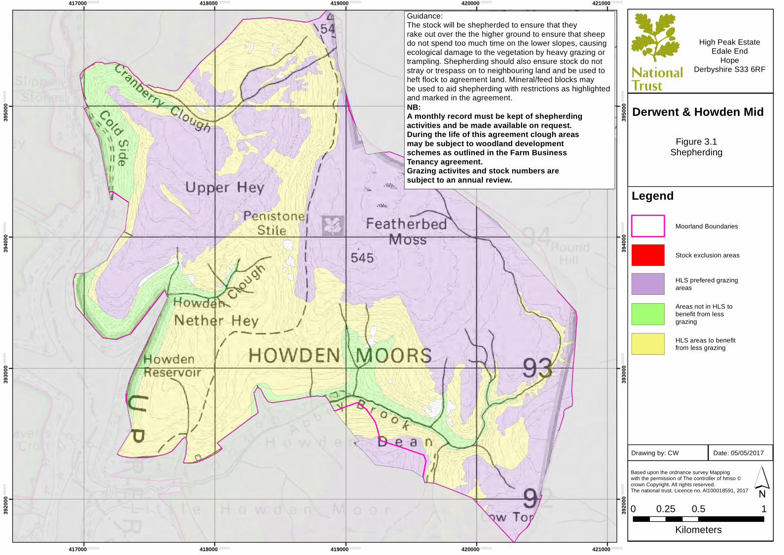
417000 .000000 417000 .000000 418000 .000000 418000 .000000 419000 .000000 419000 .000000 420000 .000000 420000 .000000 421000 .000000 421000 .000000 392000 .000000 392000 .000000 393000 .000000 393000 .000000 394000 .000000 394000 .000000 395000 .000000 395000 .000000 Legend Moorland Boundaries Stock exclusion areas HLS prefered grazing areas Areas not in HLS to benefit from less grazing HLS areas to benefit from less grazing Based upon the ordnance survey Mapping with the permission of The controller of hmso © crown Copyright. All rights reserved. The national trust. Licence no. Al100018591, 2017 0 0.5 1 0.25 Kilometers ´ High Peak Estate Edale End Hope Derbyshire S33 6RF Figure 3.1 Shepherding Date: 05/05/2017 Drawing by: CW Derwent & Howden Mid Guidance: The stock will be shepherded to ensure that they rake out over the the higher ground to ensure that sheep do not spend too much time on the lower slopes, causing ecological damage to the vegetation by heavy grazing or trampling. Shepherding should also ensure stock do not stray or trespass on to neighbouring land and be used to heft flock to agreement land. Mineral/feed blocks may be used to aid shepherding with restrictions as highlighted and marked in the agreement. NB: A monthly record must be kept of shepherding activities and be made available on request. During the life of this agreement clough areas may be subject to woodland development schemes as outlined in the Farm Business Tenancy agreement. Grazing activites and stock numbers are subject to an annual review.
Transcript of Derwent & Howden Mid Legend - Natural England
417000.000000
417000.000000
418000.000000
418000.000000
419000.000000
419000.000000
420000.000000
420000.000000
421000.000000
421000.000000
3920
00.00
0000
3920
00.00
0000
3930
00.00
0000
3930
00.00
0000
3940
00.00
0000
3940
00.00
0000
3950
00.00
0000
3950
00.00
0000
Legend
Moorland Boundaries
Stock exclusion areas
HLS prefered grazingareas
Areas not in HLS tobenefit from lessgrazing
HLS areas to benefitfrom less grazing
Based upon the ordnance survey Mapping with the permission of The controller of hmso ©crown Copyright. All rights reserved. The national trust. Licence no. Al100018591, 2017
0 0.5 10.25Kilometers
´
High Peak EstateEdale End
HopeDerbyshire S33 6RF
Figure 3.1Shepherding
Date: 05/05/2017Drawing by: CW
Derwent & Howden Mid
Guidance:The stock will be shepherded to ensure that theyrake out over the the higher ground to ensure that sheepdo not spend too much time on the lower slopes, causingecological damage to the vegetation by heavy grazing ortrampling. Shepherding should also ensure stock do not stray or trespass on to neighbouring land and be used to heft flock to agreement land. Mineral/feed blocks may be used to aid shepherding with restrictions as highlighted and marked in the agreement.NB: A monthly record must be kept of shepherding activities and be made available on request.During the life of this agreement clough areasmay be subject to woodland development schemes as outlined in the Farm Business Tenancy agreement.Grazing activites and stock numbers are subject to an annual review.
414000.000000
414000.000000
415000.000000
415000.000000
416000.000000
416000.000000
417000.000000
417000.000000
418000.000000
418000.000000
3950
00.00
0000
3950
00.00
0000
3960
00.00
0000
3960
00.00
0000
3970
00.00
0000
3970
00.00
0000
3980
00.00
0000
3980
00.00
0000
3990
00.00
0000
3990
00.00
0000
Legend
Moorland Boundaries
Stock exclusion areas
HLS prefered grazingareas
Areas not in HLS tobenefit from lessgrazing
HLS areas to benefitfrom less grazing
Based upon the ordnance survey Mapping with the permission of The controller of hmso ©crown Copyright. All rights reserved. The national trust. Licence no. Al100018591, 2017
0 0.5 10.25Kilometers
´
High Peak EstateEdale End
HopeDerbyshire S33 6RF
Figure 3.1Shepherding
Date: 05/05/2017Drawing by: CW
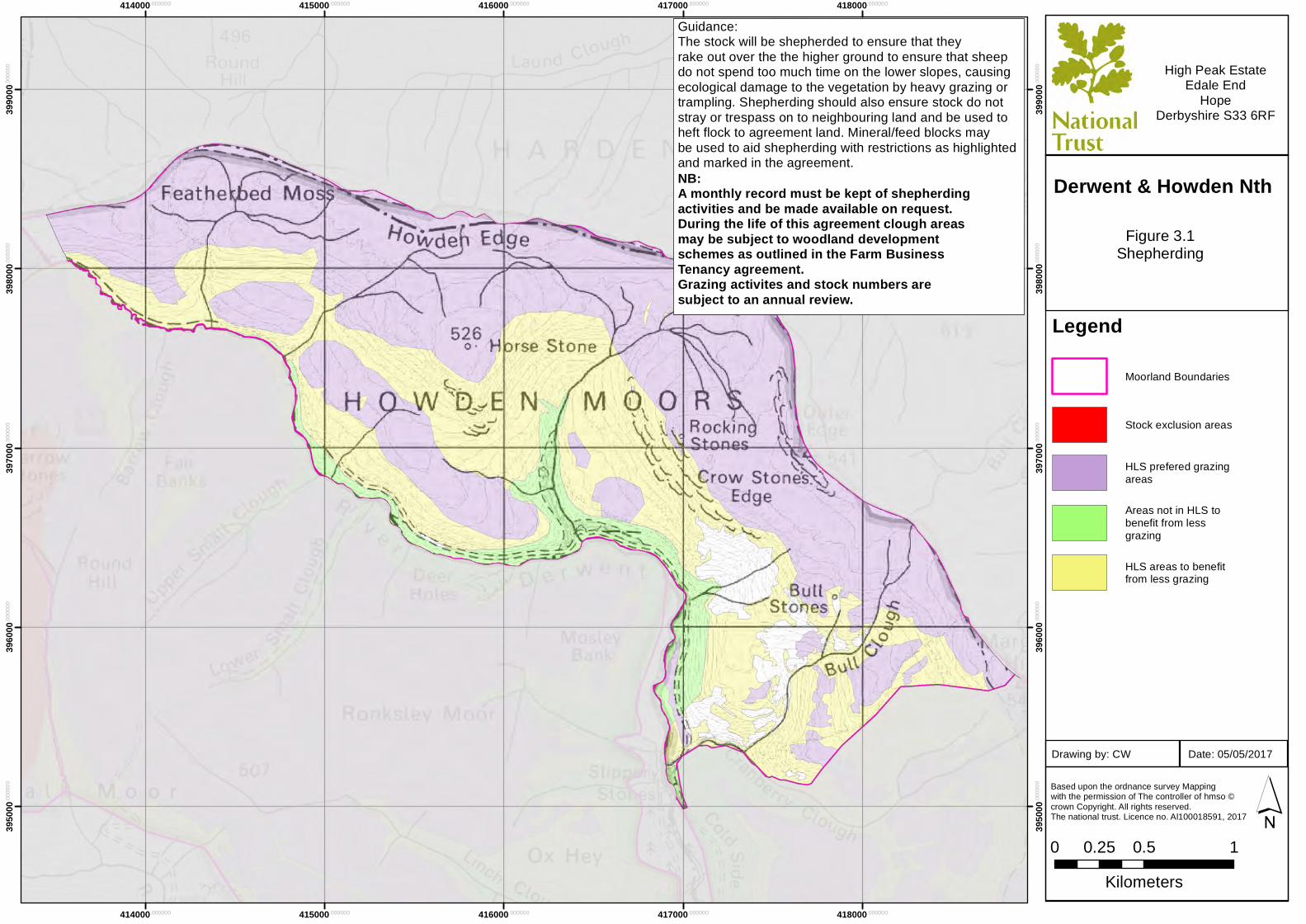
Derwent & Howden Nth
Guidance:The stock will be shepherded to ensure that theyrake out over the the higher ground to ensure that sheepdo not spend too much time on the lower slopes, causingecological damage to the vegetation by heavy grazing ortrampling. Shepherding should also ensure stock do not stray or trespass on to neighbouring land and be used to heft flock to agreement land. Mineral/feed blocks may be used to aid shepherding with restrictions as highlighted and marked in the agreement.NB: A monthly record must be kept of shepherding activities and be made available on request.During the life of this agreement clough areasmay be subject to woodland development schemes as outlined in the Farm Business Tenancy agreement.Grazing activites and stock numbers are subject to an annual review.
417000.000000
417000.000000
418000.000000
418000.000000
419000.000000
419000.000000
420000.000000
420000.000000
421000.000000
421000.000000
3890
00.00
0000
3890
00.00
0000
3900
00.00
0000
3900
00.00
0000
3910
00.00
0000
3910
00.00
0000
3920
00.00
0000
3920
00.00
0000
Legend
Moorland Boundaries
Stock exclusion areas
HLS prefered grazingareas
Areas not in HLS tobenefit from lessgrazing
HLS areas to benefitfrom less grazing
Based upon the ordnance survey Mapping with the permission of The controller of hmso ©crown Copyright. All rights reserved. The national trust. Licence no. Al100018591, 2017
0 0.5 10.25Kilometers
´
High Peak EstateEdale End
HopeDerbyshire S33 6RF
Figure 3.1Shepherding
Date: 05/05/2017Drawing by: CW
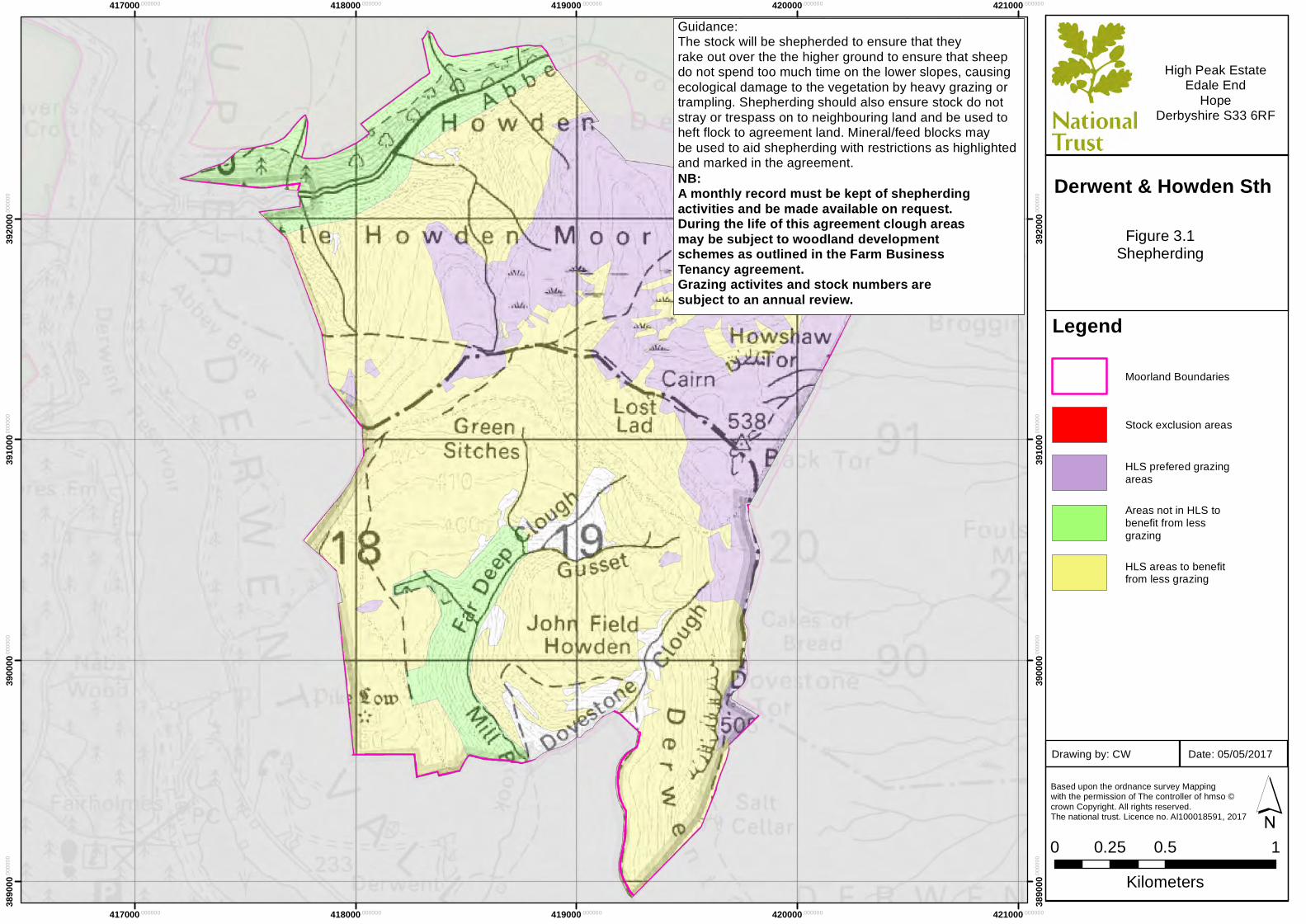
Derwent & Howden Sth
Guidance:The stock will be shepherded to ensure that theyrake out over the the higher ground to ensure that sheepdo not spend too much time on the lower slopes, causingecological damage to the vegetation by heavy grazing ortrampling. Shepherding should also ensure stock do not stray or trespass on to neighbouring land and be used to heft flock to agreement land. Mineral/feed blocks may be used to aid shepherding with restrictions as highlighted and marked in the agreement.NB: A monthly record must be kept of shepherding activities and be made available on request.During the life of this agreement clough areasmay be subject to woodland development schemes as outlined in the Farm Business Tenancy agreement.Grazing activites and stock numbers are subject to an annual review.
417000.000000
417000.000000
418000.000000
418000.000000
419000.000000
419000.000000
420000.000000
420000.000000
421000.000000
421000.000000
3920
00.00
0000
3920
00.00
0000
3930
00.00
0000
3930
00.00
0000
3940
00.00
0000
3940
00.00
0000
3950
00.00
0000
3950
00.00
0000
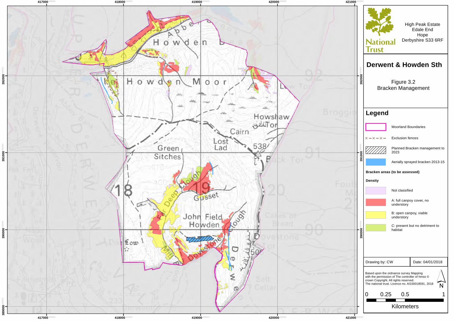
LegendMoorland Boundaries
[ [ [ Exclusion fences
Planned Bracken management to2023
Aerially sprayed bracken 2013-15
Bracken areas (to be assessed)
Density
Not classified
A: full canpoy cover, nounderstory
B: open canpoy, viableunderstory
C: present but no detriment tohabitat
Based upon the ordnance survey Mapping with the permission of The controller of hmso ©crown Copyright. All rights reserved. The national trust. Licence no. Al100018591, 2018
0 0.5 10.25Kilometers
´
High Peak EstateEdale End
HopeDerbyshire S33 6RF
Figure 3.2Bracken Management
Date: 04/01/2018Drawing by: CW
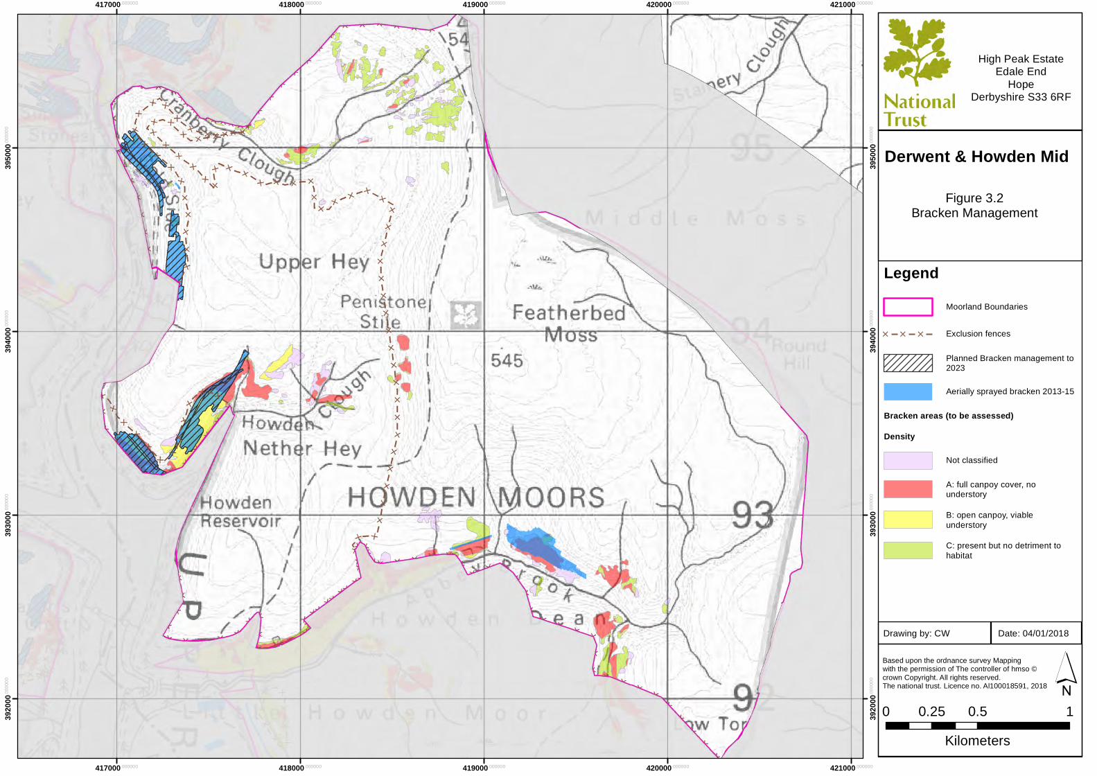
Derwent & Howden Mid
414000.000000
414000.000000
415000.000000
415000.000000
416000.000000
416000.000000
417000.000000
417000.000000
418000.000000
418000.000000
3950
00.00
0000
3950
00.00
0000
3960
00.00
0000
3960
00.00
0000
3970
00.00
0000
3970
00.00
0000
3980
00.00
0000
3980
00.00
0000
3990
00.00
0000
3990
00.00
0000
LegendMoorland Boundaries
[ [ [ Exclusion fences
Planned Bracken management to2023
Aerially sprayed bracken 2013-15
Bracken areas (to be assessed)
Density
Not classified
A: full canpoy cover, nounderstory
B: open canpoy, viableunderstory
C: present but no detriment tohabitat
Based upon the ordnance survey Mapping with the permission of The controller of hmso ©crown Copyright. All rights reserved. The national trust. Licence no. Al100018591, 2018
0 0.5 10.25Kilometers
´
High Peak EstateEdale End
HopeDerbyshire S33 6RF
Figure 3.2Bracken Management
Date: 04/01/2018Drawing by: CW
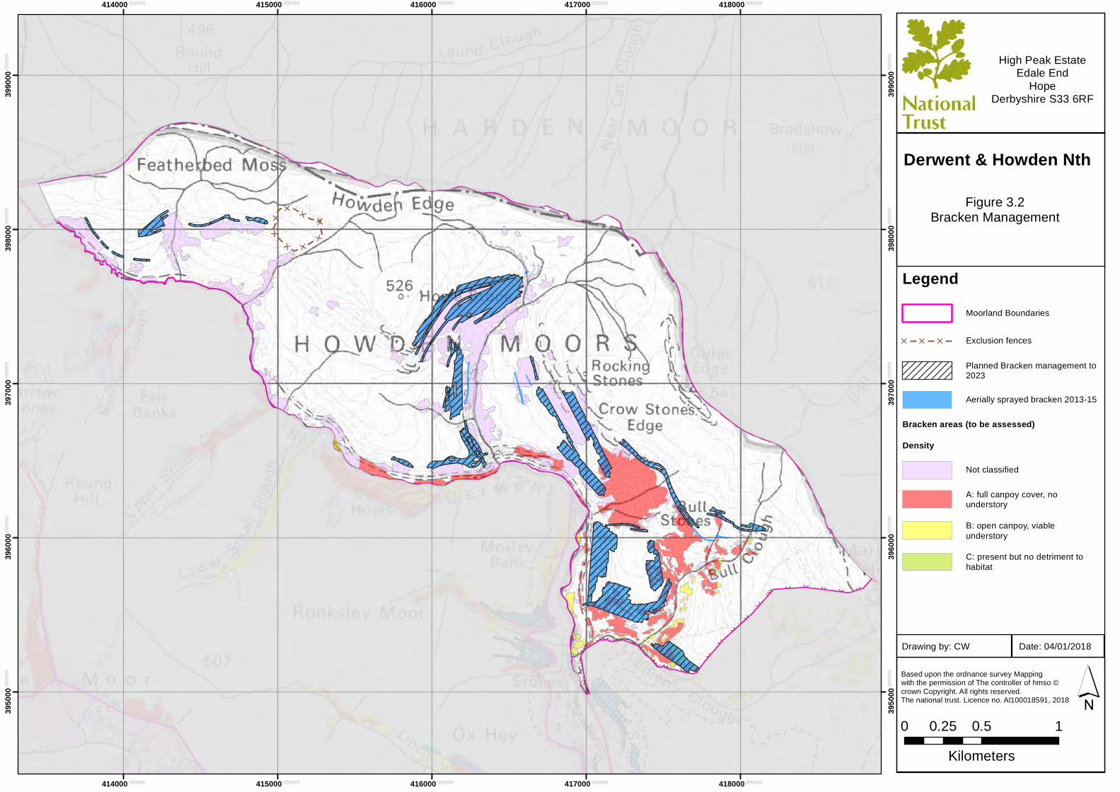
Derwent & Howden Nth
417000.000000
417000.000000
418000.000000
418000.000000
419000.000000
419000.000000
420000.000000
420000.000000
421000.000000
421000.000000
3890
00.00
0000
3900
00.00
0000
3900
00.00
0000
3910
00.00
0000
3910
00.00
0000
3920
00.00
0000
3920
00.00
0000
LegendMoorland Boundaries
[ [ [ Exclusion fences
Planned Bracken management to2023
Aerially sprayed bracken 2013-15
Bracken areas (to be assessed)
Density
Not classified
A: full canpoy cover, nounderstory
B: open canpoy, viableunderstory
C: present but no detriment tohabitat
Based upon the ordnance survey Mapping with the permission of The controller of hmso ©crown Copyright. All rights reserved. The national trust. Licence no. Al100018591, 2018
0 0.5 10.25Kilometers
´
High Peak EstateEdale End
HopeDerbyshire S33 6RF
Figure 3.2Bracken Management
Date: 04/01/2018Drawing by: CW
Derwent & Howden Sth
417000.000000
417000.000000
418000.000000
418000.000000
419000.000000
419000.000000
420000.000000
420000.000000
421000.000000
421000.000000
3920
00.00
0000
3920
00.00
0000
3930
00.00
0000
3930
00.00
0000
3940
00.00
0000
3940
00.00
0000
3950
00.00
0000
3950
00.00
0000
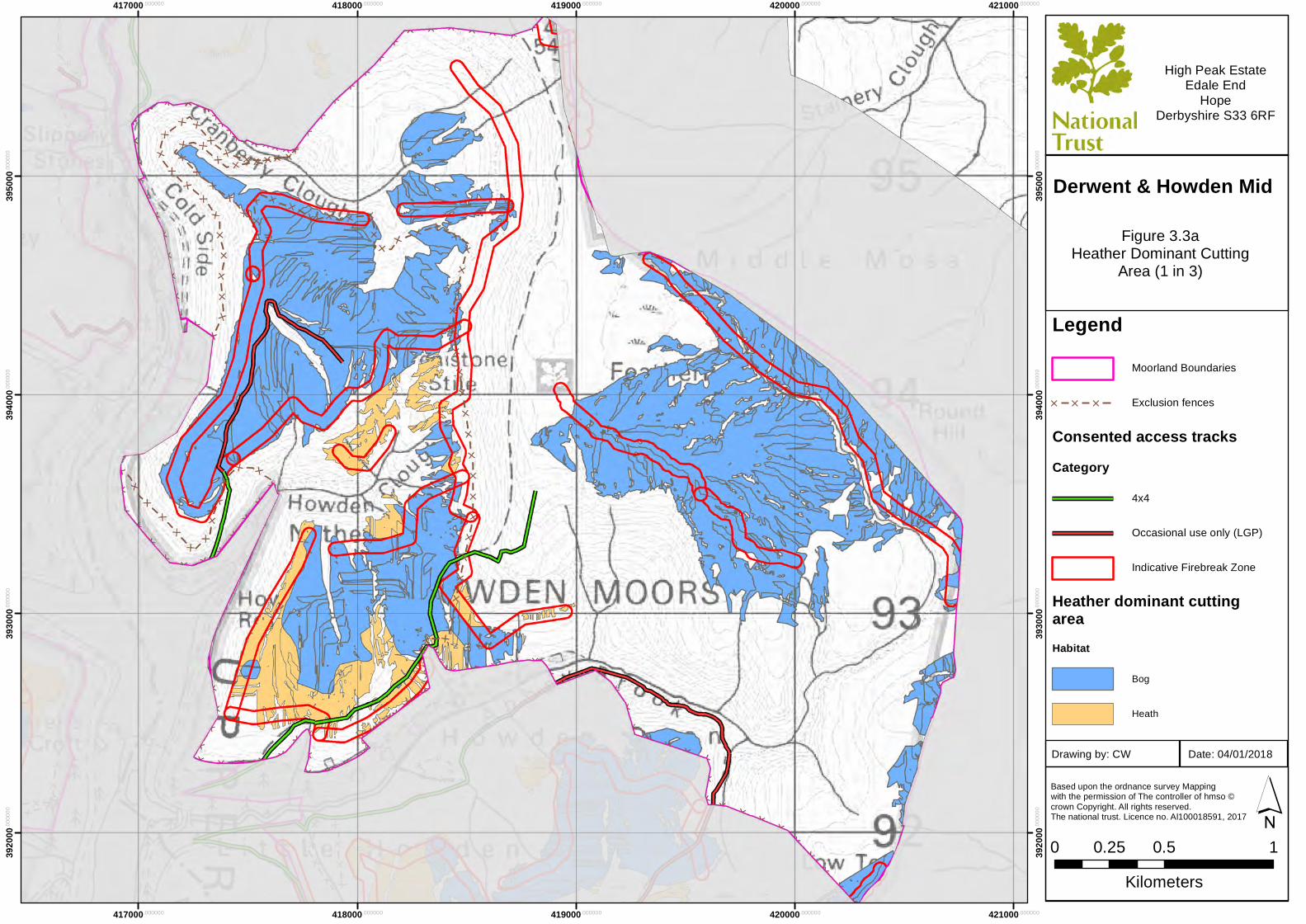
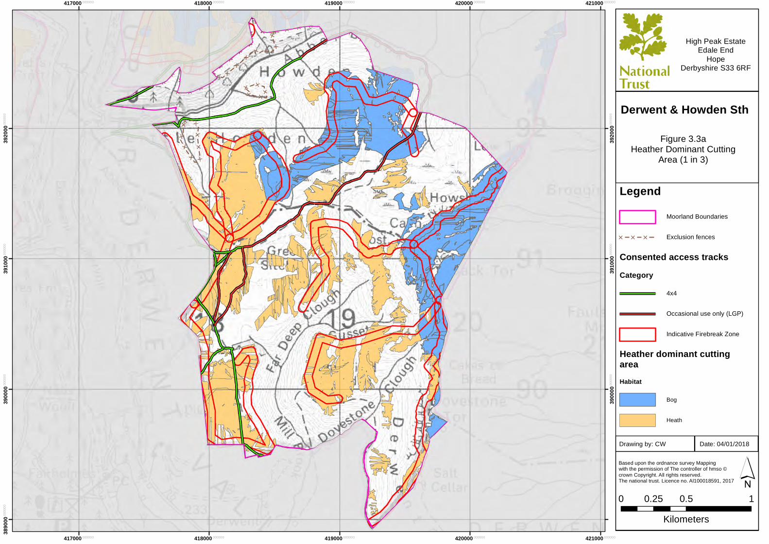
LegendMoorland Boundaries
[ [ [ Exclusion fences
Consented access tracksCategory
4x4
Occasional use only (LGP)
Indicative Firebreak Zone
Heather dominant cuttingareaHabitat
Bog
Heath
Based upon the ordnance survey Mapping with the permission of The controller of hmso ©crown Copyright. All rights reserved. The national trust. Licence no. Al100018591, 2017
0 0.5 10.25Kilometers
´
High Peak EstateEdale End
HopeDerbyshire S33 6RF
Figure 3.3aHeather Dominant Cutting
Area (1 in 3)
Date: 04/01/2018Drawing by: CW
Derwent & Howden Mid
414000.000000
414000.000000
415000.000000
415000.000000
416000.000000
416000.000000
417000.000000
417000.000000
418000.000000
418000.000000
3950
00.00
0000
3950
00.00
0000
3960
00.00
0000
3960
00.00
0000
3970
00.00
0000
3970
00.00
0000
3980
00.00
0000
3980
00.00
0000
3990
00.00
0000
3990
00.00
0000
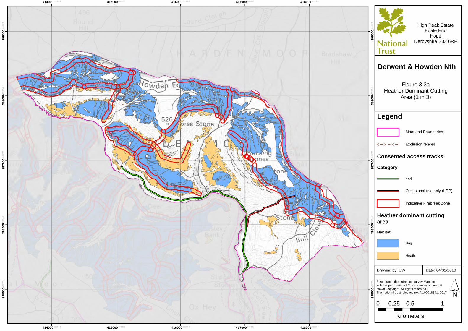
LegendMoorland Boundaries
[ [ [ Exclusion fences
Consented access tracksCategory
4x4
Occasional use only (LGP)
Indicative Firebreak Zone
Heather dominant cuttingareaHabitat
Bog
Heath
Based upon the ordnance survey Mapping with the permission of The controller of hmso ©crown Copyright. All rights reserved. The national trust. Licence no. Al100018591, 2017
0 0.5 10.25Kilometers
´
High Peak EstateEdale End
HopeDerbyshire S33 6RF
Figure 3.3aHeather Dominant Cutting
Area (1 in 3)
Date: 04/01/2018Drawing by: CW
Derwent & Howden Nth
417000.000000
417000.000000
418000.000000
418000.000000
419000.000000
419000.000000
420000.000000
420000.000000
421000.000000
421000.000000
3890
00.00
0000
3900
00.00
0000
3900
00.00
0000
3910
00.00
0000
3910
00.00
0000
3920
00.00
0000
3920
00.00
0000
LegendMoorland Boundaries
[ [ [ Exclusion fences
Consented access tracksCategory
4x4
Occasional use only (LGP)
Indicative Firebreak Zone
Heather dominant cuttingareaHabitat
Bog
Heath
Based upon the ordnance survey Mapping with the permission of The controller of hmso ©crown Copyright. All rights reserved. The national trust. Licence no. Al100018591, 2017
0 0.5 10.25Kilometers
´
High Peak EstateEdale End
HopeDerbyshire S33 6RF
Figure 3.3aHeather Dominant Cutting
Area (1 in 3)
Date: 04/01/2018Drawing by: CW
Derwent & Howden Sth
417000.000000
417000.000000
418000.000000
418000.000000
419000.000000
419000.000000
420000.000000
420000.000000
421000.000000
421000.000000
3920
00.00
0000
3920
00.00
0000
3930
00.00
0000
3930
00.00
0000
3940
00.00
0000
3940
00.00
0000
3950
00.00
0000
3950
00.00
0000
LegendMoorland Boundaries
[ [ [ Exclusion fence
HLS2013 burnconsent for heath
HLS2013 Consented AccessTracksCategory
4x4
Low Ground Pressure(Occasional Use Only)
ShootingButts
Based upon the ordnance survey Mapping with the permission of The controller of hmso ©crown Copyright. All rights reserved. The national trust. Licence no. Al100018591, 2018
0 0.5 10.25Kilometers
´
High Peak EstateEdale End
HopeDerbyshire S33 6RF
Figure 3.3bArea of Heath (to 1 in 2) in the 12 year burning
rotation
Date: 16/01/2018Drawing by: CW
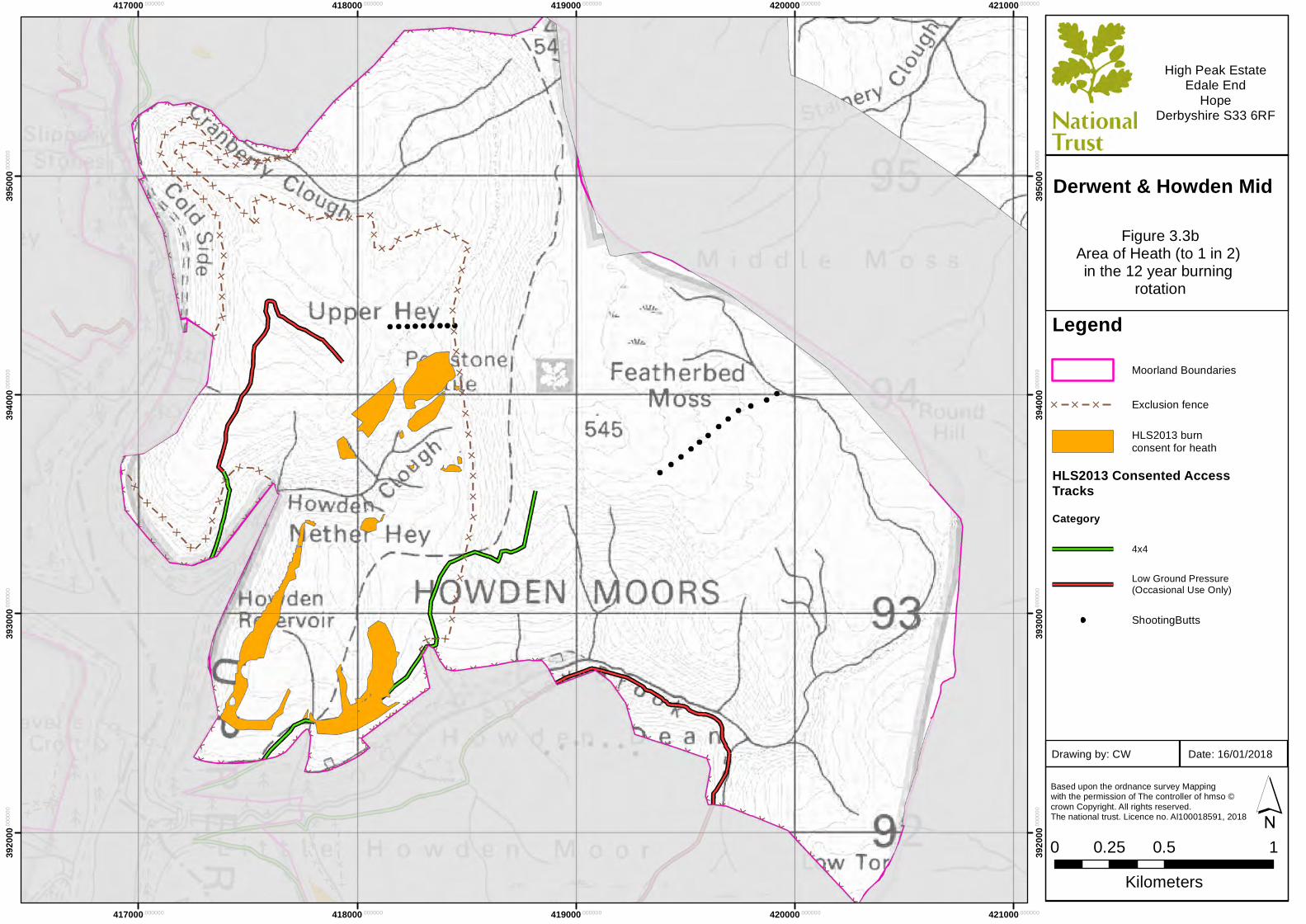
Derwent & Howden Mid
414000.000000
414000.000000
415000.000000
415000.000000
416000.000000
416000.000000
417000.000000
417000.000000
418000.000000
418000.000000
3950
00.00
0000
3950
00.00
0000
3960
00.00
0000
3960
00.00
0000
3970
00.00
0000
3970
00.00
0000
3980
00.00
0000
3980
00.00
0000
3990
00.00
0000
3990
00.00
0000
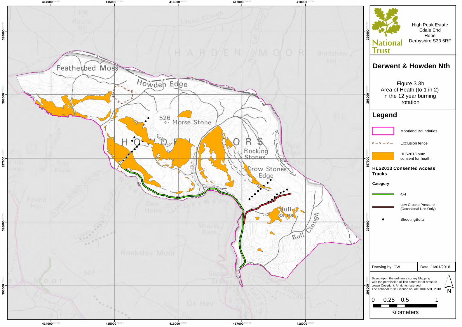
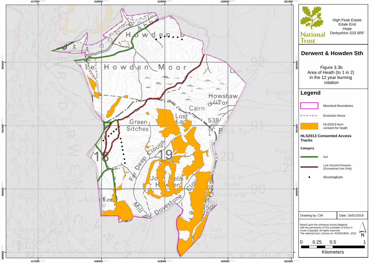
LegendMoorland Boundaries
[ [ [ Exclusion fence
HLS2013 burnconsent for heath
HLS2013 Consented AccessTracksCategory
4x4
Low Ground Pressure(Occasional Use Only)
ShootingButts
Based upon the ordnance survey Mapping with the permission of The controller of hmso ©crown Copyright. All rights reserved. The national trust. Licence no. Al100018591, 2018
0 0.5 10.25Kilometers
´
High Peak EstateEdale End
HopeDerbyshire S33 6RF
Figure 3.3bArea of Heath (to 1 in 2) in the 12 year burning
rotation
Date: 16/01/2018Drawing by: CW
Derwent & Howden Nth
417000.000000
417000.000000
418000.000000
418000.000000
419000.000000
419000.000000
420000.000000
420000.000000
421000.000000
421000.000000
3890
00.00
0000
3900
00.00
0000
3900
00.00
0000
3910
00.00
0000
3910
00.00
0000
3920
00.00
0000
3920
00.00
0000
LegendMoorland Boundaries
[ [ [ Exclusion fence
HLS2013 burnconsent for heath
HLS2013 Consented AccessTracksCategory
4x4
Low Ground Pressure(Occasional Use Only)
ShootingButts
Based upon the ordnance survey Mapping with the permission of The controller of hmso ©crown Copyright. All rights reserved. The national trust. Licence no. Al100018591, 2018
0 0.5 10.25Kilometers
´
High Peak EstateEdale End
HopeDerbyshire S33 6RF
Figure 3.3bArea of Heath (to 1 in 2) in the 12 year burning
rotation
Date: 16/01/2018Drawing by: CW
Derwent & Howden Sth
417000.000000
417000.000000
418000.000000
418000.000000
419000.000000
419000.000000
420000.000000
420000.000000
421000.000000
421000.000000
3920
00.00
0000
3920
00.00
0000
3930
00.00
0000
3930
00.00
0000
3940
00.00
0000
3940
00.00
0000
3950
00.00
0000
3950
00.00
0000
LegendMoorland Boundaries
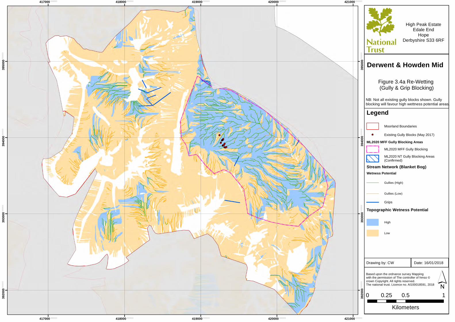
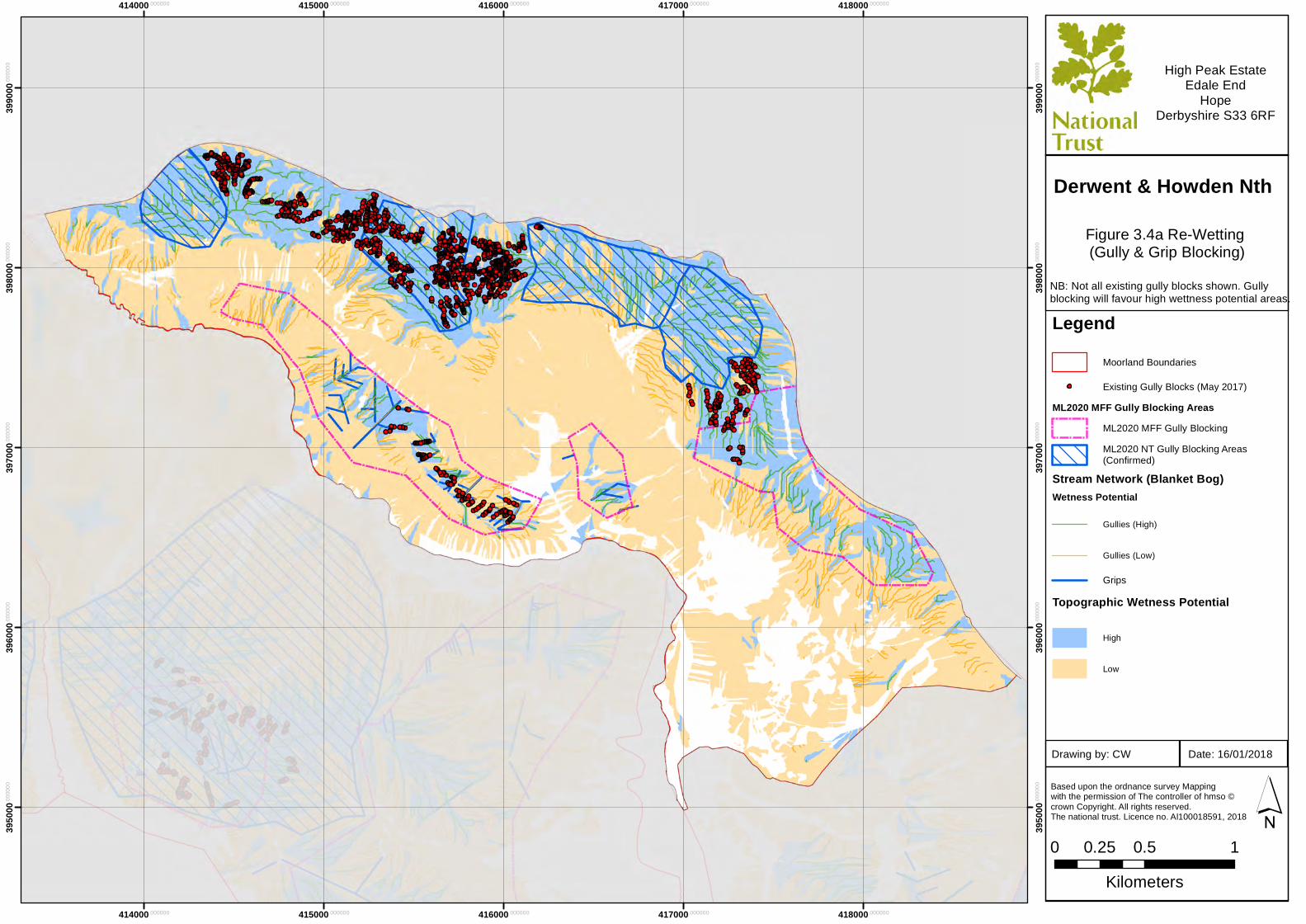
Existing Gully Blocks (May 2017)ML2020 MFF Gully Blocking Areas
ML2020 MFF Gully BlockingML2020 NT Gully Blocking Areas(Confirmed)
Stream Network (Blanket Bog)Wetness Potential
Gullies (High)
Gullies (Low)
GripsTopographic Wetness Potential
High
Low
Based upon the ordnance survey Mapping with the permission of The controller of hmso ©crown Copyright. All rights reserved. The national trust. Licence no. Al100018591, 2018
0 0.5 10.25Kilometers
´
High Peak EstateEdale End
HopeDerbyshire S33 6RF
Figure 3.4a Re-Wetting (Gully & Grip Blocking)
Date: 16/01/2018Drawing by: CW
Derwent & Howden Mid
NB: Not all existing gully blocks shown. Gullyblocking will favour high wettness potential areas.
414000.000000
414000.000000
415000.000000
415000.000000
416000.000000
416000.000000
417000.000000
417000.000000
418000.000000
418000.000000
3950
00.00
0000
3950
00.00
0000
3960
00.00
0000
3960
00.00
0000
3970
00.00
0000
3970
00.00
0000
3980
00.00
0000
3980
00.00
0000
3990
00.00
0000
3990
00.00
0000
LegendMoorland Boundaries
Existing Gully Blocks (May 2017)ML2020 MFF Gully Blocking Areas
ML2020 MFF Gully BlockingML2020 NT Gully Blocking Areas(Confirmed)
Stream Network (Blanket Bog)Wetness Potential
Gullies (High)
Gullies (Low)
GripsTopographic Wetness Potential
High
Low
Based upon the ordnance survey Mapping with the permission of The controller of hmso ©crown Copyright. All rights reserved. The national trust. Licence no. Al100018591, 2018
0 0.5 10.25Kilometers
´
High Peak EstateEdale End
HopeDerbyshire S33 6RF
Figure 3.4a Re-Wetting (Gully & Grip Blocking)
Date: 16/01/2018Drawing by: CW
Derwent & Howden Nth
NB: Not all existing gully blocks shown. Gullyblocking will favour high wettness potential areas.
417000.000000
417000.000000
418000.000000
418000.000000
419000.000000
419000.000000
420000.000000
420000.000000
421000.000000
421000.000000
3890
00.00
0000
3900
00.00
0000
3900
00.00
0000
3910
00.00
0000
3910
00.00
0000
3920
00.00
0000
3920
00.00
0000
LegendMoorland Boundaries
Existing Gully Blocks (May 2017)ML2020 MFF Gully Blocking Areas
ML2020 MFF Gully BlockingML2020 NT Gully Blocking Areas(Confirmed)
Stream Network (Blanket Bog)Wetness Potential
Gullies (High)
Gullies (Low)
GripsTopographic Wetness Potential
High
Low
Based upon the ordnance survey Mapping with the permission of The controller of hmso ©crown Copyright. All rights reserved. The national trust. Licence no. Al100018591, 2018
0 0.5 10.25Kilometers
´
High Peak EstateEdale End
HopeDerbyshire S33 6RF
Figure 3.4a Re-Wetting (Gully & Grip Blocking)
Date: 16/01/2018Drawing by: CW
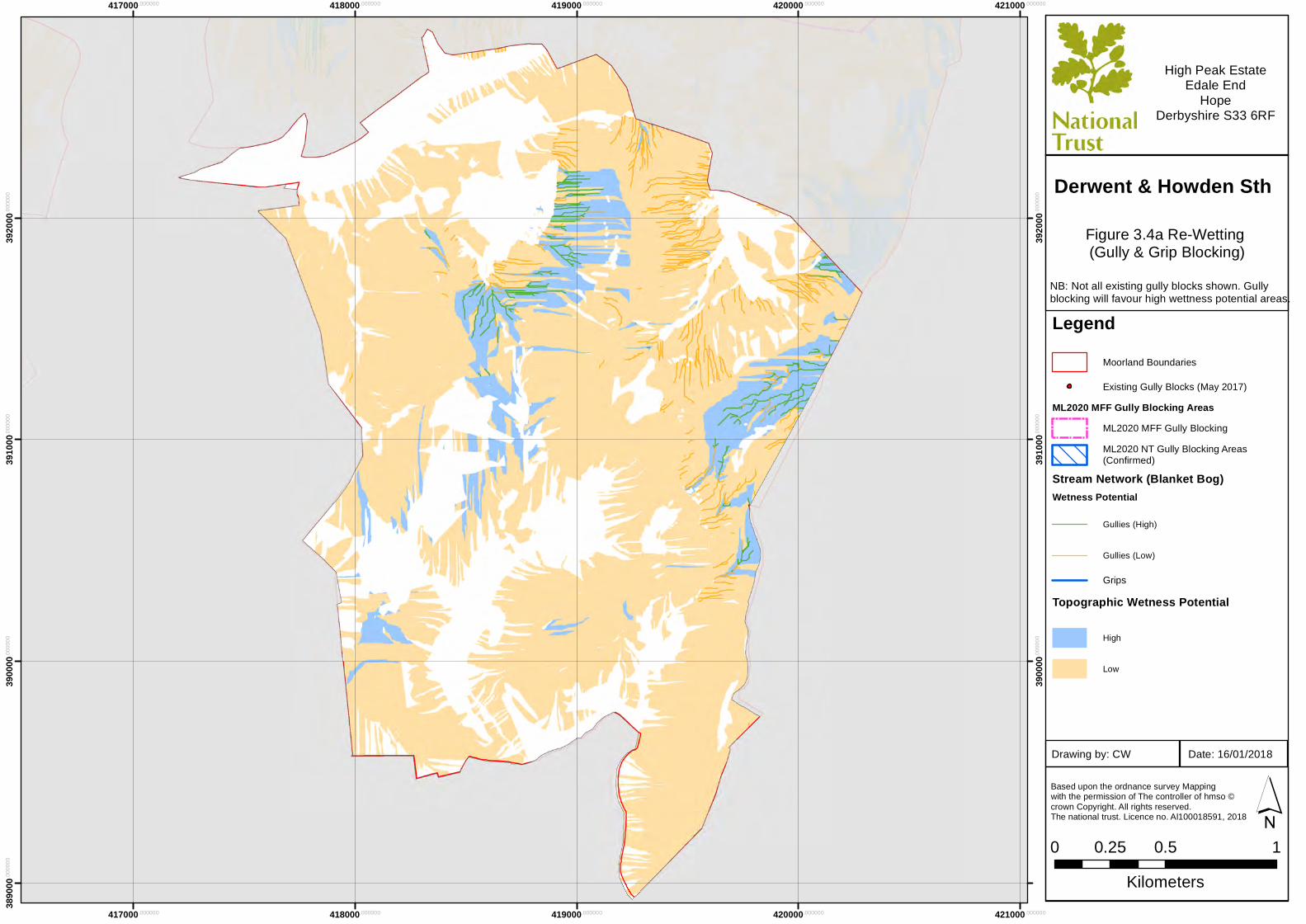
Derwent & Howden Sth
NB: Not all existing gully blocks shown. Gullyblocking will favour high wettness potential areas.
417000.000000
417000.000000
418000.000000
418000.000000
419000.000000
419000.000000
420000.000000
420000.000000
421000.000000
421000.000000
3920
00.00
0000
3920
00.00
0000
3930
00.00
0000
3930
00.00
0000
3940
00.00
0000
3940
00.00
0000
3950
00.00
0000
3950
00.00
0000
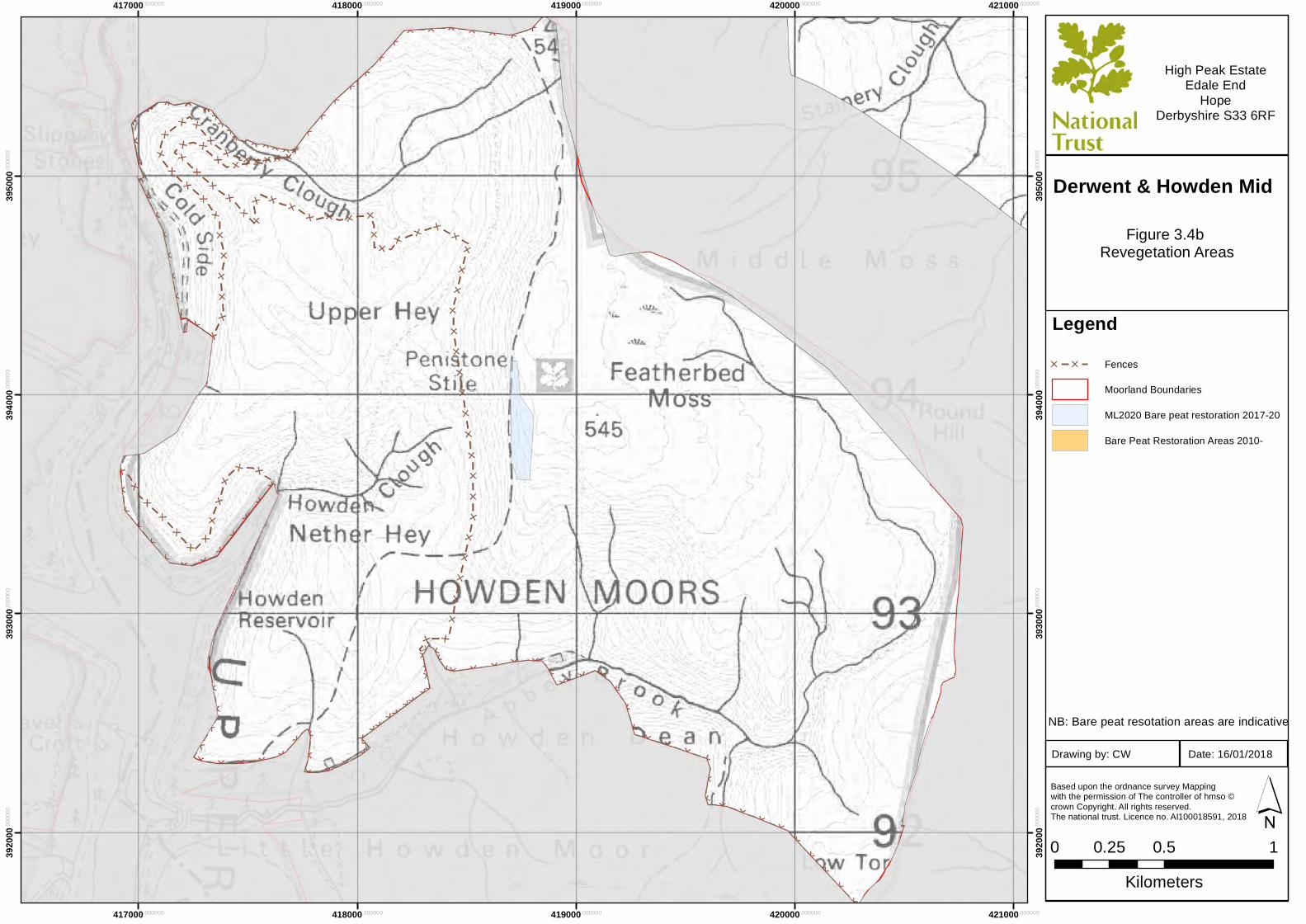
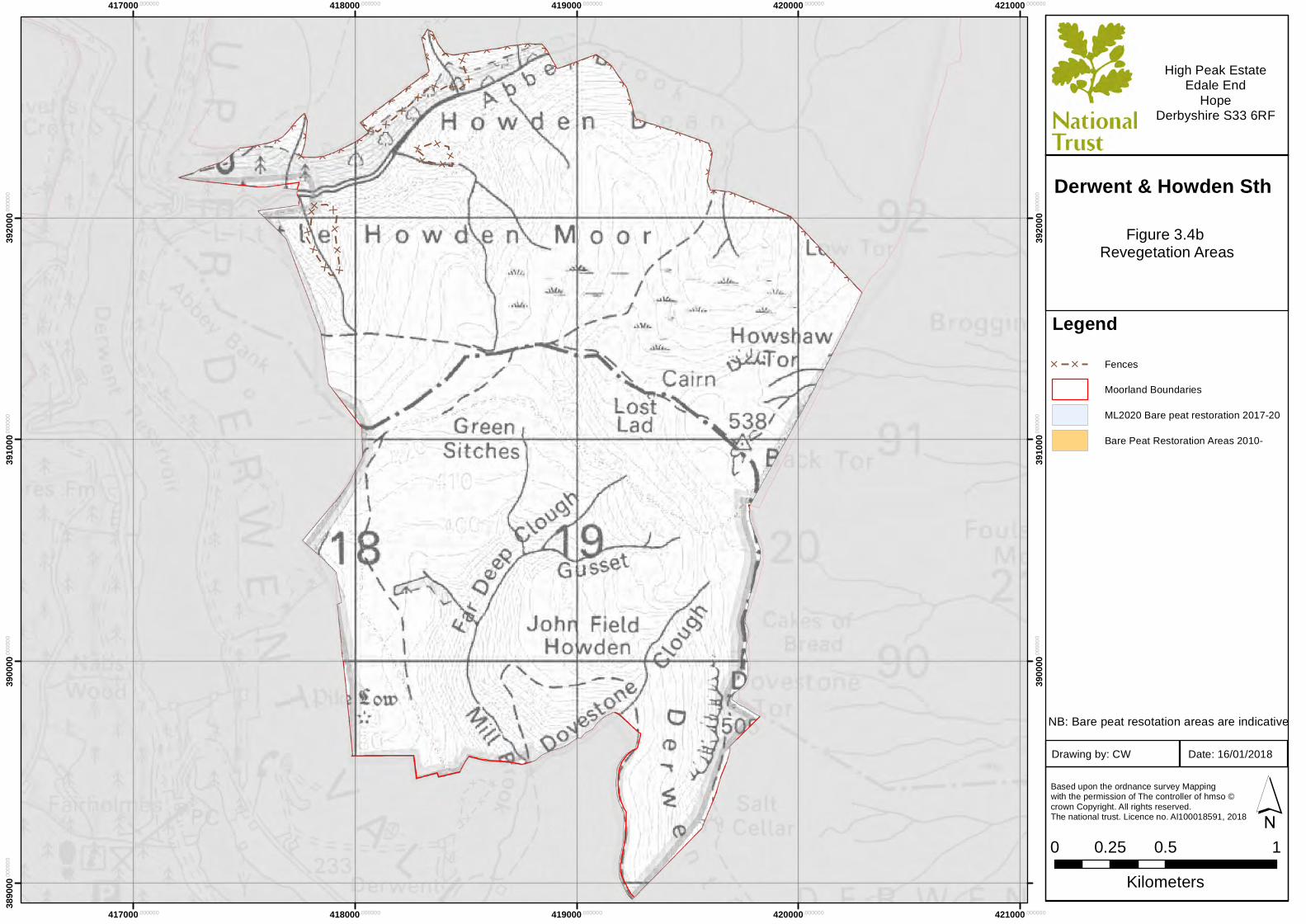
Legend[ [ Fences
Moorland Boundaries
ML2020 Bare peat restoration 2017-20
Bare Peat Restoration Areas 2010-
Based upon the ordnance survey Mapping with the permission of The controller of hmso ©crown Copyright. All rights reserved. The national trust. Licence no. Al100018591, 2018
0 0.5 10.25Kilometers
´
High Peak EstateEdale End
HopeDerbyshire S33 6RF
Figure 3.4b Revegetation Areas
Date: 16/01/2018Drawing by: CW
Derwent & Howden Mid
NB: Bare peat resotation areas are indicative
414000.000000
414000.000000
415000.000000
415000.000000
416000.000000
416000.000000
417000.000000
417000.000000
418000.000000
418000.000000
3950
00.00
0000
3950
00.00
0000
3960
00.00
0000
3960
00.00
0000
3970
00.00
0000
3970
00.00
0000
3980
00.00
0000
3980
00.00
0000
3990
00.00
0000
3990
00.00
0000
Legend[ [ Fences
Moorland Boundaries
ML2020 Bare peat restoration 2017-20
Bare Peat Restoration Areas 2010-
Based upon the ordnance survey Mapping with the permission of The controller of hmso ©crown Copyright. All rights reserved. The national trust. Licence no. Al100018591, 2018
0 0.5 10.25Kilometers
´
High Peak EstateEdale End
HopeDerbyshire S33 6RF
Figure 3.4b Revegetation Areas
Date: 16/01/2018Drawing by: CW
Derwent & Howden Nth
NB: Bare peat resotation areas are indicative
417000.000000
417000.000000
418000.000000
418000.000000
419000.000000
419000.000000
420000.000000
420000.000000
421000.000000
421000.000000
3890
00.00
0000
3900
00.00
0000
3900
00.00
0000
3910
00.00
0000
3910
00.00
0000
3920
00.00
0000
3920
00.00
0000
Legend[ [ Fences
Moorland Boundaries
ML2020 Bare peat restoration 2017-20
Bare Peat Restoration Areas 2010-
Based upon the ordnance survey Mapping with the permission of The controller of hmso ©crown Copyright. All rights reserved. The national trust. Licence no. Al100018591, 2018
0 0.5 10.25Kilometers
´
High Peak EstateEdale End
HopeDerbyshire S33 6RF
Figure 3.4b Revegetation Areas
Date: 16/01/2018Drawing by: CW
Derwent & Howden Sth
NB: Bare peat resotation areas are indicative
417000.000000
417000.000000
418000.000000
418000.000000
419000.000000
419000.000000
420000.000000
420000.000000
421000.000000
421000.000000
3920
00.00
0000
3920
00.00
0000
3930
00.00
0000
3930
00.00
0000
3940
00.00
0000
3940
00.00
0000
3950
00.00
0000
3950
00.00
0000
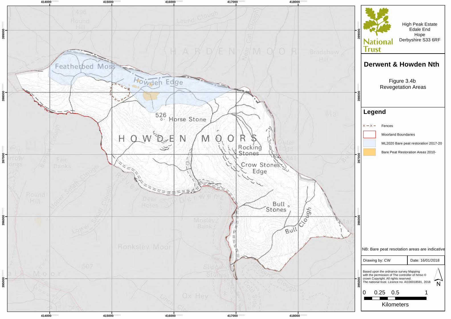
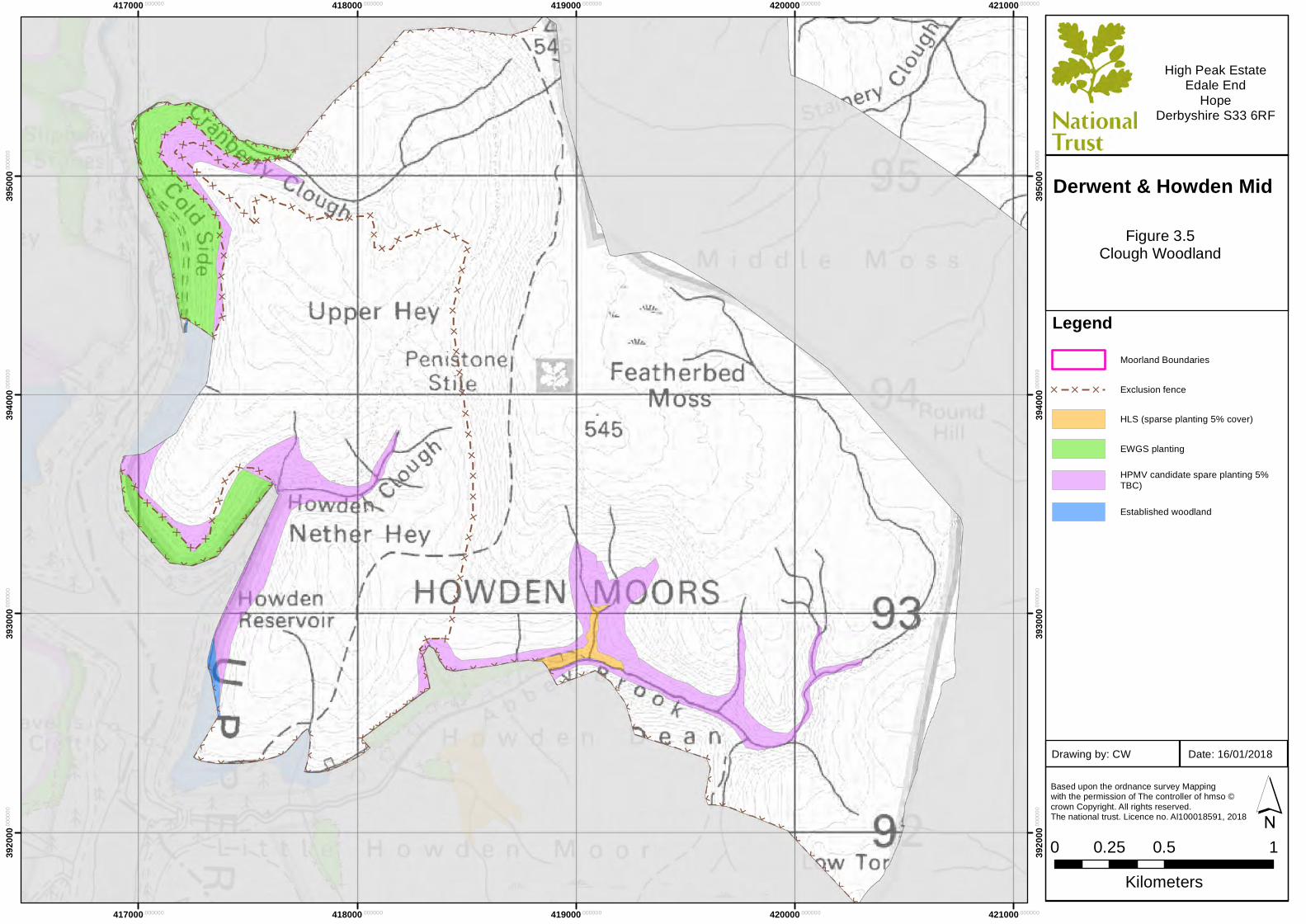
LegendMoorland Boundaries
[ [ [ Exclusion fence
HLS (sparse planting 5% cover)
EWGS planting
HPMV candidate spare planting 5%TBC)
Established woodland
Based upon the ordnance survey Mapping with the permission of The controller of hmso ©crown Copyright. All rights reserved. The national trust. Licence no. Al100018591, 2018
0 0.5 10.25Kilometers
´
High Peak EstateEdale End
HopeDerbyshire S33 6RF
Figure 3.5Clough Woodland
Date: 16/01/2018Drawing by: CW
Derwent & Howden Mid
414000.000000
414000.000000
415000.000000
415000.000000
416000.000000
416000.000000
417000.000000
417000.000000
418000.000000
418000.000000
3950
00.00
0000
3950
00.00
0000
3960
00.00
0000
3960
00.00
0000
3970
00.00
0000
3970
00.00
0000
3980
00.00
0000
3980
00.00
0000
3990
00.00
0000
3990
00.00
0000
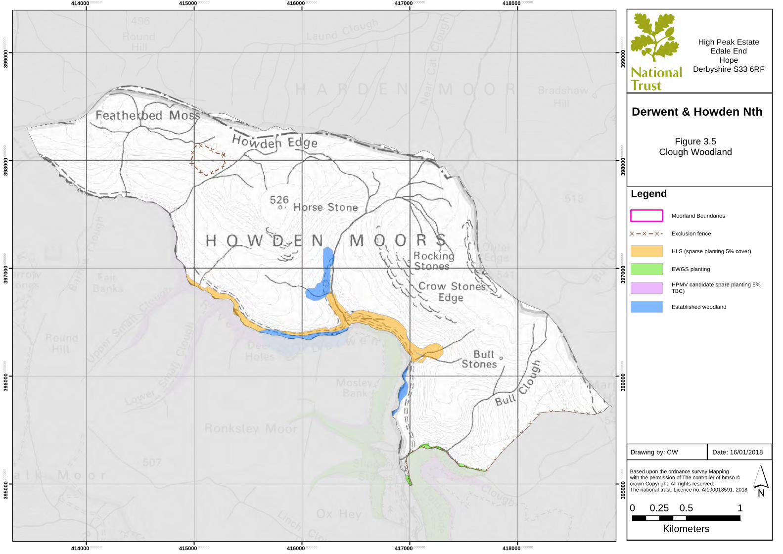
LegendMoorland Boundaries
[ [ [ Exclusion fence
HLS (sparse planting 5% cover)
EWGS planting
HPMV candidate spare planting 5%TBC)
Established woodland
Based upon the ordnance survey Mapping with the permission of The controller of hmso ©crown Copyright. All rights reserved. The national trust. Licence no. Al100018591, 2018
0 0.5 10.25Kilometers
´
High Peak EstateEdale End
HopeDerbyshire S33 6RF
Figure 3.5Clough Woodland
Date: 16/01/2018Drawing by: CW
Derwent & Howden Nth
417000.000000
417000.000000
418000.000000
418000.000000
419000.000000
419000.000000
420000.000000
420000.000000
421000.000000
421000.000000
3890
00.00
0000
3900
00.00
0000
3900
00.00
0000
3910
00.00
0000
3910
00.00
0000
3920
00.00
0000
3920
00.00
0000
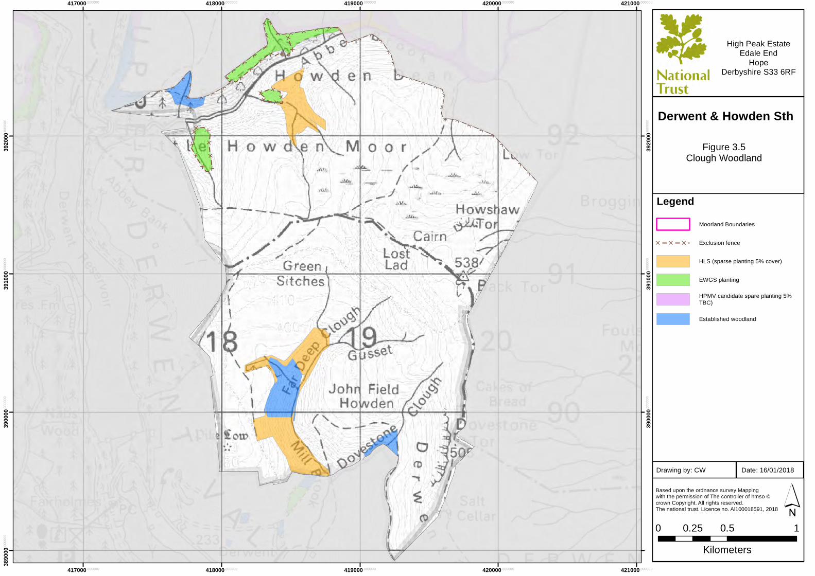
LegendMoorland Boundaries
[ [ [ Exclusion fence
HLS (sparse planting 5% cover)
EWGS planting
HPMV candidate spare planting 5%TBC)
Established woodland
Based upon the ordnance survey Mapping with the permission of The controller of hmso ©crown Copyright. All rights reserved. The national trust. Licence no. Al100018591, 2018
0 0.5 10.25Kilometers
´
High Peak EstateEdale End
HopeDerbyshire S33 6RF
Figure 3.5Clough Woodland
Date: 16/01/2018Drawing by: CW
Derwent & Howden Sth

417000.000000
417000.000000
418000.000000
418000.000000
419000.000000
419000.000000
420000.000000
420000.000000
421000.000000
421000.000000
3920
00.00
0000
3920
00.00
0000
3930
00.00
0000
3930
00.00
0000
3940
00.00
0000
3940
00.00
0000
3950
00.00
0000
3950
00.00
0000
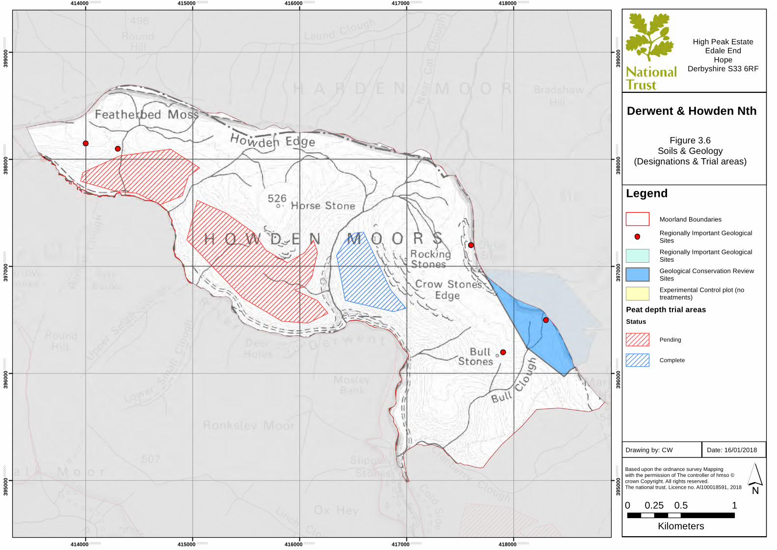
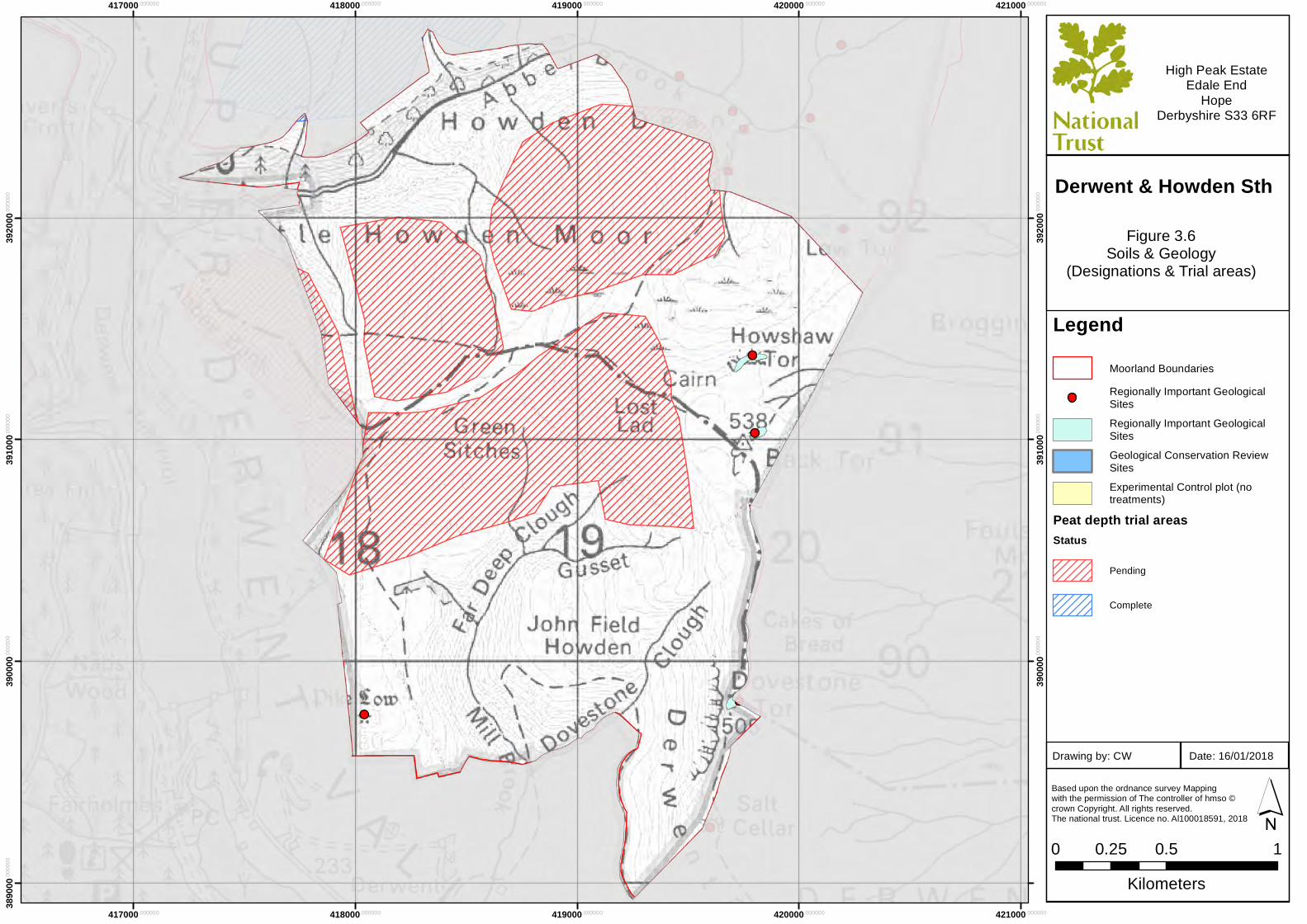
LegendMoorland BoundariesRegionally Important GeologicalSitesRegionally Important GeologicalSitesGeological Conservation ReviewSitesExperimental Control plot (notreatments)
Peat depth trial areasStatus
Pending
Complete
Based upon the ordnance survey Mapping with the permission of The controller of hmso ©crown Copyright. All rights reserved. The national trust. Licence no. Al100018591, 2018
0 0.5 10.25Kilometers
´
High Peak EstateEdale End
HopeDerbyshire S33 6RF
Figure 3.6Soils & Geology
(Designations & Trial areas)
Date: 16/01/2018Drawing by: CW
Derwent & Howden Mid
414000.000000
414000.000000
415000.000000
415000.000000
416000.000000
416000.000000
417000.000000
417000.000000
418000.000000
418000.000000
3950
00.00
0000
3950
00.00
0000
3960
00.00
0000
3960
00.00
0000
3970
00.00
0000
3970
00.00
0000
3980
00.00
0000
3980
00.00
0000
3990
00.00
0000
3990
00.00
0000
LegendMoorland BoundariesRegionally Important GeologicalSitesRegionally Important GeologicalSitesGeological Conservation ReviewSitesExperimental Control plot (notreatments)
Peat depth trial areasStatus
Pending
Complete
Based upon the ordnance survey Mapping with the permission of The controller of hmso ©crown Copyright. All rights reserved. The national trust. Licence no. Al100018591, 2018
0 0.5 10.25Kilometers
´
High Peak EstateEdale End
HopeDerbyshire S33 6RF
Figure 3.6Soils & Geology
(Designations & Trial areas)
Date: 16/01/2018Drawing by: CW
Derwent & Howden Nth
417000.000000
417000.000000
418000.000000
418000.000000
419000.000000
419000.000000
420000.000000
420000.000000
421000.000000
421000.000000
3890
00.00
0000
3900
00.00
0000
3900
00.00
0000
3910
00.00
0000
3910
00.00
0000
3920
00.00
0000
3920
00.00
0000
LegendMoorland BoundariesRegionally Important GeologicalSitesRegionally Important GeologicalSitesGeological Conservation ReviewSitesExperimental Control plot (notreatments)
Peat depth trial areasStatus
Pending
Complete
Based upon the ordnance survey Mapping with the permission of The controller of hmso ©crown Copyright. All rights reserved. The national trust. Licence no. Al100018591, 2018
0 0.5 10.25Kilometers
´
High Peak EstateEdale End
HopeDerbyshire S33 6RF
Figure 3.6Soils & Geology
(Designations & Trial areas)
Date: 16/01/2018Drawing by: CW
Derwent & Howden Sth
417000.000000
417000.000000
418000.000000
418000.000000
419000.000000
419000.000000
420000.000000
420000.000000
421000.000000
421000.000000
3920
00.00
0000
3920
00.00
0000
3930
00.00
0000
3930
00.00
0000
3940
00.00
0000
3940
00.00
0000
3950
00.00
0000
3950
00.00
0000
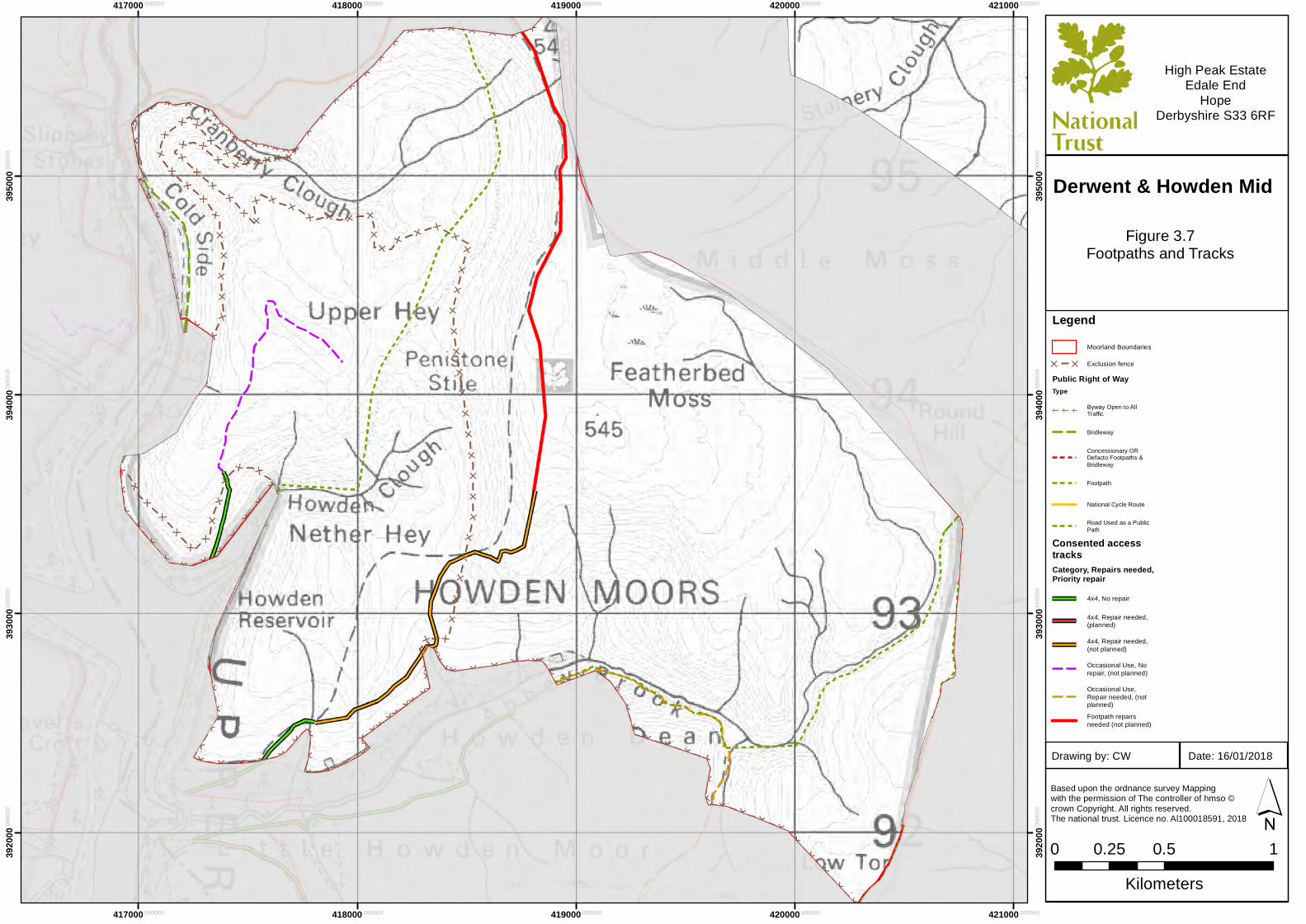
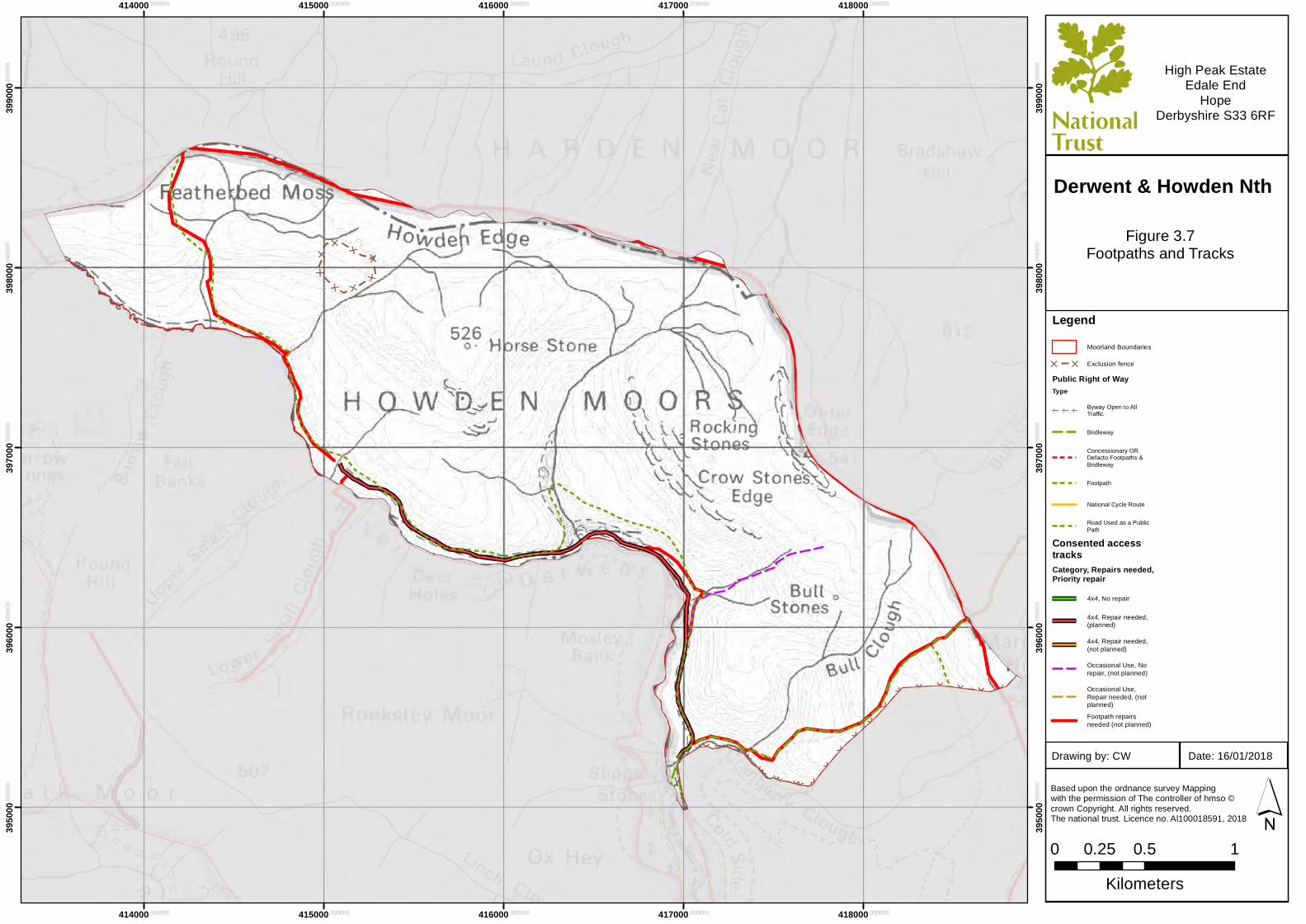
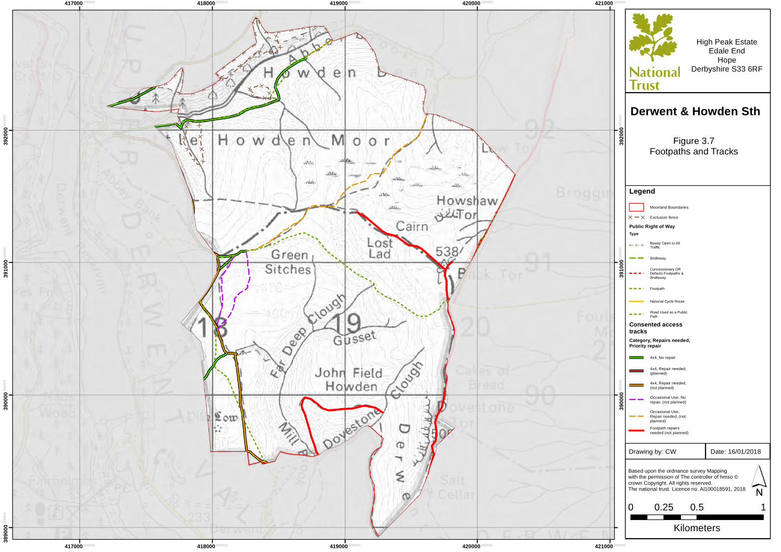
LegendMoorland Boundaries
[ [ Exclusion fencePublic Right of WayType
Byway Open to AllTraffic
Bridleway
Concessionary ORDefacto Footpaths &Bridleway
Footpath
National Cycle Route
Road Used as a PublicPath
Consented accesstracksCategory, Repairs needed,Priority repair
4x4, No repair
4x4, Repair needed,(planned)
4x4, Repair needed,(not planned)
Occasional Use, Norepair, (not planned)
Occasional Use,Repair needed, (notplanned)Footpath repairsneeded (not planned)
Based upon the ordnance survey Mapping with the permission of The controller of hmso ©crown Copyright. All rights reserved. The national trust. Licence no. Al100018591, 2018
0 0.5 10.25Kilometers
´
High Peak EstateEdale End
HopeDerbyshire S33 6RF
Figure 3.7Footpaths and Tracks
Date: 16/01/2018Drawing by: CW
Derwent & Howden Mid
414000.000000
414000.000000
415000.000000
415000.000000
416000.000000
416000.000000
417000.000000
417000.000000
418000.000000
418000.000000
3950
00.00
0000
3950
00.00
0000
3960
00.00
0000
3960
00.00
0000
3970
00.00
0000
3970
00.00
0000
3980
00.00
0000
3980
00.00
0000
3990
00.00
0000
3990
00.00
0000
LegendMoorland Boundaries
[ [ Exclusion fencePublic Right of WayType
Byway Open to AllTraffic
Bridleway
Concessionary ORDefacto Footpaths &Bridleway
Footpath
National Cycle Route
Road Used as a PublicPath
Consented accesstracksCategory, Repairs needed,Priority repair
4x4, No repair
4x4, Repair needed,(planned)
4x4, Repair needed,(not planned)
Occasional Use, Norepair, (not planned)
Occasional Use,Repair needed, (notplanned)Footpath repairsneeded (not planned)
Based upon the ordnance survey Mapping with the permission of The controller of hmso ©crown Copyright. All rights reserved. The national trust. Licence no. Al100018591, 2018
0 0.5 10.25Kilometers
´
High Peak EstateEdale End
HopeDerbyshire S33 6RF
Figure 3.7Footpaths and Tracks
Date: 16/01/2018Drawing by: CW
Derwent & Howden Nth
417000.000000
417000.000000
418000.000000
418000.000000
419000.000000
419000.000000
420000.000000
420000.000000
421000.000000
421000.000000
3890
00.00
0000
3900
00.00
0000
3900
00.00
0000
3910
00.00
0000
3910
00.00
0000
3920
00.00
0000
3920
00.00
0000
LegendMoorland Boundaries
[ [ Exclusion fencePublic Right of WayType
Byway Open to AllTraffic
Bridleway
Concessionary ORDefacto Footpaths &Bridleway
Footpath
National Cycle Route
Road Used as a PublicPath
Consented accesstracksCategory, Repairs needed,Priority repair
4x4, No repair
4x4, Repair needed,(planned)
4x4, Repair needed,(not planned)
Occasional Use, Norepair, (not planned)
Occasional Use,Repair needed, (notplanned)Footpath repairsneeded (not planned)
Based upon the ordnance survey Mapping with the permission of The controller of hmso ©crown Copyright. All rights reserved. The national trust. Licence no. Al100018591, 2018
0 0.5 10.25Kilometers
´
High Peak EstateEdale End
HopeDerbyshire S33 6RF
Figure 3.7Footpaths and Tracks
Date: 16/01/2018Drawing by: CW
Derwent & Howden Sth
Reconstructedpackhorse bridgefrom Derwent Hall
Reconstructedpackhorse bridgefrom Derwent Hall
CAIRN 550M SOUTHOF HOWDEN
RESERVOIR DAM WALL
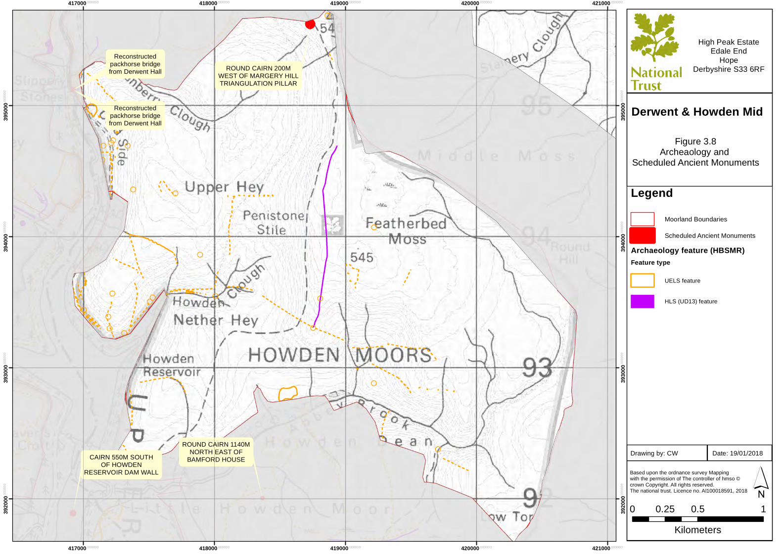
ROUND CAIRN 200MWEST OF MARGERY HILLTRIANGULATION PILLAR
ROUND CAIRN 1140MNORTH EAST OF
BAMFORD HOUSE
417000.000000
417000.000000
418000.000000
418000.000000
419000.000000
419000.000000
420000.000000
420000.000000
421000.000000
421000.000000
3920
00.00
0000
3920
00.00
0000
3930
00.00
0000
3930
00.00
0000
3940
00.00
0000
3940
00.00
0000
3950
00.00
0000
3950
00.00
0000
LegendMoorland Boundaries
Scheduled Ancient MonumentsArchaeology feature (HBSMR)Feature type
UELS feature
HLS (UD13) feature
Based upon the ordnance survey Mapping with the permission of The controller of hmso ©crown Copyright. All rights reserved. The national trust. Licence no. Al100018591, 2018
0 0.5 10.25Kilometers
´
High Peak EstateEdale End
HopeDerbyshire S33 6RF
Figure 3.8Archeaology and
Scheduled Ancient Monuments
Date: 19/01/2018Drawing by: CW
Derwent & Howden Mid
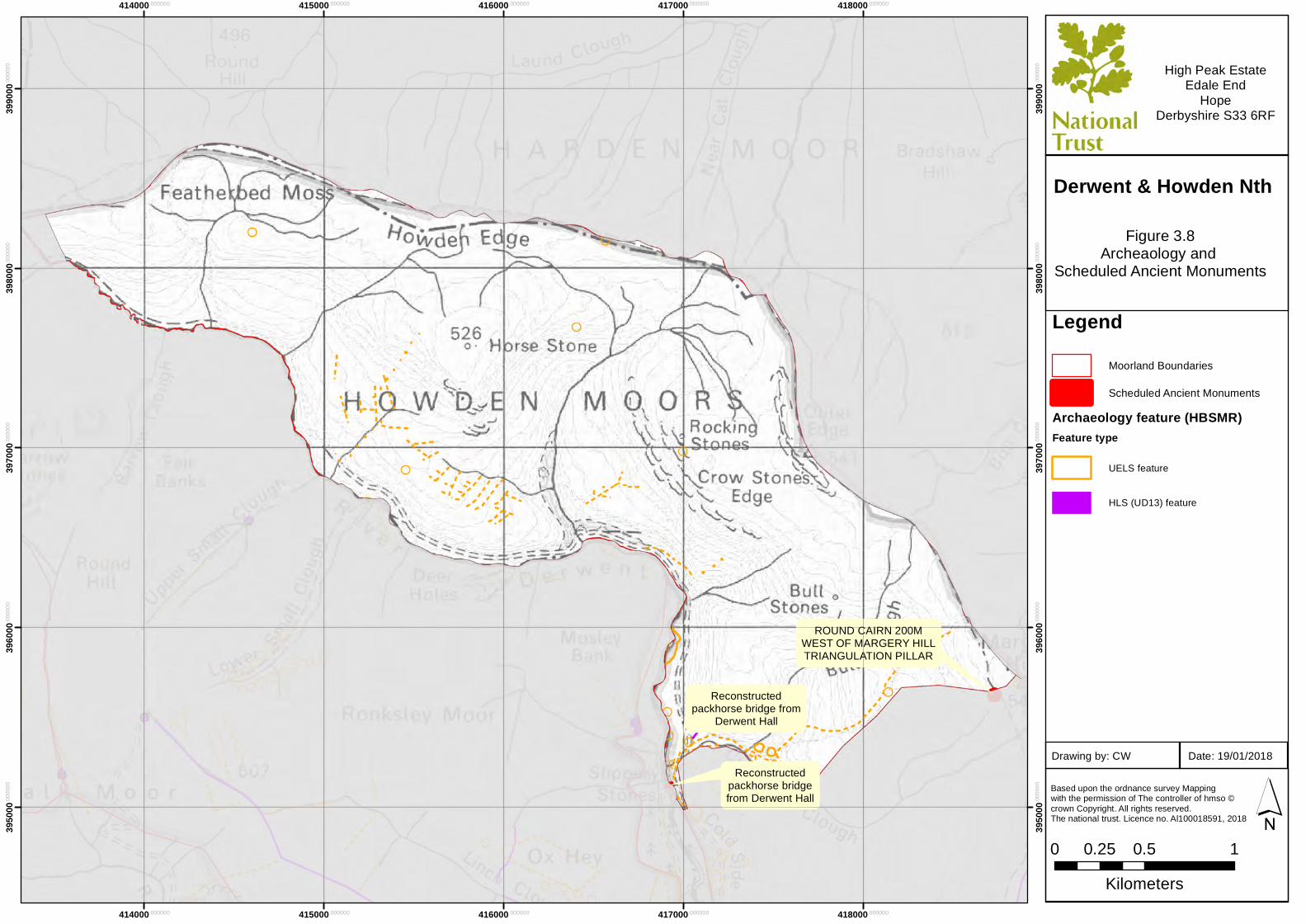
Reconstructedpackhorse bridge from
Derwent Hall
Reconstructedpackhorse bridgefrom Derwent Hall
ROUND CAIRN 200MWEST OF MARGERY HILLTRIANGULATION PILLAR
414000.000000
414000.000000
415000.000000
415000.000000
416000.000000
416000.000000
417000.000000
417000.000000
418000.000000
418000.000000
3950
00.00
0000
3950
00.00
0000
3960
00.00
0000
3960
00.00
0000
3970
00.00
0000
3970
00.00
0000
3980
00.00
0000
3980
00.00
0000
3990
00.00
0000
3990
00.00
0000
LegendMoorland Boundaries
Scheduled Ancient MonumentsArchaeology feature (HBSMR)Feature type
UELS feature
HLS (UD13) feature
Based upon the ordnance survey Mapping with the permission of The controller of hmso ©crown Copyright. All rights reserved. The national trust. Licence no. Al100018591, 2018
0 0.5 10.25Kilometers
´
High Peak EstateEdale End
HopeDerbyshire S33 6RF
Figure 3.8Archeaology and
Scheduled Ancient Monuments
Date: 19/01/2018Drawing by: CW
Derwent & Howden Nth
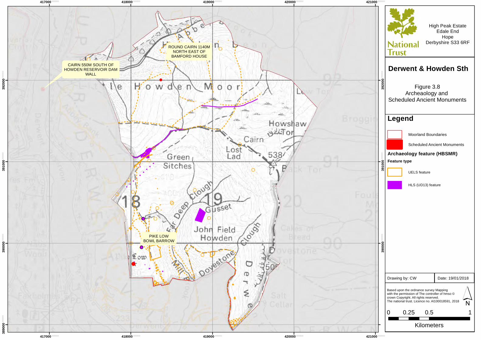
CAIRN 550M SOUTH OFHOWDEN RESERVOIR DAM
WALL
PIKE LOWBOWL BARROW
ROUND CAIRN 1140MNORTH EAST OF
BAMFORD HOUSE
417000.000000
417000.000000
418000.000000
418000.000000
419000.000000
419000.000000
420000.000000
420000.000000
421000.000000
421000.000000
3890
00.00
0000
3900
00.00
0000
3900
00.00
0000
3910
00.00
0000
3910
00.00
0000
3920
00.00
0000
3920
00.00
0000
LegendMoorland Boundaries
Scheduled Ancient MonumentsArchaeology feature (HBSMR)Feature type
UELS feature
HLS (UD13) feature
Based upon the ordnance survey Mapping with the permission of The controller of hmso ©crown Copyright. All rights reserved. The national trust. Licence no. Al100018591, 2018
0 0.5 10.25Kilometers
´
High Peak EstateEdale End
HopeDerbyshire S33 6RF
Figure 3.8Archeaology and
Scheduled Ancient Monuments
Date: 19/01/2018Drawing by: CW
Derwent & Howden Sth