Delaware RTT & RWT Facility Master Plan- …...alignment across private agricultural land NW of New...
22
Junction & Breakwater Trail Viewshed- Lewes Terminus Delaware RTT & RWT Facility Master Plan- APPENDIX- I I.3.1 Figure 1- Looking SE toward Gills Neck Road from the end of Monroe Figure 2- Looking SW at the SW quadrant of US 9 and Monroe Avenue Figure 3- Looking SW along US 9 at Monroe Avenue Avenue intersection Figure 4- Looking NE along US 9 at Monroe Avenue Figure 5- Looking east along Cape Henlopen Drive toward US 9 Figure 6- Looking north at Lewes beachfront
Transcript of Delaware RTT & RWT Facility Master Plan- …...alignment across private agricultural land NW of New...
Junction & Breakwater Trail Viewshed- Lewes Terminus
Delaware RTT & RWT Facility Master Plan- APPENDIX- I I.3.1
Figure 1- Looking SE toward Gills Neck Road from the end of Monroe Figure 2- Looking SW at the SW quadrant of US 9 and Monroe Avenue Figure 3- Looking SW along US 9 at Monroe Avenue Avenue intersection
Figure 4- Looking NE along US 9 at Monroe Avenue Figure 5- Looking east along Cape Henlopen Drive toward US 9 Figure 6- Looking north at Lewes beachfront

Junction & Breakwater Trail Viewshed- Rehoboth Terminus
Delaware RTT & RWT Facility Master Plan- APPENDIX- I I.3.2
Figure 1- Looking NW at end of Church Street extension Figure 2- Looking SW, Church Street toward Rehoboth Avenue Figure 3- Looking east on Church Street
Figure 4- Looking south on Church Street toward Rehoboth Avenue Figure 5- Looking west behind Suburban Figure 6- Looking south from Suburban Gas toward Rehoboth Avenue Gas toward Church Street and the Lewes/ Rehoboth Canal Bridge

Brandywine Industrial Track Viewshed
Delaware RTT & RWT Facility Master Plan- APPENDIX- I I.3.3
Figure 1- Looking south at Bancroft Mills Figure 2- Looking east from Bancroft Mills pedestrian bridge through Figure 3- Looking SE from an Alapocas Run State Park overlook at the pedestrian bridge the Alapocas Run State Park Brandywine Creek falls at the Bancroft Mills area
Figure 4- Looking west from existing rail trail Figure 5- Looking west across Brandywine Figure 6- Looking south under I-95 from toward railroad bridge over Brandywine Creek Park pedestrian bridge over Brandywine Creek existing rail trail

Brandywine Industrial Track Viewshed
Delaware RTT & RWT Facility Master Plan- APPENDIX- I I.3.4
Figure 7- Looking north across Brandywine Park entrance toward existing Figure 8- Brandywine Park monument and water Figure 9- Looking north along rail corridor through Brandywine Park
rail trail feature (Brandywine Zoo on right)
Figure 10- Looking west from rail corridor toward Washington Street Figure 11- Looking SE along Park Drive toward Walnut Street terminus Figure 12- Looking south at Walnut Street Bridge bridge

Ellendale-Milton Industrial Track Viewshed
Delaware RTT & RWT Facility Master Plan- APPENDIX- I I.3.5
Figure 1- Looking west along SR 16 in Ellendale Figure 2- Looking north toward SR 16 intersection in Ellendale Figure 3- Looking SE one block south of SR 16 in Ellendale
Figure 4- Looking west toward Ellendale Figure 5- Looking NW from SR 30 intersection Figure 6- Looking SE from SR 30

Ellendale-Milton Industrial Track Viewshed
Delaware RTT & RWT Facility Master Plan- APPENDIX- I I.3.6
Figure 7- Looking SE at Orchard Road intersection (SR 16 on left) Figure 8- Looking SE, east of Spicer Road Figure 9- Looking SE at Pemberton Branch railroad bridge
Figure 10- Looking NW at Pemberton Branch railroad bridge Figure 11- Looking west at rail corridor from Chestnut Street in Milton Figure 12- Looking south at Cannery Village Center entrance in Milton

Clayton-Easton Line Viewshed
Delaware RTT & RWT Facility Master Plan- APPENDIX- I I.3.7
Figure 1- Looking NE toward Clayton from School Lane Road Figure 2- Looking east across Wheatley’s Pond Figure 3- Looking NE from Underwoods Corner Road
Figure 4- Looking SE at SR 42 intersection in Kenton Figure 5- Looking SW at Sudlersville Road (SR 300) intersection Figure 6- Looking NE at Shorts Corner Road intersection

Clayton-Easton Line Viewshed
Delaware RTT & RWT Facility Master Plan- APPENDIX- I I.3.8
Figure 7- Looking NE, south of Lockwood Chapel Road Figure 8- Looking NE toward Hartly Road (SR 44) in Hartly Figure 9- Looking SW along Slaughter Station Road south of Hartly
Figure 10- Looking east at water crossing south of Slaughter Figure 11- Looking west at rail corridor bridge at Harrington Beaverdam Figure 12- Looking east from rail corridor bridge at Harrington
Ditch north of Marydel Beaverdam Ditch north of Marydel
Clayton-Easton Line Viewshed
Delaware RTT & RWT Facility Master Plan- APPENDIX- I I.3.9
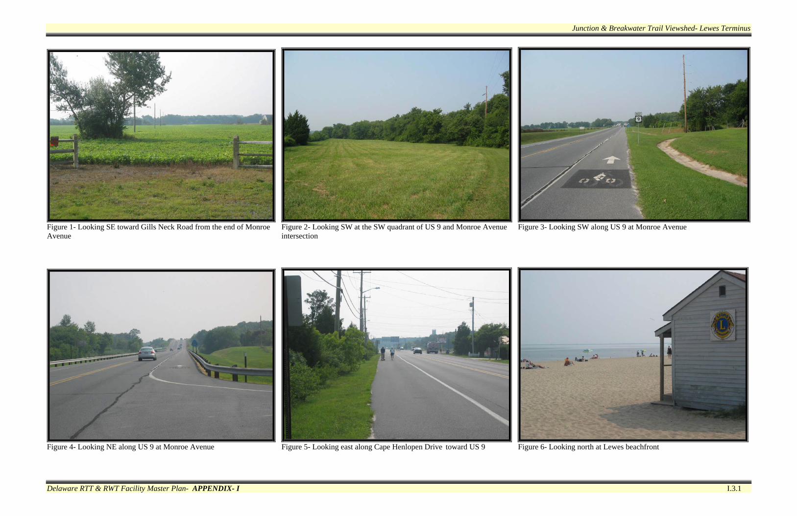
Figure 13- Looking south along the adjacent green space at the Marydel Figure 14- State line marker adjacent to the terminus rail corridor in Marydel

New Castle Industrial Track Viewshed
Delaware RTT & RWT Facility Master Plan- APPENDIX- I I.3.10
Figure 1- Looking north from south side of Delaware Street (SR 9) Figure 2- Looking north from New Castle Middle School parking Figure 3- Looking north at rail corridor between Delaware Street (SR 9) In New Castle adjacent to Delaware Street (SR 9) and Narrow Dyke Canal
Figure 4- Looking NW at the Narrow Dyke Canal crossing Figure 5- Looking north at the Narrow Dyke Canal crossing Figure 6- Looking SE at the Narrow Dyke Canal crossing

New Castle Industrial Track Viewshed
Delaware RTT & RWT Facility Master Plan- APPENDIX- I I.3.11
Figure 7- Looking north in the Lesley Lane area Figure 8- Looking south from Boulden Boulevard Figure 9- Looking north across Boulden Boulevard
Figure 10- Looking west along Boulden Boulevard Figure 11- Looking east along Boulden Boulevard

Rockland Track Viewshed
Delaware RTT & RWT Facility Master Plan- APPENDIX- I I.3.12
Figure 1- Looking east at bio-retention facility on the rail corridor Figure 2- Looking NE at rail corridor behind private residence Figure 3- Looking NE at rail corridor from private driveway crossing behind Carpenter Row in Montchanin
Figure 4- Looking south from rail corridor at Brandywine Creek Figure 5- Looking NE approaching the Brandywine Creek railroad Figure 6- Looking west across the Brandywine Creek railroad bridge bridge
Rockland Track Viewshed
Delaware RTT & RWT Facility Master Plan- APPENDIX- I I.3.13
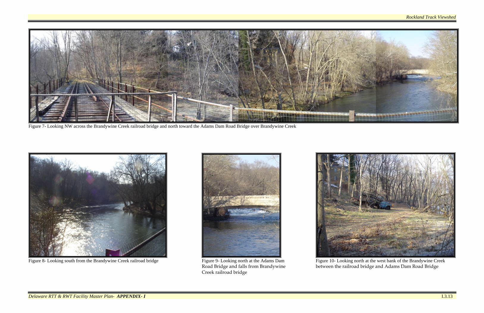
Figure 7- Looking NW across the Brandywine Creek railroad bridge and north toward the Adams Dam Road Bridge over Brandywine Creek
Figure 8- Looking south from the Brandywine Creek railroad bridge Figure 9- Looking north at the Adams Dam Figure 10- Looking north at the west bank of the Brandywine Creek Road Bridge and falls from Brandywine between the railroad bridge and Adams Dam Road Bridge Creek railroad bridge

Rockland Track Viewshed
Delaware RTT & RWT Facility Master Plan- APPENDIX- I I.3.14
Figure 11- Looking north at the south terminus of the Brandywine Figure 12- Looking west along Adams Dam Road toward the Brandywine Creek State Park trail system on Adams Dam Road Creek Bridge (Brandywine Creek State Park trail on right)

Kentmere Track Viewshed
Delaware RTT & RWT Facility Master Plan- APPENDIX- I I.3.15
Figure 1- Looking north toward west terminus of rail corridor at Figure 2- Looking NE parallel to Westover Circle east of Greenwood Figure 3- Looking SW at roadway and sidewalk improvements on Dupont Greenwood Road area Road Road west of the park-n-ride
Figure 4- Looking NE through the Kennett Pike (SR 52) overpass Figure 5- Looking east across service/maintenance driveway to Figure 6- Looking east at west end of railroad tunnel west of Rising private residence Sun Lane

Kentmere Track Viewshed
Delaware RTT & RWT Facility Master Plan- APPENDIX- I I.3.16
Figure 7- Looking east, east of Rising Sun Lane Figure 8- Looking south at fenced end of Brandywine Falls Road Figure 9- Looking west toward private residences on Brandywine Falls Road from Rockford Road old railroad bridge abutment
Figure 10- Looking north at entrance to Bancroft Mills complex (Brandywine Falls Road on left, Rockford Road in center, Hill Figure 11- Looking east on Rockford Road toward Bancroft Mills Road on right)

Wilmington & Northern Line Viewshed
Delaware RTT & RWT Facility Master Plan- APPENDIX- I I.3.17
Figure 1- Looking north from the north rail corridor terminus under Figure 2- Looking south between I-95 Figure 3- Looking SE approaching the active rail line south of the I-95 near Frawley Stadium and Frawley Stadium Shipyard Shops
Figure 4- Looking west near the active Figure 5- Looking north toward the Figure 6- Looking north at the south Figure 7- Looking SE at the Riverfront Park Gateway rail crossing west of the Christina south terminus of the Riverfront terminus of the Riverfront Park River Park promenade promenade
Wilmington & Northern Line Viewshed
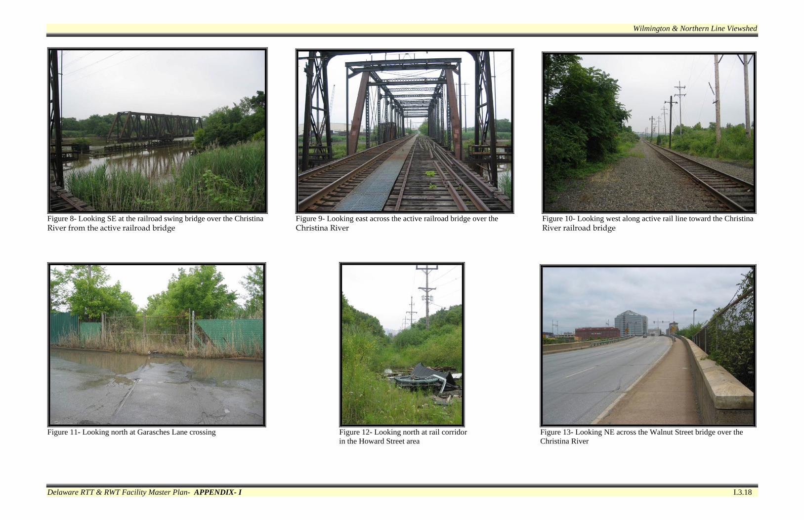
Delaware RTT & RWT Facility Master Plan- APPENDIX- I I.3.18
Figure 8- Looking SE at the railroad swing bridge over the Christina Figure 9- Looking east across the active railroad bridge over the Figure 10- Looking west along active rail line toward the Christina River from the active railroad bridge Christina River River railroad bridge
Figure 11- Looking north at Garasches Lane crossing Figure 12- Looking north at rail corridor Figure 13- Looking NE across the Walnut Street bridge over the in the Howard Street area Christina River

Milton-Lewes Line Viewshed
Delaware RTT & RWT Facility Master Plan- APPENDIX- I I.3.19
Figure 1- Looking west at the rail corridor from Chestnut Street in Figure 2- Looking east at rail corridor alignment through Cannery Figure 3- Looking south, east of the Black Hog Gut crossing Milton Village Center
Figure 4- Looking north, east of the Black Hog Gut crossing Figure 5- Looking north from the Beaverdam Creek crossing Figure 6- Looking east across the Brickyard Road crossing
Milton-Lewes Line Viewshed
Delaware RTT & RWT Facility Master Plan- APPENDIX- I I.3.20
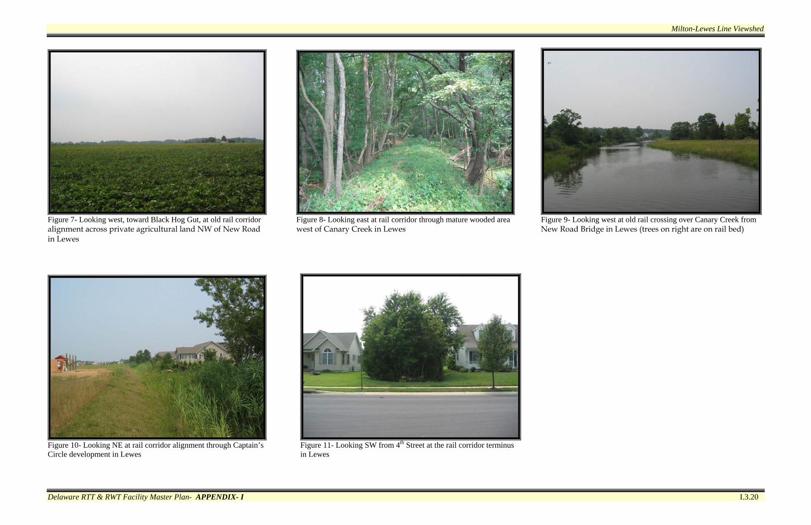
Figure 7- Looking west, toward Black Hog Gut, at old rail corridor Figure 8- Looking east at rail corridor through mature wooded area Figure 9- Looking west at old rail crossing over Canary Creek from alignment across private agricultural land NW of New Road west of Canary Creek in Lewes New Road Bridge in Lewes (trees on right are on rail bed) in Lewes
Figure 10- Looking NE at rail corridor alignment through Captain’s Figure 11- Looking SW from 4th Street at the rail corridor terminus Circle development in Lewes in Lewes

Smyrna Track Viewshed
Delaware RTT & RWT Facility Master Plan- APPENDIX- I I.3.21
Figure 1- Looking NW at historic train station in Clayton and Smyrna- Figure 2- Looking SW at rail corridor at N. Rodney Street Figure 3- Looking NE from N. Rodney Street Clayton Boulevard
Figure 4- Looking SW from private drive opposite Dickerson Street Figure 5- Looking SW from N. Reed Street Figure 6- Looking NE toward Glenwood Avenue (rail corridor
alignment and Greens Branch on north side of Smyrna-Clayton Boulevard)
Smyrna Track Viewshed
Delaware RTT & RWT Facility Master Plan- APPENDIX- I I.3.22
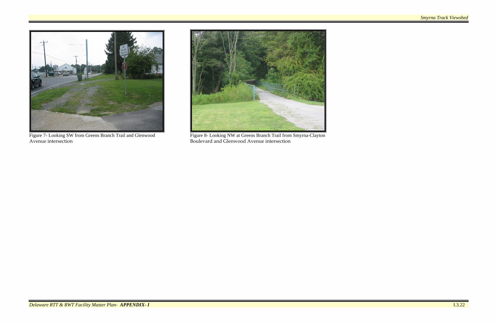
Figure 7- Looking SW from Greens Branch Trail and Glenwood Figure 8- Looking NW at Greens Branch Trail from Smyrna-Clayton Avenue intersection Boulevard and Glenwood Avenue intersection