Dawood Public School Geography Class VII outlines/Secondary...Dawood Public School Course Outline...
13
Dawood Public School Course Outline 2017-2018 Geography Class VII Book: Crawford, D (2013)Geography Today Pupil Book1 and 2 Revised Edition, Peak Publishing Ltd, UK Month Contents Book August Basic Skills Trade and Transport Geography Today Book 1 by Doreen Crawford. Geography Today Book 2 by Doreen Crawford. September Natural Vegetation Geography Today Book 1 by Doreen Crawford. October Fresh Water Geography Today Book 2 by Doreen Crawford. November Revision for Mid-Term Exam December Mid-Year Examination 2017 ---- January Weather and Climate Geography Today Book 2 by Doreen Crawford. February Agriculture Geography Today Book 1 by Doreen Crawford. March Settlements and their industries Geography Today Book 1 by Doreen Crawford. April Revision for Final Exam May Final Examination 2018
Transcript of Dawood Public School Geography Class VII outlines/Secondary...Dawood Public School Course Outline...

Dawood Public School Course Outline 2017-2018
Geography Class VII
Book:
Crawford, D (2013)Geography Today Pupil Book1 and 2 Revised Edition, Peak Publishing Ltd, UK
Month Contents Book
August
Basic Skills
Trade and Transport
Geography Today Book 1 by Doreen Crawford. Geography Today Book 2 by Doreen Crawford.
September
Natural Vegetation
Geography Today Book 1 by Doreen Crawford.
October
Fresh Water
Geography Today Book 2 by Doreen Crawford.
November
Revision for Mid-Term Exam
December
Mid-Year Examination 2017
----
January
Weather and Climate
Geography Today Book 2 by Doreen Crawford.
February
Agriculture
Geography Today Book 1 by Doreen Crawford.
March
Settlements and their industries
Geography Today Book 1 by Doreen Crawford.
April
Revision for Final Exam
May Final Examination 2018
Syllabus Content
August:
Chapter: Basic Skills
Book: Crawford, D (2013)Geography Today Pupil Book 1 Revised Edition, Peak Publishing Ltd, UK
Page# 66-109
Reference Book:
Jay, Sian E; Lim, Solomon and Nathan, Edward (n.d.) Our World: a Closer Look, Secondary 3, Federal
Publications, Singapore.
Topics:
Maps. A map is a visual representation of an area – symbolic depiction highlighting relationships between
elements of that space such as objects, regions, and themes. Map can be read or interpreted with
the help of its Title, Scale, North sign, Legend or Key, Scale, Grid lines.
a) Political maps: Map showing individual countries, each separated by national boundary.
b) Thematic Maps: A thematic map is a type of map especially designed to show a particular theme
related to a specific geographic area. These maps can portray physical, social, political, cultural,
economic, sociological, agricultural, or any other aspects of a city, state, region, nation, or
continent.
c) Climatic or Weather maps: A climatic map gives general information about the weather
condition, temperature and precipitation (rain and snow) of a region. Representation of data
can be done by choropleth or symbols.
d) Physical or Topographical maps: A physical map shows all the natural and manmade features on
the earth’s surface. Topographical maps can be choropleth or contour.
Photograph Interpretation Photographs are the important source of data for geographical analysis. Photographs can be
interpreted using a structural method of division into three vertical and three horizontal directions.
Photographs can be ground photograph or aerial photograph.
Graphs. Graph is a diagram showing the relation between variable quantities, typically of two variables, each
measured along one of a pair of axis at right angles. It is also an important tool for a geographer, for
instance in order to know precipitation received by an area in the course of month or year, or to
know the population growth of a town or a country.
Diagrams. Diagrams can be of two types, Cross sectional and block diagrams. Cross sectional diagrams
represent interior of the object, while block diagram is a three-dimensional drawing representing a
block of the earth's crust, showing geological structure.
Statistics. The collection, organization, and interpretation of numerical data especially the analysis of
population characteristics by inference from sampling or weather data.
Key Words: Political map, Dot map. Thematic map, Choropleth, Cross section, Statistical data, Mean, average, Grid, Latitudes, Longitudes. (Refer to glossary given on Pageno#220-223)
Model Questions:
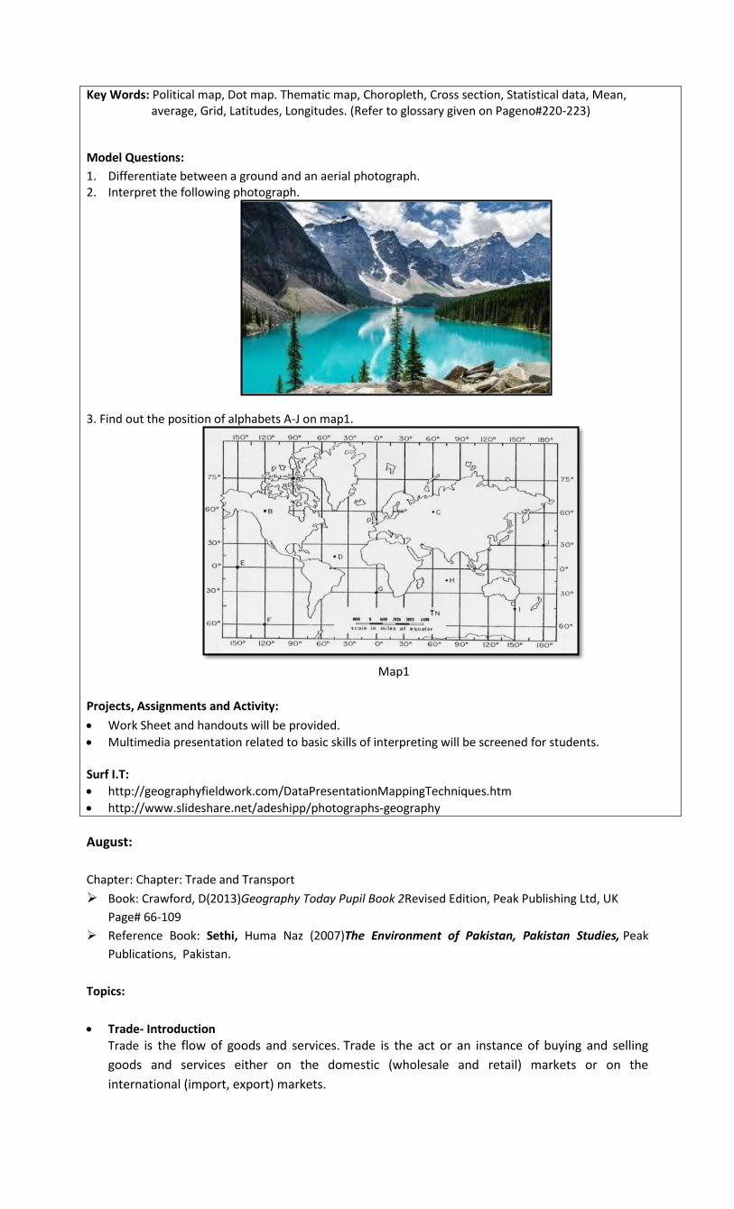
1. Differentiate between a ground and an aerial photograph. 2. Interpret the following photograph.
3. Find out the position of alphabets A-J on map1.
Map1
Projects, Assignments and Activity:
Work Sheet and handouts will be provided.
Multimedia presentation related to basic skills of interpreting will be screened for students. Surf I.T:
http://geographyfieldwork.com/DataPresentationMappingTechniques.htm
http://www.slideshare.net/adeshipp/photographs-geography
August:
Chapter: Chapter: Trade and Transport
Book: Crawford, D(2013)Geography Today Pupil Book 2Revised Edition, Peak Publishing Ltd, UK
Page# 66-109
Reference Book: Sethi, Huma Naz (2007)The Environment of Pakistan, Pakistan Studies, Peak
Publications, Pakistan.
Topics:
Trade- Introduction
Trade is the flow of goods and services. Trade is the act or an instance of buying and selling
goods and services either on the domestic (wholesale and retail) markets or on the
international (import, export) markets.

Why do People Trade? Every country or town is not self-sufficient in all the necessities of a life, in order to fulfill their needs
people trade on domestic and International levels. Trade activities are carried out in order to satisfy
people’s need for basic commodities and luxuries and to improve country’s economic and social
condition.
How do we Trade? Trade is carried out using different modes of transport depending upon the cost, availability of
natural routes, feasibility, nature and size of product.
Dimensions of Trade There are seven dimensions of trade, internal trade, International trade, visible trade, invisible
trade, imports, exports and barter trade.
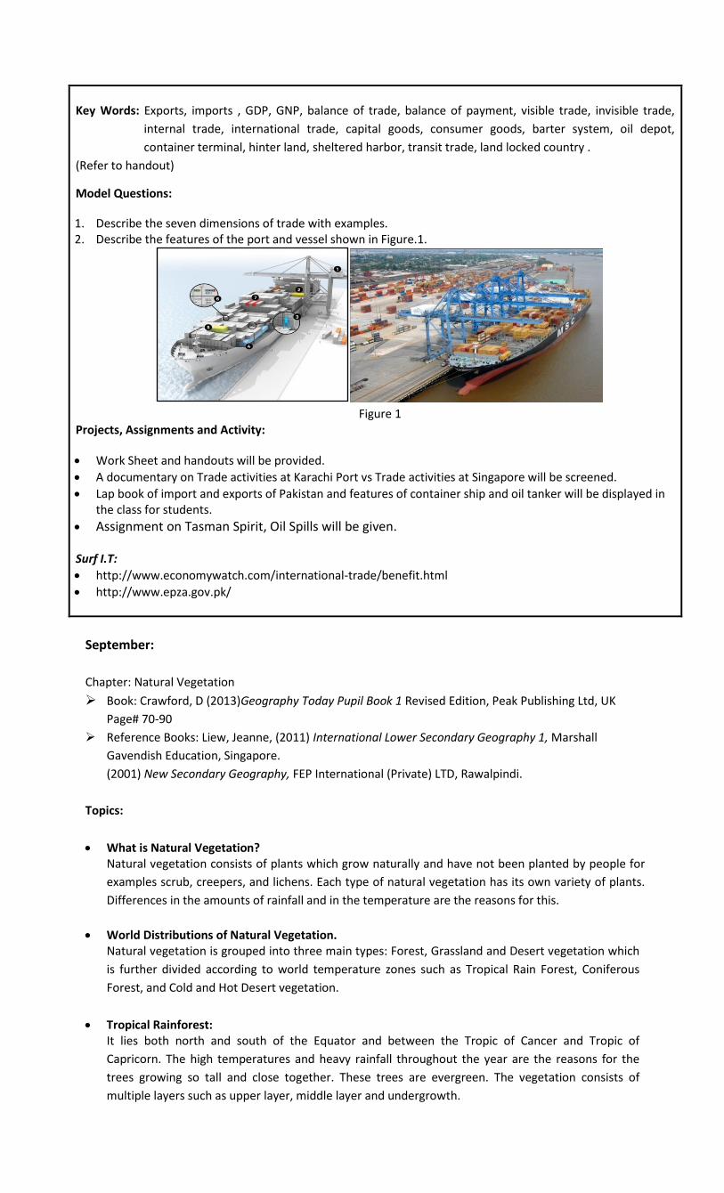
Difference between A Container Ship and an Oil Tanker Container and oil ships are used to transport bulk quantities of products across the sea. Oil tankers
are designed specifically to transport large quantities of oil from the source to destinations around
the globe.
Description of An Oil Terminal and an Container Terminal Docking of an oil tanker requires different set up on port such as tankers, pumps and connected
pipes etc. to unload oil and store it on the port while container terminals requires cranes and
warehouses.
Pakistan’s main Imports and Exports Pakistan’s major exports comprise of agricultural products that are comparatively low in cost while
imports are high value products such as oil and motors.
Why does Pakistan have a Negative Balance of Trade? Pakistan has agro-based economy due to which the major exports are agricultural products such as
cotton and rice. Due to political instability, lack of technology, energy crisis, offered incentives,
government policies and investments from foreign and local investors Pakistan is facing negative
balance of trade as its imports are higher than exports.
Role of Export Processing Zones and Export Promotion Bureau. EPB and EPZ can play a vital role in boosting economic condition of a country. EPZ are the areas
designated specifically to export oriented industries, where investors are offered incentives from
the government, while EPB search markets for the country’s product, creates brand awareness,
holds fairs and exhibitions at local and international levels to improve exports.
Pakistan’s Trading Groups. Pakistan main trading agreements include ECO, SAARC, and ATTA etc.
Key Words: Exports, imports , GDP, GNP, balance of trade, balance of payment, visible trade, invisible trade,
internal trade, international trade, capital goods, consumer goods, barter system, oil depot,
container terminal, hinter land, sheltered harbor, transit trade, land locked country .
(Refer to handout)
Model Questions:
1. Describe the seven dimensions of trade with examples. 2. Describe the features of the port and vessel shown in Figure.1.
Figure 1
Projects, Assignments and Activity:
Work Sheet and handouts will be provided.
A documentary on Trade activities at Karachi Port vs Trade activities at Singapore will be screened.
Lap book of import and exports of Pakistan and features of container ship and oil tanker will be displayed in the class for students.
Assignment on Tasman Spirit, Oil Spills will be given.
Surf I.T:
http://www.economywatch.com/international-trade/benefit.html
http://www.epza.gov.pk/
September:
Chapter: Natural Vegetation
Book: Crawford, D (2013)Geography Today Pupil Book 1 Revised Edition, Peak Publishing Ltd, UK
Page# 70-90
Reference Books: Liew, Jeanne, (2011) International Lower Secondary Geography 1, Marshall
Gavendish Education, Singapore.
(2001) New Secondary Geography, FEP International (Private) LTD, Rawalpindi.
Topics:
What is Natural Vegetation? Natural vegetation consists of plants which grow naturally and have not been planted by people for
examples scrub, creepers, and lichens. Each type of natural vegetation has its own variety of plants.
Differences in the amounts of rainfall and in the temperature are the reasons for this.
World Distributions of Natural Vegetation. Natural vegetation is grouped into three main types: Forest, Grassland and Desert vegetation which
is further divided according to world temperature zones such as Tropical Rain Forest, Coniferous
Forest, and Cold and Hot Desert vegetation.
Tropical Rainforest: It lies both north and south of the Equator and between the Tropic of Cancer and Tropic of
Capricorn. The high temperatures and heavy rainfall throughout the year are the reasons for the
trees growing so tall and close together. These trees are evergreen. The vegetation consists of
multiple layers such as upper layer, middle layer and undergrowth.
Cold Temperate Coniferous Forest: This type of forest is found only to the north of the Equator. These trees have special features such
as flexible branches, thick bark and needles instead of leaves which help them to survive in
temperatures below freezing point.
Tropical Grassland. Tropical grassland consists of grasses and scattered trees between the tropical regions especially
where the rain falls seasonally. Near the semi-desert areas the grasses are quite short. Near the
tropical rainforest, where there is more rainfall, the grasses grow tall to over 0.5m.
Hot Desert Vegetation: The existence of such vegetation is the result of low rainfall and high temperatures. Most of the hot
deserts have some plants and they are all adapted to surviving long period of drought. Various types
of cactus, e.g. the prickly pear have long roots, which widely near the surface so that they can catch
any rainfall.
Tundra Vegetation: The tundra vegetation can survive under the snow during the long winter when the temperature
remains below freezing point for about nine months of the year. This vegetation consists of lichens.
All these plants are small and close to the ground.
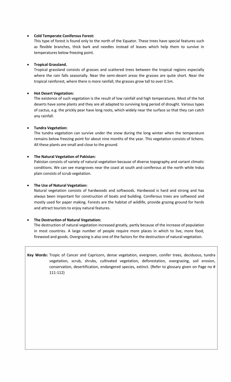
The Natural Vegetation of Pakistan: Pakistan consists of variety of natural vegetation because of diverse topography and variant climatic
conditions. We can see mangroves near the coast at south and coniferous at the north while Indus
plain consists of scrub vegetation.
The Use of Natural Vegetation: Natural vegetation consists of hardwoods and softwoods. Hardwood is hard and strong and has
always been important for construction of boats and building. Coniferous trees are softwood and
mostly used for paper making. Forests are the habitat of wildlife, provide grazing ground for herds
and attract tourists to enjoy natural features.
The Destruction of Natural Vegetation: The destruction of natural vegetation increased greatly, partly because of the increase of population
in most countries. A large number of people require more places in which to live, more food,
firewood and goods. Overgrazing is also one of the factors for the destruction of natural vegetation.
Key Words: Tropic of Cancer and Capricorn, dense vegetation, evergreen, conifer trees, deciduous, tundra
vegetation, scrub, shrubs, cultivated vegetation, deforestation, overgrazing, soil erosion,
conservation, desertification, endangered species, extinct. (Refer to glossary given on Page no #
111-112)
Model Questions:
1. Identify the type of vegetation shown in the following figure and explain the features which help it to
adapt itself to the environment.
2. Discuss why is it necessary to conserve natural vegetation?
Projects, Assignments and Activity:
Worksheets and handouts will be provided
Students will prepare charts on types of vegetation and its features. Surf I.T
http://eschooltoday.com/forests/types-of-forests.html
http://www.sciencekids.co.nz/sciencefacts/earth/rainforests.html
October:
Chapter: Fresh Water
Book: Crawford, D(2013)Geography Today Pupil Book 2Revised Edition, Peak Publishing Ltd, UK
Page# 29-39
Reference Book: Liew, Jeanne, (2011) International Lower Secondary Geography 1, Marshall
Gavendish Education, Singapore.
Topics:
What is Water? Water is made up of tiny particles called molecules. Each molecule of water contains even tinier
particles called atoms. In one molecule of water there are 2 atoms of hydrogen (H2o), 1 atom of
oxygen (o) so the chemical symbol for water is H2O.
Where is all the Earth’s Water? There is a fixed amount of water on the Earth. We can’t make any more. 97% is salty water in the
seas and oceans .We cannot drink it. 3% is fresh. Water is found in rivers, lakes, rainfall, clouds,
water vapors and is also underground and trapped in ice and snow.
The Importance of Fresh Water. The United Nations declared the Year 2003 to be the International year of Fresh water.
Water is needed for many purposes e.g. agriculture and industries, but this water does not have to
be so safe. Despite this, there are still serious shortages in many countries for these purposes other
than drinking.
Shortage of Fresh Water – A World Problem There are many reasons for the increase in population, industries and irrigation, the pollution of
fresh water supplies and the problems of the supply of fresh water.
What are the Results of Shortages of Fresh Water A shortage of fresh water has serious results. It can lead to problems within a country. It can also
lead to disputes between countries and to serious damage being caused to the environment.
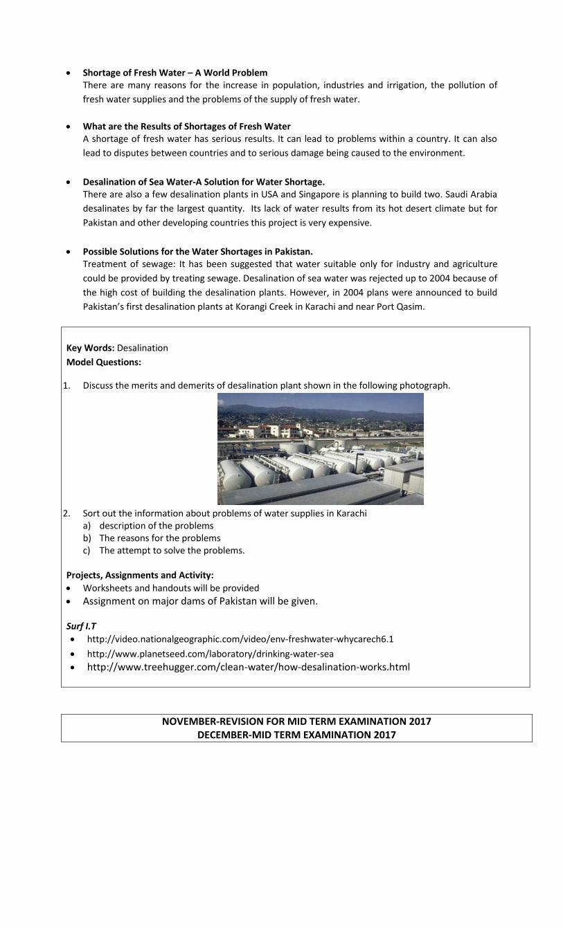
Desalination of Sea Water-A Solution for Water Shortage. There are also a few desalination plants in USA and Singapore is planning to build two. Saudi Arabia
desalinates by far the largest quantity. Its lack of water results from its hot desert climate but for
Pakistan and other developing countries this project is very expensive.
Possible Solutions for the Water Shortages in Pakistan. Treatment of sewage: It has been suggested that water suitable only for industry and agriculture
could be provided by treating sewage. Desalination of sea water was rejected up to 2004 because of
the high cost of building the desalination plants. However, in 2004 plans were announced to build
Pakistan’s first desalination plants at Korangi Creek in Karachi and near Port Qasim.
Key Words: Desalination
Model Questions:
1. Discuss the merits and demerits of desalination plant shown in the following photograph.
2. Sort out the information about problems of water supplies in Karachi
a) description of the problems b) The reasons for the problems c) The attempt to solve the problems.
Projects, Assignments and Activity:
Worksheets and handouts will be provided
Assignment on major dams of Pakistan will be given. Surf I.T
http://video.nationalgeographic.com/video/env-freshwater-whycarech6.1
http://www.planetseed.com/laboratory/drinking-water-sea http://www.treehugger.com/clean-water/how-desalination-works.html
NOVEMBER-REVISION FOR MID TERM EXAMINATION 2017 DECEMBER-MID TERM EXAMINATION 2017

January:
Chapter: Weather and Climate
Book: Crawford, D(2013)Geography Today Pupil Book 2Revised Edition, Peak Publishing Ltd, UK
Page#4-28.
Reference Book: Chun, Tham Yoke, (1998) Understanding Geography 3, Longman, Singapore.
Topics:
What is Weather? Weather is the state of atmosphere at a particular place and at a particular time. Weather is
recorded by measuring different elements such as temperature, air pressure, wind direction,
rainfall, and humidity.
How is Air Heated and get Cool: The air is heated by radiation, conduction and by convectional current. Air gets cool by ascending,
when warm air and cold air mixes and by convectional current.
The Composition of the Atmosphere The atmosphere is composed of 78% nitrogen, 21% oxygen 1% other gases such as carbon dioxide.
Variable quantities of water vapors i.e. tiny droplets of water which are invisible and also described
as a gas are also part of the atmosphere.
Sea Breezes and Land Breezes: During the summer season the coastal regions experience sea breezes while during winter season
they experience land breezes. These winds blow over thousands of miles due differences in
temperature and air pressure between land and sea.
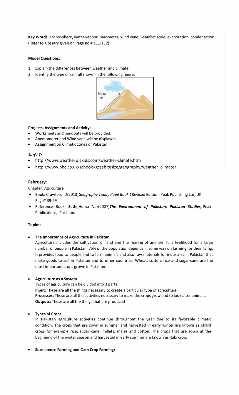
Types of Rainfall: Types of rainfall determine the way the air gets cool. When the moist air gets cool due to ascending
of air because of high temperature, conventional rainfall occurs. When the moist air gets cool due to
ascending because of high relief, relief rainfall occurs. Cyclonic rainfall occurs when the moist air
gets cool due to mixing of warm and cold air mass.
Climate: Climate is the average weather condition of the weather over many years. There are different types
of climate throughout the world depending on the latitudinal position such as equatorial climate
which remains constant throughout the year because it receives overhead sun around the year.
Polar climate which remains very cold due to six months day and six months night.
The Monsoon Climate which brings rainfall in South and South-East Asia during summer seasons.
During winter seasons it blows in opposite direction. There are other factors too which determine
the types of climate such as altitudinal factor, distance from the sea, direction of the wind, ocean
currents etc.
Key Words: Troposphere, water vapour, barometer, wind vane, Beaufort scale, evaporation, condensation
(Refer to glossary given on Page no # 111-112)
Model Questions:
1. Explain the differences between weather and climate.
2. Identify the type of rainfall shown in the following figure.
Projects, Assignments and Activity:
Worksheets and handouts will be provided.
Anemometer and Wind vane will be displayed.
Assignment on Climatic zones of Pakistan Surf I.T:
http://www.weatherwizkids.com/weather-climate.htm
http://www.bbc.co.uk/schools/gcsebitesize/geography/weather_climate/
February:
Chapter: Agriculture
Book: Crawford, D(2013)Geography Today Pupil Book 1Revised Edition, Peak Publishing Ltd, UK
Page# 39-69
Reference Book: Sethi,Huma Naz(2007)The Environment of Pakistan, Pakistan Studies, Peak
Publications, Pakistan.
Topics:
The Importance of Agriculture in Pakistan. Agriculture includes the cultivation of land and the rearing of animals. It is livelihood for a large
number of people in Pakistan. 75% of the population depends in some way on farming for their living.
It provides food to people and to farm animals and also raw materials for industries in Pakistan that
make goods to sell in Pakistan and to other countries. Wheat, cotton, rice and sugar-cane are the
most important crops grown in Pakistan.
Agriculture as a System Types of agriculture can be divided into 3 parts:
Input: These are all the things necessary to create a particular type of agriculture. Processes: These are all the activities necessary to make the crops grow and to look after animals.
Outputs: These are all the things that are produced
Types of Crops: In Pakistan agriculture activities continue throughout the year due to its favorable climatic
condition. The crops that are sown in summer and harvested in early winter are known as Kharif
crops for example rice, sugar cane, millets, maize and cotton. The crops that are sown at the
beginning of the winter season and harvested in early summer are known as Rabi crop.
Subsistence Farming and Cash Crop Farming:
Subsistence farming means small scale farming by the poor farmer who grows crops for himself and
for his family. A crop which is grown for sale is called a cash crop. Farmer sells the crop to receive
cash.
Shift Cultivation: It is a farming system where crops are grown for a few years in a clearing. This type of farming is
practiced by tribes in forests round the world. Shift cultivation is also one of the reasons for
deforestation.
Soilless Cultivation: Soilless cultivation is practiced in Singapore which is a very small country and a very small area is left
for farming due to growing population and industrialization. This involves high- tech methods to
grow a lot of vegetation in a small area.
Key Words: Agriculture, export, tributaries, arable land, plantation, hydroponic and aeroponic.
(Refer to glossary given on Page no # 111-112) Model Questions:
Discuss the importance of agriculture for the economy of Pakistan.
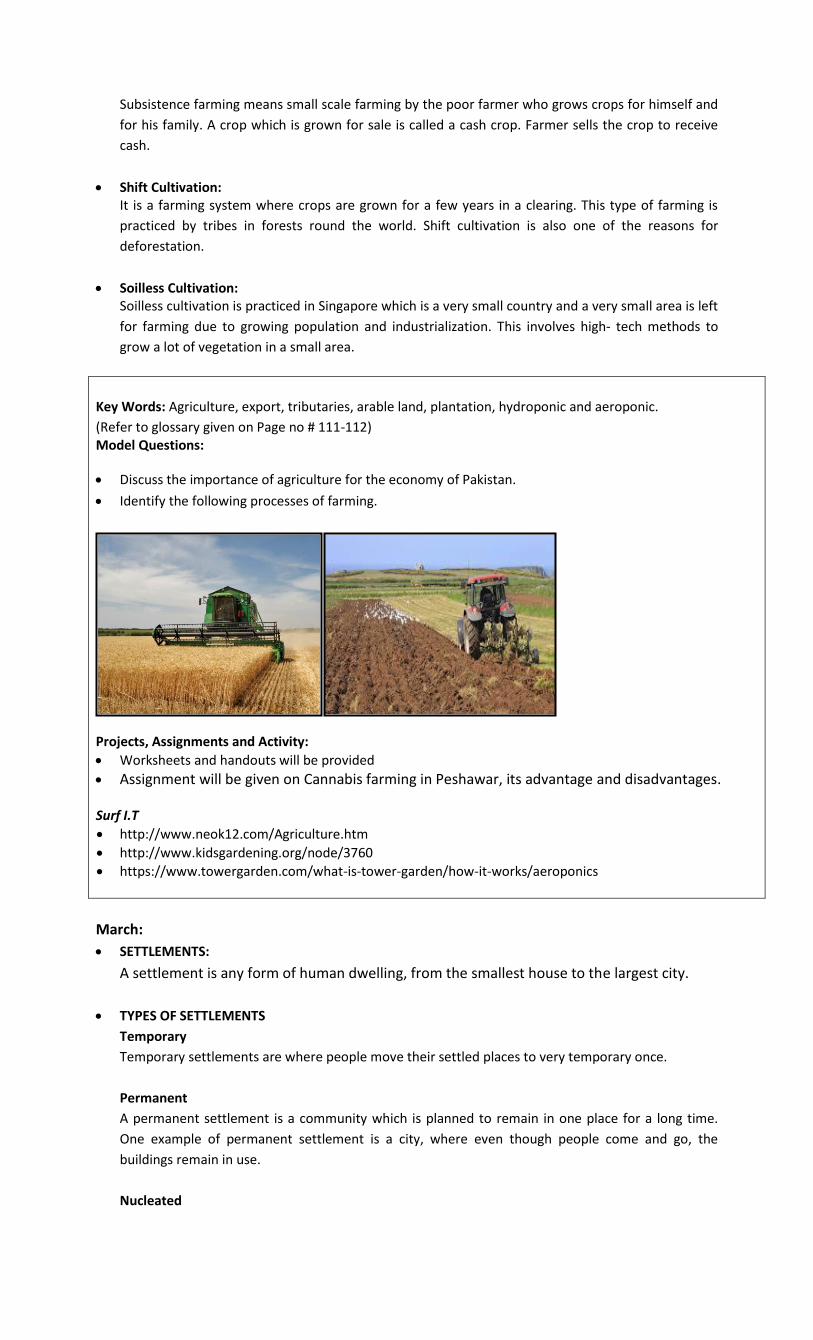
Identify the following processes of farming.
Projects, Assignments and Activity:
Worksheets and handouts will be provided
Assignment will be given on Cannabis farming in Peshawar, its advantage and disadvantages. Surf I.T
http://www.neok12.com/Agriculture.htm
http://www.kidsgardening.org/node/3760
https://www.towergarden.com/what-is-tower-garden/how-it-works/aeroponics
March:
SETTLEMENTS:
A settlement is any form of human dwelling, from the smallest house to the largest city.
TYPES OF SETTLEMENTS
Temporary
Temporary settlements are where people move their settled places to very temporary once.
Permanent
A permanent settlement is a community which is planned to remain in one place for a long time.
One example of permanent settlement is a city, where even though people come and go, the
buildings remain in use.
Nucleated
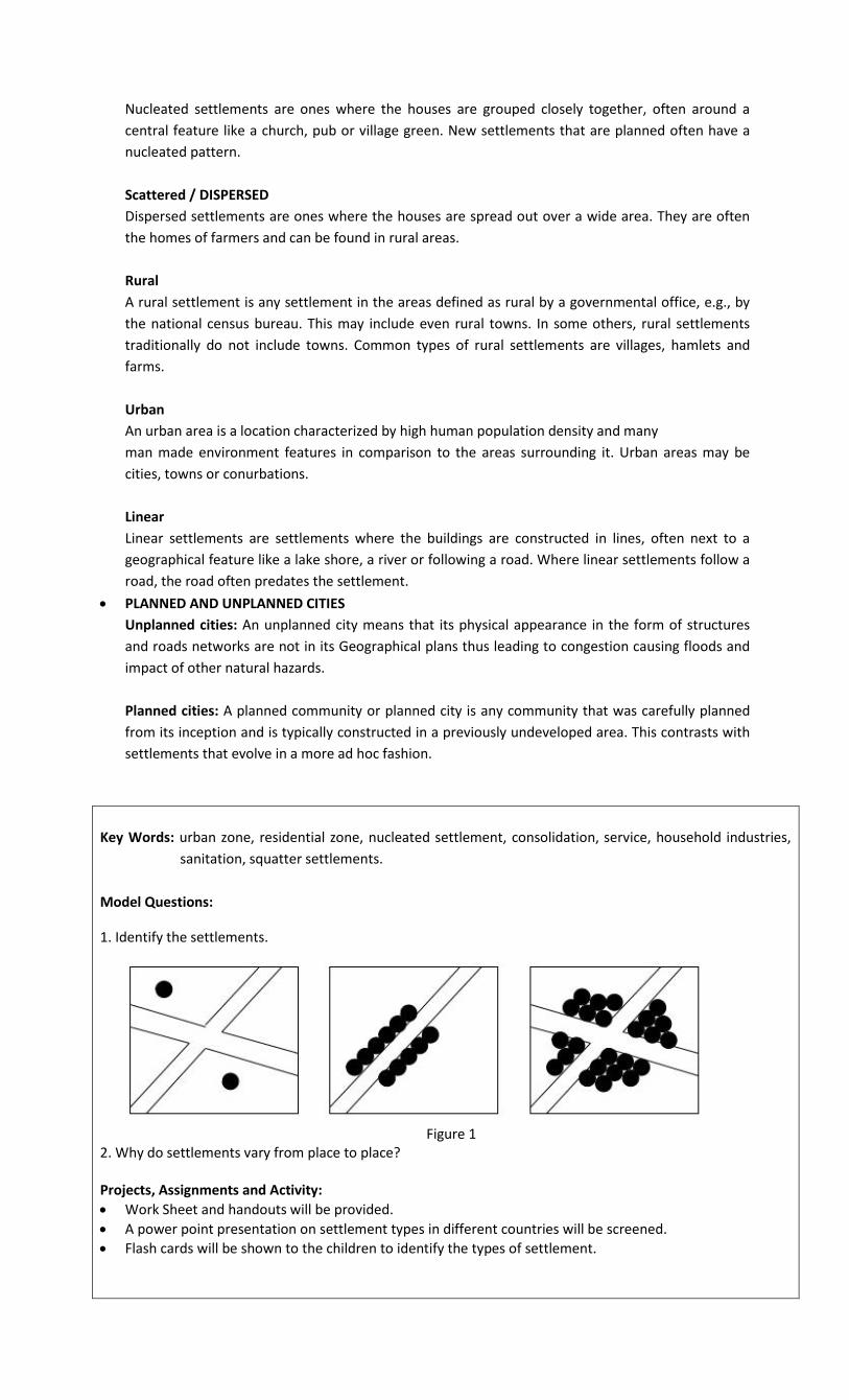
Nucleated settlements are ones where the houses are grouped closely together, often around a
central feature like a church, pub or village green. New settlements that are planned often have a
nucleated pattern.
Scattered / DISPERSED
Dispersed settlements are ones where the houses are spread out over a wide area. They are often
the homes of farmers and can be found in rural areas.
Rural
A rural settlement is any settlement in the areas defined as rural by a governmental office, e.g., by
the national census bureau. This may include even rural towns. In some others, rural settlements
traditionally do not include towns. Common types of rural settlements are villages, hamlets and
farms.
Urban
An urban area is a location characterized by high human population density and many
man made environment features in comparison to the areas surrounding it. Urban areas may be
cities, towns or conurbations.
Linear
Linear settlements are settlements where the buildings are constructed in lines, often next to a
geographical feature like a lake shore, a river or following a road. Where linear settlements follow a
road, the road often predates the settlement.
PLANNED AND UNPLANNED CITIES
Unplanned cities: An unplanned city means that its physical appearance in the form of structures
and roads networks are not in its Geographical plans thus leading to congestion causing floods and
impact of other natural hazards.
Planned cities: A planned community or planned city is any community that was carefully planned
from its inception and is typically constructed in a previously undeveloped area. This contrasts with
settlements that evolve in a more ad hoc fashion.
Key Words: urban zone, residential zone, nucleated settlement, consolidation, service, household industries,
sanitation, squatter settlements.
Model Questions:
1. Identify the settlements.
Figure 1
2. Why do settlements vary from place to place? Projects, Assignments and Activity:
Work Sheet and handouts will be provided.
A power point presentation on settlement types in different countries will be screened.
Flash cards will be shown to the children to identify the types of settlement.

Surf I.T:
http://www.3dgeography.co.uk/#!settlement-geography/c11jl
APRIL-REVISION FOR FINAL ASSESSMENTS 2018
MAY-FINAL ASSESSMENTS 2018