Datum Transformations: Nightmare on GIS StreetEsri Environment: Time-Dependent Geodetic Datum •...
8
Datum Transformations: Nightmare on GIS Street Speaker: Eric Gakstatter Contributing Editor – GPS World Editor - Geospatial Solutions Presented at: Minnesota Society of Professional Surveyors Bloomington, MN February 20, 2014 ©Copyright 2014 Agenda What’s the problem and why should I care? - The challenge of horizontal datums - The challenge of integrating high-accuracy data into the GIS workflow. Vendor perspetive. - The challenge of integrating high-accuracy data into the GIS workflow. User perspective. - Discussion. ©Copyright 2014 Challenges - The cost of acquiring high-precision geospatial data is declining (eg. GNSS, airborne/terrestrial Lidar, UAVs, etc.) - Legacy (and some current) geospatial “base” data is likely less accurate than what you are collecting today. - How do you make good quality decisions when the data is so disparate? ©Copyright 2014
Transcript of Datum Transformations: Nightmare on GIS StreetEsri Environment: Time-Dependent Geodetic Datum •...

Datum Transformations: Nightmare on GIS Street
Speaker: Eric Gakstatter Contributing Editor – GPS World
Editor - Geospatial Solutions
Presented at: Minnesota Society of Professional Surveyors Bloomington, MN February 20, 2014
©Copyright 2014
Agenda
What’s the problem and why should I care? - The challenge of horizontal datums - The challenge of integrating high-accuracy
data into the GIS workflow. Vendor perspetive. - The challenge of integrating high-accuracy
data into the GIS workflow. User perspective. - Discussion.
©Copyright 2014
Challenges
- The cost of acquiring high-precision geospatial data is declining (eg. GNSS, airborne/terrestrial Lidar, UAVs, etc.)
- Legacy (and some current) geospatial “base” data is likely less accurate than what you are collecting today.
- How do you make good quality decisions when the data is so disparate?
©Copyright 2014

©Copyright 2014
- Orthophotos: A picture is worth a thousand words…not.
- Understand the source of the data; how is was collected, which datum/epoch was is referenced to.
- The Truth: Checking against survey marks. - …but all survey marks aren’t created equal. Just
because it’s a disk on the ground, doesn’t make it a survey mark you should use.
How do I know which data is “good”?
©Copyright 2014
Survey Marks
©Copyright 2014
Audience Poll
Poll #1 Question How much of a problem is matching data with disparate datums in your organization? 1. It’s a big problem 2. It’s a problem. 3. It’s not a problem 4. I don’t know if it’s a problem.

©Copyright 2014
Datums
• Geometric (“horizontal”) datums – a.k.a. “geographic coordinate systems” – Basis for determining positions on the Earth – Modern ones are 4-D
• Latitude, longitude, ellipsoid height (or Earth-Centered, Earth-Fixed XYZ) • Time variation is 4th dimension
– Ellipsoid (“spheroid”) by itself is NOT a datum • Same ellipsoid for NAD 83 and WGS 84, but they differ by ~2 m
• Includes “local” and “global” datums – “Local” (regional) datums are for a specific part of the Earth
• e.g., North American Datum of 1983 (NAD 83) – “Global” datums are for the entire Earth
• e.g., World Geodetic System of 1984 (WGS 84)
• Vertical (geopotential) datums another topic for another time…
©Copyright 2014
Datums
• Datums must be “realized” – Connected to the Earth by observations (e.g., GNSS) – New realizations improve accuracy of coordinates – A single datum can have multiple realizations
• e.g., both NAD 83 and WGS 84 datums have 4-5 realizations
• Interrelationships given by “datum transformations” – Mathematical methods for converting between datums – Needed if combining data based on different datums – There are many different kinds and they can vary greatly
• From simple geometric shift to modeling tectonic motion
• Modern datum definitions are accurate but complex – Will focus on two here: NAD 83 and WGS 84.
©Copyright 2014
Datums
yrigh 2014ht 2
• Original realization completed in 1986 – Almost entirely classical (optical) observations
• “High Accuracy Reference Network” (HARN) realizations (1990s) – Done essentially state-by-state – Based on GNSS but classical stations included
• National Re-Adjustment of 2007 – NAD 83(NSRS2007/CORS96) epoch 2002.00 – Nationwide adjustment (GNSS only)
• NAD 83 (2011/PA11/MA11) epoch 2010.00 – Also nationwide GNSS-only adjustment – Realization SAME for CORS and passive marks – This is NOT a new datum! (still NAD 83)

©Copyright 2014
Datums
©Copyright 2014
Brief History of WGS-84
yrigh 2014ht 2
• Original realization completed in 1987 – Intent was to align with NAD 83(1986) – “Same” as NAD 83 (to within ±1-2 m)
• WGS 84 (G730) — adopted Jan 2, 1994 – “G730” is GPS week 730, began Jan 2, 1994 – Aligned with ITRF91
• WGS 84 (G873) — adopted Sep 29, 1996 – Aligned with ITRF94
• WGS 84 (G1150) — adopted Jan 20, 2002 – Aligned with ITRF2000/IGS00 (at epoch 2001.00)
• WGS 84 (G1674) — adopted Feb 5, 2012 – Aligned with ITRF2008/IGS08 (at epoch 2005.00) – Coordinates updated annually for tectonic motion – Note that current NAD 83 is epoch 2010.00
©Copyright 2014
Datums

©Copyright 2014
Datums
©Copyright 2014
Datums
©Copyright 2014
Datums
©Copyright 2014
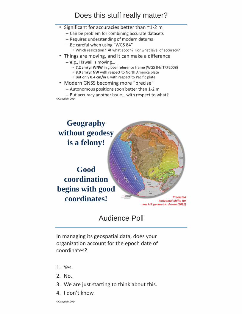
Does this stuff really matter? • Significant for accuracies better than ~1-2 m – Can be problem for combining accurate datasets – Requires understanding of modern datums – Be careful when using “WGS 84”
• Which realization? At what epoch? For what level of accuracy? • Things are moving, and it can make a difference – e.g., Hawaii is moving…
• 7.2 cm/yr WNW in global reference frame (WGS 84/ITRF2008) • 8.0 cm/yr NW with respect to North America plate • But only 0.4 cm/yr E with respect to Pacific plate
• Modern GNSS becoming more “precise” – Autonomous positions soon better than 1-2 m – But accuracy another issue… with respect to what?
Predicted horizontal shifts for
new US geometric datum (2022)
Geography without geodesy
is a felony!
Good coordination
begins with good coordinates!
©Copyright 2014
Audience Poll
In managing its geospatial data, does your organization account for the epoch date of coordinates? 1. Yes. 2. No. 3. We are just starting to think about this. 4. I don’t know.

Esri Environment: Time-Dependent Geodetic Datum
• Not currently defined in Esri technology - Perhaps a “time-enabled” GEOGCS
• Pervasive among national geodetic datums • Maintain stability of reference frame axes by modeling
their movement over time • Physical locations move measurably with the crust
- Tectonic plate and local crustal motion
• So coordinates change measurably in two ways – - Due to variations in the reference frame - Due to crustal motion
• These coordinate changes cannot be ignored in GIS
Reference Frame Realizations
Coordinates Move • Between different reference frames
- 14 parameter Helmert transform
• Within the same reference frame
- Global Tectonic Plate Motion (Global Velocities) - Local continuous crustal motion (Local Velocities) - Abrupt Events – earthquakes

Some Challenges • Multiple transformation parameters between same or
similar reference frames - IGSxx-to-ITRFyy vs. ITRFxx-to-ITRFyy – Which one?
• Velocity model performance - Tectonic plate selection for each point - In GIS we deal with thousands, millions of points - How to handle discontinuous motion at plate boundaries
• Within frame movement referenced to source or target - Added burden of transforming velocity vectors
©Copyright 2014
Audience Questions?
Eric Gakstatter Contact Information: [email protected]
Subscribe to Survey Scene and Geospatial Weekly Newsletters at www.gpsworld.com/newsletters
Subscribe to GPS World Magazine at www.gpsworld.com/subscribemag
©Copyright 2014