The Deep Sea at MarineBio.org - Ocean Biology, Marine Life, Sea Creatures, Marine Conservation...

Canadian Parks & Wilderness Society
CPAWS
DARE TO BE DEEP
SeaStates Report on North America’s Marine Protected Areas (MPAs)
Canadian Parks and Wilderness Society Marine Conservation Institute | 32 | Canadian Parks and Wilderness Society Marine Conservation Institute
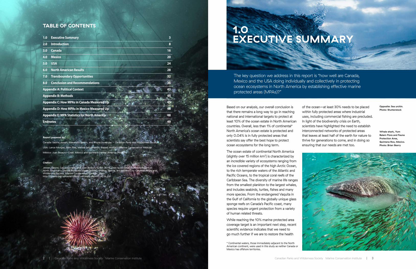
Based on our analysis, our overall conclusion is that there remains a long way to go in reaching national and international targets to protect at least 10% of the ocean estate in North American countries. Overall, less than 1% of continental* North America’s ocean estate is protected and only 0.04% is in fully protected areas that scientists say offer the best hope to protect ocean ecosystems for the long term.
The ocean estate of continental North America (slightly over 15 million km2) is characterized by an incredible variety of ecosystems ranging from the ice covered regions of the high Arctic Ocean, to the rich temperate waters of the Atlantic and Pacific Oceans, to the tropical coral reefs of the Caribbean Sea. The diversity of marine life ranges from the smallest plankton to the largest whales, and includes seabirds, turtles, fishes and many more species. From the endangered Vaquita in the Gulf of California to the globally unique glass sponge reefs on Canada’s Pacific coast, many species require urgent protection from a variety of human related threats.
While reaching the 10% marine protected area coverage target is an important next step, recent scientific evidence indicates that we need to go much further if we are to restore the health
of the ocean—at least 30% needs to be placed within fully protected areas where industrial uses, including commercial fishing are precluded. In light of the biodiversity crisis on Earth, scientists have highlighted the need to establish interconnected networks of protected areas that leaves at least half of the earth for nature to thrive for generations to come, and in doing so ensuring that our needs are met too.
1.0EXECUTIVE SUMMARY
Whale shark, Yum Balam Flora and Fauna Protection Area, Quintana Roo, Mexico. Photo: Brian Skerry
Opposite: Sea urchin. Photo: Shutterstock
The key question we address in this report is “how well are Canada, Mexico and the USA doing individually and collectively in protecting ocean ecosystems in North America by establishing effective marine protected areas (MPAs)?”
TABLE OF CONTENTS
1.0 Executive Summary 3
2.0 Introduction 8
3.0 Canada 16
4.0 Mexico 20
5.0 USA 24
6.0 North American Results 28
7.0 Transboundary Opportunities 32
8.0 Conclusion and Recommendations 36
Appendix A: Political Context 43
Appendix B: Methods 44
Appendix C: How MPAs in Canada Measured Up 45
Appendix D: How MPAs in Mexico Measured Up 46
Appendix E: MPA Statistics for North America 48
Endnotes 49
Report prepared by:
Canada: Sabine Jessen, Alexandra Barron, and Rhona Govender – Canadian Parks and Wilderness Society
USA: Lance Morgan, Beth Pike, Vienna Saccomanno, Russell Moffitt - Marine Conservation Institute
México: Juan Bezaury-Creel. México and Northern Central America Program.
Citation:
Jessen, Sabine, Lance Morgan, and Juan Bezaury-Creel. 2016. Dare to be Deep: SeaStates Report on North American’s Marine Protected Areas (MPAs). Ottawa, Seattle, and México City: Canadian Parks and Wilderness Society, Marine Conservation Institute, 52pp. http://cpaws.org/uploads/CPAWS-Oceans-Report-2016.pdf
* Continental waters, those immediately adjacent to the North American continent, were used in this study as neither Canada or Mexico has offshore territories.
4 | Canadian Parks and Wilderness Society Marine Conservation Institute Canadian Parks and Wilderness Society Marine Conservation Institute | 5
DARE TO BE DEEP: SeaStates Report on North America’s Marine Protected Areas (MPAs) DARE TO BE DEEP: SeaStates Report on North America’s Marine Protected Areas (MPAs)
Marine protected areas are a tried and tested conservation strategy. Much like parks on land, MPAs serve as refuges for marine animals and ecosystems, by preventing destructive human activities. They also offer the opportunity to humans to experience nature at its healthiest.
Fully protected areas provide species and ecosystems with the space and resources that they need to recover from exploitation. In doing so, they also provide long-term economic benefits by supporting healthy, sustainable fisheries, ecotourism and recreation activities, and ecosystem services like carbon storage and shoreline protection. The ecosystem services that the ocean provides have an estimated worth of $24 trillion globally and many cannot be replaced by human technology.
MPAs can only be effective if they have clear conservation objectives and are designed
using sound science and local knowledge. The most effective MPAs result from large size, full protection and good management, sufficient isolation to prohibit encroachment from surrounding human activities, and have been established for long enough to allow populations to recover. To effectively protect our oceans we need MPA networks that represent the full variety and diversity of ecosystems and species within our ocean and that support ecological connections as species interact with each other, move and migrate.
While we are encouraged by recent political pronouncements by each of the political leaders in North America regarding their intention to meet or exceed international and national MPA targets, all three countries will need to make a significant effort to get there.
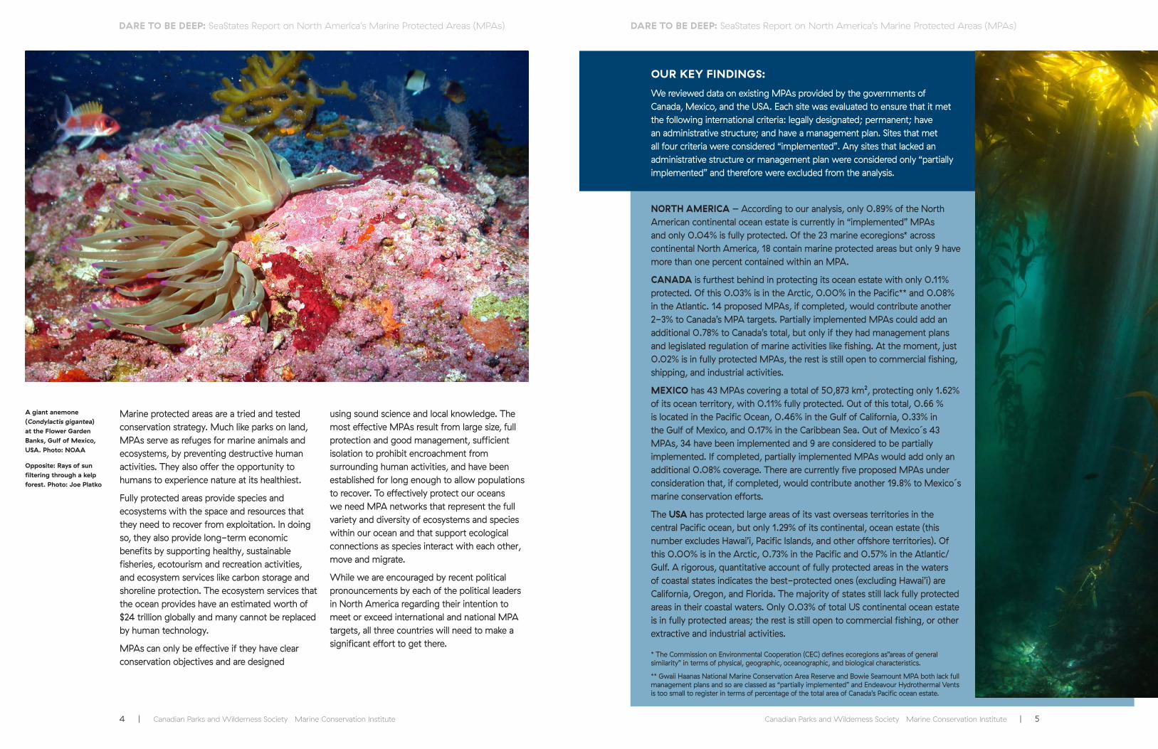
A giant anemone (Condylactis gigantea) at the Flower Garden Banks, Gulf of Mexico, USA. Photo: NOAA
Opposite: Rays of sun filtering through a kelp forest. Photo: Joe Platko
OUR KEY FINDINGS:
We reviewed data on existing MPAs provided by the governments of Canada, Mexico, and the USA. Each site was evaluated to ensure that it met the following international criteria: legally designated; permanent; have an administrative structure; and have a management plan. Sites that met all four criteria were considered “implemented”. Any sites that lacked an administrative structure or management plan were considered only “partially implemented” and therefore were excluded from the analysis.
NORTH AMERICA – According to our analysis, only 0.89% of the North American continental ocean estate is currently in “implemented” MPAs and only 0.04% is fully protected. Of the 23 marine ecoregions* across continental North America, 18 contain marine protected areas but only 9 have more than one percent contained within an MPA.
CANADA is furthest behind in protecting its ocean estate with only 0.11% protected. Of this 0.03% is in the Arctic, 0.00% in the Pacific** and 0.08% in the Atlantic. 14 proposed MPAs, if completed, would contribute another 2-3% to Canada’s MPA targets. Partially implemented MPAs could add an additional 0.78% to Canada’s total, but only if they had management plans and legislated regulation of marine activities like fishing. At the moment, just 0.02% is in fully protected MPAs, the rest is still open to commercial fishing, shipping, and industrial activities.
MEXICO has 43 MPAs covering a total of 50,873 km², protecting only 1.62% of its ocean territory, with 0.11% fully protected. Out of this total, 0.66 % is located in the Pacific Ocean, 0.46% in the Gulf of California, 0.33% in the Gulf of Mexico, and 0.17% in the Caribbean Sea. Out of Mexico´s 43 MPAs, 34 have been implemented and 9 are considered to be partially implemented. If completed, partially implemented MPAs would add only an additional 0.08% coverage. There are currently five proposed MPAs under consideration that, if completed, would contribute another 19.8% to Mexico´s marine conservation efforts.
The USA has protected large areas of its vast overseas territories in the central Pacific ocean, but only 1.29% of its continental, ocean estate (this number excludes Hawai’i, Pacific Islands, and other offshore territories). Of this 0.00% is in the Arctic, 0.73% in the Pacific and 0.57% in the Atlantic/Gulf. A rigorous, quantitative account of fully protected areas in the waters of coastal states indicates the best-protected ones (excluding Hawai’i) are California, Oregon, and Florida. The majority of states still lack fully protected areas in their coastal waters. Only 0.03% of total US continental ocean estate is in fully protected areas; the rest is still open to commercial fishing, or other extractive and industrial activities.
* The Commission on Environmental Cooperation (CEC) defines ecoregions as”areas of general similarity” in terms of physical, geographic, oceanographic, and biological characteristics.
** Gwaii Haanas National Marine Conservation Area Reserve and Bowie Seamount MPA both lack full management plans and so are classed as “partially implemented” and Endeavour Hydrothermal Vents is too small to register in terms of percentage of the total area of Canada’s Pacific ocean estate.

6 | Canadian Parks and Wilderness Society Marine Conservation Institute Canadian Parks and Wilderness Society Marine Conservation Institute | 7
DARE TO BE DEEP: SeaStates Report on North America’s Marine Protected Areas (MPAs) DARE TO BE DEEP: SeaStates Report on North America’s Marine Protected Areas (MPAs)
All three North American countries need to significantly increase the amount of their ocean estate that is protected. They also need to ensure that their MPAs have strong legislation and management plans in place that will effectively conserve marine biodiversity. Simply naming a place as a MPA is not enough.
Each country should move forward urgently in developing national representative networks of MPAs with an interim target of fully protecting at least 10% by 2020, and 30% or more by 2030 in order to help in the recovery of depleted species and ecosystems, and to protect the diversity of life in the ocean. MPA networks in North America need to include a substantial portion in fully protected areas that cover at least 30% of each marine bioregion.*
Designate all currently proposed sites and upgrade all partially implemented MPAs. This would bring Canada, Mexico, and the USA much closer to their MPA goals** and international commitments. In some cases, a legislative framework is already in place and the sites simply need a full management plan for the marine component.
Strict interim protection measures should be put in place for all proposed MPAs so that all potentially harmful activities within the boundary are stopped until it is determined that they do not impact the ecological and cultural values of the area.
Plan networks of MPAs. The existing site-by-site approach to MPA identification, design, and designation is ineffective. Science and real-world experiences demonstrate that MPA network planning is a more effective and efficient approach to MPA establishment, with greater conservation benefits.
We recommend securing full, permanent protection for at least 30% of each marine ecoregion. Canada, Mexico, and the United States need more areas that are completely free from fishing and other extractive uses, in order to achieve the full benefits of a national network
of MPAs. Harmful fishing activities should be prohibited throughout the entire MPA.
Most of North America’s MPAs are small. Well-designed, large MPAs or networks of MPAs could significantly help safeguard marine life and meet international marine protection targets in domestic waters for all three countries.
There is an urgent need for sufficient and consistent funding for MPA establishment and management across North America. Adequate funding ensures sufficient human and logistical resources are available to effectively protect and manage MPAs. While the federal governments of Canada, Mexico, and the USA should be the principal source of MPA funding for basic operational needs, other financial arrangements can support MPA establishment and management, such as the public-private partnerships recently used in California and British Columbia.
Nations must take immediate steps to overcome jurisdictional complications and simplify MPA legislation to streamline the process. Where MPA legislation requires corroborating fisheries legislation to prohibit fishing activities, the MPA legislation should be revised to allow for the management of all marine activities and to improve coordination across federal departments. Better coordination between the federal governments of all three countries and their respective provincial/state and municipal governments for MPA management is also needed.
Governments in North America should create opportunities for stakeholder collaboration and consensus building to help reduce opposition to MPAs. One mechanism is marine spatial planning such as the recent effort in Canada’s Great Bear Sea. Marine spatial planning brings stakeholders together to identify shared interests and conflicting uses, and develop plans to ensure sustainable use of marine resources, including MPA networks, while maintaining conservation as a primary goal.
Canada and the USA have an immediate and urgent opportunity to collaborate on a network of MPAs in the Arctic, including transboundary MPAs that would provide protection at the scale required by species and ecosystems. Such a step would demonstrate international leadership and is consistent with recent statements by Prime Minister Trudeau and President Obama. A binational (or multinational) protected area in the Arctic offers a critical tool in maintaining political stability and reducing conflict while protecting rapidly changing and vulnerable ecosystems and species.
All three countries should explore opportunities for transboundary MPAs in the following marine regions:
• Between Mexico and the USA in the northern Gulf of Mexico and the Southern Californian Pacific ecoregions;
• Between Canada and the USA in the Arctic between Alaska and Yukon; on the east coast between the Gulf of Maine and the Bay of Fundy; and on the West Coast between Alaska and the north coast of British Columbia in Dixon Entrance and at the southern tip of British Columbia and Washington around the Strait of Juan de Fuca.
Additional specific recommendations for each country are included in the report.
OUR RECOMMENDATIONS TO CANADA, MEXICO AND THE USA
Diving cormorant. Photo: Joe Platko
Whale tail, British Columbia, Canada. Photo: A.S. Wright
School of fish in the Cozumel Reefs National Park, Quintana Roo, Mexico. Photo: Claire Fackler, NOAA National Marine Sanctuaries
* Like ecoregions, bioregions are a spatial unit defined by their biological, physical and oceanographic similarities. Bioregional analyses have been conducted by the governments of Canada, Mexico, and the USA for their respective ocean estates.
** The USA is not a signatory to the CBD or other agreements to establish MPAs. The Office of National Marine Sanctuaries does not have a stated national target for MPA coverage.

Canadian Parks and Wilderness Society Marine Conservation Institute | 98 | Canadian Parks and Wilderness Society Marine Conservation Institute
2.0INTRODUCTION
However, overfishing, climate change, pollution, development and industrial use, vessel traffic, and noise pollution threaten the health of our ocean. These threats do not act in isolation but occur simultaneously, amplifying their
consequences. Declines in the number and abundance of marine species from whales to seagrass are widespread and rapid. We are facing mass extinctions in our ocean.
Our global ocean is critical to all life on earth. We depend on the ocean to provide half of the oxygen we breathe, as well as contributing to the food we eat. The ocean regulates our climate and weather, and has been absorbing the majority of the carbon dioxide that we pump into our atmosphere.
Convention on Biological Diversity, Strategic Plan for Biodiversity 2011-2020
Aichi Target 11: By 2020, at least 17% of terrestrial and inland water areas and 10% of coastal and marine areas, especially areas of particular importance for biodiversity and ecosystem services, are conserved through effectively and equitably managed, ecologically representative and well-connected systems of protected areas and other effective area-based conservation measures, and integrated into the wider landscape and seascape.
Above: Harbour seal among kelp. Photo: Joe Platko
Opposite: To come. Photo: Joe Platko
Intertidal explorations. Photo: Leah Honka
10 | Canadian Parks and Wilderness Society Marine Conservation Institute Canadian Parks and Wilderness Society Marine Conservation Institute | 11
DARE TO BE DEEP: SeaStates Report on North America’s Marine Protected Areas (MPAs) DARE TO BE DEEP: SeaStates Report on North America’s Marine Protected Areas (MPAs)
POLITICAL COMMIT MENTS TO MPAS IN NORTH AMERICA
“Canada and the U.S. re-affirm our national goals of protecting at least 17% of land areas and 10% of marine areas by 2020. We will take concrete steps to achieve and substantially surpass these national goals in the coming years.”1a – Prime Minister Trudeau and President Obama, U.S.-Canada Joint Statement on Climate, Energy, and Arctic Leadership, 10 March 2016
“President Peña Nieto desires to reach Aichi Target 11 on Protected Areas in 2018, that is two years before of what is established by CBDs 2011-2020 Strategic Plan”1b - Mexico’s Secretary of the Environment and Natural Resources Rafael Pacchiano –Alamán. 17 November 2015
Protecting marine species and their habitats is the best way to maintain and restore biological diversity, abundance, and resilience. Canada, Mexico, and the USA have all made significant commitments to establish marine protected areas (MPAs) in order to conserve marine biodiversity. Canada and Mexico are both signatories to the United Nations Convention on Biological Diversity commitment to protect at least 10% of their
ocean territories by 2020. While the USA did not ratify the convention, it has made similar commitments. There are several other important agreements, including the United Nations Framework Convention on Climate Change and the Durban Accord that followed from the 2003 IUCN World Parks Congress, that have set gradual and tangible marine conservation goals for world leaders.
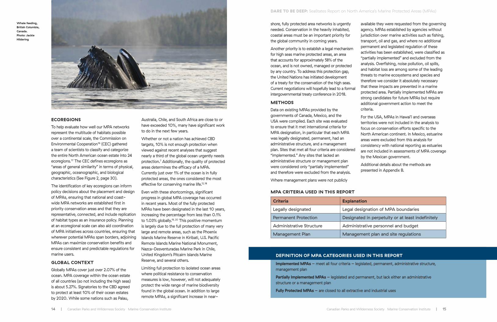
THE MARITIME ZONES
Maritime zones are measured from lines called territorial sea baselines. The key zones, which are defined by the United Nations Convention on the Law of the Sea (UNCLOS) are:
Territorial Sea: extends up to 12 nautical miles out to sea from the baseline. Countries have sovereignty over the airspace, water, seafloor and subsoil in this zone. Ships from other countries have the “right of innocent passage” through this zone as long as they operate under certain conditions.
Exclusive Economic Zone: ranges from 12 to a maximum of 200 nautical miles from baselines. Within this zone, a country has sovereign rights over the exploration, exploitation, management and conservation of resources in the water, on the seabed and under the seafloor. A country also has jurisdiction over certain activities like marine scientific research and protecting the marine environment.
High Seas: the water beyond the Exclusive Economic Zone. No state has sovereignty over the high seas.
We are using the term Ocean Estate to include the territorial sea and the exclusive economic zone.
WORLD PARKS CONGRESS, 2014, THE PROMISE OF SYDNEY: OFFICIAL RECOMMENDATIONS ON MPAS2
“Recommendation 1. Urgently increase the ocean area that is effectively and equitably managed in ecologically representative and well-connected systems of MPAs or other effective conservation measures. This network should target protection of both biodiversity and ecosystem services and should include at least 30% of each marine habitat. The ultimate aim is to create a fully sustainable ocean, at least 30% of which has no extractive activities.”
Geo-political boundaries do not constrain the threats to our oceans and the species and ecosystems affected. Protection or inaction on one side of a border will have consequences for species and ecosystems on the other, and potentially in other places across the continent. Through collaboration, opportunities are created for countries to more effectively address risks and protect ecosystems.
This report provides an assessment of progress on the establishment of MPAs in Canada, Mexico and the USA, as well as their collective efforts on a North American continental scale. Recommendations for future MPA planning, including transboundary protected areas are provided.
WHAT ARE MARINE PROTECTED AREAS?
Marine Protected Areas (MPAs) are a tried and
tested conservation strategy.3, 4, 5 Much like parks on land, marine protected areas serve as refuges for marine animals and ecosystems, by preventing destructive human activities.
Fully protected areas provide species and ecosystems with the space and resources that they need to recover from exploitation. In doing so, they also provide long-term economic benefits by supporting healthy, sustainable fisheries, ecotourism and recreation activities, and ecosystem services like carbon storage and shoreline protection. The ecosystem services that the ocean provides have an estimated worth of $24 trillion globally and many cannot be replaced by human technology.6
HOW MUCH DO WE NEED?
Effective ocean conservation requires that at least 30% of the ocean is protected7 according to scientific research.8
Sanderlings in Nova Scotia. Photo: Dennis Jarvis
Continental Shelf
nm = nautical miles
TerritorialSea
12nm200nm
Terr
itori
al S
ea B
asel
ine
Inte
rnal
Wat
ers
Continental Stope
Continental RiseDeep Seabed
The High SeasExclusive Economic Zone
Ocean Estate
Ad
apte
d f
rom
DFO
, 20
11 D
efini
ng C
anad
a’s
Mar
itim
e Z
ones
.
http
://w
ww
.dfo
-m
po.
gc.
ca/s
cien
ce/p
ublic
atio
ns/a
rtic
le/2
011
/10
-11
-11
-en
g.ht
ml

12 | Canadian Parks and Wilderness Society Marine Conservation Institute Canadian Parks and Wilderness Society Marine Conservation Institute | 13
DARE TO BE DEEP: SeaStates Report on North America’s Marine Protected Areas (MPAs) DARE TO BE DEEP: SeaStates Report on North America’s Marine Protected Areas (MPAs)
NATURE NEEDS HALF
“Nature Needs Half applies to the waters of the world as well as the land, from the tops of mountains to the greatest depths of the sea. More than half of the world is ocean, the blue heart of the planet. You decide: How much of your heart do you need to stay alive?” - Dr. Sylvia Earle
Nature Needs Half™ (NNH) is a science-based and common-sense vision of a relationship between people and nature. The goal is to ensure that enough natural areas of land and ocean are protected and interconnected to provide life-supporting ecosystem and biodiversity services. These services are essential to both human health and prosperity and a bountiful, beautiful legacy of wild nature. In practice, this recognizes that human well-being and security depend greatly on a healthy and abundant natural world. It also recognizes that nature itself has a right to exist freely. This principle is central to achieving a truly sustainable society – one that integrates traditional and indigenous knowledge and life-ways with conservation science and management, and meets human needs while leaving “at least half” in wild nature. For people and nature to survive, we must share Earth, at least equally.9
In order to stave off the mass extinction of species, including our own, we must move swiftly to preserve the biodiversity of our planet, says Edward O. Wilson in his most recent book, Half Earth. Wilson argues that the situation facing us is too large to be solved piecemeal and proposes a solution commensurate with the magnitude of the problem: dedicate fully half the surface of the Earth to nature.10
WHAT IS AN MPA?
Not all marine protected areas are created equal. There are many types of MPAs that provide varying levels of regulation and conservation effectiveness. Studies show that fully protected areas are the most effective type of protected areas.4,11,12 Fully protected areas prohibit all extractive activities and therefore deliver conservation benefits to people and marine life alike. In contrast, MPAs with limited protection (i.e., areas that allow bottom trawling or other types of fishing, dredging, mining, oil and gas development, etc.) do not provide the same benefits. Many so-called “protected areas” are in reality fisheries regulations that do not have ecosystem conservation objectives. Fishing regulations are an important management tool that can restrict seasons and gear types, or prohibit take of certain species, but they do not offer the full suite of permanent safeguards critical to ensuring the resilience of our ocean ecosystems.
WHAT MAKES A GOOD MPA?
In order for MPAs to be effective they need clear conservation objectives, be designed purposefully and strategically, and must be based on sound science and local knowledge. Recent research has shown that the most effective MPAs are a combination of large, old, isolated, strictly protected, and well managed.12
Fully Protected
Fully protected (i.e., no-take reserves) are areas where all fishing and other extractive activities like oil and gas activities, and deep sea mining are strictly prohibited. They are much more effective at conserving and rebuilding biodiversity than partially protected areas where some fishing and industrial activities are allowed.13
Large MPAs
Protecting very large areas makes a highly valuable contribution to the global MPA network by protecting intact ecosystems in areas with limited human activity before degradation can occur.7
Old MPAs
Studies have indicated that it can take up to 15 years for improvements in marine ecosystem health to be noticeable after an MPA is established.14 However, the differences between mature fully protected MPAs and surrounding areas can be astounding, with levels of species richness and abundances that are often many multiples higher inside the reserves than outside.4
Isolated
Isolated areas are habitats that are isolated by deep water or sand and thus are intrinsically buffered from human use and impact. Isolated MPAs can thus provide greater protection by preventing encroachment from surrounding activities. Isolation generally allows for protected area design that takes into account physical features that contribute to an area’s biological richness.
Strategically Placed
Unfortunately, MPAs are often located in areas with limited human activities in an effort to avoid stakeholder conflict. This approach often ignores the most ecologically important areas, thus creating ineffective “residual reserves” that do not protect key habitats or species.15
Representation and Connectivity
The coastal waters of North America are incredibly diverse; from shallow sandy shelves, to rocky shores, warm shallow seas fringed by coral reefs and mangroves, to the frozen north. Each of these areas is created by distinct physical, geographic, and oceanographic features and is home to a unique assemblage of species. Effectively protecting our oceans for future generations requires MPA networks that represent the variety and diversity of ecosystems and species within our ocean, and supports the ecological connections between them as species move and migrate.
Sea hare. Photo: Joe Platko
14 | Canadian Parks and Wilderness Society Marine Conservation Institute Canadian Parks and Wilderness Society Marine Conservation Institute | 15
DARE TO BE DEEP: SeaStates Report on North America’s Marine Protected Areas (MPAs) DARE TO BE DEEP: SeaStates Report on North America’s Marine Protected Areas (MPAs)
shore, fully protected area networks is urgently needed. Conservation in the heavily inhabited, coastal areas must be an important priority for the global community in coming years.
Another priority is to establish a legal mechanism for high seas marine protected areas, an area that accounts for approximately 58% of the ocean, and is not owned, managed or protected by any country. To address this protection gap, the United Nations has initiated development of a treaty for the conservation of the high seas. Current negotiations will hopefully lead to a formal intergovernmental treaty conference in 2018.
METHODS
Data on existing MPAs provided by the governments of Canada, Mexico, and the USA were compiled. Each site was evaluated to ensure that it met international criteria for MPA designation, in particular that each MPA was legally designated, permanent, had an administrative structure, and a management plan. Sites that met all four criteria are considered “implemented.” Any sites that lacked an administrative structure or management plan were considered only “partially implemented” and therefore were excluded from the analysis.
Where management plans were not publicly
available they were requested from the governing agency. MPAs established by agencies without jurisdiction over marine activities such as fishing, transport, oil and gas, and where no additional permanent and legislated regulation of these activities has been established, were classified as “partially implemented” and excluded from the analysis. Overfishing, noise pollution, oil spills, and habitat loss are among some of the leading threats to marine ecosystems and species and therefore we consider it absolutely necessary that these impacts are prevented in a marine protected area. Partially implemented MPAs are strong candidates for future MPAs but require additional government action to meet the criteria.
For the USA, MPAs in Hawai’i and overseas territories were not included in the analysis to focus on conservation efforts specific to the North American continent. In Mexico, estuarine areas were excluded from this analysis for consistency with national reporting as estuaries are not included in assessments of MPA coverage by the Mexican government.
Additional details about the methods are presented in Appendix B.
ECOREGIONS
To help evaluate how well our MPA networks represent the multitude of habitats possible over a continental scale, the Commission on Environmental Cooperation16 (CEC) gathered a team of scientists to classify and categorize the entire North American ocean estate into 24 ecoregions.17 The CEC defines ecoregions as “areas of general similarity” in terms of physical, geographic, oceanographic, and biological characteristics (See Figure 2, page 30).
The identification of key ecoregions can inform policy decisions about the placement and design of MPAs, ensuring that national and coast-wide MPA networks are established first in priority conservation areas and that they are representative, connected, and include replication of habitat types as an insurance policy. Planning at an ecoregional scale can also aid coordination of MPA initiatives across countries, ensuring that wherever potential MPAs span borders, adjoining MPAs can maximize conservation benefits and ensure consistent and predictable regulations for marine users.
GLOBAL CONTEXT
Globally MPAs cover just over 2.07% of the ocean. MPA coverage within the ocean estate of all countries (so not including the high seas) is about 5.27%. Signatories to the CBD agreed to protect at least 10% of their ocean estates by 2020. While some nations such as Palau,
Australia, Chile, and South Africa are close to or have exceeded 10%, many have significant work to do in the next few years.
Whether or not a nation has achieved CBD targets, 10% is not enough protection when viewed against recent analyses that suggest nearly a third of the global ocean urgently needs protection.7 Additionally, the quality of protected areas determines the efficacy of a MPA. Currently just over 1% of the ocean is in fully protected areas, the ones considered the most effective for conserving marine life.12,18
Even with these shortcomings, significant progress in global MPA coverage has occurred in recent years. Most of the fully protected MPAs have been designated in the last 10 years, increasing the percentage from less than 0.1% to 1.03% globally.19, 20 This positive momentum is largely due to the full protection of many very large and remote areas, such as the Phoenix Islands Marine Reserve in Kiribati, U.S. Pacific Remote Islands Marine National Monument, Nazca-Desventuradas Marine Park in Chile, United Kingdom’s Pitcairn Islands Marine Reserve, and several others.
Limiting full protection to isolated ocean areas where political resistance to conservation measures is low, however, will not adequately protect the wide range of marine biodiversity found in the global ocean. In addition to large remote MPAs, a significant increase in near-
MPA CRITERIA USED IN THIS REPORT
Criteria Explanation
Legally designated Legal designation of MPA boundaries
Permanent Protection Designated in perpetuity or at least indefinitely
Administrative Structure Administrative personnel and budget
Management Plan Management plan and site regulations
DEFINITION OF MPA CATEGORIES USED IN THIS REPORT
Implemented MPAs – meet all four criteria – legislated, permanent, administrative structure, management plan
Partially Implemented MPAs – legislated and permanent, but lack either an administrative structure or a management plan
Fully Protected MPAs – are closed to all extractive and industrial uses
Whale feeding, British Columbia, Canada. Photo: Jackie Hildering
Canadian Parks and Wilderness Society Marine Conservation Institute | 1716 | Canadian Parks and Wilderness Society Marine Conservation Institute
3.0CANADA
BACKGROUND
Bordering the Arctic, Atlantic, and Pacific oceans, Canada has the longest coastline in the world and an ocean estate that is the second largest in North America after the USA, at 5,746,694 km2. Canada does not possess any remote overseas territories - Canadian waters all lie within 200 nautical miles of its coastline and fall under a combination of federal and provincial jurisdiction (see Appendix A).
Canada is a signatory to the UN Convention on Biological Diversity and has made a commitment to protect at least 10% of its waters by 2020. Canada’s 2005 Federal Marine Protected Areas strategy outlines the three main federal legislative tools available to establish MPAs in Canada: Fisheries and Oceans Canada can designate Marine Protected Areas under the Oceans Act; Parks Canada can designate National Marine Conservation Areas under the National Marine Conservation Areas Act; and Environment Canada can establish marine National Wildlife Areas under the Canada Wildlife Act.
Other sites that can include marine components
are National Parks, National Wildlife Areas, and Migratory Bird Sanctuaries. To date, however, since management plans for the marine components of these sites have not been developed, we do not consider them to be “implemented MPAs”. Some provincial and municipal governments have also established “marine protected areas”, however they rely on federal regulation of fishing, shipping, and industrial activities and are unable to regulate key threats to marine biodiversity and in most cases this has not been provided.
For this reason, they are considered “partially implemented” in this analysis, although we do recognize that they are important sites and can easily be raised to be considered fully implemented.
Despite making international commitments to MPAs and MPA network planning, in Canada over the past eight years there has been a lack of political will to take meaningful steps to protect our ocean and slow progress to achieve these goals. Efforts to identify and designate MPAs were also hampered by funding cuts to relevant government departments.
In particular, I will expect you to work with your colleagues ….. to deliver on your top priorities: Work with the Minister of Environment and Climate Change to increase the proportion of Canada’s marine and coastal areas that are protected – to five percent by 2017, and ten percent by 2020…. – Prime Minister Justin Trudeau mandate letter to Hunter Tootoo, Minister of Fisheries, Oceans and the Canadian Coast Guard, 13 November 2015 22
Above: Sea lion breathing, British Columbia, Canada. Photo: Markus Thompson
Opposite: Arctic ice. Photo: A. S. Wright

18 | Canadian Parks and Wilderness Society Marine Conservation Institute Canadian Parks and Wilderness Society Marine Conservation Institute | 19
DARE TO BE DEEP: SeaStates Report on North America’s Marine Protected Areas (MPAs) DARE TO BE DEEP: SeaStates Report on North America’s Marine Protected Areas (MPAs)
In late 2015, Canada elected a new federal government with a strong environmental platform and ambitious targets to protect 5% of Canada’s ocean territory by 2017, and at least 10% by 2020.21 These targets were made a prominent focus of the Ministers’ mandate letters from Prime Minister Trudeau.22 Given the lack of progress and slashed budgets over the past 8 years, these are indeed lofty goals. However, as had been demonstrated in California and Australia, political will, strict timelines, and firm milestones play a significant role in advancing conservation.23
QUANTITY
Canada has protected only 0.11% of its ocean territory. Of this 0.03% is in the Arctic, 0.00% in the Pacific and 0.08% in the Atlantic. There are currently 14 proposed MPAs under consideration that, if completed, would contribute another 2-3% to Canada’s interim MPA targets.24
Partially implemented MPAs could add an additional 0.78% of Canada’s waters in MPAs, but only if they had management plans and legislated regulation of marine activities like fishing (these include areas such as Bowie Seamount and Gwaii Haanas) (see Table 1).
QUALITY
Just 0.02% of Canada’s ocean territory is in strict fully protected reserves; the rest is still open to commercial fishing, shipping, and industrial activities. A 2015 analysis by the Canadian Parks and Wilderness Society found that Canada’s MPA legislation was worryingly weak.25 Oil and gas extraction is not expressly prohibited from a significant number of Canada’s existing MPAs and many MPAs have a longer list of activities exempted from the prohibitions, than activities that are actually prohibited.
Although there are several National Wildlife Areas, Migratory Bird Sanctuaries, National Parks and, provincially designated protected areas, management plans were not available for the marine components of these sites.
See Appendix C and E for more details on Canadian sites.
RECOMMENDATIONS FOR CANADA
Barely 0.1% of Canadian waters are protected and just 0.02% are fully protected. Canada urgently needs to increase not only the number of MPAs, but strengthen the quality. The new political will to advance marine conservation in Canada and the targets that have been committed to by the new government provide hope that the pace of progress will be significantly stepped up. There are several tactics that the Canadian government needs to take in order to ensure that we meet our international commitments, with truly effective MPAs, including at least one very large MPA (greater than 100,000 km2) created on each coast.26 In addition, given the extraordinarily slow process to establish an MPA in Canada with some candidate areas first nominated more than 20 years ago, efforts need to be made to streamline the establishment process, move to MPA network planning, and ensure interim protection during the establishment phase.
Iles-de-la-Madeleine, Quebec, Canada. Photo: Michelle Seyemon
Puffins nesting on the Scott Islands, British Columbia, Canada. Photo: Sabine Jessen
CANADA WANTS TO LEAD
“...we want to get back in a leadership role internationally to be able to move these targets forward.” –Hon. Hunter Tootoo, Minister of Fisheries, Oceans and Canadian Coastguard, Embassy News, 23 March 2016
Canadian Parks and Wilderness Society Marine Conservation Institute | 2120 | Canadian Parks and Wilderness Society Marine Conservation Institute
4.0MEXICO
“As a nation with a vast marine extension and high global responsibility, today more than ever, our country must face the challenge of conserving the natural heritage of our coastal and marine ecosystems”
- Mexico’s Secretary of the Navy. Vidal F. Soberón-Sanz27
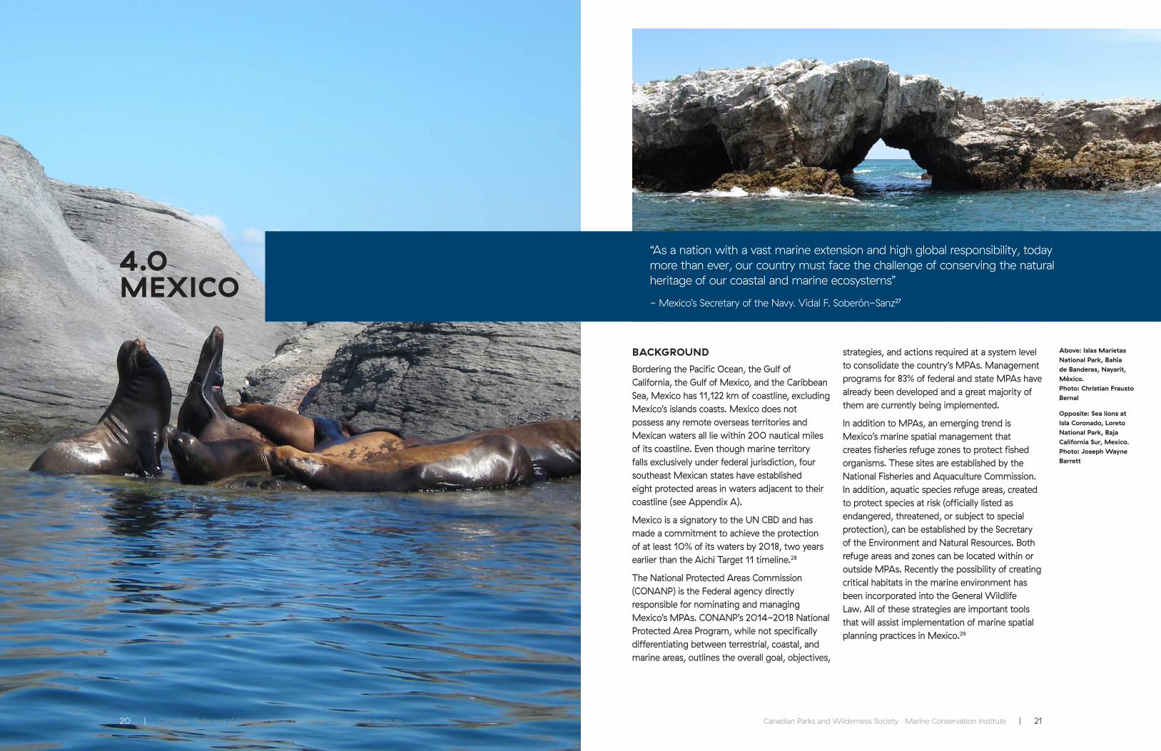
BACKGROUND
Bordering the Pacific Ocean, the Gulf of California, the Gulf of Mexico, and the Caribbean Sea, Mexico has 11,122 km of coastline, excluding Mexico’s islands coasts. Mexico does not possess any remote overseas territories and Mexican waters all lie within 200 nautical miles of its coastline. Even though marine territory falls exclusively under federal jurisdiction, four southeast Mexican states have established eight protected areas in waters adjacent to their coastline (see Appendix A).
Mexico is a signatory to the UN CBD and has made a commitment to achieve the protection of at least 10% of its waters by 2018, two years earlier than the Aichi Target 11 timeline.28
The National Protected Areas Commission (CONANP) is the Federal agency directly responsible for nominating and managing Mexico’s MPAs. CONANP’s 2014-2018 National Protected Area Program, while not specifically differentiating between terrestrial, coastal, and marine areas, outlines the overall goal, objectives,
strategies, and actions required at a system level to consolidate the country’s MPAs. Management programs for 83% of federal and state MPAs have already been developed and a great majority of them are currently being implemented.
In addition to MPAs, an emerging trend is Mexico’s marine spatial management that creates fisheries refuge zones to protect fished organisms. These sites are established by the National Fisheries and Aquaculture Commission. In addition, aquatic species refuge areas, created to protect species at risk (officially listed as endangered, threatened, or subject to special protection), can be established by the Secretary of the Environment and Natural Resources. Both refuge areas and zones can be located within or outside MPAs. Recently the possibility of creating critical habitats in the marine environment has been incorporated into the General Wildlife Law. All of these strategies are important tools that will assist implementation of marine spatial planning practices in Mexico.29
Above: Islas Marietas National Park, Bahía de Banderas, Nayarit, México. Photo: Christian Frausto Bernal
Opposite: Sea lions at Isla Coronado, Loreto National Park, Baja California Sur, Mexico. Photo: Joseph Wayne Barrett

22 | Canadian Parks and Wilderness Society Marine Conservation Institute Canadian Parks and Wilderness Society Marine Conservation Institute | 23
DARE TO BE DEEP: SeaStates Report on North America’s Marine Protected Areas (MPAs) DARE TO BE DEEP: SeaStates Report on North America’s Marine Protected Areas (MPAs)
QUANTITY
With a total area of 50,873 km², Mexico has protected only 1.62% of its ocean territory. Of this total, 0.66 % is located in the Pacific Ocean, 0.46% in the Gulf of California, 0.33% in the Gulf of Mexico, and 0.17% in the Caribbean Sea. Of Mexico’s 43 MPAs, 34 have been implemented and 9 are considered to be partially implemented. Partially implemented MPAs would add only an additional 0.08% coverage. There are currently five proposed MPAs under consideration that, if completed, would contribute another 19.8% to Mexico’s marine conservation efforts .30
International designations have provided an additional layer of protection to Mexican MPAs. These designations currently include: 11 federal MPAs which are inscribed in UNESCO’s World Heritage list, 25 federal and state areas included in the Ramsar List of Wetlands of International Importance, and 12 federal areas participating in UNESCOs World Network of Biosphere Reserves. Out of these MPAs, 17 belong to only one international instrument, 12 belong to two, and only three are covered by all three instruments.
QUALITY
Approximately 6.8 % of Mexico’s MPAs, or 0.11% of its ocean territory, is in fully protected areas (i.e., strict, permanent, no-take reserves); the rest is open to commercial fishing, shipping, and mining. Oil and gas extraction is expressly prohibited from all protected areas in Mexico.
An independent evaluation of 1,120 protected areas in 12 Latin American countries31 found that out of Mexico’s 34 implemented federal MPAs, 19 were at the high end of the implementation and stewardship index, 13 in the middle ranges, only 1 in the lower end. These results demonstrate a significant advance and commitment on MPA implementation and stewardship in Mexico over the last two and a half decades, during which 91% of Mexican federal MPAs were established or had their enabling legal instrument updated.32
Unfortunately, the global slump in oil prices has affected Mexico’s financial investment in protected areas. The recent reduction in resources has had serious negative impacts on administrative, management, and stewardship functions.
See Appendix D and E for additional details about Mexican sites.
RECOMMENDATIONS FOR MEXICO
Mexico’s current political and legal system does not give CONANP (the federal protected areas agency) direct jurisdiction over activities such as fisheries, shipping, and mining within the country’s protected areas. However, the requirement for a special environmental impact process to assess all activities that take place within protected areas could and should certainly be significantly strengthened. This is especially feasible in MPAs where no real property rights
exist, since marine territories are entirely within the public domain and thus under federal jurisdiction. Effective and strict implementation of the existing environmental impact process would better protect sites from a variety of impacts from allowed uses. It would also create the basis for greater coordination between agencies responsible for authorizing fisheries, mining, navigation and other activities, and those charged with environmental protection within MPAs.
Fish and boat above reef, Cabo Pulmo, Sea of Cortez, México. Photo: Pep Murrieta
A white sponge with a yellow feather star crinoid. Photo: NOAA

Canadian Parks and Wilderness Society Marine Conservation Institute | 2524 | Canadian Parks and Wilderness Society Marine Conservation Institute
5.0USA
“Marine protected areas enable parts of the ocean to rejuvenate without human interference and they can serve as replenishment zones for fisheries and provide safe harbors for entire ecosystems.”
– John Kerry, US Secretary of State, Our Ocean Conference, Oct. 5, 2015
BACKGROUND
From the Atlantic Ocean to the Pacific Ocean, the Arctic Ocean to the Gulf of Mexico, the United States’ coastal waters encompass 14 of the 23 continental North American ecoregions, totaling 6,165,586 km2. The ocean estate of the USA also includes 14 overseas territories, but for the purposes of this North American continental analysis, marine protected areas in overseas territories and the state of Hawai’i are not included. Removing these areas from USA marine protection coverage decreases protected areas from 16.32%33 to 1.29% and reveals that these large, remote areas make up the vast majority of the fully protected waters of the USA.
The USA has signed but not ratified the UN CBD. While the USA is also a Party to the United Nations Framework Convention on Climate Change, Sustainable Development Goal supporter as a UNGA member state, and signatory of the Agenda 21 Earth Summit agreement, the USA is not beholden under any international, binding agreement to conserve a minimum amount of ocean area by a given date (i.e., the 10% by 2020 Aichi 11 target).
The USA has legislation to secure protection
for important ocean places in federal waters. The National Marine Sanctuaries Act (NMSA) of 1972 was designed with the objective to protect special areas of the marine environment as national marine sanctuaries. Today, the system includes 13 national marine sanctuaries and two marine national monuments designated under the Antiquities Act, a separate law that gives the President of the United States presidential proclamation authority to protect important natural areas, on land or in the sea.34
Above: Channel Islands National Marine Sanctuary. Photo: Robert Schwemmer NOAA
Opposite: Mono Lobo Wall, Monterey. Photo: Clinton Bauder
Humpback whale. Photo: Clinton Bauder

26 | Canadian Parks and Wilderness Society Marine Conservation Institute Canadian Parks and Wilderness Society Marine Conservation Institute | 27
DARE TO BE DEEP: SeaStates Report on North America’s Marine Protected Areas (MPAs) DARE TO BE DEEP: SeaStates Report on North America’s Marine Protected Areas (MPAs)
QUANTITY
For the purposes of this analysis we examined 736 MPAs, of which 91 are fully protected. The USA has protected only 78,470 km2 or 1.29% of its continental, ocean estate. Of this 0.00% is in the Arctic, 0.73% in the Pacific and 0.57% in the Atlantic and Gulf of Mexico. A rigorous, quantitative account35 of fully protected areas in the waters of coastal states indicates the best-protected (excluding Hawai’i and overseas territories) are California, Oregon, and Florida. The majority of states still lack fully protected areas in their coastal waters.
QUALITY
Only 0.03% of total US continental coverage is in fully protected areas, the rest is still open to commercial fishing, extraction, and industrial activities. Some domestic US marine regulatory zones are put in place by regional fishery management councils and are temporary, non-permanent areas that generally allow seasonal or year-round take by specific fishing gear and thus do not provide the ecological benefits of fully-protected, permanent MPAs. Beyond the California statewide network of MPAs and recent efforts by Oregon, the creation of fully protected areas in state waters is minimal.
See Appendix E for additional details about USA sites.
RECOMMENDATIONS FOR THE UNITED STATES
Increase Domestic Protection
Significant effort is needed to represent the full diversity of habitats in ecoregions under US stewardship. The majority of fully protected areas in the US ocean estate are found in the isolated central Pacific where political resistance to conservation measures is low due to the remoteness of the area and were not included in this analysis. Protection of the ocean estate near populated regions where stakeholder interests are more pronounced is very limited; ironically, these heavily-used areas are most in need of protection from damaging human activity. To adequately protect marine biodiversity found in
the US ocean estate, MPAs are urgently needed, especially in the least represented ecoregions, such as Arctic, Bering Sea, Gulf of Mexico and along the East Coast.
Stronger Federal Mandate
The US currently lacks a federal mandate to protect a minimum percentage of state and federal marine area by a given date, resulting in very limited, sluggish and uncoordinated protection of marine areas. A strong federal mandate that includes requirements for representation and a fully protected area target would greatly help catalyze protection for the unique marine biodiversity found in US waters.
Cordel Bank National Marine Sanctuary. Photo: Clinton Bauder
Monterey Bay National Marine Sanctuary, Big Sur coastline looking north to Bixby Canyon Bridge. Photo: Robert Schwemmer
Canadian Parks and Wilderness Society Marine Conservation Institute | 2928 | Canadian Parks and Wilderness Society Marine Conservation Institute
6.0NORTH AMERICA
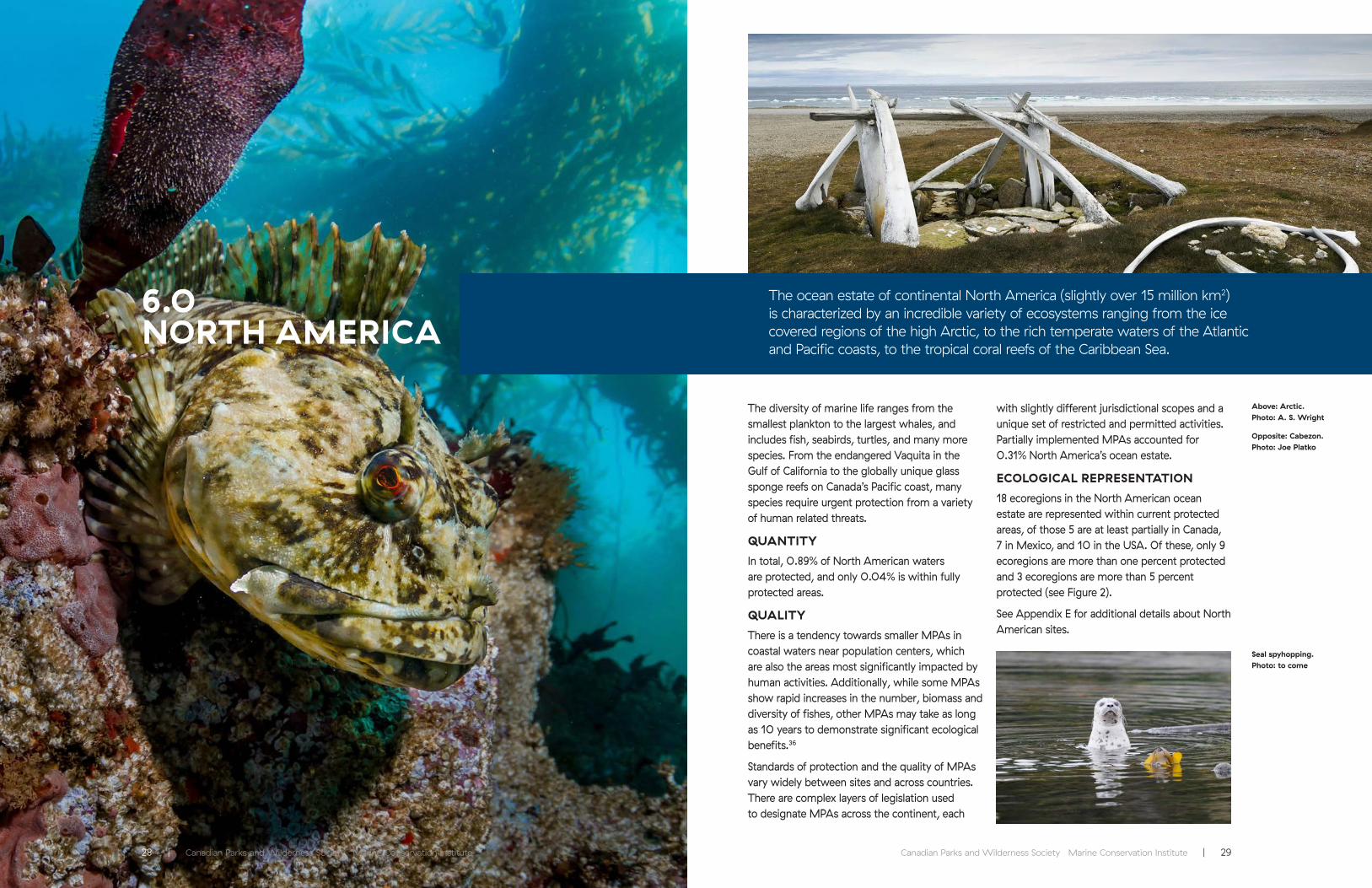
The ocean estate of continental North America (slightly over 15 million km2) is characterized by an incredible variety of ecosystems ranging from the ice covered regions of the high Arctic, to the rich temperate waters of the Atlantic and Pacific coasts, to the tropical coral reefs of the Caribbean Sea.
The diversity of marine life ranges from the smallest plankton to the largest whales, and includes fish, seabirds, turtles, and many more species. From the endangered Vaquita in the Gulf of California to the globally unique glass sponge reefs on Canada’s Pacific coast, many species require urgent protection from a variety of human related threats.
QUANTITY
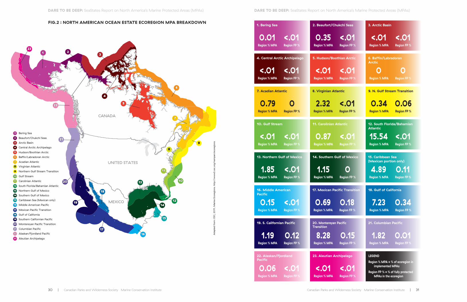
In total, 0.89% of North American waters are protected, and only 0.04% is within fully protected areas.
QUALITY
There is a tendency towards smaller MPAs in coastal waters near population centers, which are also the areas most significantly impacted by human activities. Additionally, while some MPAs show rapid increases in the number, biomass and diversity of fishes, other MPAs may take as long as 10 years to demonstrate significant ecological benefits.36
Standards of protection and the quality of MPAs vary widely between sites and across countries. There are complex layers of legislation used to designate MPAs across the continent, each
with slightly different jurisdictional scopes and a unique set of restricted and permitted activities. Partially implemented MPAs accounted for 0.31% North America’s ocean estate.
ECOLOGICAL REPRESENTATION
18 ecoregions in the North American ocean estate are represented within current protected areas, of those 5 are at least partially in Canada, 7 in Mexico, and 10 in the USA. Of these, only 9 ecoregions are more than one percent protected and 3 ecoregions are more than 5 percent protected (see Figure 2).
See Appendix E for additional details about North American sites.
Above: Arctic. Photo: A. S. Wright
Opposite: Cabezon. Photo: Joe Platko
Seal spyhopping. Photo: to come
30 | Canadian Parks and Wilderness Society Marine Conservation Institute Canadian Parks and Wilderness Society Marine Conservation Institute | 31
DARE TO BE DEEP: SeaStates Report on North America’s Marine Protected Areas (MPAs) DARE TO BE DEEP: SeaStates Report on North America’s Marine Protected Areas (MPAs)
FIG.2 : NORTH AMERICAN OCEAN ESTATE ECOREGION MPA BREAKDOWN
CANADA
UNITED STATES
MEXICO
4
321
23
22
21
20
19
17
18
16
15
14
13
12
10
11
8
9
7
6
5
Bering Sea
Arctic Basin
Alaskan/Fjordland Pacific
Baffin/Labradoran Arctic
Acadian Atlantic
Hudson/Boothian Arctic
Mexican Pacific Transition
Southern Gulf of Mexico
Columbian Pacific
Central Arctic Archipelago
Gulf Stream
Beaufort/Chukchi Seas
Virginian Atlantic
Northern Gulf Stream Transition
Carolinian Atlantic
Middle American Pacific
Aleutian Archipelago
4
3
2
1
23
22
21
Montereyan Pacific Transition20
Southern Californian Pacific19
17
Gulf of California18
16
Caribbean Sea (Mexican only)15
14
Northern Gulf of Mexico13
South Florida/Bahamian Atlantic12
10
11
8
9
7
6
5
4. Central Arctic Archipelago
1. Bering Sea
21. Columbian Pacific
17. Mexican Pacific Transition
15. Caribbean Sea (Mexican portion only)
12. South Florida/Bahamian Atlantic
8. Virginian Atlantic
6. Baffin/Labradoran Arctic
3. Arctic Basin
23. Aleutian Archipelago
20. Montereyan Pacific Transition
18. Gulf of California
14. Southern Gulf of Mexico
10. Gulf Stream
9. N. Gulf Stream Transition
5. Hudson/Boothian Arctic
2. Beaufort/Chukchi Seas
22. Alaskan/Fjordland Pacific
19. S. Californian Pacific
16. Middle American Pacific
13. Northern Gulf of Mexico
11. Carolinian Atlantic
7. Acadian Atlantic
Region % MPA
Region % MPA
Region % MPA
LEGEND
Region % MPA = % of ecoregion in implemented MPAs
Region FP % = % of fully protected MPAs in the ecoregion
Region % MPA
Region % MPA
Region % MPA
Region % MPA
Region % MPA
Region % MPA
Region % MPA
Region % MPA
Region % MPA
Region % MPA
Region % MPA
Region % MPA
Region % MPA
Region % MPA
Region % MPA
Region % MPA
Region % MPA
Region % MPA
Region % MPA
Region % MPA
Region FP %
Region FP %
Region FP %
Region FP %
Region FP %
Region FP %
Region FP %
Region FP %
Region FP %
Region FP %
Region FP %
Region FP %
Region FP %
Region FP %
Region FP %
Region FP %
Region FP %
Region FP %
Region FP %
Region FP %
Region FP %
Region FP %
Region FP %
<.01
0.01
0.69
4.89
1.82
1.15
8.28
1.85
1.19
15.54
2.320.79 0.34
0
<.01
<.01
7.23
<.01
<.01
0.35
0.06
0.15
0.87
<.01
<.01
0.18
0.11
0.01
0
0.15
<.01
0.12
<.01
<.010 0.06
0
<.01
<.01
0.34
<.01
<.01
<.01
<.01
<.01
<.01
Ad
apte
d f
rom
: C
EC, 2
011
. M
arin
e Ec
oreg
ions
. ht
tp:/
/ww
w2.
cec.
org
/nam
pan
/eco
reg
ions

Canadian Parks and Wilderness Society Marine Conservation Institute | 3332 | Canadian Parks and Wilderness Society Marine Conservation Institute
7.0TRANSBOUNDARYOPPORTUNITIES
Transboundary protected areas can help to strengthen the conservation efforts for migratory species, strengthen relationships between countries, promote international cooperation, and reduce resource conflicts and boundary disputes. Although relationships between Canada, Mexico, and the USA are peaceful, there are disagreements over the exact location of national borders in the oceans.
CANADA-USA
Disputed borders between Canada and the USA exist on each coast: in the Arctic between Alaska and Yukon; on the east coast between the Gulf of Maine and the Bay of Fundy; and on the West Coast between Alaska and the north coast of British Columbia in Dixon Entrance and at the southern tip of British Columbia and Washington State near the Strait of Juan de Fuca.
A great opportunity exists for international cooperation through a marine peace park that would link the US Olympic Coast National Marine Sanctuary with a new, large MPA on the Canadian side. This marine peace park could provide contiguous protection of the Juan de Fuca Eddy, a large ocean gyre that once supported abundant and diverse ecosystems and one of the most productive fishing grounds in all of North America, but is now plagued by low oxygen areas, toxic algal blooms, and declining fisheries. Collaborative management of fisheries, shipping, and other industrial activities in the area would reduce potential areas for conflict between
the two nations and increase the ecological benefits for local marine life.
Above: Sea stars, British Columbia, Canada. Photo: Jackie Hildering
Opposite: Mouth of the whale. Photo: Joe Platko
Left: Wolf eel, Alaska. Photo: Clinton Bauder

34 | Canadian Parks and Wilderness Society Marine Conservation Institute Canadian Parks and Wilderness Society Marine Conservation Institute | 35
DARE TO BE DEEP: SeaStates Report on North America’s Marine Protected Areas (MPAs) DARE TO BE DEEP: SeaStates Report on North America’s Marine Protected Areas (MPAs)
MEXICO-USA
The 1970, 1979 and 2014 Boundary Treaty settled most disputes over the USA-Mexico border, although there is some disagreement between Cuba, Mexico, and the USA over the extended continental shelf maritime territory at the eastern edge of the Gulf of Mexico. There are still significant opportunities for collaboration on transboundary MPAs throughout the northern Gulf of Mexico and the Southern Californian Pacific ecoregions, specifically alongside the Laguna Madre in Texas and Tamaulipas, and the extended area in between Point Conception, California, and Cabo Colonett - Bahía de San Quintín, Baja California, known as the Bight of the Californias.
THE ARCTIC – A CASE FOR COLLABORATION AND CONFLICT RESOLUTION THROUGH CONSERVATION
The Arctic is a particularly significant area for trans-boundary marine protected areas and collaborative management. Both Canada and the USA have territorial claims to Arctic waters, alongside Denmark, Norway, and Russia. The area is rich in oil and gas, has relatively un-fished stocks and offers a direct shipping route between the Atlantic and Pacific. To date conflicts over sovereignty and territory have been limited by the inaccessibility of the area due to sea ice.
As sea ice disappears with climate change, the Northwest Passage and the rich resources of the Arctic are being “unlocked” and conflicts over rights and access to resources are growing as nations and industries eye the not-so-frozen
north and disputed borders. In March of this year, Prime Minister Trudeau and President Obama pledged that the two nations would work together to protect the Arctic from overfishing and development.1a, 37 Despite this, just days later, a proposal for offshore oil and gas drilling leases in the Beaufort Sea released by the US Bureau of Energy Management was contested by the Government of Yukon for encroaching on a disputed border with Canada and “violating Canada’s Arctic sovereignty and territory” according to Yukon Justice Minister Brad Cathers.38
It is almost certain that as sea ice continues to disappear in the Arctic there will be increasing conflict over resources and access. In their announcement, Trudeau and Obama not only called for a binding international agreement to carefully manage and regulate fisheries in the
Arctic, but also pledged to create a network of MPAs across the Arctic that protected at least 10% of their respective waters. In an area where geopolitical boundaries subdivide ecoregions and ecosystems at a fine scale, transboundary protected areas not only offer the potential to expand protection to the scale that species and ecosystems require, but also provide political stability by making disputed areas “off limits” to all activities, and provide consistent management measures over large areas encouraging adherence to the regulations and supporting enforcement.
As such transboundary protected areas in the Arctic offer a critical tool in maintaining political stability and reducing conflict while protecting rapidly changing and vulnerable ecosystems and species.
Lobos Rocks, Monterey. Photo: Clinton Bauder
Arctic summer. Photo: A. S. Wright

36 | Canadian Parks and Wilderness Society Marine Conservation Institute Canadian Parks and Wilderness Society Marine Conservation Institute | 37
8.0CONCLUSION AND RECOMMENDATIONS
Our overall conclusion is that the level of MPA coverage in North America is completely inadequate to protect marine biodiversity. All three countries have a significant way to go to reach even the interim CBD Aichi target of protecting at least 10% of the ocean, and it will require significant effort to reach the scientifically recommended target of protecting at least 30% of each marine ecoregion. Substantially more and larger fully protected, representative MPAs are urgently needed in North America to safeguard marine life from the many threats they face, and allow populations to recover so that we can regain the full benefits of healthy oceans.
While we are encouraged by the renewed political commitment and energy directed towards protecting ocean ecosystems in North America, we urge each country to significantly increase the pace of progress and make ocean conservation a high priority.
We offer the following nine recommendations with a view to the key issues that must be addressed in North America by all three countries if they are going to achieve comprehensive marine conservation, and ensure that our ocean ecosystems remain vibrant and healthy for future generations.
RECOMMENDATIONS FOR NORTH AMERICA
Each country should move forward urgently in developing national representative networks of MPAs with an interim target of fully protecting at least 10% by 2020, and 30% or more by 2030 in order to help in the recovery of depleted species and ecosystems, and to protect the diversity of life in the ocean.
Above: Lion’s mane Jellyfish, British Columbia, Canada. Photo: Jackie Hildering
Left: Killer whales, British Columbia, Canada. Photo: Jackie Hildering
Opposite: Bald eagles, British Columbia, Canada. Photo: Sabine Jessen
38 | Canadian Parks and Wilderness Society Marine Conservation Institute Canadian Parks and Wilderness Society Marine Conservation Institute | 39
DARE TO BE DEEP: SeaStates Report on North America’s Marine Protected Areas (MPAs) DARE TO BE DEEP: SeaStates Report on North America’s Marine Protected Areas (MPAs)
Designate and Fully Implement Proposed MPAs
In all three countries there are a large number of proposed and partially implemented MPAs that currently do not restrict fishing, shipping, oil and gas development, and other federally mandated activities. These sites cannot currently contribute to each countries’ marine protection goal, but with better coordination and protection, these sites could significantly bolster coastal and ocean protection in each nation.
Designating all currently proposed sites and upgrading all partially implemented MPAs identified in this report would bring Canada, Mexico, and the USA much closer to their MPA goals and international commitments. These sites have all been identified as ecologically important areas that are vulnerable to human activities. In some cases, a legislative framework is already in place and the site simply needs a full management plan for the marine component. These sites could be comprehensively incorporated through an MPA network planning process.
Establish Interim Protections
Proposed MPAs, and all future MPAs, should have strict interim protection measures in place, so that all potentially harmful activities within the proposed boundary are stopped until it is determined that they do not impact the ecological and cultural values of the area.
Develop network planning
The existing site-by-site approach to MPA identification, design, and designation is ineffective. Science and real-world experiences, such as the establishment of California’s statewide MPA network,39 demonstrate that network planning40 is a more effective and efficient approach to MPA establishment, with greater conservation benefits.41 All three countries have yet to fully engage in consistent MPA network planning.
Fully Protect Areas
Canada, Mexico, and the United States need to protect more of the ocean from fishing and other extractive uses. At present only 0.04% of North America’s continental waters are in fully protected areas and many current and proposed MPAs mandate few, if any restrictions on federal activities. A 2015 analysis of Canadian MPAs and MPA legislation by CPAWS found, for the most part, that there was little difference between what was allowed inside Canadian MPAs and what occurs outside them25. Mexico has recently advanced towards higher protection by expressly prohibiting oil and gas extraction from its MPAs. Fully protected areas reap much greater benefits more quickly than multiple-use and partially protected MPAs.12, 13 In order to achieve conservation benefits, it is critically important that at least a third of each site within a national network of MPAs is fully protected, that is off limits to all extractive activities. Harmful fishing activities should be prohibited throughout the entire MPA. And overall, full, permanent protection should be secured for at least 30% of each marine ecoregion.
Create Large MPAs
Most of North America’s MPAs are small. Well-designed, large12 MPAs could contribute significantly to interim targets and international commitments. Large, continental MPAs could significantly help safeguard marine life and meet international marine protection targets in domestic waters for all three countries.
Provide Consistent and Appropriate Funding
Lack of sufficient and consistent funding for MPA establishment and management is a major problem across North America and currently the most pervasive threat to Mexican protected areas. Without proper funding, sufficient human and logistical resources are not available to effectively protect and manage MPAs. In Canada, the recent federal budget included an allocation of new funding for MPAs (see Box below). The Federal Governments of Canada, Mexico, and the USA need to be the principal source of MPA funding for basic operational needs but other financial alternatives can support MPA establishment and management. In California, a public-private funding partnership offered a novel approach to ensure sufficient funds for MPA network planning and a similar approach has been taken for Marine Spatial Planning in the Great Bear Sea region of British Columbia, Canada.
Canada’s federal budget allocation
The most recent federal budget made a significant new funding allocation to expand Canada’s MPAs. Budget 2016 proposes to provide $81.3 million (CAD) over five years, starting in 2016-17, to Fisheries and Oceans Canada and Natural Resources Canada to support marine conservation activities, including the designation of new Marine Protected Areas under the Oceans Act. Parks Canada will also continue efforts to develop new National Marine Conservation Areas. Together these actions are designed to achieve the target to protect 10% of Canada’s marine and coastal areas by 2020.42
USA federal budget allocation
Marine protected areas in the USA fall under a number of different state and federal agencies such that it is complicated to untangle the total spending on marine protected areas. Within the National Oceanic and Atmospheric Administration (NOAA) the National Marine Sanctuary program operates on an annual budget of just over $50M USD. Other activities within NOAA direct additional millions to coral reefs, endangered species and habitat conservation and restoration, and some of this money helps marine protected areas or the wildlife in them. The Department of Interior likewise manages several marine monuments in the Pacific under the wildlife refuge program (i.e., Papahānaumokuākea, Pacific Remote Islands) and several marine components of national parks and refuges that are also part of the US national MPA system (i.e., Biscayne Bay, Dry Tortugas and Channel Islands National Parks). These programs provide an additional $15M towards the US MPA program. While some states, notably California, have created marine protected areas in state waters, expenditures on these programs are not included here.
BUDGET ALLOCATIONS
Below: Sunflower sea star, British Columbia, Canada. Photo: Markus Thompson
Below right: Great white shark in Baja California waters.. Photo: Joe Platko
Glass sponge reef, British Columbia, Canada. Photo: Sally Leys/ Miriam O/ ROPOS

40 | Canadian Parks and Wilderness Society Marine Conservation Institute Canadian Parks and Wilderness Society Marine Conservation Institute | 41
DARE TO BE DEEP: SeaStates Report on North America’s Marine Protected Areas (MPAs) DARE TO BE DEEP: SeaStates Report on North America’s Marine Protected Areas (MPAs)
Prioritize Effective Coordination and Reduce Jurisdictional Complexity
All three countries have unique jurisdictional situations for marine waters, but each is equally complex (see Appendix A). This level of complexity presents a significant problem in both establishing and evaluating MPAs, resulting in long and expensive planning and consultation processes, and a lack of clarity about how MPAs are measured. Steps must be taken to overcome jurisdictional complications and simplify MPA legislation to streamline the process. In all three countries MPA legislation generally still requires corroborating fisheries legislation to prohibit fishing activities, which means that even within a legally established, fully protected marine reserve fishing prohibitions could easily be overturned from year to year. More power needs to be given under MPA legislation to manage marine activities and improve coordination across federal departments. There also needs to be better coordination between the federal governments of all three countries and their respective provincial/state and municipal governments for MPA management.
Establish Transboundary MPAs
All three countries should explore opportunities for transboundary MPAs in the following marine regions:
• Between Mexico and the USA in the northern Gulf of Mexico and the Southern Californian Pacific ecoregions;
• Between Canada and the USA in the Arctic between Alaska and Yukon; on the east coast between the Gulf of Maine and the Bay of Fundy; and on the West Coast between Alaska and the north coast of British Columbia in Dixon Entrance and at the southern tip of British Columbia and Washington State around the Strait of Juan de Fuca.
In the Arctic, Canada and the USA have the potential through transboundary MPAs to expand protection to the scale required by species and ecosystems, and at the same time provide political stability by making disputed areas “off limits” to all activities, and provide consistent management measures of large areas, thereby encouraging adherence to regulations and supporting enforcement. As such transboundary protected areas in the Arctic offer a critical tool in maintaining political stability and reducing conflict while protecting vulnerable ecosystems and species.
Another opportunity exists for international cooperation through a marine peace park that would link the US Olympic Coast National Marine Sanctuary with a new, large MPA on the Canadian side. This marine peace park could provide contiguous protection of the Juan de Fuca Eddy marine ecosystem.
Build consensus on MPAs and implement Marine Spatial Planning
Across North America, efforts to fully protect marine areas face strong opposition. While the science supporting the benefits to humans and marine life from fully protected areas is strong and growing19 local opposition and strong industry voices are often difficult to overcome because of both perceived and real short-term costs to users. MPA siting is contentious and the political dialog on protecting marine life and natural resources is slow moving, given the urgent need to recover populations.43
In order to secure the protection necessary to safeguard marine life in North American marine areas and to meet international conservation goals (i.e. Aichi Target 11), processes must be developed that allow collaboration among stakeholders to create workable solutions that have high ecological benefits and reach consensus on the empirically supported benefits of permanent protection.
Marine spatial planning is an approach that allows for the engagement of multiple stakeholders and interests, while ensuring sustainable use of our oceans. Establishing MPA networks should be a priority of marine spatial plans. Plans were developed for the Great Bear Sea on the North Pacific coast in British Columbia, Canada, that included protection management zones that will be considered in future MPA network planning. Together ocean users and managers develop zoning plans and practical management guidelines for the ocean, that dictate what activities can take place and where. These plans can reduce user conflict and cumulative impacts and ensure sustainable use of marine resources while protecting biodiversity when executed properly. Coast-wide marine spatial planning across North America would admittedly take a great deal of effort but could reap equally significant ecological benefits if properly conducted.
Below: Dumbo octopus in unique swimming posture. Photo: NOAA Okeanos Explorer Program
Below right: School of rockfish, California. Photo: Joe Platko
Sea star navigates a seaweed covered reef, British Columbia, Canada. Photo: Jackie Hildering
Canadian Parks and Wilderness Society Marine Conservation Institute | 43
DARE TO BE DEEP: SeaStates Report on North America’s Marine Protected Areas (MPAs)
42 | Canadian Parks and Wilderness Society Marine Conservation Institute
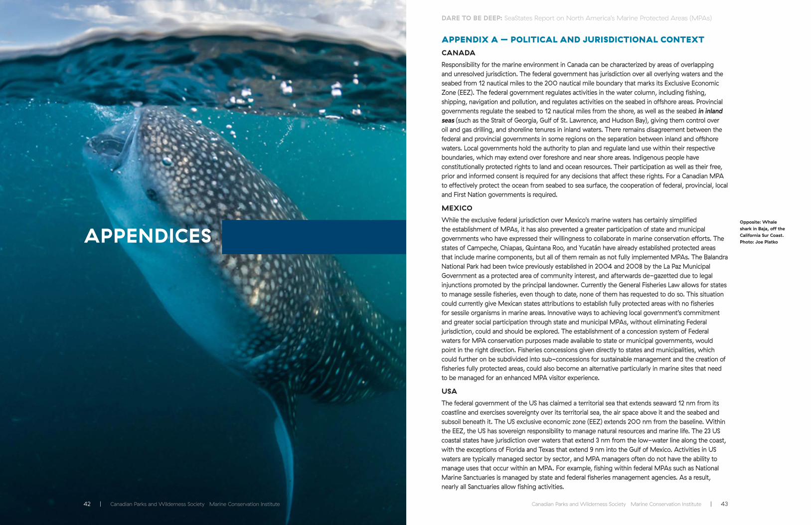
APPENDIX A – POLITICAL AND JURISDICTIONAL CONTEXTCANADA
Responsibility for the marine environment in Canada can be characterized by areas of overlapping and unresolved jurisdiction. The federal government has jurisdiction over all overlying waters and the seabed from 12 nautical miles to the 200 nautical mile boundary that marks its Exclusive Economic Zone (EEZ). The federal government regulates activities in the water column, including fishing, shipping, navigation and pollution, and regulates activities on the seabed in offshore areas. Provincial governments regulate the seabed to 12 nautical miles from the shore, as well as the seabed in inland seas (such as the Strait of Georgia, Gulf of St. Lawrence, and Hudson Bay), giving them control over oil and gas drilling, and shoreline tenures in inland waters. There remains disagreement between the federal and provincial governments in some regions on the separation between inland and offshore waters. Local governments hold the authority to plan and regulate land use within their respective boundaries, which may extend over foreshore and near shore areas. Indigenous people have constitutionally protected rights to land and ocean resources. Their participation as well as their free, prior and informed consent is required for any decisions that affect these rights. For a Canadian MPA to effectively protect the ocean from seabed to sea surface, the cooperation of federal, provincial, local and First Nation governments is required.
MEXICO
While the exclusive federal jurisdiction over Mexico’s marine waters has certainly simplified the establishment of MPAs, it has also prevented a greater participation of state and municipal governments who have expressed their willingness to collaborate in marine conservation efforts. The states of Campeche, Chiapas, Quintana Roo, and Yucatán have already established protected areas that include marine components, but all of them remain as not fully implemented MPAs. The Balandra National Park had been twice previously established in 2004 and 2008 by the La Paz Municipal Government as a protected area of community interest, and afterwards de-gazetted due to legal injunctions promoted by the principal landowner. Currently the General Fisheries Law allows for states to manage sessile fisheries, even though to date, none of them has requested to do so. This situation could currently give Mexican states attributions to establish fully protected areas with no fisheries for sessile organisms in marine areas. Innovative ways to achieving local government’s commitment and greater social participation through state and municipal MPAs, without eliminating Federal jurisdiction, could and should be explored. The establishment of a concession system of Federal waters for MPA conservation purposes made available to state or municipal governments, would point in the right direction. Fisheries concessions given directly to states and municipalities, which could further on be subdivided into sub-concessions for sustainable management and the creation of fisheries fully protected areas, could also become an alternative particularly in marine sites that need to be managed for an enhanced MPA visitor experience.
USA
The federal government of the US has claimed a territorial sea that extends seaward 12 nm from its coastline and exercises sovereignty over its territorial sea, the air space above it and the seabed and subsoil beneath it. The US exclusive economic zone (EEZ) extends 200 nm from the baseline. Within the EEZ, the US has sovereign responsibility to manage natural resources and marine life. The 23 US coastal states have jurisdiction over waters that extend 3 nm from the low-water line along the coast, with the exceptions of Florida and Texas that extend 9 nm into the Gulf of Mexico. Activities in US waters are typically managed sector by sector, and MPA managers often do not have the ability to manage uses that occur within an MPA. For example, fishing within federal MPAs such as National Marine Sanctuaries is managed by state and federal fisheries management agencies. As a result, nearly all Sanctuaries allow fishing activities.
APPENDICESOpposite: Whale shark in Baja, off the California Sur Coast. Photo: Joe Platko

44 | Canadian Parks and Wilderness Society Marine Conservation Institute Canadian Parks and Wilderness Society Marine Conservation Institute | 45
DARE TO BE DEEP: SeaStates Report on North America’s Marine Protected Areas (MPAs) DARE TO BE DEEP: SeaStates Report on North America’s Marine Protected Areas (MPAs)
APPENDIX B: METHODS
Data on existing MPAs provided by the governments of Canada, Mexico, and the USA were compiled. Each site was evaluated to make sure that it met international criteria for MPA designation, in particular that each MPA was legally designated, permanent, had an administrative structure, and a management plan. Sites that met all four criteria are considered “implemented”. Any sites that lacked an administrative structure or management plan were considered only “partially implemented” and therefore were excluded from the analysis.
Where management plans were not publicly available they were requested from the governing agency. MPAs established by agencies without jurisdiction over marine activities such as fishing, transport, oil and gas, and where no additional permanent and legislated regulation of these activities has been established, were classified as partially implemented and excluded from the analysis1. Partially implemented MPAs are considered to be strong candidates for future MPAs but require additional formal protection to meet the criteria. Spatial regulations that apply only to fishery management were not considered MPAs.
The implemented MPAs for each country were first analyzed for total marine area by clipping out the country’s coastline from each MPA boundary using ArcGIS software. USA MPAs from Hawai’i or overseas territories were not included to focus on conservation efforts specific to continental North America. In Mexico, the estuarine areas at Laguna de Términos and El Vizcaíno were excluded from this analysis for consistency with national reporting as the estuaries are not included in assessments of MPA coverage by the National Protected Areas Commission (CONANP).44 Total MPA area and fully protected areas were calculated as a percentage of each country’s marine estate (total waters from 0-200nm from shore, inclusive of state, territorial, and exclusive economic zones).
Each country’s progress in addressing biodiversity conservation by protecting all unique biogeographic regions within its ocean estate was examined using the hierarchical Marine Ecoregions of North America by the CEC.
APPENDIX C - HOW MPAS IN CANADA MEASURED UP
Designation/Site Legislation
Management Plan/Site
Regulations
Administrative Structure Implementation
Saguenay – St. Lawrence
Federal Y Y Implemented
Tarium Niryutait Federal Y Y Implemented
Endeavour Hydrothermal Vents
Federal Y Y Implemented
Musquash Estuary
Federal Y Y Implemented
Gully Federal Y Y Implemented
Basin Head Federal Y Y Implemented
Gilbert Bay Federal Y Y Implemented
Eastport Federal Y Y Implemented
Gwaii Haanas National Marine Conservation Area Reserve and Haida Heritage Site
Federal N* Y Partial
Bowie Seamount
Federal N Y Partial
National Parks of Canada (12)
Federal N Y Partial
National Wildlife Areas (14)
Federal N Y Partial
Migratory Bird Sanctuaries (52)
Federal N Y Partial
Provincial Sites BC, QC, NL (202) **
Provincial N Y Partial
Other Provincial Sites (69)***
Provincial N Y Partial
* Interim management plan, and only 3 % of the site is managed differently from external waters
** Includes Provincial Parks, Conservancies, Ecological Reserves, Wildlife Management Areas, and Aquatic and Biodiversity Reserves
*** Includes Wildlife Management Areas, Natural Areas, and Quebec’s National Parks
Note: All sites listed are considered to be under permanent protection

46 | Canadian Parks and Wilderness Society Marine Conservation Institute Canadian Parks and Wilderness Society Marine Conservation Institute | 47
DARE TO BE DEEP: SeaStates Report on North America’s Marine Protected Areas (MPAs) DARE TO BE DEEP: SeaStates Report on North America’s Marine Protected Areas (MPAs)
APPENDIX D - HOW MPAS IN MEXICO MEASURED UP
Site LegislationManagement
Plan /Site Regulations
Administrative Structure Implementation
Alto Golfo de California y Delta del Río Colorado
Federal Y Y Implemented
Archipíelago de Revillagigedo
Federal Y Y Implemented
Arrecife Alacranes Federal Y Y Implemented
Arrecife de Puerto Morelos Federal Y Y Implemented
Arrecifes de Cozumel Federal Y Y Implemented
Arrecifes de Sian Ka’an Federal Y Y Implemented
Arrecifes de Xcalak Federal Y Y Implemented
Bahía de Loreto Federal Y Y Implemented
Bahía de los Angeles, Canales de Ballenas y de Salsipuedes
Federal Y Y Implemented
Balandra Federal Y Y Implemented
Banco Chinchorro Federal Y Y Implemented
Cabo Pulmo Federal Y Y Implemented
Cabo San Lucas Federal * Y Implemented
Costa Occidental de Isla Mujeres, Punta Cancun y Punta Nizuc
Federal Y Y Implemented
El Vizcaíno Federal Y Y Implemented
Huatulco Federal Y Y Implemented
Isla Contoy Federal Y Y Implemented
Isla Guadalupe Federal Y Y Implemented
Isla San Pedro Mártir Federal Y Y Implemented
Islas Marías Federal Y Y Implemented
Islas Marietas Federal Y Y Implemented
La Encrucijada Federal Y Y Implemented
Laguna de Terminos Federal Y Y Implemented
Los Petenes Federal Y Y Implemented
Porción norte y la franja costera oriental, terrestres y marinas de la Isla de Cozumel
Federal Y Y Implemented
Ría Celestún Federal Y Y Implemented
Sian Ka’an Federal Y Y Implemented
Site LegislationManagement
Plan /Site Regulations
Administrative Structure Implementation
Sistema Arrecifal Lobos Tuxpan
Federal Y Y Implemented
Sistema Arrecifal Veracruzano
Federal Y Y Implemented
Tiburón Ballena Federal Y Y Implemented
Ventilas Hidrotermales de la Cuenca de Guaymas y de la Dorsal del Pacífico Oriental
Federal Y Y Implemented
Yum Balam Federal Y Y Implemented
Zona Marina del Archipiéago de Espíritu Santo
Federal Y Y Implemented
Zona Marina del Archipiélago de San Lorenzo
Federal Y Y Implemented
Islas La Pajarera, Cocinas, Mamut, Colorada, San Pedro, San Agustín, San Andrés y Negrita y los Islotes Los Anegados, Novillas, Mosca y Submarino.
Federal Y Y Partial
Santuario de la Tortuga Marina X’cacel - X’cacelito
State+ Y Y Partial
Santuario del Manati Bahia de Chetumal
State+ Y Y Partial
El Cabildo Amatal State+ Y N Partial
El Gancho Murillo State+ Y N Partial
Reserva de Dzilam State+ Y N Partial
Reserva El Palmar State+ Y N Partial
La Encrucijada State+ N N Partial
Los Petenes State+ N N Partial
* Interim management plan
+ Established state MPAs, but currently lacking jurisdiction over marine waters.
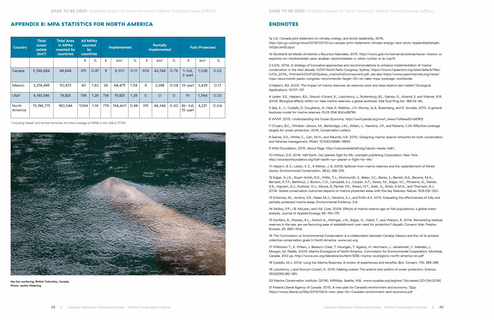
48 | Canadian Parks and Wilderness Society Marine Conservation Institute Canadian Parks and Wilderness Society Marine Conservation Institute | 49
DARE TO BE DEEP: SeaStates Report on North America’s Marine Protected Areas (MPAs) DARE TO BE DEEP: SeaStates Report on North America’s Marine Protected Areas (MPAs)
APPENDIX E: MPA STATISTICS FOR NORTH AMERICA
Country
Total ocean estate(km2)
Total Area in MPAs
counted by countries
All MPAs counted
by countries
Implemented Partially Implemented Fully Protected
# % # km2 % # km2 % #
km2 %
Canada 5,746,694 49,848 315 0.87 9 6,101 0.11 306 43,748 0.76 1-full,2-part
1,038 0.02
Mexico 3,274,495 50,873 43 1.62 34 48,475 1.54 9 2,398 0.08 13-part 3,439 0.11
USA* 6,165,586 79,825 736 1.29 736 79,825 1.29 0 0 0 91 1,744 0.03
North America
15,186,775 180,546 1094 1.19 779 134,401 0.88 315 46,146 0.30 92- full,15-part
6,221 0.04
ENDNOTES
1a U.S.-Canada joint statement on climate, energy, and Arctic leadership. 2016. http://pm.gc.ca/eng/news/2016/03/10/us-canada-joint-statement-climate-energy-and-arctic-leadership#sthash.WDjhUsWS.dpuf.
1b Secretaría de Medio Ambiente y Recursos Naturales. 2015. http://www.gob.mx/semarnat/prensa/reune-mexico-a-expertos-en-biodiversidad-para-analizar-oportunidades-y-retos-rumbo-a-la-cop13
2 IUCN. 2014. A strategy of innovative approaches and recommendations to enhance implementation of marine conservation in the next decade. IUCN World Parks Congress, Sydney. https://www.mpaaction.org/sites/default/files/IUCN_2014_ Promise%20of%20Sydney_marine%20component.pdf, see also https://www.openchannels.org/news/mpa-news/world-parks-congress-recommends-target-30-no-take-mpa-coverage-worldwide.
3 Halpern, B.S. 2003. The impact of marine reserves: do reserves work and does reserve size matter? Ecological Applications. 13:117-137.
4 Lester. S.E., Halpern, B.S., Grorud-Colvert, K., Lubchenco, J., Ruttenburg, B.I., Gaines, G., Airamé, S. and Warner, R.R. 2009. Biological effects within no-take marine reserves: a global synthesis. Mar Ecol Prog Ser. 384:33-46.
5 Sala, E., C. Costello, D. Dougherty, G. Heal, K. Kelleher, J.H. Murray, A.A. Rosenberg, and R. Sumaila. 2013. A general business model for marine reserves. PLOS ONE 8( 4):e58799.
6 WWF. 2015. Understanding the Ocean Economy. http://wwf.panda.org/wwf_news/?uNewsID=247812
7 O’Leary, B.C., Winther-Janson, M., Bainbridge, J.M., Aitken, J., Hawkins, J.P., and Roberts, C.M. Effective coverage targets for ocean protection. 2016. Conservation Letters.
8 Gaines, S.D., White, C., Carr, M.H., and Palumbi, S.R. 2010. Designing marine reserve networks for both conservation and fisheries management. PNAS. 107(43):18286-18293.
9 Wild Foundation. 2015. About Page. http://natureneedshalf.org/nature-needs-half/.
10 Wilson, E.O. 2016. Half Earth. Our planets fight for life. Liverlight publishing Corporation. New York. http://eowilsonfoundation.org/half-earth-our-planet-s-fight-for-life/
11 Halpern, B. S., Lester, S. E., & Kellner, J. B. 2009. Spillover from marine reserves and the replenishment of fished stocks. Environmental Conservation. 36( 4), 268-276.
12 Edgar, G.J.E., Stuart-Smith, R.D., Willis, T.J., Kininmonth, S., Baker, S.C., Banks, S., Barrett, N.S., Becerro, M.A., Bernard, A.T.F., Berkhout, J. Buxton, C.D., Campbell, S.J., Cooper, A.T., Davey, M., Edgar, S.C., Försterra, G., Galván, D.E., Irigoyen, A.J., Kushner, D.J., Moura, R, Parnell, P.E., Shears, N.T., Soler, G., Strain, E.M.A., and Thomson, R.J. 2014. Global conservation outcomes depend on marine protected areas with five key features. Nature. 506:216-220.
13 Sciberras, M., Jenkins, S.R., Kaiser M.J., Hawkins, S.J., and Pullin A.S. 2013. Evaluating the effectiveness of fully and partially protected marine areas. Environmental Evidence. 2:4.
14 Molloy, P.P., I.B. McLean, and I.M. Cote. 2009. Effects of marine reserve age on fish populations: a global meta-analysis. Journal of Applied Ecology 46: 743-751.
15 Devillers, R., Pressey, R.L., Grench A., Kittinger, J.N., Edgar, G., Ward, T., and Watson, R. 2014. Reinventing residual reserves in the sea: are we favouring ease of establishment over need for protection? Aquatic Conserv: Mar. Freshw. Ecosyst. 25: 480-504.
16 The Commission on Environmental Conservation is a collaboration between Canada, Mexico and the US to achieve collective conservation goals in North America. www.cec.org.
17 Wilkinson T., E. Wiken, J. Bezaury-Creel, T. Hourigan, T. Agardy, H. Herrmann, L. Janishevski, C. Madden, L. Morgan, M. Padilla. 2009. Marine Ecoregions of North America. Commission for Environmental Cooperation. Montreal, Canada. 200 pp. http://www.cec.org/islandora/es/item/3256-marine-ecoregions-north-america-en.pdf
18 Costello, M.J. 2014. Long live Marine Reserves: A review of experiences and benefits. Biol. Conserv. 176: 289-296
19 Lubchenco, J and Grorud-Culvert, K. 2015. Making waves: The science and politics of ocean protection. Science. 350(6259):382-383.
20 Marine Conservation Institute. (2016). MPAtlas. Seattle, WA. www.mpatlas.org/explore/ [Accessed (20/04/2016]
21 Federal Liberal Agency of Canada. 2015. A new plan for Canada’s environment and economy. 12pp. https://www.liberal.ca/files/2015/08/A-new-plan-for-Canadas-environment-and-economy.pdf
Sea lion surfacing, British Columbia, Canada. Photo: Jackie Hildering
* Including Hawai’i and remote territories the total coverage of MPAs in the USA is 17.74%

50 | Canadian Parks and Wilderness Society Marine Conservation Institute Canadian Parks and Wilderness Society Marine Conservation Institute | 51
DARE TO BE DEEP: SeaStates Report on North America’s Marine Protected Areas (MPAs) DARE TO BE DEEP: SeaStates Report on North America’s Marine Protected Areas (MPAs)
22 Justin Trudeau. 2015. Ministerial mandate letters. http://pm.gc.ca/eng/ministerial-mandate-letters
23 CPAWS. 2014. Dare to be deep: charting Canada’s course to 2020. 36pp. http://cpaws.org/uploads/CPAWS_DareDeep2020_final.pdf
24 Lancaster Sound National Marine Conservation Area is currently proposed as 43,400km2, (0.6% Canada’s ocean territory) but there has been a proposal that it be increased to 103,000 km2 (1.45% Canada’s ocean territory).
25 CPAWS. 2015. Dare to be deep: are Canada’s marine protected areas really ‘protected’? Ottawa: CPAWS. 49pp. http://cpaws.org/uploads/CPAWS_DareDeep2015_v10singleLR.pdf
26 The largest existing MPA is Bowie Seamount at 6,000 km2. This pales in comparison with the world’s largest MPAs. The largest proposed MPA is Lancaster Sound National Marine Conservation Area, which presently stands at 43,400 km2. However the Qikiqtani Inuit Association has recommended that it be expanded 103,000 km2 in order to cover additional areas of ecological and cultural value.
27 015. Vidal Francisco Soberón Sanz. https://www.gob.mx/cms/uploads/attachment/file/43290/DISCURSO_DEL_ALMIRANTE_VIDAL_FRANCISCO_SOBERON_SANZ__SECRETARIO_DE_MARINA __EN_LA_DECIMA_SESION_ORDINARIA_DE_LA_COMISION_INTERSECRETARIAL_PARA_EL_MANEJO_SUSTENTABLE_DE_MARES_Y_COSTAS.pdf
28 Secretaría de Medio Ambiente y Recursos Naturales. 2015. http://www.gob.mx/semarnat/prensa/reune-mexico-a-expertos-en-biodiversidad-para-analizar-oportunidades-y-retos-rumbo-a-la-cop13
29 Currently Mexico’s largest and best enforced permanent no-take fisheries reserve was established in 2003 for protecting the Campeche Sound strategic oil production infrastructure. A permanent agreement signed by the Secretaries of the: Navy; Communications and Transportation; and, Agriculture, Livestock and Fisheries, establishes security measures for protecting oil production facilities, where no fishing activities are allowed and boat traffic is highly restricted within a 17,633 km² area (equivalent to a supplemental 36 % beyond MPA coverage). This highlights the additional contribution that refuge areas, refuge zones, and marine critical habitats can make towards a system level strategy for protecting Mexico’s marine heritage, outside the formal MPA network.
30 These include three deep sea networks of MPAs in the Southern Californian Pacific, the Gulf of California, the Mexican Transitional Pacific and the Middle American Pacific ecoregions, a network of marine areas surrounding islands in the Southern Californian Pacific and a nearshore large MPA in Mexican Caribbean waters.
31 OLACEFS - COMTEMA. 2015. Áreas protegidas, América Latina: Auditoría Coordinada, Resumen Ejecutivo. Organización Latinoamericana y del Caribe de Entidades Fiscalizadoras Superiores (OLACEFS). Comisión Técnica de Medio Ambiente (COMTEMA), Coordinación Tribunal de Contas da União, Contraloría General de la República de Paraguay. Brasilia, Brasil. 32 pp.
32 Only 1 Federal MPA was established from 1920 to 1960, 7 between 1961 and 1990, 19 within the 1991-2000 period and 10 from 2001 to 2012.
33 The Pacific Remote Islands Marine National Monument, roughly 1.269 million km2, prohibits all commercial fishing and is strongly protected. It does allow recreational and subsistence fishing by permit, and is thus not-strictly fully protected. Because of its remoteness and very minimal human access we consider it part of the fully protected number for the US ocean estate. (SeaStates.US)
34 NOAA. 2015. About: information about your national marine sanctuaries. http://sanctuaries.noaa.gov/about/.
35 SeaStates US. 2015. How Well Does Your State Protect Your Coastal Waters? Marine Conservation Institute, Seattle WA. https://seatates.us.
36 Babcock, R.C., Shears, N.T., Alcala, A.C., Barrett, N.S., Edgar, G.J., Lafferty, K.D., McClanahan, T.R., Russ, G.R. 2010. Decadal trends in marine reserves reveal differential rates of change in direct and indirect effects. PNAS 107(43):18256-18261.
37 Dyer, E. 2016. Obama and Trudeau pledge to protect a warming Arctic. CBC News. http://www.cbc.ca/news/politics/us-canada-arctic-protection-1.3486062.
38 Windeyer, C. Proposed U.S. Beaufort Sea drilling leases infringe on Canada’s sovereignty, says Yukon. CBC news article. http://www.cbc.ca/news/canada/north/proposed-beaufort-licences-infringe-arctic-sovereignty-1.3498469.
39 The need to protect California’s unique marine life was recognized by the California Legislature in 1999 with the passage of the Marine Life Protection Act, aimed to protect the State’s marine natural heritage via creating a statewide network of MPAs designed and managed using science as well as stakeholder participation. The statewide coastal network currently includes 119 MPAs designed to maximize ecological benefits and safeguard marine life. See endnote 41.
40 Canada has adopted the IUCN definition of MPA networks as “A collection of individual marine protected areas that operates cooperatively and synergistically, at various spatial scales, and with a range of protection levels, in order to fulfill ecological aims more effectively and comprehensively than individual sites could alone.”
41 Gleason, M., Kirlin, J. and E. Fox (Eds). 2013. Special Issue on California’s Marine Protected Area Network Planning Process. Ocean and Coastal Management. 74. p.1-102
42 Hon. Morneau, W.P. 2016. Growing the Middle Class. 2016 Canadian Federal Budget. http://www.budget.gc.ca/2016/docs/plan/budget2016-en.pdf, page 162.
43 http://mappocean.org/
44 Oceguera-Salazar, K.A., Rodríguez-Sánchez, L.G., Lomelín-Molina, Ch., Ruiz-Paniagua,L., Leyja-Ramírez, D., Paniagua-Ruiz, I., March-Misfut, J.I., Bustamante-Moreno, E.I., Brambila-Navarrete, J., Gallina-Tessaro. M.P., Flores-Rodríguez, A., García-Martínez, S.A., Valdés-Ríos, A.R.,Vallejo-Castro, J., Fernández-Arriaga, A.L., López-Sánchez, Y., y Rulfo-Méndez, A. 2016. Prontuario Estadístico y Geográfico de las Áreas Naturales Protegidas de México. Comisión Nacional de Áreas Naturales Protegidas. Ciudad de México. 54 pp.
Killer whale, British Columbia, Canada. Photo: Jackie Hildering

www.cpaws.orgmarine-conservation.org
For further information, contact:
Front and back cover photo: Joe Platko