Danielson LZD 5B3 Danielson Airport Danielson
8
Danielson Airport Master Plan AIP No. 3-09-0007 & State Project No 68-204 Executive Summary December 2008 Prepared for: Connecticut Department of Transportation (ConnDOT) Danielson AIRPORT MASTER PLAN LZD Prepared by:
Transcript of Danielson LZD 5B3 Danielson Airport Danielson

Danielson Airport Master Plan
AIP No. 3-09-0007 & State Project No 68-204
Executive Summary
December 2008
Prepared for:
Connecticut Department of Transportation
(ConnDOT)
DANIELSON AIRPORT
5B3
MASTER PLAN
Danielson5B3AirportMASTER PLAN
DANIELSON AIRPORT
5B3
MASTER PLAN
DANIELSON AIRPORT
5B3
MASTER PLAN
DanielsonAIRPORTMASTER PLAN
LZD
DanielsonAIRPORT
LZD
Prepared by:

Danielson Airport Airport Master Plan
EXECUTIVE SUMMARY The Danielson Airport Master Plan provides long-range recommendations for the safety, improvement and development of the Airport. The Master Plan includes a detailed report and set of drawings that identify, schedule, and illustrate the projects recommended for Danielson Airport over a 20-year planning period. This Executive Summary provides an overview of the Airport’s activity forecasts, facility requirements, and future development recommendations. Public involvement activities were conducted as part of the Master Plan process, including Advisory Committee (AC) meetings and a Public Information Meeting. A website (www.DanielsonAirportPlan.com) was also developed to provide public access to meeting notices and study materials, and to enable the submission of comments and questions.
Airport Overview
Danielson Airport is one of the six airports owned by the Connecticut Department of Transportation (ConnDOT), and is located in the Town of Killingly, along the Quinebaug River in eastern Windham County. The 257-acre property was opened in 1963 to serve the local community and the aviation program at the adjacent Harvard H. Ellis Technical. Since that time, the Airport has exclusively served small general aviation (GA) aircraft (i.e., no scheduled airline service). Although there is activity by light charter and corporate aircraft, most Danielson Airport users are Windham County residents flying for recreation, instruction, or personal transportation. The airfield facilities at Danielson Airport include a 2,700-foot long paved runway (Runway 13-31), full-parallel taxiway, and associated lighting and visual aids (e.g., wind sock). An Automated Weather Observing System (AWOS) was recently installed that provides surface weather conditions to pilots via a radio frequency. The landside facilities at Danielson Airport include the hangars, aprons, and roadways. These facilities support the Airport’s 66 based aircraft, which include a mix of single and multi engine pistons, as well as gliders. New England Flight Services (NEFS) is the fixed base operator at the Airport, and provides aircraft fueling, maintenance, charter and rentals, and flight instruction services. Danielson Airport is also home to a skydiving business (Way Up Skydiving, LLC) and a chapter of the Civil Air Patrol. The existing facilities at Danielson Airport are illustrated on Figure ES-1.
FINAL Page ES-1


Danielson Airport Airport Master Plan
Forecasts of Aviation Demand Aviation forecasts represent a key component in the master planning process. Based aircraft forecasts largely establish the need for aircraft storage space (e.g., hangars and tiedowns). Operations forecasts determine whether existing airfield systems (e.g., runways and taxiways) can safely sustain future activity levels. The forecasts for Danielson Airport were developed with a base year of 2005, and extend through the year 2025. As Danielson Airport does not have an Air Traffic Control Tower (ATCT), no formal record of operations is maintained. The recommended forecasts, which have been approved by the Federal Aviation Administration (FAA) and ConnDOT, are based on estimations of annual use and various forecasting methodologies. As summarized in Table ES-1, total based aircraft are forecast to increase from 66 in year 2005 to 80 by year 2025. Total operations are forecast to increase from about 24,000 to 30,000 by 2025.
TABLE ES-1 – RECOMMENDED FORECASTS Aircraft Type 2005 2010 2015 2020 2025
BASED AIRCRAFT Single-Engine 62 65 68 71 75 Multi-Engine 1 1 2 2 2
Glider 3 3 3 3 3 Total 66 69 73 76 80
OPERATIONS BY FLEET MIX Single-Engine 23,324 24,580 25,580 27,350 28,930 Multi-Engine 400 420 630 660 700
Glider 400 420 450 470 500 Total 24,124 25,420 26,920 28,480 30,130
Airport design standards are based on the identified “design aircraft,” which the FAA defines as the largest aircraft to conduct at least 500 annual operations. Danielson Airport’s existing and forecast design aircraft is a small single or multi engine piston aircraft, such as a Piper Saratoga. The Master Plan does not recommend any change in airport design standards or enhancements to accommodate a larger aircraft class. This philosophy is expressed in the following vision statement for the Danielson Airport Master Plan:
PIPER SARATOGA
As modest growth in the population and economy of eastern Connecticut continues, improvements at Danielson Airport will be needed to adequately accommodate regional general aviation demand. Danielson Airport will provide the facilities and services necessary to ensure a safe, efficient, and convenient operating environment for small aircraft users.
FINAL Page ES-3

Danielson Airport Airport Master Plan
Facility Requirements and Development Alternatives
Based on the forecasts of aviation demand, the Master Plan identified facility requirements for the 20-year planning period. The identified airfield facility requirements included tree obstruction removal, additional runway length, a potential turf runway, lighting and instrumentation, and an exit taxiway. The identified landside facility requirements included additional T-hangar and conventional hangar storage, fueling facilities, and improved parking and roadway access.
The Master Plan presents various development alternatives to address the facility requirements. Each alternative was evaluated against a set of criteria, including potential environmental impacts, operational efficiency, safety, and cost. Several of the alternatives were recommended for Danielson Airport, while others were dismissed, as discussed below.
Airfield Recommendations Tree obstruction removal is considered the highest priority airfield recommendation. The other recommendations focus on providing improved aircraft approach capability (e.g., runway lighting, visual slope indicators, and an instrument approach) and more efficient access to the landside facilities. Due to the potential impacts, the Master Plan does not recommend a runway extension or a new turf runway for Danielson Airport. The recommended airfield facilities are illustrated on Figure ES-2.
NOT RECOMMENDED
Landside Recommendations
As illustrated on Figure ES-2, the landside recommendations include new T-hangars and conventional hangars, apron development, security improvements (e.g., fencing and gates), an aboveground fuel farm, and parking and roadway improvements. While there are many recommended landside facilities for Danielson Airport, their ultimate development depends on funding availability, demand, and environmental approvals.
FINAL Page ES-4
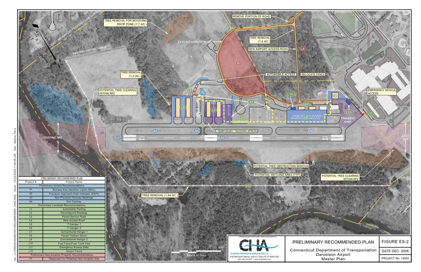
PRELIMINARY RECOMMENDED PLANProject # Project Name
Mag
netic
(YE
AR
200
6)14° 4
3'
W
TRANSIENTRAMP
0
Scale in feet
300 600
EXISTING AIRPORT PROPERTY LINE (APPROX)
EXISTING RPZEXIST.RPZ
EXISTING AIRPORT FENCE
EXISTING AIRPORT ROAD
Preliminary Airfield Recommendations
A1 Runway End Identifier Lights (REIL)
A2 Precision Approach Path Indicator (PAPI)
A3 Non-Precision Runway Markings
A4 Exit Taxiway
Preliminary Landside Recommendations
L1 Automobile Parking
L2 Reconfigured Roadway
L3 Paved Service Road
L4 New Access Road
L5 T-hangar 1
L6 T-hangar 2
L7 Conventional Hangar 1
L8 Paved Tiedown Apron
L9 Conventional Hangar 2
L10 Fuel Farm/Fuel Truck Pad
L11 Emergency Access Gate
L12 Airport Fence
Preliminary Non-Aviation Property Recommendation
P1 Reserved For Potential Non-Aviation Use
TRANSIENTRAMP
EXISTING AIRPORT PROPERTY LINE (APPROX)
EXISTING RPZEXIST.RPZ
EXISTING AIRPORT FENCE
EXISTING AIRPORT ROAD
10
-BA
YT
-HA
NG
AR
P1
L4
L6
L2
L5
L3
L1L7
L10L8
L9
L11
L12
L10
A1
A2 A4
A3
A2
PRELIMINARY RECOMMENDED PLANProject # Project Name
Preliminary Airfield Recommendations
A1 Runway End Identifier Lights (REIL)
A2 Precision Approach Path Indicator (PAPI)
A3 Non-Precision Runway Markings
A4 Exit Taxiway
Preliminary Landside Recommendations
L1 Automobile Parking
L2 Reconfigured Roadway
L3 Paved Service Road
L4 New Access Road
L5 T-hangar 1
L6 T-hangar 2
L7 Conventional Hangar 1
L8 Paved Tiedown Apron
L9 Conventional Hangar 2
L10 Fuel Farm/Fuel Truck Pad
L11 Emergency Access Gate
L12 Airport Fence
Preliminary Non-Aviation Property Recommendation
P1 Reserved For Potential Non-Aviation Use
POTENTIAL WETLAND AREA (TYP)
AUTOMOBILE ACCESS
TEMPORARY TIEDOWN APRON
TREE REMOVAL(1.5 AC.) RELOCATE FENCE
POTENTIAL TREE CLEARINGWITHIN RPZ
POTENTIAL TREE OBSTRUCTION REMOVAL
POTENTIAL TREE CLEARINGWITHIN RPZ
EMERGENCY VEHICLEACCESS
NEW AIRPORT ACCESS ROAD
TREE REMOVAL(1.4 AC.)
TREE REMOVAL FOR SKYDIVINGDROP ZONE (1.7 AC.)
REMOVE PORTION OF ROAD
TREE REMOVAL (1.64 AC.)
DATE DEC. 2008Connecticut Department of TransportationDanielson Airport
Master Plan PROJECT No. 14002
Drawing Copyright © 2008 Clough, Harbour & Associates LLP
2139 Silas Deane Highway, Suite 212 Rocky Hill, CT 06067-2336www.cloughharbour.comMain: (860) 257-4557F
ile:
U:\
14
00
2\A
CA
D\R
EP
OR
T\R
EC
OM
ME
ND
ED
_1
40
02
.DW
GS
ave
d:
12
/22
/20
08
7:2
8:3
9 A
MU
ser:
Me
din
a,
Pe
rry
PRELIMINARY RECOMMENDED PLAN FIGURE ES-2
CLOUGH HARBOUR & ASSOCIATES LLP

Danielson Airport Airport Master Plan
Airport Capital Improvement Plan The Airport Capital Improvement Plan (ACIP) lists the recommended projects and associated cost estimates for the 20-year planning period. Since Danielson Airport is part of the National Plan of Integrated Airport Systems (NPIAS), grant-eligible projects may receive 95 percent federal funding, with ConnDOT responsible for the remaining 5 percent. In addition to potential new developments, Danielson Airport must also continually rehabilitate existing airfield and other paved facilities, which are included in the ACIP. Although these items are not considered new capital developments, the associated costs can comprise the majority of an airport’s annual capital investment. The ACIP does not constitute a commitment on behalf of the FAA or ConnDOT to fund any of the projects. In addition, the ACIP does not imply that the projects would receive environmental approvals. Thus, the ACIP serves as a planning document that must remain flexible, and should undergo regular updates as project priorities and demands indicate. The projects included in the ACIP are organized into the following three implementation phases:
Phase I (Implementation in 0 to 5 years)
1A - Tree obstruction removal from runway approach surfaces 1B - Airport perimeter fencing and emergency access gate through high school 1C - Paved airfield service road and reconfigured roadway to T-hangars 1D - Fuel farm/fuel truck parking pad 1E - Runway End Identifier Lights (beyond Runway 13) and Precision Approach Path Indicators
(both runway ends) 1F - GPS instrument approach (for Runway 13) and non-precision runway markings 1G - Exit taxiway development near existing T-hangars 1H - Tree clearing/grubbing for skydiving drop zone 1I - T-hangar development east of existing T-hangars 1J - Rehabilitation of existing Airport Road and parking areas
Phase II (Implementation in 6 to 10 years)
2A - Rehabilitation of existing paved Tiedown Apron 2B - Paved tiedown apron development adjacent to existing paved Tiedown Apron 2C - Conventional hangar development west of the FBO hangar Phase III (Implementation in 11 to 20 years)
3A - Rehabilitation of existing runway 3B - Rehabilitation of existing taxiway 3C - Airport Road reconfiguration 3D - T-hangar development west of existing T-hangars 3E - Conventional hangar development north of the FBO hangar
Table ES-2 summarizes the 20-year ACIP for Danielson Airport.
FINAL Page ES-6

Danielson Airport Airport Master Plan
TABLE ES-2 – AIRPORT CAPITAL IMPROVEMENT PLAN Anticipated Funding Source
Project Total
Estimated Cost FAA State Private
Phase I (0 to 5 years) 1A - Tree obstruction removal $250,000 $237,500 $12,500
1B - Airport fencing and emergency gate $300,000 $285,000 $15,000
1C - Paved airfield service road $125,000 $118,750 $6,250
1D - Fuel farm/fuel truck parking pad Undetermined Undetermined
1E - REILs and PAPIs $150,000 $142,500 $7,500
1F - GPS approach, upgrade runway markings $75,000 $71,250 $3,750
1G - Exit taxiway development $100,000 $95,000 $5,000
1H - Tree clearing for skydiving drop zone $50,000 $50,000
1J - T-hangar development (east) $1,100,000 $1,100,000
1K - Rehab Airport Road and parking areas $150,000 $142,500 $7,500
Phase I Subtotal $2,300,000 $1,092,500 $57,500 $1,150,000
Phase II (6 to 10 years)
2A - Rehab existing Paved Tiedown Apron $250,000 $237,500 $12,500
2B - Paved tiedown apron development $1,400,000 $1,330,000 $70,000
2C - Conventional hangar development (west) $750,000 $750,000
Phase II Subtotal $2,400,000 $1,567,500 $82,500 $750,000
Phase III (11 to 20 years)
3A - Rehabilitation of existing runway $1,000,000 $950,000 $50,000
3B - Rehabilitation of existing taxiway $500,000 $475,000 $25,000
3C - Airport Road reconfiguration $275,000 $475,000 $25,000
3D - T-hangar development (west) $2,200,000 $2,200,000
3E - Conventional hangar development (north) $800,000 $800,000
Phase II Subtotal $4,775,000 $1,686,250 $88,750 $3,000,000
GRAND TOTAL $9,475,000 $4,346,250 $228,750 $4,900,000
FINAL Page ES-7