Cushman Trail Phase V Planning Study - Gig Harbor, WA
34
Cushman Trail Phase V Planning Study Final Report May 27, 2020 Submitted to: City of Gig Harbor 3510 Grandview Street Gig Harbor, WA 98335 Prepared by: PND Engineers, Inc. 1736 Fourth Avenue S Seattle, WA 98134
Transcript of Cushman Trail Phase V Planning Study - Gig Harbor, WA

Cushman Trail Phase V Planning Study
Final Report
May 27, 2020
Submitted to:
City of Gig Harbor
3510 Grandview Street
Gig Harbor, WA 98335
Prepared by:
PND Engineers, Inc.
1736 Fourth Avenue S
Seattle, WA 98134

Final Report Cushman Trail Phase V Planning Study
The following Cushman Trail Phase V Planning Study – Final Report was prepared by, and under the direct supervision of, the following professionals licensed in the State of Washington:
Gary Watters, P.E.
PND Engineers, Inc.
Juliet Vong, ASLA, LEED AP
HBB Landscape Architecture
Appendices prepared separately are also individually stamped and signed where applicable.
5/21/2020
2/07
/202
0

Final Report Cushman Trail Phase V Planning Study
Page | i
TABLE OF CONTENTS SECTION PAGE
EXECUTIVE SUMMARY ................................................................................................................................... iii
1 INTRODUCTION ........................................................................................................................................ 1
2 IDENTIFY PREFERRED ALTERNATIVE ........................................................................................................ 1
3 PUBLIC INVOLVEMENT ............................................................................................................................. 5 Technical Advisory Committee ........................................................................................................ 5 City Council ...................................................................................................................................... 6 Public Open House ........................................................................................................................... 6
4 PRELIMINARY DESIGN .............................................................................................................................. 7 Topographic Survey ......................................................................................................................... 8 Archaeological/Cultural Study ......................................................................................................... 8 Environmental Studies ..................................................................................................................... 8
Wetlands ................................................................................................................................. 8
Streams ................................................................................................................................... 9
Biological Assessment ............................................................................................................. 9
Preliminary Civil Design ................................................................................................................... 9
Civil Design Commentary ........................................................................................................ 9
Stormwater Management .................................................................................................... 11
Lighting ................................................................................................................................. 11
Rest Areas ............................................................................................................................. 12
Right of Way ......................................................................................................................... 12
Preliminary Bridge Concepts .......................................................................................................... 13
Borgen Boulevard Bridge ...................................................................................................... 13
Level Crossing Option ........................................................................................................... 13
Stream Y Bridge .................................................................................................................... 14
5 CONCLUSIONS ........................................................................................................................................ 14 Cost Estimates ................................................................................................................................ 15 Next Steps ...................................................................................................................................... 15

Final Report Cushman Trail Phase V Planning Study
Page | ii
LIST OF TABLES
Table 1. Station-by-Station Civil Design Comments ..................................................................................... 10
Table 2. First Mile Civil Quantities ................................................................................................................ 11
Table 3. First Mile Cost Estimates ................................................................................................................. 15
LIST OF FIGURES
Figure 1. Preferred Alternative Route 6 from Borgen Blvd to the Kitsap County line ................................... 3
Figure 2. Preferred Alternative with Connections .......................................................................................... 4
Figure 3. Sample Rest Area Plan ................................................................................................................... 12
Figure 4. Rendering of Stream Y bridge ........................................................................................................ 14
LIST OF APPENDICES
Appendix A – Open House III Presentation Documents
Appendix B – First Mile Design Drawings
Appendix C – First Mile Quantities and Cost Estimates
Appendix D – Stormwater Analysis
Appendix E – Design Renderings
Appendix F – Cultural Resources Assessment
Appendix G – Wetland and Habitat Assessment
Appendix H – Biological Assessment
Appendix I – SEPA Checklist
Appendix J – NEPA Categorical Exclusion

Cushman Trail Phase V Planning StudyTask III Concept Analysis Report
PROJECT PURPOSE:The purpose of the Cushman Trail Phase V Planning Study was to iden fy a preferred route to extend Cushman trail from its Borgen Boulevard trail head north to the Kitsap County line. This project will encourage mul -modal transporta on and span a large segment between the exis ng termina on of the Cushman Trail and an established bicycle route in south Kitsap County. Extending the trail is an cipated to reduce vehicle trips from the surrounding road network while providing bicycles and pedestrians safer and expanded choices to connect with exis ng bike, trail, and transit infrastructure. The exis ng Cushman Trail connects with Tacoma’s Sco Pierson Trail to the south that crosses the Narrows Bridge. Cushman Trail’s Phase V extension will provide a con nuous connec on from Tacoma to south Kitsap County’s established bicycle routes on a safe, non-motorized trail.
EXECUTIVE SUMMARY
FINAL ALIGNMENT:
Also included in the Planning Study was analyzing grade separa ons to cross Borgen Boulevard, SR-16, and Canterwood Boulevard, as well as determining poten al project Right-of-Way and easement needs. Opportuni es to connect with other non-motorized facili es and exis ng public transit routes, evalua on of topographical features to determine compliance with applicable Federal ADA standards, demonstra on of compliance with local adopted standards for a shared use path, and considera on of trail ameni es such as benches, trash cans, and ligh ng were all also analyzed.
54th Ave NW
54th Ave NW
Borgen BlvdBorgen Blvd
Burnham Dr NW16
16
16
62nd Ave NW
62nd Ave NW
KITSAP COUNTYKITSAP COUNTYPIERCE COUNTYPIERCE COUNTY
66th Ave NW
66th Ave NW
SE 160th StSE 160th St
to Kitsap County to Kitsap County Route 37 Route 37
Sehmel Dr NWSehmel Dr NW
Harbor H
ill Dr
Harbor H
ill Dr
PurdyPurdy
Willow
Rd SE
Willow
Rd SE
Goodrich R
d NW
Goodrich R
d NW
Henderson Henderson BayBay
WaunaWauna
302
Woodhill Dr NWWoodhill Dr NW
70th Ave NW
70th Ave NW
Peacock Hill Ave N
WPeacock H
ill Ave NW
302
Goodnough Dr NW
Goodnough Dr NW
Canterw
ood Blvd N
WC
anterwood B
lvd NW
Purdy Dr NWPurdy Dr NW Peacock H
ill Ave NW
Peacock Hill Ave N
W
Burley Burley LagoonLagoon
Dr NWWNWWDr NW
TRAIL EXTENSION START
EXISTINGTRAIL
PROPOSEDTRAIL
URBAN GROWTH BOUNDARY
GIG HARBOR CITY LIMITS
NORTH
The Planning Study evaluated diff erent route alignments for a 4-mile length of non-motorized, mul -use trail extension between the trailhead and an established bike route in south Kitsap County, as well as provide a framework to analyze and rank alterna ve routes in the decision-making process. Six alterna ve routes were evaluated with stakeholders and the community to iden fy the preferred trail alignment. Na onal Environmental Policy Act (NEPA) and a 30% design for the fi rst mile of the selected alignment was also provided as part of the study deliverables.
PROJECT DESCRIPTION:
The recommended route crosses Borgen Boulevard and con nues north up the exis ng powerline route un l reaching St. Anthony Hospital and following the eastern parking lot edge. From here it rejoins the powerline route and then connects to Canterwood Boulevard, the trail will be adjacent to the road which takes a 90-degree corner and becomes 54th Avenue Northwest. Con nuing north along 54th, the trail then crosses 144th Street Northwest and turns east while veering away from the road. This sec on of trail quickly turns north through the woods and exits the woods at 62nd Avenue Northwest, where an exis ng vehicular bridge crossing highway 16 would be retrofi ed to accommodate the trail crossing at this loca on. The fi nal stretch would head north within unimproved Right-Of-Way between Highway 302 and 66th Avenue Northwest where the Planning Study ends at the county line.
Providing a safe crossing at Borgen Boulevard was an important project component. A pedestrian bridge spanning the roadway was evaluated, with an at-grade, signalized crossing also considered. The City will perform a value engineering analysis and further analyze safety implica ons prior to selec ng a crossing mechanism for Borgen Boulevard. A second bridge will also be needed to cross Stream Y, south of St. Anthony Hospital.
This Planning Study is funded by a $200,000 Federal Surface Transporta on grant and $70,000 in local city funds.

Cushman Trail Phase V Planning StudyTask III Concept Analysis Report
PLANNING STUDY CONCLUSIONS AND NEXT STEPS:
ACKNOWLEDGEMENTS:MAYOR: Kit Kuhn
Bob Himes, Jim Franich, Jenny Woock,Robyn Denson, Le Rodenberg, and Tracie Markley
Tacoma Public U li es, Gig Harbor Parks Commission, City of Gig Harbor Council Members, PenMet Parks, Peninsula Light Company, Kitsap County, WSDOT- Olympic Region, KeyPen Parks, Peninsula School District, Pierce County Parks and Recrea on, Pierce County Planning and Public Works, Puget Sound Energy–Gas
Aaron Hulst, Nicole Jones-Vogel,Maureen Whitaker, Trent Ward, Jeff Langhelm
Robert J. Larson
PND Engineers, Inc., HBB Landscape Architecture, Soundview Consultants LLC, Cultural Resources Consultants, LLC
CITY COUNCIL:
TAC:
CITY STAFF:
CITY ADMINISTRATOR:
CONSULTANTS:
• An alignment for the Phase V extension of Cushman Trail has been iden fi ed and confi rmed as the preferred op on by the TAC, City Council, and the public.
• This route best sa sfi es all project requirements.• Environmental studies determined there are no exis ng condi ons which could impact or delay construc on of the
fi rst mile.• The biological assessment found the project is “Not Likely to Adversely Aff ect” any of the nearby endangered or
threatened species.
PROCESS:The planning study was separated into three main tasks: Task I– evalua on of the corridor, Task II–alterna ve alignment studies, and Task III– the preferred alignment. For each Task, the consultant team and representa ves from the City of Gig Harbor Public Works Department presented their fi ndings in three separate mee ngs to the following groups: a Technical Advisory Commi ee (TAC), City Council, and the public during an open house and through an on-line survey. Each group provided feedback which helped guide the consultant team in determining the fi nal alignment. As part of Task III, consultants conducted a topographic survey of the fi rst mile, performed an archaeological/cultural study, and completed environmental studies for wetlands, streams, and a biological assessment. A preliminary civil design for the fi rst mile was then developed, allowing for preliminary cost es mates of the fi rst mile. The fi rst mile stretches between Borgen Boulevard and Canterwood Boulevard.
The fi rst mile has been designed to a level suffi cient to facilitate permi ng and cost es mates, and permi ng applica on materials have been provided to the city. Cost es mates separate construc on of the Borgen Boulevard pedestrian bridge crossing to provide the City with ample informa on to budget for, and poten ally phase, this por on of the trail. Construc on of the fi rst mile is es mated to cost $3.05 million in 2020 dollars, with the Borgen Boulevard bridge cos ng an addi onal $4.4 million. The city will perform a value engineering analysis to determine the best method of crossing Borgen Boulevard, will review funding opportuni es on an annual basis, and will con nue to support inclusion of the trail extension into the PROS plan.
KITSAP COUNTYPIERCE COUNTY
END(County Limits)
URBAN GROWTH BOUNDARY
GIG HARBOR CITY LIMITS
EXISTINGTRAIL
START(Exis ng trailhead at Borgen Blvd.)
PROJECT LIMITS
NORTH

Cushman Trail Phase V Planning StudyTask III Concept Analysis Report
CONCEPTUAL BRIDGE RENDERING:
Conceptual rendering of bridge crossing Stream Y near St. Anthony Hospital looking west
TRAIL CONDITIONS:
Trail sec on adjacent to road with retaining wall. Trail sec on with side slope.
Trail sec on under powerline, typical condi on. Trail sec on parallel to road with side slope.

Cushman Trail Phase V Planning StudyTask III Concept Analysis Report
16’-0”
DOG WASTEBAG DISPENSOR
WASTE RECEPTACLE
6’-0”
1’-0”
4’-0”
6’ BENCHSURFACE MOUNT
ASPHALTTRAIL
ROOM FORCOMPANION (ADA)SEATING
CONCRETE PAD
2’ WIDEGRAVEL EDGE
TRAIL CONDITIONS:
Plan view of typical rest area.
Conceptual rendering showing how a typical rest area could be incorporated. The trail extension will provide experiences through forested areas.

Final Report Cushman Trail Phase V Planning Study
Page | 1
1 INTRODUCTION Beginning in 2000, Pierce County and the City of Gig Harbor (City) constructed segments of Cushman Trail, a 6.2-mile multipurpose, non-motorized trail connecting Tacoma's Scott Pierson Trail in the south to Borgen Boulevard in north Gig Harbor. In 2008 Pierce County began planning for future northern extensions of the trail, but those plans were abandoned due to the economic downturn. Today, the City has resumed the project, beginning with the Cushman Trail Phase V Development, which conducted a planning study for an expansion of the trail from the existing Cushman Trail termination at Borgen Boulevard to the regional trail and bicycle system near the Pierce/Kitsap County line. The major elements of this planning study are as follows:
1. The study shall evaluate a minimum of three alternative route alignments and work with the City, the public, and other stakeholders to determine the preferred alignment.
2. The preferred alternative shall demonstrate compliance with local adopted standards for a shared-use path.
3. Analyze opportunities to connect to other non-motorized facilities. 4. Alternative alignments will consider and analyze grade separations to cross Borgen Boulevard,
SR-16, and/or Canterwood Boulevard. 5. The study analysis will include benches, trash cans, bicycle signage, lighting at roadway crossings
and trail heads, connections to transit stops, and other amenities. 6. Determine potential project right-of-way and easement needs while analyzing alternative
alignments. 7. Analyze topographical features of alignments to determine compliance with all applicable Federal
ADA standards. 8. Provide planning-level preliminary stormwater analysis.
In order to accomplish these major elements, the project was broken into three main tasks: Task I – Corridor Study, Task II – Alternative Alignments, and Task III – Preferred Alternative, plus multiple sub-tasks. This concept analysis report provides the City and the Washington State Department of Transportation (WSDOT) with a summary of the Task III results and final recommendations for the Cushman Trail Planning Study. The purpose of Task III was to continue robust stakeholder and public outreach, select the preferred trail alignment, and begin preliminary design of the first mile of trail. Preliminary design also included cost estimates and preparation of NEPA/SEPA documentation. Task III was broken into the following three sub-tasks: Identify Preferred Alternative, Public Involvement, and Preliminary Design. The Task III deliverable is the Final Report.
2 IDENTIFY PREFERRED ALTERNATIVE Five alternate routes for the Cushman Trail Phase V extension were identified in Task I that continued generally north from the existing Cushman Trail trailhead at Borgen Boulevard to the Kitsap County line. These routes are illustrated in Appendix A. Through input from the Technical Advisory Committee (TAC), Gig Harbor City Council (Council), and the public, it was determined that a route utilizing the existing power line corridor, connecting neighborhoods, and providing access to green space would best serve the needs of the community.

Final Report Cushman Trail Phase V Planning Study
Page | 2
Task II evaluated the various routes against design criteria (or Guiding Principles) developed from the TAC, Council, and public input. It was clear that Routes 3 and 4 were preferred by all parties, and the Council provided clear instruction to pursue a combination of Routes 3 and 4, designated Route 6, for further study. Route 6, shown below in Figure 1, was evaluated and determined to be a feasible route for its entire 4-mile alignment. The first mile of the trail was designed in further detail, as detailed in the Preliminary Design section below.
The preferred route begins at the end of the current Cushman Trail terminus at Borgen Boulevard, crosses Borgen, and continues north along the existing Tacoma Public Utilities (TPU) powerline corridor to Canterwood Boulevard. The route then follows Canterwood until it curves north onto 54th Avenue NW, following 54th to 144th Street NW. This section of trail will parallel the streets on a grade-separated path in existing right-of-way. Crossing 144th, the trail then enters Pierce County property at the Purdy Transfer Station. The trail will meander through undeveloped woodlands around the perimeter of the transfer station until a narrow right-of-way due west to SR 16. The trail will then follow SR 16 on a new embankment until joining 154th Street NW, which it will join as a widened sidewalk to cross the freeway. After a controlled crossing at Purdy Dr. NW, the trail will parallel 66th Avenue NW to the county line. A more detailed route description is provided in the Task II report.
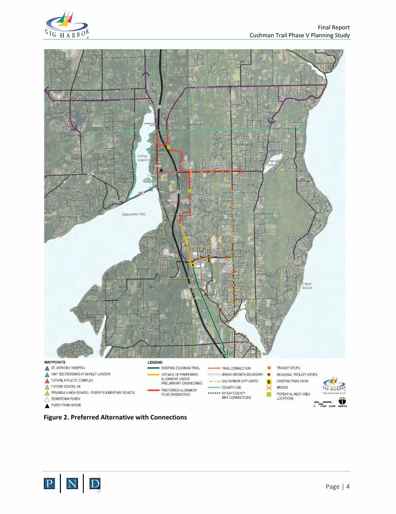
Route 6 offers connections to the following places or things (shown in Figure 2 and Appendix A):
• Other non-motorized facilities – The proposed route connects directly to the existing Cushman Trail at Borgen Boulevard. The northern terminus of the proposed route meets Kitsap County Bike Route 37 to Burley and Port Orchard, with a spur route on 62nd Avenue NW connecting via the Kitsap County bicycle network to Olalla.
• Transit stops – existing stops at both Borgen Boulevard and 144th Street NW connect directly to the proposed trail route.
• Parking – Parking currently exists at the Borgen Boulevard trailhead, which would be the southern terminus of the trail extension. The corner of 55th Avenue NW and 144th Street NW, where the trail crosses and there is open public land, is also a logical location for another trailhead parking area. For the first mile, a parking area may be added just north of St. Anthony hospital at Baker Way.
• St. Anthony Hospital – As a major center of employment and public activity, the hospital was widely named as a location desired for trail access. The trail passes directly by the hospital with multiple access points possible.
• Purdy – The route does not directly access Purdy and the Highway 302 crossing of Burley Lagoon. There was a vocal minority of Key Peninsula residents advocating for the trail to go through Purdy, but the majority of the TAC, Council, and the public preferred a route that accesses more nature and less traffic, avoiding Highway 302 and Purdy. A spur trail connection is shown connecting the proposed route to Purdy via 144th Street NW. This spur route would not necessarily be a new trail construction, but could take advantage of wide shoulders on 144th Street and neighborhood streets to get to the Purdy intersection.
• Olalla – Bicycle user groups advocated access to Olalla in Kitsap County as a scenic destination for recreational rides. The proposed spur route on 62nd Avenue NW would take advantage of existing shoulders to connect to Kitsap County’s route to Olalla. Alternatively, a spur route along 144th Street to the east connects to Peacock Hill Avenue and Crescent Valley Drive. Peacock Hill Road has been separately identified by Pierce County for sidewalk or multi-use upgrades.

Final Report Cushman Trail Phase V Planning Study
Page | 3
• Schools – Peninsula High School and Purdy Elementary School would be accessible to the new trail route via the spur route 144th Street NW.
Figure 1. Preferred Alternative Route 6 from Borgen Blvd to the Kitsap County line
Final Report Cushman Trail Phase V Planning Study
Page | 4
Figure 2. Preferred Alternative with Connections
Final Report Cushman Trail Phase V Planning Study
Page | 5
3 PUBLIC INVOLVEMENT Public Involvement sub-task for Phase III included a presentation to the Technical Advisory Committee, a working session with Gig Harbor City Council, and a public Open House. Materials presented for all three meetings included the final trail alignment for the full 4-mile segment, and additional details covering the first mile. The first mile of the trail extension was engineered to a 30% design level which allowed the design team opportunity to evaluate crossing options over Borgen Boulevard and crossing a stream with nearby Category III wetlands south of St. Anthony Hospital. Conceptual sketches of how these bridges may appear for the preferred design were presented at all three public involvement meetings during this task. Rendered cross sections of how the trail could be integrated into various topographical situations were also shown, as well as a conceptual layout of what a typical rest area alongside the trail could look like. Each meeting throughout the public involvement process included members from the Gig Harbor Public Works Department and the consultant design team.
Technical Advisory Committee Technical Advisory Committee (TAC) members met on November 7, 2019. The meeting provided TAC members an opportunity to review the proposed final design and have a dialogue around the established trail alignment, how it relates to the design criteria previously established, and the more detailed 30% design of the first mile. The presentation identified how the design criteria the TAC helped create were applied to the six alternatives evaluated during the Phase II task and then used to select the final alignment.
Valuable feedback was given to the design team throughout the presentation regarding potential conflicts, potential design improvements, and input for future permit applications related to the trail. A potential underground gas line conflict was identified in close proximity to the proposed Borgen Boulevard crossing location, especially as it relates to the proposed bridge option. Other conflicts discussed include underground drainage from a detention pond northeast of the proposed Borgen Boulevard bridge crossing and a category III wetland southwest of the proposed bridge. The drainage conflict was identified during the design team’s on-site investigation and was discussed with the TAC for further input; no committee members had any additional information to provide. Prior to any bridge design, a full survey of the area, including underground utilities and storm drains, will need to be performed.
A number of TAC members recommended increasing the trail width to 14’ under the power lines. The TPU representative made this recommendation based on previous experiences where their line trucks crack the edges of a 12’ wide asphalt trail, but have enough support in a 14’ wide trail to avoid this damage. Line trucks will be occasionally driving on the trail to service power poles within the power line right-of-way. The TPU representative also pointed out the importance of siting rest areas away from overhead power lines to avoid falling icicles or other potential debris falling from lines or poles.
TAC members suggested that a future bridge over Borgen Boulevard should consider adding staircases to either side of the street connecting into the existing sidewalk to accommodate users not already on the trail who simply wish to cross the street safely. Several people noted this stretch of roadway is particularly unsafe for pedestrians to cross. TAC members generally liked the Borgen Boulevard bridge crossing, but understood it was a significant cost. Committee members addressed safety options if an at-grade crossing was proposed, even as a temporary measure. Pedestrian-operated stop lights, in-ground

Final Report Cushman Trail Phase V Planning Study
Page | 6
flashing beacons, and crosswalk striping were all discussed as part of a minimum set of street improvements for a safe at-grade crossing.
City Council The final trail alignment and 30% design for the first mile was presented to the City Council on November 18, 2019, and was ultimately given approval to move forward as designed. Council questions were focused around addressing impacts to residents along 54th Avenue and the Canterwood development, trail crossings at roads and driveways, the two proposed bridge locations over Borgen Boulevard and the stream south of St. Anthony Hospital, and the overall project costs.
Citizen comments were received by the city prior to the Council meeting and were discussed during the meeting. These comments were focused on the potential impact of the trail along Canterwood Boulevard NW and 54th Avenue NW with concerns about how the trail will safely cross existing driveways and the effect of the trail directly adjacent to residential properties and fences. It was noted during the discussion that there appears to be sufficient existing right-of-way to accommodate the trail and include a minimum 3’ vegetated grade separation between the trail and the roadway without impacting private properties. Multiple driveways and potentially two of three entrances to the Canterwood development will need to be crossed by the trail as well. Specific safety interventions for each intersection and driveway will be needed and is an important consideration as part of the final design, but are not part of this phase of work.
The potential cost of the project was discussed at length by the City Council. The discussion included how the project could be phased, and what happens if the bridge over Borgen Boulevard isn’t included as part of the first phase of construction. The first phase proposed for implementation extends from the existing trailhead south of Borgen Boulevard through approximately the first mile of the power line corridor until it intersects Canterwood Boulevard The bridge over Borgen Boulevard could be part of this initial phase or planned separately depending on funding. Due to the financial magnitude of this bridge, it would likely require state and/or federal money to complete. Any at-grade crossing, temporary or permanent, would need to include additional pedestrian safety features. City staff will continue to investigate State funding and other grant sources, similar to those obtained for previous phases of the Cushman Trail.
Public Open House A third and final public Open House was held on December 12, 2019 at the Gig Harbor Civic Center and was advertised by the City. The Open House was an opportunity for the community to see the final alignment for the Cushman trail extension, details of the first mile proposed, typical trail cross-sections, and rendered images of the two proposed bridges along the trail route. Materials were presented on large posters allowing visitors the chance to discuss proposed improvements with the Gig Harbor Public Works Department and project design team. Presentation posters also included all six alignment alternatives with their accompanying criteria rankings from the previous phase of work, the definitions of the criteria (referred to as Guiding Principles for public Open Houses), feedback from the Phase II Open House, and a poster of the Next Steps for the project.

Final Report Cushman Trail Phase V Planning Study
Page | 7
Approximately 30 people attended the Open House, including residents of the Canterwood neighborhood, residents along 54th Avenue NW, members of the West Sound Cycling Club, the Gig Harbor Parks Commissioner, and the general public.
The Canterwood neighborhood is a private community which borders the final alignment along Canterwood Blvd & 54th Avenue NW. The trail is adjacent to all three of the eastern entrances to the development, and will likely cross at least two of these entrances at Baker Way and at the entrance off 54th Avenue NW. Open House participants were informed that the existing right-of-way appeared to be adequate to support the proposed trail and allow for a vegetated buffer between the trail and adjacent properties along Canterwood Boulevard and 54th Avenue NW. Detailed design of trail crossings would need to be addressed as part of a final design process but could include any number of safety improvements for vehicles and trail users.
Members from the Canterwood HOA Grounds Committee attended the Open House and informed the City of a proposed landscape upgrade at their main entrance off 54th Avenue NW. Concerns were expressed surrounding existing traffic backups at this gate, and how any impacts from trail users crossing at this location would be mitigated. Final design will address how this interface is safely planned and integrated into any proposed or existing landscape and traffic conditions. Washington State Department of Transportation (WSDOT) collision data at the ninety-degree corner where Canterwood Boulevard turns north and becomes 54th Avenue NW was provided by a resident attending the Open House for reference and use by the City in the design of any trail crossing. Canterwood residents would like to work with Pierce County when the design moves forward and ensure that their traffic concerns are taken into consideration and the trail provides a safe experience for all.
West Sound Cycling Club and other community members attending the Open House showed a high level of support for the final alignment. Several people expressed the need for the pedestrian bridge crossing over Borgen Boulevard as a critical element for safety. Opinions varied for if the City should include this bridge in the first phase of the project or build the first mile without the bridge and try out a less expensive, at-grade crossing with initial construction. It was noted that that a safer bridge crossing may help the City secure funding. Another community member noted that a HAWK (High-Intensity Activated crosswalk) beacon could work well in this location for an at-grade crossing, with a recent example installed in the City of Bremerton at Chester Avenue and Burnell Street. This style of pedestrian activated beacon allows foot and bicycle traffic to trigger a stoplight for vehicles, safely cross a road, and will then permit vehicles to proceed with caution. Outside of activation times, the HAWK signal is inactive and will not disrupt traffic.
4 PRELIMINARY DESIGN PND’s work scope included preliminary design (approximately 30%) of the first mile of trail located primarily within the City limits. The actual aerial distance along the powerline corridor from Borgen Blvd to the intersection with Canterwood Boulevard, a logical stopping point, is 1.02 miles so this segment was selected to represent the “first mile.” The design contained the following elements:
1. Topographic survey of the entire powerline corridor and relevant parts of the St. Anthony Hospital property

Final Report Cushman Trail Phase V Planning Study
Page | 8
2. Archaelogical/cultural study to identify any points of cultural significance along the route 3. Environmental studies including wetland and stream delineation, biological assessment, and
NEPA/SEPA checklist preparation 4. Preliminary civil design including selection of alignment and grading 5. Preliminary concept design of two bridge structures 6. Preliminary quantities and cost estimates
Topographic Survey PND conducted a topographic survey in August 2019. The area covered includes the full width of the powerline corridor from Borgen Boulevard to Canterwood Boulevard and an arc of the St. Anthony Hospital property around the north parking lot. This arc was included because the powerline corridor passes directly through the busy St. Anthony parking lot and a route around the parking lot would be beneficial for all users.
The survey was purely topographical to assist in civil design. No property lines or corners were surveyed and no legal boundaries were determined or marked. A formal boundary line and right-of-way survey, and title report, will need to be performed before final design. Features such as curbs, power poles, manhole covers, and the existing tree line (most of the powerline corridor is cleared, with blackberries and scotch broom covering the cleared areas) were surveyed as well. Elevation contours and landmark features are shown in the drawing set attached in Appendix B.
Archaeological/Cultural Study Cultural Resource Consultants (CRC) completed a desktop and field study in October 2019 to determine if there are cultural or archaeological landmarks on or near the proposed trail route. Local tribes were also consulted. Their study concluded that there are no sites that could impact or delay development of the first mile of the trail. The full study is attached as Appendix F.
Environmental Studies Soundview Consultants performed a desktop and field study along the proposed first mile trail alignment to prepare draft documentation for SEPA/NEPA permit submittals. The major components of their study were wetland and stream classification to determine the presence of any wetlands and streams and to classify them for determining impacts and setbacks, and biological assessment to determine the presence and impacts to local plant and animal species. Their full reports and SEPA/NEPA documents are attached in Appendices G-J. Delineated wetlands and streams are also shown in the Design Drawings in Appendix B.
Wetlands
The following wetlands were identified by Soundview along the first mile of trail alignment:
• Wetland A, Category III, south of Borgen Boulevard and west of existing Cushman Trail. The existing trail is adjacent to the edge of this wetland, with the timber bridge between the restroom building and the Borgen Boulevard sidewalk spanning a small finger of this wetland area. A new level crossing of Borgen Boulevard would not require any new construction that

Final Report Cushman Trail Phase V Planning Study
Page | 9
would impact this wetland, but a new bridge over Borgen Boulevard would require construction within the wetland buffer and new bridge spans over parts of the wetland.
• Wetland B, Category III, west of trail alignment south of St. Anthony Hospital. This wetland straddles Stream Y downstream of the proposed trail bridge. Parts of the trail construction would be within the wetland buffer.
• Wetland C/D, Category III, east of trail alignment south of St. Anthony Hospital parking lot. This wetland straddles Stream Y upstream of the proposed trail bridge. Parts of the trail construction would be within the wetland buffer.
• Wetland E, Category IV, east of trail alignment 600 feet south of intersection with Canterwood Boulevard. This wetland is small and isolated, a natural depression in the topography. It is likely to be waived from buffer requirements due to its small size.
Streams
The following streams were identified by Soundview along the first mile of trail alignment:
• Stream X. This stream extends southwest from Wetland A. Trail construction activities will not impact the stream buffer area.
• Stream Y. This stream extends from the Canterwood neighborhood southwest across the powerline corridor before crossing under Highway 16. A new mixed-use trail would cross the stream on a bridge without impact to the stream or banks.
Biological Assessment
Soundview’s Biological Assessment found that the project is “Not Likely to Adversely Affect” any of the endangered or threatened species that may be affected by this project.
Preliminary Civil Design The first mile of trail was designed to a level to support both permitting and 30%-level cost estimates. The design included alignment with stationing, grading, cut and fill slopes, quantities, and wetland/stream crossings. Drawings are provided in Appendix B and station-by-station comments are provided in the table below. Note that two separate alignments are provided at the southern end of the trail alignment: one for a level crossing at Borgen Boulevard and one for a bridge over Borgen Boulevard. Further discussion of these options is provided below in the Preliminary Structural Design section.
Civil Design Commentary
The following design criteria governed the choice of the selected alignment:
1. Minimum trail paved width of 12 feet (a 14-foot width or thickened edge may be added to address TPU vehicle load concerns)
2. Gravel shoulders either side 2 feet wide 3. Maximum sustained grade of 5% to meet ADA requirements

Final Report Cushman Trail Phase V Planning Study
Page | 10
Table 1. Station-by-Station Civil Design Comments
STATION COMMENT
0+00 TO 7+50 Crossing of Borgen Boulevard – either by level crossing or multi-span bridge. Bridge must cross at an elevation that clears Borgen Boulevard leaving a minimum of 17.5 feet clear, so the top of deck has been set at 26 feet above Borgen Boulevard.
5+30 TO 12+75 For the level crossing option only, the grade must rise from Borgen Boulevard at elevation 200 feet to 230 feet at a local high point. The grade rises steeply to 215 feet, requiring that the trail be built upon a fill embankment. The route approximately follows the existing powerline corridor access road, and the existing road is approximately 5% up to the top of the local high, so the trail alignment will follow this access road with minimal regrading.
12+75 TO 22+00 The access road follows the topography downhill at an approximately 5% grade towards Stream Y. The new trail follows the access road. Note, however, that the access road deviates from the powerline corridor parcels and into a privately-owned neighboring parcel between Stations 12+80 and 17+63 (see Right of Way discussion below).
22+00 TO 25+50 The Stream Y bridge. The trail grade is approximately 10 feet above the tops of the stream banks and 20 feet above the stream thalweg. The trail has begun a steady 5% climb continuing to Station 40+50. Trail is built up on MSE walls on one or both sides to minimize impact of fill slopes around the stream and nearby wetland buffers.
25+50 TO 37+00 The trail wraps around the St. Anthony Hospital parking lot, gaining elevation at 5% throughout. A trail alignment through the parking lot would not be long enough to gain the elevation required, so going around the parking lot is the only option. Some cuts and fills up to 5-8 feet are required, and retaining walls may be used above the stream to minimize fill slopes areas. From 33+25 to 35+00, at the north corner of the parking lot, a retaining wall may be required because the trail must dip below the elevation of the parking lot.
37+00 TO 40+50 Rejoins the access road, which climbs at 5%. Minimal regrading.
40+50 TO 44+50 Follows the access road, topography levels to about 1%.
44+50 TO 46+25 Access road diverges to connect to Baker Way due to a typically-dry drainage. A fill embankment with culvert is required to cross the drainage
46+25 TO 50+30 The trail will sit in a 2- to 5-foot deep trench as the grade rises at 5% to meet Baker Way. A proposed parking area is adjacent in the powerline corridor.
50+30 TO 50+70 Crossing of Baker Way with a level crossing.

Final Report Cushman Trail Phase V Planning Study
Page | 11
50+70 TO 55+50 Trail rejoins access road and climbs to a local high point at elevation 330 feet with minimal grading required.
55+50 TO 58+00 Trail follows access road route, but new fill embankment required to maintain 5% grade down across local low point with small Wetland E.
58+00 TO 62+50 Trail follows access road, with some grading required as route follows side slope until merge with Canterwood Boulevard.
The following earthwork quantities were calculated during the design process:
Table 2. First Mile Civil Quantities
ITEM QUANTITY UNIT
PAVED AREA 75,000 SF
TOTAL AREA 190,000 SF
CUT VOLUME 5,840 CY
FILL VOLUME 12,580 CY
NET CUT/FILL 6,740 CY
Stormwater Management
Stormwater will be managed, to the greatest extent possible, by ensuring that natural flows are unaffected. The trail will use pervious pavement, subgrade, and fill materials so that natural sheet flows will continue to their natural drainages. Runoff from the two bridge structures will be collected and detained before discharge according to the Best Management Practices prescribed in the 2016 City of Gig Harbor Stormwater Management and Site Development Manual (SMSDM). Further details are provided in the Preliminary Stormwater Analysis summary in Appendix D.
Lighting
Lighting along the new segment of trail was discussed, but the existing trail is not currently lit and is officially closed at dusk. Per TAC recommendation and Council direction, no new lighting was included in this study to avoid giving the impression to users that the facility is open after dusk. Street lighting along Borgen Boulevard currently provides ambient light at the planned location of the trail crossing.

Final Report Cushman Trail Phase V Planning Study
Page | 12
Rest Areas
Design of a typical rest area layout was provided by landscape architect HBB, shown in Figure 3 below. Locations for rest areas have not been proposed, but it is recommended that they be positioned at or near the top of major grades to provide refuge after sustained climbs. The City is also concurrently exploring a separate project to provide wayfinding and emergency call stations at points along the trail. As the trail is expanded, these improvements should be collocated with the rest areas.
Figure 3. Sample Rest Area Plan
Right of Way
The majority of the proposed first mile lies in TPU’s powerline corridor. The corridor is 100 feet wide, 5,500 feet long, and extends from Borgen Boulevard to Canterwood Boulevard with only one road crossing at Baker Way (note that Baker Way is a private road but it has an easement across TPU’s property).
One section not in TPU’s corridor is owned privately between Stations 12+80 and 17+63. The City has indicated that property acquisition in this section may be an option, but would prefer to coordinate with TPU to resolve both agencies’ land needs. The existing access road follows this route due to higher elevations and steep drop-offs on the powerline corridor properties. A trail could be built through this area and remain on the powerline corridor properties, but significant earthworks, including retaining walls and reinforcing the steep slopes, would be required.
Another section deviates from TPU’s corridor between Stations 24+70 and 37+00. St. Anthony Hospital owns this parcel where the majority of their north parking lot sits. The hospital has indicated a willingness
Final Report Cushman Trail Phase V Planning Study
Page | 13
to support an easement for the trail, especially since a mixed-use trail on the powerline corridor property would bisect their parking lot.
Preliminary Bridge Concepts Two structures were preliminarily designed as part of the first mile of trail: a bridge over Borgen Boulevard and a bridge over Stream Y.
Borgen Boulevard Bridge
This bridge concept was designed to cross Borgen Boulevard with a span of approximately 100 feet. The pavement width at the crossing point is approximately 60 feet, so this clear span allows for sidewalks to pass beneath the bridge uninterrupted, and ensure that sight distances for drivers are unaffected. WSDOT specifications (Design Manual M22) require that there be 17.5 feet aerial clearance from any point on a paved road for pedestrian bridge clearance, and in order to meet this clearance the bridge deck was conservatively assumed to be 26 feet above the pavement at the minimum.
In order to raise the trail grade 26 feet above the road, major approaches are required on either side of the bridge. To the south, wetlands have been identified. Rather than placing fill in the wetlands, two additional spans have been proposed in this concept to span wetland areas, with piers between the three spans not installed in wetland areas. The bridge structure will also provide vertical clearance over the existing restroom structure, so it does not have to be moved. To the north, there are no wetlands or existing trail or structures, so a concrete MSE wall with earth fill is proposed.
The alignment of the bridge is shifted west of the center of the powerline corridor because it rises above grade and would be within the safety radius of the powerlines themselves if left on an alignment between the two rows of powerlines. No property acquisition would be required, however, as the powerline corridor is wider on the north side of Borgen Boulevard and can accommodate the approach, and the parcel to the west on the south side of Borgen Boulevard is currently undeveloped and is owned by the City.
This concept proposes steel girders arched in a vertical curve over the road. This type of bridge would be simple to construct and could be placed with minimal impact to the surfaces spanned below, whether road or wetland. Any amount of art or design flourishes could be added, or an entirely different kind of span designed if the City and public so choose. The rendering merely shows the approximate scale and clearances of a bridge over Borgen Boulevard.
Level Crossing Option
The costs for the Borgen Boulevard bridge and approaches would exceed the cost of the rest of the first mile of trail, as summarized in Section 5.1 below. With funding uncertain and beyond the means of the City’s regular budget, the City Council has recommended that two options be presented at this level of design: one for a bridge crossing of Borgen Boulevard and another for a level crossing at Borgen Boulevard.
The level crossing would have traffic control devices to provide safe crossings for trail users while minimizing traffic effects on a busy access road to a major commercial district. It would begin right at the

Final Report Cushman Trail Phase V Planning Study
Page | 14
end of the current Cushman Trail (Phase IV) where the timber bridge crosses the wetland and deposits users on the south sidewalk of Borgen Boulevard. The route would then cross Borgen Boulevard and begin climbing at 5% on the other side. Most importantly, construction of a level crossing option in conjunction with the rest of the first mile of trail does not preclude construction of a bridge over Borgen Boulevard at a later date. The alignment of the bridge could be tied in with the trail north and south of Borgen Boulevard with minimal additional work required.
Neither the bridge nor level crossing is recommended over the other at this time. The City will perform a value engineering analysis and further analyze safety implications prior to selecting a crossing mechanism for Borgen Boulevard.
Stream Y Bridge
A bridge is required at Stream Y, just south of the St. Anthony Hospital parking lot. A clear span of 90-100 feet would span both banks, minimizing impact to the stream. The rendering below shows a simple steel girder span that can be placed without work being done in the stream itself. Concrete MSE approach walls lead to the bridge from either side; approximate extent is shown on the drawings in Appendix B.
Figure 4. Rendering of Stream Y bridge
5 CONCLUSIONS The route for an extension of the Cushman Trail, Phase V, has been identified and confirmed as the best option by the TAC, City Council, and the public. This route has been assessed as feasible by PND and completes the primary project goals as listed in the Introduction.

Final Report Cushman Trail Phase V Planning Study
Page | 15
The first mile has been designed up to a level of detail sufficient to facilitate permitting and cost estimates. Permitting is underway in a separate effort and cost estimates have been completed for the two trail options: with a Borgen Boulevard bridge and without. To assist the City in determining their path forward, the following sections summarize the estimated costs and other pertinent next steps.
Cost Estimates Table 3 below summarizes the estimated costs for the first mile of Cushman Trail Phase V extension from Borgen Boulevard to Canterwood Boulevard. The Borgen Boulevard bridge, as an optional structure, is listed separately. The City Council has expressed some interest in separating out the Borgen Boulevard bridge in terms of securing funding and grants. Note that of the estimated costs for the first mile of Phase V trail without the Borgen bridge, the Stream Y bridge remains the most expensive component.
A further breakdown with quantities and unit costs is attached in Appendix C. All costs include contingency of 15%.
Table 3. First Mile Cost Estimates
ITEM ESTIMATED COST
TRAIL FROM BORGEN BOULEVARD TO CANTERWOOD BOULEVARD WITH LEVEL CROSSING AT BORGEN
$3,053,278
BORGEN BOULEVARD BRIDGE $4,479,974
GRAND TOTAL $7,533,252
Next Steps If the City decides to pursue construction of the first mile, the most important step is to identify funding sources. The City has indicated that the estimated costs exceed what they would be able to fund from their own discretionary budgets. Grants are available from the federal and state governments, including WSDOT’s Surface Transportation Program grants like the one that funded this study. This timeline is open-ended, depending on where pursuing funding falls among the City’s other needs and projects.
Another next step is securing permits. NEPA and SEPA documents have been provided separately as part of this project and may be submitted. A mitigation proposal is required and responses to agencies’ questions will inevitably be needed. This process is expected to take up to one year from submittal. Additional permits required by the City of Gig Harbor and Pierce County would need to be secured, but the timeline is expected to be much shorter.
Following a funding plan, the project is now ready to move into final engineering design. Some additional field work in geotechnical explorations and surveying would be required. But with the design work performed thus far, it is at a point where a team of engineers and architects can provide stamped documents for construction in 6 to 12 months.

Final Report Cushman Trail Phase V Planning Study
Page | 16
Lastly, in parallel with the efforts described above, the City should pursue the formal request for the necessary easements through St. Anthony Hospital and TPU powerline corridor. Acquisition of additional right-of-way will be performed by TPU for the private parcel located between Stations 12+80 and 17+63.

Final Report Cushman Trail Phase V Planning Study
APPENDIX A – OPEN HOUSE III PRESENTATION DOCUMENTS

Final Report Cushman Trail Phase V Planning Study
APPENDIX B – FIRST MILE DESIGN DRAWINGS

Final Report Cushman Trail Phase V Planning Study
APPENDIX C – FIRST MILE QUANTITIES AND COST ESTIMATES

Final Report Cushman Trail Phase V Planning Study
APPENDIX D – STORMWATER ANALYSIS

Final Report Cushman Trail Phase V Planning Study
APPENDIX E – DESIGN RENDERINGS

Final Report Cushman Trail Phase V Planning Study
APPENDIX F – CULTURAL RESOURCES ASSESSMENT

Final Report Cushman Trail Phase V Planning Study
APPENDIX G – WETLAND AND HABITAT ASSESSMENT

Final Report Cushman Trail Phase V Planning Study
APPENDIX H – BIOLOGICAL ASSESSMENT

Final Report Cushman Trail Phase V Planning Study
APPENDIX I – SEPA CHECKLIST

Final Report Cushman Trail Phase V Planning Study
APPENDIX J – NEPA CATEGORICAL EXCLUSION