County of San Diego · 2019-02-15 · implementation). For Group 2 features this means not...
6
County of San Diego Stormwater Quality Management Plan (SWQMP) For Standard Projects Use for all Standard Projects (see Storm Water Intake Form, Part 5) Preparation Date: Template Date: January 28, 2019 LUEG: SW Standard SWQMP Page | i COUNTY ACCEPTED SWQMP Approved By: Approval Date: * Note* Approval does not constitute compliance with regulatory requirements. Project Information Project Name Project Address Assessor’s Parcel # (APN) Permit # / Record ID Project Applicant / Project Proponent Name Address Phone Email: SWQMP Preparer Name Company (if applicable) Address Phone Email: PE Number (if applicable) Preparer's Certification I understand that the County of San Diego has adopted minimum requirements for managing urban runoff, including storm water, from land development activities, as described in the County of San Diego BMP Design Manual. The BMP Design Manual is a design manual for compliance with local County of San Diego Watershed Protection Ordinance (Sections 67.801 et seq.) and regional MS4 Permit (California Regional Water Quality Control Board San Diego Region Order No. R9-2013-0001, as amended by Order No. R9-2015-0001 and Order No. R9-2015-0100) requirements for storm water management. This SWQMP is intended to comply with applicable requirements of the BMP Design Manual. I certify that it has been completed to the best of my ability and accurately reflects the project being proposed and the applicable BMPs proposed to minimize the potentially negative impacts of this project's land development activities on water quality. I understand and acknowledge that the plan check review of this SWQMP by County staff is confined to a review and does not relieve me as the person in charge of overseeing the selection and design of storm water BMPs for this project, of my responsibilities for project design. Signature Date
Transcript of County of San Diego · 2019-02-15 · implementation). For Group 2 features this means not...
County of San Diego Stormwater Quality Management Plan (SWQMP) For Standard Projects Use for all Standard Projects (see Storm Water Intake Form, Part 5)
Preparation Date: Template Date: January 28, 2019 LUEG: SW Standard SWQMP P a g e | i
COUNTY ACCEPTED SWQMP Approved By: Approval Date:
* Note* Approval does not constitute compliance with regulatory requirements.
Project InformationProject Name
Project Address Assessor’s Parcel # (APN)
Permit # / Record ID
Project Applicant / Project Proponent Name
Address Phone Email:
SWQMP Preparer Name
Company (if applicable) Address
Phone Email: PE Number (if applicable)
Preparer's Certification I understand that the County of San Diego has adopted minimum requirements for managing urban runoff, including storm water, from land development activities, as described in the County of San Diego BMP Design Manual. The BMP Design Manual is a design manual for compliance with local County of San Diego Watershed Protection Ordinance (Sections 67.801 et seq.) and regional MS4 Permit (California Regional Water Quality Control Board San Diego Region Order No. R9-2013-0001, as amended by Order No. R9-2015-0001 and Order No. R9-2015-0100) requirements for storm water management.
This SWQMP is intended to comply with applicable requirements of the BMP Design Manual. I certify that it has been completed to the best of my ability and accurately reflects the project being proposed and the applicable BMPs proposed to minimize the potentially negative impacts of this project's land development activities on water quality. I understand and acknowledge that the plan check review of this SWQMP by County staff is confined to a review and does not relieve me as the person in charge of overseeing the selection and design of storm water BMPs for this project, of my responsibilities for project design.
Signature Date

Template Date: January 28, 2019 Preparation Date: LUEG: SW Standard SWQMP P a g e | ii
General DirectionsNote: These directions may be omitted from the final SWQMP submittal.
See Standard SWQMP Form Instructions for additional, more detailed guidance and explanation of terms.
Attachment 1: Stormwater Intake Form (Required) Include a copy of your completed Storm Water Intake Form as Attachment 1 to this submittal.
Table 1: BMPs for Existing Natural Features and Proposed Site Features Complete Table 1 to document existing and proposed site features and the BMPs to be implemented for them. Except where otherwise noted, all BMPs must be implemented where applicable and feasible.
• Full implementation means a BMP will be fully implemented everywhere that the feature exists onthe site. For example, all existing water bodies will be fully conserved.
• Partial implementation means that some BMP implementation will occur, but the BMP will NOTbe fully implemented everywhere that the feature exists. For example, only one of two existing waterbodies will be conserved, or not all rooftop runoff will be dispersed to vegetated areas.
• Infeasible means a BMP cannot be either partially or fully implemented. Infeasibility can be basedboth on technical factors (soil type, site layout, etc.) and economic considerations (material or laborcosts, etc.). However, technical factors should generally be given greater weight.
Provide justifications for not fully implementing BMPs in Table 4, Part 1.
Table 2: Source Control BMPs for Pollutant-generating Sources All projects must complete Table 2, Part A. Part B is required unless the project is a Small Residential Project OR none of the features listed in the table are proposed for the project. Small Residential Projects are those requiring either: a Building Permit, Minor Residential Grading Permit, or Site Plan Permit for a single family home; or a Tentative Parcel Map Permit for up to 4 single family homes and a remainder parcel.
Each BMP must be implemented where applicable and feasible. Leaving a BMP unselected means it will not be implemented (either partially or fully). Provide infeasibility and partial feasibility justifications in Table 4, Part 1. Also describe in Table 4, Part 1 any proposed sources and/or BMPs not listed in Table 3.
If requested, complete and submit a Source Control BMP Worksheet (Attachment 3).
Table 3: Temporary Construction Phase BMPsComplete Table 3 to document which BMPs will be implemented for each construction activity on the site. For each applicable activity, all BMPs listed must be fully implemented where applicable and feasible. Provide justifications for not fully implementing BMPs in Table 4, Part 2.
Table 4: Required ExplanationsUse Table 4 to provide justifications for Table 1, 2, and 3 BMPs as shown below.
Feature or Activity Mandatory Justification Justify if Requested • Table 1 and 2 Site Features & Sources Any feature or activity for which NO
BMPs are selected (you must explain why all BMPs are infeasible)
Individual BMPs that will either not be implemented, or will only be partially implemented
• Table 3 Construction Activities
Table 5: Construction Plan Set Requirements Complete Table 5 to verify that the construction plans incorporate all applicable site features, activities, and BMPs identified in this SWQMP (Tables 1, 2, and 3).

Preparation Date: Template Date: January 28, 2019 LUEG: SW Standard SWQMP P a g e | 1
Table 1 – Baseline BMPs for Existing and Proposed Site Features Site Features Select each feature that applies.
BMP Implementation Describe BMP implementation for each selected site feature.
Group 1: Existing Natural Site Features [See BMPDM Sections 4.3.1 and 4.3.2]
Maintain & conserve natural features (SD-G)
Establish buffers for waterbodies
(SD-H) Full Partial Full Partial
☐ Natural waterbodies ☐ ☐ ☐ ☐ ☐ Natural storage reservoirs
& drainage corridors ☐ ☐
☐ Natural areas, soils, &vegetation (incl. trees) ☐ ☐
Group 2: Common Impervious Outdoor Site Features [See BMPDM Sections 4.3.3 and 4.3.5]
Disperse impervious areas
(SD-B)
Use permeable materials
(SD-D)
Minimize impervious areas
(SD-I) Full Partial Full Partial ☐ Check here to confirm
that impervious surfaceshave been minimizedwhere applicable andfeasible for all outdoorimpervious areas. If not,explain in Table 4.
☐ Streets and roads ☐ ☐ ☐ ☐ ☐ Sidewalks & walkways ☐ ☐ ☐ ☐ ☐ Parking areas & lots ☐ ☐ ☐ ☐ ☐ Driveways ☐ ☐ ☐ ☐
☐ ☐ ☐ ☐ ☐ ☐ ☐ ☐ ☐ ☐ ☐ ☐
☐ Patios, decks, & courtyards☐ Hardcourt recreation areas☐
☐ ☐ ☐ ☐ ☐ ☐ ☐ ☐ ☐ ☐
Group 3: Other Outdoor Site Features [See BMPDM Sections 4.2.6, 4.3.4, 4.3.5, 4.3.7, and 4.3.8]
☐ Rooftop areas Disperse rooftop runoff (SD-B)
Install green roofs (optional; SD-C)
Use rain barrels to capture runoff
(optional; SD-E) Full Partial Full Partial Full Partial ☐ ☐ ☐ ☐ ☐ ☐
☐ Landscaped areas Use water-efficient landscaping
(SD-J)
Install efficient irrigation systems
(SD-K)
Minimize erosion of slopes and surfaces
(SD-L) Full Partial Full Partial Full Partial ☐ ☐ ☐ ☐ ☐ ☐
☐ Water features (pools,spas, etc.)
Provide a designated washing
area (SC-A)
Drain feature to the sanitary sewer (if allowed) (SC-B)
Drain feature to a stormwater BMP
(SC-C) Full Partial Full Partial Full Partial ☐ ☐ ☐ ☐ ☐ ☐
Note: Table 4 justifications are required for any feature not selecting at least one BMP (either full or partial implementation). For Group 2 features this means not selecting either SD-B or SD-D. Additional justifications may be required on request by County staff. Also use Table 4 to describe sources or BMPs other than those listed.

Preparation Date: Template Date: January 28, 2019 LUEG: SW Standard SWQMP P a g e | 2
Table 2 –Baseline BMPs for Pollutant-generating Sources (Group 4) A. Requirements for DocumentationSelect either or both as applicable.
Completion of Part B is not required because:
☐ This is a Small Residential Project, OR
☐ None of these sources or features areproposed.
☐ Source Control BMP Requirements WorksheetE.1-1 (SC in Appendix E of the BMP Design Manual) isincluded as Attachment 3 (optional unless requestedby County staff).
B. Sources and BMPsSelect all proposed sources and features below. Then select the BMPs on the right to be implemented for each.
SC-B SC-C SC-D SC-E SC-F SC-G SC-H
Plumb to sanitary
sewer
Drain feature to a
pervious area
Provide containment for spills and
discharges
Prevent contact with
rainfall
Isolate flows from adjacent
areas Prevent wind
dispersal
Label with stencils or
signs
Common Source Areas ☐ Trash & Refuse Storage ☐ --- ☐ ☐ ☐ ☐ --- ☐ Materials & Equipment Storage ☐ --- ☐ ☐ ☐ ☐ --- ☐ Loading & Unloading ☐ --- ☐ ☐ ☐ --- --- ☐ Fueling ☐ --- ☐ ☐ ☐ --- --- ☐ Maintenance & Repair ☐ --- ☐ ☐ ☐ --- --- ☐ Vehicle & Equipment Cleaning ☐ --- ☐ ☐ ☐ --- --- ☐ Food Preparation or Service ☐ --- ☐ ☐ ☐ --- ---
Distributed Features ☐ Storm drain inlets & catch basins --- --- --- --- --- --- ☐
☐ Interior floor drains and sumps ☐ --- --- --- --- --- --- ☐ Drain lines (air conditioning, etc.) ☐ ☐ ☐ --- --- --- --- ☐ Fire test sprinkler discharges ☐ ☐ ☐ --- --- --- ---
Provide the following in Table 4, Part 1: (1) justification of any source area or feature with NO BMPs selected, (2) justification of individual unselected BMPs if requested by County staff, and (3) identification of any proposed pollutant-generating sources and BMPs not listed here.
Note: Pollutant-generating sources and features may not discharge directly to the MS4.
Preparation Date: Template Date: January 28, 2019 LUEG: SW Standard SWQMP P a g e | 3
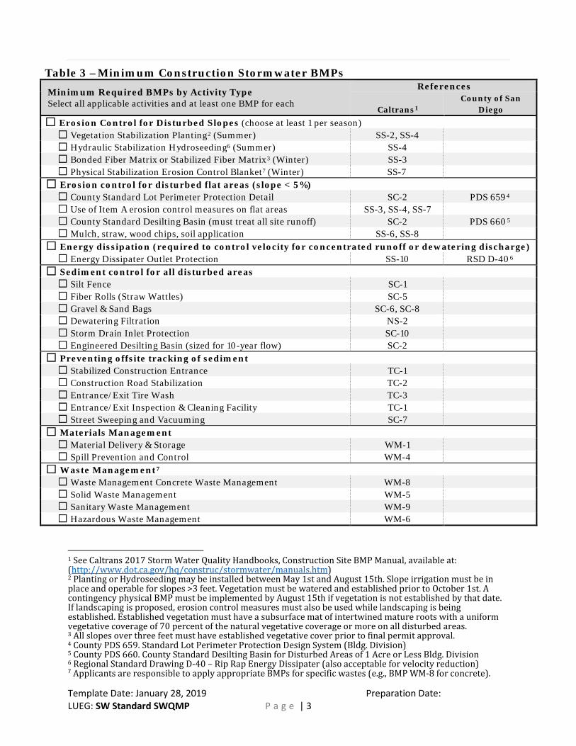
Table 3 –Minimum Construction Stormwater BMPs
Minimum Required BMPs by Activity Type Select all applicable activities and at least one BMP for each
References
Caltrans1 County of San
Diego
☐ Erosion Control for Disturbed Slopes (choose at least 1 per season)☐ Vegetation Stabilization Planting2 (Summer) SS-2, SS-4 ☐ Hydraulic Stabilization Hydroseeding6 (Summer) SS-4 ☐ Bonded Fiber Matrix or Stabilized Fiber Matrix3 (Winter) SS-3 ☐ Physical Stabilization Erosion Control Blanket7 (Winter) SS-7
☐ Erosion control for disturbed flat areas (slope < 5%)☐ County Standard Lot Perimeter Protection Detail SC-2 PDS 6594 ☐ Use of Item A erosion control measures on flat areas SS-3, SS-4, SS-7 ☐ County Standard Desilting Basin (must treat all site runoff) SC-2 PDS 6605 ☐ Mulch, straw, wood chips, soil application SS-6, SS-8
☐ Energy dissipation (required to control velocity for concentrated runoff or dewatering discharge)☐ Energy Dissipater Outlet Protection SS-10 RSD D-406
☐ Sediment control for all disturbed areas☐ Silt Fence SC-1 ☐ Fiber Rolls (Straw Wattles) SC-5 ☐ Gravel & Sand Bags SC-6, SC-8 ☐ Dewatering Filtration NS-2 ☐ Storm Drain Inlet Protection SC-10 ☐ Engineered Desilting Basin (sized for 10-year flow) SC-2
☐ Preventing offsite tracking of sediment☐ Stabilized Construction Entrance TC-1 ☐ Construction Road Stabilization TC-2 ☐ Entrance/Exit Tire Wash TC-3 ☐ Entrance/Exit Inspection & Cleaning Facility TC-1 ☐ Street Sweeping and Vacuuming SC-7
☐ Materials Management☐ Material Delivery & Storage WM-1 ☐ Spill Prevention and Control WM-4
☐ Waste Management7
☐ Waste Management Concrete Waste Management WM-8 ☐ Solid Waste Management WM-5 ☐ Sanitary Waste Management WM-9 ☐ Hazardous Waste Management WM-6
1 See Caltrans 2017 Storm Water Quality Handbooks, Construction Site BMP Manual, available at: (http://www.dot.ca.gov/hq/construc/stormwater/manuals.htm) 2 Planting or Hydroseeding may be installed between May 1st and August 15th. Slope irrigation must be in place and operable for slopes >3 feet. Vegetation must be watered and established prior to October 1st. A contingency physical BMP must be implemented by August 15th if vegetation is not established by that date. If landscaping is proposed, erosion control measures must also be used while landscaping is being established. Established vegetation must have a subsurface mat of intertwined mature roots with a uniform vegetative coverage of 70 percent of the natural vegetative coverage or more on all disturbed areas. 3 All slopes over three feet must have established vegetative cover prior to final permit approval. 4 County PDS 659. Standard Lot Perimeter Protection Design System (Bldg. Division) 5 County PDS 660. County Standard Desilting Basin for Disturbed Areas of 1 Acre or Less Bldg. Division 6 Regional Standard Drawing D-40 – Rip Rap Energy Dissipater (also acceptable for velocity reduction) 7 Applicants are responsible to apply appropriate BMPs for specific wastes (e.g., BMP WM-8 for concrete).

Template Date: January 28, 2019 Preparation Date: LUEG: SW Standard SWQMP P a g e | 4
Table 4 – Required Explanations
Part 1: Permanent Post-construction BMPs (from Tables 1 and 2) • Required Justifications: If NO BMPs are selected for a source or feature, justify why all BMPs are either not
applicable or are infeasible. For Group 2 features NO BMPs means not selecting either SD-B or SD-D.• If Requested: Justify why individual BMPs will not be implemented or will only be partially implemented.• Additional Explanation: Describe any proposed features and/or BMPs not listed in Tables 1 or 2.
BMP-Feature Combination Explanation
Feature
BMP
Feature
BMP
Feature
BMP
Part 2: Justifications for Temporary Construction Phase BMPs (from Table 3) • Required Justifications: Justify all construction activity types for which NO BMPs were selected.• If Requested: Justify why specific individual BMPs were not selected.• Additional Explanation: Describe any proposed features and/or BMPs not listed in Table 3.
BMP-Activity Combination Explanation
Activity Type
BMP
Activity Type
BMP
Table 5 – Construction Plan Set Requirements8
Use this checklist to confirm that the required information is included on the construction plans.
☐ Include all source control and site design measures described in the SWQMP.
☐ Include all construction BMPs described in the SWQMP.
8 For Building Permit Applications, refer to Form PDS 272, https://www.sandiegocounty.gov/content/dam/sdc/pds/docs/pds272.pdf