County of Los Angeles CHIEF ADMINISTRATIVE...
112
County of Los Angeles CHIEF ADMINISTRATIVE OFFICE 713 KENNETH HAHN HALL OF ADMINISTRATION. LOS ANGELES , CALIFORNIA 90012 (213) 974- 1101 http://cao. co. la. ca. DAVID E. JANSSEN Chief Administrative Officer Board of Supervisors GLORIA MOLINA First District YVONNE BRATHWAITE BURKE Second District January 6 , 2003 ZEV YAROSLAVSKY Third District DON KNABE Fourth District The Honorable Board of Supervisors County of Los Angeles 383 Kenneth Hahn Hall of Administration 500 W est Temple Street Los Angeles , CA 90012 MICHAEL D. ANTONOVICH Fifth District Dear Supervisors: APPROVAL OF REDEVLOPMENT PLAN AND AMENDMENT NO. PERTAINING TO THE CITY OF AZUSA' MERGED PROJECT AREA (FIRST DISTRICT) (3 VOTES) IT IS RECOMMENDED THAT YOUR BOARD: 1. Adopt an Ordinance approving s (Agency Redevelopment Plan for Business District and West End Redevelopment Project Areas Area) . 2. Approve 1 (Amendment) to Agreement for Reimbursement of Tax Increment Funds (Agreement) of April 17 , 1984 (No. 47136) between the County of Los Angeles , the City of Azusa , and the Agency to eliminate the limitation on the receipt of tax increment for the West End Redevelopment Project , and establish a new limitation for the Merged Project Area. PURPOSE/JUSTIFICATION OF RECOMMENDED ACTIONS Redevelopment Plan On January, 9 2001 , your Board adopted an ordinance allowing Azusa to include three parcels of contiguous County unincorporated area in the Merged Project Area contingent on your Board' s approval of the Agency s Redevelopment Plan Ordinance recommended for adoption (Attachment II) would confer that approval. cralazusalbrd Itr (12- 19-03) To Enrich Lives Through Effective And Caring Service
Transcript of County of Los Angeles CHIEF ADMINISTRATIVE...

County of Los AngelesCHIEF ADMINISTRATIVE OFFICE
713 KENNETH HAHN HALL OF ADMINISTRATION. LOS ANGELES , CALIFORNIA 90012(213) 974- 1101
http://cao.co. la.ca.
DAVID E. JANSSENChief Administrative Officer
Board of SupervisorsGLORIA MOLINAFirst District
YVONNE BRATHWAITE BURKESecond District
January 6 , 2003 ZEV YAROSLAVSKYThird District
DON KNABEFourth District
The Honorable Board of SupervisorsCounty of Los Angeles383 Kenneth Hahn Hall of Administration500 W est Temple StreetLos Angeles , CA 90012
MICHAEL D. ANTONOVICHFifth District
Dear Supervisors:
APPROVAL OF REDEVLOPMENT PLAN AND AMENDMENT NO.PERTAINING TO THE CITY OF AZUSA'
MERGED PROJECT AREA (FIRST DISTRICT) (3 VOTES)
IT IS RECOMMENDED THAT YOUR BOARD:
1. Adopt an Ordinance approving s (Agency
Redevelopment Plan for Business District and West End Redevelopment Project Areas Area) .
2. Approve 1 (Amendment) to Agreement for Reimbursement of TaxIncrement Funds (Agreement) of April 17 , 1984 (No. 47136) between the County ofLos Angeles , the City of Azusa , and the Agency to eliminate the limitation on thereceipt of tax increment for the West End Redevelopment Project , and establish anew limitation for the Merged Project Area.
PURPOSE/JUSTIFICATION OF RECOMMENDED ACTIONS
Redevelopment Plan
On January, 9 2001 , your Board adopted an ordinance allowing Azusa to include threeparcels of contiguous County unincorporated area in the Merged Project Area contingenton your Board's approval of the Agency s Redevelopment Plan
Ordinance recommended for adoption (Attachment II) would confer that approval.
cralazusalbrd Itr (12- 19-03)
To Enrich Lives Through Effective And Caring Service

Honorable Board of SupervisorsJanuary 6, 2004Page 2
Proiect Cap
The purpose of approving the Amendment to the April 17 , 1984 Agreement is to eliminatethe current $3 establish a new tax increment limit for the Merged Project Business District and West End Redevelopment Project Areas have been merged as theMerged Project Area with the authorization to utilize tax increment financing as one entity,there is an Agreement with the County limiting the West End Redevelopment Project Areato $3 million annually. The Amendment NO. 1 (Attachment III) would replace the annualcap with an overall project cap of $ 114 931 075 , which according to the Agency will allowthem administrative flexibility in issuing bonds for the Merged Project Area.
Implementation of StrateQic Plan Goals
The recommendation actions are consistent with the following Strategic Plan Goal:
Goal: Fiscal Responsibility: Strengthen the County s fiscal capacity.
The recommended actions promote coordination of the efforts of the County and the Cityof Azusa to encourage redevelopment of , and economic growth in , a blighted area thatbenefits both agencies.
FISCAL IMPACT/FINANCING
Redevelopment Plan
The Agency plans to use tax increment generated from the County unincorporated parcelsto finance redevelopment activities. Because the unincorporated parcels exhibit blighting conditions , it is reasonable to assume that significant development will not occur ifthe parcels are not included in the redevelopment project. The County and other taxingentities will receive statutory pass-through payments of tax increment , as well as thebenefit of higher property taxes generated via , theproposed action should have a positive financial impact on the County in the long run.
cralazusalbrd Itr (12- 19- 03)

Honorable Board of SupervisorsJanuary 6 , 2004Page 3
Proiect Cap
The proposed tax increment limit would have no greater fiscal impact of the West End Redevelopment Project were to overall cap limit for the Merged Project Area of $114 931 075 is the sum of the following:
. The , which is $28.9 million;
. The Project (20 years) multiplied by the $3 million annual cap ($60 million); and
. The Redevelopment Project ($26, 031 075).
FACTS AND PROVISIONS/LEGAL REQUIREMENTS
Redevelopment Plan
As noted above , on January 9, 2001 , your Board approved an ordinance adding Part 10 toChapter 2.60 of the Los Angeles Code , authorizing the Azusa Redevelopment Agency toestablish a Redevelopment Plan that includes certain unincorporated territory contiguous tothe City of Azusa. Section 2.60.580(C) of that Ordinance requires your Board's approval ofthe Redevelopment Plan , as adopted by the Agency and City, in order for redevelopmentof the Ordinance 03-06 on October 6 , 2003 approving the Redevelopment Plan for the MergedProject Area , which provides for the redevelopment of the three County unincorporatedarea parcels. According to , plans for the County unincorporated parcelsrange from a commercial ground-floor commercial retail and upper-story residential.
Proiect Cap
On , 1984, the County and Reimbursement of Tax Increment Funds stipulating the following, "the total amount of taxincrements allocated and paid to the Redevelopment Project Area), shall not exceed three million dollars ($3 000,000) per year
cralazusalbrd Itr p 2-19-03)

Honorable Board of SupervisorsJanuary 6 , 2004Page 4
and no portion of the tax increment revenues entities shall be counted , the Agency from amending the Redevelopment Plan increment generated in the Project Area without prior approval of the Los Angeles CountyBoard of Supervisors.
IMPACT ON CURRENT SERVICES
Proposed redevelopment activities for the County unincorporated area by the Agency while the County will continue to provide normal municipal services. Theproposed tax increment limit for the Merged Project Area is an administrative amendmentthat does have additional fiscal impact on the County"
CONCLUSION
At such time as the recommendation actions are approved by your Board , please returnapproved copies of the 1 to the Chief Administrative
Office , Office of Unincorporated Area Services and Special Projects , and County Counsel.
D EJ: LSMKZ:JR:nl
Attachments
c: County Counsel
Auditor-ControllerAzusa Redevelopment Agency
cralazusalbrd Itr (12-19-03)
Attachment I
AMENDED AND RESTATEDREDEVELOPMENT PLAN
FOR THEMERGED CENTRAL BUSINESS DISTRICT
ANDWEST END
REDEVELOPMENT PROJECTS
Adopted: October 6, Ordinance Nos. 03-
Prepared by the
REDEVELOPMENT AGENCY OF THE CITY OF AZUSAAZUSA, CALIFORNIA
Revised Pinal Redevelopment Plan (1 1 1703).doc.azu060203/ac
II.
III.
(Section 100)
TABLE OF CONTENTS
PAGE
INTRODUCTION............................................................................................................ 1
(Section 101)
(Section 1 (Section 1
(Section 200)
(Section 300)
General.............................................................................................................. Goals and Objectives............... . ......................................................................... 2Merged Project................................................................................................... 2
MERGED PROJECT AREA BOUNDARY ANDLEGAL DESCRIPTION................................................................................................... 3
REDEVELOPMENT ACTIVITIES................................................................................... 4
(Section 301)
(Section 302)
General.............................................................................................................. 4Owner Participation and Business Reentry Preferences ..................................
(Section 303)
(Section 304)(Section 305)(Section 306)
(Section 307)
Owner Participation............................................................................... 4Business Reentry Preferences. ......................... ................................... 5Participation Agreements...................................................................... 5Implementing Rules ....
Property Acquisition ............ .....
(Section 308)
(Section 309)
(Section 31 0)
(Section 311)
Acquisition of Real Property........... ................. .......... ...... Acquisition of Personal Property..................... ......
Property Management........................................................................................ 7
Relocation of Occupants Displaced by Agency Acquisition ...............................
(Section 312)
(Section 313)
(Section 314)
(Section 315)
(Section 316)
Relocation Housing Requirements ........... Assistance in Finding Other Locations.................................................. 7Relocation Payments................................................... .........................
Payments to Taxing Agencies in Lieu of Taxes ................................................. 7
Demolition , Clearance , Public ImprovementsBuilding and Site Preparation............................................................................. 7
(Section 317)
(Section 318)(Section 319)
(Section 320)
(Section 321)
Property Disposition and Development........................................... ................... 8
Real Property Disposition and Development ........................................
Demolition and Clearance................ .......... Public Improvements......................................................................... Preparation of Building Sites.......................................................... :...... 8
(Section 322). (Section 323)
(Section 324)
(Section 325)
(Section 326)
General.................................................................................... 8Disposition and Development Documents ............................... 9Development by the Agencyor Other Public Bodies or Entities ............................................Development Plans ............ ........
Personal Property Disposition..................... ........................................ 10

IV. (Section 400)
(Section 327)
(Section 328)
PAGE
Cooperation with Public Bodies .......................................................................
Rehabilitation , Conservation and Moving of Structures
(Section 329)(Section 330)
(Section 331)
Rehabilitation and Conservation ... ...................................... ................ 10Moving of Structures..................................................................... ......
Low or Moderate Income Housing ...................................................................
(Section 332)(Section 333)(Section 334)(Section 335)(Section 336)
(Section 338)
(Section 337)
Implementation Plans .................................................................................. 14
Authority Generally.............................................................................. Replacement Housing ...... Replacement Housing Plan ................. .................. ............................. Increase , Improve and Preserve the Supply....................................... 12New or Rehabilitated DwellingUnits Developed Within Merged Project Area..................................... 13Duration of Dwelling Unit Availability and Agency Monitoring ............. 14
LAND USES AND DEVELOPMENT REQUIREMENTS ............................................... 15
(Section 401)(Section 402)(Section 403)
Redevelopment Plan Map and Major Merged Project Area Land Uses ..........Major Land Uses.............................................................................................. 15Other Land Uses................................ ....................... , '"'''''''''''''''''''.''''''''''''''' 16
(Section 404)(Section 405)
(Section 406)
(Section 407)
(Section 408)
(Section 409)
10.
(Section 500)
Public Rights of Way........................................................................... 16Other Public, Semi-Public , Institutional and Non-Profit Uses .............
Conform ing Properties..................................................................................... 17
Interim Uses..................................................................................................... 17
Nonconforming Uses ......
General Controls and Limitations............ ........... .....................
(Section 41 0)
(Section 411)(Section 412)(Section 413)(Section 414)(Section 415)(Section 416)(Section 417)(Section 418)(Section 419)
(Section 420)
(Section 421)
Construction ..................... ,................. ........ .............................. ...........Limitation on the Number of Buildings ................................................Number of Dwelling Units ...................................................................Limitations on Type, Size and Height of Buildings ...................,..........Open Spaces , Landscaping, Light, Air and Privacy............................ 18Signs................................................................................................... 18Utilities................................................................................................. 19Incompatible Uses....................................................................... ... .... 19Subdivision of Parcels......................................................................... 19Minor Variations .......... ......................,....... ....... .......... .................. ....... 19
Design Guide ,,,,,,,,.,,.,,.,.,.,,. ... ........,.........
Building Permits............................................................................................... 20
METHODS OF FINANCING THE MERGED PROJECT
(Section 501)(Section 502)
General Description of the Proposed Financing Method .................................Tax Increment Funds............................... n............. ' on..................................... 21

(Section 503)
(Section 504)
(Section 505)
(Section 506)
PAGE
Agency Bonds.................................................................................................. 22Time Limits on Establishment of Indebtedness ...............................................Statutory Payments to Affected Taxing Entities............................................... 23Time Limits on Receipt of Tax Increment........................................................
VI. (Section 600)
VII. (Section 700)
VIII. (Section 800)
IX. (Section 900)
(Section 1000)
ACTIONS BY THE CITY AND COUNTY......................................................................
EN FORCEMENT ..... no.......... ...
DURATIONS OF THIS PLAN'S EFFECTIVENESS .....................................................
PROCEDURE FOR AMENDMENT
SEVERABILITY............................................................................................................. 25
EXHIBITS " 1," " " and " REDEVELOPMENT PLAN MAP
EXHIBITS "
" "
" and " LEGAL DESCRIPTION OF MERGED PROJECT AREA
EXHIBIT " NON-RESIDENTIAL PROPERTIES SUBJECT TO ACQUISITIONBY EMINENT DOMAIN
EXHIBIT " PROPOSED PUBLIC IMPROVEMENTS AND FACILITIES PROJECTS
jji

AMENDED AND RESTATEDREDEVELOPMENT PLAN
FOR THEMERGED CENTRAL BUSINESS DISTRICT AND
WEST END REDEVELOPMENT PROJECTS
(Section 100) INTRODUCTION
(Section 101) General
This is the Redevelopment Plan" or "Plan ) for the
Merged Central Business District and West End Redevelopment Projects Merged Projecf' ) inthe City of City ), County of , restates and
supersedes in their constituent projects ("Constituent Projects ) that comprise the Merged Project. Nothing in this Plan is intended toor shall affect in any manner the base years or determined in accordance with Health and Safety Code Section 33670.
This Plan consists of text (Sections 100 through 1000), a Redevelopment Plan Map showing the MergedProject and each of the Constituent Projects (Exhibits "
" "
" and " ), a Legal Description of the MergedProject Area (Exhibits "
" "
" and " ), a listing of the Non-Residential Properties Subject to Acquisition byEminent Domain (Exhibit " ), and the Proposed Public Improvements and Facilities Projects (Exhibit " ). This
Plan was prepared by the Redevelopment Agency of the .City of Azusa ("Agency ), pursuant to the CommunityRedevelopment Law of the State of , Section 33000 et seq. all statutoryrefefences hereinafter shall be to the
Constitution , and other applicable federal , state and local laws.
The definitions of general terms that are contained in the Community construction of this Plan , unless more specific terms and definitions thefefor are otherwise provided in this Plan.
Many of the provisions in effect at the time of adoption of this Plan. Such statutory time. In the event s requirements , and would be applicable to the Agency,any constituent project, the , or this Plan whether reflect such changes , then the requirements of this changes, to the extent necessary to be in conformity with such changes.
The merged ) includes all properties within the boundary shown on the Redevelopment Plan Map and described in the Legal Description of the Merged ProjectArea.
A portion of the Merged Project Area is located within unincorporated County of Los Angeles ("Countyterritory. Pursuant to , by Ordinance No. 2001-0006 , adoptedJanuary 16, 2001 , the Board of Supervisors of Los Angeles County authorized the City to prepare and approvethis redevelopment plan , and to include, for redevelopment purposes , unincorporated "County" property.
This Plan provides the Agency with powers , duties and obligations to implement and further the programgenerally formulated in this Plan for the continued redevelopment, rehabilitation , and revitalization of the MergedProject Area. This redevelopment, rehabilitation , and Merged Project Area. Instead , this Plan presents a development plans will be presented, priorities for specific projects will be established , and specific solutions will

be proposed , and by which tools are provided to the Agency to fashion , develop, and proceed with such specificplans , projects , and solutions.
(Section 102) Goals and Obiectives
The goals and s redevelopment program for the Project Area (including the areas added to the Project by the first, second , third and fifth amendments) and theWest End Project Area are set forth in the objectives of the Agency s redevelopment program for the areas added to the Central Business District ProjectArea by the eighth amendment to the Project's redevelopment plan , are set forth in the Preliminary Plan for theareas adopted by the Planning Commission on August 15 , 2001. The principal goal and objective of the MergedProject shall be to eliminate all remaining blight and complete all quickly as possible consistent with the needs of the Constituent Projects and the availability of financial resourcesto fund them.
Redevelopment of the Merged Project Area pursuant to this Redevelopment Plan and the above goalsand objectives will attain the purposes of the areas suffering from economic dislocation and disuse; (2) which are stagnant or improperly utilized , and which could not be accomplished by private enterprise acting alonewithout public participation and assistance; (3) protecting and promoting sound development and redevelopmentof blighted areas and the through the employment of improvements , facilities and improvements , facilities and utilities; and (5) other means as deemed appropriate.
(Section 103) Merged Proiect
The Constituent Projects are merged so that taxes attributable to each constituent project area which areallocated to the Agency pursuant to Section 33670(b) of the Community Redevelopment Law are to be allocatedto the entire , and interest on , indebtednessincurred by the Agency to finance or refinance, in whole or in part, the Merged Project, except that any suchtaxes attributable to any constituent project area shall first be used to pay indebtedness in compliance with theterms of any bond resolution or other agreement , whichresolution or other agreement was adopted or approved by the Agency prior to the merging of the ConstituentProjects. Except as otherwise noted above , tax increment revenue attributed to each constituent project may beused for any lawful purpose in either of the Constituent Projects.

II. (Section 200) MERGED PROJECT AREA BOUNDARY AND LEGAL DESCRIPTION
The boundaries of the Redevelopment Plan Map attached as Exhibits " n " " and " n The boundaries Area are described in the Legal Description of the Merged Project Area attached as Exhibits "
" "
2" and "
The Exhibit " 1" map includes the original area of the Central Business District Redevelopment Projectas adopted in 1978 , as well as the areas added by Amendment Nos. 1 , 2 , 3 , and 5.
The Exhibit " 2" map includes the areas added to the Central Business District Redevelopment Projectby the eighth amendment to the project's redevelopment plan , adopted in 2003 ("Central Business District EighthAmendment Area
The Exhibit " 3" map includes the original area of the West End Project as adopted in 1983.
The 1" legal Redevelopment Project, as adopted in 1978 , as well as the area added by Amendment Nos. 1 , 2 , 3 , and 5.
The 2" legal description describes the Eighth Business District Project by the amendment adopted in 2003.
The Exhibit " 3" legal description describes the area of the West End , asadopted in 1983.
III. (Section 300) REDEVELOPMENT ACTIVITIES
(Section 301) General
The Agency has and will continue to eliminate and prevent the spread of blight and blighting influencesand to strengthen the economic base of the following:
1. the Merged Project Area , consistent with this Plan and rules adopted by the Agency;
2. 3. Management of
4. Area;
5, 6. Installation , construction , expansion , addition , extraordinary maintenance or re-construction of streets
utilities , and other public facilities and improvements;
7. 8. Redevelopment
9. , their successors , and the Agency;
10. Rehabilitation , development or Project Area and/or the City or the County; and
11. Providing for the retention of controls and establishment of land so that property will continue to be used in accordance with this Plan.
In the accomplishment of these activities , and in the , theAgency is authorized to use all the powers provided in this Plan and all the powers to the extent now or hereafterpermitted by law, which powers are not expressly limited by this Plan.
(Section 302) Owner Participation and Business Reentrv Preferences
(Section 303) Owner Participation
Owners of real property within the participate in the redevelopment of property in their constituent project owners agree to
participation implementation rules adopted by the Agency.
Participation methods include portions of the property, or by retaining all or portions of the property and purchasing adjacent property from theAgency or joining with another person or entity for the rehabilitation or development of the owner s property andif appropriate , other property. An owner who demolish all or part of his/her existing buildings , or the Agency may acquire the buildings only and then remove ordemolish the buildings.
market value from owners and offering other parcels for purchase and
owners , or offering an opportunity for such owners to rehabilitate or develop property jointly with other persons orentities.
Participation opportunities shall be limited to the
necessarily be subject to and limited by factors including but not limited to the following: (1) the changing of some land uses; (2) the construction , realignment, ab~ndonment, widening, opening and/or otheralteration or elimination of public rights-of-way; (3) the removal , relocation , and/or installation of public utilitiesand public facilities; (4) the ability of potential participants to finance the proposed acquisition , development orrehabilitation in accordance with this Redevelopment Plan; (5) the ability and experience of potential participantsto undertake and complete the proposed development; (6) any reduction in the total number of individual parcelsin the constituent project area; (7) the construction or expansion of public , and thenecessity to assemble areas for such; (8) any change in orientation and character of the constituent project area;(9) the necessity to assemble areas for public and/or private development; (10) the requirements of this Plan andapplicable rules, regulations , and ordinances of the City of Azusa and County of Los Angeles; (11) any DesignGuide adopted by the Agency pursuant to Section 420 hereof; and (12) the feasibility of the potential participant'sproposal.
(Section 304) Business Reentrv Preferences
Business occupants engaged in business in the preferences to reenter in business
prescribed by this Redevelopment Plan and business reentry preferences implementation rules adopted by theAgency.
Whenever a business occupant will be displaced by Agency action from any constituent project within theMerged Project Area, the , prior to such displacement, determine: 1) occupant desires to relocate directly to another location within the business occupant's constituent project, or 2) ifsuitable relocation accommodations within the constituent project are not available prior to displacement, whethersuch business occupant would desire to reenter in business within the constituent project at a later date shouldsuitable accommodations become available. For those business occupants another location within the constituent .project the Agency occupants to find record of the business
occupants who cannot be or do not want to be directly . their constituent project, but who havestated that they desire to reenter into business within their rents are available, will be maintained by the Agency. The Agency business occupants to find reentry accommodations at locations and rents suitable to their needs.
Unless otherwise determined by the Agency,
business occupant's constituent project and shall necessarily be subject to and limited by factors such as thefollowing: (1) the extent to which developed within the constituent project; (2) the extent to which suitable are available to displaced business occupants within an acceptable time period or at rents and other terms thatare acceptable to such displaced business occupants , and within their financial means; and (3)- the of this Redevelopment Plan or any Design Guide adopted by the Agency pursuant to this Redevelopment Plan.
(Section 305) Participation Aareements
The Agency may require that, as a condition to participate in redevelopment or to obtain a building permitpursuant to Section 421 hereof, each participant shall enter into a binding written participation agreement with theAgency by which the participant agrees to contribute , sell , lease, acquire , rehabilitate , develop or use the propertyin conformance with this Plan and to be subject to provisions hereof and such other provisions and conditions towhich the parties may agree. In such agreements , participants who retain real property may be required to signand join in the recordation of such documents as is necessary to make the participation agreement applicable to their properties. develop, or use and maintain , their real property pursuant to this Plan and such participation agreement, the real

property or any
accordance with this Plan.
Whether or not a participant enters into a participation agreement Plan are applicable to all public and private property in the Merged Project Area.
(Section 306) Implementina Rules
The provisions of Sections 302 through 305 shall be implemented according to the rules adopted by theAgency prior to the approval of this Plan , and the same may be from time to time Where there is a conflict rules adopted by the Agency, the rules shall prevail.
(Section 307) Property Acquisition
(Section 308)
Except as specifically limited herein , the Agency may acquire, but is not required to acquire , any real orpersonal property, any interest in property, 'and any improvements thereon , located in the Merged Project Area bygift, grant, bequest devise , exchange, lease, purchase, eminent domain or any other lawful method.
It is in the public interest and is necessary in order to execute this Plan for the power of eminent domainto be employed by the Agency to acquire non-residential real property in the Merged Project Area , as identified inExhibit " " Non-Residential Properties Subject to
proceeding to acquire property within the following the effective date of the ordinances that adopted this Amended and Restated Redevelopment Plan.
The Redevelopment Agency will not subject residences , regardless ofzoning, both owner-occupied and rental , to condemnation unless requested in writing by the property Furthermore, prior to the fourth (4th) Amended and Restated , the located within that portion of the Project Area identified as "Area 10" in the Project Area s legal description unlesssuch condemnation is requested in writing by the property owner.
The Agency shall not acquire interests in oil , gas , or other mineral or hydrocarbon substances of any kindor character within the Central Business District constituent project area , except to preclude the right to explorefor, produce or extract such substances through any opening or .penetration for any purpose connected therewithwithin 500 feet from the surface of any property in the Central Business District constituent project area.
The Agency is authorized to acquire structures without are located. The Agency is also authorized to
Without the consent of the owner, the Agency shall not acquire property to be retained by an ownerpursuant to a
acquire real property on which an existing building is to be continued on its present site and in its present formand , unless such , improvementmodernization, or rehabilitation , or the site or lot on which the shape or use , or it is necessary to impose upon such property any of the standards, restrictions and controls ofthis Plan or of any Design Guide adopted by the Agency pursuant to this Plan , and the owner fails or refuses toparticipate in the Plan or in conformance with any such Design Guide by executing a participation agreement.
(Section 309) Acquisition of Personal Property
Generally, personal property shall not be acquired by the , where necessary in theexecution of this Plan , the Agency is authorized to acquire personal property in the Merged Project Area by anylawful means , including eminent domain.
(Section 310) Property Manaaement
During such time as property, if any, in the Merged Project Area is owned by the Agency, such propertyshall be under the Agency pending its disposition for redevelopment, and such rental or lease shall be pursuant to such policies asthe Agency may adopt.
(Section 311) Relocation of Occupants Displaced bv Aaencv Acquisition
(Section 312) Relocation Housina Requirements
No persons or displaced unless and until there is a suitable housing unit person or family at rents comparable to those at the time of their suitable to the needs of such , safe, sanitary, and otherwisestandard dwellings. The Agency shall not and ready for occupancy.
Permanent housing facilities shall be made displaced. Pending the development of such
adequate temporary housing facilities at rents displacement.
(Section 313) Assistance in Findina Other Locations
The Agency shall assist all persons (including , and othersdisplaced by Agency action in the Merged Project Area in finding other locations and facilities. In order to carryout the Merged Project with a concerns , and others , if any, displaced from their respective places of residence or business , the Agency shallassist such persons, business concerns and others in finding new locations that are decent, safe , sanitary, withintheir respective financial means , in reasonably convenient locations , and otherwise suitable to their respectiveneeds. The Agency may also provide
(Section 314) Relocation Payments
The Agency shall make all families), business concerns, and others Such relocation payments shall be made pursuant to the Code Section 7260 et seq. and Agency rules and amended from time to time. The Agency which funds are available.
(Section 315) Payments to Taxina Aaencies In Lieu of Taxes
The Agency may in any year during which it owns property in the Merged Project Area pay directly to theCity, County, or other district, including, but not limited to, a school district, or other public corporation for whosebenefit a tax would have been levied upon the , an amount ofmoney in lieu of taxes.

(Section 316) Demolition. Clearance. Public Improvements.Buildina and Site Preparation
(Section 317) Demolition and Clearance
The Agency is authorized to demolish and clear buildings , structures , and other improvements from anyreal property in the Merged Project Area as necessary to carry out the purposes of this Plan.
(Section 318) Public Improvements
The Agency is authorized to install and construct, or to cause to be installed and constructed , the publicimprovements, facilities and utilities (within or outside the Merged Project Area) necessary to carry out this Plan.Such public improvements , facilities and utilities include, but are not limited to, the following: (1) over- and under-passes; (2) sewers; (3) storm , natural gas , telephone and water distribution systems; (5)parks and plazas; (6) playgrounds; (7) parking and transportation facilities; (8) landscaped areas; (9) street andcirculation improvements; (10) flood control improvements and facilities; (11) fire stations , school facilities , andcommunity centers; and (12) other Anticipated public improvements, facilities and , or caused to beinstalled or constructed , by the Agency include, but are not limited to , those set forth in Proposed Public Improvements and Facilities Projects for the Merged Project Area.
(Section 319) Preparation of Buildina Sites
The Agency is authorized to prepare, or cause to be prepared , as building sites any real property in theMerged Project Area owned by the Agency. The Agency is also authorized to construct foundations , platformsand other structural forms necessary for the provision or commercial , public, and other uses provided in this Plan.
The Agency may take any actions which it determines are necessary and which are consistent with otherstate and federal laws to remedy or remove a release of hazardous substances on , under, or from property in theMerged Project Area in accordance with the requirements of Health and Safety Code Section 33459 et seq.
(Section 320) Property Disposition and Development
(Section 321) Real Property Disposition and Development
(Section 322) General
For the purposes of this Plan , the Agency is authorized to sell , lease for a period not to exceed 99 years
, .
exchange , subdivide, transfer, assign , pledge , encumber by mortgage or deed of trust, or otherwise dispose ofany interest in real property. The Agency is transfer without public bidding but only after public hearing.
Before any interest in real property of the Agency acquired in whole or in part, directly or indirectly, withtax increment moneys is sold, leased , or otherwise disposed of for development pursuant to this Plan , such salelease or disposition shall be first approved by the City Council by resolution after public hearing in conformancewith Section 33433 of the Health and Safety Code.
All real property acquired by the Agency in the Merged Project Area shall be sold or leased to public orprivate persons or entities for development for the uses permitted in this Plan , and any such sale or lease may befor an amount at less than fair market value if determined to be at the highest and best use consistent with thisPlan. Real property , where beneficial to ' any constituentproject or the Merged Project Area , to any other public body without charge or for an amount at less than fairmarket value.
All purchasers or lessees of property from the Agency shall be made obligated to use the property for thepurposes designated in this Plan , to begin and complete which the Agency fixes as reasonable, and to comply with other to carry out the purposes of this Plan.
During the period of development , the provisions of this Plan and of other documents , and thatdevelopment in the Merged Project Area is proceeding in accordance schedules.
(Section 323) Disposition and Development Documents
The Agency shall reserve powers and controls in necessary to prevent transfer, retention, or use of property development is expeditiously carried out pursuant to this Plan.
To provide adequate safeguards to ensure that the prevent the recurrence of blight, all real property sold , leased , or conveyed by the Agency, as well as all propertysubject to participation agreements , shall be made subject to the provisions of this Plan and any adopted DesignGuide and other conditions imposed by the Agency by leases, deeds , contracts , agreements , declarations ofrestrictions , provisions of the zoning ordinance, conditional use permits , or other means. Where appropriate, asdetermined by the Agency, such documents or portions thereof shall be recorded in the Office of the Recorder ofthe County.
The leases , deeds, contracts , agreements, and declarations of covenants , covenants running with the land , rights of reverter, conditions subsequent, equitable servitudes, orany other provision necessary to carry out this Plan.
All property in the Merged Project Area is hereby subject to the restriction that there shall be no illegaldiscrimination or segregation based upon sex, marital status , race, color, religion , national origin , or ancestry inthe sale, lease , sublease , transfer, use , occupancy, tenure , or enjoyment of property in the Merged Project Area.All property sold , leased , conveyed , or subject to a participation agreement, by or through the Agency, shall beexpressly subject by appropriate documents to the , leases, or contracts for the salelease, sublease, or other transfer of land in the Merged Project discrimination andnon-segregation clauses as are required by law, including without limitation, the requirements of Sections 33435and 33436 of the Health and Safety Code.
(Section 324) Development bv the Aaencv orOther Public Bodies or Entities
To the extent now or hereafter permitted by law, the Agency may, with the consent of the City Councilpay all or part of the value of the land for and the cost of the structure, or other improvement which is publicly owned either within or outside the Merged Project Area , if theCity Council determines: (1) that such buildings , facilities , structures , or other either constituent project or the Merged Project or the immediate neighborhood in which the constituent project orMerged Project is located , regardless of whether such improvement is within the constituent project or MergedProject Area; (2) that no other , facilities, structures, or other
improvements are available to the community; and (3) that the payment of funds for the cost of buildings , facilities , structures , or other improvements will assist in the elimination of one or more blightingconditions inside the either the constituent project or Merged Project Area or provide housing for low or moderateincome persons and is consistent with the implementation plan adopted pursuant to Section 33352 or 33490 ofthe Health and Safety Code. conclusive.
Specifically, the Agency may pay all or part of the value of the land for and the cost of the installation andconstruction of any
including, without limitation , those set forth in Exhibit " " Proposed Public Improvements and Facilities Projectsfor the Merged Project Area. When the value of such land or the cost of the
structure, or other improvement, or both , has been , or will be paid or provided for initially by the City or otherpublic corporation , the Agency may enter into a contract with the City or other public corporation under which itagrees to advance funds to , or reimburse the City or other public corporation for all or part of the value of suchland or all or part of the cost of such , or other improvement, or both , by periodicpayments over a period of years.
The obligation of the Agency under such contract shall constitute an indebtedness of the Agency for thepurpose of , which indebtedness may payable out of taxes levied in the Section 33670 of the California , or out of any other availablefunds.
In a case where such land has been or will be acquired by, or the cost of the installation and constructionof such building, facility, structure or other improvement has been paid by, a parking authority, joint powers entity,or other public corporation to provide a building, facility, structure , or other improvement which has been or will beleased to the City such contract may be made with , and such reimbursement may be made payable to , the City.
Before the Agency commits to use the portion of taxes to be allocated and paid to the Agency pursuantto subdivision (b) of Section 33670 for the purpose of paying all or part of the value of the land for, and the cost ofthe installation and construction of, any publicly owned building, other than parking facilities , the City Council shallhold a public hearing in accord with the provisions of Section 33679 of the Health and Safety Code.
(Section 325) Development Plans
All development plans applicable City and County codes as they are or as they may be amended from time to time. the Merged Project Area must conform to City or County, as applicable , and Agency design review proceduresincluding any Design Guide adopted by the Agency pursuant to Section 420 hereof.
(Section 326) Personal Property Disposition
For the purposes of this Plan , the Agency is authorized to lease, sell , exchange , transfer, assign , pledgeencumber, or otherwise dispose of personal property that is acquired by the Agency.
(Section 327) Cooperation with Public Bodies
Certain public bodies are authorized by state law to aid and cooperate with or without consideration in theplanning, undertaking, construction, or operation of this
cooperation of such public bodies and attempt to coordinate this Plan with the activities of such public bodies inorder to accomplish the purposes of redevelopment and the highest public good.
The Agency, by law, is not authorized to consent of such public bodies. The , will seek the cooperation of all public bodies that own orintend to acquire property in the
Merged Project Area will be afforded all the privileges of owner participation if such public body is willing to enterinto a participation agreement with the Agency. All plans for development of property in the Merged Project Areaby a public body shall be subject to Agency approval.
The Agency is authorized to financially (and otherwise) assist any public entity in the cost of public landbuildings , facilities , structures , or other buildings , facilities , structures , or other improvements are of benefit to the Merged Project.

(Section 328) Rehabilitation, Conservation and Moving of Structures
(Section 329) Rehabilitation and Conservation
The Agency is authorized to , or to cause to be any building or structure in the Merged Project Area owned by the advise , encourage, and assist (through a loan property in the Merged Project Area not owned by the Agency. The Agency is also authorized to acquire, restore,rehabilitate, move and conserve buildings of historic or architectural significance. .
It shall be the practicable and to add to the economic life of these businesses by a program of voluntary conservation and rehabilitation. The Agency is to encourage owners of consistent with this Plan and such standards as may be developed for the Merged Project Area.
The extent of retention , conservation and rehabilitation in the Merged Project Area shall be subject to thefollowing limitations:
a. The Plan;
b. expeditious manner and in property rehabilitation standards as may be adopted by the Agency, the City and the County.
c. The expansion , facilities and utilities.
d. The assembly and
The Agency may constituent project area or the Merged Project Area.
Within the Merged Project Area and as part of an rehabilitation of property that will be used for , the Agency may assist withthe financing of facilities or capital equipment, including, but not necessarily , pollution control devices.The Agency may also establish a rehabilitating commercial buildings or structures within the Merged Project Area.
The Agency shall not assist in the rehabilitation or conservation of properties which , in its opinion , are noteconomically and/or structurally feasible , or which do not further the purposes of this Plan.
(Section 330) Moving of Structures
As necessary in carrying out this Plan , the Agency is authorized to move or to cause to be moved , anystandard structure or building or any structure or building that can be rehabilitated to a location within or outsidethe Merged Project Area.
(Section 331) Low or Moderate Income Housing
(Section 332) Authoritv Generallv
The Agency may, inside or outside the Merged Project Area , acquire land , improve sites , or construct orrehabilitate structures in order to provide Agency may also provide subsidies to , or for the benefit of, such persons and families or households to assistthem in obtaining housing. The Agency may also sell , lease , grant, or donate real property owned or acquired by

the Agency to the housing authority that operates otherwise cooperate with the Housing Authority in carrying out the provisions of Section 335 hereinbelow.
(Section 333) Replacement Housinn
In accordance with Sections 33334.5 and 33413 of the Health and Safety Code , whenever dwelling unitshousing persons and families of low or moderate income are destroyed or removed from the low and moderateincome housing market as part of a Agency or where financial assistance has been provided by the Agency, the Agency shall , within four years ofsuch destruction or removal , rehabilitate, develop, or construct, or cause to be rehabilitated , developed, orconstructed , for rental or sale to , an equal number ofreplacement dwelling units which have an equal or greater number of bedrooms as those destroyed or removedunits at affordable housing costs, as defined by Sections 50052.5 and 50053 of the within the territorial jurisdiction of the Agency, in 33413.5 of the Health and Safety Code. Seventy-five percent (75%) of the replacement replace dwelling units households , lower income households , and persons and families of low and moderate income , as the personsdisplaced from those destroyed or removed units.
(Section 334) Replacement Housinn Plan
Not less than thirty days . prior to execution of an agreement for the participation agreement, which agreement would lead to the destruction or removal of dwelling units from the lowand moderate income housing market, the Agency shall adopt by resolution a replacement housing plan.
The replacement housing plan shall developed , or constructed pursuant to Section 33413 of the Health and Safety Code; (2) an adequate means offinancing such rehabilitation , development, or construction; (3) a finding that the replacement housing does notrequire the approval of the voters pursuant to Article XXXIV of the California Constitution , or that such approvalhas been obtained; (4) the number of planned for construction or s relocation , rehabilitationand replacement housing objectives. A which no replacement housing plan has been prepared , shall not be destroyed or removed from the low andmoderate income housing market until the Agency has by resolution adopted a replacement housing plan.
Nothing in this section shall prevent the Agency from destroying or removing from the low and moderateincome housing market a dwelling unit which the Agency owns and which is an immediate danger to health andsafety. The Agency shall , as soon as practicable, adopt by resolution a replacement housing plan with respect tosuch dwelling unit.
(Section 335) Increase, Improve and Preserve the Supplv
Subject to the provisions of subdivisions (a) and (b) of Section 33486 of the Health and Safety Code, notless than 20 percent of all taxes which are allocated to the Agency, pursuant to Section 33670 of the Health andSafety Code , shall be deposited by the Agency into the Low and Moderate Income Housing Fund established forthe Merged Project pursuant to , which fund shall include anymoneys previously deposited into or deficits previously incurred by the Low and Moderate Income Housing Fundsfor the Constituent Projects. The rehabilitation of housing units which will be available to , or occupied by, persons and families of low or moderateincome, and very low income households , as defined in Health respectively, for the period specified in Section 33487(a) of the Health and Safety Code , as amplified by Healthand Safety Code Section 33334. 14(b). Such funds may and Safety Code Section 33334. 14(b). For the purposes of this subsection
, "
construction and rehabilitation" shallinclude acquisition of land; improvements to land; the acquisition , rehabilitation or construction of structures; or

the provision of subsidies necessary to provide housing for persons and families of low or moderate income, andvery low income households.
The Agency may use the set aside funds , theAgency may only use these funds outside the Merged Project Area upon a resolution of the Agency and the CityCouncil that such use will be of benefit to the Merged Project. Such Council shall be final and conclusive as to the issue of benefit to the Merged Project Area.
The expenditures or obligations incurred by the Agency pursuant to this subsection shall constitute anindebtedness of the Merged Project.
If moneys deposited in the subsection have not been committed for the purposes specified above for a period of six years following depositin that fund , the Agency shall offer such moneys to the housing authority which operates within the jurisdiction ofthe Agency for the purpose of constructing or rehabilitating housing as provided above. However, if no housingauthority operates within the jurisdiction of the Agency, the Agency may retain such moneys for use pursuant tothis subsection.
If the Agency deposits less than 20 percent of taxes allocated pursuant to Section 33670 of the Healthand Safety Code, due to the provisions of subdivisions (a) and (b) of Section Code, in any fiscal year, a deficit shall be created in the Merged Project Low and Moderate Income Housing Fundin an amount equal to the difference between 20 percent of the taxes allocated pursuant to Section 33670 of theHealth and Safety Code and the amount deposited in such year. The deficit, if any, created pursuant to thissection constitutes an indebtedness of the Merged Project. The Agency shall eliminate the deficit by expendingtaxes allocated in years subsequent to eliminated , the Agency shall not incur new obligations for purposes other than those set forth in Section 33487 ofthe Health and Safety Code except to comply with the terms of any resolution or other agreement pledging taxesallocated pursuant to Section 33670 of the Health and Safety Code which existed on the effective date of theordinances approving and adopting this Amended and Restated Redevelopment Plan.
(Section 336) New or Rehabilitated Dwellina UnitsDeveloped Within Meraed Proiect Area
At least thirty percent (30%) of all new and Agency, if any, shall be available at affordable housing cost to persons and families of low or moderate income.Not less than fifty percent (50%) of the persons and families of low or moderate income shall be available at affordable , and occupiedby, very low income households.
At least fift~en percent (15%) of all new and each constituent project in the Agency, if any, shall be available at affordable housing cost to persons and families of low or moderate income.Not less than forty percent (40%) of the persons and families of low or moderate income shall be available at affordable housing costs to very low incomehouseholds.
The Agency may satisfy the , in whole or in part, by any of themethods described in Health and Safety Code Section 33413(b) or any other method permitted by law.
The percentage requirements set forth in this Section 336 shall apply independently of the requirementsof Section 333 and in the aggregate to housing individual case of rehabilitation , development or construction of dwelling units , unless the Agency determinesotherwise.
By regulation or policy guideline adopted by the Agency from time to time , the Agency shall ensurecompliance with the provisions of Health and Safety Code Section 33413 requiring that specified percentages of

all new or rehabilitated dwelling units developed in each constituent project within the Merged Project Area beavailable at affordable housing cost to low and households). Such adopted Agency
under this Plan with respect to parcels developed with new or rehabilitated structures in the Merged Project Arearegardless of whether such parcels are developed with Agency assistance or participation.
If all or any moderate income housing units , the Agency shall require by housing be made displaced by the constituent project. Such persons and families housing; provided , however, failure to give such priority shall not affect the validity of title to real property.
(Section 337) Duration of Dwellina Unit Availabilitv and Aaencv Monitorina
The Agency shall require that the aggregate number of replacement units rehabilitated , developed , constructed , or price-restricted pursuant to Sections 333 and 336 shall remainavailable at affordable housing cost to persons and families of low income, moderate income and very lowincome households , respectively, for the longest feasible time, as determined by the Agency, but for not less thanthe periods set forth in Section 800 for the durations of this Plan s land use controls applicable to the ConstituentProjects, except to the extent a longer or shorter period of time is permitted or required by other provisions of thelaw.
Pursuant to Section 33418 of the , the Agency shall monitor, on an basis , any housing affordable to persons and families of low or moderate income developed or otherwise madeavailable pursuant to the Health and Safety Code. As part of this monitoring, the Agency shall require owners ormanagers of the housing to submit an annual report to the Agency. The annual reports shall include for eachrental unit the rental rate and the income and family size of the occupants , and for each whether there was a change in ownership from the prior year and , if so , the income and family size of the newowners. The income on a form provided by the Agency.
(Section 338) Implementation Plans
In accord with the provisions of Section 33490 of the , in December 1994, theAgency adopted an implementation plan for each of the Constituent Projects and one other project area in theCity of Azusa (Ranch Center). and each five years thereafter, the Agency shall adopt, after a public hearing, succeeding implementation plansthat shall contain the specific goals and Merged Project, the specific programs, including potential projects , and estimated expenditures proposed to themade during the , and an , programs, andexpenditures will eliminate blight within the Merged Project Area and implement the 33334. , 33334.4 , 33334.6 and 33413 of the Health and Safety Code. The implementation plan adopted by theAgency in December 1994 , constitutes the first , the MergedProject and the Ranch Center Project. On , 2000 , the Agency adopted the second implementationplan for these redevelopment projects. The parts of future implementation plans that 33334.4, 33334.6 and 33413 conjunction with the General Plan Housing Element cycle or the amend any implementation plan after conducting a public hearing on the proposed amendment.
At least once within the five-year term of each implementation plan than two years and no later than three years after , the Agency shall conduct a publichearing and hear testimony of all interested parties for the purpose of reviewing its redevelopment plans and theimplementation plan and evaluating the progress of its projects.

IV. (Section 400) LAND USES AND DEVELOPMENT REQUIREMENTS
(Section 401) Redevelopment Plan Map and Maior Merged Proiect AreaLand Uses
The Redevelopment Plan Map attached hereto illustrates the location of each constituent project areaand Merged Project Area boundaries , identifies the major streets within each constituent project area and theMerged Project Area, and designates the major land uses Merged Project Area by the current City and County General Plans ("General Plans ). The City and
from time to time update and revise their respective General Plans. It is the intention of this that the major and other land uses to be permitted within each constituent project within the Merged Project Areashall be as provided within the City and County General Plans , as they currently exist or as they may from time totime be amended , and as implemented and applied by ordinances , resolutions and other laws and in particularthat such major and other land uses shall be as specified in any specific plan on the campus of Azusa Pacific University. The major land uses authorized the Merged Project Area by the General Plans are described below. Other uses may be authorized from time totime by General Plan amendments.
(Section 402) Maior Land Uses
Major land uses permitted within each constituent project within the Merged Project Area are shown onRedevelopment Plan Map Exhibits " 1 ,
" "
" and " 3" attached to this Plan. Such uses shall include:
Central Business District (Map " 1 "
Low Density ResidentialMedium Density ResidentialHigh Density ResidentialRural Density ResidentialCommunity CommercialGeneral CommercialCentral Business DistrictConservation
West End Redevelopment Proiect (Map "
Light IndustrialHeavy IndustrialSpecific PlanCommunity FacilitiesConservation
Central Business District Redevelopment ProiectEiQhth Amendment Area (Map "
Low Density ResidentialMedium Density ResidentialHigh Density ResidentialCommunity CommercialGeneral CommercialCentral Business DistrictCommercial
The areas shown on the Redevelopment Plan various kinds of uses resolutions and other laws.

(Section 403) Other Land Uses
(Section 404) Public Riahts of Way
Major public streets within the Merged Project Area are as shown on Redevelopment Plan Map, Exhibits1 ,
" "
" and " 3" attached to this Plan. Major public streets include:
Central Business District (Map "
Alameda AvenueAzusa AvenueEleventh StreetFoothill BoulevardFifth StreetFirst StreetGladstone StreetNinth Street
Rockvale AvenueSan Gabriel AvenueSan Gabriel Canyon RoadSoldano AvenueTenth StreetVernon Avenue
West End Redevelopment Project (Map "
Fifth StreetFish Canyon RoadFirst StreetFoothill BoulevardIrwindale AvenueThird Street
Todd Avenue
Central Business District Redevelopment ProjectEiahth Amendment Area (Map "
Alosta AvenueArrow HighwayAzusa AvenueCitrus AvenueEighth Street
Fifth Street.Foothill BoulevardLime StreetNinth StreetPasadena AvenueSan Gabriel AvenueSixth Street
Additional public streets , alleys and easements may be created in the Merged Project Area as neededfor proper use and/or development. , closed or modified as
necessary for proper use and/or development. It is vacation and/or realignment of certain streets , alleys , and other rights-of-way.
Any changes in the existing street layout shall be in accord with the General Plans , the objectives of thisPlan, and the City's and County s design standards , shall be effectuated in the manner prescribed by state andlocal law, and shall be guided by the following criteria:
1 . balancing of the needs of vehicular access , vehicular parking, and developments proposed or potentially proposed to remain. Such balancing shall take into the rights of existing owners under the participation and preferences rules adopted by the Agency for theappropriate constituent project or the , and any thereunder;
2. The
3. The , but toalso serve areas outside the Merged Project Area by providing convenient, efficient vehicular access andmovement; and
4. The modes.
The public , as well as for improvements , public and private utilities , and activities typically found in public , all
necessary easements for public uses , public facilities , and public utilities may be retained , amended or created.
(Section 405) Other Public. Semi-Public. Institutional. and Non-Profit Uses
In any area the Agency is authorized to permit the maintenance , establishment or enlargement of publicsemi-public, institutional, or non-profit uses , including park and , libraries, educational
fraternal , employee, philanthropic, religious and , utilities, railroad rights-of-way, and
facilities of other similar associations or provisions of this Plan applicable to the uses in the specific area involved. The Agency may impose such otherreasonable restrictions as are necessary to protect the development and uses in the Merged Project Area.
(Section 406) ConforminQ Properties
The Agency may, at its sole and absolute discretion , determine that certain real properties within eitherconstituent project area meet the requirements of this Plan , and the owners of such properties may be permittedto remain as owners of conforming properties without a participation. agreement with the Agency, provided suchowners continue to operate , use, and maintain the certificate of conformance to this effect may be issued by the Agency and recorded. An owner of a conformingproperty may be required by the Agency to enter into a participation agreement with the Agency in the event thatsuch owner desires to (1) structures on any of the real property described above as conforming; or (2) acquire additional property within theconstituent project area.
(Section 407) Interim Uses
Pending the ultimate development of land by , the Agency is authorized touse or permit the use of any land in the permitted in this Plan. Such interim use shall
(Section 408) NonconforminQ Uses
The Agency is authorized to permit an existing use to remain in an existing building in good conditionwhich use does not conform to the , provided that such use is generally compatible withexisting and , and
abatement of such uses is not required by be required to enter into a participation agreement , to record a covenant of restrictions against the property, andagree to the imposition of such uses in the constituent project area.
The Agency may authorize additions , alterations, repairs or other improvements in a constituent projectarea for uses which do not conform to the provisions of this of the constituent , in the determination of the Agency,

compatible with surrounding and applicable City or County codes.
(Section 409) General Controls and Limitations
All real property in the Merged Project Area is hereby made subject to the controls and requirements ofthis Plan. No real , rehabilitated , or otherwise changed after the effective date of theordinance adopting this Plan , except in conformance with the provisions of this Plan.
(Section 410) Construction
All construction in the Merged Project Area shall comply with all applicable federal , state and local lawswhich are in effect at the time of the construction is undertaken , and as may be amended from time to time.
In addition to applicable codes , ordinances , or other requirements governing development in the MergedProject Area , additional specific performance and development standards may be adopted by the Agency tocontrol and direct redevelopment activities within a constituent project area or the Merged Project Area , includingproperty rehabilitation standards adopted pursuant to , and one or adopted pursuant to Section 420 hereof.
(Section 411) Limitation on the Number of Buildinas
The approximate number of buildings in the constituent project areas shall not exceed the numbers allowed under the densities permitted under the applicable City General Plan or County General Plan
. as implemented and applied by local codes and ordinances.
(Section 412) Number of Dwellina Units
The number of allowed under the . Plan , asimplemented and applied by local codes and ordinances.
(Section 413) Limitations on Tvpe. Size and Heiaht of Buildinas
Except as set forth in other sections of this Plan , the type, size, and height of buildings shall be as limitedby the applicable federal , state and local statutes and ordinances.
(Section 414) Open Spaces. Landscapina. Liaht. Air and Privacy
The approximate amount of open space to be provided in the Merged Project Area is the total of all areathat will be in the public , and all other outdoor areasnot permitted to be covered by approval to ensure that landscaping be developed to ensure optimum use of living plant material in the MergedProject Area.
In all areas , sufficient space shall be , air andprivacy.
(Section 415) Sians
All signs shall conform to City or County requirements as applicable. Design of all proposed new signsshall be submitted prior to installation to the Agency and/or City or County for review and approval pursuant to theprocedures permitted by this Plan.

(Section 416) Utilities
The Agency shall economically feasible.
(Section 417) Incompatible Uses
No use or structure that in the Agency s opinion would , by reason of appearance , traffic, smoke , glarenoise, odor, or similar factors , be incompatible with the surrounding areas or structures shall be permitted in anypart of the Merged Project Area. .
(Section 418) Subdivision of Parcels
No parcels in the , shall be
consolidated, subdivided or re-subdivided without the approval of the appropriate City or applicable ahd , if necessary for purposes of this Plan , the Agency.
10. (Section 419) Minor Variations
The Agency is authorized to permit minor variations from the limits, restrictions and controls establishedby this Plan. In order to permit any such variation , the Agency. must determine that:
The application of certain provisions of the Plan would result in practical difficulties orunnecessary hardships inconsistent with the general purpose and intent of the Plan.
There are exceptional circumstances or conditions applicable to the property or to theintended development of the property that do not apply having the same standards, restrictions , and controls.
Permitting a variation will not be materially detrimental to the public welfare or injuriousto property or improvements in the area.
Permitting a variation will not be contrary to the objecfives of the Plan.
No such variation shall be granted which permits other than a minor departure from the provisions of thisPlan. In public health , safety, or welfare, and to assure compliance with the purposes of this Plan. permitted by the Agency hereunder shall not supersede any other County codes and ordinances.
(Section 420) Desian Guide
Within the limits, restrictions , and controls established in this Plan , the Agency is authorized to establishheights of buildings, land coverage, setback requirements , design and sign criteria, traffic circulation , traffic
access , parking, and other development and design controls necessary for proper development and use of bothprivate and public areas within any constituent project in the Merged Project Area. the approval of specific developments , by the adoption of geheral restrictions and controls by resolution of theAgency, or by the adoption of one or more Design Guides pursuant to this Section.
No new improvement shall be constructed and no existing improvement shall be substantially modifiedaltered , repaired , or rehabilitated except in accordance with architectural , landscape, and site plans submitted toand approved in writing by the Agency unless allowed pursuant to the procedures of Section 421 hereof. the objectives of this Plan is to create an such plans shall give consideration to good design , opeh space , and other amenities to enhance the aesthetic

and architectural quality of the affected constituent project area. The Agency shall not approve any plans that donot comply with this Plan.
(Section 421) Building Permits
No permit shall be issued for the construction of any new building or any addition , construction , moving,conversion or alteration to an existing building in the Merged Project Area from the date of adoption of this Planuntil the application for such permit has been County requirements. Any permit that is issued hereunder must be in Plan, any Design Guide adopted by the Agency, and any applicable participation or other agreement.
. The above where required for purposes of this Plan. A same has been granted all approvals required by the City or County, as applicable , and the Agency at the time ofapplication.

(Section 500)
(Section 501) General Description of the Proposed Financing Method
The Agency is Agency bonds; donations; loans from private financial institutions; the lease or sale of owner participant or developer loans; use or transient occupancy taxes; financial assistance from the City, , the federal government, or any other availablesource, public or private.
The Agency is also authorized to obtain advances, borrow funds , issue bonds , and create indebtednessin carrying out this Plan. The any other funds available to the Agency. The City, as it is able, may also supply issuance of bonds, loans and grants and in-kind assistance.
The City or any other public agency may expend money to assist the Agency in carrying out the MergedProject. As available , gas tax funds or other legally available funds from the state and county may be used forstreet improvements and public transit facilities. All or a portion of the parking may be installed authority or other public or private entities.
Any other loans, grants, guarantees, or financial assistance , the State of
California , or any other public or private source Merged Project. In addition , the Agency may make loans as permitted by law to public or private entities for anyof its redevelopment purposes.
Tax increment financing, as authorized by Section 502 of this Plan , is intended as a source of financingin combination with other sources offinancing that may be available for specific Merged Project activities.
(Section 502) Tax Increment Funds
All taxes levied upon taxable each year, by .or for the benefit of the State of California , the County of Los Angeles , the City of Azusa , anydistrict or any other public corporation (hereinafter sometimes called "taxing agencies ) after the effective datesof the ordinances approving .the redevelopment plans for the Constituent Projects and any amendments addingterritory thereto , shall be divided as follows:
1. That
or for each of said taxing agencies within a constituent project area in the Merged Project Area as shown upon the assessment roll used inconnection with the taxation of such property by such taxing agency, last equalized prior to the effectivedate of the applicable constituent s adoption ordinance, shall be collected shall be paid to the respective taxing agencies as taxes by or for said taxing agencies on allother property are paid (for the purpose of allocating taxes levied by or for any taxing agency or agencieswhich did not include the territory of a constituent project within the Merged Project on the effective dateof such ordinance but to which such effective date , the assessment roll of the County of Los Angeles last equalized on the effective date ofsaid ordinance shall be used in constituent project area on said effective date); and
2. Except , that portion of said levied taxes each year in excess ofsuch amount shall be allocated to and when collected shall be paid into a special fund of the Agency topay the principal of and interest on bonds , loans , moneys advanced to , or indebtedness (whether fundedrefunded , assumed or otherwise) incurred by the Agency to finance or refinance, in whole or in part, theMerged Project. Unless and until the project area in the Merged Project Area exceeds the total assessed value of the taxable property in thatconstituent project area as hereof, all of the taxes
shall be paid into the funds of the respective taxing agencies. When said bonds , loans , advances andindebtedness , if any, and interest thereon , have been paid , all moneys thereafter received from taxesupon the taxable property in that constituent project area shall be paid to the respective taxing agenciesas taxes on all other property are paid.
3. Any taxes
be first used to comply with the terms of any bond from that constituent project area if such indebtedness had been such constituent project area prior to the constituent project's merger into the Merged Project.
4. That to a tax rate levied by a taxing agency for the purpose of producing revenues in an amount sufficient tomake annual , and the , any acquisition or improvement of real property shall be allocated to and when collected shall be paid intothe fund of that indebtedness approved by the voters of the taxing agency on or after January 1 , 1989.
The portion of taxes hereby irrevocably pledged for the payment of the principal of and interest on the advance of moneys , or makingof loans, or the incurring of any indebtedness (whether funded , refunded , assumed or otherwise) by the Agencyto finance or refinance the Merged Project, in whole or in part.
The Agency is authorized to make such pledges as to specific advances , loans and indebtedness asappropriate in carrying out the Merged Project, subject to the limitations on allocation of taxes , debt creation , andbonded indebtedness contained in the Health and Safety Code and other applicable laws.
Except by amendment of this Plan , the portion of taxes divided and allocated to the Agency from theConstituent Projects pursuant to subdivision 2 above (exclusive of the Central Business District Eighth Areaswhich shall have no limit) shall not exceed a 931 075 and no portion of tax incrementrevenues distributed and paid to taxing entities, Supervisors , shall be counted toward such total. This limit shall not apply to , include or prevent the Agency fromincurring debt to be paid from the Low and 33334.3 of the Health and Safety Code, or any amounts required to fulfill the Agency s obligations under Section33413 of the Health and Safety Code.
(Section 503) Aaencv Bonds
The Agency is authorized to issue bonds from time to time, if it deems it appropriate to do so , in order tofinance all or any part of the Merged Project.
Neither the members of the Agency nor any persons bonds by reason of their issuance. The bonds and other obligations of the Agency are not a debt of the City, the State , or any of its political
subdivisions and neither the City, the State, nor any of its political subdivisions is liable on them , nor in any eventshall the bonds or obligations be payable out of any funds or properties other than those of the Agency; and suchbonds and other obligations shall so state on their face. The bonds do not constitute an meaning of any constitutional or statutory debt limitation or restriction.
The amount of Merged allocation of taxes described in subdivision 2 of Section 502 above which can. shall not exceed $68 million in principal amount, except by amendment of this Plan. This limit, however, shall notprevent the Agency from issuing additional bonds in order to fulfill the Agency s obligations under Section 33413of the Health and Safety Code.

(Section 504) Time Limits on Establishment of Indebtedness
The Agency shall not establish or incur loans , advances , or indebtedness to finance in whole or in partthe Merged Project beyond the following dates for the areas indicated:
1. For loans , advances or indebtedness to be repaid from any tax increment revenues received from theoriginal Central Business District fourth amendments to the project's redevelopment plan: January 1 , 2004 , and from the area added byfifth amendment: December 17 , 2004; and
2. For loans , advances or indebtedness to be repaid from any tax revenues received from the areas addedto the Central Business
redevelopment plan: 20 years from the effective date of the ordinance amendment; and
3. For loans , advances , or indebtedness to be repaid from any tax increment revenues received from theWest End Redevelopment Project Area: November 28 2003.
Loans , advances , or indebtedness may be repaid over a period of time beyond said time limits. Theselimits , however, shall not prevent the Agency from incurring debt to be paid from the Low and Moderate Income
. Housing Fund established pursuant to Section 33334.3 of the Health and Safety Code and Section 335 of thisPlan , or establishing more debt in order to fulfill the Agency s obligations under Section 33413 of the Health andSafety Code and Sections 333 or 336 of this Plan. These limits refunding or restructuring indebtedness after the time limit if the increased and the timeduring which the indebtedness is to be repaid is not extended beyond the time limits contained in Section 506.
(Section 505) Statutory Payments to Affected Taxina Entities
To the extent applicable , and in the amounts and manner provided therein , the Agency shall annually payto Merged Project Area affected taxing entities the payments required by Sections 33607.5 and 33607.7 of theHealth and Safety Code.
(Section 506) Time Limits on Receipt of Tax Increment
. The received pursuant to Section 33670 of the following dates for the areas indicated , except . to Housing Fund established pursuant to Section 33334.3 of the Community Redevelopment Law and Section 335of this Plan , or debt established in order to fulfill the Agency s obligations under Section 33413 of the Health andSafety Code and Sections 333 and 336 of this Plan:
1. For Business District Redevelopment Project Area: September 18 , 2028; and
2. For
first amendment to the project's redevelopment plan: July 2 , 2029; and
3. For second amendment to the project's redevelopment plan: July 20 , 2031; and
4. For third amendment to the project's redevelopment plan: November 28 , 2033; and
5. For
amendment to the project's redevelopment plan: December 17 , 2034; and

6. For eighth amendment to the project's redevelopment plan: 10 years of this Plan s effectiveness applicable to this said areas , as provided in Section 800 to this Plan; and
7. For Redevelopment Project Area: November 28 , 2033.

VI. (Section 600) ACTIONS BY THE CITY AND COUNTY
The City and County shall aid and cooperate with the Agency in carrying out this Plan and shall take allactions necessary to ensure the continued fulfillment of the purposes of this Plan and to prevent the recurrenceor spread in the area of conditions causing blight. Actions by the City , but are not limited
, the following:
1. grades of streets, alleys , and other public streets , the street layout, and other public rights-of-way in the Merged Project Area. Such action City or County shall include the requirement of abandonment, removal , and relocation by the public utilitycompanies of their operations in public rights-of-way as appropriate to carry out this Plan , provided thatnothing in this Plan shall be construed to require the cost of such abandonment, removal , and relocationbe borne by others than those legally required to bear such costs.
2. publicly-owned public utilities within or affecting the Merged Project Area.
3. Area to permit the land uses and development authorized by this Plan.
4. , conditional use permits or other means) ofappropriate controls within the limits of this Plan upon parcels in the Merged Project Area to ensure theirproper development and use.
5. developments approved by the Agency.
6. 7. Performance , and of all other functions and services relating to public health , safety,
and physical development redevelopment of the Merged unnecessary delays.
8. , offices and departments of the City for theAgency s purposes under this Plan.
9. 10. The undertaking and completing of any other proceedings necessary to carry out the Merged Project.
The foregoing actions to be taken by the City and County may involve financial outlays by the City andCounty, but do not constitute a commitment to make such outlays.

VII. (Section 700) ENFORCEMENT
The documents implementing this Plan , shall be performed by the Agency and/or the City.
The provisions of this Plan or other documents entered into pursuant to this Plan may also be enforcedby court litigation instituted by either the Agency or the City. Such remedies , but are not limited to,specific performance , damages , re-entry, injunctions , or any other remedies appropriate to the purposes of thisPlan. , any recorded constituent project within the Merged Project Area may be enforced by such owners.
VIII. (Section 800) DURATIONS OF THIS PLAN'S EFFECTIVENESS
Except for the non-discrimination and non-segregation provisions imposed by the Agency which shall runin perpetuity, and the affordable housing covenants imposed by the Agency which shall continue in effect for aperiod as may be determined and specified by the Agency, the provisions of this Plan shall be effective , and theprovisions of other documents indicated below; provided , however, that, subject to the limitations and exceptions thereto set forth in Sections504 and 506 of this Plan , the Agency may issue bonds and incur obligations pursuant to this Plan which extendbeyond the termination dates below, and in such event, this Plan shall repaying such bonds or other obligations until the dates of retirement of such bonds or other provisions of this Plan shall be effective:
1. For , 2018 , and
2. For , 2019; and
3. For , 2021; and
4. For s redevelopment , 2023;and
5. For , 2024;and
6. For following the effective date of ordinance approving and adopting the eighth amendment; and
7. For 2023.
IX. (Section 900) PROCEDURE FOR AMENDMENT
This Plan may be amended by means of the procedure established in the Health and Safety Code , or byany other procedure hereafter established by law.
(Section 1000) SEVERABILITY
If any , subsection , subdivision , sentence , clause or phrase of this Plan is for anyreason held to be invalid , unenforceable, or unconstitutional , such decision shall not affect the effectiveness of the remaining portion or portions of the Plan.
project area within the Merged Project Area shall be determined to have been invalidly or incorrectly included inthe constituent project area that is the subject of this Plan , such portion of the constituent project area shall bedeemed . severable from the remainder of the provisions of this Plan.

Exhibit "
Exhibit "
Exhibit "
EXHIBITS "
" "
" and "A-3"
REDEVELOPMENT PLAN MAP
Central Business District Redevelopment Project through 19 Added by Amendment Nos. 1 3, and 5), Boundaries and Land Uses
Central Business District Redevelopment Project Eighth Amendment Amendment Area Nos.1 through 15) Boundaries and Land Uses
West End Project Area Boundary and Land Uses

Exhibit "
REDEVELOPMENT PLAN MAP
Central Business District Redevelopment Project(Including Area Nos. 4 through 19 Added by Amendment Nos. 1, , and 5)
. I

Exhibit A-
" /,.j('~ :."';===---,,
:o~~
,, "
f"f. )~l ...~ I:
j. /1.":' ;1 ,
-(~
,I "
:'),~
''::''''-v'1~ :II
,-.:!
II p I'--
;~ ~'=:':::..'~!;~
=i(,JlJ l'
, .') '
iU
~(;1!li i L.JLUL.JU~~iWr~
\...,'~. ~'::~ /\ " " , "-.' '.....
Ut((
J/ I TI LlJun'
LEGEND
/,:
City Limits
! , \,.! .
tral Business District Boundary
: .
EXisting en ~"123"C:\Atcoli8w"iIc:
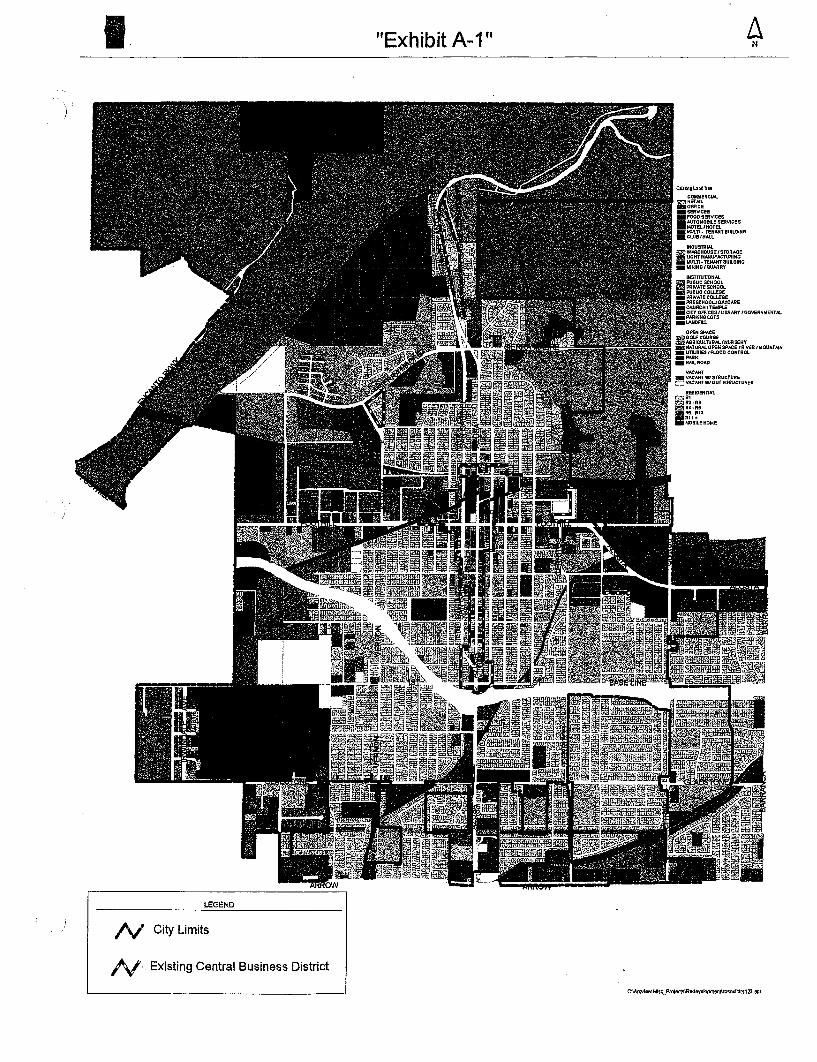
Exhibit A- 1 "
&!Itlng COMMaCw..
:& RCTM._OffiCE- SERVICES
FOOD AUTOMOBILE! MOTEL/HOTELMULTI. CLUB/HAll..
IHSTrrunONAL~ PUSUC m PRIVATE _PUaUCCOl.LElJe- PRIVATE - PRESCHOOLlDAYCARE
g~Rg~:J'::J~BRARY tGOVERNMENTAl
- PARIGNG _lANDFill.
OPEN
~~~C~~~~/NUAseRY- NATURAL - unUTIE9 _PARK- MIL ROAD
VN;Nff
~~::g=::gr~U ~UAES
LEGEND
I'v City Limits
Existing Central Business District
C\AtCYisw MlscProjects\R&d8V8Iopmen1\rOsexltirs 12J.apr

Exhibit "
REDEVELOPMENT PLAN MAP
Central Business District Project Eighth Amendment Areas(Eighth Amendment Area Nos. 1 through 15)

Exhibit A-
LEGEN D
City Limits
Existing Central Business District
C\Arcvisw MiscProjeCIS\RedllVaIopmenl\rosexlti.IS123.

Exhibit A-
&nllng18ndUuCOMMERCIAL
i!1!!~~SERVICESFOOO .-uTOMOBllf MOTa/HoreLMUlTI. TEN.lHTBU\1DINGCWB/H.IU.
INSTlTUnONALPUBUC
~ PRIVATE - PUBUC - PRIVATE - PRESCHOOL/OAVCAAE_CHURCHfTeMPLE- ClTYOFFICES/UBRART .:::;~~LOTS
O~SJlACE
iI :::JftU.J:"lNURSERY.. NA.TURALOPEN - UTIUTIES .. ::,IC
ROAO
LEGEN D
City Limits
Existing Central Business District
C\Atcvlew MiscProiects\Redaveloprn&nI\l'OS8Klttts123.apr

\.....
..
AGENCY: CITY OF
PR
OJE
CT
: RE
DE
VE
LOP
ME
NT
B
USI
NE
SS D
IST
. PR
OJE
CT
,' 8
TH
. ~ AREAS.
. ~
g b
g'
.a ~ 0 ~
1---
1 5'
~;:II: ~
0 ~
!IJ p
o :a
....
(\I r'"
--,-
--...
.
r--
~ ~erri\O
~ ~
:I: IP
":)
h \.
..~_.
r--.
......
......
..
Sun.ell Ave,
Son
I O
obrle
l Av~
. Azu
sa lA
ve.
III
f1.
~\\\;
~)~~
:
t:.
~. $h
~~"
:!:
Ala
med
a lA
ve.
;~. ~
01
.....
!IJ
!IJ
Jl*!
jl4i
J
Cer
rito
s A
ve.
I; ...
.
;!l
Roc~vale Ave.
6th st.
,J.fl
.J'
J:
2.
r;
en
:;;'
:-:;~
~:'
I;:::::
/:;"
;:'
1' :"
.i', .~1
0. It::
"""
~:,~~
:: ,
:~:.::
:'
;: i
::;i~
~\,i::
:: ;;;
:0;
!IJ
Sol
dano
I A
ve.
I ~
pOlodenoJ Ave. -
16ir
Citrus Ave.
Pal
m D
r.
!IJ
':;':.
:~:!;
'~::'
:1 I-
-
l,L
VIC
INIT
Y ED
,
!!!!
f;Z
0 C
/OQ
2fou
c
~C!f
A~!
ua~ cr
(J)
.o:(
Qa;
:~a;
:rr
lON
;~:Y
i
::.~;
,
VL
lOM
HIM
.
E=
;J:s
:...;)
() IT!:S:
)- (
) rr
loo
l-N
- U z;
; ~"'
lPnI
.a...
VA
l;"B!a D
-c .'
..N""
"""!
!!II
a;:
(")
OII
O/J
c.
JIT
! _:J
:!"
""""
'!II
:" '
0-
ON
",.
'" ,~
,. :.
ralqoLq ~cr
o~l-
;g
!!!!
!,!!
,!",
,!.q
:
IT" IT! cr
I1cMpRLap at
.q: .., a;:
:J:
'I:t.-
1 ~M
~
~~.
cr ..
.) ~
:;E (
T1
ru
!!!!
!!!!
!!!!
!!!
:,:;
N IT
! ()
;:.
.q: s:: I-
IiiiI
I
:!!
. - ~
cr~
IJ,
.q:;:.
~:J:
..j fT1
.q:
e!!!
!!0
:;E. :
;EC
laq2
fous
2f"
I- (T1 .q:
IIII
!!'!!
!!!!
II:s
: cr
0 0
'-"fT
1 :;E
s:: f
T1
';:.
I-:S
:0:
:::
I!'!!
!!!!
!!!!
!!.0
:(..,
I!!!
!!!!
!!!!
!!
!!!!
!!!!
!!!
IIII
!!'!!
!!!!
II
ill!!
!!!!
!!II
!!
!:!.
IIII
!!'!!
!!!!
II
III!
!I~:
=!!
I(f
1II
01
.
III
!!!!
!!!!
'!!
11'.:
1
a;:
,,0
:,:;
;:.
HO
lfC
Wr;
I.2L
Q'
III"
!I
III!
:ip
f~~:
~:~
c::
t-w
rec
bI"
II)
c::
.q:
ri
e:)
!.!!
2W'
II!
Do ~
(")
::0 c::
:;:;
c::
r;:i
~q; .
.q:
ew'
~ lO
, :'
;:.
1:.0
0IJ
!II
;IIA
qI)
'
::=--
I:!I
iiI!I
!~1
U:;.
i!:f
!:;~
t--! I!.
iiI!I
::Iew
't-
-! (
)
;:!:;:
;
01(
co
c.J
II!
:!II
I
,. .. .
E-c
N
tJ"'
b;i
!III
!!:
oW'
;?~n "
'-.I
II!
JOW
'2f
'

AG
EN
CY
: PR
OJE
CT
: B
USI
NE
SS
8TH
. A
RE
A
ASS
ESS
OR
'S REFERENCE: 8608-
024-
004
EL
3N
CO
UII!
'I~ T
&R
IJi!'
coU
RSE
(Ct)
(C2) lIt!
(C8)
111
BIW
IIN
G
S 8
1'15
8E
2.4
1.Rad: 2.5.
Arc
: 39.
2.e
D,lta: 81'
2.0.
Chd
: S 4
4'11
1' toE
JII.
S W
OO
'f;
S
81'
JJ'S
O"W
tBO
,07'
N OO'OOO
O"W
e0.
03N
89"
582.
0"W
141
,N OO'
OO
'OO
"W 4
14.
Radl 2.11.00
' 2.
B
Chd
l N 4
5'1I
0E
D,lt
al 1
0'
~~~~
:
S 8
\'. E
85.
(TIE
UN
E)
MA
P P
RE
PA
RE
D B
Y:
SOLOFF. SURVEYING &
DATE: 6/18/01
, ,
' 60
~ .
e I
\ fi
~ I'
-t
~ \
\ .
POIN
T' O
F C
OM
ME
NC
EM
EN
T
INTERSECTION OF 9TH. STREET AND SAN GABRIEL
AV
EN
UE
PE
R P
AR
CE
L M
AP
P,
B 16, PG.
80.
(TOTAL AREA-J,
1J:I
:
SO
UtH
EA
LY U
NE
OF
LO
T 2
.PER PMCD. MNO P.
1I,
PAGE 80
' I eo'
~~,
~O'\)
~"
.". ,
~~'
O~ G
.. ."
.
","-CENTERUNE OF MILS
....
PE
R M
NO
IN M
.t6, PO.' I 40
1~ \
~\ ~
i.\
::1
' SANITMY SEWER EASEMENT
TO
mE
ER BOOK 0-3907. PAOES 869 AND BIO
I'S
SH
OW
N O
N P
MC
E\.
MA
P P
.8. \8-80
9th,
Sl.
E3N
J,W
:II.
II:
IND
ICA
ttS 8
0UN
DA
RY
IND
ICA
TE
S P
OIN
T O
F B
EO
IIIN
INO
IND
ICA
TE
S PO
INT
OP'
CO
MM
EN
CE
ME
Nt
IND
ICA
TE
S I'
SS
ES
SO
R'S ,P
MC
EI.
NU
MB
ER
(B
B08
-024
-1I1
I)

WE
STE
RL
Y L
INE
OF
TH
E L
EM
ON
TflA
CT
11. PO.
108
~ 1
p.,
AGENCY: CITY OF
PRO
JEC
T:
BU
SIN
ESS
A
RE
A 2
ASS
ESS
OR
"S REFERENCE: 8608-
017"
';'02
3
80
110
'"
SCA
LI
1.1
0,N
OR
TH
ER
LY L
INE
OF
, THE LEMON TRACT
11 PO.
108,
415'
AP
N 8
625
EASTERLY LINE OF
THE LEMON TRACT
B11. PO.
108
(;O
UR
SI!
TA
BU
:,C
OU
ltSII
" OO'OOE 9MO
ca
00"
41'-0
0'C
3 00
"( 120.
00'
C4
" 80
'00'
OO
"W 3
80.
(C5)
00
' 27
'D
ella
: 10'
00Chdl " 45'
00"'/'1 35.
NORTHERLY LINE OF SOUTHERLY 15 FEET
F LOTS nHROUGH 6 OF THE LEMON
B11. PG.
108
PO
INT
OF
INTERSECTION OF 9TH. STREET AND
, PA
SAD
EN
A A
VE
.
PE
R T
HE
LE
MO
N T
RA
CT
M.
11, PO,
; 08.
MA
P, P
RE
PA
RE
D B
Y:
SOLOFF SURVEYING & CONSULTING
DATE: 6/19/01
JmJ:
1III
:
INDICATES, BOUNDARY DESCRIB&:D HEREIN
IND
ICA
TE
S PO
INT
OF
BE
OIN
NIN
G
IND
ICA
TE
S PO
INT
OF
CO
MM
EN
C&
:ME
tlT
IND
ICA
TE
S A
SSE
SSO
R'S PARCEL "UMBER (8808-0t7-KK)
---.
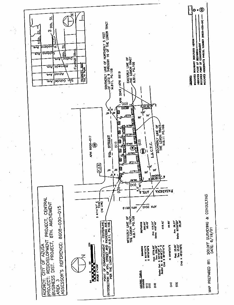
AG
EN
CY
: P
RO
JEC
T: R
ED
EV
ELO
PM
EN
T
BU
SIN
ESS
AREA 3
ASS
ESS
ORS REFERENCE: 8608-
030-
015
Gi
~ ~
9th. St.
S 8
1.41
'' E
. 73.
PO
INT
OF
INTERSECTION OF 9TH, STREET AND
PER "'.
11. p
o.' 0
0.
-;;t:( ,
C7I
WE
STE
RL
Y L
INE
OF
THE lEMON TRACT
11, PG.
108
80
BC
AU
! 1'
.100
'
111
APN 8608-017
DIS
I'AN
CI!
:
300. 00
.
.cO
t/RB
I: T
AB
LE:
CO
UR
S8
(Ct)
D
O"
(C2)
O
O"
(CJ)
81
1'
Tan. 208.
Rad
ial O
ul' 9
02.
' E
Radla' In' 1'1
" W
Chd
l S 8
5.,5
'4'"
W
(C4)
(C5)
H OO'OO
lIad
: 15.
Ton
I 25
.C
hd, 1
'1 4
8'O
O'
9th. STREET
SOUTHERLY LINE OF NORTHERLY 5
F LOTS 9 THROUGH 16 OF THE LEMON TRACT
B11.. PG.
108
Arc: 418.
D81
\al 4
:07'
48'
' .
(C3)
. 903
'i;. ..
'i;. L.
SOUTHERLY UNE OF
THE LEMON TRACT
11 PG.
108
418.
42
99.8
5'
Arcl 311.2
7'
Dlltal 80'00 35
.
IND
ICA
TE
S B
OU
NO
AA
Y D
ES
CR
IBE
D H
ER
EIN
c: ::.::
:3
IND
ICA
TE
S PO
INT
OF'
BE
GIN
NIN
G
IND
ICA
TE
S P
OIN
T O
F'
IND
ICA
TE
S A
SS
ES
SO
R'S
PM
CE
\. N
UM
BE
R (
8808
-030
-11)
()
MA
P P
RE
PA
RE
D B
Y:
SOLOFF SURVEYING
DATE: 6/19/01
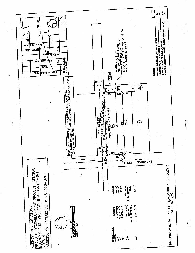
-,,
110
110
~--
-~--
-
BC
ALS
1..1
00
1110
PO
INT
OF
OF PASADENA AVENUE AND 8TH.
15; PAGES 93-96.
9lh. Sl.
AG
EN
CY
: CIT
Y O
F A
ZU
SA
PRO
JEC
T:
BU
SIN
ESS
A
RE
A 4
ASS
ESS
OR
'S REFERENCE: 8608-
030-
006
6jN
, ~
---
CDURIII: TABLm:.
toU
RSI
BIl
Al\l
NO
DIS
I'AN
CII
\~~\
5 00'00'
00':E
12.0
.
N IO'OO'
OO
"W41
&.
N OO'OO
OO
"W'0
5.
(C4)
Rad: 111.
Arel 23.
118'
Ta"
1 16
.00'
Del
tal 8
0'00
00.
Chdl N 45"00
11.1
1
(CII
)S 80'00
400.
TOTAL AREA-1.
14:1
: AC
RE
S
(C2)
EASTERLY LINE OF
PORTION OF LOT 8 AND
SOUTHERLY HALF OF LOT 7
BLOCK 84, PER THE MAP OF AZUSA
15, P
AG
ES
93 T
O 9
6
., ,
(!)
MA
P P
RE
PA
RE
D B
Y:
SOLOFF SURVEYING & CONSULTING
DATE: 6/19/01
INDICA1ES BOUNDAIIY DESCRIBED HEREIN
IND
ICA
1ES
POIN
T o
r B
EG
INN
ING
IN
DlC
A1E
S PO
INT
or
CO
MM
EN
CE
t,lE
NT
INOICATU ASSESSOR'
S PA
RC
El.
NU
MB
ER
(1I
1I06
-030
-XII
)

EtY
N
9th. SL
AG
EN
CY
: CIT
Y O
F A
ZU
SA
PRO
JEC
T:
BU
SIN
ESS
A
RE
A 5
ASS
ESS
ORS REF6:RENCE: 8611-001-
046
110
110
sCA
LI L
",;,i
OO
LII
O
\~~1
DE
Alll
NO
14 II
O'O
O'
Rad
. 25.
Chd: S T:g
!
~t8P
~
S OO'OO
OO
"WII IIO'OOO
O"W
II OO"OO
. DtSTAIICB
125.
00'
~CI 311.
2.7'
Oella: 110' 35
.
150.
00:
m:s
s.
PO
INT
OF
' C
EN
TE
RU
NE
S
OF FOOTHill BLVD. (FORMERLY CENTRE ST.) AND SOLDANO
PER THE MAP OF AZUSA
15 PAGES '9J
-96.
j;OU
RS
II: T
"ULI
I::C
OU
RlB
(Ct)
(C2)
WESTERLY LINE OF LOT J AND
WESTERLY UNE OF NORTHERLY HALF OF LOT
BLOCK JJ. PER THE MAP OF AIUSA
15. P
AG
ES
93
TO
96
~I
fI.I8 O
40' 40
E:::
J
MA
P P
RE
PA
RE
D B
Y:
SOLOFF SURVEYING & CONSULTING
DATE: 6/19/01
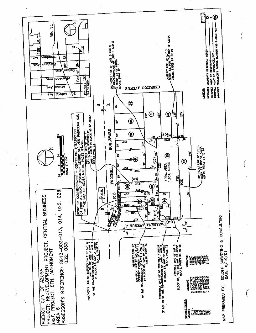
69N
9th.
Sl.
AG
EN
CY
: CIT
Y O
F A
ZU
SA
PRO
JEC
T:
DIS
T. P
RO
JEC
T, 8
TH
. A
RE
A 6
ASS
ESS
OR
'S REFERENCE: 8612-
003-
013, 014, 025, 026
032, 033
M--
-
----
. SC
AL
I: i.
.iOO
100
NO
RT
HE
RLY
UN
E O
F E
AS
TE
RLY
IIN
O A
LL 0
1' L
OT
S 3
IIN
O 4
01" -mE RE -SUBOIVSION Of' lOTS I
IN B
LO
CK
83.
Mill
' OF
18, P
,a.o
E 7
1
PO
INT
OF
O
F F
OO
TH
ILL
BLV
O. (
FO
RM
ER
LY C
EN
TR
E S
T.) AND PASADENA
PE
R T
HE
MA
P O
F A
ZU
SA
M.
15, PAGES 93-96.
OF
'!ME
RE
-SU
BO
M91
0N O
FO
TS
1 A
ND
:I I
N
R. II
SOVT1iERlY LINE OF lOTS & ","0
OF
RE
-SU
eOM
SIO
H O
F L
OT
S 1
MO
N BLOCK 83 OF
18, PAOE 7:l.
SO
UT
t\ER
lY L
INE
OF
OF
, OF LOT 10 OF 1HE RE-SUBOIVSION OF LOTS I
IN B
LOC
K 8
3, M
N' O
F A
lUS
A18
. P,a
.OE
7:l.
135'
, i '011 fI)
WE
STE
RlY
LIN
E O
FEASTERLY HALF OF LOT :I AND
(ASR
:RlY
PO
RT
ION
Of'
LO
T 1
0O
F -
mE
RE
-SU
BO
MS
ION
Of'
IN B
LO
CK
83,
Mill
' 01"
AlU
SA18
, PA
OE
72
230' e!
)
rAS
l1:R
l Y L
INE
OF
LO
T 3
BLO
CK
83,
PE
R 1
HE
MA
P O
F A
lUM
R.I
II,
WESTERLY LINE OF lOT 3
BL
OC
K B
3, P
ER
TH
E M
AP
OF
AlU
MR
. HI.
PA
GE
S O
J T
O
S)O
IlRS
R T
&A
LIs
CO
Ull8
&B
IWII
IIO
N 9
0'00
S 0
0'00
'00"
\'1N
110
'00'
00.
S OO'OO
OO
"EN
90'
00Q
O"W
H 0
1100
:00
n S~gg,gg:~
DIS
fAII
CII
12&
.00:
110.
2111
.10
5.41
8.00
105. 75.0
0:21
0,00
235'
105'
NORTMERlY lIN( OF lOT 4,
BLO
CK
B3,
MA
P O
F A
lUS
A15
, PA
GE
S 8
3 T
O 9
0JaWID.; ~
IND
IC,a
.m
IND
ICA
1D P
OIN
T O
F B
EO
INN
INO
IN
DlC
AT
U P
OIN
T O
F
INO
ICA
TE
S A
SS
ES
SO
R'S PARCEL NUMBER ("'2-003-1UI)
MA
P P
RE
PA
RE
D B
Y:
SO
LOF
F S
UR
VE
YIN
G li
e DATE: 6/19/01
----
---.
,...
...--
-..

AGENCY: CITY OF
PRO
JEC
T:
DIS
T. P
RO
JEC
T, 8
TH
. A
RE
A 7
ASS
ESS
ORS REFERENCE: 8612-
001-
027 THROUGH
040
--a
C,,
---
--- /
""
/..
'\..."
'"
....
INT
ER
SEC
TIO
N O
F 'F
OO
TH
ILL
~I.
f'OR
ME
RLY
' CE
NT
RE
ST
.) AND ALOSTA AVE.
~/.,.
f'
....
27346 M.
699 PAGES
4'1
rV' 1f
OF LO 3S
CT "0.27348, 'I.4.888, PAGES 22-23 8' PUeLlC UTILITY
EASEMENT TO
B. NORTHWESTERLY
CORNER LOT JI TRACT NO.
27:5
~6699, PAGES 22-2J
scALI 1
-10,
MA
P P
RE
PA
RE
D B
Y:
NORTHEASTERLY UHE OF
OTS 27 ""0 38, TRACT NO.
2734
G
G8I
1, P
AO
ES
. I
SOLOFF SURVEYING & CONSULTING
DATE: 6/19/01
.J:O
IIR
9I!
TA
RtE
:
CO
UIU
IBB
EA
RIN
GO
IST
AN
CB
\gi1
N 811'
311'
30Z
.80:
S 40'S8
240.
5 48.
1I4"
V1
3s.
(C4)
Rod
! 46
.00:
M=
I 88
.08'
Ton
i ~I.
Oll\al ".
s2' .
Chdl S
' OS
'22
2SG
Ul3
'
(C5)
5 32
. I S
110.
(CS)
Rad
l to.
OO
'""01 SO.
Tan: '68.
Oll\
al 3
2.,0
'47'
Chd
l 5 I
S'OS 04 E
50,
(07)
5 OO'OO
OI'
3S.
(C8)
Rad
l '5.
....c
: 23.
Tan
: 15.
~O
lllal
88'
Chd
l 5 4
4'21
.21
(C8)
S 811'
I4"W
187,
(CIO
)lIa
dl '0
....
.-0:
23.
Ton
: 15.
Oel
lal 8
0'.
Ohdl " 45.
21"V
121
.21'
~CI1
" oaoo
os""
173.
34:
OlZ
N lal4
10.
(CI3
)R
od: 7
0.00
'""01 134.1
17'
Tan
: '90
.8S'
Oel\al 110'20
32'
Chdl " 48.
0008
"V1
110.
01'
~014
S 711.4
0'3s
"W00
.01'
0'0
S S8.
54"W
U:~
~:0\
8" oa02
02"W
(0'7
)R
od:
2.2.
0.M
=!
SI2.
3'T
oni 4
-1 .O
J!'
0111
0: 2
1.\8
'C
hdl N
10'
32.'3
1 E
. 80.
77'
L::"
:~'1
IND
ICA
TE
S B
OU
ND
AR
Y O
ES
CR
IBE
D H
ER
E'"
INDICATES POINT OF BEOINNlNO
IND
ICA
TE
S P
OIN
T O
F O
OM
ME
NC
!ME
NT
IND
ICA
TE
S A
SSE
SSO
R'S PNlCa. HUMBER

AG
EN
CY
: P
RO
JEC
T: R
ED
EV
ELO
PM
EN
T
DIS
T, P
RO
JEC
T, 8
TH
. AM
EN
DM
EN
TA
RE
A 8
ASS
ESS
OR
'S REFERENCE: 8612-
001-
048, 052,' 0
53,
059,
060
, 063
J:Pl
lR..q
l! T
AR
lE!
CO
.UR
SI
(cl)
(C2)
(CJ)
(C4)
(C&
)
(Ce)
(Cn
(CB
)
PO
INT
OF
' IN
TE
RS
EC
TIO
N O
F' O
LEN
FIN
NA
N A
VE
NU
EAND LIME STREET PER TRACT NO.
2734
6699, PAGES 22-23.
EI3
N80
11
0
SCA
LI
10.0
0
(C8)
WESTERLY LINE OF LOTS 32 THROUGH
PE
R T
RA
CT
NO
.273
46699, PAGES 22-23
. BI:
AllD
fO
N 8
8.84
OE
78.
Rad
; 25.
A,cl 311.27
'T
anl !
"OO' D,llal 80'00'00
0
Chdl S 4&'00
08E
36.
38'
S 00'00
08OE
2.1
0.0
I'
lIadl 15.
Arc
l 23.
Tanl ~5.
' Dellal 88'
Chi
li S
44'58
34"W
21.
2.1'
. S 8
8'58
" 4"
W 1
80.03
'
Radl 2.8.0
0'
Tan: ~4.
1l9' o.lIal 88'
440
Chd
l N 4
S0t 2
4"W
35.
38Ii
00'
0102
"W 2
.10,
04'
Rad
l HI.O
O'
57'
Tan: 15.0"
8,
0C
hdl N
. 44'
III'III"E 21.
N 1"5,'1I4"E 111.
111
MA
P P
RE
PA
RE
D B
Y:
SO
LOF
F S
UR
VIiY
ING
lie
DA
TE
::
' 30' m
'\ ~ ~ .oo
~~w
B. NORTHWESTERLY
CO
RN
ER
LO
T 4
8 T
RA
CT
NO
.2734
6699, PAGES 22-23
IND
ICA
TE
S B
OU
ND
AR
'( D
ES
CR
IBE
D H
EIIE
IN
INDICATES POIKT OF BEGINNING
INDICATES POIKT OF
SOUTHERLY LINE OF lOTS 35 AND 36
S PMCEI. NUMBER
PE
R T
RA
CT
NO
,27346, M.
egg, PAGES 22-23
mt'
30' I 30
tOO
'
100.
STR
EE
T
EASTERLY LINE OF' LOTS 36
PE
R T
RA
CT
NO
.273
46699, PAGES 22-
ror.
:r A
ll. 1
Not to Scole
~ ~
r::::
l
~~

AG
EN
CY
: CIT
Y O
F A
ZU
SA
PRO
JEC
T:
PROJECT, 8TH.
AR
EA
9A
SSE
SSO
RS REFERENCE:
FOO
TH
ILL
BO
UL
EV
AR
D
"0 ~
0.0
Fool
hlll
Blv
d, '
-1.;.
-tJ
't 1/
1O
-1t
- 1!' N
fI)
, -
B. NORTHEASTERLY
CO
RN
ER
LO
T 1
, 27
346
"fA
..
699, PAGES 22-23 '
" ~
PO
INT
OF
IN
TE
RS
EC
TIO
N O
F G
LEN
FIN
NA
N A
VE
NU
EAND LIME STREET PER TRACT NO.
2734
6
699 PAGES 22-23
110
ICA
LII
1".
100'
i:OIIR
.!11!
TA
BLE
!
CO
UR
III
(Ct)
t!I
APN 8612-
002
EASTERLY UNE Of'LOT ,
PER TI\AOT MAP NO.
5119
4..1
.B.1
20B
, PA
OE
S 2B
-29
' PU
BU
Cun
U1Y
EA
SEM
EN
T T
O C
ItY
Of'
ASU
ZA
SOU
TH
ER
LY
UN
E o
f'L01S B "THROUOH t7
40 I'
27348, M.
811I
1, p
AC
ES
- :.
'40
~ ~
~m~
WlU
BI:
INO
ICA
TE
S B
OU
ND
AR
Y D
ES
CR
I8E
D H
ER
EIN
INOltATES POINT Of' BEGlNNINO
1N0l
CA
TI!:
S p
oIN
T
IND
ICA
TE
S A
SSE
SSO
RS
PA
RC
El.
NU
MB
ER
(11
112-
001-
1111
)
BIl
AlU
NO
Rod, 2BO.O
O'
113
Tan: ~0.
' Oella: 18'28
42"
Chd
: S 0
8'12 II"YI 110,
211'
: ~~~
Er~
2~t
:~&
:
Rod
: 70.00
' Tan: 100.
111.
:'
Chd: S 411'0
1'24 E 1111,
II 7
,',B
"E
N B
"!I"
14E
43'
.03'
Rod, 211.00
" Toni ?II.O
,\!' Oella, '0'00
Chd
l S 4
5'00
211
E 3
11,31
'
S OO'OO;08E
75.
00:
f6)
CII
) ( 112.
EASTERLY LINE Of' LOT 17
:mACT ND.
2734
110
1.
"" ~g
l(C
4)
(!!)
200
103.
~gi1
(C7)
c::J
MA
P P
RE
PA
RE
D B
Y:
(C9) 8
' EA
SEM
EN
T T
O O
~EA
AL
SOL
OFF
SU
RV
EY
ING
& C
ON
SUL
TIN
G C
OM
:': cw
., :t~
:;!:'t
DA
TE
: 01
APN 8612-002
EASEMENT TO Cm' OF ASUZA

AG
EN
CY
: CIT
Y O
F A
ZU
SA
PR
OJE
CT
: RE
DE
VE
LOP
ME
NT
PROJECT, 8TH,
AREA 10 (SHEET
ASS
ESS
OR
'S REFERENCE: 8624-021-015 THROUGH
"0 .
0.5
Foot
hill
Blv
d. '
-o
oi:(
),
'l't
-1~ 1.'I N
.....--
----
-
liI
- --
i- ~
'ff':"
5TH, STREET
J.3
~!jk
(~~C
2" 125
' ~
... 1
04.1
0'
' ~ r.
..(( v'
POINT OF COMMENCEMENT -
INTERSECTION OF ALOSTA AVENUE
AN
D 5
TH
. ST
RE
ET
PE
R P
AR
CE
L M
AP
1'1
0.14
645
P ,
153 PAGES
63N
~IIR!IE TARLE!
OoU
RS!
(0
1)
(C2)
00
:Tanl 4.
Chd
: S 7
3'28
'iO
O60
SC
AL
I 1
-100
(C3)
Rodl 2300.
Tan
: 41U
l8C
hdl S
81'
02' t
8
(C4)
Rad
: ,0.
00:
Chdl S T:8
!3d%
~l
S 0
0'0t
30"W
N 0
1l"0
U'3
0"W
N 00'OO
80"W
N 4
6'47
"W
B. - NORTHWESTERLY. CORNER
PA
RC
EL
1, P
AR
Ca
1484
5P
.153, PAGE 2
......
.....
......
......
.4l;O
8~
J1~l
Vf1
(C'J
) -
-:.
NORTtlEASTERLY LINE OF
PNlC
EL
t.tN
' 148
4t.t
.8, '53 PAGES 1-
APN 8624-
003
WE
SltR
LY L
INE
OF
PN
lCE
L ,
NlC
EL
t.tN
' '48
488, 153 PAOE
S 1-
8
"....
.;.;
.....,
;' ':'01 --
I
:(' II
!.
TOTAL AREA
22,7
1:1:
AC
RE
S
. '
.t.E
:~~~
:~:~
'
DIS
fAN
CIi
:
22',
Ne:
~.O
Il'
Oel
\al 3
3'01 3':
"re:
'78.
I g:
Oel
\al 2
4'2'
'5B
,87
0, 2'.2
7'O
el\a
l 8 .
'4'46
:18
,
771.
16'
'030
.82'
1023
.23:
. t7U
B
. MATCHUNE
:::'~
':SB
OU
NO
NIY
OE
SC
RI8
EO
HE
RE
IN
L '~.
;\
INDICATES POINT OF BEOINNING
INDICATES POINT OF
IND
ICA
TE
S A
SSE
SSO
R'S PNlCEL flUMBER
QSI
APN 8624-
004
SEE SHEET 2
MA
P P
RE
PA
RE
D B
Y:
SOLOFF SURVEYING & CONSULTING
DATE: 6/19/01
.~\
-?-"
''"
~

AG
EN
CY
: C
ITt
OF AZUSA
PRO
JEC
T:
PROJECT, 8TH.
AREA 10 (SHEET 2 OF
ASS
ESS
OR
'S REFERENCE: 8624-021-015 THROUGH 018
MA
rCH
LlN
ESE
E S
HE
P" 1
(.II....
(.II V!,
WE
ST
ER
LY 'INE OF PARCELS
. 1 ..
.HO
Z
"'RC
EL
M"'P
148
45
8. 1&3 PAGES 1-5
. GO
.
. QI
....
r"I
402.
MA
P P
RE
PA
RE
D B
Y:so
urnE
RL
Y U
NE
OF
PMC
EL
S , H
lO :z
MC
EL
",
;8. 1
53
626.
149
EASTERLY UNE OF
PAnC
EL
M"'
P , 4
84. P.
B. 153 PAOES 1-6
(C6)
APN 6624-005
SOLOFF SURVEYING & CONSULTING
DATE: 6/19/01
0 ~
0.0
Foot
hill
Blv
d. 11/
/0
. ~
"'I-
Q -
1,. ... N
~~
;, 80
, 40' I 40
,.....
: v.
~ ""
"
I ~. ~ I ~
AP
N 6
626
~~O
sCA
LI:
a".
aoo'
EI3
N
10 :
or;,
;;)'
\D -:
~
' , 40' J
.SIII
Wt
IND
ICA
TE
S 8
0UN
DM
Y D
ES
CR
I8E
D
IND
ICA
TE
S P
OIN
T O
F 8
EG
INN
ING
IHDlCA1ESPOINT or
IND
ICA
tES
ASS
ESS
OR
'S PARCEL NUMBER
c::1

AG
EN
CY
: CIT
Y O
F A
ZU
SA
PRO
JEC
T:
BU
SIN
ESS
AREA 11
ASS
ESS
ORS REFERENCE: 8622-023-008 AND 009
160
:;;. ....
Vl'
APN NO. 8622-
: 40
~40' \ I
""" I
; fJ \ ~
SOUTHERLY UNE OF LOT 2
TR
AC
T N
O. 4
2888
101
.10
2.0
PAG
E 4
'
80
~~~
-.
Sc~
1".
100
APN NO. 8622-22
(C4)
. ,"
, , I
, ~~'
.~.
171.
46
' '"
'.,'' '
. . .
TOTAL AREA
82:1
: AC
RE
S
(!)
(!)
150(!)
SOU
TH
ER
LY
LIN
E O
FS
EC
TIO
N 2
, TO
WN
SH
IP 1
" W
RANGE 10 WEST, SAN BERNARDINO
(TIE LINE)
MA
P P
RE
PA
RE
D B
Y:
SOLOFF SURVEYING & CONSULTING
DATE: 6/19/01
/---
----
. .x-
--..
.cPt/Dr. TARLE:
CO
I/Jl
SBB
lAR
ING
9 4,
'03
"W5 B9.
!l7'
14"W
N 0
0'11
'63'
N 8
9'07
'18"
N 0
0'21
'37"
N 8
,'4"
4'"
N 0
0'21
'113
"H
88"
48S 00'12.
II'''W
DIS
TA
NC
I14
.13:
870,
330.
327. 60
.
~:S~
'11
0.0'
:4
t:z.9
~
EASTERLY LINE OF
SE
CT
ION
2. T
OW
NS
HIP
1
RANGE 10 WEST. SAN BERNARDINO
B. NORTHERLY ANGLE POINT
NORTHWESTERLY R-W OF
PO
INT
OF
CORNER OF
RANGE 10 WEST. SAN BERNARDINO
:=:,
BO
UN
DA
RY
DE
SC
RIB
ED
~E
RE
tN
' :J
IND
lCA
m P
OIN
T O
F INDICATES POINT of
IND
ICA
TE
S A
SSE
SSO
RS
PA
RC
EL
NU
MB
ER
(B
812.
-023
-1I1
I)
''''''-
'''''''

AGENCY: crTY OF
PRO
JEC
T:
OIS
T, P
RO
JEC
T, 8
TH
. A
RE
A 1
2A
SSE
SSO
RS REFERENCE: 8621-
024-
001,
eo
8CALII i"-iOO
WESTEALY UNE OF SECTION 2
TO
WN
SH
IP 1
SO
UT
H M
NO
E
SAN 8ERNARDtHO MERIDIAN
82'
1:1.
'
J.. ,
Fl '\
01 g
I iii
S. I
~ \
~ ~
l : .
, ,,-,.
: (C
7)
110
588.
~ Ii
;RLD
UR
GH
AV
E.
B. INTERSECTION EAST LINE OF 100
RIGHT OF WAY FOR AlUSA AVENUE AND NORTH
LINE OF S. 1/2 OF S.
1/1,
. O
F S.
III,
.
1/1,
. OF SECTION 2 TOWNSHIP 1 SOUTH
RANGE 10 WEST, SAN BERNARDINO
SO\1rnERLY UNE OF NOAft! '
2 OF S.W
1/4
OF SoW 1/4 OF SoW 1/ OF SECl10N.
TOWNSHIP' SOUTH, MNOE to
sNI BERNARDINO
(C1) 888.
' EASEMENT TO
oEN
EM
L T
ElE
PH
ON
E C
O. O
F (
WJF
OIIN
IAF
Oil
~P
HO
NE
D
I OR
458
52-3
44
TOTAL AREA
57:1
: AC
RE
S
100 (4\
10' SLOPE Eo'SEMENT
\!.; 8 TO
DE
CI O
R 5
0531
-301
. ,
BJl
85
'
,... PO
INT
OF
C
OR
NE
R O
F S
.1/
1,.
OF SECTION 2 TOWNSHIP 1 SOUTH
RANGE 10 WEST, SAN BERNARDINO
SOUTHERLY UNE OF SECl10N 2
TOWNSHIP I So\1rn
SA
N B
EIIN
AR
DlN
O M
EIII
DIA
N
~:~
1\1
,,"O
UR
SE
TA
8LE
:
DIS
fAN
CE
:
eOl1
.44'
'72, 8',
114. 34
.38
8. 23.
254.
32'
CO
UR
SBB
IlW
UN
O
N 8
9'50
1 S"
5 Olr04
23"W
S 5
4.O
O"W
S 7
3'38
"WS
54.
40'O
B"W
S 89"4!1'1
7"W
N 4
5'~7
"WN
oo'
otl4
8"
MA
P P
RE
PA
RE
D B
Y:
SOLOFF SURVEYING &
DATE: 6/19/01
Ww
m:
INDICATES 8DUNDAAY DESCRI8ED HEREIN
I""I
CA
TE
S P
OIN
T O
F
INDICATES POINT OF
INDICATES ASSESSOIIS PARCEl. NUMBER (Oe2t-OZ4-XX)

AGENCY: CIlY OF
PRO
JEC
T:
BU
SIN
ESS
A
RE
A 1
3A
SSE
SSO
R'S REFERENCE:
' 862
0-00
4-00
5,01
5,
016,
020
, 021
SOUtMERlY UNE OF PAACEl I
OF PAACEL MAP NO.
'3 ,
7
(cd'
58.58 PAGE 76
. ,. m
::z3J
. "
, '
C5:
J:D
' "'
00
SCA
LI
i.iO
O
WA
11t.d
(1!)
'
TOTAL AREA
96:1
: . A
CR
ES
fIH
). 1
0M
C 3
1.41
'
38.
254. 21
4.89
~WESTEIILY UtlE OF 'NORESS
EG
RE
SS
EA
SE
ME
NT
fS
O
EF
ttlE
O 8
YPMCEl MAP NO." 89
B. 108 PAGE DJ
1;;
oj.
nmi
, ~
115.
150.
:1.1
NO
",T
HE
RlY
UN
E O
F M
RO
W
PE
R P
MC
EL
MA
P N
O.t
1897
8. 108' PAGE 113
EJ.
PO
INT
AT
EN
D O
F.A 2.5 FT. RADIUS (C3) 1
iI
CU
RV
E F
RO
M A
ZU
SA
AV
EN
UE
(10
0' WIDTH)
TO THE NORTH UNE OF
ARROW HIGHWAY (100'
~R~I
I!G
HW
AY
8
MA
P, P
RE
PAR
ED
SO
LO
FF S
UR
VE
YIN
G &
: DATE: 6/19/01
Q~.
EASTERLY UNE OF SEC1tON J
TOWNSHIP I SOUTH IWIGE lOWEST
SN!. BERNAADINO MEAIDIN!
jJDlIRSr. TABLm,
coU
IISI
I
\11
(C7)
DIS
TA
NC
E:
148.
68'
10.0
1:30
.&
74.1
11:
i~1:
':'~: 40.
80'
0.1\
01 8
3'01
'86"
38.2
8'
BIW
tIN
Q
N 8
8"06
'17"
WS
00'
OI'
48"W
~ ~~
t1:~
~s IIT3~!l2."
S 00'01 48"W
Radl Z"OO'
Tan: &8.37'
Chdl S 41'33 1I"W
' 81
I l
116'
,...,.
; U......
, 50'
~~.
(f.)
PO
INT
OF
C
OR
NE
R O
F S
.E 1/4 OF SECTION J TOWNSHIP 1 SOUTH
RANGE 10 WEST, SAN BERNARDINO
EA
S1t
RlY
LIN
E O
F P
AR
CE
L'ARCEL MAP "887
B. '08, PAGE 53
,....
J.&
IWiD
;
INDICATES BOUNDARY DESCIII8EO HEREIN
IND
ICA
TE
S PO
INT
OF
BE
GIN
NIN
G
. INDICATES POINT OF
IND
ICA
TE
S A
SS
ES
SO
A'S
PM
CE
L N
UM
BE
R (
8820
-004
-101
)
101
~
~-..

. .
AG
EN
CY
: P
RO
JEC
T: R
ED
EV
ELO
PM
EN
T
BU
SIN
ESS
A
RE
A ,14
A
SSE
SSO
R'S REFERENCE: 8621-
024-
0 14
EI3
N60
S
CA
UI &
".&
00'
Wn:
RL
Y U
NE
OF
"VENUE PER R
76-
WE
Sn:R
I.Y
UN
E O
F SE
CT
ION
2"TQWNSHIP IS
SAN BERNARDINO MERIDWi
MA
P P
RE
PA
RE
D B
Y:
'70
. 2.118,8
3'
~TO
~
2118
.83'
50'
SO
UlM
ER
I.Y U
NE
OF
I.O
T 3
OF RS 76-44
SOL
OFF
SU
RV
EY
ING
lie
DATE: 6/19/01
RO
AD
~lm!l1J: TABLE!
CO
Ult8
I1
(C1)
(C2.
)
DIS
I'AN
CE
1118
,411
ho: 64.
14'
0.1101 112.'
00"
1I,
34,4
8:20
2,
UU
~,
WO
OD
CR
OFT ST,
J.II
WII
tINOICAn:S BOUNDARY DESCRIBED HEREIN
:::, : J
IHDICAn:S POINT OF BEOINNINO
INDICAn:S POINT of
IND
ICA
TE
S A
SSE
SSO
R" PARCEl. HUMBER (8~21-024-IIK)
\\1\
88A
IUN
O
N 0
0'01
'48'
E
Rad
l 70,
Tan
: 34
.6,t
Chd
: H 2
8'18
'48 E
N 6
2'31
', 89'
53"
5 ocr04'
2.0"
WS 811'65'1
2"W
u' \'
"
PO
INT
OF
LINE OF SECTION 2, T' 1S
PR
OJE
CT
ION
OF
TH
E C
EN
TE
RLI
NE
OF
AZ
US
A A
VE
NU
E (
FO
RM
ER
LY L
ET
ON
AVENUE PER RECORD OF SURVEY 76-
\;
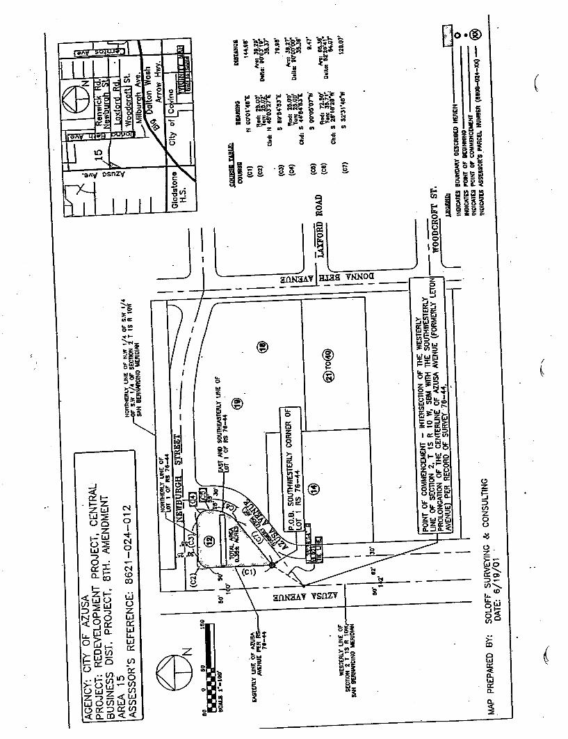
AG
EN
CY
: PR
OJE
CT
: B
USI
NE
S~
AR
EA
A
SSE
SSO
RS REFERENCE: 8621-
024-
012
NORTHERLY LINE OF N,W
1/4
OF
'S.W
1/4
I" S
.W '/
4 O
F SAN BEllNAADINO MERIDIAN
60 ~~
-_.
----
...
SOA
LII
1.1
00'
160
EA
StE
RLY
UN
E O
F A
ZU
SA
AVENUE PER R
78-4
4
. wE
SrE
RlY
LIN
E O
FSECTION 2 T tS R tOW,
SAN BEf.lIWIDINO MERIDIAN
WT
or , OF RS 78-44
DIB
TA
NC
II
144.
88'
""': 39.2
\!D
.lla:
'0'0
3'1'
~35
.37'
79.1
18
""', 311.27.
D.lt
a, '0
'00 35
,38' 47
'
""'I 86.3
11'
O.ll
a,
28'
114.
07'
128,
07'
PO
INT
OF
tiNE OF SECTION 2, T IS R 10 W,
PROLONGATION OF THE CENTERLINE OF AZUSA AVENUE (FORMERLY LETON
.;oO
CR
OFT
AV
EN
UE
PE
R R
EC
OR
D O
F
. \
. .
::::"
:sB
OU
ND
AR
Y D
ES
CR
IBE
O H
ER
EIN
INDICATES POINT OF BEGINNING
INDICATES POINT OF
IND
ICA
TE
S A
SSE
SSO
R'S PARCEL HUMBER
$!O
IIR
!III
I T
AB
LE
:
OO
VJt
811
(01)
(C2)
G!)
lUR
ING
N 0
0'O
~'4
8"E
Rad
: 25.
00'
Tan
: 'l.5
.0?'
Chd
: N 4
6'03
27
S 811'1
I4'1
I3.
Rad
. 25.
00'
Tan. ~5.
0p"
Chd
. S 4
4.8483 E
S DD'05'
D7.
Rad
. 72.
80"
Tan: 35.
Chd
: S 2
8'18
'28"
W'
S 5
2.3I
'48"
W
(ij)
(C3)
(C4)
\ G
RO
AD
e, SOUTHWESTERLY CORNER OF
LOT 1 RS 76-44
(C5)
(C8)
~TO
~(C
7)
MA
P P
RE
PA
RE
D B
Y:
SOLOFF SURVEYING & CONSULTING
DATE: 6/19/01
,-?"
,,---
\:33

....
;:c
;:cc:
:::
c::
::r::;...
..., .2
.
):10
.....
III
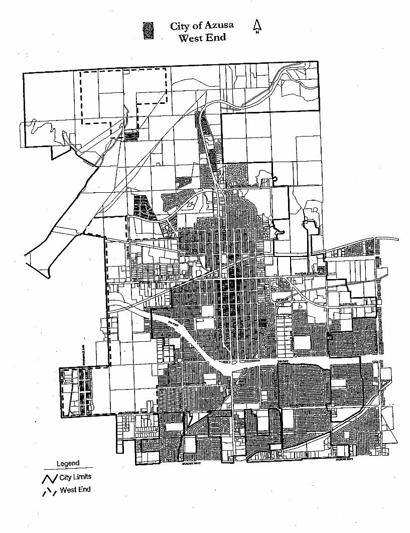
~ Q
~. .
:::J ;:+
Co
I~ -
-(I
I:::
J,\1
: H-
III
_118
"if .-----
""-
,
~I
---
fn-r
~---
"'"
IlII
lTfT
("~
mo.
...
i""
L I
--c-
!.7.
~
\'h"!
I:
,(P.
~
F;:
!=-'-
II:
::'1
1\1
~ J
i1.
I!im
~ '" 1
___
--~
~::::
:::~~
:~~':
~:--
.m-
\"iF
_I'
-- \1
1
_--
,~.
~'O
IJII
B8-
----
--
1---
-
~III
B--
---
=..
--
~.ff
~~=
-
~'
TlII
m
' ~~
II
t=1
~~
\ ~~
j~-
I;i 171) (
.., ~
r!D
Im
::illl
l
!!i:!
.-.
r--
:'ii
1II1
I1I1
II1I
1111
11:!
mH
II!B
,,=
,..u
aa!:
lea
tf!S
3S3E
8t;E
! E
I3E
13
('j~
~
rtJ
0t"
t ~tr
j ~
=' = rt
J
~~~.

(it
i1i
!i.
Iii
::T;:+)=-
nllm
~ D
IIIm
.U.lu
g '..
.E:!i
~lH
i!i!I
~~
~
i~oa
I,
;;Ui:2
:1i1
i!JC
!2 .u
:C.i2
D
.'-:~
oIllD
as
- ,-
nn ,,5 " ., ,~, ..-..
- &..'
8 ....
..
~::U
:i:l 5
: 3O
":i:
Ic:
~t;~
:r
;;oi..
. ,.E
:,.I:
:!
ii:S~
~.
-Siilo "= K\"
:i i
In ;.....
0 i!~
n; Fo::!i!2:;:n
iilg~
'-:
;1
i'!:;~
!::~
Fr
n c
~!!
S ~~
c!~l
; ,s~~gn~...nCl D~;;~5 1=;;I
i!i~
~'"
e:c ~~
~~W
;:~
~~~i
j~~
-8
liilii
"",~'
"~ -
o;
~~~
~~ m
i s
~a~

EXHIBITS "
" "
" and "
LEGAL DESCRIPTION OF MERGED PROJECT AREA
Exhibit " Central Business District Redevelopment Project Area (Including Areas Addedby Amendment Nos. 1, 2, 3, and 5)
Exhibit " Central Business District Project Eighth Amendment Areas
Exhibit " West End Redevelopment Project Area

LEGAL DESCRIPTION OF MERGED PROJECT AREA
Exhibit "
Central Business District Redevelopment Project Area(Including Areas Added by Amendment Nos. 1, 2, 3, and 5)

I ,~~- - r
~ . ' ..,.....-:~
-;r:'~
. ~ .. .~ "
REDEVELOPHENT AGENCY OF THE CITY OF
A2U~A, CALIFORNIA
REDEVELOPHENT PLAN
FOR THE
AZUSA CENTRAL BUSINESS DISTRICT
- - ,,:-
REDEVELOPMENT PROJECT
Adopted September IS , 1978
Ordinance No. 2062
Amended July
Ordinance No. 2077
.. -I
?RO?O$ED
-:...."
P.EDEVELOPHENT
FOR THE
AZusA CENTRAL BUSINESS DISTRICT REDEVELOPHEHT PROJECT
. (S 100) INTRODUCTION
The Redevelopment plan (liP Ian " ) for the Azusa Central Business
District Redevelopment Project
. ("
project ") consists of the Text and
the. Hap
).
the Redevelopment
) pursuant to
the community Redevelopment Law of the State
Redevel-
opment Law ), the united states constitution, the california Consti-
tution, and all applicable local laws and ordinances. community Red.ev~lopment
Law is located in the California Health and
Safety Code, section
II.The boundary of the Azusa Central Business
ment project area (" p.roject area ") is illustrated on the
legal d~scription of the boundary of the Project area
That certain real. property .in the City
state of. California,
(S 200) PROJECT AREA BOUNDARY
-=~
Beginning at the southeast corner of Lot l-1ap of
orded in Book lS,
Office of the county Recorder of Los . said point also
being ~he northwest corner of First Street and the Azusa Avenue .and Alameda Avenue as it existed January northerly 125 feet to the northerly line of Parcel 3
ot Parcel Map
recorded in Book 4, Page " thence
this northerly line to the easterly right of way line
" of
(100 feet wide). . the .northeast corner
16, Block 76, of said erly line of Lot 16 to the to the northeast corne
r of Lot 60, Block
thepce northerly along the ~esterly right of way between San Gabriel Avenue and
. Azusa Avenue to of way line of northwesterly along the westerly
" San
Avenue through its various courses to the southeast 12, Block 70, of said Hap
also being the north-
AREA 1

~ -,",-
c::st corner of S~::::ond cnue
thence easterly along thc northerly " of
Street
"'-'-
of Hap of " Azusa, said point also being the Second Avenue: thence northerly along the ~esterly right of last mentioned alley
. 34, the south",'est corner of Fifth Street and the alley Gabriel Avenue and Azusa Avenue; thence line of said Lot 34 to the easterly right of way
" Avenue " (100 Lot 10., Block 54 of said westerly line of San Gabri~l Avenue to the Block 43 of Map of Azusa, said point being 237.
5 feet southerly of
the southwest corner of 'Westerly along said
" line San Gabriel Avenue Avenue;
" thence. south~esterly to Block 43 of
Map of last mentioned alley and being of way line of sixth Street; thence northerly along the line of last mentioned of the south line of Foothill erly to the southeast corner of Lot thence northerly to the of Azusa; thence westerly its westerly prolongation
~~. ~abri~l Avenue and
--.
" of Bou1evard; thence
northerly to the "northeast corner of Lot l5, Block .thence westerly -to t~e northwest corner of in the easterly right of way" erly to the southeast corner of Lot said point being at the thence" westerly
" of thence
northerly 150 feet to ~he being in" the southerly thence northerly to the
, Block 26 of
of Azusa, said "point being Foothill Boulevard; thence 50 feet east to the
northwest. corner of
Foothill Boulevard and Angeleno westerly right of way line northeast corne~ of Lot 22, erly along the southwesterly. right of way Topeka and Santa Fe Railroad to "a point which is on the center line
. of line of Angeleno Avenue and
. er1y right of road: thence northeasterly along the line to the intersection with the east right of
" way
alley between Angeleno Avenue erly along said mentioned
. way"
-2-

...
u.::ing 30 feet line of said north\,esterly line of the road right of ~ay to a San Gabriel Avenue; thence northerly along way line of San Gabriel Avenue to Block 22. Map of hzusai er1y right of way line southwest corner o~ Lot 45. Block erly to the northwest easter~y 140 feet along the northerly line of continuing easterly 10 feet along the easterly northerly line of said Lot
03 feet to a point
which is the most southerly in Book Railroad right of way to way:1ine of Az~sa ~venue
wide): thence northerly along the
westerly right of way line of Azusa Avenue of Azusa Avenue and Ninth street ber 27, to the southeast corner of
" and - San
it existed December 27, 1966: thence northerly ner. of northeast corner of Ninth street and northerly
the easterly right of Avenue of Map of Azusa,
said point being
line of Ninth $tteet; thence easterly .along the southerly line of
said Lot 22 and its bf Lot
" Map of Azusa; thence easteriy along the north-
erly line of Lot 11 to the - thence easterly to the" southwest corner of " Block 13,
Azusa; Avenue to the existed July way line of Ninth street
Avenue
and NiDth street: thence line .of Alameda Avenue
- corner of Lot 10, of , AzusaJ said point being 100
feet north of "the northerly line of" NiDth S4"eet~ thence easterly
to the southwest corner of" Lot
easter1y a1ong the south line of Lot tion to the e~sterly right of Avenue and Da1
southerly along the easterly right
of way line of the last of Ninth street and last
" northerly right 'of way line of Ninth street to the northeast corner" of Ninth -street
' thence southerly
along the easterly right of of intersection with the right of way line of westerly along the west corner of Lot 32, in the easterly right of
alley between Azusa Avenue
and A1amed~ Avenue: easterly right of way
~d.
-3-

. . ,,-"
line of last Block 29, of Map of Azusa,
said ?oi~t being of the northerly li=.e of Foothill Eoule,,-
ard: thence easterly along
- ~" the ! easterly right of
along the easterly :ine of of sixth Street anc Alameda !,.
venue; thence westerly along the south-
erly line of sixth street to the southeast corner of sixth and the alley between Alameda along the easterly =ight of way southwest corner of Lot being 550 feet nort~ of the
First easterly along the southerly line line of Alameda Ave~ue; thence easterly to the way line of Alameda Avenue, said .
point also . being the northeast
corner of A~ameda A~enue and the alley between First of Alameda ~venue to the (80 feet wide); of First Street 135 feet, more or the ramp right of way line of Interstate erly and westerly and its easterly prolongation to its
intersection with the westerly
right of way line of Azusa Avenue March lO, line of Azusa Av~nue
and its northerly
section of the northerly line .. - -. east-erly along the northerly right 6f ~~~ the point of beginning.
Beginning at the line of Azusa Avenue and the southerly No. l3426, as shown on a map recorded in Book 268, Maps, in ,the office of the Los Angeles county '
Recorder; thence
westerly along the " corner thereof, said point way of northerly o? said easterly alley right of way or lessJ to the southerly right of way line Route 210: thence ~asterly along said through its various courses to the Azusa Avenue; thence southerly along the line of Azusa Avenue.
AREA 2
AREA 3
- parcel 2 of 9 of parcel Maps in the office of the County County and Parcel 2
~ of parcel Maps in the . Said land being Gladstone street and having a depth of 250 363. 80 feet on Gladstone street.
-4-

. .. . .. .
;-:"r- AREA 4
That portion of Lot 56 of said Subdivision No.
2 of .4zusa Land
and ~ater
, County of Los Angeles, State of
California, as per
Office of ,the County Recorder of said County
Beginning at the intersection of 56 and Tenth Street, 6D feet rigbt-of-way of said Tenth Street to the true point of beginning; thenceNorth 160
02 feet to a point on the
southerly ri&bt-of-way of Sierra Uadre Boulevard, 100 feet wide;
thence NortheasterlY aloDg tbeSoutherly rigbt-of-way of said Sierra
Madre Boulevard, 430. 18 feet to a curve that is concave SouthwesterlY
and having a radius of 25.00 feet; thence along said curve South-
easterlY 36.07 feet through aD
is the most WesterlY l;.ne of Vernon Avenue
, 100 feet wide; ' thence
south 290 62 feet to a ' curve
ha.ving ,a radius, of 180. 20 feet through an arc of 220
, westerlY 00 feet; thence aloDg said curve
: SoutbwesterlY 42.31 feet tbrougb.
wh ich is tbe most Northern West along said rigbt-of-way line ,
662. 83 ' feet to tbe true poiDt of
~;';~DD~Dg .
-..
AREA 5
All of :ract . 20894 iD , County of Los Angeles,
State of
, Pages 75-80 of
lIaps. iD tbe Office of tbe d--. .
as fo11ows:
Beginning' at the recorded in BoOk 903, Pages 75-80 of Official Maps of Los Angelescount1 Recorder,' thence North 0"
55 feet to the
SODtheast corner of Lot West a distance of 79.77 feet to the Southerly right-of-way ofSierra Madre Boulevard, 100 feet wide, thence SODtheast along theSoutherly right-of-way of said Sierra Madre
, Boulevard 486. 33 feet
a curve concave southeasterly having a radius of 25.
00 feet'
thence along said curve SODthwesterlY 40.
05 feet through an arc
of 91" AveDue, 100 feet 729 feet, more or lesS, to a curve that is concave Northeasterlyand having a radius of 25.
00 feet, thence along said curve 36.
feet through an arc of Northerly right-of-way line of Tenth Street, thence along
rtherly right-of-way line of Tenth street 7B. ~int of beginning.
1:-

~ : - . .
J.. f: Eb 6
........
PARCEL 1:
, All that ' s
divisioD No.2 iD the City of
State of
, Pase
1Ii O f
COUDt~ described - as
. Beginning at which point is 83; theDce West along
205 feet,
more or recorded in
, Pages 19 and 20 , of Maps of
Recorder; feet to a two-
inch pipe set iDconcrete; theDce North 20 degrees
East 81. 63 feet to a'two- iDch pipe set in,
. degrees ' a
said poiDt being in tbe incl usi ve of the
' s Subdivision
No. 2 from iDcb pipe bears Sou
th 6 degrees 15
miDutes East 3. 5 feet; theDce Soutb 57 degrees 00 minutes 00 East 120 feet to a two-iDch pipe set
~grees 4 10 feet to a
set iD ..~et to :'inch pipe ;et to a two-inch pipe set
the Horth line of TeDth
That portioD of
2 of Azusa Land and
.', Co. 's SUbdivisioD: ~D the City of Azusa
, iD tbe CoUDty
State of CaliforDJ.a, as per map recorded iD Book 43,
cellaneous Records, in the office of tbe
CoUDt~. described as
PARCEL 2:
BegiDning at a point
street, which
pOiDt is 60 feet North which point is marked by two-
inch pipe set in concrete,
East aloDg the EasterlY prolongatioD Street a 40 feet to a
of 180 ' feet to a poiDt' of 122 feet
thence North a distance of grees 56 miDutes East a
thence North
71 degrees 12 minutes East North 42 degrees 1 minute East thence North 5 degrees 58 minutes point' thenc7 South 69 degrees 31
distance of
feet to a
-6-
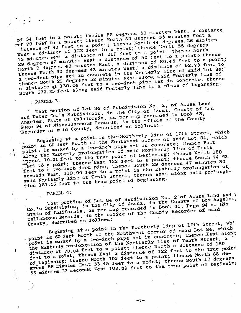
. ' ...
of 54 feet to =f lst~nce of 43 feet to a point; thence 50rth 44
'''est a distance
of 122 feet to a
13 minutes .est a distance of 209 feet to a point; 29 degrees 47 minutes West a distance of North 9
45 feet to a
thence North 32 degreeS 43 minutes West; a
73 feet to
a two-inch pipe set in concrete in the thence South a distanc.; 04 feet to a two-inch pipe set in
South 67D. 35 feet
. PARCEL 3:
That portion of .Lot 84 of Subdivision" No. , of Azusa Land
and ~ater Co. Subdivision , in the Ci Az~sa County of Los
Angeles. State of California. as per map recorded in
Page 94 of Miscellaneous Records. in the office of the County
Recorder of said County, descr
\;" . -
point is 60
. which
points is inch pipe set in concrete; thence East
along the Easterly prolongation of said "treet 70. , feet
!o.&~al?t td ' poin
feet to a two~incb iron pipe; tbence ' South 29 degrees 47
' minutes
seconds East, 119. 90 feet to a point in tbe EasterlY prolongation of
said Northerly line of tion 181. 56 feet to tbe
That portion of Lot 84 No. 2. of Azusa Land and
Co. ' 5 Subdivision, in tbe City of Azusa. in
State of California. as per.
cellaneous Records
, ,
in the office of the County Recorder of said
County. described as Beginning at -a point in the Northerly line of 10th Street
. whi.
point is 60
, which
point is marked by a two-incb pipe set in concrete; thence ,
East along
the EasterlY prolongation of. the
, a distance of
10_ 04 feet to a point; thence Nortb a distance of 180
feet to a feet to tbe true point
of beginning; tbence to a point; tbence Nortb 88 de-
eeS 56 minutes East 33_ 45 feet to a point; thence Soutb 17 'degreeS
, 53 minutes
PARCEL 4:
-7~

h REh 7
B~ginning at the .... . hce
of-'l.:ay of
~venue 60 feet wi ~ockvale
of-'l.:ay of
Street, Southeast JJ,ap 79
ine of Fi
thence South Tract 78-89, Tract
AREA 8
Beg~DDiDg at a point which is the Lot 14 Book 888,
. Recorder I .S Office;
tbence- Hortb 00 OI" 00 feet" to the. of Gl
b 890 35' 01" East 468 feet . more or 1
to a thence Soutb
O 01' ~8" West 375 feet
to a
. .
01" West 120 feet ; thence South
810 24' 28 feet; thence North 890
feet. b 00 01' 48" East 198. 49 feet; thence No"tb 890
58' 22 feet; thence South 340 21 feet,
+0 a vin.g a radius. of 45
~et; curve No~thwesterlY. 22. feet through an
arc of 290 line of said
Lot 14; 00 .O~' 21 feet beginning. ~rea
Beginning at the southeast corner of Azusa recorde
in of LOs Angeles Cqunty; said point al~o being the and the alley.between
- 1967, thence 00 feet ~o the
recorded in line to the easterly right of
00 feet wide); thence
northwesterly to northeast corner of Lbt 16.~ Block 76. of said
thence the nortnwest intersection of
First Street the northerly right
- t
...
-8-
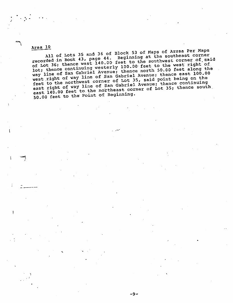
"..".... .
Area 10
All of Lots 35 and 36 of Block 53 of Maps recorded . in Book of Lot
00 feet to the southwest corner of said
lot: thence continuing 00.
way line of San Gabriel Avenue: thence 00 feet along the
west .right Qf way line of San feet to the northwest corner of east right of way line of San east l40. 00 feet to the northeast corner of Lot 50. 00 feet to the Point of Beginning.
-...--- ....
-9-

.. '.
PROPOSED
SECOND AMENDMENT
TO THE
REDEVELOPMENT PLAN
FOR THE
AZUSA 'CENTRAL
... -: ~:
APRIL 1981
REDEVELOPMENT AGENCY OF THE CITY OF AZUSA
AZUSA, CALIFORNIA

EXHIBIT ~
. .....~. ~
REDEVELOPMENT AGENCY OF THE CITY OF AZUSA
AZUSA CENTRAL BUSINESS DISTRICT REDEVELOPMENT PROJECT
GENERAL DESCRIPTION OF THE AMENDED BOUNDARIES OF THEAREA WITHIN THE AZUSA CENTRAL
BUSINESS DISTRICT REDEVELOPMENT PROJECT
The original and previous amended boundar~es of the Azusa centralBusiness District Redevelopment Project are legally documents recorded with the County Recorder of Los Angeles Countyas Document No. 78-
l03995l on September 19, 1978 and as Docwnent
No. 79-776740 on July 16, to be added to .the proj
2 are legally
described as follows:
That certain real property in the Ange1es~ state of california, described as follows:
-=..:-~
AREA 11
That portion of Lot 68 of Subdivision No.2 Azusa Land and Water
Company, in the city of Azusa, County of Los Angeles, California as per map recorded the Offic~ of the County Recorder of said County and that of Lots l-7 apd 22-
24 of Block 26 of the Map of Azusa
in Map Book l5, Pages 93-96 of Maps in the Office of Recorder, County of Los Angeles describ~d as follows:
Beginning at the southeast ~orner of Lot
of the Map
of Azusa recorded in Book 15, Pages 93-96 of Maps in the Office
of the County Recorder of Los Angeles County; said point alsobeing the intersection of
the westerly right-of-way line of
Angeleno Avenue (80 feet of Foothill Boulevard said westerly right-of-way line of Angeleno Avenue more or less to the southerly right-
of-way line of the Atchison
Topeka and Santa Fe Railway right-of-way
' thence
southwesterly along said southerly Atchison Topeka and Santa Fe
. Railway 875 .the intersection of the
. line Boulevard right-of-way line of Foothill Boulevard and its 825 feet more or

. ..,;,.- .
AREA 12
That portion of Lots 16-19 of Block 76 of the Map of Azusa recordedin Book 15, pages 93-96 of map records in the Office of the CountyRecorder of Los Ange1e~ 76-81 of Tract No. 14069 recorded in Map Book 289, Pages 7 and 8 ofmap records in the Office of the County Recorder of Los AngelesCounty; and that portion of Block B Lot 1 of subdivision No.
1 of
Lands of Azusa Land and Water Company recorded in MR in the Office of the County Recorder of Los Angeles that portion of Lots 36 and Book 280, Pages 20 and 21 of map records in the Office of the CountyRecord~r, county of Los follows:
Beginning at the northeast corner of Lot l6, Block 76 of the Mapof Azusa recorded in Book Office of the County Recorder along the northerly line of Lot 16 and its prolongation to the south-
. east also being the westerly right-of-way line of the alley betweenSan Gabriel Avenue and Azusa Avenue: thence northerly along saidwesterly right-of-way line of the af1ey to the intersection of thewesterly right-of-way line of San Gabriel Avenue thence in a northwesterly direction along the westerly right-of-wayline of San Gabriel Avenue and its prolongation through its variouscourses to the southeast corner of Lot point also being on the westerly right-of-way line of San
Gabriel
Aven"Ue: westerly right-of-way line of
San Gabriel Avenue intersection with the northerly right-of-way line of First Street(80 feet wide): thence westerly along line of First street and its prolongation to its intersection withthe westerly right-of-way line of thence southeasterly 180 feet more or less to a point, said pointbeing the intersection of the southerly right-of-way line of FirstStreet and the northe~ly right-of-way line of Interstate Highway2l0; thence southeasterly along said Interstate Highway right-of-way line and its prolongation to its intersection with thewesterly right-of-way line of Azusa Avenue northerly along the westerly right-of-way line of Azusa Avenue andits northerly prolongation to the point

. .. ."''' -:-''
AREA 13
That portion of . Lots 1-8 of Block 77 of the Map of Azusa recorded~n Book ,15, Pages 93-96 of map records Recorder of the city of Azusa, County of Los ,
Angeles, state of
California described as follows:
Beginning at the southwest corner of Lot Azusa ~ecorded in Book of county Recorder of Los Angeles 550 feet (80 feet wide) Lot 8 and its . prolongat1.on to A1ameda Avenue corner of Alameda .Avenue and the alley between Second.
feet wide) and First Street said easterly right-of-way line of Alameda Avenue to its tion with the northerly right-of-way line of Second street feet wide): thence westerly along said northerly right-of-wayline of Second street to its intersection with the easterly right-of-way lin~ of the a~ley located between Alameda Avenue and AzusaAvenue; thence southerly along the easterly right-of-way line ofsaid alley and its prolongation to the Point of Beginning.
io.d
AREA 14
That portion of Lots 3, Azusa recorded in Book subdivision No. 2 Azusa Land and Water Company in the city of
Azusa as per Map recorded in Book Office of the County Recorder, county of Los Angeles, state ofcalifornia. described as
Beginning at the northwest corner of Lot of Azusa recorded in Book 15, Pages 93~96 of the County Recorder, County of Los being the intersection of the easterly right-of-way line of
. Pasadena Avenue line of Atchison Topeka and Santa Fe Rai1w~y thence southerly along said easterly r~ght-of-way l~ne ofPasadena Avenue (80 wide) to the
3, of said Map 9f Azusa: thence easterly along the lot line of .Lot 3 to southeast corner of Lot said Map of Azusa; thence southerly along the easterly lot linesof Lots 4-9, Block 84 of the Y~p of Azusa, and the easterlyterminus of 8th Street
. of Lot erly lot line of . said Lot

.. ... .
feet along a line feat from the easterly
. lot being on the northerly (100 feet wide); thence easterly along the northerly right-of-wayline of Foothill Boulevard more- or less, easterly southeasterlY along said easterly. Avenue and its right-of~way line of erly along said its. Avenue shown in county No Road n ) to its intersection with the
Atchison Topeka and .Santa Fe Railway right-of-way line: thence west-erly along line to the point o~
~ - -
AREA IS
That portion of Lot 2 Azusa Land
and Water . State of california,
Maps i.n the cribed
as follows:Beginning at the erly. right-of-way line northerly westerly feet more or of
erly
right-of-way line of along said easterly right-of-way line
64 feet
to the 2 Azusa Land
and Water 1:.hence 29 feet more or less along
the southerly lot Azusa Land and water easterly northerly
. of Loren
thence easterly 263.40 feet along a line parallel to and 60 feet from
the northerly line of Lot 2 of as shown on a
21 of Maps in
the Office of the Los lOOO feet more or less to a right-of-way line of the
Company
right-of-way southerly right-of-way line of Vernon along said courses to
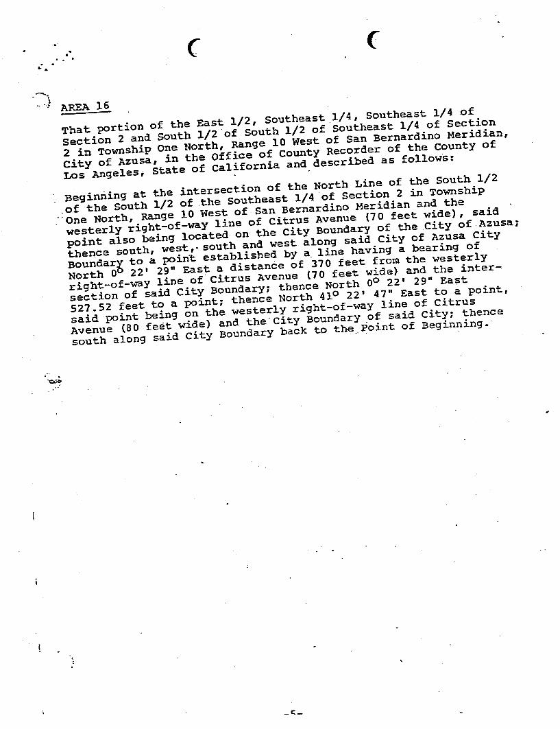
. .. .~ ..- """""":-
That portion of the East l/2, Southeast _
l/4, Southeast l/4
section 2 and South 1/2 of South 1/2
of Southeast l/4 of Section
2 in Township One North, Range 10 West
of San Bernardino Meridian,
city of Azusa, in the Office
of County Recorder of the county
Los Angeles; state
of California and described as follows:
, Beginning at the intersection
of the North Line of the South 1/2
of the South l/2 of the southeast 1/4
of Section 2 in Township
. One of San Bernardino Meridian and the
westerly right-of-way line
of citrus Avenue
point also being located on the city Boundary
of the city of Azusa,
thence south, west, " south of Azusa city
Boundary to a point established by a. line
North 00 of 370 teet from the westerly
right-of-way line
of citrus Avenue
section of said city Boundary: thence North 00
527. 52 feet to a point: thence North 410 said point being on the westerly right-of-way line
of citrus
Avenue city Boundary.of said city: thence
south along said city Boundary back to thepoint of Beginning.
c;.:";:.
t::.-

....
- -.: . t.
~:\
. i
.. ,
PROPOSED
TH 1 RD
TO THE
REDEVELOPMENT PLAN
FOR THE
AZtlSA CENTRAL BUSINESS
. . ...
REDEVELOPMENT AGENCY OF THE
AZUSA I CALIFOR~lA
----

... ... -.. . . -
LEGAL DESCRlPTION FOR ADDED
AZUSA CENTRAL BUSINESS DISTRlCT REDEVELOPMENT AMENDMENT THR.EH
" .
That portion of
--- ... - .~
- No. 2; .Azusa L~nd and
Miscellaneous Records, in the Office .of the County
. -- - --_. . .
O' - .
. - .. --- . ~.- - ... ..- ... -
erly and
.. - ~,,.
.state Higbway known 'as ,Road vn-LA-62-A, also
. as
.';hoWI! on 1140 on me in
County, as conveyed t9 the State of California by Deed Official Records of said County.
. .
Also except therefrom those Azusa and San Gabriel Canyon
. 87 of Deeds and in .,;..;..a
Also except therefrom that
. . ..;
Beginning at the . the Parcel
R~ymond Raido and Wife, aid :
County sajd corner being a .point in the ~esterly line of.
as described in the Deed to the County of Los Angeles, Recorded in
Deeds, Records of said County, distant thereon north-4 degrees 13' West 641.13 feet from
the intersection of said westerly line with the northeasterly described in the
to the State of California, Recorded in
Records; thence, west in a direct line
to a point in the center line of said
land, thence prolongation of the easterly line of along said prolongation and said easterly line
- line of the parcel of land described in said
westerly along said easterly prolongation to the oC beginning.

- . . .. ,- ..; ,:.
. 1. .
LEGAL PFSCRIP110N FOR ADDED AREA NO.
BUSINESS DJSTR1CT REDBVHLOPMENT
,,"'-
The westerly 215 feet of Lot 4
Book 15, Pages 93-96 inclusive or Miscellaneous Records, in the Office of
Recorder of the County or Los Angeles.
. -... -
..ci.~
... _.... ~

( ~
AMENDMENT NO. V
TO THE
REDEVELOPMENT PLAN FOR THE
AZUSA CENTRAL BUSINESS
September, 1984
Prepared by:
CITY OF. AZUSA REDEVELOPMENT AGENCY213 E. Foothill Blvd.
Azusa., California 91702
"'"'
and
MUNICIP AL SERVICES, INC.712 No. Diamond Bar Blvd.
Diamond Bar, California 917

\.- .
. L.:. I""
""'.- .. ...
The following is a legal description of the former Miller Brewery Propertyin the City of Azusa,
That portion of Lot 2 Azusa Land
and Sta te Haps in the Office as follows:Be~ inning erly right-of-way line northerly. right-of-y;ay line of westerly of-way line of 8th Street
. feet more or less to a the intersection
of the northerly right-of-y;ay line of along said easterly
64 feet
to the 2 Azusa Land
-. and 29 feet more or less along
the southerly lot lines of Lots 42 and 55 Azusa Land and Hater
point being on the
easterly right-of-way line of Loren Avenue
northerly along said easterly right-of-way line of Loren Avenue thence easterly 263. 40 feet along a.1ine parallel to and
the northerly line of Lot 2 of Tract No: 14072 in the as shown on a map recorded in Book
2:1 of
the .office of the Los Angeles County lOOO feet more or less to a poin
. said point . ri9ht-of-~~y line of the Southern Pacific
right-of-way southerly right-of-way line to its intersection wit~ the right-of-way line of Vernon Avenue along said westerly right-of-way line through all its variouscourses to the Point of Beginning.

LEGAL DESCRIPTION OF MERGED PROJECT AREA
Exhibit "
Central Business District Project Eighth Amendment Areas

LEGAL DESCRIPTIONCITY OF AZUSA REDEVELOPMENT AGENCY
CENTRAL BUSINESS DISTRICT EIGHTH AMENDMENT
ARE4 NO.
ASSESSOR' S REFERENCE: 8608-024-004
A parcel of land in the City of Azus~ County of Los Angeles, State of California, beingParcel 1 of .parcel Map recorded in , Page 77, records. of said
County, described as follows:
LEGAL DESCRIPTIONCommencing at the intersection of the centerlines of San Gabriel Avenue and 9
th Street
as said intersection is shown on Parcel Map recorded in Parcel Map Book 16, Page 80,records of Los Angeles County;
54' 35"E 85.03 feet to a point on
southerly line of said 9th Street, also being the northerly terminus
the southeast and
BEGINNING; thence along the l through the following
courses: S89058' 20"E 249.99 feet to the beginning of a curve, tangent at its point of
beginning, concave to the southwest with a chord of 35.35 feet and having a radius of
25.00 feet; thence southeasterly along said curve through a central angle of 89058' 20"
an arc distance of39.26 feet; thence South 419.08 feet; thence S69033' 50"W 160.
feet; thence North 60.03 feet; thence N89058' 20"W 149.99 feet; thence North 414.
feet to the , tangent at its point of
southeast with a g a r~ius of 25.00 feet;
northeasterly along said curve through a central angle of .90001 '40" an arc distance of
39.28 feet to the POINT OF BEGINNING.Containing 136 535.41 square feet or 3. 13442 acres, more or less.
END OF DESCRIPTION.
This legal description was prepared by me or under my direction from record sources.
f.....
Lewis SoloffP.L.S. 53~4 , Expires

LEGAL DESCRIPTIONCITY OF AZUSA
CENTRAL BUSINESS DISTRICT EIGHTH AMENDMENT
AREA NO.
ASSESSOR' S REFERENCE: 8608-017-023
A parcel of land in the City of Azus~ County of Los Angeles, State of California, beinga portion of the
, of said
County, described as follows:
Commencing at the intersection of the centerlines of Pasadena Avenue and 9th Street as
said intersection is shown on said Lemon Tract; thence N29044' 42"E 80.62' to a point
on the westerly line of Lot 8 of said terminus of a curve concave to the point being the POINT
'E 95.00 feet along the
westerly line of said Lot E 415.
feet along the northerly line of said Lemon Tract to the northeast comer of Lot 1 of saidTract; thence Soo E 120.00 feet along the easterly line of said Lot 1 to a point on a
line parallel with and centerline of said 9
th Street; thence N900 W 390.00 feet along said parallel line to
the beginning of a curve, tangent at its point of beginning, concave to the northeast with
a chord of 35.36 feet and having a radius of 25.00 feet; thence northwesterly along said
curve through a central angle of 900 0" an arc distance of39.27 feet to the POINT OF
BEGINNING.Containing 1. 14 acres, more or less.
END OF DESCRIPTION
This legal description was prepared by me or under my direction
Lewis SoloffP.L.S. 5344, Expires 12/31/03
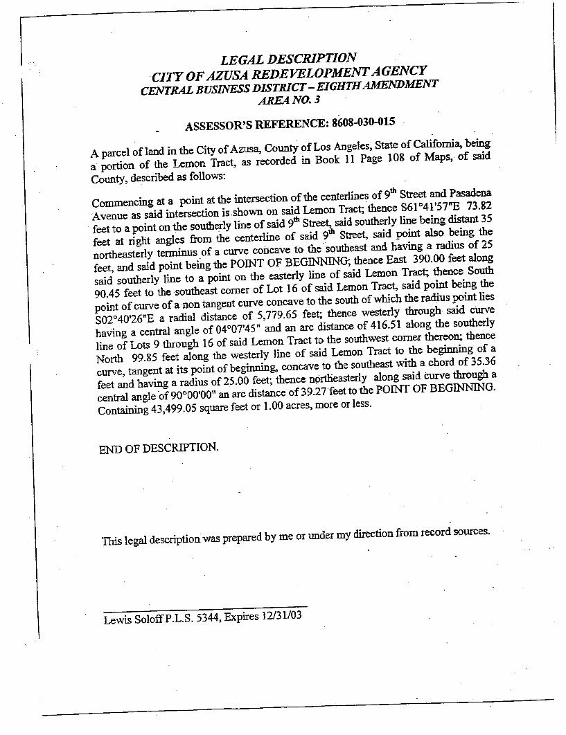
LEGAL DESCRIPTIONCITY OF AZUSA
CENTRAL BUSINESS DISTRICT - EIGHm AREA NO.
ASSESSOR'S
A parcel of land in the City of Azusa, County of Los - portion of the Lemon
County, described as follows:
Commencing at a th Street and Pasadena
Avenue as said intersection is.shown on said Lemon Tract; thence S61041' 57"E 73.
feet to a point on the southe!ly line of said 9th Street, said southerly line being distant 35
feet at right angles th Street, said point also being the
northeasterly terminus .of a curve concave to the . sQutheast and
feet, and said point being the POINT OF BEGINNING; thence East 390.00 feet along
said southerly line to a point on the easterly . 90.45 feet to the .southeast comer of Lot 16 of said Lemon
point of curve of anon tangent curve concave S02040' 26"E a radial 779.65 feet;
having a central angle of 04007'45" and an arc distance of 416. 51 along the southerly
line of Lots 9 through 16 of said Lemon Tract to the North 99.85 feet along the westerly line of said vnning of a
curve, tangent at its point of beginning, concave to the southeast with a chord of 35.36feet and having a radius of 25.00 feet; thence nprtlieasterly along said curve through a
central angle .of90000' OO" an arc distance of 39.27 feet
Containing 43 499.05 square feet or 1.00 acres, more or less.
END OF DESCRIPTION.
This legal description was prepared by me or under my direction from record squrces.
Lewis SoloffP. S. 5344 , Expires 12/31/03

LEGAL DESCRIPTIONCITY OF AZUSA REDEVELOPMENT AGENCY
CENTRAL BUSINESS DISTRICT EIGHTH AMENDMENTAREA NO.
ASSESSOR' S REFERENCE: 8608-030-006
. A parcel , State of California, being
a portion of The Miscellaneous Records, records of said County, described as follows:
Commencing at the intersection of the centerlines of 8th Street and Pasadena
said intersection is shown on said Map of Azusa; thence S860 13' 40"E 455.99 feet to
the intersection of the easterly line of Lot 8, Block 84 of said Map of Azusa with thesoutherly line of s~d 8
th Street, said southerly line being parallel with and distant 30' atright angles from the centerline of said 8
th Street, and said point being the POINT OF
BEGINNING; thence South 120.00 feet along the easterly line of lots 7 and 8, Block
84 of said Map of Azusa to the southerly line of Los Angeles County Assessor s Parcel
8608-030-006, as said Parcel is currently constituted; thence 00 feet along
said southerly line to a point on the westerly line of said Lot 8; thence North 105.feet along the westerly line of said Lots 7 and 8 to the beginning of a curve, tangent at
its point of beginning, concave to the southeast with a chord of 21.21 feet and having a
radius of 15.00 feet; thence northeasterly along 90000' 00" an arc 00 feet to the POINT OF
BEGINNING.Containing 49 751. 71 ~quare feet or 1. 14 acres, more or less.
END OF DESCRIPTION.
Ibis legal description
Lewis SoloffP.L.S. 5344, Expires 12/31/03

LEGAL DESCRIPTIONCITY OF AZUSA REDEVELOPMENT AGENCY
CENTRAL BUSINESS DISTRICT EIGHTH AMENDMENT
AREA NO.
ASSESSOR'S REFERENCE: 8611- 001-046
A parcel of land in the City of Azus~ County of Los Angeles, State of califomi~ being
a portion of Block 33 of the Map ofAzusa, as
, ,
Pages 93 through
96 of Miscellaneous Records, records of said County, described as follows:
Commencing at the intersection of the Avenue as said
15' 23"
196.47 feet to the northwest comer of Lot 3, Block 33 of said Map of,Azusa said pointbeing the POINT OF BEGINNING; thence East 125.00 feet along the northerly line of
Lots 1 through 3, Block 33 of said Map of Azusa to the beginning of a its point of beginning, concave to the southwest with a chord of 35.36 feet and having aradius of 25.00 feet; thence southeasterly along said curve through a central angle of90000' 00" an arc distance of 39.27 feet to a point on the easterly thence South 150.00 feet along said easterly line to a point on the southerly line of thenortherly half of Lot 24, Block 33 of said Map of 00 feet
along said southerly line to a point on the westerly line of said Lot 24; thence North175.00 feet along the westerly line of said Lot 24 and said Lot 3 to the BEG~G. Containing 26, 115.87 square feet or 0.60 acres, more or less.
END OF DESCRIPTION.
This legal description was prepared by me or under my direction from record sources.
Lewis SoloffP.L.S. 5344, Expires 12/31/03

LEGAL DESCRIPTIONCITY OF AZUSA REDEVELOPMENT AGENCY
CENTRAL BUSINESS DISTRICT EIGHTH AMENDMENT
AREA NO.
ASSESSOR'S REFERENCE: 8612-: 003-013,014,025,026,032,033
A parcel of land in the City of Azus~ County of Los Angeles, State of a portion of the Map of
, Pages 93 through 96 of
Miscellaneous Records, and a portion of the Resubdivision of Lots 1 & 2 in Block . Azusa, as recorded in Book , Miscellaneous Records, records of said
County, described as follows:
Commencing at the intersection of the centerlines of Foothill Boulevard and PasadenaAvenue as said
30' 05"
125.40 feet t~ Resubdivision with the westerly line of the easterly half of said Lot 2, said point beingthe POINT OF BEGJNNING; thence East 125.
00 feet along the northerly line of Lots 2
through 4, of said 210.00 feet along the easterly line of said Lot 4 to the southeast comer East 215.00 feet along the southerly line of Lots 5 and 9 of said resubdivision to a pointon the easterly line of Lot 3, Block 83 of said Map of Azusa; thence South 105.
00 feet
along said easterly line ' to
northerly line of Lot 4, Block 83 of said Map of Azusa; thence West 415.00 feet along
said northerly line to the northwest ~omer thereon; thence North 105.00 feet along the
easterly line of said Pasadena Avenue, said easterly line being paraliel with and distant
40 feet easterly, measured at right angles, from said centerline of Pasadena Avenue, to a
point on the southerly line of Lot 10 of said Re-Subdivision; thence East 75.00 feet
along said southerly line to a point on the southerly prolongation of Lot 2; thence North 210.00 feet along said prolongation and along said easterly half
of Lot 2 to the POINT. OF
Containing 69,825.00 square feet or 1.60 acres, more or less.
END OF DESCRIPTION.
This legal description was prepared by me or under my direction from record sources.
Lewis SoloffP.L.S. 5344, Expires 12/31/03

LEGAL DESCRIPTIONCITY OF AZUSA
CENTRAL BUSINESS DISTRICT EIGHTH AMENDMENT
AREA NO.
MSESSOR' S REFERENCE: 8612-001-027 THROUGH 040
A parcel of land in the City of Azusa, County of Los Angeles, State of California, being.a portion of , as recorded in Map Book 699, Pages 22-23, records of
said County, described as follows:
Commencing at the . intersection is shown on said Tract No. 27346; thence S380
17' 18"W 283.44 feet to the
PO:!NT OF BEGINNING; lines of Lots 18 through 31 of said Tract No. 27346 through the following
N89059' 39"E 302.66 feet; 59' 06" 240.40 feet; thence S49000' 54"
38.00 feet to the beginning of a curve, tangent at its point of beginning, concave to the
east with a chord of 62.53 feet and having a radius of 48.00 feet; thence southerly
along said curve through a 16' 52" an arc distance of 68.09 feet;
thence S320 15' 58"E 50.00 feet to the beginning, concave to the west with a chord of 50.
01 feet and having a radius of 90.
feet; thence southerly 15' 47" an arc
distance of 50.68 feet; then~e SOooOO' 06"E 38.70 feet to the beginning of a curve
tangent at its point of and having a radius of 15.00 feet; thence southwesterly along said
central angle. of 89059' 20" an arc distance of 23.56 feet; thence S89059' 14"W 187.69.
feet to the northeast with a
00 feet;
northwesterly along said 00' 40" an arc distance of
23.56 feet; thence NOooOO' 06" 173.34 feet; thence NI00 14' 10"E 50.01 feet to the
beginning of a . chord 01 feet and having a radius of 70.00 feet; thence northwesterly along said
curve through a central 28' 32" an arc 97 feet; thence
S79045' 38" . 50.01 feet; 59' 54" 138.54 feet; thence NOoo02' 02"
22.90 feet to the beginning of a curve, tangent at its point ofbeginniDg, concave to the
east with a chord of 80.77 feet and having a radius of220.00 feet; thence northerly
along said curve through a central angle of 21009' 16" an arc distance of 81.23 feet to
the POINT OF BEGINNING.Containing 95 633. 89 square feetor 2.20 acres, more or less.
END OF DESCRIPTION.
This legal description was prepared by me or under my direction from record sources.
Lewis SoloffP.L.S. 5344, Expires 12/31/03

LEGAL DESCRIPTIONCITY OF AZUSA
CENTRAL BUSINESS DISTRICT EIGHTH AMENDMENT
AREA NO.
ASSESSOR'S IU:FERENCE: 8612-001-048,052,053059060063 THROUGH 66,100
A parcel of land in the City of Azusa, County of Los Angeles, State of California, beinga portion of Tract No. 27346, as recorded in Map Book 699, Pages 22-
23, records of
said County, described as follows:
Commencing at the Avenue as said
01' 26"
133.59 feet to the northeast comer of Lot 32 of said Tract No. 27346, said point being
. the POINT OF westerly lines of Lots 32 courses: N89059' 54"E 75.00 feet to the beghming of a curve, tangent at its point of beginning, .
concave to the southwest with a chord of 35.36 feet and having a radius of 25.00 feet;
thence 00' 00" an
distance of 39.27 feet; thence SOOoOO' 06"E 210.01 feet to the beginning of a curve
tangent at its point of and having a 00 feet; thence southwesterly along said curve through a
central angle of 89059' 20" an arc distance of 23. S6 feet; thence S89059' 14"W 160.
feet to the northeast with a chord of 35.35
00
northwesterly along
58' 44" an arc distance of
39.26 feet; thence NOoo02' 02"W 210.04 feet to the beginning of a curve, tangent at its
point of beginning,
22 feet and having a
adius of 15.00 feet; thence northeasterly along said 90001' 56" an arc distance of 23.57 feet; thence N890
59' 54"E 85.15 feet to the POINT
OF BEGINNING.: Containing 49,662.00 square feet or 1.14 acres, more or less.
END OF DESCRIPTION.
. . This
Lewis SoloffP. S. 5344, Expires 12/31/03

LEGAL JJESCRIPTIONCITY OF AZUSA REDEVELOPMENT AGENCY
CENTRAL BUSINESS DISTRICT EIGHTH AMENDMENT
AREA NO.
ASSESSOR' S REFERENCE: 8612-001-010 THROUGH 026
A parcel of land in the City of a portion of Tract No. 27346, as recorded in Map Book 699, Pages 22-
23, records of
said County, described as follows:
Commencing at the enfinnan
Avenue as said intersection is shown on said Tract No. 27346; thence N07059' 37"
1)3.59 feet to the beginning of a S73033' 20"E, a radial distance of 280.
00 feet, said point being
BEGINNING; thence along the easterly, southerly, westerly and northerly lines of Lots .1 through 17 of said Tract No. 27346 through the following courses:
Southerly along said curve, through a central 28' 42" , a distance of 80.
feet; thence SOOOO2' 02"E 271.30 12' 14"W 50.00 feet to the beginning
of.a curve, tangent at its point of beginning, 115.00 feet and having a radius of 70.00 feet; thence southeasterly along said curve
through a r' 11 0027'16" an 95
N79044' 58"E 50.01 feet; thence N89059' 14" 431.03 feet to the beginning of a curve,
tangent at its point of beginning, concave to the southwest with a chord and having a radius of 25.00 feet; thence
central angle of 90000' 40" an arc distance of 39.27 feet; thence SOooOO' 06"E 75.00 feet;
thence S89059' 1.4"W 678.57 OO' 01 " 572.36 feet;
N89059' 39" 112.12 feet to the POINT OF BEGINNJNG.
Containing 114 690.94 square feet or 2.63 acres, more or less.
END OF DESCRIPTION.
This legal description was prepared by me or under my direction from record sources.
Lewis SoloffP.L.S. 5344, Expires 12/31/03

LEGAL DESCRIPTIONCITY OF AZUSA REDEVELOPMENT AGENCY
cENTRAL BUSINESS DISTRICT
EIGHTH AMENDMENTAREA NO. 10
A~SESSOR'S REFERENCE:
A parcel of land in the City of County of Los Angeles, State of Californi~ being
a portion of Parcel Map No. 14845 recorded in Parcel Map Book 153, Pages 1 through
5, records of said County, described as follows:
Commencing at the intersection of the centerlines of Alosta Avenue and Fifth Street assaid centerlines are shown on said Parcel Map No. 14845; thence 8780
36' 51 "W 253.
feet to the northwesterly being the POINT OF BEGINNING; thence along the northerly, easterly, southerly, andwesterly lines . of
courses:
N89059' 10"E 229.10 feet to the beginning of a curve, tangent at its point of beginning,
concave to the south with a cbord of 8.56 feet and having a radius of 15.00 feet; thence
easterly along said curve 09' 31" an arc distance of 8.
feet to a point of reverse curve 300.00 feet;
thence easterly along said curve through a central angle of 240
21 '58" an arc distance of
978. 12 feet to the point of curve of curve concave to the southwest of which the radius .point lies S08046' 44"W a radial distance of 15.00 feet; thence southeasterly along said
curve through a 14' 46" an . arc distance of
SOooOI' 30"W 779. 16 feet; thence N89058' 30"W 1,030.92 feet; thence NOooOO' 50"
023.23 feet; thence N460 10' 47"W 173.28 feet to the POINT OF BEGINNING.
Containing 989,041.11 square feet or 22.71 acres, more or le~s.
END OF DESCRIPTION.
This legal description was prepared by me or under my direction from record sources.
Lewis SoloffP. S. 5344, Expires 12/31/03

LEGAL DESCRIPTIONCITY OF AZUSA
CENTRAL BUSINESS DISTRICT EIGHTH AMENDMENT
AREA NO.
- ASSESSOR'S REFERENCE: 8622-023-008 AND 009
A parcel of land in the City of Azus~ County of Los Angeles, State of Califomi~ a portion of the Southeast Quarter of Section 2, Township 1 South, Range 10 West, SanBernardino Meridian, described as follows:
Commencing at the Highway, said intersection being the Southeast Comer of Section 2, Township 1 South,Range 10 West, San Bernardino Meridian; thence N240
23' 06"W 95.48 feet to an angle
point in the weSterly right of .way of Citrus Avenue, said angle pomt being on a line
parallel with and distant 40 feet westerly, measured at right angles, from the centerline
of said Citrus Avenue, said angle point being the POINT OF BEGINNING;
along the
Assessor s Parcels 8622-023-008 and 8622-023-009, as currently constituted through
the following courses:
. S450 10' 03"W 24. 13; thence S8905T14"W 670.88 feet; thence NOoo22' 53"E 330.
feet; thence 89057'16" E 327.89 21' 37"E 60.70
N89045' 49"E 240.01 feet; 22' 53"E 38.00 49"
120.01 feet; thence SOoo22' 55"W 412.90 feet to the POINT OF BEGINNING.
Containing 253,476.45 square feet or 5.82 acres, more
ot less:
END OF DESCRIPTION. .
. This legal description was prepared by me or under my direction from record sources.
Lewis SoloffP.L.S. 5344, Expires 12131/03
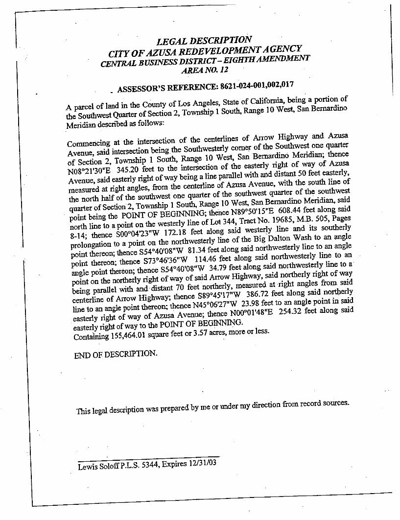
LEGAL DESCRIPTIONCITY OF AZUSA
CENTRAL BUSINESS DISTRICT - EIGHTH AMENDMENTAREA NO.
- ASSESSOR' S REFERENCE: 8621-024-001,002,017
A parcel of land , State of
the Southwest Quarter of Section 2, Township 1 South, Range Meridian described as follows:
Commencing at the Avenue, said intersection being. the Southwesterly comer of the Southwest one quarter
of Section 2,
N08021' 30"E 345.20 feet to the Avenue, said easterly right of way being a line parallel with and distant 50 feet easterly,measured at right angles, from the centerline of Azusa Avenue
, with the south line of
the north half of the southwest one quarter of the quarter of Section 2, Township
point being the POINT OF BEGINN1NG; 50' 15"E 608.44 feet along said
north line to a point on the westerly line of Lot 344, Tract No. 19685, M.B. 505 , Pages
14; thence SOQo04' 23"W 172. 18 feet
prolongation to a point on the northwesterly line of the Big Dalton Wash to point thereon; thence S54040' 08" 81.34 feet along said northwesterly line to an angle
point thereon; thence S73046' 36"W 114.46 feet along said northwesterly line to an
angle point thereon; thence S54040' 08"W 34.79 feet along said northwesterly line to a
point on the northerly right of way of said Arrow Highway, said northerly right being parallel with and. distant 70 feet
northerly, measured at .right angles from said
centerline of Arrow Highway; thence S89045' 17"W 386.72 feet along said northerly
line to an angle point thereon; thence N45006' 27"W 23.98 feet to an angle point in said
easterly right of way of Azusa Avenue; 01'48" 254.32 feet along said
easterly right of way to the POINT OF BEG1NNJNG.Contalning 155,464.01 sq1,lMe feet or 3.57 acres, more or less.
END OF DESCRJPTION.
This legal description was prepared by me or under my direction from record sources.
Lewis SoloffP. S. 5344, Expires 12/31/03

LEGAL DESCRIPTIONCITY OF AZUSA REDEVELOPMENT AGENCY
CENTRAL BUSINESS DISTRICT EIGHTH AMENDMENT
AREA NO.
ASSESSOR' S REFERENCE: 8620-004-005,015,016,020,021
A parcel of land in the City of Azus~ County of Los Angeles, State of Califomi~ beinga portion of the Southeast Quarter of Section 3, Township
So~ Bernardino Meridian, descnDed as follows:
Commencing at the Avenue said point being the southeasterly comer of the southeast quarter of Section 3,Township 1 Sou~
47'39"
106.43 feet to a point on the northerly line of POINT OF BEGINNING; thence N86055' 17"W 248.59 feet along said northerly line
to an angle point thereon; thence SOooOI' 48"W 10.01 feet along said northerly line to
an angle point thereon; thence N86055' 17"W 30.04 feet along said northerly line to an
angle point thereon, said angle point being a point on the westerly line of an ingress
egress easement as shown on Parcel Map No. B. 109, Page 53; thence
NOOO01' 48"E 574.81 feet along said westerly line to a point on
rarceI"1 of Parcel Map No. 5317, P. B. 56, Page. 76; 52"E 304.84 feet
along said southerly line to a point
SOooOI' 48"W 541.76 feet along.said easterly line to the beginning of a curve, tangent
at its point of beginning, concave to the northwest with a chord of 36.28 feet and having
a radius of 25.00 feet; thence southwesterly along said curve through a central angle of93002' 55" an arc distance of 40.60 feet to the POINT OF BEGINNING.
Containing 172 676.26 square feet or 3.96 acres,. more or less.
END OF DESCRIPTION.
This legal description was prepared by me or under my direction from record sources.
Lewis SoloffP. S. 5344, Expires 12/31/03

LEGAL DESCRIPTIONCITY OF AZUSA
CENTRAL BUSINESS DISTRICT EIGHTH AMENDMENT
AREA NO.
ASSESSOR'S REFERENCE: 8621- 024-014
A parcel of land in the City of Azus~ County of Los Angeles, State of Californi~ beinga portion of Record of Survey 76-44, records of said County, described as follows:
Commencing at the intersection of the centerlines of Azusa Avenue and Azusa Avenue(formerly Letoh Avenue), as said thence S29049' 58"E 184.77 feet to the southwest comer of LOt 3 of said Record
Survey, said point being the POINT OF BEGINNING; northerly, easterly, and southerly lines of said Lot 3 through the following courses:
NOOO01' 48" 1~8.49 feet to the beginning of a curve, tangent at its point of beginning,
concave to the southeast with a chord of 61.92 feet and having a radius of 70.00 feet;
thence northeasterly along said 30' 00" an arc
distance of 64.14 feet; thence N52031' 48"E 34.48 feet; thence S89054' 53" 202.28
feet; thence SOoo04' 20" 234.33 feet; thence S89055' 12"W 256.85 feet to the POINT
OF BEGINNING.Containing 58,980.28 square feet 9r 1.35 acres, more or less.
END OF DESCRIPTION.
This legal description was prepared by me or under my direction from record sources.
Lewis SoloffP. S. 5344, Expires 12131/03
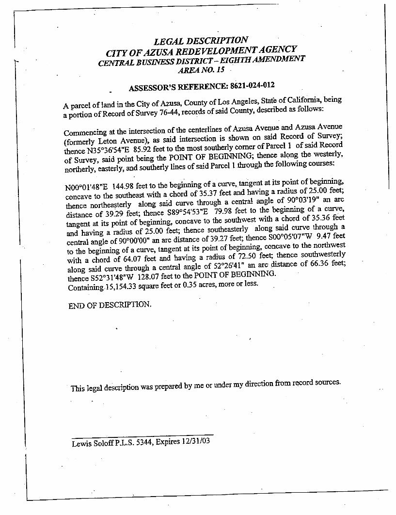
0;....
LEGAL DESCRIPTIONCITY OF AZUSA
CENTRAL BUSINESS DISTRICT EIGHTH AMENDMENT
AREANO. 15
ASSESSOR'S REFERENCE: 8621- 024-012
A parcel of land in the City of Azus~ County of Los Angeles, State of Califomi~ a portion of Record of Survey 76-44, records of said County, described as follows:
Commencing at the intersection of the centerlines of Azusa Avenue and Azusa Avenue(formerly Leton Avenue), as said thence N35036' 54"E 85.92 feet to the most southerly comer of Parcel I of Survey, said point being the POINT OF BEGINNING; northerly, easterly, and southerly lines of said
NOooOI' 48"E 144.98 feet to the beginning of a curve tarigent at its point of beginning,
concave to the southeast with a chord of 35.37 feet and having a radius of 25.00 feet;
thence northe~terly along 03' 19" an arc
distance of 39.29 feet; thence S89054' 53"E 79.98 feet to the beginning of a curve
tangent at its point of beginning, concave to the and having a radius of 25.00 feet; thence southeasterly along said curve through acentral angle of 90000' 00" an arc diStance of 39.27 feet; thence SOoo05' 07"W 9.47 feet
to the , tangent at its point of beginning, concave to the northwest
with a chord of 64.07 feet and having a along said curve through a central angle of 520
26' 41" an
thence S52031' 48"W 128.07 feet to the POINT OF BEGINNING.
Containing. 15,154.33 square feet or 0.35 acres, more or less.
END OF DESCRIPTION.
. This legal description was prepared by me or under my direction from re!cord sources.
Lewis SoloffP.L.S. 5344, Expires 12/31/03

LEGAL DESCRIPTION OF MERGED PROJECT AREA
Exhibit "
West End Redevelopment Project Area

...
till
. -;.;. . "'"- -...
LEGAL DESCRIPTION
WEST END REDEVELOPMENT
That portion of the City of Azusa, two parcels described as follows:
Parcel No.
::I
Beginning at the
northerly line of Gladstone Street (80 feet wide), said point being on
boundary; th~nce northwesterly along said easterly line of Jackson line of Paramount Paramount Avenue to the southerly projection of the wide); thence northwesterly along the projection of said
2 feet to a 0 feet
southerly of the south line of Tract B. 164 Pages 13 & 14 in the Office
of the Recorder of
0 51' 20" W 305. 0 feet along last
p~2.llellineto the easterly 08' 40" W 119.
feet along the easterly line of said
line of lot x of said 0 51' 20" 0 feet alo~g said easterly
projection and said northerly line of lot x
wide); thence N 00 08' 40" W 311. 0 feet along the easterly line of said
northerly line. of ~ird 51' 20" W 255. 0 feet to the
westerly line of lot 165 of said tract 10660;
0 08' 40n 0 feet aloag the
westerly line of said lot 165 to the southerly
thence S 890 511 20" W 100.'0 feet along the
westerly line of said lot 0 08' 40n W 635. 8 feet along the westerly line of said
lot 137 and its northerly projection to the southerly line of Freeway); thence southeasterly along said southerly line of easterly line of of said
0 51'
20" E 1,160.0 feet along the southerly line of said Fifth Street to the
Virginia Street (60 feet wide); thence N 00 OS; 40" Vi 973.0 feet to the northerly right-of-
way line of the ce N 69
0 22'

;.; . ..,
20'r E 2, 542. feet along the northerly line of said
right-of-way to the easterly line of feet wide); thence northerly along
the easterly line of said 8 feet to the
southerly line of lot 8 Block B. 15 pages 93 thru 96 recorded in the Office of the
Recorder o~ said County; thence N 890 21' 15n 230.0 feet along the southerly line of.
lot 8; thence northerly and their northerly projection to the northerly line of Crescent
feet wide); thence
westerly and northwesterly along the northerly line of said Crescent line of feet wide); thence north along the easterly line of said
Avenue to easterly projection
N 89 53' IOn W 2402. 4 feet along said easterly
Tenth Street to the centerline of centerline of said
thence east along the northerly lines of lots 2 Azusa Land and
Water Co. recorded in M.B. 43 page .94 recorded in the Office of the Recorder of
County 1874.1 feet to the easterly line of the
5 recorded in the Office of the Recorder of said o 50' 26" W 1, 021.2 feet
along last mentioned easterly line to the the Pacific
feet wide); thence
southeasterly, southwesterly, southwesterly, southeasterly, northeasterly along the City of
Azusa boundary to the . point
. boundary of Ay.on A venue also being on the northerly
continuing northeasterly along the northerly line of
beginning.
Except
Area 15 of the second
Business District
That portion of Lot 42, S4 and 55 of Subdivision No.2 Azusa Land. and
City of Azusa, County of Los Angeles, State of California, in Book 43,
Page 94 of Maps in the Office
Beginning at the

--;,:
...s
\ ; - -. ..,
Vet-non Avenue (65 feet
wide); thence westerly along the northerly right-of-way line of 8th 0 feet more or
' - .
less to a point, said point being
" of
Street and the easterly right-of-way line of along said easterly right-of-way line of Georgia Place 35.
64 feet to the southerly lot line of
- Lot S5 of Subdivision: No. 2 _Azusa Land and Water ' westerly 1, 246 29 feet
more or less along the southerly lot ~nes of Lots 42 2 Azusa Land
and Water Company, toa
Avenue (60 feet Avenue 60 feet; thence easterly 263.40 feet along a line parallel to and
northerly line of Lot 2 of Tract in Book 282, Pages 20 and 21 of thence due north 1, 000.0 feet more or less to a point, said point being on the southerly right-
of-way line of the thence westerly right-of-way line of
westerly right-of-way line through all its various courses to the Point of
...,,;.
Parcel No. 2
Beginning at the IN. R.10E. S. M., said point being on the City of
Azusa boundary; thence N 890 51' E 2, 597.10 feet more or less along City of
to the N.B. ' Cor. of N.E. 1, N. 320.0 feet more. or less to
the S.E. Cor. of the N.E. 1, N. 937.0 feet
the S.E. Cor. of S. ~. w. 1 . of See. 980.0 feet more or"
less to the S.E. Cor. of N.W. 1, N.W. 1, S.W. 1 of Sec. 22; thence westerly 660.0 feet more
or less to the S.W. Cor. of N.W. 1, N.W. .i, S.W. 1 of Sec. 22; thence northerly 660.0 feet
more or less to the N.W. Cor. of N. l:s.w. 1 of 328. 0 feet
more or less to the B. i, N. W. 640.0 fee
more or less to the N.W. Cor. of . R. 1, N.E. 1 of See. 21, said point being
Azusa boundary; thence N 890 51' E 1, 328.14 feet along the City of
point of beginning.

EXHIBIT
Merged Central Business District and West End Redevelopment Projects
NON-RESIDENTIAL PROPERTIES SUBJECT TO ACQUISITIONBY EMINENT DOMAIN
CENTRAL BUSINESS DISTRICT PROJECT
Existing Project Area
1. , commonly known as 604 N. Azusa Avenue
2. 801 , an unimproved property
3. , an unimproved property
4. , commonly known as 100 W. Foothill Boulevard
5. , commonly known as 150 W. Foothill Boulevard
6. 7. , commonly known as 638 N. Azusa Avenue
8. , commonly known as 152 E. Foothill Boulevard
9. 002, commonly known as 809 N. Azusa Avenue
10. Assessor , commonly known as 800 N. San Gabriel Avenue
Eighth Amendment Areas
1. , commonly known as 150 E. 9th Street
2. , commonly known as 444 E. Foothill Boulevard
3. 013, commonly known as 624 N. Pasadena Avenue
4. 014 , commonly known as 628 N. Pasadena Avenue
5. 025 , commonly known as 518 E. Foothill Boulevard
6. 026, commonly known as 534 E. Foothill Boulevard
7. 003-032, an unimproved property
8. 033, an unimproved property
9. 021-015 , an unimproved property
10. Assessor 021-016, commonly known as 330 N. Fenimore Avenue
11. Assessor Parcel , an unimproved property
12. Assessor 021-018, commonly known as 890E. Alosta Avenue
13. Assessor , commonly known as 17511 E. Arrow Highway
14. Assessor 002, an unimproved property
15. ~sessor , commonly known as 17525 E. Arrow Highway
16. Assessor , commonly known as 887 S. Azusa Avenue
17. Assessor , an unimproved property
Revised FmaI Redevelopment Plan (111703).azu
060203/ac

Eighth Amendment Areas (confd.
18. Assessor.Parcel No. 8620-004-016 , commonly known as 859 S. Azusa Avenue
19. Assessor Parcel , commonly known as 877 S. Azusa Avenue
20. Assessor Parcel , commonly known as 155 W. Arrow Highway
21. Assessor Parcel , commonly known as 710 S. Azusa Avenue
WEST END PROJECT
Assessor Parcel No. 8616-001-408, an unimproved property commonly known as Kincaid Pit

EXHIBIT "
Merged Central Business District and West End Redevelopment Projects
PROPOSED PUBLIC IMPROVEMENTS AND FACILITIES PROJECTS
CENTRAL BUSINESS DISTRICT PROJECT
Central Business District Redevelopment Project Area (Including areas
added by Amendment Nos. 1, 2,
3, and 5) Construction of garage structures, public kiosks, and pedestrian plazas
Street and streetscape improvements, including street widening, traffic and street lights, street furniture
sidewalks, landscaping and trees, kiosks and similar structures
Construction and installation storm drain and sewer systems, gas delivery systems, electrical systems, and
communication systems
Eighth Amendment Areas
Installation and construction of bridges, streets , curbs, gutters , sidewalks, street lights, sewers, storm
drains, traffic signals , electrical distribution systems, natural gas , water
systems, parks, plazas, , motor vehicle parking facilities, and landscaped
areas
WEST END REDEVELOPMENT PROJECT
Widening and reconstruction of the following streets:Ninth Street, Vernon Avenue to Angeleno AvenueEighth Street, Coney AvenuelMiller Avenue to Vernon AvenueIndustrial Street, Coney Avenue/Miller Avenue to Vernon AvenueFrontage Road, north of Foothill Boulevard , east of McKeever Avenue
Aerojet Avenue, south of Optical Drive
Storm drain construction on the following streets:Fifth Street, west of Virginia AvenueFoothill Boulevard , west of Todd AvenueTodd Avenue, north of Foothill BoulevardCorey Avenue, north of Foothill Boulevard to Tenth Street
Construction of pedestrian walkways, bikeways, streets , curbs, gutters, sidewalks, street lights, sewers
storm drains, traffic signals, electrical distribution systems, water distribution systems, parks, plazas, and
playgrounds, as necessary throughout the Project Area
Note: This list of Redevelopment Agency's authority to implement this Redevelopment Plan.
Revised Final azn
060203/ac

Attachment II
ANAL YSIS
This ordinance adds Section 2.60.610 to Part 10 of Chapter 2.60 of the
Los Angeles County Code , giving final approval to the Azusa Redevelopment Agency
Merged Project Areas redevelopment plan. The Board of Supervisors previously
authorized the Agency to plan the exercise of jurisdiction over three unincorporated
parcels contiguous to the Agency redevelopment areas.
LLOYD W. PELLMANCounty Counsel
By
THOMAS M. TPrincipal Deputy County CounselSpecial Services Division
TMT:er11/06/03 (Requested)

ORDINANCE NO.
An ordinance adding Section 2.60.610 to Chapter 2.60 - Community
Redevelopment Agency of Title 2 - Administration of the Los Angeles County Code,
relating to the Azusa Redevelopment Agency.
The Board of Supervisors of the County of Los Angeles ordains as follows:
SECTION 1. Section 2.60.610 is hereby added to read as follows:
60.610 Approval of redevelopment plan.
The county reaffirms the findings , determinations and authorization
found in Section 2.60.560 and Section 2.60.580.
The county approves the Amendment to the Redevelopment Plan for
the Merged Project Area adopted by the City of Azusa on October 6 , 2003 by Ordinance
No.03-06, which includes the redevelopment of county territory contiguous to the
territorial boundaries of the city.
(260610TTCOC)

Attachment
AMENDMENT NO.TO AGREEMENT FOR REIMBURSEMENT
OF TAX INCREMENT FUNDS(REDEVELOPMENT PLAN FOR THE AZUSA WEST END REDEVELOPMENT PROJECT)
THIS FIRST AMENDMENT TO AGREEMENT FOR First Amendment" ) is made and entered into this 16th day of December 2003 , by and among the Azusa
Redevelopment Agency ("Agency ), the City of Azusa ("City ), and the County of Los Angeles ("County
WITNESSETH:
WHEREAS, on November 28, 1983, the City adopted adopting the Redevelopment Plan ("West End Redevelopment Plan ) for the West End RedevelopmentProject Area ("West End Project Area ); and
WHEREAS on April 17 , 1984 , the City, the Agency and the County entered into an Agreementfor Reimbursement of Tax Agreement"). Unless Amendment , all initially capitalized terms used shall have the same meaning as in the Agreement; and
WHEREAS the Agreement provides , in part , that the City and/or Agency shall not West End Redevelopment Plan in any respect which affects the tax increment generated in the West EndProject Area without prior written approval of the County Board of Supervisors; and
WHEREAS, on November 7 , 1989, the City adopted merger of the West End Project Area and the Agency s Central Business District Redevelopment ProjectArea (the "CBD Project Area ); and
WHEREAS, on October 6 , 2003, the City 06 which , among otherthings , replaced the separate redevelopment plans for the West End Project Area and the CBD ProjectArea with one (1) amended and restated redevelopment plan for the West End Project Area and the CBDProject Area ("Amended and Restated Redevelopment Plan ); and
WHEREAS the Agency has proposed to amend the Plan to , among other things, restate the limitation on the receipt of tax increment dollars from the WestEnd Project Area and the CBD Hundred Thirty-One Thousand Seventy-Five Dollars ($114,931 075); and
WHEREAS, pursuant to the Agreement , the City and approval of the proposed amendment to the Amended and Restated Redevelopment Plan;
NOW THEREFORE for and in consideration of the foregoing, the parties do hereby follows:
Paragraph 4 of the following:
The total amount of tax Area and the Central Business District Redevelopment Project Area collectively, shall notexceed One Hundred Fourteen Million Nine Hundred Thirty-One Thousand Seventy-FiveDollars ($114 931 075) and no portion of tax increment revenues distributed and paid to
cralAzusalbrd Itr (12- 18-03Lattach III

the County taxing entities shall be counted toward such total. increment revenues generated by the application of any tax rates levied for the purposeof paying voter approved indebtedness shall pursuant to Health and Safety Code totaL"
All other provisions of the Agreement shall remain in full force and effect.
represents and warrants to the other that there have been no written or oral modificationsto the , valid and obligation.
The County approves the Agency s proposed amendment to the Amended and RestatedRedevelopment Plan and this document shall serve as County s express written approvalrequired by the Agreement.
IN WITNESS THEREOF , the Azusa Redevelopment Agency, the City of Azusa and the County of LosAngeles have caused this representatives.
IN WITNESS WHEREOF , the parties hereto have caused this Amendment to be date first herein above written.
(Signatures on following page)
cralAzusalbrd Itr (12-18-03Lattach III

IN WITNESS WHEREOF , the parties hereto have caused this Amendment to be executed on thedate first herein above written.
City CITYO
By:
~--
Name: Cristina Madrid
Title:
Agency THE REDEVELOPMENT AGENGY OF THE CITY OFAZUSA, ~bl~ b~y, By: ~Name: Rick Cole
Title:City Manager
County COUNTY OF LOS ANGELES
By:Chair, Board of Supervisors
ATTEST:
VIOLET VARONA-LUKENSExecutive Officer-Clerkof the Board of Supervisors
APPROVED AS TO FORM:
Lloyd W. PellmanCounty Counsel
Thomas M. TyrrellPrincipal Deputy
cralAzusalbrd Itr (12-18-03Lattach III