COUNCIL BLUFFS’ FIVE-DAY FORECAST
1
Cold front Warm front Stationary front Showers T-storms Rain Flurries Snow Ice Monterrey 83/68 Chihuahua 88/65 Los Angeles 86/67 Washington 91/75 New York 88/74 Miami 87/78 Atlanta 86/72 Detroit 84/70 Houston 90/75 Kansas City 91/74 Chicago 87/74 Minneapolis 76/61 El Paso 95/74 Denver 81/59 Billings 86/60 San Francisco 70/57 Seattle 76/54 Toronto 83/68 Montreal 80/67 Winnipeg 83/58 40 60 80 100 84 65 82 64 81 65 79 65 80 65 78 61 88 64 82 61 79 57 77 61 79 63 88 63 77 59 75 63 Daily Temperature Forecast Temperature Average High Average Low Good Moderate Unhealthy (sensitive) Unhealthy Very Unhealthy Hazardous ALMANAC Temperature Precipitation Forecast index based on presence of man-made particulates affecting aspects of human health. Today’s Air Quality airnow.gov Skywatch RealFeel Temperature® Today Shown are noon positions of precipitation. Temperature bands are highs for the day. City Hi/Lo/W Hi/Lo/W City Hi/Lo/W Hi/Lo/W City Hi/Lo/W Hi/Lo/W City Hi/Lo/W Hi/Lo/W WORLD FORECAST -10s -0s 0s 10s 20s 30s 40s 50s 60s 70s 80s 90s 100s 110s W-weather, s-sunny, pc-partly cloudy, c-cloudy, sh-showers, i-ice, r-rain, t-thunderstorms, sf-snow flurries, sn-snow National Extremes Cedar Rapids Waterloo Omaha Dubuque Mason City Denison Fort Madison Davenport Des Moines Sioux Falls Norfolk Council Bluffs St. Joseph Lincoln Beatrice Decorah Kirksville Hannibal Ottumwa Sioux City Fort Dodge Clarinda WIND Columbus WIND WIND WIND WIND WIND COUNCIL BLUFFS’ FIVE-DAY FORECAST REGIONAL OUTLOOK NATIONAL OUTLOOK TEMPERATURE TRENDS An exclusive index of effective temperature, wind, humidity, sunshine intensity, cloudiness, precipita- tion, pressure and elevation on the human body. Rise Set City Hi/Lo/W Hi/Lo/W City Hi/Lo/W Hi/Lo/W Shown is today’s weather. Temperatures are today’s highs and tonight’s lows. REGIONAL FORECAST A severe thunderstorm this afternoon. Expect 3-6 hours of sunshine with a 60% chance of precipitation and average relative humidity 70%. Drying conditions fair. A couple of thunderstorms tonight. Chance of precipitation 60% with average relative humidity 85%. A shower and thunderstorm tomorrow. ©2021; forecasts and graphics provided by High: 102° in Thermal, CA Low: 41° in Dillon, CO Albuquerque 82/66/t 86/67/t Atlanta 86/72/t 88/72/t Austin 88/72/pc 90/74/t Baltimore 91/72/t 93/73/pc Boise 100/70/pc 100/65/pc Boston 79/70/t 85/71/pc Casper 79/51/pc 89/55/s Charleston, SC 90/72/pc 89/72/t Charleston, WV 83/67/t 89/67/s Chicago 87/74/pc 81/67/t Cincinnati 85/70/pc 88/71/t Cleveland 82/70/t 87/73/t Columbia, SC 90/73/pc 92/72/t Columbus, OH 86/69/c 89/72/t Dallas 92/76/s 93/77/pc Denver 81/59/pc 87/61/t Detroit 84/70/t 88/71/t El Paso 95/74/pc 90/74/t Fresno 102/68/s 99/66/s Grand Rapids 84/72/pc 82/66/t Hartford 83/67/t 88/68/pc Helena 93/60/pc 94/60/s Indianapolis 84/70/t 88/70/t Kansas City 91/74/pc 79/69/t Las Vegas 106/87/pc 108/87/s Los Angeles 86/67/pc 81/68/pc Louisville 87/73/pc 91/73/t Memphis 90/75/pc 90/74/t Miami 87/78/sh 88/78/t Milwaukee 86/72/pc 80/63/t Minneapolis 76/61/t 79/64/c New Orleans 89/79/t 89/78/t New York City 88/74/t 89/75/pc Oklahoma City 90/73/s 89/73/pc Omaha 90/65/t 81/63/t Orlando 86/73/t 90/74/t Philadelphia 91/74/t 92/76/pc Pittsburgh 81/66/t 85/69/t Portland, ME 70/64/t 79/65/pc Portland, OR 80/55/pc 76/56/pc Raleigh 92/73/s 92/73/pc Richmond 92/74/pc 93/75/pc Sacramento 88/55/s 85/55/s St. Louis 93/77/pc 93/74/pc Salt Lake City 96/74/pc 99/72/s San Antonio 88/75/pc 90/76/c San Diego 76/69/pc 75/67/pc San Francisco 70/57/pc 66/57/pc Santa Fe 80/59/t 81/59/t Seattle 76/54/pc 71/55/pc Spokane 98/64/s 88/58/s Washington, DC 91/75/t 93/76/pc Today Thursday Today Thursday Amsterdam 71/63/sh 71/59/t Athens 96/79/s 98/78/s Baghdad 114/83/pc 112/80/pc Beijing 85/74/pc 86/73/c Berlin 79/64/t 80/63/pc Bermuda 85/77/t 84/78/sh Buenos Aires 54/48/r 57/43/s Cairo 97/74/s 99/77/s Dublin 72/57/pc 72/56/s Hong Kong 92/83/t 93/83/t Johannesburg 53/38/s 55/37/pc Kabul 92/61/s 91/71/pc Kuwait City 116/88/pc 113/87/s London 76/59/pc 75/57/pc Madrid 86/61/pc 91/65/s Mexico City 72/57/t 71/54/t Moscow 89/70/t 87/69/t Nassau 89/78/pc 88/79/sh New Delhi 93/82/t 96/82/pc Paris 72/63/c 76/61/sh Rio de Janeiro 80/69/pc 83/71/c Rome 79/65/s 80/67/s Seoul 89/78/c 90/75/c Singapore 85/77/pc 87/78/pc Sydney 65/56/pc 71/55/s Tokyo 81/74/t 83/75/pc Vienna 86/61/t 82/63/t Warsaw 92/70/t 85/67/t Today Thursday Today Thursday First Quarter July 17 Last Quarter July 31 Full Moon July 23 New Moon Aug 8 Sun 6:02 a.m. 8:55 p.m. Moon 10:39 a.m. none Statistics through 1 p.m. Tuesday 24 hrs through 1 p.m. Tue. 0.00” Month to date (normal) 1.94” (1.61”) Year to date (normal) 17.27” (17.07”) Last year to date 8.88” Degree days are an indicator of energy needs. The more the total degree days, the more energy is necessary to cool. Tuesday 7 Month to date 108 Normal month to date 152 Since January 1 521 Normal since January 1 461 High/low 82°/61° Normal high/low 88°/66° Record high 108° (1954) Record low 51° (1975) Ames 87/66/t 79/60/t Atlantic 87/63/t 79/57/t Avoca 88/63/t 77/61/t Beatrice, NE 94/63/t 81/62/t Cedar Falls 92/69/t 81/59/sh Cedar Rapids 86/70/t 77/61/t Clarinda 89/67/pc 79/62/t Columbus, NE 92/62/t 79/58/c Council Bluffs 88/64/t 78/61/t Davenport 86/73/c 78/62/t Denison 88/63/t 79/58/c Des Moines 88/68/t 77/64/t Dubuque 84/70/t 75/62/t Fort Madison 89/75/pc 81/70/t Glenwood 91/66/t 80/62/t Harlan 86/62/t 75/59/c Iowa City 88/74/c 80/66/t Kansas City, MO 91/74/pc 79/69/t Lincoln, NE 91/65/t 80/62/t Mason City 80/62/t 79/58/c Missouri Valley 87/63/t 80/59/t Muscatine 89/75/pc 80/64/t Nebraska City, NE 91/65/t 80/63/t Norfolk, NE 84/59/t 78/59/c Okoboji 79/61/t 80/56/pc Omaha, NE 90/65/t 81/63/t Ottumwa 87/72/pc 76/65/t Red Oak 90/65/t 78/62/t St. Joseph, MO 92/72/pc 80/66/t Shenandoah 89/66/t 79/63/t Sidney 91/65/t 80/61/t Sioux City 82/60/t 78/57/pc Sioux Fall, SD 76/60/r 80/59/pc Walnut 86/64/t 77/60/t Waterloo 89/68/t 81/59/sh Woodbine 88/64/t 79/58/c Today Thursday Today Thursday W T F S S M T W T F S S M T 76° 88° 87° 80° 8 a.m. noon 4 p.m. 8 p.m. SSE 10-20 mph 88° TODAY A severe afternoon t-storm N 7-14 mph 64° TONIGHT Humid with a t-storm or two NNE 6-12 mph 61° 78° THURSDAY A shower and thunderstorm ENE 6-12 mph 80° 65° FRIDAY Sunny to partly cloudy ESE 6-12 mph 79° 65° SATURDAY Sunshine and nice E 6-12 mph 81° 65° SUNDAY A thunderstorm possible 86/70 92/72 91/65 94/63 81/66 89/74 92/77 89/68 90/65 87/72 84/70 80/62 88/63 83/62 92/62 86/73 88/68 76/60 84/59 89/67 82/60 89/75 88/64 Cooling Degree Days Very warm, humid air with light winds will contribute to slow-moving thunderstorms capable of producing flash flooding, not only in the Northeast but also parts of the South and Midwest today. Severe storms are likely in parts of the central Plains and Upper Midwest, while a few gusty, drenching storms will dot the interior West. Tuesday for the 48 contiguous states 0 1 2 3 4 5 6 7 8 9 10 11+ The higher the AccuWeather.com UV Index™ number, the greater the need for eye and skin protection. Shown is the highest value of the day. UV Index Today Pollen Today Source: National Allergy Bureau Grasses low Trees low Weeds low Molds moderate
Transcript of COUNCIL BLUFFS’ FIVE-DAY FORECAST
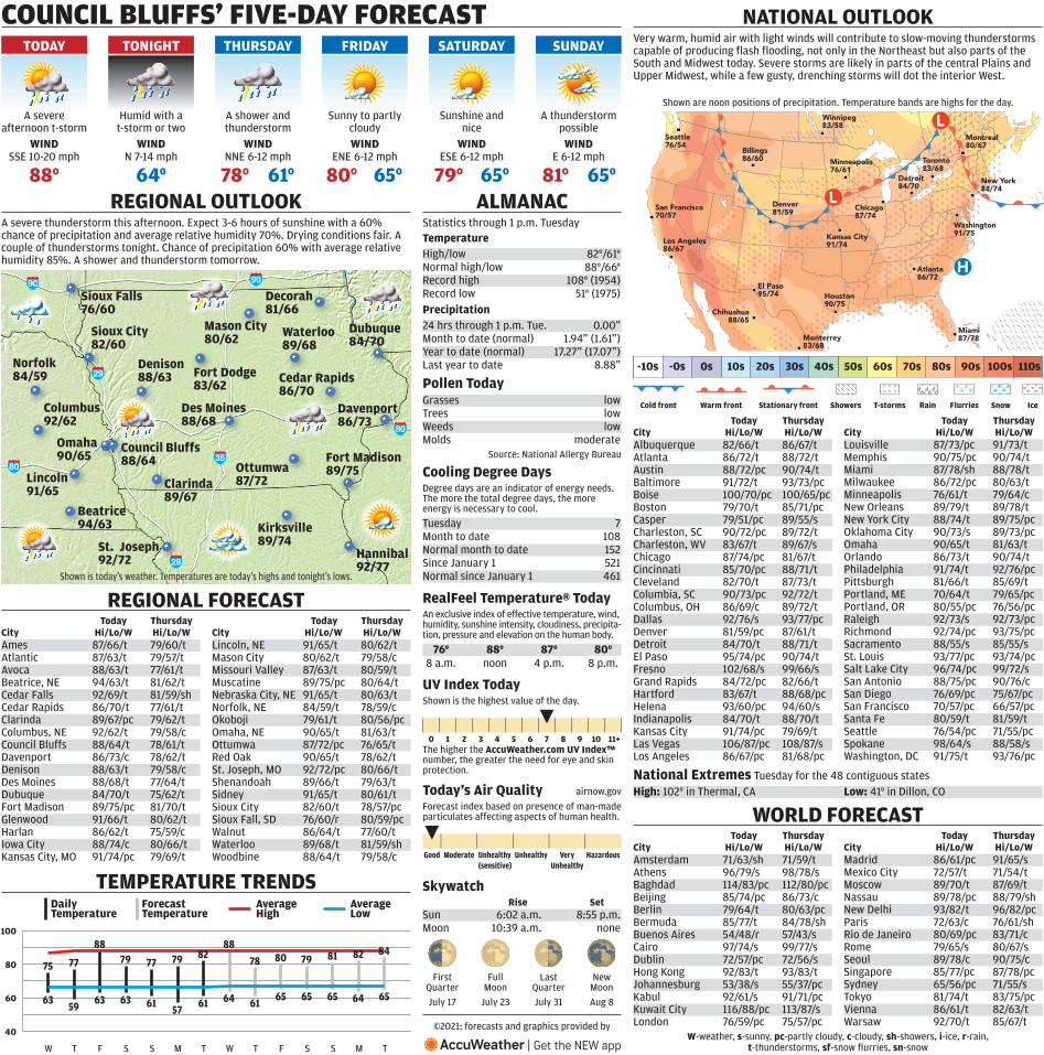
Cold front Warm front Stationary front Showers T-storms Rain Flurries Snow Ice
Monterrey83/68
Chihuahua88/65
Los Angeles86/67
Washington91/75
New York88/74
Miami87/78
Atlanta86/72
Detroit84/70
Houston90/75
Kansas City91/74
Chicago87/74
Minneapolis76/61
El Paso95/74
Denver81/59
Billings86/60
San Francisco70/57
Seattle76/54
Toronto83/68
Montreal80/67
Winnipeg83/58
40
60
80
100
84
65
82
64
81
65
79
65
80
65
78
61
88
64
82
61
79
57
77
61
79
63
88
63
77
59
75
63
DailyTemperature
ForecastTemperature
AverageHigh
AverageLow
Good Moderate Unhealthy(sensitive)
Unhealthy VeryUnhealthy
Hazardous
ALMANAC
Temperature
Precipitation
Forecast index based on presence of man-made particulates affecting aspects of human health.
Today’s Air Quality airnow.gov
Skywatch
RealFeel Temperature® Today
Shown are noon positions of precipitation. Temperature bands are highs for the day.
City Hi/Lo/W Hi/Lo/W City Hi/Lo/W Hi/Lo/W
City Hi/Lo/W Hi/Lo/W City Hi/Lo/W Hi/Lo/W
WORLD FORECAST
-10s -0s 0s 10s 20s 30s 40s 50s 60s 70s 80s 90s 100s 110s
W-weather, s-sunny, pc-partly cloudy, c-cloudy, sh-showers, i-ice, r-rain, t-thunderstorms, sf-snow flurries, sn-snow
National Extremes
Cedar Rapids
Waterloo
Omaha
DubuqueMason City
Denison
Fort Madison
DavenportDes Moines
Sioux Falls
Norfolk
Council Bluffs
St. Joseph
Lincoln
Beatrice
Decorah
Kirksville
Hannibal
Ottumwa
Sioux City
Fort Dodge
Clarinda
WIND
Columbus
WIND WIND WIND WINDWIND
COUNCIL BLUFFS’ FIVE-DAY FORECAST
REGIONAL OUTLOOK
NATIONAL OUTLOOK
TEMPERATURE TRENDS
An exclusive index of effective temperature, wind, humidity, sunshine intensity, cloudiness, precipita-tion, pressure and elevation on the human body.
Rise Set
City Hi/Lo/W Hi/Lo/W City Hi/Lo/W Hi/Lo/W
Shown is today’s weather. Temperatures are today’s highs and tonight’s lows.
REGIONAL FORECAST
A severe thunderstorm this afternoon. Expect 3-6 hours of sunshine with a 60% chance of precipitation and average relative humidity 70%. Drying conditions fair. A couple of thunderstorms tonight. Chance of precipitation 60% with average relative humidity 85%. A shower and thunderstorm tomorrow.
©2021; forecasts and graphics provided by
High: 102° in Thermal, CA Low: 41° in Dillon, CO
Albuquerque 82/66/t 86/67/tAtlanta 86/72/t 88/72/tAustin 88/72/pc 90/74/tBaltimore 91/72/t 93/73/pcBoise 100/70/pc 100/65/pcBoston 79/70/t 85/71/pcCasper 79/51/pc 89/55/sCharleston, SC 90/72/pc 89/72/tCharleston, WV 83/67/t 89/67/sChicago 87/74/pc 81/67/tCincinnati 85/70/pc 88/71/tCleveland 82/70/t 87/73/tColumbia, SC 90/73/pc 92/72/tColumbus, OH 86/69/c 89/72/tDallas 92/76/s 93/77/pcDenver 81/59/pc 87/61/tDetroit 84/70/t 88/71/tEl Paso 95/74/pc 90/74/tFresno 102/68/s 99/66/sGrand Rapids 84/72/pc 82/66/tHartford 83/67/t 88/68/pcHelena 93/60/pc 94/60/sIndianapolis 84/70/t 88/70/tKansas City 91/74/pc 79/69/tLas Vegas 106/87/pc 108/87/sLos Angeles 86/67/pc 81/68/pc
Louisville 87/73/pc 91/73/tMemphis 90/75/pc 90/74/tMiami 87/78/sh 88/78/tMilwaukee 86/72/pc 80/63/tMinneapolis 76/61/t 79/64/cNew Orleans 89/79/t 89/78/tNew York City 88/74/t 89/75/pcOklahoma City 90/73/s 89/73/pcOmaha 90/65/t 81/63/tOrlando 86/73/t 90/74/tPhiladelphia 91/74/t 92/76/pcPittsburgh 81/66/t 85/69/tPortland, ME 70/64/t 79/65/pcPortland, OR 80/55/pc 76/56/pcRaleigh 92/73/s 92/73/pcRichmond 92/74/pc 93/75/pcSacramento 88/55/s 85/55/sSt. Louis 93/77/pc 93/74/pcSalt Lake City 96/74/pc 99/72/sSan Antonio 88/75/pc 90/76/cSan Diego 76/69/pc 75/67/pcSan Francisco 70/57/pc 66/57/pcSanta Fe 80/59/t 81/59/tSeattle 76/54/pc 71/55/pcSpokane 98/64/s 88/58/sWashington, DC 91/75/t 93/76/pc
Today Thursday Today Thursday
Amsterdam 71/63/sh 71/59/tAthens 96/79/s 98/78/sBaghdad 114/83/pc 112/80/pcBeijing 85/74/pc 86/73/cBerlin 79/64/t 80/63/pcBermuda 85/77/t 84/78/shBuenos Aires 54/48/r 57/43/sCairo 97/74/s 99/77/sDublin 72/57/pc 72/56/sHong Kong 92/83/t 93/83/tJohannesburg 53/38/s 55/37/pcKabul 92/61/s 91/71/pcKuwait City 116/88/pc 113/87/sLondon 76/59/pc 75/57/pc
Madrid 86/61/pc 91/65/sMexico City 72/57/t 71/54/tMoscow 89/70/t 87/69/tNassau 89/78/pc 88/79/shNew Delhi 93/82/t 96/82/pcParis 72/63/c 76/61/shRio de Janeiro 80/69/pc 83/71/cRome 79/65/s 80/67/sSeoul 89/78/c 90/75/cSingapore 85/77/pc 87/78/pcSydney 65/56/pc 71/55/sTokyo 81/74/t 83/75/pcVienna 86/61/t 82/63/tWarsaw 92/70/t 85/67/t
Today Thursday Today Thursday
First Quarter
July 17
Last Quarter
July 31
Full Moon
July 23
New Moon
Aug 8
Sun 6:02 a.m. 8:55 p.m.Moon 10:39 a.m. none
Statistics through 1 p.m. Tuesday
24 hrs through 1 p.m. Tue. 0.00”Month to date (normal) 1.94” (1.61”)Year to date (normal) 17.27” (17.07”)Last year to date 8.88”
Degree days are an indicator of energy needs. The more the total degree days, the more energy is necessary to cool.
Tuesday 7Month to date 108Normal month to date 152Since January 1 521Normal since January 1 461
High/low 82°/61°Normal high/low 88°/66°Record high 108° (1954)Record low 51° (1975)
Ames 87/66/t 79/60/tAtlantic 87/63/t 79/57/tAvoca 88/63/t 77/61/tBeatrice, NE 94/63/t 81/62/tCedar Falls 92/69/t 81/59/shCedar Rapids 86/70/t 77/61/tClarinda 89/67/pc 79/62/tColumbus, NE 92/62/t 79/58/cCouncil Bluffs 88/64/t 78/61/tDavenport 86/73/c 78/62/tDenison 88/63/t 79/58/cDes Moines 88/68/t 77/64/tDubuque 84/70/t 75/62/tFort Madison 89/75/pc 81/70/tGlenwood 91/66/t 80/62/tHarlan 86/62/t 75/59/cIowa City 88/74/c 80/66/tKansas City, MO 91/74/pc 79/69/t
Lincoln, NE 91/65/t 80/62/tMason City 80/62/t 79/58/cMissouri Valley 87/63/t 80/59/tMuscatine 89/75/pc 80/64/tNebraska City, NE 91/65/t 80/63/tNorfolk, NE 84/59/t 78/59/cOkoboji 79/61/t 80/56/pcOmaha, NE 90/65/t 81/63/tOttumwa 87/72/pc 76/65/tRed Oak 90/65/t 78/62/tSt. Joseph, MO 92/72/pc 80/66/tShenandoah 89/66/t 79/63/tSidney 91/65/t 80/61/tSioux City 82/60/t 78/57/pcSioux Fall, SD 76/60/r 80/59/pcWalnut 86/64/t 77/60/tWaterloo 89/68/t 81/59/shWoodbine 88/64/t 79/58/c
Today Thursday Today Thursday
W T F S S M T W T F S S M T
76° 88° 87° 80°8 a.m. noon 4 p.m. 8 p.m.
SSE 10-20 mph
88°
TODAY
A severe afternoon t-storm
N 7-14 mph
64°
TONIGHT
Humid with a t-storm or two
NNE 6-12 mph
61°78°
THURSDAY
A shower and thunderstorm
ENE 6-12 mph
80° 65°
FRIDAY
Sunny to partly cloudy
ESE 6-12 mph
79° 65°
SATURDAY
Sunshine and nice
E 6-12 mph
81° 65°
SUNDAY
A thunderstorm possible
86/70
92/72
91/65
94/63
81/66
89/74
92/77
89/68
90/65
87/72
84/7080/62
88/6383/62
92/62 86/7388/68
76/60
84/59
89/67
82/60
89/7588/64
Cooling Degree Days
Very warm, humid air with light winds will contribute to slow-moving thunderstorms capable of producing flash flooding, not only in the Northeast but also parts of the South and Midwest today. Severe storms are likely in parts of the central Plains and Upper Midwest, while a few gusty, drenching storms will dot the interior West.
Tuesday for the 48 contiguous states
0 1 2 3 4 5 6 7 8 9 10 11+The higher the AccuWeather.com UV Index™ number, the greater the need for eye and skin protection.
Shown is the highest value of the day.
UV Index Today
Pollen Today
Source: National Allergy Bureau
Grasses lowTrees lowWeeds lowMolds moderate