CORE MANAGEMENT PLAN INCLUDING … · The other rare plants found on the site – slender yellow...
44
CYNGOR CEFN GWLAD CYMRU COUNTRYSIDE COUNCIL FOR WALES CORE MANAGEMENT PLAN INCLUDING CONSERVATION OBJECTIVES FOR NORTHWEST PEMBROKESHIRE COMMONS SAC (SPECIAL AREA OF CONSERVATION) Version: 20 Date: 15 April 2008 Approved by: Tracey Lovering A Welsh version of all or part of this document can be made available on request.
Transcript of CORE MANAGEMENT PLAN INCLUDING … · The other rare plants found on the site – slender yellow...

CYNGOR CEFN GWLAD CYMRU COUNTRYSIDE COUNCIL FOR WALES
CORE MANAGEMENT PLAN INCLUDING CONSERVATION OBJECTIVES
FOR
NORTHWEST PEMBROKESHIRE COMMONS SAC
(SPECIAL AREA OF CONSERVATION)
Version: 20 Date: 15 April 2008 Approved by: Tracey Lovering A Welsh version of all or part of this document can be made available on request.

2
CONTENTS Preface: Purpose of this document 1. Vision for the Site 2. Site Description
2.1 Area and Designations Covered by this Plan 2.2 Outline Description 2.3 Outline of Past and Current Management 2.4 Management Units
3. The Special Features
3.1 Confirmation of Special Features 3.2 Special Features and Management Units
4. Conservation Objectives Background to Conservation Objectives 4.1 Conservation Objective for Feature 1: Luronium natans Floating Water Plantain 4.2 Conservation Objective for Feature 2: European Dry Heaths 4.3 Conservation Objective for Feature 3: Transition Mires and Quaking Bogs 4.4 Conservation Objective for Feature 4: Northern Atlantic Wet Heaths with Erica
tetralix 4.5 Conservation Objective for Feature 5: Molinia Meadows on calcareous, peaty or
clayey-silt-laden soils (Molinion caeruleae) 4.6 Conservation Objective for SSSI Feature: Assemblage of RDB and/or Nationally
Scarce vascular plants 4.7 Conservation Objective for SSSI Feature: Small Red Damselfly
5. Assessment of Conservation Status and Management Requirements: 5.1 Conservation Status and Management Requirements of Feature 1: Luronium
natans Floating Water Plantain 5.2 Conservation Status and Management Requirements of Feature 2: European
Dry Heaths 5.3 Conservation Status and Management Requirements of Feature 3: Transition
Mires and Quaking Bogs 5.4 Conservation Status and Management Requirements of Feature 4: Northern
Atlantic Wet Heaths with Erica tetralix 5.5 Conservation Status and Management Requirements of Feature 5: Molinia
Meadows on calcareous, peaty or clayey-silt-laden soils (Molinion caeruleae) 5.6 Conservation Status and Management Requirements of SSSI Feature:
Assemblage of RDB and/or Nationally Scarce vascular plants 5.7 Conservation Status and Management Requirements of SSSI Feature: Small Red
Damselfly
6. Action Plan: Summary 7. Glossary 8. References and Annexes

3
PREFACE This document provides the main elements of CCW’s management plan for the site named. It sets out what needs to be achieved on the site, the results of monitoring and advice on the action required. This document is made available through CCW’s web site and may be revised in response to changing circumstances or new information. This is a technical document that supplements summary information on the web site. One of the key functions of this document is to provide CCW’s statement of the Conservation Objectives for the relevant Natura 2000 site. This is required to implement the Conservation (Natural Habitats, &c.) Regulations 1994, as amended (Section 4). As a matter of Welsh Assembly Government Policy, the provisions of those regulations are also to be applied to Ramsar sites in Wales.

4
1. VISION FOR THE SITE
This is a descriptive overview of what needs to be achieved for conservation on the site. It brings together and summarises the Conservation Objectives (part 4) into a single, integrated statement about the site. The commons around St David’s should remain dominated by heath and wetland in the years to come. Changes in climate and changes in the way people use the land are perhaps inevitable, and the detail of the vegetation that we see on the commons today may also shift over time. Our vision, however, is for the more open mixtures of grassland, heath, fen and swamp to persist. This means that development of scrub and woodland must be kept in check, and that wider catchment-level initiatives are put in place to reduce nutrient enrichment and adverse hydrological management. Conserving this blend of habitats will ensure that the characteristic rare plants and insects currently found here continue to flourish Bogbean, marsh cinquefoil and water horsetail will be among the most obvious plants in the areas of fen and swamp that are scattered throughout the site. Taller species like bulrush or great reedmace should be kept in check by grazing. Among the swampy vegetation, small areas of more open water will support populations of the small red damselfly. The marshy grasslands will largely be dominated by purple moor-grass. Grazing will maintain these Molinia meadows as an uneven, low sward with a variety of small grasses, sedges, heathers and herbs such as devil’s-bit scabious and tormentil. Flea sedge and tawny sedge will be found where the soils are more alkaline. Wild angelica or other tall herbs will occur among larger moor-grass tussocks in the wetter parts. Most of the remainder of the marshy grasslands will have an abundance of sharp-flowered rush, with plenty of marsh bedstraw, water mint and greater bird’s-foot trefoil. Some taller areas of yellow-flag iris or meadowsweet will be present. Stands of wet heathland will be found across the site, displaying an abundance of heather, cross-leaved heath and purple moor-grass. Most of the heath will be short and open enough for smaller plants such as bog asphodel, bog pimpernel, Sphagnum moss and short sedges to grow. Three types of heather - bell heather, ling and cross-leaved heath - will flourish alongside small tussocks of purple moor-grass and bushes of western gorse in the stands of dry and humid heath that dominates much of the site. Much of this dry heath will remain short and open enough for smaller plants and mosses to grow on and around the tussocks. The other rare plants found on the site – slender yellow centaury, pillwort, wavy St. John’s-wort, chamomile, three-lobed water crowfoot, pale dog violet and pale heath violet – will be maintained. Floating water plantain will be present in a few areas, including newly established areas, where historic records once existed.

5
2. SITE DESCRIPTION
2.1 Area and Designations Covered by this Plan
Grid reference: SM776273 Unitary authority: Pembrokeshire Coast National Park Area (hectares): 248.89 ha Designations covered:
• North West Pembrokeshire Commons Special Area of Conservation Site comprises of:
• Trefeiddan Moor SSSI • St David’s Airfield Heaths SSSI • Waun Fawr, Tyddewi SSSI • Dowrog Common SSSI • Tretio Common SSSI
Detailed maps of the designated sites are available through CCW’s web site: http://www.ccw.gov.uk/interactive-maps/protected-areas-map.aspx
2.2 Outline Description
North West Pembrokeshire Commons SAC is comprised of five SSSIs which all fall entirely within the SAC boundary. These sites are not contiguous; in total they cover 248.89 hectares. See accompanying management Unit Map for SSSI locations.
• Dowrog Common SSSI, notified April 1987. Grid reference SM 775273, 101 hectares of a
diverse habitat mosaic. The main habitats of interest are: fen, swamp, marshy grassland, wet heath and dry heath. Additional species of interest are: small red damselfly, slender yellow centaury (Cicendia filiformis), pillwort (Pilularia globulifera), wavy St. John’s-wort (Hypericum undulatum), chamomile (Chamaemelum nobile), pale heath violet (Viola lactea) and three-lobed water crowfoot (Ranunculus tripartitus). Owned by the National Trust and managed by the Wildlife Trust of South and West Wales.
• St David’s Airfield Heaths SSSI, notified June 1984. Grid reference SM 788262, a 93-hectare site including wet heath, marshy grassland, fen, swamp and neutral grassland.
• Trefeiddan Moor SSSI, notified June 1984. Grid reference SM733252, a 19.9-hectare site comprising fen, swamp, marshy grassland, wet heath and dry heath. Additional species of interest are: slender yellow centaury (Cicendia filiformis), pillwort (Pilularia globulifera), chamomile (Chamaemelum nobile).
• Tretio Common SSSI, notified April 1987. Grid reference SM 785283, 55 hectare site. The main habitats of interest are dry heath, wet heath, fen and marshy grassland. Additional species of interest are: slender yellow centaury (Cicendia filiformis), pillwort (Pilularia globulifera), wavy St. John’s-wort (Hypericum undulatum), pale heath violet (Viola lactea) and three-lobed water crowfoot (Ranunculus tripartitus).
• Waun Fawr, Ty Ddewi SSSI, notified June 1984. Grid reference SM 762262, 16-hectare site. The main habitats of interest are dry heath, wet heath and marshy grassland. Additional species of interest are pale heath violet (Viola lactea), wavy St. John’s-wort (Hypericum undulatum), slender yellow centaury (Cicendia filiformis) and chamomile (Chamaemelum nobile).

6
2.3 Outline of Past and Current Management
The commons around St David’s have a long history of traditional pastoral practices supported by patch burning. The commons were regularly and intensively grazed, generally by horses and cattle, until the 1950’s. Reports suggest that grazing took place all year round, but particularly in summer when there was less work for horses on the farms. Although no detailed information is available on stocking regimes prior to the early twentieth century, the former value attached to the commons suggests that they have all received at least episodically heavy grazing. Clay was also excavated from small pits and peat appears to have been dug. Small-scale drainage improvements were made, evidenced by the leats constructed on Dowrog and Trefeiddan. A decline in or abandonment of traditional grazing and management practices in the second half of last century has resulted in structural and compositional changes in the vegetation. The drier habitats have been allowed to develop an increasingly rank or tussocky structure, with a few potential dominant species such as Molinia and western gorse tending to smother less competitive species. There has been an increase in scrub, mainly dense stands of gorse and bramble. Management of the whole catchment including the effects of agricultural intensification, improvement of grasslands, application of fertiliser, and the hydrological impacts resulting from peripheral drainage as well as abstraction for irrigation need to be considered in the future. Grazing with heavy-footed stock has been reintroduced to all of the commons since 2000. Welsh Mountain ponies have been used at all sites in this current recovery management phase, complemented by cattle where possible. Re-integrating the grazing management of these commons with mainstream beef production is a challenge currently facing the site managers. The National Trust now owns much of the site. Dowrog Common is leased by NT to the Wildlife Trust, South and West Wales. Pembrokeshire Coast National Park Authority and Pembrokeshire County Council between them own or are responsible for most of the remainder. The two privately owned sections of the site are subject to S15 management agreements with CCW. Recent conservation management by the former two organisations has employed a mixture of winter burning, grazing with cattle and ponies, pool creation and firebreak mowing. Despite this, the commons generally remain under-managed, with under-stocking the key issue to address.
2.4 Management Units
The plan area has been divided into management units to enable practical communication about features, objectives, and management. This will also allow us to differentiate between the different designations where necessary. In this plan the management units have been based upon common land units, SSSI boundaries and existing management compartments, detached and almost detached land parcels have also been treated as separate units. See accompanying map showing the management units which are referred to in this plan. The following table confirms the relationships between the management units and the designations covered:
Unit number
SAC SSSI Common land Other
Dowrog Common SSSI 1 a a a 2 a a a 3 a a a

7
Waun Fawr, Tyddewi SSSI 4 a a a Trefeiddan Moor SSSI 5 a a a St David’s Airfield Heaths SSSI 6 a a a 7 a a 8 a a a 9 a a a Tretio Common SSSI 10 a a a 11 a a a 12 a a a 13 a a a 14 a a a

8
3. THE SPECIAL FEATURES 3.1 Confirmation of Special Features
Designated feature Relationships, nomenclature etc Conservation Objective in part 4
SAC features Luronium natans Floating Water Plantain
4.1
European Dry Heaths 4.2 Transition Mires and Quaking Bogs 4.3 Northern Atlantic Wet Heaths with Erica tetralix (including H4 humid heath)
4.4
Molinia Meadows on calcareous, peaty or clayey-silt-laden soils (Molinion caeruleae)
4.5
SSSI features Assemblage of RDB and/or Nationally Scarce vascular plants
4.6
Small Red Damselfly 4.7 Fen & Swamp Non-SAC Marshy Grassland
3.2 Special Features and Management Units
This section sets out the relationship between the special features and each management unit. This is intended to provide a clear statement about what each unit should be managed for, taking into account the varied needs of the different special features. All special features are allocated to one of seven classes in each management unit. These classes are:
Key Features KH - a ‘Key Habitat’ in the management unit, i.e. the habitat that is the main focus of management and monitoring effort, perhaps because of the dependence of a key species (see KS below). There will rarely be more than one Key Habitat in a unit. KS – a ‘Key Species’ in the management unit, often driving both the selection and management of a Key Habitat. Geo – an earth science feature that is the main focus of management and monitoring effort in a unit. Other Features Sym - habitats, species and earth science features that are of importance in a unit but are not the main focus of management or monitoring. These features will benefit from management for the key feature(s) identified in the unit. These may be classed as ‘Sym’ features because: a) they are present in the unit but are of less conservation importance than the key feature;
and/or b) they are present in the unit but in small areas/numbers, with the bulk of the feature in
other units of the site; and/or c) their requirements are broader than and compatible with the management needs of the key
feature(s), e.g. a mobile species that uses large parts of the site and surrounding areas.

9
Nm - an infrequently used category where features are at risk of decline within a unit as a result of meeting the management needs of the key feature(s), i.e. under Negative Management. These cases will usually be compensated for by management elsewhere in the plan, and can be used where minor occurrences of a feature would otherwise lead to apparent conflict with another key feature in a unit. Mn - Management units with no special feature present but which are of importance for management of features elsewhere on a site e.g. livestock over-wintering areas included within designation boundaries, buffer zones around water bodies, etc. x – Features not known x – Features not present in the management unit.
The table below sets out the relationship between the special features and management units identified in this plan:

10
North West Pembrokeshire Commons SAC EU SAC code UK0030229
North West Pembrokeshire Commons SAC Management units
Dowrog Common Waun Fawr SSSI
Trefeiddan Moor SSSI St David’s Airfield Heaths SSSI Tretio Common SSSI
1
2
3
4
5
6
7
8
9 10 11 12 13 14
SAC a a a a a a
a a a a a a a
a
SSSI a a a a a a a a a a a a a a SAC features 1.Luronium natans Floating Water Plantain
KS x x x x (KS) x x x x x x x x x
2. European Dry Heaths Sym Nm Sym Nm Sym Nm Nm Nm Sym Nm Nm Nm Nm Nm 3. Transition Mires and Quaking Bogs
KH x Sym x KH Sym Sym Sym x x x x x x
4. Northern Atlantic Wet Heaths with Erica tetralix
Sym Sym KH KH Sym KH KH Sym x Sym Sym Sym KH Sym
5. Molinia Meadows on calcareous, peaty or clayey-silt-laden soils (Molinion caeruleae)
Sym KH Sym x Sym Sym Sym KH x KH KH KH Sym KH
SSSI features Assemblage of RDB and/or Nationally Scarce vascular plants
Sym KS KS KS KS KS KS KS KS KS KS KS KS KS
Small Red Damselfly Sym Sym Sym x x x x x x x x x x x Fen & Swamp Sym Sym Sym Sym Sym x x Sym KH Sym Sym Sym x x Marshy Grassland Sym Sym Sym Sym Sym Sym Sym Sym Sym Sym Sym Sym Sym Sym


12
4. CONSERVATION OBJECTIVES
Background to Conservation Objectives:
a. Outline of the legal context and purpose of conservation objectives.
Conservation objectives are required by the 1992 ‘Habitats’ Directive (92/43/EEC). The aim of the Habitats Directives is the maintenance, or where appropriate the restoration of the ‘favourable conservation status’ of habitats and species features for which SACs and SPAs are designated (see Box 1). In the broadest terms, 'favourable conservation status' means a feature is in satisfactory condition and all the things needed to keep it that way are in place for the foreseeable future. CCW considers that the concept of favourable conservation status provides a practical and legally robust basis for conservation objectives for Natura 2000 and Ramsar sites.
Achieving these objectives requires appropriate management and the control of factors that may cause deterioration of habitats or significant disturbance to species. As well as the overall function of communication, Conservation objectives have a number of specific roles: • Conservation planning and management.
The conservation objectives guide management of sites, to maintain or restore the habitats and species in favourable condition.
Box 1 Favourable conservation status as defined in Articles 1(e) and 1(i) of the Habitats Directive “The conservation status of a natural habitat is the sum of the influences acting on it and its typical species that may affect its long-term natural distribution, structure and functions as well as the long term survival of its typical species. The conservation status of a natural habitat will be taken as favourable when:
• Its natural range and areas it covers within that range are stable or increasing, and • The specific structure and functions which are necessary for its long-term
maintenance exist and are likely to continue to exist for the foreseeable future, and • The conservation status of its typical species is favourable.
The conservation status of a species is the sum of the influences acting on the species that may affect the long-term distribution and abundance of its populations. The conservation status will be taken as ‘favourable’ when:
• population dynamics data on the species indicate that it is maintaining itself on a
long-term basis as a viable component of its natural habitats, and • the natural range of the species is neither being reduced nor is likely to be reduced
for the foreseeable future, and • There is, and will probably continue to be, a sufficiently large habitat to maintain
its populations on a long-term basis.”

13
• Assessing plans and projects. Article 6(3) of the ‘Habitats’ Directive requires appropriate assessment of proposed plans and projects against a site's conservation objectives. Subject to certain exceptions, plans or projects may not proceed unless it is established that they will not adversely affect the integrity of sites. This role for testing plans and projects also applies to the review of existing decisions and consents.
• Monitoring and reporting.
The conservation objectives provide the basis for assessing the condition of a feature and the status of factors that affect it. CCW uses ‘performance indicators’ within the conservation objectives, as the basis for monitoring and reporting. Performance indicators are selected to provide useful information about the condition of a feature and the factors that affect it.
The conservation objectives in this document reflect CCW’s current information and understanding of the site and its features and their importance in an international context. The conservation objectives are subject to review by CCW in light of new knowledge. b. Format of the conservation objectives There is one conservation objective for each feature listed in part 3. Each conservation objective is a composite statement representing a site-specific description of what is considered to be the favourable conservation status of the feature. These statements apply to a whole feature as it occurs within the whole plan area, although section 3.2 sets out their relevance to individual management units. Each conservation objective consists of the following two elements:
1. Vision for the feature 2. Performance indicators
As a result of the general practice developed and agreed within the UK Conservation Agencies, conservation objectives include performance indicators, the selection of which should be informed by JNCC guidance on Common Standards Monitoring1. There is a critical need for clarity over the role of performance indicators within the conservation objectives. A conservation objective, because it includes the vision for the feature, has meaning and substance independently of the performance indicators, and is more than the sum of the performance indicators. The performance indicators are simply what make the conservation objectives measurable, and are thus part of, not a substitute for, the conservation objectives. Any feature attribute identified in the performance indicators should be represented in the vision for the feature, but not all elements of the vision for the feature will necessarily have corresponding performance indicators. As well as describing the aspirations for the condition of the feature, the Vision section of each conservation objective contains a statement that the factors necessary to maintain those desired conditions are under control. Subject to technical, practical and resource constraints, factors which have an important influence on the condition of the feature are identified in the performance indicators.
1 Available through www.jncc.gov.uk and follow links to Protected Sites and Common Standards Monitoring.

14
4.1 Conservation Objective for Feature 1: Floating Water Plantain Luronium natans Vision for Floating Water Plantain The vision for this feature is for it to be in a favourable conservation status, where all of the following conditions are satisfied: C There will be at least two populations, in separate waterbodies. C There will be no contraction in the extent of L. natans populations. C L. natans populations will be viable & able to maintain themselves on a long-term basis. L. natans
must be able to complete sexual and/or vegetative reproduction successfully. C The waterbodies will have sufficient suitable habitat to support viable L. natans populations and to
allow for future expansion of the population. C All factors affecting the achievement of these conditions are under control. Performance indicators for Floating Water Plantain The performance indicators are part of the conservation objective, not a substitute for it. Assessment of plans and projects must be based on the entire conservation objective, not just the performance indicators. Performance indicators for feature condition Attribute Attribute rationale and other comments Specified limits A1. Population size
Based upon recent counts. No CSM monitoring of the population to date.
Upper limit: None set Lower limit: Present in at least 1/3 of sampling units at one location, and a minimum of 5 plants are present at a second
A.2. Extent of population
Based upon recent counts. No CSM monitoring of the population to date. Although recently only recorded from Dowrog Pool, the plant was formerly widespread in the area. Steven Evans (BSBI), Andy Jones and Matt Sutton (CCW) in discussion agreed that as a single population is potentially vulnerable to pollution or other damaging activities, FCS should specify a need for more than one discrete population.
Upper limit: None set Lower limit: Two populations one of which must cover at least 15 square metres
A3. Reproductive capability
Sampling should take place between mid-June and the end of July (ideally the second week in July) to establish the presence of flowering plants. The plants here are known to be fertile, and flowering is the only practical surrogate for reproductive capability and hence seed dispersal. Further populations, if located, will require only a minimum of five plants (vegetative or flowering) to be present.
Upper limit: None set Lower limit: Flowering Luronium is present in one sixth of sampling units at one location
A4. Distribution of population
Based upon current distribution. No CSM monitoring of the population to date.
Upper limit: None set Lower limit: Present in at least two hydrologically separated locations

15
Performance indicators for feature condition (cont.d) Attribute Attribute rationale and other comments Specified limits A5. Sufficient habitat
Submerged populations of L. natans require substrates comprising of clay, mud, stable fine gravel or silt in depths of clear water up to 3m.
Sufficient good quality habitat should exist to support the expansion of existing populations. Extent of good quality habitat should not be reduced.
Performance indicators for factors affecting the feature Factor Factor rationale and other comments Operational Limits F1. Water Quality Dowrog Pool is fed by water arising on the
common, but could potentially be impacted by agricultural activities such as fertiliser application on adjoining land. This is currently under organic management.
Upper limit: levels of pollutants must not exceed critical thresholds for vegetation types according to JNCC guidance Lower limit: none set
F2. Water Quantity
Modifying the hydrology of the area could have negative impacts as could successional changes to the vegetation in and around the pools, leading to a loss of suitable habitat
Upper limit: volume and number of private abstractions or drains not to increase above current levels. Areas of open water should be maintained. Lower limit: none set
F3. Alien species No invasive or alien species are currently recorded near the Luronium populations, but they could in future threaten the population.
Upper limit: No invasive or alien species. Lower limit: None set
4.2 Conservation Objective for Feature 2: European Dry Heaths Vision for Dry Heath The vision for this feature is for it to be in a favourable conservation status, where all of the following conditions are satisfied: • Dry heath will cover between 1% and 30% of the site area and display a range of plant and insect
species typical of the habitat. • The following plants will be common in the dry heath: heather Calluna vulgaris; bell heather
Erica cinerea and western gorse Ulex gallii. • Competitive species indicative of under-grazing, particularly bracken Pteridium aquilinum and
purple moor-grass Molinia caerulea will be kept in check. Western gorse Ulex gallii will not exceed 50% cover.
• 70% of dry heath will be “good condition” dry heath. • All factors affecting the achievement of these conditions, including grazing and scrub/bracken
encroachment are under control.

16
Performance indicators for Dry Heath The performance indicators are part of the conservation objective, not a substitute for it. Assessment of plans and projects must be based on the entire conservation objective, not just the performance indicators. Performance indicators for feature condition Attribute Attribute rationale and other comments Specified limits A1. Extent of Dry Heath
Although a primary reason for SAC selection, the dry heath here takes the form of a species-poor ‘humid heath’. This appears to have been derived from a more species-rich North Atlantic wet heath through a history of neglect and overly frequent burning. Good habitat management would return this dry heath to wet heath, and the specified limits reflect this.
Upper limit: 30% of site area Lower limit: 1% of site area
A2. Condition of Dry Heath
Based on the Standard CSM attribute for this feature. Modified according to site-specific requirements.
Upper limit: Not required Lower limit: 70% of the Dry Heath vegetation is in good condition, characterised by vegetation where at each sample point:
• Ericoid cover is 25-90% • Two ericoids are present • The combined cover of Molinia
caerulea and Ulex gallii is <60% • Two positive indicator species are
present (Polygala serpyllifolia, Succisa pratensis, Serratula tinctoria, Viola lactea Pedicularis sylvatica, Carex, Salix repens Dactylorhiza maculata) • Ulex europeaus and other scrub
species are absent
A3. Distribution of dry heath
Dry heath is not a Key Habitat in any units. Lower limit based on management units where dry heath occurs and has been selected as a Sym Habitat.
Upper limit: not set Lower limit: Good condition dry heath should be present in management units 1,3,5 and 9
Performance indicators for factors affecting the feature Factor Factor rationale and other comments Operational Limits F1. Livestock grazing
The dry heath vegetation has been maintained by traditional grazing practices. Without an appropriate grazing regime, the dry heath would become rank and eventually turn to gorse scrub and woodland. Light grazing by animals - ideally cattle from April – November and ponies throughout year - is essential for maintaining the dry heath.
Upper limit: The grazing pressure must not be so high as to break down the vegetation structure and cause significant bare areas to appear. Lower limit: The dry heath must be subject to sufficient grazing to prevent the growth of bracken, purple moor-grass tussocks and western gorse clumps from smothering the growth of mosses, lichens and flowering plants.

17
Performance indicators for factors affecting the feature (cont.d) Factor Factor rationale and other comments Operational Limits F2. Burning
Areas of dry heath have been burnt on an annual basis. These are usually carried out by the commoners to encourage fresh growth for stock, but occasionally may be accidental burns or arson attacks. Burning the same area too frequently may impoverish the heath, encouraging a vigorous re-growth of more competitive, fire-resistant species like purple moor-grass, western gorse and bracken
Upper limit: 10% of heath burnt in any one year. No individual patch should be burnt more than once in 10 years. Lower limit: none set
F3. Pollutants
The dry heath could be affected by airborne pollutants such as nitrous oxides from vehicle exhausts, or drift of lime from adjacent fields
Upper limit: levels of pollutants must not exceed critical thresholds for vegetation types according to JNCC guidance Lower limit: none set
4.3 Conservation Objective for Feature 3: Transition Mires and Quaking Bogs Vision for Transition Mire and Quaking Bog The vision for this feature is for it to be in a favourable conservation status, where all of the following conditions are satisfied: • TM&QB will cover at least 9ha of the site and display a range of plant and invertebrate species
typical of the habitat. • Potentilla palustris, Carex diandra, Carex rostrata, Menyanthes trifoliata, Hypericum elodes,
Pedicularis palustris will be common, forming a quaking raft of vegetation. • Juncus effusus will be at less than 5% cover. • 70% of TM&QB will be good condition, where open water species will be present; large sedges,
negative indicator species and scrub will be absent; grasses form <5% cover. • All factors affecting the achievement of these conditions are under control.

18
Performance indicators for Transition Mire and Quaking Bog The performance indicators are part of the conservation objective, not a substitute for it. Assessment of plans and projects must be based on the entire conservation objective, not just the performance indicators. Performance indicators for feature condition Attribute Attribute rationale and
other comments Specified limits
A1. Extent of TM&QB
Lower limit based on the habitat extent as defined by CCW Phase II Grassland Survey data (produced between 2001 and 2003).
Upper limit: As limited by natural hydroecological constraints. Lower limit: 9ha (current extent)
A2. Condition of TM&QB
Based on the Standard CSM attribute for this feature. Modified according to site-specific requirements.
Upper limit: Not required Lower limit: 70% of the TM&QB vegetation is in good condition, characterised by:
• Vegetation with at least two of the following: Potentilla palustris, Carex diandra, Carex rostrata, Menyanthes trifoliata, Hypericum elodes and Pedicularis palustris present within a 50cm radius area of search.
• Open water species (Utricularia minor, Potamogeton spp. Charophytes) are present in at least 20% of samples
• Juncus effusus is at <5% cover; • Tussocks of Carex paniculata are absent, as
are plants of broad leaved sedges (Carex acutiformis, Carex riparia)
• Grasses form <5% cover • Typha, Oenanthe crocata, Apium nodiflorum,
Scirpus tabernamontani, trees and scrub are absent
A3. Distribution of TM&QB
Lower limit based on the habitat distribution as defined on the GIS maps of SAC features produced by CCW Phase II Grassland Survey team. Full NVC data for these sites was produced between 2001 and 2003.
Upper limit: not set Lower limit: Good condition TM&QB should be present in management units 1,5,6 and 8

19
Performance indicators for factors affecting the feature (cont.d) Factor Factor rationale and other comments Operational Limits F1. Livestock grazing
The TM&QB vegetation has been maintained by traditional grazing practices. Without an appropriate grazing regime, it would become dominated by tall swamp plants and eventually succeed to wet woodland. Light grazing by heavy animals - ideally cattle or water buffalo in late summer - is essential for maintaining the TM&QB.
Upper limit: The grazing pressure must not be so high as to break down the vegetation structure and cause significant bare areas to appear. Lower limit: The TM&QB must be subject to sufficient grazing to prevent the growth of reedmace and large sedges from smothering the growth of small sedges, mosses and flowering plants.
F2. Water Quality
Water may be subject to run-off from agricultural activities such as fertiliser application. It could also be affected by pesticides or airborne pollutants such as nitrous oxides from vehicle exhausts.
Upper limit: levels of atmospheric pollutants must not exceed critical thresholds for vegetation types according to JNCC guidance. The quality of water derived from surrounding catchments should be very good, with low (< 3 mg/l) concentrations of inorganic nitrogen. Lower limit: none set
F3. Water Quantity
Peripheral surface drainage and/or abstractions for private water supply could reduce the quantity and quality of water available to this feature.
Upper limit: volume and number of private abstractions not to increase above current levels Lower limit: none set. No artificial groundwater abstraction.
F4. Burning Burning is considered to be detrimental and must be prevented. However this vegetation type is unlikely to burn
Upper limit: No fires shall be tolerated on the transition mire Lower limit: None set

20
4.4 Conservation Objective for Feature 4: Northern Atlantic Wet Heaths with Erica tetralix Vision for Wet Heath The vision for this feature is for it to be in a favourable conservation status, where all of the following conditions are satisfied: • Wet heath will cover at least 14.5 ha of the site and display a range of plant and invertebrate
species typical of the habitat. • The following plants will be common in the dry heath: heather Calluna vulgaris; Cross-leaved
heath Erica tetralix as well as bog moss Sphagnum spp. and Narthecium ossifragum. • Competitive species indicative of under-grazing, particularly bracken Pteridium aquilinum, purple
moor-grass Molinia caerulea and western gorse Ulex gallii will be kept in check. • 70% of wet heath will be “good condition” wet heath. • All factors affecting the achievement of these conditions are under control. The overall aim of management of these commons is to at least maintain the current extent of wet heath. However it is hoped that suitable recovering management will actually result in an increase in the extent of this habitat. This may occur at the expense of the humid heath and/or part of the dry heath feature. Although dry heath has been selected as a higher grading feature than wet heath in the context of the SAC, a presumption against regular burning on this site would ensure development of a more stable, sustainable heath with more diverse lower plant and invertebrate communities. Performance indicators for Wet Heath The performance indicators are part of the conservation objective, not a substitute for it. Assessment of plans and projects must be based on the entire conservation objective, not just the performance indicators. Performance indicators for feature condition Attribute Attribute rationale and other
comments Specified limits
A1. Extent of Wet Heath
Lower limit based on the habitat extent as defined by CCW Phase II Grassland Survey team, produced between 2001 and 2003. Upper limit reflects potential for most dry heath to become wet heath under appropriate management regime.
Upper limit: 61.5ha Lower limit: 14.5ha
A2. Condition of Wet Heath
Based on the Standard CSM attribute for this feature. Modified according to site-specific requirements.
Upper limit: Not required Lower limit: 70% of the Wet Heath vegetation is in good condition, characterised by vegetation where at each sample point:
• Ericoid cover is 25-90% • Erica tetralix is present with one other ericoid • The combined cover of Molinia caerulea and Ulex
gallii are <60% • Sphagnum spp. plus two of the following are
present: Narthecium ossifragum, Viola lactea, Anagallis tenella, Polygala serpyllifolia, Serratula tinctoria, Dactylorhiza maculata, Pedicularis sylvatica, Dactylorhiza maculata, Carex spp. or Succisa pratensis
• Scrub species and Ulex europeaus are absent

21
Performance indicators for feature condition (cont.d) Attribute Attribute rationale and other
comments Specified limits
A3. Distribution of Wet Heath
Lower limit based on management units where wet heath has been selected as a Key Habitat.
Upper limit: not set Lower limit: Good condition wet heath should be present in management units 3,4,6,7 and 13
Performance indicators for factors affecting the feature Factor Factor rationale and other
comments Operational Limits
F1. Livestock grazing
The wet heath vegetation has been maintained by traditional grazing practices. Without an appropriate grazing regime, the wet heath would become rank and eventually turn to scrub and woodland. Light grazing by animals - ideally cattle from April – November and ponies throughout year - is essential for maintaining the wet heath.
Upper limit: The grazing pressure must not be so high as to break down the vegetation structure and cause significant bare areas to appear. Lower limit: The wet heath must be subject to sufficient grazing to prevent the growth of purple moor-grass tussocks and western gorse clumps from smothering the growth of small sedges, mosses and flowering plants.
F2. Burning
Burning can damage the bryophyte layer and encourages a vigorous re-growth of more competitive, fire-resistant species like purple moor-grass. It may cause wet heath to turn into dry heath in this way.
Upper limit: 10% of wet heath burnt in any six year period Lower limit: none set
F3. Water Quality
The wet heath is kept moist by precipitation and seepages. It is not subject to run-off from agricultural activities such as fertiliser application. It could still be affected by airborne pollutants such as lime drift from adjoining farmland or nitrous oxides from vehicle exhausts
Upper limit: levels of pollutants must not exceed critical thresholds for vegetation types according to JNCC guidance Lower limit: none set
F4. Water Quantity
Abstractions for private water supply could reduce the quantity of water available to vegetation here with a groundwater influence.
Upper limit: volume and number of private abstractions not to increase above current levels Lower limit: none set

22
4.5 Conservation Objective for Feature 5: Molinia Meadows on calcareous, peaty or clayey-silt-laden soils (Molinion caeruleae) Vision for Molinia Meadows The vision for this feature is for it to be in a favourable conservation status, where all of the following conditions are satisfied:
• Molinia meadows habitat will cover at least 22 ha of the site and display a range of plant and
invertebrate species typical of the habitat. • 70% of the Molinia meadows habitat in each area of habitat will be described as being in good
condition. • The SAC marshy grassland will be dominated by Molinia caerulea, typically with a species-
rich mixture of short sedges, forbs and bryophytes. One or more of Carex pulicaris, Carex hostiana or Cirsium dissectum must be at least frequent.
• Competitive species indicative of under-grazing, particularly Molinia itself, will be kept in check.
• Scrub species such as willow Salix and birch Betula will also be largely absent from the marshy grassland.
• All factors affecting the achievement of these conditions are under control. Performance indicators for Molinia Meadows The performance indicators are part of the conservation objective, not a substitute for it. Assessment of plans and projects must be based on the entire conservation objective, not just the performance indicators. Performance indicators for feature condition Attribute Attribute rationale and other
comments Specified limits
A1. Extent of Molinia Meadows
Lower limit based on the habitat extent as defined on the GIS maps of SAC features which were produced by CCW Phase II Grassland Survey team. Full NVC data for these sites was produced between 2001 and 2003.
Upper limit: As limited by other habitats. Lower limit: Current extent of Molinia meadows maintained (as mapped – 2001-05)
A2. Condition of Molinia Meadows
Based on the Standard CSM attribute for this feature. Modified according to site-specific requirements.
Upper limit: Not required Lower limit: 70% of the Molinia meadows vegetation is in good condition, characterised by vegetation where, within 1m of any point:
• Molinia caerulea is present along with at least 1 of the following: Cirsium dissectum, Carex pulicaris or Carex hostiana.
• There is one area of short vegetation and one area of tussocky vegetation
• Bare ground is <20% • At least three desirable species are
present • Molinia cover is <80% • Negative indicators are absent

23
Performance indicators for feature condition (cont.d) Attribute Attribute rationale and other
comments Specified limits
A3. Distribution of Molinia meadows
Lower limit based on the habitat distribution as defined on the GIS maps of SAC features produced by CCW Phase II Grassland Survey team. Full NVC data for these sites was produced between 2001 and 2003.
Upper limit As limited by other SAC/SSSI feature habitats Lower limit: Good condition Molinia meadows should be present in management units 2,8,10,11,12 and 14
Performance indicators for factors affecting the feature Factor Factor rationale and other
comments Operational Limits
F1. Livestock grazing
The Molinia meadows vegetation has been maintained by traditional grazing practices. Without an appropriate grazing regime, it would become rank and eventually turn to gorse scrub and woodland. Light grazing by animals - ideally cattle from April – November and ponies throughout year - is essential for maintaining the Molinia meadows.
Upper limit: The grazing pressure must not be so high as to break down the vegetation structure and cause significant bare areas to appear. Lower limit: The Molinia meadows must be subject to sufficient grazing to prevent the growth of purple moor-grass tussocks and western gorse clumps from smothering the growth of small sedges, mosses and flowering plants.
F2. Burning Burning can encourage a vigorous re-growth of the more competitive, fire-resistant species like purple moor-grass. If used, it must be backed up by an appropriate grazing regime
Upper limit: 20% of Molinia meadows burnt in any 6 year period Lower limit: none set
F3. Water Quality The Molinia meadows feature is kept moist by precipitation, seepages and overland flows. It could be affected run-off from agricultural activities such as fertiliser application. It could also be affected by airborne pollutants such as nitrous oxides from vehicle exhausts
Upper limit: levels of pollutants must not exceed critical thresholds for vegetation types according to JNCC guidance Lower limit: none set
F4. Water Quantity
Abstractions for private water supply could reduce the quantity of water available to vegetation here with a groundwater influence.
Upper limit: volume and number of private abstractions not to increase above current levels Lower limit: none set

24
4.6 Conservation Objective for SSSI Feature: Assemblage of RDB and/or Nationally Scarce vascular plants Vision for Assemblage of RDB and/or Nationally Scarce vascular plants The vision for this feature is for it to be in a favourable conservation status, where all of the following conditions are satisfied: C Populations of all component species of the assemblage will be at least present in within the SAC. C There will be no contraction of the extent of these populations C At least some plants of all component species of the assemblage are capable of flowering and/or
fruiting and will be viable & will be able to maintain themselves on a long-term basis. C All factors affecting the achievement of these conditions are under control. Performance indicators for Assemblage of RDB and/or Nationally Scarce vascular plants The performance indicators are part of the conservation objective, not a substitute for it. Assessment of plans and projects must be based on the entire conservation objective, not just the performance indicators. Performance indicators for feature condition Attribute Attribute rationale and other comments Specified limits A1. Population size
No CSM monitoring of the populations to date.
Upper limit: None set Lower limit: None set, presence in units as set out in A4 below will suffice
A.2. Extent of population
No CSM monitoring of the populations to date. As all species in the assemblage tend to occur in ephemeral habitats such as summer-drying pools, ruts and puddles they are not expected to occur in the same locations year after year but to shift around the site as disturbance such as stock poaching and wheel rutting creates new opportunities for seedling establishment.
Upper limit: None set Lower limit: None set, presence in units as set out in A4 below will suffice
A3. Reproductive capability
Sampling should take place between May and the end of July to establish the presence of flowering plants. The plants here are thought to be fertile, and flowering or fruiting is the only practical surrogate for reproductive capability and hence seed dispersal.
Upper limit: None set Lower limit: at least some plants in each component SSSI should be flowering/fruiting

25
Performance indicators for feature condition (cont.d) Attribute Attribute rationale and other comments Specified limits A4. Distribution of population
Based upon current distribution. No CSM monitoring of the population to date.
Upper limit: None set Lower limit: The species of the assemblage are distributed as follows:
• Ranunculus tripartitus, Cicendia filiformis should be present in at least 5 management units
• Pilularia globulifera should be present in at least 4 management units
• Viola lactea, Hypericum
undulatum should be present in at least 3 management units
• Chamaemelum nobile
should be present in at least 2 management units
A5 Habitat attributes
Based upon generic guidance for vascular plant species of ephemeral ponds, ruts and puddles (‘suite 11’)
Upper limit: None set Lower limit: evidence of poaching, flooding and sufficient niche availability to maintain species populations must be met
Performance indicators for factors affecting the feature Factor Factor rationale and other comments Operational Limits F1. Water Quality There is potential for the hydrology to be
impacted by agricultural activities such as fertiliser application on adjoining land. Some of this is however currently under organic management.
Upper limit: levels of pollutants must not exceed critical thresholds for vegetation types according to JNCC guidance Lower limit: none set
F2. Water Quantity
Modifying the hydrology of the area could have negative impacts as could successional changes to the vegetation in and around the pools, leading to a loss of suitable habitat
Upper limit: volume and number of private abstractions or drains not to increase above current levels. Areas of open water should be maintained. Lower limit: none set
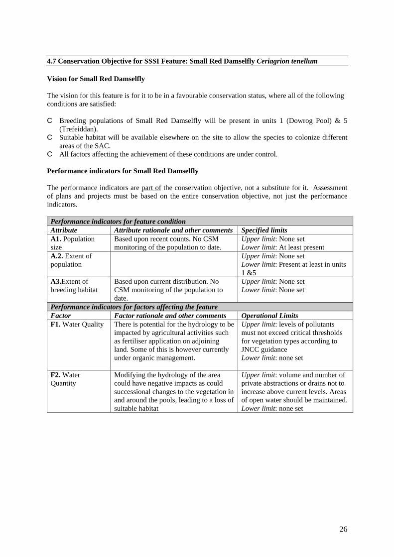
26
4.7 Conservation Objective for SSSI Feature: Small Red Damselfly Ceriagrion tenellum Vision for Small Red Damselfly The vision for this feature is for it to be in a favourable conservation status, where all of the following conditions are satisfied: C Breeding populations of Small Red Damselfly will be present in units 1 (Dowrog Pool) & 5
(Trefeiddan). C Suitable habitat will be available elsewhere on the site to allow the species to colonize different
areas of the SAC. C All factors affecting the achievement of these conditions are under control. Performance indicators for Small Red Damselfly The performance indicators are part of the conservation objective, not a substitute for it. Assessment of plans and projects must be based on the entire conservation objective, not just the performance indicators. Performance indicators for feature condition Attribute Attribute rationale and other comments Specified limits A1. Population size
Based upon recent counts. No CSM monitoring of the population to date.
Upper limit: None set Lower limit: At least present
A.2. Extent of population
Upper limit: None set Lower limit: Present at least in units 1 &5
A3.Extent of breeding habitat
Based upon current distribution. No CSM monitoring of the population to date.
Upper limit: None set Lower limit: None set
Performance indicators for factors affecting the feature Factor Factor rationale and other comments Operational Limits F1. Water Quality There is potential for the hydrology to be
impacted by agricultural activities such as fertiliser application on adjoining land. Some of this is however currently under organic management.
Upper limit: levels of pollutants must not exceed critical thresholds for vegetation types according to JNCC guidance Lower limit: none set
F2. Water Quantity
Modifying the hydrology of the area could have negative impacts as could successional changes to the vegetation in and around the pools, leading to a loss of suitable habitat
Upper limit: volume and number of private abstractions or drains not to increase above current levels. Areas of open water should be maintained. Lower limit: none set

27
5. ASSESSMENT OF CONSERVATION STATUS AND MANAGEMENT REQUIREMENTS This part of the document provides: • A summary of the assessment of the conservation status of each feature. • A summary of the management issues that need to be addressed to maintain or restore each feature. 5.1 Conservation Status and Management Requirements of Floating Water Plantain Luronium natans Conservation Status of Floating Water Plantain The conservation status of Luronium natans in the North-west Pembrokeshire Commons SAC is Unfavourable as the population is still present at only one site - Dowrog Pool - despite the restoration of other areas of suitable habitat. The number of flowering plants here varies annually; no formal counts or monitoring have been carried out but is generally around or above 100. The current areas of open water should be maintained, and the plant should be encouraged to spread by excavation of other pools across the SAC. Relevant publications: SAC Monitoring Report (draft) Northwest Pembrokeshire Commons. Management Requirements of Floating Water Plantain
• Re-excavation of Dowrog Pool in the 1980’s proved successful in recovering this species. Recent management has sought to extend the potential habitat, by creating or restoring shallow, open water bodies across the SAC. Luronium has yet to colonise these. Regular disturbance and partial clearance of parts of the pools may be required to maintain the early successional habitats preferred by this species.
• Grazing in Unit 1, containing Dowrog Pool, must be maintained. Welsh Black cattle are
currently grazed over the summer, but other breeds of cattle or perhaps water buffalo would be satisfactory alternatives. If grazing does not keep tall plants like reedmace Typha in the pools in check, consideration could be given to hand removal of these plants.
• Scrub cutting may be required to clear vegetation from parts of the pool perimeter to prevent
shading.
• Activities that could lead to enrichment problems, such as supplementary stock-feeding or storage of cut vegetation, should not take place near waterbodies.
• Animals or machines should not be moved on to the SAC from areas known to contain aquatic
alien plants. 5.2 Conservation Status and Management Requirements of European Dry Heath Conservation Status of Dry Heath The status of dry heath on the North-west Pembrokeshire Commons SAC is Unfavourable Recovering (August 2005). As the monitoring concentrated on the largest and best condition areas of heath it is safe to assume that the remaining un-sampled dry heath was also in unfavourable condition. The feature failed predominantly due to a lack of associated species (positive indicators) and the high cover of Molinia. Under-management in recent decades has allowed Molinia to develop a tall tussocky

28
structure, often with few associates besides sub-shrubs. Over the last five years, recovery management (cutting, limited burning) has been applied and grazing management has been reintroduced to, or enhanced, across all sites. Providing this effort is maintained, the feature can be described as recovering and is expected to move to favourable condition in the next reporting round. Relevant publications: Dry and wet heath draft SAC monitoring report 2005 (Sutton, 2005) Management Requirements of Dry Heath
• Extensive grazing in spring and summer is ideal. Grazing should aim to keep scrub and coarse plants such as purple moor-grass in check, and maintain an uneven patchwork of short and long vegetation. Vegetation across much of the site should vary from around ankle height to around knee height. Hardier breeds of beef cattle or ponies are ideal grazers.
• Winter burning has been used as a traditional method of keeping moor-grass and gorse in
check. The use of burning, as a tool for restoration management, will be kept under review as mechanical methods of vegetation clearance may prove to be more effective. No burning to take place on or directly adjoining the site without CCW consent.
• Mowing can be a good way of restoring neglected habitats but is not an ideal way of keeping
the vegetation down in the long term, as this sudden removal is more damaging to insects than the gradual impact of extensive grazing. No specific targets have been set for mowing regimes but mowing will continue to be considered as a management tool, where appropriate, to facilitate grazing management. It will also be used to maintain and enhance the firebreak network.
• Some cutting of gorse and willow scrub will be required in parts of the site, to allow the
habitats of special interest to expand. Limits on scrub extent are set in the individual site management plans.
• There is a presumption against ditch management in the SSSI management plans, and attempts
to restore or maintain natural hydrological processes are encouraged.
• Fertilisers or trace elements should not be used anywhere on the site, as this would damage the vegetation by encouraging agricultural species. Other activities that could lead to enrichment problems, such as supplementary stock-feeding or storage of cut vegetation, should not take place on the heath.

29
5.3 Conservation Status and Management Requirements of Transition Mires and Quaking Bogs Conservation Status of Transition Mires and Quaking Bogs The status of Transition Mires and Quaking Bogs on the North-west Pembrokeshire Commons SAC is Unfavourable Recovering (June 2006). Monitoring of the main areas on Dowrog and Trefeiddan found that they were lacking the required complement of open-water species, indicating that successional processes were occurring unchecked (leading to development of greater tussock sedge Carex paniculata fen on Dowrog). Soft Rush Juncus effusus was also a problem at Dowrog Pool. Management Requirements of Transition Mires and Quaking Bogs
• Extensive grazing in late summer is ideal. Grazing should aim to keep plants such as reedmace and large sedges in check. Hardier breeds of beef cattle or water buffalo are ideal grazers.
• Scrub cutting will be used to maintain the feature where required. Some cutting of willow
scrub will be required in parts of the site, to avoid the TM&QB habitat patches becoming invaded by scrub.
• There is a presumption against ditch management in the SSSI management plans, and attempts
to restore or maintain natural hydrological processes are encouraged. Shallow excavations to reverse successional processes may need to be carried out on an appropriate rotation.
• The use of fertilisers or trace elements should be avoided where they could impact on the site,
as this would damage the vegetation by encouraging agricultural species. Other activities that could lead to enrichment problems, such as supplementary stock-feeding or storage of cut vegetation, should take place on adjoining land.
5.4 Conservation Status and Management Requirements of Northern Atlantic Wet Heaths with Erica tetralix Conservation Status of Wet Heath The status of the wet heath on the North West Pembrokeshire Commons is Unfavourable Recovering (August 2005). As the monitoring concentrated on the largest and best condition areas of heath it is safe to assume that the remaining un-sampled heath was also in unfavourable condition. The feature failed predominantly due to a lack of associated species (positive indicators) and the high cover of Molinia. Under-management in recent decades has allowed Molinia to develop a tall tussocky structure, often with few associates besides sub-shrubs. Over the last five years, recovery management (cutting, limited burning) has been applied and grazing management has been reintroduced to, or enhanced, across all sites. Providing this effort is maintained, the feature can be described as recovering and could be expected to move to favourable condition in the next reporting round. Relevant publications: Dry and wet heath draft monitoring report 2005 Management Requirements of Wet Heath
• Extensive grazing in spring and summer is ideal. Grazing should aim to keep scrub and coarse plants such as purple moor-grass in check, and maintain an uneven patchwork of short and long vegetation. Vegetation across much of the site should vary from around ankle height to around knee height. Hardier breeds of beef cattle or ponies are ideal grazers.

30
• Winter burning has been used as a traditional method of keeping moor-grass and gorse in
check. The use of burning, as a tool for restoration management, will be kept under review as mechanical methods of vegetation clearance may prove to be more effective. No burning to take place on or directly adjoining the site without CCW consent.
• Mowing can be a good way of restoring neglected habitats but is not an ideal way of keeping
the vegetation down in the long term, as this sudden removal is more damaging to insects than the gradual impact of extensive grazing. No specific targets have been set for mowing regimes but mowing will continue to be considered as a management tool, where appropriate, to facilitate grazing management.
• Scrub cutting will be used to maintain and enhance the firebreak network. Some cutting of
gorse and willow scrub will be required in parts of the site, to allow the habitats of special interest to expand. Limits on scrub extent are set in the individual site management plans.
• There is a presumption against ditch management in the SSSI management plans, and attempts
to restore or maintain natural hydrological processes are encouraged.
• Fertilisers or trace elements should not be used anywhere on the site, as this would damage the vegetation by encouraging agricultural species. Other activities that could lead to enrichment problems, such as supplementary stock-feeding or storage of cut vegetation, should take place on adjoining land.
5.5 Conservation Status and Management Requirements of Molinia Meadows on calcareous,
peaty or clayey-silt-laden soils (Molinion caeruleae) Conservation Status of Molinia Meadows The status of the Molinia Meadows on the North West Pembrokeshire Commons is Unfavourable Recovering (surveillance, 2005 – 2007). Primary reason for failure is excess growth of Molinia, due to recent history of under-grazing on component sites. With re-instatement of grazing management allied to cutting, the feature could be expected to move to favourable condition in the next reporting round. Management Requirements of Molinia Meadows
• Extensive grazing in spring and summer is ideal. Grazing should aim to keep scrub and coarse plants such as purple moor-grass in check, and maintain an uneven patchwork of short and long vegetation. Vegetation across much of the site should vary from around ankle height to around knee height. Hardier breeds of beef cattle or ponies are ideal grazers.
• Winter burning has been used as a traditional method of keeping moor-grass and gorse in
check. The use of burning, as a tool for restoration management, will be kept under review as mechanical methods of vegetation clearance may prove to be more effective.
• Mowing can be a good way of restoring neglected habitats but is not an ideal way of keeping
the vegetation down in the long term, as this sudden removal is more damaging to insects than the gradual impact of extensive grazing. No specific targets have been set for mowing regimes but mowing will continue to be considered as a management tool, where appropriate, to facilitate grazing management.

31
• Scrub cutting will be used to maintain and enhance the firebreak network. Some cutting of
gorse and willow scrub will be required in parts of the site, to allow the habitats of special interest to expand. Limits on scrub extent are set in the individual site management plans.
• There is a presumption against ditch management in the SSSI management plans, and attempts
to restore or maintain natural hydrological processes are encouraged.
• Fertilisers or trace elements should not be used anywhere on the site, as this would damage the vegetation by encouraging agricultural species. Other activities that could lead to enrichment problems, such as supplementary stock-feeding or storage of cut vegetation, should take place on adjoining land.
5.6 Conservation Status and Management Requirements of
Assemblage of RDB and/or Nationally Scarce vascular plants Conservation Status of Assemblage of RDB and/or Nationally Scarce vascular plants The conservation status of this assemblage in the North-west Pembrokeshire Commons SAC is Favourable. No formal monitoring has been carried out, but records have been kept of species distributions and niche availability across all management units and these clearly show that the conservation objectives are being met. Management Requirements Assemblage of RDB and/or Nationally Scarce vascular plants
• Good management of the habitats across the sites must be coupled to sufficient disturbance – either by animals or machines – to create the open ground required by these species.
5.7 Conservation Status and Management Requirements of Small Red Damselfly Conservation Status of SSSI feature: Small Red Damselfly The conservation status of this feature in the North-west Pembrokeshire Commons SAC is not known at present. Management Requirements of Small Red Damselfly
• Extensive grazing in spring and summer should be maintained. Grazing should aim to keep scrub and coarse plants such as purple moor-grass in check, and maintain an uneven patchwork of short and long vegetation. Vegetation across much of the site should vary from around ankle height to around knee height. Hardier breeds of beef cattle or ponies are ideal grazers.
• If grazing does not keep tall plants like reedmace Typha in and around the pools in check,
consideration could be given to hand removal of these plants. • Re-excavation, recreation or restoration of shallow, open water bodies across the SAC should
help ensure there is plenty of suitable habitat available for this species. Regular disturbance and partial clearance of parts of the pools may be required to hold successional processes in check.
• Scrub cutting may be required to clear vegetation from parts of the pool perimeter to prevent
shading.

32
• Activities that could lead to enrichment problems, such as supplementary stock-feeding or storage of cut vegetation, should not take place near water bodies.
• There is a presumption against ditch management in the SSSI management plans, and attempts
to restore or maintain natural hydrological processes are encouraged.
• Fertilisers or trace elements should not be used anywhere on the site, as this would damage the vegetation by encouraging agricultural species. Other activities that could lead to enrichment problems, such as supplementary stock-feeding or storage of cut vegetation, should take place on adjoining land.
• Animals or machines should not be moved on to the SAC from areas known to contain alien
aquatic plants.

33
6. ACTION PLAN: SUMMARY This section takes the management requirements outlined in Section 5 a stage further, assessing the specific management actions required on each management unit. This information is a summary of that held in CCW’s Actions Database for sites, and the database will be used by CCW and partner organisations to plan future work to meet the Wales Environment Strategy targets for sites.
Unit Number
CCW Database Number
Unit Name Summary of Conservation Management Issues
Action needed?
001 000166 Dowrog Common - Dowrog Pool
An important but long neglected part of the site, until grazing was taken up in 2002. Around 9 welsh black cattle have grazed this section since then, and condition of the heath and Molinia meadows has improved dramatically. The grazing regime is not financially assisted, but partner organisations have assisted with provision of land for out wintering the cattle. Dowrog Pool itself holds the key Transition Mire habitat - this was partly re-excavated in the 1980s and the population of Floating Water Plantain re-appeared as a result. The shallow pool is still threatened by successional processes, and consideration will need to be given to mechanical intervention in and around it once again.
Yes
002 000168 Dowrog Common - mid section
Grazed with Welsh mountain ponies. Harder grazing and cutting (e.g. for firebreaks) turns heath into Molinia meadows - this will be encouraged in this section. The leat formerly held floating water plantain - management here now aims to rehabilitate this species by providing open water on rotation. Run-off from adjoining farmland has created eutrophic conditions in a couple of wet runnels.
Yes
003 000169 Dowrog Common - north section
Long-term burning and grazing restoration project brought the heath in this unit close to favourable condition, but a decline in stocking in the last three years now needs attention.
Yes
004 000170 Waun Fawr A suitable grazing regime involving cattle and ponies has successfully been re-established here over the past five years. Small pools have been dug to encourage the rare plants. This small common has problems with eutrophication, both from adjoining farmland and from a septic tank. The latter has been addressed, but the enriched organic matter should be scraped off and removed, in order to re-establish a low-fertility flush system in the central channel.
Yes

34
Unit Number
CCW Database Number
Unit Name Summary of Conservation Management Issues
Action needed?
005 000171 Trefeiddan Moor Following some burning and mowing, grazing management was re-instated in 2003 after decades of neglect. Now summer grazed by NT welsh black, horse and, for the first time in October 2007, water buffalo. Despite these efforts, the site remains undergrazed. The pool only has open water in winter now, and succession towards transition mire is well advanced. CCW dug a succession of new small pools in 2004, but removal of spoil from this site is problematic. Eutrophication is an issue in places around the inflows on the north and east side, as evidenced by the spread of grassy swamp and Typha. Work with the landowner on the east side has removed the threat from here. Uncontrolled burning has been an issue in recent years.
Yes
006 000172 St David's Airfield Heaths - Waun Vachelich
site works (mowing, burning, fencing) and regular grazing management re-instated in 2000, recently grazed with Welsh Mountain ponies and Aberdeen Angus cattle. Achieving regular, sufficient grazing is a continuing challenge.
Yes
007 000173 St David's Airfield Heaths - Llandruidion PCNPA
site works (mowing, burning, fencing) and regular grazing management re-instated in 2000, recently grazed with Welsh Mountain ponies but not with sufficient intensity.
Yes
008 000174 St David's Airfield Heaths - Waun Llandruidion / Waun Llechell
Section 9 common / National Trust - site works (mowing, burning, temporary fencing) and regular grazing management re-instated in 2000, currently grazed with Aberdeen Angus cattle with features in unfavourable recovering condition. Crassula helmsii is present in ditch along northern boundary of this section - initial control attempts were made on Waun Tresais in 2002 but Glyphosate treatment in a waterbody like this was deemed unlikely to be successful. The swamp in Llandruidion appears eutrophicated in part, with Typha latifolia replacing the Potentilla palustris. Whether run-off from the waste tip is responsible, or past improvement of Waun Tresais, is not clear. Further eutrophication has occurred where run-off from adjoining land meets the site e.g. by the gateway between Waun Llechell and Waun Treflodan, and around the stepping-stones in the southeast corner of the unit. Removal of enriched material is an option here.
Yes
009 000175 St David's Airfield Heaths - Waun Treflodan / Waun Caerfachell
Section 9 common / National Trust - site works (mowing, burning, temporary fencing) and regular grazing management re-instated in 2000, currently grazed with Icelandic ponies .
No

35
Unit Number
CCW Database Number
Unit Name Summary of Conservation Management Issues
Action needed?
010 000189 Tretio Common west
section of common cattle grazed, sometimes also late season pony grazing by NT. Maintaining this regime, and supporting it with firebreak cutting and scrub management where appropriate, will be key to achieving favourable condition of Molinia meadows and heath.
No
011 000190 Tretio Common roadside
section of common, recently grazed by cattle. Maintaining this regime and supporting it with pony grazing where appropriate will be key to achieving favourable condition of Molinia meadows.
No
012 000193 Tretio Common North
section of common grazed by the Dexter cattle. Maintaining this regime and supporting it with pony grazing where appropriate will be key to achieving favourable condition of Molinia meadows and rare plant species. Artificial pool digging here has created open water habitat at the expense of marshy grassland - regular maintenance of these pools has been required out to remove silt deposited by the stream that flows through them. NT, CCW and commoners have agreed on a rotational de-silting plan for all but the uppermost pool.
No
013 000194 Tretio Common East
section of common sometimes grazed by NT ponies, recently grazed by cattle in conjunction with adjoining semi-improved field. Limiting burning and maintaining a suitable grazing regime is key to achieving favourable condition of wet heath here.
No
014 000195 Tretio (Llandigige fawr)
Privately owned section of SSSI, management supported by S15 agreement. Management has been burning and summer cattle grazing. CCW have carried out flail mowing here in an attempt to reverse some of the neglect caused by under-stocking, but the site is rocky and difficult to mow. Maintaining a suitable grazing regime is crucial.
No

36
7. GLOSSARY This glossary defines the some of the terms used in this Core Management Plan. Some of the definitions are based on definitions contained in other documents, including legislation and other publications of CCW and the UK nature conservation agencies. None of these definitions is legally definitive. Action A recognisable and individually described act, undertaking or project of any
kind, specified in section 6 of a Core Management Plan or Management Plan, as being required for the conservation management of a site.
Attribute A quantifiable and monitorable characteristic of a feature that, in combination
with other such attributes, describes its condition. Common Standards Monitoring A set of principles developed jointly by the UK
conservation agencies to help ensure a consistent approach to monitoring and reporting on the features of sites designated for nature conservation, supported by guidance on identification of attributes and monitoring methodologies.
Condition A description of the state of a feature in terms of qualities or attributes that
are relevant in a nature conservation context. For example the condition of a habitat usually includes its extent and species composition and might also include aspects of its ecological functioning, spatial distribution and so on. The condition of a species population usually includes its total size and might also include its age structure, productivity, relationship to other populations and spatial distribution. Aspects of the habitat(s) on which a species population depends may also be considered as attributes of its condition.
Condition assessment The process of characterising the condition of a feature with
particular reference to whether the aspirations for its condition, as expressed in its conservation objective, are being met.
Condition categories The condition of feature can be categorised, following
condition assessment as one of the following2: Favourable: maintained; Favourable: recovered;
Favourable: un-classified Unfavourable: recovering; Unfavourable: no change; Unfavourable: declining; Unfavourable: un-classified Partially destroyed; Destroyed.
2 See JNCC guidance on Common Standards Monitoring http://www.jncc.gov.uk/page-2272

37
Conservation management Acts or undertaking of all kinds, including but not necessarily
limited to actions, taken with the aim of achieving the conservation objectives of a site. Conservation management includes the taking of statutory and non-statutory measures, it can include the acts of any party and it may take place outside site boundaries as well as within sites. Conservation management may also be embedded within other frameworks for land/sea management carried out for purposes other than achieving the conservation objectives.
Conservation objective The expression of the desired conservation status of a feature,
expressed as a vision for the feature and a series of performance indicators. The conservation objective for a feature is thus a composite statement, and each feature has one conservation objective.
Conservation status A description of the state of a feature that comprises both its condition
and the state of the factors affecting or likely to affect it. Conservation status is thus a characterisation of both the current state of a feature and its future prospects.
Conservation status assessment The process of characterising the conservation status of
a feature with particular reference to whether the aspirations for it, as expressed in its conservation objective, are being met. The results of conservation status assessment can be summarised either as ‘favourable’ (i.e. conservation objectives are met) or unfavourable (i.e. conservation objectives are not met). However the value of conservation status assessment in terms of supporting decisions about conservation management, lies mainly in the details of the assessment of feature condition, factors and trend information derived from comparisons between current and previous conservation status assessments and condition assessments.
Core Management Plan A CCW document containing the conservation objectives for a
site and a summary of other information contained in a full site Management Plan.
Factor Anything that has influenced, is influencing or may influence the condition of
a feature. Factors can be natural processes, human activities or effects arising from natural process or human activities, They can be positive or negative in terms of their influence on features, and they can arise within a site or from outside the site. Physical, socio-economic or legal constraints on conservation management can also be considered as factors.
Favourable condition See condition and condition assessment

38
Favourable conservation status See conservation status and conservation status
assessment.3
Feature The species population, habitat type or other entity for which a site is designated. The ecological or geological interest which justifies the designation of a site and which is the focus of conservation management.
Integrity See site integrity Key Feature The habitat or species population within a management unit that is the
primary focus of conservation management and monitoring in that unit. Management Plan The full expression of a designated site’s legal status, vision, features,
conservation objectives, performance indicators and management requirements. A complete management plan may not reside in a single document, but may be contained in a number of documents (including in particular the Core Management Plan) and sets of electronically stored information.
Management Unit An area within a site, defined according to one or more of a range of
criteria, such as topography, location of features, tenure, patterns of land/sea use. The key characteristic of management units is to reflect the spatial scale at which conservation management and monitoring can be most effectively organised. They are used as the primary basis for differentiating priorities for conservation management and monitoring in different parts of a site, and for facilitating communication with those responsible for management of different parts of a site.
Monitoring An intermittent (regular or irregular) series of observations in time, carried out
to show the extent of compliance with a formulated standard or degree of deviation from an expected norm. In Common Standards Monitoring, the formulated standard is the quantified expression of favourable condition based on attributes.
Operational limits The levels or values within which a factor is considered to be
acceptable in terms of its influence on a feature. A factor may have both upper and lower operational limits, or only an upper limit or lower limit. For some factors an upper limit may be zero.
Performance indicators The attributes and their associated specified limits, together
with factors and their associated operational limits, which provide the standard against which information from monitoring and other sources is used to determine the degree to which the conservation objectives for a feature are being met. Performance indicators are part of, not the same as, conservation objectives. See also vision for the feature.
3 A full definition of favourable conservation status is given in Section 4.

39
Plan or project Project: Any form of construction work, installation, development or
other intervention in the environment, the carrying out or continuance of which is subject to a decision by any public body or statutory undertaker. Plan: a document prepared or adopted by a public body or statutory undertaker, intended to influence decisions on the carrying out of projects. Decisions on plans and projects which affect Natura 2000 and Ramsar sites are subject to specific legal and policy procedures.
Site integrity The coherence of a site’s ecological structure and function, across its whole
area, that enables it to sustain the habitat, complex of habitats and/or the levels of populations of the species for which it is designated.
Site Management Statement (SMS) The document containing CCW’s views about the
management of a site issued as part of the legal notification of an SSSI under section 28(4) of the Wildlife and Countryside Act 1981, as substituted.
Special Feature See feature. Specified limit The levels or values for an attribute which define the degree to which
the attribute can fluctuate without creating cause for concern about the condition of the feature. The range within the limits corresponds to favourable, the range outside the limits corresponds to unfavourable. Attributes may have lower specified limits, upper specified limits, or both.
Unit See management unit. Vision for the feature The expression, within a conservation objective, of the
aspirations for the feature concerned. See also performance indicators.
Vision Statement The statement conveying an impression of the whole site in the state
that is intended to be the product of its conservation management. A ‘pen portrait’ outlining the conditions that should prevail when all the conservation objectives are met. A description of the site as it would be when all the features are in favourable condition.
8. REFERENCES AND ANNEXES The following internal CCW reports quoted in this management plan are available on request: Dry and wet heath draft monitoring report 2005 Sutton, M. (2005) SAC Monitoring Report (draft) North West Pembrokeshire Commons.

40
Annex 1. Vegetation feature maps and key

41

42

43

44


![Genetic mapping of a lobed-leaf gene associated …...leaf [1,17,18]. Some molecular markers linked to lobed-leaf genes were identified. For example, a SCAR marker linked to the lobed-leaf](https://static.fdocuments.us/doc/165x107/5e771cd79b545f444838ff7a/genetic-mapping-of-a-lobed-leaf-gene-associated-leaf-11718-some-molecular.jpg)