CONSULTING GEOLOGICAL ENGINEERS
49
CONSULTING GEOLOGICAL ENGINEERS LATITUDE 64'27'N REPORT ON GEOLOGICAL MAPPING AND SOIL TESTING SURVEY JULY 13, 1981 TO AUGUST 14, 1981 TATER 1-28 CLAIMS TESLIN JOINT VENTURE DAWSON MINING DISTRICT, Y.T. CLAIM SHEET 116 C/7 LONGITUDE 140°41'W J. SCOTT MURRAY BOX 4127. 3125 THIRD AVENUE, WHITEHORSE, Y. T. YIA 3 5 9
Transcript of CONSULTING GEOLOGICAL ENGINEERS

, CONSULTING GEOLOGICAL ENGINEERS
LATITUDE 6 4 ' 2 7 ' N
REPORT ON
GEOLOGICAL MAPPING
AND S O I L TESTING SURVEY
JULY 13, 1 9 8 1 TO AUGUST 14 , 1 9 8 1
TATER 1 - 2 8 CLAIMS
T E S L I N JOINT VENTURE
DAWSON MINING D ISTRICT , Y.T.
C L A I M SHEET 1 1 6 C / 7
LONGITUDE 140°41 'W
J. SCOTT MURRAY
B O X 4127. 3125 T H I R D AVENUE, WHITEHORSE, Y. T. YIA 3 5 9


TABLE OF CONTENTS
PAGE
In t roduc t ion ........................................... 1
Proper ty , Locat ion and Access .......................... 2
His tory and Previous Work .............................. 3
Geomorphol ogy . . . . . . . . . . . . . . . . . . . . . . . . . . . . . . . . . . . . . . . . . . 9
Regional Geology ....................................... 9
Geology and Mine ra l i za t ion ............................. 10
F ib re Dispers ion Survey ................................ 16
Conclusions and Recommendations ........................ 18
APPENDIX 1
F ib re Dispers ion Surveys
Theory ............................................ Poin t Values ......................................
FIGURES
No. - FOLLOWING PAGE
1 Clin ton Creek, Looking Northeast . . . .. ..... . . .. .. ... 2 ( I n Text)
2 Poin t Value Frequencies ............................ 4 ( I n Appendix)
3 Geology and F ib re Dispersion Survey ................ In Pocket

- 1 -
INTRODUCTION
The Tater 1-28 claims were staked for Teslin Joint Venture (Brinco Mining
L t d . , Cominco Limited and Exploram Minerals L t d . ) during July, 1981. They cover
a poorly-exposed serpent ini te body which crosses the eastern boundary of the
Clinton Mine lease, about 13 km eas t of the Snowshoe P i t .
The ultramafite i s marked by loose, serpentinite ta lus which extends for
100 m along the main haulage road but, in spi te of i t s close proximity to the
former asbestos mine, t h i s potential host rock has never been thoroughly explored.
Only a single, shallow bulldozer trench on the uppermost portion of the ultramafite
i s evidence of previous physical work.
The 1981 f i e l d work consisted mainly of grid soil sampl ing, 1 inecutting
and geological mapping. Work was conducted from the Clinton Creek townsite and
daily transportation t o the property was by helicopter and by Ford Econoline Van.
The Archer, Cathro crew consisted of party chief J.S. Murray, geologist
J . Ryan, l inecut ters S. Beckmann and G . Stewart, and samplers C . Chalmers,
M. Luxmoore and M. Penner.

PROPERTY, LOCATION A N D ACCESS
This praperty i s s i t ua t ed on the northeast s ide of Clinton Creek, approximately
14 km eas t of the Clinton minesite, a t 64'27'N and 140°41'W on claim shee t 116C/7.
I t consists of 28 contiguous mineral claims t h a t were recorded in the name of
Archer, Cathro & Associates (1981) Limited in the Dawson Mining D i s t r i c t a s follows:
Claim Name No. of Claims Record Numbers Expiry Date
Tater 1 1 YA55746 15 July/82 2-9 8 YA55838-YA55745 13 July/82
10- 13 4 YA55747-YA55750 15 July/82 14-28 15 - YA64201-YA64215 15 July/82
2 8 - -
A Bell 47 G3/B2 he l i cop te r , on cha r t e r from Trans North Turbo Air of
Whitehorse, was used f o r crew t ranspor t t o the most remote p a r t s of the claims;
whereas, a Ford Econoline Van was used when working near the mine haulage road.
Helicopter landing s i t e s were cleared a t four locations f o r access.
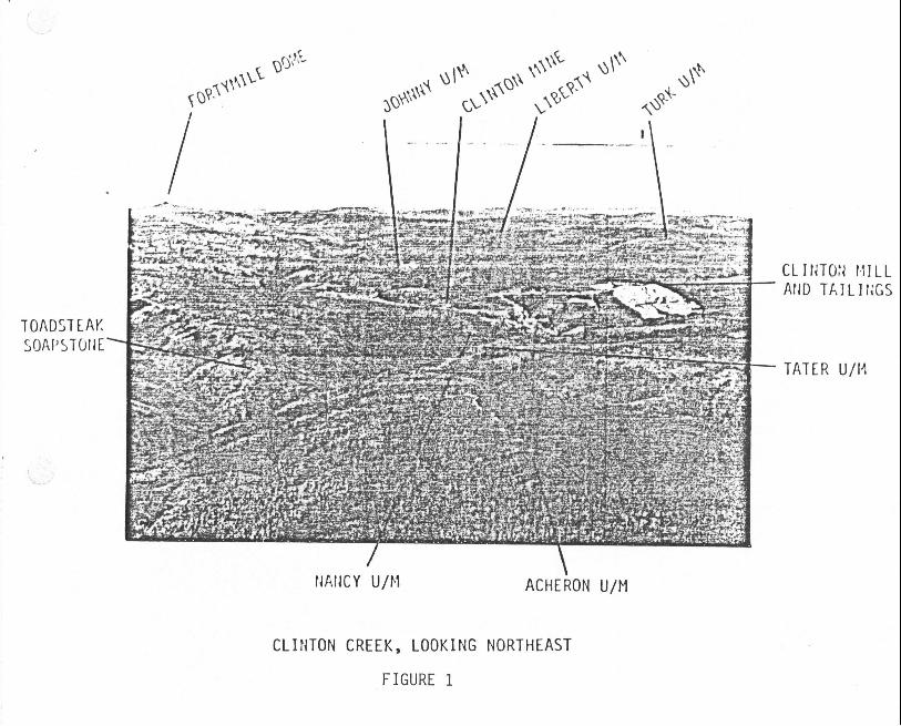
C L I N T O N C R E E K , LOOKING N O R T H E A S T
FIGURE 1
TATER U/I4
\
ACHERON U / M

HISTORY A N D PREVIOUS WORK (ASBESTOS)
Cassiar Asbestos Corp. Ltd.
The discovery outcrops on Snowshoe H i l l were f i r s t s taked i n Apr i l , 1957 by
prospectors G. Walters and A. Anderson, who were grubstaked by Fred Caley, a Dawson
merchant. Caley had optioned claims covering the Caley asbes tos depos i t on Cassiar
Creek t o Conwest t h e previous year and was successful i n s t imu la t i ng i n t e r e s t in
asbestos exp lora t ion among res idents o f t h e Dawson area . The presence of asbestos
i n the Clinton Creek area had been known s ince before 1887, when t he rumours were
reported by t he G.S.C.
Caley's Cl in ton Creek claims were optioned by Conwest soon a f t e r they were
recorded and were t r a n s f e r r e d t o an a f f i l i a t e , Cass iar Asbestos Corp. Ltd., l a t e
i n 1957 following prospect ing and hand t renching. Cass ia r explored with trenching,
diamond d r i l l i n g and two a d i t s (250 m) i n the main (west) zone on Porcupine Creek
'and a 365 m a d i t on a smal ler zone 300 m t o the e a s t on Snowshoe-Hill i n 1957-58.
I n i t i a l r e s u l t s from the .property were disappointing. The a d i t beneath the
h i g h grade outcrops on Snowshoe Hi l l was s i t u a t e d a few metres below the orebody
and the f i r s t a d i t on Porcupine Creek ran out of minera l i za t ion w i t h i n 20 m from
the por ta l . A second a d i t higher on Porcupine Hi l l was very c l o s e t o planned
completion i n barren s e r p e n t i n i t e when t h e f i r s t high grade minera l i za t ion was
encountered. Even so , only about 5 mi l l i on tonnes of ore-grade rock was discovered,
which was i n s u f f i c i e n t t o begin mining operat ion.
The Porcupine u l t r a m a f i t e was poorly exposed except f o r a small f i b r e showing
below a quartz-carbonate outcrop on Porcupine Creek and a s i d e - h i l l vegetation
anomaly along Cl in ton Creek. Hand p i t s

- 4 -
were dug across t h e vegeta t ion anomaly a t 7.6 m i n t e r v a l s but nothing but f i b r e
f i a t was discovered. Thicker overburden on the r idge promoted heavier vegetation
growth than on the s i d e h i l l , g iv ing the impression t h a t t he u l t r amaf i t e was small.
Early dip-needle magnetic surveys on the r idge f a i l e d t o i nd i ca t e the t r u e s i z e
of the u l t ramaf i te and i t was no t u n t i l a f luxgate magnetometer survey was performed
in 1961 t h a t the major por t ion of t he Porcupine u l t r amaf i t e was ou t l ined .
The property remained i d l e u n t i l 1963, when diamond d r i l l i n g resumed t o t e s t
the magnetic anomaly. About 45 sur face holes and 29 underground holes l ed t o the
discovery of the Porcupine orebody and in 1965, a f e a s i b i l i t y study was completed
t h a t reconmended production.
Following a $36.5 mi l l i on investment, mining commenced i n October, 1967 and
f luc tua ted between 3,600 and 4,100 tonnes per day. A t o t a l of 63.3 mi l l ion tonnes
of waste were removed t o permit t h e mi l l ing of 15.9 mi l l ion tonnes of open-pit ore,
fo r a t o t a l production of about 940,000 tonnes of f i b r e . Of this. 12.35 mill ion
tonnes of ore were mined from t h e Porcupine p i t , 3.25 mi l l i on tonnes from the
Snowshoe p i t and t he o the r 0.25 mil 1 ion tonnes from t h e Caley p i t , several miles
away. Operations ceased with t he exhaustion of economic ore reserves in August, 1978.
Throughout t h e production per iod, exploration was r e s t r i c t e d t o t he mine area
and consis ted mainly of de f in ing the ore boundaries and maintaining grade control
within t he Porcupine and Snowshoe reserves. The deepest por t ion of t h e Porcupine
orebody, which plunged t o t h e west and was known as t he Bear Creek depos i t , was
diamond d r i l l e d up t o 1975. I t was found t o contain about 4 mi l l ion tonnes of
ore-grade mineral izat ion but was declared uneconomic because i t required about
60 mi l l ion tonnes of waste s t r ipp ing ,

The Clinton Mine s e r p e n t i n i t e i s one of the l a r g e s t bodies i n the Clinton Creek
camp. I t i s a t l e a s t 1500 m long and 300 m wide a t the mines i t es and may have
extended a s f a r a s the s e r p e n t i n i t e bodies on Trace Hi l l and Wolverine H i l l ,
over a ki lometre t o the no r thea s t , p r i o r t o downcutting of Cl in ton and Wolverine
Creeks. The s e r p e n t i n i t e bodies host ing the Snowshoe and Porcupine p i t s a r e
contiguous, but t h e Snowshoe por t ion i s only an eros ional remnant l e s s than 100 m
thick. The Tater ul t r amaf i t e i s a smaller body t h a t probably separated from the
Cl inton ul tramafi t e p r i o r t o emplacement.
The Porcupine s e r p e n t i n i t e was found t o be a dome-shaped body 1,500 m long
and 300 m wide t h a t plunges t o the southwest a t about 20" beneath enveloping
g raph i t i c shale. Most of the body consis ted of pa r t l y - t o highly-sheared, barren
s e rpen t i n i t e w i t h several small l en se s of marginal-grade, blocky s e rpen t i n i t e
sca t t e red throughout. The commercial grade zone was r e s t r i c t e d t o the periphery
of the u l t ramaf i t e and ranged in d i p from 40" NW a t the no r thea s t end t o nearly
ve r t i ca l toward Bear Creek. The mineable por t ion was from 15 t o 75 m wide,
decreasing a t depth , and had a s t r i k e length of about 300 m. The southwestern
extension (Bear Creek zone) was t raced by d r i l l i n g f o r ano ther 200 m and i s s t i l l
open t o depth.
Other explora t ion c a r r i e d ou t by Cass iar during t he development and mining
period i ncl uded :
(a ) Mine Lease
( 1 ) Diamond d r i l l i n g on Trace H i l l , near t h e m i l l s i t e - about 6 holes.
( 2 ) Diamond d r i l l i n g and t renching on Wolverine H i l l , a c ro s s Clinton Creek
from the Snowshoe P i t - 4 holes.
( 3 ) Ground magnetometer surveys of p i t a reas and t h e Nancy ul t ramafi te .
( 4 ) Ground magnetomer survey and some trenching on the Tater u l t ramafi te .
(b) Surrounding Area
(1) Staking and trenching of the Judy serpent ini te , 5 km eas t of the mine.
(2) Staking a n d magnetometer surveys of the Turk serpent in i te , west of the
air2ort (now Turk claims).
( 3 ) Stzking of the Bi l l s e rpen t in i t e , northwest of the Johnny showing.
( 4 ) Prcspecting elsewhere in the camp with two-man teams between 1958 and 1963.
Cassiar geologists a l so v i s i t e d a l l other exploration propert ies i n the area
tha t were being investigated by o thers and were prepared t o option any property
tha t showed merit: Exploration a c t i v i t y died down short ly a f t e r the mine opened,
however, and no option agreements were ever made.
Exploration 3y Others
The ear l ies t reported asbestos discovery away from the Clinton Mine was located
on the west bank of the Yukon River, about 3 km south of Fortymile. I t was staked
i n i t i a l l y in 1895, restaked as the Aurora claims in 1912 and subsequently restaked
as the Verl~ne claims in 1928. The 1912 claim application s ta ted t h a t t h i s was
an asbestos occurrence. Chrysot i le f i b r e up t o 5 rnm long occurs a t t h i s loca l i ty .
I t i s associated with f ibrous tremol i t e i n two small, highly sheared, ultramafite
bodies, one of which i s capped by Ter t i a ry columnar Sasal t . Much of the chrysot i le
i s s l i p fibre and to ta l f i b r e content i s l e s s than 1%. The showing has no current
economic potential.
Modern exploration in the camp da tes from the optioning of the Caley and Clinton
asbestos discoveries by Conwest i n 1956 and 1957, respectively. Some of the most
aggressive early grass-roots asbestos exploration in the camp, however, was
conducted by a jo in t venture between Asbestos Corp. Ltd. and Yukon Consolidated
Gold Corp. Ltd. (Y .C.G.C.), which car r ied out an aeromagnetic survey of the

Clinton Creek val ley in e t r l y 1957 and s t aked many of the magnetic anomalies and
exposed ul t ramafi tes near the Cl inton Mine. By 1964, the j o i n t venture had performed
gr id magnetometer surveys and mapping on s eve ra l u l t r amaf i t e s , including the Liber ty ,
Tipp, T u r k and Easter ; trenching on the Acheron t a r g e t ; and trenching and d r i l l i n g
on the Foxy t a rge t . No i r po r t an t a sbes tos occurrences were found and the p ro jec t
was terminated.
Other work performed in t he camp i s t abu l a t ed below:
( 1 ) Mag survey and trenching of the Johnny u l t r a m a f i t e by Canex Aerial Exploration
Ltd. i n 1958. >
( 2 ) Aeromagnetic survey of the Cl inton v a l l e y and follow-up ground mag surveys
of t he T u r k , Liberty, Acheron and B i l l t a r g e t s i n 1966 and 1967 by Sphere
Development Corp. L t d .
( 3 ) Bulldozer trenching of the Eas te r u l t r a m a f i t e by Voels In ternat ional Development
L t d . i n 1967.
( 4 ) Bulldozer trenching 2nd diamond d r i l l i ng ( 3 ho les ) on the Acheron ul t r amaf i t e
by Acheron Mines Ltd. i n 1971 and 1972, and add i t iona l trenching by Pan Acheron
Resources Ltd. i n 1976.
( 5 ) Magnetometer survey on t he L iber ty u l t r a m a f i t e by Minas de Cerro Dorada Ltd.
i n 1973.
Summary
The d i f f i c u l t y t h a t b;as experienced i n l oca t i ng asbestos mineral i z a t i on beneath
overburden i s r e f l e c t ed in the f a c t t h a t t r ench ing was r e s t r i c t e d t o the bes t exposed
port ions of th ree ul t ramafites. Only t h e Foxy and Acheron ul t ramafi tes were ever

dr i l l ed - t he Foxy w .h two I
- 8
diamond d r i 11 holes (3024 m ) ; and t he Acheron w
three diamond d r i l l holes (277 m). A 1 though r e s u l t s were disappoint ing, the
d r i l l i n g was d i rec ted only by magnetometer work and was i n s u f f i c i e n t t o t e s t t h e
t rue potent ia l of e i t h e r u l t ramafi te . None of the other t a r g e t s i n the region
were s u f f i c i e n t l y exposed t o s t imulate even minimal physical work and most were
v i r t ua l l y unexplored when the Clinton Mine closed i n 1978.

GEOMORPHOLOGY
The Tater claims are situated within the unglaciated portion of the
Yukon Plateau which i s marked by poor bedrock exposures. Regional up1 i f t in
the l a t e Tertiary, together with disrupted drainage patterns to the east
caused by glacial advance in the Pleistocene from the Ogilvie Mountains, has
resulted in substantial rejuvenation and some disruption of the drainage system.
Major t r ibu ta r i e s , such as Clinton Creek, are incised into steep, V-shaped valleys
with low gradients and steep headwalls.
The Tater claims cover a l l three elements of te r ra in in t h i s d i s t r i c t -
plateau, incised val 1 eys, and a1 1 uvial terraces. Gravel s resembl i ng the Kl ondi ke
White Channel Gravel are present a t about 700 m elevation on the Clinton Mine
lease and probably extend onto the Tater claims a t s imilar elevations. Clay i s
comnon in overburden below the 700 m elevation and may be al luvial in origin.
Vegetation consists of thick black spruce, a lder , aspen and poplar except on
the moss-covered, north-facing slopes where permafrost occurs.
REGIONAL GEOLOGY
The Clinton Creek camp i s s i tuated within the Yukon Plateau and i s sharply bounled
t o the northeast by the l a t e Cretaceous Tintina Faul t . The d i s t r i c t has a complex
geological history r e su l t ing from tectonic a c t i v i t y t h a t has thoroughly deformed
and intermixed several major rock assemblages. Ages a r e d i f f i c u l t t o estimate
since the fossi l record has been obliterated by deformation and regional metamorphism
and contacts are obscured by overburden cover.

Rocks in t h i s region have been subdivided by government geologists i n t o three
major packages: Nasina S u i t e (OSD) ; Anvil Allochthon (CPv); and, Klondi ke Schis t
( ~ P K ) . I n the continental col 1 i sion model proposed by Tempelman-Kl ui t ( l 9 7 9 ) ,
the Nasina Suite represents t h e North American p la te margin material . The Anvil
A1 1 ochthon and Kl ondi ke S c h i s t represent seafl oor materi a1 and continental
"Stikinia" plate rocks obducted onto the North American plate during a c o l l i s i o n
in ~ u r a s s i c ( ? ) time. The t h r u s t fau l t ing associated with the col 1 i s ion resul ted
in complex interf ingering of t h e three uni t s , destruction of sedimentary fea tures
and development o fvew c a t a c l a s t i c textures .
Anvil Allocthon
Creek cmp, these rock types a r e usually present as t h e i r
serpentini t e with associated hornblende d ior i t e , amphi bol
The ophiolite assemblage has become highly dismembered by
serpentini t e bodies a re enveloped in graphi t ic schis t s of
The allochthonous ove r th rus t block consis ts of an ophiol i te s u i t e composed
of alpine-type ul tramafi t e , gabbro, basa l t , chert and 1 imestone. In the Cl inton
metamorphosed equivalents:
i t e , and c h l o r i t e schis t .
thrust ing and most
the Nasi na Sui te .
The ul tramaf i t e s (CPub) a r e typica l ly f a i r l y small bodies composed of massive,
dark green, f ine t o medium grained magnetic serpent in i te derived from both
peridotite and dunite. Most of them a re highly sheared, re f lec t ing a s t r e s s f u l
emplacerent, and a r e enclosed i n metamorphosed host rocks. No re la t ionship has
been established ye t t o l i n k t h e metamorphic grade of surrounding rocks t o f i b r e
developnent within serpent i ni t e . However, i t seems probable tha t strong shearing
in the wall rocks i s important i n creating islands of unsheared serpent in i te within
which tensional f r ac tu r ing and f i b r e veins can develop.

Cross f ibre veins in commercial-grade mineralization seldom show s t r a in ing
or strong disruption except within loca l ized shear zones, indicating they formed
a t a l a t e stage in the emplacement and a l t e r a t i o n of the ultramafite. In the Clinton
Creek and Caley orebodies, blocky f r ac tu r ing with cormercial f i b r e lengths and
These zones a r e
l e t h a t a r e typical
quant i t ies constitute l e s s than 10 per cent of the serpentinite.
surrounded by sheared va r i e t i e s of s e r p e n t i n i t e such as fish-sca
of other bodies in the camp.
Some serpentinite bodies contain augen-like bodies of r e l i c , massive serpent ini te
or lens-shaped bodie's of d i o r i t e . A few of the massive lenses , such as those a t
the Tjop property, contain cross f i b r e veins t h a t may have formed during o r short ly
a f t e r emplacement. Some of the f i b r e veins near the edges o f these bodies a re
highly deformed and drawn out. S imi lar ly , f i b r e veins tha t formed in the black
wall alteration zones surrounding d i o r i t e lenses (black pods), such as those a t
the Toc property, often exhibi t curved veins and chrysotile f i b r e s t h a t a r e bent
in the direction of movement. Both types of bodies are usually too widely dispersed
through a sheared serpent in i te t o have economic importance.
The margins of many serpent in i te bodies a r e altered to soapstone; f o r example
a t the Tjop and Tiza properties. This suggests tha t temperatures exceeded 400°C
for a short period a f t e r emplacement, probably during regional metamorphism. Quartz-
carbonate al terat ion, which cons is t s of rnagnesite, t a l c and opaline s i l i c a t e s ,
i s common and i s probably a l so a post-mineralization event since the a l t e r a t i o n
i s sometimes pseudomorphic a f t e r ch ryso t i l e f ib re . Transformations from serpent in i te
to quartz-carbonate a re displayed best in the Clinton Creek Mine, where long f i b r e
veins can occasionally be traced from- se rpen t in i t e into highly a l te red rock. This
i s a gradual change from s i lky ch ryso t i l e t o harsh opal along the veins and i s
n o t accompanied by physical disrupt ion.
Fine t o medium grained, 1 i g h t grey t o dark green, b i o t i t e o r hornblene-rich
d i o r i t e s occur along with t h e u l t r amaf i t e s a t severa l loca t ions and a r e usual ly
considered t o be par t of t he Anvil Allochthonous s u i t e . The d i o r i t e s occur a s
small lens-shaped bodies o r "dykes" t h a t a r e enclosed by s e r p e n t i n i t e and o f ten
a re associated with bl ack-pod mineral i z a t i o n , a s a t t he Toc property. A1 t e rna t i ve ly ,
d i o r i t e forms la rge , stock-1 i ke bodies up t o several hundred metres a c ro s s adjacent
t o the ul t ramafi tes , a s a t t h e Tjop proper ty . Contacts between the l a r g e r bodies
of d i o r i t e and s e rpen t i n i t e a r e usua l ly a l t e r e d t o quartz-carbonate, whereas t he
smaller dykes usually exh ib i t "blackwall" a l t e r a t i o n . This suggests t h a t the d i o r i t e s
a re s l i g h t l y younger than t h e u l t r amaf i t e s . The smal les t dykes a r e usua l ly enveloped
by highly sheared s e rpen t i n i t e and appear t o have been squeezed and dismembered
in to t h e i r present lensy form by s t rong t e c t o n i c fo rces .
Nasina Su i te --
The Nasina s u i t e has been defined by Tempelman-Kluit (1976) a s a d i s t a l sequence
of carbonaceous and quar tz- r ich sedimentary rocks. They have been mostly metamorphosed
t o greenschist f a c i e s and now c o n s i s t of pa le green quar tz-mica-chlor i te s c h i s t ,
grey t o s i lve ry coloured quartz-muscovite s c h i s t , g r aph i t i c s c h i s t , c h l o r i t i c q u a r t z i t e
and minor quar tz -b io t i t e gneiss . Although t h e sequence is not well understood
and corre la t ions a r e d i f f i c u l t t o e s t a b l i s h , a t e n t a t i v e age of Ordovician t o
Devonian has been assigned t o t he Nasina. Rubidium/strontium and potassium/argon
age determinations by Htoon (1979) near t h e Cl inton Mine suggest a Permian age,
although one sample of b i o t i t e s c h i s t re turned a rubidium/strontium age of 470 ma,
which i s Ordovician. The younger da t e s poss ib ly r e f l e c t the da t e of l a t e s t
metamorphism or of regress ive ( b i o t i t e t o c h l o r i t e zone) metamorphism, whereas
the Ordovician da te may r e f l e c t t he age of depos i t ion o r of e a r l i e r metamorphism.

Preliminary mapping by J.G. Abbott of DlAND i n the v i c in i ty of Clinton Mine
during 1981 revealed the presence of s l i g h t l y metamorphosed carbonaceous mudstone,
limy sandstone and tuffaceous phyl l i te t h a t he t e n t a t i v e l y assigned t o the Nasina
su i te . These rocks probably represent the unmetamorphosed equivalents of the common
Nasina su i t e rocks. They resemble rocks mapped elsewhere in Yukon tha t a re Triassic
in age, although no f o s s i l s have been found in the Clinton Creek camp yet. Abbott
was able t o demonstrate f a i r l y conclusively t h a t the Nasina s u i t e underlies the
allochthonous assemblage and concluded t h a t the graphi te sch i s t adjoining the
orebody was derived from Nasina rocks.
Klondike Schist
The Klondike s c h i s t i s a ca t ac la s t i c rock t h a t i s thought t o be derived from
f e l s i c intrusive rocks. In the Clinton Creek camp, quartz-rich ca tac las t ics ,
gneisses and quartz-muscovite ca t ac la s t i c s c h i s t a r e common. Age relationships
are d i f f i c u l t t o determine as the Klondike s c h i s t s cannot be related to other rock
units. Radiometric ages of 138 and 145 ma were obtained from samples of ca t ac la s t i c
material by Tempelman-Kl ui t (1976). These dates a re 1 a t e Jurassic and probably
r e f l ec t the time of cataclasism.
Igneous Rocks
Igneous rocks in the b e l t consist of lower Cretaceous b i o t i t e granodiorite
and quartz monzonite and Tert iary feldspar porphries. These have been combined
for simplicity on Figure 3 as uni t Tqfp b u t a re d i f f e ren t i a t ed on GSC Map 1284a.
One of the largest quartz rnonzonite stocks in the d i s t r i c t i s located about 2 km
west of the Tjop claims. I t consists of plagioclase, b i o t i t e and altered grains
of hornblende with minor amounts of potash fe ldspar , quartz and magnetite.

Grani t i c gneiss and amphibol i t e have developed along con t ac t zones. The eas tern
contact of t h i s body was explored f o r tungsten minera l i za t ion by Noranda during 1981.
Small bodies of fe ldspar porphyry occur throughout t h e region. These rocks
a r e character ized by phenocrysts of f e l d spa r and quar tz up t o several mm i n length
in a l i g h t grey t o grey-green, f i n e grained groundmass. One of t he l a rge s t of
these porphyry bodies, on Cass ia r Dome, was staked by Cominco f o r molybdenum-
tungsten po ten t ia l a s the P lu to claims and was d r i l l e d in 1981. A porphyry dyke
a t the southeas t corner of t he Tjop claims was staked i n 1927 f o r sulphide
mineral iza t ion a s t h e Roal occurrence ( s e e 1979 TJV Final Repor t ) . Also, basa l t
associa ted with a small porphyry dyke on t he Thane g r i d a r ea was found t o contain
t r a ce s of uranium minera l i za t ion . The porphyry bodies a r e probably more numerous
than was previously known and some may host important base metal mineralizat ion.
01 iv ine b a s a l t (Tv) occurs l oca l l y i n the region and is probably the youngest
rock type as i t ove r l i e s a l l o t he r u n i t s .
References
Htoon, M. 1979: Geology of the Clinton Creek asbestos d e p o s i t , Yukon Ter r i to ry ;
unpublished M-Sc. Thesis , Universi ty of British Columbia
Tempelman-Kl u i t , D. J . 1976: The Yukon c r y s t a l l i n e t e r r ane : Enigma i n t h e Canadian Cordi l lera ;
Geological Socie ty of America Bu l l e t i n , v. 87, pp. 1343-1357.
1979: Transported c a t a c l a s i t e , oph io l i t e and g r anod io r i t e i n Yukon: Evidence of a rc -con t inen t c o l l i s i o n ; G.S.C. Paper 79-14.

GEOLOGY A N D MINERALIZATION
Talus composed of highly sheared and well serpentinized ultramafite fragments
i s exposed on a steep h i l l s ide for a b o u t 100 m along the mine road in the south-
central portion of the claims. I n addition, some serpent ini te chips were
discovered along an old bulldozer t r a i l on the ridge between Tater and Eagle
Creeks, which i s mainly overburden covered. The ultramafite i s apparently large
and may extend a l l the way from the mine road t o the bulldozer t r a i l on the ridges.
The serpent in i te seen was essentially barren and very few of the talus pieces
examined contained any v is ib le f ibre . The largest vein seen was only about 10 cm
long and 3 mm wide. The fragments were generally highly weathered b u t did not
display any "blocky" surface features t h a t can sometimes be a t t r ibuted t o
weathered-out asbestos veins. However, these ultramafites strongly resemble
those found in the sheared, footwall waste rocks of the Porcupine P i t only 3 km
t o the west, and be t te r mineralization may be present a t depth or covered by
overburden higher on the hi1 1 side.
Surrounding rocks a re mainly graphitic schis t s and ch lo r i t e schis t s of the
Nasina Series and Anvil Series, respectively. Rock exposures a re mainly limited
t o along the mine road b u t i t i s evident tha t these rocks a re highly thrust
fauled and thoroughly intermixed; however, Nasina Series graphi t ic schis t i s
usually found adjacent to the ul tramaf i t e , where exposed.

FIBRE DISPERSION SURVEY
Soil sampling grids were established throughout the Clinton Distr ic t in 1981
to investigate anomalous s i l t and soi l responses from reconnaissance traverses
performed ea r l i e r . The Tater grid consisted of two surveyed picket l ines total l ing
6.3 km t ha t were cut 900 m apart . Samples were collected on flagged compass l ines
normal to the baselines that were extended to the edge of the claims on e i ther side.
About 750 soil samples were collected from the gr id. No trenching was performed
because sample analysis was delayed until a f t e r the end of the f i e ld season.
Anomaly M consists of two so i l l i nes with extremely high point scores a t the
northeast corner of the Tater claims. The high scores probably resulted from
poor sample collection techniques in an area sens i t ive t o airborne contamination.
Point scores of u p t o 267b (9.2 mm) and 428c (8.1 m m ) occur along b o t h l i nes b u t
n o t in s o i l s from adjacent l i nes . These s o i l s were collected by an inexperienced
sampler and may have been contaminated with surface organic material. This area
i s par t icu lar ly susceptible t o airborne contamination because i t i s s i tua ted l e s s
than 2 km eas t of the Clinton mill and mill t a i l i n g s . Nearby s o i l s col lected by
other samplers normally contain no f i b r e , although a few e r r a t i c "d" samples with
high points are present on nearly every 1 ine on the grid. The anomalous 1 ines
should be resampled and the grid should be extended t o the northeast.
Anomaly N i s a large, kidney-shaped col lec t ion of so i l s that occurs a t the
southern end of the Tater claims.and extend t o the west onto the mine lease,
The anomaly i s s t i l l open t o the e a s t where i t crosses onto unstaked ground. '

ous so i l s c l u s t e r i n t o roximately th ree posi t ions across the anomaly.
A t the northwestern edge, point scores up t o 166a a r e fr inged uphill and t o the
e a s t by s o i l s w i t h "b" a n d "c" q u a n t i t y values . The highest values occur within
100 m of the Clinton road and could be caused by contamination from the mine road.
The cen t r a l anomalous c l u s t e r i s over a vege t a t i on anomaly and i s underlain by
sheared s e r p e n t i n i t e . Point scores a r e g e n e r a l l y low but e r r a t i c po in t values
u p t o 92a occur near the northern p a r t of t he vegeta t ion zone. The extreme
par t of the anomaly has small c l u s t e r s of s o i l s with point scores up t o 84a
this area and t he vegeta t ion anomaly, p o i n t s range from 40d t o 80c.
eas te rn
. Between

CONCLUSIONS AND RECOMMENDATIONS
The Ta te r c la ims cover a
body 1 ocated on a steep h i 11 s
p o o r l y exposed, b u t p o t e n t i a l l y l a r g e , u l t r a m a f i t e
i d e l e s s t han 2 km f rom t h e former C l i n t o n m ines i t e .
U l t r a m a f i t e t a l u s on t he c l a ims c o n s i s t s of s e r p e n t i n i t e f ragments t h a t a r e g e n e r a l l y
devo id o f v i s i b l e f i b r e b u t s t r o n g l y resemble t h e k i n d of s e r p e n t i n i t e t h a t formed
t h e f o o t w a l l rocks a t the Porcupine P i t .
H igh p o i n t values f rom s o i l - c o v e r e d a reas may i n d i c a t e t h a t l o n g - f i b r e
asbestos m i n e r a l i z a t i o n i s p resen t i n u l t r a m a f i t e s b u r i e d beneath the overburden
o r may r e f l e c t o n l y a su r f ace c o n c e n t r a t i o n o f s e t t l e d - o u t f i b r e s t h a t were
and m i l l i n g opera t ions nearby.
i n g and hand p i t t i n g i s recommended t o expose
and eva lua te t h e bedrock i n t h e most anomalous areas.
r e l eased t o t h e atmosphere by t h e
A one week program o f t r e n c h
fo rmer m in ing
Respec t f u l 1y submit ted,
ARCHER, CATHRO & ASSOCIATES (1981) LIMITED
J.S. Murray

STATEMENT OF QUALIFICATIONS
J. S c o t t Murray
S c o t t Murray was r a i s e d a t Abbo ts fo rd , B.C. and a t t ended U.B.C., B.C.I.T.
and S e l k i r k Co l lege . He was employed by Cass ia r Asbestos Corp. f rom 1973 t o
1978 as a g e o l o g i c a l t e c h n i c i a n a t b o t h t h e C a s s i a r and C l i n t o n Mines. Dur ing
t h i s p e r i o d he was engaged i n a l l phases o f mapping, su r vey ing , grade c o n t r o l
and e x p l o r a t i o n f o r asbestos f i b r e . From 1979 t o p r e s e n t M r . Murray has superv ised
asbestos e x p l o r a t i o n f o r Archer, Ca th ro & Assoc ia tes (1981) L i m i t e d .
J. S c o t t Mur ray

APPENDIX

APPENDIX 1
FIBRE DISPERSION SURVEYS
THEORY
Fibre dispersion surveys take advantage of the f a c t t ha t chrysot i le i s chemically
r e s i s t an t t o weathering and maintains i t s f ibrous in t eg r i ty during weathering and
erosion. Thus, f ibre can be detected in s o i l s whether i t i s being dispersed by
normal residual erosion in unglaciated areas , such as the Clinton Creek camp, o r
by glacial scouring. Experience has shown tha t chrysot i le f i b r e i s so much more
r e s i s t an t t o weathering than i t s hos t serpent in i te t h a t i t can be found i n s o i l
in areas tha t are devoid of obvious se rpen t in i t e outcrops or ta lus .
In theory, the amount of f i b r e i n the soi l should be d i r e c t l y proportional
to the amount of underlying minera l iza t ion , since the bulk of the f i b r e occurs
in simple veins tha t break apa r t r ead i ly when subjected t o weathering. Like
conventional geochemical surveys, however, simple dispersion patterns and s t rongly
anomalous contrasts only occur around buried f i b r e occurrences tha t a re covered
by simple soi l profiles. TJV sampling has shown t h a t a l l se rpent in i te bodies
contain f ib re a n d t ha t even those t h a t a r e apparently unmineralized have a low
background level that i s detectable i n s o i l .
Fibre veins pinch and swell , and a r e usually divided along t h e i r length by
a central parting. Weathering of ch ryso t i l e mineralization f r e e s f i b r e veins from
the walls a n d breaks t h e i r par t ings , causing the veins to d is in tegra te i n t o rod-
shaped fragments called f i b r e bundles ( o r spicks) . Further weathering wil l cause
these bundles to s p l i t lengthwise i n t o thinner strands called f i b r i l s . Experience
has shown that individual f i b r i l s a r e unusually strong and tha t they wil l seldom
break transversely, a1 though they can spl i t 1 ongi tudinal ly in to thinner f i b r i 1 s .

In s o i l s , the longest f i b r i l s r e f l e c t t he maximum width of veins between pa r t i ngs ,
but seldom the dis tance between t h e vein wa l l s .
Much of what i s known about t h e r e l a t i o n s h i p between length and quan t i ty i n
a f i b r e deposit has,come from m i l l i n g p r a c t i s e . TJV has assumed t h a t t he weathering
of f i b r e is analagous t o t he m i l l i n g of f i b r e t o produce a commercial blend of
l eng ths . Milling experience has shown t h a t f i b r e lengths in a deposit a r e inverse ly
proport ional t o the quan t i ty of s h o r t f i b r e s , and t h a t t h e t o t a l quanti ty of f i b r e
i n t h e rock i s roughly propor t ional t o f i b r e length . This suggests t h a t , under
most condi t ions , the number of f i b r e veins t h a t develop i n a block of s e r p e n t i n i t e
i s f a i r l y constant and t h a t t h e main v a r i a b l e i s f i b r e length (vein th ickness ) .
T h u s , i f conditions a r e favourable , longer f i b r e s wi l l form i n many of t he f r a c t u r e s ,
thereby increasing both the average length (and value) a s well a s the proport ion
of t h e rock t ha t i s f i b r e ( o r e ) . When condi t ions a r e unfavourable, only s h o r t
f i b r e wi l l form and the t o t a l f i b r e content of t he rock wi l l remain low. The v a l i d i t y
of th i s concept i s confirmed by t h e f a c t t h a t long f i b r e s a r e seldom found i n lower
grade ores .
The laboratory technique and i n t e r p r e t a t i o n methods used by TJV have been designed
t o i d e n t i f y samples t h a t conta in longer f i b r e s and, by de f i n i t i on , have a b e t t e r
p robab i l i t y of having been der ived f r ~ m commercial mineral iza t ion. Most commercial
depos i t s contain abundant 6 .5 mm f i b r e . For example, Group 5 spec i f i ca t ions s t i p u l a t e
t h a t about 20% must exceed t h a t l eng th . Since 6.5 mm f i b r e s a r e ra re i n TJV samples
and have only been found i n samples co l l e c t ed near important occurrences, t h a t
length has been chosen a s an important th resho ld i n f i b r e dispersion surveys.

POINT VALUES
In the TJV sampling, i t has been found t h a t most samples contain l e s s than
100 f i b r e s and t h a t quan t i t i es exceeding 10,000 f i b r e s a r e only obtained when
sampling has encountered a f i b r e mat. A f i b r e mat i s f a i r l y uncommon in TJV
sampling, e i t h e r because the sample cannot be col lected deep enough o r because
there is i n su f f i c i en t f i b r e in bedrock. Al ternat ively , some s o i l s a r e too mixed
by sol i f l uc t i on t o permit the development of a mature p ro f i l e . As a r e su l t , most
samples do not contain enough f i b r e s t o be sure t h a t the longest f i b r e present in
the bedrock source a r e represented.
For example, the probabil i t y of col lect ing a f i b r e 6.5 mm long in so i l over
asbestos veins containing some f i b r e s 6.5 mm long i s high i f the sample contains
over 10,000 f i b r e s (a f i b r e mat) b u t i s poor i f the sample contains only 10 f ib res .
To overcome t h i s d i f f i c u l t y , a "point" value i s ca lcula ted by the laboratory
a t Kamloops which u t i l i z e s standard re la t ionships between f i b r e lengths and quan t i t i es
and g rea t l y s impl i f ied the in terpreta t ion of so i l r e su l t s .
By permitting the comparison of samples containing d i f f e r e n t quan t i t i es of f i b r e ,
the points help t o overcome the f i e l d d i f f i c u l t y of co l lec t ing samples of uniform
qua1 i t y .
Using the example quoted above, the sample containing 10 f i b r e s and a longest
f i b r e of 3.2 m would have the same point s co re (50 po in t s ) a s the f i b r e mat sample
with 10,000 f i b r e s and a maximum length of 6.5 rnm. A point score of 50 seems t o
be a good threshold value s ince nearly a l l s o i l s t e s t e d from commercial-grade
asbestos showings have scores of 50 o r more.

Field test ing of t h i s method in 1981 showed tha t i t loses i t s s t a t i s t i c a l
validity once the number of f ib res in the soi l f a l l s t o a low level . For example,
a soil sample containing only three f ibres will give a point score of 34 i f the
longest f ibre i s 2 mm long, b u t a much higher score of 75 i f the longest f i b r e
measures 3 m.
To overcome t h i s weakness, i t was necessary t o r a t e samples according t o the
number of f ibres present by adding a suff ix t o the point number. Points with an
"a" suff ix have the highest r e l i a b i l i t y and those marked "d" the lowest, as shown
below:
Suff ix Fibre quanti tylsampl e
a more than 100 f i b r e s
10 to 99 f i b r e s
4 to 9 f i b r e s
1 to 3 f i b r e s
Samples with quantity "a" a re usually collected where s o i l s a r e thinnest over
ultramafites. Soi ls wi th "d" ra t ings generally f r inge u l t ramaf i te bodies, contain
spurious f ib re because of contamination, or re f lec t deeper and more complex over-
burden profi les . For a given u l t ramaf i te , scores derived from "a" s o i l s and from
"d" s o i l s will be roughly s imi lar but the "d" scores wi l l be more e r r a t i c . S t a t i s t i c s
show tha t over 90% of a l l "d" scores were less than 50 points and f i b r e s 3 rnm or
more i n length seldom occur i n "d" s o i l s . A graph of point value frequencies f o r
each quantity suff ix i s shown on Figure 2 on the following page.

POINT VALUE FREQUENCIES
Quantity suffixes
a
b
C
d TOTAL
No. of samples

ARCHER, CATIIRO ASSOCIATES (lQ8l) LIMITED
CONSULTING GEOLOGICAL E N G I N E E R S 9
BOX 4127, 3125 T H I R D AVENUE W H I T E H O R S E . Y T Y I A 359 (403) 667-4415
AFFIDAVIT
I , Joan Mariacher, o f Whitehorse, Y.T., make oath and say:
That t o t h e bes t o f my knowledge the a t tached Statement o f
Expendi tures f o r exp lo ra t i on work on t h e T a t e r 1-28
minera l c la ims on Claim Sheet 116C/7 i s accurate.
Sworn b e f o r e me a t Whitehorse, Y.T.
t h i s 1 s t day o f October, 1982.
, 7 / jj. i c L i i Notary, Yukon T e r r i t o r y
1016 - 510 WEST HASTINGS STREET. VANCOUVER. 8. C. V 6 B IL8 (604 ) 6 8 8 - 2 5 6 8

Statement of Expendi tures F i b r e Dispersion Geology
T a t e r 1-28 Claims May 25, 1982
Labour
Ju ly 13 - 20, 1981 $ 2,007.00
Expenses
Room and board - 19 mandays a t $35/day $ 655.00 Geotor S e r v i c e s Inc. - 750 a s s a y s a t
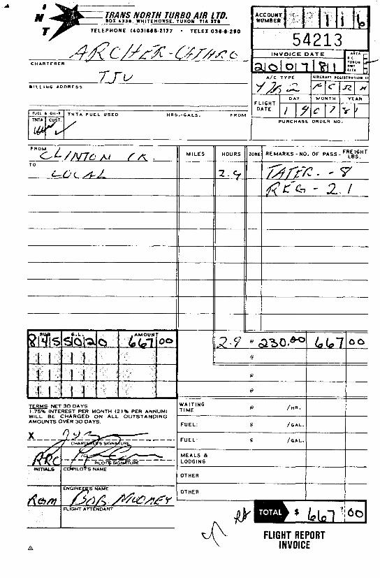
$7/sampl e 5,250.00 Trans North c o n t r a c t Bel l 47G3/B2 -
5.7 hours a t $322/hour i nc lud ing f u e l 1,835.40 Report p r epa ra t i on 1,000.00 8,740.40
Tota l $10,747.40

In Account With
total 3 days at $ 35- /day Field wui~ment f r a n AC stock - . Xerox copies, by 9 copies at 29 C'/~opy f 7 3 r 7 ~ . Radio rental 5 !?x 10 u\\ -31 2 0 1 ~
Total

In Account With
MANAQEMENT ,
LABOUR Supervwy
EXPENSES Accounting Drafting,5s'/zhrs. at Lk /hr. *,
Xerox copies, 3 3 1- copies a t 2 5 7 /copy Petty cash 2 . U f 7.00 f /+oo
- Telephone 3 . +@
& el- / /
- Total

GEOTOR SERVICES INCORPORATED 485 - 12th AVENIJE
K ~ ~ ~ ~ ~ ~ ~ , B.C. V X ARCHER CATHA0 II ASSOC. LTD.
GEOTOR SERVICES INCORPORATEL!
R E D I F O R M - 7M31

s t * r ,LL -:,.- - .- .- A - . - - - - -
ADDREST VIA

T I - 0 B I L L I N G A D D R E S S
N E T 30 D A Y S 1.75% I N T E R E S T P E R M O N T H (21% P E R A N N U M I W I L L B E C H A R G E D O N A L L O U T S T A N D I N G A M O U N T S O V E R 30 D A Y S
ENGINEER'S NAME
T N T A F U E L U S E D H R 6 . - G A L S . P R O M NEL ' OnL-'-
-1 NUMBER
TNTA CUST.
/
WAITING TIME e /HR.
FUEL: e /GAL .
- ,
M I L E S
F U E L . e / G A L . ]
P U R C H A S E ORDER NO.
I M O N T H
'L IGHT mTE
I I M E A L S & LODGING
I - YEAR
I7yI/
D A Y
1 7 c i
I#
HOURS
OTHER
OTHER
FLIGHT REPORT INVOICE
ZONE R E M A R K S - N O . OF PASS - FT\F,HT
CHARTERER u
BILLING ADDRESS
FLIGHT
* O1L-' TNTA FUEL USED HRS.-GALS. FROM PURCHASE ORDER NO,
FROM
TO
NET 3 0 DAYS 1 75% INTEREST PER MONTH (2196 PER ANNUM) WILL BE C H A R G E D O N ALL O U T S T A N D I N G AMOUNTS OVER 3 0 DAYS
I ENGINEER'S NAME
REMARKS - N O . O F PASS - FRti:.HT
'UEL' 0 / G A L .
'UEL. 0 /GAL.
AEALS & .ODGING
ITHER
c
,darn FLIGHT A r r e ~ o ~ M
h
FLIGHT REPORT INVOICE

CHARTERER
-4
B I L L I N G ADDRESS
, OIL-l T N T A F U E L U S E D HRS. -GALS. F R O M
F R O M
T O
N E T 30 D A Y S 1.75% INTEREST PER M O N T H (21% P E R A N N U M ) W I L L BE C H A R G E D O N A L L O U T S T A N D I N G A M O U N T S O V E R 30 D A Y S .
M I L E S HOURS ONE REMARKS - N O . OF PASS - Fyi':"T
WAITING T I M E @ I F U E L : 6' /GAL. / I F U E L : 6' I
I I
M E A L S & LODGING
OTHER
I I
OTHER I I
FLIGHT ATTENDANT - \
I v p." FLIGHT REPORT
INVOICE

?-
B I L L I N G ADDRESS
* T N T A F U E L U S E D HRS. -GALS. F R O M
THTA CUST.
M I L E S HOURS
.-I NUMBER
N E T 30 D A Y S W A I T I N G 0 /HR.
1 75% INTEREST PER M O N T H 121% P E R A N N U M ) W I L L B E C H A R G E D O N A L L O U T S T A N D I N G
F U E L @ /GAL.
0 /GAL.
, L O D G I N G
I 1 OTHER I I ENGINEERS NAME OTHER
R~)c;m
FLIGHT REPORT A
INVOICE

B I L L I N G A D D R E S S
m: NET 30 D A Y S 1.75% INTEREST PER MONTH (21% PER ANNUM) W I L L BE CHARGED O N ALL OUTSTANDING AMOUNTS OVER 30 DAYS.
ENGINEERS NAME
FLIGHT ATTENDANT
T N T A F U E L U S E D HRs. -GALS. F R O M
'
'
MILES
TNTA
DAY M O N T H YEAR
)'7)0 pld/ P U R C H A S E ORDER NO. CUST.
L.
U E L : 0 hL.( I - -
B E L 0 /GAL .
IEALS 8 ODGING
THER
THER

TRANS NORTH TURBO AIR L TD. BOX 4 3 3 I . WHITEHOIISC. YUKON YIA 1 T I
T E L E P H O N E 1 4 0 3 1 6 6 0 2 1 7 7 . TELEX OS6 8 290
B I L L I N G A D D R E S S
F R O M M I L E S HOURS
N L L 011-1 T N T A F U E L U S E D H R 5 . - G A L S . F R O M
m1 NUMBER .I
TNTA
I N V O I C E D A T E ,' q 5p3lSl5tl )
A/C T Y P E I A I R C R A ~ R
CUST.
:LIGHT DATF 1-1 P U R C H A S E ORDER NO.
: o w l RE MARKS - NO, OF PASS - F:\ItnT
AMOUNTS OVER 3 0 DAYS
---A__
F U E L :
F U E L :
M E A L S 8 LODGING
OTHER
I FLIGHT REPORT
A INVOICE

/- ARCHER. CATHIZO
8 A S O O C U T E H (1081) L I M I T E D
CONSULTING GEOLOGICAL ENGINEERS
B O X 4127. 3125 THIRD AVENUE WHITEHORSE. Y. T. Y I A 359
AFFIDAVIT
I, Joan Mar iacher , of Whi tehorse, Y .T., make o a t h and say:
Tha t t o t h e b e s t o f my knowledge t h e a t t a c h e d Statement o f
Expend i tu res f o r e x p l o r a t i o n work on t h e T i z a 1-4,9,11,25-30,33-44,50,E 54 and 56
m ine ra l c l a i m s on C la im Sheet 116C/8 i s accu ra te .
/
Joan,'Mar i a c h e r i /'
Sworn b e f o r e me a t Whi tehorse, Y.T.
t h i s 1 s t day o f October, 1982.
/ / .
Notary , Yukon T e r r i t o r y

S t a ternent of Expendi tures Trenching and P i t t i n g
Tiza 1-4,9,11,25-30,33-44,50,52,54 and 56 Claims May 25, 1982
Ibex Cont rac t ing L t d . - c o n t r a c t excavator

CONSULTING OEOLOQICAL
BOX 4127. 3 1 2 5 T H I R D AVENUE WHITEHORSE, Y. T. YIA 359
ENGINEERS
(403) 6 6 7 - 4 4 1 5
AFFIDAVIT
I, Joan Mar iacher , o f Whitehorse, Y.T., make oa th and say:
Tha t t o t h e b e s t o f my knowledge t h e a t t a c h e d Statement o f
Expend i tu res f o r e x p l o r a t i o n work on t h e T a r t z h a r t 25 and 27-38
m ine ra l c l a i m s on C la im Sheet 116C/7 & 8 i s accu ra te .
/' , , " , , - 1
Joan Mar i ache r
Sworn b e f o r e me a t Wh i tehorse , Y .T.
t h i s 1 s t day o f October, 1982.
/ /' i
I 1 1 l .
.No ta ry , Yukon T e r r i t o r y
1 0 1 6 - 5 I Q W E S T H A S T I N G S STREET , VANCOUVER. B C V 6 B I L 8

Statement o f Expendi tures Trenching and P i t t i n g
T a r t z h a r t 25 and 27-38 Claims May 25, 1982
Ibex Con t rac t i ng L td . - c o n t r a c t excavator $6 ,01'6 .OO
Trans Nor th A i r - c o n t r a c t B e l l 47 G3/B2 h e l i c o p t e r a t $322/hour i n c l u d i n g f u e l - 7 hours 2,254.00
Tota 1