Conservation Management Zones of Australia - Brigalow Woodlands
44
Conservation Management Zones of Australia Brigalow Woodlands Prepared by the Department of the Environment
-
Upload
truongthuan -
Category
Documents
-
view
217 -
download
1
Transcript of Conservation Management Zones of Australia - Brigalow Woodlands

Conservation Management Zones of AustraliaBrigalow Woodlands
Prepared by the Department of the Environment

Conservation Management Zones of Australia, Brigalow Woodlands
AcknowledgementsThis project and its associated products are the result of collaboration between the Department of the Environment’s Biodiversity Conservation Division and the Environmental Resources Information Network (ERIN). Invaluable input, advice and support were provided by staff and leading researchers from across the Department of Environment (DotE), Department of Agriculture (DoA), the Commonwealth Scientific and Industrial Research Organisation (CSIRO) and the academic community. We would particularly like to thank staff within the Wildlife, Heritage and Marine Division, Parks Australia and the Environment Assessment and Compliance Division of DotE; Nyree Stenekes and Robert Kancans (DoA), Sue McIntyre (CSIRO), Richard Hobbs (University of Western Australia), Michael Hutchinson (ANU); David Lindenmayer and Emma Burns (ANU); and Gilly Llewellyn, Martin Taylor and other staff from the World Wildlife Fund for their generosity and advice.
Special thanks to CSIRO researchers Kristen Williams and Simon Ferrier whose modelling of biodiversity patterns underpinned identification of the Conservation Management Zones of Australia.
Image CreditsFront Cover: Carnarvon Gorge National Park – Photo by Dan Proud, www.danproud.com.auPage 4: Northern hairy-nosed wombat (Lasiorhinus krefftii) – Darren JewPage 10: Relic bottle tree (Brachychiton rupestris) amongst brigalow scrub near Barcaldine – Allan FoxPage 14: Giant pink slug (Triboniophorus aff. graeffei), Mt Kaputar National Park – R Cleary Sean Australia/OEHPage 16: Rufous Bettong (Aepyprymnus rufescens) – Bernard DupontPage 18: Grass trees (Xanthorrhoea glauca subspecies angustifolia), Warrumbungle National Park – Richard LukaczPage 21: Pilliga Mouse, Poolkoo (Pseudomys pilligaensis) – Justin McDowellPage 22: Star Finch (Neochmia ruficauda) – JJ HarrisonPage 25: Ornamental Snake (Denisonia maculata) – Steve WilsonPage 32: Yakka skinks (Egernia rugosa) – Steve WilsonPage 33: Eucalyptus woodlands with a tussock grass understorey, Bimble box (Eucalyptus populnea) – Wendy Hawes @ The Envirofactor Page 34: Brigalow forests and woodlands (Acacia harpophylla) – Murray FaggPage 35: Eucalyptus woodlands with a shrubby understorey, Mount Kaputar National Park – Jessica Stokes/OEHPage 36: Eucalyptus open forests with a grassy understorey (Corymbia citriodora) – Brooker and KleinigPage 37: Eucalyptus open woodlands with a grassy understorey (Eucalyptus microcarpa) – R.W. PurdiePage 38: Other Acacia forests and woodlands (Acacia pendula) – Murray FaggPage 39: Blue grass (Dichanthium) and tall bunch grass (Chrysopogon) tussock grasslands – Department of the EnvironmentPage 40: Dry rainforest or vine thickets (Brachychiton rupestris) – Murray FaggBack Cover: Carnarvon Gorge National Park – Photo by Dan Proud, www.danproud.com.au
© Commonwealth of Australia, 2015.
The Conservation Management Zones of Australia profile is licensed by the Commonwealth of Australia for use under a Creative Commons By Attribution 3.0 Australia licence with the exception of the Coat of Arms of the Commonwealth of Australia, the logo of the agency responsible for publishing the report, content supplied by third parties, and any images depicting people.
For licence conditions see here.

Conservation Management Zones of Australia, Brigalow Woodlands
Contents
Acknowledgement of Traditional Owners and Country ����������������������������������������������2
Introduction ��������������������������������������������������������������������������������������������������������������������������������2
Zone at a glance ������������������������������������������������������������������������������������������������������������������������3
Population characteristics �������������������������������������������������������������������������������������������������������6
Employment, volunteering and incomes �������������������������������������������������������������������������9
Agriculture, Natural Resource Management practices and sources of NRM advice ��������������������������������������������������������������������������������������������������11
Land tenure, land use, Native Title and Local Government Areas ������������������������� 13
Zone vegetation characteristics����������������������������������������������������������������������������������������� 15
Nationally Important Wetlands �������������������������������������������������������������������������������������������17
World and National Heritage ���������������������������������������������������������������������������������������������� 18
Major National Reserve System properties �������������������������������������������������������������������� 19
EPBC Act (1999) threatened ecological communities ������������������������������������������������� 20
EPBC Act (1999) threatened species ��������������������������������������������������������������������������������� 21
EPBC Act (1999) migratory species ������������������������������������������������������������������������������������ 26
Threatened endemic species ���������������������������������������������������������������������������������������������� 27
Invasive species ���������������������������������������������������������������������������������������������������������������������� 29
Vegetation profiles and management recommendations ��������������������������������������� 32
2 / Conservation Management Zones of Australia, Arid Shrublands and Desert
The Australian Government acknowledges Australia’s Traditional Owners and pays respect to Elders past and present of our nation’s Aboriginal and Torres Strait Islander communities� We honour the deep spiritual, cultural and customary connections of Traditional Owners to the Australian landscape, including Australia’s waterways, land and sea country�
Introduction The 23 Conservation Management Zones of Australia are geographic areas, classified according to their ecological and threat characteristics. The zones are also aligned with the Interim Biogeographic Regionalisation of Australia.
The Conservation Management Zones provide a way of understanding Australia’s natural environment that will assist in long-term conservation planning and help the Australian Government to better design, deliver and report on Natural Resource Management (NRM) investments, including ensuring alignment of national NRM priorities with local action.
The Conservation Management Zones also provide a filter through which to make national environmental and socio-economic data more accessible and comprehensible, and a framework for gathering on-ground knowledge and expertise about the environment. This will improve information flow to the Australian Government about regional NRM requirements, best practice management, emerging NRM issues and knowledge gaps.
The Conservation Management Zones do not represent any change to existing administrative boundaries or governance structures, but aim to support the NRM and wider community to cooperatively manage environmental assets across boundaries, where they share common threats, ecological characteristics and stakeholders.
Each Conservation Management Zone profile contains a standard suite of nationally available ecological and socio-economic information. We hope that this information will enable Australians of all ages and backgrounds to engage with, understand and appreciate Australian landscapes, and support all Australians to manage our natural resources more effectively.
The profile information provides an indicative, high-level stock-take of the environmental and socio-economic landscape and it is not intended to be comprehensive. It should also be noted that, at present, the profiles contain only limited information on aquatic ecosystems, coastal assets and Indigenous land management practices. In future, consultation and comprehensive literature reviews will enable us to provide more complete information.
Acknowledgement of Traditional Owners and Country

3 / Conservation Management Zones of Australia, Brigalow Woodlands
Zone at a glance
Area of zone: 34,219,347 hectares
% of Australia:
4.45%1.25 people per square kilometre
Population density:
Zone population characteristics
0
100,000
200,000
300,000
400,000
500,000
450,568
Tota
l
Engl
ish a
s a
seco
nd
lang
uage
Indi
geno
us
Ove
r 65
Yout
h (1
5–24
)
Num
ber o
f peo
ple
Zone employment characteristics
96.5%
3.5%
UnemployedEmployed
Source: Based on Australian Bureau of Statistics data

4 / Conservation Management Zones of Australia, Brigalow Woodlands
Major cities and towns Population
Dalby 10,861
Dubbo 32,335
Emerald 12,896
Tamworth 36,160
Toowoomba 96,221
Warwick 13,371
Rural centres PopulationBiloela 5,809Blackwater 4,846Calliope 3,058Chinchilla 4,774Coonabarabran 2,566Dysart 3,010Gracemere 7,576Gunnedah 7,901Highfields 7,947Moranbah 8,624Moree 7,722Mount Morgan 2,557Narrabri 4,040Oakey 4,299
Natural Resource Management (NRM) regions
Hunter Local Land Services NSW
Central Tablelands Local Land Services NSW
Central West Local Land Services NSW
North West Local Land Services NSW
Northern Tablelands Local Land Services NSW
Queensland Murray Darling Basin Committee Inc QLD
Burnett Mary Regional Group for NRM QLD
Condamine Alliance QLD
Fitzroy Basin Association QLDNQ Dry Tropics Group Inc QLD
Top five agricultural commodities Value per annum
Beef $1,344m
Cereals for grain $881m
Other broadacre crops $623m
Poultry $207m
Vegetables for consumption $204mTotal value of agricultural commodities $4,254m
Climate characteristics*
Mean annual temperature 19.6 Celsius
Mean Maximum of the Hottest Month 32.7 Celsius
Mean Minimum of the Coldest Month 4.6 Celsius
Mean Annual Rainfall 634.9mm
Dominant rainfall season Summer
* The figures are interpolated 75-year means (1921 to 1995) representing the period prior to the onset of rapid climatic warming. Cited in: Williams KJ, Belbin L, Austin MP, Stein J, Ferrier S (2012) Which environmental variables should I use in my biodiversity model? International Journal of Geographic Information Sciences 26(11), 2009–2047. (Data derived from Australian Climate surfaces version 2.1 for the ANUCLIM-BIOCLIM package).
For future climate projections please refer to: http://www.climatechangeinaustralia.gov.au/
Source: Based on Australian Bureau of Statistics data

5 / Conservation Management Zones of Australia, Brigalow Woodlands
Native Title area
3%
97%
Other areaNative Title area
National Reserve System area
5%
95%
Other areaNRS area
Native vegetation clearance level
43.9%56.1%
Uncleared (ha)Cleared (ha)
Number of threatened species by class
133
14
15
16
5 4
1
FishFrogs
ReptilesPlants Birds
Other
Mammals
Status of EPBC Act listed threatened species, communities and migratory species
0 28 56 84 112 140
120
61
28
8
11Threatened ecologicalcommunities
Migratory species
Critically endangered species
Endangered species
Vulnerable species
Source: Based on data from the National Native Title Register; Collaborative Australian Protected Area Database (CAPAD); National Vegetation Information System (NVIS); Species’ Profile and Threats Database (SPRAT).

6 / Conservation Management Zones of Australia, Brigalow Woodlands
Population
Population characteristics
Population by age group
22%
13%32%
19%
65 years and over40–64 years
15–24 years0–14 years 25–39 years
14%
Indigenous population by age group
37%
18%
4%
22%
19%
65 years and over40–64 years
15–24 years0–14 years 25–39 years
Farmer and farm managers by age group
18%
2%
24%
56%
65 years and over40–64 years
25–39 years15–24 years
Gender of farmers and farm managers
10,731
4,570
FemaleMale
Source: Based on Australian Bureau of Statistics data

7 / Conservation Management Zones of Australia, Brigalow Woodlands
Languages spoken at home
English 91.43%
Other languages 3.01%
Not stated 5.47%
Non-English languages spoken at home*
Northern European (including Scandinavia, Celtic, Germanic, Dutch)Southern European
Eastern European
Central Asian, Turkic, Iranic and Semitic
Southern Asian, Dravidan and Indo-Ayran
South-East Asian
East Asian
Australian Aboriginal and Torres Strait Islander
African
Paci�c / Oceanic
Sign language
7.36% 15.93%
7.62%
14.32%
14.29%
5.06%
1.12%
0.79%0.72%
* Please note, these �gures are based on the proportion of the population who indicated in the 2011 ABS Census that they spoke a language other than English at home.
3.80%
11.30%
18.49%
Indigenous languages spoken at home**
8%
3%
15%
70%
Arnhem Land and Daly River Region Languages
Cape York Peninsula Languages
Torres Strait Island Languages
Northern Desert Fringe Area Languages
Other Australian Indigenous Languages
** Please note, these �gures are based on the proportion of the population who indicated in the 2011 ABS Census that they spoke an Indigenous language at home.
4%
Source: Based on Australian Bureau of Statistics data

8 / Conservation Management Zones of Australia, Brigalow Woodlands
Education
0%
5%
10%
15%
20%
25%
30%
35%
40%
65 years and over40–64 years
25–39 years15–24 years
Highest level of educational attainment – total population
Inad
equa
tely
des
crib
ed/N
ot st
ated
No
Educ
atio
nal A
ttai
nmen
t
Scho
ol Y
ears
10
or b
elow
Scho
ol Y
ears
11
and
12
Cert
i�ca
te L
evel
Bach
elor
Deg
ree/
Adva
nced
Dip
lom
a an
d D
iplo
ma
Post
grad
uate
Deg
ree/
Gra
duat
eD
iplo
ma
& G
radu
ate
Cert
i�ca
te
Highest level of educational attainment – Indigenous community
0%
10%
20%
30%
40%
50%
60%
Inad
equa
tely
des
crib
ed/N
ot st
ated
No
Educ
atio
nal A
ttai
nmen
t
Scho
ol Y
ears
10
or b
elow
Scho
ol Y
ears
11
and
12
Cert
i�ca
te L
evel
Bach
elor
Deg
ree/
Adva
nced
Dip
lom
a an
d D
iplo
ma
Post
grad
uate
Deg
ree/
Gra
duat
eD
iplo
ma
& G
radu
ate
Cert
i�ca
te
65 years and over40–64 years
25–39 years15–24 years
0%
10%
20%
30%
40%
50%
60%
65 years and over40–64 years
25–39 years15–24 years
Highest level of educational attainment – farmers and farm managers
Inad
equa
tely
des
crib
ed/N
ot st
ated
No
Educ
atio
nal A
ttai
nmen
t
Scho
ol Y
ears
10
or b
elow
Scho
ol Y
ears
11
and
12
Cert
i�ca
te L
evel
Bach
elor
Deg
ree/
Adva
nced
Dip
lom
a an
d D
iplo
ma
Post
grad
uate
Deg
ree/
Gra
duat
eD
iplo
ma
& G
radu
ate
Cert
i�ca
te
0
2,000
4,000
6,000
8,000
10,000
12,000
14,000
16,000
18,000
Post-school quali�cation types*
15–2
4 ye
ars o
ld
25–3
9 ye
ars o
ld
40–6
4 ye
ars o
ld
65 y
ears
an
d ab
ove
Natural and Physical Sciences
Agriculture, Environmental and Related Studies
Health and education
Architecture, building, society and culture and creative arts
Information Technology, Management and Commerce and service industries
* Please note, this table omits quali�cations of mixed �eld, quali�cations that are not adequately described, and information relating to census respondents who have not stated their quali�cation or are not applicable (i.e. Not of age to have post-school quali�cation).
Source: Based on Australian Bureau of Statistics data

9 / Conservation Management Zones of Australia, Brigalow Woodlands
Employment
0%
20%
40%
60%
80%
100%
Employment status of general population*
65 y
ears
and
abov
e
15–2
4 ye
ars o
ld
40–6
4 ye
ars o
ld
25–3
9 ye
ars o
ld
Employed
Unemployed
Not in labour force or not stated
* Please note the % �gures are relative to each of the age groupings of the population. The categories above are aggregates of the following Australian Bureau of Statistics categories: Employed = Employed full-time; Employed part-time; and Employed away from work. Unemployed = Unemployed looking for full-time work; and Unemployed looking for part-time work. Not in the Labour Force or Not Stated = Not in the Labour Force; and Not Stated. Please note the ‘not applicable’ category has been omitted from the analysis. Not applicable applies to the proportion of the population that is not of working age (e.g. 0–15 year olds and retired). ABS 2011 Census Labour Force data has been utilised for this report, as the national quarterly employment �gures are derived from a relatively small sample of the population.
Employment by industry
Agriculture, forestry and sheries
Mining
Manufacturing
Utilities, construction and transport
Health, Social Assistance, Education and training
Public administration and safety
Wholesale and retail trade
Services
Food, accommodation, arts and recreation
Unknown/not stated
11%
14%
7%
19%
6%
14%
13%
7%
7%2%
0%
20%
40%
60%
80%
100%
Employment status of Indigenous population*
Indi
geno
us65
yea
rsan
d ab
ove
Indi
geno
us15
–24
year
s old
Indi
geno
us40
–64
year
s old
Indi
geno
us25
–39
year
s old
Employed
Unemployed
Not in labour force or not stated
0%
20%
40%
60%
80%
100%
Employment status of general population*
65 y
ears
and
abov
e
15–2
4 ye
ars o
ld
40–6
4 ye
ars o
ld
25–3
9 ye
ars o
ld
Employed
Unemployed
Not in labour force or not stated
* Please note the % �gures are relative to each of the age groupings of the population. The categories above are aggregates of the following Australian Bureau of Statistics categories: Employed = Employed full-time; Employed part-time; and Employed away from work. Unemployed = Unemployed looking for full-time work; and Unemployed looking for part-time work. Not in the Labour Force or Not Stated = Not in the Labour Force; and Not Stated. Please note the ‘not applicable’ category has been omitted from the analysis. Not applicable applies to the proportion of the population that is not of working age (e.g. 0–15 year olds and retired). ABS 2011 Census Labour Force data has been utilised for this report, as the national quarterly employment �gures are derived from a relatively small sample of the population.
Source: Based on Australian Bureau of Statistics data
Employment, volunteering and incomes

10 / Conservation Management Zones of Australia, Brigalow Woodlands
Volunteering
0%
10%
20%
30%
40%
50%
60%
70%
80%
Volunteering rates
15–2
4 ye
ars o
ld
25–3
9 ye
ars o
ld
40–6
4 ye
ars o
ld
65 y
ears
an
d ab
ove
Not a volunteer
Volunteer
Not stated or not applicable
Income
Total household income (% of households)*
22.1%
49.1%
12%
4.4%
12.4%
Over $104,000
Under $20,800
Not Stated/Partially Stated
$20,800–64,999 $65,000–$103,999
* Please note these �gures have been derived from the ABS Equivalised Total Household Income (HIED)Census 2011 data. ABS data categories have been aggregated for the purposes of this report. For more information see: http://www.abs.gov.au/websitedbs/censushome.nsf/home/statementsdwellinghied?opendocument&navpos=430
In the 2011–12 �nancial year, persons who earned $67,500 or less were eligible for Low Income Tax O�set. Human Services applied the following de�nitions of “low income” as eligibility criteria for the Low Income Supplement in the 2012–13 �nancial year: Income below $30,000 for singles, $45,000 combined for couples, or $60,000 combined for couples or singles with a dependent child.
Source: Based on Australian Bureau of Statistics data

11 / Conservation Management Zones of Australia, Brigalow Woodlands
Agricultural commodity values
Value of agricultural commodities^
$0
$250
$500
$750
$1,000
$1250
$1,500
Oth
er b
road
acre
cro
ps
Nut
s
Frui
t
Oils
eeds
Legu
me
for g
rain
Hay
Cere
als f
or g
rain
Eggs
Woo
l
Beef
Lam
b
Pork
Goa
ts
Poul
try
Dai
ry
Vege
tabl
es fo
r see
d
Vege
tabl
es fo
r con
sum
ptio
n
Nur
serie
s and
cut
�ow
ers
Mill
ions
^ Data obtained from the Australian Bureau of Statistics Value of Agricultural Commodities Produced. The value estimates in this publication are derived by the multiplication of price and quantity estimates of agricultural commodities. Price information is estimated based on the average unit value of a given commodity realised in the market place. For more information please refer to: http://www.abs.gov.au/AUSSTATS/[email protected]/Lookup/7503.0Explanatory%20Notes12010-11?OpenDocument
Source: Based on Australian Bureau of Statistics data
Agriculture, Natural Resource Management practices and sources of NRM adviceAustralian farmers manage over 60% of the Australian continent and shoulder much of the burden of responsibility for maintaining and protecting Australia’s natural resource wealth. The information contained in this profile aims to assist the wider community, non-governmental organisations and government agencies to support Australia’s key environmental custodians.
Number of people employed in agriculture, �shing, forestry and downstream industries
21,233
7,272
204
79
83Forestry industry (including
production, logging, sawmillingand downstream wood and
paper product manufacturing)
Fishing industry employment,including production and
downstream seafood processingand wholesaling
Agriculture industry employment(downstream – including services,
food and beverage)
Agriculture industry employment (production)
1,056
25

12 / Conservation Management Zones of Australia, Brigalow Woodlands
Natural resource management practices and sources of NRM advice
0%
10%
20%
30%
40%
50%
60%
70%
80%
90%
Feral animal control*(% of agricultural holdings)
No
man
agem
ent
of fe
ral a
nim
als
Oth
er (u
nspe
ci�e
d)fe
ral a
nim
al c
ontr
ol
Fera
l wat
er b
u�al
o
Fera
l goa
ts
0%
1%
2%
3%
4%
5%
6%
7%
Native vegetation protection and regeneration*(% of agricultural holdings)
Oth
er
Stop
ping
mec
hani
cal
or c
hem
ical
des
truc
tion
Redu
cing
gra
zing
pre
ssur
e
Man
agin
g w
eeds
Fenc
ing
o�/e
xclu
ding
stoc
k
Sought advice when adopting native vegetation management**
82.46%
17.54%
NoYes
Sources of advice**^
Yes
No
Yes
No
Yes
No
Yes
No
Yes
No
Yes
No
Yes
No
Priv
ate
cons
ulta
nt o
rag
ribus
ines
s age
nt
CMA/
NRM
regi
onem
ploy
ed fa
cilit
ator
Rese
arch
and
Dev
elop
men
t Cor
pora
tion
Gov
ernm
ent
exte
nsio
n o�
cer
Peer
s or n
eigh
bour
s
Farm
er g
roup
Land
care
or f
arm
erpr
oduc
tion
grou
p
** The sample for the Drivers of Practice Change 2012 survey consisted of a random subsample of 1228 broadacre farm managers from the Australian Agricultural and Grazing Industries Survey (AAGIS) frame. The data has been aligned to Conservation Management Zones from ABS Statistical Area 2 units. For this reason, the figures presented here are indicative only.
^ This chart indicates the sources of advice utilised for native vegetation management from respondents who identified they sought advice.
For more information please refer to http://www.daff.gov.au/SiteCollectionDocuments/forestry/domestic-forestry/prep-for-future/drivers-practice-change.pdf
* Data obtained from the Australian Bureau of Statistics (ABS) 2012 Land Management Practices Survey (LaMPS) 2012. LaMPS collected land practices information from approximately 50,000 farm businesses across Australia. The data has been aligned to Conservation Management Zones from ABS Statistical Area 2 units and Australian Agricultural Environment units. The % figures presented here are indicative only. For more information on LaMPS please refer to: http://www.abs.gov.au/ausstats/[email protected]/mf/4630.0

13 / Conservation Management Zones of Australia, Brigalow Woodlands
Land tenure, land use, Native Title and Local Government Areas
Land tenure
Crown Land – Private – Leased
Crown Land – Public
Crown Land – Public – Leased
Crown Land – Unknown – Leased
Freehold – Unknown
No Data/Unknown
24.2%
37.6%3.5%
22.9%
0.4%11.5%
Land use
Conservation and Natural Environments
Grazing Native Vegetation
Production Forestry (native vegetation)
Grazing Modi�ed Pastures
Cropping and Horticulture
Production from Irrigated Agriculture and Plantations
Other
63%
10%
2%1%
7%
7%
10%
Source: Land tenure data based on Environmental Resources Information Network (ERIN) categorisation of Public Sector Mapping Authority (PSMA) State Tenure 2012; Land use mapping based on Australian Collaborative Land Use and Management Program (ACLUMP) 2012. For more information on Australian land use and management information and classification please refer to: http://www.daff.gov.au/ABARES/aclump/Pages/Default.aspx
Traditional Owners Registered Native Title Body Corporate Hectares % of zone
The Jangga People Bulganunna Aboriginal Corporation RNTBC 1,104,080 3.2

14 / Conservation Management Zones of Australia, Brigalow Woodlands
Local Government Areas
Coonamble Shire Council NSW
Dubbo City Council NSW
Gilgandra Shire Council NSW
Gunnedah Shire Council NSW
Gwydir Shire Council NSW
Inverell Shire Council NSW
Liverpool Plains Shire Council NSW
Mid-Western Regional Council NSW
Moree Plains Shire Council NSW
Muswellbrook Shire Council NSW
Narrabri Shire Council NSW
Narromine Shire Council NSW
Singleton Shire Council NSW
Tamworth Regional Council NSW
Tenterfield Shire Council NSW
Upper Hunter Shire Council NSW
Walcha Council NSW
Walgett Shire Council NSW
Warrumbungle Shire Council NSW
Wellington Council NSW
Balonne Shire QLD
Local Government Areas
Banana Shire QLD
Barcaldine Regional QLD
Blackall Tambo Regional QLD
Central Highlands Regional QLD
Charters Towers Regional QLD
Gladstone Regional QLD
Goondiwindi Regional QLD
Isaac Regional QLD
Livingstone Shire QLD
Lockyer Valley Regional QLD
Mackay Regional QLD
Maranoa Regional QLD
Murweh Shire QLD
North Burnett Regional QLD
Rockhampton Regional QLD
South Burnett Regional QLD
Southern Downs Regional QLD
Toowoomba Regional QLD
Western Downs Regional QLD
Whitsunday Regional QLD
Woorabinda Aboriginal Shire QLD

15 / Conservation Management Zones of Australia, Brigalow Woodlands
Zone vegetation characteristics
Major Vegetation Subgroups (MVS) with >1% original distribution within zone
Brig
alow
(Aca
cia
harp
ophy
ylla
)fo
rest
s and
woo
dlan
ds
Oth
er A
caci
a fo
rest
s and
woo
dlan
ds
Euca
lypt
us lo
w o
pen
woo
dlan
dsw
ith tu
ssoc
k gr
ass
Calli
tris
fore
sts a
nd w
oodl
ands
Euca
lypt
us o
pen
fore
sts w
ith a
tuss
ock
gras
s und
erst
orey
Euca
lypt
us o
pen
fore
sts w
itha
gras
sy u
nder
stor
ey
Euca
lypt
us o
pen
fore
sts w
itha
shru
bby
unde
rsto
rey
Euca
lypt
us o
pen
fore
sts w
itha
shru
bby
unde
rsto
rey
Dry
rain
fore
st o
r vin
e th
icke
ts
Euca
lypt
us o
pen
woo
dlan
dsw
ith a
gra
ssy
unde
rsto
rey
Oth
er tu
ssoc
k gr
assla
nds
Blue
gra
ss (D
icha
nthi
um) a
ndta
ll bu
nch
gras
s(Ch
ryso
pogo
n)tu
ssoc
k gr
assla
nds
0%
5%
10%
15%
20%
25%
30%
35%
40%
Present day percentage of CMZ areaPre 1750 percentage of CMZ area
Source: The National Vegetation Information System (NVIS). See overleaf for more information on this dataset.

16 / Conservation Management Zones of Australia, Brigalow Woodlands
The National Vegetation Information System (NVIS) framework is a nationally consistent vegetation classification system based on vegetation data collected by states and territories. It provides information on the extent and distribution of vegetation types across the Australian landscape.
Two products are used to provide the Zone Vegetation Characteristics graph. A modelled pre-European vegetation distribution (pre-1750), and extant (current extent) vegetation, which is based on contemporary vegetation mapping. The information presented here relates to Major Vegetation Subgroups (MVSs). There are 85 MVS types across Australia, describing the structure and floristic composition of dominant and secondary vegetation stratums (e.g. canopy and mid-storey species). Major Vegetation Subgroups only reflect the dominant vegetation type occurring in an area from a mix of vegetation types. Less-dominant vegetation groups which may also be present are therefore not represented.
It is important to note that the vegetation information is indicative only, as state and territory mapping in Australia is of variable resolution and scale. However, this data is the best available nationally consistent information on vegetation, and the dataset continues to evolve and increase in accuracy.
Analysing this information at Conservation Management Zone, rather than national level provides greater discrimination for decision makers, as clearance levels of vegetation types are not uniform across Australia. For example, eucalypt woodlands with a tussock grass understory is a vegetation type found across Australia. In the Brigalow Woodlands Conservation Management Zone, eucalypt open woodlands with a tussock grass understory originally covered approximately 36% of the zone, but today it only covers only 14.5 % of the zone (58.7% of this vegetation community has been cleared in the Brigalow). In the Northern Australia Tropical Savannah zone, this vegetation type originally occupied 19.6% of the zone. Today, it occupies approximately 19.4% of the zone (only 2.3% of this vegetation type has been cleared). It should be noted that this data only provides an indication of change in extent, and not vegetation condition.
For more information on the National Vegetation Information System (NVIS) please refer to: http://www.environment.gov.au/topics/science-and-research/databases-and-maps/national-vegetation-information-system

17 / Conservation Management Zones of Australia, Brigalow Woodlands
Nationally Important Wetlands
Nationally Important Wetlands Jurisdiction Hectares Criteria
Bingeringo Aggregation QLD 2,336 1, 2, 3
Boggomoss Springs QLD 399 1, 3
Bowen River: Birralee – Pelican Creek QLD 156 1, 2, 3, 5
Broad Sound QLD 364 1, 2, 3, 4, 5
Dalrymple and Blackfellow Creeks QLD 5 1, 3, 5
Fairbairn Dam QLD 15,406 1, 3
Fitzroy River Floodplain QLD 1 1, 2, 3, 4, 5
Lake Broadwater QLD 215 1, 2, 3, 5
Lake Dalrymple QLD 27,341 1, 2, 3
Lake Elphinstone QLD 300 1, 2, 3
Lake Goran NSW 6,788 1, 3, 4
Lake Nuga Nuga QLD 2,070 1, 3
Palm Tree and Robinson Creeks QLD 50,223 1, 5
Rollston River and Molly Darling Creek Aggregation QLD 2,801 1, 2, 3, 5
Scartwater Aggregation QLD 332 1, 2, 3
The Gums Lagoon QLD 343 1, 3Turkey Mound Spring and Iron Pot Spring Aggregation QLD 20 1, 3
Why Not Aggregation QLD 3 1, 2
Nationally important wetlands are defined according to the following criteria:
1. It is a good example of a wetland type occurring within a biogeographic region in Australia.
2. It is a wetland which plays an important ecological or hydrological role in the natural functioning of a major wetland system/complex.
3. It is a wetland which is important as the habitat for animal taxa at a vulnerable stage in their life cycles, or provides a refuge when adverse conditions such as drought prevail.
4. The wetland supports 1% or more of the national populations of any native plant or animal taxa.
5. The wetland supports native plant or animal taxa or communities which are considered endangered or vulnerable at the national level.
6. The wetland is of outstanding historical or cultural significance.
Please note, the above are a subset of all the Nationally Important Wetlands found within the Zone. For more information on Nationally Important Wetlands please see: http://www.environment.gov.au/resource/directory-important-wetlands-australia-third-edition

18 / Conservation Management Zones of Australia, Brigalow Woodlands
Please refer to the Australian Heritage Database for detailed information on listing criteria for these heritage values: http://www.environment.gov.au/topics/heritage/publications-and-resources/australian-heritage-database
For more information on Australia’s world and national heritage please refer to: http://www.environment.gov.au/topics/heritage/about-australias-heritage
World and National Heritage
Heritage values World or National Heritage Heritage type Jurisdiction Hectares % of zoneThe Greater Blue Mountains Area
World and National Heritage Natural NSW 113268.66 0.33
Gondwana Rainforests of Australia
World and National Heritage Natural NSW 109.54 0.00
Myall Creek Massacre and Memorial Site National Heritage Indigenous NSW 23.17 0.07
Moree Baths and Swimming Pool National Heritage Indigenous NSW 1.01 0.00
Warrumbungle National Park National Heritage Natural NSW 23611.98 0.33
19 / Conservation Management Zones of Australia, Brigalow Woodlands
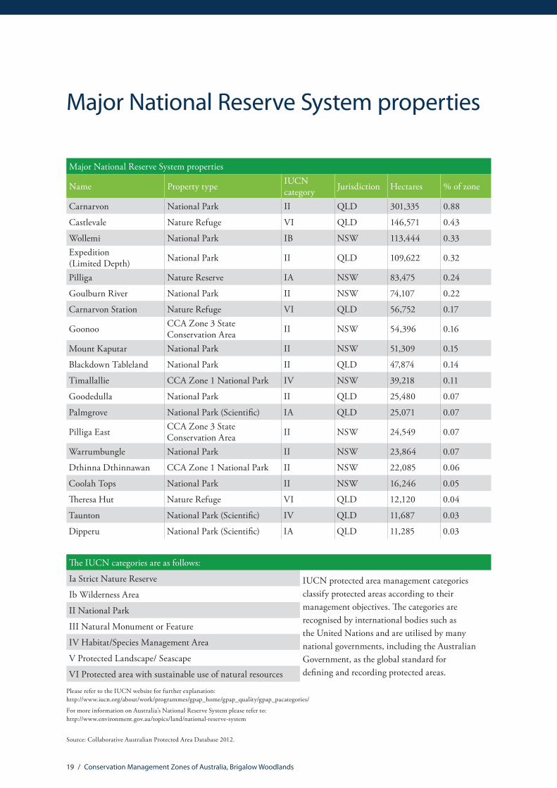
Major National Reserve System properties
Major National Reserve System properties
Name Property type IUCN category Jurisdiction Hectares % of zone
Carnarvon National Park II QLD 301,335 0.88
Castlevale Nature Refuge VI QLD 146,571 0.43
Wollemi National Park IB NSW 113,444 0.33Expedition (Limited Depth) National Park II QLD 109,622 0.32
Pilliga Nature Reserve IA NSW 83,475 0.24
Goulburn River National Park II NSW 74,107 0.22
Carnarvon Station Nature Refuge VI QLD 56,752 0.17
Goonoo CCA Zone 3 State Conservation Area II NSW 54,396 0.16
Mount Kaputar National Park II NSW 51,309 0.15
Blackdown Tableland National Park II QLD 47,874 0.14
Timallallie CCA Zone 1 National Park IV NSW 39,218 0.11
Goodedulla National Park II QLD 25,480 0.07
Palmgrove National Park (Scientific) IA QLD 25,071 0.07
Pilliga East CCA Zone 3 State Conservation Area II NSW 24,549 0.07
Warrumbungle National Park II NSW 23,864 0.07
Dthinna Dthinnawan CCA Zone 1 National Park II NSW 22,085 0.06
Coolah Tops National Park II NSW 16,246 0.05
Theresa Hut Nature Refuge VI QLD 12,120 0.04
Taunton National Park (Scientific) IV QLD 11,687 0.03
Dipperu National Park (Scientific) IA QLD 11,285 0.03
The IUCN categories are as follows:
Ia Strict Nature Reserve IUCN protected area management categories classify protected areas according to their management objectives. The categories are recognised by international bodies such as the United Nations and are utilised by many national governments, including the Australian Government, as the global standard for defining and recording protected areas.
Ib Wilderness Area
II National Park
III Natural Monument or Feature
IV Habitat/Species Management Area
V Protected Landscape/ Seascape
VI Protected area with sustainable use of natural resources
Please refer to the IUCN website for further explanation: http://www.iucn.org/about/work/programmes/gpap_home/gpap_quality/gpap_pacategories/
For more information on Australia’s National Reserve System please refer to: http://www.environment.gov.au/topics/land/national-reserve-system
Source: Collaborative Australian Protected Area Database 2012.

20 / Conservation Management Zones of Australia, Brigalow Woodlands
EPBC Act (1999) threatened ecological communitiesThreatened ecological communities
Name Listing status % of total distribution* % of zone**Natural Grasslands of the Queensland Central Highlands and the northern Fitzroy Basin Endangered 94.7 23.3
Brigalow (Acacia harpophylla dominant and co-dominant) Endangered 87.5 3.3
Semi-evergreen vine thickets of the Brigalow Belt (North and South) and Nandewar Bioregions
Endangered 85.7 0.7
Natural grasslands on basalt and fine-textured alluvial plains of northern New South Wales and southern Queensland
Critically Endangered 62.6 24.6
Coolibah – Black Box Woodlands of the Darling Riverine Plains and the Brigalow Belt South Bioregions
Endangered 58.3 64.6
Weeping Myall Woodlands Endangered 42.0 83.7New England Peppermint (Eucalyptus nova-anglica) Grassy Woodlands
Critically Endangered 22.8 4.2
Grey Box (Eucalyptus microcarpa) Grassy Woodlands and Derived Native Grasslands of South-eastern Australia
Endangered 9.7 10.1
White Box-Yellow Box-Blakely’s Red Gum Grassy Woodland and Derived Native Grassland
Critically Endangered 5.1 3.5
The community of native species dependent on natural discharge of groundwater from the Great Artesian Basin
Endangered 3.9 0.1
Lowland Rainforest of Subtropical Australia Critically Endangered 0.3 0.1
* % of the total national distribution describes the proportion of the total national distribution of the Threatened Ecological Community that is found within the zone.
** % of the total zone area describes the proportion of the zone that the Threatened Ecological Community is likely or known to occur in.
It should be noted that the identification of any given Threatened Ecological Community above does not imply that the Threatened Ecological Community (TEC) is found uniformly across the Conservation Management Zone. Rather, the % of the TEC’s total distribution (*) within the zone is an indication of its importance to that zone in terms of conservation efforts. The % of the zone (**) indicates how rare, or difficult the ecological community may be to find within the zone.
The threatened ecological communities above are listed under The Environment Protection and Biodiversity Conservation Act 1999 (EPBC Act), which is the Australian Government’s principal environmental legislation. For more information, please refer to http://www.environment.gov.au/biodiversity/threatened/communities

21 / Conservation Management Zones of Australia, Brigalow Woodlands
EPBC Act (1999) threatened species
Threatened mammals
Common name Scientific name Status % of total distribution*
% of zone**
Northern Hairy-nosed Wombat, Yaminon Lasiorhinus krefftii Endangered 100 0.01Pilliga Mouse, Poolkoo Pseudomys pilligaensis Vulnerable 60.63 0.96Koala (combined populations of Queensland, New South Wales and the Australian Capital Territory)
Phascolarctos cinereus (combined populations of Qld, NSW and the ACT)
Vulnerable 26.07 31.83
Brush-tailed Rock-wallaby Petrogale penicillata Vulnerable 10.88 1.31Bridled Nail-tail Wallaby Onychogalea fraenata Endangered 6.82 0.04New Holland Mouse, Pookila Pseudomys novaehollandiae Vulnerable 3.79 1.05Grey-headed Flying-fox Pteropus poliocephalus Vulnerable 3.67 1.85Hastings River Mouse, Koontoo Pseudomys oralis Endangered 3.39 0.29Spot-tailed Quoll, Spotted-tail Quoll, Tiger Quoll (southeastern mainland population)
Dasyurus maculatus maculatus (SE mainland population) Endangered 2.67 1.37
Northern Quoll Dasyurus hallucatus Endangered 1.29 2.30Water Mouse, False Water Rat, Yirrkoo Xeromys myoides Vulnerable 0.02 0.002Semon’s Leaf-nosed Bat, Greater Wart-nosed Horseshoe-bat Hipposideros semoni Endangered May be
presentMay be present
Long-nosed Potoroo (SE mainland) Potorous tridactylus tridactylus Vulnerable May be present
May be present
South-eastern Long-eared Bat Nyctophilus corbeni Vulnerable May be present
May be present
Large-eared Pied Bat, Large Pied Bat Chalinolobus dwyeri Vulnerable May be present
May be present
Greater Bilby Macrotis lagotis Vulnerable May be present
May be present

22 / Conservation Management Zones of Australia, Brigalow Woodlands
* % of total distribution describes the proportion of the total national distribution of the threatened species that is found within the zone.
** % of zone describes the proportion of the zone that the threatened species is likely or known to occur in.
The % of zone indicates how rare, or difficult the species may be to find within the zone.
Threatened birds
Common name Scientific name Status % of total distribution*
% of zone**
Star Finch (eastern), Star Finch (southern) Neochmia ruficauda ruficauda Endangered 59.82 71.00
Squatter Pigeon (southern) Geophaps scripta scripta Vulnerable 57.35 60.03
Black-breasted Button-quail Turnix melanogaster Vulnerable 38.12 15.69
Regent Honeyeater Anthochaera phrygia Endangered 17.91 12.51
Red Goshawk Erythrotriorchis radiatus Vulnerable 17.24 51.77
Swift Parrot Lathamus discolor Endangered 9.13 4.79
Superb Parrot Polytelis swainsonii Vulnerable 4.97 2.63
Black-throated Finch (southern) Poephila cincta cincta Endangered 4.81 0.91
Coxen’s Fig-Parrot Cyclopsitta diophthalma coxeni Endangered 1.26 0.01
Australasian Bittern Botaurus poiciloptilus Endangered 1.17 1.27
Eastern Bristlebird Dasyornis brachypterus Endangered 0.94 0.13
Australian Painted Snipe Rostratula australis Endangered 0.89 0.50
Malleefowl Leipoa ocellata Vulnerable 0.44 1.36
Yellow Chat (Dawson) Epthianura crocea macgregori Critically Endangered
May be present
May be present
Masked Owl (northern) Tyto novaehollandiae kimberli Vulnerable May be present
May be present

23 / Conservation Management Zones of Australia, Brigalow Woodlands
Threatened reptiles
Common Name Scientific name Status % of total distribution*
% of zone**
Allan’s Lerista, Retro Slider Lerista allanae Endangered 100 0.47
Ornamental Snake Denisonia maculata Vulnerable 93.72 19.74Five-clawed Worm-skink, Long-legged Worm-skink Anomalopus mackayi Vulnerable 66.94 2.56
Dunmall’s Snake Furina dunmalli Vulnerable 58.19 1.55Border Thick-tailed Gecko, Granite Belt Thick-tailed Gecko Uvidicolus sphyrurus Vulnerable 57.91 7.85
Yakka Skink Egernia rugosa Vulnerable 47.29 11.19
Collared Delma Delma torquata Vulnerable 45.47 1.33
Grassland Earless Dragon Tympanocryptis pinguicolla Endangered 41.81 0.35
Mount Cooper Striped Lerista Lerista vittata Vulnerable 9.94 0.19Pink-tailed Worm-lizard, Pink-tailed Legless Lizard Aprasia parapulchella Vulnerable 5.28 0.57
Broad-headed Snake Hoplocephalus bungaroides Vulnerable 4.06 0.37Bell’s Turtle, Western Sawshelled Turtle, Namoi River Turtle, Bell’s Saw-shelled Turtle
Wollumbinia belli Vulnerable 0.77 0.01
Three-toed Snake-tooth Skink Coeranoscincus reticulatus Vulnerable May be present
May be present
Other threatened fauna
Common name Scientific name Status % of total distribution*
% of zone**
Boggomoss Snail, Dawson Valley Snail Adclarkia dawsonensis Critically Endangered 100 0.0004
Australian Lungfish, Queensland Lungfish Neoceratodus forsteri Vulnerable 15.1 0.18
Fleay’s Frog Mixophyes fleayi Endangered 7.81 0.06
Booroolong Frog Litoria booroolongensis Endangered 7.75 0.33
Mary River Cod Maccullochella mariensis Endangered 0.91 0.004Kroombit Tinker Frog, Pleione’s Torrent Frog Taudactylus pleione Critically
Endangered 0.79 0.0005
Trout Cod Maccullochella macquariensis Endangered May be present
May be present
Giant Barred Frog, Southern Barred Frog Mixophyes iteratus Endangered May be present
May be present
Littlejohn’s Tree Frog, Heath Frog Litoria littlejohni Vulnerable May be present
May be present
Murray Cod Maccullochella peelii Vulnerable May be present
May be present

24 / Conservation Management Zones of Australia, Brigalow Woodlands
Threatened flora
Common Name Scientific name Status % of total distribution*
% of zone**
a shrub Bertya granitica Endangered 100 0.01
a shrub Homoranthus decumbens Endangered 100 0.85
Hando’s Wattle, Percy Grant Wattle Acacia handonis Vulnerable 100 0.08
Kogan Waxflower Philotheca sporadica Vulnerable 100 0.46
None Eucalyptus beaniana Vulnerable 100 0.06
None Kennedia retrorsa Vulnerable 100 0.06
None Logania diffusa Vulnerable 100 0.07
None Prostanthera discolor Vulnerable 100 0.02
None Corymbia clandestina Vulnerable 100 0.07
None Newcastelia velutina Vulnerable 100 0.01
None Acacia eremophiloides Vulnerable 100 0.02
None Acacia deuteroneura Vulnerable 100 0.01
None Xerothamnella herbacea Endangered 100 0.05
None Microcarpaea agonis Endangered 100 0.01
None Prostanthera sp. Dunmore (D.M.Gordon 8A) Vulnerable 100 0.11
None Aristida annua Vulnerable 100 1.03
None Acacia porcata Endangered 100 0.02
None Hakea pulvinifera Endangered 100 0.03Queensland White Gum, Queensland Western White Gum, Lapunyah, Scrub Gum, White Gum
Eucalyptus argophloia Vulnerable 100 0.21
Sandy Hollow Commersonia Commersonia rosea Endangered 100 0.004
Yarwun Whitewood Atalaya collina Endangered 100 0.01
None Acacia lauta Vulnerable 99.32 0.08
None Lasiopetalum longistamineum Vulnerable 96.86 0.03
None Decaspermum struckoilicum Endangered 95.51 0.01
None Ozothamnus tesselatus Vulnerable 93.35 0.14
None Westringia parvifolia Vulnerable 91.38 1.35
None Indigofera efoliata Endangered 90.57 0.08
Hawkweed Picris evae Vulnerable 89.92 0.97
Belson’s Panic Homopholis belsonii Vulnerable 89.79 0.05
Ingram’s Zieria Zieria ingramii Endangered 87.17 0.13
None Leucopogon sp. Coolmunda (D.Halford Q1635) Endangered 87.1 0.01
Small-leaved Denhamia Denhamia parvifolia Vulnerable 87.02 2.97
None Eucalyptus virens Vulnerable 86.79 3.13
None Rulingia procumbens Vulnerable 85.7 2.39

25 / Conservation Management Zones of Australia, Brigalow Woodlands
Threatened flora
Common Name Scientific name Status % of total distribution*
% of zone**
Denman Pomaderris Pomaderris reperta Critically Endangered 84.53 0.01
Finger Panic Grass Digitaria porrecta Endangered 80.64 12.32
Austral Cornflower, Native Thistle Rhaponticum australe Vulnerable 79.89 3.11
None Zieria verrucosa Vulnerable 76.95 0.16
None Daviesia discolor Vulnerable 75.81 0.18
None Tylophora linearis Endangered 74.2 3.75
bluegrass Dichanthium setosum Vulnerable 73.71 1.34
Ooline Cadellia pentastylis Vulnerable 72.87 19.36
None Calytrix gurulmundensis Vulnerable 72.52 0.20
None Philotheca ericifolia Vulnerable 69.61 6.77
None Polianthion minutiflorum Vulnerable 69.4 0.15
None Homoranthus darwinioides Vulnerable 66.28 0.30
King Blue-grass Dichanthium queenslandicum Endangered 66.26 5.43
None Acacia grandifolia Vulnerable 52.95 1.11
Cobar Greenhood Orchid Pterostylis cobarensis Vulnerable 47.81 5.15
* % of total distribution describes the proportion of the total national distribution of the threatened species that is found within the zone.
** % of zone describes the proportion of the zone that the threatened species is likely or known to occur in. The % of zone indicates how rare, or difficult the species may be to find within the zone.
The above species are listed under The Environment Protection and Biodiversity Conservation Act 1999 (EPBC Act), the Australian Government’s principal environmental legislation.
Please note that the list of threatened flora species is not comprehensive. The flora listed here have a significant proportion of their total national distribution within the zone. For more information please refer to: http://www.environment.gov.au/biodiversity/threatened/species or the Species Profiles and Threats Database http://www.environment.gov.au/cgi-bin/sprat/public/sprat.pl

26 / Conservation Management Zones of Australia, Brigalow Woodlands
EPBC Act (1999) migratory species
Migratory birds
Common name Scientific name
Barn Swallow Hirundo rustica
Black-faced Monarch Monarcha melanopsis
Black-tailed Godwit Limosa limosa
Campbell Albatross Thalassarche impavida
Cattle Egret Ardea ibis
Coxen’s Fig-Parrot Cyclopsitta diophthalma coxeni
Curlew Sandpiper Calidris ferruginea
Eastern Curlew Numenius madagascariensis
Flesh-footed Shearwater, Fleshy-footed Shearwater Puffinus carneipes
Fork-tailed Swift Apus pacificus
Great Egret, White Egret Ardea alba
Great Knot Calidris tenuirostris
Latham’s Snipe, Japanese Snipe Gallinago hardwickii
Little Curlew, Little Whimbrel Numenius minutus
Little Tern Sterna albifrons
Marsh Sandpiper, Little Greenshank Tringa stagnatilis
Painted Snipe Rostratula benghalensis (sensu lato)
Rainbow Bee-eater Merops ornatus
Red-necked Stint Calidris ruficollis
Rufous Fantail Rhipidura rufifrons
Satin Flycatcher Myiagra cyanoleuca
Sharp-tailed Sandpiper Calidris acuminata
Southern Giant-Petrel Macronectes giganteus
Spectacled Monarch Monarcha trivirgatus
Whimbrel Numenius phaeopus
White-bellied Sea-Eagle Haliaeetus leucogaster
White-throated Needletail Hirundapus caudacutus
Wood Sandpiper Tringa glareola

27 / Conservation Management Zones of Australia, Brigalow Woodlands
Threatened endemic species
Threatened endemic species
Taxonomic group Scientific name Reservation status EPBC Act status IUCN status
Frogs Taudactylus pleione Not recorded in reserves
Critically Endangered
Critically Endangered
Mammals Pseudomys pilligaensis Recorded in reserves Vulnerable Data Deficient
Molluscs Jardinella exigua Not recorded in reserves n/a Endangered
Molluscs Adclarkia dawsonensis Recorded in reserves Critically Endangered n/a
Plants Cycas cupida Not recorded in reserves n/a Vulnerable
Plants Macrozamia crassifolia Recorded in reserves Vulnerable Vulnerable
Plants Macrozamia fearnsidei Recorded in reserves Vulnerable Least Concern
Plants Macrozamia platyrhachis Recorded in reserves Endangered Vulnerable
Plants Acacia deuteroneura Not recorded in reserves Vulnerable n/a
Plants Acacia eremophiloides Recorded in reserves Vulnerable n/a
Plants Acacia handonis Not recorded in reserves Vulnerable n/a
Plants Acacia porcata Recorded in reserves Endangered n/a
Plants Indigofera efoliata Not recorded in reserves Endangered n/a
Plants Microcarpaea agonis Not recorded in reserves Endangered n/a
Plants Bertya granitica Recorded in reserves Endangered n/a
Plants Decaspermum struckoilicum Recorded in reserves Endangered n/a
Plants Homoranthus decumbens Recorded in reserves Vulnerable n/a
Plants Aristida annua Not recorded in reserves Vulnerable n/a
Plants Philotheca sporadica Not recorded in reserves Vulnerable n/a
Plants Atalaya collina Not recorded in reserves Endangered n/a
Reptiles Lerista allanae Not recorded in reserves Endangered Critically
Endangered

28 / Conservation Management Zones of Australia, Brigalow Woodlands
The colour grids and numbers are an indication of the location and number of endemic species that have all their known range outside of the National Reserve System. Concentrations of unreserved endemic species may be useful focal areas for private land conservation efforts.
Endemism analyses were provided by the Australian Government Department of Environment Australian Natural Heritage Assessment Tool (ANHAT). The ANHAT database has been compiled from specimens and site records held in state agency wildlife atlases, museum collections, and the work of individual researchers. For more information please refer to: http://www.environment.gov.au/topics/heritage/publications-and-resources/australian-natural-heritage-assessment-tool
Concentrations of unreserved endemic species
Brigalow Woodlands CMZ
Concentrations of unreservedendemic species
Australian Natural HeritageAssessment Tool
Data Sources: - All biodiversity data have been derived from the Australian Natural Heritage Assessment Tool, which includes species location records from Australian museums, Australian herbaria, Birds Australia, CSIRO,state and territory governments and other sources.- Weighted endemism / richness scores are calculated for all species within a specified group with the exception of vascular plants (includes only 75 families) and vertebrates (does not include fish species).For a full list of taxa included in ANHAT see www.environment.gov.au/heritage/index.html
- Drainage and waterbodies have been derived from the GeoscienceAustralia GEODATA TOPO 10M 2002 - Locality data have been derived from the Geoscience AustraliaGEODATA TOPO 10M 2002 data layer
Caveat: While every effort has been made to ensure accuracy andcompleteness, no guarantee is given, nor responsibility taken by theCommonwealth for errors or omissions and the Commonwealth doesnot accept responsibility in respect of any information or advice givenin relation to, or as a consequence of, anything contained herein.
Produced by: The Department of the Environment. © Commonwealth of Australia 2008
Concentration of Endemics1
2
3
4 - 11
Brigalow Woodlands
CMZ Boundaries
Parks and Reserves
0 100 20050Kilometres

29 / Conservation Management Zones of Australia, Brigalow Woodlands
* % of the total national distribution of the invasive species found within the zone.
** % of the total zone area that the invasive species is likely or known to occur in.
Invasive species
Invasive mammals
Common name Scientific name % of total distribution* % of zone**
Cat, House Cat, Domestic Cat Felis catus 4.45 100
Red Fox, Fox Vulpes vulpes 5.55 100
Pig Sus scrofa 9.71 99.7
Rabbit, European Rabbit Oryctolagus cuniculus 6.16 98.6
House Mouse Mus musculus 7.32 76.0
Domestic Dog Canis lupus familiaris 7.11 51.8
Brown Hare Lepus capensis 15.2 44.2
Domestic Cattle Bos taurus 8.02 39.9
Black Rat, Ship Rat Rattus rattus 10.97 35.6
Goat Capra hircus 2.85 17.8
Horse Equus caballus 3.48 15.1
Feral deer species in Australia n/a 9.53 10.7
Brown Rat, Norway Rat Rattus norvegicus 2.19 1.2
Other invasive fauna
Common name Scientific name % of total distribution* % of zone**
House Sparrow Passer domesticus 10.06 86.90
Cane Toad Rhinella marina 14.57 82.30
Rock Pigeon, Rock Dove, Domestic Pigeon Columba livia 9.35 69.65
Common Starling Sturnus vulgaris 10.37 65.39
Spotted Turtle-Dove Streptopelia chinensis 13.82 33.66
Common Myna, Indian Myna Acridotheres tristis 17.09 25.84
Mallard Anas platyrhynchos 8.01 16.56
Common Blackbird, Eurasian Blackbird Turdus merula 6.12 16.36
European Goldfinch Carduelis carduelis 5.55 14.55
Nutmeg Mannikin Lonchura punctulata 17.63 13.69
Skylark Alauda arvensis 2.39 4.52
Asian House Gecko Hemidactylus frenatus 4.71 3.10
Red-whiskered Bulbul Pycnonotus jocosus 2.87 0.67
Eurasian Tree Sparrow Passer montanus 0.68 0.55

Invasive flora
Common name Scientific name % of total distribution* % of zone** Parthenium Weed, Bitter Weed, Carrot Grass, False Ragweed Parthenium hysterophorus 39.86 71.52
Parkinsonia, Jerusalem Thorn, Jelly Bean Tree, Horse Bean Parkinsonia aculeata 9 41.59
Rubber Vine, Rubbervine, India Rubber Vine, India Rubbervine, Palay Rubbervine, Purple Allamanda
Cryptostegia grandiflora 18.02 35.83
Prickly Pears Opuntia spp. 31.25 34.67Lantana, Common Lantana, Kamara Lantana, Large-leaf Lantana, Pink Flowered Lantana, Red Flowered Lantana, Red-Flowered Sage, White Sage, Wild Sage
Lantana camara 22.08 31.47
Radiata Pine Monterey Pine, Insignis Pine, Wilding Pine Pinus radiata 18.86 25.19
Willows except Weeping Willow, Pussy Willow and Sterile Pussy Willow
Salix spp. except S.babylonica, S.x calodendron & S.x reichardtii
11.47 22.09
Prickly Acacia, Blackthorn, Prickly Mimosa, Black Piquant, Babul Vachellia nilotica 11.64 18.98
Blackberry, European Blackberry Rubus fruticosus aggregate 7.61 18.53
Prickly Acacia Acacia nilotica subsp. indica 5.21 17.50Hymenachne, Olive Hymenachne, Water Stargrass, West Indian Grass, West Indian Marsh Grass
Hymenachne amplexicaulis 23.18 15.29
Athel Pine, Athel Tree, Tamarisk, Athel Tamarisk, Athel Tamarix, Desert Tamarisk, Flowering Cypress, Salt Cedar
Tamarix aphylla 7.18 15.16
Cotton-leaved Physic-Nut, Bellyache Bush, Cotton-leaf Physic Nut, Cotton-leaf Jatropha, Black Physic Nut
Jatropha gossypifolia 12.79 14.96
African Boxthorn, Boxthorn Lycium ferocissimum 6.9 10.61Bridal Creeper, Bridal Veil Creeper, Smilax, Florist’s Smilax, Smilax Asparagus Asparagus asparagoides 3.3 7.93
Salvinia, Giant Salvinia, Aquarium Watermoss, Kariba Weed Salvinia molesta 7.73 7.00
Fireweed, Madagascar Ragwort, Madagascar Groundsel Senecio madagascariensis 10.97 4.70
Mesquite, Algaroba Prosopis spp. 2.52 4.45Serrated Tussock, Yass River Tussock, Yass Tussock, Nassella Tussock (NZ) Nassella trichotoma 4.47 3.78
Chilean Needle grass Nassella neesiana 4.61 3.75Cat’s Claw Vine, Yellow Trumpet Vine, Cat’s Claw Creeper, Funnel Creeper Dolichandra unguis-cati 19.94 3.31

31 / Conservation Management Zones of Australia, Brigalow Woodlands
Invasive flora
Common name Scientific name % of total distribution* % of zone** Silver Nightshade, Silver-leaved Nightshade, White Horse Nettle, Silver-leaf Nightshade, Tomato Weed, White Nightshade, Bull-nettle, Prairie-berry, Satansbos, Silver-leaf Bitter-apple, Silverleaf-nettle, Trompillo
Solanum elaeagnifolium 5.69 2.48
Madeira Vine, Jalap, Lamb’s-tail, Mignonette Vine, Anredera, Gulf Madeiravine, Heartleaf Madeiravine, Potato Vine
Anredera cordifolia 8.52 2.32
Prickly Pears Cylindropuntia spp. 12.47 2.29
Broom Genista sp. X Genista monspessulana 1.66 1.28
Bitou Bush, Boneseed Chrysanthemoides monilifera 0.77 1.27
Water Hyacinth, Water Orchid, Nile Lily Eichhornia crassipes 3.81 1.05Broom, English Broom, Scotch Broom, Common Broom, Scottish Broom, Spanish Broom
Cytisus scoparius 1.21 0.84
Climbing Asparagus, Climbing Asparagus Fern Asparagus africanus 18.88 0.68
Montpellier Broom, Cape Broom, Canary Broom, Common Broom, French Broom, Soft Broom
Genista monspessulana 1.25 0.55
Climbing Asparagus-fern Asparagus plumosus 4.61 0.44
Climbing Asparagus-fern, Ferny Asparagus Protasparagus plumosus 4.61 0.44Delta Arrowhead, Arrowhead, Slender Arrowhead Sagittaria platyphylla 0.47 0.12
Alligator Weed Alternanthera philoxeroides 0.45 0.11Asparagus Fern, Ground Asparagus, Basket Fern, Sprengi’s Fern, Bushy Asparagus, Emerald Asparagus
Asparagus aethiopicus 1.14 0.10
Buffel-grass, Black Buffel-grass Cenchrus ciliaris 0.01 0.10
Gamba Grass Andropogon gayanus 0.15 0.04
* % of the total national distribution of the invasive species found within the zone.
** % of the total zone area that the invasive species is likely or known to occur in.
It should be noted that the identification of any given invasive species above does not imply that the species is found uniformly across the Conservation Management Zone. The % of the zone area (**) indicates how common or rare the species may be within the zone.
For more information on invasive species please refer to: http://www.environment.gov.au/topics/biodiversity/invasive-species

32 / Conservation Management Zones of Australia, Brigalow Woodlands
Vegetation profiles and management recommendationsVegetation extent information and species lists contained in the vegetation profiles are based on analysis from the National Vegetation Information System (NVIS), including analysis of Major Vegetation Subgroups and NVIS Level V descriptions. Please see http://www.environment.gov.au/node/18930 for more information.
The management recommendations have been drawn from EPBC Act Recovery Plans, EPBC Act Ecological Communities Listing Advice and other sources. The recommendations are indicative only. Systematic reviews of management literature, consultation processes and improved Natural Resource Management program monitoring and evaluation will support development of a comprehensive set of management recommendations over time.

33 / Conservation Management Zones of Australia, Brigalow Woodlands
Eucalyptus woodlands with a tussock grass understorey vegetation profile
41.31%Remaining
Change in extent
Pres
ent d
ay
Pre-
1750
36%
14.9%
Commonly found species within this communityEucalyptus crebra; Eucalyptus melanophloia; Eucalyptus platyphylla; Eucalyptus populnea; Eucalyptus melliodora; Eucalyptus camaldulensis; Corymbia citriodora; Corymbia clarksoniana; Callitris glaucophylla; Casuarina cunninghamiana; Acacia leiocalyx; Themeda triandra; Bothriochloa bladhii; Aristida ramosa; tussock grass.
Protection Sustainable Agricultural Practice
Rehabilitation Fire Management
Wildlife Management
Weed Management
Feral Animal Management
Disease Management
Encourage uptake of conservation agreements and covenants on private land.
Ban firewood harvesting and retain standing dead trees and fallen timber.
Protect paddock trees through fencing and removal of stock.
Manage grazing practices, including avoiding high-intensity set stocking.
Adopt rotational grazing practices and avoid grazing when ground layer plants are flowering and setting seed (usually spring to midsummer).
Avoid application of nitrogen and phosphorous fertilisers.
Avoid spray drift of herbicides, pesticides and fertiliser from adjacent agricultural lands.
Create artificial shade to prevent stock camping under trees.
Encourage natural regeneration through fencing and stock management.
If there is no tree recruitment (regeneration) around fenced mature paddock trees then plant seedlings from locally sourced tube stock.
Replant species where appropriate using locally-sourced seed.
Protect mature trees with tree hollows.
If few or no mature trees with hollows exist within remnants, provide nesting boxes and monitor these regularly for invasive species, such as Noisy Miners.
Manage Coolatai grass (Hyparrhenia hirta), African love grass (Eragrostis curvula) and Johnson grass (Sorghum halapense).
Grazing, burning or soil disturbance also favours the introduction of weeds. Monitor for weeds in grazed and disturbed sites.
Management recommendations

34 / Conservation Management Zones of Australia, Brigalow Woodlands
Brigalow (Acacia harpophylla) forests and woodlands vegetation profile
Protection Sustainable Agricultural Practice
Rehabilitation Fire Management
Wildlife Management
Weed Management
Feral Animal Management
Disease Management
Purchase high quality remnants into reservation.
Encourage uptake of conservation agreements on private land
Create buffer zones around remnants.
Protect paddock trees and clumps of regrowth.
Protect shrubby understorey and maintain dense stands of vegetation.
Manage grazing practices and stocking rates; or exclude grazing entirely from intact stands where possible.
Adopt rotational grazing practices and avoid grazing when ground layer plants are flowering and setting seed (usually spring to midsummer).
Avoid application of fertiliser, or the aerial/broad scale spraying of herbicides.
Implement water management, sediment erosion and pollution control.
Connect shade-lines to one another and keep them as wide as possible (ideally more than 100 m).
Undertake regeneration of high value regrowth sites and revegetation of degraded sites.
Encourage woodland regeneration close to areas of existing woodland.
In general, the most appropriate fire regime for Brigalow stands is fire-exclusion.
Leave dead trees standing and allow fallen timber and leaf litter to rot where it falls as this provides key habitat for reptiles and insects and supports food sources for other fauna.
Re-introduce microhabitat features (e.g. rocks, logs and other woody debris) to sites that have been disturbed.
Manage high biomass exotic grasses (buffel grass, Rhodes grass, green panic grass).
Minimise soil disturbance and monitor for weeds if soil is disturbed.
Use spot application of herbicides.
Minimise tree thinning.
Manage foxes, feral pigs and cats.
9.1%Remaining
Change in extent
Pres
ent d
ay
Pre-
1750
20.3%
1.8%
Commonly found species within this communityAcacia harpophylla; Eucalyptus populnea; Eucalyptus cambageana; Casuarina cristata; Lysiphyllum cunninghamii; Acacia argyrodendron; Eremophila mitchellii; Geijera parviflora; Carissa ovata; Paspalidium caespitosum; Chloris ventricosa; Digitaria brownii; Eragrostis megalosperma.
Management recommendations

35 / Conservation Management Zones of Australia, Brigalow Woodlands
Eucalyptus woodlands with a shrubby understorey vegetation profile
60.46%Remaining
Commonly found species within this communityEucalyptus crebra; Eucalyptus populnea; Eucalyptus sideroxylon; Eucalyptus fibrosa; Eucalyptus moluccana; Corymbia clarksoniana; Eremophila mitchellii; Callitris glaucophylla; Canthium oleifolium; Geijera parviflora; Cheilanthes sieberi.
Change in extent
Pres
ent d
ay
Pre-
1750
10.3%
6.3%
Protection Sustainable Agricultural Practice
Rehabilitation Fire Management
Wildlife Management
Weed Management
Feral Animal Management
Disease Management
Encourage uptake of conservation agreements and covenants, particularly on private land.
Protect from firewood harvesting.
Protect paddock trees.
Manage grazing practices and stocking rates; or exclude grazing entirely from intact stands where possible.
Avoid fertiliser drift from adjacent crops and pastures.
Encourage natural regeneration through fencing and stock management.
Undertake replanting where appropriate, and if possible reconnect remnant patches with suitable flora species so that wildlife can move naturally through the landscape.
Severe and too frequent fire can inhibit regeneration capacity.
If few, or no hollow bearing trees are present within remnants, provide nest boxes and monitor regularly for invasive species.
Management recommendations

36 / Conservation Management Zones of Australia, Brigalow Woodlands
Eucalyptus open forests with a grassy understorey vegetation profile
84.28%Remaining
Commonly found species within this communityCorymbia citriodora; Eucalyptus albens; Eucalyptus crebra; Eucalyptus melanoleuca; Eucalyptus cloeziana; Corymbia trachyphloia; Eucalyptus siderophloia; Eucalyptus sphaerocarpa; Bursaria spinosa; Arundinella nepalensis; Eremophila mitchellii; Arundinella nepalensis; Acacia decora; Acacia macradenia; Persoonia falcata; Themeda triandra; Bothriochloa decipiens; tussock grass.
Change in extent
Pres
ent d
ay
Pre-
1750
5.2%
4.4%
Protection Sustainable Agricultural Practice
Rehabilitation Fire Management
Wildlife Management
Weed Management
Feral Animal Management
Disease Management
Protect remnants from clearing.
Protect hollow-bearing trees.
Protect standing dead trees and fallen timber.
Avoid spray drift of herbicides, pesticides and fertiliser from adjacent agricultural lands
Encourage natural regeneration through fencing and stock management.
Undertake replanting where appropriate, and if possible reconnect remnant patches with suitable flora species so that wildlife can move naturally through the landscape.
Management recommendations

37 / Conservation Management Zones of Australia, Brigalow Woodlands
Eucalyptus open woodlands with a grassy understorey vegetation profile
46.6%Remaining
Commonly found species within this communityEucalyptus melanophloia; Eucalyptus coolabah; Eucalyptus populnea; Corymbia leichhardtii; Eucalyptus crebra; Eucalyptus microcarpa; Eucalyptus orgadophila; Corymbia clarksoniana; Corymbia dallachiana; Eremophila mitchellii; Carissa ovata; Triodia pungens Thellungia advena; Aristida ramosa; tussock grass; forb; sedge.
Change in extent
Pres
ent d
ay
Pre-
1750
5.1%
2.4%
Management recommendations
Protection Sustainable Agricultural Practice
Rehabilitation Fire Management
Wildlife Management
Weed Management
Feral Animal Management
Disease Management
Purchase remnants of Coolibah Black Box and Inland Grey Box ecological communities into reservation.
Encourage uptake of conservation agreements on private land.
Retain fallen timber and hollow bearing trees (including dead trees) and ensure that trees are always left to grow to maturity.
Protect and maintain water table and water flows by wise use of water and maintenance of native vegetation.
Protect remnants during maintenance/road works.
Manage total grazing pressure at important sites through exclusion fencing or other barriers. e.g. Fence riparian areas and stream banks.
Manage livestock grazing practices and density.
Reduce fertiliser and herbicide application.
Implement water efficiency measures for existing irrigation and dryland cropping infrastructure.
Revegetate gullies and stream banks where vegetation has been cleared and widen the strip of riparian vegetation.
Plant eucalypts that develop hollows.
Create or restore wildlife corridors and linkages.
Develop appropriate fire management plans.
Provide maps to local and state Rural Fire Services.
If few hollow bearing trees are present place nest boxes in remnants; monitor nest boxes for invasive species (e.g. Indian myna and noisy miners).
Manage weeds including Lippia (Phyla canescens) and African Boxthorn (Lycium ferocissimum).
Avoid inappropriate chemical use or mowing/slashing to eradicate weeds.
Control feral animals contributing to grazing pressure and trampling.
Manage underlying causes of dieback in New England Peppermint and Grey Box, such as outbreaks of leaf-eating insects, which can proliferate in areas of weed infestation and in surrounding modified pastures.

38 / Conservation Management Zones of Australia, Brigalow Woodlands
Other Acacia forests and woodlands vegetation profile
Protection Sustainable Agricultural Practice
Rehabilitation Fire Management
Wildlife Management
Weed Management
Feral Animal Management
Disease Management
Encourage uptake of conservation agreements and covenants.
Protect Weeping Myall from clearing and lopping for drought fodder.
Avoid firewood collection (dead and fallen trees).
Retain standing dead trees.
Use lopping methods that do not result in the death of the dominant tree species.
Prevent trampling and excessive grazing pressure in Weeping Myall Woodlands sites.
Use strategic grazing to facilitate regeneration.
Avoid fertiliser and herbicide application in or near remnants.
Replant understorey species (such as chenopods) where they have been depleted.
Repair, expand and connect remnants.
Collect and store seeds for future plantings.
Implement fire regimes that protect chenopod shrubs (e.g. saltbushes and native cotton bushes). Seek advice from your local NRM organisation on appropriate fire regimes.
Keep stock away from known nesting sites of ground dwelling birds.
Allow fallen branches and bark to remain on ground to provide fauna habitat.
Do not remove mistletoe from Weeping Myall trees, other acacias and eucalypts as these provide important food resources for birds and mammals.
Manage sites to prevent introduction of invasive plant species.
Manage grassy weeds such as Buffel grass (Cenchrus ciliaris) and Coolatai grass (Hyparrhenia hirta).
Avoid cultivating or disturbing the soil to prevent weed invasion.
Control Bag shelter moth outbreaks in significant stands of Weeping Myall.
Control introduced pest animals at known sites.
48.8%Remaining
Commonly found species within this communityAcacia pendula; Acacia argyrodendron; Acacia cambagei; Acacia shirleyi; Eremophila mitchellii; Eucalyptus decorticans; Eucalyptus thozetiana; Carissa ovata; Alphitonia excelsa; Aristida caput-medusae; Croton phebalioides; Canthium odoratum; Acalypha eremorum; tussock grass; shrub; forb.
Change in extent
Pres
ent d
ay
Pre-
1750
4.5%
2.2%
Management recommendations

39 / Conservation Management Zones of Australia, Brigalow Woodlands
Blue grass (Dichanthium) and tall bunch grass (Chrysopogon) tussock grasslands vegetation profile
23.88%Remaining
Commonly found species within this communityDichanthium fecundum; Astrebla sp+/-Panicum sp; Acacia harpophylla; Acacia pendula; Acacia victoriae; Corymbia erythrophloia; Eucalyptus melanophloia; chenopod shrub; Dichanthium sericeum; Astrebla lappacea; Astrebla pectinata; tussock grass.
Change in extent
Pres
ent d
ay
Pre-
1750
3.8%
0.9%
Protection Sustainable Agricultural Practice
Rehabilitation Fire Management
Wildlife Management
Weed Management
Feral Animal Management
Disease Management
Avoid changes to hydrology which may affect water table levels and surface water flow.
Encourage conservation agreements and covenants on private land.
Purchase remnants into reservation.
Protect during road widening and maintenance activities (or other infrastructure or development activities).
Avoid excessive soil disturbance.
Remove stock during flowering and seeding (Spring / Summer) and manage total grazing pressure to maintain ground cover at all times.
Avoid spray drift of fertilisers and herbicides into remnant sites.
Avoid slashing during peak flowering season (Spring to summer.)
Avoid herbicide and fertiliser application.
Revegetate areas that have been treated for weeds, and to extend and buffer remnant patches.
Use only plant native local species.
Avoid burning during peak flowering season (spring to summer).
Identify appropriate intensity and interval of fire to promote seed germination.
Ensure chemicals for weed control do not have adverse impact.
Control Lippia, Coolatai Grass, African Love Grass and Buffel Grass.
Implement good hygiene measures for mowing and grading equipment and observe appropriate state protocols for moving stock.
Control the house mouse (Mus domesticus).
Management recommendations

40 / Conservation Management Zones of Australia, Brigalow Woodlands
Dry rainforest or vine thickets vegetation profile
Protection Sustainable Agricultural Practice
Rehabilitation Fire Management
Wildlife Management
Weed Management
Feral Animal Management
Disease Management
Purchase remnants into reservation.
Encourage uptake of conservation agreements and covenants on private land.
Create buffer zones around remnants and revegetation areas.
Fence significant remnants to prevent stock and feral animal access.
Exclude grazing and fence significant remnant vine thickets.
Provide alternative watering points for domestic stock to discourage incursion.
Increase connectivity between remnants.
Use low intensity, cool season burns to reduce biomass.
Use strategic aerial incendiary mosaic burning techniques which mitigate against hot frequent wildlife, and protect wildlife.
Seek advice from your local NRM organisation about appropriate fire regimes.
Monitor and if necessary, manage over-populations of native grazers, especially the black-striped wallaby (Macropus dorsalis).
Maintain dingo populations to suppress over-populations of native grazers.
Implement cane toad ‘taste aversion’ baiting activities in remnants containing populations of the northern quoll.
Manage buffel grass (Pennisetum ciliare) and green panic grass (Megathyrsus maximus var. Pubiglumis) including in areas adjacent to thickets to prevent incursion of fire.
Manage weeds, especially lantana (Lantana camara) and rubber vine (Cryptostegia grandiflora).
Manage pigs and goats as well as other feral animals.
31.04%Remaining
Commonly found species within this communityBrachychiton australis; Brachychiton rupestris; Flindersia australis; Canthium odoratum; Diospyros humilis; Geijera parviflora; Cheilosporum acutilobum; Croton insularis; Cassine australis; Paspalidium caespitosum; Ancistrachne uncinulata; Eragrostis megalosperma; Sclerolaena tetracuspis; tussock grass; forb; sedge.
Change in extent
Pres
ent d
ay
Pre-
1750
1.8%
0.6%
Management recommendations

Notes
41 / Conservation Management Zones of Australia, Brigalow Woodlands

ALC
100.
0915