COMPREHENSIVE PLAN - ci.moscow.id.us
36
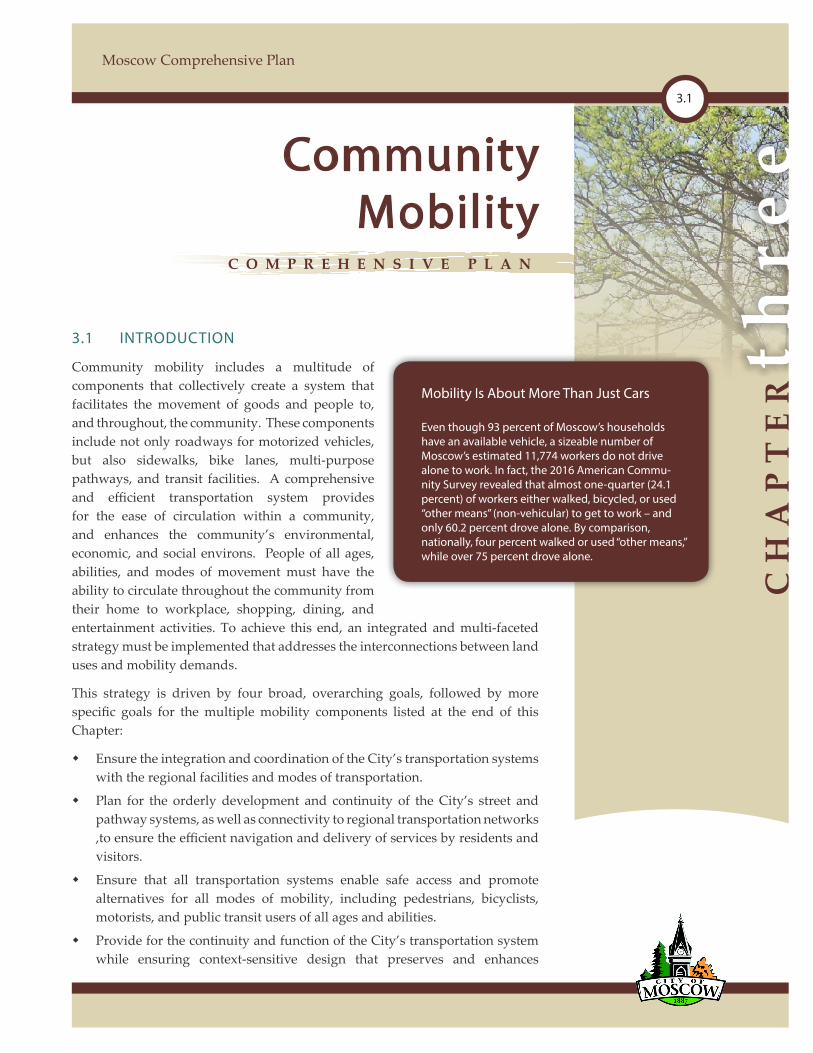
CHAPTER three 3.1 Moscow Comprehensive Plan 3.1 INTRODUCTION Community mobility includes a multitude of components that collectively create a system that facilitates the movement of goods and people to, and throughout, the community. These components include not only roadways for motorized vehicles, but also sidewalks, bike lanes, multi-purpose pathways, and transit facilities. A comprehensive and efficient transportation system provides for the ease of circulation within a community, and enhances the community’s environmental, economic, and social environs. People of all ages, abilities, and modes of movement must have the ability to circulate throughout the community from their home to workplace, shopping, dining, and entertainment activities. To achieve this end, an integrated and multi-faceted strategy must be implemented that addresses the interconnections between land uses and mobility demands. This strategy is driven by four broad, overarching goals, followed by more specific goals for the multiple mobility components listed at the end of this Chapter: Ensure the integration and coordination of the City’s transportation systems with the regional facilities and modes of transportation. Plan for the orderly development and continuity of the City’s street and pathway systems, as well as connectivity to regional transportation networks ,to ensure the efficient navigation and delivery of services by residents and visitors. Ensure that all transportation systems enable safe access and promote alternatives for all modes of mobility, including pedestrians, bicyclists, motorists, and public transit users of all ages and abilities. Provide for the continuity and function of the City’s transportation system while ensuring context-sensitive design that preserves and enhances Community Mobility COMPREHENSIVE PLAN Mobility Is About More Than Just Cars Even though 93 percent of Moscow’s households have an available vehicle, a sizeable number of Moscow’s estimated 11,774 workers do not drive alone to work. In fact, the 2016 American Commu- nity Survey revealed that almost one-quarter (24.1 percent) of workers either walked, bicycled, or used “other means” (non-vehicular) to get to work – and only 60.2 percent drove alone. By comparison, nationally, four percent walked or used “other means,” while over 75 percent drove alone.
Transcript of COMPREHENSIVE PLAN - ci.moscow.id.us
CH
AP
TE
Rth
ree
3.1
Moscow Comprehensive Plan
3.1 INTRODUCTION
Community mobility includes a multitude of components that collectively create a system that facilitates the movement of goods and people to, and throughout, the community. These components include not only roadways for motorized vehicles, but also sidewalks, bike lanes, multi-purpose pathways, and transit facilities. A comprehensive and efficient transportation system provides for the ease of circulation within a community, and enhances the community’s environmental, economic, and social environs. People of all ages, abilities, and modes of movement must have the ability to circulate throughout the community from their home to workplace, shopping, dining, and entertainment activities. To achieve this end, an integrated and multi-faceted strategy must be implemented that addresses the interconnections between land uses and mobility demands.
This strategy is driven by four broad, overarching goals, followed by more specific goals for the multiple mobility components listed at the end of this Chapter:
Ensure the integration and coordination of the City’s transportation systems with the regional facilities and modes of transportation.
Plan for the orderly development and continuity of the City’s street and pathway systems, as well as connectivity to regional transportation networks ,to ensure the efficient navigation and delivery of services by residents and visitors.
Ensure that all transportation systems enable safe access and promote alternatives for all modes of mobility, including pedestrians, bicyclists, motorists, and public transit users of all ages and abilities.
Provide for the continuity and function of the City’s transportation system while ensuring context-sensitive design that preserves and enhances
CommunityMobility
C O M P R E H E N S I V E P L A N
Mobility Is About More Than Just Cars
Even though 93 percent of Moscow’s households have an available vehicle, a sizeable number of Moscow’s estimated 11,774 workers do not drive alone to work. In fact, the 2016 American Commu-nity Survey revealed that almost one-quarter (24.1 percent) of workers either walked, bicycled, or used “other means” (non-vehicular) to get to work – and only 60.2 percent drove alone. By comparison, nationally, four percent walked or used “other means,” while over 75 percent drove alone.
comPrehensiveP
LA
N
Community Mobility
3.2
community character and quality of life.
3.2 REGIONAL CONTEXT
3.2.1 Introduction
While community mobility is often primarily focused upon the ability to move and circulate within the community, it also concerns the interactions and interconnections of the local circulation system with broader regional, state, and federal transportation facilities. The economic viability of a community is dependent upon the ability of people, products, and goods to circulate to and throughout the community.
3.2.2 Relationship to National and Regional Highways
Moscow is connected to the rest of the state by U.S. 95, which runs north-south, and S.H. 8, which runs east-west and connects to State Route 270 on the Washington side of the state line. Other than its close relationship to Pullman, Washington, approximately nine miles west on S.H. 8, the City is relatively isolated. The closest cities of significant size to the north are Spokane, Washington, 85 miles away via Highways 270 and 195 in Washington, and Coeur d’Alene, 87 miles away via U.S. 95. To the south is Lewiston, 30 miles away via U.S. 95. The closest Interstate Highway is I-90, accessible from Spokane, Washington, and Coeur d’Alene, Idaho.
The limited regional road network in the Idaho panhandle means that Moscow is in the path of trucks traveling U.S. 95 to access the Port of Lewiston, Coeur d’ Alene, and destinations in British Columbia and Alberta, Canada. Many of these trucks bring wood chips from areas north of the City to the paper plant south in Lewiston. Washington Highway 195 connects Lewiston to Spokane (via Pullman), and therefore, likely provides some relief from regional truck traffic.
Moscow is located within Idaho Transportation Department’s District 2 and is surrounded by the North Latah County Highway District.
3.2.3 Air Transportation
The Pullman-Moscow Regional Airport is located in Washington State roughly seven miles west of downtown Moscow. The Pullman-Moscow Regional Airport is presently served by Horizon Airlines/Alaska Air, as well as a full-service ,fixed-base operator that offers regional charter services.
The Lewiston-Nez Perce County Regional Airport is located in the southern part of Lewiston, approximately 30 miles south of Moscow. The Lewiston-Nez Perce County Regional Airport is slightly more trafficked than the Pullman-Moscow Regional Airport, and is currently served by SkyWest/Delta Airlines.

CH
AP
TE
Rth
ree
3.3
Moscow Comprehensive Plan
Many air travelers use the larger Spokane International Airport located 85 miles away and offers service from ten commercial carriers. Local transit provider Wheatland Express runs a fixed-route, periodic shuttle service between the Pullman-Moscow Airport and the Spokane International Airport.
3.2.4 Rail and Interstate Bus Transportation
The closest passenger rail service is provided by Amtrak via its “Empire Builder” line in Spokane, Washington, servicing Seattle, Portland, and Chicago. Northwestern Trailways and Greyhound provide regional and national bus transportation services. SMART Transit provides local bus services. Wheatland Express offers scheduled shuttles to the Spokane Airport and special express trips to western Washington and Oregon during University holidays. Freight rail service is provided by a BNSF short line, which connects to a main line at Lakeside Junction in Washington.
3.2.5 Regional Ports
Thirty-two miles south of Moscow is the Port of Lewiston, on the Snake River. See Figure 3.1, Port of Lewiston. The Port provides connections to seaports on the West Coast and contains warehousing and distribution facilities, a storage container yard, and grain storage facilities.
The Port is served with rail service provided by Union Pacific (via a short line operated by the Great Northwest Railroad Company) and BNSF. However, rail service in the region has been declining recently as many rail lines have been abandoned in nearby rural areas. Rail service is also inherently limited by the Snake River Canyon topography that forces rail lines to run west out of the canyon before they go north, south, or east. Truck traffic from the port uses U.S. 95 to access cities to the north, including Moscow.
Four other river ports are located in or adjacent to Whitman County, Washington: The Port of Almota, a small but significant grain shipping port on the Snake River; the Port of Wilma, across the river from Lewiston, Idaho; the Port of Central Ferry, a rural port 50 miles downstream from the Port of Wilma; and the Port of Clarkston, located between Whitman County and Asotin
The Port of Clarkston was created in 1958, which was 17 years before completion of the Lower Granite Dam in 1975. The dam enabled shipments of agricultural and forest products from the area. The Port of Clarkston is the farthest inland port in Washington State, located at river mile 137.8 of the Snake River, approximately 460 miles from the mouth of the Colum-bia River. Prior to navigable access, the Port focused on industrial development.
The Port of Clarkston’s jurisdiction includes the entire county, but most of its activity is centered in the City of Clarkston adjacent to the Snake River on 120 acres of prime flat land with all infrastructure in place. However, this area has become nearly fully utilized. As a result, the Port is planning development of an additional 120 acres of land available for future development, in an area located south and west of the existing Port facilities. The Port of Clarkston is involved in marine commerce, property development (industrial and commercial) and recreation/tourism facilities.
Source: http://portofclarkston.com
Figure 3.1:Port of Lewiston
Source: Port of Lewiston
comPrehensiveP
LA
N
Community Mobility
3.4
County, Washington, the farthest inland port in Washington State, located along the Snake River approximately 460 miles from the mouth of the Columbia River. The Port of Clarkston also provides docking for the Columbia Queen and Empress of the North cruise boats along with four other cruise lines and tour boats. From these ports, barge and tug lines also link the region to the coast and international markets.
3.3 LOCAL CONTEXT
Moscow is a small town with a compact form. As a result, it is a very walkable and bikeable community that remains conducive to non-motorized mobility opportunities. In fact, between 2012 and 2016, the American Community Survey reported that four percent of the City’s “journey to work” trips were made by bicycle. Nearly one-half of the City’s population consists of students of the University of Idaho who regularly walk or bike to school, work, and shop. In reflection of the University, the City’s traffic volumes ebb and flow around the academic calendar.
Generally, traffic congestion is rarely considered a significant problem within the community. In the City’s 2016 Citizen Survey, 72 percent of the City’s residents believed that traffic is either “not a problem”, or only a “minor problem.” Only eight percent of respondents believed that traffic was a “major problem” or “extreme problem.” The most significant traffic within the community results from the two highways (U.S. 95 and S.H. 8) that pass through the center of the City, channeling both local and regional traffic through the community.
Auto ownership in Moscow has been relatively stable over the last two decades, despite the increasing wealth of Moscow’s residents. However, even though 93 percent of Moscow’s households have an available vehicle, a sizeable number of Moscow’s workers do not use single-passenger automobiles to get to work. Between 2012 and 2016, just over 24 percent of Moscow’s residents either walked or used “other means” (non-automobile) to get to work, and just over 60 percent of those drove alone. By comparison, national figures during the same time period reflected that just over four percent walked or used “other means,” while over 76 percent drove alone.
In reflection of Moscow’s favorable comparison with the nation for non-motorized transportation use, it is no surprise that creating a walkable environment was a recurring desire articulated by community residents throughout the Plan development process. To accomplish this, transportation facilities must be planned, designed, and constructed with all users in mind to create an environment that is safe, free of impediments, and aesthetically pleasing.

CH
AP
TE
Rth
ree
3.5
Moscow Comprehensive Plan
3.4 CITY STREETS
3.4.1 General Existing Conditions
The City of Moscow includes over 88 miles of paved streets and nearly nine miles of developed alleyways. Generally, the older historic core of the community was developed with a traditional grid system of interconnected streets running in a north-south and east-west direction. As the community grew into the areas east of Mountain View Road, and in limited areas in the southern and eastern reaches of the City, developers encounter challenging terrain, as well as changing market preferences, that result in the creation of curvilinear street networks that often include cul-de-sacs.
The northern and southern portions of Main Street and western portions of Third Street function not only as local community roads but as national and state highways as well, and as a result, commercial truck, and other through traffic is channeled through downtown. Until approximately 1980, U.S. 95 was aligned with Main Street and through the center of downtown. Subsequent highway construction projects resulted in the one-way couplet configuration that exists today, with Washington and Jackson Streets serving as one-way north and south segments of U.S. 95 respectively. The additional heavy traffic is disruptive to the pedestrian environment that is desired and promoted within the Central Business District, and inhibits the vitality and expansion of this core community area.
While the majority of the City’s streets are paved, some limited areas remain surfaced with only gravel. While the City has historically not proactively paved gravel streets, the City does support the owners of property adjacent to such streets who wish to pave them through the creation of Local Improvement Districts. In approaching the improvement of these streets, consideration should be given to a street improvement program whereby each gravel street segment is rated and prioritized based on criteria such as average daily trip volumes, property access, and its function within the street network system.
3.4.2 StreetClassification
The purpose of the City street system is to provide for the orderly and efficient navigation into and throughout the community by all modes of mobility. The distribution of land uses and the transportation system often leads to the channelization of traffic as people and goods circulate from origin to destination, from home to work, shopping, and other destinations. Each road or street segment plays a particular role in serving the mobility needs of the community and in turn the desirable attributes of that segment (such as width, access, amenities, and capacity) through its functional classification. It is important to note that while the functional classification system is important and necessary to accommodate and plan for future transportation needs, it
comPrehensiveP
LA
N
Community Mobility
3.6
must be complemented with a well-connected street network that provides for reduced trip distance, improved street system function, and the orderly and efficient delivery of community services.
As the City has developed and transitioned over the last century, the role that individual streets play has evolved as well. Streets such as East Third and Sixth Streets have transitioned from lesser-used local streets to designated arterial and collector streets conveying significantly greater volumes of traffic. This transition of street function over time can result in conflicts between the adjacent land uses (such as access, parking, and disruption of residential activities) and the need to provide the necessary circulation through the community. Future street network planning must adequately consider the current and future function of the street system to avoid the creation of similar conflicts in future developments within the City.
Public streets also serve many users beyond just the automobile. Their design, operation, and maintenance must ensure that they are safe and accessible to all users. For public streets to reach their full potential, the needs of bicyclists, pedestrians, motorists, and public transit users of all ages and abilities must be addressed through the creation of an integrated and connected network. These modes of mobility are addressed in more detail later in this Chapter.
The Thoroughfare Plan for the City is set out in Map 3.1, Thoroughfare Plan. The Thoroughfare Plan classifies the streets in the City into five types:
National/State Highways
Principal Arterials
Minor Arterials
Collectors
Local Streets
Principal Arterials
Principal arterials are intended to carry large amounts of regional traffic. Within Moscow, the designated principal arterials include U.S. 95 and S.H. 8. These arterials are commonly two- to five-lane facilities designed to accommodate in excess of 15,000 vehicles per day. Access is generally limited along streets of this classification in order to preserve their vehicle-carrying capacity, but as they enter urbanized settings implementing access control becomes more challenging. Since the principal arterials within the City are also state highways, the City’s ability to manage these roadways is limited. While it is necessary that arterials continue to serve their intended purpose of conveying regional traffic, within an urban setting it is important that they also provide facilities for all users including bike lanes, tree lawns, sidewalks, and transit facilities.

CH
AP
TE
Rth
ree
3.7
Moscow Comprehensive Plan
Minor Arterials
Minor arterials are intended to carry less traffic than major arterials. Generally, minor arterials can be anticipated to accommodate 3,000-15,000 vehicles per day and they are typically fed by collectors, although local streets may also connect to them. Access to these streets from neighboring properties should be controlled to limit conflicts. Mountain View Road is a good example of a minor arterial. Minor arterial streets should include bike lanes, tree lawns, sidewalks, and transit facilities.
Collectors
Collectors are intended to carry fewer trips than minor arterials, but they are “higher order” roads than local streets. Collector streets can typically be expected to accommodate 1,000-5,000 vehicles per day. To adequately serve their role to collect and distribute traffic from local streets to the arterial street system, collectors are generally placed between arterial streets, with a desired spacing of no more than approximately one-half mile. To maximize mobility it is essential that collector streets traverse adjacent neighborhoods to provide access and circulation not only within but also among neighborhoods.
Driveway access to individual residential properties along collectors should be limited. Where numerous residential driveways exist, the City should require access spacing, on-site turn-arounds, semi-circular driveways, or alley access (where available) when properties with direct access to the street are substantially improved or redeveloped. All collector streets should include bike lanes, tree lawns, sidewalks, and transit facilities.
Local Streets
Local streets are principally intended to provide access to abutting properties. Traffic on local streets is generally slow and relatively sparse and such streets can typically be anticipated to accommodate fewer than 1,500 vehicles per day. Local streets in areas of cut-through traffic are candidates for traffic calming (see Figure3.2,TrafficCalming on next page). Where local streets provide access to adjacent residential developments, narrower streets may be allowed to reduce the amount of impervious surfaces (reducing stormwater runoff) and to slow local traffic through residential areas. Local streets should include tree lawns and sidewalk facilities.
3.4.3 East-West Access
While much of the more recent residential development has occurred at the eastern portions of the community, many employment and shopping centers continue to be located in the central and western areas of the community, thus increasing east-west local traffic patterns (as opposed to regional). This
comPrehensiveP
LA
N
Community Mobility
3.8
separation between residential and commercial areas increases the dependence upon motor vehicle trips to reach shopping and employment centers, reduces the share of non-motorized modes of mobility for these trips, and increases traffic and congestion upon the City’s streets. Thus one of the key vehicular transportation challenges in Moscow is east-west local access.
Access within the core of the City is facilitated by a traditional grid system of streets. However, overall east-west circulation is limited because only four streets (‘D’ Street, Sixth Street, State Highway 8 and Palouse River Drive) provide uninterrupted continuity between Highway 95 to the west, and Mountain View Road to the east. The connections across Mountain View Road tend to spread traffic throughout the near-downtown neighborhoods because they terminate at intersections that are varying distances to the West of Mountain View Road. Much of this traffic naturally migrates to U.S. 95 or S.H. 8, which are also used for regional trips. The nine connections are, from north to south:
F Street, which ends at Public Avenue, but is more likely to feed into Garfield or Hayes Streets.
D Street, which extends across Main Street (U.S. 95) to Jackson Street (thus providing the first direct east-west connection).
B Street, which terminates at a T-intersection at Adams Street.
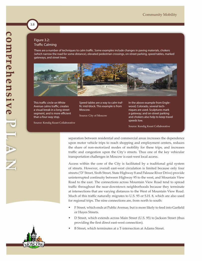
Figure 3.2:Traffic Calming
There are a number of techniques to calm traffic. Some examples include changes in paving materials, chokers (which narrow the road for some distance), elevated pedestrian crossings, on-street parking, speed tables, marked gateways, and street trees.
This traffic circle on White Avenue calms traffic, creates a visual break in a long street segment, and is more efficient than a four-way stop.
Source: Kendig Keast Collaborative
Speed tables are a way to calm traf-fic mid-block. This example is from Moscow.
Source: City of Moscow
In the above example from Engle-wood, Colorado, several tech-niques are used. Sculptures mark a gateway; and on-street parking and chokers also help to keep travel speeds low.
Source: Kendig Keast Collaborative

CH
AP
TE
Rth
ree
3.9
Moscow Comprehensive Plan
Third Street ultimately merges with S.H. 8, which provides access to highway commercial uses and the City of Pullman, Washington. However, East of U.S. 95, Third Street terminates at Paradise Creek near Mountain View Road.
Sixth Street, which provides a cross-City connection to the University of Idaho (thus providing the second direct east-west connection).
Joseph Street, which terminates at a T-intersection at Nez Perce Street.
Harold Avenue, which terminates at a T-intersection at Lynn Street.
White Avenue, which connects to S.H. 8 and, via Styner Avenue, to U.S. 95.
S.H. 8, which provides regional east-west connectivity (thus providing the third direct east-west connection).
Palouse River Drive, which connects to U.S. 95 (thus providing the fourth and final direct east-west connection).
The Thoroughfare Plan (shown in Map 3.1 and discussed in Section 3.4.5) reflects the following improvements to east-west mobility (listed starting from the north):
Trail Road would extend from Orchard Avenue westward across U.S. 95 tying into Mix Road.
Darby Road would be extended westward connecting Orchard Avenue and Mountain View Road.
The current east-west segment of Mountain View Road would be extended eastward and westward as a collector street that would eventually connect to Orchard Street.
East F Street would be extended eastward to tie into the proposed connection between East Third Street (as extended) and the northernmost segment of Mountain View Road.
D Street is planned to extend eastward providing a continuous connection between points to the east and U.S. 95.
The development of Third Street beginning at Mountain View Road and continuing eastward eventually curving north, intersecting with Sixth Street and D Street (near the current City limits), and extending to the northernmost segment of Mountain View Road.
Robinson Park Road is planned to extend eastward.
The City’s Transportation Commis-sion and City Council have previously endorsed the construction of a vehicle bridge across Paradise Creek to extend Third Street east to connect to Moun-tain View Road. The proposed bridge is intended to better connect the City street system and balance the amount of traffic on Sixth Street, “B” Street, “D” Street and Hayes Street. The City’s 2014 Multi-Modal Transportation Plan recommended that the bridge installa-tion be accompanied with traffic calm-ing measures to mitigate potential adverse impacts to existing land uses within the corridor and provide for the safety of non-motorized users. After an unsuccessful bid process to con-struct the vehicular bridge in 2018, the City began the installation of various pedestrian safety and bicycle system improvements within the corridor that were developed through a public par-ticipation process and will reevaluate the installation of the vehicular bridge at a later time.
comPrehensiveP
LA
N
Community Mobility
3.10
A connection between Joseph Street and Carmichael Road.
Palouse River Drive is planned to serve as a minor arterial roadway. It is advised that the traffic-carrying capacity of this roadway be protected through access management regulations that prevent closely spaced curb cuts and promote a corridor design where access to properties that front on Palouse River Drive is taken from side streets or auxiliary roads constructed in conjunction with new development.
Each of these proposed roadway extensions and improvements would occur concurrently with new development. The cumulative effect of these network enhancements would serve to greatly improve east-west mobility.
In addition to improving east-west street continuity, there are additional strategies that can be utilized to help alleviate east-west congestion. Improvement of available transit services into the eastern side of the City would help reduce traffic volumes by providing a viable alternate to individual automobiles. Additionally, improving the availability of commercial goods and services in close proximity to existing and future residential developments in the eastern side of the City could also help reduce east-west traffic volumes. This is most needed within the northeastern area of the City, where existing residential uses are currently located nearly two miles from the nearest available commercial services.
3.4.4 North-South Access
Similar to east-west streets, the north-south streets within the City also have limited continuity. Only Mountain View Road and U.S. 95 provide continuous paths from the southern to the northern areas of the City. North-south access is complicated by regional truck traffic as U.S. 95 is the only cross-City north-south route that allows for regional movements (although Mountain View Road provides direct north-south access within the City limits on the east side of the City).
U.S. 95 plays several roles. First, it runs directly through much of Moscow’s downtown Central Business District through a separated one-way couplet system. Second, it is a regional traffic and truck route. The two roles of U.S. 95 conflict with each other as the regional traffic detracts from the function of downtown as a pedestrian-oriented retail district.
Although the City’s downtown is successful notwithstanding the impacts of regional traffic, the City prefers to reduce the conflict and re-route the regional traffic. As such, the City has planned for alternative access and truck routes around the City through a future alternate U.S. 95 alignment outside the City’s downtown core.

CH
AP
TE
Rth
ree
3.11
Moscow Comprehensive Plan
3.4.5 Thoroughfare Plan
Thoroughfare system planning is intended to facilitate the development of the most efficient and appropriate street system necessary to meet existing and future travel needs. The primary objective of the Thoroughfare Plan is to ensure that adequate right-of-way is preserved on appropriate alignments to allow the orderly and efficient expansion and improvement of the street system. The Thoroughfare Plan will affect the growth and development of Moscow as it guides the future development of the City’s street network. While other elements of the Plan examine foreseeable changes and needs over a 20-year horizon, thoroughfare planning requires a much longer-range perspective. Future changes in transportation technology, cost structure, service demand, and long-term shifts in the economy and urban growth patterns require a far-sighted approach to thoroughfare planning decisions.
Map 3.1, Thoroughfare Plan, illustrates the proposed general conceptual future alignments for new and existing arterial and collector streets. The location and alignment of thoroughfares within proposed developments should generally conform to the Thoroughfare Plan, but actual alignments will be determined at the time of development in consideration of topography, logical and orderly development layout and other considerations. Any proposed significant change in thoroughfare alignment should be reviewed to ensure it will not adversely impact the function of the street system.
Some elements of the thoroughfare system may require new or wider rights-of-way and depending on need, may be developed as two-lane or multi-lane roadways with various cross sections. Some streets identified as collectors on the plan may not ever be widened due to physical constraints and right-of-way limitations. Instead, the collector designation signifies its traffic-handling role in the overall street system and the importance of maintaining it in good condition -- including designations such as snow routes prompting priority removal -- to maximize their traffic capacity since they most likely cannot be improved to an optimal width and cross section.
The plan does not show future local streets because they will provide access to individual sites and parcels and their future alignments will vary depending upon individual land development plans. Local street alignment can be determined by the City in conjunction with landowners as part of the subdivision development process. Likewise, collectors are required with new development, but may not all be reflected on the Thoroughfare Plan since their alignments will depend on the surrounding street system and the particular development concept. They are, nevertheless, vital to an efficient and viable transportation network and therefore, must not be overlooked during the subdivision development review process.
comPrehensiveP
LA
N
Community Mobility
3.12
3.4.6 Proposed Alternate Highway Alignments
For nearly 50 years, the City has discussed the need to provide alternative routes for regional and local traffic to reach its intended destination without having to funnel through downtown, which conflicts with the intended use of downtown as a pedestrian-oriented retail and entertainment district. This concept has appeared in various City planning documents over the last several decades often under the moniker of “Loop Road”, among others. More recent planning documents focused on a U.S. 95 bypass that was proposed to be located at the western edge of the City along the alignment of Warbonnet Drive.
In early 2002 and 2003, the City and Idaho Transportation Department conducted an origin-destination study upon the state highways and a corridor study for the portion of S.H. 8 located west of Washington Street. Both studies concluded that a State highway bypass was not warranted at this time, and that the projected future traffic volumes for the next twenty years could be physically accommodated within the existing highway corridors. While the studies concluded that the traffic could be physically accommodated without a bypass, the wider community’s opinion has been that accommodating the current and anticipated future traffic volumes through the center of downtown is not a desirable long-term solution.
Out of this discussion, the City’s Transportation Commission began the process of identifying future transportation corridors that would link together the four quadrants of the City and the State highway system, thus providing a more direct alternative route for both local and regional traffic and relieving congestion in the downtown area. These proposed alternate highway alignments would provide a truck bypass route (especially along its western alignments, due to the large amount of truck traffic that comes into the City from the north and south on U.S. 95 and exits to the west on Pullman Road) and improve east-west mobility within the community.
Within the 2014 Multi-Modal Transportation Plan, the proposed “Ring Road”was modeled to assess the relative benefits the facility would provide to reduce congestion within the downtown core. The study concluded that the Ring Road would not significantly improve intersection operations downtown or on parallel routes, and would increase truck travel times using the Ring Road compared to the existing highway system. The study largely concluded that the benefits of the ring road would not justify the projected expense of $110 to $140 million. The study recommended continued pursuit of the southwest quadrant which provided the greatest benefit based upon current traffic patterns.
As a result, the City’s Transportation Commission revised the City’s long range street system plan including a potential alternated U.S. 95 alignment which is reflected in the Thoroughfare Plan shown in Map 3.1, Thoroughfare Plan.

CH
AP
TE
Rth
ree
3.13
Moscow Comprehensive Plan
3.4.7 Local Street Design
While the Thoroughfare Plan projects the future for the City’s major street system, the character and development patterns of local streets impact the quality of neighborhoods and the mobility of its future residents.
Many past developments within the City have resulted in a somewhat disconnected street system. Discontinuous streets create circuitous routes that increase trip distances and present navigation challenges to residents, visitors and emergency responders, as well as the efficient delivery of public services (sanitation collection, transit delivery, mail delivery, and others). Increased trip distances also result in greater vehicle fuel consumption and emissions, and reduce the attractiveness of non-motorized modes of mobility.
As new local streets are planned and developed, considerations should be provided to the interactions and relationships with adjacent existing and future planned roadways. Intersections of new local streets with existing thoroughfares within or bordering the subdivision should be planned to align with existing intersections, where feasible, to avoid creation of off-set or “jogged” intersections. Through-streets and T-intersections should be utilized in place of cul-de-sacs, when feasible, and care should be taken to minimize the utilization of cul-de-sacs, which limits through-access, restricts pedestrian circulation, increases response times, and confuses motorists. When cul-de-sacs are used, their length should be limited from the connecting street and pedestrian ways should be provided to enhance pedestrian access.
Street continuity must also be balanced against the preservation of neighborhood quality. A properly designed hierarchy of arterial, collector, and local streets can be utilized to direct local traffic to collector streets and beyond and reduce through-traffic on local streets. Where through-traffic problems exist, traffic calming devices can be effectively utilized to discourage through-traffic use of local streets, while still maintaining the overall connectivity of the street network.
Subdivision layout should avoid the creation of residential lots fronting on collector or arterial streets. Rather, lots should be accessed from local residential streets within or bordering the subdivision or an auxiliary (or marginal access) street designed to accommodate driveway traffic. Existing streets in adjacent areas should be continued, and when an adjacent area is undeveloped, the street layout should provide for future continuation of streets into the undeveloped area.
The City should discourage the use of private streets, including gated communities, unless adequate precautions are taken to ensure minimum standards of construction, necessary space for utilities and street widening, sufficient room and an access arrangement for emergency vehicles, and appropriate public pedestrian access and circulation.

comPrehensiveP
LA
N
Community Mobility
3.14
3.4.8 Arterial and Collector Street Access Management
The automobile-oriented segments of the City’s principal commercial corridors (S.H. 8 and U.S. 95) were, in large measure, developed at a time when the level of traffic on the highways was low enough that driveway access did not significantly impair regional traffic flow. Consequently, the highways have numerous access points to adjacent uses, which is normally the function of local streets. Currently, the City’s regulations prohibit backing movements onto arterials and allow for a maximum of one driveway connection per lot onto City streets. The State of Idaho has additional access management requirements for State highways that involve access spacing requirements. The City should develop similar access management strategies along its arterials and collectors. Such a strategy could include consolidating access points and requiring internal cross-access between adjacent uses, where feasible, as they develop and redevelop.
3.4.9TrafficControlandSafety
Intelligent Transportation Systems (ITS) help relieve congestion and improve traffic operations by optimizing
traffic signal timing and communication. See Figure 3.3, Signal Timing. The University of Idaho is home to the National Institute for Advanced Transportation Technology (NIATT), which has pioneered cutting-edge ITS components to better manage arterial roadway traffic. NIATT is currently deploying many of these systems in the City. The City should continue to partner with NIATT and the Idaho Transportation Department (ITD) to improve traffic operations using technology-based solutions as part of a multi-faceted approach to transportation management. Pullman Road, Third Street (in the downtown area), Main Street, Washington Street, and Jackson Street should be priority areas for ITS systems.
According to ITD collision data reporting, 753 collisions were reported in Moscow between 2007 and 2011. See Map 3.2, Accident-Prone Intersections. Collisions in nearly every category decreased during this time, year to year. However, 2011 saw the first traffic-related fatality in five years. Collisions occurred in a variety of weather conditions, but only 13% occurred in snowy or rainy conditions. In addition, road surface conditions were primarily dry (67% of collisions versus the 18% occurring in icy or snow covered road conditions), and three quarters of all collisions (77%) occurred during the daylight hours. Factors contributing to collisions included high travel speeds, failure to yield, limited sight distances
Figure 3.3:Signal Timing
The benefits of improved signal timing have been demonstrated in Oakland County, Michigan and Syracuse, New York. In Oakland County, Michigan, retiming 640 traffic signals during a two-phase project resulted in carbon monoxide reductions of 1.7 and 2.5 percent, nitrogen oxide reductions of 1.9 and 3.5 per-cent, and hydrocarbon reductions of 2.7 and 4.2 percent. The benefit-to-cost ratios for the two phases of this project were 55:1 to 175:1.
In Syracuse, New York, benefits were realized when signal timing was optimized for 145 intersections. Signal retiming decreased the number of stops by 15.7 percent, reduced travel time by 16.7 percent, lowered delay by 18.8 percent, caused a 13.8 percent decline in fuel consumption, and resulted in a 13 percent reduction in vehicle emissions and noise pollution.
Source: U.S. Department of Transportation.
CH
AP
TE
Rth
ree
3.15
Moscow Comprehensive Plan
or obstructed visibility, and failure to obey traffic control devices such as red lights and stop signs. See Table 3.1, Top Ten Collision Locations in Moscow (2007-2011).
3.4.10 CorridorandGatewayBeautification
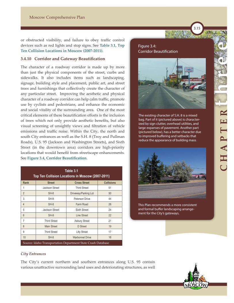
The character of a roadway corridor is made up by more than just the physical components of the street, curbs and sidewalks. It also includes items such as landscaping, signage, building style and placement, public art, and street trees and furnishings that collectively create the character of any particular street. Improving the aesthetic and physical character of a roadway corridor can help calm traffic, promote use by cyclists and pedestrians, and enhance the economic and social vitality of the surrounding area. One of the most critical elements of these beautification efforts is the inclusion of trees which not only provide aesthetic benefits, but also visual screening of unsightly views and filtration of vehicle emissions and traffic noise. Within the City, the north and south City entrances as well as the S.H. 8 (Troy and Pullman Roads), U.S. 95 (Jackson and Washington Streets), and Sixth Street (in the downtown area) corridors are high-priority locations that would benefit from streetscape enhancements. See Figure3.4,CorridorBeautification.
Table 3.1 Top Ten Collision Locations in Moscow (2007-2011)
Rank Street Cross Street Collisions1 Jackson Street Third Street 51
2 SH-8 Driveway/Parking Lot 50
3 SH-8 Peterson Drive 44
4 SH-8 Farm Road 26
5 Jackson Street Sixth Street 24
6 SH-8 Line Street 22
7 Third Street Asbury Street 21
8 Main Street D Street 19
9 Third Street Lilly Street 17
10 SH-8 Warbonnet Drive 16
Source: Idaho Transportation Department State Crash Database
City Entrances
The City’s current northern and southern entrances along U.S. 95 contain various unattractive surrounding land uses and deteriorating structures, as well
Figure 3.4:Corridor Beautification
The existing character of S.H. 8 is a mixed bag. Part of it (pictured above) is character-ized by sign clutter, overhead utilities, and large expanses of pavement. Another part (pictured below), has a better character due to improved buffering and setbacks that reduce the appearance of building mass.
This Plan recommends a more consistent and formal buffer landscaping arrange-ment for the City’s gateways.

comPrehensiveP
LA
N
Community Mobility
3.16
as limited landscaping and green spaces. As these location serve as two of the most heavily traveled entrances into and through the community, improvement to the aesthetic and physical character of these gateways through the transition of land uses, provision of greenways, landscaping, and public art installations would greatly improve the City’s impression upon visitors and travelers using U.S. 95.
Key Roadway Corridors
Along many of these roadway corridors there are limited landscape areas. In terms of character, S.H. 8 on the west side of the City (Pullman Road) and the segments of U.S. 95 near the City entrance locations have the greatest potential for significant impact. The City should initiate a beautification program of sign controls, upgraded landscaping, street tree planting, strategic installation of landscaped medians (if traffic engineering analysis supports them), and the installation of public art (including both public art installations, as well as the incorporation of art into common street fixtures and infrastructure).
In terms of median installation, the City should explore the opportunity for median installation on the Pullman Road along the Palouse Mall frontage, where the presence of Paradise Creek and Paradise Path on the south side of the road limit the impacts of medians upon access to private property. Medians are commonly constructed in either a raised or lowered form. Medians in either configuration provide a number of benefits including improved traffic safety, pedestrian sanctuary, reduced impervious surfaces, and enhanced aesthetic character.
3.4.11 Public Art Integration
Public art not only improves the quality of the commute and aesthetics of the roadway corridor, but it also helps with way-finding by providing landmarks throughout the City. Public art can be in the form of installations of sculptures, as well as the incorporation of art into everyday street fixtures such as handrails, guard rails, bridges, signage, public benches, bus shelters, grates, light standards, and many others. In 2015, the City adopted a Public Art Master Plan that identified a ten-year vision for public art in Moscow, and outlined a plan for desired types of art and locations for public art placement.
The Plan identified priority locations for installation within the next ten years:
North City Entry - Couplet at Main & C Street
Downtown Streetscape (benches, trash receptacles, planters, sculpture plinths)
Jackson and 6th Street (SW corner)
South City Entry - U.S. 95 crossing of the South Fork of Palouse River
CH
AP
TE
Rth
ree
3.17
Moscow Comprehensive Plan
Moscow Public Library
Berman Creekside Park
East City Park
1912 Center
Paradise Path
Friendship Square
In 2018, public art was installed at the Moscow Public Library which completed one of the ten priority locations for public art within the City.
3.4.12 Street Trees
As discussed in Section 1.3.1, street trees and tree lawn areas are essential parts of the character of the historic parts of the City and provide significant environmental, economic, and aesthetic benefits to the community. Tree lawns provide separation of pedestrians from passing automobiles, as well as a location for the storage of snow away from the sidewalk during the winter months. However, in many neighborhoods and the downtown business district, the City’s street trees are aging and under additional stress from increased temperatures and drier conditions. The threat of invasive and destructive insects and disease -carrying pests has increased as these species begin to migrate to our warming region. The rate of tree mortality along Moscow’s streets is increasing. As such, the City should continue its efforts to diversify its urban forests since tree diversity is the best mechanism to make trees more resilient to weather extremes, disease, and pests.
In 2017, the City revised its existing Street Tree Planting Program to require street trees to be planted as part of the building permit process. Street trees are now required to be planted as part of any new development and the developer is given the option of planting the trees or furnishing a security to install the trees at a later date. The Community Forestry Administrator works in concert with the Community Development Department to administer the Street Tree Planting Program.
3.5 PEDESTRIAN MOBILITY
3.5.1 Introduction
Much of Moscow (especially in and around downtown) is highly “walkable,” with connected sidewalks and attractive streetscapes. This pedestrian-friendly environment is essential to the lifestyle of Moscow’s residents. And Moscow residents do “walk the walk” (so to speak) -- one out of every five Moscow workers walked to work between 2008 and 2012.
comPrehensiveP
LA
N
Community Mobility
3.18
Part of Moscow’s charm is the fact that the only large, uninterrupted width of street pavement in the City is S.H. 8 between downtown and the State line. For the streets with more limited capacity, the fact that so many people walk to work helps to reduce the need for street improvements and expansion -- protecting community character and the public treasury. Accordingly, maintaining and enhancing the pedestrian environment is a high priority.
3.5.2 Sidewalk and Crosswalk Facilities
Pedestrian connectivity and mobility is highly valued within the community. The installation of sidewalks where they do not currently exist, and the repair of sidewalks in disrepair, have been identified as a priority for the City. Prioritization for sidewalk installation should include key routes to schools, as well as those areas connecting residential developments with areas of employment and commercial services.
The design of public streets and their amenities greatly influences the safety and enjoyment of pedestrians and encourages people to choose alternative modes of transportation. Sidewalks of a minimum width of five feet should be constructed on both sides of all new public streets with wider sidewalks along designated arterial
streets and within commercial areas. Tree lawns of at least eight feet in width provide areas for street tree planting, snow storage, and separate pedestrians from the noise, exhaust, and danger of adjacent automobile traffic and should be included within all new streets. Street grades should generally be less than 10% so that sidewalks remain conducive to use by pedestrians, cyclists, wheelchairs, and others.
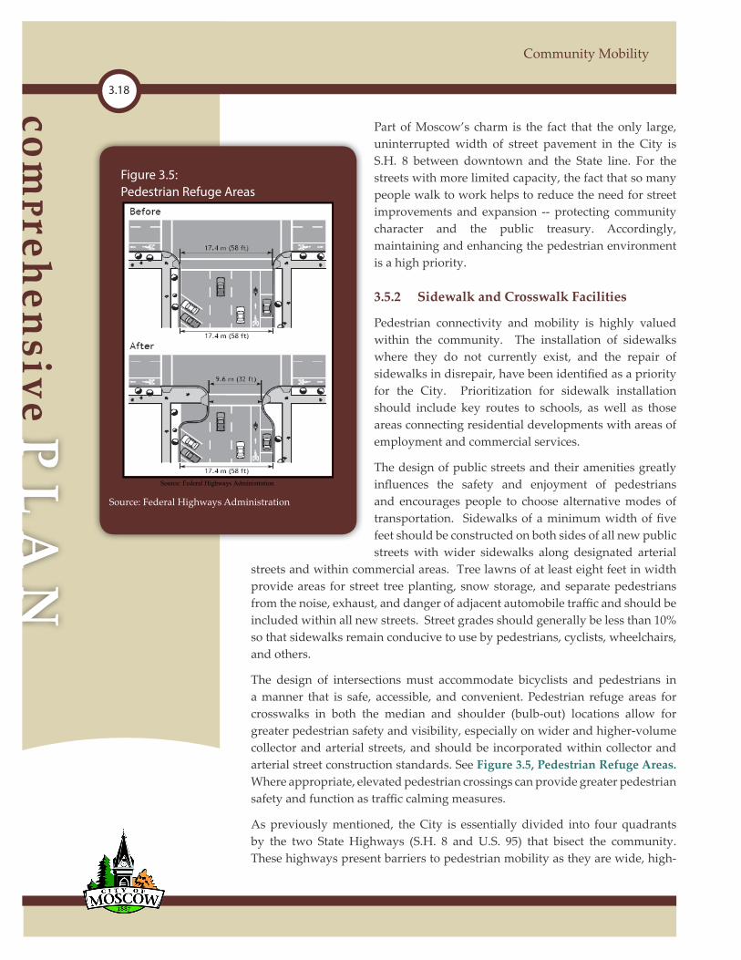
The design of intersections must accommodate bicyclists and pedestrians in a manner that is safe, accessible, and convenient. Pedestrian refuge areas for crosswalks in both the median and shoulder (bulb-out) locations allow for greater pedestrian safety and visibility, especially on wider and higher-volume collector and arterial streets, and should be incorporated within collector and arterial street construction standards. See Figure 3.5, Pedestrian Refuge Areas. Where appropriate, elevated pedestrian crossings can provide greater pedestrian safety and function as traffic calming measures.
As previously mentioned, the City is essentially divided into four quadrants by the two State Highways (S.H. 8 and U.S. 95) that bisect the community. These highways present barriers to pedestrian mobility as they are wide, high-
Source: Federal Highways Administration
Source: Federal Highways Administration
Source: Federal Highways Administration
Figure 3.5:Pedestrian Refuge Areas
CH
AP
TE
Rth
ree
3.19
Moscow Comprehensive Plan
volume roadways that are intimidating to pedestrians. This situation is most prevalent at the intersection of North Main Street and E Street, the intersection of Styner and U.S. 95, and the intersections of both Styner Ave and Mountain View Road with S.H. 8. In 2018, the City constructed a pedestrian underpass at Styner Ave and S.H. 8, and additional pedestrian crossing and safety improvements at the remaining highway intersections should be assessed to help mitigate the barrier these highways present to pedestrians and bicyclists.
3.5.3 Subdivision Design and Pedestrian Pathways
While street connectivity provides many benefits including the promotion of alternative mode share in transportation selection, pedestrian routes must be viewed at a significantly different scale. A block length of 500 feet in a motor vehicle may feel inconsequential, but for a pedestrian it is much more significant. Within subdivision review, likely current or future pedestrian destinations (such as parks, schools, and nearby shopping and dining establishments) should be carefully examined and pedestrian pathways should be required in mid-block or cul-de-sac locations to provide more direct and efficient pedestrian route opportunities.
3.5.4 Accessibility for People with Disabilities
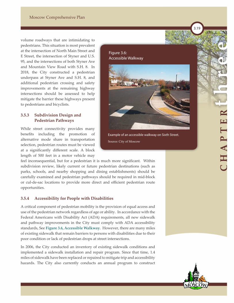
A critical component of pedestrian mobility is the provision of equal access and use of the pedestrian network regardless of age or ability. In accordance with the Federal Americans with Disability Act (ADA) requirements, all new sidewalk and pathway improvements in the City must comply with ADA accessibility standards, See Figure 3.6, Accessible Walkway. However, there are many miles of existing sidewalk that remain barriers to persons with disabilities due to their poor condition or lack of pedestrian drops at street intersections.
In 2006, the City conducted an inventory of existing sidewalk conditions and implemented a sidewalk installation and repair program. Since that time, 1.4 miles of sidewalk have been replaced or repaired to mitigate trip and accessibility hazards. The City also currently conducts an annual program to construct
Part of Moscow’s charm is the fact that the only large, uninterrupted width of street pavement in the City is S.H. 8 between downtown and the State line. For the streets with more limited capacity, the fact that so many people walk to work helps to reduce the need for street improvements and expansion -- protecting community character and the public treasury. Accordingly, maintaining and enhancing the pedestrian environment is a high priority.
3.5.2 Sidewalk and Crosswalk Facilities
Pedestrian connectivity and mobility is highly valued within the community. The installation of sidewalks where they do not currently exist, and the repair of sidewalks in disrepair, have been identified as a priority for the City. Prioritization for sidewalk installation should include key routes to schools, as well as those areas connecting residential developments with areas of employment and commercial services.
The design of public streets and their amenities greatly influences the safety and enjoyment of pedestrians and encourages people to choose alternative modes of transportation. Sidewalks of a minimum width of five feet should be constructed on both sides of all new public streets with wider sidewalks along designated arterial
streets and within commercial areas. Tree lawns of at least eight feet in width provide areas for street tree planting, snow storage, and separate pedestrians from the noise, exhaust, and danger of adjacent automobile traffic and should be included within all new streets. Street grades should generally be less than 10% so that sidewalks remain conducive to use by pedestrians, cyclists, wheelchairs, and others.
The design of intersections must accommodate bicyclists and pedestrians in a manner that is safe, accessible, and convenient. Pedestrian refuge areas for crosswalks in both the median and shoulder (bulb-out) locations allow for greater pedestrian safety and visibility, especially on wider and higher-volume collector and arterial streets, and should be incorporated within collector and arterial street construction standards. See Figure 3.5, Pedestrian Refuge Areas. Where appropriate, elevated pedestrian crossings can provide greater pedestrian safety and function as traffic calming measures.
As previously mentioned, the City is essentially divided into four quadrants by the two State Highways (S.H. 8 and U.S. 95) that bisect the community. These highways present barriers to pedestrian mobility as they are wide, high-
Source: Federal Highways Administration
Figure 3.6:Accessible Walkway
Example of an accessible walkway on Sixth Street.
Source: City of Moscow

comPrehensiveP
LA
N
Community Mobility
3.20
pedestrian drops and other accessibility improvements at key intersections within the community to promote accessibility. Between 2014 and 2018, 110 pedestrian ramps were installed. It is important that the City continues this program to correct these impediments to disabled accessibility.
3.6 BICYCLE MOBILITY
3.6.1 Introduction
In the years 2008-2012, the American Community Survey reported that over 5% of the City’s “journey to work” trips were made by bicycle. This ranks Moscow in the top 1% of communities in the U.S. for bicycle commuters. Moscow City Surveys have shown higher and increasing percentages of bicycle commuters. The 2012, 2014, and 2016 City Surveys reported bicycle commuting shares of 9%, 7%, and 7%, respectively. Because of its relatively compact size, slower-speed and low-volume streets, and its progressive citizenry, Moscow is an ideal community in which to encourage bicycle mobility.
Almost anyone can ride a bicycle, and this makes bicycling a difficult mode of transportation to plan for. Bicyclists vary significantly in their age, knowledge, skills, and comfort level in riding with other traffic. Therefore, different types of facilities are needed to accommodate different types of bicyclists.
Bicyclists’ riding behaviors can be grouped into three broad categories along a spectrum: integrated, segregated, and separated. Bicyclists using integrated behaviors act like other vehicles on the street and require no special on-street facilities. Bicyclists using segregated behaviors ride in bike lanes on the street or on shoulders, segregated from motor vehicle traffic. Bicyclists using separated behaviors ride on shared-use pathways, physically separated from the street. Most bicyclists use all three behaviors at some time when riding, depending on their route, riding preferences, and the facilities provided.
Bicyclists use all streets in Moscow, and accommodating them requires different facilities depending on the street’s characteristics. Segregated facilities (i.e., bike lanes) are not necessary on low-volume, low-speed local streets where bicyclists and motorists can safely and comfortably share the road. As traffic volumes, speeds, and street classification increase to collector and arterial status, the rationale increases for providing bike lanes for bicyclists’ safety and comfort. Bicyclists that prefer to avoid streets altogether and use shared-use pathways also need a well-connected and maintained pathway system in order for bicycle mobility to reach its full potential in Moscow.
3.6.2 Bike Lanes
Bike lanes provide extra width on the roadway that allows motorists to pass bicyclists with more ease, comfort, and safety. In Idaho, bicyclists are not required to use bike lanes. Sometimes bicyclists’ safety dictates that they not use
CH
AP
TE
Rth
ree
3.21
Moscow Comprehensive Plan
the bike lane, for example, when preparing for a left turn, when the bike lane is covered in snow or ice, or when the bike lane is located in the door zone next to parked cars.
Planning for and providing the roadway width necessary to include bike lanes is relatively easy for new street construction. It is more difficult, however, to retrofit streets with bike lanes once curbs are in place and the street width is fixed. Retrofitting streets with bike lanes may involve tradeoff decisions involving numbers of traffic lanes, width of traffic lanes, and provision of on-street parking.
In 2016, the City’s Transportation Commission and Public Works Department developed a City-wide Bike Route and Facilities Plan which was adopted by the City Council in June of 2016. Since that action, the City has gradually been working to implement the plan with many of the routes and facilities.
3.6.3 Bike Routes
Bike Routes are suggested routes for bicyclists that may or may not have special bicycle facilities. They usually follow streets with lower speeds and traffic volumes, as well as bike lanes and paths. Signing bike routes with directional and destination information is important for their utility by bicyclists. The City should develop and maintain maps of signed bike routes and signs along bike routes in accordance with the 2016 Bike Routes and Facilities Map, and should indicate the prominent destinations to which the route leads.
3.6.4 Bicycle Parking
Bicyclists need adequate and secure parking when they reach their destinations. Moscow experiences some form of precipitation about half the days each year so covered bicycle parking would encourage bicycling during periods of inclement weather. The City has recently adopted a bicycle parking incentive whereby a certain percentage of automobile parking spaces can be reduced with the inclusion of bicycle parking. The City should continue to pursue the development of bicycle parking requirements for new multi-family residential and commercial developments.
3.6.5 Integrating Bicycling with Transit
Integrating bicycling with transit services increases the utility and convenience of both modes of transportation and may decrease the necessity of using private automobiles for some longer trips. The City should create an integration plan for bicycling and public transit. Elements should include such things as:
Designating bicycle routes that lead to bus stops.
Covered, secure bicycle parking at bus stop shelters.
comPrehensiveP
LA
N
Community Mobility
3.22
3.6.6 Other Bicycling Issues
Nonresponsive traffic signals are a problem at many intersections for bicyclists. Although in Idaho bicyclists are allowed to proceed through red lights after stopping and only when it is safe to do so, safety issues still arise due to nonresponsive signals. Many newer traffic signals do not change in a pre-set or predictable pattern, leaving the waiting bicyclists wondering what the duration of the signals current indicator may be.
3.7 MULTI-PURPOSE PATHWAYS
The City has developed, maintains and continues the expansion of a system of separated multipurpose pathways that include the Paradise Path and the interconnections of the Latah Trail to the east and the Chipman Trail to the west. These multi-purpose pathway systems not only provide opportunities for passive and active recreation activities, but also function as multi-modal transportation corridors linking various locations within the community. These facilities are discussed in more detail in Section 4.4.4 of this Plan. See Map 3.3, Multipurpose Pathways.
3.8 TRANSIT AND TRANSIT-SUPPORTIVE DEVELOPMENT
3.8.1 Introduction
According to the 2000 U.S. Census, about one percent of Moscow’s workers used transit (which includes taxicab) to get to work. The national average was 4.7 percent. However, fixed-route transit did not exist in Moscow in 2000. A local non-profit corporation, Regional Public Transportation, Inc. operating as Moscow Valley Transit, began providing fixed route services in 2004 and quickly became important to the mobility of all City residents. In 2012, Moscow Valley Transit became the Sustainable Moscow Area Regional Tansportation (SMART) Transit system. SMART Transit continues to provide free ridership and should be considered as a factor that influences the ability of the City and the University to attract and retain students and staff.
3.8.2 Existing Routes and Ridership
At the time of this writing, SMART Transit provides two free fixed bus routes for local transit (East Route, which serves generally east of Main Street; and West Route, which serves generally west of Main Street, except for a slight jog into the University). These routes, shown in Map 3.4, Transit Routes, have 30-minute headways and report 120,000 boardings annually. Almost two-thirds of SMART Transit riders are University of Idaho students. Forty-six percent of the students riding SMART Transit are going to and from class. SMART Transit also provides point-to-point “dial-a-ride” service.
The University of Idaho, the City of Moscow, the U.S. Department of Transportation,

CH
AP
TE
Rth
ree
3.23
Moscow Comprehensive Plan
Idaho Transportation Department, United Way, and New Saint Andrews College all contribute to support transit services within the region through “in-kind” or cash-match contributions. Together, they contribute funding that is used to leverage federal funding that helps fund transit service in the region.
3.8.3 Projected Ridership
It is likely that the most significant limiting factor in ridership is the limited transit service coverage and service hours possible under current available funding. There are many examples around the country where small town public transportation operations can be successful given adequate funding mechanisms, such as local option taxes and student fees in university communities. As funding allows, new routes and additional service hours should be investigated as a means to increase ridership, and the rising cost of gasoline could also contribute to an increased interest in transit over time.
3.8.4 Bus Shelters and Transit-Supportive Development
Part of the transit ridership equation is having adequate shelter at the pick-up point and then a safe, attractive, and convenient walk to the destination of choice. The City should take efforts to provide all-weather bus shelters in prioritized locations based on the average number of boardings at the stop. Further, the City should take steps to improve the character of the stops by providing benches, appropriate signage, unique public art, and ensuring that sidewalks and landscaping around the stops are in good condition. See Figure 3.7, Transit Stops.
Higher-density development has historically provided greater opportunities for more efficient transit operations in that a large number of riders concentrated in a single location allows for the logical location of fewer transit stops and more efficient transit operation. While development densities within Moscow vary widely, the location of established and potential future transit routes should be considered in locating higher-density development nodes within the City. Subdivision design should be reviewed for the appropriate siting and construction of centrally located and accessible transit stops. Facilities should include pull-outs, shelters and signage, and be accessible via pathways and sidewalks. Additionally, infill and higher-density redevelopment projects should be encouraged in areas where transit service is readily available.
Figure 3.7:Transit Stops

comPrehensiveP
LA
N
Community Mobility
3.24
3.8.5 Extension of Transit Service
There are several areas that are currently zoned for multifamily development or manufactured housing that are located more than one-quarter mile from the nearest SMART Transit bus stop. These locations could be relatively dense sources of additional ridership. This Plan recommends that these additional areas be studied to determine whether additional service is warranted.
As there are limited funding sources for public transit within the State of Idaho, funding of any service extensions within Moscow presents a challenge. Future service extension studies should include a fiscal component to determine whether a reasonable bus fare schedule would help support the service extension, and if benefits of the service extension to overall community mobility and under-served populations would outweigh the burden that existing users would bear if bus fares were charged. Fares typically support only a modest portion of the cost of delivery of transit services and collection of fares can negatively impact transit ridership. Therefore, care must be taken to carefully weigh the costs and benefits of fare collection upon service delivery and utilization.
3.9 SCHOOL ACCESS AND TRANSPORTATION
3.9.1 Introduction
Moscow School District #281’s strategic plan states that the District aims to: “provide safe and efficient pupil transportation services to all qualifying students in the district.” To that end, it seeks to “[d]evelop a system of to/from school routes that will provide qualifying students with safe and efficient transportation to the appropriate school buildings.” This includes bus routes and safe routes for students to walk to school.
In terms of busing, the District has 13 bus routes that transport approximately 700 students. As common school busing times overlap with normal peak-hour traffic, the street network patterns that affect non-school traffic also affect school buses. The School District reports that the existing stock of buses is adequate to provide the necessary service.
In terms of walking routes, State regulations generally require that students who live within 1.5 miles of their school must walk or use private transportation. As such, connected sidewalks are essential for safe travel to school.
The City has already obtained grant funding and constructed sidewalks that serve Lena S. Whitmore Elementary School and Moscow Middle School through the Safe Routes to School Program.1
1 The Safe Routes to School program provides grant funding for installing or repairing side-walks and signage, safety education and enforcement through extra police patrols. Individual schools, school districts, nonprofits, highway districts, cities, and counties can apply for the grants.

CH
AP
TE
Rth
ree
3.25
Moscow Comprehensive Plan
Sidewalks have also been installed on several streets including Cleveland Street between First and B Streets and F Street and Public Avenue, B Street between Blaine and Cleveland Streets, and D Street between Moscow Middle School and the Eggan Youth Center.
In addition to the projects listed above, continuous sidewalks should be installed along Orchard Avenue, Public Avenue, Mountain View Road, Polk Street, and Jefferson Street.
3.9.2 Safety Routes
In the absence of safe connections, the School District may run bus routes called “safety routes” to students who live closer than 1.5 miles to school. There are currently five safety routes, which are shown in Map 3.5, Safety Routes. Completion of the sidewalk system along Mountain View Road including the area outside the City limits where Mountain View Road turns into an east-west alignment, will enable the school district to eliminate one of these routes by providing a safe route for students to walk to school. The balance of the safety routes cannot be “fixed” with sidewalks because they were created to address the risks associated with crossing major streets.
3.10 PARKING
3.10.1 Introduction
The City’s parking requirements are set out in the City’s Zoning Code which stipulates the minimum number of off-street parking stalls that must be provided for various uses. Many of the requirements are at least in part based on the number of employees on the premises, which can make plan review and code enforcement very difficult. The City recently reviewed parking requirements and made revisions to better address parking demands and ease of administration.
3.10.2 Downtown Parking
As of this writing, uses within the Central Business (CB) Zoning District are exempt from the requirement to provide off-street parking under the City’s Zoning Code. The requirement for large private surface parking lots would detract from the desired urban, pedestrian-oriented character of the downtown area and create demand for automobile traffic in the area. Currently the majority of the auto parking demand is satisfied with public parking, both on-street and in several public parking lots. The reliance on public parking for the downtown district provides a great deal of flexibility in meeting parking demand as it fluctuates during the course of the day and week, rather than privately held and managed parking dedicated to a particular use.
Although a formal traffic and parking study has not been conducted for the

comPrehensiveP
LA
N
Community Mobility
3.26
downtown area since 1993, the City’s Transportation Commission conducted a downtown parking survey in 2008 to assess the perception of parking held by business owners, employees, residents and customers in the downtown area. While the degree of a perceived problem varied among the user groups surveyed, the conclusion of the Transportation Commission’s work was that a perception exists that there is a parking shortage within the downtown area. The Transportation Commission’s report concluded with a list of 25 implementation strategies that were identified as feasible actions to pursue in order to improve parking in the downtown area. The City should pursue implementation of the Transportation Commission’s recommendations and conduct additional surveys in subsequent years to assess their effectiveness.
In addition to the implementation of the Transportation Commission’s recommendations, which are anticipated to assist in meeting current parking demands, the City should pursue requiring the provision of off-street parking within the CB Zone for uses that have greater demands than the short-term public parking can fulfill. Examples of such uses include residential uses and hotels/hospitality and larger office complexes where long-term parking demands cannot be reasonably served with the currently available public parking. If parking is required of such uses, the City should carefully control its placement, such as underneath or behind the buildings, so as to not interrupt the continuous building streetwall and pedestrian environment of downtown.
3.11 COMMUNITY MOBILITY GOALS AND OBJECTIVES
3.11.1 General Community Mobility Goals
Ensure the integration and coordination of the City’s transportation systems with the regional facilities and modes of transportation.
Plan for the orderly development and continuity of the City’s street and pathway systems, as well as connectivity to regional transportation networks to ensure the efficient delivery of services and navigation by residents and visitors.
Ensure that all transportation systems enable safe access and promote alternative mode use for all modes of mobility, including pedestrians, bicyclists, motorists, and public transit users of all ages and abilities.
Provide for the continuity and function of the City’s transportation system while ensuring context-sensitive design that preserves and enhances community character and quality of life.
3.11.2 Regional Mobility
Objective:
Provide for the efficient integration of the City’s transportation systems

CH
AP
TE
Rth
ree
3.27
Moscow Comprehensive Plan
with regional facilities and modes of mobility including county roads, state highways, shared-use trail systems, air transportation, and regional bus transportation services.
Implementation Actions:
1. Actively engage and participate within regional transportation planning efforts of surrounding jurisdictions and entities engaged in the development, provision, and maintenance of transportation facilities and services.
2. Work in collaboration with the Idaho Transportation Department to identify and construct priority transportation improvement projects through the State of Idaho Statewide Transportation Improvement Plan program and other similar programs.
3.11.3 City Street System
Objectives:
A. Provide for the safe and efficient movement of people, goods and services throughout the community supporting all modes of transportation.
B. Plan for the logical and orderly extension of the City’s public street network.
C. Ensure that the City’s transportation system supports and relates with the surrounding land uses, and preserves and enhances the community’s character and values.
Implementation Actions:
1. Provide for the orderly development and preservation of future alignments of the City’s arterial and collector street network as identified in the Thoroughfare Plan. See Section 3.4.5, Thoroughfare Plan.
2. Ensure that all City streets are designed to provide safe access and use for all users including pedestrians, bicyclists, transit users, and motorists. See Section3.4.2,StreetClassifications.
3. Ensure that future local streets provide for the continuity of the City’s street network while directing through-traffic to collector and arterial streets. See Section3.4.2,StreetClassifications.
4. Adopt and implement approved traffic calming measures, such as narrower streets, on-street parking, and other devices, in residential areas where such actions will not impede the function of the City street network. See Section 3.4.7, Local Street Design.
5. Identify and explore cooperative opportunities for the preservation of right-of-way for the proposed Alternate Highway 95 Alignment.
6. Encourage the improvement of existing substandard and gravel streets and
comPrehensiveP
LA
N
Community Mobility
3.28
alleys through the use of local improvement districts or other techniques. See Section 3.4.1, General Existing Conditions.
7. Implement the 2015 Corridor and Entrance Beautification Program along S.H. 8 and U.S. 95 with landscaping and public art; install a landscaped median with appropriate cuts on S.H. 8 along the mall frontage. See Section 3.4.10,CorridorandGatewayBeautification and Section 3.4.11, Public Art Integration.
8. Implement a program of access management along designated arterial and collector streets to preserve their safe and efficient function. See Section 3.4.3, East-West Access.
9. Require street improvements and right-of-way dedication when property is developed, redeveloped, or substantially improved, based on the functional classification of the adjacent street. See Section 3.4.3, East-West Access.
10. Expand collaboration with NIATT at the University of Idaho and ITD to deploy and upgrade Intelligent Transportation Systems infrastructure. See Section3.4.9,TrafficControlandSafety.
11. Set out a policy for joint access easements along S.H. 8 and U.S. 95 (outside of downtown) as properties develop and redevelop to reduce the number of private driveways and access points. The policy should reinforce State access management standards. See Section 3.4.8, Arterial and Collector Street Access Management.
12. Monitor and prioritize traffic safety improvements at intersections with high accident rates. See Section3.4.9,TrafficControlandSafety.
3.11.4 Pedestrian Mobility
Objectives:
A. Provide for the safe access and use of the City’s pedestrian facilities for users of all ages and abilities.
B. Promote walking as a mode of transportation within the community to enhance the physical and social health of the community.
Implementation Actions:
1. Continue efforts to fill gaps in the City’s existing sidewalk system utilizing a variety of possible funding sources including bonds, grants, local improvement districts, and other methods. See Section 3.5.2, Sidewalk and Crosswalk Facilities.
2. Continue the development and expansion of the City’s multipurpose pathway system. See Section 3.7, Multi-Purpose Pathways.
3. Assess, monitor, and maintain the City’s pedestrian facilities and operation to ensure safe access and use for all users at all times. See Section 3.5.4, Accessibility for Disabled Persons.

CH
AP
TE
Rth
ree
3.29
Moscow Comprehensive Plan
4. Provide direct pedestrian access within and through new developments to surrounding pedestrian destinations through easements, dedications, or other means. See Section 3.5.3, Subdivision Design and Pedestrian Pathways.
3.11.5 Bicycle Mobility
Objectives:
A. Increase the safety and convenience of cyclists of all ages and abilities, and encourage the use of bicycles as a desirable mode of transportation within the community.
B. Promote the development and enhancement of logical and connected bicycle ways and parking facilities throughout the community.
C. Enhance the integration of cyclists and community public transit services.
Implementation Actions:
1. Implement the 2016 Bike Route and Facility Plan. See Section 3.6.2, Bike Lanes.
2. Develop and maintain a current map of the City’s bicycle system plan where it can be easily accessed and viewed, such as on the City’s website. See Section 3.6.3, Bike Routes.
3. Integrate bicycling and public transit facilities by coordinating bicycle routes and bus stops, and provide covered, secure bicycle parking at bus stop shelters. See Section 3.6.5, Integrating Bicycling with Transit.
4. Continue to develop and extend the City’s multipurpose pathway system. See Section 3.6.1, Introduction and Section 3.7 Multi-Purpose Pathways.
5. Ensure that all bicycle facilities (i.e., bike lanes and shared-use paths) are designed and built to meet the guidelines in the most current version (2012 as of this writing) of AASHTO’s Guide for the Development of Bicycle Facilities and that City traffic signals accommodate bicyclists to the greatest extent possible. See Section 3.6.6, Other Bicycling Issues.
3.11.6 Public Transit
Objective:
Promote the increased use and expansion of public transit services within the community and region as a desirable transportation alternative.
Implementation Actions:
1. Review all applicable subdivisions (those adjacent to a transit route and not already served by a nearby transit stop) and large commercial developments to integrate transit stop improvements into their site design. See Section

comPrehensiveP
LA
N
Community Mobility
3.30
3.8.4, Bus Shelters and Transit-Supportive Development.
2. Identify, prioritize and seek funding to improve bus stops to provide all-weather shelters. See Section 3.8.4, Bus Shelters and Transit-Supportive Development.
3. Improve streetscape, sidewalks, landscape, and public art around bus stops. See Section 3.8.4, Bus Shelters and Transit-Supportive Development.
4. Study feasibility of extending bus service to the north, east, and south including potential funding sources to support the extension of service within the community. See Section 3.8.5, Extension of Transit Service.
3.11.7 School Access and Student Transportation
Objectives:
A. Assist local schools in providing efficient and safe student access and transportation to school facility locations within the community.
B. Promote student use of biking and walking to school through the development and improvement of pedestrian and bicycle facilities throughout the community.
Implementation Actions:
1. Pursue grant and other funding opportunities to reduce the need for safety bussing areas. See Section 3.9.2, Safety Routes.
2. Review proposed subdivisions and other development proposals for potential pedestrian easements or other means of providing more direct pedestrian routes between residential developments and school facilities. See Section 3.5.3, Subdivision Design and Pedestrian Pathways.
3.11.8 Parking
Objective:
Ensure that the City’s off-street parking requirements balance the need for parking to serve developments while promoting alternative transportation options and ensuring that environmental and aesthetic considerations are addressed.
Implementation Actions:
1. Pursue implementation of the Transportation Commission’s 2008 Downtown Parking Study’s recommended actions to improve parking in the downtown area. See Section 3.10.2, Downtown Parking.
2. Study potential parking management options within the downtown area including, but not limited to: transportation demand management strategies to reduce parking demand; the potential requirement for new

CH
AP
TE
Rth
ree
3.31
Moscow Comprehensive Plan
development and redevelopment within the Central Business District to provide parking or pay a fee-in-lieu to fund new public parking acquisition and development; the development of satellite parking areas; and other similar parking management strategies.
3. Enhance public transit services to and from downtown to reduce parking demand within the downtown area.

D StC St
Polk
St
A St
Loga
n St
Polk R
d
West Palouse River Dr
Line S
t Sixth St
Third St
B St
South
Main
St
E St
Styner Ave
West Pullman Rd
North
Mou
ntain
View
Rd
Joseph St
Blake
Ave
Jack
son S
t
Rodeo Dr
Indian Hills Dr
Haye
s St
West C St
Public Ave
Perimeter Dr
Farm
Rd
Troy Rd
Warbo
nnet
Dr
Wash
ington
St
Canterwood Rd
Fairv
iew D
r
Concord Ave
Blaine
St
East Sixth St
North
Main
St
Travois Way
White Ave
State Hwy 8
Third St
A St
E St
Blaine
St
UV270
UV8
UV8
£¤95
£¤95
ThoroughfarePlan
0 0.3 0.60.15Miles
3.1
IWash
ingt
on
Idah
o
THOROUGHFARE PLANNational HighwayAlt Highway 8 AlignAlt Highway 95 AlignPrincipal ArterialMinor ArterialProposed Minor ArterialCollectorProposed Collector
BOUNDARIES, WATER, & INFRASTRUCTURECity LimitsState BorderArea of City Impact
Note: Proposed future roadway locations are approximate and ultimate roadway locations will be determined at the time of development based upon topography, existing development, property boundaries and proposed devleopment needs.

Accident-ProneIntersections
3.2
J
*Refer to Table 3.1, Top TenCollision Locations in Moscow(2007 to 2011) on Page 3.16

D StC St
Polk
St
A St
Loga
n St
Polk R
d
West Palouse River Dr
Line S
t Sixth St
Third St
B St
South
Main
St
E St
Styner Ave
West Pullman Rd
North
Mou
ntain
View
Rd
Joseph St
Blake
Ave
Jack
son S
t
Rodeo Dr
Indian Hills DrHa
yes S
t
West C St
Public Ave
Perimeter Dr
Farm
Rd
Troy Rd
Warbo
nnet
Dr
Wash
ington
St
Canterwood Rd
Fairv
iew D
r
Concord Ave
Blaine
St
East Sixth St
North
Main
St
Travois Way
White Ave
State Hwy 8
Third St
A St
E St
Blaine
St
UV270
UV8
UV8
£¤95
£¤95
Paradise
Creek
S. Fork Palous
e River
MultipurposePathways
0 0.25 0.50.125Miles
3.3
IWash
ingt
on
Idah
o
FUTURE PROPOSED PATHSPedestrian WalkwaysFuture/Proposed PathwaysMulti-Purpose Pathways - PavedMulti-Purpose Pathways - UnpavedPark PathwaysUniversity Pathways - Unpaved
BOUNDARIES, WATER, & INFRASTRUCTURECity LimitsArea of City ImpactState BorderParadise Creek and S. Fork Palouse River

Transit Routes3.4
J
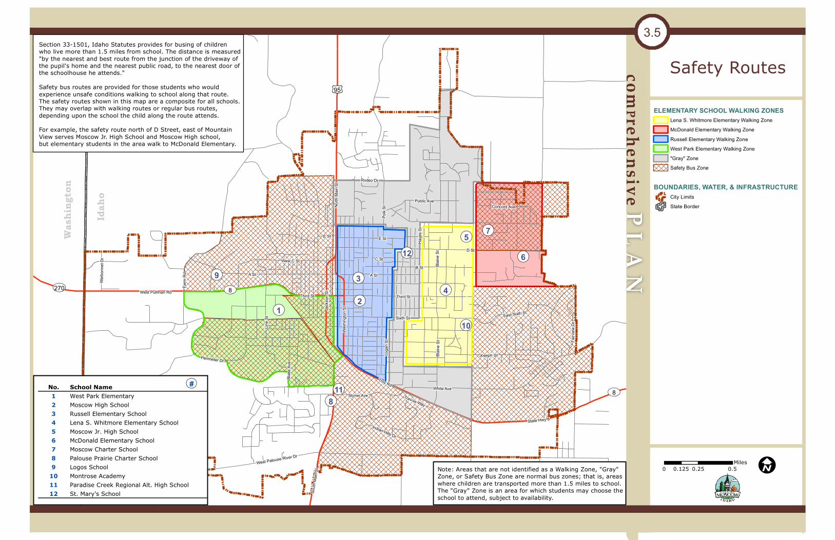
¬«5
¬«6
¬«4¬«2
¬«3
¬«7
¬«10¬«1
¬«11
¬«9
¬«12
¬«8
D StC St
Polk
St
A St
Loga
n St
West Palouse River Dr
Line S
t Sixth St
Third St
B St
South
Main
St
E St
Styner Ave
West Pullman Rd
Joseph St
Blake
Ave
Jack
son S
t
Rodeo Dr
Indian Hills Dr
Haye
s St
West C St
Public Ave
Perimeter Dr
Farm
Rd
Troy Rd
Warbo
nnet
Dr
Wash
ington
St
Fairv
iew D
r
Concord Ave
Blaine
St
East Sixth St
North
Main
St
Travois Way
White Ave
State Hwy 8
Third St
A St
E St
Blaine
St
UV270
UV8
UV8
£¤95
Safety Routes
0 0.25 0.50.125Miles
3.5
I
Wash
ingt
on
Idah
oELEMENTARY SCHOOL WALKING ZONES
Lena S. Whitmore Elementary Walking ZoneMcDonald Elementary Walking ZoneRussell Elementary Walking ZoneWest Park Elementary Walking Zone"Gray" ZoneSafety Bus Zone
BOUNDARIES, WATER, & INFRASTRUCTURECity LimitsState Border
Section 33-1501, Idaho Statutes provides for busing of children who live more than 1.5 miles from school. The distance is measured "by the nearest and best route from the junction of the driveway of the pupil's home and the nearest public road, to the nearest door of the schoolhouse he attends."Safety bus routes are provided for those students who would experience unsafe conditions walking to school along that route. The safety routes shown in this map are a composite for all schools. They may overlap with walking routes or regular bus routes, depending upon the school the child along the route attends. For example, the safety route north of D Street, east of Mountain View serves Moscow Jr. High School and Moscow High school, but elementary students in the area walk to McDonald Elementary.
Note: Areas that are not identified as a Walking Zone, "Gray" Zone, or Safety Bus Zone are normal bus zones; that is, areas where children are transported more than 1.5 miles to school. The "Gray" Zone is an area for which students may choose theschool to attend, subject to availability.
No. School Name1 West Park Elementary2 Moscow High School3 Russell Elementary School4 Lena S. Whitmore Elementary School5 Moscow Jr. High School6 McDonald Elementary School7 Moscow Charter School8 Palouse Prairie Charter School9 Logos School
10 Montrose Academy11 Paradise Creek Regional Alt. High School12 St. Mary's School
QR#