
Commonwealth of the Northern Mariana Islands Joint ...cnmimarines.s3.amazonaws.com/static/DraftEIS/2...
82
CJMT EIS/OEIS April 2015 Draft Table of Contents ES-i EXECUTIVE SUMMARY Table of Contents EXECUTIVE SUMMARY ................................................................................................................... ES-I ES.1 INTRODUCTION ............................................................................................................... ES-1 ES.2 PURPOSE AND NEED FOR THE PROPOSED ACTION ............................................................ ES-4 ES.3 AGENCY AND STAKEHOLDER COORDINATION ................................................................... ES-5 ES.4 ALTERNATIVES DEVELOPMENT ......................................................................................... ES-6 ES.5 PROPOSED ACTION ........................................................................................................ ES-12 ES.6 RESOURCE MANAGEMENT MEASURES ........................................................................... ES-49 ES.7 MITIGATION MEASURES................................................................................................. ES-49 ES.8 PREFERRED ALTERNATIVE .............................................................................................. ES-49 ES.9 OVERVIEW OF ENVIRONMENTAL IMPACTS ..................................................................... ES-50 ES.10 REFERENCES................................................................................................................... ES-78 List of Figures ES-1 U.S. Pacific Command Area of Responsibility ........................................................................ ES-2 ES-2 Mariana Islands Regional Map .............................................................................................. ES-3 ES-3 Tinian All Action Alternatives Military Lease Area-wide Training Assets ............................ ES-25 ES-4 Tinian All Action Alternatives Surface Danger Zones .......................................................... ES-27 ES-5 Tinian All Action Alternatives Special Use Airspace: Two-Dimensional Perspective........... ES-29 ES-6 Tinian All Action Alternatives Base Camp ............................................................................ ES-30 ES-7 Tinian All Action Alternatives Munitions Storage Area ....................................................... ES-31 ES-8 Tinian All Action Alternatives Airport Improvements ......................................................... ES-32 ES-9 Tinian All Action Alternatives Port Improvements and Supply Route ................................. ES-33 ES-10 Tinian All Action Alternatives Range Access Improvements, Fence Lines, and Gates ........ ES-35 ES-11 Tinian All Action Alternatives Utility Improvements ........................................................... ES-37 ES-12 Unai Chulu Tactical Amphibious Beach Landing Dredging and Construction ..................... ES-38 ES-13 Unai Chulu Tactical Amphibious Beach Landing Operations ............................................... ES-39 ES-14 Pagan Alternative 1 Range Complexes ................................................................................ ES-45 ES-15 Pagan Alternative 2 Range Complexes ................................................................................ ES-46 ES-16 Pagan All Action Alternatives Surface Danger Zones .......................................................... ES-47
Transcript of Commonwealth of the Northern Mariana Islands Joint ...cnmimarines.s3.amazonaws.com/static/DraftEIS/2...

CJMT EIS/OEIS April 2015 Draft Table of Contents
ES-i
EXECUTIVE SUMMARY
Table of Contents
EXECUTIVE SUMMARY ................................................................................................................... ES-I
ES.1 INTRODUCTION ............................................................................................................... ES-1
ES.2 PURPOSE AND NEED FOR THE PROPOSED ACTION ............................................................ ES-4
ES.3 AGENCY AND STAKEHOLDER COORDINATION ................................................................... ES-5
ES.4 ALTERNATIVES DEVELOPMENT ......................................................................................... ES-6
ES.5 PROPOSED ACTION ........................................................................................................ ES-12
ES.6 RESOURCE MANAGEMENT MEASURES ........................................................................... ES-49
ES.7 MITIGATION MEASURES ................................................................................................. ES-49
ES.8 PREFERRED ALTERNATIVE .............................................................................................. ES-49
ES.9 OVERVIEW OF ENVIRONMENTAL IMPACTS ..................................................................... ES-50
ES.10 REFERENCES................................................................................................................... ES-78
List of Figures
ES-1 U.S. Pacific Command Area of Responsibility ........................................................................ ES-2 ES-2 Mariana Islands Regional Map .............................................................................................. ES-3 ES-3 Tinian All Action Alternatives Military Lease Area-wide Training Assets ............................ ES-25 ES-4 Tinian All Action Alternatives Surface Danger Zones .......................................................... ES-27 ES-5 Tinian All Action Alternatives Special Use Airspace: Two-Dimensional Perspective ........... ES-29 ES-6 Tinian All Action Alternatives Base Camp ............................................................................ ES-30 ES-7 Tinian All Action Alternatives Munitions Storage Area ....................................................... ES-31 ES-8 Tinian All Action Alternatives Airport Improvements ......................................................... ES-32 ES-9 Tinian All Action Alternatives Port Improvements and Supply Route ................................. ES-33 ES-10 Tinian All Action Alternatives Range Access Improvements, Fence Lines, and Gates ........ ES-35 ES-11 Tinian All Action Alternatives Utility Improvements ........................................................... ES-37 ES-12 Unai Chulu Tactical Amphibious Beach Landing Dredging and Construction ..................... ES-38 ES-13 Unai Chulu Tactical Amphibious Beach Landing Operations ............................................... ES-39 ES-14 Pagan Alternative 1 Range Complexes ................................................................................ ES-45 ES-15 Pagan Alternative 2 Range Complexes ................................................................................ ES-46 ES-16 Pagan All Action Alternatives Surface Danger Zones .......................................................... ES-47

CJMT EIS/OEIS April 2015 Draft Table of Contents
ES-ii
List of Tables
ES-1 Summary of No-Action Alternative Training on Tinian Exclusive Military Use Area by U.S. Air Force, Army, Marine Corps, Navy, and Guam National Guard/Reserve ................ ES-17
ES-2 Summary Comparison of Action Tinian Alternatives ........................................................... ES-19 ES-3 Summary Comparison of Pagan Alternatives ...................................................................... ES-42 ES-4 Summary of Impacts for Tinian Alternatives ....................................................................... ES-51 ES-5 Summary of Impacts for Pagan Alternatives ....................................................................... ES-58 ES-6 Summary of Potential Mitigation Measures........................................................................ ES-62

CJMT EIS/OEIS April 2015 Draft Acronyms and Abbreviations
ES-iii
Acronyms and Abbreviations
% percent CFR Code of Federal Regulations CIP Capital Improvements Projects Program Office CJMT Commonwealth of the Northern Mariana Islands Joint Military Training CNMI Commonwealth of the Northern Mariana Islands DoN Department of the Navy
EIS Environmental Impact Statement MSL mean sea level NEPA National Environmental Policy Act OEIS Overseas EIS QDR Quadrennial Defense Review RTA Range and Training Areas U.S. United States

CJMT EIS/OEIS April 2015 Draft Acronyms and Abbreviations
ES‐iv
This page intentionally left blank.
CJMT EIS/OEIS April 2015 Draft Executive Summary
ES-1
ES.1 INTRODUCTION
The National Environmental Policy Act (NEPA) requires federal agencies to examine the potential effects of their proposed actions on the human environment. The human environment includes the natural and physical environment and the relationship of people with that environment. An Environmental Impact Statement (EIS) is a detailed public document that complies with the requirements of NEPA by assessing the potential effects that a major federal action may have on the human environment. This Executive Summary presents a summary of information presented in the EIS/Overseas EIS (OEIS). A list of technical terms and definitions is presented in the Glossary.
The proposed action is to establish a series of live-fire ranges, training courses, and maneuver areas within the Commonwealth of the Northern Mariana Islands (CNMI) to reduce existing joint service training deficiencies and meet the United States (U.S.) Pacific Command Service Components’ unfilled unit level and combined level training requirements in the Western Pacific. Under the proposed action, unit level training would occur on Tinian and combined level training would occur on Pagan. Use of both islands is required to meet the purpose and need for the proposed action. The proposed action includes: construction, range management, expanded training and operations (to include combined arms, live-fire, and maneuver training at the unit and combined level), establishment of danger zones, designation of Special Use Airspace, and interest in land to support simultaneous and integrated training.
An OEIS is required per Executive Order 12114 when a proposed action has the potential to significantly harm the environment of the U.S. Exclusive Economic Zone, the global commons, or a foreign nation’s Exclusive Economic Zone, territorial sea, or land mass. An OEIS is warranted for the proposed action described in this document because of proposed changes to international airspace past 12 nautical miles (22 kilometers). To reduce duplication, the EIS and OEIS are combined into one document. This EIS/OEIS identifies the proposed action, along with a preferred alternative, and evaluates the potential environmental effects associated with a variety of reasonable alternatives. Each of the action alternatives, as well as the no-action alternative, is described in Chapter 2, Proposed Action and
Alternatives.
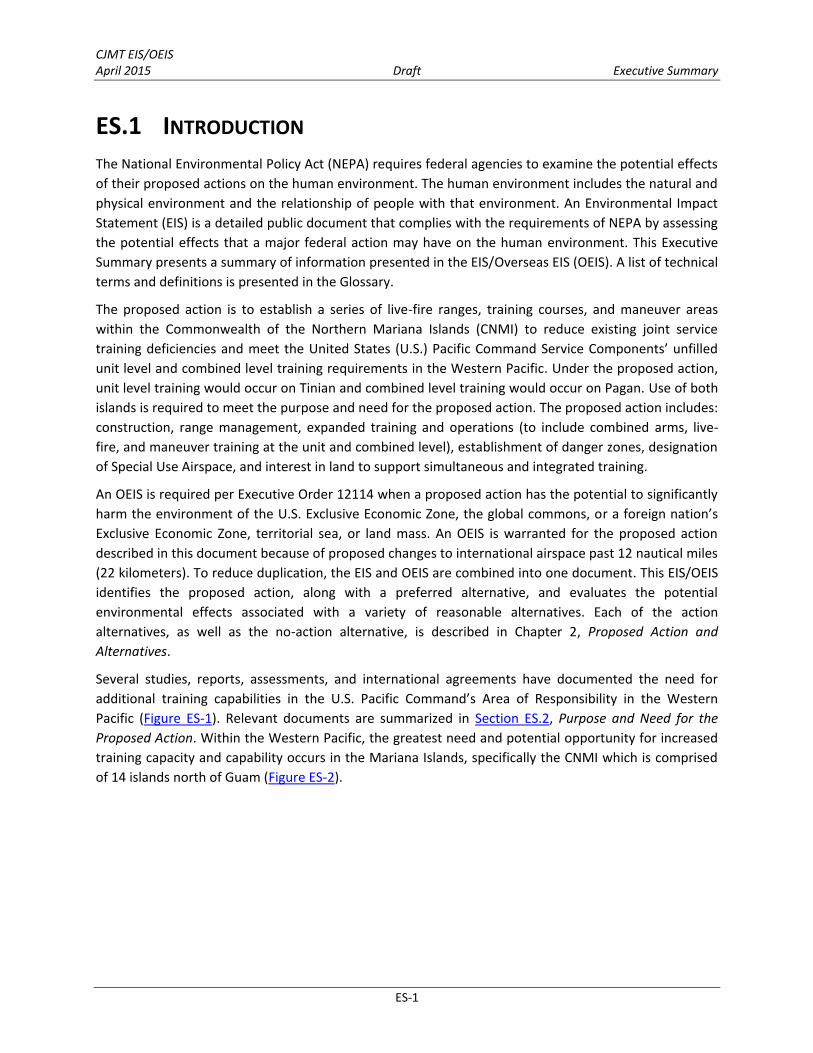
Several studies, reports, assessments, and international agreements have documented the need for additional training capabilities in the U.S. Pacific Command’s Area of Responsibility in the Western Pacific (Figure ES-1). Relevant documents are summarized in Section ES.2, Purpose and Need for the
Proposed Action. Within the Western Pacific, the greatest need and potential opportunity for increased training capacity and capability occurs in the Mariana Islands, specifically the CNMI which is comprised of 14 islands north of Guam (Figure ES-2).
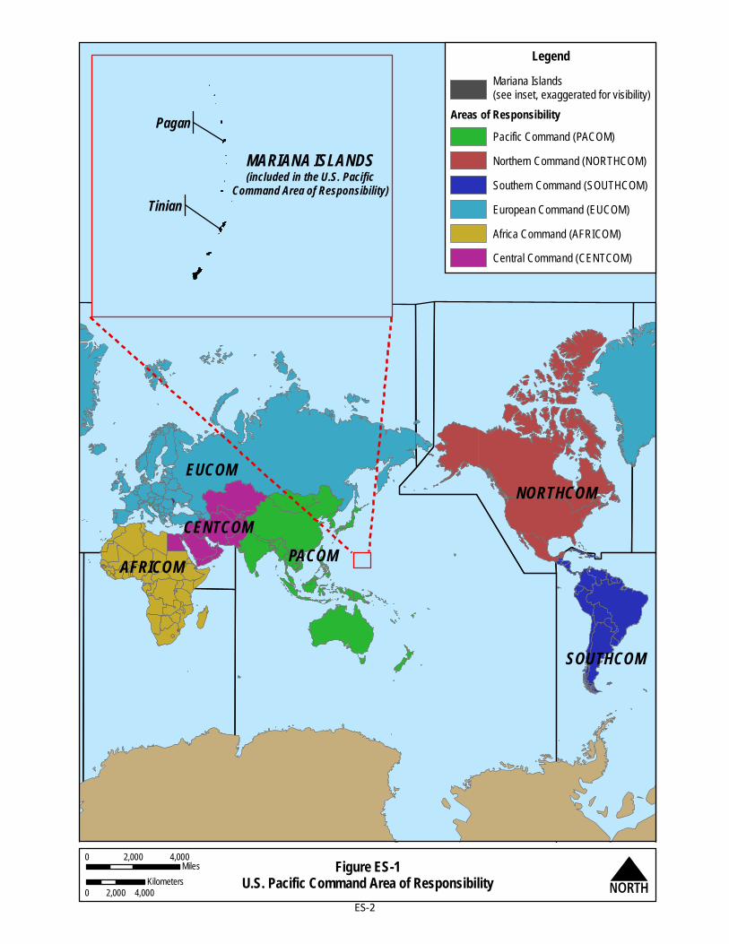
Figure ES-1U.S. Pacific Command Area of Responsibility N
PACOM
EUCOM
AFRICOM
NORTHCOM
SOUTHCOM
CENTCOM
LegendMariana Islands(see inset, exaggerated for visibility)
Areas of ResponsibilityPacific Command (PACOM)Northern Command (NORTHCOM)Southern Command (SOUTHCOM)European Command (EUCOM)Africa Command (AFRICOM)Central Command (CENTCOM)
MARIANA ISLANDS(included in the U.S. Pacific
Command Area of Responsibility)Tinian
Pagan
0 2,000 4,000Miles
0 2,000 4,000Kilometers
ES-2
Figure ES-2Mariana Islands Regional Map N
North Beach
Gold BeachSouth Beach
Green Beach
Blue Beach
South PaganVolcano
MountPagan
LagunaSanhiyon
LagunaSanhalom
Kutake Yashi
Mount Maru
Mount Togari
Minami Saki(South Point)
PhilippineSea
PacificOcean
Red Beach
Pagan
NorthField
MountLasso
Tinian InternationalAirport
San Jose
Tinian Harbor
Lamanibot Bay
Unai Chulu
Unai Lam Lam
Ushi "Cross" Point
Unai Chiget
Unai Masalok
Marpo Point
Southwest Carolinas Point
LakeHagoi
Pacific Ocean
Philippine SeaUnai Babui
Unai Dankulo
8thA v
enue
Broa dw
a y
86th Street
Tinian
International Broadcasting BureauMilitary Lease Area
0 1 20.5Miles
0 1 2Kilometers
0 1 20.5Miles
0 1 2Kilometers
Guam
Rota
AguijanTinian
Saipan
Farallon DeMedinilla
Anatahan
Sarigan
Pagan
Maug
Uracus
Asuncion
Agrihan
AlamaganGuguanPhilippine
Sea
Pacific Ocean
GuamCNMI
Area of Extent0 15 307.5
Nautical Miles0 15 30
Kilometers
MarianaIslands
Angyuta Islet
ES-3

CJMT EIS/OEIS April 2015 Draft Executive Summary
ES-4
ES.2 PURPOSE AND NEED FOR THE PROPOSED ACTION
The purpose of the proposed action is to reduce joint training deficiencies for military services in the Western Pacific. Existing U.S. military live-fire, unit and combined level training ranges, training areas, and support facilities are insufficient to support U.S. Pacific Command Service Components’ training requirements in the Western Pacific, specifically in the Mariana Islands. The proposed action is needed to enable U.S. Pacific Command forces to meet their U.S. Code Title 10 requirements to maintain, equip, and train combat and humanitarian forces in the Western Pacific. The proposed action assists in correcting these training deficiencies by establishing live-fire unit and combined level range and training areas (RTAs) in the CNMI. Establishing unit and combined level RTAs in the CNMI would support ongoing operational requirements, changes to U.S. force structure, geographic repositioning of forces, and U.S. training relationships with allied nations.
The following studies, reports, assessments, and international statements and agreements document the need for additional training capabilities in the Western Pacific, and specifically in the CNMI.
The 2009 Institute for Defense Analyses Study assessed the ability of the Service Components to meet training requirements in the U.S. Pacific Command’s Area of Responsibility (Institute for Defense Analyses 2009).
In 2010, the Quadrennial Defense Review (hereafter “2010 QDR”) evaluated global U.S. military strategy and priorities (Department of Defense 2010). The 2010 QDR requires a more widely distributed U.S. presence in Asia.
In November 2011, President Obama underlined the Asia Pacific’s regional importance in his speech to the Australian parliament.
The bilateral Realignment Roadmap agreement between the U.S. and Japan calls for transforming Guam and the CNMI into a hub for security activities in the region (Security Consultative Committee 2012).
In 2013, the Training Needs Assessment: An Assessment of Current Training Ranges and
Supporting Facilities in the U.S. Pacific Command Area of Responsibility (hereafter the “Assessment”) identified and validated unfilled training requirements for units/commands in the U.S. Pacific Command Area of Responsibility (Department of the Navy [DoN] 2013a). This process provided an initial list of 62 unfilled training requirements, with all Service Components identifying unfilled training needs in the Western Pacific.
The 2013 CNMI Joint Military Training Requirements and Siting Study (DoN 2013b) (hereafter referred to as “the Siting Study”) refined the analysis of unfilled training requirements in the Mariana Islands that was identified in the 2013 Training Needs Assessment. The initial 62 requirements were refined by the Executive Agent (U.S. Marine Corps Forces Pacific) to review previously identified Pacific-wide unfilled training requirements for those that could potentially be filled in the CNMI. This resulted in reducing the number of unfilled training requirements carried forward into this Siting Study from 62 to 42. These 42 unfilled training requirements served as the basis for developing the proposed action and alternatives in this EIS/OEIS.
In 2014, the Quadrennial Defense Review (hereafter “2014 QDR”) re-evaluated global U.S. military strategy and priorities (Department of Defense 2014). The 2014 QDR confirmed the U.S.

CJMT EIS/OEIS April 2015 Draft Executive Summary
ES-5
military’s continued commitment to rebalance the Asia-Pacific region, which is increasingly central to U.S. political, economic and security interests.
ES.3 AGENCY AND STAKEHOLDER COORDINATION
ES.3.1 Cooperating Agencies
As defined by 40 Code of Federal Regulations (CFR) § 1508.5, a cooperating agency is “any federal agency other than a lead agency which has jurisdiction by law or special expertise with respect to any environmental impact involved in a proposal (or a reasonable alternative) for legislation or other major federal actions significantly affecting the quality of the human environment.” Numerous agencies were invited to serve as cooperating agencies for this EIS/OEIS. The following agencies agreed to be cooperating agencies: Department of Interior, Office of Insular Affairs; Federal Aviation Administration; International Broadcasting Bureau; National Marine Fisheries Service; U.S. Army Corps of Engineers, Honolulu District; and the U. S. Air Force. The U.S. Fish and Wildlife Service declined to serve as a cooperating agency due to staffing and workload constraints, but they agreed to work collaboratively with the Executive Agent (U.S. Marine Corps Forces Pacific) throughout the EIS/OEIS process. In addition, the Executive Agent signed a Memorandum of Understanding with the following Pacific Command Service Components: U.S. Air Force, U.S. Army, and U.S. Special Operations Command. These Service Components operate in the same capacity as cooperating agencies.
ES.3.2 Agency Consultation
The proposed action is subject to federal and CNMI regulatory requirements in addition to NEPA. Agency reviews must be conducted and procedures followed before starting construction activities or initiating operations. Appropriate consultations with regulatory entities will be completed as part of the EIS/OEIS process, and relevant information will be included in the EIS/OEIS as applicable. Various agency consultations are underway as part of this EIS/OEIS process and as applicable will be summarized in the Final EIS/OEIS. Agency consultations include:
Endangered Species Act, Section 7: U.S. Fish and Wildlife Service and National Marine Fisheries Service
Marine Mammal Protection Act: National Marine Fisheries Service National Historic Preservation Act, Section 106: Advisory Council on Historic Preservation, and
CNMI Historic Preservation Office Magnuson-Stevens Fishery Conservation and Management Act: National Marine Fisheries
Service Coastal Zone Management Act: CNMI Bureau of Environmental and Coastal Quality Section 404 of the Clean Water Act: U.S. Army Corps of Engineers
ES.3.3 Collaborative Stakeholder Coordination
The Council on Environmental Quality regulations (40 CFR 1500.1 [b]) provide that public input and scrutiny are essential to implementing NEPA. For this reason, the Executive Agent (U.S. Marine Corps

CJMT EIS/OEIS April 2015 Draft Executive Summary
ES-6
Forces Pacific) has implemented a collaborative coordination approach with CNMI government agencies, local organizations, and individual stakeholders for this EIS/OEIS including but not limited to:
The CNMI Governor’s Office The CNMI agencies: Bureau of Environmental and Coastal Quality, Capital Improvements
Projects Program Office (CIP), Commonwealth Ports Authority, Military Integration Management Committee, Department of Public Works
Tinian Mayor’s Office Tinian Cattlemen’s Association and other cattle ranchers Northern Islands Mayor’s Office representatives Federal agencies: Federal Aviation Administration, U.S. Department of Agriculture (Natural
Resource Conservation Service), U.S. Army Corps of Engineers, U.S. Environmental Protection Agency, U.S. Geological Survey, Department of Defense Office of Economic Adjustment
ES.4 ALTERNATIVES DEVELOPMENT
The U.S. Marine Corps Forces Pacific as the Executive Agent undertook the following methodical process to identify potential alternatives for meeting unfilled, joint military training requirements in the CNMI. The U.S. Marine Corps Forces Pacific first developed and applied operational siting criteria (see Section 2.3.1, Operational Siting Criteria) which identified Tinian and Pagan as the only suitable locations for development of RTAs for unit level and combined level training, respectively. Use of both islands is required to meet the purpose and need for the proposed action. The Alternative development process then analyzed various laydowns on Tinian and Pagan to address the unfilled training requirements.
ES.4.1 Operational Siting Criteria
Operational siting criteria were developed as part of the CNMI Joint Military Training Requirements and
Siting Study (DoN 2013b) (see Section 1.3.6) to identify potential locations within the CNMI that could meet these unfilled training requirements. These criteria included land use and topographic compatibility, the need for beachfront and transition lands for amphibious training, airspace and sea space, military training trails, and the ability to employ a spectrum of weapons systems.
The operational siting criteria were applied to screen the 14 CNMI islands for feasible RTA sites. Of the 14 CNMI islands, only a combination of RTAs on Tinian and Pagan were identified as capable of meeting unit level and combined level screening criteria, and could address virtually all 42 unfilled training requirements.
While the ideal scenario would be to site both RTAs on one island, neither Tinian nor Pagan individually have the space to support both. In addition, the lands currently leased by the Department of Defense on Tinian lack land areas large enough to accommodate the safety footprint for the broad spectrum of weapons used in combined level training. Therefore, Tinian would be most suitable for unit level RTA development and Pagan for combined level RTA training. Tinian and Pagan collectively is the only combination of training locations that meets the purpose of and need for the proposed action.

CJMT EIS/OEIS April 2015 Draft Executive Summary
ES-7
ES.4.2 Development of Unit Level Range and Training Area Alternatives on Tinian
The primary criteria for unit level RTA alternative development was maximizing use of the Military Lease Area—an area controlled by the U.S. government under a long-term lease.
The Military Lease Area meets the operational siting criteria for a unit level training RTA. It is located away from civilian population centers to ensure safe separation of military activities and the public. The Military Lease Area also has accessible beaches for amphibious training and roadways for tracked and wheeled vehicles. There is suitable topography and land area for maneuvering purposes for unit level RTAs. There are suitable airfields, available airspace, and adjacent sea space to accommodate the proposed training activities on Tinian. Additionally, Tinian International Airport and the Port of Tinian are both in close proximity to provide efficient personnel, cargo, and equipment transport.
The goal for Tinian unit level RTA training is two-fold: the first provides the capability and capacity for using the weapons organic to (i.e., belonging to and brought along with) units ranging in size from about 30 to 2,200 personnel. The second goal is to link ground-based activities with aviation and amphibious training. Tinian alternatives development went through two stages: initial identification of the locations of training facilities and support facilities on Tinian, followed by refinement of alternatives to better meet the purpose and need for the proposed action and address socioeconomic and environmental concerns and input from public comment.
ES.4.2.1 Initial Development of Tinian Unit Level Range and Training Area
Alternatives
Initial alternative development on Tinian involved identifying where unit level support facilities and training facilities could be accommodated (DoN 2014). To be considered a viable and reasonable alternative, any RTA layout on Tinian must satisfy the following criteria:
Land Use Compatibility: An alternative must have a suitable location and sufficient land area for the High Hazard Impact Area that will accommodate the spectrum of weapons and munitions proposed; allow for a variety of targets; and provide a buffer area to ensure public safety. Additionally, this impact area must be situated in such a manner that when it is active, maneuver training could still be conducted in its vicinity.
Simultaneous Use: An alternative needs to maximize the potential for simultaneous use so that multiple ranges and training areas can be used simultaneously and the use of one range does not necessarily preclude the use of other ranges. Opportunities for compatible combinations or configurations of ranges, training courses, or maneuver area laydowns were evaluated to minimize land needed and maximize the ability to train at a given location if other types of training were ongoing in another location (i.e., simultaneity of use).
Topographic Compatibility: An alternative must have land areas with adequate space and suitable topography (slope) for the largest components of proposed training.
CJMT EIS/OEIS April 2015 Draft Executive Summary
ES-8
Beachfront and Transition to Land: An alternative must have beaches suitable to conduct ship-to-objective maneuvering or amphibious training. Required capability is that four Amphibious Assault Vehicles can land at one location at one time and transit from the training beach to suitable land areas for conducting tactical maneuvering to established ranges.
Airspace and Sea Space: An alternative must have sufficient land, airspace and sea space for ground-training activities to operate in conjunction with aircraft maneuvering in overlying airspace (e.g., Close Air Support Range training, Offensive Air Support Range training).
An alternative must include suitable locations for aircraft Drop Zones (e.g., personnel and cargo delivery via parachute) and Landing Zones (i.e., locations for aircraft takeoffs and landings), and airfields and open space where Unmanned Aircraft Systems can operate in Special Use Airspace. An alternative must have enough sea space to safely separate military operations from non-participating marine vessels.
The next step of alternative development identified how Tinian could accommodate the various training components and included the steps identified below.
Step 1: Apply Screening Criteria for Large-Scale Unit Level Training Components. Initial planning involved siting the largest ranges (i.e., Tank/Fighting Vehicle Multi-Purpose Range Complex, and Battle Area Complex), High Hazard Impact Area, and their associated surface/weapons danger zones. Siting of the largest ranges took into account alternatives that allowed for (1) the continued operation of the International Broadcasting Bureau in its present location within the Military Lease Area; and (2) eventual discontinuation of the operation of the International Broadcasting Bureau within the Military Lease Area.
Step 2: Apply Screening Criteria for Additional Unit Level Training Components. Following placement of the larger training components, the smaller ranges/training areas (e.g., Combat Pistol Range) and supporting infrastructure were sited.
Step 3: Evaluate and Select Alternatives for Analysis. The above process identified three reasonable alternatives to be carried forward for analysis (see Section ES.5.2, Tinian Alternatives). These alternatives on Tinian were identified and presented during the scoping period.
ES.4.2.2 Refinement of Tinian Unit Level Range and Training Area
Alternatives
After the public scoping meetings, intensive field surveys, and ongoing dialogue with the CNMI government, the alternatives were further refined. Notable changes since presentation of the preliminary alternatives at the public scoping meetings include:
Tank/Fighting Vehicle Multi-Purpose Range Complex. The Tank/Fighting Vehicle Multi-Purpose Range Complex was shifted west due to airspace conflicts, avoidance of National Historic Landmark, and terrain obstacles. Firing locations were moved to avoid terrain obstacles and provide longer engagement zones for Light Armor Vehicle weapon training.
High Hazard Impact Area. The High Hazard Impact Area was reduced in size by eliminating explosive aviation ordnance and restricting use to inert aviation ordnance. This facilitated improved mortar firing positions and accommodated fire and maneuver activities on the Battle Area Complex. This reduction

CJMT EIS/OEIS April 2015 Draft Executive Summary
ES-9
enabled the layout of the fire break/road to shift it away from cliff line/limestone forests and off the National Historic Landmark. These changes minimized environmental impacts.
Convoy Course. The Convoy Course was moved to reduce the size of the course and number of engagement areas. These changes were made to keep training activities away from Lake Hagoi, provide a portion of the course the ability to fire into the High Hazard Impact Area, maximize the use of existing paved areas to the greatest extent possible, distance the engagement areas from surface water bodies to minimize potential negative socioeconomic and environmental effects, and to reduce the overlap of surface danger zones with commercial airspace.
Field Artillery Indirect Fire Range. One Field Artillery Indirect Fire Range firing position was shifted away from Ushi Point and onto flat terrain.
Special Use Airspace. Special Use Airspace was modified to avoid conflict with Saipan International Airport’s Class D airspace and to encompass the surface danger zones associated with the Convoy Course and other ranges. Additional modifications to Special Use Airspace overlying Tinian were made to minimize impacts to aircraft transiting between Saipan and Tinian. Previously planned Special Use Airspace was partitioned both vertically and horizontally to allow a greater degree of scheduling precision to match specific airspace with specific ground range use, and commercial on-land operations.
Amphibious Training. All beaches within the Military Lease Area were considered for amphibious training operations; however, a careful selection process was employed based on analysis and environmental factors. Beaches on the windward side of the Military Lease Area, including Unai Chiget, Unai Dankulo and Unai Masalok, were not considered for use of Amphibious Assault Vehicle landings due to wind and wave action. Based on environmental criteria including analysis of bathymetry and coral cover, Unai Babui and Unai Chulu were both considered for Amphibious Assault Vehicle and Landing Craft Air Cushion vessel training. A detailed engineering analysis of construction alternatives was conducted for these two locations. Different methods for constructing amphibious landing ramps were considered, including a dredge only option, a pile-armored ramp, and a tribar-armored ramp. The pile-armored ramp alternative was chosen for its stable design and long-term durable surface. Ultimately, Unai Babui was dismissed for Amphibious Assault Vehicle training to lessen environmental impacts, but it would still support training for Landing Craft Air Cushion vessels, small boat and swimmer training. Unai Chulu was chosen as the single beach for Amphibious Assault Vehicle landings as it offered better training opportunities and was not as constrained by size as Unai Babui. Areas outside of Military Lease Area were discounted for tactical amphibious training because they would not provide immediate access (i.e., contiguous) to live-fire training, which is a training criterion.
Compatibility with Existing Land Uses Outside of the Military Lease Area. Potential conflicts with existing land uses were accounted for, such as location of populated areas (i.e., noise receptors), recognized historic properties, sensitive natural resources, existing infrastructure (e.g., runways, roads, power supply), recreation sites, and economic activities.

CJMT EIS/OEIS April 2015 Draft Executive Summary
ES-10
ES.4.3 Development of Combined Level Range and Training Area Alternatives on Pagan
ES.4.3.1 Initial Development of Pagan Combined Level RTA Alternatives
Combined level training is different from unit level in that it allows various units and unit types to train simultaneously towards a single training objective within the RTA whereas in unit level training, generally only one unit type trains together towards an objective. As in combat, each unit works in coordination with one another during combined level training. The land area for combined level training must be capable of supporting multiple unit level tasks simultaneously, combined into a broader task. The combined level training RTA is designed to replicate, to the extent possible, the fluid nature of a battlefield with multiple land, sea, or air-based units engaging in a series of activities at the same time (DoN 2014).
The primary criterion for combined level RTA alternative development was to maximize land use on northern Pagan. This portion of the island is sparsely vegetated due to volcanic activity, has several accessible beaches, and contains an inactive World War II-era airfield. The relative lack of vegetation provides the visibility required for various types of combined level training. Accessible beaches allow for amphibious training and logistical support for delivering cargo and personnel. The presence of an airfield supports aviation activities.
Development of combined level RTA alternatives on Pagan involved identifying where training facilities could potentially be accommodated on the island (DoN 2014). To be a viable and reasonable alternative, any RTA on Pagan must at a minimum satisfy the conditions for unit level training as well as the following additional criteria:
Land Use Compatibility: An alternative must have land areas with a suitable location for a High Hazard Impact Area (or areas) that will accommodate the spectrum of weapons and munitions proposed, allow for ground-based, aviation, and naval munitions; and provide a buffer to ensure public safety. This impact area (or areas) must be situated in such a manner that when it is active, maneuver training could still be conducted in its vicinity.
Topographic Compatibility: An alternative must have land areas with adequate space and suitable topography (slope) for maneuvering (e.g., heavy forces, amphibious forces). Land areas were identified for use as “military training trails;” these would serve as unimproved pathways to move and maneuver personnel, vehicles, and equipment across the island to an objective. The maneuver area should be at least 1,640-feet (500-meters) wide with a slope of less than 30% to support a mechanized/motorized infantry company in a tactical formation.
Beachfront and Transition to Land: An alternative must have beaches suitable to conduct ship-to-objective maneuvering or amphibious training (e.g., Combined Arms Live-Fire Amphibious Beaches with Maneuver Area, Tactical Amphibious Training Beaches, and Maneuver Area [Amphibious Forces]).
Airspace and Sea Space: An alternative must have a suitable location for aircraft operations at Landing Zones (i.e., areas where aircraft land and take off) and Drop Zones (i.e., areas where aircraft drop personnel and cargo delivery via parachute), and airfields and overlying airspace to support Unmanned

CJMT EIS/OEIS April 2015 Draft Executive Summary
ES-11
Aircraft Systems and other aircraft operations. Sufficient water surfaces to accommodate danger zones that separate military operations from non-participating marine vessels.
Full Spectrum Weapons Employment: An alternative must include a suitable location(s) for the High Hazard Impact Area(s) that would accommodate the full spectrum of weapons required for combined level training while providing a safe distance from the proposed expeditionary base camp/bivouac area and airfield. The targets for the Field Artillery Indirect Fire Range, Mortar Range, Field Artillery Direct Fire Range, Combined Arms Training Range to Support Close Air Support and Naval Gunfire Support Training, Offensive Air Support Range, and Close Air Support Range need to be co-located as these types of training utilize high explosive munitions which require a High Hazard Impact Area to provide a larger variety of target placement and engagement scenarios. The High Hazard Impact Area needs to be in a central area for Field Artillery Indirect Fire Range points to fire overhead into the impact area.
Mobility Corridor(s): An alternative must allow for mobility corridors with sufficient space and flexibility for integrated ground, air, and sea training by including sufficient land, airspace, and sea space to conduct simultaneous training of combined arms, live-fire, amphibious maneuvering, naval surface fire support (i.e., ship-to-shore bombardment), air-delivered munitions, and indirect (i.e., artillery and mortars) and direct munitions firing training. The area must be large enough to provide separate impact areas and maneuver areas, such that live-fire and maneuver training can be safely conducted simultaneously.
The next step of alternative development identified how Pagan could accommodate the various training components as discussed in the steps below.
Step 1: Apply Screening Criteria for Large-Scale Combined Level Training Components. The initial planning effort was to site the largest ranges and High Hazard Impact Area(s) and their associated surface/weapons danger zones.
Step 2: Apply Screening Criteria for Additional Combined Level Training Components. Following placement of various configurations of the larger training components, the bivouac area and airfield extension were sited.
Step 3: Evaluate and Select Alternatives for Analysis. The above process identified two reasonable alternatives to be carried forward for analysis (see Section ES.5.3, Pagan Alternatives). These alternatives on Pagan were identified and presented during the scoping period.
ES.4.3.2 Refinement of Pagan Combined Level Range and Training Area
Alternatives
After the public scoping meetings, intensive field surveys, and ongoing dialogue with the CNMI government, the alternatives were further refined. Notable changes since presentation of the preliminary alternatives at the public scoping meetings include:
High Hazard Impact Area. Changes were made to the configuration of the northern High Hazard Impact Area to provide separation from Lake Sanhalom and to provide space for safe maneuverability on the ground and account for danger zones associated with weapons systems and munitions employment. Under one of the alternatives, one High Hazard Impact Area was removed from the Pagan isthmus to reduce environmental impact and allow for greater room for ground maneuvers.

CJMT EIS/OEIS April 2015 Draft Executive Summary
ES-12
To Meet the Purpose and Need, An Alternative Must Include:
1. One Tinian unit level alternative.
2. One Pagan combined level alternative.
Special Use Airspace. Airspace was modified to better facilitate civil aviation activity during periods of military training. Previously planned Special Use Airspace was partitioned both vertically and horizontally to allow a greater degree of scheduling precision to match specific airspace with specific ground range use. Airspace was partitioned to enable certain aviation and maritime activities to occur during training and to facilitate access into and around the island.
Amphibious Training. All beaches on Pagan were considered for amphibious training operations. A careful selection process was employed based on training operations and environmental factors. Beaches on the windward side were not considered for use of Amphibious Assault Vehicle landings due to wind and wave action. Based on environmental criteria including analysis of bathymetry and coral cover, Blue, Green, and Red Beach were considered for Amphibious Assault Vehicle landings. Blue, Green, Red, and South were also considered for Landing Craft Air Cushion vessel training. North Beach was identified for small boat and swimmer insertions.
Environmental and Operational Considerations. Environmental (e.g., lakes, coral reef habitat, Endangered Species Act species presence, cultural resources) and operational (e.g., lack of beach access or foot trails to southern Pagan) considerations were evaluated and resulted in readjustment of the locations or configurations of ranges, maneuver areas, or supporting infrastructure.
ES.4.4 Action Alternatives Carried Forward for Analysis
Action alternatives carried forward for analysis in this EIS/OEIS, which meet the purpose and need for the proposed action, include three unit level RTA alternatives on Tinian and two combined level RTA alternatives on Pagan and their associated operations. Implementation of one Tinian unit level alternative and one Pagan combined level alternative is required to satisfy the purpose and need for the proposed action.
ES.5 PROPOSED ACTION
ES.5.1 Overview
The proposed action is to establish live-fire range and training areas (RTAs) within the CNMI to address the U.S. Pacific Command Service Components’ unfilled unit level and combined level training requirements in the Western Pacific. An RTA refers to live-fire ranges, training courses, maneuver areas, and associated support facilities, collectively, that are located in close proximity to each other. Under the proposed action, a unit level RTA is proposed on Tinian and a combined level RTA is proposed on Pagan. Establishing a unit level RTA and combined level RTA in the CNMI would support joint Service training requirements, ongoing operational requirements, changes to U.S. force structure, and geographic repositioning of forces in the Western Pacific.
The alternatives include several common elements:
Land Use Agreements to provide land area necessary to support simultaneous and integrated training as appropriate (including amendments to existing agreements).

CJMT EIS/OEIS April 2015 Draft Executive Summary
ES-13
Construction to support RTA development and associated infrastructure.
Range Management to sustain unit level and combined level RTA training capabilities in an environmentally responsible manner.
Expanded Training and Operations to include combined arms, live-fire, amphibious landings, and maneuver training at the unit level and combined level.
Danger Zones to establish safe separation of non-participating military personnel and the public from live-fire training over water (i.e., sea space). Danger zones may be closed to the public on a full-time or intermittent basis (Title 33 CFR Part 334). Danger zones are established pursuant to statutory authority of the Secretary of the Army and are administered by the Army Corps of Engineers. Surface danger zones are three-dimensional areas that delineate portions of the earth’s surface and the overlying airspace in which personnel and/or equipment may be endangered by ground weapons firing or detonation activities because of ricochet or fragmentation hazard.
Designation of Special Use Airspace to identify areas to which activities must be confined because of their nature, or where limitations are imposed upon aircraft that are not part of those activities, or both. Special Use Airspace is geographically defined by vertical and horizontal limits over a portion of the earth’s surface. The Federal Aviation Administration is the agency responsible for regulatory oversight and implementation of Special Use Airspace.
Construction would occur to support range and target installation; administrative, command, and control functions; access roads and trails; delivery of utilities (i.e., water, electric, wastewater, communications and solid waste handling); personnel billeting; and equipment and munitions storage. Additionally, all alternatives include RTA management activities, RTA use and scheduling, range observation to provide live feedback on training activities and target scoring, vegetation management for range use and firebreak purposes, as well as vehicle and equipment use and maintenance activities for RTA training. For all action alternatives, it is anticipated that approximately 95 full-time personnel would be needed to carry out range management and maintenance activities. These personnel would have responsibility for both RTAs on Tinian and Pagan; for purposes of analysis it is assumed these employees would live on Tinian. Both the Tinian RTA and the Pagan RTA require amphibious training beaches linked to an existing or improved road/trail system, maneuver areas to support personnel on foot or in vehicles, as well as access points (i.e., airfields, ports) for personnel, equipment, and cargo deliveries.
Based on the planned deployment and training exercise tempo for units in the U.S. Pacific Command Area of Responsibility, it was determined that 20 weeks of live-fire training on Tinian and 16 weeks of live-fire training on Pagan would meet the unfilled training requirements; therefore, these time periods are analyzed in this document. In addition, other activities including pre-training and post-training activities (arrival and departure of trainees and equipment), non-live-fire training (e.g., logistics training), and RTA maintenance and management functions would occur outside of the live-fire training durations throughout the year. Major conflicts, terrorism, international lawlessness, natural disasters, and the current U.S. national strategy to focus on the Pacific theater have the potential to change the structure of military forces in the region and the required training frequency. A potential change in force

CJMT EIS/OEIS April 2015 Draft Executive Summary
ES-14
Construction and Improvements
1. Support Facilities and Infrastructure Construction.
2. Training Facilities Construction.
structure, unit type, and/or location may result in the need to change operational training tempo in the future.
The potential increase in training described in the Unconstrained Training Concept (Appendix C) reflects the maximum training capacity for each island. Potential future live-fire training could be accommodated up to a total of 45 weeks of training on Tinian and a total of 40 weeks of training on Pagan. Should the tempo of live-fire training need to be increased above the annual live-fire training demand of 20 weeks for Tinian and 16 weeks for Pagan analyzed in this EIS/OEIS, additional NEPA compliance and agency consultations would be completed before implementing any increase in tempo.
Two additional projects are not being formally proposed at this time, but they are anticipated to be needed and would be implemented in the future although no specific timeframe has been identified. The two projects are: (1) relocation of the existing International Broadcasting Bureau (currently located on Tinian), and (2) new dock and associated breakwater on Pagan. If, as a result of the selected alternative, the International Broadcasting Bureau must be relocated outside of the Military Lease Area, then additional NEPA analysis will be done as needed. The new International Broadcasting Bureau facility must be complete and fully operational before relocation occurs. Potential relocation of the International Broadcasting Bureau and the dock and breakwater on Pagan are analyzed programmatically in this EIS/OEIS (see Section 4.18, Programmatic Analysis of Future Potential Project
Components).
ES.5.2 Tinian Alternatives
ES.5.2.1 Land Use Agreements
Land use agreements would be required to implement the proposed action on Tinian. The U.S. currently has a real estate agreement for nearly two-thirds of Tinian, (i.e., the Military Lease Area). The Department of Defense would acquire jurisdictional control of additional lands outside of the Military Lease Area through long-term real estate agreements. Since the 1975 Covenant and Technical Agreement (see Appendix K, Summary of Historical Land Use Agreements between the U.S. and the
CNMI), some areas covered under the original lease were returned to the CNMI government through lease amendments. Long-term real estate agreements with the CNMI for roadway and utility easements would be required. The additional areas would include the north portion of Tinian International Airport and parcels near the Port of Tinian.
The International Broadcasting Bureau site is located within the Military Lease Area. Under Tinian Alternative 1, the International Broadcasting Bureau facility would continue to operate. Under Tinian Alternatives 2 and 3, the International Broadcasting Bureau facility would no longer exist in its current location. The International Broadcasting Bureau is a cooperating agency for this EIS/OEIS and has been involved in this NEPA process. A full discussion of land acquisition and land uses on Tinian is provided in Sections 3.7 and 4.7, Land and Submerged Land Use.
ES.5.2.2 Construction and Improvements
Construction of the training facilities (e.g., ranges, training courses, High Hazard Impact Area, Landing Zones, Drop Zones, range

CJMT EIS/OEIS April 2015 Draft Executive Summary
ES-15
Observation Posts, Surface Radar sites) would start after the Record of Decision (anticipated in Summer 2016). Construction is expected to span 8 to 10 years depending on funding and operational commitments of the U.S. military. Construction and improvements for this alternative include two broad categories: (1) support facilities and infrastructure, and (2) training facilities. These are further described below.
Support Facilities and Infrastructure Construction. Support facilities include the base camp, Munitions Storage Area, airport and port improvements, access roads, gates, fences, and utilities (including water, wastewater, electrical, information technology, communications, and solid waste).
Training Facilities Construction. Numerous training facilities (e.g., ranges, training courses, maneuver areas, High Hazard Impact Area, Landing Zones, Drop Zones, range Observation Posts, Surface Radar sites) would be constructed within the Tinian RTA for all action alternatives. To provide the reader with an easier way to identify the various RTA training facilities, they were grouped into four range complexes based on geographic proximity. The complexes are identified as Range Complex A, B, C, and D. An underwater tactical amphibious beach landing area would be constructed for Amphibious Assault Vehicles at Unai Chulu. Construction would modify the seafloor (i.e., limestone, coral reef) by contouring landing area to create a pile-armored ramp.
ES.5.2.3 Training Operations
At the proposed Tinian RTA, the amount and variety of training would progressively increase over the 8 to 10 year construction period culminating in the final 20 weeks proposed. Live-fire training using small arms would occur from the start; however, training with large-caliber weapons would not occur until the Special Use Airspace is approved and mapped by the Federal Aviation Administration. Live-fire ranges would be managed in accordance with current Marine Corps range management policies and procedures, which are designed to ensure the safe, efficient, effective, and environmentally sustainable use of the range areas. The proposed training operations at the four range complexes are summarized as follows:
Range Complex A comprises the High Hazard Impact Area where live-fire high explosives from ground-based and aviation training activities would be employed. Ground-based activities would include hand grenades thrown and launched from the Live Hand Grenade and Grenade Launcher ranges. Aviation activities would use live munitions from machine guns and rockets and delivery of inert aviation ordnance at targets within the High Hazard Impact Area as part of Offensive Air Support Range and Close Air Support Range training.
Range Complex B primary emphasis would be live-fire vehicle-mounted (e.g., tanks, fighting vehicles) training. Personnel in vehicles would move to firing points and using the lines of sight they would practice firing at stationary and moving targets (i.e., target objectives). Although not the primary purpose for this range complex, personnel would maneuver on foot within the range complex in squads. Simulated aviation training would occur within Range Complex B but it would not involve firing of weapons.
Range Complex C primary emphasis would be the live-fire training activities associated with the Infantry Platoon Battle Course and the Urban Assault Course. Training activities at the Infantry Platoon Battle Course and Urban Assault Courses would involve personnel moving primarily on foot to target objective areas employing live munitions for rifles and inert munitions for
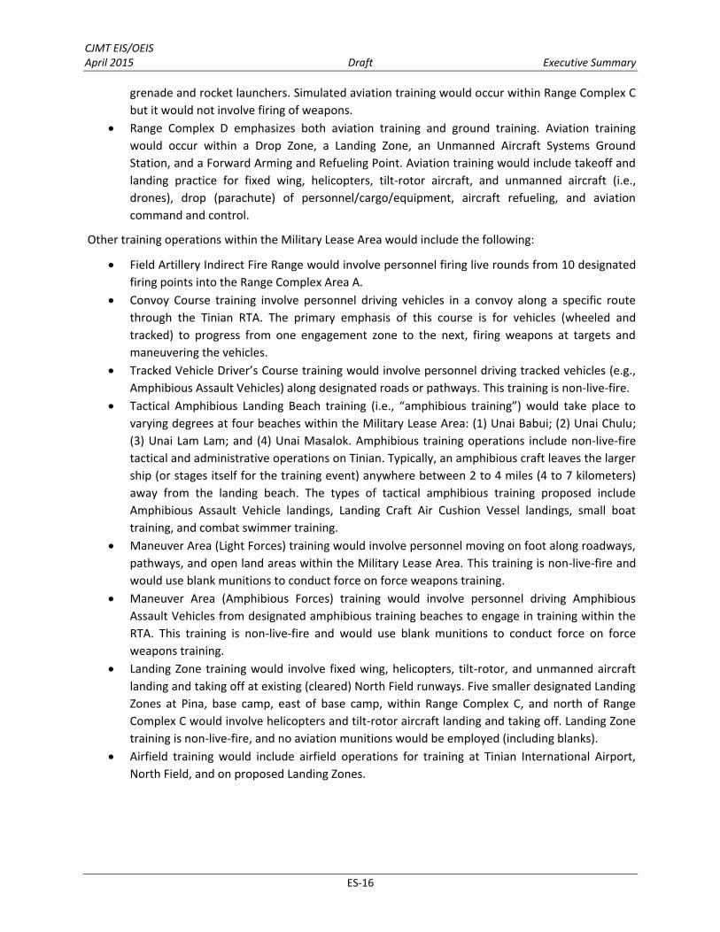
CJMT EIS/OEIS April 2015 Draft Executive Summary
ES-16
grenade and rocket launchers. Simulated aviation training would occur within Range Complex C but it would not involve firing of weapons.
Range Complex D emphasizes both aviation training and ground training. Aviation training would occur within a Drop Zone, a Landing Zone, an Unmanned Aircraft Systems Ground Station, and a Forward Arming and Refueling Point. Aviation training would include takeoff and landing practice for fixed wing, helicopters, tilt-rotor aircraft, and unmanned aircraft (i.e., drones), drop (parachute) of personnel/cargo/equipment, aircraft refueling, and aviation command and control.
Other training operations within the Military Lease Area would include the following:
Field Artillery Indirect Fire Range would involve personnel firing live rounds from 10 designated firing points into the Range Complex Area A.
Convoy Course training involve personnel driving vehicles in a convoy along a specific route through the Tinian RTA. The primary emphasis of this course is for vehicles (wheeled and tracked) to progress from one engagement zone to the next, firing weapons at targets and maneuvering the vehicles.
Tracked Vehicle Driver’s Course training would involve personnel driving tracked vehicles (e.g., Amphibious Assault Vehicles) along designated roads or pathways. This training is non-live-fire.
Tactical Amphibious Landing Beach training (i.e., “amphibious training”) would take place to varying degrees at four beaches within the Military Lease Area: (1) Unai Babui; (2) Unai Chulu; (3) Unai Lam Lam; and (4) Unai Masalok. Amphibious training operations include non-live-fire tactical and administrative operations on Tinian. Typically, an amphibious craft leaves the larger ship (or stages itself for the training event) anywhere between 2 to 4 miles (4 to 7 kilometers) away from the landing beach. The types of tactical amphibious training proposed include Amphibious Assault Vehicle landings, Landing Craft Air Cushion Vessel landings, small boat training, and combat swimmer training.
Maneuver Area (Light Forces) training would involve personnel moving on foot along roadways, pathways, and open land areas within the Military Lease Area. This training is non-live-fire and would use blank munitions to conduct force on force weapons training.
Maneuver Area (Amphibious Forces) training would involve personnel driving Amphibious Assault Vehicles from designated amphibious training beaches to engage in training within the RTA. This training is non-live-fire and would use blank munitions to conduct force on force weapons training.
Landing Zone training would involve fixed wing, helicopters, tilt-rotor, and unmanned aircraft landing and taking off at existing (cleared) North Field runways. Five smaller designated Landing Zones at Pina, base camp, east of base camp, within Range Complex C, and north of Range Complex C would involve helicopters and tilt-rotor aircraft landing and taking off. Landing Zone training is non-live-fire, and no aviation munitions would be employed (including blanks).
Airfield training would include airfield operations for training at Tinian International Airport, North Field, and on proposed Landing Zones.

CJMT EIS/OEIS April 2015 Draft Executive Summary
ES-17
ES.5.2.4 Tinian No-Action Alternative
Section 1502.14(d) of Council on Environmental Quality regulations implementing NEPA requires an EIS/OEIS to analyze the no-action alternative. No action means that the proposed action would not take place. Analysis of the no-action alternative provides a benchmark, enabling decision-makers to compare the magnitude of the environmental effects of the proposed action or alternatives versus the potential impacts if no action were implemented. In many projects, a no-action alternative is the same as the description of the existing condition. However, in the case of this Proposed Action, the no-action alternative would not be a static situation but represents the continuation of having military training exercises on Tinian as well as the implementation of training ranges and operations that have been documented in recent Records of Decisions for NEPA actions. The no-action alternative would continue current training activities on Tinian, including those contained in other Department of Defense documents such as the Mariana Islands Range Complex EIS/OEIS (July 2010 Record of Decision, DoN 2010a), and would complete construction of four live-fire ranges on Tinian contained in the September 2010 Record of Decision in the Guam and CNMI Military Relocation EIS/OEIS (DoN and Department of the Army 2010). These activities are summarized in Table ES-1.
Table ES-1. Summary of No-Action Alternative Training on Tinian Exclusive Military Use Area by U.S. Air Force, Army, Marine Corps, Navy, and Guam National Guard/Reserve
Training Activity Description
Mariana Islands Range Complex EIS/OEIS (see Tables 2-7 and 2-8 in the EIS/OEIS)
Field Training Exercise The battalion and its combat and service support units deploy to field locations to conduct tactical training activities under simulated combat conditions.
Ship to Objective Maneuver Training conducted to gain a tactical advantage over the enemy; it is not aimed at seizing the beach but expanding the battle space.
Noncombatant Evacuation Operation
Training activities are conducted when directed by the Departments of State and Defense, or other appropriate authority whereby noncombatants are evacuated from foreign countries to safe havens or to the U.S., when their lives are endangered by war, civil unrest, or natural disaster.
Assault Support
This training provides helicopter support for Command and Control, assault escort, troop lift/logistics, reconnaissance, search and rescues, medical evacuation, reconnaissance team insertion/extract, and helicopter coordinator duties.
Reconnaissance and Surveillance
Activity conducted to evaluate the battlefield and enemy forces, and to gather intelligence.
Combat Search and Rescue Train rescue forces personnel in the tasks needed to be performed to affect the recovery of distressed personnel during war or military operations other than war.

CJMT EIS/OEIS April 2015 Draft Executive Summary
ES-18
Table ES-1. Summary of No-Action Alternative Training on Tinian Exclusive Military Use Area by U.S. Air Force, Army, Marine Corps, Navy, and Guam National Guard/Reserve
Training Activity Description
Additional Training Activities Occurring on Tinian (NEPA coverage - Categorical Exclusion) Geiger Fury The U.S. military conducts aviation and expeditionary force training exercises on
Tinian and Pagan. For components not specifically covered under the MIRC EIS/OEIS, Joint Region Marianas prepared a Categorical Exclusion document, conducted Section 106 consultation, and ensured compliance with all regulations.
Forager Fury
Forager Fury II
Forager Fury III
Guam and CNMI Relocation EIS/OEIS (see Table 2.3-1 in the Guam and CNMI Relocation EIS)
Known Distance Range This range trains personnel on the skills necessary to identify, engage, and hit stationary targets from a known distance with a rifle.
Automated Combat Pistol/Military Police Firearms Qualification
This range is designed to meet training and qualification requirements with combat pistols and revolvers and used to train and test personnel on the skills necessary to identify, engage, and hit stationary infantry targets.
Field Firing Range This range supports training in target engagement techniques with the rifle, including identifying, engaging, and hitting stationary infantry targets.
Platoon Battle Course
A range designed for training and qualifying infantry platoons, either mounted or dismounted, on movement techniques and operations. This course trains and tests platoons on the skills necessary to conduct tactical movement techniques, detect, identify, engage, and defeat stationary and moving infantry targets in a tactical array.
ES.5.2.5 Comparison of Tinian Alternatives
Table ES-2 provides a summary comparison of the proposed action elements for each of the three Tinian action alternatives and the no-action alternative. Best management practices would be incorporated into the proposed action and common to all three Tinian action alternatives. Figure ES-3 shows an overview of proposed activities in the Military Lease Area. Figure ES-4 shows a comparison of range layouts and “composite” surface danger zones for the three alternatives. The composite consists of individual surface danger zones for all proposed training activities. Typically, only certain surface danger zones within this composite would be active at any given time depending on the type of training being conducted. Figure ES-5 shows proposed Special Use Airspace. Figures ES-6 through ES-13 show elements of the proposed action common to all three Tinian action alternatives.

CJMT EIS/OEIS April 2015 Draft Executive Summary
ES-19
Table ES-2. Summary Comparison of Action Tinian Alternatives Comparison of Tinian Action Alternatives
Alternative 1 Alternative 2 Alternative 3 No-Action
Alternative
General Differences
Lacks a southern Battle Area Complex.
Includes a southern Battle Area Complex. No extensive
development of land, sea and air live-fire training ranges and exercises.
Continued limited military training exercises in the MLA pursuant to recent regional NEPA document.
Possible future development of four live-fire training ranges should the Proposed Action not be implemented.
Surface danger zones support live-fire training; smaller than the action alternatives.
Includes a northern Battle Area Complex. Lacks a northern
Battle Area Complex.
6 Convoy Course engagement areas. 11 Convoy Course engagement areas.
International Broadcasting Bureau present. Limits some weapons employment in Range Complexes C and D.
International Broadcasting Bureau absent. Allows for full array of weapons employment in Range Complexes C and D.
International Broadcasting Bureau absent. Allows for full array of weapons employment in Range Complex C.
Surface danger zones supports live-fire ranges over land and over water.
Surface danger zones larger than Alternative 1.
Simultaneous Use
Simultaneous use of training assets coordinated with Range Control and training exercise planners to maximize training for participants.
Limited existing periodic training exercises would not require extensive management of simultaneous use Presence of one
(northern) Battle Area Complex limits training options.
Presence of two Battle Area Complexes provides most training options.
Presence of one (southern) Battle Area Complex limits training options.
Training Value
International Broadcasting Bureau presence limits some of the firing directions that could be used in Range Complexes C and D.
Fewer Convoy Course engagement areas.
International Broadcasting Bureau absence allows for full array of weapons employment in Range Complex C and D.
The full array of RTA training facilities available providing
International Broadcasting Bureau absence allows for full array of weapons employment in Range Complex C.
The southern Battle Area Complex affords more training options
Limited training value, but continued importance of Tinian MLA for periodic training is critical

CJMT EIS/OEIS April 2015 Draft Executive Summary
ES-20
Table ES-2. Summary Comparison of Action Tinian Alternatives Comparison of Tinian Action Alternatives
Alternative 1 Alternative 2 Alternative 3 No-Action
Alternative
No southern Battle Area Complex in Range Complex C.
A lesser degree of training options when compared to Alternatives 2 and 3.
greater flexibility in training activities across all range complexes.
Increased number of trainees actively training at any given time compared to Alternatives 1 and 3.
Greatest training value when compared to Alternatives 1 and 3.
than the northern Battle Area Complex when compared to Alternative 1.
Affords a lesser degree of training value when compared to Alternative 2, but more than Alternative 1.
Elements Common to All Tinian Action Alternatives
Training Facilities Construction
Alternatives 1, 2, and 3 No-Action
Alternative
Base Camp
Includes headquarters, administrative, and range control facilities; permanent barracks and temporary facilities for personnel; security facilities; warehouse; equipment storage; weapons armory; staging area; a Landing Zone; and utilities infrastructure.
Not Planned
Munitions Storage Area
Includes controlled entry, fencing, assembly, holding and storage facilities, explosive safety stand-off, and communications infrastructure.
Not Planned
Airport Improvements
Includes tactical aircraft parking ramp, cargo aircraft parking ramp, connecting taxiways, ordnance arming and de-arming pads, hot cargo pad/combat aircraft loading area, expeditionary/temporary refueling area, arresting gear pads, munitions holding pads, taxiway crossings, access roads connecting to the airfield, field carrier landing practice pad, and landing helicopter dock pad, primarily on the north side of the airport.
Not Planned
Port Improvements
Includes on-shore boat ramp improvements, biosecurity facility, bulk fuel storage, upgrades of access roads from the port to the Military Lease Area for heavy equipment and vehicle movement, tracked vehicle transit, and utilities infrastructure.
Not planned
Access Road Improvements, Fence Lines, Gates
Access road improvements throughout the Military Lease Area. Fencing along the southern Military Lease Area boundary and around the base camp, airfield, munitions storage area, and the High Hazard Impact Area.
Limited upgrades

CJMT EIS/OEIS April 2015 Draft Executive Summary
ES-21
Table ES-2. Summary Comparison of Action Tinian Alternatives Elements Common to All Tinian Action Alternatives
Training Facilities Construction
Alternatives 1, 2, and 3 No-Action
Alternative
Utility Improvements
Electrical power—distribution system from the power plant to facilities in the Military Lease Area, base camp, Munitions Storage Area, range/target activities, Range Control, etc. Lines would be either underground or overhead. Potable Water— new dedicated military water supply system to support proposed action within the Military Lease Area plus improvements to existing Commonwealth Utilities Corporation water system to serve the proposed Port of Tinian facilities. Wastewater—new wastewater treatment plant and disposal facilities at the base camp with an underground sewer system; septic system at the Munitions Storage Area; portable toilets across the RTA, Port and Tinian International Airport for trainee use that would be transferred to the base camp treatment and disposal system; holding tank for wastewater generated at the biosecurity building at the port; treatment and disposal for vehicle wash water at the proposed vehicle wash down facility at Port of Tinian. Communications—install overhead and underground lines to the base camp, Range Control facilities, Munitions Storage Area, port facilities, IT&E cable landing facility on Broadway. Solid Waste – proposed base camp transfer station and recycling center.
Limited upgrades
Tactical Amphibious Beach Landing
Construct an underwater tactical amphibious beach landing area for Amphibious Assault Vehicles at Unai Chulu. Construction would modify the seafloor (i.e., limestone, coral reef) by contouring landing area to create a pile-armored ramp.
Not planned
Range Operations and Maintenance
Alternatives 1, 2, and 3 No-Action
Alternative
Employment Approximately 95 personnel would work year-round supporting RTA operations and maintenance activities.
Not planned
Public Access
Common to all alternatives would be the prohibition of public access at any time to the High Hazard Impact Area (includes portions of Broadway Avenue), Munitions Storage Area, base camp, the Range Observation Posts and Surface Radar sites. Only certain portions of the Military Lease Area would be open during the training periods. As training cycles are better defined, an access plan would be developed and published for public information.
Public access would be limited during periodic training exercises (Broadway Avenue to remain open when ranges are not in use.)
Security
Fences and monitoring systems would ensure safety and security within Military Lease Area boundaries. Only certain portions of the Military Lease Area would be open during the training periods. As training cycles are better defined, an access plan would be developed and published for public information.
Existing security during periodic military training exercises
Biosecurity
Biosecurity protocols would be established for personnel, cargo, and equipment arriving on Tinian. Specific protocols for logistics movements and tactical movements would be developed. Washdown and inspection areas would be established.
Biosecurity would be done for periodic training exercises
Emergency Services
Military fire and safety services would be established as well as medical emergency procedures.
No emergency services established

CJMT EIS/OEIS April 2015 Draft Executive Summary
ES‐22
Table ES‐2. Summary Comparison of Action Tinian Alternatives Elements Common to All Tinian Action Alternatives
Range Operations and Maintenance
Alternatives 1, 2, and 3 No‐Action Alternative
Transportation Various roads and trails would be improved. Aircraft and marine operations would be conducted for arriving and departing personnel, equipment, cargo, and fuel.
Limited upgrades
Munitions Total: 4,882,013 rounds/year Total: 3,280,000 rounds/year*
Amphibious Training Beaches Alternatives 1, 2, and 3 No‐Action
Alternative
Operations
The following amphibious operations would occur: Unai Chulu would be used for Amphibious Assault Vehicle landings. Unai Babui and Unai Masalok would be used for Landing Craft Air
Cushion vessel landings, swimmer training and insertions, and small boat landings.
Unai Lam Lam would be used for swimmer training and insertions, and small boat landings.
Administrative landings of Amphibious Assault Vehicles at the Port of Tinian
Swimmer training and insertions and small boat landings
Airspace Requirement Alternatives 1, 2, and 3 No‐Action
Alternative
Operations
Special Use Airspace would be established. Restricted Area 7203 East/West/A/B/C/X/Y/Z would be established
and activated from the surface to various altitudes based on the training being conducted, up to a maximum of 18,000 feet (5,486 meters) mean sea level (MSL).
Tinian Military Operations Area would extend 12 nautical miles (22 kilometers) from the Tinian shoreline. The floor would start at 3,000 feet (914 meters) MSL and extend to a ceiling of up to a maximum of 18,000 feet (5,486 meters).
An Air Traffic Control Assigned Airspace would be activated whenever military operations are occurring in the Military Operations Area. This overlying airspace starts at the Military Operations Area ceiling (at 18,000 feet [5,486 meters]) and extends to 30,000 feet (9,144 meters).
Limited to actions in periodic military training exercises
Sea Space Requirement Alternatives 1, 2, and 3 No‐Action
Alternative
Operations Danger zones would be established using the Tinian Restricted Area boundaries. These danger zones would be activated when corresponding airspace is activated.
Limited to actions in periodic military training exercises

CJMT EIS/OEIS April 2015 Draft Executive Summary
ES-23
Table ES-2. Summary Comparison of Action Tinian Alternatives Comparison of Tinian All Action Alternatives: Ground Disturbance and Newly Created Impervious Surfaces
Alternative 1 Alternative 2 Alternative 3 No-Action
Alternative
Total Ground Disturbance/Newly Created Impervious Surface
Total: 1,902 acres (771 hectares)/662
acres (270 hectares)
Total: 2,025 acres (820 hectares)/784 acres (319hectares)
Total: 2,003 acres (811 hectares)/763
acres (310 hectares)
225 acres (91 hectares)* plus
periodic short term and minor ground
disturbances
Base Camp
257 acres (104 hectares)
only 30 acres (12 hectares) would be considered newly
created impervious surface
Same as Alternative 1 Same as Alternative 1 Not applicable
Munitions Storage Area
38 acres (15 hectares) only 8 acres (3
hectares) would be considered newly
created impervious surface
Same as Alternative 1 Same as Alternative 1 Not applicable
Airfield Improvements (Tinian International Airport)
41 acres (17 hectares) only 41 acres (17
hectares) would be considered newly
created impervious surface
Same as Alternative 1 Same as Alternative 1 Not applicable
Port of Tinian Improvements
5 acres (2 hectares) only 5 acres (2
hectares) would be considered newly
created impervious surface
Same as Alternative 1 Same as Alternative 1 Not applicable
Roadway Improvements
133 acres (53 hectares) only 133 acres (53 hectares)
would be considered newly created
impervious surface
Same as Alternative 1 Same as Alternative 1 Not applicable
Range Complex A 527 acres (213
hectares) Same as Alternative 1 Same as Alternative 1 Not applicable
Range Complex B
47 acres (20 hectares) all of which would be
considered newly created impervious
surface
Same as Alternative 1 Same as Alternative 1 Not applicable
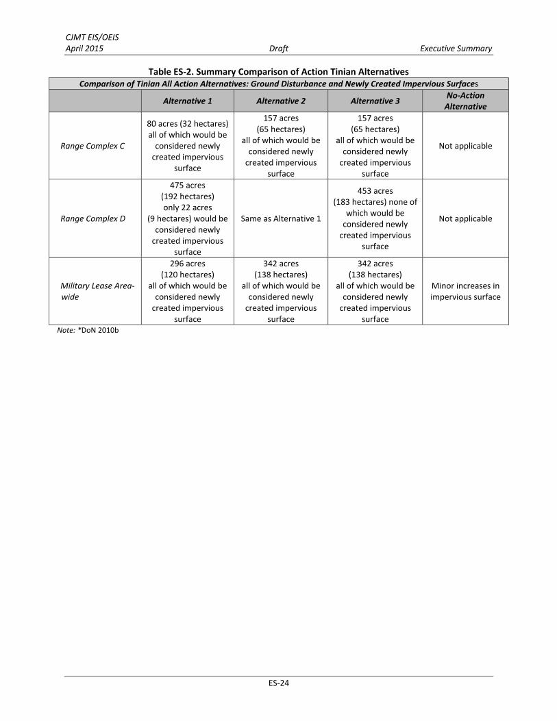
CJMT EIS/OEIS April 2015 Draft Executive Summary
ES-24
Table ES-2. Summary Comparison of Action Tinian Alternatives Comparison of Tinian All Action Alternatives: Ground Disturbance and Newly Created Impervious Surfaces
Alternative 1 Alternative 2 Alternative 3 No-Action
Alternative
Range Complex C
80 acres (32 hectares) all of which would be
considered newly created impervious
surface
157 acres (65 hectares)
all of which would be considered newly
created impervious surface
157 acres (65 hectares)
all of which would be considered newly
created impervious surface
Not applicable
Range Complex D
475 acres (192 hectares) only 22 acres
(9 hectares) would be considered newly
created impervious surface
Same as Alternative 1
453 acres (183 hectares) none of
which would be considered newly
created impervious surface
Not applicable
Military Lease Area-wide
296 acres (120 hectares)
all of which would be considered newly
created impervious surface
342 acres (138 hectares)
all of which would be considered newly
created impervious surface
342 acres (138 hectares)
all of which would be considered newly
created impervious surface
Minor increases in impervious surface
Note: *DoN 2010b

")")
")
")
")
")
")
")")")")")")
")")
")")
")")")")
")")")")")
"S
"S
"S
"S
"S
"S
##
##
#
# #
#
!i
!i
!i
!i!i
_̂
_̂
_̂
_̂
[
[
[[
[[
Philippine Sea
Pacific Ocean
InternationalBroadcasting
Bureau
MunitionsStorage Area
BaseCamp
Tinian InternationalAirport
Landing Zone activitiescould occur in clearedareas.
Grand Avenue
Masa
lok B
each
Roa
d
Broa
dway
42nd Street
8th Avenue
86th Street
96th Street 96th Street8th
Aven
ue
123rd Street
Riversid
e Drive 124th Street
Broa
dway
OP8
OP7OP6
OP3
OP4
OP1
OP2
SR6
SR4
SR3
SR2
SR1
SR5
OP5
NFigure ES-3
Tinian All Action AlternativesMilitary Lease Area-Wide Training Assets
LegendMilitary Lease Area
Range ComplexABCD
!i Landing Zone (20 acres)") Indirect Artillery Firing Position") Mortar Firing Position# Observation Post"S Surface Radar Site
[
[ [ [
[[ Munitions Storage Area FenceBase Camp Area,Range Control,and Staging Area
Tactical Amphibious Landing Beaches
_̂
Amphibious Assault Vehicles,Landing Craft Air Cushion,Small Boat and SwimmerTraining
_̂Landing Craft Air Cushion,Small Boat andSwimmer Training
_̂Small Boat andSwimmer TrainingTracked Vehicle Driver'sCourse (101 acres)Maneuver AreaHigh Hazard Impact AreaVegetation Cleared AreaNo Training AreaInternational BroadcastingBureau
0 1 20.5Miles
0 1 20.5Kilometers
ES-25

CJMT EIS/OEIS April 2015 Draft Executive Summary
ES-26
This page intentionally left blank.
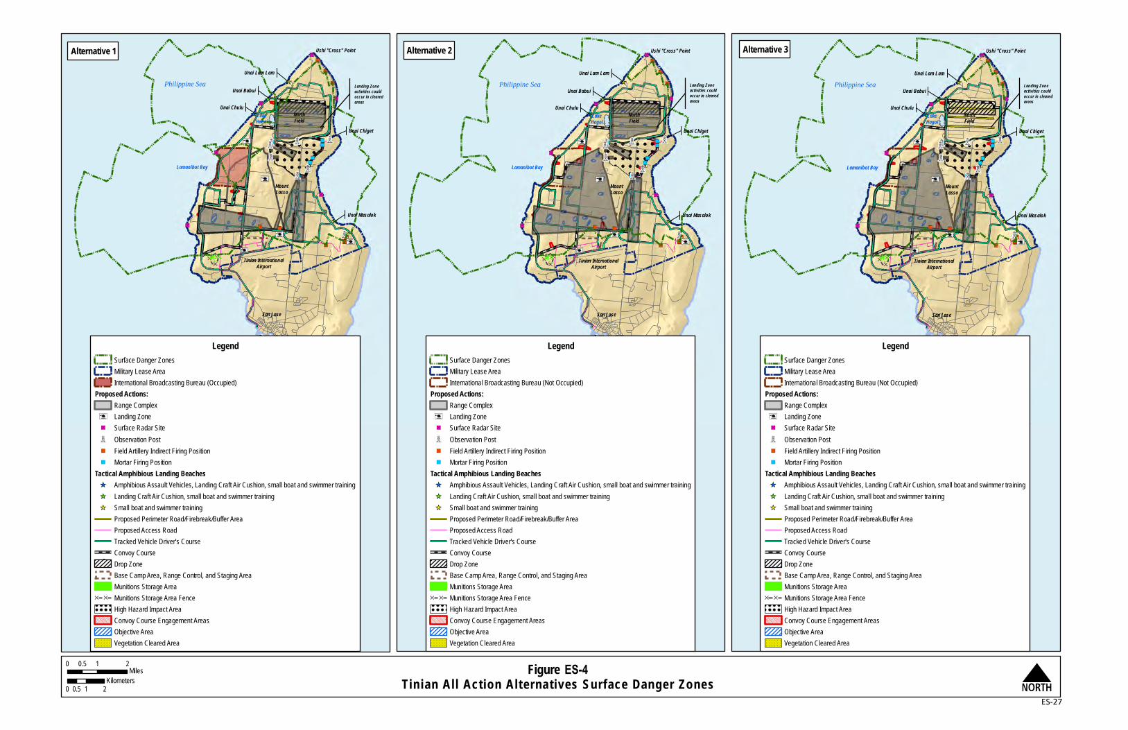
NorthField
MountLasso
Tinian InternationalAirport
San Jose
Tinian Harbor
Lamanibot Bay
Unai Chulu
Unai Lam Lam
Ushi "Cross" Point
Unai Chiget
Unai Masalok
Southwest Carolinas Point
LakeHagoi
Philippine SeaUnai Babui Landing Zone
activities couldoccur in cleared areas
NFigure ES-4Tinian All Action Alternatives Surface Danger Zones
0 1 20.5Miles
0 1 20.5Kilometers
NorthField
MountLasso
Tinian InternationalAirport
San Jose
Tinian Harbor
Lamanibot Bay
Unai Chulu
Unai Lam Lam
Ushi "Cross" Point
Unai Chiget
Unai Masalok
Southwest Carolinas Point
LakeHagoi
Philippine SeaUnai Babui
Landing Zoneactivities couldoccur in cleared areas
NorthField
MountLasso
Tinian InternationalAirport
San Jose
Tinian Harbor
Lamanibot Bay
Unai Chulu
Unai Lam Lam
Ushi "Cross" Point
Unai Chiget
Unai Masalok
Southwest Carolinas Point
LakeHagoi
Philippine SeaUnai Babui
Landing Zoneactivities couldoccur in cleared areas
LegendSurface Danger ZonesMilitary Lease AreaInternational Broadcasting Bureau (Occupied)
Proposed Actions:Range Complex
!i Landing Zone"S Surface Radar Site# Observation Post") Field Artillery Indirect Firing Position") Mortar Firing Position
Tactical Amphibious Landing Beaches_̂ Amphibious Assault Vehicles, Landing Craft Air Cushion, small boat and swimmer training_̂ Landing Craft Air Cushion, small boat and swimmer training_̂ Small boat and swimmer training
Proposed Perimeter Road/Firebreak/Buffer Area Proposed Access RoadTracked Vehicle Driver's CourseConvoy CourseDrop ZoneBase Camp Area, Range Control, and Staging Area Munitions Storage Area
[ [ Munitions Storage Area FenceHigh Hazard Impact AreaConvoy Course Engagement AreasObjective AreaVegetation Cleared Area
LegendSurface Danger ZonesMilitary Lease AreaInternational Broadcasting Bureau (Not Occupied)
Proposed Actions:Range Complex
!i Landing Zone"S Surface Radar Site# Observation Post") Field Artillery Indirect Firing Position") Mortar Firing Position
Tactical Amphibious Landing Beaches_̂ Amphibious Assault Vehicles, Landing Craft Air Cushion, small boat and swimmer training_̂ Landing Craft Air Cushion, small boat and swimmer training_̂ Small boat and swimmer training
Proposed Perimeter Road/Firebreak/Buffer Area Proposed Access RoadTracked Vehicle Driver's CourseConvoy CourseDrop ZoneBase Camp Area, Range Control, and Staging Area Munitions Storage Area
[ [ Munitions Storage Area FenceHigh Hazard Impact AreaConvoy Course Engagement AreasObjective AreaVegetation Cleared Area
Alternative 1 Alternative 2 Alternative 3
ES-27

This page intentionally left blank.

AGUIJAN
TINIAN
SAIPAN
Pacific Ocean
Philippine Sea
Saipan InternationalAirport
Figure ES-5Tinian All Action Alternatives
Special Use Airspace: Two-Dimensional Perspective N
Tinian International Airport
North Field
LegendMilitary Lease Area Boundary
Proposed Special Use AirspaceR-7203 EastR-7203 AR-7203 BR-7203 CR-7203 XR-7203 YR-7203 ZR-7203 WestTinian Military Operations Area / Air TrafficControl Assigned Airspace
(R = Restricted Area)
0 2 41Nautical Miles
0 2 41Kilometers
A
B C
X Y
Z
TINIAN0 2 41
Nautical Miles0 2 41
Kilometers
Tinian International Airport
North Field
ES-29

Figure ES-6Tinian All Action Alternatives
Base Camp
[
[ [
[
[[
[[
[
[
[[[[
[[[
[[ [ [
[[[[[
[[
[ [ [
[[
[[
[
[ [ [ [
[[
[
[[[
[[
[ [[
[[
[ [ [ [[
[[[[[ [ [ [ [
[[
[[
[[[[
[[
[[
[ [
[[
[[
[[
[[
[
[ [ [
[
[[[[
[
[ [
[
[ [ [[
[[
[[
[ [ [
[[
[[
[[[
[[
[
[[
[ [ [ [ [
[[
[[[[
[ [ [
[[
[[[
[[
[ [ [[
[[[[[ [ [ [ [
[[
[
[[[[
[[
[[
[ [
[[[
[
[ [ [[
[[
[ [
[[
[[
[[
[[
[[
[[
[[
[[
[[
[[
[[
[
[[
[[
[[
[[
[[
[ [ [ [ [ [ [ [ [ [ [ [ [ [ [ [ [ [ [ [ [ [ [ [ [ [ [ [ [ [ [ [ [ [ [ [ [ [ [ [ [ [ [ [ [ [ [ [ [ [ [ [ [
[
[
[
[[
[
[ [ [[
[[
[[
[
[[ [
[
[[
[[
[[
[[
[[
[[
[[
[[
[[
[[
[
[[[[[[[[[[[[[[[[[[[[[[[[[[[[[[[[[[[[[[[[[[[[[[[[[[
[[
[[
[[
[[
[[
[[
[[
[[
[[
[[
[[
[
[ [[
[[[
[
[ [ [ [ [ [ [ [ [ [ [ [ [ [ [ [ [ [ [ [ [ [ [ [ [ [ [ [ [ [ [ [ [ [ [ [ [ [ [ [ [
[[
[[
[[
[[
[[
[ [ [ [ [ [ [ [ [ [ [ [ [ [ [ [ [ [ [ [ [ [ [
[[
[[
[[
[[
[[
[[
[[
[ [ [ [ [ [ [ [ [ [ [ [ [ [ [ [ [
[[[
[
[
[
[[
[[
[[
[[
[[
[
[[
[ [ [ [ [
[[
[
[[
[[
[[
[ [ [ [ [ [[
[[
[[
[[
[[
[[
[[
[[
[
[[
[ [ [[
[[
[[
! ! !
! ! !
! ! !
! ! !
!i
#0
Barr-1246 ac
Barr-2254 acBarr-3
397 ac
Vehicle Washrack
WastewaterDisposal Field
WastewaterTreatment Facility
Cold Storage Warehouse
WastewaterLift Station
Filling Station and EquipmentReady Fuel Storage
Latrines/Laundry
CommunicationTower
Armory
MessHall
BattalionHeadquarters
Base Warehouse
DiningFacility
TransientQuarters
Public Works
FireStation
Auto Shop
BaseHeadquarters
Workshop(MWSS)
Range Operations Maintenance Shop
Workshop(Infantry BN)
Workshop(Artillery BTRY)
Solid Waste Transfer Facility
Hazardous/FlammableMaterials Storage Facility
Open AmmunitionStorage Pad
Workshop(AAV/LAR/CEB)
Workshop(CLB/ESB)
Water Tank Building (Size TBD)
Aid Station
Water Storage Tank (500k Gal)
Range Operationsand Administration/
Control Center
Gate/SentryHouse
Security Office
Solid Waste Recycling Center
AcademicInstructionBuilding
Hazardous Waste Storage and Transfer Facility
Recreation Center
NSource: NAVFAC Pacific 2013
0 1,000 2,000500Feet
0 200 400100Meters
PacificOcean
Philippine Sea
Tinian
San Jose
TinianInternational
Airport
Area of Detail
1 " = 8 Miles
Legend!i Landing Zone
#0 Communication TowerMilitary Lease Area BoundaryExisting Roads (Impoved and Unimproved)Proposed Access RoadConvoy CourseTracked Vehicle Driver's Course
[ [ Chain Link with Barbed Wire Fence
Base Camp Area, Range Control,and Staging Area (253 acres)
Airfield and Basecamp Components:Paved Areas/SidewalksProposed Facility StructureExpeditionary Tent PlatformOpen Bay Barracks(Temporary Surge TentArea Under Stage 1)Latrines/Laundry
Landscaped AreaVehicle Grease RackVehicle WashrackMisc Laydown AreaOpen Storage AreaVehicle Parking AreaStormwater Basin
Note: Layouts are notional. Final design subject to modification within proposed ground disturbance footprint.
ES-30

Figure ES-7Tinian All Action Alternatives
Munitions Storage Area
!G
!G
!G
!G
!G!G
Barr-1246 acBarr-2
254 acBarr-3397 ac
Base Camp Area(including Staging Area)
Munitions StorageMagazines
Custodial Storage
Receipt, Stowage, Segregation,and Issue Facility
Munitions Assembly Pad
Inert StorageMaintenanceFacility
Biosecurity
Munitions HandlingEquipment Fuel Point
Entry Control Point(Guard Shack)
Electrical Charging Station
Auxillary Storage
Loading Dock
Auxillary Storage
OrdnanceOperations
Munition Holding PadMunition Holding Pad
NSource: NAVFAC Pacific 2013
LegendMilitary Lease Area BoundaryExisting Roads (Impoved and Unimproved)Proposed Access RoadProposed Supply RouteConvoy Course Engagement AreasConvoy CourseTracked Vehicle Driver's CourseFAA Runway Protection Zone
Munitions Storage AreaNotional Safety Arcs
[ [ Chain Link with Barbed Wire FenceMunitions Storage Area (38 acres)
!G Proposed Primary MSA Access GatesOrganizational Vehicle ParkingProposed Ammunition Storage FacilitiesProposed Vehicle DrivewaysBarricadeMunitions Storage MagazineProposed Munitions Storage Area (MSA)
PacificOcean
Philippine Sea
Tinian
San Jose
TinianInternational
Airport
Area of Detail
1 " = 8 Miles
0 1,000 2,000500Feet
0 200 400100Meters
Note: Layouts are notional. Final design subject to modification within proposed ground disturbance footprint.
ES-31

Figure ES-8Tinian All Action Alternatives
Airport Improvements
!i
!i
[[
[[
[[
[ [ [ [[
[
[
[
[ [ [ [ [ [ [[
[[
[[ [ [ [ [ [ [ [ [ [
[[
[ [ [ [ [ [ [ [ [ [ [ [ [ [ [ [ [ [
[[
[[
[[
[ [ [ [ [ [ [ [ [ [ [ [ [
[
[
[
[[[
[[[[ [
[[[[
[ [
[[
[ [
[[
[
[[
[[
[ [[[[
[ [
[[
[[
[[
[
[[
[
[[
[ [ [[
[[
[
[[[
[ [[
[
[
[[
[
[ [ [
[[[ [ [
[
[
[
[ [
[[
[ [ [
[
[[[
[
[
[
[
[
[ [
[
[
[
[[
[[
[[
[[
[[
[[
[ [ [[
[[
[[[
[[
[[
[[
[[
[[[[[[[[[[
[[
[[
[[
[[
[[
[
[[
[[
[[
[[
[[
[[
[[
[[
[[
[[
[[
[
[[
[[
[[
[[
[[
[[
[[
[
[ [ [ [ [ [ [ [ [ [ [[
[[
[[
[[
[[
[[
[[
[[
[[
[[
[[
[[
[[
[[
[[
[[
[[
[[
[[
[[
[[
[[
[[
[[
[[
[[
[[
[[
[[
[[
[[
[[
[[
[
[[
[[
[[
[[
[[
[[
[[
[[
[[
[[
[[
[[
[[
[[
[[
[[
[[
[[
[[
[[
[[
[[
[[
[[
[[
[[
[[
[[
[[
[[
[[
[[
[[
[[[[[[[[
[ [ [ [ [ [ [ [ [ [ [ [ [ [ [ [ [ [ [ [ [ [ [ [ [ [ [
[
[
[[
[
[[
[[
[
[
[[
[[
[[
[[
[[
[
[[[[[[[[[[[[[[[[[[[[[[[[[[
[[
[[
[[
[[
[[
[[
[[
[[
[[
[[
[
[
[
[[
[[
[[
[
[[
[[
[[
[[
[
[[[
[
[
[
[ [[
[
[ [ [ [ [ [ [ [ [ [ [ [ [ [ [ [ [ [ [ [ [
[
[[
[[
[ [ [ [ [ [ [ [ [ [ [ [
[[
[[
[[
[[ [ [ [ [ [ [ [ [
[[[
[
[ [ [
[[[[[
[
[
[[
[[
[
[[ [ [
[[
[[
[ [ [ [[
[
[[
[[
[[
[
[ [
[[
Barr-1246 acBarr-2
254 acBarr-3397 ac
Tinian International Airport
Base Camp
Ordnance Arming/De-arming Pad
Hazardous CargoRed Label/CombatAircraft Loading Area
Hot CargoEquipment Pad
Hot Cargo -Biosecurity Pad
Hot Cargo -Ammo Pad
CargoPad
Aircraft Parking Ramp(12) MV-22/CH53E
Glideslope
Arresting Gear
Expeditionary FuelingPad, Fuel Pits
Aircraft MaintenanceFacilities
Field Carrier LandingPractice Pad
LandingHelicopterDock Pad
CNMI ProposedCross Taxiway
Access Roads
CNMI ProposedCross Taxiway
LSO Shack
Fresnel LensExisting Commercial Taxiway
Proposed Military TaxiwayPotentialFuture
TaxiwayExpansion
PotentialFutureTaxiwayExpansion
Fuel Pipeline
Fuel Tanks
NSource: NAVFAC Pacific 2013
LegendArresting Gear lineFuel LinesRunway CenterlineIBD ESQD ArcPTR ESQD Arc
[ [ Existing and Proposed Fencelines
Proposed Access RoadTracked Vehicle Driver's CourseConvoy CourseProposed Supply RouteExisting Roads (Impoved and Unimproved)
!i Landing Zone
USMC Parking (MV-22 or CH-53E)Hot Cargo - FighterFuel TanksFuel PipelineBase Camp Area, Range Control,and Staging Area (256.2 acres) Military Lease Area Boundary
PacificOcean
Philippine Sea
Tinian
San Jose
TinianInternational
Airport
Area of Detail
1 " = 8 Miles
0 1,000 2,000500Feet
0 200 400100Meters
Note: Layouts are notional. Final design subject to modification within proposed ground disturbance footprint.
ES-32

Figure ES-9Tinian All Action Alternatives
Port Improvements and Supply Route
!!!
!!!
!!!
!!!
!
!!
!
!!!
!!
!
!!!
!!!
!!!
!!!
!!!
!!!
!!!
!!!
!!!
!!!
!!!!
!!!
!!!
!!!
!!!
!!!
!!!
!!!
!!!
!!!
!!
!
!!
!
!!
!
!!
!
!!
!!!
[
[
[
[
[
[
[
[
[
[
[
[
[
[
[
[[
[
[
[
[
[
[ [
[
[
[
[
[
[
[
[
[
[
[
[
[
[
[
[
[
[
[
[
[
[
[
[
[
[
[
[
[
[[
[
[
[ [[
[[
[
[
[
[
[
[
[
[
[
[
[
[
"p"p
"p
Barr-1246 ac
Barr-2254 ac
Barr-3397 ac
Tinian Harbor
San JoseBulk Fuel
Storage
Cargo Inspection and Holding Area
Vehicle Inspection AreaParking
Existing Commercial Wharf
Cargo Load/Unload Area
Vehicle and EquipmentWash Down Area
H
To Base Camp
Public Boat Docks
Existing Old Boat Ramp (Public, Potential Military Use)
Retention Pond
BiosecurityBuilding
Existing CommercialFuel Storage
West Street
8th Av
enue
Canal S
treet
Grand
Avenu
e
NSource: NAVFAC Pacific 2013
LegendExisting Roads (Impoved and Unimproved)Existing Commercial Fuel StorageTracked Vehicle Transit LaneFuel Pipeline
"p Existing Boat Ramp (Cargo)
"p Existing Old Boat Ramp (Public, Potential Military Use)
"p Existing Boat Ramp (Public)Primary Proposed Cargo Transport Route
! ! ! Secondary Proposed Cargo Transport RouteProposed Port Facilities (7 acres)
Paved AreasBiosecurity BuildingLandscaped AreaNotional Fuel Storage TanksBulk Fuel Storage AreaRetention Pond
[ Existing Port of Tinian Area Fenceline
PacificOcean
Philippine Sea
Tinian
San Jose
TinianInternational
Airport
Area of Detail
1 " = 8 Miles
!
!
!
!
!!
!
!
!!
!!!
!
!!!
!!
!!!!
!!
! !
!!
! !!
! ! !
! !
!
!!!!
!
!!!
!!!
!!
!
! ! !! ! !
!!!
!!
Phillippine Sea
86th Street
8th Avenue
42nd Street
0 200 400100Feet
0 50 10025Meters
Note: Layouts are notional. Final design subject to modification within proposed ground disturbance footprint.
ES-33

CJMT EIS/OEIS April 2015 Draft Executive Summary
ES-34
This page intentionally left blank.

!i
!i
!i
!i!i
!G
!G
!G
!G!G
!G
!G
!G
!G
!G
!G
!G
!G
!G
!G
!G
!G
!G
!G
!G!G
!G
!G
!G
!G
!G
!G
!G
!G
!G !G
!G
!G
!G
!G
!G
!G
!G
!G!G !G !G
!G
!G
!G
!G
!G
!G!G
!G
!G
!G!G
!G
!G
!G
!G
!G
!G
!G
!G
NorthField
MountLasso
Tinian InternationalAirport
San Jose
Tinian Harbor
Lamanibot Bay
Unai Chulu
Unai Lam Lam
Ushi "Cross" Point
Unai Chiget
Unai Masalok
Marpo Point
LakeHagoi
Unai Babui
Unai Dankulo
AK
AJ
B
P
O
NAM
F
A
G
M
J
C
U
W
V
D
HB
HA
I
E
K
L
X
AL
AC
AD
AEAB
Q
Y
Z AA
AI AG
AH
AF
R
S
T
BA
BB
BC
BD
BE
AN
AO
AQ
AR
AP
Pacific Ocean
Marpo Point
Southwest Corolinas Point
Philippine Sea Lake Hagoi
TinianHarbor
See PortInset
InternationalBroadcasting
Bureau
RunwayAble
RunwayBaker
RunwayCharlie
RunwayDog
Landing Zone activitiescould occur in clearedareas.
OP8
OP6
OP3
OP5
OP1
OP2
SR6
SR5
SR4
SR3
SR1
SR2
OP4OP7
Figure x.x-xTinian Alternatives- Legend Items
Figure ES-10Tinian All Action Alternatives
Range Access Improvements, Fence Lines, and Gates N
Masa
lok B
each
Roa
d
Broa
dway
42nd Street
8th Avenue
86th Street
96th Street96th Street
8th Av
enue
123rd Street
Riversid
e Drive
124th Street
Broa
dway
LegendMilitary Lease AreaExisting Roads (Improved and Unimproved)High Hazard Impact Area
!i Landing Zones
# Observation Post
"S Surface Radar Site
!G Access GateTinian Fencelines Chain Link Chain Link with Barbed Wire Barbed WireDD DD DD DD DD DD Existing Airport Fence
Roadway Improvement SegmentsRepair Existing Road for Public UseRepair Existing Road for Public Use - BoulevardConstruct New Paved RoadConstruct New Gravel RoadEstablish Military Training RoadRepair Existing Road for General UseImprove Road Right of Way for UtilitiesPerimeter Patrol RoadRoad Closure - No ImprovementsNo ActionVegetation Cleared Area
!G
!G
!G
!G
!G
!G
!G
!G
!G
!G
!G
!G
!G
!G
!G
!G
!G
!G
D
E
C
8th Av
enue
Port Inset0 0.5 10.25
Mile
0 0.5 10.25Kilometer
6th Av
enue
116th Street
Lennox Avenue
DumpRoad
Babui
Beach
Road
Bosto
n Post Road
71st Street
Note 1: Roadway sections have alphabetic designations whichare discussed in Table 2.4-1, Proposed Tinian Unit Level RTARoad Improvements.Note 2: Layouts are notional. Final design subject to modification within proposed ground disturbance footprint.
ES-35

This page intentionally left blank.

!!2!!2
!!2
!!2!!2!!2
!!2¥b¢
"S
"S
"S
"S
"S
"S
##
##
#
# #
#
NorthField
MountLasso
Tinian InternationalAirport
San Jose
Tinian Harbor
Lamanibot Bay
Unai Chulu
Unai Lam Lam
Ushi "Cross" Point
Unai Chiget
Unai Masalok
Marpo Point
LakeHagoi
Unai Babui
Unai Dankulo
#ÿ*
#ÿ* Pacific Ocean
Philippine Sea
TinianHarbor
InternationalBroadcasting
Bureau
RunwayAble
RunwayBaker
RunwayCharlie
See PortInset
RunwayDog
")
LegendMilitary Lease AreaExisting Roads(Improved and Unimproved)
¥b¢ Communications Tower andArea Distribution Node
!!2 Water Source Point") Water Tank
Water Line
# Observation Post"S Surface Radar Site#ÿ* Electrical Substation
Electrical Cable LineIT/Communications LineWastewater Treatement Facility/Wastewater Disposal FieldWastewater Lift StationWastewater LineStormwater DitchOpen Drainage AreaProposed Port FeatureFuel PipelineFuel Tanks
Figure ES-11Tinian All Action Alternatives
Utility Improvements N
See BaseCamp Inset
Grand Avenue
Masa
lok B
each
Roa
d
Broa
dway
42nd Street
8th Avenue
86th Street
96th Street 96th Street8th Av
enue
123rdStreetRive
rside D
rive 124th Street
Broa
dway
0 1 20.5Miles
0 1 20.5Kilometers
¥b¢
#ÿ*
#ÿ*
")
Base Camp Inset
8th Av
enue
Solid WasteTransfer Facility
8th
Aven
ue
Port Inset
Wastewater Treatement Facility/Wastewater Disposal Field
Open DrainageArea
Note: Layouts are notional. Final designsubject to modification within proposedground disturbance footprint.
ES-37

Figure ES-12 Unai ChuluTactical Amphibious Beach Landing
Dredging and Construction
Barr-1246ac
Barr-2254ac
Barr-3397ac
Babu
i Bea
ch Ro
ad
-4
N0 200 400100
Feet
0 50 10025Meters
LegendAmphibious Landing RampProposed Tracked Vehicle RouteExisting RoadMaximum reach of excavatorSheetpile CausewayTrestle CausewayApproach Zone²LCAC - Craft Landing Site (75 ft radius) LCAC Landing FootprintConstruction Footprint (4.32 acres)4 Meter Depth Contour1 Meter Depth Contour
Depth Relative to Mean Lower Low Water¹Greater than 40 feet Depth-40 to -20 feet Depth-20 to -12 feet Depth-12 to -7 feet Depth-7 to -5 feet Depth-5 to -3 feet Depth-3 to -1 feet Depth-1 to 0 feet Depth0 to 3 feet3 to 5 feetGreater than 5 feet
4 METERDEPTH CONTOUR
MAXIMUM REACH OF EXCAVATOR
APPROACH AREA-4 M NOMINAL DEPTH
DREDGE SWATH36.4 M PER CAUSEWAY
Source: NAVFAC Pacific 2013; Sea Engineering, Inc. 2014
1 Depth values based on mean-mean low water and grouped to distinguish between the following depths of concern: - Maximum Potential Impact Depth (-12 feet) - In-water Draft of AAV (-7 feet) - Wave Surge Potential Track Impact (-5 feet) - Track Engagement (-3 feet) - Reef Flat Maneuver (-1 feet or above)2 Unai Chulu will be used for: amphibious assault vehicle landings, landing craft air cushion, small boat, and swimmer insertions approach training.
ES-38

Figure ES-13 Unai ChuluTactical Amphibious Beach Landing
Operations
Barr-1246 ac
Barr-2254 ac
Barr-3397 ac
Rivers
ide Dr
ive
123rd Street
Babu
i Bea
ch Ro
ad
8th Av
enue
8th Av
enue
Roun
dabo
ut
Riverside Drive
8th Av
enue
Rivers
ide Dr
ive
-4
N0 200 400100
Feet
0 50 10025Meters
SHORE
RAMP
Source: NAVFAC Pacific 2013; Sea Engineering, Inc. 2014
LegendAmphibious Landing RampProposed Tracked Vehicle RouteExisting Road4 Meter Depth Contour1 Meter Depth ContourApproach Zone²Craft Landing Site (75 ft radius)Landing FootprintOperations Footprint
Depth Relative to Mean Lower Low Water¹Greater than 40 feet Depth-40 to -20 feet Depth-20 to -12 feet Depth-12 to -7 feet Depth-7 to -5 feet Depth-5 to -3 feet Depth-3 to -1 feet Depth-1 to 0 feet Depth0 to 3 feet3 to 5 feetGreater than 5 feet
1 Depth values based on mean-mean low water and grouped to distinguish between the following depths of concern: - Maximum Potential Impact Depth (-12 feet) - In-water Draft of AAV (-7 feet) - Wave Surge Potential Track Impact (-5 feet) - Track Engagement (-3 feet) - Reef Flat Maneuver (-1 feet or above)2 Unai Chulu will be used for: amphibious assault vehicle landings, landing craft air cushion, small boat, and swimmer insertions approach training.
ES-39

CJMT EIS/OEIS April 2015 Draft Executive Summary
ES-40
Construction and Improvements
1. Support Facilities and Infrastructure Construction.
2. Training Facilities Construction.
ES.5.3 Pagan Alternatives
ES.5.3.1 Land Use Agreements
Land use agreements will be required to implement the proposed action on Pagan. Pagan is owned entirely by the CNMI government; there are no federal lands on the island. The federal government would seek to acquire a real estate interest for the entire island of Pagan (approximately 11,794 acres [4,443 hectares]) from the CNMI government. A full discussion of proposed land acquisition and land uses on Pagan is provided in Section 4.7, Land and Submerged Land Use.
ES.5.3.2 Construction and Improvements
Construction and improvements at Pagan RTA would commence only upon completion of required real estate actions. Construction is anticipated to span 8 to 10 years depending on funding and operational commitments of the U.S. military. Construction improvements may be part of initial training exercises on Pagan, and subsequent training events would include maintenance. Construction and improvements for the Pagan action alternatives include two broad categories: (1) support facilities and infrastructure, and (2) training facilities. These are further described below.
Support Facilities and Infrastructure Construction. Support facilities to be constructed include an expeditionary base camp/bivouac area, airfield, expeditionary military training trails, and a temporary Munitions Storage Area.
Training Facilities Construction. The combined level RTA is composed of High Hazard Impact Area(s), maneuver areas, amphibious training beaches, and Landing Zones, regardless of the alternative. To provide the reader with an easier way to identify the various RTA training facilities, they were grouped into two range complexes based on geographic proximity. The complexes are labeled North and South Range Complexes.
ES.5.3.3 Training Operations
The training would occur in two areas identified as the North Range Complex and the South Range Complex.
ES.5.3.3.1 North Range Complex
Ground training in the North Range Complex would include the following:
High Hazard Impact Area centered on Mount Pagan would be used for ground, air, and naval surface fire support live-fire and inert munitions expenditures.
Training in the northern maneuver areas includes, but is not limited to: (1) patrolling, establishing defensive positions, and firing live-fire weapons into and/or around the High Hazard Impact Area; and (2) integrating supporting arms (including aviation, artillery, and naval gunfire assets.
Amphibious training would include Amphibious Assault Vehicles and Landing Craft Air Cushion operations. Up to six beaches would be used for amphibious training. Targets along the beachfront

CJMT EIS/OEIS April 2015 Draft Executive Summary
ES-41
would be established for tactical training (primarily at Red Beach) and a path maintained to provide access to the military trail network. Amphibious forces would maneuver from naval ships via water or air to various locations on Pagan, based on the design of the training exercise.
Landing Zones Training Operations would involve tilt-rotor and rotary-wing aircraft such as CH-53, UH-1, and AH-1 would take off and land from Landing Zones proposed across northern Pagan. Fixed-wing aircraft would use the airfield as would rotor and tilt-rotor aircraft. Live-fire would be allowed at the Landing Zones. Other aviation training would include Drop Zones, unmanned aircraft operating areas, and training flight maneuver areas.
ES.5.3.3.2 South Range Complex
The training in the South Range Complex includes the following:
Maneuver Area Training Operations would involve small units, a platoon or less, of special operations personnel (Navy SEALS; Marine Corps Special Forces Operations Command; Army Rangers, etc.) that would move toward an objective or Observation Post. Troops would access South Pagan via air insertion (e.g., helicopter using fast rope) or using small boat (raiding craft) and swimmers. No tactical Landing Zones would be created in the south. Units would either walk out of the southern area or be extracted by helicopters using Special Control Insertion/Extraction, or small boats.
Small boat and swimmer training, and combat swimmer training.
ES.5.3.4 Pagan No-Action Alternative
As a result of the CNMI government’s mandate prohibiting residents from Pagan because of the 1981 volcano eruption, the island has not been officially occupied and there is limited visitation. The no-action alternative for Pagan assumes the continuation of this occupancy prohibition and limited activity. Therefore, the no-action alternative essentially reflects existing conditions as described in Chapter 3, Affected Environment, of this EIS/OEIS.
The limited visitations under the no-action alternative would continue the infrequent eco-tourism cruise visits. This would be a low impact activity with no permanent pier or wharf construction with visitation facilitated by small boat landings from the larger vessel moored offshore. It is also assumed that these would be day trips with no permanent accommodations on the island. Another probable and low impact activity on Pagan would be periodic visits for scientific or related research conducted by federal and CNMI organizations. Unlike Tinian where the military has long held training exercises on leased land, activities by the military, while not excluded, would be minimal under the no-action alternative and would entail infrequent search and rescue type training exercises following coordination and approval from the CNMI government.
ES.5.3.5 Comparison of Pagan Alternatives
Table ES-3 provides a comparison of Pagan combined level action alternatives. It is assumed that training throughput (total personnel) and munitions usage would be the same for both alternatives; however, the type of training and maneuvering capability would vary. Best management practices would be incorporated into the proposed action and common to both Pagan action alternatives. Figures ES-14 and ES-15 show range layouts for Pagan Alternative 1 and Pagan Alternative 2, respectively. Figure ES-16

CJMT EIS/OEIS April 2015 Draft Executive Summary
ES-42
shows “composite” surface danger zones for both alternatives. The composite consists of individual surface danger zones for all proposed training activities. Typically, only certain surface danger zones within this composite would be active at any given time depending on the type of training being conducted.
Table ES-3. Summary Comparison of Pagan Alternatives Comparison of Pagan Action Alternatives
Alternative 1 Alternative 2 No-Action Alternative
General Differences
Two High Hazard Impact Areas (on Mount Pagan and isthmus).
One High Hazard Impact Area (Mount Pagan) and, as a result, smaller surface danger zones.
Very limited military training and minimal human visitation and related activities
Larger High Hazard Impact Areas on Mount Pagan.
Smaller High Hazard Impact Area on Mount Pagan.
11 Landing Zones 13 Landing Zones
6 Mortar Range Firing Positions
5 Mortar Range Firing Positions
Simultaneous Use
Both the North and South Complex Ranges could be used at the same time.
Same as Alternative 1, however, the North Range Complex would only have one High Hazard Impact Area.
Not applicable
Training Value
This alternative provides greater combined arms training value but less ground maneuver flexibility as compared to Alternative 2.
Lesser live-fire training options, flexibility in attack approach and more limited options for weapons deployment due to smaller northern High Hazard Impact Area on Mount Pagan and lack of a High Hazard Impact Area on the isthmus.
Greater ground maneuver flexibility compared to Alternative 1.
Military visits to Pagan would continue to be limited and coordinated with the CNMI government
Elements Common to All Pagan Action Alternatives
Training Facilities Construction
Alternatives 1 and 2 No-Action Alternative
Expeditionary Base Camp/Bivouac Area
Includes bivouac area for tents “housing” personnel. Staging areas for equipment and vehicles, and temporary infrastructure such as water tanks, portable toilets, and diesel generators.
Not applicable
Airfield Improvements Includes extending the runway, space for aircraft turnaround and parking, refueling, and munitions loading space.
No activities
Military Training Trail Network
Includes a 22-mile (35 kilometer) military training trail network from the expeditionary base camp/bivouac area to the North Range Complex.
No activities

CJMT EIS/OEIS April 2015 Draft Executive Summary
ES-43
Table ES-3. Summary Comparison of Pagan Alternatives Comparison of Pagan Action Alternatives
Training Facilities Construction
Alternatives 1 and 2 No-Action Alternative
South Range Complex No construction footprint. No activities
Range Operations and Maintenance
Alternatives 1 and 2 No-Action Alternative
Security As training cycles are better defined an access plan would be developed and published for public information.
Not applicable
Public Access
Prohibition of public access at all times to the High Hazard Impact Area (s). Portions of the island and surrounding waterways may be available for public access depending on the type of training and the training scenario. Public access would be allowed when training is not occurring.
Access would continue to be limited and coordinated with
the CNMI government
Biosecurity Biosecurity measures would be established to wash down and inspect equipment prior to arriving on and upon departure from Pagan.
Biosecurity would be done as needed
Emergency Services Establishing fire, safety, and medical emergency procedures for all visiting personnel. Not applicable
Munitions Total: 700,298 rounds/year Not applicable Amphibious Training
Beaches Alternatives 1 and 2 No-Action Alternative
Operations
The following amphibious operations would occur: Red, Green, Blue (Shomshon, Palapala, Apan
Beaches) – Amphibious Assault Vehicle, Landing Craft Air Cushion vessel, small boat, and combat swimmer training.
South (Regussa Beach) would be used for Landing Craft Air Cushion vessel, small boat, and combat swimmer training.
Gold (Unai Dikidiki Beach) would be used for small boat and combat swimmer training.
Not applicable
Public Access to Beaches Access allowed to Pagan beaches when no training is occurring
No limits to public access beyond those imposed by the
CNMI government Airspace Requirement Alternatives 1 and 2 No-Action Alternative
Operations
Special Use Airspace would be established. Warning Area 14, a quadrilateral with a dimension
of roughly 60 nautical miles by 80 nautical miles (111 kilometers by 148 kilometers), from the center of Pagan. The floor would start at the surface and extend to a ceiling of 59,999 feet (18,288 meters) MSL.
Restricted Area 7204 extends horizontally 12 nautical miles (22 kilometers) from Pagan’s shoreline with a floor starting at the surface to a ceiling of 60,000 feet (18,300 meters) MSL.
Not applicable
Sea Space Requirement Alternatives 1 and 2 No-Action Alternative
Operations Danger zones would be established using the Pagan Not applicable

CJMT EIS/OEIS April 2015 Draft Executive Summary
ES-44
Table ES-3. Summary Comparison of Pagan Alternatives Comparison of Pagan Action Alternatives
Restricted Area boundaries. These danger zones would be activated when corresponding airspace is activated.
Comparison of Pagan All Action Alternatives: Ground Disturbance and Newly Created Impervious Surfaces Element Alternative 1 Alternative 2 No-Action Alternative
Total Ground Disturbance/Newly Created Impervious Surface
Total: 764 acres (310 hectares)/350 acres
(142 hectares)
Total: 697 acres (283hectares)/347 acres (140
hectares)
Minimal disturbance/no increase in impervious
surfaces
Expeditionary Base Camp/Bivouac Area
42 acres (17 hectares) all of which is considered newly created impervious surface Not applicable
Expeditionary Airfield 41 acres (17 hectares) all of which is considered newly
created impervious surface Not applicable
Munitions Storage Area and Supply Route
42 acres (17 hectares)/only 12 acres (5 hectares) is considered newly created impervious surface Not applicable
Military Training Trails 39 acres (16 hectares) all of which is considered newly
created impervious surface Not applicable
North Range Complex (Landing Zones, Firing Positions, Target Areas)
600 acres (243 hectares)/216 acres
(88 hectares)
533 acres (241 hectares)/213 acres (86 hectares) Not applicable
South Range Complex 0 acre (0 hectare) 0 acre (0 hectare) Not applicable
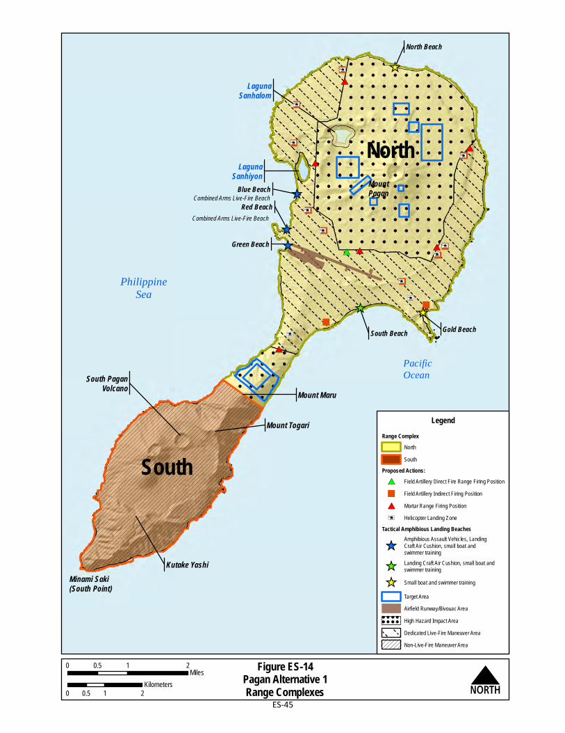
North Beach
Gold Beach
Green Beach
South PaganVolcano
MountPagan
LagunaSanhiyon
LagunaSanhalom
Kutake Yashi
Mount Maru
Minami Saki(South Point)
PhilippineSea
Red Beach
"
"
#*
"
""
"
"
#*
"
"
"
"
#* #* #*
#*
#*
!i
!i
!i
!i!i
!i
!i
!i
!i
!i
!i
_̂
_̂_̂
_̂
_̂
_̂
North
South
South Beach
Blue BeachCombined Arms Live-Fire Beach
Combined Arms Live-Fire Beach
Mount Togari LegendRange Complex
NorthSouth
Proposed Actions:#* Field Artillery Direct Fire Range Firing Position" Field Artillery Indirect Firing Position#* Mortar Range Firing Position!i Helicopter Landing Zone
Tactical Amphibious Landing Beaches
_̂Amphibious Assault Vehicles, LandingCraft Air Cushion, small boat andswimmer training
_̂ Landing Craft Air Cushion, small boat andswimmer training
_̂ Small boat and swimmer training
Target AreaAirfield Runway/Bivouac AreaHigh Hazard Impact AreaDedicated Live-Fire Maneuver AreaNon-Live-Fire Maneuver Area
Figure ES-14Pagan Alternative 1Range Complexes N
0 1 20.5Miles
0 1 20.5Kilometers
Pacific Ocean
ES-45
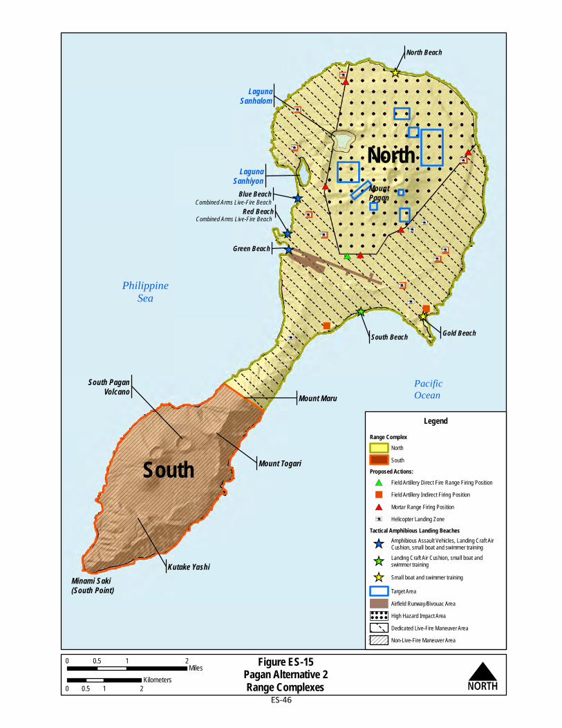
North Beach
Gold Beach
Green Beach
South PaganVolcano
MountPagan
LagunaSanhiyon
LagunaSanhalom
Kutake Yashi
Mount Maru
Minami Saki(South Point)
PhilippineSea
Red Beach
"
"
"
""
"
"
#*
"
"
"
"
#* #*
#*
#*
#*
!i
!i
!i
!i!i
!i
!i !i!i
!i
!i
!i
!i
_̂
_̂_̂
_̂
_̂
_̂
North
South
South Beach
Blue BeachCombined Arms Live-Fire Beach
Combined Arms Live-Fire Beach
Mount Togari
LegendRange Complex
NorthSouth
Proposed Actions:#* Field Artillery Direct Fire Range Firing Position" Field Artillery Indirect Firing Position#* Mortar Range Firing Position!i Helicopter Landing Zone
Tactical Amphibious Landing Beaches
_̂ Amphibious Assault Vehicles, Landing Craft AirCushion, small boat and swimmer training
_̂ Landing Craft Air Cushion, small boat andswimmer training
_̂ Small boat and swimmer trainingTarget AreaAirfield Runway/Bivouac AreaHigh Hazard Impact AreaDedicated Live-Fire Maneuver AreaNon-Live-Fire Maneuver Area
Figure ES-15Pagan Alternative 2Range Complexes N
0 1 20.5Miles
0 1 20.5Kilometers
Pacific Ocean
ES-46

Minami Saki(South Point) Kutake Yashi
South PaganVolcano
Mount Togari
Mount Maru
South Beach
Gold Beach
North BeachLaguna
Sanhalom
LagunaSanhiyon
Blue Beach
Red Beach
Green Beach
LegendSurface Danger Zone Alternative 1
Figure ES-16Pagan All Act ion Alternatives Surface Danger Zones
0 1 20.5Miles
0 1 20.5Kilometers
Minami Saki(South Point) Kutake Yashi
South PaganVolcano
Mount Togari
Mount Maru
South Beach
Gold Beach
North BeachLaguna
Sanhalom
LagunaSanhiyon
Blue Beach
Red Beach
Green Beach
N
LegendSurface Danger Zone Alternative 2
Alternative 1 Alternative 2
ES-47

This page intentionally left blank.

CJMT EIS/OEIS April 2015 Draft Executive Summary
ES-49
ES.6 RESOURCE MANAGEMENT MEASURES
The Resource Management Measures section discusses applicable (1) avoidance and minimization measures, and (2) best management practices and standard operating procedures, and how they serve to lessen impacts to specific resources. Resource management measures include avoidance and minimization measures, and best management practices and standard operating procedures. Resource management measures would be incorporated into the proposed action and are common to all action alternatives. Avoidance and minimization measures that further reduce environmental impacts are not necessarily required by law, regulation, or policy. However, they are incorporated into the site planning and design of the proposed action. Examples of avoidance and minimization include moving target locations, moving firing positions, adjusting engagement zones, limiting weapons deployment, adjusting High Hazard Impact Area boundaries, and adjusting use of tactical landing beaches. Best management practices include standard operating procedures and commonly accepted practices routinely implemented by the DoN in design, construction, and operations to provide for the safety of personnel and equipment, as well as aid with regulatory compliance. The EIS/OEIS impact analysis (Chapter 4, Environmental Consequences) assumes that resource management measures are successfully incorporated into the proposed action. Best management practices and standard operating procedures are described in Appendix D, Best Management Practices.
ES.7 MITIGATION MEASURES
For the purpose of this EIS/OEIS, potential mitigation measures are modifications to the proposed action that are implemented for the sole purpose of reducing a specific potential environmental impact on a particular resource or implemented to actively benefit a resource. Potential mitigation measures are considered additional, project-specific measures proposed during the environmental review process and regulatory agency consultation. Examples of potential mitigation measures include habitat restoration to mitigate for habitat removed during construction, and removal of existing non-native species. While resource management measures are incorporated into the proposed action, commitments to specific mitigation measures will be documented through the Record of Decision, a permit/approval, programmatic agreement, or other formal agreement. Potential mitigation measures detailed by resource area are discussed in Chapter 4, Environmental Consequences. Potential mitigation measures are described throughout the EIS/OEIS, and are summarized in Table ES-6, and Section 4.20, Summary of
Impacts and Mitigations.
ES.8 PREFERRED ALTERNATIVE
The preferred alternative has been identified as a combination of Tinian Alternative 2 and Pagan Alternative 2.
Tinian Alternative 2 was selected as the preferred alternative for Tinian because it is operationally superior and results in similar environmental impacts as other alternatives. The training flexibility of Tinian Alternative 2 is greater than that of the other action alternatives because it contains two Battle

CJMT EIS/OEIS April 2015 Draft Executive Summary
ES-50
Area Complexes and a Convoy Course with a greater number of engagement zones. The environmental impacts for Tinian Alternative 2 are similar to those of the other two action alternatives.
Pagan Alternative 2 was selected as the preferred alternative for Pagan because it is operationally similar to Pagan Alternative 1 but results in less environmental impacts. Operationally, Pagan Alternative 2 provides a lesser degree of combined arms training than Pagan Alternative 1; however, Pagan Alternative 2 offers a larger maneuver area within the North Range Complex due to a smaller High Hazard Impact Area on Mount Pagan and lack of a second High Hazard Impact Area on the isthmus. This operational distinction for Pagan Alternative 2 results in less environmental impacts with regard to natural resources (particularly terrestrial biological resources).
ES.9 OVERVIEW OF ENVIRONMENTAL IMPACTS
This section summarizes the impacts and potential mitigation measures for the three Tinian alternatives and the two Pagan alternatives analyzed in this EIS/OEIS. Tables ES-4 and ES-5 provide a summary of the impacts for both construction and operation activities for the Tinian and Pagan alternatives. The following acronyms are used in Tables ES-4 and ES-5: NI = no impact; LSI = less than significant impact; SI = significant impact and BI = beneficial impact. Shading is used to highlight the significant impacts. Not Applicable indicates an element or category with no potential for impacts.
Section 4.19 of this EIS/OEIS, Section 4(f) Evaluation, provides a Section 4(f) evaluation of the Tinian International Airport improvements and associated historic properties. Section 4(f) of the Department of Transportation Act of 1966, codified in Federal law at 49 United States (U.S.) Code §303, requires that the U.S. government endeavors to preserve the natural beauty of the countryside and public park and recreation lands, wildlife and waterfowl refuges, and historic sites.
The assessment of cumulative impacts is presented in Chapter 5, Cumulative Impacts, of this EIS/OEIS and addresses the potential long-term impacts of present and reasonably foreseeable future projects in conjunction with the proposed action. Cumulative impacts were identified for the following resources within the Tinian study area: noise, airspace, land and submerged land use, recreational resources, terrestrial biology, marine biology, cultural resources. Within the Pagan study area, cumulative impacts were identified for marine biology and cultural resources. The cumulative impacts associated with terrestrial biology, marine biology, and cultural resources would primarily be the result of ground and submerged land disturbance activities. The proposed action, in conjunction with other Department of Defense projects that are considered present or reasonably foreseeable, contribute to the cumulative impacts identified for Pagan and Tinian. No additional mitigation measures beyond those described for the proposed action in Chapter 4, Environmental Consequences, are proposed for the potential cumulative impacts on Tinian or Pagan.
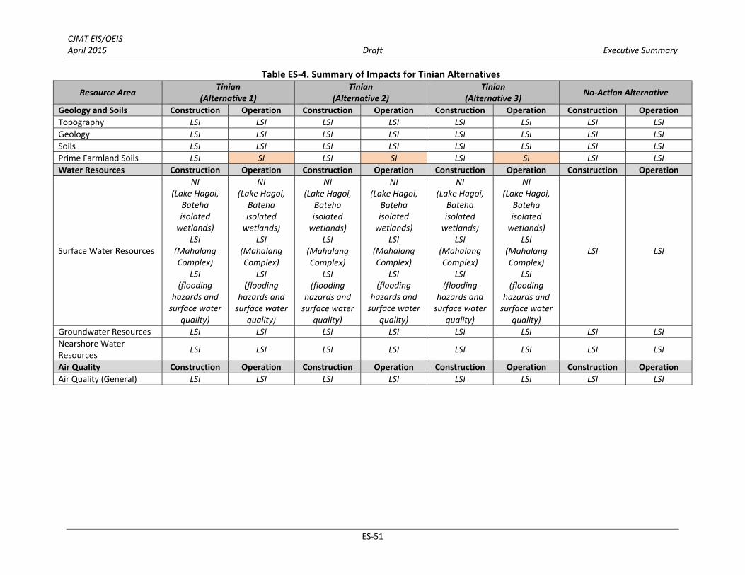
CJMT EIS/OEIS April 2015 Draft Executive Summary
ES‐51
Table ES‐4. Summary of Impacts for Tinian Alternatives
Resource Area Tinian
(Alternative 1) Tinian
(Alternative 2) Tinian
(Alternative 3) No‐Action Alternative
Geology and Soils Construction Operation Construction Operation Construction Operation Construction Operation
Topography LSI LSI LSI LSI LSI LSI LSI LSI
Geology LSI LSI LSI LSI LSI LSI LSI LSI
Soils LSI LSI LSI LSI LSI LSI LSI LSI
Prime Farmland Soils LSI SI LSI SI LSI SI LSI LSI
Water Resources Construction Operation Construction Operation Construction Operation Construction Operation
Surface Water Resources
NI (Lake Hagoi,
Bateha isolated wetlands)
LSI (Mahalang Complex)
LSI (flooding
hazards and surface water
quality)
NI (Lake Hagoi,
Bateha isolated wetlands)
LSI (Mahalang Complex)
LSI (flooding
hazards and surface water
quality)
NI (Lake Hagoi,
Bateha isolated wetlands)
LSI (Mahalang Complex)
LSI (flooding
hazards and surface water
quality)
NI (Lake Hagoi,
Bateha isolated wetlands)
LSI (Mahalang Complex)
LSI (flooding
hazards and surface water
quality)
NI (Lake Hagoi,
Bateha isolated wetlands)
LSI (Mahalang Complex)
LSI (flooding
hazards and surface water
quality)
NI (Lake Hagoi,
Bateha isolated wetlands)
LSI (Mahalang Complex)
LSI (flooding
hazards and surface water
quality)
LSI LSI
Groundwater Resources LSI LSI LSI LSI LSI LSI LSI LSI
Nearshore Water Resources LSI LSI LSI LSI LSI LSI LSI LSI
Air Quality Construction Operation Construction Operation Construction Operation Construction Operation
Air Quality (General) LSI LSI LSI LSI LSI LSI LSI LSI

CJMT EIS/OEIS April 2015 Draft Executive Summary
ES-52
Table ES-4. Summary of Impacts for Tinian Alternatives
Resource Area Tinian
(Alternative 1) Tinian
(Alternative 2) Tinian
(Alternative 3) No-Action Alternative
Noise Construction Operation Construction Operation Construction Operation Construction Operation
On Land LSI Not applicable LSI Not applicable LSI Not applicable LSI LSI/Not
applicable
In-water LSI Not applicable LSI Not applicable LSI Not applicable NA LSI/Not
applicable
Ground-based Operation Not applicable LSI Not applicable LSI Not applicable LSI LSI LSI
Airfield and Airspace Based Operations Not applicable SI Not applicable SI Not applicable SI Not applicable Not applicable
Waterborne Operation Not applicable NI Not applicable NI Not applicable NI Not applicable Not applicable
Traffic Not applicable LSI Not applicable LSI Not applicable LSI NA LSI
Occupational Noise Not applicable NI Not applicable NI Not applicable NI NI NI
Airspace Construction Operation Construction Operation Construction Operation Construction Operation
Tinian Not applicable SI mitigated to
LSI Not applicable
SI mitigated to LSI
Not applicable SI mitigated to
LSI Not applicable NI
Saipan Not applicable SI mitigated to
LSI Not applicable
SI mitigated to LSI
Not applicable SI mitigated to
LSI Not applicable NI

CJMT EIS/OEIS April 2015 Draft Executive Summary
ES-53
Table ES-4. Summary of Impacts for Tinian Alternatives
Resource Area Tinian
(Alternative 1) Tinian
(Alternative 2) Tinian
(Alternative 3) No-Action Alternative
Land Use Construction Operation Construction Operation Construction Operation Construction Operation
Land Acquisition (Jurisdictional Control) Not applicable LSI Not applicable LSI Not applicable LSI Not applicable LSI
Submerged Land Acquisition (Jurisdictional Control)
Not applicable NI Not applicable NI Not applicable NI Not applicable LSI
Land Use Within the Military Lease Area – Existing and Planned Land Use
Not applicable SI mitigated to
LSI Not applicable
SI mitigated to LSI
Not applicable SI mitigated to
LSI Not applicable LSI
Land Use Within the Military Lease Area –Public Access
Not applicable SI Not applicable SI Not applicable SI Not applicable LSI
Land Use Outside the Military Lease Area –Existing and Planned Land Use
Not applicable LSI Not applicable LSI Not applicable LSI Not applicable LSI
Land Use Outside the Military Lease Area – Public Access
Not applicable NI Not applicable NI Not applicable NI Not applicable LSI
Land Use Outside the Military Lease Area – Noise
Not applicable LSI Not applicable LSI Not applicable LSI Not applicable LSI
Submerged Land Use – Existing and Planned Land Use
Not applicable LSI Not applicable LSI Not applicable LSI Not applicable LSI
Submerged Land Use – Public Access Not applicable LSI Not applicable LSI Not applicable LSI Not applicable LSI

CJMT EIS/OEIS April 2015 Draft Executive Summary
ES-54
Table ES-4. Summary of Impacts for Tinian Alternatives
Resource Area Tinian
(Alternative 1) Tinian
(Alternative 2) Tinian
(Alternative 3) No-Action Alternative
Recreation Construction Operation Construction Operation Construction Operation Construction Operation
Recreation (Construction Only) LSI Not applicable LSI Not applicable LSI Not applicable LSI Not applicable
Historic and Cultural Not applicable SI Not applicable SI Not applicable SI Not applicable LSI
Beaches and Parks Not applicable SI Not applicable SI Not applicable SI Not applicable LSI
Ocean-based Resources Not applicable SI Not applicable SI Not applicable SI Not applicable LSI
Scenic Points Not applicable SI Not applicable SI Not applicable SI Not applicable LSI
Annual Events Not applicable SI mitigated to
LSI Not applicable
SI mitigated to LSI
Not applicable SI mitigated to
LSI Not applicable LSI
Training Noise Impacts Not applicable LSI Not applicable LSI Not applicable LSI Not applicable LSI
Roadway and Access Improvements Not applicable BI/LSI Not applicable BI/LSI Not applicable BI/LSI Not applicable LSI
Terrestrial Biology Construction Operation Construction Operation Construction Operation Construction Operation
Vegetation Communities SI LSI SI LSI SI LSI LSI LSI
Native Wildlife SI LSI SI LSI SI LSI LSI LSI
Special-status Species: Endangered Species Act-listed and Proposed Species
LSI (Mariana fruit bat, Mariana common moorhen,
Micronesian megapode, sea turtles). NI (humped tree snail, Heritiera
longipetiolata, Dendrobium guamense)
LSI (Mariana fruit bat,
Micronesian megapode,
Mariana common
moorhen sea turtles).
NI (humped tree snail, Heritiera
longipetiolata, Dendrobium guamense)
LSI (Mariana fruit bat, Mariana common moorhen,
Micronesian megapode).
NI (sea turtles, humped tree
snail)
LSI (Mariana fruit bat, Mariana common moorhen,
Micronesian megapode).
NI (sea turtles, humped tree
snail)
Special-status Species: Migratory Bird Treaty Act SI LSI SI LSI SI LSI LSI LSI
Special-status Species: CNMI-listed Species
NI (Micronesian
gecko)
NI (Micronesian
gecko)
NI (Micronesian
gecko)
NI (Micronesian
gecko)
NI (Micronesian
gecko)
NI (Micronesian
gecko)
NI (Micronesian
gecko)
NI (Micronesian
gecko)

CJMT EIS/OEIS April 2015 Draft Executive Summary
ES-55
Table ES-4. Summary of Impacts for Tinian Alternatives
Resource Area Tinian
(Alternative 1) Tinian
(Alternative 2) Tinian
(Alternative 3) No-Action Alternative
Marine Biology Construction Operation Construction Operation Construction Operation Construction Operation
Marine Habitat/Essential Fish Habitat (Coral Reef) SI LSI SI LSI SI LSI LSI LSI
Marine Flora LSI LSI LSI LSI LSI LSI LSI LSI
Marine Invertebrates (Coral) SI LSI SI LSI SI LSI LSI LSI
Marine Invertebrates (Non-coral) LSI LSI LSI LSI LSI LSI LSI LSI
Fish LSI LSI LSI LSI LSI LSI LSI LSI
Special-status Corals SI SI SI SI SI SI LSI LSI
Sea Turtles LSI LSI LSI LSI LSI LSI LSI LSI
Marine Mammals LSI LSI LSI LSI LSI LSI LSI LSI
Cultural Resources Construction Operation Construction Operation Construction Operation Construction Operation
Range Complex A SI mitigated to LSI
SI mitigated to LSI
SI mitigated to LSI
SI mitigated to LSI
SI mitigated to LSI
SI mitigated to LSI
Not applicable Not applicable
Range Complex B SI mitigated to LSI
LSI SI mitigated to
LSI LSI
SI mitigated to LSI
LSI Not applicable Not applicable
Range Complex C SI mitigated to LSI
LSI SI mitigated to
LSI LSI
SI mitigated to LSI
LSI Not applicable Not applicable
Range Complex D SI mitigated to LSI
LSI SI mitigated to
LSI LSI NI LSI Not applicable Not applicable
Military Lease Area-wide Training Assets and Support Facilities Outside of the Range Complexes
SI mitigated to LSI
SI mitigated to LSI
SI mitigated to LSI
SI mitigated to LSI
SI mitigated to LSI
SI mitigated to LSI
Not applicable Not applicable
Tinian International Airport
SI mitigated to LSI
LSI SI mitigated to
LSI LSI
SI mitigated to LSI
LSI Not applicable Not applicable
Outside Military Lease Area
SI mitigated to LSI
LSI SI mitigated to
LSI LSI
SI mitigated to LSI
LSI Not applicable Not applicable
Military Lease Area Not applicable Not applicable Not applicable Not applicable Not applicable Not applicable SI mitigated to
LSI SI mitigated to
LSI

CJMT EIS/OEIS April 2015 Draft Executive Summary
ES-56
Table ES-4. Summary of Impacts for Tinian Alternatives
Resource Area Tinian
(Alternative 1) Tinian
(Alternative 2) Tinian
(Alternative 3) No-Action Alternative
Visual Resources1 Construction Operation Construction Operation Construction Operation Construction Operation
National Historic Landmark at North Field (#1)
Not applicable BI/LSI Not applicable BI/LSI Not applicable BI/LSI Not applicable Not applicable
Unai Chulu (#2), Unai Babui (#3) and Unai Lam Lam (#4)
Not applicable LSI Not applicable LSI Not applicable LSI Not applicable Not applicable
Ushi “Cross” Point A and B (#5 and #6) Not applicable NI (#5); SI (#6) Not applicable NI (#5); SI (#6) Not applicable NI (#5); SI (#6) Not applicable Not applicable
Blow Hole (#7) Not applicable LSI Not applicable LSI Not applicable LSI Not applicable Not applicable
Mount Lasso Lookout A and B (#8 and #9) Not applicable
SI (#8); LSI (#9)
Not applicable SI (#8); LSI (#9)
Not applicable SI (#8); LSI (#9)
Not applicable LSI
8th Avenue-North of the Airport (#10) Not applicable LSI Not applicable LSI Not applicable LSI Not applicable Not applicable
Broadway North (#11) Not applicable LSI Not applicable LSI Not applicable LSI Not applicable LSI
Broadway South A and B (#12 and #13) Not applicable
LSI (#12); NI (#13)
Not applicable LSI (#12); NI (#13)
Not applicable LSI (#12); NI (#13)
Not applicable LSI
Unai Dankulo (#14) and Unai Masalok (#15) Not applicable LSI (#14-15) Not applicable LSI (#14-15) Not applicable LSI (#14-15) Not applicable Not applicable
Transportation Construction Operation Construction Operation Construction Operation Construction Operation
Air Transportation LSI LSI LSI LSI LSI LSI NI NI
Ground Transportation LSI LSI/BI LSI LSI/BI LSI LSI/BI LSI LSI
Marine Transportation LSI LSI LSI LSI LSI LSI NI NI
Utilities Construction Operation Construction Operation Construction Operation Construction Operation
Electrical Power LSI LSI LSI LSI LSI LSI LSI LSI
Potable Water LSI LSI LSI LSI LSI LSI LSI LSI
Wastewater LSI LSI LSI LSI LSI LSI LSI LSI
Stormwater Management LSI LSI LSI LSI LSI LSI LSI LSI
Solid Waste LSI LSI LSI LSI LSI LSI LSI LSI
Information Technology/ Communications LSI LSI LSI LSI LSI LSI LSI LSI

CJMT EIS/OEIS April 2015 Draft Executive Summary
ES-57
Table ES-4. Summary of Impacts for Tinian Alternatives
Resource Area Tinian
(Alternative 1) Tinian
(Alternative 2) Tinian
(Alternative 3) No-Action Alternative
Socioeconomic and Environmental Justice
Construction Operation Construction Operation Construction Operation Construction Operation
Population2 NI NI NI NI NI NI NI NI
Economic Conditions
Tourism LSI LSI LSI LSI LSI LSI LSI LSI
Gross Domestic Product BI BI BI BI BI BI LSI LSI
Employment and Income BI BI BI BI BI BI BI BI
Government Revenues BI BI BI BI BI BI LSI LSI
Housing LSI LSI LSI LSI LSI LSI LSI LSI
Agriculture LSI LSI LSI LSI LSI LSI LSI LSI
Commercial Fishing and Aquaculture NI LSI NI LSI NI LSI LSI LSI
Airports and Sea Ports BI BI BI BI BI BI LSI LSI
Power Utility Rates NI BI NI BI NI BI LSI LSI
Public Services
Education LSI LSI LSI LSI LSI LSI LSI LSI
Emergency Services LSI BI LSI BI LSI BI LSI LSI
Public Health LSI LSI LSI LSI LSI LSI LSI LSI
Community and Social Topics LSI/SI LSI/SI LSI/SI LSI/SI LSI/SI LSI/SI LSI LSI
Environmental Justice and Protection of Children
NI NI NI NI NI NI LSI LSI
Hazardous Materials and Waste
Construction Operation Construction Operation Construction Operation Construction Operation
Hazardous Materials LSI LSI LSI LSI LSI LSI LSI LSI
Toxic Substances LSI LSI LSI LSI LSI LSI LSI LSI
Hazardous Waste LSI LSI LSI LSI LSI LSI LSI LSI
Contaminated Sites LSI LSI LSI LSI LSI LSI LSI LSI

CJMT EIS/OEIS April 2015 Draft Executive Summary
ES-58
Table ES-4. Summary of Impacts for Tinian Alternatives
Resource Area Tinian
(Alternative 1) Tinian
(Alternative 2) Tinian
(Alternative 3) No-Action Alternative
Public Health and Safety Construction Operation Construction Operation Construction Operation Construction Operation
Aircraft Operations LSI LSI LSI LSI LSI LSI LSI LSI
Ground Operations LSI LSI LSI LSI LSI LSI LSI LSI
Marine Operations NI LSI NI LSI NI LSI LSI LSI Notes: 1# indicates Key Observation Point (see Section 4.12, Figure 4.12-1). 2A change in population is not considered an impact itself. However, population change has the potential to drive positive or negative impacts to other socioeconomic factors. Legend: BI = beneficial impact; LSI = less than significant impact; NI = no impact; SI = significant impact. Shading is used to highlight the significant impacts. Not Applicable indicates an
element or category with no potential for impacts.
Table ES-5. Summary of Impacts for Pagan Alternatives
Resource Area Pagan
(Alternative 1) Pagan
(Alternative 2) No-Action Alternative
Geology and Soils Construction Operation Construction Operation Construction Operation
Topography LSI LSI LSI LSI LSI LSI Geology LSI LSI LSI LSI LSI LSI Soils LSI LSI LSI LSI LSI LSI Prime Farmland Soils LSI LSI LSI LSI LSI LSI
Water Resources Construction Operation Construction Operation Construction Operation
Surface Water Resources LSI LSI LSI LSI LSI LSI
Groundwater Resources LSI LSI LSI LSI LSI LSI
Nearshore Water Resources LSI LSI LSI LSI LSI LSI
Air Quality Construction Operation Construction Operation Construction Operation
Air Quality LSI
LSI; NI (regarding
volcanic activity)
LSI
LSI; NI (regarding
volcanic activity)
NI NI
Noise Construction Operation Construction Operation Construction Operation
On Land NI Not applicable NI Not applicable NI Not applicable
In-water NI Not applicable NI Not applicable NI Not applicable

CJMT EIS/OEIS April 2015 Draft Executive Summary
ES-59
Table ES-5. Summary of Impacts for Pagan Alternatives
Resource Area Pagan
(Alternative 1) Pagan
(Alternative 2) No-Action Alternative
Ground-Based Operation Not applicable NI Not applicable NI Not applicable NI
Airfield and Airspace Based Operations Not applicable NI Not applicable NI Not applicable NI
Waterborne Operation Not applicable NI Not applicable NI Not applicable NI
Traffic Not applicable NI Not applicable NI Not applicable NI
Occupational Noise Not applicable NI Not applicable NI Not applicable NI
Airspace Construction Operation Construction Operation Construction Operation
Pagan Not applicable LSI Not applicable LSI Not applicable NI
Land Use Construction Operation Construction Operation Construction Operation
Land Acquisition (Jurisdictional Control) Not applicable SI Not applicable SI Not applicable NI
Submerged Land Acquisition (Jurisdictional Control) Not applicable LSI Not applicable LSI Not applicable NI
Land Use – Current and Planned Use Not applicable SI Not applicable SI Not applicable NI
Land Use – Public Access Not applicable LSI Not applicable LSI Not applicable NI
Submerged Land Use – Current and Planned Not applicable LSI Not applicable LSI Not applicable NI
Submerged Land Use – Public Access Not applicable LSI Not applicable LSI Not applicable NI
Recreation Construction Operation Construction Operation Construction Operation
Recreation LSI LSI LSI LSI NI NI

CJMT EIS/OEIS April 2015 Draft Executive Summary
ES-60
Table ES-5. Summary of Impacts for Pagan Alternatives
Resource Area Pagan
(Alternative 1) Pagan
(Alternative 2) No-Action Alternative
Terrestrial Biology Construction Operation Construction Operation Construction Operation
Vegetation Communities SI LSI SI LSI NI NI
Native Wildlife LSI LSI LSI LSI NI NI
Special-status Species: Endangered Species Act-listed and Proposed Species and CNMI-listed Species
LSI
SI (Mariana fruit bat)
LSI (Micronesian
megapode, sea turtles, humped
tree snail, Slevin’s skink)
NI (Cycas micronesica,
Bulbophyllum guamenese)
LSI
SI (Mariana fruit bat)
LSI (Micronesian
megapode, sea turtles, humped
tree snail, Slevin’s skink)
NI (Cycas micronesica,
Bulbophyllum guamenese)
NI NI
Special-status Species: Migratory Bird Treaty Act LSI LSI LSI LSI NI NI
Marine Biology Construction Operation Construction Operation Construction Operation
Marine Habitat/Essential Fish Habitat LSI LSI LSI LSI LSI LSI
Marine Flora LSI LSI LSI LSI LSI LSI
Marine Invertebrates (Coral) LSI LSI LSI LSI LSI LSI
Marine Invertebrates (Non-Coral) LSI LSI LSI LSI LSI LSI
Fish LSI LSI LSI LSI LSI LSI
Special-status Coral Species LSI SI LSI SI LSI LSI
Sea Turtles LSI LSI LSI LSI LSI LSI
Marine Mammals LSI LSI LSI LSI LSI LSI
Cultural Resources Construction Operation Construction Operation Construction Operation
North Range Complex SI mitigated to LSI
SI mitigated to LSI
SI mitigated to LSI
SI mitigated to LSI
LSI LSI
South Range Complex LSI LSI LSI LSI LSI LSI

CJMT EIS/OEIS April 2015 Draft Executive Summary
ES-61
Table ES-5. Summary of Impacts for Pagan Alternatives
Resource Area Pagan
(Alternative 1) Pagan
(Alternative 2) No-Action Alternative
Visual Resources Construction Operation Construction Operation Construction Operation
Visual Resources Not applicable LSI Not applicable LSI Not applicable NI
Transportation Construction Operation Construction Operation Construction Operation
Air Transportation LSI BI LSI BI NI NI
Ground Transportation NI NI NI NI NI NI
Marine Transportation NI NI NI NI NI NI
Utilities Construction Operation Construction Operation Construction Operation
Electrical Power Not applicable Not applicable Not applicable Not applicable Not applicable Not applicable
Potable Water Not applicable Not applicable Not applicable Not applicable Not applicable Not applicable
Wastewater Not applicable Not applicable Not applicable Not applicable Not applicable Not applicable
Stormwater Management LSI LSI LSI LSI Not applicable Not applicable
Solid Waste LSI LSI LSI LSI Not applicable Not applicable
Information Technology/ Communications Not applicable Not applicable Not applicable Not applicable Not applicable Not applicable
Socioeconomics and Environmental Justice
Construction Operation Construction Operation Construction Operation
Population1 NI NI NI NI NI NI
Economic Conditions BI BI BI BI NI LSI
Public Services NI LSI NI LSI NI NI
Community and Social Topics NI Potential for SI NI Potential for SI NI LSI
Hazardous Materials and Waste Construction Operation Construction Operation Construction Operation
Hazardous Materials LSI LSI LSI LSI LSI LSI
Toxic Substances LSI LSI LSI LSI LSI LSI
Hazardous Waste LSI LSI LSI LSI LSI LSI
Contaminated Sites LSI LSI LSI LSI LSI LSI
Public Safety and Health Construction Operation Construction Operation Construction Operation
Aircraft Operations NI LSI NI LSI LSI LSI
Ground Operations NI LSI NI LSI LSI LSI
Marine Operations NI LSI NI LSI LSI LSI Notes:
1A change in population is not considered an impact itself. However, population change has the potential to drive positive or negative impacts to other socioeconomic factors.
Legend: BI = beneficial impact; LSI = less than significant impact; NI = no impact; SI = significant impact. Shading is used to highlight the significant impacts. Not Applicable indicates an element or category with no potential for impacts.

CJMT EIS/OEIS April 2015 Draft Executive Summary
ES-62
Table ES-6. Summary of Potential Mitigation Measures
Impacts Category Potential Mitigation Measures
Tinian Phase
Pagan Phase
Co
nst
ruct
ion
Op
era
tio
n
Co
nst
ruct
ion
Op
era
tio
n
AIRSPACE Tinian The increase in military air traffic would not restrict access to Tinian International Airport. Private flights could experience minimal delays in departures and arrivals during the time when military aircraft are practicing approaches to the Tinian International Airport runway. Restricted Area 7203 was segmented to minimize impacts to commuter flight traffic between Tinian and Saipan. Civilian aircraft can be routed around the restricted airspace while staying within the minimum safety glide slope except for periods when Restricted Area 7203A/B/C/X/Y/Z/E/W are activated together. Indirect effects such as increased fuel consumption and time en route could be experienced. No impacts would be expected with activation of the Tinian Military Operations Area.
SI mitigated
to LSI
Establish a Letter of Procedure or Joint Use Agreement to accommodate civilian arrivals and departures into the airport.
Establish communication procedures between Tinian Range Control and Saipan International Airport Air Traffic Control to ensure priority access to Tinian International Airport for life-flight and other emergency-related activities.
Add positive control measures (e.g., air traffic control tower at Tinian, short-range radar on Tinian or Saipan that would allow air traffic controllers to see aircraft operating below 2,000 feet [609 meters]), and communications capability at Saipan or Tinian to ensure non-participating aircraft are advised of military operations.
Establish communication procedures to provide immediate feedback between air traffic controllers and range control to accommodate smaller inter-island commuter aircraft travelling between Saipan and Tinian.
X

CJMT EIS/OEIS April 2015 Draft Executive Summary
ES-63
Table ES-6. Summary of Potential Mitigation Measures
Impacts Category Potential Mitigation Measures
Tinian Phase
Pagan Phase
Co
nst
ruct
ion
Op
era
tio
n
Co
nst
ruct
ion
Op
era
tio
n
Saipan Air and ground activities would have the potential to significantly impact current airspace procedures during the 140 days per year that the Restricted Areas 7203A/B/C and W are scheduled and activated for use. Restricted areas would not be activated during times with scheduled Saipan International Airport commercial large passenger jet and jetliner activity. Existing procedures used to manage aircraft operations at Tinian North Field and deconflict military and civilian aircraft would be expected to continue.
SI mitigated
to LSI
Establish a Letter of Procedure between the Federal Aviation Administration and the U.S. military that contains the procedures for access to the airspace and gives priority to large commercial aircraft. The agreement would ensure proper range scheduling procedures are in place to ensure no significant disruption of normal flights into and out of Saipan International Airport.
Electronically monitor each training event through the use of radar and other surveillance equipment such as an expeditionary control tower that would continually monitor the airspace to ensure the safety of the flying public during times when training is occurring.
Schedule and coordinate training events with Saipan International Airport arrivals and departures as to not conflict.
Establish procedures and communications that allow for air traffic controllers and range controllers to simultaneously see the airspace and ensure priority is given to any aircraft heading to or from Saipan International Airport. In the event of an unforeseen incursion into an active restricted airspace, the simultaneous ability to monitor activities on the ground and in the air should provide the ability to stop any training in seconds.
X

CJMT EIS/OEIS April 2015 Draft Executive Summary
ES-64
Table ES-6. Summary of Potential Mitigation Measures
Impacts Category Potential Mitigation Measures
Tinian Phase
Pagan Phase
Co
nst
ruct
ion
Op
era
tio
n
Co
nst
ruct
ion
Op
era
tio
n
LAND AND SUBMERGED LAND USE
Land Use Within the Military Lease Area – Existing and Planned Land Use There would be land use incompatibilities associated with the Tinian Military Retention Land for Wildlife Conservation and the agricultural and cattle grazing activities in the Lease Back Area.
SI mitigated
to LSI
Four areas are being assessed as potential conservation areas for the protection of the Tinian monarch and other wildlife species (Section 4.9, Terrestrial Biology, Figure 4.9-2). These areas may also be used for additional natural resource conservation actions such as forest enhancement and/or non-native species control. The Department of Defense is coordinating with the Federal Aviation Administration and the U.S. Fish and Wildlife Service on these potential conservation areas.
The DoN has identified and proposed a total of 2,554 acres (1,034 hectares) of land for grazing areas within the Military Lease Area. Of this total 1,010 acres (409 hectares) would be unencumbered and 1,544 acres (625 hectares) would be encumbered by surface danger zones.
X
RECREATION
Historic and Cultural Attractions Due to restricted access, there would be significant impacts to: historic and cultural attractions (10 of 12 sites). These impacts would remain significant even with the implementation of the proposed mitigation measures.
SI
In as much as possible, training would be scheduled around peak tourist holidays, such as the three World War II anniversaries.
There is no mitigation currently proposed to minimize this impact to the Shinto Shrine and Hinode American Memorial. The DoN is consulting with the CNMI Historic Preservation Officer and other interested parties regarding impacts to the Shinto Shrine and Hinode American Memorial as part of the Section 106 process (see Appendix N, Cultural Resources Technical Memo for a discussion of the consultation process). Potential mitigation will be determined through this consultation process and could include documentation
X

CJMT EIS/OEIS April 2015 Draft Executive Summary
ES-65
Table ES-6. Summary of Potential Mitigation Measures
Impacts Category Potential Mitigation Measures
Tinian Phase
Pagan Phase
Co
nst
ruct
ion
Op
era
tio
n
Co
nst
ruct
ion
Op
era
tio
n
and relocation of the Shinto Shrine and Hinode American Memorial.
Annual Events Closure of recreational areas on Tinian during training operations could result in reduced event attendance. Impacts would be mitigated to less than significant with implementation of the potential mitigation measures.
SI mitigated
to LSI
In as much as possible, the DoN would coordinate with event sponsors to ensure that training events do not occur during annual events.
X
TERRESTRIAL BIOLOGY Vegetation Communities Alternatives 1, 2, and 3: The conversion of 6.3 acres (2.5 hectares) of native limestone forest on Tinian to developed land would be unavoidable.
SI Department of Defense may implement forest enhancement on 6.3 acres (2.5 hectares) to replace the area of native limestone forest removed during construction. Forest enhancement would include removal of non-native vegetation and establishment of native species that are characteristic of native limestone forest habitats.
To avoid and minimize impacts to native limestone forest on Tinian, the Department of Defense will implement training restrictions within native limestone forest. All limestone forest habitat within the Military Lease Area will be designated as “No Wildlife Disturbance Areas,” with the following actions prohibited: off-road vehicle travel; vehicle parking except on existing roads or trails; firing of live or inert munitions; mechanical vegetation clearing; digging or excavation without prior approval; open fires; and aircraft landings. Any maneuvers conducted in native limestone forest will be on foot (no off-road vehicle maneuvers), and units will be tactical, with no support camps. Limestone forest “No Wildlife Disturbance Area” restrictions will be implemented upon initiation of CJMT training activities on
X

CJMT EIS/OEIS April 2015 Draft Executive Summary
ES-66
Table ES-6. Summary of Potential Mitigation Measures
Impacts Category Potential Mitigation Measures
Tinian Phase
Pagan Phase
Co
nst
ruct
ion
Op
era
tio
n
Co
nst
ruct
ion
Op
era
tio
n
Tinian. Department of Defense may implement forest
enhancement in areas of tangantangan or herbaceous scrub habitat to replace the forested habitats removed during construction. Forest enhancement would include removal of non-native vegetation and establishment of native species that are characteristic of native forest habitats.
Native Wildlife Alternative 1: The removal of 1,743 acres (705 hectares) of forest and herbaceous scrub habitats (including Tinian Military Retention Land for Wildlife Conservation) used by native landbirds, including the Tinian monarch, and other native wildlife species would be unavoidable. Alternative 2: The removal of 1,885 acres (763 hectares)
of forest and herbaceous scrub habitats (including Tinian Military Retention Land for Wildlife Conservation) used by native landbirds, including the Tinian monarch, and other native wildlife species would be unavoidable.
Alternative 3: The removal of 1,874 acres (758 hectares) of forest and herbaceous scrub habitats (including Tinian Military Retention Land for Wildlife Conservation) used by native landbirds, including the Tinian monarch, and other native wildlife species would be unavoidable.
SI Department of Defense may implement forest enhancement in areas of mixed introduced forest, tangantangan, or herbaceous scrub habitat to replace the forest habitat removed during construction. Forest enhancement would include removal of non-native vegetation and establishment of native species that are characteristic of native forest habitats.
Department of Defense may replace the current Tinian Military Retention Land for Wildlife Conservation by establishing a conservation area(s) for the protection of the Tinian monarch and other wildlife species with one or more conservation sites within the Military Lease Area. Forest enhancement and non-native species control may also be implemented within the replacement Wildlife Conservation site(s).
To improve habitat quality for native wildlife on Tinian, the Department of Defense may implement monitoring and control of non-native species within forest habitat, including control of non-native plant, mammal, and insect species.
To avoid and minimize impacts to native wildlife species that use native limestone forest on Tinian, the Department of
X

CJMT EIS/OEIS April 2015 Draft Executive Summary
ES-67
Table ES-6. Summary of Potential Mitigation Measures
Impacts Category Potential Mitigation Measures
Tinian Phase
Pagan Phase
Co
nst
ruct
ion
Op
era
tio
n
Co
nst
ruct
ion
Op
era
tio
n
Defense will implement training restrictions within native limestone forest. All limestone forest habitat within the Military Lease Area will be designated as “No Wildlife Disturbance Areas,” with the following actions prohibited: off-road vehicle travel; vehicle parking except on existing roads or trails; firing of live or inert munitions; mechanical vegetation clearing; digging or excavation without prior approval; open fires; and aircraft landings. Any maneuvers conducted in native limestone forest will be on foot (no off-road vehicle maneuvers), and units will be tactical, with no support camps. Limestone forest “No Wildlife Disturbance Area” restrictions will be implemented upon initiation of CJMT training activities on Tinian.
Special-status Species: Endangered Species Act-listed and Proposed Species Noise impacts to foraging Mariana common moorhens at the Mahalang sites from large-caliber munitions on the High Hazard Impact Area would be unavoidable.
SI To avoid impacts to Mariana common moorhens at the Lake Hagoi and two Bateha wetland sites, the Department of Defense will designate the three wetland sites as "No Training Areas.” Ground disturbance and vegetation removal of any kind will be prohibited within these “No Training Areas.” In addition, CJMT-associated aircraft overflights of these sites will be limited to a minimum altitude of 500 feet (152 meters) above ground level. Wetland “No Training Area” restrictions would be implemented upon initiation of CJMT training activities on Tinian.
To mitigate for loss of Mariana common moorhen foraging habitat at Mahalang, the Department of Defense may implement portions of the DoN Tinian Wetlands Management Plan at Hagoi and two Bateha sites. This may include non-native plant surveys, monitoring, and control; habitat restoration and improvement; baseline surveys for
X

CJMT EIS/OEIS April 2015 Draft Executive Summary
ES-68
Table ES-6. Summary of Potential Mitigation Measures
Impacts Category Potential Mitigation Measures
Tinian Phase
Pagan Phase
Co
nst
ruct
ion
Op
era
tio
n
Co
nst
ruct
ion
Op
era
tio
n
moorhen predators; and predator control at Hagoi and Bateha.
To avoid and minimize impacts to special-status species that use native limestone forest on Tinian, the Department of Defense will implement training restrictions within native limestone forest. All limestone forest habitat within the Military Lease Area will be designated as "No Wildlife Disturbance Areas," with the following actions prohibited: off-road vehicle travel; vehicle parking except on existing roads or trails; firing of live or inert munitions; mechanical vegetation clearing; digging or excavation without prior approval; open fires; and aircraft landings. Any maneuvers conducted in native limestone forest will be on foot (no off-road vehicle maneuvers), and units will be tactical, with no support camps. Limestone forest “No Wildlife Disturbance Area” restrictions will be implemented upon initiation of CJMT training activities on Tinian.
To avoid and minimize impacts to nesting sea turtles, the Department of Defense will implement training protocols at all beaches used for amphibious operations on Tinian. Personnel trained in identifying sea turtle nests will survey landing beaches no more than 6 hours prior to the first craft landing or use of other beach landing equipment. Any potential sea turtle nests will be flagged, with a buffer zone of 20 feet (6 meters) from the edge of the nesting activity (area disturbed by the turtle) to ensure complete avoidance. The flagged area will be avoided by landing craft and personnel. Beach training activities will also be coordinated with monthly sea turtle nest monitoring, during which any

CJMT EIS/OEIS April 2015 Draft Executive Summary
ES-69
Table ES-6. Summary of Potential Mitigation Measures
Impacts Category Potential Mitigation Measures
Tinian Phase
Pagan Phase
Co
nst
ruct
ion
Op
era
tio
n
Co
nst
ruct
ion
Op
era
tio
n
potential turtle nests will be flagged, with a buffer zone of 20 feet (6 meters) to ensure avoidance. If an active nest with a pre-hatch hole is discovered on a beach during monitoring, night training over the next 5 nights will be conducted only on other beaches. If beach sand is compacted by landing craft, the beach topography will be restored within 3 days using non-mechanized methods (e.g., rakes or other hand tools). The Department of Defense will implement beach training protocols upon initiation of CJMT amphibious training activities.
Special-status Species: Migratory Bird Treaty Act-listed Species Alternative 1: The removal of 1,743 acres (705 hectares)
of forest and herbaceous scrub habitats (including Tinian Military Retention Land for Wildlife Conservation) used by native landbirds, including the collared kingfisher, Mariana fruit dove, and white-throated ground-dove, would be unavoidable.
Alternative 2: The removal of 1,885 acres (763 hectares) of forest and herbaceous scrub habitats (including Tinian Military Retention Land for Wildlife Conservation) used by native landbirds, including the collared kingfisher, Mariana fruit dove, and white-throated ground-dove, would be unavoidable.
Alternative 3: The removal of 1,874 acres (758 hectares) of forest and herbaceous scrub habitats (including Tinian Military Retention Land for Wildlife Conservation) used by native landbirds, including the collared kingfisher, Mariana fruit dove, and white-throated ground-dove, would be unavoidable.
SI Department of Defense may implement forest enhancement in areas of tangantangan or herbaceous scrub habitat to replace the mixed introduced forest and herbaceous scrub removed during construction. Forest enhancement would include removal of non-native vegetation and establishment of native species that are characteristic of native forest habitats.
Department of Defense may establish a conservation area for the protection of the Tinian monarch and other wildlife species with one or more conservation sites within the Military Lease Area. Forest enhancement and non-native species control may also be implemented within the wildlife conservation site(s).
To avoid and minimize impacts to Migratory Bird Treaty Act-listed species that use native limestone forest on Tinian, the Department of Defense will implement training restrictions within native limestone forest. All limestone forest habitat within the Military Lease Area will be designated as "No Wildlife Disturbance Areas," with the following actions
X

CJMT EIS/OEIS April 2015 Draft Executive Summary
ES-70
Table ES-6. Summary of Potential Mitigation Measures
Impacts Category Potential Mitigation Measures
Tinian Phase
Pagan Phase
Co
nst
ruct
ion
Op
era
tio
n
Co
nst
ruct
ion
Op
era
tio
n
prohibited: off-road vehicle travel; vehicle parking except on existing roads or trails; firing of live or inert munitions; mechanical vegetation clearing; digging or excavation without prior approval; open fires; and aircraft landings. Any maneuvers conducted in native limestone forest will be on foot (no off-road vehicle maneuvers), and units will be tactical, with no support camps. Limestone forest “No Wildlife Disturbance Area” restrictions will be implemented upon initiation of CJMT training activities on Tinian.
To improve habitat quality for native wildlife on Tinian, Department of Defense may implement monitoring and control of non-native species within forest habitat, including control of non-native plant, mammal, and insect species.
To avoid and minimize impacts to Mariana fruit bats and sea turtles, hooded lights will be used to the maximum extent practicable at all new roads and facilities within sea turtle nesting habitat and fruit bat foraging and roosting habitat. “Night-adapted” lights will be installed in the briefing and bleacher areas. Illumination of forests, coastlines, and beaches will be kept to an absolute minimum. Lighting will be designed to meet minimum safety, anti-terrorism, and force protection requirements.
To avoid impacts to Migratory Bird Treaty Act-listed species that use the Lake Hagoi and two Bateha wetland sites, the Department of Defense will designate the three wetland sites as “No Training Areas.” Ground disturbance and vegetation removal of any kind will be prohibited within these “No Training Areas.” In addition, CJMT-associated aircraft overflights of these sites will be limited to a
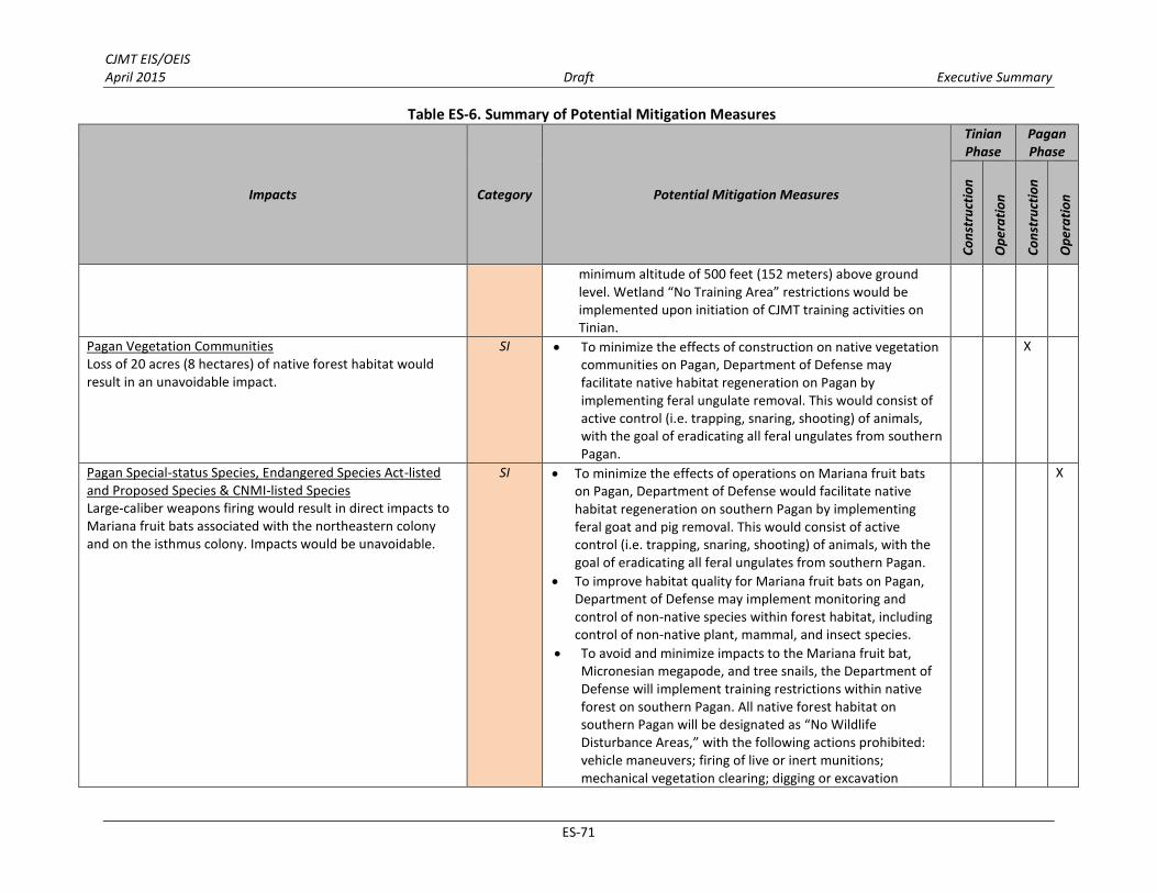
CJMT EIS/OEIS April 2015 Draft Executive Summary
ES-71
Table ES-6. Summary of Potential Mitigation Measures
Impacts Category Potential Mitigation Measures
Tinian Phase
Pagan Phase
Co
nst
ruct
ion
Op
era
tio
n
Co
nst
ruct
ion
Op
era
tio
n
minimum altitude of 500 feet (152 meters) above ground level. Wetland “No Training Area” restrictions would be implemented upon initiation of CJMT training activities on Tinian.
Pagan Vegetation Communities Loss of 20 acres (8 hectares) of native forest habitat would result in an unavoidable impact.
SI To minimize the effects of construction on native vegetation communities on Pagan, Department of Defense may facilitate native habitat regeneration on Pagan by implementing feral ungulate removal. This would consist of active control (i.e. trapping, snaring, shooting) of animals, with the goal of eradicating all feral ungulates from southern Pagan.
X
Pagan Special-status Species, Endangered Species Act-listed and Proposed Species & CNMI-listed Species Large-caliber weapons firing would result in direct impacts to Mariana fruit bats associated with the northeastern colony and on the isthmus colony. Impacts would be unavoidable.
SI To minimize the effects of operations on Mariana fruit bats on Pagan, Department of Defense would facilitate native habitat regeneration on southern Pagan by implementing feral goat and pig removal. This would consist of active control (i.e. trapping, snaring, shooting) of animals, with the goal of eradicating all feral ungulates from southern Pagan.
To improve habitat quality for Mariana fruit bats on Pagan, Department of Defense may implement monitoring and control of non-native species within forest habitat, including control of non-native plant, mammal, and insect species.
To avoid and minimize impacts to the Mariana fruit bat, Micronesian megapode, and tree snails, the Department of Defense will implement training restrictions within native forest on southern Pagan. All native forest habitat on southern Pagan will be designated as “No Wildlife Disturbance Areas,” with the following actions prohibited: vehicle maneuvers; firing of live or inert munitions; mechanical vegetation clearing; digging or excavation
X

CJMT EIS/OEIS April 2015 Draft Executive Summary
ES-72
Table ES-6. Summary of Potential Mitigation Measures
Impacts Category Potential Mitigation Measures
Tinian Phase
Pagan Phase
Co
nst
ruct
ion
Op
era
tio
n
Co
nst
ruct
ion
Op
era
tio
n
without prior approval; open fires; flights below 500 feet (152 meters) above ground level, with the exception of personnel insertion/extraction via helicopter; and aircraft landings. Any maneuvers conducted in native forest will be on foot. In addition to restricting aircraft flights to a minimum of 500 feet (152 meters) above ground level in southern Pagan, a 0.5-mile (0.8-kilometer) lateral buffer zone will be established for the two fruit bat colonies in southern Pagan. In addition to avoiding and minimizing noise disturbance to fruit bat colonies, the proposed 0.5-mile (0.8-kilometer) buffer zone around each colony will significantly reduce the potential for aircraft strikes of fruit bats. Native forest “No Wildlife Disturbance Area” restrictions will be implemented upon initiation of CJMT training activities on southern Pagan.

CJMT EIS/OEIS April 2015 Draft Executive Summary
ES-73
Table ES-6. Summary of Potential Mitigation Measures
Impacts Category Potential Mitigation Measures
Tinian Phase
Pagan Phase
Co
nst
ruct
ion
Op
era
tio
n
Co
nst
ruct
ion
Op
era
tio
n
MARINE BIOLOGY
Marine Habitat and Essential Fish Habitat Construction of underwater landing areas for Amphibious
Assault Vehicles at Unai Chulu would result in the loss of 20.6 acres (8.3 hectares) of marine habitat within these areas impacted by direct and indirect physical disturbance stressors at Unai Chulu.
Construction would cause short- and long-term impacts to ecological function, including abundance/distribution of marine organisms.
Construction would result in loss/alteration of hard-bottom habitat and bathymetry.
SI Department of Defense may consider transplantation of coral species.
Department of Defense may consider debris removal and disposal as a one-time effort to collect large quantities of debris from an area such as Dankulo Beach on Tinian.
Department of Defense may consider recreational mooring Buoys and/or Fish Aggregation Devices to avoid impacts to coral by dropping anchors and to reduce the potential effects on access to fishing areas.
Implementation of Marine Species Awareness Training for all lookouts and other key personnel.
Additional measures may be recommended during agency consultations.
X X
Marine Invertebrates A total area of 20.6 acres (8.3 hectares) of marine habitat
that includes coral reef substrate (coral colonies and coral reef habitat) and supports populations of non-coral invertebrates would be directly and indirectly impacted by the construction of the Amphibious Assault Vehicle landing area at Unai Chulu. Adjacent corals outside the Amphibious Assault Vehicles landing areas may be indirectly impacted from the construction activities due to movement of coral rubble, and from the movement of mobile species out of the construction area. Construction would cause direct loss of coral reef substrate: 10.3 acres (4.1 hectares).
Amphibious training activities at Unai Babui would
SI See above, Potential Mitigation Projects to Offset Impacts to Coral.
X X
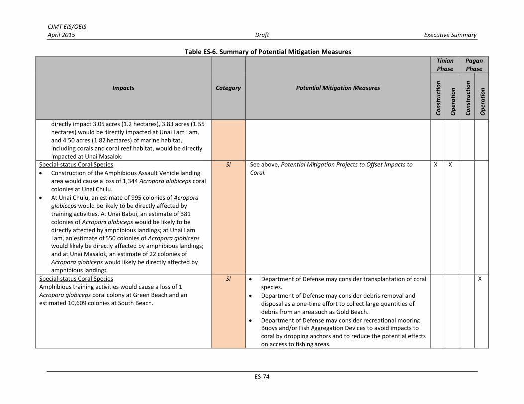
CJMT EIS/OEIS April 2015 Draft Executive Summary
ES-74
Table ES-6. Summary of Potential Mitigation Measures
Impacts Category Potential Mitigation Measures
Tinian Phase
Pagan Phase
Co
nst
ruct
ion
Op
era
tio
n
Co
nst
ruct
ion
Op
era
tio
n
directly impact 3.05 acres (1.2 hectares), 3.83 acres (1.55 hectares) would be directly impacted at Unai Lam Lam, and 4.50 acres (1.82 hectares) of marine habitat, including corals and coral reef habitat, would be directly impacted at Unai Masalok.
Special-status Coral Species Construction of the Amphibious Assault Vehicle landing
area would cause a loss of 1,344 Acropora globiceps coral colonies at Unai Chulu.
At Unai Chulu, an estimate of 995 colonies of Acropora globiceps would be likely to be directly affected by training activities. At Unai Babui, an estimate of 381 colonies of Acropora globiceps would be likely to be directly affected by amphibious landings; at Unai Lam Lam, an estimate of 550 colonies of Acropora globiceps would likely be directly affected by amphibious landings; and at Unai Masalok, an estimate of 22 colonies of Acropora globiceps would likely be directly affected by amphibious landings.
SI See above, Potential Mitigation Projects to Offset Impacts to Coral.
X X
Special-status Coral Species Amphibious training activities would cause a loss of 1 Acropora globiceps coral colony at Green Beach and an estimated 10,609 colonies at South Beach.
SI Department of Defense may consider transplantation of coral species.
Department of Defense may consider debris removal and disposal as a one-time effort to collect large quantities of debris from an area such as Gold Beach.
Department of Defense may consider recreational mooring Buoys and/or Fish Aggregation Devices to avoid impacts to coral by dropping anchors and to reduce the potential effects on access to fishing areas.
X

CJMT EIS/OEIS April 2015 Draft Executive Summary
ES-75
Table ES-6. Summary of Potential Mitigation Measures
Impacts Category Potential Mitigation Measures
Tinian Phase
Pagan Phase
Co
nst
ruct
ion
Op
era
tio
n
Co
nst
ruct
ion
Op
era
tio
n
Implementation of Marine Species Awareness Training for all lookouts and other key personnel.
Additional measures may be recommended during agency consultations.
CULTURAL RESOURCES
All Tinian alternatives would have a significant direct impact on historic properties in the Military Lease Area, immediately north of Tinian International Airport runways, and at the Port of Tinian. Tinian Alternative 1 would have a significant direct
impact to 172 historic properties from construction and to 15 historic properties from operations, as well as significant indirect impacts to 4 historic properties. These historic properties include the North Field National Historic Landmark; Pre-Contact latte sites, pottery scatters, and rock shelters; pre-World War II Japanese farms and shrines; World War II-era Japanese and American military sites; and potential traditional cultural properties.
Tinian Alternative 2 would have a significant direct impact to 182 historic properties from construction and to 15 historic properties from operations, as well as significant indirect impacts to 4 historic properties. These historic properties include. North Field National Historic Landmark; Pre-Contact latte sites, pottery scatters, and rock shelters; pre-World War II Japanese farms and shrines; World War II-era Japanese and American military sites; and potential traditional cultural properties.
SI mitigated
to LSI
Measures to mitigate significant impacts to historic properties will be identified through consultation with the CNMI Historic Preservation Officer, Advisory Council on Historic Preservation, National Park Service, and other interested parties representing the interests of the local government and the public. These measures, which may include data recovery excavations, archaeological monitoring, documentation, public education, and/or other appropriate measures, will be formalized in an agreement document.
X X

CJMT EIS/OEIS April 2015 Draft Executive Summary
ES-76
Table ES-6. Summary of Potential Mitigation Measures
Impacts Category Potential Mitigation Measures
Tinian Phase
Pagan Phase
Co
nst
ruct
ion
Op
era
tio
n
Co
nst
ruct
ion
Op
era
tio
n
Tinian Alternative 3 would have a significant direct impact to 179 historic properties from construction and to 15 historic properties from operation, as well as significant indirect impacts to 4 historic properties. These historic properties include the North Field National Historic Landmark; Pre-Contact latte sites, pottery scatters, and rock shelters; pre-World War II Japanese farms and shrines; World War II-era Japanese and American military sites; and potential traditional cultural properties.
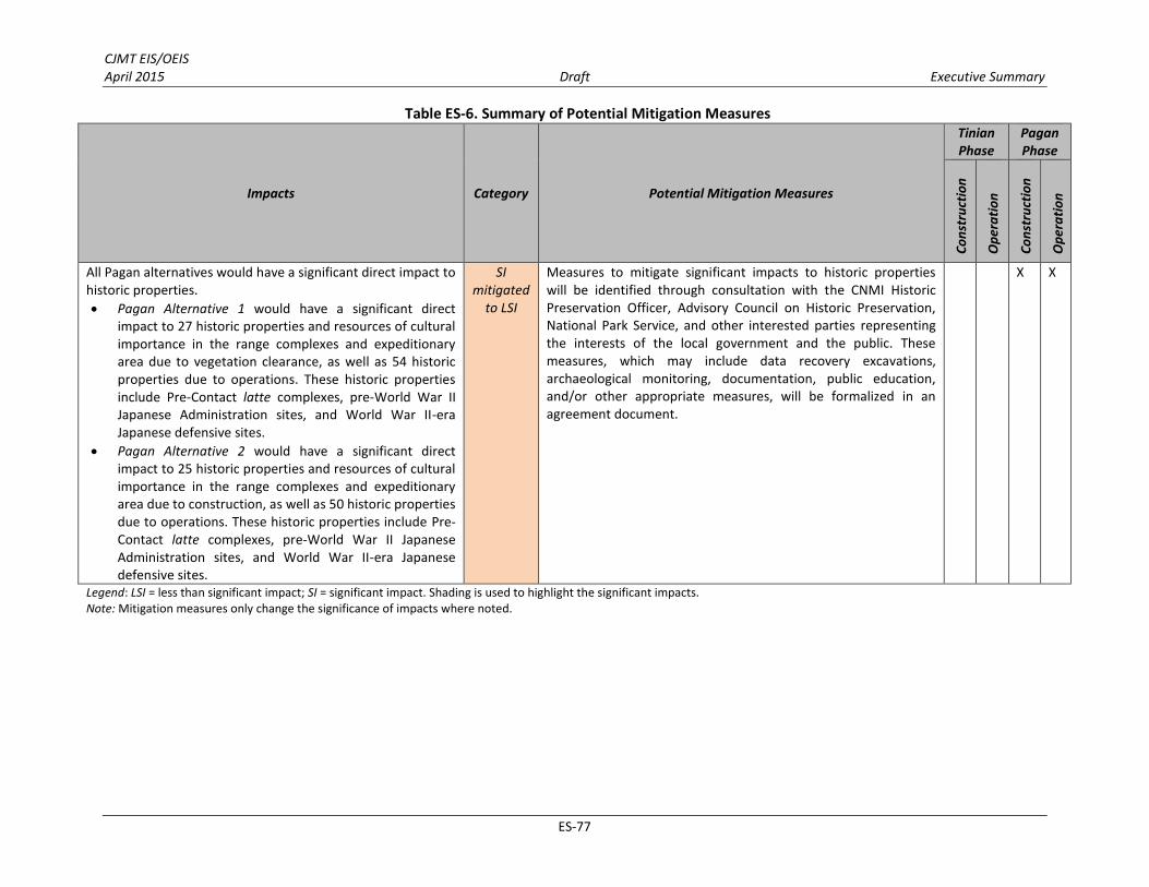
CJMT EIS/OEIS April 2015 Draft Executive Summary
ES-77
Table ES-6. Summary of Potential Mitigation Measures
Impacts Category Potential Mitigation Measures
Tinian Phase
Pagan Phase
Co
nst
ruct
ion
Op
era
tio
n
Co
nst
ruct
ion
Op
era
tio
n
All Pagan alternatives would have a significant direct impact to historic properties. Pagan Alternative 1 would have a significant direct
impact to 27 historic properties and resources of cultural importance in the range complexes and expeditionary area due to vegetation clearance, as well as 54 historic properties due to operations. These historic properties include Pre-Contact latte complexes, pre-World War II Japanese Administration sites, and World War II-era Japanese defensive sites.
Pagan Alternative 2 would have a significant direct impact to 25 historic properties and resources of cultural importance in the range complexes and expeditionary area due to construction, as well as 50 historic properties due to operations. These historic properties include Pre-Contact latte complexes, pre-World War II Japanese Administration sites, and World War II-era Japanese defensive sites.
SI mitigated
to LSI
Measures to mitigate significant impacts to historic properties will be identified through consultation with the CNMI Historic Preservation Officer, Advisory Council on Historic Preservation, National Park Service, and other interested parties representing the interests of the local government and the public. These measures, which may include data recovery excavations, archaeological monitoring, documentation, public education, and/or other appropriate measures, will be formalized in an agreement document.
X X
Legend: LSI = less than significant impact; SI = significant impact. Shading is used to highlight the significant impacts. Note: Mitigation measures only change the significance of impacts where noted.

CJMT EIS/OEIS April 2015 Draft Executive Summary
ES-78
ES.10 REFERENCES
Department of Defense. (2010). Quadrennial Defense Review Report. Washington, D.C. Retrieved from http://www.cnmijointmilitarytrainingeis.com/system/assets/1/original/qdr_as_of_26jan10_0700.pdf?1362673871
Department of Defense. (2014). Quadrennial Defense Review Report. Washington, D.C. DoN. (2010a). Record of Decision for Mariana Islands Range Complex Training (p. 63). July 20.
DoN. (2010a). Record of Decision for Mariana Islands Range Complex Training (p. 63). July 20.
DoN. (2010b). Final Environmental Impact Statement. Guam and CNMI Military Relocation – Relocating
Marines from Okinawa, Visiting Aircraft Carrier Berthing, and Army Air and Missile Defense Task
Force. Prepared by TEC-AECOM Pacific Joint Venture for Naval Facilities Engineering Command, Pacific. Retrieved from http://www.guambuildupeis.us/documents
DoN. (2013a). Training Needs Assessment: An Assessment of Current Training Ranges and Supporting
Facilities in the U.S. Pacific Command Area of Responsibility. Prepared by TEC-AECOM Pacific Joint Venture for Naval Facilities Engineering Command, Pacific. Retrieved from http://www.cnmijointmilitarytrainingeis.com/system/assets/5/original/dtp_eis_tna_03082013.pdf?1362969550
DoN. (2013b). Commonwealth of the Northern Mariana Islands Joint Military Training Requirements and
Siting Study. Revised. Pearl Harbor, HI: Naval Facilities Engineering Command, Pacific. Retrieved from http://www.cnmijointmilitarytrainingeis.com/system/assets/6/original/cjmt_siting_study__as_of_1725_8_mar_2013_.pdf?1362969628
DoN. (2014). Commonwealth of the Northern Mariana Islands Joint Military Training Concept of
Operations (aka CONOPs) V4. Pearl Harbor, HI: Naval Facilities Engineering Command, Pacific.
DoN and Department of the Army. (2010). Record of Decision. Final Environmental Impact Statement.
Guam and CNMI Military Relocation – Relocating Marines from Okinawa, Visiting Aircraft Carrier
Berthing, and Army Air and Missile Defense Task Force. Retrieved from http://www.guambuildupeis.us/documents/record_of_decision/Guam_Record_Of_Decision_FINAL.pdf
Institute for Defense Analyses. (2009, October). DoD Training in the Pacific Study: Needs, Capacities and
Options for the Future. Requirements and Funding for an Environmental Impact Statement (EIS) in FY 11.
Security Consultative Committee. (2012). Joint Statement of the Security Consultative Committee (No. 315-12).