Commission on the Limits of the Continental Shelf · THE LIMITS OF THE CONTINENTAL SHELF IN ... of...
55
United Nations Convention on the Law of the Sea ___________________________________________________________________________ SUMMARY OF THE RECOMMENDATIONS OF THE COMMISSION ON THE LIMITS OF THE CONTINENTAL SHELF IN REGARD TO THE JOINT SUBMISSION MADE BY MAURITIUS AND SEYCHELLES CONCERNING THE MASCARENE PLATEAU REGION ON 1 DECEMBER 2008 1 Recommendations prepared by the Subcommission established for the consideration of the Joint Submission made by Mauritius and Seychelles Adopted by the Subcommission on 25 March 2011 Adopted by the Commission on 30 March 2011 1 The aim of this Summary is to provide information which is not of confidential or proprietary nature in order to facilitate the function of the Secretary-General of the United Nations in accordance with CLCS/40/Rev.1, Annex III, Section V, Rule 11.3. This Summary is based on excerpts of the Recommendations and may refer to material not necessarily included either in the full Recommendations or this Summary. Commission on the Limits o o f f t t h h e e C C o o n n t t i i n n e e n n t t a a l l S S h h e e l l f f
Transcript of Commission on the Limits of the Continental Shelf · THE LIMITS OF THE CONTINENTAL SHELF IN ... of...

United Nations Convention on the Law of the Sea ___________________________________________________________________________
SUMMARY OF THE RECOMMENDATIONS OF THE COMMISSION ON THE LIMITS OF THE CONTINENTAL SHELF IN REGARD TO TH E JOINT SUBMISSION MADE BY MAURITIUS AND SEYCHELLES
CONCERNING THE MASCARENE PLATEAU REGION ON 1 DECEMBER 20081
Recommendations prepared by the Subcommission established for the consideration
of the Joint Submission made by Mauritius and Seychelles
Adopted by the Subcommission on 25 March 2011
Adopted by the Commission on 30 March 2011
1 The aim of this Summary is to provide information which is not of confidential or proprietary nature in order to
facilitate the function of the Secretary-General of the United Nations in accordance with CLCS/40/Rev.1, Annex III, Section V, Rule 11.3. This Summary is based on excerpts of the Recommendations and may refer to material not necessarily included either in the full Recommendations or this Summary.
CCoommmmiissssiioonn oonn tthhee LLiimmiittss
ooff tthhee CCoonnttiinneennttaall SShheellff
Summary of the Recommendations of the Commission on the Limits of the Continental Shelf in regard to the Joint Submission Made by Mauritius and Seychelles in respect of the Mascarene Plateau region on 1 December 2008 Page ii
TABLE OF CONTENTS
GENERAL LIST OF TERMS AND ABBREVIATIONS……………………………… ………………………….V
I. INTRODUCTION ......................................................................................................................... 1
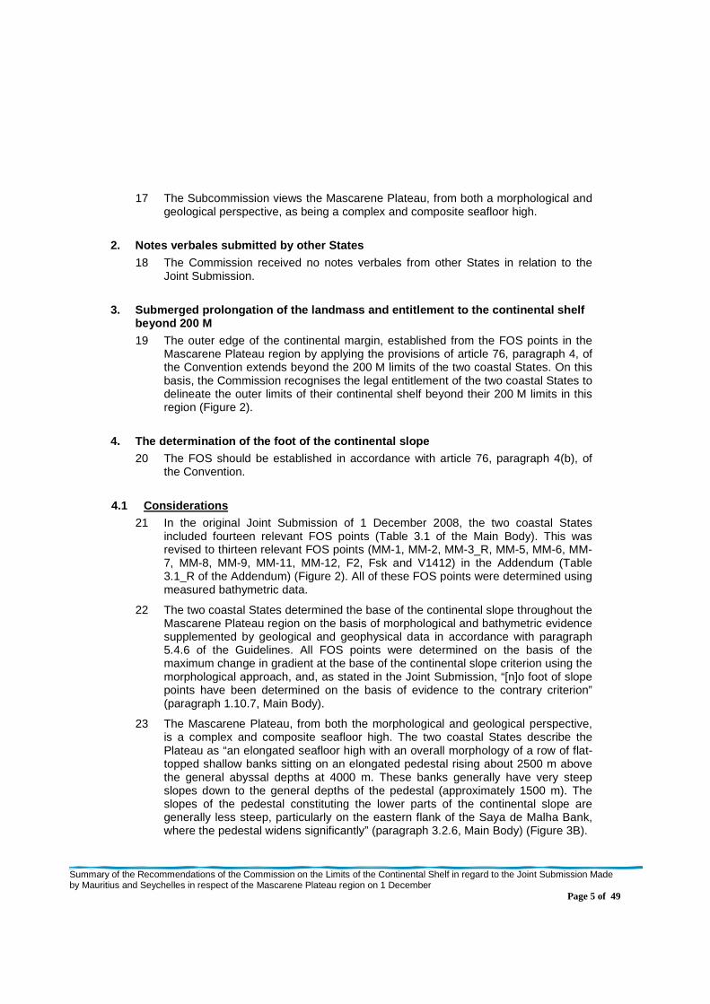
II. CONTENTS OF THE JOINT SUBMISSION................... ............................................................... 2
A. Original Joint Submission ........................................................................................................ 2 B. Communications and additional material.................................................................................. 2
III. GENERAL PRINCIPLES ON WHICH THESE RECOMMENDATIONS A RE BASED ..................... 2
IV. RECOMMENDATIONS ................................................................................................................ 2
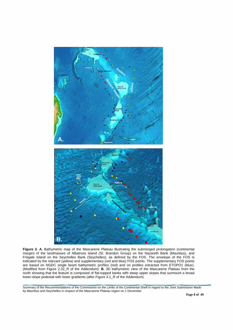
1. Description of the Mascarene Plateau region ........ ........................................................... 2 2. Notes verbales submitted by other States........... .............................................................. 5 3. Submerged prolongation of the landmass and entitlem ent to the continental shelf
beyond 200 M ....................................... .............................................................................. 5 4. The determination of the foot of the continental sl ope ................................................ ..... 5
4.1 Considerations.............................................................................................................. 5 4.2 Recommendations ...................................................................................................... 14
5. The establishment of the outer edge of the continen tal margin ..................................... 15 5.1 The application of the 60 M distance formula ............................................................... 15 5.2 Configuration of the Outer Edge of the Continental Margin........................................... 15 5.3 Recommendations ...................................................................................................... 17
6. The delineation of the outer limits of the continen tal shelf .......................................... .. 17 6.1 The application of constraint criteria ............................................................................ 17
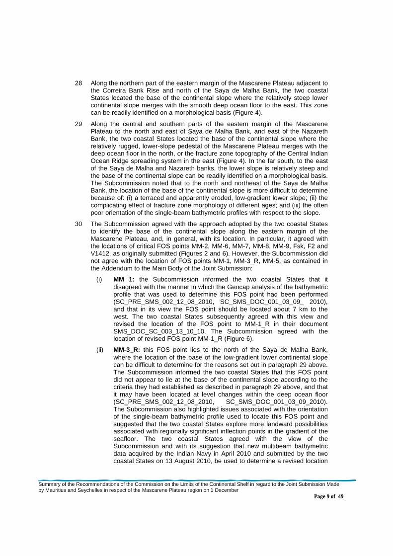
6.1.1 The construction of the distance constraint line .................................................... 17 6.1.2 The construction of the depth constraint line......................................................... 19 6.1.3 Consideration and classification of submarine highs ............................................. 19 6.1.4 The application of the combination of the distance and the depth constraints ........ 21
6.2 The outer limits of the continental shelf........................................................................ 21 6.3 Recommendations ...................................................................................................... 21
ANNEX .............................................. .............................................................................................. 24
Table 1. Geographic coordinates and other information related to the agreed FOS points, as submitted by the two Coastal States on 7 February 2011. …………………………………………………………………………………......... 24
Table 2. Geographic coordinates (DATUM: WGS84) and other information related to the delineation of the outer edge of the continental margin, as provided by the two coastal States on 21 March 2011……………………………………………………………………………………………………………………….........25
Table 3. Geographic coordinates (DATUM WGS 84) and other information related to the outer limit of the continental shelf beyond 200 M and the corresponding foot of the slope/base points, as provided by the two coastal States on 16 March 2011…………………………………………………………………………………………………..... 37

Summary of the Recommendations of the Commission on the Limits of the Continental Shelf in regard to the Joint Submission Made by Mauritius and Seychelles in respect of the Mascarene Plateau region on 1 December 2008 Page iii
LIST OF FIGURES
Figure 1 . Locality maps showing the location and setting of the Mascarene Plateau region of the Joint Submission. The figure shows: A. The location of the Mascarene Plateau within the western Indian Ocean (based on an image derived from the ETOPO1 GRID); B. The regional tectonic setting (modified from Courtillot et al., 1986); and C. The main geomorphological features in the region (after Figure 2.1 of the Main Body). …………………………………………………….4
Figure 2. Map indicating the basis of the entitlement of the two coastal States to delineate the outer limits of the continental shelf beyond 200 M in the Mascarene Plateau region (modified from Figure 3.3_R of the Addendum to the Main Body). The map shows the locations and numbers of the relevant FOS points (yellow stars) as originally submitted and revised in the Addendum; the corresponding 60 M arcs (magenta) and the resulting 60 M distance formula line with its bridging lines (dark brown); the 200 M limits of Mauritius (red) and Seychelles (green line); and the agreed (treaty) boundary delimiting the respective exclusive economic zones of the two coastal States (purple line). Relevant morphological features and islands are labeled. ……………………………………………………………………………………………………………….. 7
Figure 3. A. Bathymetric map of the Mascarene Plateau illustrating the submerged prolongation (continental margin) of the landmasses of Albatross Island (St. Brandon Group) on the Nazareth Bank (Mauritius), and Frégate Island on the Seychelles Bank (Seychelles), as defined by the FOS. The envelope of the FOS is indicated by the relevant (yellow) and supplementary (red and blue) FOS points. The supplementary FOS points are based on NGDC single beam bathymetric profiles (red) and on profiles extracted from ETOPO1 (blue). (Modified from Figure 2.32_R of the Addendum). B. 3D bathymetric view of the Mascarene Plateau from the north showing that the feature is composed of flat-topped banks with steep upper slopes that surmount a broad lower-slope pedestal with lower gradients (after Figure 3.1_R of the Addendum). …………………………………………………………………………….. ………………………………………………………………8
Figure 4. A. 3D bathymetric image of the Mascarene Plateau region prepared by the Subcommission using the global SRMT30 bathymetric grid in Fledermaus. It shows the morphological characteristics of the Plateau and its lower-slope pedestal and the very different characteristics of the deep ocean floor with its seafloor spreading fabric. Seafloor deeper than 3800 m has been shaded white and 100 m contours are shown. Also shown are the FOS points as originally submitted in the Addendum to the Joint Submission and revised during the period of examination by the Subcommission (green); the agreed FOS points as contained in Table 1 of Annex I to these Recommendations (dark blue); and original FOS points MM-11 and MM-12 (light blue). B. 2D bathymetric image of the Mascarene Plateau region prepared by the Subcommission using the “Gradient Band” analysis tool of Geocap and the SRMT30 bathymetric grid. It highlights the consistency of the agreed FOS locations with respect to major regional changes in seafloor gradient. FOS locations are coloured as in A above. It also shows the revised outer limit of the continental shelf (OLCS; black line), the 200 M limits of the two coastal States (green line) and the agreed (treaty) boundary delimiting the respective exclusive economic zones of the two coastal States (purple line)…………………………………………………………………………………………………...11
Figure 5. A. 3D bathymetric image of part of the western margin of the Mascarene Plateau prepared by the Subcommission using the global SRMT30 bathymetric grid15 in Geocap. It shows the morphological characteristics of this part of the Plateau and its lower-slope pedestal as well as the locations of the bathymetric data from the Nansen 2009 and Indian 2008 surveys submitted (SMS_DOC_SC_003_13_10_10) to support the location of new FOS points Nansen1, Nansen2 and IMB08_3 (dark blue) along the outer the edge of the lower-slope terrace. Also shown are FOS points MM-11 and MM-12 (light blue) as originally submitted in the Addendum to the Joint Submission. B. 2D bathymetric image of the same part of the Plateau prepared by the Subcommission using the ”Gradient Band” analysis tool of Geocap and the SRMT30 bathymetric grid. It indicates that the new FOS points occur at a major regional change in seafloor gradient. FOS locations are coloured as in A above. Also shown are the Nansen 2009 (black) and Indian 2008 (white) tracks used to determine the new FOS points; the 200 M limits of Mauritius (green line); and the 60 M distance formula arcs (red) constructed from the new FOS points indicating overlap of the outer edge of the continental margin with the 200 M limits of Mauritius………………………………………………………………………………………………………………………………….12
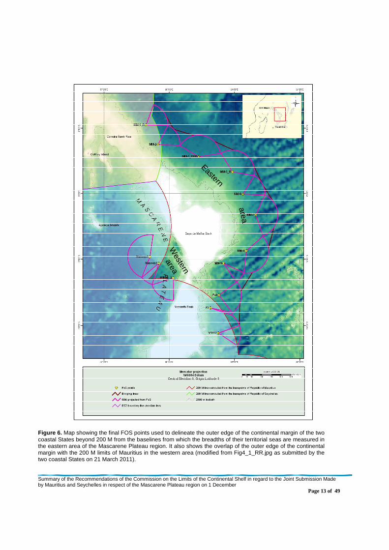
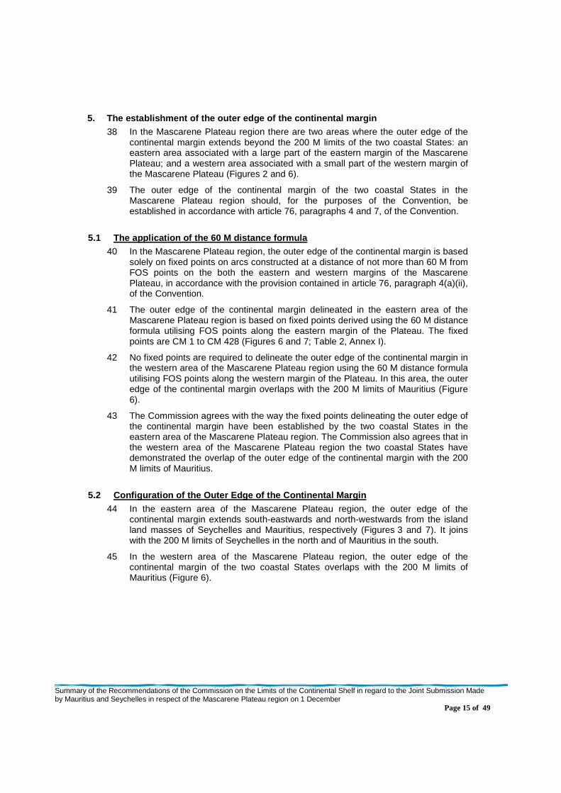
Figure 6. Map showing the final FOS points used to delineate the outer edge of the continental margin of the two coastal States beyond 200 M from the baselines from which the breadths of their territorial seas are measured in the eastern area of the Mascarene Plateau region. It also shows the overlap of the outer edge of the continental margin with the 200 M limits of Mauritius in the western area (modified from Fig4_1_RR.jpg as submitted by the two coastal States on 21 March 2011).……………………………………..……………………………………………………………………………………………...13
Figure 7. Map showing the line and associated fixed points delineating the outer edge of the continental margin of the two coastal States beyond 200 M from the baselines from which the breadths of their territorial seas are measured in the Mascarene Plateau region. The map also shows the final agreed FOS points used to establish the outer edge of the
Summary of the Recommendations of the Commission on the Limits of the Continental Shelf in regard to the Joint Submission Made by Mauritius and Seychelles in respect of the Mascarene Plateau region on 1 December 2008 Page iv
continental margin (submitted by the two coastal States as Fig4_2_RR. on 21 March 2011). Coordinates of the fixed points delineating the outer edge of the continental margin are given in Table 2, Annex I. …………………………………………16
Figure 8. Map showing the distance (orange) and depth (blue) constraint lines submitted by the two coastal States in the Mascarene Plateau region. The map also shows the relevant FOS points and associated 60 M arcs, and straight bridging lines used to delineate the outer edge of the continental margin (submitted by the two coastal States as Fig4_4_RR on 21 March 2011). ……………………………………………………………………………………………………………………………18
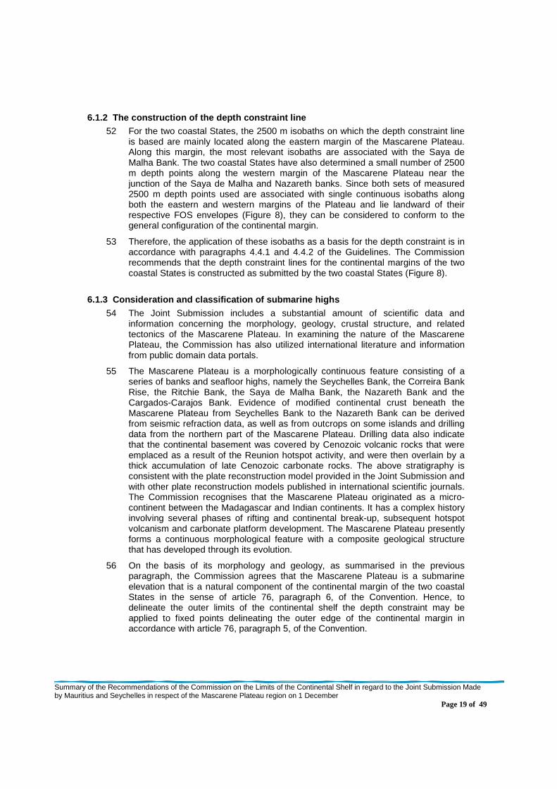
Figure 9. Map showing the application of the combination of the distance (orange) and depth (blue) constraint lines to delineate the fixed points that establish the outer limits of the continental shelf in the Mascarene Plateau region. The map also shows the relevant FOS points (red stars) and the line (brown) delineating the outer edge of the continental margin where it extends beyond the outer limits of the continental shelf (submitted by the two coastal States as CM_constraints_2011_1 on 21 March 2011). …………………………………………………………………………………….. .20
Figure 10. Map showing the outer limits of the continental shelf of the two coastal States beyond 200 M from the baselines from which the breadths of their territorial seas are measured in the Mascarene Plateau region. Coordinates of the fixed points delineating the outer limit of the continental shelf are given in Table 3, Annex I (submitted by the two coastal States as Fig5_2_RR on 21 March 2011). ……………………………………………………………………………………………….. ...23
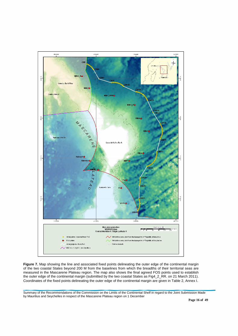
Summary of the Recommendations of the Commission on the Limits of the Continental Shelf in regard to the Joint Submission Made by Mauritius and Seychelles in respect of the Mascarene Plateau region on 1 December 2008 Page v
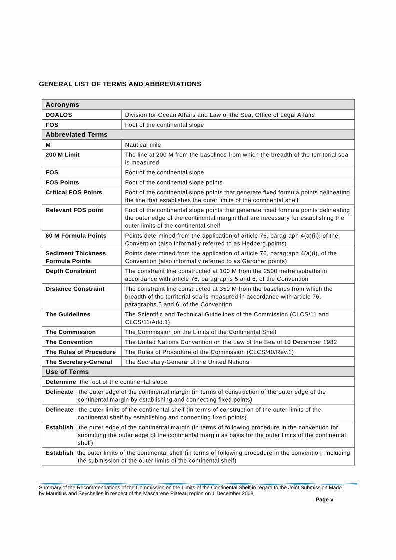
GENERAL LIST OF TERMS AND ABBREVIATIONS
Acronyms
DOALOS Division for Ocean Affairs and Law of the Sea, Office of Legal Affairs
FOS Foot of the continental slope
Abbreviated Terms
M Nautical mile
200 M Limit The line at 200 M from the baselines from which the breadth of the territorial sea is measured
FOS Foot of the continental slope
FOS Points Foot of the continental slope points
Critical FOS Points Foot of the continental slope points that generate fixed formula points delineating the line that establishes the outer limits of the continental shelf
Relevant FOS point Foot of the continental slope points that generate fixed formula points delineating the outer edge of the continental margin that are necessary for establishing the outer limits of the continental shelf
60 M Formula Points Points determined from the application of article 76, paragraph 4(a)(ii), of the Convention (also informally referred to as Hedberg points)
Sediment Thickness Formula Points
Points determined from the application of article 76, paragraph 4(a)(i), of the Convention (also informally referred to as Gardiner points)
Depth Constraint The constraint line constructed at 100 M from the 2500 metre isobaths in accordance with article 76, paragraphs 5 and 6, of the Convention
Distance Constraint The constraint line constructed at 350 M from the baselines from which the breadth of the territorial sea is measured in accordance with article 76, paragraphs 5 and 6, of the Convention
The Guidelines The Scientific and Technical Guidelines of the Commission (CLCS/11 and CLCS/11/Add.1)
The Commission The Commission on the Limits of the Continental Shelf
The Convention The United Nations Convention on the Law of the Sea of 10 December 1982
The Rules of Procedure The Rules of Procedure of the Commission (CLCS/40/Rev.1)
The Secretary-General The Secretary-General of the United Nations
Use of Terms
Determine the foot of the continental slope
Delineate the outer edge of the continental margin (in terms of construction of the outer edge of the continental margin by establishing and connecting fixed points)
Delineate the outer limits of the continental shelf (in terms of construction of the outer limits of the continental shelf by establishing and connecting fixed points)
Establish the outer edge of the continental margin (in terms of following procedure in the convention for submitting the outer edge of the continental margin as basis for the outer limits of the continental shelf)
Establish the outer limits of the continental shelf (in terms of following procedure in the convention including the submission of the outer limits of the continental shelf)

Summary of the Recommendations of the Commission on the Limits of the Continental Shelf in regard to the Joint Submission Made by Mauritius and Seychelles in respect of the Mascarene Plateau region on 1 December 2008 Page vi
(page left intentionally blank)
Summary of the Recommendations of the Commission on the Limits of the Continental Shelf in regard to the Joint Submission Made by Mauritius and Seychelles in respect of the Mascarene Plateau region on 1 December
Page 1 of 49
I. INTRODUCTION
1 On 1 December 2008, in accordance with article 76, paragraph 8, of the United
Nations Convention on the Law of the Sea of 10 December 1982, the Republic of Mauritius and the Republic of Seychelles jointly submitted to the Commission on the Limits of the Continental Shelf, through the Secretary-General of the United Nations, information on the limits of their continental shelf beyond 200 M from the baselines from which the breadths of their territorial seas are measured.
2 The presentation of the Joint Submission was made to the plenary of the twenty-third session on 26 March 2009. The Commission decided that, as provided for in article 5 of Annex II to the Convention and in rule 42 of the Rules of Procedure, the Joint Submission would be addressed through the establishment of a subcommission. The Commission, however, did not establish the subcommission for the consideration of the Joint Submission at the twenty-third session.1 At the twenty-fourth session, the Commission decided that a subcommission to consider the Joint Submission would not be formed until two of the existing subcommissions2 had submitted their recommendations to the Commission.3
3 On 12 March 2010, the two coastal States revised the original Joint Submission by submitting an “Addendum to Main Body of the Joint Submission to the Commission on the Limits of the Continental Shelf” (SMS-MB-DOC_Addendum - hereinafter referred to as “Addendum”) and a revised Executive Summary (SMS-ES-DOC_Rev).
4 At the twenty-fifth session, the Commission proceeded with establishing a subcommission to examine the Joint Submission in accordance with the established procedure.4
5 The Subcommission carried out its examination of the Joint Submission during the following sessions: twenty-fifth, twenty-sixth, resumed twenty-sixth and twenty-seventh. The Subcommission adopted its Recommendations on 25 March 2011, and submitted them to the Commission on 28 March 2011 for consideration and approval by the Commission.
6 On 29 March 2011, the Subcommission presented its Recommendations to the Commission and the Delegations made a presentation to the Commission in accordance with paragraph 52 and paragraph 15 of Annex III of the Rules of Procedure of the Commission.
7 The Commission prepared these Recommendations, which were adopted on 30 March 2011, taking into consideration the internal procedures and the methodology outlined in the following documents of the Commission: the Rules of Procedure; the Scientific and Technical Guidelines and article 6 of Annex II to the Convention.
1 See CLCS/62, paragraphs 60-66. 2 Namely, the Subcommissions which had been established to examine the Submissions made, respectively, by
Barbados; the United Kingdom of Great Britain and Northern Ireland in respect of Ascension Island; Indonesia; and Japan.
3 See CLCS/64, paragraph 30. 4 See CLCS/42, paragraphs 19-20.
Summary of the Recommendations of the Commission on the Limits of the Continental Shelf in regard to the Joint Submission Made by Mauritius and Seychelles in respect of the Mascarene Plateau region on 1 December
Page 2 of 49
8 The Commission makes these Recommendations to Mauritius and Seychelles in fulfillment of its mandate as contained in article 76, paragraph 8, and articles 3 and 5 of Annex II to the Convention.
9 The Commission makes its recommendations recognising that the outer limits of the continental shelf as established by a coastal State on the basis of its recommendations shall be final and binding according to article 76, paragraph 8, of the Convention.
II. CONTENTS OF THE JOINT SUBMISSION
A. Original Joint Submission 10 The original Joint Submission received on 1 December 2008 contained: an
Executive Summary; a Main Body which is the analytical and descriptive part (hereinafter referred to as “Main Body”); and Scientific and Technical Data.
B. Communications and additional material 11 The Delegations submitted an Addendum dated 12 March 2010, which revised the
Joint Submission. Moreover, during the course of the examination of the Joint Submission, the Delegations submitted further material, in response to questions, requests for clarification and written preliminary considerations of the Subcommission.
III. GENERAL PRINCIPLES ON WHICH THESE RECOMMENDATI ONS ARE BASED 12 The recommendations of the Commission are based on the scientific and technical
data and other material provided by the two coastal States in relation to the implementation of article 76 of the Convention. The recommendations of the Commission only deal with issues related to article 76 and Annex II to the Convention and are without prejudice to matters relating to delimitation between States, or application of other parts of the Convention or any other treaties.
IV. RECOMMENDATIONS
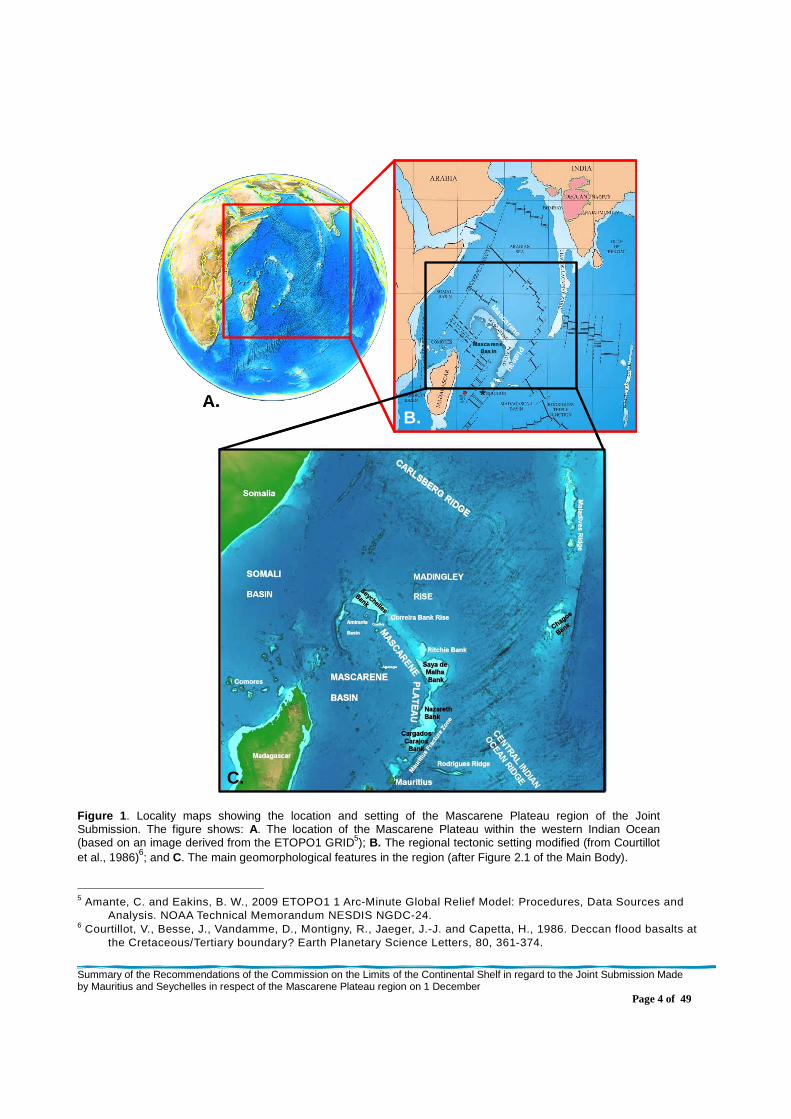
13 The Joint Submission of Mauritius and Seychelles of 1 December 2008 relates to an area referred to by the two coastal States as the Mascarene Plateau region (Figure 1).
1. Description of the Mascarene Plateau region
14 The Mascarene Plateau region is located in the southwestern part of the Indian Ocean to the northeast of Madagascar. It is dominated by the Mascarene Plateau, which is a large, arcuate, composite seafloor high that lies between 4º S and 21º S and constitutes the submerged prolongation of the land masses of the two coastal States, Seychelles to the north and Mauritius to the south.
15 The Plateau extends north-south for over 2300 km from the granitic islands of the Seychelles that surmount Seychelles Bank, on a south-easterly trend through the Correira Bank Rise, to Saya de Malha Bank (that includes Ritchie Bank), and then on a south-south-westerly trend through the Nazareth Bank and the Cargados-Carajos Bank, with its surmounting islands of the St. Brandon Group (Cargados-Carajos Shoals), to the main island of Mauritius.

Summary of the Recommendations of the Commission on the Limits of the Continental Shelf in regard to the Joint Submission Made by Mauritius and Seychelles in respect of the Mascarene Plateau region on 1 December
Page 3 of 49
16 The understanding of the Commission, based on the data and material contained in the Joint Submission, is that the geological evolution of the Mascarene Plateau involved (i) several episodes of rifting and break-up of the Gondwana super-continent since the Jurassic; (ii) Large Igneous Province (LIP) magmatism associated with the emplacement of the Deccan flood basalts in the Late Cretaceous; (iii) further magmatism associated with the southward path of the Deccan-Réunion hotspot, and, finally, (iv) significant Tertiary carbonate platform development. All these events and processes contributed to the formation of the large, elongated, mid-ocean seafloor high that is now the Mascarene Plateau with its rectilinear margins, and deep, broad, low-gradient pedestal surmounted by narrower, steep-sided, flat-topped carbonate platforms.
Summary of the Recommendations of the Commission on the Limits of the Continental Shelf in regard to the Joint Submission Made by Mauritius and Seychelles in respect of the Mascarene Plateau region on 1 December
Page 4 of 49
A.
C.
Mascarene
Plateau
Masca rene Bas in
B.A.
C.
Mascarene
Plateau
Masca rene Bas in
B.
Figure 1 . Locality maps showing the location and setting of the Mascarene Plateau region of the Joint Submission. The figure shows: A. The location of the Mascarene Plateau within the western Indian Ocean (based on an image derived from the ETOPO1 GRID5); B. The regional tectonic setting modified (from Courtillot et al., 1986)6; and C. The main geomorphological features in the region (after Figure 2.1 of the Main Body).
5 Amante, C. and Eakins, B. W., 2009 ETOPO1 1 Arc-Minute Global Relief Model: Procedures, Data Sources and
Analysis. NOAA Technical Memorandum NESDIS NGDC-24. 6 Courtillot, V., Besse, J., Vandamme, D., Montigny, R., Jaeger, J.-J. and Capetta, H., 1986. Deccan flood basalts at
the Cretaceous/Tertiary boundary? Earth Planetary Science Letters, 80, 361-374.
Summary of the Recommendations of the Commission on the Limits of the Continental Shelf in regard to the Joint Submission Made by Mauritius and Seychelles in respect of the Mascarene Plateau region on 1 December
Page 5 of 49
17 The Subcommission views the Mascarene Plateau, from both a morphological and
geological perspective, as being a complex and composite seafloor high.
2. Notes verbales submitted by other States
18 The Commission received no notes verbales from other States in relation to the Joint Submission.
3. Submerged prolongation of the landmass and entit lement to the continental shelf beyond 200 M
19 The outer edge of the continental margin, established from the FOS points in the Mascarene Plateau region by applying the provisions of article 76, paragraph 4, of the Convention extends beyond the 200 M limits of the two coastal States. On this basis, the Commission recognises the legal entitlement of the two coastal States to delineate the outer limits of their continental shelf beyond their 200 M limits in this region (Figure 2).
4. The determination of the foot of the continental slope 20 The FOS should be established in accordance with article 76, paragraph 4(b), of
the Convention.
4.1 Considerations 21 In the original Joint Submission of 1 December 2008, the two coastal States
included fourteen relevant FOS points (Table 3.1 of the Main Body). This was revised to thirteen relevant FOS points (MM-1, MM-2, MM-3_R, MM-5, MM-6, MM-7, MM-8, MM-9, MM-11, MM-12, F2, Fsk and V1412) in the Addendum (Table 3.1_R of the Addendum) (Figure 2). All of these FOS points were determined using measured bathymetric data.
22 The two coastal States determined the base of the continental slope throughout the Mascarene Plateau region on the basis of morphological and bathymetric evidence supplemented by geological and geophysical data in accordance with paragraph 5.4.6 of the Guidelines. All FOS points were determined on the basis of the maximum change in gradient at the base of the continental slope criterion using the morphological approach, and, as stated in the Joint Submission, “[n]o foot of slope points have been determined on the basis of evidence to the contrary criterion” (paragraph 1.10.7, Main Body).
23 The Mascarene Plateau, from both the morphological and geological perspective, is a complex and composite seafloor high. The two coastal States describe the Plateau as “an elongated seafloor high with an overall morphology of a row of flat-topped shallow banks sitting on an elongated pedestal rising about 2500 m above the general abyssal depths at 4000 m. These banks generally have very steep slopes down to the general depths of the pedestal (approximately 1500 m). The slopes of the pedestal constituting the lower parts of the continental slope are generally less steep, particularly on the eastern flank of the Saya de Malha Bank, where the pedestal widens significantly” (paragraph 3.2.6, Main Body) (Figure 3B).
Summary of the Recommendations of the Commission on the Limits of the Continental Shelf in regard to the Joint Submission Made by Mauritius and Seychelles in respect of the Mascarene Plateau region on 1 December
Page 6 of 49
24 As mentioned by the two coastal States, there is no geomorphological or geological evidence for substantial continental rise development throughout the region in the sense of paragraphs 5.4.4, 6.2.1 and 8.1.7 of the Guidelines. This reflects the isolated, mid-ocean location of the Mascarene Plateau and its small island land masses, and resultant sediment starvation of its margins. Consequently, the two coastal States have generally located the base of the continental slope where the lower slope associated with the pedestal of the Plateau merges with the deep ocean floor (paragraphs 3.2.6 - 3.2.8 of the Main Body, and paragraphs 3.1 and 3.2 of the Addendum to the Main Body) in accordance with paragraphs 5.4.4, 5.4.5 and 5.4.6 of the Guidelines.
25 Parts of both the eastern and western continental margins of the Mascarene Plateau extend beyond the 200 M limits of the two coastal States. Therefore, for the purposes of these Recommendations, the following considerations on the FOS have been divided into two parts – an eastern part that is associated with the eastern margin of the Plateau and lies east of the Correira Bank Rise, the Saya de Malha Bank and the Nazareth Bank; and a small western part that is associated with the western margin of the Plateau and lies southwest of the Saya de Malha Bank and northwest of the Nazareth Bank (Figures 2 and 3A).
26 Table 3.1_R of the Addendum contains a total of thirteen FOS points as follows:
(i) Eleven FOS points (MM-1, MM-2, MM-3_R, MM-5, MM-6, MM-7, MM-8, MM-9, F2, Fsk, and V1412) that are associated with the eastern margin of the Mascarene Plateau (Figures 2 and 3). Two of these FOS points (MM-9 and F2) do not generate formula points beyond the 200 M limits of the two coastal States; and
(ii) two FOS points (MM-11 and MM-12) that are associated with the western margin of the Mascarene Plateau (Figures 2 and 3), and were submitted by the two coastal States to demonstrate overlap with the 200 M limits of Mauritius of the outer edge of the continental margin established by applying the provisions of article 76, paragraph 4, of the Convention.
27 With respect to the eastern margin of the Mascarene Plateau, relevant FOS points were located, from north to south, at the base of the continental slope associated with the Correira Bank Rise (MM-1 and MM-2), the Saya de Malha Bank (MM-3_R, MM-5, MM-6, MM-7, MM-8, and MM-9, and the Nazareth Bank (Fsk, F2 and V1412). (Figure 2).
Summary of the Recommendations of the Commission on the Limits of the Continental Shelf in regard to the Joint Submission Made by Mauritius and Seychelles in respect of the Mascarene Plateau region on 1 December
Page 7 of 49
Eastern
Western m
argin
marg
in
Eastern
Western m
argin
marg
in
Figure 2. Map indicating the basis of the entitlement of the two coastal States to delineate the outer limits of the continental shelf beyond 200 M in the Mascarene Plateau region (modified from Figure 3.3_R of the Addendum to the Main Body). The map shows the locations and numbers of the relevant FOS points (yellow stars) as originally submitted and revised in the Addendum; the corresponding 60 M arcs (magenta) and the resulting 60 M distance formula line with its bridging lines (dark brown); the 200 M limits of Mauritius (red) and Seychelles (green line); and the agreed (treaty) boundary7 delimiting the respective exclusive economic zones of the two coastal States (purple line). Relevant morphological features and islands are labeled.
7 Agreement between the Government of the Republic of Mauritius and the Government of the Republic of Seychelles
on the Delimitation of the Exclusive Economic Zone between the two States, 29 July 2008.
Summary of the Recommendations of the Commission on the Limits of the Continental Shelf in regard to the Joint Submission Made by Mauritius and Seychelles in respect of the Mascarene Plateau region on 1 December
Page 8 of 49
A.
B.
Eastern
marg
in
Western m
argin
A.
B.
A.
B.
Eastern
marg
in
Western m
argin
Figure 3. A. Bathymetric map of the Mascarene Plateau illustrating the submerged prolongation (continental margin) of the landmasses of Albatross Island (St. Brandon Group) on the Nazareth Bank (Mauritius), and Frégate Island on the Seychelles Bank (Seychelles), as defined by the FOS. The envelope of the FOS is indicated by the relevant (yellow) and supplementary (red and blue) FOS points. The supplementary FOS points are based on NGDC single beam bathymetric profiles (red) and on profiles extracted from ETOPO1 (blue). (Modified from Figure 2.32_R of the Addendum). B. 3D bathymetric view of the Mascarene Plateau from the north showing that the feature is composed of flat-topped banks with steep upper slopes that surmount a broad lower-slope pedestal with lower gradients (after Figure 3.1_R of the Addendum).
Summary of the Recommendations of the Commission on the Limits of the Continental Shelf in regard to the Joint Submission Made by Mauritius and Seychelles in respect of the Mascarene Plateau region on 1 December
Page 9 of 49
28 Along the northern part of the eastern margin of the Mascarene Plateau adjacent to the Correira Bank Rise and north of the Saya de Malha Bank, the two coastal States located the base of the continental slope where the relatively steep lower continental slope merges with the smooth deep ocean floor to the east. This zone can be readily identified on a morphological basis (Figure 4).
29 Along the central and southern parts of the eastern margin of the Mascarene Plateau to the north and east of Saya de Malha Bank, and east of the Nazareth Bank, the two coastal States located the base of the continental slope where the relatively rugged, lower-slope pedestal of the Mascarene Plateau merges with the deep ocean floor in the north, or the fracture zone topography of the Central Indian Ocean Ridge spreading system in the east (Figure 4). In the far south, to the east of the Saya de Malha and Nazareth banks, the lower slope is relatively steep and the base of the continental slope can be readily identified on a morphological basis. The Subcommission noted that to the north and northeast of the Saya de Malha Bank, the location of the base of the continental slope is more difficult to determine because of: (i) a terraced and apparently eroded, low-gradient lower slope; (ii) the complicating effect of fracture zone morphology of different ages; and (iii) the often poor orientation of the single-beam bathymetric profiles with respect to the slope.
30 The Subcommission agreed with the approach adopted by the two coastal States to identify the base of the continental slope along the eastern margin of the Mascarene Plateau, and, in general, with its location. In particular, it agreed with the locations of critical FOS points MM-2, MM-6, MM-7, MM-8, MM-9, Fsk, F2 and V1412, as originally submitted (Figures 2 and 6). However, the Subcommission did not agree with the location of FOS points MM-1, MM-3_R, MM-5, as contained in the Addendum to the Main Body of the Joint Submission:
(i) MM 1: the Subcommission informed the two coastal States that it disagreed with the manner in which the Geocap analysis of the bathymetric profile that was used to determine this FOS point had been performed (SC_PRE_SMS_002_12_08_2010, SC_SMS_DOC_001_03_09_ 2010), and that in its view the FOS point should be located about 7 km to the west. The two coastal States subsequently agreed with this view and revised the location of the FOS point to MM-1_R in their document SMS_DOC_SC_003_13_10_10. The Subcommission agreed with the location of revised FOS point MM-1_R (Figure 6).
(ii) MM-3_R: this FOS point lies to the north of the Saya de Malha Bank, where the location of the base of the low-gradient lower continental slope can be difficult to determine for the reasons set out in paragraph 29 above. The Subcommission informed the two coastal States that this FOS point did not appear to lie at the base of the continental slope according to the criteria they had established as described in paragraph 29 above, and that it may have been located at level changes within the deep ocean floor (SC_PRE_SMS_002_12_08_2010, SC_SMS_DOC_001_03_09_2010). The Subcommission also highlighted issues associated with the orientation of the single-beam bathymetric profile used to locate this FOS point and suggested that the two coastal States explore more landward possibilities associated with regionally significant inflection points in the gradient of the seafloor. The two coastal States agreed with the view of the Subcommission and with its suggestion that new multibeam bathymetric data acquired by the Indian Navy in April 2010 and submitted by the two coastal States on 13 August 2010, be used to determine a revised location
Summary of the Recommendations of the Commission on the Limits of the Continental Shelf in regard to the Joint Submission Made by Mauritius and Seychelles in respect of the Mascarene Plateau region on 1 December
Page 10 of 49
for the FOS point. Following a series of interactions involving responses by the two coastal States (SMS_DOC_SC_003_13_10_10, SMS_DOC_SC _004_29_01_11, and “Presentation on replies to issues raised by the Subcommission on 9th December, 2010” dated 15 March 2011) to the views of the Subcommission (SC_PRE_SMS_002_12_08_2010, SC_SMS_DOC_001_03_09_2010, SC_PRE_SMS_004_09_12_2010), the two coastal States submitted a revised FOS point MM-3_RRR (SMS_DOC_SC_004_29_01_11). The Subcommission agreed with the location of this revised FOS point (Figure 6).
(iii) MM-5: this FOS point lies to the northeast of the Saya de Malha Bank, where the location of the base of the low-gradient lower continental slope can be difficult to determine for the reasons set out in paragraph 29 above. The Subcommission informed the two coastal States that this FOS point does not appear to lie at the base of the continental slope according to the criteria they had established as described in paragraph 29 above, and that it may have been located at level changes within the deep ocean floor associated with fracture zones (SC_PRE_SMS_002_12_08_2010 and SC_SMS_DOC_001_03_09_ 2010). The Subcommission also highlighted issues associated with critical gaps in the bathymetric data. The Subcommission suggested that the two coastal States explore more landward possibilities for the FOS location associated with regionally significant inflection points in the gradient of the seafloor. The two coastal States agreed with the view of the Subcommission, and revised the location landward of the critical data gap to new FOS point MM-5_R (SMS_DOC_SC_003_13_10_10). The Subcommission agreed with the location of this revised FOS point (Figure 6).
31 With respect to the western margin of the Mascarene Plateau, relevant FOS points MM-11 and MM-12 are located in the area to the southwest of the Saya de Malha Bank and northwest of the Nazareth Bank (Figures 2, 3 and 5).
32 In this area of the western Mascarene Plateau the two coastal States located the base of the continental slope where the “steeper, lower part of the slope merges with the deep ocean” (paragraph 3.5.14.2, Main Body).
33 On the western margin of the northwesterly-trending northern part of the Mascarene Plateau, the pedestal underpinning the lower slope appears to broaden to the east of the Saya de Malha Bank and has the form of a lower-slope terrace (Figure 5). This terrace is associated with a relatively thin sediment layer that is conformable with the apparent basement. Furthermore the overall relief of the terrace generally mimics that of the apparent basement surface. In general, the western continental margin does not exhibit typical continental rise characteristics as indicated by: the sparse single channel seismic data in the north; the generally rugged seafloor of the deep margin, as imaged by single-beam and multibeam bathymetric data, that in places appears to be associated with major erosion by bottom currents; and the significant along-strike variability of the lower slope.
Summary of the Recommendations of the Commission on the Limits of the Continental Shelf in regard to the Joint Submission Made by Mauritius and Seychelles in respect of the Mascarene Plateau region on 1 December
Page 11 of 49
A.
Saya de MalhaBank
Nazareth Bank
B.200 M
200 M
OLC
S
Agreed boundary
A.
Saya de MalhaBank
Nazareth Bank
B.200 M
200 M
OLC
S
Agreed boundary
Figure 4. A. 3D bathymetric image of the Mascarene Plateau region prepared by the Subcommission using the global SRMT30 bathymetric grid8 in Fledermaus. It shows the morphological characteristics of the Plateau and its lower-slope pedestal and the very different characteristics of the deep ocean floor with its seafloor spreading fabric. Seafloor deeper than 3800 m has been shaded white and 100 m contours are shown. Also shown are the FOS points as originally submitted in the Addendum to the Joint Submission and revised during the period of examination by the Subcommission (green); the agreed FOS points as contained in Table 1 of Annex I to these Recommendations (dark blue); and original FOS points MM-11 and MM-12 (light blue). B. 2D bathymetric image of the Mascarene Plateau region prepared by the Subcommission using the “Gradient Band” analysis tool of Geocap and the SRMT30 bathymetric grid. It highlights the consistency of the agreed FOS locations with respect to major regional changes in seafloor gradient. FOS locations are coloured as in A above. It also shows the revised outer limit of the continental shelf (OLCS; black line), the 200 M limits of the two coastal States (green line) and the agreed (treaty) boundary delimiting the respective exclusive economic zones of the two coastal States (purple line). 8 http://topex.ucsd.edu/WWW_html/srtm30_plus.html.

Summary of the Recommendations of the Commission on the Limits of the Continental Shelf in regard to the Joint Submission Made by Mauritius and Seychelles in respect of the Mascarene Plateau region on 1 December
Page 12 of 49
200 M
200 M
60 M
Nansen 2009Nansen 2009
Indian 2008Indian 2008multibeammultibeam
60 M
11
12
Saya de MalhaBank
Nazareth Bank
B.
A.
Lower-slope terrace
Lower-slope terrace
200 M
200 M
60 M
Nansen 2009Nansen 2009
Indian 2008Indian 2008multibeammultibeam
60 M
11
12
Saya de MalhaBank
Nazareth Bank
B.
A.
200 M
200 M
60 M
Nansen 2009Nansen 2009
Indian 2008Indian 2008multibeammultibeam
60 M
11
12
Saya de MalhaBank
Nazareth Bank
B.
A.
Lower-slope terrace
Lower-slope terrace
Figure 5 . A. 3D bathymetric image of part of the western margin of the Mascarene Plateau prepared by the Subcommission using the global SRMT30 bathymetric grid15 in Geocap. It shows the morphological characteristics of this part of the Plateau and its lower-slope pedestal as well as the locations of the bathymetric data from the Nansen 2009 and Indian 2008 surveys submitted (SMS_DOC_SC_003_13_10_10) to support the location of new FOS points Nansen1, Nansen2 and IMB08_3 (dark blue) along the outer the edge of the lower-slope terrace. Also shown are FOS points MM-11 and MM-12 (light blue) as originally submitted in the Addendum to the Joint Submission. B. 2D bathymetric image of the same part of the Plateau prepared by the Subcommission using the ”Gradient Band” analysis tool of Geocap and the SRMT30 bathymetric grid. It indicates that the new FOS points occur at a major regional change in seafloor gradient. FOS locations are coloured as in A above. Also shown are the Nansen 2009 (black) and Indian 2008 (white) tracks used to determine the new FOS points; the 200 M limits of Mauritius (green line); and the 60 M distance formula arcs (red) constructed from the new FOS points indicating overlap of the outer edge of the continental margin with the 200 M limits of Mauritius.
Summary of the Recommendations of the Commission on the Limits of the Continental Shelf in regard to the Joint Submission Made by Mauritius and Seychelles in respect of the Mascarene Plateau region on 1 December
Page 13 of 49
Eastern
Western
area
area
Eastern
Western
area
area
Figure 6. Map showing the final FOS points used to delineate the outer edge of the continental margin of the two coastal States beyond 200 M from the baselines from which the breadths of their territorial seas are measured in the eastern area of the Mascarene Plateau region. It also shows the overlap of the outer edge of the continental margin with the 200 M limits of Mauritius in the western area (modified from Fig4_1_RR.jpg as submitted by the two coastal States on 21 March 2011).

Summary of the Recommendations of the Commission on the Limits of the Continental Shelf in regard to the Joint Submission Made by Mauritius and Seychelles in respect of the Mascarene Plateau region on 1 December
Page 14 of 49
34 On the balance of the regional morphological, geological and geophysical evidence presented by the two coastal States, supported by information that the Subcommission had compiled itself from the international literature and public domain data portals, the Subcommission was of the view that that the 0.5°- 0.6° gradient lower margin in the vicinity of FOS points MM-11 and MM-12 was more appropriately considered as continental slope rather than continental rise (SC_SMS_DOC_001 _03_09_2010). However, in the absence of other supporting data such as seismic profiles, sub-bottom profiler data, substantial multi-beam bathymetry and backscatter data etc., the Subcommission was unable to confirm this view.
35 The two coastal States submitted Indian (Investigator) 2008 multibeam grids and newly obtained single-beam bathymetric data acquired by the vessel Dr Fridtjof Nansen in 2009 in support of their original base of continental slope zone on the western margin of the Mascarene Plateau in the vicinity of FOS points MM-11 and MM-12 (SMS_DOC_SC_003_13_10_10). Following examination of these new data sets, the Subcommission remained of the view that it could not verify FOS points MM-11 and MM-12 as valid FOS locations using only bathymetric data. However, the Subcommission indicated to the two coastal States that it could support an inner base of continental slope, which could be observed on the newly submitted Nansen 2009 and Indian 2008 data sets, on a morphological basis. This inner base of continental slope largely corresponded to the outer edge of the lower slope terrace. The Subcommission recognised that associated FOS points would also establish an outer edge of the continental margin that overlapped with the 200 M limits of Mauritius (SC_PRE_SMS_004_09_12_2010) (Figure 5).
36 Following the interactions described above, and notwithstanding their view that FOS points MM-11 and MM-12 were appropriately located, the two coastal States submitted three new FOS points (Nansen1, Nansen2 and IMB08_3) on the western margin of the Mascarene Plateau associated with the revised base of continental slope derived from the Nansen 2009 bathymetry data (SMS_DOC_SC _004_29_01_11). On the basis of the data and information contained in the Joint Submission, the additional data and material provided in the responses by the two coastal States, as well as other geological and geophysical data that it compiled itself from the international literature and public domain data portals, the Subcommission agreed with the way the locations of new FOS points Nansen1, Nansen2 and IMB08_3 were established (Figure 6).
4.2 Recommendations 37 Based on its consideration of the technical and scientific documentation contained
in the Joint Submission and the additional information provided in documents referred to in paragraphs 30 to 36 above, the Commission concludes that, in the Mascarene Plateau region, the fourteen relevant FOS points listed in Table 1 of Annex I and shown in Figure 6, fulfill the requirements of article 76 of the Convention and Chapter 5 of the Guidelines. The Commission recommends that these FOS points should form the basis for the establishment of the outer edge of the continental margin in the Mascarene Plateau region. Additionally, the Commission recognises that the FOS points on the western margin of the Mascarene Plateau (Nansen1, Nansen2, IMB08_3) as listed in Table 1 of Annex I, establish an outer edge of the continental margin that overlaps to the west with the 200 M limits of Mauritius.
Summary of the Recommendations of the Commission on the Limits of the Continental Shelf in regard to the Joint Submission Made by Mauritius and Seychelles in respect of the Mascarene Plateau region on 1 December
Page 15 of 49
5. The establishment of the outer edge of the conti nental margin 38 In the Mascarene Plateau region there are two areas where the outer edge of the
continental margin extends beyond the 200 M limits of the two coastal States: an eastern area associated with a large part of the eastern margin of the Mascarene Plateau; and a western area associated with a small part of the western margin of the Mascarene Plateau (Figures 2 and 6).
39 The outer edge of the continental margin of the two coastal States in the Mascarene Plateau region should, for the purposes of the Convention, be established in accordance with article 76, paragraphs 4 and 7, of the Convention.
5.1 The application of the 60 M distance formula 40 In the Mascarene Plateau region, the outer edge of the continental margin is based
solely on fixed points on arcs constructed at a distance of not more than 60 M from FOS points on the both the eastern and western margins of the Mascarene Plateau, in accordance with the provision contained in article 76, paragraph 4(a)(ii), of the Convention.
41 The outer edge of the continental margin delineated in the eastern area of the Mascarene Plateau region is based on fixed points derived using the 60 M distance formula utilising FOS points along the eastern margin of the Plateau. The fixed points are CM 1 to CM 428 (Figures 6 and 7; Table 2, Annex I).
42 No fixed points are required to delineate the outer edge of the continental margin in the western area of the Mascarene Plateau region using the 60 M distance formula utilising FOS points along the western margin of the Plateau. In this area, the outer edge of the continental margin overlaps with the 200 M limits of Mauritius (Figure 6).
43 The Commission agrees with the way the fixed points delineating the outer edge of the continental margin have been established by the two coastal States in the eastern area of the Mascarene Plateau region. The Commission also agrees that in the western area of the Mascarene Plateau region the two coastal States have demonstrated the overlap of the outer edge of the continental margin with the 200 M limits of Mauritius.
5.2 Configuration of the Outer Edge of the Continen tal Margin
44 In the eastern area of the Mascarene Plateau region, the outer edge of the continental margin extends south-eastwards and north-westwards from the island land masses of Seychelles and Mauritius, respectively (Figures 3 and 7). It joins with the 200 M limits of Seychelles in the north and of Mauritius in the south.
45 In the western area of the Mascarene Plateau region, the outer edge of the continental margin of the two coastal States overlaps with the 200 M limits of Mauritius (Figure 6).
Summary of the Recommendations of the Commission on the Limits of the Continental Shelf in regard to the Joint Submission Made by Mauritius and Seychelles in respect of the Mascarene Plateau region on 1 December
Page 16 of 49
Figure 7. Map showing the line and associated fixed points delineating the outer edge of the continental margin of the two coastal States beyond 200 M from the baselines from which the breadths of their territorial seas are measured in the Mascarene Plateau region. The map also shows the final agreed FOS points used to establish the outer edge of the continental margin (submitted by the two coastal States as Fig4_2_RR. on 21 March 2011). Coordinates of the fixed points delineating the outer edge of the continental margin are given in Table 2, Annex I.
Summary of the Recommendations of the Commission on the Limits of the Continental Shelf in regard to the Joint Submission Made by Mauritius and Seychelles in respect of the Mascarene Plateau region on 1 December
Page 17 of 49
5.3 Recommendations
46 In the Mascarene Plateau region, the outer edge of the continental margin beyond 200 M is based on points on the 60 M arcs as described in section 5.1, in accordance with article 76, paragraph 7, of the Convention (Figure 7). The Commission recommends that these arcs and points are used as the basis for delineating the outer limits of the continental shelf in this region.
6. The delineation of the outer limits of the conti nental shelf
47 The outer limits of the continental shelf should be based on the established outer edge of the continental margin, taking into consideration the constraints contained in article 76, paragraphs 5 and 6, of the Convention.
6.1 The application of constraint criteria 48 The outer limits of the continental shelf cannot extend beyond the constraints as
per the provisions contained in article 76, paragraph 5, of the Convention. Accordingly, the provision that the outer limits of the continental shelf may not exceed the distance constraint may be applied in all cases. Alternatively, the provision that the outer limits of the continental shelf may not exceed the depth constraint may be applied to those parts of the continental margin that are classified as natural components of that margin.
49 For the outer limits of the continental shelf in the Mascarene Plateau region, the two coastal States have invoked a combination of the distance and the depth constraints. In the northern and southern parts of the region, consideration of the outer limits of the continental shelf only involves an examination of the construction of the distance constraint line. However, in the central part, consideration of the outer limits also involves the application of depth constraint (Figures 8 and 9). In the view of the Commission, the application of the depth constraint requires the examination of whether the relevant seafloor highs in the central part of the Mascarene Plateau region may be considered as natural components of the continental margin of the land masses of the two coastal States.
50 The Commission notes that establishing the extent of the continental shelf beyond 200 M in the western area of the Mascarene Plateau region, where the outer edge of the continental margin of the two coastal States overlaps with the 200 M limits of Mauritius, also involves consideration of the constraint criteria (Figure 8).
6.1.1 The construction of the distance constraint l ine
51 The distance constraint line submitted by the two coastal States is constructed by arcs at 350 M distance from the baselines from which the breadths of the territorial seas of the two coastal States are measured (Figures 8). The Commission agrees with the procedure and methods applied by the two coastal States in the construction of this constraint line.
Summary of the Recommendations of the Commission on the Limits of the Continental Shelf in regard to the Joint Submission Made by Mauritius and Seychelles in respect of the Mascarene Plateau region on 1 December
Page 18 of 49
Figure 8. Map showing the distance (orange) and depth (blue) constraint lines submitted by the two coastal States in the Mascarene Plateau region. The map also shows the relevant FOS points and associated 60 M arcs, and straight bridging lines used to delineate the outer edge of the continental margin (submitted by the two coastal States as Fig4_4_RR on 21 March 2011).
Summary of the Recommendations of the Commission on the Limits of the Continental Shelf in regard to the Joint Submission Made by Mauritius and Seychelles in respect of the Mascarene Plateau region on 1 December
Page 19 of 49
6.1.2 The construction of the depth constraint line 52 For the two coastal States, the 2500 m isobaths on which the depth constraint line
is based are mainly located along the eastern margin of the Mascarene Plateau. Along this margin, the most relevant isobaths are associated with the Saya de Malha Bank. The two coastal States have also determined a small number of 2500 m depth points along the western margin of the Mascarene Plateau near the junction of the Saya de Malha and Nazareth banks. Since both sets of measured 2500 m depth points used are associated with single continuous isobaths along both the eastern and western margins of the Plateau and lie landward of their respective FOS envelopes (Figure 8), they can be considered to conform to the general configuration of the continental margin.
53 Therefore, the application of these isobaths as a basis for the depth constraint is in accordance with paragraphs 4.4.1 and 4.4.2 of the Guidelines. The Commission recommends that the depth constraint lines for the continental margins of the two coastal States is constructed as submitted by the two coastal States (Figure 8).
6.1.3 Consideration and classification of submarine highs
54 The Joint Submission includes a substantial amount of scientific data and information concerning the morphology, geology, crustal structure, and related tectonics of the Mascarene Plateau. In examining the nature of the Mascarene Plateau, the Commission has also utilized international literature and information from public domain data portals.
55 The Mascarene Plateau is a morphologically continuous feature consisting of a series of banks and seafloor highs, namely the Seychelles Bank, the Correira Bank Rise, the Ritchie Bank, the Saya de Malha Bank, the Nazareth Bank and the Cargados-Carajos Bank. Evidence of modified continental crust beneath the Mascarene Plateau from Seychelles Bank to the Nazareth Bank can be derived from seismic refraction data, as well as from outcrops on some islands and drilling data from the northern part of the Mascarene Plateau. Drilling data also indicate that the continental basement was covered by Cenozoic volcanic rocks that were emplaced as a result of the Reunion hotspot activity, and were then overlain by a thick accumulation of late Cenozoic carbonate rocks. The above stratigraphy is consistent with the plate reconstruction model provided in the Joint Submission and with other plate reconstruction models published in international scientific journals. The Commission recognises that the Mascarene Plateau originated as a micro-continent between the Madagascar and Indian continents. It has a complex history involving several phases of rifting and continental break-up, subsequent hotspot volcanism and carbonate platform development. The Mascarene Plateau presently forms a continuous morphological feature with a composite geological structure that has developed through its evolution.
56 On the basis of its morphology and geology, as summarised in the previous paragraph, the Commission agrees that the Mascarene Plateau is a submarine elevation that is a natural component of the continental margin of the two coastal States in the sense of article 76, paragraph 6, of the Convention. Hence, to delineate the outer limits of the continental shelf the depth constraint may be applied to fixed points delineating the outer edge of the continental margin in accordance with article 76, paragraph 5, of the Convention.
Summary of the Recommendations of the Commission on the Limits of the Continental Shelf in regard to the Joint Submission Made by Mauritius and Seychelles in respect of the Mascarene Plateau region on 1 December
Page 20 of 49
Figure 9. Map showing the application of the combination of the distance (orange) and depth (blue) constraint lines to delineate the fixed points that establish the outer limits of the continental shelf in the Mascarene Plateau region. The map also shows the relevant FOS points (red stars) and the line (brown) delineating the outer edge of the continental margin where it extends beyond the outer limits of the continental shelf (submitted by the two coastal States as CM_constraints_2011_1 on 21 March 2011).
Summary of the Recommendations of the Commission on the Limits of the Continental Shelf in regard to the Joint Submission Made by Mauritius and Seychelles in respect of the Mascarene Plateau region on 1 December
Page 21 of 49
6.1.4 The application of the combination of the dis tance and the depth constraints
57 In the Mascarene Plateau region, the two coastal States have applied a constraint line based on the combination of lines constructed by the application of both the distance and depth constraints contained in article 76, paragraph 5, of the Convention (see sections 6.1.1 and 6.1.2 above). The Commission agrees with the way this combined constraint line has been applied where the outer edge of the continental margin extends beyond the combined constraint line (Figures 8 and 9).
58 In the western area of the Mascarene Plateau region the two coastal States have constructed a small, valid section of depth constraint from measured 2500 m depth points on the adjacent western margin of the Plateau (Figures 8 and 9). The Commission recognises that this depth constraint line falls within the 200 M limits of Mauritius and lies beyond the relevant parts of the 60 M arcs that establish the outer edge of the continental margin in this area (Figure 8). The Commission acknowledges that the interaction of this constraint line with the outer edge of the continental margin confirms that the two coastal States have entitlement to continental shelf beyond 200 M arising from this part of the western margin of the Mascarene Plateau that extends up to the adjacent 200 M limits of Mauritius.
6.2 The outer limits of the continental shelf 59 The outer limits of the continental shelf in the Mascarene Plateau region, as
contained in the Joint Submission of the two coastal States of 1 December 2008 and revised by the Addendum of 12 March 2010 (SMS-MB-DOC_Addendum) and further revised on 16 March 2011, consists of fixed points connected by straight lines not exceeding 60 M in length that lie along the eastern margin of the Plateau. The fixed points are listed in Table 3, Annex I, as submitted on 16 March 2011 (ECSpoints_march2011). The fixed points are established in accordance with the provisions contained in article 76, paragraphs 4(a)(ii) and 5, of the Convention and two fixed points located on the 200 M limits of the two coastal State’s associated with Frégate Island of Seychelles in the north and St. Brandon Group of Islands of Mauritius in the south (ECS 1 and ECS 453, respectively; Figures 9 and 10).
60 The Commission confirms that the outer limits of the continental shelf beyond 200 M of the two coastal States arising from the central part of the western margin of the Mascarene Plateau extends up to the 200 M limits of Mauritius. No outer limit fixed points are required to be established in this area in accordance with article 76 of the Convention.
61 The full continental shelf of the two coastal States associated with both the eastern and western margins of the Mascarene Plateau extends beyond the 200 M limits of the two coastal States up to the outer limits of the continental shelf of the Mascarene Plateau region as shown in Figure 10.
6.3 Recommendations 62 The Commission agrees with the determination of the fixed points listed in Table 2,
Annex I, and illustrated in Figure 7, establishing the outer edge of the continental margin in the Mascarene Plateau region. The Commission also agrees that in the western area of the Mascarene Plateau region the two coastal States have demonstrated the overlap of the outer edge of the continental margin with the 200
Summary of the Recommendations of the Commission on the Limits of the Continental Shelf in regard to the Joint Submission Made by Mauritius and Seychelles in respect of the Mascarene Plateau region on 1 December
Page 22 of 49
M limits of Mauritius (Figure 8) and have entitlement to continental shelf beyond 200 M that extends up to the 200 M limits of Mauritius (Figures 9 and 10). The Commission recommends that the delineation of the outer limits of the continental shelf of the two coastal States in the Mascarene Plateau region be established in accordance with article 76, paragraph 7, of the Convention by straight lines not exceeding 60 M in length, connecting fixed points, defined by coordinates of latitude and longitude as listed in Table 3, Annex I, and illustrated in Figure 10. The Commission recommends that the two coastal States proceed to establish the outer limits of the continental shelf in the Mascarene Plateau region from fixed point ECS 1 to fixed point ECS 453 accordingly.

Summary of the Recommendations of the Commission on the Limits of the Continental Shelf in regard to the Joint Submission Made by Mauritius and Seychelles in respect of the Mascarene Plateau region on 1 December
Page 23 of 49
Figure 10. Map showing the outer limits of the continental shelf of the two coastal States beyond 200 M from the baselines from which the breadths of their territorial seas are measured in the Mascarene Plateau region. Coordinates of the fixed points delineating the outer limit of the continental shelf are given in Table 3, Annex I (submitted by the two coastal States as Fig5_2_RR on 21 March 2011).
Summary of the Recommendations of the Commission on the Limits of the Continental Shelf in regard to the Joint Submission Made by Mauritius and Seychelles in respect of the Mascarene Plateau region on 1 December
Page 24 of 49
ANNEX I
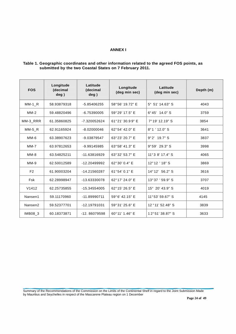
Table 1. Geographic coordinates and other informati on related to the agreed FOS points, as submitted by the two Coastal States on 7 February 2 011.
FOS Longitude (decimal
deg )
Latitude (decimal
deg )
Longitude (deg min sec)
Latitude (deg min sec)
Depth (m)
MM-1_R 58.93879318 -5.85406255 58° 56' 19.72" E 5° 51' 14.63" S 4043
MM-2 59.48820496 -6.75390005 59° 29' 17.5" E 6° 45' 14.0" S 3759
MM-3_RRR 61.35860825 -7.320052624 61° 21' 30.9 9" E 7° 19' 12.19" S 3854
MM-5_R 62.91165924 -8.02000046 62° 54' 42.0" E 8° 1 ' 12.0" S 3641
MM-6 63.38907623 -9.03879547 63° 23' 20.7" E 9° 2' 19.7" S 3837
MM-7 63.97812653 -9.99145985 63° 58' 41.3" E 9° 59' 29.3" S 3998
MM-8 63.54825211 -11.63816929 63° 32' 53.7" E 11° 3 8' 17.4" S 4065
MM-9 62.50012589 -12.20499992 62° 30' 0.4" E 12° 12 ' 18" S 3869
F2 61.90003204 -14.21560287 61° 54' 0.1" E 14° 12' 56.2" S 3616
Fsk 62.28998947 -13.63330078 62° 17' 24.0" E 13° 37 ' 59.9" S 3707
V1412 62.25735855 -15.34554005 62° 15' 26.5" E 15° 20' 43.9" S 4019
Nansen1 59.11170960 -11.89990711 59° 6' 42.15" E 11° 53' 59.67" S 4145
Nansen2 59.52377701 -12.19791031 59° 31' 25.6" E 12 ° 11' 52.48" S 3839
IMB08_3 60.18373871 -12. 86079598 60° 11' 1.46" E 1 2° 51' 38.87" S 3633

Summary of the Recommendations of the Commission on the Limits of the Continental Shelf in regard to the Joint Submission Made by Mauritius and Seychelles in respect of the Mascarene Plateau region on 1 December
Page 25 of 49
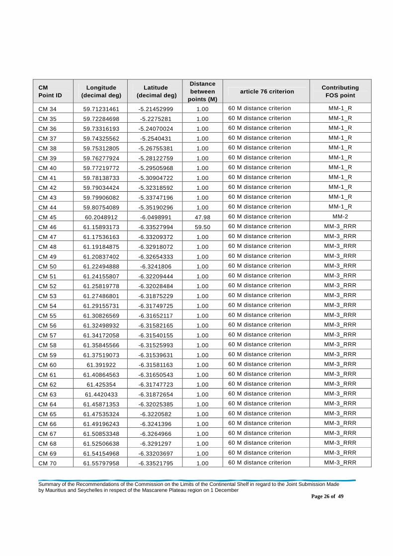
Table 2. Geographic coordinates (DATUM: WGS84) and other information related to the delineation of the outer edge of the continental ma rgin, as provided by the two coastal States on 21 March 2011
CM Point ID
Longitude (decimal deg)
Latitude (decimal deg)
Distance between
points (M) article 76 criterion
Contributing FOS point
CM 1 59.27680588 -4.90806007 0.00
60 M distance criterion / Baseline +200M
MM-1_R
CM 2 59.28062057 -4.90942097 0.24 60 M distance criterion MM-1_R
CM 3 59.29626846 -4.9152565 1.00 60 M distance criterion MM-1_R
CM 4 59.3118248 -4.92135286 1.00 60 M distance criterion MM-1_R
CM 5 59.32727051 -4.92770767 1.00 60 M distance criterion MM-1_R
CM 6 59.34260941 -4.93432045 1.00 60 M distance criterion MM-1_R
CM 7 59.35784149 -4.94118786 1.00 60 M distance criterion MM-1_R
CM 8 59.37295532 -4.94830942 1.00 60 M distance criterion MM-1_R
CM 9 59.38794708 -4.95568085 1.00 60 M distance criterion MM-1_R
CM 10 59.40281296 -4.96330166 1.00 60 M distance criterion MM-1_R
CM 11 59.41755676 -4.97117043 1.00 60 M distance criterion MM-1_R
CM 12 59.43216705 -4.97928381 1.00 60 M distance criterion MM-1_R
CM 13 59.44664001 -4.9876399 1.00 60 M distance criterion MM-1_R
CM 14 59.46097183 -4.9962368 1.00 60 M distance criterion MM-1_R
CM 15 59.47515869 -5.00507212 1.00 60 M distance criterion MM-1_R
CM 16 59.48920059 -5.01414299 1.00 60 M distance criterion MM-1_R
CM 17 59.50308228 -5.02344513 1.00 60 M distance criterion MM-1_R
CM 18 59.51681519 -5.03297901 1.00 60 M distance criterion MM-1_R
CM 19 59.53038788 -5.04274082 1.00 60 M distance criterion MM-1_R
CM 20 59.54379272 -5.05272675 1.00 60 M distance criterion MM-1_R
CM 21 59.55703354 -5.06293631 1.00 60 M distance criterion MM-1_R
CM 22 59.57010269 -5.07336521 1.00 60 M distance criterion MM-1_R
CM 23 59.58299637 -5.08401108 1.00 60 M distance criterion MM-1_R
CM 24 59.59571075 -5.09486961 1.00 60 M distance criterion MM-1_R
CM 25 59.60824585 -5.10594034 1.00 60 M distance criterion MM-1_R
CM 26 59.62059784 -5.11721849 1.00 60 M distance criterion MM-1_R
CM 27 59.63275528 -5.12870073 1.00 60 M distance criterion MM-1_R
CM 28 59.64472198 -5.14038324 1.00 60 M distance criterion MM-1_R
CM 29 59.65649414 -5.15226555 1.00 60 M distance criterion MM-1_R
CM 30 59.66806793 -5.1643424 1.00 60 M distance criterion MM-1_R
CM 31 59.67943954 -5.17660999 1.00 60 M distance criterion MM-1_R
CM 32 59.69060898 -5.18906689 1.00 60 M distance criterion MM-1_R
CM 33 59.70156479 -5.20170832 1.00 60 M distance criterion MM-1_R
Summary of the Recommendations of the Commission on the Limits of the Continental Shelf in regard to the Joint Submission Made by Mauritius and Seychelles in respect of the Mascarene Plateau region on 1 December
Page 26 of 49
CM Point ID
Longitude (decimal deg)
Latitude (decimal deg)
Distance between
points (M) article 76 criterion
Contributing FOS point
CM 34 59.71231461 -5.21452999 1.00 60 M distance criterion MM-1_R
CM 35 59.72284698 -5.2275281 1.00 60 M distance criterion MM-1_R
CM 36 59.73316193 -5.24070024 1.00 60 M distance criterion MM-1_R
CM 37 59.74325562 -5.2540431 1.00 60 M distance criterion MM-1_R
CM 38 59.75312805 -5.26755381 1.00 60 M distance criterion MM-1_R
CM 39 59.76277924 -5.28122759 1.00 60 M distance criterion MM-1_R
CM 40 59.77219772 -5.29505968 1.00 60 M distance criterion MM-1_R
CM 41 59.78138733 -5.30904722 1.00 60 M distance criterion MM-1_R
CM 42 59.79034424 -5.32318592 1.00 60 M distance criterion MM-1_R
CM 43 59.79906082 -5.33747196 1.00 60 M distance criterion MM-1_R
CM 44 59.80754089 -5.35190296 1.00 60 M distance criterion MM-1_R
CM 45 60.2048912 -6.0498991 47.98 60 M distance criterion MM-2
CM 46 61.15893173 -6.33527994 59.50 60 M distance criterion MM-3_RRR
CM 47 61.17536163 -6.33209372 1.00 60 M distance criterion MM-3_RRR
CM 48 61.19184875 -6.32918072 1.00 60 M distance criterion MM-3_RRR
CM 49 61.20837402 -6.32654333 1.00 60 M distance criterion MM-3_RRR
CM 50 61.22494888 -6.3241806 1.00 60 M distance criterion MM-3_RRR
CM 51 61.24155807 -6.32209444 1.00 60 M distance criterion MM-3_RRR
CM 52 61.25819778 -6.32028484 1.00 60 M distance criterion MM-3_RRR
CM 53 61.27486801 -6.31875229 1.00 60 M distance criterion MM-3_RRR
CM 54 61.29155731 -6.31749725 1.00 60 M distance criterion MM-3_RRR
CM 55 61.30826569 -6.31652117 1.00 60 M distance criterion MM-3_RRR
CM 56 61.32498932 -6.31582165 1.00 60 M distance criterion MM-3_RRR
CM 57 61.34172058 -6.31540155 1.00 60 M distance criterion MM-3_RRR
CM 58 61.35845566 -6.31525993 1.00 60 M distance criterion MM-3_RRR
CM 59 61.37519073 -6.31539631 1.00 60 M distance criterion MM-3_RRR
CM 60 61.391922 -6.31581163 1.00 60 M distance criterion MM-3_RRR
CM 61 61.40864563 -6.31650543 1.00 60 M distance criterion MM-3_RRR
CM 62 61.425354 -6.31747723 1.00 60 M distance criterion MM-3_RRR
CM 63 61.4420433 -6.31872654 1.00 60 M distance criterion MM-3_RRR
CM 64 61.45871353 -6.32025385 1.00 60 M distance criterion MM-3_RRR
CM 65 61.47535324 -6.3220582 1.00 60 M distance criterion MM-3_RRR
CM 66 61.49196243 -6.3241396 1.00 60 M distance criterion MM-3_RRR
CM 67 61.50853348 -6.3264966 1.00 60 M distance criterion MM-3_RRR
CM 68 61.52506638 -6.3291297 1.00 60 M distance criterion MM-3_RRR
CM 69 61.54154968 -6.33203697 1.00 60 M distance criterion MM-3_RRR
CM 70 61.55797958 -6.33521795 1.00 60 M distance criterion MM-3_RRR

Summary of the Recommendations of the Commission on the Limits of the Continental Shelf in regard to the Joint Submission Made by Mauritius and Seychelles in respect of the Mascarene Plateau region on 1 December
Page 27 of 49
CM Point ID
Longitude (decimal deg)
Latitude (decimal deg)
Distance between
points (M) article 76 criterion
Contributing FOS point
CM 71 61.57435989 -6.33867264 1.00 60 M distance criterion MM-3_RRR
CM 72 61.59067917 -6.34240007 1.00 60 M distance criterion MM-3_RRR
CM 73 61.60693741 -6.34639788 1.00 60 M distance criterion MM-3_RRR
CM 74 61.62312317 -6.35066462 1.00 60 M distance criterion MM-3_RRR
CM 75 61.63923264 -6.35520077 1.00 60 M distance criterion MM-3_RRR
CM 76 61.65526581 -6.36000395 1.00 60 M distance criterion MM-3_RRR
CM 77 61.67122269 -6.36507416 1.00 60 M distance criterion MM-3_RRR
CM 78 61.68709183 -6.37040901 1.00 60 M distance criterion MM-3_RRR
CM 79 61.7028656 -6.3760066 1.00 60 M distance criterion MM-3_RRR
CM 80 61.71854782 -6.38186646 1.00 60 M distance criterion MM-3_RRR
CM 81 61.73412704 -6.38798571 1.00 60 M distance criterion MM-3_RRR
CM 82 61.74960709 -6.39436436 1.00 60 M distance criterion MM-3_RRR
CM 83 61.76497269 -6.40099859 1.00 60 M distance criterion MM-3_RRR
CM 84 61.78023148 -6.40788794 1.00 60 M distance criterion MM-3_RRR
CM 85 61.79537201 -6.41503096 1.00 60 M distance criterion MM-3_RRR
CM 86 61.8103981 -6.42242527 1.00 60 M distance criterion MM-3_RRR
CM 87 61.82529068 -6.43006754 1.00 60 M distance criterion MM-3_RRR
CM 88 61.84006119 -6.43795681 1.00 60 M distance criterion MM-3_RRR
CM 89 61.85469437 -6.44609165 1.00 60 M distance criterion MM-3_RRR
CM 90 61.86919403 -6.45446777 1.00 60 M distance criterion MM-3_RRR
CM 91 61.88354874 -6.46308422 1.00 60 M distance criterion MM-3_RRR
CM 92 61.89775848 -6.47193909 1.00 60 M distance criterion MM-3_RRR
CM 93 61.91181564 -6.48102808 1.00 60 M distance criterion MM-3_RRR
CM 94 61.92572784 -6.49035025 1.00 60 M distance criterion MM-3_RRR
CM 95 61.93947983 -6.4999032 1.00 60 M distance criterion MM-3_RRR
CM 96 61.95307159 -6.50968266 1.00 60 M distance criterion MM-3_RRR
CM 97 61.96650314 -6.51968861 1.00 60 M distance criterion MM-3_RRR
CM 98 61.97976303 -6.52991676 1.00 60 M distance criterion MM-3_RRR
CM 99 61.99285126 -6.54036427 1.00 60 M distance criterion MM-3_RRR
CM 100 62.00576401 -6.55102587 1.00 60 M distance criterion MM-3_RRR
CM 101 62.01849747 -6.56190205 1.00 60 M distance criterion MM-3_RRR
CM 102 62.03104782 -6.57298803 1.00 60 M distance criterion MM-3_RRR
CM 103 62.04341125 -6.58428144 1.00 60 M distance criterion MM-3_RRR
CM 104 62.05558777 -6.59578037 1.00 60 M distance criterion MM-3_RRR
CM 105 62.06757355 -6.6074791 1.00 60 M distance criterion MM-3_RRR
CM 106 62.96939087 -7.01689148 59.12 60 M distance criterion MM-5_R
CM 107 62.98611832 -7.01798964 1.00 60 M distance criterion MM-5_R
Summary of the Recommendations of the Commission on the Limits of the Continental Shelf in regard to the Joint Submission Made by Mauritius and Seychelles in respect of the Mascarene Plateau region on 1 December
Page 28 of 49
CM Point ID
Longitude (decimal deg)
Latitude (decimal deg)
Distance between
points (M) article 76 criterion
Contributing FOS point
CM 108 63.00282288 -7.01936531 1.00 60 M distance criterion MM-5_R
CM 109 63.01949692 -7.02101803 1.00 60 M distance criterion MM-5_R
CM 110 63.03614807 -7.02294827 1.00 60 M distance criterion MM-5_R
CM 111 63.05276871 -7.02515507 1.00 60 M distance criterion MM-5_R
CM 112 63.06934357 -7.027637 1.00 60 M distance criterion MM-5_R
CM 113 63.08587646 -7.03039455 1.00 60 M distance criterion MM-5_R
CM 114 63.10236359 -7.03342581 1.00 60 M distance criterion MM-5_R
CM 115 63.11879349 -7.03673077 1.00 60 M distance criterion MM-5_R
CM 116 63.13516998 -7.04030848 1.00 60 M distance criterion MM-5_R
CM 117 63.15148544 -7.04415751 1.00 60 M distance criterion MM-5_R
CM 118 63.16772842 -7.04827738 1.00 60 M distance criterion MM-5_R
CM 119 63.18390656 -7.05266619 1.00 60 M distance criterion MM-5_R
CM 120 63.20001221 -7.05732346 1.00 60 M distance criterion MM-5_R
CM 121 63.21603394 -7.0622468 1.00 60 M distance criterion MM-5_R
CM 122 63.23196793 -7.0674367 1.00 60 M distance criterion MM-5_R
CM 123 63.24781799 -7.07289028 1.00 60 M distance criterion MM-5_R
CM 124 63.26357651 -7.07860565 1.00 60 M distance criterion MM-5_R
CM 125 63.27923584 -7.08458376 1.00 60 M distance criterion MM-5_R
CM 126 63.29479218 -7.09081936 1.00 60 M distance criterion MM-5_R
CM 127 63.31024551 -7.09731388 1.00 60 M distance criterion MM-5_R
CM 128 63.32559204 -7.10406446 1.00 60 M distance criterion MM-5_R
CM 129 63.3408165 -7.11106825 1.00 60 M distance criterion MM-5_R
CM 130 63.35593033 -7.11832476 1.00 60 M distance criterion MM-5_R
CM 131 63.37091446 -7.12583017 1.00 60 M distance criterion MM-5_R
CM 132 63.38577652 -7.13358498 1.00 60 M distance criterion MM-5_R
CM 133 63.40050507 -7.1415844 1.00 60 M distance criterion MM-5_R
CM 134 63.41510391 -7.14982796 1.00 60 M distance criterion MM-5_R
CM 135 63.4295578 -7.15831232 1.00 60 M distance criterion MM-5_R
CM 136 63.44386673 -7.16703606 1.00 60 M distance criterion MM-5_R
CM 137 63.45803452 -7.1759963 1.00 60 M distance criterion MM-5_R
CM 138 63.4720459 -7.18518972 1.00 60 M distance criterion MM-5_R
CM 139 63.48590851 -7.19461584 1.00 60 M distance criterion MM-5_R
CM 140 63.49960709 -7.20426989 1.00 60 M distance criterion MM-5_R
CM 141 63.51314545 -7.21415138 1.00 60 M distance criterion MM-5_R
CM 142 63.52651978 -7.22425604 1.00 60 M distance criterion MM-5_R
CM 143 63.53972244 -7.23458195 1.00 60 M distance criterion MM-5_R
CM 144 63.55275345 -7.24512434 1.00 60 M distance criterion MM-5_R

Summary of the Recommendations of the Commission on the Limits of the Continental Shelf in regard to the Joint Submission Made by Mauritius and Seychelles in respect of the Mascarene Plateau region on 1 December
Page 29 of 49
CM Point ID
Longitude (decimal deg)
Latitude (decimal deg)
Distance between
points (M) article 76 criterion
Contributing FOS point
CM 145 63.56560135 -7.25588226 1.00 60 M distance criterion MM-5_R
CM 146 63.57827377 -7.26685238 1.00 60 M distance criterion MM-5_R
CM 147 63.59075928 -7.27803135 1.00 60 M distance criterion MM-5_R
CM 148 63.60306168 -7.28941727 1.00 60 M distance criterion MM-5_R
CM 149 63.61516571 -7.30100489 1.00 60 M distance criterion MM-5_R
CM 150 63.62708282 -7.31279325 1.00 60 M distance criterion MM-5_R
CM 151 63.63879776 -7.32477617 1.00 60 M distance criterion MM-5_R
CM 152 63.65031433 -7.33695221 1.00 60 M distance criterion MM-5_R
CM 153 63.66162491 -7.34931946 1.00 60 M distance criterion MM-5_R
CM 154 63.67272568 -7.36187029 1.00 60 M distance criterion MM-5_R
CM 155 63.68362045 -7.37460566 1.00 60 M distance criterion MM-5_R
CM 156 63.69429779 -7.38752079 1.00 60 M distance criterion MM-5_R
CM 157 63.70476532 -7.40060997 1.00 60 M distance criterion MM-5_R
CM 158 63.71500397 -7.41387129 1.00 60 M distance criterion MM-5_R
CM 159 63.72502518 -7.42730093 1.00 60 M distance criterion MM-5_R
CM 160 63.73482132 -7.44089508 1.00 60 M distance criterion MM-5_R
CM 161 63.74438858 -7.4546504 1.00 60 M distance criterion MM-5_R
CM 162 63.75372696 -7.46856165 1.00 60 M distance criterion MM-5_R
CM 163 63.76283646 -7.48262835 1.00 60 M distance criterion MM-5_R
CM 164 63.77170181 -7.49684191 1.00 60 M distance criterion MM-5_R
CM 165 63.78033447 -7.51120329 1.00 60 M distance criterion MM-5_R
CM 166 63.78872681 -7.52570438 1.00 60 M distance criterion MM-5_R
CM 167 63.796875 -7.54034376 1.00 60 M distance criterion MM-5_R
CM 168 63.80477905 -7.5551157 1.00 60 M distance criterion MM-5_R
CM 169 63.81243896 -7.57001829 1.00 60 M distance criterion MM-5_R
CM 170 63.81984329 -7.58504438 1.00 60 M distance criterion MM-5_R
CM 171 63.82699966 -7.60019302 1.00 60 M distance criterion MM-5_R
CM 172 63.83389664 -7.61545801 1.00 60 M distance criterion MM-5_R
CM 173 63.84054565 -7.63083553 1.00 60 M distance criterion MM-5_R
CM 174 63.84693527 -7.64632082 1.00 60 M distance criterion MM-5_R
CM 175 63.85306168 -7.66190958 1.00 60 M distance criterion MM-5_R
CM 176 64.27495575 -8.55622578 59.01 60 M distance criterion MM-6
CM 177 64.28292847 -8.57097054 1.00 60 M distance criterion MM-6
CM 178 64.80682373 -9.41411877 59.19 60 M distance criterion MM-7
CM 179 64.81641388 -9.42788982 1.00 60 M distance criterion MM-7
CM 180 64.82578278 -9.44181824 1.00 60 M distance criterion MM-7
CM 181 64.83490753 -9.45589828 1.00 60 M distance criterion MM-7

Summary of the Recommendations of the Commission on the Limits of the Continental Shelf in regard to the Joint Submission Made by Mauritius and Seychelles in respect of the Mascarene Plateau region on 1 December
Page 30 of 49
CM Point ID
Longitude (decimal deg)
Latitude (decimal deg)
Distance between
points (M) article 76 criterion
Contributing FOS point
CM 182 64.84379578 -9.47012901 1.00 60 M distance criterion MM-7
CM 183 64.85243988 -9.4845047 1.00 60 M distance criterion MM-7
CM 184 64.8608551 -9.49902058 1.00 60 M distance criterion MM-7
CM 185 64.86901855 -9.51367188 1.00 60 M distance criterion MM-7
CM 186 64.87693787 -9.52845669 1.00 60 M distance criterion MM-7
CM 187 64.88460541 -9.5433712 1.00 60 M distance criterion MM-7
CM 188 64.89202118 -9.55840969 1.00 60 M distance criterion MM-7
CM 189 64.89918518 -9.57356834 1.00 60 M distance criterion MM-7
CM 190 64.90609741 -9.58884335 1.00 60 M distance criterion MM-7
CM 191 64.91275024 -9.60423183 1.00 60 M distance criterion MM-7
CM 192 64.91915131 -9.61972713 1.00 60 M distance criterion MM-7
CM 193 64.92528534 -9.63532543 1.00 60 M distance criterion MM-7
CM 194 64.93115234 -9.65102291 1.00 60 M distance criterion MM-7
CM 195 64.93675995 -9.6668148 1.00 60 M distance criterion MM-7
CM 196 64.94210815 -9.68269825 1.00 60 M distance criterion MM-7
CM 197 64.9471817 -9.69866657 1.00 60 M distance criterion MM-7
CM 198 64.95198822 -9.71471691 1.00 60 M distance criterion MM-7
CM 199 64.95652771 -9.7308445 1.00 60 M distance criterion MM-7
CM 200 64.96079254 -9.74704552 1.00 60 M distance criterion MM-7
CM 201 64.96479034 -9.76331425 1.00 60 M distance criterion MM-7
CM 202 64.96850586 -9.77964783 1.00 60 M distance criterion MM-7
CM 203 64.97195435 -9.79603863 1.00 60 M distance criterion MM-7
CM 204 64.97512054 -9.81248474 1.00 60 M distance criterion MM-7
CM 205 64.97801208 -9.82898045 1.00 60 M distance criterion MM-7
CM 206 64.9806366 -9.84552097 1.00 60 M distance criterion MM-7
CM 207 64.98297119 -9.86210442 1.00 60 M distance criterion MM-7
CM 208 64.98503113 -9.87872219 1.00 60 M distance criterion MM-7
CM 209 64.98681641 -9.8953743 1.00 60 M distance criterion MM-7
CM 210 64.98831177 -9.91205215 1.00 60 M distance criterion MM-7
CM 211 64.98953247 -9.92875195 1.00 60 M distance criterion MM-7
CM 212 64.99047089 -9.94546986 1.00 60 M distance criterion MM-7
CM 213 64.99112701 -9.96220207 1.00 60 M distance criterion MM-7
CM 214 64.99150848 -9.97894192 1.00 60 M distance criterion MM-7
CM 215 64.99160004 -9.99568462 1.00 60 M distance criterion MM-7
CM 216 64.99141693 -10.01242733 1.00 60 M distance criterion MM-7
CM 217 64.99095154 -10.02916527 1.00 60 M distance criterion MM-7
CM 218 64.99020386 -10.04589176 1.00 60 M distance criterion MM-7
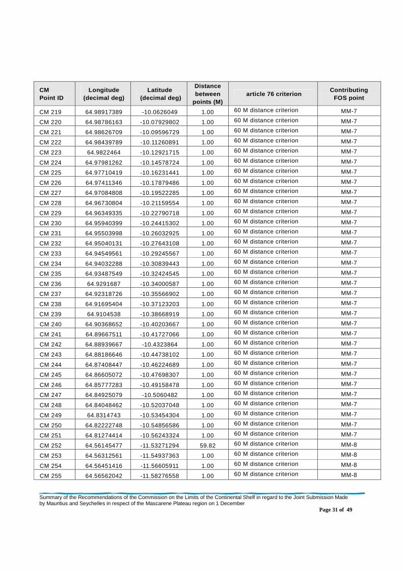
Summary of the Recommendations of the Commission on the Limits of the Continental Shelf in regard to the Joint Submission Made by Mauritius and Seychelles in respect of the Mascarene Plateau region on 1 December
Page 31 of 49
CM Point ID
Longitude (decimal deg)
Latitude (decimal deg)
Distance between
points (M) article 76 criterion
Contributing FOS point
CM 219 64.98917389 -10.0626049 1.00 60 M distance criterion MM-7
CM 220 64.98786163 -10.07929802 1.00 60 M distance criterion MM-7
CM 221 64.98626709 -10.09596729 1.00 60 M distance criterion MM-7
CM 222 64.98439789 -10.11260891 1.00 60 M distance criterion MM-7
CM 223 64.9822464 -10.12921715 1.00 60 M distance criterion MM-7
CM 224 64.97981262 -10.14578724 1.00 60 M distance criterion MM-7
CM 225 64.97710419 -10.16231441 1.00 60 M distance criterion MM-7
CM 226 64.97411346 -10.17879486 1.00 60 M distance criterion MM-7
CM 227 64.97084808 -10.19522285 1.00 60 M distance criterion MM-7
CM 228 64.96730804 -10.21159554 1.00 60 M distance criterion MM-7
CM 229 64.96349335 -10.22790718 1.00 60 M distance criterion MM-7
CM 230 64.95940399 -10.24415302 1.00 60 M distance criterion MM-7
CM 231 64.95503998 -10.26032925 1.00 60 M distance criterion MM-7
CM 232 64.95040131 -10.27643108 1.00 60 M distance criterion MM-7
CM 233 64.94549561 -10.29245567 1.00 60 M distance criterion MM-7
CM 234 64.94032288 -10.30839443 1.00 60 M distance criterion MM-7
CM 235 64.93487549 -10.32424545 1.00 60 M distance criterion MM-7
CM 236 64.9291687 -10.34000587 1.00 60 M distance criterion MM-7
CM 237 64.92318726 -10.35566902 1.00 60 M distance criterion MM-7
CM 238 64.91695404 -10.37123203 1.00 60 M distance criterion MM-7
CM 239 64.9104538 -10.38668919 1.00 60 M distance criterion MM-7
CM 240 64.90368652 -10.40203667 1.00 60 M distance criterion MM-7
CM 241 64.89667511 -10.41727066 1.00 60 M distance criterion MM-7
CM 242 64.88939667 -10.4323864 1.00 60 M distance criterion MM-7
CM 243 64.88186646 -10.44738102 1.00 60 M distance criterion MM-7
CM 244 64.87408447 -10.46224689 1.00 60 M distance criterion MM-7
CM 245 64.86605072 -10.47698307 1.00 60 M distance criterion MM-7
CM 246 64.85777283 -10.49158478 1.00 60 M distance criterion MM-7
CM 247 64.84925079 -10.5060482 1.00 60 M distance criterion MM-7
CM 248 64.84048462 -10.52037048 1.00 60 M distance criterion MM-7
CM 249 64.8314743 -10.53454304 1.00 60 M distance criterion MM-7
CM 250 64.82222748 -10.54856586 1.00 60 M distance criterion MM-7
CM 251 64.81274414 -10.56243324 1.00 60 M distance criterion MM-7
CM 252 64.56145477 -11.53271294 59.82 60 M distance criterion MM-8
CM 253 64.56312561 -11.54937363 1.00 60 M distance criterion MM-8
CM 254 64.56451416 -11.56605911 1.00 60 M distance criterion MM-8
CM 255 64.56562042 -11.58276558 1.00 60 M distance criterion MM-8

Summary of the Recommendations of the Commission on the Limits of the Continental Shelf in regard to the Joint Submission Made by Mauritius and Seychelles in respect of the Mascarene Plateau region on 1 December
Page 32 of 49
CM Point ID
Longitude (decimal deg)
Latitude (decimal deg)
Distance between
points (M) article 76 criterion
Contributing FOS point
CM 256 64.5664444 -11.59948826 1.00 60 M distance criterion MM-8
CM 257 64.56699371 -11.61622238 1.00 60 M distance criterion MM-8
CM 258 64.56725311 -11.63296223 1.00 60 M distance criterion MM-8
CM 259 64.56723022 -11.64970398 1.00 60 M distance criterion MM-8
CM 260 64.56692505 -11.66644287 1.00 60 M distance criterion MM-8
CM 261 64.56633759 -11.68317509 1.00 60 M distance criterion MM-8
CM 262 64.56546021 -11.69989491 1.00 60 M distance criterion MM-8
CM 263 64.56430817 -11.71659756 1.00 60 M distance criterion MM-8
CM 264 64.56286621 -11.73328018 1.00 60 M distance criterion MM-8
CM 265 64.5611496 -11.7499361 1.00 60 M distance criterion MM-8
CM 266 64.5591507 -11.76656151 1.00 60 M distance criterion MM-8
CM 267 64.55686951 -11.78315258 1.00 60 M distance criterion MM-8
CM 268 64.5542984 -11.79970264 1.00 60 M distance criterion MM-8
CM 269 64.55146027 -11.81620979 1.00 60 M distance criterion MM-8
CM 270 64.54833984 -11.8326664 1.00 60 M distance criterion MM-8
CM 271 64.54494476 -11.84907055 1.00 60 M distance criterion MM-8
CM 272 64.54125977 -11.86541557 1.00 60 M distance criterion MM-8
CM 273 64.53730774 -11.88169765 1.00 60 M distance criterion MM-8
CM 274 64.53308105 -11.89791393 1.00 60 M distance criterion MM-8
CM 275 64.52857208 -11.91405678 1.00 60 M distance criterion MM-8
CM 276 64.52379608 -11.93012333 1.00 60 M distance criterion MM-8
CM 277 64.51875305 -11.94611073 1.00 60 M distance criterion MM-8
CM 278 64.51342773 -11.96201134 1.00 60 M distance criterion MM-8
CM 279 64.50784302 -11.97782421 1.00 60 M distance criterion MM-8
CM 280 64.50198364 -11.99354076 1.00 60 M distance criterion MM-8
CM 281 64.49586487 -12.00916195 1.00 60 M distance criterion MM-8
CM 282 64.48947906 -12.02467918 1.00 60 M distance criterion MM-8
CM 283 64.48282623 -12.04008865 1.00 60 M distance criterion MM-8
CM 284 64.47592163 -12.0553875 1.00 60 M distance criterion MM-8
CM 285 64.46875 -12.07056904 1.00 60 M distance criterion MM-8
CM 286 64.4613266 -12.08563137 1.00 60 M distance criterion MM-8
CM 287 64.4536438 -12.10057068 1.00 60 M distance criterion MM-8
CM 288 64.44571686 -12.11538124 1.00 60 M distance criterion MM-8
CM 289 64.43753052 -12.13005829 1.00 60 M distance criterion MM-8
CM 290 64.42910004 -12.14460087 1.00 60 M distance criterion MM-8
CM 291 64.42041779 -12.15900135 1.00 60 M distance criterion MM-8
CM 292 64.41149902 -12.17325592 1.00 60 M distance criterion MM-8

Summary of the Recommendations of the Commission on the Limits of the Continental Shelf in regard to the Joint Submission Made by Mauritius and Seychelles in respect of the Mascarene Plateau region on 1 December
Page 33 of 49
CM Point ID
Longitude (decimal deg)
Latitude (decimal deg)
Distance between
points (M) article 76 criterion
Contributing FOS point
CM 293 64.40233612 -12.18736458 1.00 60 M distance criterion MM-8
CM 294 64.39293671 -12.20132065 1.00 60 M distance criterion MM-8
CM 295 64.38330078 -12.21511936 1.00 60 M distance criterion MM-8
CM 296 64.37342834 -12.22875881 1.00 60 M distance criterion MM-8
CM 297 64.36332703 -12.24223328 1.00 60 M distance criterion MM-8
CM 298 64.35299683 -12.25553894 1.00 60 M distance criterion MM-8
CM 299 64.34244537 -12.2686758 1.00 60 M distance criterion MM-8
CM 300 64.33166504 -12.28163528 1.00 60 M distance criterion MM-8
CM 301 64.32067108 -12.29441643 1.00 60 M distance criterion MM-8
CM 302 64.30945587 -12.30701542 1.00 60 M distance criterion MM-8
CM 303 64.29802704 -12.31942749 1.00 60 M distance criterion MM-8
CM 304 64.28639984 -12.33165169 1.00 60 M distance criterion MM-8
CM 305 64.27455139 -12.34368229 1.00 60 M distance criterion MM-8
CM 306 64.26251221 -12.35551739 1.00 60 M distance criterion MM-8
CM 307 64.25026703 -12.36715126 1.00 60 M distance criterion MM-8
CM 308 64.23782349 -12.37858295 1.00 60 M distance criterion MM-8
CM 309 64.22518921 -12.3898077 1.00 60 M distance criterion MM-8
CM 310 64.2123642 -12.40082455 1.00 60 M distance criterion MM-8
CM 311 64.19935608 -12.41162968 1.00 60 M distance criterion MM-8
CM 312 64.18616486 -12.42221832 1.00 60 M distance criterion MM-8
CM 313 64.17279053 -12.43258953 1.00 60 M distance criterion MM-8
CM 314 64.15924835 -12.44273758 1.00 60 M distance criterion MM-8
CM 315 64.1455307 -12.45266438 1.00 60 M distance criterion MM-8
CM 316 64.1316452 -12.46236324 1.00 60 M distance criterion MM-8
CM 317 64.11759186 -12.47183323 1.00 60 M distance criterion MM-8
CM 318 64.10338593 -12.48107052 1.00 60 M distance criterion MM-8
CM 319 64.0890274 -12.4900732 1.00 60 M distance criterion MM-8
CM 320 64.07450867 -12.49883938 1.00 60 M distance criterion MM-8
CM 321 64.05984497 -12.50736427 1.00 60 M distance criterion MM-8
CM 322 64.04503632 -12.51564789 1.00 60 M distance criterion MM-8
CM 323 64.03009033 -12.52368736 1.00 60 M distance criterion MM-8
CM 324 64.01501465 -12.53147888 1.00 60 M distance criterion MM-8
CM 325 63.99979782 -12.53902245 1.00 60 M distance criterion MM-8
CM 326 63.98446274 -12.54631424 1.00 60 M distance criterion MM-8
CM 327 63.96900177 -12.55335426 1.00 60 M distance criterion MM-8
CM 328 63.95342255 -12.56013775 1.00 60 M distance criterion MM-8
CM 329 63.93772888 -12.5666666 1.00 60 M distance criterion MM-8

Summary of the Recommendations of the Commission on the Limits of the Continental Shelf in regard to the Joint Submission Made by Mauritius and Seychelles in respect of the Mascarene Plateau region on 1 December
Page 34 of 49
CM Point ID
Longitude (decimal deg)
Latitude (decimal deg)
Distance between
points (M) article 76 criterion
Contributing FOS point
CM 330 63.92192459 -12.57293701 1.00 60 M distance criterion MM-8
CM 331 63.90601349 -12.57894611 1.00 60 M distance criterion MM-8
CM 332 63.89001083 -12.584692 1.00 60 M distance criterion MM-8
CM 333 63.87390518 -12.59017467 1.00 60 M distance criterion MM-8
CM 334 63.85770798 -12.59539318 1.00 60 M distance criterion MM-8
CM 335 63.84142685 -12.60034275 1.00 60 M distance criterion MM-8
CM 336 63.8250618 -12.60502434 1.00 60 M distance criterion MM-8
CM 337 63.300354 -13.45549107 59.37 60 M distance criterion Fsk
CM 338 63.30327225 -13.47198486 1.00 60 M distance criterion Fsk
CM 339 63.30591583 -13.48852444 1.00 60 M distance criterion Fsk
CM 340 63.30827713 -13.50510406 1.00 60 M distance criterion Fsk
CM 341 63.31035233 -13.52171993 1.00 60 M distance criterion Fsk
CM 342 63.31214905 -13.53836632 1.00 60 M distance criterion Fsk
CM 343 63.31365585 -13.55504227 1.00 60 M distance criterion Fsk
CM 344 63.314888 -13.5717392 1.00 60 M distance criterion Fsk
CM 345 63.31582642 -13.58845329 1.00 60 M distance criterion Fsk
CM 346 63.31648636 -13.60518074 1.00 60 M distance criterion Fsk
CM 347 63.3168602 -13.62191677 1.00 60 M distance criterion Fsk
CM 348 63.31694412 -13.63865566 1.00 60 M distance criterion Fsk
CM 349 63.31674576 -13.65539455 1.00 60 M distance criterion Fsk
CM 350 63.31626511 -13.67212772 1.00 60 M distance criterion Fsk
CM 351 63.31549835 -13.68885136 1.00 60 M distance criterion Fsk
CM 352 63.31444168 -13.70555782 1.00 60 M distance criterion Fsk
CM 353 63.31310272 -13.72224712 1.00 60 M distance criterion Fsk
CM 354 63.31148148 -13.73890972 1.00 60 M distance criterion Fsk
CM 355 63.30957794 -13.75554562 1.00 60 M distance criterion Fsk
CM 356 63.30738449 -13.77214813 1.00 60 M distance criterion Fsk
CM 357 63.30491257 -13.7887125 1.00 60 M distance criterion Fsk
CM 358 63.30215836 -13.80523491 1.00 60 M distance criterion Fsk
CM 359 63.29912186 -13.82170773 1.00 60 M distance criterion Fsk
CM 360 63.29580307 -13.83813095 1.00 60 M distance criterion Fsk
CM 361 63.29220581 -13.854496 1.00 60 M distance criterion Fsk
CM 362 63.28832245 -13.87080193 1.00 60 M distance criterion Fsk
CM 363 63.28416824 -13.88704109 1.00 60 M distance criterion Fsk
CM 364 63.27973557 -13.90321064 1.00 60 M distance criterion Fsk
CM 365 63.27502823 -13.9193058 1.00 60 M distance criterion Fsk
CM 366 63.27004242 -13.93532181 1.00 60 M distance criterion Fsk
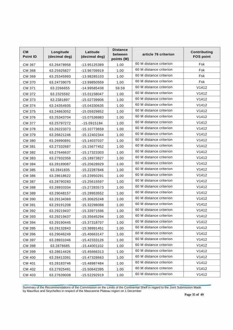
Summary of the Recommendations of the Commission on the Limits of the Continental Shelf in regard to the Joint Submission Made by Mauritius and Seychelles in respect of the Mascarene Plateau region on 1 December
Page 35 of 49
CM Point ID
Longitude (decimal deg)
Latitude (decimal deg)
Distance between
points (M) article 76 criterion
Contributing FOS point
CM 367 63.26478958 -13.95125389 1.00 60 M distance criterion Fsk
CM 368 63.25925827 -13.96709919 1.00 60 M distance criterion Fsk
CM 369 63.25345993 -13.98285103 1.00 60 M distance criterion Fsk
CM 370 63.24739075 -13.99850559 1.00 60 M distance criterion Fsk
CM 371 63.2266655 -14.99585438 59.59 60 M distance criterion V1412
CM 372 63.2325592 -15.01158047 1.00 60 M distance criterion V1412
CM 373 63.2381897 -15.02739906 1.00 60 M distance criterion V1412
CM 374 63.24354935 -15.04330635 1.00 60 M distance criterion V1412
CM 375 63.24863052 -15.05929852 1.00 60 M distance criterion V1412
CM 376 63.25343704 -15.07536983 1.00 60 M distance criterion V1412
CM 377 63.25797272 -15.0915184 1.00 60 M distance criterion V1412
CM 378 63.26223373 -15.10773659 1.00 60 M distance criterion V1412
CM 379 63.26621246 -15.12402344 1.00 60 M distance criterion V1412
CM 380 63.26990891 -15.14037037 1.00 60 M distance criterion V1412
CM 381 63.27332687 -15.15677452 1.00 60 M distance criterion V1412
CM 382 63.27646637 -15.17323303 1.00 60 M distance criterion V1412
CM 383 63.27932358 -15.18973827 1.00 60 M distance criterion V1412
CM 384 63.28189087 -15.20628929 1.00 60 M distance criterion V1412
CM 385 63.2841835 -15.22287846 1.00 60 M distance criterion V1412
CM 386 63.28618622 -15.23950291 1.00 60 M distance criterion V1412
CM 387 63.28790283 -15.25615597 1.00 60 M distance criterion V1412
CM 388 63.28933334 -15.27283573 1.00 60 M distance criterion V1412
CM 389 63.29048157 -15.28953552 1.00 60 M distance criterion V1412
CM 390 63.29134369 -15.30625248 1.00 60 M distance criterion V1412
CM 391 63.29191208 -15.32298088 1.00 60 M distance criterion V1412
CM 392 63.29219437 -15.33971596 1.00 60 M distance criterion V1412
CM 393 63.29219437 -15.35645294 1.00 60 M distance criterion V1412
CM 394 63.29190445 -15.37318707 1.00 60 M distance criterion V1412
CM 395 63.29132843 -15.38991451 1.00 60 M distance criterion V1412
CM 396 63.29046249 -15.40663147 1.00 60 M distance criterion V1412
CM 397 63.28931046 -15.42333126 1.00 60 M distance criterion V1412
CM 398 63.2878685 -15.44001102 1.00 60 M distance criterion V1412
CM 399 63.28614426 -15.45666313 1.00 60 M distance criterion V1412
CM 400 63.28413391 -15.47328663 1.00 60 M distance criterion V1412
CM 401 63.28183746 -15.48987484 1.00 60 M distance criterion V1412
CM 402 63.27925491 -15.50642395 1.00 60 M distance criterion V1412
CM 403 63.27639008 -15.52292919 1.00 60 M distance criterion V1412

Summary of the Recommendations of the Commission on the Limits of the Continental Shelf in regard to the Joint Submission Made by Mauritius and Seychelles in respect of the Mascarene Plateau region on 1 December
Page 36 of 49
CM Point ID
Longitude (decimal deg)
Latitude (decimal deg)
Distance between
points (M) article 76 criterion
Contributing FOS point
CM 404 63.27323532 -15.53938389 1.00 60 M distance criterion V1412
CM 405 63.26980591 -15.55578709 1.00 60 M distance criterion V1412
CM 406 63.26608658 -15.57213116 1.00 60 M distance criterion V1412
CM 407 63.26209259 -15.58841515 1.00 60 M distance criterion V1412
CM 408 63.2578125 -15.60462952 1.00 60 M distance criterion V1412
CM 409 63.25325775 -15.62077427 1.00 60 M distance criterion V1412
CM 410 63.24842453 -15.63684177 1.00 60 M distance criterion V1412
CM 411 63.24331284 -15.65283012 1.00 60 M distance criterion V1412
CM 412 63.2379303 -15.66873169 1.00 60 M distance criterion V1412
CM 413 63.23226929 -15.68454456 1.00 60 M distance criterion V1412
CM 414 63.22634125 -15.70026398 1.00 60 M distance criterion V1412
CM 415 63.22013855 -15.71588516 1.00 60 M distance criterion V1412
CM 416 63.21366882 -15.7314043 1.00 60 M distance criterion V1412
CM 417 63.20693207 -15.74681759 1.00 60 M distance criterion V1412
CM 418 63.19992828 -15.76211739 1.00 60 M distance criterion V1412
CM 419 63.19266129 -15.7773037 1.00 60 M distance criterion V1412
CM 420 63.18513489 -15.79236984 1.00 60 M distance criterion V1412
CM 421 63.17734909 -15.80731201 1.00 60 M distance criterion V1412
CM 422 63.16930771 -15.82212639 1.00 60 M distance criterion V1412
CM 423 63.16100693 -15.83680916 1.00 60 M distance criterion V1412
CM 424 63.15245438 -15.85135555 1.00 60 M distance criterion V1412
CM 425 63.14365005 -15.86575985 1.00 60 M distance criterion V1412
CM 426 63.13460159 -15.8800211 1.00 60 M distance criterion V1412
CM 427 63.12530518 -15.89413452 1.00 60 M distance criterion V1412
CM 428 63.12361526 -15.89661980 0.18
60 M distance criterion / Baseline +200M
V1412

Summary of the Recommendations of the Commission on the Limits of the Continental Shelf in regard to the Joint Submission Made by Mauritius and Seychelles in respect of the Mascarene Plateau region on 1 December
Page 37 of 49
Table 3. Geographic coordinates (DATUM WGS 84) and other information related to the outer limit of the continental shelf beyond 200 M and the corresponding foot of the slope/base points, as provided by the two coastal States on 16 March 2011
ECS Point ID
Longitude (decimal deg)
Latitude (decimal deg)
Distance between
points (M) article 76 criterion
Contributing FOS point
ECS 1 59.27680588 -4.90806007 0.00 60 M distance criterion / Baseline +200M
MM-1_R
ECS 2 59.28105164 -4.90956497 0.27 60 M distance criterion MM-1_R
ECS 3 59.29670334 -4.91540956 1.00 60 M distance criterion MM-1_R
ECS 4 59.31225586 -4.92151403 1.00 60 M distance criterion MM-1_R
ECS 5 59.32770157 -4.92787600 1.00 60 M distance criterion MM-1_R
ECS 6 59.34303665 -4.93449545 1.00 60 M distance criterion MM-1_R
ECS 7 59.35826111 -4.94137001 1.00 60 M distance criterion MM-1_R
ECS 8 59.37337112 -4.94849682 1.00 60 M distance criterion MM-1_R
ECS 9 59.38836288 -4.95587683 1.00 60 M distance criterion MM-1_R
ECS 10 59.40323257 -4.96350431 1.00 60 M distance criterion MM-1_R
ECS 11 59.41796875 -4.97137928 1.00 60 M distance criterion MM-1_R
ECS 12 59.43257141 -4.97949934 1.00 60 M distance criterion MM-1_R
ECS 13 59.44704437 -4.98786354 1.00 60 M distance criterion MM-1_R
ECS 14 59.46137238 -4.99646616 1.00 60 M distance criterion MM-1_R
ECS 15 59.47555161 -5.00530624 1.00 60 M distance criterion MM-1_R
ECS 16 59.48958588 -5.01438284 1.00 60 M distance criterion MM-1_R
ECS 17 59.50346756 -5.02369118 1.00 60 M distance criterion MM-1_R
ECS 18 59.51719284 -5.03323078 1.00 60 M distance criterion MM-1_R
ECS 19 59.53075790 -5.04299784 1.00 60 M distance criterion MM-1_R
ECS 20 59.54415894 -5.05298948 1.00 60 M distance criterion MM-1_R
ECS 21 59.55739212 -5.06320477 1.00 60 M distance criterion MM-1_R
ECS 22 59.57045746 -5.07363844 1.00 60 M distance criterion MM-1_R
ECS 23 59.58334732 -5.08429050 1.00 60 M distance criterion MM-1_R
ECS 24 59.59605789 -5.09515572 1.00 60 M distance criterion MM-1_R
ECS 25 59.60858536 -5.10623217 1.00 60 M distance criterion MM-1_R
ECS 26 59.62093353 -5.11751652 1.00 60 M distance criterion MM-1_R
ECS 27 59.63308716 -5.12900496 1.00 60 M distance criterion MM-1_R
ECS 28 59.64505005 -5.14069462 1.00 60 M distance criterion MM-1_R
ECS 29 59.65681839 -5.15258312 1.00 60 M distance criterion MM-1_R
ECS 30 59.66838837 -5.16466522 1.00 60 M distance criterion MM-1_R
ECS 31 59.67975616 -5.17693901 1.00 60 M distance criterion MM-1_R
ECS 32 59.69091797 -5.18940115 1.00 60 M distance criterion MM-1_R
ECS 33 59.70186615 -5.20204639 1.00 60 M distance criterion MM-1_R
ECS 34 59.71261215 -5.21487331 1.00 60 M distance criterion MM-1_R
ECS 35 59.72314072 -5.22787952 1.00 60 M distance criterion MM-1_R
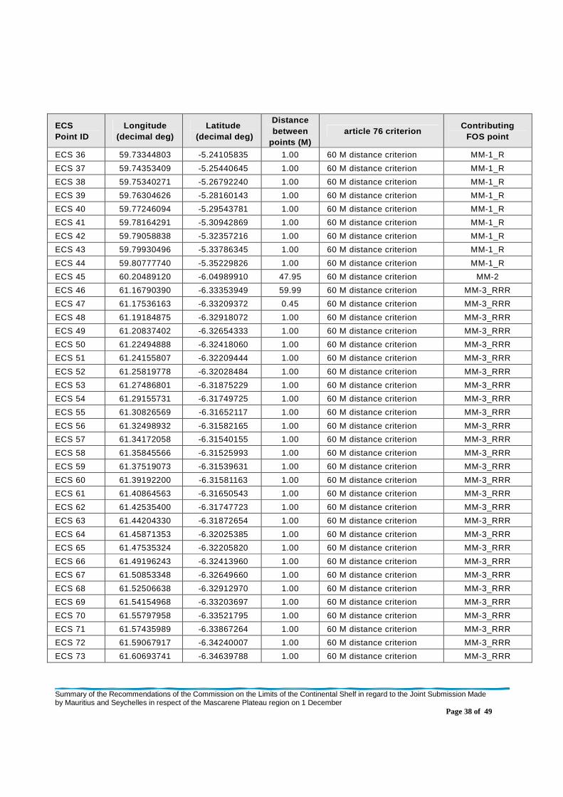
Summary of the Recommendations of the Commission on the Limits of the Continental Shelf in regard to the Joint Submission Made by Mauritius and Seychelles in respect of the Mascarene Plateau region on 1 December
Page 38 of 49
ECS Point ID
Longitude (decimal deg)
Latitude (decimal deg)
Distance between
points (M) article 76 criterion
Contributing FOS point
ECS 36 59.73344803 -5.24105835 1.00 60 M distance criterion MM-1_R
ECS 37 59.74353409 -5.25440645 1.00 60 M distance criterion MM-1_R
ECS 38 59.75340271 -5.26792240 1.00 60 M distance criterion MM-1_R
ECS 39 59.76304626 -5.28160143 1.00 60 M distance criterion MM-1_R
ECS 40 59.77246094 -5.29543781 1.00 60 M distance criterion MM-1_R
ECS 41 59.78164291 -5.30942869 1.00 60 M distance criterion MM-1_R
ECS 42 59.79058838 -5.32357216 1.00 60 M distance criterion MM-1_R
ECS 43 59.79930496 -5.33786345 1.00 60 M distance criterion MM-1_R
ECS 44 59.80777740 -5.35229826 1.00 60 M distance criterion MM-1_R
ECS 45 60.20489120 -6.04989910 47.95 60 M distance criterion MM-2
ECS 46 61.16790390 -6.33353949 59.99 60 M distance criterion MM-3_RRR
ECS 47 61.17536163 -6.33209372 0.45 60 M distance criterion MM-3_RRR
ECS 48 61.19184875 -6.32918072 1.00 60 M distance criterion MM-3_RRR
ECS 49 61.20837402 -6.32654333 1.00 60 M distance criterion MM-3_RRR
ECS 50 61.22494888 -6.32418060 1.00 60 M distance criterion MM-3_RRR
ECS 51 61.24155807 -6.32209444 1.00 60 M distance criterion MM-3_RRR
ECS 52 61.25819778 -6.32028484 1.00 60 M distance criterion MM-3_RRR
ECS 53 61.27486801 -6.31875229 1.00 60 M distance criterion MM-3_RRR
ECS 54 61.29155731 -6.31749725 1.00 60 M distance criterion MM-3_RRR
ECS 55 61.30826569 -6.31652117 1.00 60 M distance criterion MM-3_RRR
ECS 56 61.32498932 -6.31582165 1.00 60 M distance criterion MM-3_RRR
ECS 57 61.34172058 -6.31540155 1.00 60 M distance criterion MM-3_RRR
ECS 58 61.35845566 -6.31525993 1.00 60 M distance criterion MM-3_RRR
ECS 59 61.37519073 -6.31539631 1.00 60 M distance criterion MM-3_RRR
ECS 60 61.39192200 -6.31581163 1.00 60 M distance criterion MM-3_RRR
ECS 61 61.40864563 -6.31650543 1.00 60 M distance criterion MM-3_RRR
ECS 62 61.42535400 -6.31747723 1.00 60 M distance criterion MM-3_RRR
ECS 63 61.44204330 -6.31872654 1.00 60 M distance criterion MM-3_RRR
ECS 64 61.45871353 -6.32025385 1.00 60 M distance criterion MM-3_RRR
ECS 65 61.47535324 -6.32205820 1.00 60 M distance criterion MM-3_RRR
ECS 66 61.49196243 -6.32413960 1.00 60 M distance criterion MM-3_RRR
ECS 67 61.50853348 -6.32649660 1.00 60 M distance criterion MM-3_RRR
ECS 68 61.52506638 -6.32912970 1.00 60 M distance criterion MM-3_RRR
ECS 69 61.54154968 -6.33203697 1.00 60 M distance criterion MM-3_RRR
ECS 70 61.55797958 -6.33521795 1.00 60 M distance criterion MM-3_RRR
ECS 71 61.57435989 -6.33867264 1.00 60 M distance criterion MM-3_RRR
ECS 72 61.59067917 -6.34240007 1.00 60 M distance criterion MM-3_RRR
ECS 73 61.60693741 -6.34639788 1.00 60 M distance criterion MM-3_RRR

Summary of the Recommendations of the Commission on the Limits of the Continental Shelf in regard to the Joint Submission Made by Mauritius and Seychelles in respect of the Mascarene Plateau region on 1 December
Page 39 of 49
ECS Point ID
Longitude (decimal deg)
Latitude (decimal deg)
Distance between
points (M) article 76 criterion
Contributing FOS point
ECS 74 61.62312317 -6.35066462 1.00 60 M distance criterion MM-3_RRR
ECS 75 61.63923264 -6.35520077 1.00 60 M distance criterion MM-3_RRR
ECS 76 61.65526581 -6.36000395 1.00 60 M distance criterion MM-3_RRR
ECS 77 61.67122269 -6.36507416 1.00 60 M distance criterion MM-3_RRR
ECS 78 61.68709183 -6.37040901 1.00 60 M distance criterion MM-3_RRR
ECS 79 61.70286560 -6.37600660 1.00 60 M distance criterion MM-3_RRR
ECS 80 61.71854782 -6.38186646 1.00 60 M distance criterion MM-3_RRR
ECS 81 61.73412704 -6.38798571 1.00 60 M distance criterion MM-3_RRR
ECS 82 61.74960709 -6.39436436 1.00 60 M distance criterion MM-3_RRR
ECS 83 61.76497269 -6.40099859 1.00 60 M distance criterion MM-3_RRR
ECS 84 61.78023148 -6.40788794 1.00 60 M distance criterion MM-3_RRR
ECS 85 61.79537201 -6.41503096 1.00 60 M distance criterion MM-3_RRR
ECS 86 61.81039810 -6.42242527 1.00 60 M distance criterion MM-3_RRR
ECS 87 61.82529068 -6.43006754 1.00 60 M distance criterion MM-3_RRR
ECS 88 61.84006119 -6.43795681 1.00 60 M distance criterion MM-3_RRR
ECS 89 61.85469437 -6.44609165 1.00 60 M distance criterion MM-3_RRR
ECS 90 61.86919403 -6.45446777 1.00 60 M distance criterion MM-3_RRR
ECS 91 61.88354874 -6.46308422 1.00 60 M distance criterion MM-3_RRR
ECS 92 61.89775848 -6.47193909 1.00 60 M distance criterion MM-3_RRR
ECS 93 61.91181564 -6.48102808 1.00 60 M distance criterion MM-3_RRR
ECS 94 61.92572784 -6.49035025 1.00 60 M distance criterion MM-3_RRR
ECS 95 61.93947983 -6.49990320 1.00 60 M distance criterion MM-3_RRR
ECS 96 61.95307159 -6.50968266 1.00 60 M distance criterion MM-3_RRR
ECS 97 61.96650314 -6.51968861 1.00 60 M distance criterion MM-3_RRR
ECS 98 61.97976303 -6.52991676 1.00 60 M distance criterion MM-3_RRR
ECS 99 61.99285126 -6.54036427 1.00 60 M distance criterion MM-3_RRR
ECS 100 62.00576401 -6.55102587 1.00 60 M distance criterion MM-3_RRR
ECS 101 62.01849747 -6.56190205 1.00 60 M distance criterion MM-3_RRR
ECS 102 62.03104782 -6.57298803 1.00 60 M distance criterion MM-3_RRR
ECS 103 62.04341125 -6.58428144 1.00 60 M distance criterion MM-3_RRR
ECS 104 62.05558777 -6.59578037 1.00 60 M distance criterion MM-3_RRR
ECS 105 62.06757355 -6.60747910 1.00 60 M distance criterion MM-3_RRR
ECS 106 62.14421082 -6.64228535 5.03 60 M chord/ 350M constraint point
N/A
ECS 107 62.14431381 -6.64349413 0.07 350M constraint point N/A
ECS 108 62.14571762 -6.66018200 1.00 350M constraint point N/A
ECS 109 62.14706802 -6.67687464 1.00 350M constraint point N/A
ECS 110 62.14837265 -6.69357014 1.00 350M constraint point N/A
ECS 111 62.14962769 -6.71026993 1.00 350M constraint point N/A
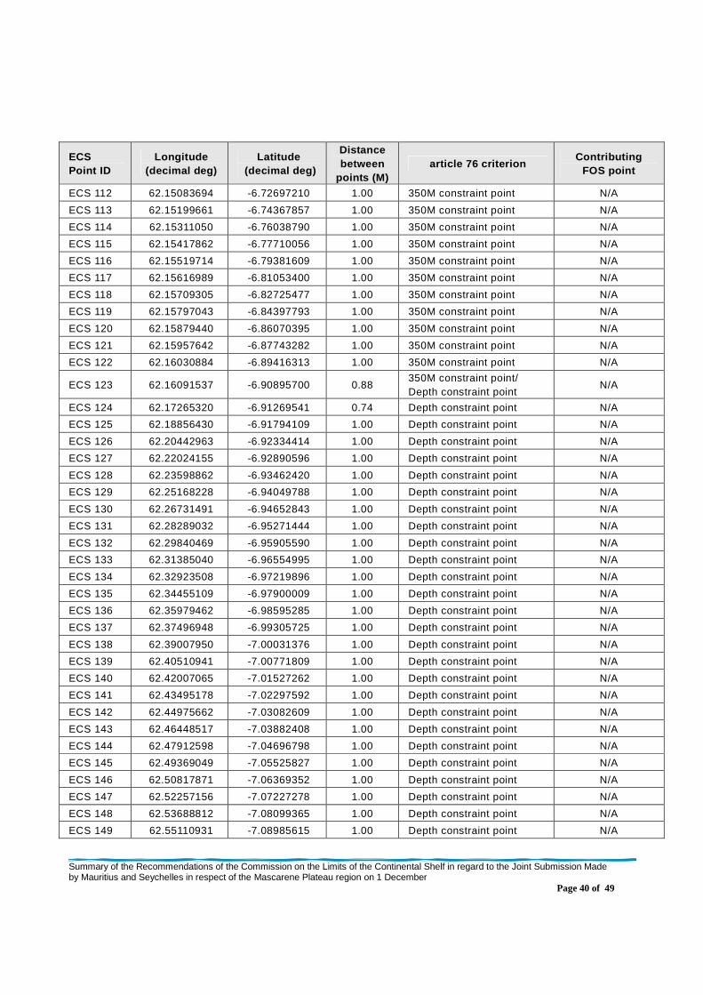
Summary of the Recommendations of the Commission on the Limits of the Continental Shelf in regard to the Joint Submission Made by Mauritius and Seychelles in respect of the Mascarene Plateau region on 1 December
Page 40 of 49
ECS Point ID
Longitude (decimal deg)
Latitude (decimal deg)
Distance between
points (M) article 76 criterion
Contributing FOS point
ECS 112 62.15083694 -6.72697210 1.00 350M constraint point N/A
ECS 113 62.15199661 -6.74367857 1.00 350M constraint point N/A
ECS 114 62.15311050 -6.76038790 1.00 350M constraint point N/A
ECS 115 62.15417862 -6.77710056 1.00 350M constraint point N/A
ECS 116 62.15519714 -6.79381609 1.00 350M constraint point N/A
ECS 117 62.15616989 -6.81053400 1.00 350M constraint point N/A
ECS 118 62.15709305 -6.82725477 1.00 350M constraint point N/A
ECS 119 62.15797043 -6.84397793 1.00 350M constraint point N/A
ECS 120 62.15879440 -6.86070395 1.00 350M constraint point N/A
ECS 121 62.15957642 -6.87743282 1.00 350M constraint point N/A
ECS 122 62.16030884 -6.89416313 1.00 350M constraint point N/A
ECS 123 62.16091537 -6.90895700 0.88 350M constraint point/ Depth constraint point
N/A
ECS 124 62.17265320 -6.91269541 0.74 Depth constraint point N/A
ECS 125 62.18856430 -6.91794109 1.00 Depth constraint point N/A
ECS 126 62.20442963 -6.92334414 1.00 Depth constraint point N/A
ECS 127 62.22024155 -6.92890596 1.00 Depth constraint point N/A
ECS 128 62.23598862 -6.93462420 1.00 Depth constraint point N/A
ECS 129 62.25168228 -6.94049788 1.00 Depth constraint point N/A
ECS 130 62.26731491 -6.94652843 1.00 Depth constraint point N/A
ECS 131 62.28289032 -6.95271444 1.00 Depth constraint point N/A
ECS 132 62.29840469 -6.95905590 1.00 Depth constraint point N/A
ECS 133 62.31385040 -6.96554995 1.00 Depth constraint point N/A
ECS 134 62.32923508 -6.97219896 1.00 Depth constraint point N/A
ECS 135 62.34455109 -6.97900009 1.00 Depth constraint point N/A
ECS 136 62.35979462 -6.98595285 1.00 Depth constraint point N/A
ECS 137 62.37496948 -6.99305725 1.00 Depth constraint point N/A
ECS 138 62.39007950 -7.00031376 1.00 Depth constraint point N/A
ECS 139 62.40510941 -7.00771809 1.00 Depth constraint point N/A
ECS 140 62.42007065 -7.01527262 1.00 Depth constraint point N/A
ECS 141 62.43495178 -7.02297592 1.00 Depth constraint point N/A
ECS 142 62.44975662 -7.03082609 1.00 Depth constraint point N/A
ECS 143 62.46448517 -7.03882408 1.00 Depth constraint point N/A
ECS 144 62.47912598 -7.04696798 1.00 Depth constraint point N/A
ECS 145 62.49369049 -7.05525827 1.00 Depth constraint point N/A
ECS 146 62.50817871 -7.06369352 1.00 Depth constraint point N/A
ECS 147 62.52257156 -7.07227278 1.00 Depth constraint point N/A
ECS 148 62.53688812 -7.08099365 1.00 Depth constraint point N/A
ECS 149 62.55110931 -7.08985615 1.00 Depth constraint point N/A

Summary of the Recommendations of the Commission on the Limits of the Continental Shelf in regard to the Joint Submission Made by Mauritius and Seychelles in respect of the Mascarene Plateau region on 1 December
Page 41 of 49
ECS Point ID
Longitude (decimal deg)
Latitude (decimal deg)
Distance between
points (M) article 76 criterion
Contributing FOS point
ECS 150 62.56524277 -7.09886122 1.00 Depth constraint point N/A
ECS 151 62.57928848 -7.10800505 1.00 Depth constraint point N/A
ECS 152 62.59323883 -7.11728811 1.00 Depth constraint point N/A
ECS 153 62.60710144 -7.12671137 1.00 Depth constraint point N/A
ECS 154 62.62086487 -7.13627148 1.00 Depth constraint point N/A
ECS 155 62.63453293 -7.14596748 1.00 Depth constraint point N/A
ECS 156 62.64810181 -7.15579844 1.00 Depth constraint point N/A
ECS 157 62.66157913 -7.16576481 1.00 Depth constraint point N/A
ECS 158 62.67495346 -7.17586517 1.00 Depth constraint point N/A
ECS 159 62.68822861 -7.18609715 1.00 Depth constraint point N/A
ECS 160 62.70139694 -7.19646263 1.00 Depth constraint point N/A
ECS 161 62.71446228 -7.20695877 1.00 Depth constraint point N/A
ECS 162 62.72742462 -7.21758318 1.00 Depth constraint point N/A
ECS 163 62.74028015 -7.22833681 1.00 Depth constraint point N/A
ECS 164 62.75302505 -7.23921728 1.00 Depth constraint point N/A
ECS 165 62.76566696 -7.25022507 1.00 Depth constraint point N/A
ECS 166 62.77819824 -7.26135778 1.00 Depth constraint point N/A
ECS 167 62.79061127 -7.27261400 1.00 Depth constraint point N/A
ECS 168 62.80291367 -7.28399372 1.00 Depth constraint point N/A
ECS 169 62.81510544 -7.29549551 1.00 Depth constraint point N/A
ECS 170 62.82718277 -7.30711746 1.00 Depth constraint point N/A
ECS 171 62.83914566 -7.31886101 1.00 Depth constraint point N/A
ECS 172 62.85098267 -7.33071995 1.00 Depth constraint point N/A
ECS 173 62.86270523 -7.34269810 1.00 Depth constraint point N/A
ECS 174 62.87430954 -7.35479164 1.00 Depth constraint point N/A
ECS 175 62.88578796 -7.36700201 1.00 Depth constraint point N/A
ECS 176 62.89714813 -7.37932396 1.00 Depth constraint point N/A
ECS 177 62.90838623 -7.39175987 1.00 Depth constraint point N/A
ECS 178 62.91949844 -7.40430641 1.00 Depth constraint point N/A
ECS 179 62.93048477 -7.41696167 1.00 Depth constraint point N/A
ECS 180 62.94134140 -7.42972660 1.00 Depth constraint point N/A
ECS 181 62.95207214 -7.44259834 1.00 Depth constraint point N/A
ECS 182 62.96267700 -7.45557690 1.00 Depth constraint point N/A
ECS 183 62.97314835 -7.46866083 1.00 Depth constraint point N/A
ECS 184 62.98348999 -7.48184776 1.00 Depth constraint point N/A
ECS 185 62.99370193 -7.49513769 1.00 Depth constraint point N/A
ECS 186 63.00377655 -7.50852728 1.00 Depth constraint point N/A
ECS 187 63.30073547 -7.91089344 29.84 Depth constraint point N/A

Summary of the Recommendations of the Commission on the Limits of the Continental Shelf in regard to the Joint Submission Made by Mauritius and Seychelles in respect of the Mascarene Plateau region on 1 December
Page 42 of 49
ECS Point ID
Longitude (decimal deg)
Latitude (decimal deg)
Distance between
points (M) article 76 criterion
Contributing FOS point
ECS 188 63.99520874 -8.63939953 59.99 Depth constraint point N/A
ECS 189 64.00283813 -8.64674473 0.63 Depth constraint point N/A
ECS 190 64.01480865 -8.65851116 1.00 Depth constraint point N/A
ECS 191 64.02666473 -8.67039585 1.00 Depth constraint point N/A
ECS 192 64.03840637 -8.68239594 1.00 Depth constraint point N/A
ECS 193 64.05001831 -8.69451237 1.00 Depth constraint point N/A
ECS 194 64.06151581 -8.70674229 1.00 Depth constraint point N/A
ECS 195 64.07288361 -8.71908665 1.00 Depth constraint point N/A
ECS 196 64.08412933 -8.73154259 1.00 Depth constraint point N/A
ECS 197 64.09525299 -8.74411106 1.00 Depth constraint point N/A
ECS 198 64.10624695 -8.75678825 1.00 Depth constraint point N/A
ECS 199 64.11711884 -8.76957417 1.00 Depth constraint point N/A
ECS 200 64.12786102 -8.78246784 1.00 Depth constraint point N/A
ECS 201 64.13847351 -8.79546642 1.00 Depth constraint point N/A
ECS 202 64.14895630 -8.80856991 1.00 Depth constraint point N/A
ECS 203 64.15930176 -8.82177639 1.00 Depth constraint point N/A
ECS 204 64.16952515 -8.83508396 1.00 Depth constraint point N/A
ECS 205 64.17960358 -8.84849358 1.00 Depth constraint point N/A
ECS 206 64.18955231 -8.86200142 1.00 Depth constraint point N/A
ECS 207 64.19937134 -8.87560654 1.00 Depth constraint point N/A
ECS 208 64.20904541 -8.88930893 1.00 Depth constraint point N/A
ECS 209 64.21858215 -8.90310764 1.00 Depth constraint point N/A
ECS 210 64.22798157 -8.91699982 1.00 Depth constraint point N/A
ECS 211 64.23724365 -8.93098354 1.00 Depth constraint point N/A
ECS 212 64.24636841 -8.94505882 1.00 Depth constraint point N/A
ECS 213 64.25534821 -8.95922375 1.00 Depth constraint point N/A
ECS 214 64.26418304 -8.97347832 1.00 Depth constraint point N/A
ECS 215 64.27288055 -8.98781776 1.00 Depth constraint point N/A
ECS 216 64.28143311 -9.00224400 1.00 Depth constraint point N/A
ECS 217 64.28984070 -9.01675510 1.00 Depth constraint point N/A
ECS 218 64.29809570 -9.03134918 1.00 Depth constraint point N/A
ECS 219 64.30621338 -9.04602337 1.00 Depth constraint point N/A
ECS 220 64.31417847 -9.06077766 1.00 Depth constraint point N/A
ECS 221 64.66599274 -9.72202778 44.66 Depth constraint point N/A
ECS 222 64.67373657 -9.73690510 1.00 Depth constraint point N/A
ECS 223 64.68132782 -9.75185776 1.00 Depth constraint point N/A
ECS 224 64.68877411 -9.76688576 1.00 Depth constraint point N/A
ECS 225 64.69606781 -9.78198719 1.00 Depth constraint point N/A

Summary of the Recommendations of the Commission on the Limits of the Continental Shelf in regard to the Joint Submission Made by Mauritius and Seychelles in respect of the Mascarene Plateau region on 1 December
Page 43 of 49
ECS Point ID
Longitude (decimal deg)
Latitude (decimal deg)
Distance between
points (M) article 76 criterion
Contributing FOS point
ECS 226 64.70320892 -9.79715919 1.00 Depth constraint point N/A
ECS 227 64.71019745 -9.81239986 1.00 Depth constraint point N/A
ECS 228 64.71703339 -9.82771015 1.00 Depth constraint point N/A
ECS 229 64.72371674 -9.84308815 1.00 Depth constraint point N/A
ECS 230 64.73023987 -9.85853100 1.00 Depth constraint point N/A
ECS 231 64.73661041 -9.87403774 1.00 Depth constraint point N/A
ECS 232 64.74282837 -9.88960648 1.00 Depth constraint point N/A
ECS 233 64.74888611 -9.90523720 1.00 Depth constraint point N/A
ECS 234 64.75479126 -9.92092419 1.00 Depth constraint point N/A
ECS 235 64.76053619 -9.93666935 1.00 Depth constraint point N/A
ECS 236 64.76611328 -9.95247269 1.00 Depth constraint point N/A
ECS 237 64.77153778 -9.96832848 1.00 Depth constraint point N/A
ECS 238 64.77680206 -9.98423862 1.00 Depth constraint point N/A
ECS 239 64.78191376 -10.00019836 1.00 Depth constraint point N/A
ECS 240 64.78685760 -10.01620960 1.00 Depth constraint point N/A
ECS 241 64.79164124 -10.03226757 1.00 Depth constraint point N/A
ECS 242 64.79626465 -10.04837227 1.00 Depth constraint point N/A
ECS 243 64.80072021 -10.06452084 1.00 Depth constraint point N/A
ECS 244 64.80502319 -10.08071423 1.00 Depth constraint point N/A
ECS 245 64.80915070 -10.09694862 1.00 Depth constraint point N/A
ECS 246 64.81312561 -10.11322403 1.00 Depth constraint point N/A
ECS 247 64.81693268 -10.12953854 1.00 Depth constraint point N/A
ECS 248 64.82057953 -10.14588833 1.00 Depth constraint point N/A
ECS 249 64.82405090 -10.16227436 1.00 Depth constraint point N/A
ECS 250 64.82736206 -10.17869282 1.00 Depth constraint point N/A
ECS 251 64.83051300 -10.19514370 1.00 Depth constraint point N/A
ECS 252 64.83348846 -10.21162510 1.00 Depth constraint point N/A
ECS 253 64.83630371 -10.22813511 1.00 Depth constraint point N/A
ECS 254 64.83895874 -10.24467182 1.00 Depth constraint point N/A
ECS 255 64.84143829 -10.26123428 1.00 Depth constraint point N/A
ECS 256 64.84375000 -10.27782059 1.00 Depth constraint point N/A
ECS 257 64.84589386 -10.29442883 1.00 Depth constraint point N/A
ECS 258 64.84787750 -10.31105804 1.00 Depth constraint point N/A
ECS 259 64.84968567 -10.32770443 1.00 Depth constraint point N/A
ECS 260 64.85132599 -10.34436989 1.00 Depth constraint point N/A
ECS 261 64.85280609 -10.36104870 1.00 Depth constraint point N/A
ECS 262 64.85411072 -10.37774277 1.00 Depth constraint point N/A
ECS 263 64.85524750 -10.39444828 1.00 Depth constraint point N/A

Summary of the Recommendations of the Commission on the Limits of the Continental Shelf in regard to the Joint Submission Made by Mauritius and Seychelles in respect of the Mascarene Plateau region on 1 December
Page 44 of 49
ECS Point ID
Longitude (decimal deg)
Latitude (decimal deg)
Distance between
points (M) article 76 criterion
Contributing FOS point
ECS 264 64.85622406 -10.41116428 1.00 Depth constraint point N/A
ECS 265 64.85702515 -10.42788887 1.00 Depth constraint point N/A
ECS 266 64.85765076 -10.44462109 1.00 Depth constraint point N/A
ECS 267 64.85812378 -10.46135712 1.00 Depth constraint point N/A
ECS 268 64.85841370 -10.47809792 1.00 Depth constraint point N/A
ECS 269 64.85850525 -10.49031353 0.73 60 M distance criterion / Depth constraint point
MM-7
ECS 270 64.85778809 -10.49157715 0.09 60 M distance criterion MM-7
ECS 271 64.84926605 -10.50604057 1.00 60 M distance criterion MM-7
ECS 272 64.84049225 -10.52036285 1.00 60 M distance criterion MM-7
ECS 273 64.83148956 -10.53453636 1.00 60 M distance criterion MM-7
ECS 274 64.82224274 -10.54855919 1.00 60 M distance criterion MM-7
ECS 275 64.81275940 -10.56242657 1.00 60 M distance criterion MM-7
ECS 276 64.56176758 -11.53587055 60.00 60 M distance criterion MM-8
ECS 277 64.56311798 -11.54926395 0.80 60 M distance criterion MM-8
ECS 278 64.56450653 -11.56594849 1.00 60 M distance criterion MM-8
ECS 279 64.56561279 -11.58265495 1.00 60 M distance criterion MM-8
ECS 280 64.56644440 -11.59937763 1.00 60 M distance criterion MM-8
ECS 281 64.56698608 -11.61611176 1.00 60 M distance criterion MM-8
ECS 282 64.56725311 -11.63285160 1.00 60 M distance criterion MM-8
ECS 283 64.56723022 -11.64959335 1.00 60 M distance criterion MM-8
ECS 284 64.56692505 -11.66633320 1.00 60 M distance criterion MM-8
ECS 285 64.56633759 -11.68306541 1.00 60 M distance criterion MM-8
ECS 286 64.56546783 -11.69978523 1.00 60 M distance criterion MM-8
ECS 287 64.56431580 -11.71648884 1.00 60 M distance criterion MM-8
ECS 288 64.56288147 -11.73317146 1.00 60 M distance criterion MM-8
ECS 289 64.56115723 -11.74982834 1.00 60 M distance criterion MM-8
ECS 290 64.55915833 -11.76645279 1.00 60 M distance criterion MM-8
ECS 291 64.55688477 -11.78304386 1.00 60 M distance criterion MM-8
ECS 292 64.55432129 -11.79959488 1.00 60 M distance criterion MM-8
ECS 293 64.55148315 -11.81610012 1.00 60 M distance criterion MM-8
ECS 294 64.54836273 -11.83255959 1.00 60 M distance criterion MM-8
ECS 295 64.54496002 -11.84896374 1.00 60 M distance criterion MM-8
ECS 296 64.54411316 -11.85276985 0.23 60 M distance criterion / Depth constraint point
N/A
ECS 297 64.53952789 -11.86732674 0.91 Depth constraint point N/A
ECS 298 64.53433990 -11.88326836 1.00 Depth constraint point N/A
ECS 299 64.52898407 -11.89915848 1.00 Depth constraint point N/A
ECS 300 64.52346039 -11.91499519 1.00 Depth constraint point N/A

Summary of the Recommendations of the Commission on the Limits of the Continental Shelf in regard to the Joint Submission Made by Mauritius and Seychelles in respect of the Mascarene Plateau region on 1 December
Page 45 of 49
ECS Point ID
Longitude (decimal deg)
Latitude (decimal deg)
Distance between
points (M) article 76 criterion
Contributing FOS point
ECS 301 64.51778412 -11.93077564 1.00 Depth constraint point N/A
ECS 302 64.51194763 -11.94649982 1.00 Depth constraint point N/A
ECS 303 64.50595093 -11.96216488 1.00 Depth constraint point N/A
ECS 304 64.49979401 -11.97776890 1.00 Depth constraint point N/A
ECS 305 64.49347687 -11.99331379 1.00 Depth constraint point N/A
ECS 306 64.48699951 -12.00879383 1.00 Depth constraint point N/A
ECS 307 64.48036957 -12.02420902 1.00 Depth constraint point N/A
ECS 308 64.47357941 -12.03956032 1.00 Depth constraint point N/A
ECS 309 64.46662903 -12.05484200 1.00 Depth constraint point N/A
ECS 310 64.45952606 -12.07005405 1.00 Depth constraint point N/A
ECS 311 64.45227814 -12.08519459 1.00 Depth constraint point N/A
ECS 312 64.44486237 -12.10026455 1.00 Depth constraint point N/A
ECS 313 64.43729401 -12.11526108 1.00 Depth constraint point N/A
ECS 314 64.42958069 -12.13018131 1.00 Depth constraint point N/A
ECS 315 64.42170715 -12.14502525 1.00 Depth constraint point N/A
ECS 316 64.41368866 -12.15979004 1.00 Depth constraint point N/A
ECS 317 64.40551758 -12.17447376 1.00 Depth constraint point N/A
ECS 318 64.39720154 -12.18907642 1.00 Depth constraint point N/A
ECS 319 64.38872528 -12.20359898 1.00 Depth constraint point N/A
ECS 320 64.38011169 -12.21803570 1.00 Depth constraint point N/A
ECS 321 64.37423706 -12.22765923 0.67 Depth constraint point / 60 M distance criterion
N/A
ECS 322 64.37349701 -12.22867489 0.07 60 M distance criterion MM-8
ECS 323 64.36339569 -12.24215317 1.00 60 M distance criterion MM-8
ECS 324 64.35307312 -12.25546074 1.00 60 M distance criterion MM-8
ECS 325 64.34251404 -12.26859665 1.00 60 M distance criterion MM-8
ECS 326 64.33174133 -12.28155994 1.00 60 M distance criterion MM-8
ECS 327 64.32074738 -12.29434299 1.00 60 M distance criterion MM-8
ECS 328 64.30953217 -12.30694199 1.00 60 M distance criterion MM-8
ECS 329 64.29811096 -12.31935501 1.00 60 M distance criterion MM-8
ECS 330 64.28647614 -12.33158112 1.00 60 M distance criterion MM-8
ECS 331 64.27463531 -12.34361267 1.00 60 M distance criterion MM-8
ECS 332 64.26259613 -12.35544777 1.00 60 M distance criterion MM-8
ECS 333 64.25035095 -12.36708546 1.00 60 M distance criterion MM-8
ECS 334 64.23790741 -12.37851810 1.00 60 M distance criterion MM-8
ECS 335 64.22527313 -12.38974571 1.00 60 M distance criterion MM-8
ECS 336 64.21245575 -12.40076351 1.00 60 M distance criterion MM-8
ECS 337 64.19944763 -12.41156864 1.00 60 M distance criterion MM-8
ECS 338 64.18625641 -12.42216015 1.00 60 M distance criterion MM-8
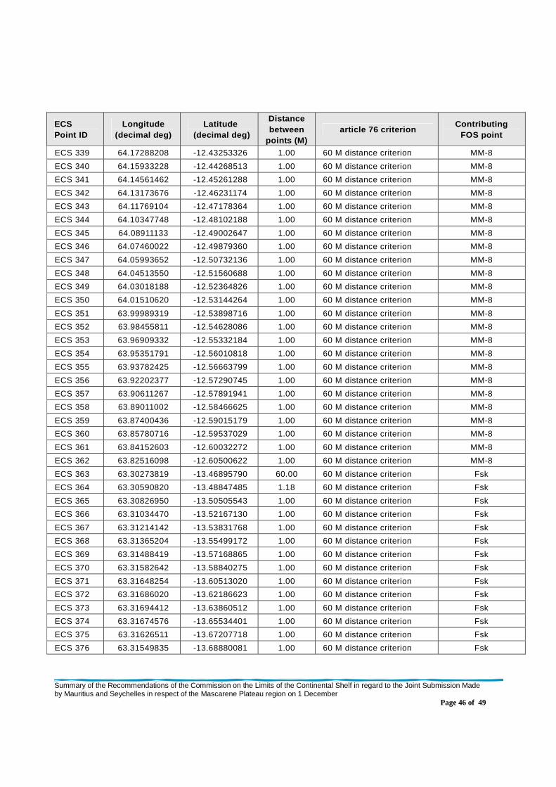
Summary of the Recommendations of the Commission on the Limits of the Continental Shelf in regard to the Joint Submission Made by Mauritius and Seychelles in respect of the Mascarene Plateau region on 1 December
Page 46 of 49
ECS Point ID
Longitude (decimal deg)
Latitude (decimal deg)
Distance between
points (M) article 76 criterion
Contributing FOS point
ECS 339 64.17288208 -12.43253326 1.00 60 M distance criterion MM-8
ECS 340 64.15933228 -12.44268513 1.00 60 M distance criterion MM-8
ECS 341 64.14561462 -12.45261288 1.00 60 M distance criterion MM-8
ECS 342 64.13173676 -12.46231174 1.00 60 M distance criterion MM-8
ECS 343 64.11769104 -12.47178364 1.00 60 M distance criterion MM-8
ECS 344 64.10347748 -12.48102188 1.00 60 M distance criterion MM-8
ECS 345 64.08911133 -12.49002647 1.00 60 M distance criterion MM-8
ECS 346 64.07460022 -12.49879360 1.00 60 M distance criterion MM-8
ECS 347 64.05993652 -12.50732136 1.00 60 M distance criterion MM-8
ECS 348 64.04513550 -12.51560688 1.00 60 M distance criterion MM-8
ECS 349 64.03018188 -12.52364826 1.00 60 M distance criterion MM-8
ECS 350 64.01510620 -12.53144264 1.00 60 M distance criterion MM-8
ECS 351 63.99989319 -12.53898716 1.00 60 M distance criterion MM-8
ECS 352 63.98455811 -12.54628086 1.00 60 M distance criterion MM-8
ECS 353 63.96909332 -12.55332184 1.00 60 M distance criterion MM-8
ECS 354 63.95351791 -12.56010818 1.00 60 M distance criterion MM-8
ECS 355 63.93782425 -12.56663799 1.00 60 M distance criterion MM-8
ECS 356 63.92202377 -12.57290745 1.00 60 M distance criterion MM-8
ECS 357 63.90611267 -12.57891941 1.00 60 M distance criterion MM-8
ECS 358 63.89011002 -12.58466625 1.00 60 M distance criterion MM-8
ECS 359 63.87400436 -12.59015179 1.00 60 M distance criterion MM-8
ECS 360 63.85780716 -12.59537029 1.00 60 M distance criterion MM-8
ECS 361 63.84152603 -12.60032272 1.00 60 M distance criterion MM-8
ECS 362 63.82516098 -12.60500622 1.00 60 M distance criterion MM-8
ECS 363 63.30273819 -13.46895790 60.00 60 M distance criterion Fsk
ECS 364 63.30590820 -13.48847485 1.18 60 M distance criterion Fsk
ECS 365 63.30826950 -13.50505543 1.00 60 M distance criterion Fsk
ECS 366 63.31034470 -13.52167130 1.00 60 M distance criterion Fsk
ECS 367 63.31214142 -13.53831768 1.00 60 M distance criterion Fsk
ECS 368 63.31365204 -13.55499172 1.00 60 M distance criterion Fsk
ECS 369 63.31488419 -13.57168865 1.00 60 M distance criterion Fsk
ECS 370 63.31582642 -13.58840275 1.00 60 M distance criterion Fsk
ECS 371 63.31648254 -13.60513020 1.00 60 M distance criterion Fsk
ECS 372 63.31686020 -13.62186623 1.00 60 M distance criterion Fsk
ECS 373 63.31694412 -13.63860512 1.00 60 M distance criterion Fsk
ECS 374 63.31674576 -13.65534401 1.00 60 M distance criterion Fsk
ECS 375 63.31626511 -13.67207718 1.00 60 M distance criterion Fsk
ECS 376 63.31549835 -13.68880081 1.00 60 M distance criterion Fsk
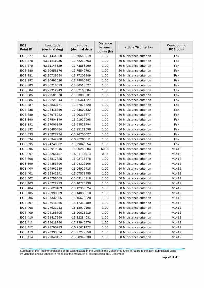
Summary of the Recommendations of the Commission on the Limits of the Continental Shelf in regard to the Joint Submission Made by Mauritius and Seychelles in respect of the Mascarene Plateau region on 1 December
Page 47 of 49
ECS Point ID
Longitude (decimal deg)
Latitude (decimal deg)
Distance between
points (M) article 76 criterion
Contributing FOS point
ECS 377 63.31444550 -13.70550919 1.00 60 M distance criterion Fsk
ECS 378 63.31311035 -13.72219753 1.00 60 M distance criterion Fsk
ECS 379 63.31148529 -13.73886299 1.00 60 M distance criterion Fsk
ECS 380 63.30958176 -13.75549793 1.00 60 M distance criterion Fsk
ECS 381 63.30739594 -13.77209949 1.00 60 M distance criterion Fsk
ECS 382 63.30492020 -13.78866482 1.00 60 M distance criterion Fsk
ECS 383 63.30216599 -13.80518627 1.00 60 M distance criterion Fsk
ECS 384 63.29912949 -13.82166004 1.00 60 M distance criterion Fsk
ECS 385 63.29581070 -13.83808231 1.00 60 M distance criterion Fsk
ECS 386 63.29221344 -13.85444927 1.00 60 M distance criterion Fsk
ECS 387 63.28833771 -13.87075520 1.00 60 M distance criterion Fsk
ECS 388 63.28418350 -13.88699532 1.00 60 M distance criterion Fsk
ECS 389 63.27975082 -13.90316677 1.00 60 M distance criterion Fsk
ECS 390 63.27504349 -13.91926098 1.00 60 M distance criterion Fsk
ECS 391 63.27006149 -13.93527794 1.00 60 M distance criterion Fsk
ECS 392 63.26480484 -13.95121098 1.00 60 M distance criterion Fsk
ECS 393 63.25927734 -13.96705627 1.00 60 M distance criterion Fsk
ECS 394 63.25347900 -13.98280811 1.00 60 M distance criterion Fsk
ECS 395 63.24740982 -13.99846554 1.00 60 M distance criterion Fsk
ECS 396 63.22919846 -15.00259304 60.00 60 M distance criterion V1412
ECS 397 63.23255157 -15.01154613 0.57 60 M distance criterion V1412
ECS 398 63.23817825 -15.02736378 1.00 60 M distance criterion V1412
ECS 399 63.24353790 -15.04327106 1.00 60 M distance criterion V1412
ECS 400 63.24862289 -15.05926418 1.00 60 M distance criterion V1412
ECS 401 63.25342941 -15.07533455 1.00 60 M distance criterion V1412
ECS 402 63.25796509 -15.09148216 1.00 60 M distance criterion V1412
ECS 403 63.26222229 -15.10770130 1.00 60 M distance criterion V1412
ECS 404 63.26620483 -15.12398624 1.00 60 M distance criterion V1412
ECS 405 63.26990509 -15.14033318 1.00 60 M distance criterion V1412
ECS 406 63.27332306 -15.15673828 1.00 60 M distance criterion V1412
ECS 407 63.27646255 -15.17319489 1.00 60 M distance criterion V1412
ECS 408 63.27931213 -15.18970108 1.00 60 M distance criterion V1412
ECS 409 63.28188705 -15.20625210 1.00 60 M distance criterion V1412
ECS 410 63.28417969 -15.22284031 1.00 60 M distance criterion V1412
ECS 411 63.28618240 -15.23946476 1.00 60 M distance criterion V1412
ECS 412 63.28790283 -15.25611877 1.00 60 M distance criterion V1412
ECS 413 63.28933334 -15.27279758 1.00 60 M distance criterion V1412
ECS 414 63.29048157 -15.28949738 1.00 60 M distance criterion V1412

Summary of the Recommendations of the Commission on the Limits of the Continental Shelf in regard to the Joint Submission Made by Mauritius and Seychelles in respect of the Mascarene Plateau region on 1 December
Page 48 of 49
ECS Point ID
Longitude (decimal deg)
Latitude (decimal deg)
Distance between
points (M) article 76 criterion
Contributing FOS point
ECS 415 63.29133606 -15.30621433 1.00 60 M distance criterion V1412
ECS 416 63.29191208 -15.32294273 1.00 60 M distance criterion V1412
ECS 417 63.29219437 -15.33967781 1.00 60 M distance criterion V1412
ECS 418 63.29219437 -15.35641479 1.00 60 M distance criterion V1412
ECS 419 63.29190826 -15.37314892 1.00 60 M distance criterion V1412
ECS 420 63.29132843 -15.38987637 1.00 60 M distance criterion V1412
ECS 421 63.29046631 -15.40659332 1.00 60 M distance criterion V1412
ECS 422 63.28931046 -15.42329121 1.00 60 M distance criterion V1412
ECS 423 63.28787613 -15.43997192 1.00 60 M distance criterion V1412
ECS 424 63.28615189 -15.45662403 1.00 60 M distance criterion V1412
ECS 425 63.28414154 -15.47324753 1.00 60 M distance criterion V1412
ECS 426 63.28184128 -15.48983574 1.00 60 M distance criterion V1412
ECS 427 63.27925873 -15.50638485 1.00 60 M distance criterion V1412
ECS 428 63.27639389 -15.52288914 1.00 60 M distance criterion V1412
ECS 429 63.27324677 -15.53934574 1.00 60 M distance criterion V1412
ECS 430 63.26981354 -15.55574894 1.00 60 M distance criterion V1412
ECS 431 63.26609802 -15.57209492 1.00 60 M distance criterion V1412
ECS 432 63.26210403 -15.58837700 1.00 60 M distance criterion V1412
ECS 433 63.25782776 -15.60459232 1.00 60 M distance criterion V1412
ECS 434 63.25327301 -15.62073612 1.00 60 M distance criterion V1412
ECS 435 63.24843979 -15.63680649 1.00 60 M distance criterion V1412
ECS 436 63.24332809 -15.65279388 1.00 60 M distance criterion V1412
ECS 437 63.23794174 -15.66869640 1.00 60 M distance criterion V1412
ECS 438 63.23228836 -15.68451118 1.00 60 M distance criterion V1412
ECS 439 63.22635269 -15.70023251 1.00 60 M distance criterion V1412
ECS 440 63.22015381 -15.71585274 1.00 60 M distance criterion V1412
ECS 441 63.21368790 -15.73137283 1.00 60 M distance criterion V1412
ECS 442 63.20695114 -15.74678612 1.00 60 M distance criterion V1412
ECS 443 63.19994736 -15.76208591 1.00 60 M distance criterion V1412
ECS 444 63.19268036 -15.77727318 1.00 60 M distance criterion V1412
ECS 445 63.18515778 -15.79233932 1.00 60 M distance criterion V1412
ECS 446 63.17736816 -15.80728149 1.00 60 M distance criterion V1412
ECS 447 63.16932678 -15.82209682 1.00 60 M distance criterion V1412
ECS 448 63.16102982 -15.83677864 1.00 60 M distance criterion V1412
ECS 449 63.15247726 -15.85132599 1.00 60 M distance criterion V1412
ECS 450 63.14367294 -15.86573219 1.00 60 M distance criterion V1412
ECS 451 63.13462830 -15.87999344 1.00 60 M distance criterion V1412
ECS 452 63.12532806 -15.89410686 1.00 60 M distance criterion V1412
Summary of the Recommendations of the Commission on the Limits of the Continental Shelf in regard to the Joint Submission Made by Mauritius and Seychelles in respect of the Mascarene Plateau region on 1 December
Page 49 of 49
ECS Point ID
Longitude (decimal deg)
Latitude (decimal deg)
Distance between
points (M) article 76 criterion
Contributing FOS point
ECS 453 63.12361526 -15.89661980 0.18 60 M distance criterion / Baseline +200M
V1412