Comment on: Historical perspective on seismic hazard … · Our comment challenges this model ......
12
© 2013 American Geophysical Union. All Rights Reserved. Comment on: “Historical perspective on seismic hazard to Hispaniola and the northeast Caribbean region” by U. ten Brink et al. Carol S. Prentice 1 , Paul Mann 2 , and Luis R. Peña 3 1 U.S. Geological Survey, 345 Middlefield Road, Menlo Park, California, USA 2 Department of Earth and Atmospheric Sciences, University of Houston, Houston, Texas, USA 3 Pontificia Universidad Católica Madre y Maestra, Autopista Duarte Km. 1, Santiago de los Caballeros, Dominican Republic This article has been accepted for publication and undergone full peer review but has not been through the copyediting, typesetting, pagination and proofreading process, which may lead to differences between this version and the Version of Record. Please cite this article as doi: 10.1002/jgrb.50170 Accepted Article
Transcript of Comment on: Historical perspective on seismic hazard … · Our comment challenges this model ......

© 2013 American Geophysical Union. All Rights Reserved.
Comment on: “Historical perspective on seismic hazard to Hispaniola and the northeast
Caribbean region” by U. ten Brink et al.
Carol S. Prentice1, Paul Mann2, and Luis R. Peña3
1U.S. Geological Survey, 345 Middlefield Road, Menlo Park, California, USA 2Department of Earth and Atmospheric Sciences, University of Houston, Houston, Texas, USA 3Pontificia Universidad Católica Madre y Maestra, Autopista Duarte Km. 1, Santiago de los Caballeros, Dominican Republic
This article has been accepted for publication and undergone full peer review but has not been through the copyediting, typesetting, pagination and proofreading process, which may lead to differences between this version and the Version of Record. Please cite this article as doi: 10.1002/jgrb.50170
Acc
epte
d A
rticl
e
© 2013 American Geophysical Union. All Rights Reserved.
1. Introduction
The analysis of historical earthquakes in the northeastern Caribbean by ten Brink et al.
[2011] (hereafter, TB11) addresses the occurrence of large and destructive historical earthquakes
associated with the North American-Caribbean plate boundary. One conclusion presented in TB11
is that the recurrence interval for large earthquakes on the left-lateral, strike-slip Septentrional
Fault (SF) (Figure 1a) is approximately 300 years. Their Figure 7 shows rupture of the SF across
the entire island of Hispaniola in CE 1200, 1542, and 1842. Our comment challenges this model
for SF earthquake recurrence because it is inconsistent with our published paleoseismic data that
show no large historical earthquake is associated with surface rupture along the SF east of Santiago
(Figure 1a) [Prentice et al., 1993; Mann et al., 1998; Prentice et al., 2003].
Historical records of earthquakes prior to the 20th century rarely provide direct observations
linking a specific fault with a particular earthquake. Researchers of historical earthquakes typically
formulate hypotheses such as those presented in TB11 associating earthquakes with particular
faults, based on their modeled isoseismals. In contrast, paleoseismic studies based on direct
observations of the fault zone and reliable age analyses provide fault-specific data to constrain
when, within the uncertainty of the data, a particular section of a fault did or did not produce large
surface-rupturing earthquakes. A model based solely on historical accounts of ground shaking and
damage is useful in the absence of paleoseismic data, but interpretations based on historical
accounts alone do not have the same resolution as geologic data that constrain the timing and
location of fault surface rupture. The ambiguity inherent in using intensity centers alone to assign
an historical earthquake to a particular fault is well illustrated by Figure 3 in Bakun et al., [2012],
which shows the intensity center for the 1946 earthquake immediately adjacent to the SF (Figure
1a, green triangle). Yet this earthquake is well known to have occurred on the North Hispaniola
Acc
epte
d A
rticl
e
© 2013 American Geophysical Union. All Rights Reserved.
thrust belt, not on the SF [Dolan and Wald, 1998]. (We note an error in TB11’s Figure 4 showing
the intensity center for the 1946 earthquake: the intensity center and all intensity locations are
systematically mislocated about 50 km to the north compared to Figure 3 in Bakun et al., [2012].)
TB11 dismiss existing paleoseismic data as a constraint when they attribute the 1842 and 1562
Hispaniola earthquakes to the SF. Our published paleoseismic data contradict their interpretation;
therefore we believe their model for SF recurrence is incorrect.
2. Paleoseismic Data from sites near Rio Cenoví and Rio Licey
Paleoseismic data from detailed studies along the SF show there has been no historical (i.e.
post-1492) surface rupture on the SF in the central Cibao Valley east of Santiago, and therefore,
neither the 1562 nor 1842 earthquakes ruptured the SF in this region. [Prentice et al., 2003; Mann
et al., 1998; Prentice et al., 1993]. In previous studies, we excavated eight fault-crossing trenches,
all of which show evidence for the most recent surface rupture; three of these trenches exposed
stratigraphic and structural relations and yielded multiple radiocarbon samples that allow us to
constrain the age of the most recent surface-rupturing earthquake (MRE), while the remaining five
trenches do not provide data that allow age constraint of the MRE. In two trenches the evidence is
clear that the MRE is prehistoric in age. We collected a suite of radiocarbon samples in both the
Rio Cenoví West and the Rio Cenoví East trenches throughout the unfaulted stratigraphic section
that overlies the fault zone. [Prentice et al., 1993 and 2003]. Radiocarbon analyses show that the
sedimentary horizons overlying the faulted strata are prehistoric (Figure 1b). Because these
samples are from unfaulted, post-earthquake deposits, they provide very strong evidence that the
MRE is prehistoric. It is well established that in general fault rupture repeats within a narrow zone
[e.g. Rockwell and Ben-Zion, 2007; Rymer et al., 2011] and therefore unfaulted sediments
overlying an active fault zone provide strong evidence that no fault surface rupture has occurred
Acc
epte
d A
rticl
e
© 2013 American Geophysical Union. All Rights Reserved.
since the deposition of the unfaulted horizons. The Rio Licey trench 3 exposure yielded samples
that are consistent with a prehistoric age for the MRE, but do not on their own rule out surface
rupture in 1562 at this site (these data do, however, rule out 1842 surface rupture at this site)
(Figure 1b) [Prentice et al., 2003]. TB11 infer, according to their Figure 7, that both the 1562 and
1842 earthquakes ruptured the SF across the entire island of Hispaniola. However, TB11 provide
no explanation for the observation that unfaulted strata overlying the active fault zone date to more
than 500 YBP in our trenches at the Rio Cenoví sites east of Santiago.
TB11 misinterpret data from Rio Licey trench 2 [Prentice et al., 2003, Figure 10], and state
that the young ages of several samples collected from unit 10/110 indicate that faulting affecting
this unit could be as young as 1680-1940, implying an historical surface rupture. However, TB11
apparently misunderstand that unit 10/110 is not a depositional unit, but is the modern soil, which
has been actively forming at this location for at least two thousand years, and that young organic
material is constantly being bioturbated and mixed into the modern soil as it evolves. Because of
the ongoing soil formation processes, the age of the MRE cannot be determined from the
radiocarbon ages from unit 10/110 in Rio Licey trench 2, and instead, we rely on the relations and
ages in the nearby Rio Licey trench 3, where undeformed depositional strata bury folded and
faulted strata that were deformed by the MRE [Prentice et al., 2003]. The same issue with samples
from the modern soil also applies to our Tenares trench 2, where dates from the modern soil do not
constrain the age of the MRE.
Acc
epte
d A
rticl
e
© 2013 American Geophysical Union. All Rights Reserved.
3. Paleoseismic Data from Santiago Viejo (Old Santiago)
TB11 state that a study of a trench at Santiago Viejo (Old Santiago) provides stratigraphic
evidence that the 1562 earthquake occurred on the SF, citing an abstract by Hengesh et al. [2000].
However, the study of the Santiago Viejo trench provides no conclusive stratigraphic evidence that
the 1562 earthquake ruptured the SF, nor does the cited abstract make that claim. The study (which
remains unpublished except as an abstract) did not include any radiocarbon ages or ages from any
other quantitative age-analysis method. The cited abstract describes an unfaulted horizon
containing cultural artifacts from the Spanish settlement of Santiago Viejo, which was founded in
1504 and abandoned after the earthquake in 1562 [Encyclopedia Britannica Online, 2012]. The
city was not rebuilt at this site after the earthquake, instead the survivors moved to a new location
about 5 km away to rebuild. While Hengesh et al., [2000] speculate that the faults terminating
below the cultural horizon might represent surface rupture during the 1562 earthquake, the limited
data available from that study provide no compelling evidence to support this hypothesis. Instead,
the unfaulted cultural horizon suggests to us that the earthquake represented by these faults likely
occurred before Spanish occupation at the site, i.e. before 1504. If the base of the cultural horizon
represents the establishment of the Spanish settlement, then the faults that terminate below the
cultural horizon cannot be related to surface rupture in 1562.
TB11 also do not address why, if the 1842 earthquake ruptured the SF as they propose, the
cultural horizon at Santiago Viejo was not faulted during that earthquake. While the age of the
base of the cultural horizon is not known, it seems highly unlikely that it is younger than 1842,
because this would require that more than 330 years passed after the settlement was established in
1504 until artifacts began to accumulate in the cultural horizon. The Santiago Viejo study, far from
contradicting the conclusions in Prentice et al., [2003], can be interpreted to provide additional
Acc
epte
d A
rticl
e
© 2013 American Geophysical Union. All Rights Reserved.
support for the conclusion that the SF did not rupture in the central Cibao Valley in either the 1562
or the 1842 earthquake. All three authors listed on the Hengesh et al. [2000] abstract agree with
this analysis of their study (personal communication, James Hengesh 2/28/12 and 4/6/12; personal
communication, Jeffrey Bachhuber, 2/29/12 and 4/5/12; Luis Peña is a coauthor of this comment).
Another key geologic observation related to understanding the earthquake history of the SF
is the lack of small left-lateral geomorphic offsets typically associated with an historical surface
rupture. Small, single-event offsets of geomorphic features, such as those found along the
Enriquillo-Plantain Garden Fault in Haiti [Prentice et al., 2010] and the San Andreas Fault in
California [Sieh, 1978; Zielke et al., 2010], would be expected along the SF if the fault had
ruptured as recently as 1842. We note that the climate in Haiti, where multiple small offsets likely
associated with an 18th century earthquake are observed, is no different than the climate in the
Dominican Republic.
4. 1842 and 1562 Earthquake Sources
We agree with TB11 (and previous workers) that historical accounts allow the 1842
earthquake to have ruptured the offshore section of the SF north of Haiti. It is possible that the
1842 rupture extended onshore along the SF in western Dominican Republic, west of Santiago
Viejo, but the published paleoseismic data show that no surface rupture occurred on the SF in this
event from Santiago eastward. The effects of ground shaking and damage to structures are
controlled by many local and regional factors, and the 1842 shaking reports in eastern Hispaniola,
which strongly influenced TB11 to conclude that the SF ruptured across the entire island, could be
related to directivity and local site effects due to a rupture of the SF that terminated west of
Santiago Viejo. The 1842 damage reports do not require rupture of the SF across the entire island,
and the existing paleoseismic data argue strongly against it. We suspect that the major left-step in
Acc
epte
d A
rticl
e

© 2013 American Geophysical Union. All Rights Reserved.
the fault system near Guayabin [Mann et al., 1998] (Figure 1a) may have acted as a segment
boundary that halted the 1842 surface rupture, although more paleoseismic research is needed to
test this hypothesis.
TB11 admit that their location of the 1562 earthquake is poorly constrained and that it
could have been produced by a seismic source other than the SF. Very little is known about the
1562 earthquake, and the analysis of TB11 is based on damage reports from only four localities.
Our paleoseismic data show that the 1562 earthquake did not involve surface rupture on the SF
east of Santiago. Other possible sources for the 1562 earthquake include the North Hispaniola
thrust belt (Figure 1a), or a thrust fault associated with either the Cordillera Central or Cordillera
Septentrional. Nothing in the historical record precludes an alternative source for the 1562
earthquake.
5. Worldwide Fault Statistics and Stress Transfer Model
TB11 advocate their 300-year recurrence model for the SF by noting that, at the estimated
slip rate they give of 6-12.3 mm/yr, 1.8-3.7 m of slip would accumulate between earthquakes 300
years apart, and stating that this is consistent with average strike-slip fault behavior worldwide.
However, [Prentice et al., 2003], documented a minimum of 4.6-5.5 m of slip associated with the
most recent surface rupture at the Rio Cenoví East site, which, if representative of the average, is
substantially greater than the expected slip using a 300-year recurrence, even if the highest slip rate
is used to estimate the offset. Slip associated with strike-slip earthquakes worldwide is highly
variable, and there are well-documented strike-slip earthquakes associated with average slip much
greater than 3.7 m, including the San Andreas Fault in the Carrizo Plain, California [1857, ˜5m,
Zielke et al., 2010], the Denali Fault in Alaska [2002, 4.5-5.1m, Haeussler et al., 2004], the Bulnay
Acc
epte
d A
rticl
e

© 2013 American Geophysical Union. All Rights Reserved.
Fault in Mongolia [1905, 8 m; Baljinnyam et al., 1993], and the Fuyun Fault in China [1931, 6.3
m; Klinger et al., 2011], for example. There is no reason to assume that the SF must behave in line
with any worldwide average, especially given the great variability in strike-slip fault behavior.
TB11 further promote their 300-year recurrence model by noting that a static stress transfer
model suggests that the series of large earthquakes on the North Hispaniola thrust from 1943-1953
would have increased the Coulomb stress on the SF, bringing it closer to failure [Dolan and
Bowman, 2004]. According to TB11, the absence of an earthquake on the SF in response to the
increased Coulomb stress associated with the thrust-belt earthquakes is best explained by invoking
rupture of the SF across the entire island in 1842, leaving little accumulated stress to be released in
the 20th century. However, there are many examples of large earthquakes inducing positive
Coulomb stress changes on adjacent faults that are believed to be in the late stages of the
earthquake cycle without any subsequent triggered failure of those faults (for example, the 1992
Landers earthquake increased the Coulomb stress on the adjacent southern San Andreas Fault
segments [Stein et al., 1992] without triggering a large earthquake in the ensuing two decades).
The lack of a large SF earthquake following the 1943-1953 North Hispaniola earthquake sequence
does not require that the 1842 earthquake ruptured through eastern Hispaniola, nor does it indicate
that the SF is not currently storing significant accumulated stress.
Acc
epte
d A
rticl
e
© 2013 American Geophysical Union. All Rights Reserved.
6. Conclusion
Geologic observations are inconsistent with the model proposed by TB11 that the
recurrence interval for large earthquakes on the SF is 300 years. The earthquakes in 1842 and 1562
were not associated with surface rupture along the SF east of Santiago; if they had ruptured the SF
east of Santiago, evidence for historic surface rupture would be visible in the paleoseismic trenches
at Rio Cenoví East and Rio Cenoví West. A recurrence model for Hispaniola earthquakes that is
consistent with both paleoseismic data and the historical record would yield a more robust
assessment of the island’s seismic hazard than the recurrence model proposed by TB11, which
relies on analysis of historical intensity data alone to assign sources to the 1562 and 1842
earthquakes.
References
Bakun, W. H., C. H. Flores, and U. S. ten Brink (2012), Significant earthquakes on the Enriquillo
fault system, Hispaniola, 1500–2010: Implications for seismic hazard, Bull. Seismol. Soc.
Am., 102(1), 18-30.
Baljinnyam, I., A. Bayasgalan, B. A. Borisov, A. Cisternas, M. G. Dem'yanovich, L. Ganbaatar, V.
M. Kochetkov, R. A. Kurushin, P. Molnar, H. Philip, and Y. Vashchilov (1993), Ruptures of
Major Earthquakes and Active Deformation in Mongolia and Its Surroundings. Geological
Society of America Memoir 181, 61.
Dolan, J. F., and D. D. Bowman (2004), Tectonic and seismologic setting of the 22 September
2003, Puerto Plata, Dominican Republic earthquake: Implications for earthquake hazard in
northern Hispaniola, Seismol. Res. Lett., 75(5), 587-597.
Acc
epte
d A
rticl
e

© 2013 American Geophysical Union. All Rights Reserved.
Dolan, J. F., and D. J. Wald (1998). The 1943–1953 north-central Caribbean earthquakes: Active
tectonic setting, seismic hazard, and implications for Caribbean–North America plate
motion, Geol. Soc. Am. Sec. Pap. 326, 143-169.
Encyclopædia Britannica Online, s. v. "Santiago de los Caballeros," accessed April 02, 2012,
http://www.britannica.com/EBchecked/topic/523277/Santiago-de-los-Caballeros.
Haeussler, P. J., D. P. Schwartz, T. E. Dawson, H. D. Stenner, J. J. Lienkaemper, B. Sherrod, F. R.
Cinti, P. Montone, P. A. Craw, A. J. Crone, and S. F. Personius (2004), Surface rupture and
slip distribution of the Danali and Totschunda Faults in the 3 November 2002 M 7.9
earthquake, Alaska: Bull. Seismol. Soc. Am., 94(6B), S23-S52.
Hengesh, J. V., L. R. Peña, and J. Bachhuber (2000), Possible geological evidence for surface fault
rupture related to the 1562 Santiago Viejo earthquake, Dominican Republic [abs]: Eos
Trans. AGU, 81 (48), Fall Meet. Suppl., Abstract T11B-03.
Klinger, Y., M. Etchebes, P. Tapponier, and N. Narteau (2011), Characteristic slip for five great
earthquakes along the Fuyun fault in China: Nat. Geosci., 4, 389-392.
Mann, P., C. Prentice, G. Burr, L. Peña, and F. Taylor (1998), Tectonic geomorphology and
paleoseismicity of the North America-Caribbean plate boundary (Septentrional fault zone),
Dominican Republic, in: Active Strike-slip and Collisional Tectonics of the Northern
Caribbean Plate Boundary Zone, Geol. Soc. Am. Spec. Pap. 326, 63-123.
Prentice, C. S., P. Mann, F. W. Taylor, G. Burr, and S. Valastro, Jr. (1993), Paleoseismicity of the
North American-Caribbean plate boundary (Septentrional fault), Dominican Republic:
Geology, 21(1), 49-52.
Acc
epte
d A
rticl
e

© 2013 American Geophysical Union. All Rights Reserved.
Prentice, C. S., P. Mann, L. Peña, and G. Burr (2003), Slip rate and earthquake recurrence along
the central Septentrional fault, North American-Caribbean plate boundary, Dominican
Republic: J. Geophys. Res., 108(B3), doi:10.1029/2001JB000442.
Prentice, C. S., P. Mann, A. J. Crone, R. D. Gold, K. W. Hudnut, R. W. Briggs, R. D. Koehler, and
P. Jean (2010), Seismic hazard of the Enriquillo–Plantain Garden fault in Haiti inferred
from palaeoseismology: Nat. Geosci., 3(11), 789-793.
Rockwell, T. K., and Y. Ben-Zion (2007), High localization of primary slip zones in large
earthquakes from paleoseismic trenchesL Observations and implications for earthquake
physics: J. Geophys. Res., 112(B10304), doi:10.1029/2006JB004764.
Rymer, M.J., J.A. Treiman, K.J. Kendrick, J.J. Lienkaemper, R.J. Weldon, R. Bilham, M. Wei,
E.J. Fielding, J.L. Hernandez, B.P.E. Olson, P.J. Irvine, N. Knepprath, R.R. Sickler, X.
Tong, and M.E. Siem (2011), Triggered Surface Slips in Southern California Associated
with the 2010 El Mayor-Cucapah, Baja California, Mexico, Earthquake: US Geol. Surv.
OFR 2010-1333, http://pubs.usgs.gov/of/2010/1333/
Sieh, K. E. (1978), Slip along the San Andreas Fault associated with the great 1857 earthquake:
Bull. Seismol. Soc. Am., 68 (5), 1421-1448.
Stein, R. S., G. C. P. King, and J. Lin (1992), Change in failure stress on the southern San Andreas
Fault system caused by the 1992 magnitude = 7.4 Landers earthquake: Science, 258, 1326-
1332.
Zielke, O., J. R. Arrowsmith, L. Grant Ludwig, S. O. Akçiz (2010), Slip in the 1857 and earlier
large earthquakes along the Carrizo Plain, San Andreas Fault: Science, 327, 1119-1122. Acc
epte
d A
rticl
e
© 2013 American Geophysical Union. All Rights Reserved.
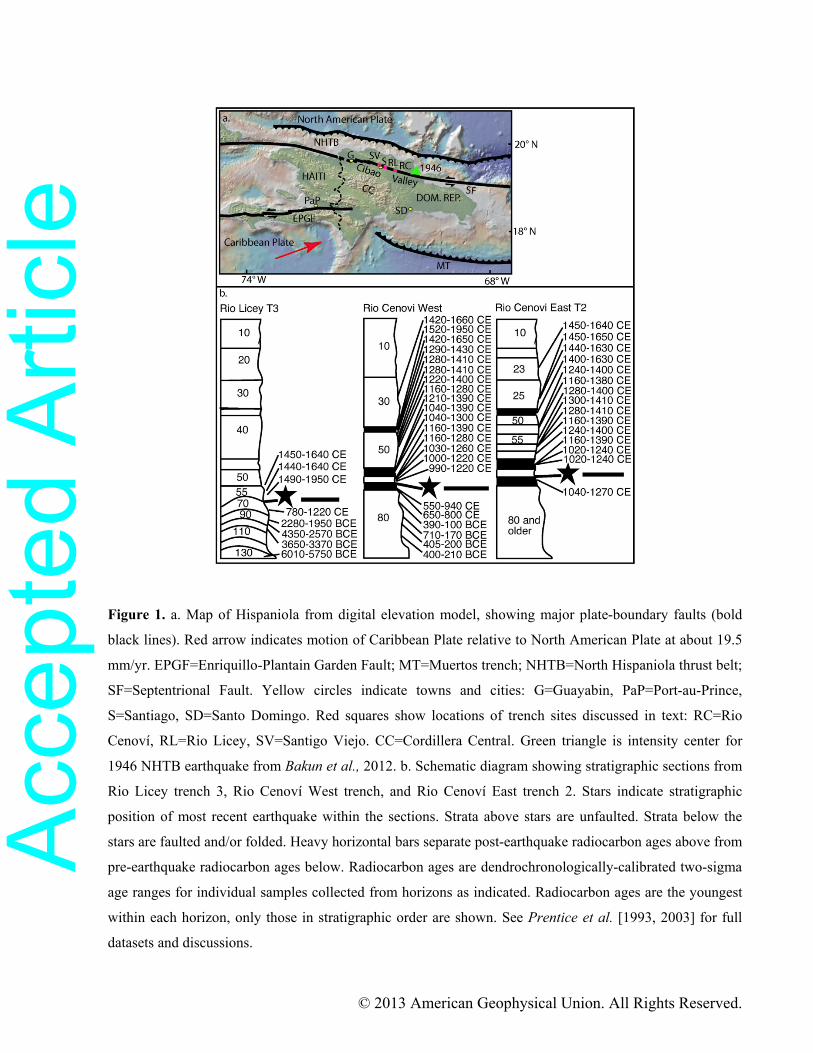
Figure 1. a. Map of Hispaniola from digital elevation model, showing major plate-boundary faults (bold
black lines). Red arrow indicates motion of Caribbean Plate relative to North American Plate at about 19.5
mm/yr. EPGF=Enriquillo-Plantain Garden Fault; MT=Muertos trench; NHTB=North Hispaniola thrust belt;
SF=Septentrional Fault. Yellow circles indicate towns and cities: G=Guayabin, PaP=Port-au-Prince,
S=Santiago, SD=Santo Domingo. Red squares show locations of trench sites discussed in text: RC=Rio
Cenoví, RL=Rio Licey, SV=Santigo Viejo. CC=Cordillera Central. Green triangle is intensity center for
1946 NHTB earthquake from Bakun et al., 2012. b. Schematic diagram showing stratigraphic sections from
Rio Licey trench 3, Rio Cenoví West trench, and Rio Cenoví East trench 2. Stars indicate stratigraphic
position of most recent earthquake within the sections. Strata above stars are unfaulted. Strata below the
stars are faulted and/or folded. Heavy horizontal bars separate post-earthquake radiocarbon ages above from
pre-earthquake radiocarbon ages below. Radiocarbon ages are dendrochronologically-calibrated two-sigma
age ranges for individual samples collected from horizons as indicated. Radiocarbon ages are the youngest
within each horizon, only those in stratigraphic order are shown. See Prentice et al. [1993, 2003] for full
datasets and discussions.
Acc
epte
d A
rticl
e