
Closed-bottom corrugated-steel embedded culverts in ... · Closed-bottom corrugated-steel ......
31
Author Clayton T. Gillies, Western Division Contents Restricted to FERIC Members and Partners Vol. 4 No. 29 September 2003 1 Introduction 1 Objectives 2 Methods 2 Results 3 Implementa- tion 5 References 5 Acknowledge- ments Introduction In some situations, closed-bottom corrugated-steel embedded culverts 1 may be an appropriate and cost-effective alternative to conventional structures for stream crossings on forest roads in British Columbia. Stream crossings on forest roads should maintain water quality, protect fish and fish habitat, and provide safe fish passage. In British Columbia, fish habitat must be identified and treated appropriately (BCMOF 2002a). While the use of embedded culverts is increasing, little information is available to potential forest industry users about installation procedures and costs of these structures. To address this gap, FERIC worked with the Engineering Section of the B.C. Ministry of Forests (BCMOF) Resource Tenures and Engineering Branch to inventory closed- bottom corrugated-steel embedded culverts on forest roads in British Columbia and to describe selected installations in more detail. This report describes twelve embedded culvert installations and presents implemen- tation suggestions grouped by installation phase. Objectives The primary purpose of this study was to document the use of embedded culverts within British Columbia. The locations of embedded culverts were identified, and field visits were conducted to selected sites. Although there are many options available for crossing fish-bearing streams, only embedded culverts are presented in this report to help address the lack of literature describing the installation of these structures in British Columbia. Closed-bottom corrugated-steel embedded culverts in British Columbia: overview of twelve sites Abstract The Forest Engineering Research Institute of Canada (FERIC) surveyed users of closed- bottom corrugated-steel embedded culverts within British Columbia and visited selected sites. This report presents information about the installations visited, including the in- stallation procedures and costs. This report also provides suggestions for the implemen- tation of future embedded culverts. Keywords Stream crossing, Water crossing, Embedded pipe culvert, Corrugated steel pipe cul- vert, Fish habitat. 1 An embedded culvert differs from a typical water- passing culvert in that it is purposefully installed below the natural streambed level and filled with aggregate through the length of the culvert, up to the natural streambed level. Typical target infill depths are: round culverts filled to 40% of diameter, and pipe arch culverts filled to 20% of their rise. When filled to these infill depths, round culverts have 63% and pipe arches have 83% of the original cross-sectional end area remaining for water flow.
Transcript of Closed-bottom corrugated-steel embedded culverts in ... · Closed-bottom corrugated-steel ......

AuthorClayton T. Gillies,Western Division
Contents
Restricted to FERIC Members and Partners Vol. 4 No. 29 September 2003
1 Introduction
1 Objectives
2 Methods
2 Results
3 Implementa-tion
5 References
5 Acknowledge-ments
IntroductionIn some situations, closed-bottom
corrugated-steel embedded culverts1 may bean appropriate and cost-effective alternativeto conventional structures for stream crossingson forest roads in British Columbia. Streamcrossings on forest roads should maintainwater quality, protect fish and fish habitat, andprovide safe fish passage. In British Columbia,fish habitat must be identified and treatedappropriately (BCMOF 2002a). While theuse of embedded culverts is increasing, littleinformation is available to potential forestindustry users about installation proceduresand costs of these structures.
To address this gap, FERIC worked withthe Engineering Section of the B.C. Ministryof Forests (BCMOF) Resource Tenures andEngineering Branch to inventory closed-bottom corrugated-steel embedded culvertson forest roads in British Columbia and todescribe selected installations in more detail.This report describes twelve embeddedculvert installations and presents implemen-tation suggestions grouped by installation phase.
ObjectivesThe primary purpose of this study was
to document the use of embedded culvertswithin British Columbia. The locations ofembedded culverts were identified, andfield visits were conducted to selected sites.Although there are many options availablefor crossing fish-bearing streams, onlyembedded culverts are presented in thisreport to help address the lack of literaturedescribing the installation of these structuresin British Columbia.
Closed-bottom corrugated-steelembedded culverts in British Columbia:overview of twelve sites
Abstract
The Forest Engineering Research Institute of Canada (FERIC) surveyed users of closed-bottom corrugated-steel embedded culverts within British Columbia and visited selectedsites. This report presents information about the installations visited, including the in-stallation procedures and costs. This report also provides suggestions for the implemen-tation of future embedded culverts.
Keywords
Stream crossing, Water crossing, Embedded pipe culvert, Corrugated steel pipe cul-vert, Fish habitat.
1 An embedded culvert differs from a typical water-passing culvert in that it is purposefully installed belowthe natural streambed level and filled with aggregatethrough the length of the culvert, up to the naturalstreambed level. Typical target infill depths are: roundculverts filled to 40% of diameter, and pipe arch culvertsfilled to 20% of their rise. When filled to these infilldepths, round culverts have 63% and pipe arches have83% of the original cross-sectional end area remainingfor water flow.
2 AdvantageVol. 4 No. 29
September 2003
Forest Engineering Research Institute of Canada (FERIC)
Eastern Division and Head Office Western Division580 boul. St-Jean 2601 East MallPointe-Claire, QC, H9R 3J9 Vancouver, BC, V6T 1Z4
(514) 694-1140(514) [email protected]
(604) 228-1555(604) [email protected]
DisclaimerAdvantage is published solely to disseminate information to FERIC’s mem-bers and partners. It is not intended as an endorsement or approval of anyproduct or service to the exclusion of others that may be suitable.
Copyright 2003. Printed in Canada on recycled paper.
ISSN 1493-3381
ResultsThe survey identified 94 closed-bottom
corrugated-steel embedded culvert installationson forest roads throughout British Columbia.FERIC visited twelve of these sites todocument information such as their installa-tion procedures and costs. This informationis contained in the Appendix of this report,and is organized by site.
Engineering designs were prepared for allbut Sites 7 and 10 (Appendix). These twoculverts are not major culverts, which legallyrequire a professional engineer to take designresponsibility.3 However, it is recommendedthat drawings and designs be produced forstream culverts not classified as major culvertsthat are installed on fish-bearing streams(BCMOF 2002b). Embedded culverts are
Note:The Ministry of Forests contracted with FERIC to inventory closed-bottom embedded culvert systems todemonstrate the viability of embedded culverts as an option for consideration for fish stream crossings.Two primary objectives of embedded culver ts are safe fish passage now and in the future, and protection offish habitat. It should be noted that all but one of the sample projects cited were carried out prior to thecompletion and dissemination of the Forest Practices Code publication Fish-stream Crossing Guidebook inMarch, 2002. Consequently, the reader should not interpret the data presented herein as recommendedprocedures, unless they happen to reflect the multi-agency consensus results that are found in theGuidebook. The key differences will be in the habitat criteria (if any), depth of embedment in the pipe (infilldepth) and required survey accuracy (precise construction level recommended). The reader is encouragedto draw on the details provided in the Guidebook, which can be found on the Internet using the followingaddress: http://www.for.gov.bc.ca/tasb/legsregs/fpc/fpcguide/guidetoc.htm.—Ron Davis, P.Eng. Chief Engineer, B.C. Ministry of Forests.
MethodsMajor forest licensees and BCMOF
district offices in every Forest Region werecontacted to identify installations of closed-bottom corrugated-steel embedded culverts.Installations that were candidates for fieldvisits potentially fulfilled the followingcriteria:2
• round culverts filled to 40% of theirdiameter, or pipe-arch culverts filled to20% of their rise
• installed structures with gradients of lessthan 6%
• natural stream channels less than 2.5 mwide
• the culvert had been in place for at leastone year and/or had experienced at leastone freshetThe twelve installations cover a range of
geographic areas, culvert types (round andarch), dimensions, infilling techniques, andsite characteristics. The installations presentedare considered appropriate examples for thepurpose of informing potential users aboutinstallation techniques, costs and requirementsfor embedded pipe culverts.
2 The first three criteria are general guidelines for theuse of embedded culverts found in the Forest PracticesCode of B.C.: Fish-stream crossing guidebook (BCMOF2002a).
3 The Forest Road Regulation (B.C. Reg 106/98) of theForest Practices Code of B.C. Regulations defines a“major culvert” as a stream culvert having a pipediameter of 2000 mm or greater, or a maximum designdischarge of 6 m3/s or greater.
3September 2003
Vol. 4 No. 29Advantage
significant structures and need to be installedproperly to meet the desired goals. Theculverts described in Sites 7 and 10 werecarefully installed and met their desired goals.
All the culverts that were left to infillnaturally had accumulated stream bedloadmaterial at the time of field inspections. Sites5 and 6 are examples where natural infillingoccurred (Appendix). The culverts at thesetwo sites were functioning well and presentedno barriers to fish passage at the time ofinspection. Natural infilling is not specificallyexcluded in the Fish-stream Crossing Guide-book as an option for creating the simulatedstreambed, but use of this technique requiresprior approval from the Department ofFisheries and Oceans Canada.
All but one of the embedded culverts(Site 7) was installed prior to publication ofthe current Fish-stream Crossing Guidebookthat was published in March, 2002. Thedesigns of these installations were guided bythe working draft for 1997/98 of the StreamCrossing Guidebook for Fish Streams(Poulin and Argent 1997), as well as by B.C.Ministry of Water, Land and Air Protectionguidelines in the form of local “Timingwindows and measures for the conservationof fish and fish habitat.”4 The working draftfor 1997/98 specified the same infill depthsfor both round culverts and pipe arches: “aminimum of 300 mm or 20% of thediameter/vertical rise, whichever is greatest.”The current guideline for round pipes is “40%of culvert diameter or 0.6 m, whichever isgreater” and for pipe arches “at least 20% ofthe vertical rise.” Few round embedded pipesmeeting the new 40% embedment depthcriterion were identified during the survey.
The description for each site in theAppendix includes a table that providesinformation on the culvert, site, cost, andinstallation data. Stream classification is notedas either S3 or S4.5 The average naturalstream widths shown in the tables weremeasured by FERIC, and do not necessarilymatch the stream classification parameters.The stream classification was taken from thedesigns or given by the cooperators. FERIC
and/or the cooperators assessed the fishhabitat for most of the sites in the Appendix.The fish habitat at the sites were described aseither “Marginal” or “Important”.6
Implementation
Planning
• Site plans developed from site surveysare useful design tools and should beutilized when preparing engineeringdesigns for the installation. Appropriateengineering design can greatly enhancethe ease of installation and help to ensurethat the desired objectives are achieved.Culvert positioning through the road,depth of excavation, and gradient of theinstallation are all easily referenced onthe designs. Size distribution of theaggregate to be used within the culvertcan also be referenced on the designs.
• Benchmarks, reference points, orworking points should be semi-permanently established in the field.These points are used to establishhorizontal and vertical culvert locationsduring installation.
• Plan the installation work to take placeduring the preferred in-stream workwindow (“fish window”) for the localarea. During this time, the risk to local fishspecies due to in-stream work activities
4 The purpose of these documents is to provide timingwindows (windows of least risk) and measures for workrelated to stream crossings, to facilitate compliancewith the Forest Practices Code of British ColumbiaAct. The documents were prepared by the DesignatedEnvironmental Officials of the Ministry of Water, Landand Air Protection. Individual documents wereprepared for either a BCMOF Forest Region, or aBCMOF Forest District.
5 S3 and S4 stream classifications refer to fish and/orcommunity watershed streams; S3 streams are 1.5 to5 m wide, and S4 streams are less than 1.5 m wide(BCMOF 1998).
6 The definitions and indicators for “Marginal”,“Important” and “Critical” fish habitat are given inBCMOF 2002a. “Marginal” habitat has low productivecapacity and contributes marginally to fish production.“Important” habitat is used by fish for feeding, growth,and migration, but is not deemed to be critical. Thishabitat category usually contains a large amount ofsimilar habitat that is readily available to the fish stock.
4 AdvantageVol. 4 No. 29
September 2003
is considered reduced. Risks to waterquality are also considered reduced dueto the typical low flow during the “fishwindow”.
• Compared to conventional culvertinstallations, embedded culverts requireadditional excavation and infilling withaggregate. The cost of this additionalwork must be budgeted when planningthe installation and allocating machinetime to the project.
Site preparation
• Isolate the construction site from fishpassage. Install fish screens (typicallywire-mesh) within the stream, above andbelow the construction site. Capture andremove any fish present between the fishscreens.
• De-water the construction site to allowthe culvert installation to take place inpredominantly dry conditions. If usinga pump-and-hose system, monitor thepumps during installation to ensure theyare working properly. Have a sparepump-and-hose set on-site in case ofpump failure.
• As an alternative to a pump-and-hosesystem and/or a precaution to a pumpfailure, consider installing a bypassculvert. For installations that requiremore than one day to complete, a bypassculvert eliminates the need to monitorpumps overnight.
Installation
• Use appropriate survey equipmentduring the installation to help achievethe design elevations, gradients, anddepths.
• Sediment-laden water should be collectedand delivered to the forest floor awayfrom the stream. Seepage will oftenoccur within the excavated trench preparedfor the culvert, creating a sedimentsource. A sump at the downstream sideof the construction site will collect thiswater, which can then be pumped ontothe forest floor.
• Match the infilling technique to the sizeof the culvert. Small culverts may requiremanual infilling with wheelbarrows andbuckets, while small loaders or self-dumping wheelbarrows may be effectivefor larger culverts. Other culvert features,such as baffles, may also influence thechoice of infilling technique andequipment. Natural infilling by thestream may also be effective.
• Ensure the infill material is well gradedand contains sufficient fines and sand tofill the voids in the simulated streambed.If the infill material is without sufficientfine particles, the result may be subsur-face streamflow which could precludefish passage. Fines and sand can be spreadover the surface of the simulatedstreambed and hosed down to drive thefiner particles into the voids.
General
• Site 7 is the smallest embedded culvertof the twelve culverts documented(Appendix). This culvert has a rise of970 mm, which is close to the smallestsize that a culvert can still be manuallyfilled with material. Conversely, Site 8is the largest culvert documented, andhas a diameter of 3.4 m. Culverts largerthan this may incur significant costs forthe delivery of infill material.
• Round embedded culverts work well inroads where the road profile and prismcontains or requires a “deep” fill (seeSite 1, Appendix). The height of a roundculvert helps negate the volume of fillrequired. Where the road does notcontain or require a deep fill, shallowerprofiled stream-crossing structures(pipe arches) may be preferred.
• The descriptions in the Appendix arenot exhaustive. Further information onspecific installations can be obtainedfrom the contacts identified, and fromGillies (2002a, b).
5September 2003
Vol. 4 No. 29Advantage
ReferencesBritish Columbia Ministry of Forests
(BCMOF). 1998. Forest practices codeof British Columbia: Fish-streamidentification guidebook (2nd ed.).Victoria, B.C. 70 pp.
British Columbia Ministry of Forests(BCMOF). 2002a. Forest practices codeof British Columbia: Fish-stream crossingguidebook. Victoria, B.C. 68 pp.
British Columbia Ministry of Forests(BCMOF). 2002b. Forest practicescode of British Columbia: Forest roadengineering guidebook. 197 pp.
Gillies, C. 2002a. Installation of an embeddedpipe culvert: Stuart Lake tributary. FERIC,Vancouver, B.C. Advantage Report Vol. 3No. 40. 8 pp.
Gillies, C. T. 2002b. Installation of anembedded pipe culvert: Hotfish Creek.FERIC, Vancouver, B.C. Advantage ReportVol. 3 No. 38. 11 pp.
Poulin, V.A.; Argent, H.W. 1997. Streamcrossing guidebook for fish streams: Aworking draft for 1997/1998. Workingdraft of Forest Practices Code guidebook,prepared for B.C. Ministry of Forests; B.C.Ministry of Employment and Investment;B.C. Ministry of Environment, Lands andParks; and Department of Fisheries andOceans. Victoria, B.C. 81 pp.
AcknowledgementsThe author expresses his appreciation to
all the cooperators of this project, and specifi-cally to those companies and personnel listedas further information contacts. Surveyresponse from many foresters within BritishColumbia and field visits to sites that werenot included in this report were also verymuch appreciated.
Review of report drafts by Brian Chow,and report insert contributions by Ron Davis,both of the BCMOF, Resource Tenures andEngineering Branch were also appreciated.
The author also thanks FERIC employeesRay Krag and Ingrid Hedin for project adviceand report reviews; former employee CindyTatarliov for data analysis; and Shelley Kerand Yvonne Chu for report formatting,graphics, and final edit.
Funding assistance for this study wasprovided by the BCMOF, Resource Tenuresand Engineering Branch.

6 AdvantageVol. 4 No. 29
September 2003

7September 2003
Vol. 4 No. 29Advantage
Appendix
Description of 12 culvert sites
8 AdvantageVol. 4 No. 29
September 2003
LocationVancouver Forest RegionCampbell River Forest DistrictElk Bay Forest Service Road, km 3.1 (from Highway 19)Crossing: Cecil Creek
Company/proponentInternational Forest Products Limited, Campbell River Operations
Date of installation/field visitSeptember 8–11, 1998/November 27, 2002
Project description• A 0.5-m by 2.0-m wooden box culvert,
under 3 to 4 m of fill, needed replacement.The opening size was considered to berestrictive to high flows, and the structurewas near the end of its effective age.
• Failure of the structure could lead to loss offish habitat and a section of road.
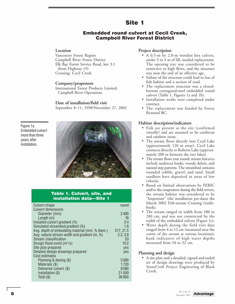
• The replacement structure was a closed-bottom corrugated-steel embedded roundculvert (Table 1, Figures 1a and 1b).
• Installation works were completed undercontract.
• The replacement was funded by ForestRenewal BC.
Habitat description/indicators• Fish are present at the site (confirmed
visually) and are assumed to be cutthroatand rainbow trout.
• The stream flows directly into Cecil Lake(approximately 120 m away). Cecil Lakeconnects directly to Roberts Lake (approxi-mately 200 m between the two lakes).
• The stream flows year round; stream featuresinclude undercut banks, woody debris, andnatural step patterns. The streambed containsrounded cobble, gravel, and sand. Smallsandbars have deposited in areas of lowvelocity.
• Based on limited observations by FERICand/or the cooperators during the field review,the stream habitat was considered to be“Important” (the installation pre-dates theMarch 2002 Fish-stream Crossing Guide-book).
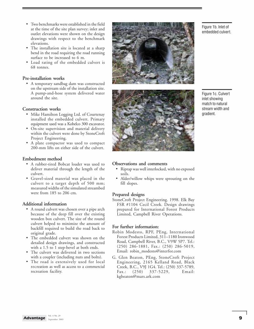
• The stream ranged in width from 180 to280 cm, and was not constricted by thewidth of the embedded culvert (Figure 1c).
• Water depth during the field visit dateranged from 4 to 12 cm (measured near thecentre of the stream at various locations);bank indicators of high water depthsmeasured from 10 to 32 cm.
Planning and design• A site plan and a detailed, signed and sealed
set of design drawings were produced byStoneCroft Project Engineering of BlackCreek.
Site 1
Embedded round culvert at Cecil Creek,Campbell River Forest District
Figure 1a.Embedded culvertmore than threeyears afterinstallation.
Table 1. Culvert, site, andinstallation data—Site 1
Culver t shape roundCulver t dimensions
Diameter (mm) 2 400Length (m) 19
Installed culver t gradient (%) 2.4Simulated streambed gradient (%) 1.6Avg. depth of embedding material (mm, % diam.) 517, 21.5Avg. natural stream width and gradient (m, %) 2.2, 3.8Stream classification S3Design flood event (m3/s) 10.2Site plan prepared yesDetailed design drawings prepared yesCost estimates
Planning & desing ($) 5 000Materials ($) 1 720Delivered culvert ($) 8 580Installation ($) 21 500Total ($) 36 800
9September 2003
Vol. 4 No. 29Advantage
• Two benchmarks were established in the fieldat the time of the site plan survey; inlet andoutlet elevations were shown on the designdrawings with respect to the benchmarkelevations.
• The installation site is located at a sharpbend in the road requiring the road runningsurface to be increased to 6 m.
• Load rating of the embedded culvert is68 tonnes.
Pre-installation works• A temporary sandbag dam was constructed
on the upstream side of the installation site.A pump-and-hose system delivered wateraround the site.
Construction works• Mike Hamilton Logging Ltd. of Courtenay
installed the embedded culvert. Primaryequipment used was a Kobelco 300 excavator.
• On-site supervision and material deliverywithin the culvert were done by StoneCroftProject Engineering.
• A plate compactor was used to compact200-mm lifts on either side of the culvert.
Embedment method• A rubber-tired Bobcat loader was used to
deliver material through the length of theculvert.
• Gravel-sized material was placed in theculvert to a target depth of 500 mm;measured widths of the simulated streambedwere from 185 to 206 cm.
Additional information• A round culvert was chosen over a pipe arch
because of the deep fill over the existingwooden box culvert. The size of the roundculvert helped to minimize the amount ofbackfill required to build the road back tooriginal grade.
• The embedded culvert was shown on thedetailed design drawings, and constructedwith a 1.5 to 1 step-bevel at both ends.
• The culvert was delivered in two sectionswith a coupler (including nuts and bolts).
• The road is extensively used for localrecreation as well as access to a commercialrecreation facility.
Figure 1b. Inlet ofembedded culvert.
Figure 1c. Culvertinlet showingmatch to naturalstream width andgradient.
Observations and comments• Riprap was well interlocked, with no exposed
soils.• Alder/willow whips were sprouting on the
fill slopes.
Prepared designsStoneCroft Project Engineering. 1998. Elk Bay
FSR #1104 Cecil Creek. Design drawingsprepared for International Forest ProductsLimited, Campbell River Operations.
For further information:Robin Modesto, RPF, PEng, International
Forest Products Limited, 311–1180 IronwoodRoad, Campbell River, B.C., V9W 5P7. Tel.:(250) 286-1881, Fax.: (250) 286-5019,Email: [email protected]
G. Glen Beaton, PEng, StoneCroft ProjectEngineering, 2165 Kelland Road, BlackCreek, B.C., V9J 1G4. Tel.: (250) 337-5789,Fax.: (250) 337-5229, Email:[email protected]
10 AdvantageVol. 4 No. 29
September 2003
Site 2
Embedded pipe arch at Benoit Creek, Kalum Forest District
LocationPrince Rupert Forest RegionKalum Forest DistrictWest Kalum Forest Service Road, km 18.6Crossing: Benoit Creek
Company/proponentBCMOF, Kalum Forest District
Date of installation/field visitAugust 24–31, 2001/October 18, 2002
Project description• A 9-m long, 1200-mm diameter, round
culvert was replaced. The culvert wasperched at the outlet and was determinedto be a barrier to fish passage.
• The replacement structure was selected tobe a closed-bottom corrugated-steelembedded pipe arch culvert (Table 2,Figure 2a).
Habitat description/indicators• Undisturbed streambed material contains an
estimated 30% cobble, 50% gravel, and20% sand.
• A Watershed Restoration Program riparianassessment during December 1997 showedcoho salmon, cutthroat trout, and rainbowtrout present within Benoit Creek.
• Only cutthroat trout were noted to bepresent immediately prior to and during theculvert installation.
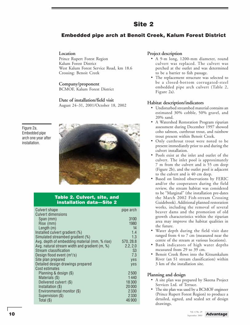
• Pools exist at the inlet and outlet of theculvert. The inlet pool is approximately7 m from the culvert and is 55 cm deep(Figure 2b), and the outlet pool is adjacentto the culvert and is 40 cm deep.
• Based on limited observations by FERICand/or the cooperators during the fieldreview, the stream habitat was consideredto be “Marginal” (the installation pre-datesthe March 2002 Fish-stream CrossingGuidebook). Additional planned restorationworks, including the removal of severalbeaver dams and the promotion of oldgrowth characteristics within the riparianarea may improve the habitat qualities inthe future.
• Water depth during the field visit dateranged from 4 to 7 cm (measured near thecentre of the stream at various locations).
• Bank indicators of high water depthsmeasured from 29 to 39 cm.
• Benoit Creek flows into the KitsumkalumRiver (an S1 stream classification) within3 km of the installation site.
Planning and design• A site plan was prepared by Skeena Project
Services Ltd. of Terrace.• The site plan was used by a BCMOF engineer
(Prince Rupert Forest Region) to produce adetailed, signed, and sealed set of designdrawings.
Figure 2a.Embedded pipearch one year afterinstallation.
Table 2. Culvert, site, andinstallation data—Site 2
Culver t shape pipe archCulver t dimensions
Span (mm) 3100Rise (mm) 1980Length (m) 14
Installed culver t gradient (%) 1.4Simulated streambed gradient (%) 1.3Avg. depth of embedding material (mm, % rise) 570, 28.8Avg. natural stream width and gradient (m, %) 2.2, 2.0Stream classification S3Design flood event (m3/s) 7.3Site plan prepared yesDetailed design drawings prepared yesCost estimates
Planning & design ($) 2 500Materials ($) 1 440Delivered culver t ($) 18 300Installation ($) 20 000Environmental monitor ($) 2 330Supervision ($) 2 330Total ($) 46 900

11September 2003
Vol. 4 No. 29Advantage
• A benchmark and two reference points wereestablished during the site plan field survey;inlet and outlet elevations were specified onthe design drawings relative to the benchmarkelevation.
• The road section at this location was straightand aligned perpendicular to the stream.
• The load rating of the embedded culvert is68 tonnes.
Pre-installation works• Fish isolation fences were installed prior to
the installation date. Minnow traps wereset overnight, and electroshocking wasconducted in the morning, to capture andremove any fish present.
• A coffer dam made of lockblocks andsandbags was constructed on the upstreamside of the installation site. Pumps and hoseswere used to deliver water around the site.A gravity-fed diversion was also addedbecause of high water flows caused by heavyrain that was in excess of pump capacity.
Construction works• A & D Trucking Ltd. of Terrace installed
the embedded culvert. The primaryequipment used included a Linkbelt 3400excavator, two Moxy rock trucks, and aCaterpillar 966 loader that was used forloading backfill and embedding material(pit-run).
• The pit-run material was delivered from apit approximately 3.5 km away (one way).
• A plate compactor was used to compact200-mm backfill lifts on either side of theculvert.
Embedment method• Spray paint was used inside the culvert to
indicate the desired fill height for embeddingmaterial.
• The excavator delivered pit-run material toboth the inlet and outlet areas. This materialwas shovelled into wheelbarrows and deliveredwithin the culvert. Wheelbarrows workedfrom each end of the culvert, delivering theembedding material to the centre of theculvert and working towards their respectiveends.
Additional information• The pit-run material used for constructing
the simulated streambed through the lengthof the culvert contained a mix of aggregatesizes, which essentially filled the voids andpromoted the stream flow to the surface.
Figure 2b. Culvertinlet showing poolarea and shallowfill height aboveculvert.
Observations and comments• The beaver dam upstream has created a large
pool.• Exposed soils were hand-seeded following
the culvert installation and were well establishedwith grasses during the field visit.
Prepared designsBCMOF, Prince Rupert Region, 2000. West
Kalum FSR - km 18.6 Benoit Creek CulvertDesign. Prepared for Kalum Forest District,Terrace, B.C.
For further information:Ralph Ottens, BCMOF Kalum Forest District.
200-5220 Keith Ave., Terrace, B.C. V8G 1L1.Tel.:(250) 638-5100, Fax.: (250) 638-5176,Email: [email protected]
Howard DeBeck, PEng, BCMOF PrinceRupert Region, 3726 Alfred Ave.,Smithers, B.C. V0J 2N0. Tel.:(250) 847-7861,Fax.:(250) 847-7217, Email:[email protected]
12 AdvantageVol. 4 No. 29
September 2003
Site 3
Embedded pipe arch at an unnamed creek,Prince George Forest District
LocationPrince George Forest RegionPrince George Forest DistrictWest Lake Connector, km 0.5Crossing: unnamed
Company/proponentCanadian Forest Products Ltd., Prince George Division
Date of installation/field visitSeptember, 2001/October 23, 2002
Project description• Two corrugated round metal pipes were
replaced with an embedded pipe arch. Bothround pipes were approximately 10 mlong, and 600 mm and 300 mm in diameter.The pipes were undersized for the channeland flow characteristics of the stream.
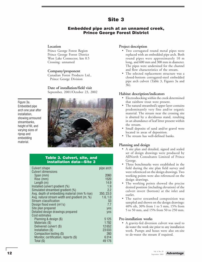
• The selected replacement structure was aclosed-bottom corrugated-steel embeddedpipe arch culvert (Table 3, Figures 3a and3b).
Habitat description/indicators• Electroshocking within the creek determined
that rainbow trout were present.• The natural streambed’s upper layer contains
predominantly very fine and/or organicmaterial. The stream near the crossing siteis abutted by a deciduous stand, resultingin an abundance of leaf litter present withinthe stream.
• Small deposits of sand and/or gravel werelocated in areas of deposition.
• The stream has well-defined banks.
Planning and design• A site plan and detailed, signed and sealed
set of design drawings were produced byAllNorth Consultants Limited of PrinceGeorge.
• Three benchmarks were established in thefield during the site plan field survey andwere referenced on the design drawings. Twoworking points were also referenced on thedesign drawings.
• The working points showed the precisedesired position (including elevation) of theculvert invert (bottom) at the inlet andoutlet.
• The native streambed composition wassampled and shown on the design drawings:40% silt, 30% from 1 to 5 mm, 15% from5 to 50 mm, and 15% from 50 to 250 mm.
Pre-installation works• A gravity-fed diversion culvert was used to
de-water the work site prior to any installationwork. Pumps and hoses were also on-siteto de-water the stream if required.
Figure 3a.Embedded pipearch one year afterinstallation,showing armouredstreambanks,height of fill, andvarying sizes ofriprap andembeddingmaterial.
Table 3. Culvert, site, andinstallation data—Site 3
Culver t shape pipe archCulver t dimensions
Span (mm) 2060Rise (mm) 1520Length (m) 14.9
Installed culver t gradient (%) 1.9Simulated streambed gradient (%) 2.2Avg. depth of embedding material (mm % rise) 350, 23.0Avg. natural stream width and gradient (m, %) 1.6, 1.0Stream classification S3Design flood event (m3/s) 7.7Site plan prepared yesDetailed design drawings prepared yesCost estimates
Planning & design ($) 5 125Materials ($) 1 792Delivered culver t ($) 12 652Installation ($) 23 033Compaction testing ($) 260Monitor, cer tification, repor ts ($) 6 314Total ($) 49 176
13September 2003
Vol. 4 No. 29Advantage
Construction works• Blackwater Construction Ltd. of Prince
George installed the embedded culvert. Theprimary equipment used during theinstallation consisted of two Caterpillar 225excavators.
• An environmental consulting firm providedon-site supervision during the installationand approved the materials (local gravelmaterial, washed gravel, and washed riprap)placed within the culvert.
• After placing the material within the culvert,the material was flushed with water, whichwas collected and pumped onto the forestfloor (to filter). This process was done untilthe water was running clearly.
• A 450-kg diesel plate compactor was usedfor compacting beside and over the culvert.Compaction tests were done to verify propercompaction of the culvert backfill material.
Embedment method• The culvert was filled using a small trailer
pulled by a four-wheel-drive all-terrainvehicle. Wheelbarrows were also on-site.The larger material within the culvertmeasured 30 cm in diameter.
• The design drawings specified the use ofclean gravel for the simulated streambed,with pieces of riprap equal to the largest10% of existing material, placed at 50-cmspacing.
Additional information• The design channel width through the
culvert was to be 1.7 m (average) as per anenvironmental management plan; the con-structed width of the simulated streambedis approximately 2.0 m.
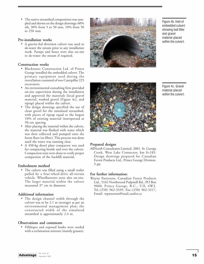
Observations and comments• A rock spur was built of riprap to help
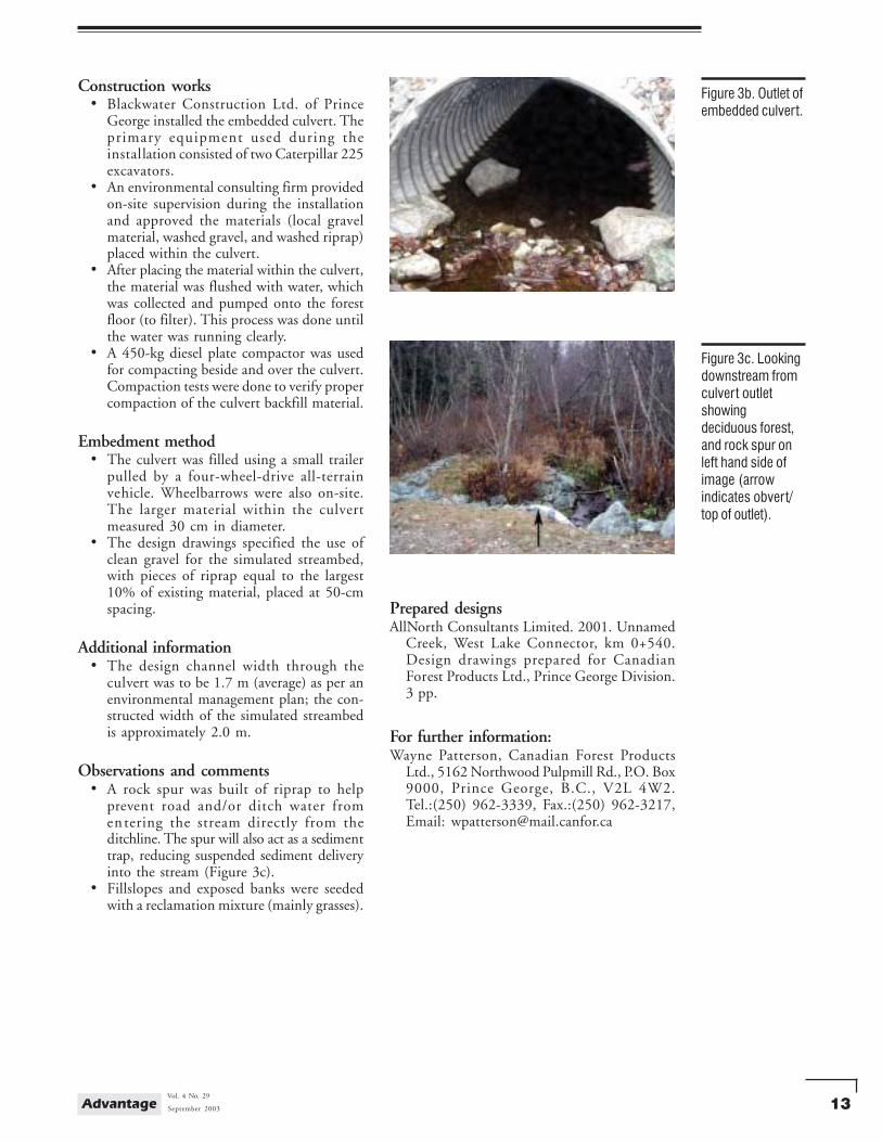
prevent road and/or ditch water fromentering the stream directly from theditchline. The spur will also act as a sedimenttrap, reducing suspended sediment deliveryinto the stream (Figure 3c).
• Fillslopes and exposed banks were seededwith a reclamation mixture (mainly grasses).
Figure 3b. Outlet ofembedded culvert.
Figure 3c. Lookingdownstream fromculvert outletshowingdeciduous forest,and rock spur onleft hand side ofimage (arrowindicates obvert/top of outlet).
Prepared designsAllNorth Consultants Limited. 2001. Unnamed
Creek, West Lake Connector, km 0+540.Design drawings prepared for CanadianForest Products Ltd., Prince George Division.3 pp.
For further information:Wayne Patterson, Canadian Forest Products
Ltd., 5162 Northwood Pulpmill Rd., P.O. Box9000, Prince George, B.C., V2L 4W2.Tel.:(250) 962-3339, Fax.:(250) 962-3217,Email: [email protected]
14 AdvantageVol. 4 No. 29
September 2003
Site 4
Embedded pipe arch at St. George Creek,Prince George Forest District
LocationPrince George Forest RegionPrince George Forest DistrictWest Lake Connector, km 0.2Crossing: St. George Creek
Company/proponentCanadian Forest Products Ltd., Prince George Division
Date of installation/field visitSeptember, 2001/October 23, 2002
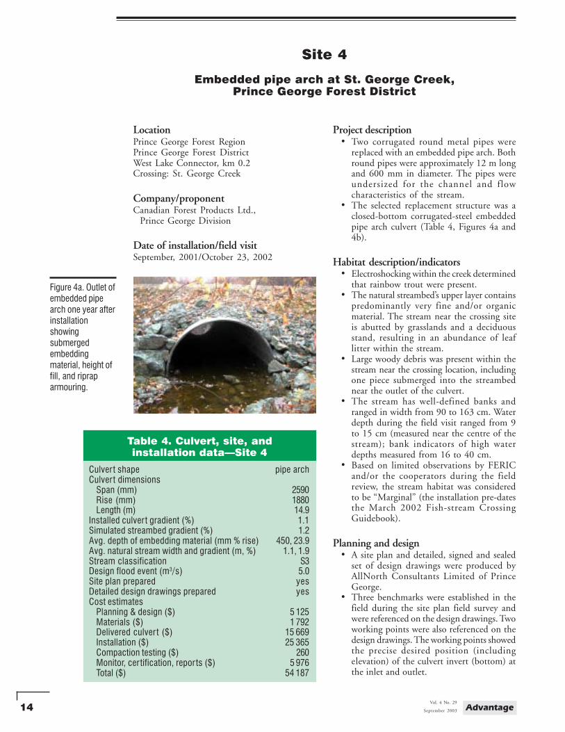
Project description• Two corrugated round metal pipes were
replaced with an embedded pipe arch. Bothround pipes were approximately 12 m longand 600 mm in diameter. The pipes wereundersized for the channel and flowcharacteristics of the stream.
• The selected replacement structure was aclosed-bottom corrugated-steel embeddedpipe arch culvert (Table 4, Figures 4a and4b).
Habitat description/indicators• Electroshocking within the creek determined
that rainbow trout were present.• The natural streambed’s upper layer contains
predominantly very fine and/or organicmaterial. The stream near the crossing siteis abutted by grasslands and a deciduousstand, resulting in an abundance of leaflitter within the stream.
• Large woody debris was present within thestream near the crossing location, includingone piece submerged into the streambednear the outlet of the culvert.
• The stream has well-defined banks andranged in width from 90 to 163 cm. Waterdepth during the field visit ranged from 9to 15 cm (measured near the centre of thestream); bank indicators of high waterdepths measured from 16 to 40 cm.
• Based on limited observations by FERICand/or the cooperators during the fieldreview, the stream habitat was consideredto be “Marginal” (the installation pre-datesthe March 2002 Fish-stream CrossingGuidebook).
Planning and design• A site plan and detailed, signed and sealed
set of design drawings were produced byAllNorth Consultants Limited of PrinceGeorge.
• Three benchmarks were established in thefield during the site plan field survey andwere referenced on the design drawings. Twoworking points were also referenced on thedesign drawings. The working points showedthe precise desired position (includingelevation) of the culvert invert (bottom) atthe inlet and outlet.
Figure 4a. Outlet ofembedded pipearch one year afterinstallationshowingsubmergedembeddingmaterial, height offill, and ripraparmouring.
Table 4. Culvert, site, andinstallation data—Site 4
Culver t shape pipe archCulver t dimensions
Span (mm) 2590Rise (mm) 1880Length (m) 14.9
Installed culver t gradient (%) 1.1Simulated streambed gradient (%) 1.2Avg. depth of embedding material (mm % rise) 450, 23.9Avg. natural stream width and gradient (m, %) 1.1, 1.9Stream classification S3Design flood event (m3/s) 5.0Site plan prepared yesDetailed design drawings prepared yesCost estimates
Planning & design ($) 5 125Materials ($) 1 792Delivered culver t ($) 15 669Installation ($) 25 365Compaction testing ($) 260Monitor, cer tification, repor ts ($) 5 976Total ($) 54 187
15September 2003
Vol. 4 No. 29Advantage
• The native streambed composition was sam-pled and shown on the design drawings: 60%silt, 30% from 5 to 50 mm, 10% from 50to 250 mm.
Pre-installation works• A gravity-fed diversion culvert was used to
de-water the stream prior to any installationwork. Pumps and hoses were also on-siteto de-water the stream if required.
Construction works• Blackwater Construction Ltd. of Prince
George installed the embedded culvert. Theprimary equipment used during theinstallation consisted of two Caterpillar 225excavators.
• An environmental consulting firm providedon-site supervision during the installationand approved the materials (local gravelmaterial, washed gravel [Figure 4c], andriprap) placed within the culvert.
• The design drawings specified the use ofclean gravel for the simulated streambed,with pieces of riprap equal to the largest10% of existing material interspersed at50-cm spacing.
• After placing the material within the culvert,the material was flushed with water whichwas then collected and pumped onto theforest floor (to filter). This process was doneuntil the water was running clear.
• A 450-kg diesel plate compactor was usedfor compacting beside and over the culvert.Compaction tests were done to verify propercompaction of the backfill material.
Embedment method• The culvert was filled using a small trailer
pulled by a four-wheel-drive all-terrainvehicle. Wheelbarrows were also on-site.The larger material within the culvertmeasured 37 cm in diameter.
Additional information• The design channel width through the
culvert was to be 2.1 m (average) as per anenvironmental management plan; theconstructed width of the simulatedstreambed is approximately 2.4 m.
Observations and comments• Fillslopes and exposed banks were seeded
with a reclamation mixture (mainly grasses).
Figure 4c. Gravelmaterial placedwithin the culvert.
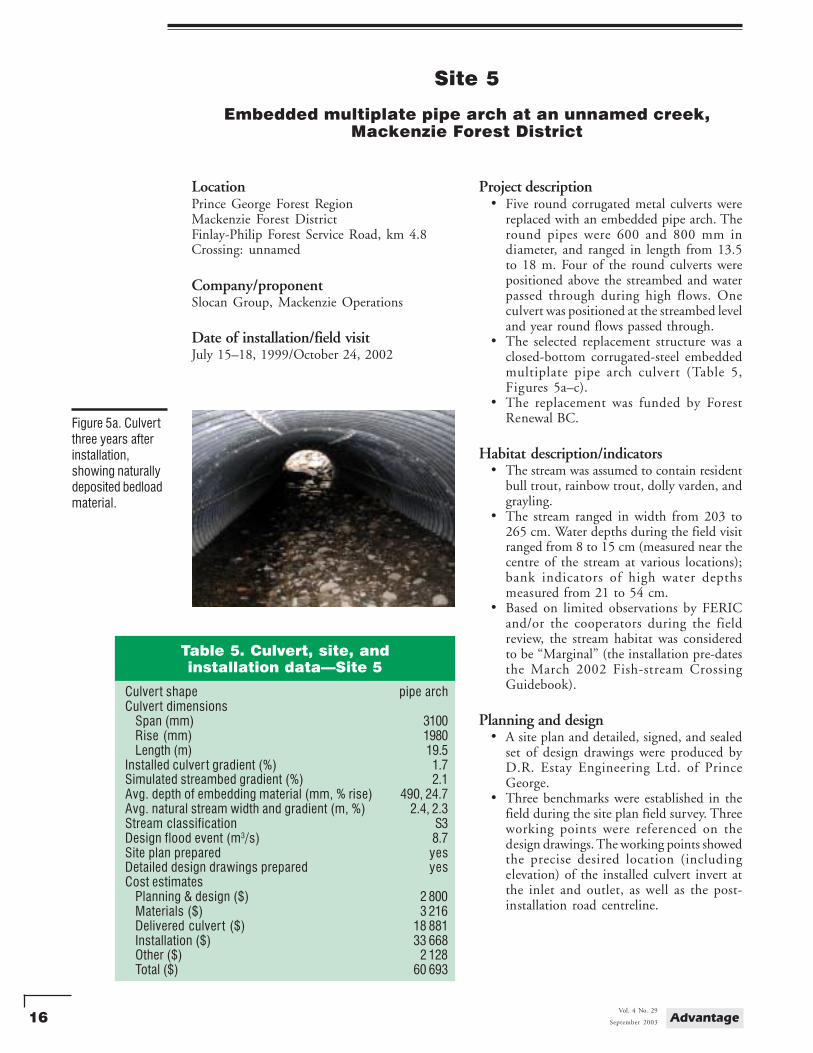
Figure 4b. Inlet ofembedded culvertshowing leaf litterand gravelmaterial placedwithin the culvert.
Prepared designsAllNorth Consultants Limited. 2001. St. George
Creek, West Lake Connector, km 0+183.Design drawings prepared for CanadianForest Products Ltd., Prince George Division.3 pp.
For further information:Wayne Patterson, Canadian Forest Products
Ltd., 5162 Northwood Pulpmill Rd., PO Box9000, Prince George, B.C., V2L 4W2.Tel.:(250) 962-3339, Fax.:(250) 962-3217,Email: [email protected]
16 AdvantageVol. 4 No. 29
September 2003
Site 5
Embedded multiplate pipe arch at an unnamed creek,Mackenzie Forest District
LocationPrince George Forest RegionMackenzie Forest DistrictFinlay-Philip Forest Service Road, km 4.8Crossing: unnamed
Company/proponentSlocan Group, Mackenzie Operations
Date of installation/field visitJuly 15–18, 1999/October 24, 2002
Project description• Five round corrugated metal culverts were
replaced with an embedded pipe arch. Theround pipes were 600 and 800 mm indiameter, and ranged in length from 13.5to 18 m. Four of the round culverts werepositioned above the streambed and waterpassed through during high flows. Oneculvert was positioned at the streambed leveland year round flows passed through.
• The selected replacement structure was aclosed-bottom corrugated-steel embeddedmultiplate pipe arch culvert (Table 5,Figures 5a–c).
• The replacement was funded by ForestRenewal BC.
Habitat description/indicators• The stream was assumed to contain resident
bull trout, rainbow trout, dolly varden, andgrayling.
• The stream ranged in width from 203 to265 cm. Water depths during the field visitranged from 8 to 15 cm (measured near thecentre of the stream at various locations);bank indicators of high water depthsmeasured from 21 to 54 cm.
• Based on limited observations by FERICand/or the cooperators during the fieldreview, the stream habitat was consideredto be “Marginal” (the installation pre-datesthe March 2002 Fish-stream CrossingGuidebook).
Planning and design• A site plan and detailed, signed, and sealed
set of design drawings were produced byD.R. Estay Engineering Ltd. of PrinceGeorge.
• Three benchmarks were established in thefield during the site plan field survey. Threeworking points were referenced on thedesign drawings. The working points showedthe precise desired location (includingelevation) of the installed culvert invert atthe inlet and outlet, as well as the post-installation road centreline.
Figure 5a. Culvertthree years afterinstallation,showing naturallydeposited bedloadmaterial.
Table 5. Culvert, site, andinstallation data—Site 5
Culvert shape pipe archCulvert dimensions
Span (mm) 3100Rise (mm) 1980Length (m) 19.5
Installed culver t gradient (%) 1.7Simulated streambed gradient (%) 2.1Avg. depth of embedding material (mm, % rise) 490, 24.7Avg. natural stream width and gradient (m, %) 2.4, 2.3Stream classification S3Design flood event (m3/s) 8.7Site plan prepared yesDetailed design drawings prepared yesCost estimates
Planning & design ($) 2 800Materials ($) 3 216Delivered culver t ($) 18 881Installation ($) 33 668Other ($) 2 128Total ($) 60 693
17September 2003
Vol. 4 No. 29Advantage
• The native streambed composition wassampled and shown on the design drawings:20% from 0 to 2 mm (sand/silt), 40% from2 to 64 mm (gravel), 35% from 64 to256 mm (cobbles), and 5% greater than256 mm (boulders).
Pre-installation works• A temporary log-sill bridge was installed
downstream from the work site, allowing theroad to remain open for forestry operations.
• Three silt fences were installed downstreamof the installation site.
• At the upstream side of the work site, anearthfill dam wrapped with filter fabricdiverted stream flow into a diversion pipe.This allowed the installation of the newculvert to take place in a de-watered worksite.
• A sump hole was excavated at each end ofthe proposed embedded culvert placement.Pumps and hoses were used to pumpsediment-laden water from the sump holesonto the forest floor.
Construction works• Ruskin Construction Ltd. of Prince George
installed the embedded culvert. AllNorthConsultants Ltd. of Prince George supervisedthe installation.
• AGRA Earth and Environmental Limitedof Prince George conducted field (nuclear)and laboratory (standard Proctor) density/compaction tests of the culvert backfillmaterial. A driveable roller compactorachieved the designed level of compactionby compacting 200-mm lifts of selectgranular backfill.
• The embedded culvert was deliveredpre-assembled and installed as one piece.Two excavators were required to lift andplace the culvert.
Embedment method• The culvert was installed 400 mm below
the streambed and left to naturally fill withstream bedload material.
Additional information• Some of the removed culverts were used
for diverting the stream flow.
Figure 5b. Lookingdownstreamthrough theembedded culvert,showing thestream flowingalong one side ofthe culvert at thislocation.
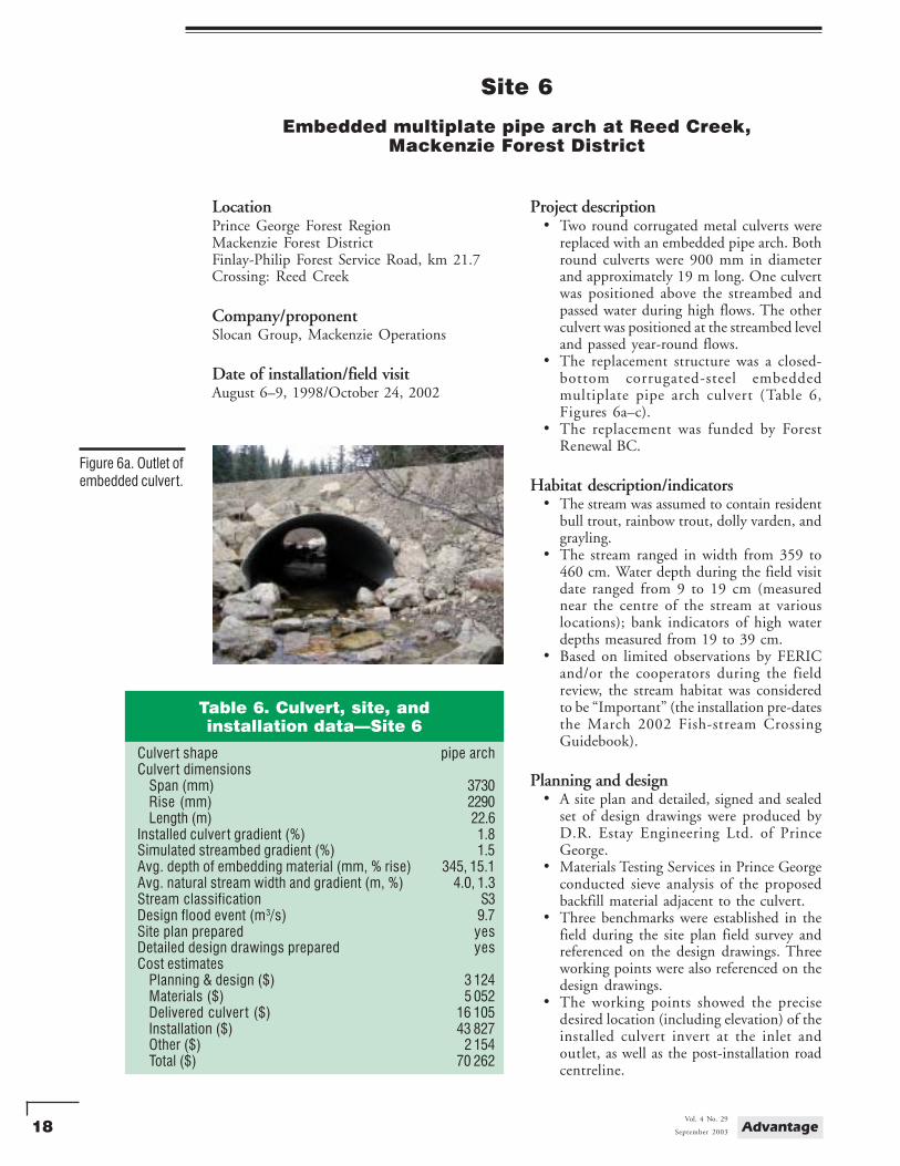
Figure 5c. Outlet ofembedded culvertshowing height offill, ripraparmouring, and asmall root waddeposited duringhigh flows.
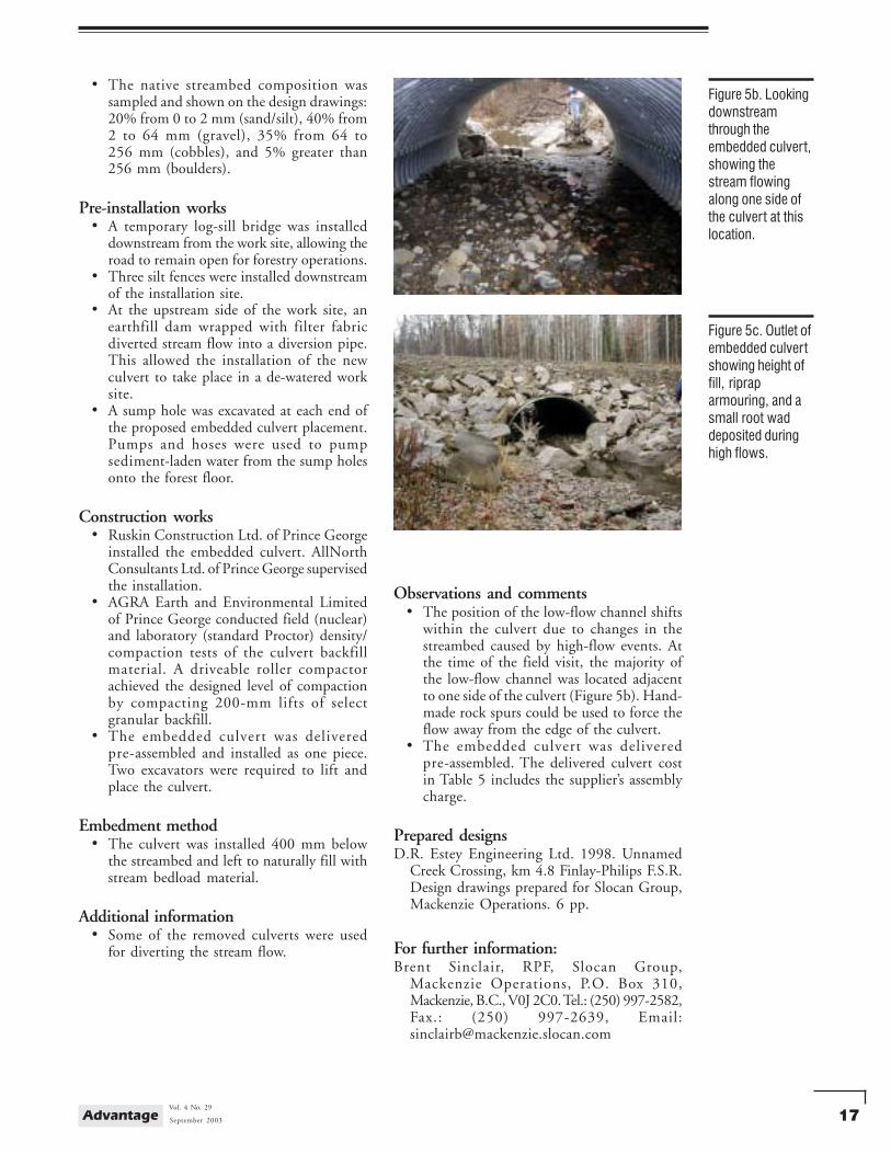
Observations and comments• The position of the low-flow channel shifts
within the culvert due to changes in thestreambed caused by high-flow events. Atthe time of the field visit, the majority ofthe low-flow channel was located adjacentto one side of the culvert (Figure 5b). Hand-made rock spurs could be used to force theflow away from the edge of the culvert.
• The embedded culvert was deliveredpre-assembled. The delivered culvert costin Table 5 includes the supplier’s assemblycharge.
Prepared designsD.R. Estey Engineering Ltd. 1998. Unnamed
Creek Crossing, km 4.8 Finlay-Philips F.S.R.Design drawings prepared for Slocan Group,Mackenzie Operations. 6 pp.
For further information:Brent Sinclair, RPF, Slocan Group,
Mackenzie Operations, P.O. Box 310,Mackenzie, B.C., V0J 2C0. Tel.: (250) 997-2582,Fax.: (250) 997-2639, Email:[email protected]
18 AdvantageVol. 4 No. 29
September 2003
Site 6
Embedded multiplate pipe arch at Reed Creek,Mackenzie Forest District
LocationPrince George Forest RegionMackenzie Forest DistrictFinlay-Philip Forest Service Road, km 21.7Crossing: Reed Creek
Company/proponentSlocan Group, Mackenzie Operations
Date of installation/field visitAugust 6–9, 1998/October 24, 2002
Project description• Two round corrugated metal culverts were
replaced with an embedded pipe arch. Bothround culverts were 900 mm in diameterand approximately 19 m long. One culvertwas positioned above the streambed andpassed water during high flows. The otherculvert was positioned at the streambed leveland passed year-round flows.
• The replacement structure was a closed-bottom corrugated-steel embeddedmultiplate pipe arch culvert (Table 6,Figures 6a–c).
• The replacement was funded by ForestRenewal BC.
Habitat description/indicators• The stream was assumed to contain resident
bull trout, rainbow trout, dolly varden, andgrayling.
• The stream ranged in width from 359 to460 cm. Water depth during the field visitdate ranged from 9 to 19 cm (measurednear the centre of the stream at variouslocations); bank indicators of high waterdepths measured from 19 to 39 cm.
• Based on limited observations by FERICand/or the cooperators during the fieldreview, the stream habitat was consideredto be “Important” (the installation pre-datesthe March 2002 Fish-stream CrossingGuidebook).
Planning and design• A site plan and detailed, signed and sealed
set of design drawings were produced byD.R. Estay Engineering Ltd. of PrinceGeorge.
• Materials Testing Services in Prince Georgeconducted sieve analysis of the proposedbackfill material adjacent to the culvert.
• Three benchmarks were established in thefield during the site plan field survey andreferenced on the design drawings. Threeworking points were also referenced on thedesign drawings.
• The working points showed the precisedesired location (including elevation) of theinstalled culvert invert at the inlet andoutlet, as well as the post-installation roadcentreline.
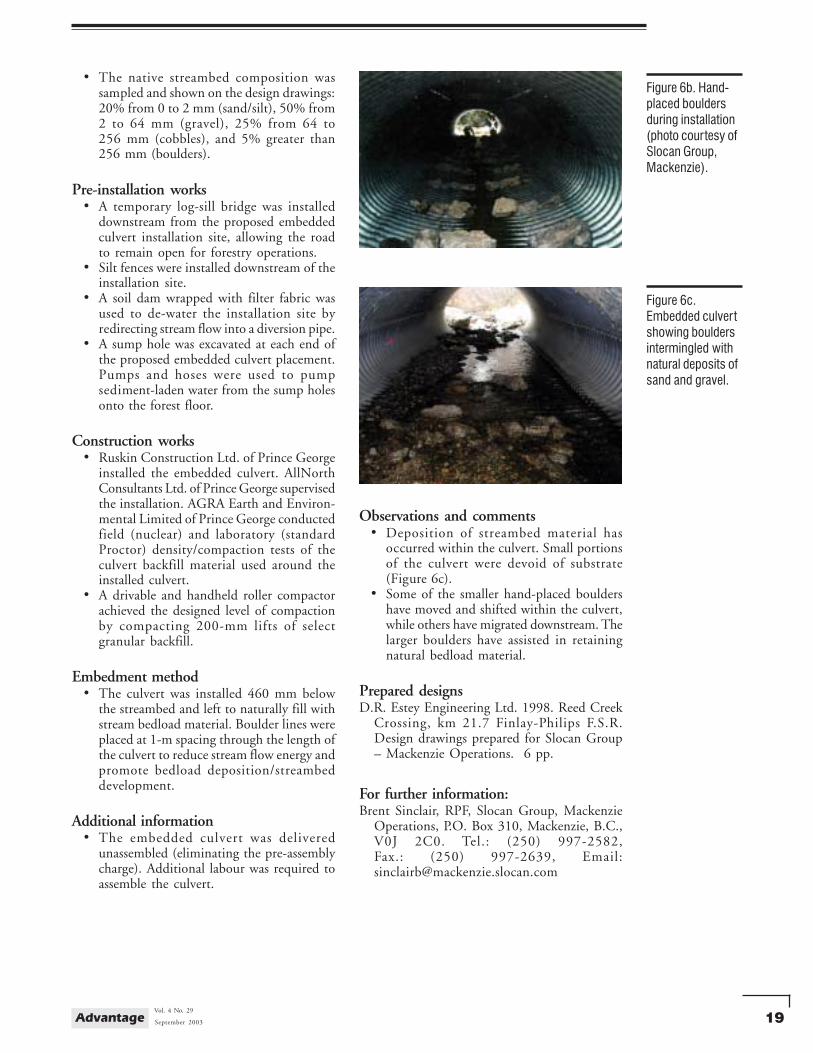
Figure 6a. Outlet ofembedded culvert.
Table 6. Culvert, site, andinstallation data—Site 6
Culver t shape pipe archCulver t dimensions
Span (mm) 3730Rise (mm) 2290Length (m) 22.6
Installed culver t gradient (%) 1.8Simulated streambed gradient (%) 1.5Avg. depth of embedding material (mm, % rise) 345, 15.1Avg. natural stream width and gradient (m, %) 4.0, 1.3Stream classification S3Design flood event (m3/s) 9.7Site plan prepared yesDetailed design drawings prepared yesCost estimates
Planning & design ($) 3 124Materials ($) 5 052Delivered culver t ($) 16 105Installation ($) 43 827Other ($) 2 154Total ($) 70 262
19September 2003
Vol. 4 No. 29Advantage
• The native streambed composition wassampled and shown on the design drawings:20% from 0 to 2 mm (sand/silt), 50% from2 to 64 mm (gravel), 25% from 64 to256 mm (cobbles), and 5% greater than256 mm (boulders).
Pre-installation works• A temporary log-sill bridge was installed
downstream from the proposed embeddedculvert installation site, allowing the roadto remain open for forestry operations.
• Silt fences were installed downstream of theinstallation site.
• A soil dam wrapped with filter fabric wasused to de-water the installation site byredirecting stream flow into a diversion pipe.
• A sump hole was excavated at each end ofthe proposed embedded culvert placement.Pumps and hoses were used to pumpsediment-laden water from the sump holesonto the forest floor.
Construction works• Ruskin Construction Ltd. of Prince George
installed the embedded culvert. AllNorthConsultants Ltd. of Prince George supervisedthe installation. AGRA Earth and Environ-mental Limited of Prince George conductedfield (nuclear) and laboratory (standardProctor) density/compaction tests of theculvert backfill material used around theinstalled culvert.
• A drivable and handheld roller compactorachieved the designed level of compactionby compacting 200-mm lifts of selectgranular backfill.
Embedment method• The culvert was installed 460 mm below
the streambed and left to naturally fill withstream bedload material. Boulder lines wereplaced at 1-m spacing through the length ofthe culvert to reduce stream flow energy andpromote bedload deposition/streambeddevelopment.
Additional information• The embedded culvert was delivered
unassembled (eliminating the pre-assemblycharge). Additional labour was required toassemble the culvert.
Figure 6b. Hand-placed bouldersduring installation(photo courtesy ofSlocan Group,Mackenzie).
Figure 6c.Embedded culvertshowing bouldersintermingled withnatural deposits ofsand and gravel.
Observations and comments• Deposition of streambed material has
occurred within the culvert. Small portionsof the culvert were devoid of substrate(Figure 6c).
• Some of the smaller hand-placed bouldershave moved and shifted within the culvert,while others have migrated downstream. Thelarger boulders have assisted in retainingnatural bedload material.
Prepared designsD.R. Estey Engineering Ltd. 1998. Reed Creek
Crossing, km 21.7 Finlay-Philips F.S.R.Design drawings prepared for Slocan Group– Mackenzie Operations. 6 pp.
For further information:Brent Sinclair, RPF, Slocan Group, Mackenzie
Operations, P.O. Box 310, Mackenzie, B.C.,V0J 2C0. Tel.: (250) 997-2582,Fax.: (250) 997-2639, Email:[email protected]
20 AdvantageVol. 4 No. 29
September 2003
Site 7
Embedded pipe arch at an unnamed creek,Fort St. James Forest District
LocationPrince George Forest RegionFort St. James Forest DistrictMeridian North, 500 Road, km 6.0Crossing: unnamed
Company/proponentCanadian Forest Products Ltd., Fort St. James Operations
Date of installation/field visitAugust 14–15, 2002/October 25, 2002
Project description• The road was newly built and, during road
construction, the unnamed stream had beencrossed using a temporary modular steelbridge.
• The temporary bridge was removed andreplaced with a permanent closed-bottomcorrugated-steel embedded pipe arch culvert(Table 7, Figures 7a–c).
Habitat description/indicators• The stream was assumed to contain rainbow
trout; kokanee and burbot are also assumedby default due to the lack of barriers andthe stream’s connectivity to the TsilcohRiver. The stream joins the Tsilcoh River(an S2 stream) approximately 300 m down-stream of the culvert installation.
• The stream has a well-defined channel andcontains very low flows during the summer.Much of the stream has a sandy bottom andsmall deposits of gravel are present. Deeppools are not present in the vicinity of theroad crossing.
• Based on limited observations by FERICand/or the cooperators during the fieldreview, the stream habitat was consideredto be “Marginal”.
Planning and design• No site plan or design drawings were
prepared.• During the installation, precision survey
equipment was used to guide the depth(elevation) of excavation. Benchmarks wereestablished in the field and pre-installationmeasurements were taken along the stream.Target elevations for the culvert invert atthe inlet and outlet were determined in thefield, and were approximately 25 cm belowthe original stream channel.
Pre-installation works• Stop nets were installed upstream and
downstream of the site to keep fish fromentering the area.
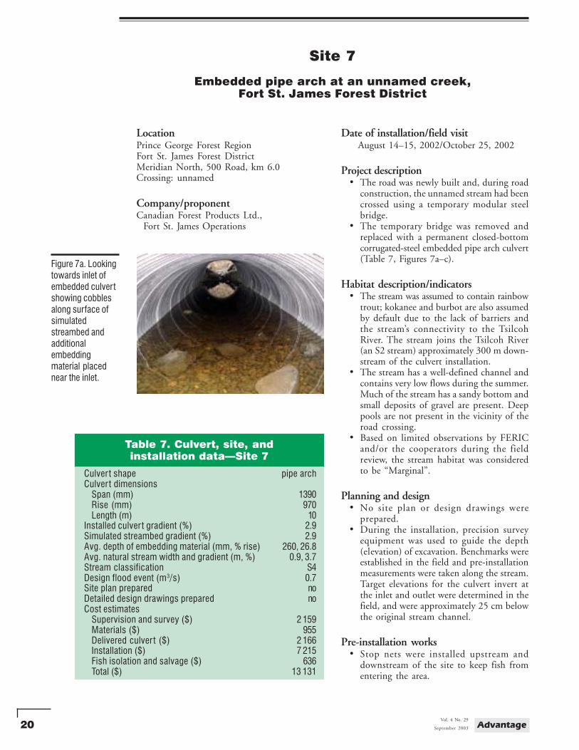
Figure 7a. Lookingtowards inlet ofembedded culvertshowing cobblesalong surface ofsimulatedstreambed andadditionalembeddingmaterial placednear the inlet.
Table 7. Culvert, site, andinstallation data—Site 7
Culver t shape pipe archCulver t dimensions
Span (mm) 1390Rise (mm) 970Length (m) 10
Installed culver t gradient (%) 2.9Simulated streambed gradient (%) 2.9Avg. depth of embedding material (mm, % rise) 260, 26.8Avg. natural stream width and gradient (m, %) 0.9, 3.7Stream classification S4Design flood event (m3/s) 0.7Site plan prepared noDetailed design drawings prepared noCost estimates
Supervision and survey ($) 2 159Materials ($) 955Delivered culver t ($) 2 166Installation ($) 7 215Fish isolation and salvage ($) 636Total ($) 13 131
21September 2003
Vol. 4 No. 29Advantage
• A fish salvage was conducted to identify andremove any fish present; no fish werecaptured.
• A temporary sandbag dam was constructedon the upstream side of the installation site.A pump-and-hose system delivered wateraround the site.
Construction works• K & D Logging Ltd. of Fort St. James
installed the embedded culvert using aHitachi 200 excavator. A plate compactorwas used to compact the backfill materialaround the outside of the culvert.
• Environmental Dynamics Inc. of PrinceGeorge provided on-site supervision.
Embedment method• The culvert was filled by hand, using
buckets to deliver material through theculvert (Figure 7b).
• The majority of the material used withinthe culvert was road fill gravel. Approximatelysix rock lines, made of larger-sized cobbles,were installed prior to completing the infill.The rock lines are expected to help keepthe finer material in place. This was cappedwith a layer of delivered drain rock. Largecobbles were placed randomly over thesurface to promote the development of alow-flow channel.
• The corrugated culvert was delivered in twosections with a coupler (including nuts andbolts). Once the first section was in place,the forest workers started to fill it withaggregate.
• By filling the first section from both ends, ashorter distance was travelled within theculvert during the delivery of the aggregate.
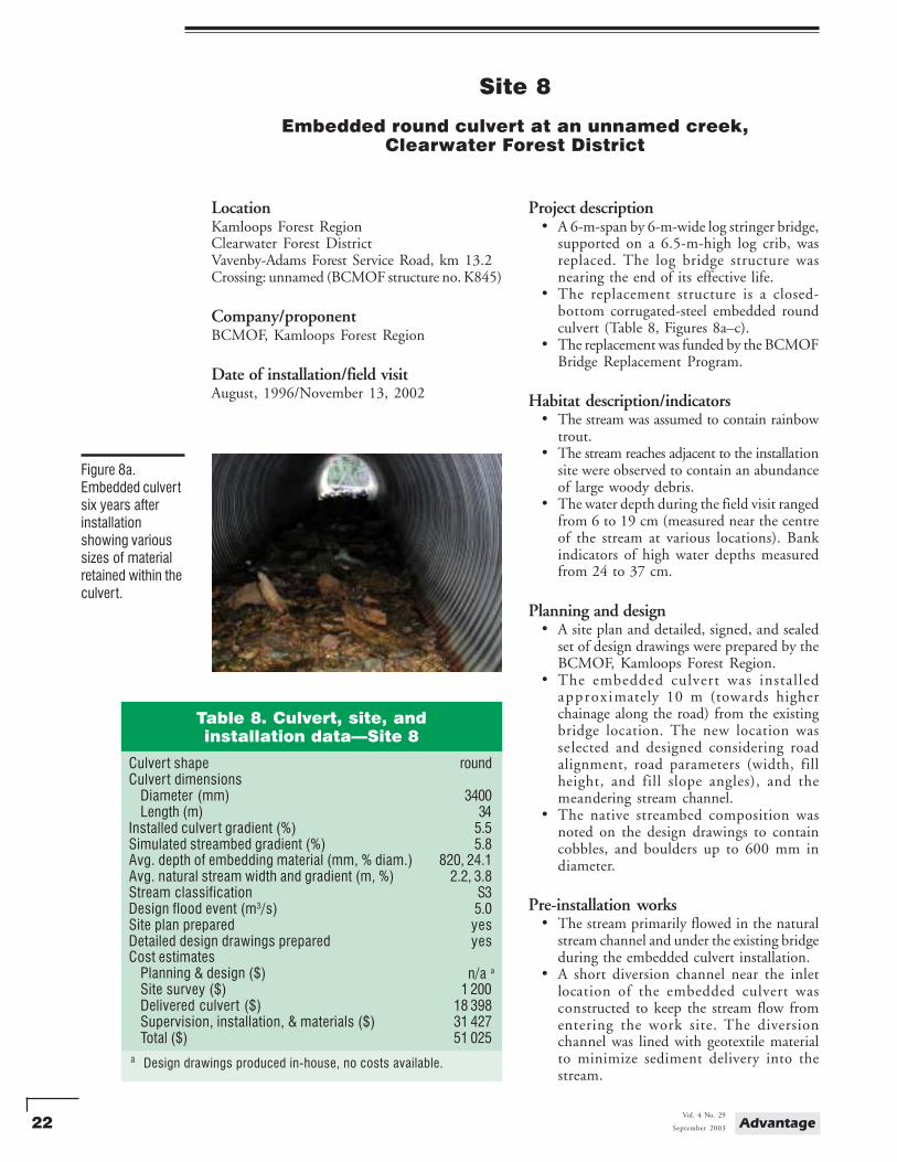
• Additional embedding material was placedwithin the culvert near the inlet to promotefurther embedment (Figures 7a and 7c).
Additional information• The gravel material used within the culvert
was chosen for its mix of sizes. This mixhelped to fill voids within the simulatedstreambed, and maintain surface streamflowin the culvert.
• The stream was sampled for fish during 2000and 2001; no fish were captured/observedeither time.
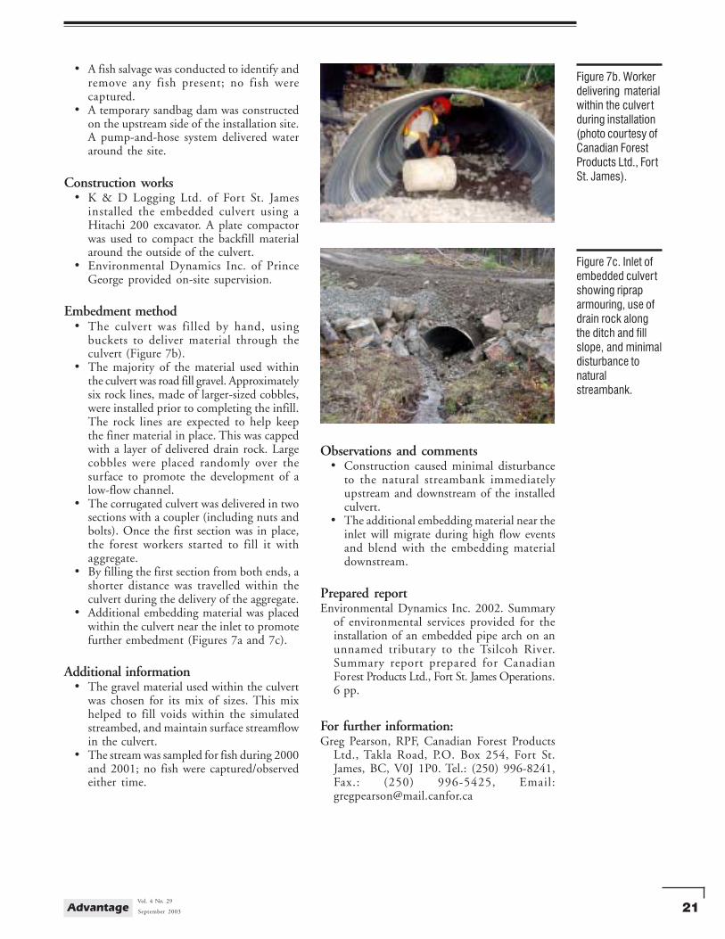
Figure 7b. Workerdelivering materialwithin the culver tduring installation(photo courtesy ofCanadian ForestProducts Ltd., FortSt. James).
Figure 7c. Inlet ofembedded culvertshowing ripraparmouring, use ofdrain rock alongthe ditch and fillslope, and minimaldisturbance tonaturalstreambank.
Observations and comments• Construction caused minimal disturbance
to the natural streambank immediatelyupstream and downstream of the installedculvert.
• The additional embedding material near theinlet will migrate during high flow eventsand blend with the embedding materialdownstream.
Prepared reportEnvironmental Dynamics Inc. 2002. Summary
of environmental services provided for theinstallation of an embedded pipe arch on anunnamed tributary to the Tsilcoh River.Summary report prepared for CanadianForest Products Ltd., Fort St. James Operations.6 pp.
For further information:Greg Pearson, RPF, Canadian Forest Products
Ltd., Takla Road, P.O. Box 254, Fort St.James, BC, V0J 1P0. Tel.: (250) 996-8241,Fax.: (250) 996-5425, Email:[email protected]
22 AdvantageVol. 4 No. 29
September 2003
Site 8
Embedded round culvert at an unnamed creek,Clearwater Forest District
LocationKamloops Forest RegionClearwater Forest DistrictVavenby-Adams Forest Service Road, km 13.2Crossing: unnamed (BCMOF structure no. K845)
Company/proponentBCMOF, Kamloops Forest Region
Date of installation/field visitAugust, 1996/November 13, 2002
Project description• A 6-m-span by 6-m-wide log stringer bridge,
supported on a 6.5-m-high log crib, wasreplaced. The log bridge structure wasnearing the end of its effective life.
• The replacement structure is a closed-bottom corrugated-steel embedded roundculvert (Table 8, Figures 8a–c).
• The replacement was funded by the BCMOFBridge Replacement Program.
Habitat description/indicators• The stream was assumed to contain rainbow
trout.• The stream reaches adjacent to the installation
site were observed to contain an abundanceof large woody debris.
• The water depth during the field visit rangedfrom 6 to 19 cm (measured near the centreof the stream at various locations). Bankindicators of high water depths measuredfrom 24 to 37 cm.
Planning and design• A site plan and detailed, signed, and sealed
set of design drawings were prepared by theBCMOF, Kamloops Forest Region.
• The embedded culvert was installedapproximately 10 m (towards higherchainage along the road) from the existingbridge location. The new location wasselected and designed considering roadalignment, road parameters (width, fillheight, and fill slope angles), and themeandering stream channel.
• The native streambed composition wasnoted on the design drawings to containcobbles, and boulders up to 600 mm indiameter.
Pre-installation works• The stream primarily flowed in the natural
stream channel and under the existing bridgeduring the embedded culvert installation.
• A short diversion channel near the inletlocation of the embedded culvert wasconstructed to keep the stream flow fromentering the work site. The diversionchannel was lined with geotextile materialto minimize sediment delivery into thestream.
Figure 8a.Embedded culvertsix years afterinstallationshowing varioussizes of materialretained within theculvert.
Table 8. Culvert, site, andinstallation data—Site 8
Culvert shape roundCulvert dimensions
Diameter (mm) 3400Length (m) 34
Installed culver t gradient (%) 5.5Simulated streambed gradient (%) 5.8Avg. depth of embedding material (mm, % diam.) 820, 24.1Avg. natural stream width and gradient (m, %) 2.2, 3.8Stream classification S3Design flood event (m3/s) 5.0Site plan prepared yesDetailed design drawings prepared yesCost estimates
Planning & design ($) n/a a
Site survey ($) 1 200Delivered culvert ($) 18 398Supervision, installation, & materials ($) 31 427Total ($) 51 025
a Design drawings produced in-house, no costs available.
n/a a
23September 2003
Vol. 4 No. 29Advantage
Construction works• On-site supervision, equipment/contractor
coordination, and surveying were done byTroll Bridge Services of Penticton.
• A surveyor using precision survey equipmentguided the excavation.
• A downstream sump was excavated to collectsediment-laden water. Pumps were used toremove the water from the sump and deliverit onto the forest floor away from the stream.
Embedment method• A rubber-tired Bobcat loader delivered
material within the culvert. The loaderentered the culvert at the inlet. The loaderdeposited material within the culvertstarting at the outlet and worked throughthe culvert towards the inlet.
• Larger cobbles and boulders were hauled tothe site. Gravel and fine material weredeveloped from the excavated material. Theloader alternated loads of boulders andcobbles, with loads of gravels and fines.
• After the material was placed within theculvert, it was washed using pumped streamwater. This helped to fill the voids withinthe delivered material and any initialsuspended sediment was washed into thesump at the outlet.
Additional information• The culvert was designed and constructed
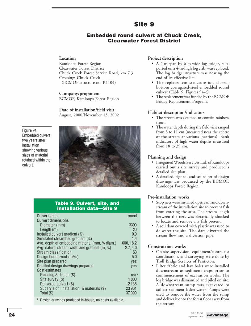
with a 1.5 to 1 step-bevel at the inlet. Astep-bevel creates a distinct top and bottomto a round culvert section.
• The culvert was comprised of four sections.Prior to coupling two sections, the abuttedsections were wrapped with a fibreglassinsulation. This wrapping technique filledany prominent gaps between joined sections.
Observations and comments• The height of fill over the culvert was
approximately 5.5 m.
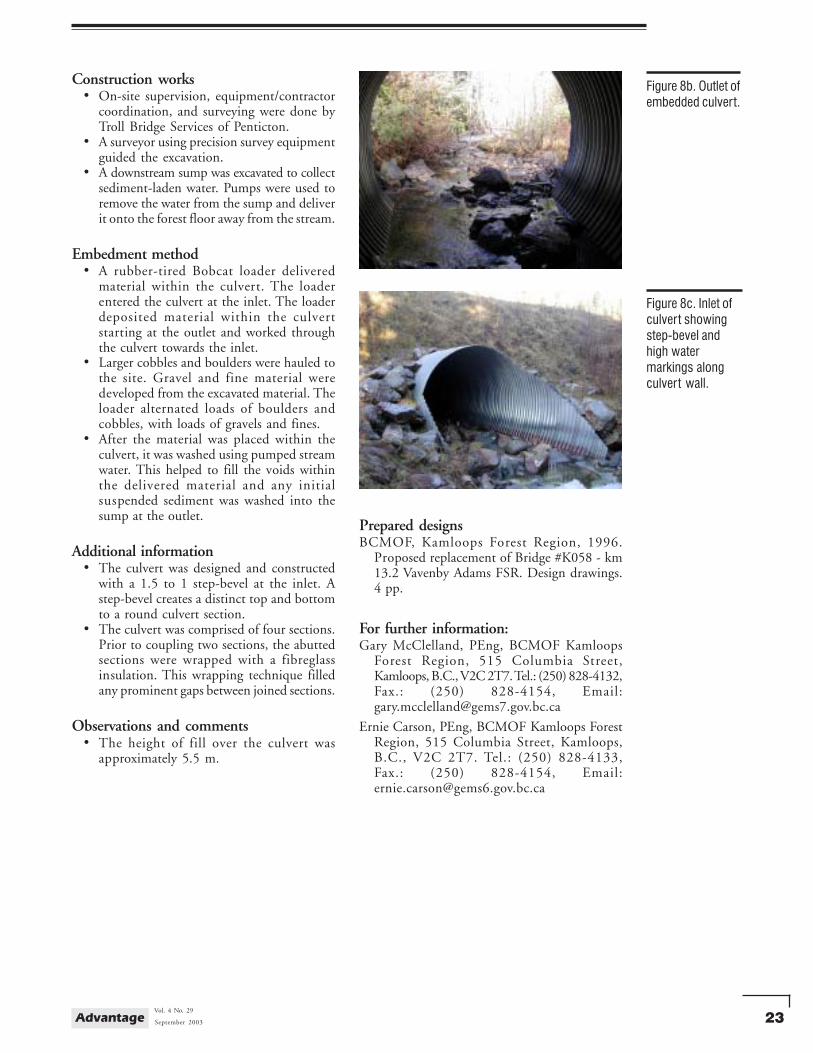
Figure 8b. Outlet ofembedded culvert.
Figure 8c. Inlet ofculvert showingstep-bevel andhigh watermarkings alongculvert wall.
Prepared designsBCMOF, Kamloops Forest Region, 1996.
Proposed replacement of Bridge #K058 - km13.2 Vavenby Adams FSR. Design drawings.4 pp.
For further information:Gary McClelland, PEng, BCMOF Kamloops
Forest Region, 515 Columbia Street,Kamloops, B.C., V2C 2T7. Tel.: (250) 828-4132,Fax.: (250) 828-4154, Email:[email protected]
Ernie Carson, PEng, BCMOF Kamloops ForestRegion, 515 Columbia Street, Kamloops,B.C., V2C 2T7. Tel.: (250) 828-4133,Fax.: (250) 828-4154, Email:[email protected]
24 AdvantageVol. 4 No. 29
September 2003
Site 9
Embedded round culvert at Chuck Creek,Clearwater Forest District
LocationKamloops Forest RegionClearwater Forest DistrictChuck Creek Forest Service Road, km 7.3Crossing: Chuck Creek (BCMOF structure no. K1104)
Company/proponentBCMOF, Kamloops Forest Region
Date of installation/field visitAugust, 2000/November 13, 2002
Project description• A 4-m-span by 6-m-wide log bridge, sup-
ported on a 4-m-high log crib, was replaced.The log bridge structure was nearing theend of its effective life.
• The replacement structure is a closed-bottom corrugated-steel embedded roundculvert (Table 9, Figures 9a–c).
• The replacement was funded by the BCMOFBridge Replacement Program.
Habitat description/indicators• The stream was assumed to contain rainbow
trout.• The water depth during the field visit ranged
from 8 to 11 cm (measured near the centreof the stream at various locations). Bankindicators of high water depths measuredfrom 18 to 39 cm.
Planning and design• Integrated Woods Services Ltd. of Kamloops
carried out a site survey and produced adetailed site plan.
• A detailed, signed, and sealed set of designdrawings was produced by the BCMOF,Kamloops Forest Region.
Pre-installation works• Stop nets were installed upstream and down-
stream of the installation site to prevent fishfrom entering the area. The stream lengthbetween the nets was electrically shockedto locate and remove any fish present.
• A soil dam covered with plastic was used tode-water the site. The dam diverted thestream flow into a diversion pipe.
Construction works• On-site supervision, equipment/contractor
coordination, and surveying were done byTroll Bridge Services of Penticton.
• Filter fabric and hay bales were installeddownstream as sediment traps prior tocommencement of excavation works. Thelog bridge was dismantled and piled on site.A downstream sump was excavated tocollect sediment-laden water. Pumps wereused to remove the water from the sumpand deliver it onto the forest floor away fromthe stream.
Figure 9a.Embedded culverttwo years afterinstallationshowing varioussizes of materialretained within theculvert.
Table 9. Culvert, site, andinstallation data—Site 9
Culver t shape roundCulver t dimensions
Diameter (mm) 3300Length (m) 20
Installed culver t gradient (%) 0.9Simulated streambed gradient (%) 1.4Avg. depth of embedding material (mm, % diam.) 600, 18.2Avg. natural stream width and gradient (m, %) 2.7, 4.0Stream classification S3Design flood event (m3/s) 5.0Site plan prepared yesDetailed design drawings prepared yesCost estimates
Planning & design ($) n/a a
Site survey ($) 1 000Delivered culver t ($) 12 138Supervision, installation, & materials ($) 23 961Total ($) 37 099
a Design drawings produced in-house, no costs available.
n/a a
25September 2003
Vol. 4 No. 29Advantage
• A surveyor using precision survey equipmentguided the excavation.
Embedment method• A rubber-tired Bobcat loader delivered
material within the culvert. The loaderdeposited material within the culvert startingat the outlet and worked through the culverttowards the inlet.
• Larger cobbles and boulders were hauled tothe site. Gravel and fine material weredeveloped from the excavated material. Theloader alternated loads of boulders andcobbles, with loads of gravels and fines.
• After the material was placed within theculvert it was hosed down with cleanpumped stream water to “seal” the surfaceand minimize the initial sediment flush whenthe streamflow was reintroduced.
Additional information• The culvert was designed and constructed
with a 1.5 to 1 step-bevel at the inlet. Astep-bevel creates a distinct top and bottomto a round culvert section.
• The culvert was comprised of two sections.Prior to coupling two sections, the abuttedsections were wrapped with a fibreglassinsulation. This wrapping technique filledany prominent gaps between the joinedsections.
Observations and comments• The height of fill over the culvert was
approximately 1.5 m.• Exposed soils along the fillslopes were seeded
with a grass mixture at the time of theinstallation. There is a continuous cover ofvegetation along the fillslope areas withoutriprap armouring (Figure 9c).
Prepared designsBCMOF, Kamloops Forest Region. 2000.
Proposed replacement of Chuck Creek Bridge- km 7.3 Chuck Creek FSR. Design drawings.4 pp.
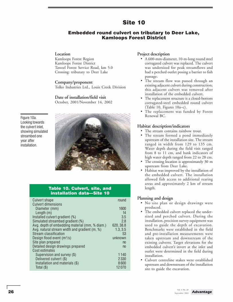
Figure 9b. Varioussizes of aggregatewithin the culver t(hat can be usedfor scale).
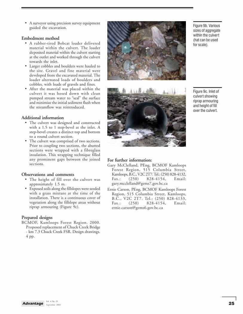
Figure 9c. Inlet ofculvert showingriprap armouringand height of fillover the culvert.
For further information:Gary McClelland, PEng, BCMOF Kamloops
Forest Region, 515 Columbia Street,Kamloops, B.C., V2C 2T7. Tel.: (250) 828-4132,Fax.: (250) 828-4154, Email:[email protected]
Ernie Carson, PEng, BCMOF Kamloops ForestRegion, 515 Columbia Street, Kamloops,B.C., V2C 2T7. Tel.: (250) 828-4133,Fax.: (250) 828-4154, Email:[email protected]
26 AdvantageVol. 4 No. 29
September 2003
Site 10
Embedded round culvert on tributary to Deer Lake,Kamloops Forest District
LocationKamloops Forest RegionKamloops Forest DistrictTaweel Forest Service Road, km 5.0Crossing: tributary to Deer Lake
Company/proponentTolko Industries Ltd., Louis Creek Division
Date of installation/field visitOctober, 2001/November 14, 2002
Project description• A 600-mm-diameter, 10-m-long round steel
corrugated culvert was replaced. The culvertwas undersized for peak streamflows andhad a perched outlet posing a barrier to fishpassage.
• The stream flow was passed through anexisting adjacent culvert during construction;this adjacent culvert was removed afterinstallation of the embedded culvert.
• The replacement structure is a closed-bottomcorrugated-steel embedded round culvert(Table 10, Figures 10a–c).
• The replacement was funded by ForestRenewal BC.
Habitat description/indicators• The stream contains rainbow trout.• The stream formed a pond immediately
upstream of the installation site. The streamranged in width from 129 to 135 cm.Water depth during the field visit rangedfrom 8 to 11 cm, and bank indicators ofhigh water depth ranged from 22 to 28 cm.
• The crossing location is approximately 30 mupstream from Deer Lake.
• Habitat was improved by the installation ofthe embedded culvert. The installationallowed fish access to additional rearingareas and approximately 2 km of streamlength.
Planning and design• No site plan or design drawings were
produced.• The embedded culvert replaced the under-
sized and perched culvert. During theinstallation, precision survey equipment wasused to guide the depth of excavation.Benchmarks were established in the fieldand pre-installation measurements weretaken upstream and downstream of theexisting culverts. Target elevations for theembedded culvert’s invert at the inlet andoutlet were determined in the field duringinstallation.
• Culvert centreline stakes were establishedupstream and downstream of the installationsite to guide the excavation.
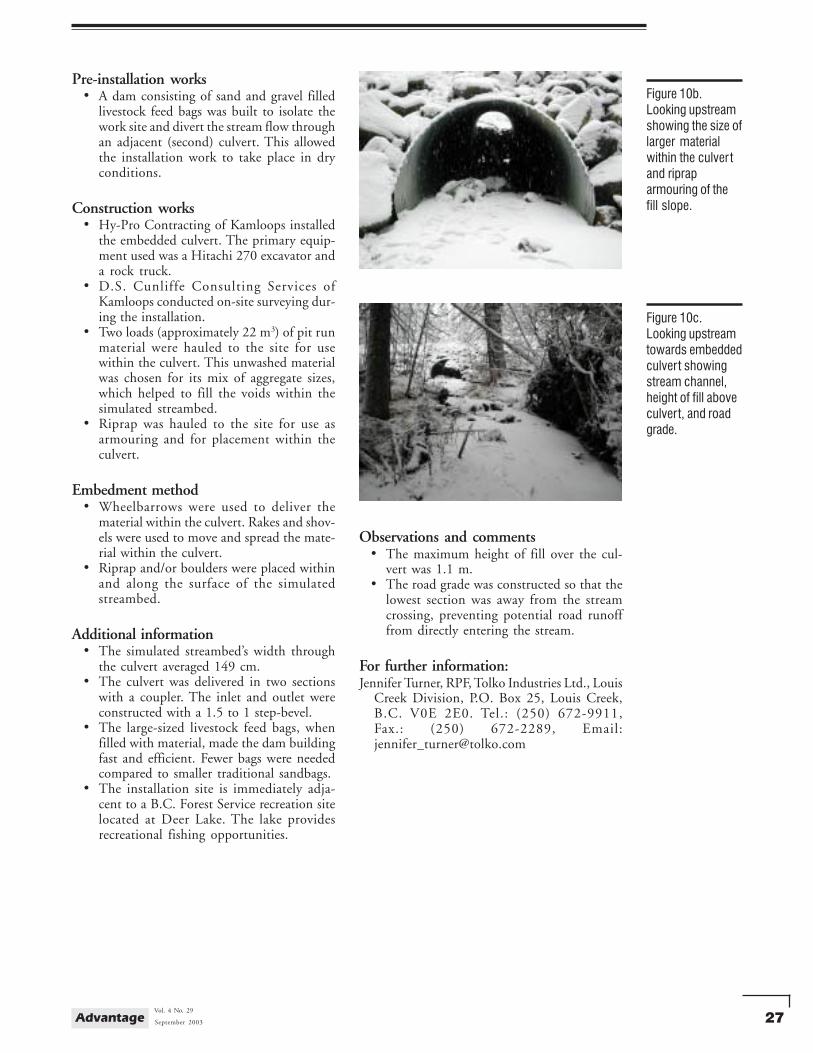
Figure 10a.Looking towardsthe culvert inlet,showing simulatedstreambed oneyear afterinstallation.
Table 10. Culvert, site, andinstallation data—Site 10
Culver t shape roundCulver t dimensions
Diameter (mm) 1600Length (m) 14
Installed culver t gradient (%) 3.5Simulated streambed gradient (%) 2.8Avg. depth of embedding material (mm, % diam.) 620, 38.8Avg. natural stream width and gradient (m, %) 1.3, 3.5Stream classification S3Design flood event (m3/s) unknownSite plan prepared noDetailed design drawings prepared noCost estimates
Supervision and survey ($) 1 140Delivered culver t ($) 2 330Installation and materials ($) 8 600Total ($) 12 070
27September 2003
Vol. 4 No. 29Advantage
Pre-installation works• A dam consisting of sand and gravel filled
livestock feed bags was built to isolate thework site and divert the stream flow throughan adjacent (second) culvert. This allowedthe installation work to take place in dryconditions.
Construction works• Hy-Pro Contracting of Kamloops installed
the embedded culvert. The primary equip-ment used was a Hitachi 270 excavator anda rock truck.
• D.S. Cunliffe Consulting Services ofKamloops conducted on-site surveying dur-ing the installation.
• Two loads (approximately 22 m3) of pit runmaterial were hauled to the site for usewithin the culvert. This unwashed materialwas chosen for its mix of aggregate sizes,which helped to fill the voids within thesimulated streambed.
• Riprap was hauled to the site for use asarmouring and for placement within theculvert.
Embedment method• Wheelbarrows were used to deliver the
material within the culvert. Rakes and shov-els were used to move and spread the mate-rial within the culvert.
• Riprap and/or boulders were placed withinand along the surface of the simulatedstreambed.
Additional information• The simulated streambed’s width through
the culvert averaged 149 cm.• The culvert was delivered in two sections
with a coupler. The inlet and outlet wereconstructed with a 1.5 to 1 step-bevel.
• The large-sized livestock feed bags, whenfilled with material, made the dam buildingfast and efficient. Fewer bags were neededcompared to smaller traditional sandbags.
• The installation site is immediately adja-cent to a B.C. Forest Service recreation sitelocated at Deer Lake. The lake providesrecreational fishing opportunities.
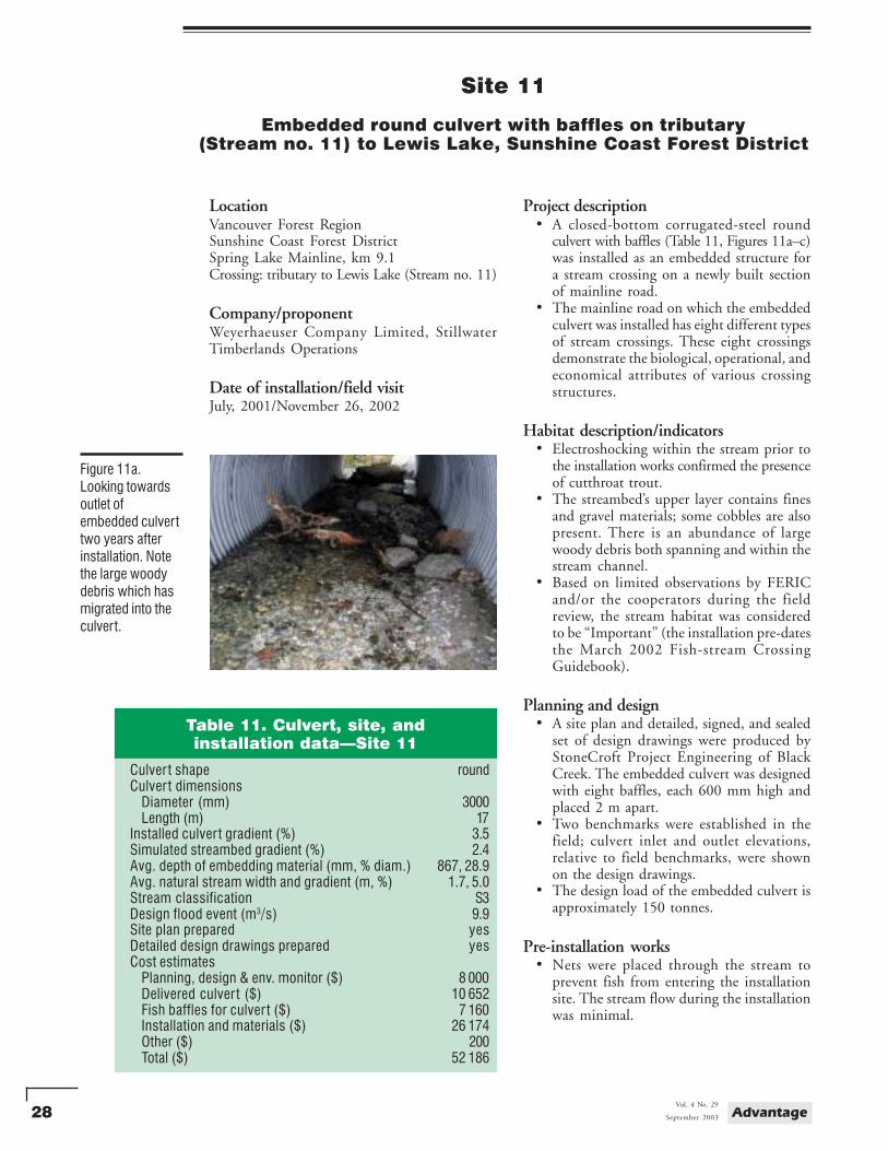
Figure 10b.Looking upstreamshowing the size oflarger materialwithin the culver tand ripraparmouring of thefill slope.
Figure 10c.Looking upstreamtowards embeddedculvert showingstream channel,height of fill aboveculvert, and roadgrade.
Observations and comments• The maximum height of fill over the cul-
vert was 1.1 m.• The road grade was constructed so that the
lowest section was away from the streamcrossing, preventing potential road runofffrom directly entering the stream.
For further information:Jennifer Turner, RPF, Tolko Industries Ltd., Louis
Creek Division, P.O. Box 25, Louis Creek,B.C. V0E 2E0. Tel.: (250) 672-9911,Fax.: (250) 672-2289, Email:[email protected]
28 AdvantageVol. 4 No. 29
September 2003
Site 11
Embedded round culvert with baffles on tributary(Stream no. 11) to Lewis Lake, Sunshine Coast Forest District
LocationVancouver Forest RegionSunshine Coast Forest DistrictSpring Lake Mainline, km 9.1Crossing: tributary to Lewis Lake (Stream no. 11)
Company/proponentWeyerhaeuser Company Limited, StillwaterTimberlands Operations
Date of installation/field visitJuly, 2001/November 26, 2002
Project description• A closed-bottom corrugated-steel round
culvert with baffles (Table 11, Figures 11a–c)was installed as an embedded structure fora stream crossing on a newly built sectionof mainline road.
• The mainline road on which the embeddedculvert was installed has eight different typesof stream crossings. These eight crossingsdemonstrate the biological, operational, andeconomical attributes of various crossingstructures.
Habitat description/indicators• Electroshocking within the stream prior to
the installation works confirmed the presenceof cutthroat trout.
• The streambed’s upper layer contains finesand gravel materials; some cobbles are alsopresent. There is an abundance of largewoody debris both spanning and within thestream channel.
• Based on limited observations by FERICand/or the cooperators during the fieldreview, the stream habitat was consideredto be “Important” (the installation pre-datesthe March 2002 Fish-stream CrossingGuidebook).
Planning and design• A site plan and detailed, signed, and sealed
set of design drawings were produced byStoneCroft Project Engineering of BlackCreek. The embedded culvert was designedwith eight baffles, each 600 mm high andplaced 2 m apart.
• Two benchmarks were established in thefield; culvert inlet and outlet elevations,relative to field benchmarks, were shownon the design drawings.
• The design load of the embedded culvert isapproximately 150 tonnes.
Pre-installation works• Nets were placed through the stream to
prevent fish from entering the installationsite. The stream flow during the installationwas minimal.
Figure 11a.Looking towardsoutlet ofembedded culverttwo years afterinstallation. Notethe large woodydebris which hasmigrated into theculvert.
Table 11. Culvert, site, andinstallation data—Site 11
Culver t shape roundCulver t dimensions
Diameter (mm) 3000Length (m) 17
Installed culver t gradient (%) 3.5Simulated streambed gradient (%) 2.4Avg. depth of embedding material (mm, % diam.) 867, 28.9Avg. natural stream width and gradient (m, %) 1.7, 5.0Stream classification S3Design flood event (m3/s) 9.9Site plan prepared yesDetailed design drawings prepared yesCost estimates
Planning, design & env. monitor ($) 8 000Delivered culver t ($) 10 652Fish baffles for culver t ($) 7 160Installation and materials ($) 26 174Other ($) 200Total ($) 52 186
29September 2003
Vol. 4 No. 29Advantage
Construction works• Pilldolla Creek Contracting Ltd. of Powell
River installed the embedded culvert. A35-tonne and a 40-tonne excavator, and arock truck were used for the installation.The larger diameter culvert required twoexcavators during installation, which isreflected in the cost estimates.
• Drain rock was hauled to the site for usewithin the culvert. Finer material generatedfrom a nearby natural source was also used.
Embedment method• A rubber-tired Bobcat loader initially
delivered material within the culvert.However, the loader was not suited totravelling over the baffles. A powered andtracked self-dumping wheelbarrow was usedto complete the delivery of the remainingmaterial within the culvert. Conventionalwheelbarrows were also on site and usedwhen needed.
• After the material was placed within theculvert, it was “washed” using pumpedstream water to help fill the voids. Suspendedsediment was collected in a sump at theoutlet and pumped onto the forest floor.
Additional information• The culvert was delivered in two sections
with a coupler; the inlet was constructedwith a 1 to 1 step-bevel.
• The stream is part of a Weyerhaeuser studyexamining fish presence and abundancebefore and after installation of stream crossingstructures. Cutthroat trout were locatedbelow, within and above the culvert duringa six-month post-installation review.
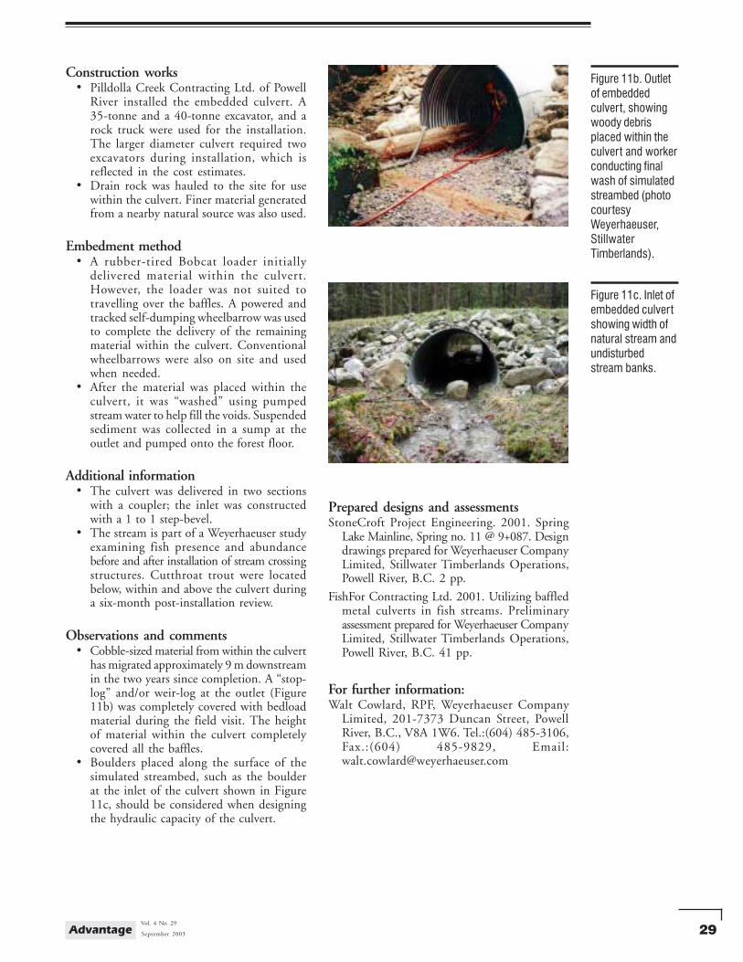
Observations and comments• Cobble-sized material from within the culvert
has migrated approximately 9 m downstreamin the two years since completion. A “stop-log” and/or weir-log at the outlet (Figure11b) was completely covered with bedloadmaterial during the field visit. The heightof material within the culvert completelycovered all the baffles.
• Boulders placed along the surface of thesimulated streambed, such as the boulderat the inlet of the culvert shown in Figure11c, should be considered when designingthe hydraulic capacity of the culvert.
Figure 11b. Outletof embeddedculvert, showingwoody debrisplaced within theculvert and workerconducting finalwash of simulatedstreambed (photocourtesyWeyerhaeuser,StillwaterTimberlands).
Figure 11c. Inlet ofembedded culvertshowing width ofnatural stream andundisturbedstream banks.
Prepared designs and assessmentsStoneCroft Project Engineering. 2001. Spring
Lake Mainline, Spring no. 11 @ 9+087. Designdrawings prepared for Weyerhaeuser CompanyLimited, Stillwater Timberlands Operations,Powell River, B.C. 2 pp.
FishFor Contracting Ltd. 2001. Utilizing baffledmetal culverts in fish streams. Preliminaryassessment prepared for Weyerhaeuser CompanyLimited, Stillwater Timberlands Operations,Powell River, B.C. 41 pp.
For further information:Walt Cowlard, RPF, Weyerhaeuser Company
Limited, 201-7373 Duncan Street, PowellRiver, B.C., V8A 1W6. Tel.:(604) 485-3106,Fax.:(604) 485-9829, Email:[email protected]
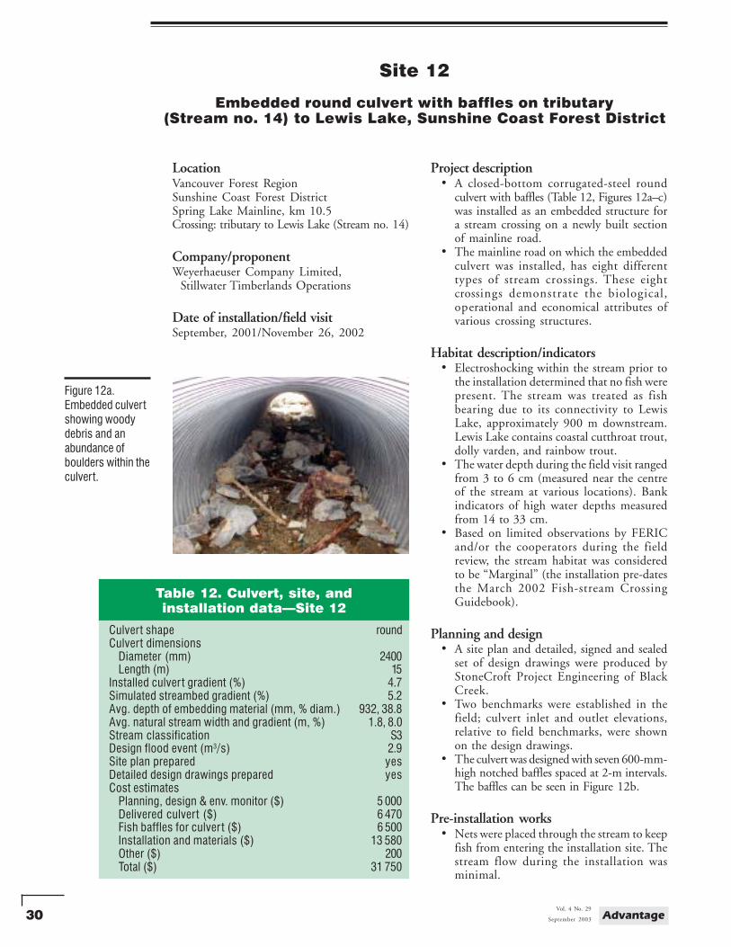
30 AdvantageVol. 4 No. 29
September 2003
Site 12
Embedded round culvert with baffles on tributary(Stream no. 14) to Lewis Lake, Sunshine Coast Forest District
LocationVancouver Forest RegionSunshine Coast Forest DistrictSpring Lake Mainline, km 10.5Crossing: tributary to Lewis Lake (Stream no. 14)
Company/proponentWeyerhaeuser Company Limited, Stillwater Timberlands Operations
Date of installation/field visitSeptember, 2001/November 26, 2002
Project description• A closed-bottom corrugated-steel round
culvert with baffles (Table 12, Figures 12a–c)was installed as an embedded structure fora stream crossing on a newly built sectionof mainline road.
• The mainline road on which the embeddedculvert was installed, has eight differenttypes of stream crossings. These eightcrossings demonstrate the biological,operational and economical attributes ofvarious crossing structures.
Habitat description/indicators• Electroshocking within the stream prior to
the installation determined that no fish werepresent. The stream was treated as fishbearing due to its connectivity to LewisLake, approximately 900 m downstream.Lewis Lake contains coastal cutthroat trout,dolly varden, and rainbow trout.
• The water depth during the field visit rangedfrom 3 to 6 cm (measured near the centreof the stream at various locations). Bankindicators of high water depths measuredfrom 14 to 33 cm.
• Based on limited observations by FERICand/or the cooperators during the fieldreview, the stream habitat was consideredto be “Marginal” (the installation pre-datesthe March 2002 Fish-stream CrossingGuidebook).
Planning and design• A site plan and detailed, signed and sealed
set of design drawings were produced byStoneCroft Project Engineering of BlackCreek.
• Two benchmarks were established in thefield; culvert inlet and outlet elevations,relative to field benchmarks, were shownon the design drawings.
• The culvert was designed with seven 600-mm-high notched baffles spaced at 2-m intervals.The baffles can be seen in Figure 12b.
Pre-installation works• Nets were placed through the stream to keep
fish from entering the installation site. Thestream flow during the installation wasminimal.
Figure 12a.Embedded culvertshowing woodydebris and anabundance ofboulders within theculvert.
Table 12. Culvert, site, andinstallation data—Site 12
Culvert shape roundCulvert dimensions
Diameter (mm) 2400Length (m) 15
Installed culver t gradient (%) 4.7Simulated streambed gradient (%) 5.2Avg. depth of embedding material (mm, % diam.) 932, 38.8Avg. natural stream width and gradient (m, %) 1.8, 8.0Stream classification S3Design flood event (m3/s) 2.9Site plan prepared yesDetailed design drawings prepared yesCost estimates
Planning, design & env. monitor ($) 5 000Delivered culvert ($) 6 470Fish baffles for culver t ($) 6 500Installation and materials ($) 13 580Other ($) 200Total ($) 31 750
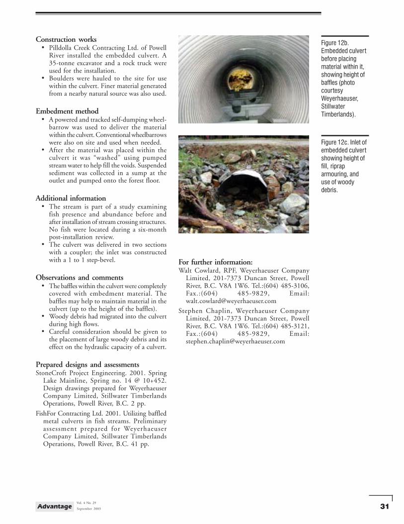
31September 2003
Vol. 4 No. 29Advantage
Construction works• Pilldolla Creek Contracting Ltd. of Powell
River installed the embedded culvert. A35-tonne excavator and a rock truck wereused for the installation.
• Boulders were hauled to the site for usewithin the culvert. Finer material generatedfrom a nearby natural source was also used.
Embedment method• A powered and tracked self-dumping wheel-
barrow was used to deliver the materialwithin the culvert. Conventional wheelbarrowswere also on site and used when needed.
• After the material was placed within theculvert it was “washed” using pumpedstream water to help fill the voids. Suspendedsediment was collected in a sump at theoutlet and pumped onto the forest floor.
Additional information• The stream is part of a study examining
fish presence and abundance before andafter installation of stream crossing structures.No fish were located during a six-monthpost-installation review.
• The culvert was delivered in two sectionswith a coupler; the inlet was constructedwith a 1 to 1 step-bevel.
Observations and comments• The baffles within the culvert were completely
covered with embedment material. Thebaffles may help to maintain material in theculvert (up to the height of the baffles).
• Woody debris had migrated into the culvertduring high flows.
• Careful consideration should be given tothe placement of large woody debris and itseffect on the hydraulic capacity of a culvert.
Prepared designs and assessmentsStoneCroft Project Engineering. 2001. Spring
Lake Mainline, Spring no. 14 @ 10+452.Design drawings prepared for WeyerhaeuserCompany Limited, Stillwater TimberlandsOperations, Powell River, B.C. 2 pp.
FishFor Contracting Ltd. 2001. Utilizing baffledmetal culverts in fish streams. Preliminaryassessment prepared for WeyerhaeuserCompany Limited, Stillwater TimberlandsOperations, Powell River, B.C. 41 pp.
Figure 12b.Embedded culvertbefore placingmaterial within it,showing height ofbaffles (photocourtesyWeyerhaeuser,StillwaterTimberlands).
Figure 12c. Inlet ofembedded culvertshowing height offill, ripraparmouring, anduse of woodydebris.
For further information:Walt Cowlard, RPF, Weyerhaeuser Company
Limited, 201-7373 Duncan Street, PowellRiver, B.C. V8A 1W6. Tel.:(604) 485-3106,Fax.:(604) 485-9829, Email:[email protected]
Stephen Chaplin, Weyerhaeuser CompanyLimited, 201-7373 Duncan Street, PowellRiver, B.C. V8A 1W6. Tel.:(604) 485-3121,Fax.:(604) 485-9829, Email:[email protected]