Climate Vulnerability and Gap Assessment Report on Flood ...
52
Climate Vulnerability and Gap Assessment Report on Flood and Drought (LOWEr Rapti River BASIN Case Study) Final Report GWP Nepal/Jalsrot Vikas Sanstha (JVS) November, 2014
Transcript of Climate Vulnerability and Gap Assessment Report on Flood ...

Climate Vulnerability and Gap Assessment
Report on Flood and Drought
(LOWEr Rapti River BASIN Case Study)
Final Report
GWP Nepal/Jalsrot Vikas Sanstha (JVS)
November, 2014

Page I
Disclaimer
The findings, interpretations and conclusions expressed herein are those of the author(s)
and do not necessarily reflect the views of the institutions.
Page II
Acknowledgement
This publication is prepared under WACREP funded by GWPO/DFID. It is one of the series of
publications of Global Water Partnership Nepal/ Jalsrot Vikas Sanstha (JVS) in the field of water
resources. GWP Nepal/JVS highly appreciates the contribution of Mr.Shital Babu Regmee, Dr. Keshav
Prasad Sharma, Mr. Surya Nath Upadhyay , Mr. Prakash Paudel, River, Mr. Kamal Raj Gautam , Mr.
Rajendra Kumar Pandit and Ms. Monica Maharjan for preparing this report. Valuable suggestions and
comments received from Mr. Som Nath Poudel, Mr Shiva Kumar Sharma and Mr Damodar Bhattarai
helped to improve the format and accuracy of the document. GWP Nepal/JVS acknowledges the
contribution from JVS staffs Mr Tejendra GC and Ms Anju Rana during the preparation of this
publication.
Jalsrot Vikas Sanstha

Page III
Table of Contents
CHAPTER I INTRODUCTION ..................................................................................................................... 1
1.1 Background ...................................................................................................................................................1
1.2 Literature Review ..........................................................................................................................................2
1.3 Objectives ......................................................................................................................................................3
1.4 Scope .............................................................................................................................................................3
1.5 Approach .......................................................................................................................................................4
1.6 Methodology .................................................................................................................................................5
CHAPTER II STUDY AREA ......................................................................................................................... 6
2.1 Rapti River ....................................................................................................................................................6
2.2 Rapti River Basin ..........................................................................................................................................6
2.2.1 Physiography ..........................................................................................................................................8
2.2.2 Climate ...................................................................................................................................................9
2.2.3 Hydrology............................................................................................................................................ 11
2.3 Socio-Economic Condition of the Study Area ........................................................................................... 12
2.3.1 Flood Affected Area ............................................................................................................................ 13
2.3.2 Population and Ethnicity ..................................................................................................................... 13
2.3.3 Utilities ................................................................................................................................................ 13
2.3.4 Public Facilities ................................................................................................................................... 14
2.3.5 Occupation .......................................................................................................................................... 14
2.3.6 Available Physical Facilities in the villages ........................................................................................ 14
2.4 Impacts of Climate Change on Social Condition ....................................................................................... 14
CHAPTER III GENERAL FINDINGS ....................................................................................................... 15
3.1 Flood Scenario ........................................................................................................................................... 15
3.1.1 The Flood of 2013 ............................................................................................................................... 15
3.1.2 Flood and Low Flow Frequency Analysis .......................................................................................... 19
3.1.3 River Flood Trend ................................................................................................................................ 20
3.1.4 Observed Flood Damages ................................................................................................................... 21
Effects of flood in south eastern part of Banke are as follows: ........................................................................ 22
Page IV
3.1.5 Flood Mitigation Measures ................................................................................................................. 23
Activities by the government agencies ............................................................................................................. 24
3.2 Flood Scenarios .......................................................................................................................................... 24
3.3Drought Scenario ........................................................................................................................................ 25
3.4 AGRICULTURE SCENARIO ................................................................................................................ 25
3.4.1 Effect of Flood on Agriculture ............................................................................................................ 26
3.4.2 Gap and recommendations .................................................................................................................. 28
3.5 LEGAL ASPECTS ................................................................................................................................... 30
3.5.1 Issues of International Concern ........................................................................................................... 31
3.5.2 Issues Relating to Use and Ownership of the Land ............................................................................. 33
3.6 Perception of Affected People .................................................................................................................... 35
3.6.1 Adaptation/Coping Practices (of the People /Communities) ............................................................... 36
3.6.2 Suggestions from Local People ........................................................................................................... 37
3.6 Assessment of Risk .................................................................................................................................... 38
3.7 Institutional Involvement and Assistance Offered ..................................................................................... 39
CHAPTER IV CONCLUSION AND RECOMMENDATION .................................................................. 41
4.1 Conclusion .................................................................................................................................................. 41
4.1.1 Forecast Mechanism ............................................................................................................................ 41
4.1.2 Flood Risks Management .................................................................................................................... 41
4.1.3 Legal Provisions for Land Lost/Reclaimed ......................................................................................... 42
4.1.4 International Provisions/Practices for Water Right and Structural Intervention in Trans-boundary
Rivers ........................................................................................................................................................... 42
4.1.5 The Future ........................................................................................................................................... 42
4.2 Recommendation ........................................................................................................................................ 42
4.2.1 General ................................................................................................................................................ 43
4.2.2 Specific (Study area) ........................................................................................................................... 44

Page V
List of Tables
Table 1: Tributaries of West Rapti River
Table 2: Drainage area of Rapti River Basin
Table 3: Hypsometric division of Rapti River Basin
Table 4: Flood and low-flow frequency: Bagasoti and Jalkundi stations
Table 5: VDC and households affected
Table6: Information about flood affected community
Table 7: Institutional involvement to cope
Table 8: Rating of flooded and eroded area inlower part of West Rapti
Table 9: Area degraded and sediment by VDC during flood till July 31, 2013
Table 10: Estimated amount loss by crop in NRs
List of Figures
Figure 1: Location map of Rapti River Basin
Figure 2: Digital Elevation Model of Rapti River Basin
Figure 3: Average monthly precipitation in Rapti River Basin
Figure 4: Average monthly temperature recorded at Sikta in the Banke district
Figure 5: Annual hydrograph at three locations on Rapti River
Figure 6: Ordinary rain-gauge and tipping bucket rain gauge
Figure 7: The Rapti at Kusum (looking downstream)
Figure 8: Satellite based rainfall estimation of 18 June 2013
Figure 9: Devastation of agriculture lands in Holiya
Figure 10: Recorded major floods on the Raoti River at Kusum (Station No. 375)
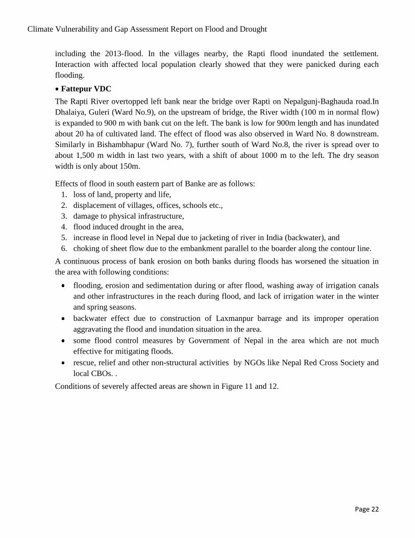
Figure 11: Flood affected area and abandoned customs office
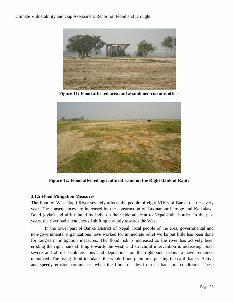
Figure 12: Flood affected agricultural land on the right bank of Rapti
Figure 13: Ineffective flood control measure
Figure 14: Consultative workshop with the stakeholders
Figure 15: Children selling local liquor to Indian customer
Figure 16: Interaction in Narainapur VDC office
Figure 17: Boat used by local people during flood

Page VI
Abbreviation
ASC Agriculture Service Center
CDO Chief District Officer
DADO District Agriculture Development Office
DHM Department of Hydrology and Meteorology
DLS Department of Livestock Services
DLSO District Livestock Services Office
DOA Department of Agriculture
DOI Department of Irrigation
DWIDP Department of Water Induced Disaster Prevention
FGD Focus Group Discussion
GDP Gross Domestic Product
Ha Hectare
HH Household
INGO International Non Governmental Organization
LSC Livestock Service Center
MoAD Ministry of Agriculture Development
NARC National Agriculture Research Council
NGO Non Governmental Organization
NRCS Nepal Red Cross Society
PRA Participatory Rural Appraisal
RbF River bed Farming
RRA Rapid Rural Appraisal
VDC Village Development Committee
WIDPD Water Induced Disaster Prevention Division
Conversions
1 Kattha = 1/20 Bigha = 1/30 Hectare
1 Maund = 40 Kilograms
1 Kosh = 1.6 Kilometer
Climate Vulnerability and Gap Assessment Report on Flood and Drought
Page 1
CHAPTER I
INTRODUCTION
1.1 Background
Climate change in Nepal in recent years has affected the discharge pattern of rivers resulting in an
increase in flood and drought events (Sharma, 2010, Sharma et al., 2000). The rivers are facing
increased high flows and reduction of rainy days. The increased intensity of rainfall and fragile
geology provide conducive conditions for flash floods. Flood protection and preventive measures are
essential to reduce damages. Since adaptation alone is not sufficient to cope with changing conditions,
a mitigation plan with appropriate arrangements is deemed necessary. A mitigation plan can help
reduce fatalities mitigate damages and improve livelihood.
Climatic hazards such as floods and droughts have always been a primary matter of concern for
human population. Severe floods harm human and animal lives, settlements, transport networks, and
arable lands. Water is life, and climate change is threatening this precious resource. The country is
facing effect of climate change and it is severer in the Himalayan areas. The risks of floods and
droughts are worsened with the increase in peak flows during wet seasons and less rainfall during dry
seasons.
Floods are generally defined as overflows of large quantities of water that are beyond normal
limits. Some of the effects of floods are inundation of land by excessive water, bank erosion by river
flow, depositing silt in lands as well as fatalities and property loss. The term drought may refer to a
meteorological drought (precipitation well below average), a hydrological drought (low river flows
and water levels in rivers, lakes and groundwater) and an agricultural drought (low soil moisture). The
socio-economic impacts of droughts may arise from changes in land use and land cover as well as
water demand. Excessive water withdrawals can worsen the impact of a drought.
The area of study for this project is in the south-eastern part of the Banke District in Mid-
western Region of Nepal (Figure 1). This area faces normal to heavy flooding every year. In the
southeast part of Banke district, eight village development committee areas are under water affecting
1,824 households. It also affects livestock, infrastructure, crops and agricultural land in the area.
While the normal seasonal flooding is common in the area, the construction of the Barrage and
dykes in India has increased the magnitude of floods. Devastating flood of mid-august 2014 is one of
the glaring examples. Deforestation, over exploitation of cultivable land, and addition of unplanned
infrastructures are all factors contributing to soil erosion, sedimentation and increased vulnerability to
flooding.
The current approach to flood control works implemented by the governments of Nepal and
India rely primarily on embankment construction and other structural measures. With only a little
information on basic quantitative data, making effective decisions regarding flood control strategies is
difficult. Thus, qualitative approaches for identifying and evaluating alternative strategies as a basic

Climate Vulnerability and Gap Assessment Report on Flood and Drought
Page 2
step towards making informed decisions are required1. In addition to traditional structural protection
measures, non-structural approaches should also be used for an effective mitigation.
Flooding poses severe constraint on socioeconomic development and puts pressure on
agricultural and industrial production. Infrastructure in the region is also at risk. Poor countries are
always hit the hardest.
Though the flood and drought used to be a regular phenomenon in the study area, the
construction of the Barrage and river control works downstream has exacerbated the risk due to afflux
caused by constricted flow. The effect of climate change has further complicated the situation.
1.2 Literature Review
Increase in flooding patterns by the river was noticed during the mid-1980s and the issue was raised by
the Nepalese side during various meetings of Standing Committee on Inundation Problems (SCIP)
between India and Nepal2. The problem was further aggravated after the construction of the
Laxmanpur Barrage in the Rapti River, about 4 km downstream of the border (Figure 2). This issue
was also raised during the prime ministerial meeting between Nepal and India and the respective
ministries of both countries were directed to resolve the problem3.
The Nepal-India Joint Commission on Water Resources (JCWR) held in Kathmandu in August
2000 also raised the inundation issue in the Banke District. Article 3.1 of the minutes of meeting
states, "It was noted that in pursuance of the decision taken by the two prime ministers in August
2000, joint inspections in Banke District of Nepal were carried out in August and September 2000, and
the situation was closely monitored." The meeting minutes further state, "It was agreed in principle by
India that the embankments along Rapti River for protection of Nepalese territory in Banke District
shall be taken up in Priority basis."4
The embankment for flood protection could not be constructed due to various technical and
administrative issues between Nepal and India. As the water resource issue falls under state (Uttar
Pradesh) jurisdiction in India, the process became furthermore complicated. Finding a solution and
implementing it in the field is yet to be materialized. The third High Level Technical Committee
(HLTC) meeting agreed to the construction of an un-gated opening for the drainage of water from
Gandheli and Sotwa Nalas in the area.5 An outlet culvert for drainage of Gandheli and Sotia Nalas that
are obstructed by Kalkalwa bund has recently been constructed by India, but it is not sufficient to drain
water during heavy floods as it is designed for providing drainage to local storm only. Moreover,
during the site visit, it was found that the downstream opening of the Nalas was blocked by a
temporary dyke obstructing flows through the culvert. Embankments are yet to be constructed along
the Rapti River in the Nepalese side.
1Dixit, A., Pokhrel, A., M. Moench and The Risk to Resilience Study Team, (2008): Costs and Benefits of Flood
Mitigation in the Lower Bagmati Basin: Case of Nepal Tarai and North Bihar, From Risk to Resilience Working Paper No. 5, eds. Moench, M., Caspari, E. & A. Pokhrel, ISET, ISET-Nepal and ProVention, Kathmandu, Nepal, 34 pp 2 Minutes of SCIP meetings
3 Joint statement between PMs G.P Koirala and and A.V. Bajpayee, Delhi, 1999
4 Minutes of first meeting of the Nepal India Joint Committee on Water Resources, October 2000, Kathmandu
5 Minutes of third meeting of HLTC

Climate Vulnerability and Gap Assessment Report on Flood and Drought
Page 3
Hazards, such as floods, landslides, and droughts induced by the climate change will impose
significant stress on the livelihoods of populations located in the mountain regions as well as in
downstream valleys and plains. Society needs to improve .adaptation strategies, and level structural
inequalities that make adaptation by poor people more difficult (Eriksson et al., 2009)6.
As observed time series data for drought in the area are not available, comparative studies with
similar areas and application of those results are required in other areas. Available studies suggest that
the drought situation may lead to poorer conditions as effects of the climate change become prominent
with time.
Climate change models project higher and more intense precipitation in warmer climates,
particularly at mid- and high latitudes where mean precipitation is also projected to increase (Meehl et
al., 2005, WGI AR4, Chapter 10, Section 10.3.6.1). Such changes are likely to intensify the risk of
flash flooding. Natural drainage systems have to be adapted to accommodate increasing rainfall
intensity resulting from the climate change (Waters et al., 2003). Projections for the 2090s by Burke et
al. (2006) suggest regions of strong wetting and drying with a net overall global drying trend. In other
words, the proportion of land surface in extreme drought, globally, is predicted to increase by the
factor of 10 to 30; from 1-3 % for the present day to 30% by the 2090s. The number of extreme
drought events per 100 years and mean drought duration are likely to increase by factors of two and
six respectively by the 2090s (Burke et al., 2006).
As temperatures rise, the likelihood of precipitation in the form of rain rather than snow
increases. Snowmelt is projected to be earlier and less abundant in the existing melt period. This may
lead to an increased risk of droughts in snow-fed basins in summer and autumn, when demand is the
highest (Barnett et al., 2005). The West Rapti River basin is below snow line so it will have less effect
of snowmelt-related stream flows.
1.3 Objectives
The main objective of the study is to analyze climate vulnerability and gap assessment of floods and
droughts based on the case study in lower part of the West Rapti River in the Banke district. The study
comprised of:
i) Study flood and drought problems caused by the West Rapti River in the south eastern part
of the Banke District,
ii) Study impact of climate change,
iii) Study water sharing and utilization in international rivers and suggest suitable means to
manage and share resources, and
iv) Suggest solutions for addressing critical flood and drought challenges to improve capacity
for climate resilience
1.4 Scope
The scope of the study comprised of the following:
6Eriksson, M.;Xu JianChu;Shrestha, A. B.;Vaidya, R. A.;Santosh Nepal;Sandström, K.,The changing Himalayas: impact of
climate change on water resources and livelihoods in the greater Himalayas2009

Climate Vulnerability and Gap Assessment Report on Flood and Drought
Page 4
Assessment of the impact of the climate change on floods and droughts in the study area.
Identification of problems and practices existing in the field and the suggestion of remedial
measures
Study of existing water resource strategies, policies, plans, governance and other institutional
arrangements as well as suggestion for future plans.
Study of bilateral relations for the river basin and analyze present practices and dispute resolution
mechanisms.
Identification of suitable practices and techniques that would increase the resilience of
communities to withstand the impacts of climate change on water resources.
Suggestion of means to promote a bilateral dialogue between Nepal and India at national and river
basin levels in order to examine the arrangements for water sharing.
Suggestion of structural as well as non-structural climate resilient plans.
1.5 Approach
In the present context, flood and drought management plans need to take climate change into account.
Although it is not possible to envisage the nature of changes with adequate confidence changes are
almost certain. There are two broad approaches to assessing the implications of climate change.
The first can be termed as a scenario-based approach, where different scenarios are considered
and the robustness of a plan is tested against different foreseeable futures7.The value of a scenario-
based approach is that it encourages the development of plans and strategies that are flexible and
adaptable to altered circumstances.
The second approach is based on risk factors. It uses probabilistic projections of future risks.
Under this approach, climate (and other) scenarios are interpreted as forecasts, and assigned
likelihoods of occurrence (e.g. Murphy et al., 2007). Adaptation plans are then designed to meet an
anticipated future course.
Regardless of which approach is followed, climate change challenges some of the key
assumptions in drought management. It is no longer feasible to assume that the past is the key to the
future. Whilst it is necessary to ensure that drought management plans can cope with current climatic
variability, it is not in itself sufficient to ensure that these plans can cope with possible changes in
drought risk. Finally, uncertainty in projected future drought risk encourages the use of flexible and
robust measures which can be readily adapted and altered as more information is gathered.
This study was carried out with the assumption of the risk-based approach with existing
physiographic changes in the study area. The study considered, flood dimensions and flood
frequencies as generated by existing and future human interventions and expected climate change.
7N.W. Arnell, Walker Institute for Climate System Research, Department of Meteorology, University of
Reading, Earley Gate, Reading RG6 6BB, UK
Climate Vulnerability and Gap Assessment Report on Flood and Drought
Page 5
1.6 Methodology
The methodologies included: field reconnaissance survey, observations, interactions with households
as well as focused group consultations with key informant and discussion with stakeholders, officials
and decision makers.
A reconnaissance study of the area was done by the study team members. Relevant data were
collected from the local population, local and district offices, areas affected by floods and drought,
embankment and other infrastructures made on the study area and the other side of the border. An
interim report was prepared based on the reconnaissance survey, related literature and analysis of data
collected in the field as well as compiled from different agencies.
The initial reconnaissance visit to Banke district was followed by focus group discussions
(FGDs) in the area of study. In order to conduct the FGD, the flood affected VDCs in Banke district
were identified with the help of secondary information provided by District Agriculture Development
Office (DADO).A detailed focus group discussion was conducted by experts in eight affected Village
Development Committees8 Details of FGD survey are provided in the Annex.
Different field surveys, studies, analysis and consultations among experts were conducted and
a draft report for the study was prepared. The draft report was discussed in a consultative workshop
attended by the selected local representatives, local institutions, NGOs, INGOs and representatives of
concerned offices and political parties of the District (Annex). The recommendations, suggestions and
outcome of the interaction have been incorporated in the study and the report has been revised
accordingly.
The draft report rectified after field interaction has been reviewed for finalization by experts
and the opinion of the related institutions were accommodated. Also the data and contents of the report
were cross examined and improvements made accordingly.
8 Holia, Kachanapur, Betahani, Binauna, Fattepur, Gangapur, Kusum and Matehiya VDCs
Climate Vulnerability and Gap Assessment Report on Flood and Drought
Page 6
CHAPTER II
STUDY AREA
2.1 Rapti River
The Rapti River drains primarily five major districts of Nepal: Rolpa, Pyuthan, Dang, Arghakhanchi
and Banke. It covers almost three-fourths of the Banke district. Because of the importance of the river,
major basin area of the Rapti River is called the 'Rapti Zone'. The Zone consists of Rukum, Rolpa,
Pyuthan, Dang, and Salyan districts.
The importance of the River is highlighted by its water resources potential. The proposed 190
meter Naumure dam at the Pyuthan-Dang border has significance for its potential for hydropower
generation and irrigation in two districts (Banke and Kapilvastu). The Sikta Irrigation Project on the
Rapti at Agaiya is under construction with projected command areas extending up to 40,000 ha9.
The construction of the Laxmanpur barrage and dykes by India in the downstream side of
Banke District has aggravated the flood situation in Nepal causing enormous damage to human
settlements, livestock, agriculture and infrastructures. Flood mitigation in the area has become
essential as the severity of this issue is continually increasing.
The flood management benefit of the river is not only limited to Nepal but also goes beyond
the border. The flood risk area associated is over 28,000 ha in the heavily populated area of Utter
Pradesh State in India (Wikipedia, 2013). Due to the scale of damage associated with Rapti floods, the
Government of Nepal has been working with international expert organizations for the assessment of
floods and flood vulnerabilities. Two typical examples include the studies carried out by the home
ministry with Asia Disaster Prevention Centre (ADPC) (ADPC, 2010) and International Center for
Water Hazard Risk Management/ (ICHARM) with Nepal Development Research Institute (NDRI)
(ICHARM 2008).
2.2 Rapti River Basin
The Tributaries of the Rapti River originate at about 3,500 m elevation close to the border of Rukum
and Rolpa districts as Madi River and at about 3,600 m elevation close to the border of Baglung and
Rolpa districts as Lungri Khola (Survey Department, 2002). The Madi Khola flows towards the west
while the Lungri Khola flows towards the south. The River is called Rapti after the confluence of the
Madi and Jhimruk rivers. Obstructed by the Duduwa Range of the Sivaliks, a sharp turning of the river
towards westerly direction takes place at Bhalubang, a small town on the East-West highway of Nepal.
The River follows mainly towards the west until it reaches the end of Duduwa Range near the
Nepalgunj Airport, where it takes another sharp turn towards the south and flows to India. The River
in India continues towards the south-east direction until it merges with the Ghagra (Karnali) River at
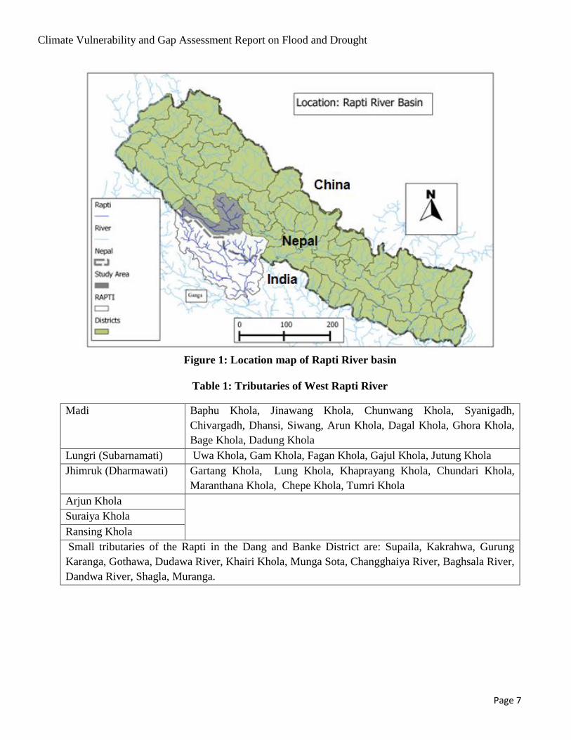
Kaparwaaghat, and the Ghagra (Saryu) ultimately merges with the Ganges at Chhapra (Figure 1). The
name of tributaries of the Rapti River and the catchment areas of the river basin at different locations
are given in Table 1 (Sharma et al, 2012):
9 Department of Irrigation
Climate Vulnerability and Gap Assessment Report on Flood and Drought
Page 7
Figure 1: Location map of Rapti River basin
Table 1: Tributaries of West Rapti River
Madi Baphu Khola, Jinawang Khola, Chunwang Khola, Syanigadh,
Chivargadh, Dhansi, Siwang, Arun Khola, Dagal Khola, Ghora Khola,
Bage Khola, Dadung Khola
Lungri (Subarnamati) Uwa Khola, Gam Khola, Fagan Khola, Gajul Khola, Jutung Khola
Jhimruk (Dharmawati) Gartang Khola, Lung Khola, Khaprayang Khola, Chundari Khola,
Maranthana Khola, Chepe Khola, Tumri Khola
Arjun Khola
Suraiya Khola
Ransing Khola
Small tributaries of the Rapti in the Dang and Banke District are: Supaila, Kakrahwa, Gurung
Karanga, Gothawa, Dudawa River, Khairi Khola, Munga Sota, Changghaiya River, Baghsala River,
Dandwa River, Shagla, Muranga.

Climate Vulnerability and Gap Assessment Report on Flood and Drought
Page 8
Table 2: Drainage area of the Rapti Basin
Location Drainage Area (km2)
Rapti Basin (Total of Nepal and India) 23,900
Indian Part of the Basin 16,550
Rapti Basin in Nepal 7,350
2.2.1 Physiography
The spade-shaped river basin is wide in its headwater areas with narrow contributing areas in its lower
parts. The lower part of the basin is dominated by low land with elevation mostly below 500 m. Only
the steering Duduwa Range rises as high as 900 m in the south. The digital elevation model of the
Rapti Basin is presented in Figure 2. Table 2 presents the hypsometric division of the Basin. It shows
that most of the Basin lies within the areal extent of 200 m to 2000 m, a range suitable for agriculture,
silviculture, and agro-forestry activities. Since the Basin lies much lower than the snowline (5,000 m)
in Nepal and since the areas above 2000 m are limited to only about 12%, the snowmelt component in
the annual hydrograph of the Rapti River is negligible.
Figure 2: Digital Elevation Model of the Rapti Basin
Climate Vulnerability and Gap Assessment Report on Flood and Drought
Page 9
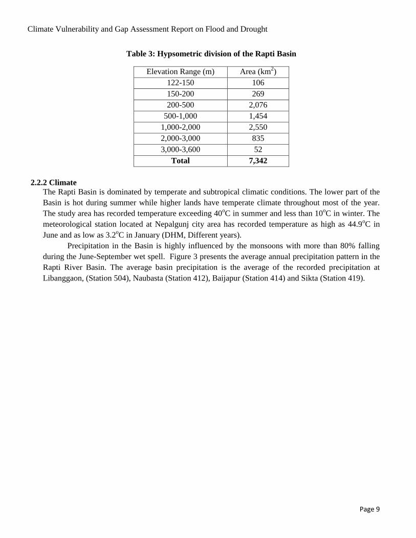
Table 3: Hypsometric division of the Rapti Basin
Elevation Range (m) Area (km2)
122-150 106
150-200 269
200-500 2,076
500-1,000 1,454
1,000-2,000 2,550
2,000-3,000 835
3,000-3,600 52
Total 7,342
2.2.2 Climate
The Rapti Basin is dominated by temperate and subtropical climatic conditions. The lower part of the
Basin is hot during summer while higher lands have temperate climate throughout most of the year.
The study area has recorded temperature exceeding 40oC in summer and less than 10
oC in winter. The
meteorological station located at Nepalgunj city area has recorded temperature as high as 44.9oC in
June and as low as 3.2oC in January (DHM, Different years).
Precipitation in the Basin is highly influenced by the monsoons with more than 80% falling
during the June-September wet spell. Figure 3 presents the average annual precipitation pattern in the
Rapti River Basin. The average basin precipitation is the average of the recorded precipitation at
Libanggaon, (Station 504), Naubasta (Station 412), Baijapur (Station 414) and Sikta (Station 419).

Climate Vulnerability and Gap Assessment Report on Flood and Drought
Page 10
Figure 3: Average monthly precipitation of the Rapti Basin.
Figure 4 exemplifies the annual pattern of average temperature in the lower part of the Basin. One
third of the Basin area lies below 500 m (Figure 2), which is signified by the hot summer.
Figure 4: Average monthly temperature recorded at Sikta in the Banke District
0
50
100
150
200
250
300
350
400
450
Jan Feb Mar Apr May Jun Jul Aug Sep Oct Nov Dec
Pre
cip
itat
ion
(m
m)
PRECIPITATION IN THE RAPTI BASIN
0
5
10
15
20
25
30
35
40
Jan Feb Mar Apr May Jun Jul Aug Sep Oct Nov Dec
Tem
pe
ratu
re o
C
Temperature in Banke district
Maximum Minimum
Climate Vulnerability and Gap Assessment Report on Flood and Drought
Page 11
2.2.3 Hydrology
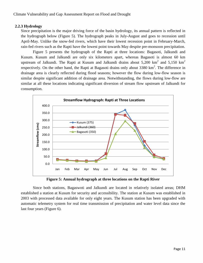
Since precipitation is the major driving force of the basin hydrology, its annual pattern is reflected in
the hydrograph below (Figure 5). The hydrograph peaks in July-August and goes to recession until
April-May. Unlike the snow-fed rivers, which have their lowest recession point in February-March,
rain-fed rivers such as the Rapti have the lowest point towards May despite pre-monsoon precipitation.
Figure 5 presents the hydrograph of the Rapti at three locations: Bagasoti, Jalkundi and
Kusum. Kusum and Jalkundi are only six kilometers apart, whereas Bagasoti is almost 60 km
upstream of Jalkundi. The Rapti at Kusum and Jalkundi drains about 5,200 km2 and 5,150 km
2
respectively. On the other hand, the Rapti at Bagasoti drains only about 3380 km2. The difference in
drainage area is clearly reflected during flood seasons; however the flow during low-flow season is
similar despite significant addition of drainage area. Notwithstanding, the flows during low-flow are
similar at all these locations indicating significant diversion of stream flow upstream of Jalkundi for
consumption.
Figure 5: Annual hydrograph at three locations on the Rapti River
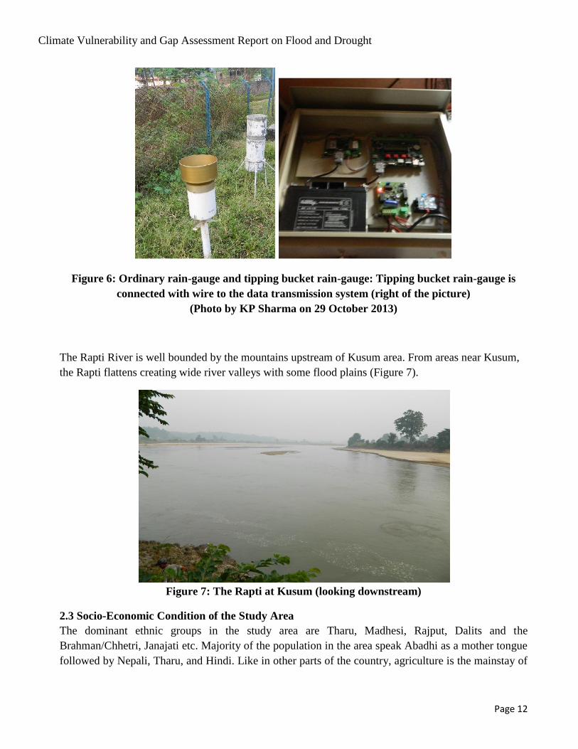
Since both stations, Bagaswoti and Jalkundi are located in relatively isolated areas; DHM
established a station at Kusum for security and accessibility. The station at Kusum was established in
2003 with processed data available for only eight years. The Kusum station has been upgraded with
automatic telemetry system for real time transmission of precipitation and water level data since the
last four years (Figure 6).
0.0
50.0
100.0
150.0
200.0
250.0
300.0
350.0
400.0
Jan Feb Mar Apr May Jun Jul Aug Sep Oct Nov Dec
Stre
amfl
ow
(cm
s)
Streamflow Hydrograph: Rapti at Three Locations
Kusum (375)
Jalkundi (360)
Bagasoti (350)
Climate Vulnerability and Gap Assessment Report on Flood and Drought
Page 12
Figure 6: Ordinary rain-gauge and tipping bucket rain-gauge: Tipping bucket rain-gauge is
connected with wire to the data transmission system (right of the picture)
(Photo by KP Sharma on 29 October 2013)
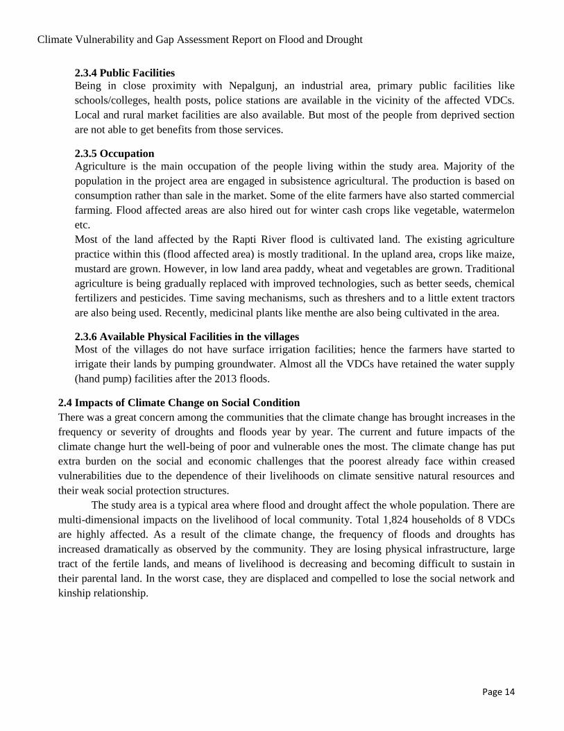
The Rapti River is well bounded by the mountains upstream of Kusum area. From areas near Kusum,
the Rapti flattens creating wide river valleys with some flood plains (Figure 7).
Figure 7: The Rapti at Kusum (looking downstream)
2.3 Socio-Economic Condition of the Study Area
The dominant ethnic groups in the study area are Tharu, Madhesi, Rajput, Dalits and the
Brahman/Chhetri, Janajati etc. Majority of the population in the area speak Abadhi as a mother tongue
followed by Nepali, Tharu, and Hindi. Like in other parts of the country, agriculture is the mainstay of

Climate Vulnerability and Gap Assessment Report on Flood and Drought
Page 13
the economy of the area. According to the District Agriculture Office, around 81 percent people are
dependent on agriculture for their livelihood. Similarly, around 11 percent are involved in business, 6
percent in service and 1.46 percent in industry. The predominant form of production till date is
subsistence agriculture. Family is the basic unit of production. Female and child labor along with adult
male labor is used for the purpose. There is hardly any surplus because the landholding size is small.
However, a few wealthy farmers are switching from domestic to market oriented production.
2.3.1 Flood Affected Area
Eight VDCs downstream from the East-West Highway are severely affected by flood in the Rapti
River. Among them, 5 VDCs are on the right bank and 3 on the left bank of the River. The major
affected VDCs are namely Holiya, Gaganpur, Matehiya, Fattepur, Betahani, Kusum, Kanchanpur,
and Binauna. Gangapur, Matehiya, Tepari Piprahawa, Bisambharpur, Sarra, Nibuwatar, Sonpur,
Jaraiya are the major affected human settlements within the given VDCs.
2.3.2 Population and Ethnicity
Based on the socio-economic survey conducted during the study, the major ethnic groups living
within the project area are Tharu, Brahman, Dalits and the Hill Brahman, Chhetri, Muslim etc.
Gaganpur, Matehiya, Holiya, Betahani are dominated by Madhesi community, Fattepur by Tharu
and Kusum and Kachanapur are dominated by Hill ethnic groups (Table 3).
Table 4: Information about Flood Affected Community
S.N. VDC Ward No HHs Popn-
Caste/Ethnicity Remarks
1 Gangapur 2,3,5,6 576 3456 Terai ethnic group Gangapur
2 Matehiya 1,2,3,4,5,
6,7,8 & 9
346 2076 Terai ethnic group Matehiya
3 Holiya 5 & 7 208 1248 Terai ethnic group Tepari Piprahawa
4 Fattepur 7 & 8 292 1752 Tharu Bisambharpur/Sarra/Nibuwa
tar/Sonpur/Jaraia
5 Betahani 7 & 9 26 156 Terai ethnic group Amritpurwa, Betpurwa
6 Kusum 2,6,8,9 86 516 Hill ethnic group Khaskusma
7 Kachanapur 2 12 72 Hill ethnic group Kachanapur
8 Binauna 278 1668 Mixed group
1824 10944
Source: Field Survey, 2013
2.3.3 Utilities
The affected VDCs, which are adjacent to the Nepalgunj municipality, are getting electricity, water
supply, telephone as basic utilities. Basic infrastructures are available for these services, but the
general people are not able to afford these services due to their economic backwardness.
Climate Vulnerability and Gap Assessment Report on Flood and Drought
Page 14
2.3.4 Public Facilities
Being in close proximity with Nepalgunj, an industrial area, primary public facilities like
schools/colleges, health posts, police stations are available in the vicinity of the affected VDCs.
Local and rural market facilities are also available. But most of the people from deprived section
are not able to get benefits from those services.
2.3.5 Occupation
Agriculture is the main occupation of the people living within the study area. Majority of the
population in the project area are engaged in subsistence agricultural. The production is based on
consumption rather than sale in the market. Some of the elite farmers have also started commercial
farming. Flood affected areas are also hired out for winter cash crops like vegetable, watermelon
etc.
Most of the land affected by the Rapti River flood is cultivated land. The existing agriculture
practice within this (flood affected area) is mostly traditional. In the upland area, crops like maize,
mustard are grown. However, in low land area paddy, wheat and vegetables are grown. Traditional
agriculture is being gradually replaced with improved technologies, such as better seeds, chemical
fertilizers and pesticides. Time saving mechanisms, such as threshers and to a little extent tractors
are also being used. Recently, medicinal plants like menthe are also being cultivated in the area.
2.3.6 Available Physical Facilities in the villages
Most of the villages do not have surface irrigation facilities; hence the farmers have started to
irrigate their lands by pumping groundwater. Almost all the VDCs have retained the water supply
(hand pump) facilities after the 2013 floods.
2.4 Impacts of Climate Change on Social Condition
There was a great concern among the communities that the climate change has brought increases in the
frequency or severity of droughts and floods year by year. The current and future impacts of the
climate change hurt the well-being of poor and vulnerable ones the most. The climate change has put
extra burden on the social and economic challenges that the poorest already face within creased
vulnerabilities due to the dependence of their livelihoods on climate sensitive natural resources and
their weak social protection structures.
The study area is a typical area where flood and drought affect the whole population. There are
multi-dimensional impacts on the livelihood of local community. Total 1,824 households of 8 VDCs
are highly affected. As a result of the climate change, the frequency of floods and droughts has
increased dramatically as observed by the community. They are losing physical infrastructure, large
tract of the fertile lands, and means of livelihood is decreasing and becoming difficult to sustain in
their parental land. In the worst case, they are displaced and compelled to lose the social network and
kinship relationship.

Climate Vulnerability and Gap Assessment Report on Flood and Drought
Page 15
CHAPTER III
GENERAL FINDINGS
3.1 Flood Scenario
3.1.1 The Flood of 2013
World-watch Institute, an international institute observes (World-watch 2013):
“The worst flooding to hit Nepal’s western region in a decade-caused by heavy
monsoon rains—has killed at least 50 people. Flood waters from the Rapti River, one of
the country's largest rivers affected as many as 60,000 villagers in 13 districts.
Bardiya, Banke and Achham districts 600-800 kilometers west of the capital,
Kathmandu, is the worst hit. The flooding has destroyed the farms, killed nearly 2,000
animals, and more than 10,000 tons of food stocks. Nepal has sought international help
worth US $3.58 million to provide emergency relief. But urgently needed medical help
and food aid has not extended to the most remote areas, even as flooding and
landslides continue to make their situation more precarious.”
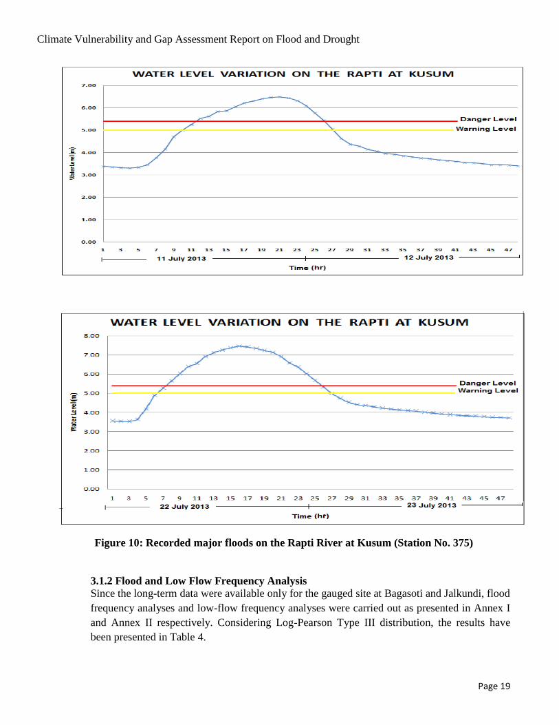
Three major floods were noted on the Rapti in 2013. The first one of 18 June (Figure 9) although
disastrous in the Mahakali basin, was moderate on this River. Although the flood exceeded the
warning level (established by DHM), and reached close to the danger, the damages were not
extensive. Severe damage was reported in the subsequent floods that occurred on 11-12 July and
22-23 July.

Climate Vulnerability and Gap Assessment Report on Flood and Drought
Page 16
Figure 8: Satellite-based rainfall estimation of 18 June 2013
Box 1
The Kathmandu Post. Jul 22, 2013
NEPALGUNJ, JUL 22 - People residing on either side of the Rapti River have been terrorized due to the
floods triggered by incessant rainfall. Locals have started hurrying towards safety after the floods
began to inundate the residential areas. Tepari and Simrahana of Holiya VDC are at the highest risk as
floods in the Rapti River have begun breaching its banks, police said. "The river has changed its
course. Locals have not been able to travel as the water level rose up to neck," said Raj Kumar Sukla,
a resident of Holiya. The water level that was recorded at 5.90 m at 8 this morning suddenly rose to
7.32 m at around 2 PM, according to an official at flood record centre. There is the possibility of floods
inundating seven VDCs once the water level rises above 5.40 m.
According to district administration office, floods have begun to inundate Gangapur, Matehiya and
Holiya villages. Along with this, there is an increasing possibility of flood water entering other VDCs
such as Narinapur, Phattepur, Laxmanpur, Kamdi and Bankatti, Chief District Office Jeewan Prasad Oli
said. He urged the residents of those villages to move to safer places. Meanwhile, rescue teams of
Nepal Police and Armed Police Force have reached the flooded areas and started rescue operation.
According to our Dang correspondent, Durga Lal KC, over a dozen villages of Deukhuri have
submerged after the floods in the Rapti River ruined the embankment of Praganna irrigation project
and gushed into human settlements. The floods have damaged around 100 houses of villages
including Lalmatiya, Sisahaniya, Sonpur, Chaulahi, Gangaparaspur, Gadwa and Gobardiha, police
said.

Climate Vulnerability and Gap Assessment Report on Flood and Drought
Page 17
Nepalese and Indian press have also given high priority to the news of flood devastation in the area
and downstream reach in India.The Times of India published a report on 12 July 2013 as, “River
Rapti was flowing very close to the danger level all through the course from Kakardhari
(Bahraich) to Birdghat (Gorakhpur) and Burhi Rapti was flowing above the red mark at Kakrahi
(Siddhartnagar)”. The report published by the Kathmandu Post, and Republica in 2013 also
reported the same event in Nepal (Box 1 and Box 2).
Box 2
Republica July 23, 2013
FATTEPUR (BANKE), July 23: Nearly 100,000 people in nine villages of Banke district have been virtually
cut off after Baghauda-Nepalgunj was badly damaged by the flooded Rapti River.
The 50-km Baghauda-Nepalgunj road, which is the only way for the people from Fattepur, Gangapur,
Matehiya, Baijapur, Laxmanpur, Narainapur, Kalaphanta, Katkuiya and Binounda VDCs of Banke to
reach Nepalgunj by motor vehicle, remains badly damaged by the Rapti river following a heavy
rainfall since Monday.
Vehicles have stopped plying the road from Tuesday leaving the people confined to the nine VDCs.
After being cut off from Nepalgunj, these people have no other option than to go to Indian towns
across the border for buying essentials. The villagers say the Rapti flooding caused more damage this
time as the Baghauda-Nepalgunj is being upgraded to postal highway and there was no channel to
drain the flood waters. "We had asked the authorities to make arrangements to protect the road from
flooding but they did not pay any heed and now the government investment has gone to waste and
we are suffering," said Amrit Malla, a local resident of Fattepur.

Climate Vulnerability and Gap Assessment Report on Flood and Drought
Page 18
Figure 9: Devastation of agricultural landin Holiya village
Climate Vulnerability and Gap Assessment Report on Flood and Drought
Page 19
Figure 10: Recorded major floods on the Rapti River at Kusum (Station No. 375)
3.1.2 Flood and Low Flow Frequency Analysis
Since the long-term data were available only for the gauged site at Bagasoti and Jalkundi, flood
frequency analyses and low-flow frequency analyses were carried out as presented in Annex I
and Annex II respectively. Considering Log-Pearson Type III distribution, the results have
been presented in Table 4.

Climate Vulnerability and Gap Assessment Report on Flood and Drought
Page 20
Table 5: Flood and low-flow frequency: Bagasoti and Jalkundi stations
3.1.3 River Flood Trend
Minor floods used to occur in the area historically as it is a flat land and by the side of big river
flowing naturally. Main flood havoc in the area occurs during the monsoon seasons. Historical flood
occurred once in every ten year or so. After the construction of river dykes and barrage in India, the
following changes in the river behavior were observed:
- The river channel was constrained.
- There was backwater effect due to obstruction of flow.
- Barrage controlled flow of the river and gate operation of the barrage directly affected
flow regime.
- Damage to crops, vegetation, life and property has become a yearly routine for the
inhabitants of the area.
- The intensity of floods is increasing every year and the river is frequently changing its
course.
The people are aware that the Laxmanpur Barrage and Kalkalwa afflux bund, constructed by the
Government of India, have further obstructed the natural flow of the river thus aggravating the
flooding. Local farmers of Holiya VDC observed that the floodgates at Laxmanpur Dam are not
operated properly and are closed during times of high flow causing backflow and submergence.
Some flood relief structures are already constructed especially in Kalkalwa bund; however the
P (%)
T
(Year)
Flood Peaks Low Flow
Bagasoti Jalkundi Bagasoti Jalkundi
Expected
Flow
(cms)
Expected
Flow
(cms)
Expected
Flow
(cms)
Expected
Flow
(cms)
50 2 1719 2,639 9.1 5.92
20 5 2715 3,928 6.4 3.15
10 10 3505 4,963 5.1 2.08
5 20 4376 6,115 4.1 1.36
2 50 5704 7,891 3.8 0.71
1 100 6873 9,472 3.1 0.37
0.5 200 8222 11,310
0.2 500 10334 14,205

Climate Vulnerability and Gap Assessment Report on Flood and Drought
Page 21
local people in Holiya express their doubt that the present action of Indian side would be helpful
enough to solve the flood problem.
3.1.4 Observed Flood Damages
The VDC and households affected by the 2013-flood in Banke are reported as follows (Table 5):
Table 6: VDC and Household affected
S.N. VDC
Affected
HH
No of affected
settlements
(Wards)
Degraded
HH
Number of
Degraded HH
settlements
(Wards)
Sedimented
HH
1 Gangapur 576 9 53 5,6 523
2 Matehiya 346 6 4 1 342
3 Holiya 208 3 0 0 208
4 Fattepur 292 6 53 7,8 239
5 Betahani 26 3 1 9 25
6 Kusum 86 6 10 6,8 76
7 Kachanapur 12 4 5 2,3 4
8 Binauna 278 3 43 6,7 & 9 235
Total 1824 40 169 13 1652
Total in No/ Kattha 1824
Source: DADO, Banke (2013)
The major affected VDCs by flood in the monsoon are Holiya, Betahani, Gangapur, Mataihiya and
Fattepur. River migration and meandering is more serious in Fattepur and Holiya.
Holiya VDC
Historical Information from Water Induced Disaster Prevention Division (WIDPD) no. 6,
Nepalgunj, shows that the area with submergence of more than 0.5 meter depth is about 1,600 ha.,
additional submergence with less than 0.5m depth is more than 600 ha. The submerged area
includes 2,600 households, 3 schools and 18 temples. The severe effect was on Holia VDC where
couples of villages including Holia Village were completely under flood and sand deposition.
The human settlements near the border area have been affected severely after the
construction of the Laxmanpur Barrage and the Kalkalawa afflux bund in India. The construction
of a bridge culvert by India for drainage of Sotia and Gandheli Nalas from Nepal has allowed
some blocked water in the area to flow downstream. During field observation it was observed that
the downstream portion of the culvert was blocked by temporary dyke to check water from the
Nalas. However, the major problem caused by the Rapti river flood is still prevailing.
The Department of Water Induced Disaster Prevention (DWIDP) carried out some
emergency flood mitigation works. Such temporary works were washed away. Villages and
agricultural land of Holia VDC has been under sand deposited by the river flood during monsoon,
Climate Vulnerability and Gap Assessment Report on Flood and Drought
Page 22
including the 2013-flood. In the villages nearby, the Rapti flood inundated the settlement.
Interaction with affected local population clearly showed that they were panicked during each
flooding.
Fattepur VDC
The Rapti River overtopped left bank near the bridge over Rapti on Nepalgunj-Baghauda road.In
Dhalaiya, Guleri (Ward No.9), on the upstream of bridge, the River width (100 m in normal flow)
is expanded to 900 m with bank cut on the left. The bank is low for 900m length and has inundated
about 20 ha of cultivated land. The effect of flood was also observed in Ward No. 8 downstream.
Similarly in Bishambhapur (Ward No. 7), further south of Ward No.8, the river is spread over to
about 1,500 m width in last two years, with a shift of about 1000 m to the left. The dry season
width is only about 150m.
Effects of flood in south eastern part of Banke are as follows:
1. loss of land, property and life,
2. displacement of villages, offices, schools etc.,
3. damage to physical infrastructure,
4. flood induced drought in the area,
5. increase in flood level in Nepal due to jacketing of river in India (backwater), and
6. choking of sheet flow due to the embankment parallel to the boarder along the contour line.
A continuous process of bank erosion on both banks during floods has worsened the situation in
the area with following conditions:
flooding, erosion and sedimentation during or after flood, washing away of irrigation canals
and other infrastructures in the reach during flood, and lack of irrigation water in the winter
and spring seasons.
backwater effect due to construction of Laxmanpur barrage and its improper operation
aggravating the flood and inundation situation in the area.
some flood control measures by Government of Nepal in the area which are not much
effective for mitigating floods.
rescue, relief and other non-structural activities by NGOs like Nepal Red Cross Society and
local CBOs. .
Conditions of severely affected areas are shown in Figure 11 and 12.
Climate Vulnerability and Gap Assessment Report on Flood and Drought
Page 23
Figure 11: Flood affected area and abandoned customs office
Figure 12: Flood affected agricultural Land on the Right Bank of Rapti
3.1.5 Flood Mitigation Measures
The flood of West Rapti River severely affects the people of eight VDCs of Banke district every
year. The consequences are increased by the construction of Laxmanpur barrage and Kalkalawa
Bund (dyke) and afflux bund by India on their side adjacent to Nepal-India border. In the past
years, the river had a tendency of shifting abruptly towards the West.
In the lower part of Banke District of Nepal, local people of the area, governmental and
non-governmental organizations have worked for immediate relief works but little has been done
for long-term mitigation measures. The flood risk is increased as the river has actively been
eroding the right bank shifting towards the west; and structural intervention is increasing. Such
severe and abrupt bank erosions and depositions on the right side seems to have remained
unnoticed. The rising flood inundates the whole flood plain area pushing the earth banks. Active
and speedy erosion commences when the flood recedes from its bank-full conditions. These

Climate Vulnerability and Gap Assessment Report on Flood and Drought
Page 24
phenomena can be observed during the monsoon months. The river might even change its course
and avulse to other rivers towards west and cause greater damage to Nepal and India.
Activities by the government agencies
Janatako Tatband Karyakram, (People‟s Embankment Program) Lamahi, Water Induced Disaster
Prevention Division (Nepalgunj) under DWIDP and District Natural Disaster Relief Committee
(District Administration Office) are major governmental agencies working for mitigating the Rapti
flood and providing respite to victims. The activities being carried out by the governmental
agencies are as follows:
- Bamboo Piling
- Protection with the construction of gabion
- Involvement of DDC, police stations etc. in an early warning system, and
- Rescue and relief operations.
3.2 Flood Scenarios
The West Rapti River flowing through south eastern part of the Banke District in Nepal provides
both important services as well as life-threatening hazards. An integrated flood management
approach should be adopted, with a view to maximize the efficient use of flood plains and
minimize the loss of life and livelihoods due to flood and inundation hazards. While floods cannot
be prevented, an integrated cross sectoral approach to flood management is essential to mitigate
flood-related disasters. As the ground slope in the area is relatively steep, structural measures like
dikes and embankments play a significant positive role in flood mitigation and hazard reduction.
Land use planning and proper training and motivation are important non-structural measures. Early
warnings can provide time and opportunity for preparedness and response measures. Timely and
accurate flood information based on real-time hydro-meteorological observations is essential to
achieve this objective. At present, there is a limited flood information system in the area. Existing
flood data dissemination system should be upgraded to flood forecasting facilities covering the
whole basin area.
The floods have caused great impact on both individuals and communities, and have social,
economic, and environmental consequences. People carrying out agricultural activities in the area
are affected greatly compelling some to migrate.
Solution of flood and drought problems in the area is vital. Solutions have to be worked out
jointly and implemented with high priority. The area has been severely affected by floods and
drought and if the problem is not solved following consequences may arise:
a. Some of the areas may be abandoned due to degradation of land which will be unfit for
cultivation.
b. People may leave the area due to fear of flood.
c. Rapti River may change the course and shift towards west causing heavy losses in Nepal and
India.
d. Criminal activities like extortion, smuggling, trafficking etc. may increase in the area.

Climate Vulnerability and Gap Assessment Report on Flood and Drought
Page 25
3.3 Drought Scenario
The area is also affected by drought during dry season. Drought occurs mainly due to following
reasons.
Little rainfall during dry season,
Too early of too late monsoon,
Large time gap between two consecutive rainfall,
Limited irrigation possibilities,
Damage of farmer managed irrigation systems by floods,
Sand and silt deposition in the field, and
Conversion of the field to river course by the meandering river with several desert like
situations
In winter, drought is inevitable due to lack of water. There are no irrigation systems from the West
Rapti River and other water bodies in the study area. At the end of each flood the silt carried by the
river is deposited on the banks that spread to long distances. It blocks in-take of canals, destroys fertile
land and decreases water retention capacity of soil. During post monsoon seasons, water is not
sufficient to irrigate crops.
Farmer managed irrigation systems are damaged by flood and the farmers depend heavily on
groundwater.
Drought is also a regular natural phenomenon for the area. Drought lasts for a few days and up to months
causing damage to livelihood and property.
3.4 Agriculture scenario
Floods and droughts are among the most severe and expensive of all natural disasters. According to
statistics published by the United Nations, over 30% of natural disasters were floods and nearly 15%
were droughts or drought-related events during 1970-2005. Droughts are the main cause of
agricultural distress. Droughts strongly impact agriculture, disrupting the annual harvest cycle,
affecting prices for agricultural commodities in real time through market speculation, lingering
scarcities, rippling through regional and global economies for many months even after the cessation of
droughts. Floods, on the other hand, tend to be more localized than droughts and rather short-lived,
lasting hours to days, although large-scale inundations can last for weeks or months.

Climate Vulnerability and Gap Assessment Report on Flood and Drought
Page 26
Agriculture is the main source of economy in the study area. The Rapti flows from mid-area of the
Banke District. It is one of the rain-fed dominant agricultural districts of Nepal. Floods, in general,
have both positive and negative impact. If the flood brings topsoil and water stays for not more than 24
hours in the field the effect is generally positive.
3.4.1 Effect of Flood on Agriculture
The average area of household affected byfloods is about 0.16 ha, varying from 0.21 ha in Bethani
VDC and 1.64 ha in Kanchanpur VDC10
. The major crop affected by flood is paddy covering an area
of about 59 percent. Large part of the Study area was not cultivated due to the damages to nursery
beds by 2013 floods. Also the standing crop of medicinal plant Mentha with the area of roughly 11.6
percent and Maize 7.3 percent were damaged by 2013 floods. Other field crops destroyed were Black-
gram, Vegetable, Arum/Colocassia, Pigunpea, Groundnut, Riverbed cultivation and Sesame (Annex).
Damages in different VDCs are presented in Table 6.
10
FGD study conducted in the flood affected VDCs of the area

Climate Vulnerability and Gap Assessment Report on Flood and Drought
Page 27
Table 7: Crop damaged areas
VDC Households
Damaged Crops - In Hector
Paddy Maize Mentha Others
Gangapur 576 165.93 10.02 86.49 18.79
Matehiya 346 134.17 2.17 15.92 1.68
Holiya 208 59.57 0.27 2.71 3.47
Fattepur 292 77.41 3.35 0.95 0.88
Bethani 26 0.85 0.98 2.74 0.85
Kusum 86 9.55 25.87 0.00 0.00
Kachanapur 12 17.61 0.00 0.00 0.00
Binauna 278 92.82 26.21 0.00 17.95
Total 1824 557.897 68.878 108.803 43.616
Source: DADO, Banke
The study area is located in a zone, where flows have relatively higher velocity and the channel
conducive to river meandering. . Both the phenomena reduce or degrade agricultural land and its
productivity. Climate change has direct and indirect effect on agriculture sector as the study area
mostly consists of rain-fed agriculture systems.
The Banke District contributes nearly 2.4% of paddy, 0.9% of maize and 2.9% of wheat in
national agriculture. The Climate change has direct and indirect affect on agriculture. The experienced
trend on flood issue indicates that the year 2013 was severe compared to the previous years (Table 8).
Table 8: Rating of Flooded and Eroded area in Lower part of the west Rapti.
S.N VDC Year 2011 Year 2012 Year 2013
Flooded
Area
Eroded
Area
Flooded
Area
Eroded
Area
Flooded
Area
Eroded
Area
1 Gangapur Low Low Low Low High High
2 Matehiya Low Low Low Low High High
3 Holiya Low Low Low Low High High
4 Fattepur High Medium High Low Medium Medium
5 Bethani Low Low Low Low High No
6 Kusum Low Low Low Low Low High
7 Kachanapur High Medium High Medium High High
8 Binauna Medium No Medium No High High
Source: Field Study (FGD), 2013

Climate Vulnerability and Gap Assessment Report on Flood and Drought
Page 28
The issue of drought is less alarming than the flood. Ground water use is increasing day by day for
irrigation. As per the experience of the farmers water level is declining. The total degraded area in
2013 is about 63.29 ha and sediment deposited land about 93.60 ha (Table 7).
Table 9: VDC-wise Area degraded and Sediment deposited till July 11, 2013
S.N VDC
Area under
Degradation Sediment deposit
1 Gangapur 28.72 0.00
2 Matehiya 1.35 0.66
3 Holiya 0.00 5.76
4 Fattepur 27.33 87.16
5 Bethani 0.14 0.00
6 Kusum 3.72 0.00
7 Kachanapur 2.03 0.00
8 Binauna 0.00 0.00
Total 63.29 93.58
Source: DADO, Banke
The major crops affected are Paddy, Maize, Mentha (Mentha Arvenses Labiatae) and other Table-
8.In value terms the estimated loss is NRs 43.0 million.
3.4.2 Gap and recommendations
The basic gap on event of drought and flood is information collection and its maintenance, and it
needs more priority at all levels. Ad hoc basis information collection is in practice and the
information is not maintained producing a consistent time series. Suggested recommendations are:
1. A well maintained crop early warning system should be developed and implemented.
2. DADO needs to have fund for rescue or immediate support for the farmers with required
inputs like seeds and fertilizers. At present affected people have to ask support available
either at DDC or at Ministry through its Department or from NGOs.
3. Flood control infrastructures should be developed to protect the area.
4. Irrigation facility should be developed for addressing drought problem.
5. Reclaiming of the eroded land should be started through which farmers' income and food
security is improved.
6. Research on flood / drought tolerance variety should be developed
Farmers are practicing to use the sediment land for the crops like watermelon, and various
vegetables, which needs to be promoted with the provision of necessary technical support. Even
Indian contract farmer were observed for this purpose where they bring technology from India.It
needs close monitoring preferably by the ASC and DADO. Introduction of aquaculture may be
appropriate but needs feasibility assessment.

Climate Vulnerability and Gap Assessment Report on Flood and Drought
Page 29
The process of fund release or decision making is very lengthy. It needs to be shortened by
maintaining emergency fund at DADO-DLSO or CDO or DDC or even at VDC.
Table 10: Estimated amount of loss by crop NRs
S.N VDC
Estimated value of crop loss (in thousand Rs)
Pad
dy
Maiz
e
Blac
k
gram
Vege
table
Menth
a
Arum/
Colocassia
Pigunpe
a
Ground
nut
Riverbed
cultivatio
n
Sesame
1 Gangapur
7,8
40 402 14 0 10,216 3 335 62 0 1
2 Matehiya
6,3
39 87 2 0 1,880 0 26 2 0 1
3 Holiya
2,8
14 11 22 5 320 21 133 5 39 1
4 Fattepur
3,6
58 135 0 60 112 1 1 8 6 1
5 Bethani 40 39 0 5 324 0 14 3 0 0
6 Kusum 451 1,039 0 0 0 0 0 0 0 0
7 Kachanap
ur 832 0 0 0 0 0 0 0 0 0
8 Binauna
4,3
86 1,053 0 0 0 0 0 530 0 0
Total
26,
360 2,766 38 70 12,852 25 389 610 45 4
Source: Field survey
Remarks:
The impact of drought and flood is generally discounted or ignored in the long-tem national
development planning and strategy formulation. It has, however, considerable negative impact on
the economy of the Banke District. The result of the study demonstrates that the droughts and
floods are major obstacles for agriculture production and food security. Indication suggests that
the drought and flood events are becoming more frequent, and the average annual impact might
increase in future. It is, therefore, crucial that the policymakers consider the severe implications of
climate variability. This has to be addressed explicitly in designing and evaluating national
development policies and strategies.
Climate Vulnerability and Gap Assessment Report on Flood and Drought
Page 30
3.5 Legal aspects
All the rivers of Nepal, big or small, drain through the Nepalese border to India. Lower parts of the
Rapti River comprise areas in the vicinities of the common border between Nepal and India. Hence,
the flow of river- its volume, time, space and intensity matters not only to Nepal but also to India. In
fact, the integrity of the river, if affected by natural or man-made activities, is going to affect both the
countries.
In the case of the Rapti River, particularly at the adjoining areas where the river crosses the
boundary, India has constructed embankments and other structures which, in essence, guide the river
flow while it is in Nepal to flow down through a particular area finally leading the flow to feed the
Laxmanpur Barrage constructed in India. The Barrage is just about 3 km (about 9 km along the river)
away from Nepal border with the 13.60 km embankment going westwards through Kalkalwa in India
and tied to highland in India parallel to the border. There is no planned embankment construction in
Nepal. The Kalkalwa embankment is only 300 m away from the Border Pillar no 19 and 650 m from
Pillar no 21. The average height of the embankment at India's Kalkalwa is only about 2 m but it
increases to 5 m when it reaches to Nepalese border. Top of the embankment also serves as road. The
bottom width of the embankment varies from 20 to 25 m while the top width is 5.50m.The 13.6 km
embankment has only single outlet to drain out the Gandheli and Sotiya Nala, the natural outlet from
Nepal. Thus unilateral construction of the Laxmanpur Barrage in the Indian Territory controls and
guides the water to a particular system of canals. This has naturally limited the river course in India to
flow through the barrage while leaving it to meander in the Nepalese territory.
In case of Nepal there is no planned flood control work done along the Rapti River. Point
control works and emergency flood control works have been done without analyzing long term effects.
The work has not been effective and river meandering happens every year affecting local people and
establishments.
Such an action has affected Nepal in many ways:
1. Due to the obstructions created in India, the natural course of the river is hindered causing
afflux of the water resulting in bank overflows leading to severe water- logging in the Nepalese
territory. Thus during the monsoon season a vast swathe of Nepalese territory remains within
water depriving the farmers and other users from any meaningful use of the land. Besides, the
water logging creates all kinds of health hazards and submerges the properties and settlement
causing loss and suffering in great magnitude.
2. While in the Nepalese territory the Rapti River meanders between a vast span of about four km
of its course and hence its swinging nature creates land use and entitlement problems in Nepal.
A piece of land owned and cultivated by a particular farmer in the winter could be completely
obliterated and brought within the flow of the river leaving no trace during the monsoon. At the
same time, after the monsoon a sandy piece of land may be found to be of some agricultural
use to the adjoining farmers again raising the issue as to who can use such land and to whom
such a land belongs. It might be a land of a particular farmer who had lost it during the last
Climate Vulnerability and Gap Assessment Report on Flood and Drought
Page 31
monsoon but then how one would be able to trace it, moreover sometimes, the land is found on
the other side of the river making the farmer travel by boat to reach his own land.
The above problems raise a number of legal and political issues. These can be grouped into mainly
two categories: First the issues of international concerns where two countries are involved and second
the issues relating to the use and ownership of the land. Following paragraphs deal with both
categories of issues.
3.5.1 Issues of International Concern
Under this category one may raise important question of the actions of a particular country in any
international watercourse. Can a Watercourse State obstruct the natural course of a river and cause
detriment to the other Watercourse State? Should a Watercourse State inform the other
Watercourse State in case if it intends to raise some infra-structure in its territory which might
have significant adverse impact on the other? If any objection is raised by other State what should
be done? Should they enter into negotiation? If such negotiation fails what should be done?
Answers to these questions may be found in the following way under international law:
A. Under the UN Convention on the law of the Non-Navigational Use of Watercourses ,1997
which, by and large, represents the customary international law on the subject defines that
"a system of surface and ground waters constituting by virtue of their physical relationship
a unitary whole and normally flowing into a common terminus" as being a Watercourse
This Convention also defines "a watercourse, parts of which are situated in different States"
as being an International Watercourse and a Watercourse State is the one through which a
part of the International Watercourse passes.
All the waters that originate in Nepal and the ones that flow from China to Nepal drain to
India and ultimately meet the common terminus – the Bay of Bengal. By applying the
above definitions one could say that all the rivers that drain to India from Nepal are a part
of International Watercourse and Nepal and India are International Watercourse States in
relation to the Ganges waters.
B. International Law governs the conduct of the State and also defines the rights and
obligations between the States. International Watercourses Law is that part of international
law which is applicable in defining the rights and duties of the States over that part of
International Watercourse which passes through their territory. Watercourse States are
entitled in their respective territories to utilize an International Watercourse in an equitable
and reasonable manner. What is equitable and reasonable is to be decided by taking into
account many relevant factors such as the geographic, hydrographic, hydrological climate
ecological and other factors of a natural character, the social and economic needs of the
watercourse States concerned, Existing and potential uses, availability of alternatives etc.
All these factors need to be taken as a whole while deciding whether a particular use is or is
not equitable and reasonable.

Climate Vulnerability and Gap Assessment Report on Flood and Drought
Page 32
C. In utilizing the international watercourse the watercourse States in their respective
territories need to take all appropriate measures to prevent the causing of significant harm
to other watercourse States. Where significant harm is caused the concerned States need to
discuss and mitigate the harm and where appropriate discuss the question of compensation.
In case of compensation such compensation should be effective, prompt and adequate.
D. No country under international law is allowed to use its territory against other country. If
this law is not observed it attracts international responsibility and the concerned country
can be made liable for all the harm that is causes. In cases of loss and damage of property
such country can be liable for reparation or an effective, prompt and adequate
compensation for the loss and damage.
E. Before a watercourse State implements or permits the implementation of planned measures
which may have a significant adverse effect upon other watercourse States, it needs to
provide those States with timely notification thereof with all the relevant data and
information about such use. Upon the reservation by the notified States the States
concerned need to enter into negotiation in good faith with a view to settle the differences.
F. In cases where negotiation between the parties fail to reach any settlement they have the
obligation of settling their difference by peaceful means such as resorting to International
Court of Justice or Arbitration or mediation or conciliation by third party etc. If any Party
is not interested to settle the difference by peaceful means it shall be taken as a serious
violation of international law and the other affected party is free to take various means
available to it including to utilize the avenues of United Nations for settling the dispute.
On the issue of the Rapti River and the construction of the bunds and other structures by Indian
side in its territory no prior notice was given to Nepal. When Nepal raised the issue it was never
taken seriously by the Indian side. The issue was either skirted out or entangled in unnecessary
discussion. The tactics was to continue the construction while keeping Nepal engaged in
discussion. Thus the negotiation was never been in good faith. After the construction was over the
subject became a fait accompli. The subject as it stands now is that Nepal was never taken into
faith , no compensation was paid no alternative solution was found no interest was shown to
accommodate the legitimate interests of Nepal and thus every year Nepal is suffering as stated
above. After long years of discussion and completion of construction of Laxmanpur Barrage,
Kalkalwa Bund and related structures thereof, the Indian side agreed to the construction of the
embankment in the Nepalese territory11
with a view to checking bank erosion and flooding in the
Nepalese territory. The embankment in the Nepalese territory was to be designed and the cost
estimate submitted by Nepalese side. it was also agreed to open the Gandheli and Sotiya Nala12
.
However, till to date structure for opening in the Gandheli and Sotia Nala has been constructed but
no other meaningful work has been carried out by India to let the water pass through. No
11
First meeting of JCWR, 2000, held at Kathmandu Nepal, between Nepal and India 12
Third meeting of HLTC, 20…, held at Kathmandu Nepal, between Nepal and India
Climate Vulnerability and Gap Assessment Report on Flood and Drought
Page 33
embankments in the Nepalese territory have been constructed and the issue is somehow being
prolonged with one or the other pretext.
3.5.2 Issues Relating to Use and Ownership of the Land
According to Section 3 of the Water Resources Act 2049, the ownership of all the water in
whatever forms that they are found within the country vests with the state. Except some uses such
as drinking or household, traditional communal irrigation, small water-grinding mill etc. water can
only be used by permit issued by the government. Hence, the ownership of the river and its beds
vests with the government. Under the Local- Self Governance Act,2055 the District Development
Committee is empowered to use the product of the rivers such as fish and other water species,
sands, gravel, boulders etc. and it also bears the responsibility of the protection of river.
In a typical situation when a river course is changed and new land is brought under its fold or
the hitherto river course emerges out of the water as a sandy land, questions arise as to what is
going to happen with the ownership and use of such land ? In the case of the land which is
engulfed by the river will the owner of such land gets any compensation by the government or any
other such bodies? In the case of the land emerged out of the water due to the change of the river-
course who will be entitled to use it? How the ownership of such land will be determined? What
rights will the owner who had lost his/her land have in regard to such land? These questions are
examined in the following paragraphs:
A. All lands of the country are categorized according to entitlement into various categories
such as private land, public land, government land, forest land, fallow land, land owned by
Trust (Guthi) etc. Each of these categories of land is managed by various provisions of
Land Revenue Act, 2034, and its Rules and Directives. Excepting the private land the
government enjoys superior authority in relation to land and its management. In a way
government is the owner of all the land except the private land. As regards the land which
is engulfed by the river due to the change of its course the private owner is not entitled to
get any compensation under the law. However, under Section 20 (3) of the Land Revenue
Act, 2034, if the owner of the land files an application for the waiver of the land revenue or
the cancellation of the registry of the said land, the government may do so by following
the procedures as laid down in Section 5.12 of the Land Administration Procedures, 2062
Part 3. Before such waiver and cancellation of the registry verification of the entitlement of
the land, payment of the due revenue if any, evidences of such engulfment of the land by
the river, field survey and determination of the exact amount of the land etc shall be done.
Such a waiver shall be duly recorded in the concerned Land Administration Office. Upon
completing the procedure the registry of the land will be changed from private land to
government land. Certification of waiver and the change of the registry shall be given to
the owner of such land.
B. In a situation where a land emerges out due to the change of the river course the entitlement
of the so emerged land may revert back to its owner by following the procedures as laid
down in the Land Administration Procedure, 2054. The erstwhile owner in such land
Climate Vulnerability and Gap Assessment Report on Flood and Drought
Page 34
requires filing an application in the concerned office with the certification of the
cancellation of the registry and the waiver of the revenue. Upon verification of the
evidences the land shall be reverted back to the former owner. Paragraph(F) of the said
Procedure states that even if the cancellation of the registry and the waiver have not been
made the land may revert back to the owner of the land if it can be established by evidences
that the said piece of emerged land belonged to the applicant before the same was engulfed
by the river.
C. According to the Mulki Ain (Law of the Land) 2020 Chapter on Land Encroachment
Paragraph 2, in a situation where the land is engulfed by the river course in such a way that
part of it remains unhurt in both the banks and latter the river again changes its course and
leaves the land emerged in one bank the owner of the partial land would be entitled to use
the land so emerged on that bank even if it does not belong to him or her. One is not
allowed to use such land in both the banks of the river course.
Field study shows that the agricultural lands are utilized after flood though the cultivation becomes
limited on such lands due to sediment deposition. The Cadastral map has been the legal basis to
identify the land. Sometimes the dispute arises between adjoining land owners on marking their
lands. In such situation, they compromise mutually and let go of some land not to worsen the
dispute. They all suffer in some way and so this is how they avoid unnecessary suffering. The
farmers have had a bitter experience of conflict when the harvested crop of one farmer was swept
away to other‟s land and two owners started claiming the crop to be theirs.
Therefore, each year after the emergence of the submerged land when the water is
somehow drained the Department of Survey should trace out the respective land owned by the
people so that the above kind of problems does not emerge. This needs to be done in consultation
with the local land holders. The field survey also shows that the owner of the submerged land does
apply for the cancellation of its registry in the Land Revenue Office. This in reality makes the
process of survey more easy otherwise the procedures of reverting back the land to its owner after
the land emerges out of water is so cumbersome that it will take months and years to complete the
procedures.

Climate Vulnerability and Gap Assessment Report on Flood and Drought
Page 35
The above survey of the law clearly establishes that the issues relating to the submergence
and flooding in the lower part of Rapti River clearly established two major policy and legal
dimensions: one relates to bilateral relations and other the national laws and policy in dealing with
such situation. As regards the first dimension it is amply clear that the actions of unilateral
constructions and obstructions in the flow of the river and other monsoon water by India is a flagrant
violation of international law. The lackluster behavior of India in mitigating the adverse impact
caused to the Nepalese territory due to such obstruction is nothing more than buying time and
pursuing a policy of fait accompli. Negotiating with India on the mitigation measures is not done in
good faith and hence it does not in reality makes any redress to the Nepalese side.
3.6 Perception of Affected People
Hydro-meteorological data acquisition, flood forecasting and warning systems have been established
recently in Kusum. People are aware of floods during the rainy season and are mentally prepared for
shifting away in case of emergency. Even though there is flood warning system, people reported that it
could not serve the flood affected community in desired level, because of short time available and
inappropriate dissemination of information. It was observed that Kusum is only about 20 km distance
from Indo-Nepal boarder, even if people were warned it would not be possible to arrange all the things
within a short span of time. Hence, special attention should be paid to install the warning system in
appropriate place upstream of the area so as to provide sufficient time gap to aware the community
people in time so that they could be able to prepare for timely response.
Figure 13: Consultative Workshop with Stakeholders

Climate Vulnerability and Gap Assessment Report on Flood and Drought
Page 36
3.6.1 Adaptation/Coping Practices (of the People /Communities)
The community has no collective coping mechanisms in flood prone areas. Most of the community
people were aware of flood frequencies during rainy seasons and arrangements made by
individual/household levels kept them mentally prepared. It was revealed that most households
have practices of keeping plastic sheets and few have tents for floods during rainy season.
Similarly, some people manage their food stocks upstairs especially during rainy season. Flood
water remains for about 2 to 7 days during high floods in the area. Recently some NGOs are
involved to train the community people for early warning, hand pump installation and construction
of Flood Shelter (in high land).Thus, the community members have adopted some measures for
coping the situation during and after the floods. Some of the measures taken during and after the
flood are as follows:
Move away temporarily onto the upland such as roadside, bank of fishpond, school
compound etc.
Take shelter in school compound, neighbor‟s house etc.
Use plastic sheets, tents while shifting temporarily
Shift cattle to the uplands
Figure 14: Children Selling Local liquor to Indian Customer
Following coping practices have been adopted in the flood affected area:
a) Pre-flood Situation
There is no collective way of coping practices in the community. People have been fighting
with the flood for long and they are conscious and aware regarding flood situation and to
save their life and property. When monsoon starts community member arrange for the
collection of additional food stuff, protecting equipment with plastic sheets, tents, rubber
tube small wooden boat etc.

Climate Vulnerability and Gap Assessment Report on Flood and Drought
Page 37
Figure 15: Boat used by local people during flood
b. During Flood Situation
The community is fully aware that flood could hamper whole community at a time.
Therefore, it is very difficult to cope collectively during flood. Most of the households are
compelled to manage individually as and when needed basis. The community people move
away in order to seek safe places like schools, roads and dam sites. Similarly most of the
community members whose houses are completely damaged and destroyed take shelter in
schools, health posts and neighboring houses. If the flood only partially affected the
community there are chances of local level facilitation. Cattle are also kept on the uplands.
Households with permanent buildings stay on the second floor and keep their cattle in the
upland.
c. Post Flood Situation
This is the most crucial phase of the flood. The people often feel socially, mentally and
physically offset. During the same time community is required to arrange clothing, shelter,
and food with great difficulty. Similarly, when the water level starts to reduce, epidemic
diseases like diarrhea, cholera, dysentery and pneumonia may cause heavy damage to human
and animal life.
3.6.2 Suggestions from Local People
Affected people of the area are very much concerned about the deteriorating situation of floods and
droughts in the area and suggested following measures for addressing the deteriorating situation:
- The villagers stressed the need to build permanent embankment on both sides of the West
Rapti River, especially in Banke district
- Some villagers emphasized the need to manage the watershed. They suggested reforestation
and bamboo plantation on the banks of the river.
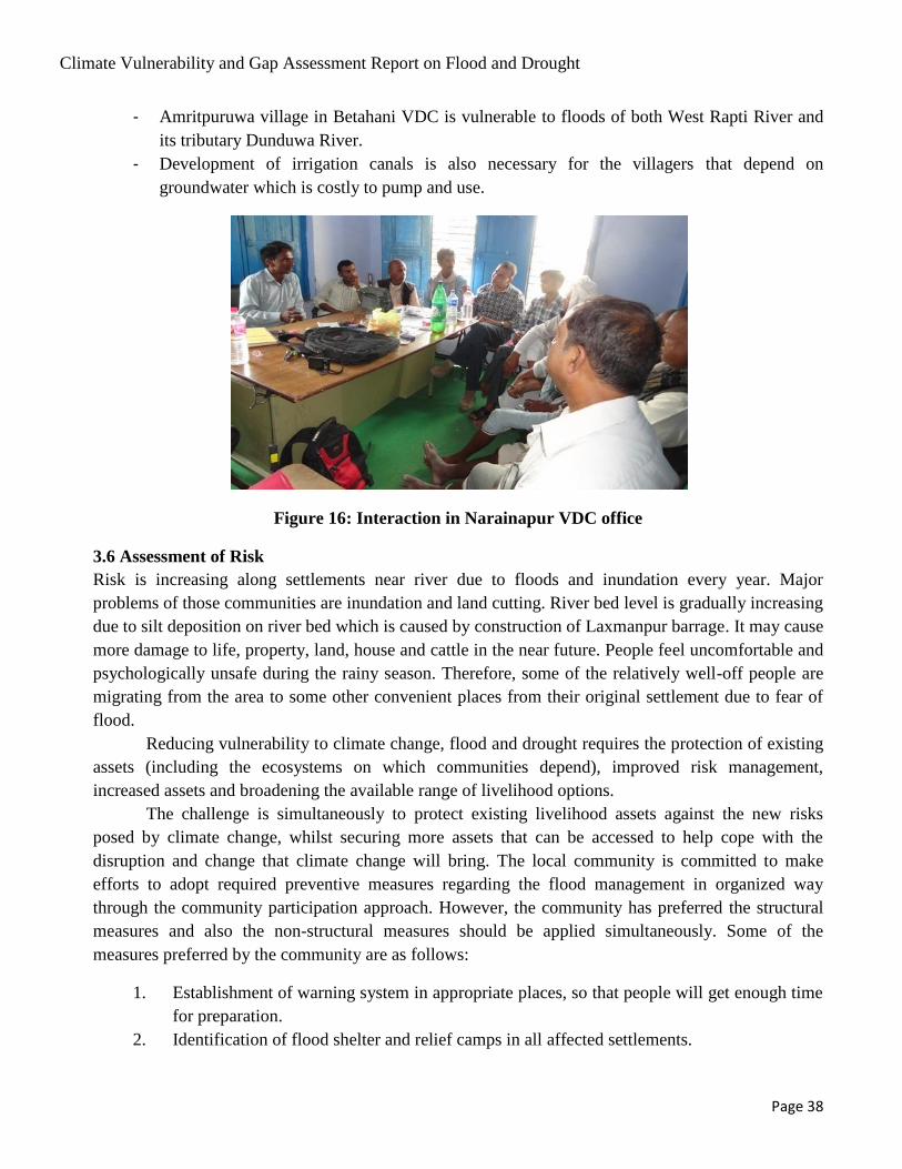
Climate Vulnerability and Gap Assessment Report on Flood and Drought
Page 38
- Amritpuruwa village in Betahani VDC is vulnerable to floods of both West Rapti River and
its tributary Dunduwa River.
- Development of irrigation canals is also necessary for the villagers that depend on
groundwater which is costly to pump and use.
Figure 16: Interaction in Narainapur VDC office
3.6 Assessment of Risk
Risk is increasing along settlements near river due to floods and inundation every year. Major
problems of those communities are inundation and land cutting. River bed level is gradually increasing
due to silt deposition on river bed which is caused by construction of Laxmanpur barrage. It may cause
more damage to life, property, land, house and cattle in the near future. People feel uncomfortable and
psychologically unsafe during the rainy season. Therefore, some of the relatively well-off people are
migrating from the area to some other convenient places from their original settlement due to fear of
flood.
Reducing vulnerability to climate change, flood and drought requires the protection of existing
assets (including the ecosystems on which communities depend), improved risk management,
increased assets and broadening the available range of livelihood options.
The challenge is simultaneously to protect existing livelihood assets against the new risks
posed by climate change, whilst securing more assets that can be accessed to help cope with the
disruption and change that climate change will bring. The local community is committed to make
efforts to adopt required preventive measures regarding the flood management in organized way
through the community participation approach. However, the community has preferred the structural
measures and also the non-structural measures should be applied simultaneously. Some of the
measures preferred by the community are as follows:
1. Establishment of warning system in appropriate places, so that people will get enough time
for preparation.
2. Identification of flood shelter and relief camps in all affected settlements.
Climate Vulnerability and Gap Assessment Report on Flood and Drought
Page 39
3. Arrangements of small boats/life jackets.
4. Awareness on flood fighting.
5. Pre- information regarding the impending flood.
6. Arrangements of tent, plastic sheets and rubber tubes and empty irons drum.
7. Arrangements of first aid and necessary medicines of mainly water borne diseases, fast
foods like beaten rice.
8. Preparation of Flood Management Plan.
9. Formation of local level relief committee and training arrangement.
10. Immunization provision for both human and animals.
11. Provide flood prone paddy seeds to the farmers whose farm land is submerged for long
time.
12. Spray of insecticides after flood to save from epidemics.
3.7 Institutional Involvement and Assistance Offered
Some households which are located near the Rapti river bank were shifted in public buildings like
schools, health post, and other institutional buildings.
People stayed out for about a month at the roadside, bank of pond and school compound. Nepal
Red Cross Society- Banke provided tents and food packages to the affected families. Also the
concerned authority of the Government side like Chief Distinct Officer (CDO), Police, Army
personnel visited the affected site. Community has also reported that every year people have been
suffering from floods and some families have shifted from the area.
The DNDRC held preparatory meetings just before the start of monsoon, specially focused on
flood fighting in the flood prone area. Concerned line agencies, Police, Military, NGOs and INGOs
take part in the meeting. This meeting usually takes stock of the disaster situation in the previous years
and draws tentative action for the forthcoming monsoon flood. The provisions made by various
agencies are found to be minimal at the district level.
Emergency flood fighting through structural measures in the case of riverbank cutting/erosion
and embankment breaches goes under the DWIDP district based office. Emergency fund is allocated
to the central organization of DWIDP. The DWIDP releases emergency fund as and when the need
arises, on the basis of the damage report submitted by their district based office.
The District agricultural development office (DADO) has no approved yearly program for
flood management related activities. However, it usually distributes Mini kit of some vegetables and
crops when the need arises.
There is service for flood warning system by a NGO. As there is no permanent mechanism for
support, the sustainability of the warning system is questionable as supply of fund dries up. Local
Police and Military respond to the rescue and relief work immediately after flood occurrence and are
providing prompt service in the area. There are some NGOs and INGOs reported to have involved
mainly on relief activities and a few on rehabilitation activities. However, Coordination and
Cooperation seems weak among the service agencies.

Climate Vulnerability and Gap Assessment Report on Flood and Drought
Page 40
Following are the institutions which were actively involved during 2013 flood in the district
Table 113: Institutions Involved in Coping with Flood
S.N Name of Institution Activities performed
1 District administration office Rescue and relief
2 Department of Hydrology and
Meteorology
Forecasting
3 Department of water Induced
Disaster Prevention
Emergency protection works
4 Department of Agriculture
Development
Emergency financial management
5 Department of Irrigation Maintenance of irrigation system
6 Nepal Red Cross Society Rescue and relief materials management and
distribution
7 District development committee Finance, coordination
8 Village Development committee assessment , recommendation
9 District Public Health Office health service
10 District Education Office education support
11 Sub Agriculture office seed support
12 Nepal Police/Nepal Army assessment, rescue
13 Nepal Red Cross Society assessment, rescue ,relief material distribution,
Tracing, First Aid service,
Source: Field Survey, 2013
.

Climate Vulnerability and Gap Assessment Report on Flood and Drought
Page 41
CHAPTER IV
CONCLUSION AND RECOMMENDATION
4.1 Conclusion
The residents of the south-east area of Banke district of Nepal face significant flood hazard. The
magnitude of flood has increased due to construction of Laxmanpur barrage and flood control dykes in
India. The onset of climate change and its predicted impacts on river flow and flooding will likely
further aggravate the risk in the area. As the future is uncertain, flexible policy should be developed. It
would be appropriate to find a solution that will cause 'no regrets' but due to uncertainty it will be
more practical to adopt a 'low regret' solution. For this we have to follow parameters for maximum
possible risks in the area.
The actual response strategies need to take into account the adaptive capacity of the natural and
social systems under consideration, including social and political drivers. Therefore, building and
strengthening adaptive capacity at the basin scale should be a central goal when it comes to dealing
with climate change. Region-specific adaptation strategies should be developed by local water
managers in discussion with the local population. This participat0ry approach would allow site-
specific expert knowledge to be incorporated into the planning process and ensure that the response
strategies consider local social and political drivers.
Water management related to extreme events is characterized by high complexity and involves
uncertainty. Therefore, water-resource management should be approached from a broad perspective,
taking into consideration the interests of different related sectors, different spatial and temporal scales,
and trans-boundary issues.
New policy prescriptions for adaptation to climate change on flood and drought management
face a complex series of institutional barriers. Constraint within the periphery of the country can be
framed in simplistic predictable parameters. The study area has also to deal with trans-boundary issues
that need cooperation between basin countries as well as good negotiation skill for finding amicable
solution. We should always keep in mind that there are people who have an unbelievable capacity to
take any policy framework and adapt it. The study area has adequate topographical features, resources,
social setup and commitment for addressing the situation of flood and drought but prerequisite for this
is trans-boundary goodwill and cooperation.
4.1.1 Forecast Mechanism
There is no reliable flood forecasting mechanism in the area. Record of an automatic hydro-
meteorological station upstream of the area at Kusum provides some indication, but it is yet to be
calibrated. Lead time of flood forecast is too short for adequate response.
4.1.2 Flood Risks Management
Government of Nepal is doing a few intervention works in the area as flood fighting or prevention.
There are emergency rescue and relief activities by Police, Military, Red Cross, local administration
etc. Department of Water Induced Disaster prevention Division office does some emergency

Climate Vulnerability and Gap Assessment Report on Flood and Drought
Page 42
protection works. The effort is minimal and the people there are compelled to live with the flood.
There is demand from local people for permanent flood mitigation measures but till now no
considerable work has been done.
4.1.3 Legal Provisions for Land Lost/Reclaimed
While cultivated lands are eroded or damaged by flood, some other land might have been reclaimed.
What will be the status of the land lost or reclaimed? What will be the status of land certificate of
landowners? Existing legal provision are not clear. The issue of land ownership is very important to
the farmers and some solution has to be worked out.
4.1.4 International Provisions/Practices for Water Right and Structural Intervention in Trans-
boundary Rivers
The West Rapti is an international river. Intervention on one side may affect the other side. What are
international legal provisions for such cases? How any problem arising thereof can be addressed
amicably? What are water rights of riparian countries? The issues are very important for the River
which is flowing from Nepal to India and river intervention in the other side of the border has
backwater effects and it has aggravated flood situation in the unprotected areas at upper reach.
4.1.5 The Future
Flood problem in the area has been aggravated due to river intervention downstream. Only joint efforts
from both countries can solve problem. If understanding is reached between the two countries and
appropriate measures taken the problem can be solved.
Analysis of the problem in the area and working out remedial measures for the problems in the area
needs detailed analysis. The study is being carried out to address the issues mentioned above.
4.2 Recommendation
Although the 21st century has been called „the age of water scarcity‟, but flood and drought extremes
are likely to increase. Increasing vulnerability to water-related disasters is due to climate change and
other human interventions, which in many cases may be harmonized by appropriate adaptive capacity.
Recent climate change scenario seems to have adversely affected flood and drought hazards in many
regions; this trend is likely to continue. Historically, changes in land use and land management have
been the most important factors affecting flood damages.
To reduce human vulnerability to water-related extreme events, a general change of paradigms
is needed. Anticipation and prevention are more effective and less expensive than emergency
response. There is no such thing as perfect security, as all defenses may fail in the case of an extreme
event. What is needed is to design preparedness systems, which may fail in a safe way.
The climate is changing and their effects are being noticed. Water resources are directly affected by
climate change. Climate change is not the only cause of floods. Other ill-considered human activities
play a key role as well. The situation in the study area is further aggravated due to human intervention
in the river regime.
Climate Vulnerability and Gap Assessment Report on Flood and Drought
Page 43
One of the major effects of floods and droughts is its impact on the livelihoods of poor and
vulnerable people. Most of the studies on impact of climate change on water resources are based on
the long term hydro meteorological data analysis. The study takes into account the effects of altered
human intervention into account.
Due to the complexity of the interacting pressures that cause water-related extremes, a holistic
perspective should be taken and integrated preparedness systems sought. There is no single universal
remedy against water-related extremes and it is necessary to devise a site-specific mix of measures,
both structural and non-structural.
Global warming has projected a warmer climate, with its increased climate variability. It will
increase the risk of both floods and droughts. The effect of human intervention combined with change
in climate will make the flood and drought situation worse in the study area of West Rapti basin, if
proper coping measures are not made. The Laxmanpur barrage and dykes constructed by India in the
downstream reach has made the situation of flood and drought more serious and analysis more
complex. Due to these complexities the area needs both mitigation and adaption practices to deal with
the problems of flood and drought. Following general and specific recommendations are made to
address the issues of the area.
4.2.1 General
The study of the area near West Rapti River in southern side of Banke District shows that the area
is affected by both flood and drought. Following general recommendation are made for addressing
the issues.
i) Equal importance should be given to both flood control and drought relief. Both structural
and non-structural measures should be adopted for managing flood and drought in the area.
Comprehensive approach of integrating effectively implementation of structural and non-
structural measures and improved capacity building is necessary.
ii) Hydro-climatic data network should be increased in the basin area.
iii) Emphasis should be given on construction of embankments, reservoirs and flood detention
areas and river course channeling and stabilizing facilities.
iv) Effective coordination mechanism should be developed between Nepal (upstream riparian
country) and India (downstream riparian country) for effective flood control measures.
Structural as well as non-structural flood control measures should be done and
communication mechanism should be developed between Nepal and India so that flood
caused by backwater effect is eliminated.
v) Structural intervention like river jacketing, channeling etc. should be similar and in
continuation in both countries.
vi) Institutional framework should be established. The flood control and drought relief
commanding system should be set up at national as well as river basin and local levels.
vii) Flood warning and forecasting mechanism should be strengthened and emergency plan
developed.

Climate Vulnerability and Gap Assessment Report on Flood and Drought
Page 44
viii) Timely response to the drought, and early-warning and forecasting as well as close
monitoring and supervision of drought conditions should be realized through increased
hydrological and meteorological data collecting and monitoring.
ix) Laws and regulations should be improved so as to address the loss of land, reclamation of
land, issuing and cancelling of land ownership certificates, providing compensation to
affected people and introducing insurance mechanism in flood and drought management.
x) The legal framework should be enhanced so as to address the rights and interests of all
parties. Socioeconomic development activities should be regulated in accordance with law.
Emergency disaster relief, flood regulation, disaster relief and economic compensation
should follow the path of law.
xi) Local communities in the area and across the country should be trained for preparation for
drought by learning to conserve water.
4.2.2 Specific (Study area)
The study area is severely affected by flood and drought. Due to climate change the risk of water-
related extreme events, floods and droughts, is likely to grow. Cause for flood and drought has
been magnified by activities in downstream side of the river, in India. Since structural measures
have been adopted in downstream side, south east Banke area should also adopt structural method
together with non structural measures. Following recommendations are made for addressing the
problems in the area. Approach for preparedness and mitigation should be designed so as to be
technically possible and financially affordable. It should also be sufficient to face water-related
extremes. If the adequate level of protection cannot be provided retreat could be a solution.
i) Extend the embankments on both banks of river from Indian border to tie it up to high land.
This will jacket the flow and pass Nepalese territory safely to join dykes in India, which
have already been constructed.
ii) Implement robust structural measures to protect the area from flood due to extreme runoff
in the river and also from backwater effect due to obstruction of natural flow along the
river and sheet flow from the area.
iii) Develop adequate mechanism for maintenance of flood protection infrastructures and
management of activities before, during and after floods and droughts.
iv) Improve and sustain livelihood strategies and resilience of vulnerable farmers in the area
improved and sustained to cope with flood, drought and climate change Outcome
v) Enhance use of Early Warning Systems.
vi) Adjust land management practices, such as changes in crop types, season and location of
farming, development of intensified and mechanized farming;
vii) Promote drought tolerant crop varieties and livestock in drought vulnerable areas.
viii) Control silt and other debris upstream of the area so that there is no silting and then
overtopping of embankment.
ix) Develop drainage system in the area so as to drain local runoff safely.
Climate Vulnerability and Gap Assessment Report on Flood and Drought
Page 45
x) Construct surface and groundwater irrigation system in the area for supply of right quantity
of water at right time.
xi) Enhance flood forecasting mechanism so as to deliver information with sufficient time for
preparation.
xii) Arrange necessary equipments, materials and manpower for flood fighting rescue and relief
in case of emergency flood occurring.
xiii) Train local people for coping with flood.