Clay County - Mapgeeks
1
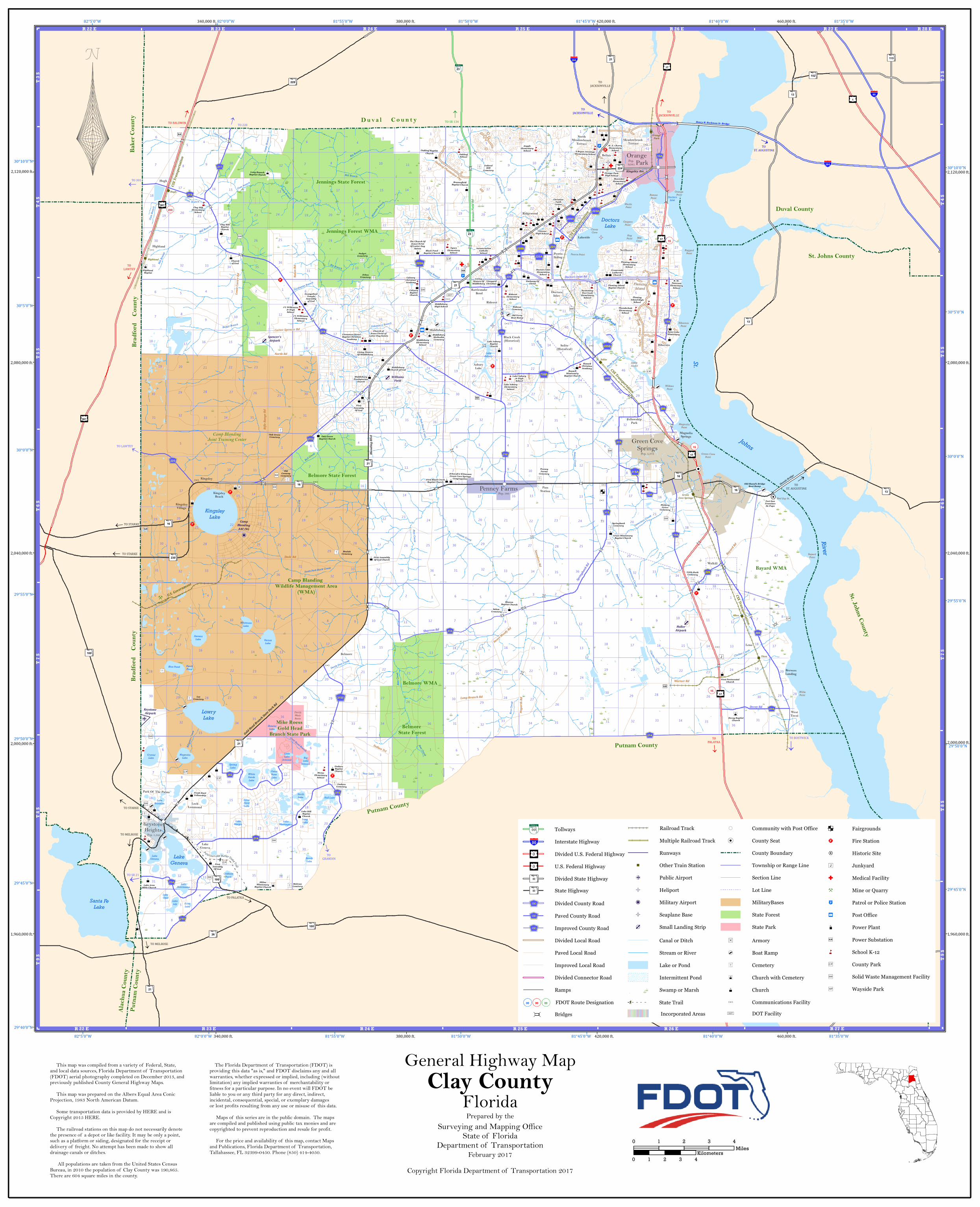
81°35'0"W 81°35'0"W 81°40'0"W 81°40'0"W 81°45'0"W 81°45'0"W 81°50'0"W 81°50'0"W 81°55'0"W 81°55'0"W 82°0'0"W 82°0'0"W 82°5'0"W 82°5'0"W 30°10'0"N 30°10'0"N 30°5'0"N 30°5'0"N 30°0'0"N 30°0'0"N 29°55'0"N 29°55'0"N 29°50'0"N 29°50'0"N 29°45'0"N 29°45'0"N 29°40'0"N 340,000 ft. 340,000 ft. 380,000 ft. 380,000 ft. 420,000 ft. 420,000 ft. 460,000 ft. 460,000 ft. 1,960,000 ft. 1,960,000 ft. 2,000,000 ft. 2,000,000 ft. 2,040,000 ft. 2,040,000 ft. 2,080,000 ft. 2,080,000 ft. 2,120,000 ft. 2,120,000 ft. ! ( ! ( ! ( ! ! ( ! ( ! ( ! ( ! ( 31 2 11 14 26 35 12 15 7 21 29 25 26 12 13 24 25 26 27 29 30 37 39 47 27 28 29 9 35 12 25 36 39 40 41 2 6 1 4 26 1 2 3 4 5 12 13 24 25 36 6 47 4 23 24 22 23 35 1 12 13 20 21 22 23 24 25 33 34 35 36 22 23 24 31 32 34 35 36 5 8 17 19 20 29 31 32 33 11 14 34 36 4 5 6 7 8 9 10 13 17 18 19 20 29 5 6 8 8 9 16 17 19 20 21 30 31 6 7 8 10 11 12 13 14 15 17 18 19 20 22 23 24 31 32 34 35 36 7 8 9 10 12 13 15 16 17 18 19 20 21 22 24 31 32 33 34 36 4 5 6 7 8 9 10 11 14 15 16 17 18 19 20 21 22 23 31 32 33 34 36 38 42 4 7 18 20 30 31 32 33 34 41 41 42 43 44 1 2 3 5 6 7 8 10 11 12 13 14 15 17 18 2 1 5 6 3 26 27 29 30 31 32 34 35 36 1 3 4 5 6 7 8 9 10 12 13 15 16 17 18 4 20 21 22 24 25 27 28 29 30 31 32 33 34 36 1 2 3 4 5 6 7 9 10 11 14 15 16 18 19 21 22 23 24 26 27 28 30 31 32 33 34 35 4 5 6 7 8 9 16 17 20 28 29 30 31 32 33 37 38 39 41 42 43 46 7 8 10 11 12 13 14 17 18 19 20 23 2 25 26 29 30 31 32 34 35 36 7 8 9 10 12 13 15 16 17 18 2 1 3 22 24 25 27 28 29 1 31 32 33 34 36 7 8 9 10 11 14 15 16 17 18 19 20 21 22 23 26 27 28 29 30 31 32 33 34 35 7 8 9 16 17 18 19 20 21 29 30 21 31 32 33 34 38 39 16 25 27 28 33 11 14 23 30 35 28 4 16 28 26 3 3 5 6 23 6 22 19 20 21 24 19 2 16 5 6 1 2 5 6 7 15 18 25 26 35 1 3 4 5 6 7 8 9 10 12 13 15 16 17 18 25 27 28 29 30 31 32 33 34 36 2 3 4 5 6 7 8 9 10 11 14 15 16 17 18 26 27 28 29 30 31 32 1 2 3 4 5 6 7 10 11 12 13 14 15 18 25 26 27 28 29 30 33 38 6 7 18 28 30 26 1 3 15 16 22 27 3 8 9 10 11 12 13 14 16 17 27 29 30 32 34 36 1 2 3 4 5 10 11 12 14 15 18 19 20 21 22 23 27 28 29 4 7 9 26 30 27 28 29 4 3 33 11 14 23 1 4 5 9 33 2 11 14 35 35 40 2 8 17 20 29 21 28 19 20 21 28 33 6 7 8 9 13 16 17 24 25 30 31 32 33 35 19 20 21 22 23 25 19 24 24 19 20 30 5 Lake Lily Santa Fe Lake Smith Lake Lowry Lake Perch Pond Doctors Inlet Lake Geneva Spring Lake Varnes Lake Lake Washington Lake Opal Gator Bone Lake White Sands Lake Little Lake Johnson Stevens Lake Lake Asbury Oldfield Pond Bundy Lake Magnolia Lake Lake Brooklyn Lake Geneva Silver Sand Lake Crystal Lake Echo Lake Doctors Lake Hall Lake Pear Lake Lake Margie Lake Hutchinson Big Lake Johnson Whitmore Lake B l a ck Cre ek Kingsley Lake Sheelar Lake Blue Pond Long Lake Double Branch Peters Creek Rice Creek Little Black Creek Mill Branch Long Branch G r e e n s C r e e k River Long Branch Little Black Creek Camp Branch Johns Bull Creek Di lla be rr y B r a n c h Big Branch C l a r k e s C re e k Bull Creek Creek Gum Branch G u m Bra nch Ates Creek Mill Branch Gum Branch Greens Creek Big Branch Bradley Pecks Branch Grog Branch South Fork Black Creek Ates Creek Devils Den Creek Big Branch Boggy Branch Mill Creek Mill Creek Duckwater Branch Peters Creek Cla r k es C ree k W h e e l e rB r a n c h S o u t h F or k Bl a c k C re e k Moccasin Slough Governors Creek Governors Creek Peters Creek Alligator Creek Gold Head Branch Mill Branch St. Ates Creek TO GRANDIN TO JACKSONVILLE TO LAWTEY TO JACKSONVILLE TO STARKE TO ST. AUGUSTINE TO SR 134 TO 301 TO STARKE TO PALATKA TO 228 TO JACKSONVILLE TO MELROSE TO ST. AUGUSTINE TO BOSTWICK TO MELROSE TO LAWTEY TO STARKE TO SR 21 TO PALATKA TO BALDWIN ¨ § ¦ 95 L L L K 16A A B 16 L L L K 214 L L L K 220A L L L K 209B L L L K 225 ¨ § ¦ 295 L L L K 209 L L L K 315 L L L K 224A R Q 15 L L L K 315 A B 100 R Q 15 L L L K 218 ¨ § ¦ 295 A B 16 L L L K 739B L L L K 219 ¹ £ ¤ 17 L L L K 226 L L L K 15A L L L K 218 A B 21 L L L K 739 ¹ £ ¤ 301 3 2 23 A B 13 L L L K 214 L L L K 220B L L L K 315A R Q 200 L L L K 209 L L L K 220 ¹ £ ¤ 301 L L L K 315C A B 100 ¹ £ ¤ 17 R Q 15 A B 100 A B 21 L L L K 218 A B 230 A B 16 A B 115 L L L K 224 L L L K 209A L L L K 15A A B 21 A B 26 L L L K 209 A B 13 3 2 23 L L L K 214 L L L K 315 A B 152 L L L K 220A A B 16 A B 21 A B 13 A B 228 L L L K 315 ¹ £ ¤ 1 A B 21 L L L K 15A ¹ £ ¤ 17 L L L K 214 A B 224 L L L K 217 ¹ £ ¤ 17 L L L K 215 L L L K 209 L L L K 352 Orange Park Solite Green Cove Springs Allen Titen Highland Hugh CSX Transportation U.S. Government CSX Transportation CSX Transportation CSX Transportation West Tocoi Doctors Inlet Peoria Siding Kingsley Beach Leno Black Creek (Historical) Bellair Meadowbrook Terrace Highland Ridgewood Rideout Park Of The Palms Hibernia Asbury Lake Belmore Lakeside Brewers Landing Middleburg Magnolia Springs Rattlesnake Bend Fellowship Park Kingsley Village Loch Lommond Hugh Lake Geneva North Meadowbrook Terrace Pass Station Neilhurst Walkill Kingsley Solite (Historical) Green Cove Springs Pop. 5,378 Keystone Heights Orange Park Penney Farms Pop. 1,349 Pop. 9,081 Pop. 580 Mike Roess Gold Head Branch State Park Belmore WMA Belmore State Forest Bayard WMA Camp Blanding Wildlife Management Area (WMA) Jennings State Forest Belmore State Forest Jennings Forest WMA Gold Head Branch State Park Rd Russell Rd Carter Spencer Rd Dade Rd Springbank Rd Saunders Rd Hogarth Rd Decoy Rd Oakleaf Plantation Pky Nolan Rd North Rd T o w n C e n t e r B lv d Sharron Rd Bayard Rd Louie Carter Rd Warner Rd Doctors Inlet Rd Blanding Blvd Rifle Range Rd Sweet Moody Rd Branan Field Rd Kingsley Ave Long Branch Rd Indian Trl Hibernia Point Red Bay Pt. Magnolia Point Willis Point Ragged Point Devils Wash Basin Peoria Point Orange Point Romeo Point Mill Cove Wilkies Point Green Cove Point Geigers Point Hog Point Canes Cove Bayard Point Macks Point Camp Blanding Joint Training Center Fleming Island Jessie Island Clay Hill Elementary School Middleburg Church of God J L Wilkinson Elementary School Little Ruth Cemetery Christian Faith Center First Assembly Of God Church Salem Cemetery Clay Hill Baptist Church Annunciation Catholic School First Assembly Of God First Pentecostal Church Saint Luke Missionary Thunderbolt Elementary School Oak Grove Baptist Church Lake Asbury Jr High School Old Ferry Boat Ramp Jehovah's Witnesses Green Cove Springs Congregation The Church Of Jesus Christ Of Latter Day Saints Long Branch Baptist Church Vineyard Christian Lake Area Bible Church Grace Missionary Baptist Church Evangelical Temple Assembly of God Russell Christian Academy Black Pond Baptist Church S Bryan Jennings Elementary School R. M. Paterson Elementary School Living Waters Of Middleburg Embassy Of Christ Oak Grove Cemetery Melrose Cemetery Orange Park High School First Black Creek Baptist Church Crossroads Lutheran Church Abline Missionary Baptist Church Beulah Cemetery Rideout Elementary School Middleburg Presbyterian Church Church of God Highland Baptist Old Shand's Bridge Boat Ramp Middleburg Methodist Cemetery Fleming Island High School Swimming Pen Creek Elementary School Padget Cemetery Fleming Island Elementary School Oakleaf School Lee Cemetery Gadara Baptist Church Sharon Baptist Church J L Wilkinson Jr High School Lake Asbury Baptist Church Mcrae Elementary School Russell Missionary Baptist Church W. E. Cherry Elementary School Calvary Baptist Church Springbank Cemetery Gadara Cemetery Citizens High School Penney Farms Cemetery Decoy Baptist Church Lake Asbury Elementary School Montclair Elementary School Middleburg High School Fleming Island Baptist Church Federal Hill Cemetery O akle af B aptis t Ch urch Calvary Christian Academy Fresh Start Fellowship Old Conway Cemetery Brannafield Baptist Church Rideout Cemetery Church of Jesus Christ of Latter Day Saints Middleburg Elementary School Cinnamon Street Baptist Christian Academy Doctors Inlet Elementary School Tynes Elementery School Hickory Grove Cemetery Living Waters Of Middleburg Fort San Fransisco De Pupo Johns Cemetery Argyle Elementary School First Assembly Of God Lake Hill Baptist Church P a la t k a-Lak eB u tl e r S t a te T r ail Putnam County Duv al C ounty Baker County Bradford County Bradford County Putnam County St. Johns County St. Johns County Duval County Alachua County Putnam County Shands Bridge Henry H. Buckman Sr. Bridge Williams Field Keystone Airpark Camp Blanding AAF/NG Haller Airpark Spencer's Airpark R 22 E R 22 E R 23 E R 23 E R 24 E R 24 E R 25 E R 25 E R 26 E R 26 E R 27 E R 27 E R 28 E T 3 S T 3 S T 4 S T 4 S T 5 S T 5 S T 6 S T 6 S T 7 S T 7 S T 8 S T 8 S T 9 S T 9 S The Florida Department of Transportation (FDOT) is providing this data "as is," and FDOT disclaims any and all warranties, whether expressed or implied, including (without limitation) any implied warranties of merchantability or fitness for a particular purpose. In no event will FDOT be liable to you or any third party for any direct, indirect, incidental, consequential, special, or exemplary damages or lost profits resulting from any use or misuse of this data. Maps of this series are in the public domain. The maps are compiled and published using public tax monies and are copyrighted to prevent reproduction and resale for profit. For the price and availability of this map, contact Maps and Publications, Florida Department of Transportation, Tallahassee, FL 32399-0450. Phone (850) 414-4050. This map was compiled from a variety of Federal, State, and local data sources, Florida Department of Transportation (FDOT) aerial photography completed on December 2013, and previously published County General Highway Maps. This map was prepared on the Albers Equal Area Conic Projection, 1983 North American Datum. Some transportation data is provided by HERE and is Copyright 2015 HERE. The railroad stations on this map do not necessarily denote the presence of a depot or like facility. It may be only a point, such as a platform or siding, designated for the receipt or delivery of freight. No attempt has been made to show all drainage canals or ditches. All populations are taken from the United States Census Bureau, in 2010 the population of Clay County was 190,865. There are 604 square miles in the county. Prepared by the Surveying and Mapping Office State of Florida Department of Transportation Copyright Florida Department of Transportation 2017 February 2017 Clay County Florida General Highway Map 0 1 2 3 4 Miles 0 1 2 3 4 Kilometers Fairgrounds Fire Station Historic Site Junkyard Medical Facility Mine or Quarry Patrol or Police Station Post Office Power Plant Power Substation School K-12 County Park Solid Waste Management Facility Wayside Park County Boundary ! ( Community with Post Office ! ( ! County Seat Township or Range Line Section Line Lot Line MilitaryBases State Forest State Park DOT Facility Armory Boat Ramp Cemetery Church with Cemetery Church Communications Facility Multiple Railroad Track Incorporated Areas State Trail Railroad Track Lake or Pond Intermittent Pond É É É Swamp or Marsh Stream or River Runways Other Train Station Public Airport Heliport Military Airport Seaplane Base Small Landing Strip Canal or Ditch Interstate Highway Divided U.S. Federal Highway U.S. Federal Highway Divided State Highway State Highway Tollways Divided County Road Paved County Road Improved County Road Divided Local Road Paved Local Road Improved Local Road Divided Connector Road Ramps 3 2 00 ¨ § ¦ 00 " ¡ 0 A B 00 L L L K 000 " ¡ 0 A B 00 L L L K 000 L L L K 000 FDOT Route Designation R Q 00 R Q 00 R Q 00 Bridges â Ë
Transcript of Clay County - Mapgeeks
81°35'0"W
81°35'0"W
81°40'0"W
81°40'0"W
81°45'0"W
81°45'0"W
81°50'0"W
81°50'0"W
81°55'0"W
81°55'0"W
82°0'0"W
82°0'0"W
82°5'0"W
82°5'0"W
30°10'0"N30°10'0"N
30°5'0"N30°5'0"N
30°0'0"N30°0'0"N
29°55'0"N29°55'0"N
29°50'0"N29°50'0"N
29°45'0"N29°45'0"N
29°40'0"N
340,000 ft.
340,000 ft.
380,000 ft.
380,000 ft.
420,000 ft.
420,000 ft.
460,000 ft.
460,000 ft.
1,960,000 ft. 1,960,000 ft.
2,000,000 ft. 2,000,000 ft.
2,040,000 ft. 2,040,000 ft.
2,080,000 ft. 2,080,000 ft.
2,120,000 ft. 2,120,000 ft.
!(
!(
!(!
!(
!(
!(
!(
!(
31
2
11
14
26
35
12
15
7
21
29
2526
12
13
24
25
26
272930
37
39
47
27
2829
9
35
12
25
36
39
40
41
26 14
26
12345
12
13
24
25
36
6
47
4
23 24 2223
35
1
12
13
20 21 22 2324
25
33 34 35 36
22 23 24
31 32 34 3536
5
8
17
19 20
29
3132
33
11
14
34 36
456
7 89 10
13
1718
1920
29
56
8
8 9
1617
19 20 21
30
31
6
7 8 10 11 12
1314151718
19 20 22 23 24
31 32 34 3536
7 8 9 1012
1315161718
19 20 21
22
24
31 32 3334 36
456
78
9 10 11
1415161718
19 20 2122 23
31 32 3334
36
38
42
4
7
18
20
30
31
3233 34
41
41
42
4344
12356
7 8 1011
12
1314151718
2 1 563
26272930
31 32 34 35 36
134
56
78 9 10
12
131516
17
18
4
2021 22 24
252728
2930
3132 33 34 36
1
23
456
79
10
11
141516
18
19
2122 23
24
2627
28
30
31 32 33 34 35
45
6
7 8 9
16
17
20
282930
3132
33
37
38
39
41
42
43
46
7 8 10 11 12
13141718
19 2023
2
25262930
31 3234 35 36
7 8 9 10 12
1315
16
1718
2
13
22 24
25272829
1
31
3233 34 36
7 8 9 10 11
1415161718
19 20 21 22 23
2627282930
31 32 33 34 35
7 89
161718
19 20
21
29
30
21
31 32 3334
38
39
16
252728
33
11
14
23
30
35
28
4
16
28 26
3 356
23
6
22 19
2021 24 19
2
16
56
125
6
7
1518
2526
35
13456
7 8 9 10 12
131516
1718
2527282930
31 32 33 34 36
23456
7 89 10 11
1415161718
262728
2930
31 32
123456
7 10 11 12
13141518
252627282930
33
38
6
7
18
2830
26
13
1516
22
27
3
8 9 10 1112
13141617
272930
32 3436
1234
5
1011
12
141518
19
20 21 2223
2728
29
4
7
9
2630 272829
43
33
11
14
23
145
9
33
2
11
14
35
35
40
2
8
17
20
29
21
28
1920
21
28
33
6
78 9
1316
17
24
2530
3132 33
35
19 20 21 22 23
25
1924
24 19 20
30
5
Lake Lily
Santa FeLake
SmithLake
LowryLake
PerchPond
DoctorsInlet
LakeGeneva
SpringLake
VarnesLake
LakeWashington
Lake Opal
GatorBoneLake
WhiteSandsLake
LittleLake
Johnson
StevensLake
LakeAsbury
OldfieldPond
BundyLake
MagnoliaLake
LakeBrooklyn
LakeGeneva
SilverSandLake
CrystalLake
Echo Lake
DoctorsLake
Hall Lake
Pear Lake
LakeMargie
LakeHutchinson
Big Lake
Johnson
WhitmoreLake
Black Creek
KingsleyLake
SheelarLake
Blue Pond
Long Lake
Double Branch
Peters C
reek
Rice C
reek
Little
Blac
k Cre
ek
Mill Branch
Long Branch
Greens Creek
River
Long Branch
Little B
lack C
reekCa
mp Br
anch
JohnsBull Creek
Dillaberry Branch
Big Branch
Clarkes Creek
Bull Creek
Creek
Gum Branch
Gum Branch
Ates
Cre
ek
Mill B
ranch
Gum
Branc
h
Greens Creek
Big Branch
Bradley
Pecks Branch
Grog Branch
South Fork Black Creek
Ates Creek
Devils Den Creek
Big Br
anch
Boggy Branch
Mill Creek
Mill Creek
Duckwater Branch
Peters Creek
Clarkes Creek
Wheele
r Branch
South Fork Black Creek
Moccasin Slough
Governors Creek
Governors Creek
Peters Creek
Alliga
tor C
reek
Gold Head Branch
Mill Branch
St.
Ates Creek
TO GRANDIN
TOJACKSONVILLE
TO LAWTEY
TO JACKSONVILLE
TO STARKE
TO ST. AUGUSTINE
TO SR 134
TO 301
TO STARKE
TO PALATKA
TO 228
TO JACKSONVILLE
TO MELROSE
TO ST. AUGUSTINE
TO BOSTWICK
TO MELROSE
TO LAWTEY
TO STARKE
TO SR 21
TOPALATKA
TO BALDWIN
§̈¦95
LLLK16A
AB16
LLLK214
LLLK220A
LLLK209B
LLLK225
§̈¦295
LLLK209
LLLK315
LLLK224A
RQ15
LLLK315
AB100
RQ15
LLLK218
§̈¦295
AB16
LLLK739B
LLLK219
¹£¤17
LLLK226
LLLK15A
LLLK218
AB21
LLLK739
¹£¤301
3223
AB13
LLLK214
LLLK220B
LLLK315A
RQ200
LLLK209
LLLK220
¹£¤301
LLLK315C
AB100
¹£¤17
RQ15
AB100
AB21
LLLK218
AB230
AB16
AB115
LLLK224
LLLK209A
LLLK15A
AB21
AB26
LLLK209
AB13
3223
LLLK214
LLLK315
AB152
LLLK220A
AB16
AB21
AB13
AB228
LLLK315
¹£¤1
AB21
LLLK15A
¹£¤17
LLLK214
AB224LLLK217
¹£¤17
LLLK215
LLLK209
LLLK352
Orange Park
Solite
Green Cove Springs
Allen
Titen
Highland
Hugh
CSX Transpo
rtation
U.S. Government
CSX Transportation
CSX Transportation
CSX Tr
anspo
rtatio
n
WestTocoi
DoctorsInlet
PeoriaSiding
KingsleyBeach
Leno
Black Creek(Historical)
Bellair
Meadowbrook Terrace
Highland
Ridgewood
Rideout
Park Of The Palms
Hibernia
AsburyLake
Belmore
Lakeside
BrewersLanding
Middleburg
MagnoliaSprings
RattlesnakeBend
FellowshipPark
KingsleyVillage
LochLommond
Hugh
LakeGeneva
NorthMeadowbrook
Terrace
PassStation
Neilhurst
Walkill
Kingsley
Solite(Historical)
Green CoveSprings
Pop. 5,378
KeystoneHeights
Orange Park
Penney Farms
Pop. 1,349
Pop. 9,081
Pop. 580
Mike Roess Gold Head
Branch State Park
Belmore WMA
Belmore State Forest
Bayard WMACamp Blanding
Wildlife Management Area(WMA)
Jennings State Forest
Belmore State Forest
Jennings Forest WMA
Gold Head Branch State Park Rd
Russell Rd
Carter Spencer Rd
Dade Rd
Spring
bank R
d
Saunders Rd
Hoga
rth Rd
Decoy Rd
Oakleaf Plantation Pky
Nolan
Rd
North Rd
Town
Cen te
rBlv
dSharron Rd
Bayard Rd
Louie
Carte
r Rd
Warner Rd
Doctors Inlet Rd
Bland
ing Bl
vd
Rifle R
ange
Rd
Sweet Moody Rd
Bran
an Fi
eld Rd
Kingsley Ave
Long Branch Rd
Indian Trl
HiberniaPoint
Red Bay Pt.
MagnoliaPoint
WillisPoint
RaggedPoint
DevilsWashBasin
Peoria Point
Orange PointRomeo
Point
MillCove
Wilkies Point
Green CovePoint
GeigersPoint
HogPoint
Canes Cove
Bayard Point
Macks Point
Camp BlandingJoint Training Center
FlemingIsland
JessieIsland
Clay HillElementary
School
MiddleburgChurch of God
J L WilkinsonElementary
School
Little RuthCemetery
ChristianFaith
Center
First AssemblyOf God Church
Salem Cemetery
Clay HillBaptistChurch
AnnunciationCatholicSchool
FirstAssembly
Of God
First PentecostalChurch
Saint LukeMissionary
ThunderboltElementary
School
Oak GroveBaptist Church
Lake AsburyJr HighSchool
Old FerryBoat Ramp
Jehovah's WitnessesGreen Cove SpringsCongregation
The Church OfJesus Christ
Of Latter DaySaints
Long BranchBaptist Church
VineyardChristian
Lake AreaBible Church
Grace MissionaryBaptist Church
EvangelicalTemple
Assemblyof God
RussellChristianAcademy
Black PondBaptist Church
S Bryan JenningsElementary School
R. M. Paterson
ElementarySchool
LivingWaters Of
MiddleburgEmbassy Of
Christ
Oak GroveCemetery
MelroseCemetery
Orange ParkHigh School
First Black CreekBaptist Church
CrossroadsLutheran
Church
AblineMissionary
Baptist Church
BeulahCemetery
RideoutElementary
School
MiddleburgPresbyterian
Church
Churchof God
Highland Baptist
Old Shand's BridgeBoat Ramp
MiddleburgMethodistCemetery
FlemingIsland High
School
SwimmingPen Creek
ElementarySchool
PadgetCemetery
Fleming IslandElementary
School
OakleafSchool
LeeCemetery
GadaraBaptistChurch
Sharon Baptist Church
J L WilkinsonJr HighSchool
Lake AsburyBaptistChurch
McraeElementary
School
RussellMissionary
Baptist Church
W. E. CherryElementary
School
CalvaryBaptistChurch
SpringbankCemetery
GadaraCemetery
CitizensHigh School
PenneyFarms
Cemetery
Decoy BaptistChurch
Lake AsburyElementary
School
MontclairElementary
School
MiddleburgHigh School
Fleming IslandBaptist Church
FederalHill
Cemetery
Oakleaf BaptistChurch
CalvaryChristianAcademy
Fresh StartFellowship
OldConway
Cemetery
BrannafieldBaptist Church
RideoutCemetery
Church ofJesus Christ of
Latter Day SaintsMiddleburgElementary
School
Cinnamon Street Baptist Christian
Academy
Doctors InletElementary
School
TynesElementery
School
HickoryGrove
Cemetery
Living WatersOf Middleburg
Fort SanFransiscoDe Pupo
JohnsCemetery
ArgyleElementary
School
FirstAssembly
Of God
Lake HillBaptistChurch
Pa lat ka-Lake Butler State Trail
Putnam County
D u v a l C o u n t yBa
ker C
ounty
Brad
ford
Cou
ntyBr
adfor
d C
ounty
Putnam County
St. Johns County
St. Johns County
Duval County
Alach
ua Co
unty
Putna
m Co
unty
Shands Bridge
Henry H. Buckman Sr. Bridge
WilliamsField
Keystone Airpark
CampBlandingAAF/NG
HallerAirpark
Spencer'sAirpark
R 22 E
R 22 E
R 23 E
R 23 E
R 24 E
R 24 E
R 25 E
R 25 E
R 26 E
R 26 E
R 27 E
R 27 E
R 28 E
R 28 E
T 3 S
T 3 S
T 4 S
T 4 S
T 5 S
T 5 S
T 6 S
T 6 S
T 7 S T 7
S
T 8 S T 8
S
T 9 S T 9
S
The Florida Department of Transportation (FDOT) is providing this data "as is," and FDOT disclaims any and allwarranties, whether expressed or implied, including (withoutlimitation) any implied warranties of merchantability or fitness for a particular purpose. In no event will FDOT be liable to you or any third party for any direct, indirect, incidental, consequential, special, or exemplary damagesor lost profits resulting from any use or misuse of this data. Maps of this series are in the public domain. The mapsare compiled and published using public tax monies and arecopyrighted to prevent reproduction and resale for profit. For the price and availability of this map, contact Mapsand Publications, Florida Department of Transportation, Tallahassee, FL 32399-0450. Phone (850) 414-4050.
This map was compiled from a variety of Federal, State,and local data sources, Florida Department of Transportation(FDOT) aerial photography completed on December 2013, and previously published County General Highway Maps. This map was prepared on the Albers Equal Area ConicProjection, 1983 North American Datum. Some transportation data is provided by HERE and isCopyright 2015 HERE. The railroad stations on this map do not necessarily denotethe presence of a depot or like facility. It may be only a point,such as a platform or siding, designated for the receipt or delivery of freight. No attempt has been made to show all drainage canals or ditches. All populations are taken from the United States CensusBureau, in 2010 the population of Clay County was 190,865. There are 604 square miles in the county.
Prepared by theSurveying and Mapping Office
State of FloridaDepartment of Transportation
Copyright Florida Department of Transportation 2017February 2017
Clay CountyFlorida
General Highway Map
0 1 2 3 4Miles
0 1 2 3 4Kilometers
FairgroundsFire StationHistoric SiteJunkyardMedical FacilityMine or QuarryPatrol or Police StationPost OfficePower PlantPower SubstationSchool K-12County ParkSolid Waste Management FacilityWayside Park
County Boundary
!( Community with Post Office!(! County Seat
Township or Range LineSection LineLot LineMilitaryBasesState ForestState Park
DOT Facility
ArmoryBoat RampCemeteryChurch with CemeteryChurchCommunications Facility
Multiple Railroad Track
Incorporated AreasState Trail
Railroad Track
Lake or PondIntermittent Pond
ÉÉÉÉ
Swamp or Marsh
Stream or River
RunwaysOther Train StationPublic AirportHeliportMilitary AirportSeaplane BaseSmall Landing Strip
Canal or Ditch
Interstate HighwayDivided U.S. Federal HighwayU.S. Federal HighwayDivided State HighwayState Highway
Tollways
Divided County RoadPaved County RoadImproved County RoadDivided Local RoadPaved Local RoadImproved Local RoadDivided Connector RoadRamps
3200
§̈¦00
"¡0
AB00
LLLK000
"¡0
AB00
LLLK000
LLLK000
FDOT Route DesignationRQ00 RQ00RQ00
BridgesâË