CITY OF GOLETA ENVIRONMENTAL CHECKLIST FORM AND …
93
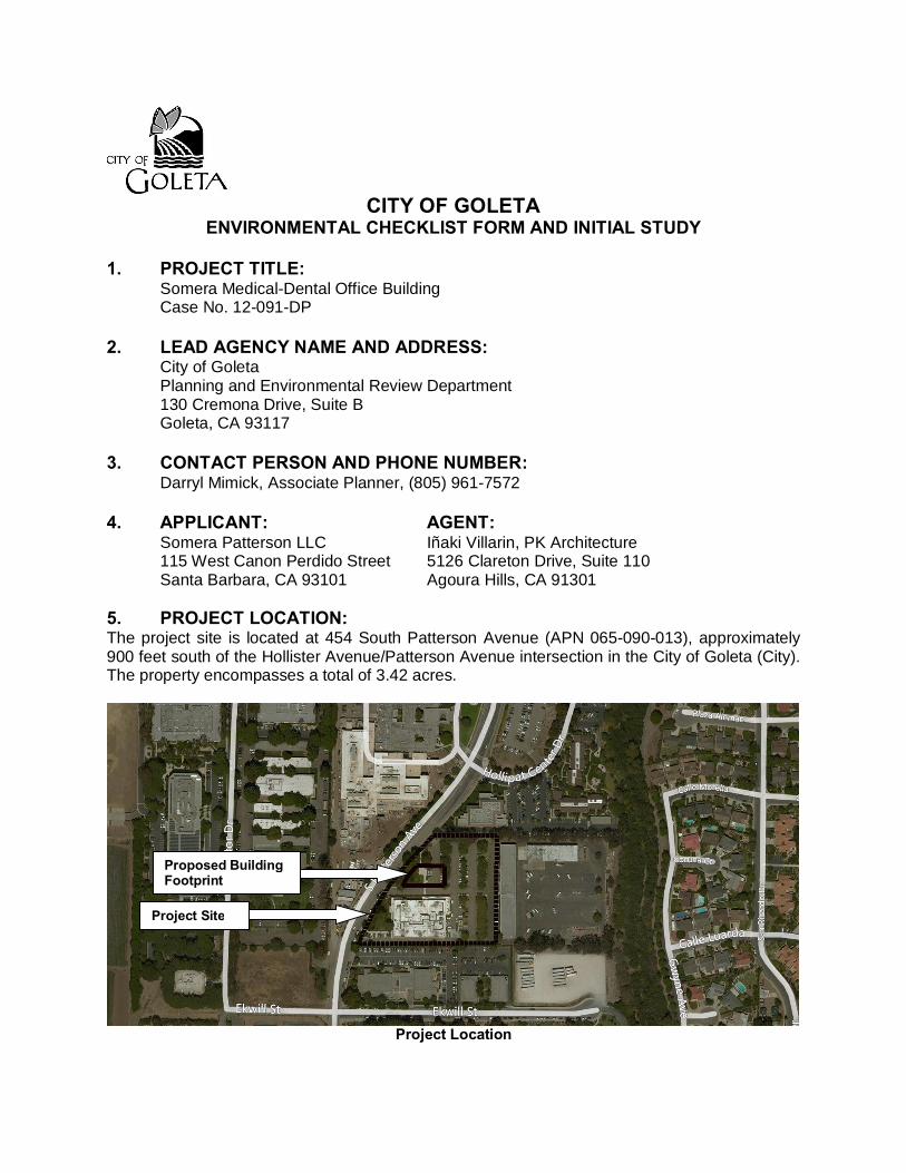
CITY OF GOLETA ENVIRONMENTAL CHECKLIST FORM AND INITIAL STUDY 1. PROJECT TITLE: Somera Medical-Dental Office Building Case No. 12-091-DP 2. LEAD AGENCY NAME AND ADDRESS: City of Goleta Planning and Environmental Review Department 130 Cremona Drive, Suite B Goleta, CA 93117 3. CONTACT PERSON AND PHONE NUMBER: Darryl Mimick, Associate Planner, (805) 961-7572 4. APPLICANT: AGENT: Somera Patterson LLC Iñaki Villarin, PK Architecture 115 West Canon Perdido Street 5126 Clareton Drive, Suite 110 Santa Barbara, CA 93101 Agoura Hills, CA 91301 5. PROJECT LOCATION: The project site is located at 454 South Patterson Avenue (APN 065-090-013), approximately 900 feet south of the Hollister Avenue/Patterson Avenue intersection in the City of Goleta (City). The property encompasses a total of 3.42 acres. Project Location Project Site Proposed Building Footprint
Transcript of CITY OF GOLETA ENVIRONMENTAL CHECKLIST FORM AND …
CITY OF GOLETA
ENVIRONMENTAL CHECKLIST FORM AND INITIAL STUDY 1. PROJECT TITLE:
Somera Medical-Dental Office Building Case No. 12-091-DP
2. LEAD AGENCY NAME AND ADDRESS: City of Goleta
Planning and Environmental Review Department 130 Cremona Drive, Suite B Goleta, CA 93117
3. CONTACT PERSON AND PHONE NUMBER:
Darryl Mimick, Associate Planner, (805) 961-7572 4. APPLICANT: AGENT:
Somera Patterson LLC Iñaki Villarin, PK Architecture 115 West Canon Perdido Street 5126 Clareton Drive, Suite 110 Santa Barbara, CA 93101 Agoura Hills, CA 91301
5. PROJECT LOCATION: The project site is located at 454 South Patterson Avenue (APN 065-090-013), approximately 900 feet south of the Hollister Avenue/Patterson Avenue intersection in the City of Goleta (City). The property encompasses a total of 3.42 acres.
Project Location
Project Site
Proposed Building Footprint
Environmental Checklist Form and Initial Study Somera Medical Building; 12-091-DP January 2014
2
6. PROJECT DESCRIPTION: The project includes the following applications:
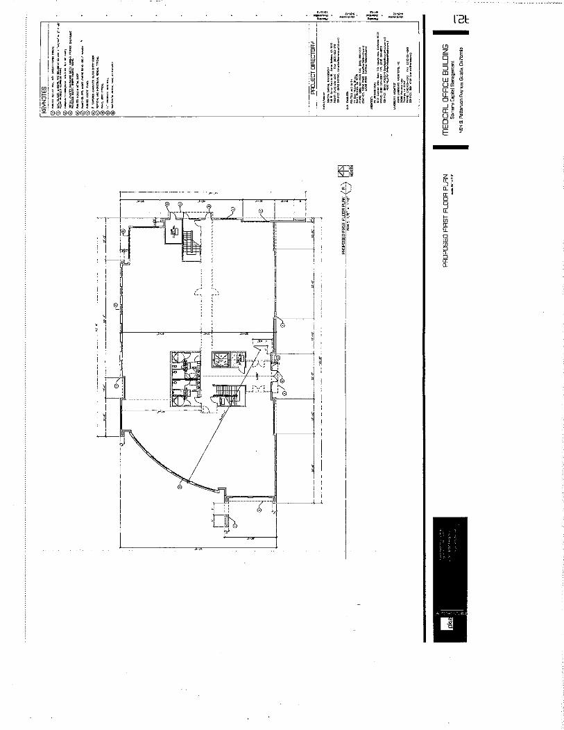
1. A Development Plan (DP) approval for the construction of a new two-story, 20,000-
square foot medical-dental office building. 2. A request for Modifications (MOD) to allow parking spaces within the front and side
yard setbacks pursuant to the City’s Inland Zoning Ordinance. (35 Goleta Municipal Code (GMC) § 35-317.8)
A Development Plan is requested for the construction of new two-story, 20-000-square foot medical-dental office building at 454 South Patterson Avenue. Associated with the Development Plan application are Modification requests to allow approximately 22 square-feet of paved parking surfaces within the front yard setback and compact parking spaces within the northern side yard setback. The proposed two-story medical-dental building would have a maximum height of 35-feet, as permitted within the PI zoning district.
Uses The proposed medical-dental building will comprise solely of medical and dental related office uses. The first and second floors will each consist of 10,000-square feet of office related space.
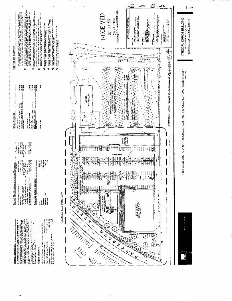
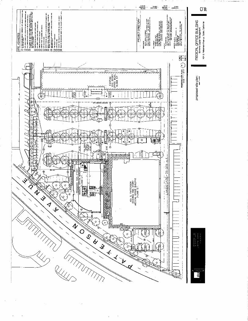
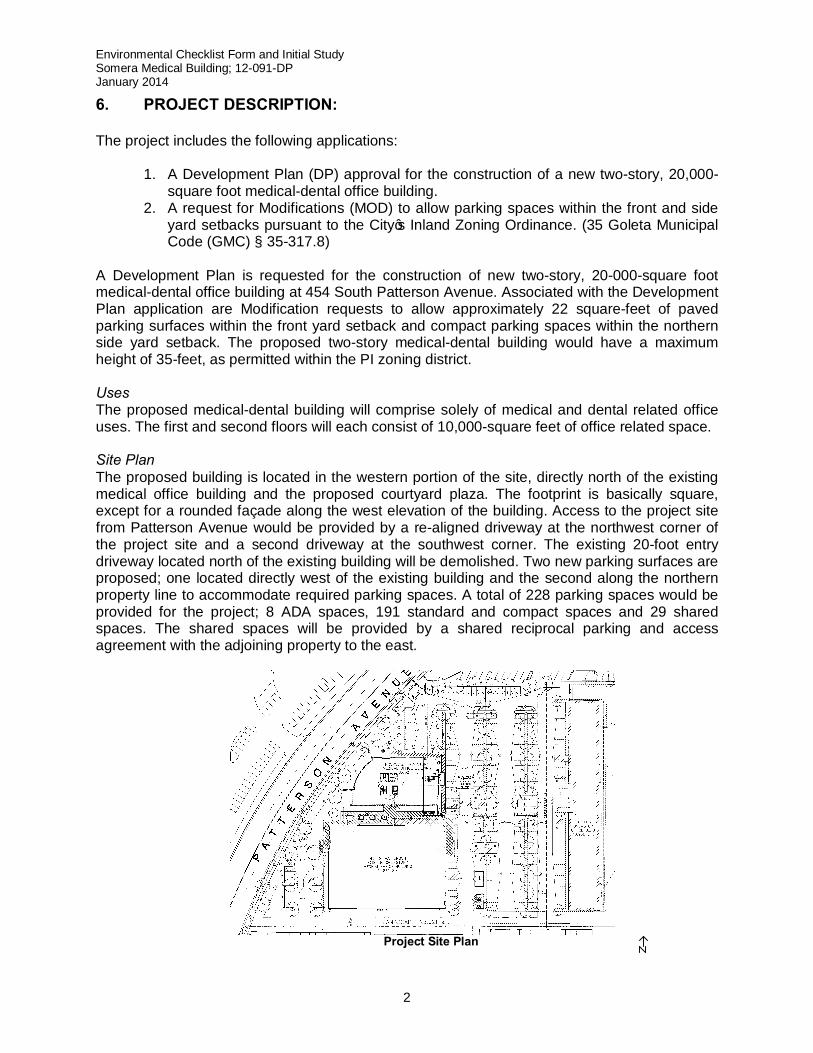
Site Plan The proposed building is located in the western portion of the site, directly north of the existing medical office building and the proposed courtyard plaza. The footprint is basically square, except for a rounded façade along the west elevation of the building. Access to the project site from Patterson Avenue would be provided by a re-aligned driveway at the northwest corner of the project site and a second driveway at the southwest corner. The existing 20-foot entry driveway located north of the existing building will be demolished. Two new parking surfaces are proposed; one located directly west of the existing building and the second along the northern property line to accommodate required parking spaces. A total of 228 parking spaces would be provided for the project; 8 ADA spaces, 191 standard and compact spaces and 29 shared spaces. The shared spaces will be provided by a shared reciprocal parking and access agreement with the adjoining property to the east.
Project Site Plan
Environmental Checklist Form and Initial Study Somera Medical Building; 12-091-DP January 2014
3
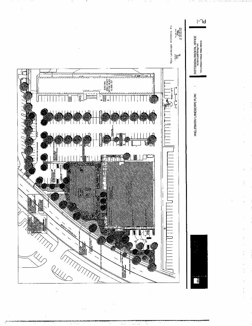
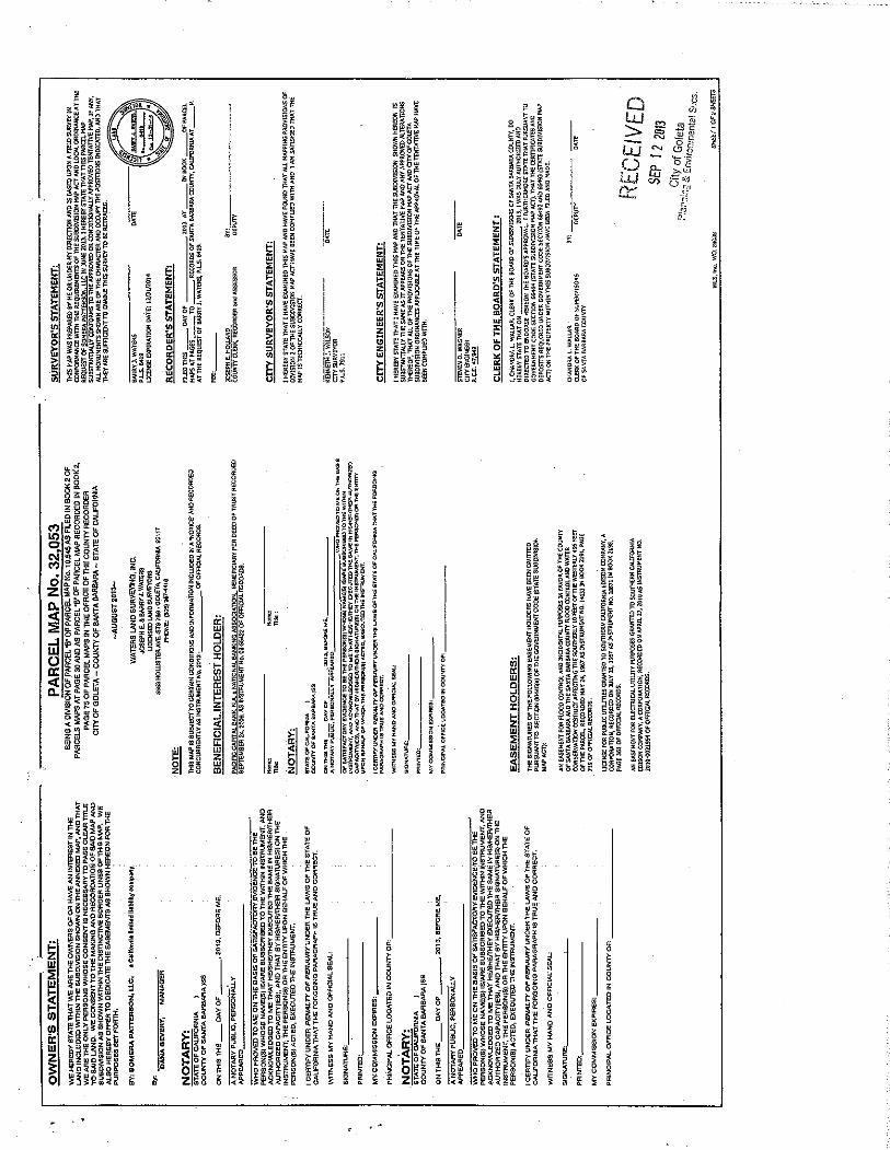
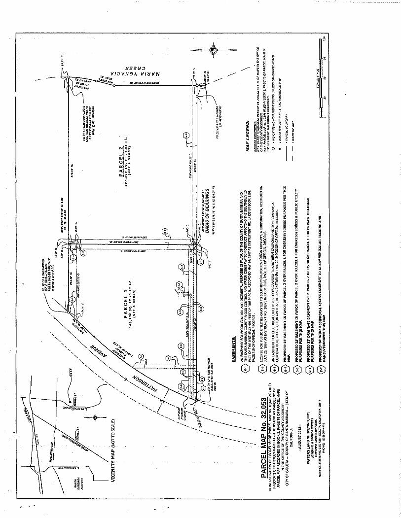
A preliminary landscape plan has identified 26,227-square feet of area to be landscaped on the project site. The plan includes various drought tolerant shrubs, jacaranda trees, evergreen trees, and various other ground covers. Preliminary earthwork quantities are estimated at 400 cubic yards of cut and 0 cubic yards of fill (net export of 400 cubic yards). Stormwater drainage would flow from the northwesterly and southwesterly parking areas into the landscaped areas along the western property line to allow for infiltration. The project will drain excess filtered stormwater to the existing storm drain system and a portion of the runoff towards Patterson Avenue. The Goleta Water District and the Goleta Sanitary District would provide water and sanitary sewer service to the proposed project. 7. BACKGROUND INFORMATION Site Information The project parcel and the adjoining parcel to the east, were originally one legal parcel (APN: 065-090-013), created on January 30, 1967. On April 4, 2013, upon request by the applicant, the City Zoning Administrator approved the Somera Parcel Map (Case No. 11-059-TPM) to split the parcel into two parcels. The project parcel (Parcel 1 of Parcel Map No. 32,053) and the adjoining parcel to the east (Parcel 2 of Parcel Map No. 32,053) were found to be in conformance with the City’s General Plan and Inland Zoning Ordinance and did not require any variances or exceptions requiring environmental review (See Attachment 1 to view Parcel Map No. 32,053). The subdivided parcels will continue to be served by existing streets and services. Application Information The proposed project was submitted and found complete in 2012. The site plan, landscaping and architecture were reviewed by the Design Review Board on December 11, 2012 and received unanimous approval at Conceptual Review. 8. APPROVAL REQUIRED BY OTHER PUBLIC AGENCIES:
None
9. SITE INFORMATION:
General Plan Land Use Designation
Office and Institutional (I-OI)
Zoning Ordinance, Zone District Article III (Inland Zoning Ordinance); PI (Professional and Institutional)
Site Size 3.42 Acres or 148,950-Square Feet
Present Use and Development On Site
Medical laboratory building (25,904 SF) Office building (16,968 SF) Light industrial building (7,461 SF)
Environmental Checklist Form and Initial Study Somera Medical Building; 12-091-DP January 2014
4
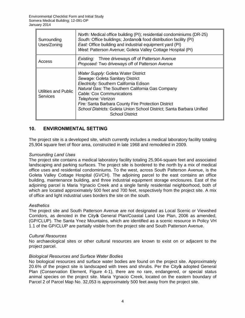
Surrounding Uses/Zoning
North: Medical office building (PI); residential condominiums (DR-25) South: Office buildings; Jordano’s food distribution facility (PI) East: Office building and industrial equipment yard (PI) West: Patterson Avenue; Goleta Valley Cottage Hospital (PI)
Access Existing: Three driveways off of Patterson Avenue Proposed: Two driveways off of Patterson Avenue
Utilities and Public Services
Water Supply: Goleta Water District Sewage: Goleta Sanitary District Electricity: Southern California Edison Natural Gas: The Southern California Gas Company Cable: Cox Communications Telephone: Verizon Fire: Santa Barbara County Fire Protection District School Districts: Goleta Union School District; Santa Barbara Unified
School District
10. ENVIRONMENTAL SETTING The project site is a developed site, which currently includes a medical laboratory facility totaling 25,904 square feet of floor area, constructed in late 1968 and remodeled in 2009. Surrounding Land Uses The project site contains a medical laboratory facility totaling 25,904-square feet and associated landscaping and parking surfaces. The project site is bordered to the north by a mix of medical office uses and residential condominiums. To the west, across South Patterson Avenue, is the Goleta Valley Cottage Hospital (GVCH). The adjoining parcel to the east contains an office building, maintenance building, and three industrial equipment storage enclosures. East of the adjoining parcel is Maria Ygnacio Creek and a single family residential neighborhood, both of which are located approximately 500 feet and 700 feet, respectively from the project site. A mix of office and light industrial uses borders the site on the south. Aesthetics The project site and South Patterson Avenue are not designated as Local Scenic or Viewshed Corridors, as denoted in the City’s General Plan/Coastal Land Use Plan, 2006 as amended, (GP/CLUP). The Santa Ynez Mountains, which are identified as a scenic resource in Policy VH 1.1 of the GP/CLUP are partially visible from the project site and South Patterson Avenue. Cultural Resources No archaeological sites or other cultural resources are known to exist on or adjacent to the project parcel. Biological Resources and Surface Water Bodies No biological resources and surface water bodies are found on the project site. Approximately 20.6% of the project site is landscaped with trees and shrubs. Per the City’s adopted General Plan (Conservation Element, Figure 4-1), there are no rare, endangered, or special status animal species on the project site. Maria Ygnacio Creek, located on the eastern boundary of Parcel 2 of Parcel Map No. 32,053 is approximately 500 feet away from the project site.
Environmental Checklist Form and Initial Study Somera Medical Building; 12-091-DP January 2014
5
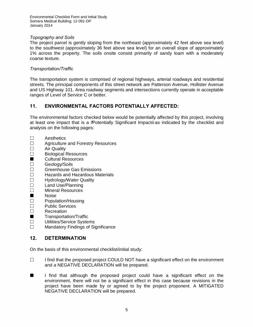
Topography and Soils The project parcel is gently sloping from the northeast (approximately 42 feet above sea level) to the southwest (approximately 36 feet above sea level) for an overall slope of approximately 1% across the property. The soils onsite consist primarily of sandy loam with a moderately coarse texture. Transportation/Traffic The transportation system is comprised of regional highways, arterial roadways and residential streets. The principal components of this street network are Patterson Avenue, Hollister Avenue and US Highway 101. Area roadway segments and intersections currently operate in acceptable ranges of Level of Service C or better. 11. ENVIRONMENTAL FACTORS POTENTIALLY AFFECTED: The environmental factors checked below would be potentially affected by this project, involving at least one impact that is a “Potentially Significant Impact” as indicated by the checklist and analysis on the following pages: £ Aesthetics £ Agriculture and Forestry Resources £ Air Quality £ Biological Resources ¢ Cultural Resources £ Geology/Soils £ Greenhouse Gas Emissions £ Hazards and Hazardous Materials £ Hydrology/Water Quality £ Land Use/Planning £ Mineral Resources ¢ Noise £ Population/Housing £ Public Services £ Recreation ¢ Transportation/Traffic £ Utilities/Service Systems £ Mandatory Findings of Significance 12. DETERMINATION On the basis of this environmental checklist/initial study: £ I find that the proposed project COULD NOT have a significant effect on the environment
and a NEGATIVE DECLARATION will be prepared. ¢ I find that although the proposed project could have a significant effect on the
environment, there will not be a significant effect in this case because revisions in the project have been made by or agreed to by the project proponent. A MITIGATED NEGATIVE DECLARATION will be prepared.
Environmental Checklist Form and Initial Study Somera Medical Building; 12-091-DP January 2014
7
13. EVALUATION OF ENVIRONMENTAL IMPACTS: (a) A brief explanation is required for all answers except “No Impact” answers that are adequately
supported by the information sources a lead agency cites in the parentheses following each question. A “No Impact” answer is adequately supported if the referenced information sources show that the impact simply does not apply to projects like the one involved (e.g., the project falls outside a fault rupture zone). A “No Impact” answer should be explained where it is based on project-specific factors as well as general standards (e.g., the project will not expose sensitive receptors to pollutants, based on a project-specific screening analysis).
(b) All answers must take into account the whole action involved, including off-site as well as on-site,
cumulative as well as project-level, indirect as well as direct, and construction as well as operational impacts.
(c) Once the lead agency has determined that a particular physical impact may occur, then the
checklist answers must indicate whether the impact is potentially significant, less than significant with mitigation, or less than significant. “Potentially Significant Impact” is appropriate if there is substantial evidence that an effect may be significant. If there are one or more “Potentially Significant Impact” entries when the determination is made, an EIR is required.
(d) “Negative Declaration: Less Than Significant With Mitigation Incorporated” applies where the
incorporation of mitigation measures has reduced an effect from “Potentially Significant Impact” to a “Less Than Significant Impact.” The lead agency must describe the mitigation measures, and briefly explain how they reduce the effect to a less than significant level (mitigation measures from “Earlier Analysis,” as described in (e) below, may be cross-referenced).
(e) Earlier analyses may be used where, pursuant to the tiering, program EIR, or other CEQA
process, an effect has been adequately analyzed in an earlier EIR or negative declaration. Section 15063(c)(3)(D). In this case, a brief discussion should identify the following:
1) Earlier Analysis Used. Identify and state where they are available for review.
2) Impacts Adequately Addressed. Identify which effects from the above checklist were within the scope of and adequately analyzed in an earlier document pursuant to applicable legal standards, and state whether such effects were addressed by mitigation measures based on the earlier analysis.
3) Mitigation Measures. For effects that are “Less Than Significant With Mitigation Measures Incorporated,” describe the mitigation measures which were incorporated or refined from the earlier document and the extent to which they address site-specific conditions for the project.
(f) Lead agencies are encouraged to incorporate into the checklist references to information sources
for potential impacts (e.g., general plans, zoning ordinances). References to a previously prepared or outside document should, where appropriate, include a reference to the page or pages where the statement is substantiated.
(g) Supporting Information Sources: A source list should be attached, and other sources used or
individuals contacted should be cited in the discussion. (h) Lead agencies should normally address the questions from this checklist that are relevant to a
project’s environmental effects in whatever format is selected. The explanation of each issue should identify:
1) the significance criteria or threshold, if any, used to evaluate each question; and 2) the mitigation measure identified, if any, to reduce the impact to a less than significant
level.
Environmental Checklist Form and Initial Study Somera Medical Building; 12-091-DP January 2014
8
14. ISSUE AREAS:
AESTHETICS Would the project:
Potentially Significant
Impact Less Than Significant
With Mitigation
Incorporated
Less Than
Significant Impact
No Impact
See Prior Docu- ment
a. Have a substantial adverse effect on a scenic vista? ■
b. Substantially damage scenic resources, including but not limited to, trees, rock outcroppings, and historic buildings within a state scenic highway?
■
c. Substantially degrade the existing visual character or quality of the site and its surroundings?
■
d. Create a new source of substantial light or glare which would adversely affect day or nighttime views in the area?
■
Existing Setting The project site is located approximately 900 feet south of the Hollister Avenue / Patterson Avenue intersection. The project site contains an existing one-story, 25,904 SF medical laboratory building located on the western (front) end of the property, with a setback of approximately 40 feet from the right-of-way line of Patterson Avenue and a height of 22 feet. The building form is mostly horizontal and is finished in stucco and glass, as part of a remodel in 2009. The two buildings on the abutting eastern property are set back over 600 feet from the right-of-way line of Patterson Avenue. They include a one-story 16,968 SF office building and a one-story 7,451 SF light industrial building. The surrounding area is comprised of primarily one- and two-story structures. The tallest development is located in the Patterson Center retail development, located at the northwest corner of the Hollister/Patterson intersection. There are four, 33-foot tall buildings in the Patterson Center. Immediately to the north of the project site is the Cavaletto Medical Office Complex, a two-story 20,700 SF building, and the Hollipat Apartments, comprised of 52 residential units in two two-story buildings. The Goleta Valley Cottage Hospital complex is located directly west of the project site across Patterson Avenue. The main hospital building, currently under construction, will be a two-story, 152,000 SF building and has a setback of 15 feet from the right-of-way line of Patterson Avenue. The complex also includes an existing medical office building, located at 5877 Hollister Avenue (approximately 250 feet to the west of the Hollister/Patterson intersection). This building contains 41,724 SF of floor area, and is a long, rectangular two-story structure with a flat roof whose ridge line is 19.5 feet high (measured from finished grade). This building will be demolished and replaced with a new medical office building located at the southwest corner of the Hollister/Patterson intersection. The new building will be a two-story structure containing 52,000 SF of floor area, with a height of 38.5 feet (measured from finished grade). Construction on the new building is expected to commence by 2014. The architectural style of both the new hospital and associated medical office building will be of a contemporary style that includes
Environmental Checklist Form and Initial Study Somera Medical Building; 12-091-DP January 2014
9
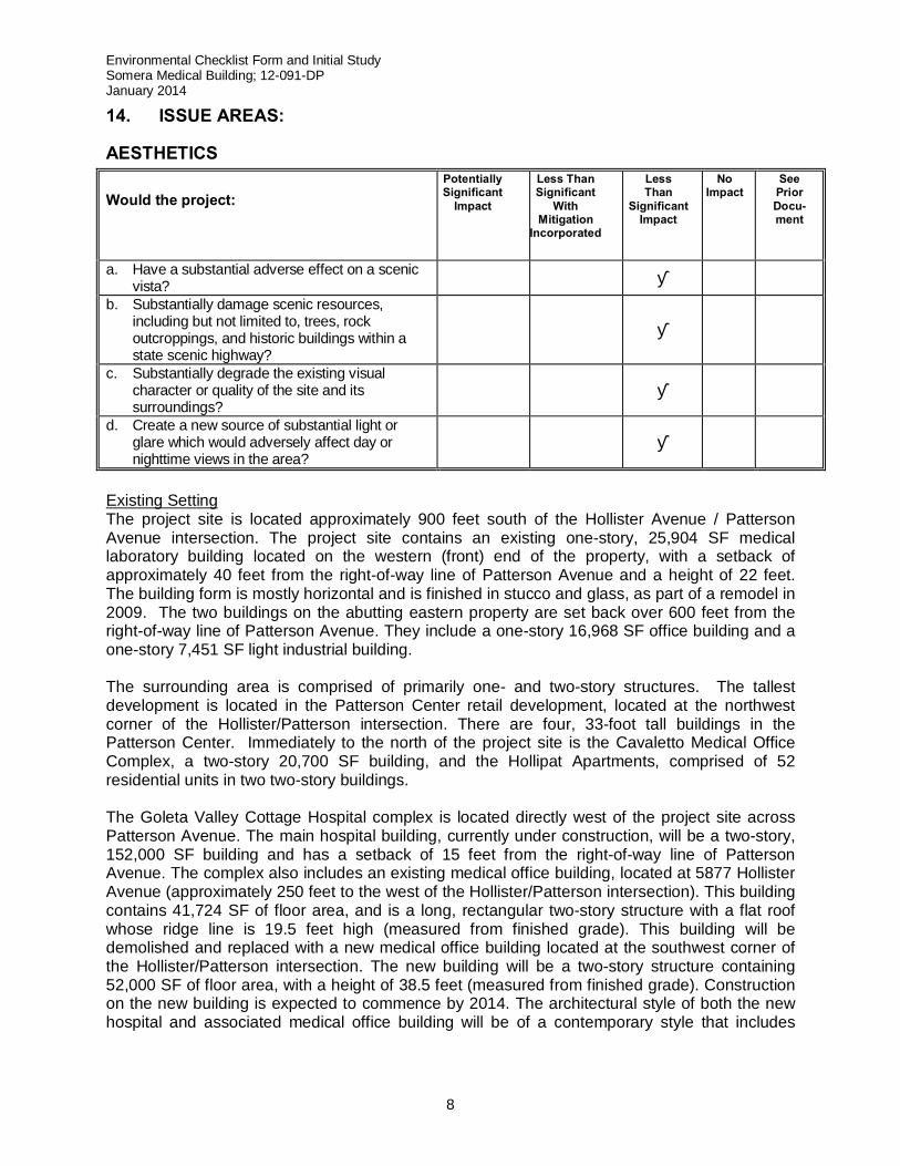
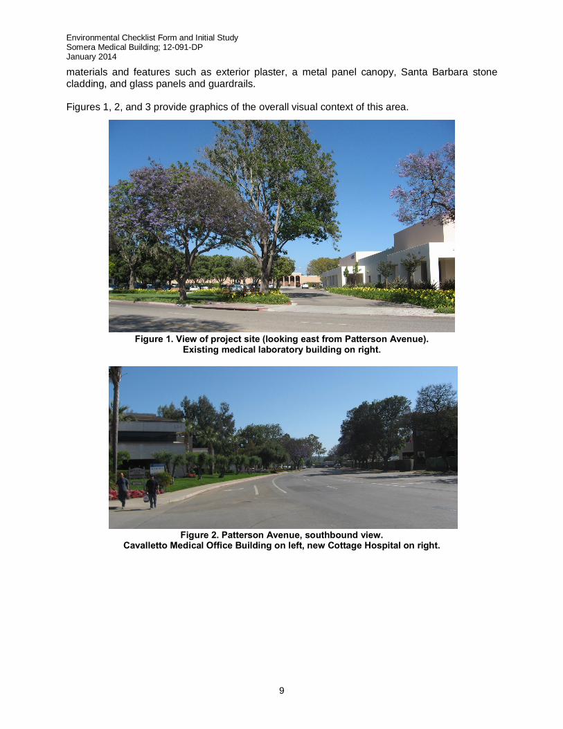
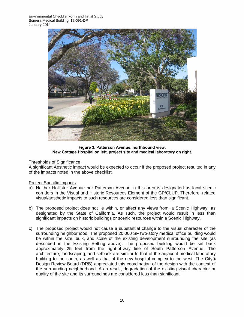
materials and features such as exterior plaster, a metal panel canopy, Santa Barbara stone cladding, and glass panels and guardrails. Figures 1, 2, and 3 provide graphics of the overall visual context of this area.
Figure 1. View of project site (looking east from Patterson Avenue). Existing medical laboratory building on right.
Figure 2. Patterson Avenue, southbound view. Cavalletto Medical Office Building on left, new Cottage Hospital on right.
Environmental Checklist Form and Initial Study Somera Medical Building; 12-091-DP January 2014
10
Figure 3. Patterson Avenue, northbound view. New Cottage Hospital on left, project site and medical laboratory on right.
Thresholds of Significance A significant Aesthetic impact would be expected to occur if the proposed project resulted in any of the impacts noted in the above checklist. Project Specific Impacts a) Neither Hollister Avenue nor Patterson Avenue in this area is designated as local scenic
corridors in the Visual and Historic Resources Element of the GP/CLUP. Therefore, related visual/aesthetic impacts to such resources are considered less than significant.
b) The proposed project does not lie within, or affect any views from, a Scenic Highway as
designated by the State of California. As such, the project would result in less than significant impacts on historic buildings or scenic resources within a Scenic Highway.
c) The proposed project would not cause a substantial change to the visual character of the
surrounding neighborhood. The proposed 20,000 SF two-story medical office building would be within the size, bulk, and scale of the existing development surrounding the site (as described in the Existing Setting above). The proposed building would be set back approximately 25 feet from the right-of-way line of South Patterson Avenue. The architecture, landscaping, and setback are similar to that of the adjacent medical laboratory building to the south, as well as that of the new hospital complex to the west. The City’s Design Review Board (DRB) appreciated this coordination of the design with the context of the surrounding neighborhood. As a result, degradation of the existing visual character or quality of the site and its surroundings are considered less than significant.
Environmental Checklist Form and Initial Study Somera Medical Building; 12-091-DP January 2014
11
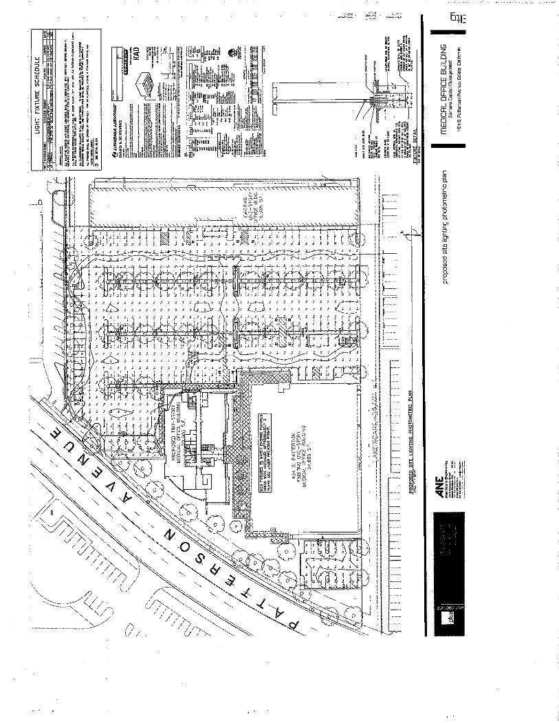
d) Project lighting would be limited to the minimum number of light fixtures needed for nighttime lighting of pedestrian walkways and the parking lot. The lighting plan complies with the City’s Outdoor Lighting Guidelines and “Dark Sky” design principles; as such the project is considered a less than significant source of nighttime glare.
Cumulative Impacts The project’s contribution to cumulative aesthetic impacts is considered to be less than significant, as it is consistent with the size, bulk and scale of surrounding buildings and uses and would not contribute to overall changes in the visual character of the City. Required/Recommended Mitigation Measures Based on the above analysis and nature of the project, no mitigation measures are necessary. Residual Impact The project’s contribution to residual aesthetic impacts is less than significant, as it is consistent with size, bulk and scale of surrounding buildings and uses and would not contribute to the overall changes in the visual character of the City. AGRICULTURE AND FOREST RESOURCES
Environmental Checklist Form and Initial Study Somera Medical Building; 12-091-DP January 2014
12
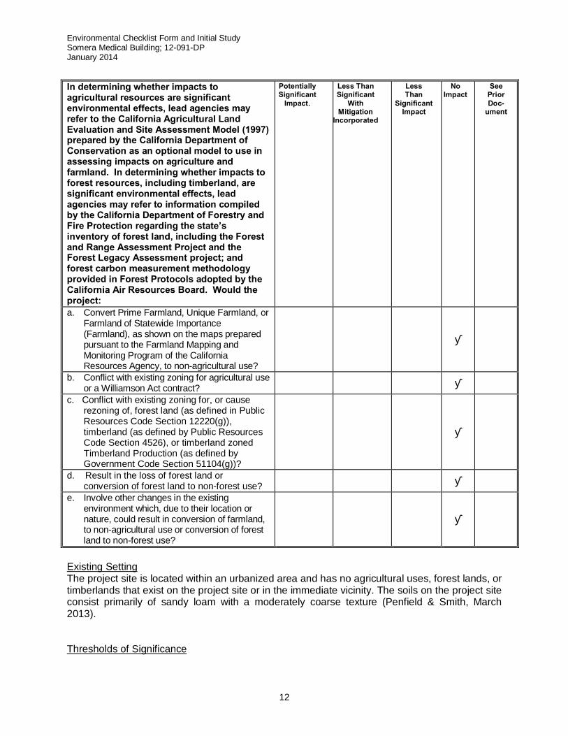
In determining whether impacts to agricultural resources are significant environmental effects, lead agencies may refer to the California Agricultural Land Evaluation and Site Assessment Model (1997) prepared by the California Department of Conservation as an optional model to use in assessing impacts on agriculture and farmland. In determining whether impacts to forest resources, including timberland, are significant environmental effects, lead agencies may refer to information compiled by the California Department of Forestry and Fire Protection regarding the state’s inventory of forest land, including the Forest and Range Assessment Project and the Forest Legacy Assessment project; and forest carbon measurement methodology provided in Forest Protocols adopted by the California Air Resources Board. Would the project:
Potentially Significant
Impact. Less Than Significant
With Mitigation
Incorporated
Less Than
Significant Impact
No Impact
See Prior Doc-
ument
a. Convert Prime Farmland, Unique Farmland, or Farmland of Statewide Importance (Farmland), as shown on the maps prepared pursuant to the Farmland Mapping and Monitoring Program of the California Resources Agency, to non-agricultural use?
■
b. Conflict with existing zoning for agricultural use or a Williamson Act contract? ■
c. Conflict with existing zoning for, or cause rezoning of, forest land (as defined in Public Resources Code Section 12220(g)), timberland (as defined by Public Resources Code Section 4526), or timberland zoned Timberland Production (as defined by Government Code Section 51104(g))?
■
d. Result in the loss of forest land or conversion of forest land to non-forest use? ■
e. Involve other changes in the existing environment which, due to their location or nature, could result in conversion of farmland, to non-agricultural use or conversion of forest land to non-forest use?
■
Existing Setting The project site is located within an urbanized area and has no agricultural uses, forest lands, or timberlands that exist on the project site or in the immediate vicinity. The soils on the project site consist primarily of sandy loam with a moderately coarse texture (Penfield & Smith, March 2013). Thresholds of Significance
Environmental Checklist Form and Initial Study Somera Medical Building; 12-091-DP January 2014
13
A significant impact to Agriculture and Forest Resources would occur if the proposed project resulted in any of the impacts noted in the above checklist. Additionally, according to the City of Goleta’s Environmental Thresholds and Guidelines Manual a project may pose a significant environmental effect on agricultural resources if it converts prime agricultural land to non-agricultural use or impairs the agricultural productivity of prime agricultural land. Project Specific Impacts a-c) The proposed project would not convert any Prime Farmland, Unique Farmland, or
Farmland of Statewide Importance as mapped by the California Resources Agency, given the existing soil type. Given the soil type, there are no agriculturally zoned properties or properties under a Williamson Act contract in the vicinity of the project site. The proposed project would not result in any environmental changes that would involve the conversion of any farmland to non-agricultural uses. Additionally, there are no lands zoned as forest lands or timberlands on the project site or in its immediate vicinity. Therefore the project would have no impact on agricultural resources in the area.
d-e) The proposed project is a previously developed site and does not contain forested
areas. Additionally the proposed project would not result in any other environmental changes that would involve the conversion of forest lands to non-forest uses. Therefore the project would have no impact on forest resources in the area.
Cumulative Impacts The proposed project would not contribute to any cumulative impact on agriculture or forest resources within the City of Goleta. Required/Recommended Mitigation Measures Based on the above analysis and nature of the project, no mitigation measures are necessary. Residual Impact No residual impacts (either project-specific or cumulative) on Agriculture and Forest Resources would occur as a result of project implementation.
Environmental Checklist Form and Initial Study Somera Medical Building; 12-091-DP January 2014
14
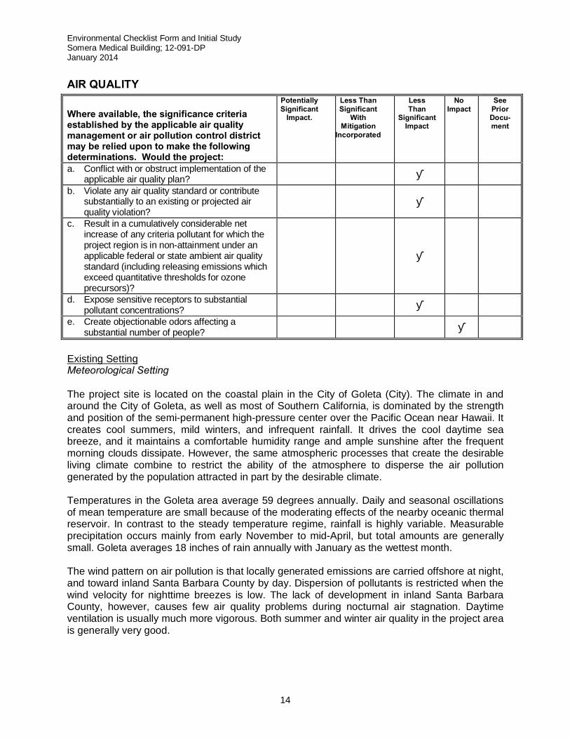
AIR QUALITY Where available, the significance criteria established by the applicable air quality management or air pollution control district may be relied upon to make the following determinations. Would the project:
Potentially Significant
Impact. Less Than Significant
With Mitigation
Incorporated
Less Than
Significant Impact
No Impact
See Prior Docu- ment
a. Conflict with or obstruct implementation of the applicable air quality plan? ■
b. Violate any air quality standard or contribute substantially to an existing or projected air quality violation?
■
c. Result in a cumulatively considerable net increase of any criteria pollutant for which the project region is in non-attainment under an applicable federal or state ambient air quality standard (including releasing emissions which exceed quantitative thresholds for ozone precursors)?
■
d. Expose sensitive receptors to substantial pollutant concentrations? ■
e. Create objectionable odors affecting a substantial number of people? ■
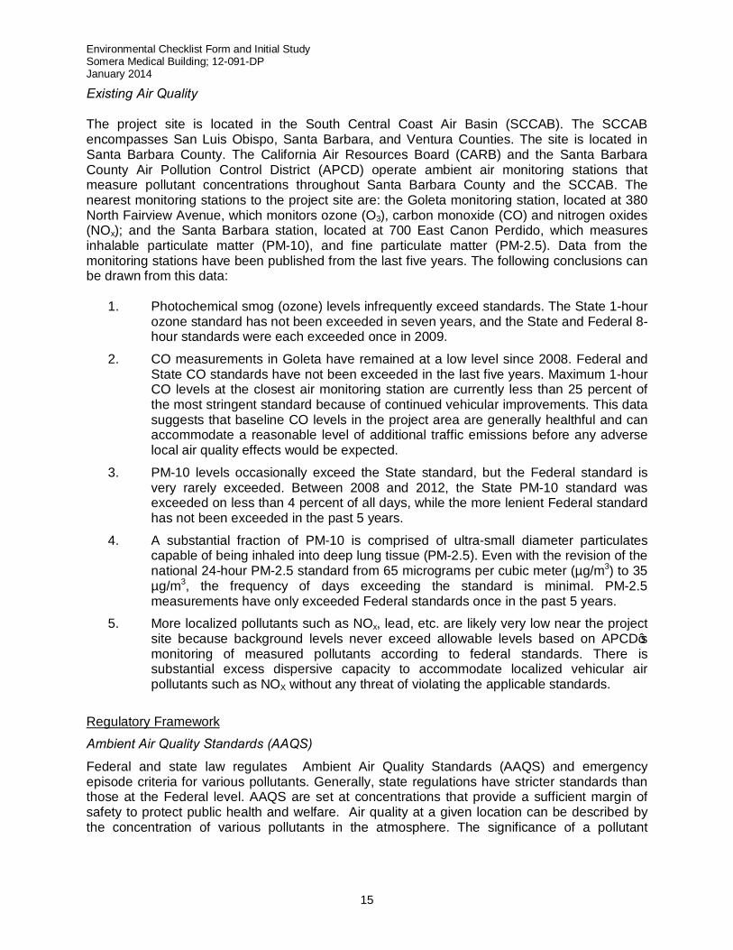
Existing Setting Meteorological Setting The project site is located on the coastal plain in the City of Goleta (City). The climate in and around the City of Goleta, as well as most of Southern California, is dominated by the strength and position of the semi-permanent high-pressure center over the Pacific Ocean near Hawaii. It creates cool summers, mild winters, and infrequent rainfall. It drives the cool daytime sea breeze, and it maintains a comfortable humidity range and ample sunshine after the frequent morning clouds dissipate. However, the same atmospheric processes that create the desirable living climate combine to restrict the ability of the atmosphere to disperse the air pollution generated by the population attracted in part by the desirable climate. Temperatures in the Goleta area average 59 degrees annually. Daily and seasonal oscillations of mean temperature are small because of the moderating effects of the nearby oceanic thermal reservoir. In contrast to the steady temperature regime, rainfall is highly variable. Measurable precipitation occurs mainly from early November to mid-April, but total amounts are generally small. Goleta averages 18 inches of rain annually with January as the wettest month. The wind pattern on air pollution is that locally generated emissions are carried offshore at night, and toward inland Santa Barbara County by day. Dispersion of pollutants is restricted when the wind velocity for nighttime breezes is low. The lack of development in inland Santa Barbara County, however, causes few air quality problems during nocturnal air stagnation. Daytime ventilation is usually much more vigorous. Both summer and winter air quality in the project area is generally very good.
Environmental Checklist Form and Initial Study Somera Medical Building; 12-091-DP January 2014
15
Existing Air Quality The project site is located in the South Central Coast Air Basin (SCCAB). The SCCAB encompasses San Luis Obispo, Santa Barbara, and Ventura Counties. The site is located in Santa Barbara County. The California Air Resources Board (CARB) and the Santa Barbara County Air Pollution Control District (APCD) operate ambient air monitoring stations that measure pollutant concentrations throughout Santa Barbara County and the SCCAB. The nearest monitoring stations to the project site are: the Goleta monitoring station, located at 380 North Fairview Avenue, which monitors ozone (O3), carbon monoxide (CO) and nitrogen oxides (NOx); and the Santa Barbara station, located at 700 East Canon Perdido, which measures inhalable particulate matter (PM-10), and fine particulate matter (PM-2.5). Data from the monitoring stations have been published from the last five years. The following conclusions can be drawn from this data:
1. Photochemical smog (ozone) levels infrequently exceed standards. The State 1-hour ozone standard has not been exceeded in seven years, and the State and Federal 8-hour standards were each exceeded once in 2009.
2. CO measurements in Goleta have remained at a low level since 2008. Federal and State CO standards have not been exceeded in the last five years. Maximum 1-hour CO levels at the closest air monitoring station are currently less than 25 percent of the most stringent standard because of continued vehicular improvements. This data suggests that baseline CO levels in the project area are generally healthful and can accommodate a reasonable level of additional traffic emissions before any adverse local air quality effects would be expected.
3. PM-10 levels occasionally exceed the State standard, but the Federal standard is very rarely exceeded. Between 2008 and 2012, the State PM-10 standard was exceeded on less than 4 percent of all days, while the more lenient Federal standard has not been exceeded in the past 5 years.
4. A substantial fraction of PM-10 is comprised of ultra-small diameter particulates capable of being inhaled into deep lung tissue (PM-2.5). Even with the revision of the national 24-hour PM-2.5 standard from 65 micrograms per cubic meter (µg/m3) to 35 µg/m3, the frequency of days exceeding the standard is minimal. PM-2.5 measurements have only exceeded Federal standards once in the past 5 years.
5. More localized pollutants such as NOx, lead, etc. are likely very low near the project site because background levels never exceed allowable levels based on APCD’s monitoring of measured pollutants according to federal standards. There is substantial excess dispersive capacity to accommodate localized vehicular air pollutants such as NOX without any threat of violating the applicable standards.
Regulatory Framework
Ambient Air Quality Standards (AAQS)
Federal and state law regulates Ambient Air Quality Standards (AAQS) and emergency episode criteria for various pollutants. Generally, state regulations have stricter standards than those at the Federal level. AAQS are set at concentrations that provide a sufficient margin of safety to protect public health and welfare. Air quality at a given location can be described by the concentration of various pollutants in the atmosphere. The significance of a pollutant
Environmental Checklist Form and Initial Study Somera Medical Building; 12-091-DP January 2014
16
concentration is determined by comparing the concentration to an appropriate Federal and/or State ambient air quality standard. Federal standards are established by the US Environmental Protection Agency (EPA) and are termed the National Ambient Air Quality Standards (NAAQS). The State standards are established by the California Air Resources Board (CARB) and are called the California Ambient Air Quality Standards (CAAQS). The region generally has good air quality, as it attains or is considered in maintenance status for most ambient air quality standards. The Santa Barbara County (County) Air Pollution Control District (APCD) is required to monitor air pollutant levels to assure that Federal and State air quality standards are being met. Air Quality Planning State and Federal laws require that jurisdictions which do not meet clean air standards develop plans and programs that will bring those areas into compliance. These plans typically contain emission reduction measures and attainment schedules to meet specified deadlines. If and when attainment is reached, the attainment plan becomes a “maintenance plan.” In 2001, the CARB developed an attainment plan that was designed to meet both Federal and State planning requirements. The Federal attainment plan was combined with those from other statewide non-attainment areas to become the State Implementation Plan (SIP). The 2001 Clean Air Plan (CAP) was adopted as the County portion of the SIP, designed to meet and maintain Federal [ONLY FEDERAL? Answer: yes, since state standards not adopted yet in 2001] clean air standards. The 2010 CAP, adopted by the APCD Board, incorporates updated data and is currently the most recent Clean Air Plan for meeting the state ozone standard. Santa Barbara County is designated as a Federal ozone attainment area for the 8-hour ozone National Ambient Air Quality Standard (the 1-hour Federal standard was revoked for Santa Barbara County). The County is also considered in attainment for the State one-hour standard for ozone as of 2010. “Attainment” means those areas of the country where air pollution levels are persistently below the national ambient air quality standards. A new California 8-hour ozone standard was implemented in May 2006, which the County has violated. The County also continues to violate the State standard for PM-10, therefore Santa Barbara County is a non-attainment area for the State standards for ozone and for PM-10. The County is in attainment for the Federal PM-2.5 standard and is designated “unclassified” for the State PM-2.5 standard, and is designated “attainment” or “unclassified” for other State standards and for all Federal clean air standards. “Unclassified” means that there is currently no quantifiable data to measure ambient air quality standards in that area. Those jurisdictions that are designated both as “attainment” or “unclassified” are considered to be in attainment of ambient air quality standards even though there is currently no quantifiable data to measure its specific ambient air quality levels. Thresholds of Significance—Criteria Pollutants A significant air quality impact could occur if the proposed project resulted in any of the impacts noted in the above checklist. In addition, pursuant to the City’s Environmental Thresholds and Guidelines Manual, a significant adverse air quality impact may occur when a project, individually or cumulatively, triggers either of the following:
Environmental Checklist Form and Initial Study Somera Medical Building; 12-091-DP January 2014
17
a) interferes with progress toward the attainment of the ozone standard by releasing emissions which equal or exceed the established long-term quantitative thresholds for NOX and ROG;
b) equals or exceeds the State or Federal ambient air quality standards for any criteria pollutant (as determined by modeling);
c) results in toxic or hazardous pollutants in amounts which may increase cancer risks for the affected population
d) Causes an odor nuisance problem impacting a considerable number of people. Cumulative air quality impacts and consistency with the policies and measures in the City’s General Plan and the Air Quality Attainment Plan (AQAP) should be determined for all projects (i.e., whether the project exceeds the AQAP standards). The following significance thresholds have been established by the Santa Barbara County APCD (Scope and Content of Air Quality Sections in Environmental Documents, SPCAPCD, 2011). While the City of Goleta has not yet adopted any new threshold criteria, these APCD thresholds are considered appropriate for use as a guideline for the impact analysis. APCD Operational Impacts Thresholds Based on APCD Thresholds, the project would result in a significant impact, either individually or cumulatively, if it would:
e) Emit 240 pounds per day or more of ROG and NOX from all sources; f) Emit 25 pounds per day or more of unmitigated ROG from any motor vehicle trips only; g) Emit 25 pounds per day or more of unmitigated NOX from any motor vehicle trips only; h) Emit 80 pounds per day or more of PM-10; i) Cause or contribute to a violation of any California or National Ambient Air Quality
standard (except ozone); j) Exceed the APCD health risk public notification thresholds adopted by the APCD Board
(10 excess cancer cases in a million for cancer risk and a Hazard Index of more than 1.0 for non-cancer risk); or
k) Be inconsistent with Federal or State air quality plans for Santa Barbara County. The cumulative contribution of project emissions to regional levels should be compared with existing programs and plans, including the most recent Clean Air Plan (SBCAPCD 2010).
l) Due to the County’s non-attainment status for ozone and the regional nature of ozone as a pollutant, if a project’s emissions from traffic sources of either of the ozone precursors (NOX or ROC), exceed the operational thresholds, then the project’s cumulative impacts are considered significant.
m) For projects that do not have significant ozone precursor emissions or localized pollutant impacts, if emissions have been taken into account in the 2010 Clean Air Plan growth projections, regional cumulative impacts may be considered to be less than significant.
Environmental Checklist Form and Initial Study Somera Medical Building; 12-091-DP January 2014
18
APCD Construction Impacts Thresholds Quantitative thresholds of significance are not currently in place for short-term emissions. However, CEQA requires that the short-term impacts such as exhaust emissions from construction equipment and fugitive dust generation during grading must be analyzed. The APCD recommends that construction-related NOX, ROC, PM-10, and PM-2.5 emissions, from diesel and gasoline powered equipment, paving, and other activities, be quantified.
n) APCD uses 25 tons per year for NOX and ROG as a guideline for determining the significance of construction impacts.
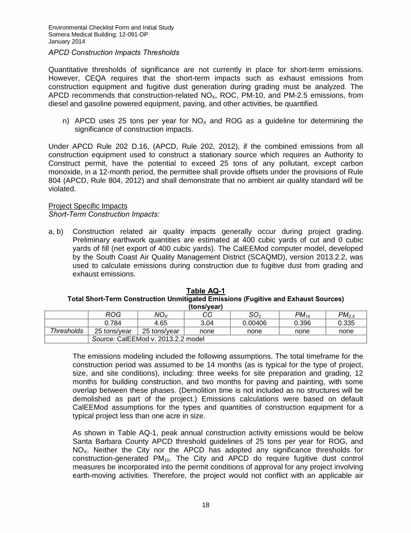
Under APCD Rule 202 D.16, (APCD, Rule 202, 2012), if the combined emissions from all construction equipment used to construct a stationary source which requires an Authority to Construct permit, have the potential to exceed 25 tons of any pollutant, except carbon monoxide, in a 12-month period, the permittee shall provide offsets under the provisions of Rule 804 (APCD, Rule 804, 2012) and shall demonstrate that no ambient air quality standard will be violated. Project Specific Impacts Short-Term Construction Impacts: a, b) Construction related air quality impacts generally occur during project grading.
Preliminary earthwork quantities are estimated at 400 cubic yards of cut and 0 cubic yards of fill (net export of 400 cubic yards). The CalEEMod computer model, developed by the South Coast Air Quality Management District (SCAQMD), version 2013.2.2, was used to calculate emissions during construction due to fugitive dust from grading and exhaust emissions.
Table AQ-1
Total Short-Term Construction Unmitigated Emissions (Fugitive and Exhaust Sources) (tons/year)
ROG NOX CO SO2 PM10 PM2.5 0.784 4.65 3.04 0.00406 0.396 0.335
Thresholds 25 tons/year 25 tons/year none none none none Source: CalEEMod v. 2013.2.2 model
The emissions modeling included the following assumptions. The total timeframe for the construction period was assumed to be 14 months (as is typical for the type of project, size, and site conditions), including: three weeks for site preparation and grading, 12 months for building construction, and two months for paving and painting, with some overlap between these phases. (Demolition time is not included as no structures will be demolished as part of the project.) Emissions calculations were based on default CalEEMod assumptions for the types and quantities of construction equipment for a typical project less than one acre in size. As shown in Table AQ-1, peak annual construction activity emissions would be below Santa Barbara County APCD threshold guidelines of 25 tons per year for ROG, and NOX. Neither the City nor the APCD has adopted any significance thresholds for construction-generated PM10. The City and APCD do require fugitive dust control measures be incorporated into the permit conditions of approval for any project involving earth-moving activities. Therefore, the project would not conflict with an applicable air
Environmental Checklist Form and Initial Study Somera Medical Building; 12-091-DP January 2014
19
quality plan and would have less than significant impacts related to fugitive and exhaust emissions.
e) Construction of new parking areas onsite would require application of aggregate concrete (AC aka asphalt) that could create objectionable odors. Such odors would be temporary and localized. APCD Rule 329, a prohibitory rule governing the application of cutback and emulsified asphalt paving materials in the County, would apply to all project paving activities. Therefore, given the short duration and minimal amount of paving, construction impacts related to objectionable odors affecting a substantial number of people are less than significant.
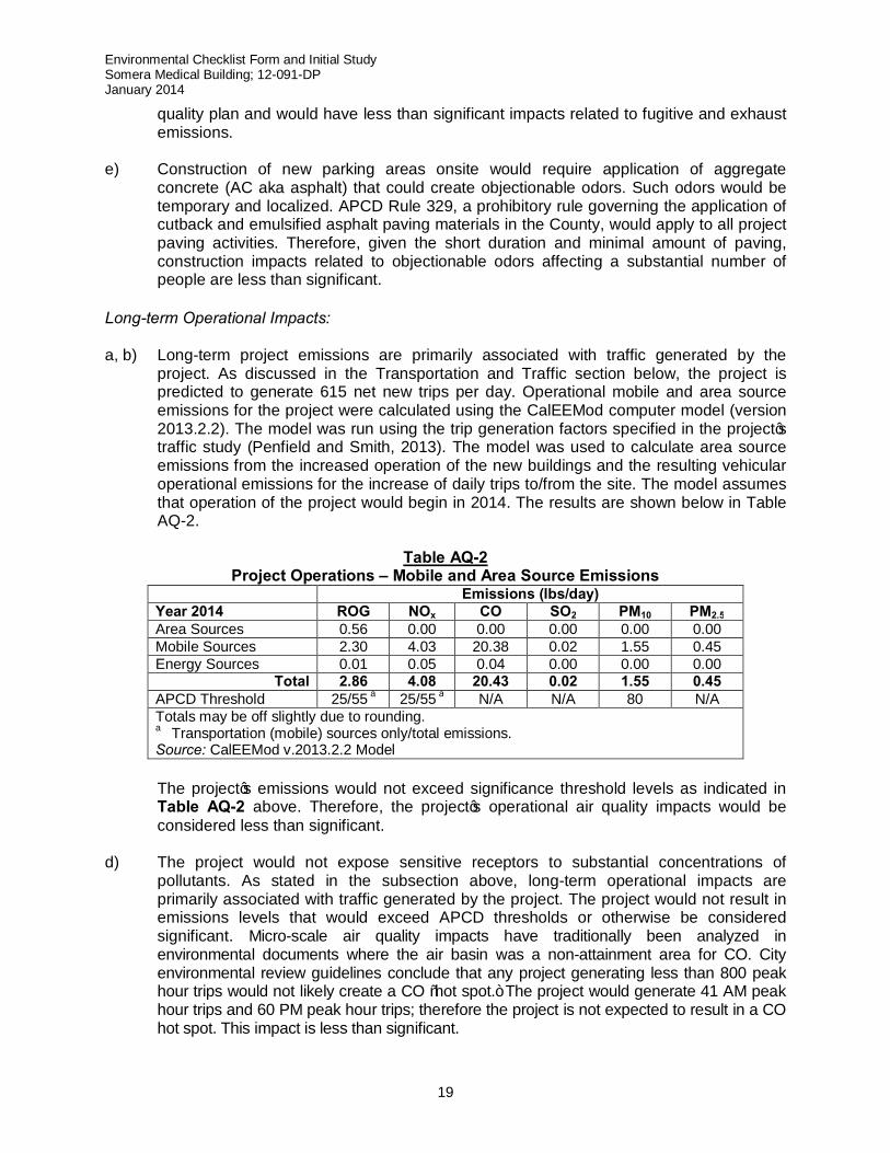
Long-term Operational Impacts: a, b) Long-term project emissions are primarily associated with traffic generated by the
project. As discussed in the Transportation and Traffic section below, the project is predicted to generate 615 net new trips per day. Operational mobile and area source emissions for the project were calculated using the CalEEMod computer model (version 2013.2.2). The model was run using the trip generation factors specified in the project’s traffic study (Penfield and Smith, 2013). The model was used to calculate area source emissions from the increased operation of the new buildings and the resulting vehicular operational emissions for the increase of daily trips to/from the site. The model assumes that operation of the project would begin in 2014. The results are shown below in Table AQ-2.
Table AQ-2
Project Operations – Mobile and Area Source Emissions Emissions (lbs/day) Year 2014 ROG NOx CO SO2 PM10 PM2.5 Area Sources 0.56 0.00 0.00 0.00 0.00 0.00 Mobile Sources 2.30 4.03 20.38 0.02 1.55 0.45 Energy Sources 0.01 0.05 0.04 0.00 0.00 0.00
Total 2.86 4.08 20.43 0.02 1.55 0.45 APCD Threshold 25/55 a 25/55 a N/A N/A 80 N/A Totals may be off slightly due to rounding. a Transportation (mobile) sources only/total emissions. Source: CalEEMod v.2013.2.2 Model
The project’s emissions would not exceed significance threshold levels as indicated in Table AQ-2 above. Therefore, the project’s operational air quality impacts would be considered less than significant.
d) The project would not expose sensitive receptors to substantial concentrations of pollutants. As stated in the subsection above, long-term operational impacts are primarily associated with traffic generated by the project. The project would not result in emissions levels that would exceed APCD thresholds or otherwise be considered significant. Micro-scale air quality impacts have traditionally been analyzed in environmental documents where the air basin was a non-attainment area for CO. City environmental review guidelines conclude that any project generating less than 800 peak hour trips would not likely create a CO “hot spot.” The project would generate 41 AM peak hour trips and 60 PM peak hour trips; therefore the project is not expected to result in a CO hot spot. This impact is less than significant.
Environmental Checklist Form and Initial Study Somera Medical Building; 12-091-DP January 2014
20
e) The project, a medical office building, is not expected to generate any sources of
objectionable odors. Therefore, the project will have no impacts due to such sources. Cumulative Impacts c) The significance thresholds used for air quality analysis on a project level (25 lbs per day
of NOX or ROG from transportation sources only) are also intended to address cumulative air quality impacts. The project’s operational emissions as outlined in Table AQ-2 would not exceed these thresholds; therefore the project’s contribution to cumulative air quality impacts are considered less than significant.
A project’s consistency with the Clean Air Plan (CAP), the County’s plan to achieve attainment status of the ozone standard, is based on consistency with growth forecasts used in developing the CAP. The current CAP (2010) used forecast data from the 2007 Regional Growth Forecast prepared by the Santa Barbara County Association of Governments (SBCAG). This forecast is based on development anticipated by general plans, including the City of Goleta General Plan. The City of Goleta General Plan anticipates an increase of 1.3 million square feet of additional industrial land uses by the year 2030, including the project site. Although the project would increase the number of trips generated at the site, and thus associated air emissions, the assessment of consistency is based on whether the project would result in an increase beyond that anticipated by the General Plan. Development at this site was anticipated as part of the General Plan’s build out.. Additionally, the assessment of consistency is based on whether the project would result in an increase in total population that would exceed the forecast population. The project, a medical office building, and it’s projected 38 employees are not anticipated to result in an increase in the City’s residential population that exceeds the forecasts used in the 2010 CAP. Therefore, the project is accounted for in the 2010 CAP growth projections and would not result in an inconsistency with the 2010 CAP. The project’s contribution to regional cumulative air quality impacts is considered less than significant.
Required Mitigation Measures As no significant impacts to air quality are anticipated to occur as a result of project implementation, no mitigation measures are required. Residual Impact Based upon the above analysis, residual project-specific and cumulative impacts on Air Quality would remain less than significant.
Environmental Checklist Form and Initial Study Somera Medical Building; 12-091-DP January 2014
21
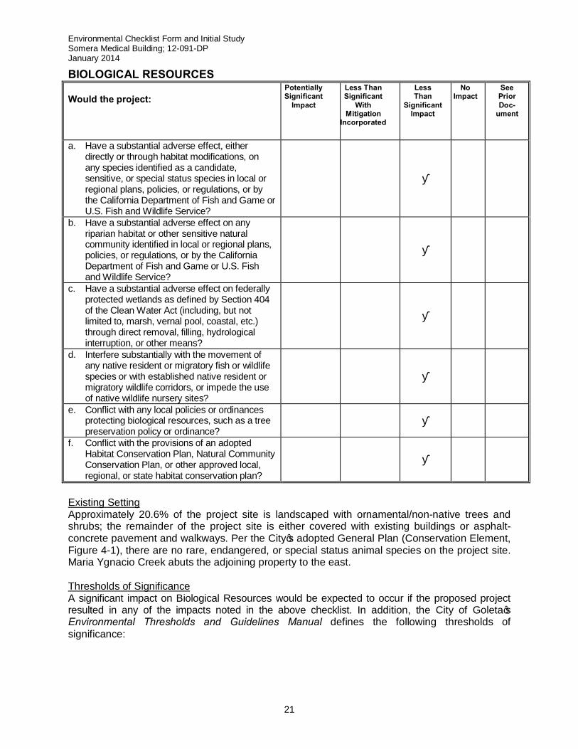
BIOLOGICAL RESOURCES Would the project:
Potentially Significant
Impact Less Than Significant
With Mitigation
Incorporated
Less Than
Significant Impact
No Impact
See Prior Doc-
ument
a. Have a substantial adverse effect, either directly or through habitat modifications, on any species identified as a candidate, sensitive, or special status species in local or regional plans, policies, or regulations, or by the California Department of Fish and Game or U.S. Fish and Wildlife Service?
■
b. Have a substantial adverse effect on any riparian habitat or other sensitive natural community identified in local or regional plans, policies, or regulations, or by the California Department of Fish and Game or U.S. Fish and Wildlife Service?
■
c. Have a substantial adverse effect on federally protected wetlands as defined by Section 404 of the Clean Water Act (including, but not limited to, marsh, vernal pool, coastal, etc.) through direct removal, filling, hydrological interruption, or other means?
■
d. Interfere substantially with the movement of any native resident or migratory fish or wildlife species or with established native resident or migratory wildlife corridors, or impede the use of native wildlife nursery sites?
■
e. Conflict with any local policies or ordinances protecting biological resources, such as a tree preservation policy or ordinance?
■
f. Conflict with the provisions of an adopted Habitat Conservation Plan, Natural Community Conservation Plan, or other approved local, regional, or state habitat conservation plan?
■
Existing Setting Approximately 20.6% of the project site is landscaped with ornamental/non-native trees and shrubs; the remainder of the project site is either covered with existing buildings or asphalt-concrete pavement and walkways. Per the City’s adopted General Plan (Conservation Element, Figure 4-1), there are no rare, endangered, or special status animal species on the project site. Maria Ygnacio Creek abuts the adjoining property to the east. Thresholds of Significance A significant impact on Biological Resources would be expected to occur if the proposed project resulted in any of the impacts noted in the above checklist. In addition, the City of Goleta’s Environmental Thresholds and Guidelines Manual defines the following thresholds of significance:
Environmental Checklist Form and Initial Study Somera Medical Building; 12-091-DP January 2014
22
1. Types of Impacts to Biological Resources Disturbances to habitats or species may be significant, based on substantial evidence in the record, if they substantially impact significant resources in the following ways:
a. Substantially reduce or eliminate species diversity or abundance. b. Substantially reduce or eliminate quantity or quality of nesting areas. c. Substantially limit reproductive capacity through loss of individuals or habitat. d. Substantially fragment, eliminate, or otherwise disrupt foraging areas and/or access
to food resources. e. Substantially limit or fragment range and movement (geographic distribution of
animals and/or seed dispersal routes). f. Substantially interfere with natural processes, such as fire or flooding, upon which
the habitat depends.
2. Less Than Significant Impacts The Environmental Thresholds and Guidelines Manual provides examples of areas in the City of Goleta where impacts to habitat are presumed to be less than significant, including:
a. Small acreages of non-native grassland if wildlife values are low. b. Individuals or stands of non-native trees if not used by important animal species such
as raptors or monarch butterflies. c. Areas of historical disturbance such as intensive agriculture. d. Small pockets of habitats already significantly fragmented or isolated, and disturbed
or degraded. e. Areas of primarily ruderal species resulting from pre-existing man-made disturbance.
Project Specific Impacts a-f) There are no candidate, sensitive, or endangered species that utilize the project site. The
closest environmentally sensitive habitat area (ESHA) is the Maria Ygnacio Creek riparian corridor, approximately 500 feet east of the project site. Given the distance between the project site and the nearest EHSA, the project would not conflict with any City policies for the protection of such ESHAs, Habitat Conservation Plan, Natural Community Conservation Plan, or any other local, regional, or state conservation plan. Finally, no native trees or other native vegetation would be affected by the proposed project.
Therefore, due to the distance to between the project site and the nearest EHSA, the
existing development (buildings and impervious asphalt-concrete pavement) of the project site, and the infill development nature of the proposed project, there will be no substantial adverse effects on special status species, protected wetlands, fish and wildlife, or conflicts with local, state or federal conservation plans. As such, the proposed project would have less than significant effects on biological resources of the project site.
Cumulative Impacts Based on the above analysis and the projects consistency with local, regional and state conservation plans, cumulative impacts on biological resources would be less than significant. Required/Recommended Mitigation Measures Based on the above analysis and nature of the project, no mitigation measures are necessary.
Environmental Checklist Form and Initial Study Somera Medical Building; 12-091-DP January 2014
23
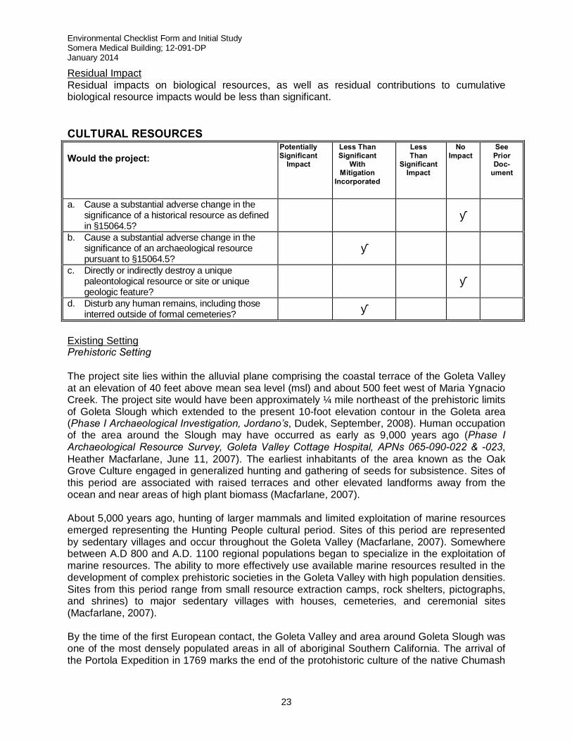
Residual Impact Residual impacts on biological resources, as well as residual contributions to cumulative biological resource impacts would be less than significant. CULTURAL RESOURCES Would the project:
Potentially Significant
Impact Less Than Significant
With Mitigation
Incorporated
Less Than
Significant Impact
No Impact
See Prior Doc-
ument
a. Cause a substantial adverse change in the significance of a historical resource as defined in §15064.5?
■
b. Cause a substantial adverse change in the significance of an archaeological resource pursuant to §15064.5?
■
c. Directly or indirectly destroy a unique paleontological resource or site or unique geologic feature?
■
d. Disturb any human remains, including those interred outside of formal cemeteries? ■
Existing Setting Prehistoric Setting The project site lies within the alluvial plane comprising the coastal terrace of the Goleta Valley at an elevation of 40 feet above mean sea level (msl) and about 500 feet west of Maria Ygnacio Creek. The project site would have been approximately ¼ mile northeast of the prehistoric limits of Goleta Slough which extended to the present 10-foot elevation contour in the Goleta area (Phase I Archaeological Investigation, Jordano’s, Dudek, September, 2008). Human occupation of the area around the Slough may have occurred as early as 9,000 years ago (Phase I Archaeological Resource Survey, Goleta Valley Cottage Hospital, APNs 065-090-022 & -023, Heather Macfarlane, June 11, 2007). The earliest inhabitants of the area known as the Oak Grove Culture engaged in generalized hunting and gathering of seeds for subsistence. Sites of this period are associated with raised terraces and other elevated landforms away from the ocean and near areas of high plant biomass (Macfarlane, 2007). About 5,000 years ago, hunting of larger mammals and limited exploitation of marine resources emerged representing the Hunting People cultural period. Sites of this period are represented by sedentary villages and occur throughout the Goleta Valley (Macfarlane, 2007). Somewhere between A.D 800 and A.D. 1100 regional populations began to specialize in the exploitation of marine resources. The ability to more effectively use available marine resources resulted in the development of complex prehistoric societies in the Goleta Valley with high population densities. Sites from this period range from small resource extraction camps, rock shelters, pictographs, and shrines) to major sedentary villages with houses, cemeteries, and ceremonial sites (Macfarlane, 2007). By the time of the first European contact, the Goleta Valley and area around Goleta Slough was one of the most densely populated areas in all of aboriginal Southern California. The arrival of the Portola Expedition in 1769 marks the end of the protohistoric culture of the native Chumash
Environmental Checklist Form and Initial Study Somera Medical Building; 12-091-DP January 2014
24
inhabitants of the area and the beginning of the Mission Period. Induction of the native Chumash into the Mission system during this time had a deleterious effect on the population as a result of the introduction of European diseases and cultural shock brought about through the adaptation to a new lifestyle (Macfarlane, 2007). Historic Setting Historically, settlement in the vicinity of the project site was defined by three periods; the Mission Period (AD 1769 to 1830), the Rancho Period (AD 1830 to 1865), and the American Period (AD 1865 to present). The missions during the Mission Period served as the center of Spanish culture in the area and substantially affected settlement patterns, trade, industry, and agriculture in the area. Upon secularization of the mission lands in 1821, the Rancho Period focused primarily on the raising of cattle. Upon statehood in 1850, and the subsequent commencement of the American Period, farming and more intensive land uses replaced cattle raising as the primary economic activity in the area. Thresholds of Significance A significant impact on cultural resources would be expected to occur if the proposed project resulted in any of the impacts noted in the above checklist. Additional thresholds are contained in the City’s Environmental Thresholds and Guidelines Manual. The City’s adopted thresholds indicate that a project would result in a significant impact on a cultural resource if it results in the physical demolition, destruction, relocation, or alteration of the resource or its immediate surroundings such that the significance of such a resource would be materially impaired. Project Specific Impacts a) There are no historic resources as defined in Section 15064.5 of the CEQA Guidelines
on the project site. The closest registered site is the Sexton House located at 5494 Hollister Avenue, approximately ¼ mile to the west of the project site. Given the distance between the project site and numerous intervening building, project implementation will not impact this historic resource. Further, a records search through the Central Coast Information Center (CCIC) and the State Historic Resource Commission (SHRC) indicated that neither the project site (Parcel 1 of Parcel Map No. 32,053), nor the adjoining parcel to the east (Parcel 2 of Parcel Map No. 32,053) contain any historical or paleontological sites. In addition, the project site in not on the List of Historical Resources (GP/CLUP, Table 6.1) in the City’s General Plan. Based on these factors, the project would not result in any impacts to historical or paleontological resources.
b, d) A Phase I archaeological survey was prepared for the Goleta Valley Cottage Hospital
project (Macfarlane, 2007), located approximately 200 feet to the west of the project site The 2007 MacFarlane survey studied a ½ mile radius area from the hospital; this project site was encompassed within said study. The 2007 MacFarlane survey noted one historic archaeological site (the Sexton House) a ¼ mile from the hospital and 18 prior cultural resource surveys had already been conducted within the survey area. All of the previous surveys have been negative for any prehistoric or historic archaeological resources. Further, a visual survey of all surface areas not covered by buildings, parking areas, and sidewalks was conducted by the hospital project’s archaeologist. The visual survey did not find any indications of any archaeological site or resource present. Lastly, a review of historic aerial photographs and topographic quadrangles of the site was also negative for any indications of archaeological resources, and indicate that the hospital

Environmental Checklist Form and Initial Study Somera Medical Building; 12-091-DP January 2014
25
lands were probably used for agricultural production prior to construction of the hospital and existing medical laboratory facility in 1966.
Although the literature search and onsite survey of the hospital lands proved negative, and the project site has been subject to extensive subsurface disturbance associated with the construction of the existing building on the project site in the late 1960s, there remains at least a theoretical potential that a buried prehistoric site or archaeological resource could be located on the property, due in part to the property’s proximity to Maria Ygnacio Creek. This potential is based primarily on historically documented flooding that has been known to cover over and preserve prehistoric archaeological sites and/or cultural remains (Macfarlane, 2007). If such resources exist, they could be uncovered and adversely affected by construction activities. Therefore, while the potential for disturbance of any remaining artifacts and/or human remains onsite is low, it is considered to be potentially significant. As such, mitigation has been included as noted below which would reduce potential impacts to less than significant.
c) A records search through the CCIC indicated that the project parcel does not contain
any paleontological sites. Therefore, the project would not result in any impacts to paleontological resources.
Cumulative Impacts Continued loss of cultural resources on a project-by-project basis could result in significant cumulative impacts to such resources over time. If cultural resources are found on site, the project’s potential contribution to these cumulative impacts is potentially significant. Required Mitigation Measures CR-1: In the event archaeological resources are encountered during grading, work must be
stopped immediately or redirected until the City-approved archaeologist and Native American representative can evaluate the significance of the find pursuant to Phase 2 investigation standards set forth in the City Archaeological Guidelines. The Phase 2 study must be funded by the applicant. If resources are found to be significant, they must be subject to a Phase 3 mitigation program consistent with City Archaeological Guidelines. The Phase 3 mitigation program must be funded by the applicant. Plan Requirements and Timing: This requirement must be printed on all plans submitted for any Land Use Permit (LUP), building, grading, or demolition permits. Monitoring: City staff must conduct periodic field inspections to verify compliance during ground disturbing activities and must ensure preparation of any necessary Phase 2 and/or Phase 3 investigation.
Residual Impact With implementation of this mitigation measure, residual project specific impacts on Cultural Resources would be less than significant.
Environmental Checklist Form and Initial Study Somera Medical Building; 12-091-DP January 2014
26
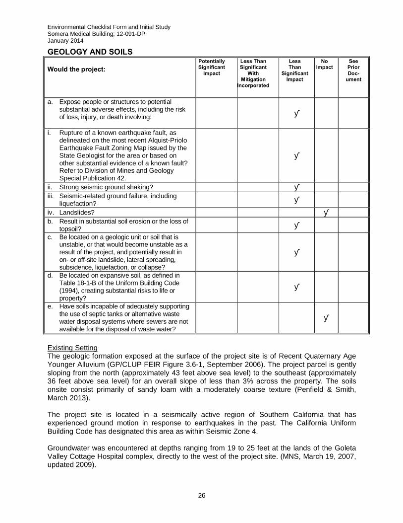
GEOLOGY AND SOILS Would the project:
Potentially Significant
Impact Less Than Significant
With Mitigation
Incorporated
Less Than
Significant Impact
No Impact
See Prior Doc-
ument
a. Expose people or structures to potential substantial adverse effects, including the risk of loss, injury, or death involving:
■
i. Rupture of a known earthquake fault, as delineated on the most recent Alquist-Priolo Earthquake Fault Zoning Map issued by the State Geologist for the area or based on other substantial evidence of a known fault? Refer to Division of Mines and Geology Special Publication 42.
■
ii. Strong seismic ground shaking? ■ iii. Seismic-related ground failure, including
liquefaction? ■ iv. Landslides? ■ b. Result in substantial soil erosion or the loss of
topsoil? ■ c. Be located on a geologic unit or soil that is
unstable, or that would become unstable as a result of the project, and potentially result in on- or off-site landslide, lateral spreading, subsidence, liquefaction, or collapse?
■
d. Be located on expansive soil, as defined in Table 18-1-B of the Uniform Building Code (1994), creating substantial risks to life or property?
■
e. Have soils incapable of adequately supporting the use of septic tanks or alternative waste water disposal systems where sewers are not available for the disposal of waste water?
■
Existing Setting The geologic formation exposed at the surface of the project site is of Recent Quaternary Age Younger Alluvium (GP/CLUP FEIR Figure 3.6-1, September 2006). The project parcel is gently sloping from the north (approximately 43 feet above sea level) to the southeast (approximately 36 feet above sea level) for an overall slope of less than 3% across the property. The soils onsite consist primarily of sandy loam with a moderately coarse texture (Penfield & Smith, March 2013). The project site is located in a seismically active region of Southern California that has experienced ground motion in response to earthquakes in the past. The California Uniform Building Code has designated this area as within Seismic Zone 4. Groundwater was encountered at depths ranging from 19 to 25 feet at the lands of the Goleta Valley Cottage Hospital complex, directly to the west of the project site. (MNS, March 19, 2007, updated 2009).
Environmental Checklist Form and Initial Study Somera Medical Building; 12-091-DP January 2014
27
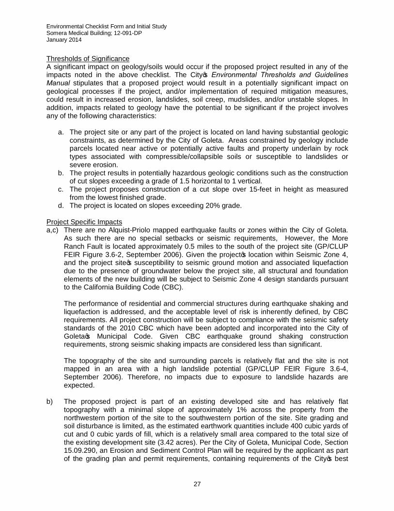
Thresholds of Significance A significant impact on geology/soils would occur if the proposed project resulted in any of the impacts noted in the above checklist. The City’s Environmental Thresholds and Guidelines Manual stipulates that a proposed project would result in a potentially significant impact on geological processes if the project, and/or implementation of required mitigation measures, could result in increased erosion, landslides, soil creep, mudslides, and/or unstable slopes. In addition, impacts related to geology have the potential to be significant if the project involves any of the following characteristics:
a. The project site or any part of the project is located on land having substantial geologic constraints, as determined by the City of Goleta. Areas constrained by geology include parcels located near active or potentially active faults and property underlain by rock types associated with compressible/collapsible soils or susceptible to landslides or severe erosion.
b. The project results in potentially hazardous geologic conditions such as the construction of cut slopes exceeding a grade of 1.5 horizontal to 1 vertical.
c. The project proposes construction of a cut slope over 15-feet in height as measured from the lowest finished grade.
d. The project is located on slopes exceeding 20% grade. Project Specific Impacts a,c) There are no Alquist-Priolo mapped earthquake faults or zones within the City of Goleta.
As such there are no special setbacks or seismic requirements, However, the More Ranch Fault is located approximately 0.5 miles to the south of the project site (GP/CLUP FEIR Figure 3.6-2, September 2006). Given the project’s location within Seismic Zone 4, and the project site’s susceptibility to seismic ground motion and associated liquefaction due to the presence of groundwater below the project site, all structural and foundation elements of the new building will be subject to Seismic Zone 4 design standards pursuant to the California Building Code (CBC).
The performance of residential and commercial structures during earthquake shaking and liquefaction is addressed, and the acceptable level of risk is inherently defined, by CBC requirements. All project construction will be subject to compliance with the seismic safety standards of the 2010 CBC which have been adopted and incorporated into the City of Goleta’s Municipal Code. Given CBC earthquake ground shaking construction requirements, strong seismic shaking impacts are considered less than significant.
The topography of the site and surrounding parcels is relatively flat and the site is not mapped in an area with a high landslide potential (GP/CLUP FEIR Figure 3.6-4, September 2006). Therefore, no impacts due to exposure to landslide hazards are expected.
b) The proposed project is part of an existing developed site and has relatively flat topography with a minimal slope of approximately 1% across the property from the northwestern portion of the site to the southwestern portion of the site. Site grading and soil disturbance is limited, as the estimated earthwork quantities include 400 cubic yards of cut and 0 cubic yards of fill, which is a relatively small area compared to the total size of the existing development site (3.42 acres). Per the City of Goleta, Municipal Code, Section 15.09.290, an Erosion and Sediment Control Plan will be required by the applicant as part of the grading plan and permit requirements, containing requirements of the City’s best
Environmental Checklist Form and Initial Study Somera Medical Building; 12-091-DP January 2014
28
management practices (BMP’S) for erosion and sediment control. As such, due to the relatively flat topography of the project site, the relatively small area of sediment disturbance from grading, and the City’s requirements of BMP’s for erosion and sediment control, the proposed project would have less significant impacts and/or occurrence of soil erosion or loss of the top soil.
d) The surface soils are part of the Quaternary alluvium geologic unit and are considered
slightly expansive. However, the building foundation will be designed to meet the California Building Code’s seismic and soil parameters. As such any impacts resulting from expansive soils are considered less than significant.
e) The project’s wastewater would be disposed of via the Goleta Sanitary District’s sewer
system. Therefore, no potential geological hazards posed by the use of septic tanks or alternative waste water disposal systems would exist.
Cumulative Impacts Based on the above analysis, its contribution to the cumulative risk of erosion would be less than significant. Required Mitigation Measures Base on the above analysis, no mitigation measures are required. Residual Impact Based on the above analysis, residual project-specific and cumulative impacts on Geology and Soils would be considered less than significant. GREENHOUSE GAS EMISSIONS Would the project:
Potentially Significant
Impact Less Than Significant
With Mitigation
Incorporated
Less Than
Significant Impact
No Impact
See Prior Doc-
ument
a. Generate greenhouse gas emissions, either directly or indirectly, that may have a significant impact on the environment?
■
b. Conflict with an applicable plan, policy or regulation adopted for the purpose of reducing the emissions of greenhouse gases?
■
Existing Conditions
Climate Change Background Parts of the Earth’s atmosphere act as an insulating “blanket” for the planet. This “blanket” of various gases traps solar energy, which keeps the global average temperature in a range suitable for life. The collection of atmospheric gases that comprise this blanket are called “greenhouse gases,” based on the idea that these gases trap heat like the glass walls of a greenhouse. These gases, mainly water vapor, carbon dioxide (CO2), methane (CH4), nitrous oxide (N2O), ozone (O3), and chlorofluorocarbons (CFCs), all act as effective global insulators, reflecting visible light and infrared radiation back to earth. Most scientists agree that human activities, such as producing electricity and driving internal combustion vehicles, have
Environmental Checklist Form and Initial Study Somera Medical Building; 12-091-DP January 2014
29
contributed to the elevated concentration of these gases in the atmosphere. As a result, the Earth’s overall temperature is rising. Climate change could impact the natural environment in California by triggering, among others things:
• Rising sea levels along the California coastline; • Extreme-heat conditions, such as heat waves and very high temperatures, which could
last longer and become more frequent; • Increase in heat-related human deaths, an increase in infectious diseases, and a higher
risk of respiratory problems caused by deteriorating air quality; • Reduced snow pack and stream flow in the Sierra Nevada mountains, affecting winter
recreation and water supplies; • Potential increase in the severity of winter storms, affecting peak stream flows and
flooding; • Changes in growing season conditions that could affect California agriculture, causing
variations in crop quality and yield; and • Changes in distribution of plant and wildlife species due to changes in temperature,
competition from colonizing species, changes in hydrologic cycles, changes in sea levels, and other climate-related effects.
According to the US Environmental Protection Agency (EPA), a GHG is any gas that absorbs infrared radiation in the atmosphere. This absorption traps heat within the atmosphere creating a greenhouse effect that is slowly raising global temperatures. California law defines GHG to include the following: carbon dioxide (CO2), methane (CH4), nitrous oxide (N2O), hydrofluorocarbons (HFCs), perfluorocarbons (PFCs), and sulfur hexafluoride (SF6) (Health and Safety Code, § 38505(g)).
The effect each GHG has on climate change is measured as a combination of the volume of its emissions, and its global warming potential (GWP), and is expressed as a function of how much warming would be caused by the same mass of CO2. Thus, GHG emissions are typically measured in terms of pounds or tons of CO2 equivalents (CO2e), and are often expressed in metric tons of CO2 equivalents (MT CO2e) or millions of metric tons of CO2 equivalents (MMT CO2e).
Global climate change issues are addressed through the efforts of various federal, state, regional, and local government agencies as well as national and international scientific and governmental conventions and programs. These agencies work jointly and individually to understand and regulate the effects of greenhouse gas emissions and resulting climate change through legislation, regulations, planning, policy-making, education, and a variety of programs. The significant agencies, conventions, and programs focused on global climate change are listed below. Federal U.S. Environmental Protection Agency California Air Resources Board California Executive Order S-3-05
Environmental Checklist Form and Initial Study Somera Medical Building; 12-091-DP January 2014
30
California Executive Order S-13-08 California Global Warming Solutions Action of 2006 (AB 32) Senate Bill (SB) 97. SB 97, enacted in 2007 State of California Climate Change Proposed Scoping Plan Senate Bill (SB) 375. SB 375 Santa Barbara County Air Pollution Control District (APCD) City of Goleta Energy Efficiency Standards Thresholds of Significance
The State Natural Resources Agency adopted amendments to the CEQA Guidelines for GHG emissions that became effective on March 18, 2010. These new CEQA Guidelines provide regulatory guidance on the analysis and mitigation of GHG emissions in CEQA documents. According to the amendments made to Appendix G of the CEQA Guidelines, the project would have a significant impact if it would:
A. Generate GHG emissions, either directly or indirectly, that may have a significant impact
on the environment; or B. Conflict with an applicable plan, policy, or regulation adopted for the purposed of
reducing the emissions of GHGs.
The adopted CEQA amendments require a lead agency to make a good-faith effort based, to the extent possible, on scientific and factual data in order to describe, calculate, or estimate the amount of GHG emissions resulting from a project. They give discretion to the lead agency in whether to:
1. Use a model or methodology to quantify GHG emissions resulting from a project, and
which model or methodology to use; and/or 2. Rely on a qualitative analysis or performance-based standards.
In addition, a lead agency should consider the following factors, among others, when assessing the significance of impacts from GHG emissions on the environment:
1. The extent to which the project may increase or reduce GHG emissions as compared to the existing environmental setting;
2. Whether the project emissions exceed a threshold of significance that the lead agency determines applies to the project; and
3. The extent to which the project complies with regulations or requirements adopted to implement a statewide, regional, or local plan for the reduction or mitigation of GHG emissions.
The amendments call on Lead Agencies to establish significance thresholds for their respective jurisdictions. Currently, neither the State of California nor the City of Goleta has established CEQA significance thresholds for GHG emissions. Indeed, many regulatory agencies are sorting through suggested thresholds and/or making project-by-project analyses. This approach is consistent with that suggested by CAPCOA in its technical advisory entitled “CEQA and Climate
Environmental Checklist Form and Initial Study Somera Medical Building; 12-091-DP January 2014
31
Change: Addressing Climate Change Through the California Environmental Quality Act Review (CAPCOA; 2008):
…In the absence of regulatory standards for GHG emissions or other specific data to clearly define what constitutes a ‘significant project’, individual lead agencies may undertake a project-by-project analysis, consistent with available guidance and current CEQA practice.
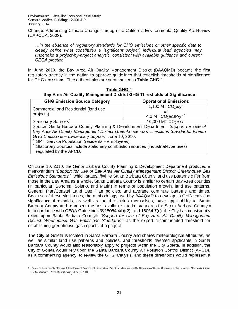
In June 2010, the Bay Area Air Quality Management District (BAAQMD) became the first regulatory agency in the nation to approve guidelines that establish thresholds of significance for GHG emissions. These thresholds are summarized in Table GHG-1.
Table GHG-1 Bay Area Air Quality Management District GHG Thresholds of Significance GHG Emission Source Category Operational Emissions
Commercial and Residential (land use projects)
1,100 MT CO2e/yr or
4.6 MT CO2e/SP/yr a Stationary Sourcesb 10,000 MT CO2e /yr Source: Santa Barbara County Planning & Development Department, Support for Use of Bay Area Air Quality Management District Greenhouse Gas Emissions Standards. Interim GHG Emissions – Evidentiary Support, June 10, 2010. a SP = Service Population (residents + employees). b Stationary Sources include stationary combustion sources (industrial-type uses)
regulated by the APCD. On June 10, 2010, the Santa Barbara County Planning & Development Department produced a memorandum “Support for Use of Bay Area Air Quality Management District Greenhouse Gas Emissions Standards,”1 which states, “While Santa Barbara County land use patterns differ from those in the Bay Area as a whole, Santa Barbara County is similar to certain Bay Area counties (in particular, Sonoma, Solano, and Marin) in terms of population growth, land use patterns, General Plan/Coastal Land Use Plan policies, and average commute patterns and times. Because of these similarities, the methodology used by BAAQMD to develop its GHG emission significance thresholds, as well as the thresholds themselves, have applicability to Santa Barbara County and represent the best available interim standards for Santa Barbara County.” In accordance with CEQA Guidelines §§15064.4(b)(2), and 15064.7(c), the City has consistently relied upon Santa Barbara County’s “Support for Use of Bay Area Air Quality Management District Greenhouse Gas Emissions Standards,” as the expert recommended threshold for establishing greenhouse gas impacts of a project. The City of Goleta is located in Santa Barbara County and shares meteorological attributes, as well as similar land use patterns and policies, and thresholds deemed applicable in Santa Barbara County would also reasonably apply to projects within the City Goleta. In addition, the City of Goleta would rely upon the Santa Barbara County Air Pollution Control District (APCD), as a commenting agency, to review the GHG analysis, and these thresholds would represent a
1 Santa Barbara County Planning & Development Department, Support for Use of Bay Area Air Quality Management District Greenhouse Gas Emissions Standards. Interim
GHG Emissions – Evidentiary Support, June10, 2010.
Environmental Checklist Form and Initial Study Somera Medical Building; 12-091-DP January 2014
32
consistent approach and uniformity for impact determinations for City and County projects under the District’s review. Therefore, this analysis uses the BAAQMD/Santa Barbara County Interim Thresholds of Significance to determine the significance of GHG emissions related to this project, based on the 1,100 MT CO2e/year or 4.6 MT CO2e per service population per year threshold for commercial and residential land uses. There is no BAAQMD threshold of significance for construction emissions. According to the applicable thresholds for this project, the project would result in a significant impact if it: A. Generates operational emissions in an amount more than 1,100 MT CO2e/yr2, and/or results
in significant construction or operational GHG emissions based on a qualitative analysis. B. Fails to employ reasonable and feasible means to minimize GHG emissions in a manner
that is consistent with the goals and objectives of AB 32. It is also noted that the use of the BAAQMD threshold does not imply that it is a threshold that the City has formally adopted or should adopt as a GHG emissions significance threshold. Project-Specific and Cumulative Impacts
a,b) The project’s “business as usual” GHG emissions have been calculated for the project. “Business as usual” refers to emissions that would be expected to occur in the absence of GHG reduction measures. These emissions include operation of the project and forecast trip generation, as well as the GHG emissions from project construction. The CalEEMod v.2012.2.2 computer model was used to calculate direct and indirect project-related emissions. Table GHG-2 presents the estimated CO2, N2O, and CH4 emissions of the project.
Construction. Project construction activities would generate approximately 375.22 MT CO2e. Construction GHG emissions are typically summed and amortized over the lifetime of the project (assumed to be 30 years), then added to the operational emissions. Construction GHG emissions have been amortized and would result in 12.51 MT CO2e/yr.
Mobile Source. The CalEEMod model relies upon project-specific land use data to calculate mobile source emissions. The proposed project would directly result in 317.53 MT CO2e/yr of mobile source-generated GHG emissions.
Energy Consumption. Energy consumption emissions were calculated using the CalEEMod model and project-specific land use data. Electricity would be provided to the project site via Southern California Edison. The project would indirectly result in 100.05 MT CO2e/yr due to energy consumption.
Water Demand. The project’s water supply would be provided by groundwater and imported sources. The estimated water demand for the proposed project is
2 The other threshold option would result in a higher threshold (4.6 MT CO2e/service population/yr X 308 average daily visits [employees or patients] = 1,417 MT CO2e/yr). (Visits are estimated based on data from the project’s traffic impact study.) Therefore, the lower, more conservative threshold is being applied to the project.
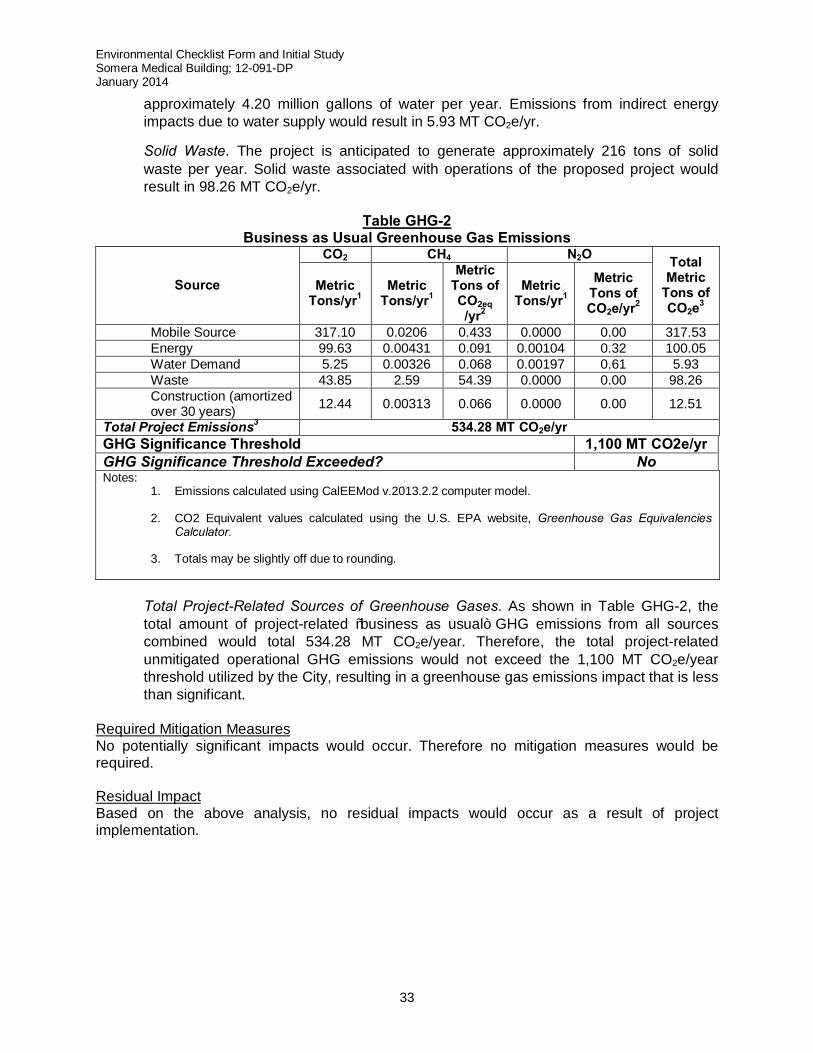
Environmental Checklist Form and Initial Study Somera Medical Building; 12-091-DP January 2014
33
approximately 4.20 million gallons of water per year. Emissions from indirect energy impacts due to water supply would result in 5.93 MT CO2e/yr.
Solid Waste. The project is anticipated to generate approximately 216 tons of solid waste per year. Solid waste associated with operations of the proposed project would result in 98.26 MT CO2e/yr.
Table GHG-2
Business as Usual Greenhouse Gas Emissions
Source
CO2 CH4 N2O Total Metric
Tons of CO2e3
Metric Tons/yr1
Metric Tons/yr1
Metric Tons of CO2eq /yr2
Metric Tons/yr1
Metric Tons of CO2e/yr2
Mobile Source 317.10 0.0206 0.433 0.0000 0.00 317.53 Energy 99.63 0.00431 0.091 0.00104 0.32 100.05 Water Demand 5.25 0.00326 0.068 0.00197 0.61 5.93 Waste 43.85 2.59 54.39 0.0000 0.00 98.26 Construction (amortized
over 30 years) 12.44 0.00313 0.066 0.0000 0.00 12.51
Total Project Emissions3 534.28 MT CO2e/yr GHG Significance Threshold 1,100 MT CO2e/yr GHG Significance Threshold Exceeded? No Notes:
1. Emissions calculated using CalEEMod v.2013.2.2 computer model.
2. CO2 Equivalent values calculated using the U.S. EPA website, Greenhouse Gas Equivalencies Calculator.
3. Totals may be slightly off due to rounding.
Total Project-Related Sources of Greenhouse Gases. As shown in Table GHG-2, the total amount of project-related “business as usual” GHG emissions from all sources combined would total 534.28 MT CO2e/year. Therefore, the total project-related unmitigated operational GHG emissions would not exceed the 1,100 MT CO2e/year threshold utilized by the City, resulting in a greenhouse gas emissions impact that is less than significant.
Required Mitigation Measures No potentially significant impacts would occur. Therefore no mitigation measures would be required. Residual Impact Based on the above analysis, no residual impacts would occur as a result of project implementation.
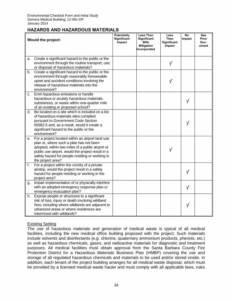
Environmental Checklist Form and Initial Study Somera Medical Building; 12-091-DP January 2014
34
HAZARDS AND HAZARDOUS MATERIALS Would the project:
Potentially Significant
Impact Less Than Significant
With Mitigation
Incorporated
Less Than
Significant Impact
No Impact
See Prior Doc-
ument
a. Create a significant hazard to the public or the environment through the routine transport, use, or disposal of hazardous materials?
■
b. Create a significant hazard to the public or the environment through reasonably foreseeable upset and accident conditions involving the release of hazardous materials into the environment?
■
c. Emit hazardous emissions or handle hazardous or acutely hazardous materials, substances, or waste within one-quarter mile of an existing or proposed school?
■
d. Be located on a site which is included on a list of hazardous materials sites compiled pursuant to Government Code Section 65962.5 and, as a result, would it create a significant hazard to the public or the environment?
■
e. For a project located within an airport land use plan or, where such a plan has not been adopted, within two miles of a public airport or public use airport, would the project result in a safety hazard for people residing or working in the project area?
■
f. For a project within the vicinity of a private airstrip, would the project result in a safety hazard for people residing or working in the project area?
■
g. Impair implementation of or physically interfere with an adopted emergency response plan or emergency evacuation plan?
■
h. Expose people or structures to a significant risk of loss, injury or death involving wildland fires, including where wildlands are adjacent to urbanized areas or where residences are intermixed with wildlands?
■
Existing Setting The use of hazardous materials and generation of medical waste is typical of all medical facilities, including the new medical office building proposed with the project. Such materials include solvents and disinfectants (e.g. chlorine, quaternary ammonium products, phenols, etc.) as well as hazardous chemicals, gases, and radioactive materials for diagnostic and treatment purposes. All medical facilities must obtain approval from the Santa Barbara County Fire Protection District for a Hazardous Materials Business Plan (HMBP) covering the use and storage of all regulated hazardous chemicals and materials to be used and/or stored onsite. In addition, each tenant of the project building arranges for all medical waste disposal, which must be provided by a licensed medical waste hauler and must comply with all applicable laws, rules
Environmental Checklist Form and Initial Study Somera Medical Building; 12-091-DP January 2014
35
and regulations (including California Health and Safety Code Section 117600 et seq.). The project site is not listed by the State as a hazardous materials site pursuant to Government Code Section 65962.5 (Cortese List). The project site lies to the east of the Santa Barbara Municipal Airport (SBMA), within the Approach Zone but well beyond the one-mile marker of the eastern end of Runway 7-25. There are no other airports or airstrips within two miles of the project site. The closest school to the project site is Hollister Elementary School located approximately 0.75 miles to the east. Thresholds of Significance A significant impact with regard to hazards and hazardous materials would be expected to occur if the proposed project resulted in any of the impacts noted in the above checklist. In addition, the City’s Environmental Thresholds and Guidelines Manual addresses public safety impacts resulting from involuntary exposure to hazardous materials. These thresholds focus on the activities that include the installation or modification to facilities that handle hazardous materials, transportation of hazardous materials, or non-hazardous land uses in proximity to hazardous facilities. Section 14.C of the City’s Environmental Thresholds and Guidelines Manual includes 12 separate criteria for what types of activities and facilities are considered potentially hazardous given the nature of the use involved. Although the project will involve the use and transportation of various materials and waste considered hazardous, the quantities involved do not meet the criteria set forth in Section 14.C. Therefore, the City’s risk based thresholds are not particularly applicable to this particular project. However, for the purposes of this analysis, the project would be considered to pose a significant impact if it results in the exposure of people to a variety of hazards or hazardous materials as listed above. Project Specific Impacts a,b) As noted in the discussion of the project’s existing setting, the use of hazardous materials
and generation of hazardous/medical waste is a normal part of operations for medical facilities such as the medical office building (MOB) proposed on the project site. The California Department of Health regulates the disposal of medical waste and issues permits to the MOB for the onsite handling and disposal of medical waste in compliance with the Medical Waste Management Act. The MOB is required to follow specific protocols for handling, transporting, and storing the waste onsite as well as protocols for the pick-up, transportation, and destruction of the waste offsite by licensed haulers. No out of the ordinary medical related activities are planned to occur within the building. Therefore, the project building would create less than significant hazardous impacts to the public and environment based on conformance with state regulations and procedures in handling potentially hazardous materials.
c) There are no existing or proposed schools within 0.25 miles of the project site. The
nearest school to the project site is the Hollister Elementary School located approximately 0.75 miles to the east. Therefore, the potential hazard to schools in the area resulting from an accidental release of any hazardous material or medical waste would be considered less than significant.
d) The project site is not listed on the Cortese List (Gov’t Code §65962.5) as a hazardous
materials site, and as such, project implementation would not result in a significant impact on the public and/or environment due to development on a designated hazardous site.
Environmental Checklist Form and Initial Study Somera Medical Building; 12-091-DP January 2014
36
e) As noted above in the project’s existing setting, the project site lies to the east of the Santa Barbara Municipal Airport (SBMA), within the Approach Zone but beyond the one-mile marker of the end of Runway 25. The City’s zoning regulations for the Airport Overlay contain restrictions on height and land use compatibility to implement the Santa Barbara County Airport Land Use Plan (adopted October, 1993). These regulations apply to the project site. The height of the proposed building would not exceed 35 feet from finished grade, which is far lower than height restrictions for development within the Approach Zone of Runway 25 and the Federal Aviation Regulations (FAR) for height requirements for development within 2000 feet of a runway. None of the uses proposed within the new medical office building are incompatible with uses allowed within the Approach Zone. Based on this understanding of the project and its regulatory setting, impacts due to exposure to potential airport hazards are considered to be less than significant.
f) No private airstrips are located within the vicinity of the project site, so no impacts would
result from proximity to such private airstrips. g,h) The project would not result in the construction of any new facilities or establishment of
new uses that could impair implementation of or physically interfere with an adopted emergency response plan or emergency evacuation plan. The project site is located well outside of the City’s Wildland Fire Hazard Area; therefore there would be no exposure to risks involving wildland fires.
Cumulative Impacts Given the proposed project’s mandated conformance with state regulations and procedures for the handling of hazardous materials and/or hazardous medical waste, the project’s contribution to such cumulative risk of exposure of the public and/or environment to hazardous materials and hazardous medical waste would be considered less than significant. Required/Recommended Mitigation Measures Based on the above analysis and nature of the project, no mitigation measures are necessary. Residual Impact Based upon the proposed project’s mandated conformance with state regulations and procedures for the handling of hazardous materials and/or hazardous medical waste, residual impacts on Hazards and Hazardous Materials would be less than significant.
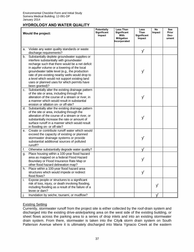
Environmental Checklist Form and Initial Study Somera Medical Building; 12-091-DP January 2014
37
HYDROLOGY AND WATER QUALITY Would the project:
Potentially Significant
Impact Less Than Significant
With Mitigation
Incorporated
Less Than
Significant Impact
No Impact
See Prior Doc-
ument
a. Violate any water quality standards or waste discharge requirements? ■
b. Substantially deplete groundwater supplies or interfere substantially with groundwater recharge such that there would be a net deficit in aquifer volume or a lowering of the local groundwater table level (e.g., the production rate of pre-existing nearby wells would drop to a level which would not support existing land uses or planned uses for which permits have been granted)?
■
c. Substantially alter the existing drainage pattern of the site or area, including through the alteration of the course of a stream or river, in a manner which would result in substantial erosion or siltation on- or off-site?
■
d. Substantially alter the existing drainage pattern of the site or area, including through the alteration of the course of a stream or river, or substantially increase the rate or amount of surface runoff in a manner which would result in flooding on- or off-site?
■
e. Create or contribute runoff water which would exceed the capacity of existing or planned stormwater drainage systems or provide substantial additional sources of polluted runoff?
■
f. Otherwise substantially degrade water quality? ■ g. Place housing within a 100-year flood hazard
area as mapped on a federal Flood Hazard Boundary or Flood Insurance Rate Map or other flood hazard delineation map?
■
h. Place within a 100-year flood hazard area structures which would impede or redirect flood flows?
■
i. Expose people or structures to a significant risk of loss, injury, or death involving flooding, including flooding as a result of the failure of a levee or dam?
■
j. Inundation by seiche, tsunami, or mudflow? ■ Existing Setting Currently, stormwater runoff from the project site is either collected by the roof-drain system and discharged into the existing drive-aisle/parking area on the west side of the existing building, or sheet flows across the parking area to a series of drop inlets and into an existing stormwater drain system. From there, stormwater is taken into the City’s storm drain system on South Patterson Avenue where it is ultimately discharged into Maria Ygnacio Creek at the eastern
Environmental Checklist Form and Initial Study Somera Medical Building; 12-091-DP January 2014
38
terminus of Ekwill Street. The project site lies well outside of the regulatory floodway and the 100 and 500-year floodplains of Maria Ygnacio Creek as designated on the FEMA FIRM maps. All sewage effluent from the existing Medical Office Building (MOB) on site is handled by the Goleta Sanitary District’s (GSD’s) collection and treatment system and would also service the proposed project when built. Water for the existing MOB on the site is supplied by the Goleta Water District (GWD), which would also service the proposed project when built. Thresholds of Significance A significant impact on hydrology and water quality would be expected to occur if the proposed project resulted in any of the impacts noted in the above checklist. In addition, the City’s Environmental Thresholds and Guidelines Manual stipulates that a significant impact on hydrology and water resources would occur if a project would result in a substantial alteration of existing drainage patterns, alter the course of a stream or river, or increase the rate of surface runoff to the extent that flooding occurs or substantially degrades water quality. Project Specific Impacts a) Under the post-project conditions, project storm water would mainly be exposed to roofs,
walkways, and the parking lot. The anticipated pollutants of concern consist of trash, nutrients, bacteria, sediment, pesticides, oil, and hydrocarbons. Mitigation measures, such as Low Impact Development (LID) consisting of catch basin inserts, will be utilized to decrease pollutant exposure to storm drains. The California Department of Health regulates the disposal of medical waste and issues permits to medical office buildings) for the onsite handling and disposal of medical waste in compliance with the Medical Waste Management Act (California Health and Safety Code, Sections 117600-118360).The proposed medical office building is required by the California Department of Health to follow specific protocols for handling, transporting, and storing of medical waste onsite as well as protocols for the pick-up, transportation, and destruction of the medical waste offsite by licensed haulers. Substances that are not defined as medical waste by the Medical Waste Management Act, such as urine and feces would be disposed of in the sanitary sewer system. Therefore, the project would result in less than significant impacts concerning water quality standards or waste discharge.
b) The project site consists of approximately 3.42 acres of paved or roofed surfaces with
planters, totaling approximately 85% of impervious surfaces. With the addition of the proposed building, new paving and several landscaping and water infiltration features to the project site, the project would increase site imperviousness by 1%, resulting in a total 86% of impervious surfaces on the project site. Volume maintenance on the project site was accomplished by application of LID techniques prescribed by the U.S. Environmental Protection Agency (US EPA) which incorporates landscaping filtering devices to treat and reduce stormwater run-off. Based on the data from the applicant’s preliminary hydrology report, the proposed project would result in a slight decrease in pervious area of 2,178 SF or 1% of the total project site. Using these changes in pervious versus impervious surfaces, the preliminary hydrology report estimates that stormwater runoff for the 10-year storm, event (such as rainfalls or floods) would decrease by -0.61 cubic foot/second (CFS), -0.65 CFS and -0.67 CFS respectively for the 25 and 50 year events, and -0.69 CFS for the 100-year event. The project site lies within the Central Sub-basin of the Goleta Groundwater Basin (GGWB). The Central Sub-basin allows for only minor recharge into the GGWB due to the type of sediments found there (City of Goleta General Plan/Coastal Land Use Plan FEIR, September, 2006). Given the de minimis change in stormwater runoff volumes and decrease in
Environmental Checklist Form and Initial Study Somera Medical Building; 12-091-DP January 2014
39
pervious surface, as well as the project’s location in the Central Sub-basin of the GGWB, project impacts on groundwater recharge would be less than significant.
c-e) As noted above, the volume of stormwater runoff will slightly decrease with the proposed
medical office building through the installation of proposed landscape features to be constructed to the west of building, where it would receive biofiltration before being captured in a series of grate inlets and conveyed via an aboveground storm drain towards South Patterson Avenue.
The City’s storm drain system then discharges into Maria Ygnacio Creek at the eastern terminus of Ekwill Street. All new inlets connected to this storm drain system would have FloGard Series Catch Basin Insert Filters installed to provide for removal of sediment, debris, trash, and oils/grease from low stormwater flows (first flush) (www.dumooresystems.com/Catch-Basin-Filters.asp). This proposed drainage system would not alter any existing, offsite drainage pattern in the area or result in any increase in flooding potential. The storage capacity of the proposed 6” perforated storm drains and associated percolation potential would ensure that the post development stormwater discharge rate would not exceed that of the existing development on the site. In fact, the upgrade of the existing, unfiltered drop inlets to inlets with catch basin insert filters capable of removing sediment, trash, debris, and oil/grease could significantly improve the water quality of the stormwater discharged offsite and into the receiving waters of Maria Ygnacio Creek. Therefore, project impacts on drainage patterns and stormwater volumes would have a positive benefit and the project would have less than significant impacts on the existing drainage system and stormwater runoff.
f) Currently, none of the drop inlets within the project site that collect stormwater for conveyance into the City’s storm drain system have any type of filtration incorporated into them. Therefore, any trash, debris, sediment, or petroleum products picked up by stormwater as it flows over the existing parking area/drive aisle into the storm drain flows into the entire City storm drain system and ultimately into the receiving waters of the City’s creeks, Goleta Slough, and offshore waters. As noted above, under the proposed project all inlets would be fitted with catch basin insert filters capable of removing sediment, trash, debris, and petroleum products from low flow (first flush) stormwater runoff. With the utilization of catch basin insert filters there would be a positive benefit and the project would have less than significant impacts to water quality.
g,h) As noted above, the project site lies outside FEMA’s designated Zone X (500-year
floodplain or 0.2% chance of occurrence in any given year) and well out of both the 100-year floodplain and regulatory floodway of Maria Ygnacio Creek. There are no levees or dams upstream of the project site on Maria Ygnacio Creek that could pose a potentially significant risk to populated areas downstream in the event of a dam or levee failure. Therefore, potential exposure of people and property to flooding risks associated with the proposed project would be less than significant.
i,j) There are no levees or dams from the project site to the top of its watershed. The entirety of the site lies outside the City’s Potential Tsunami Run-Up Area as mapped by the City’s General Plan. Therefore, no impacts to people and property associated with a tsunami or the failure of an upstream levee and/or dam would occur.
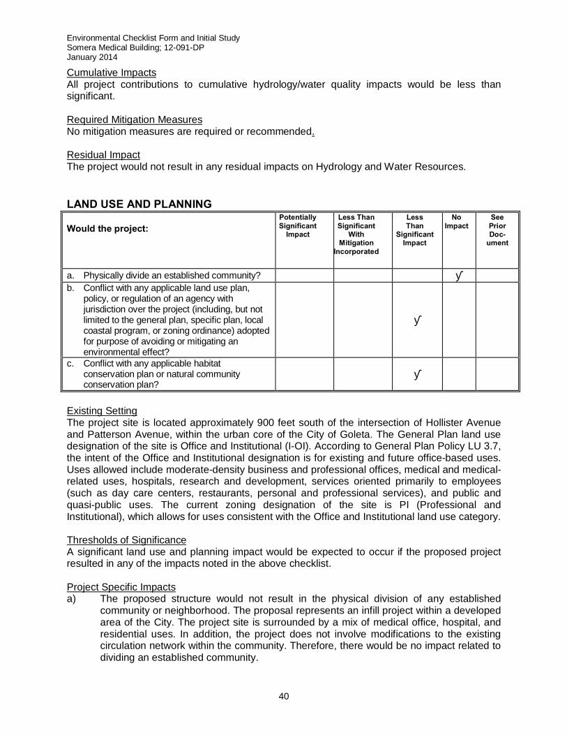
Environmental Checklist Form and Initial Study Somera Medical Building; 12-091-DP January 2014
40
Cumulative Impacts All project contributions to cumulative hydrology/water quality impacts would be less than significant. Required Mitigation Measures No mitigation measures are required or recommended. Residual Impact The project would not result in any residual impacts on Hydrology and Water Resources. LAND USE AND PLANNING Would the project:
Potentially Significant
Impact Less Than Significant
With Mitigation
Incorporated
Less Than
Significant Impact
No Impact
See Prior Doc-
ument
a. Physically divide an established community? ■ b. Conflict with any applicable land use plan,
policy, or regulation of an agency with jurisdiction over the project (including, but not limited to the general plan, specific plan, local coastal program, or zoning ordinance) adopted for purpose of avoiding or mitigating an environmental effect?
■
c. Conflict with any applicable habitat conservation plan or natural community conservation plan?
■
Existing Setting The project site is located approximately 900 feet south of the intersection of Hollister Avenue and Patterson Avenue, within the urban core of the City of Goleta. The General Plan land use designation of the site is Office and Institutional (I-OI). According to General Plan Policy LU 3.7, the intent of the Office and Institutional designation is for existing and future office-based uses. Uses allowed include moderate-density business and professional offices, medical and medical-related uses, hospitals, research and development, services oriented primarily to employees (such as day care centers, restaurants, personal and professional services), and public and quasi-public uses. The current zoning designation of the site is PI (Professional and Institutional), which allows for uses consistent with the Office and Institutional land use category. Thresholds of Significance A significant land use and planning impact would be expected to occur if the proposed project resulted in any of the impacts noted in the above checklist. Project Specific Impacts a) The proposed structure would not result in the physical division of any established
community or neighborhood. The proposal represents an infill project within a developed area of the City. The project site is surrounded by a mix of medical office, hospital, and residential uses. In addition, the project does not involve modifications to the existing circulation network within the community. Therefore, there would be no impact related to dividing an established community.
Environmental Checklist Form and Initial Study Somera Medical Building; 12-091-DP January 2014
41
b) The project’s land use, a medical office building, is an allowed and permitted use within
the Office and Institutional land use category (General Plan) and the PI (Professional and Institutional) Zone District within Article III, Inland Zoning Ordinance. The Office and Institutional use category includes lands intended to support the needs of the Goleta Valley Cottage Hospital (GVCH) and related medical services. The GP/CLUP specifically acknowledges the GVCH parcel (to the west of the project site) as the sole parcel within the adopted Hospital Overlay District, which gives allowances to both maximum building height and maximum lot coverage. However, the project site is not included in the Hospital Overlay District and is not privy to the allowances. The proposed project is consistent with the applicable requirements of the City’s Inland Zoning Ordinance (Article III, Chapter 35 of the Municipal Code) including permissible uses, maximum building height and lot coverage. The maximum building height for the project is 35 feet which is in conformance with Professional and Institutional Zoning District of Article III, Inland Zoning Ordinance. The proposed lot coverage of all buildings of the project site is 24%, which is the under the maximum lot coverage allowed of 40%, per Article III, Inland Zoning Ordinance. The applicant is requesting modifications to the front and side yard setbacks pursuant to Section 35-317.8 of the City’s Inland Zoning Ordinance, which allows modifications of setbacks in order to implement adequate site design of a project. The request for modifications to the front yard setback are functions of the front property line running through approximately 22 square feet of two separate paved parking surfaces at the front of the property. The second proposed modification is to allow parking spaces within 10 feet of the northern side yard setback to allow for compact parking spaces.
Pursuant to the City’s parking requirements for medical office buildings, the proposed project site (Parcel 1 of Parcel Map No. 32,053) would require a minimum of 224 spaces (1 space/200 SF). The proposed project site includes a total of 228 parking spaces. A portion of the 228 parking spaces would be provided through an agreement of reciprocal access and parking with the owners of Parcel 2 of Parcel Map No. 32, 053. During construction the existing building on the project site would remain in use as there is adequate parking for construction crew as well as employees and patients/visitors to the existing medical laboratory facility. The project site is located within the Airport Land Use Plan Approach Zone, however the project buildings height is consistent with the allowed height requirements within the Airport Land Use Plan Approach Zone, and does not require review by the Airport Land Use Commission. Based upon the above analysis and lack of conflict with applicable land use plans, policies, and regulations of the lead agency and other agencies with jurisdiction over the project, the proposed project would result in less than significant impacts for this subsection..
c) As discussed in the Biological Section above, there are no habitat or natural community
conservation plans that apply to the proposed project site. Per the General Plan Conservation Element Figure 4-1, an Environmentally Sensitive Habitat Area (ESHA) or special status species does not occur on the project site. The adjoining parcel to the east
Environmental Checklist Form and Initial Study Somera Medical Building; 12-091-DP January 2014
42
(Parcel 2 of Parcel Map No. 32, 053), does contain a riparian and creek corridor at the eastern boundary of the parcel. This parcel contains two existing buildings and 178 parking spaces. No new development is proposed for this adjoining parcel. Therefore, the project would not result in impacts to habitat conservation plans.
Cumulative Impacts Based on the above analysis, there are no cumulative impacts associated with land use and planning. Required Mitigation Measures Based on the above analysis, there are no potentially significant impacts; therefore no mitigation measures are required. Residual Impact Based on the above analysis, no residual impacts to Land Use and Planning would occur. MINERAL RESOURCES Would the project:
Potentially Significant
Impact Less Than Significant
With Mitigation
Incorporated
Less Than
Significant Impact
No Impact
See Prior Doc-
ument
a. Result in the loss of availability of a known mineral resource that would be of value to the region and the residents of the state?
■
b. Result in the loss of availability of a locally-important mineral resource recovery site delineated on a local general plan, specific plan, or other land use plan?
■
Existing Setting No known mineral resources have been identified on the project site nor would the project result in the loss of a locally important mineral resource recovery site. Thresholds of Significance A significant impact on mineral resources would be expected to occur if the proposed project resulted in any of the impacts noted in the checklist above. Project Specific Impacts a,b) The project would not result in the loss of availability of any known mineral resource or
identified resource recovery site. No such impacts would occur. Cumulative Impacts The project would have no impact on any cumulative loss of mineral resources or resource recovery sites. Required/Recommended Mitigation Measures No mitigation measures are required or recommended.
Environmental Checklist Form and Initial Study Somera Medical Building; 12-091-DP January 2014
43
Residual Impact The project would not result in any residual impacts on mineral resources. NOISE Would the project:
Potentially Significant
Impact Less Than Significant
With Mitigation
Incorporated
Less Than
Significant Impact
No Impact
See Prior Doc-
ument
a. Exposure of persons to or generation of noise levels in excess of standards established in the local general plan or noise ordinance, or applicable standards of other agencies?
■
b. Exposure of persons to or generation of excessive ground borne vibration or ground borne noise levels?
■
c. A substantial permanent increase in ambient noise levels in the project vicinity above levels existing without the project?
■
d. A substantial temporary or periodic increase in ambient noise levels in the project vicinity above levels existing without the project?
■
e. For a project located within an airport land use plan or, where such a plan has not been adopted, within two miles of a public airport or public use airport, would the project expose people residing or working in the project area to excessive noise levels?
■
f. For a project within the vicinity of a private airstrip, would the project expose people residing or working in the project area to excessive noise levels?
■
Existing Setting The Noise Element in the GP/CLUP sets the noise and land use standards for the maximum noise exposure to certain land uses. For example, pursuant to Table 9-2 in the Noise Element, noise exposure levels such as 50-67.5 A-Weighted Level Decibel (dBa) are considered normal and acceptable for office related uses. Figures 9-1 and 9-3 display the existing and future (2030) roadway noise levels for the project site and both the existing and future noise levels are projected not to exceed 65 dBa, which meets noise and land use compatibility criteria in Table 9-2. Additionally, the project site is located within the approach zone of the Santa Barbara Municipal Airport (SBMA) and is subject to occasional aircraft overflights from westbound straight-out departures. Figures 9-2 and 9-4 display the existing and future (2030) airport noise levels for the project site and both the existing and future noise levels are projected to not exceed 60dBa, which meets the land use compatibility criteria in Table 9-2 for airport related noise. Noise is defined as unwanted or objectionable sound. The measurement of sound takes into account three variables; 1) magnitude, 2) frequency, and 3) duration.
Environmental Checklist Form and Initial Study Somera Medical Building; 12-091-DP January 2014
44
Magnitude is the measure of a sound’s “loudness” and is expressed in decibels (dB) on a logarithmic scale. Decibel levels diminish (attenuate) as the distance from the noise source increases. For instance, the attenuation rate for a point noise source is 6dB every time the distance from the source is doubled. For linear sources such as Highway 101 or the railroad tracks, the attenuation is 3 dB for each doubling of distance from the source. The frequency of a sound relates to the number of times per second the sound vibrates. One vibration/second equals one hertz (Hz). Normal human hearing can detect sounds ranging from 20 Hz to 20,000 Hz. Duration is a measure of the time to which the noise receptor is exposed to the noise. Because noise levels in any given location fluctuate during the day, it is necessary to quantify the level of variation to accurately describe the noise environment. One of the best measures to describe the noise environment is the Community Noise Equivalent Level (CNEL). CNEL is a noise index that attempts to take into account differences in the intrusiveness of noise between daytime hours and nighttime hours. Specifically, CNEL weights average noise levels at different times of the day as follows:
Daytime—7 am to 7 pm Weighting Factor = 1 dB Evening—7 pm to 10 pm Weighting Factor = 5 dB Nighttime—10 pm to 7 am Weighting Factor = 10 dB
Thresholds of Significance A significant noise impact would be expected to occur if the proposed project resulted in any of the impacts noted in the above checklist. In addition, based on the City of Goleta’s Environmental Thresholds and Guidelines Manual, Section 12 Noise Thresholds, the following thresholds are used to determine whether significant noise impacts would occur
1. A development that would generate noise levels in excess of 65 dBa CNEL and could affect sensitive receptors would generally be presumed to have a significant impact.
2. Outdoor living areas of noise sensitive uses that are subject to noise levels in excess of 65 dBa CNEL would generally be presumed to be significantly impacted by ambient noise. A significant impact would also generally occur where interior noise levels cannot be reduced to 45 dBa CNEL or less.
3. A project would generally have a significant effect on the environment if it would increase substantially the ambient noise levels for noise sensitive receptors in adjoining areas. Per Threshold 1 above, this may generally be presumed to occur when ambient noise levels affecting sensitive receptors are increased to 65 dBa CNEL or more. However, a significant affect may also occur when ambient noise levels affecting sensitive receptors increase substantially but remain less than 65 dBa CNEL, as determined on a case-by-case level.
4. Noise from grading and construction activity proposed within 1,600 feet of sensitive receptors, including schools, residential development, commercial lodging facilities, hospitals or care facilities, would generally result in a potentially significant impact. According to the US EPA guidelines, the average construction noise is 95 dBa at a 50-foot distance from the source. A 6 dB drop occurs with a doubling of the distance from the source. Therefore, locations within 1,600 feet of the construction site would be
Environmental Checklist Form and Initial Study Somera Medical Building; 12-091-DP January 2014
45
affected by noise levels over 65 dBa. Construction within 1,600 feet of sensitive receptors on weekdays outside of the hours of 8:00AM to 5:00PM and on weekends would generally be presumed to have a significant effect. Noise attenuation barriers and muffling of grading equipment may also be required. Construction equipment generating noise levels above 95 dBa may require additional mitigation.
With regard to Threshold 3, the term “substantial increase” is not defined within the Thresholds Manual. The limits of perceptibility by ambient grade instrumentation (sound meters) or by humans in a laboratory environment is around 1.5 dBa Under ambient conditions, people generally do not perceive that noise has clearly changed until there is a 3 dB difference. A threshold of 3 dB is commonly used to define “substantial increase.” Therefore, for purposes of this analysis, an increase of +3 dBa CNEL in traffic noise would be considered a significant impact. Increases of +3.0 dB require a doubling of traffic volumes on already noise-impacted roadways. Projects usually do not, by themselves, cause traffic volumes to double. Offsite traffic noise impacts are therefore almost always cumulative in nature rather than individually significant. Project Specific Impacts a,c) The project site lies within the 65 dBa CNEL noise exposure contour within the City. The
primary sources of noise in the area are vehicular traffic on South Patterson and Hollister Avenues. Per Figures 9-1 and 9-3 in the Noise Element, the existing and future (2030) roadway noise levels at the project site are not expected to exceed 65 dBa. Additionally, the project site lies within the Santa Barbara Municipal Airport Approach Zone and is subject to occasional aircraft overflights from westbound straight-out departures. The City’s General Plan Noise Element, Figures 9-2 and 9-4 indicates that airport noise levels are not expected to reach 60 dBa at the project site. The Noise Element of the General Plan indicates that the range of normally acceptable noise levels for office related uses is 50-67.5 dBa. “Normally Acceptable” for a specified land use is defined as:
Satisfactory based on the assumption that any buildings involved are of normal conventional construction, without any special noise insulation requirements.
Pursuant to Table 9-2 of the Noise Element, the anticipated roadway noise level (65 dBa) and airport noise level (60 dBa) are compatible for office and related uses. As a medical office building, the project would not result in a substantial permanent increase in ambient noise levels in the project vicinity above existing levels and would not exceed the “Normally Acceptable” standards set forth in Table 9-2 in the Noise Element. Therefore, less than significant impacts on ambient noise levels would occur as a result of project implementation.
b) The proposed project would not expose persons, including neighboring sensitive receptors, such as the GVCH or residences to excessive ground borne vibration or ground borne noise levels since construction of the project would not require such vibration/noise generating construction techniques, such as the driving of foundation piles. Therefore no such impacts are expected to occur.
d) Pursuant to the City’s General Plan Noise Element, hospitals and residential areas are considered sensitive noise receptors, making them the closest sensitive receptors to the project site. Both the hospital (GVCH) and residential units are within 1,600 feet of the
Environmental Checklist Form and Initial Study Somera Medical Building; 12-091-DP January 2014
46
project site (200 feet and 400 feet respectively). Pursuant to Table 9-2 of the Noise Element, the limit of acceptable noise exposure for sensitive receptors is 60 dBa. Short term construction noise impacts, such as earth moving equipment and power tools are capable of producing noise levels 75 to 95 dBa within 50 feet of the source. The City permits construction hours from 8:00AM to 5:00PM Monday through Friday to limit noise exposure to sensitive receptors outside those hours in the mornings, evenings and weekends. However, during weekdays there is a potential for construction noise to pose a significant short term impact on sensitive receptors in the area. As such, mitigation has been included as noted below which would reduce impacts to less than significant.
e,f) As mentioned above, the project site is located in the SBMA airport approach zone and is subject to occasional aircraft overflights from westbound straight-out departures. There are no private airstrips within the vicinity of the project site Pursuant to the the Noise Element, Table 9-2, the SBMA noise levels at the project site would not exceed 60 dBa, which is acceptable for building occupants in office related uses. As such, the proposed project would have less than significant impacts for people residing or working in the project area.
Cumulative Impacts Incremental increases in ambient noise level as a result of project implementation would be a less than significant contribution to cumulative noise impacts in the vicinity of the project site. Required Mitigation Measures N-1: The following measures must be incorporated into grading and building plan
specifications to reduce the impact of construction noise:
a. All construction equipment, fixed or mobile, must be equipped with properly operating and maintained mufflers. Noise attenuation barriers and mufflers of grading equipment must be required for construction equipment generating noise levels above 95 dB at 50 feet from the source;
b. Construction noise reduction methods such as but not limited to shutting off idling equipment, installing acoustic barriers around significant sources of stationary construction noise sources, maximizing the distance between equipment and staging areas occupied residential areas, and use of electric air compressors and similar power tools (rather than diesel equipment) must be used when feasible;
c. During construction, stationary construction equipment must be placed such that emitted noise is directed away from sensitive noise receivers;
d. During construction, stockpiling and vehicle staging areas must be located as far as practicable from noise sensitive receptors
e. Earthmoving equipment operating on the construction site must be as far away from vibration-sensitive sites as possible; and
f. Construction hours, allowable workdays, the telephone number of the job superintendent and the telephone number of City staff contact(s) must be clearly posted at all construction entrances to enable surrounding owners and residents to contact the job superintendent directly. If the job superintendent receives a complaint, the superintendent must notify the Planning and Environmental Review Director, or designee, and investigate, take
Environmental Checklist Form and Initial Study Somera Medical Building; 12-091-DP January 2014
47
appropriate corrective action, and report the action taken to the reporting party and the Planning and Environmental Review Director, or designee.
Plan Requirements and Timing: The location of the three signs stating these restrictions must be identified on a site plan. The three signs stating these restrictions must be provided by the applicant/contractor and posted on site at each entrance to the project. All signs must be in place before the start of site preparation and grading activities and maintained through to occupancy clearance. Requirements a-f must be incorporated as text into all plan sets and must be incorporated graphically into all plan sets submitted for approval of any Land Use, building, or grading permits before permit approval. Monitoring: The Planning and Environmental Review Director, or designee, must verify compliance before Land Use, building, or grading permit approval. The Planning and Environmental Review Director, or designee, must periodically inspect the site to verify compliance with all noise attenuation requirements.
N-2: Stationary construction equipment that generates noise which exceeds 65 dBa at
the project boundaries must be shielded to the Planning and Environmental Review Director, or designee, satisfaction. Plan Requirements and Timing: The applicant/contractor must submit a list of all stationary equipment to be used in project construction which includes manufacturer’s specifications on equipment noise levels as well as recommendations from the project acoustical engineer to shielding such stationary equipment so that it complies with this requirement for review and approval by the Planning and Environmental Review Director. The equipment area with appropriate acoustic shielding must be designated on building and grading plans. Equipment and shielding must remain in the designated location throughout construction activities. This information must be reviewed and approved by the Planning and Environmental Review Director, or designee, before issuance of any Land Use Permit. All City approved noise attenuation measures for stationary equipment used in any construction and/or demolition activities must be implemented and maintained for the duration of the period when such equipment is on-site. Monitoring: The Planning and Environmental Review Director, or designee, must perform site inspections to verify compliance.
Residual Impact With implementation of the required mitigation measures, the residual short term construction and long term operational impacts of the proposed project would be less than significant. POPULATION AND HOUSING
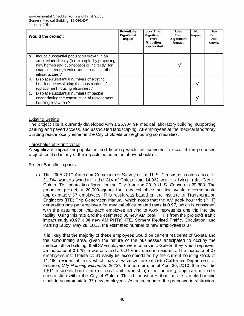
Environmental Checklist Form and Initial Study Somera Medical Building; 12-091-DP January 2014
48
Would the project:
Potentially Significant
Impact Less Than Significant
With Mitigation
Incorporated
Less Than
Significant Impact
No Impact
See Prior Doc-
ument
a. Induce substantial population growth in an area, either directly (for example, by proposing new homes and businesses) or indirectly (for example, through extension of roads or other infrastructure)?
■
b. Displace substantial numbers of existing housing, necessitating the construction of replacement housing elsewhere?
■
c. Displace substantial numbers of people, necessitating the construction of replacement housing elsewhere?
■
Existing Setting The project site is currently developed with a 25,904 SF medical laboratory building, supporting parking and paved access, and associated landscaping. All employees at the medical laboratory building reside locally either in the City of Goleta or neighboring communities. Thresholds of Significance A significant impact on population and housing would be expected to occur if the proposed project resulted in any of the impacts noted in the above checklist. Project Specific Impacts
a) The 2005-2010 American Communities Survey of the U. S. Census estimates a total of 21,764 workers working in the City of Goleta, and 14,932 workers living in the City of Goleta. The population figure for the City from the 2010 U. S. Census is 29,888. The proposed project, a 20,000-square foot medical office building would accommodate approximately 37 employees. This result was based on the Institute of Transportation Engineers (ITE) Trip Generation Manual, which notes that the AM peak hour trip (PHT) generation rate per employee for medical office related uses is 0.97, which is consistent with the assumption that each employee arriving to work represents one trip into the facility. Using this rate and the estimated 38 new AM peak PHTs from the project’s traffic impact study (0.97 x 38 new AM PHTs); ITE, Somera Revised Traffic, Circulation, and Parking Study, May 28, 2013, the estimated number of new employees is 37.
It is likely that the majority of these employees would be current residents of Goleta and the surrounding area, given the nature of the businesses anticipated to occupy the medical office building. If all 37 employees were to move to Goleta, they would represent an increase of 0.17% in workers and a 0.24% increase in residents. The increase of 37 employees into Goleta could easily be accommodated by the current housing stock of 11,486 residential units which has a vacancy rate of 5% (California Department of Finance, City Housing Estimates 2013). Furthermore, as of April 30, 2013, there will be 1,611 residential units (mix of rental and ownership) either pending, approved or under construction within the City of Goleta. This demonstrates that there is ample housing stock to accommodate 37 new employees. As such, none of the proposed infrastructure
Environmental Checklist Form and Initial Study Somera Medical Building; 12-091-DP January 2014
49
improvements needed to serve the project will be growth-inducing. The proposed project is an infill development project which will not necessitate the construction of new streets or infrastructure. Therefore, project impacts on population and growth would be less than significant.
b,c) As mentioned above there is ample housing stock available within the City of Goleta for
37 new employees. Therefore, the proposed project would not displace any existing housing units or require the displacement of any people, thereby not necessitating the construction of replacement housing.
Cumulative Impacts The project’s contribution to cumulative population growth as well as adverse impacts on the area’s housing supply would be less than significant (population growth) or non-existent (housing supply). Required/Recommended Mitigation Measures No mitigation measures are required or recommended. Residual Impact Residual impacts on population growth and the area’s housing supply, as well as the project’s contribution to such cumulative impacts would be less than significant (population) or non-existent (housing).
Environmental Checklist Form and Initial Study Somera Medical Building; 12-091-DP January 2014
50
PUBLIC SERVICES Would the project:
Potentially Significant
Impact. Less Than Significant
With Mitigation
Incorporated
Less Than
Significant Impact
No Impact
See Prior Doc-
ument
a. Result in substantial adverse physical impacts associated with the provision of new or physically altered governmental facilities, need for new or physically altered governmental facilities, the construction of which could cause significant environmental impacts, in order to maintain acceptable service ratios, response times or other performance objectives for any of these public services:
fire protection? ■ police protection? ■ schools? ■ parks? ■ other public facilities? ■
Existing Setting Fire Protection Fire protection services would be provided by the Santa Barbara County Fire Department (SBCFD) which was formed in 1957 and is governed by the Fire Protection District Law of 1987 (Health and Safety Code §§ 13800, et seq.). The closest fire station to the project site is Station #12 located at 5330 Calle Real, near the Patterson Avenue/Calle Real intersection on the north side of U. S. Highway 101. Station #12 is located within a five (5) minute response time to the project site. The National Fire Protection Association (NFPA) and SBCFD identify the following three guidelines regarding the provision of fire protection services:
1. A firefighter-to-population ratio of one firefighter on duty 24 hours a day for every 2,000 persons is the ideal goal. However, one firefighter for every 4,000 persons is the absolute maximum population that should be served.
2. A ratio of one engine company per 12,000 persons, assuming three firefighters per station (or 16,000 persons assuming four firefighters per station), represents the maximum population that should be served by a three-person crew.
3. A five-minute response time in urban areas. The mandated California Division of Occupational Safety and Health (Cal-OSHA) requirement for firefighter safety, known as the “two-in-two-out rule”, is also applicable. This rule requires a minimum of two personnel to be available outside a structure prior to entry by firefighters to provide an immediate rescue for trapped or fallen firefighters, as well as immediate assistance in rescue operations.
Environmental Checklist Form and Initial Study Somera Medical Building; 12-091-DP January 2014
51
The SBCFD has also recently implemented a dynamic deployment system, for its fire engines, in addition to the traditional static deployment system from fire stations when the station’s engine is “in house”. Dynamic deployment allows for the dispatching of engines already on the road for emergency calls rather than dispatching by a station’s “first in area”, as has been the previous practice. Basically, dynamic deployment uses a Global Positioning System (GPS) to monitor the exact location of each engine in real time. Previously, when an engine was out on routine (non-emergency) activities, such as inspections or training, the engine company was considered “in-service” and its exact location at any given moment in time was not known to County Dispatch. However, with dynamic deployment using the County’s GPS, County dispatch has real time information on the exact location of each engine at all times and can dispatch the closest, un-engaged engine to an emergency incident, regardless of which fire station’s service area the call originates from. This precludes the need for an in-service engine to have extended run times when another fire engine would be closer. The Fire Department has also added a battalion chief as the fourth fire fighter on scene, in order to meet the “two-in-two-out.” [A QUICK SENTENCE DESCRIBING WHAT 2 IN 2 OUT WOULD BE HELPFUL.] Station #12 has an engine company with a staff of four personnel, consisting of an engine company captain, engineer, firefighter and battalion chief. This engine company provides immediate response on incidents as determined by the type of call. Police Protection Police services are provided by the Santa Barbara County Sheriff’s Department under contract with the City of Goleta (City). The City is divided into 3 patrol units, with 1 police car assigned to each unit. Additional police services are available from Santa Barbara County to supplement City police in an emergency. City police operate from three locations: the City offices at 130 Cremona Drive, an office located in Old Town on Hollister Avenue, and a third location at the Camino Real Marketplace. Schools Public education services are provided by the Goleta Union School District (GUSD) and the Santa Barbara Unified School District (SBUSD). In general, enrollments in the area school system have been declining for the past several years and area schools serving the project vicinity are operating below capacity. These schools include Foothill Elementary School at 711 Ribera Drive, Kellogg Elementary School at 475 Cambridge Drive, Goleta Valley Junior High at 6100 Stow Canyon Road, and San Marcos High School at 4750 Hollister Avenue. Parks Although there are no park facilities within the immediate vicinity of the project site, access to the City’s bike path system for employees working at the project site is available by traveling east on Hollister Avenue to the Maria Ygnacio Creek Bike Path. Libraries Services at the Goleta Public Library are provided by contract with the City of Santa Barbara in a facility owned by the City at 500 North Fairview Avenue. The 2-acre library site includes a 15,437 square foot (SF) building and parking areas. The facility provides services to the City and nearby unincorporated areas. In 2010/2011, library visits were 256,996 and circulation was 606,741. Services were provided by 5 full-time and 2 part-time employees. Thresholds of Significance
Environmental Checklist Form and Initial Study Somera Medical Building; 12-091-DP January 2014
52
A significant impact on public services would be expected to occur if the proposed project resulted in any of the impacts noted in the above checklist. In addition, the City’s Environmental Thresholds and Guidelines Manual includes thresholds of significance for potential impacts on area schools. Specifically, under these thresholds, any project that would result in enough students to generate the need for an additional classroom using current State standards would be considered to result in a significant impact on area schools. The City’s Environmental Thresholds and Guidelines Manual notes current State standards are: Grades K-2, 20 students per classroom; Grades 3 -8, 29 students per classroom; and Grades 9 – 12, 28 students per classroom. Project Specific Impacts a) Fire Protection
The project includes approximately 20,000 square feet of medical office space that would be occupied by patients and employees during the building’s hours of operation. Fire protection requirements would include, but would not be limited to, structural fires, emergency medical services, public assistance, and other requests.
At 0.75 miles to the south of Fire Station 12, the project site is central to the Station’s service area. Given its close proximity to the station, along with the implementation of the dynamic deployment system, the 5-minute response guideline would be met. In the event Fire Station 12 would need back-up, other available engine companies would respond via static and/or dynamic deployment. Additionally, the applicant will be required to pay a Development Impact Fee towards fire protection for replacement of fire apparatus and equipment and a Fire Facility Fee to assist in financing fire protection capital facilities. Therefore, there would be no need for new facilities or the physical alteration of existing fire facilities.
Police Services The Santa Barbara County Sheriff’s Department provides 24-hour police protection services to the area under contract to the City of Goleta. The City of Goleta police operate from three locations: the City of Goleta offices, an office located in Old Town on Hollister Avenue, and a third location at the Camino Real Marketplace. As the proposed facility expansion would involve a minimal increase in employment levels (estimated at 37 employees), demand for police services resulting from the proposed facility expansion would not change measurably from baseline levels in the foreseeable future. As such, no altered or new police facilities would be needed and project related impacts on police services in the City would be less than significant.
Schools Only 37 new employees are estimated as a result of the proposed project, and it is assumed that the distribution of where project employees live (either within the City or neighboring communities) would remain the same. As such, the anticipated increase in project employment levels would not result in any significant increase in student enrollment either within the Goleta Union School District or Santa Barbara Unified School District in the foreseeable future. For these reasons, the proposed project would not require construction of any altered or new school facilities. Associated impacts on schools would be less than significant.
Parks Impacts to parks are discussed in the Recreation Section below.
Environmental Checklist Form and Initial Study Somera Medical Building; 12-091-DP January 2014
53
Other Public Facilities Demand for other public facilities such as the City’s public library would not significantly exceed baseline levels due to the fact that the project would involve only a minimal increase in the employed population in Goleta. Therefore, the project would not result in the need for any altered or new public facilities not already discussed and project-related impacts on other public facilities would be less than significant.
Cumulative Impacts The project would also be subject to payment of Development Impact Fees (DIFs) adopted for the purpose of requiring projects to pay a fair share of services and facilities for fire protection, police protection, libraries, and public administration associated with cumulative development. Fees are due prior to occupancy of the building. As a result of payment of these fees, the project’s contribution to cumulative impacts on police protection and library services would be less than cumulatively considerable and is considered less than significant. Required Mitigation Measures Based on the above analysis, no mitigation measures would be required. Residual Impact With implementation of this mitigation measure, residual impacts on public services and facilities would be less than significant. RECREATION
Potentially Significant
Impact Less Than Significant
With Mitigation
Incorporated
Less Than
Significant Impact
No Impact
See Prior Doc-
ument
a. Would the project increase the use of existing neighborhood and regional parks or other recreational facilities such that substantial physical deterioration of the facility would occur or be accelerated?
■
b. Does the project include recreational facilities or require the construction or expansion of recreational facilities which might have an adverse physical effect on the environment?
■
Existing Setting The City of Goleta has 16 public parks, 4 private parks, and 18 public open space areas comprising a total of 507 acres or approximately 17 acres per thousand residents. In addition, the City owns approximately 40 percent of Goleta’s two miles of Pacific shoreline, providing the public with additional opportunities for enjoyment of natural areas. According to the Goleta General Plan/Coastal Land Use Plan, three of the 20 public open space areas are large City-owned regional open space preserves including the Sperling Preserve, Santa Barbara Shores, and Lake Los Carneros Natural and Historical Preserve, which collectively account for approximately 363 acres (70 percent) of the total park and open space area, excluding shoreline areas, within the City. These open space preserves are available for passive recreation only and do not provide facilities that address the City’s active recreational needs.
Environmental Checklist Form and Initial Study Somera Medical Building; 12-091-DP January 2014
54
While recognizing the many acres of open space available for passive recreation, the Goleta General Plan/Coastal Land Use Plan identified a deficit in active public recreational space. In 2005, when the General Plan/Coastal Land Use Plan was drafted, the City had approximately 3 acres of active recreational area per thousand residents. In the public workshop process that preceded the Plan’s adoption, residents indicated that increasing the number of active parks was an important community need. The City’s single community center, the Goleta Valley Community Center, is insufficient to satisfy all of the needs of community groups and residents seeking to access the facility. In addition, although the privately owned and managed Girsh Park provides much-needed facilities for active recreation, there continues to be a shortage of publicly owned and managed active recreation facilities such as sports fields, tennis courts, and dedicated trails. The City has adopted a goal of providing 4.7 acres of parkland (open space lands whose primary purpose is recreation) per thousand residents. There are no parks or recreational facilities within the vicinity of the project site The closest facility is the Goleta Valley Community Center, approximately 0.7 miles west of the project site. Access to the City’s bike path system is available by travelling a short distance to the east, where the Maria Ygnacio Bike Path is located below the Maria Ygnacio Creek Bridge on Hollister Avenue. Thresholds of Significance A significant impact on Recreation would occur if the proposed project resulted in any of the impacts noted in the above checklist. Project Specific Impacts a) Using the City’s standard of 4.7 acres of park space per 1,000 residents (as noted in the
Existing Setting above), the addition of 37 employees (0.17% increase in workforce) to the City’s workforce as a result of the project would not generate any new, significant demand for park space within the City. The addition of 37 employees to the City’s workforce is an insignificant number of employees that would utilize the City’s existing regional parks or recreational facilities. Due to the small number of employees, the project would not generate a cumulative impact that would lead to an incremental substantial physical deterioration of such community resources. Therefore, the proposed project would not require the need for an expanded or new public park, and as such, would have less than significant impacts on recreation facilities within the City of Goleta.
b) No recreational facilities are proposed with this project; therefore no impacts associated with the construction of such facilities would occur.
Cumulative Impacts As noted above, the project would not result in any significant project-specific effects on recreational facilities or create any substantial new demand for such public amenities. Given the scope and nature of the project, the project will be required to pay for park development impact fees as per Goleta Municipal Code Chapter 16.14, which would be used to fund public park facilities that would meet the incremental demand for recreational facilities created by the project. As such, the project’s cumulative contribution can be offset and the project’s impact on recreational facilities is less than significant. Required/Recommended Mitigation Measures No mitigation is recommended or required.
Environmental Checklist Form and Initial Study Somera Medical Building; 12-091-DP January 2014
55
Residual Impact Residual demand for parks and recreational facilities generated by the proposed project would be adverse but less than significant. TRANSPORTATION/TRAFFIC Would the project:
Potentially Significant
Impact Less Than Significant
With Mitigation
Incorporated
Less Than
Significant Impact
No Impact
See Prior Doc-
ument
a. Cause an increase in traffic which is substantial in relation to the existing traffic load and capacity of the street system (i.e., result in a substantial increase in either the number of vehicle trips, the volume to capacity ratio on roads, or congestion at intersections)?
■
b. Exceed, either individually or cumulatively, a level of service standard established by the county congestion management agency for designated roads or highways?
■
c. Conflict with an applicable plan, ordinance, or policy establishing measures of effectiveness for the performance of the circulation system, taking into account all modes of transportation including mass transit and non-motorized travel and relevant components of the circulation system, including but not limited to intersections, streets, highways and freeways, pedestrian and bicycle paths, and mass transit?
■
d. Conflict with and applicable congestion management program, including, but not limited to level of service standards and travel demand measures, or other standards established by the county congestion management agency for designated roads or highways?
■
e. Result in a change in air traffic patterns, including either an increase in traffic levels or a change in location that results in substantial safety risks?
■
f. Substantially increase hazards due to a design feature (e.g., sharp curves or dangerous intersections) or incompatible uses (e.g., farm equipment)?
■
g. Result in inadequate emergency access? ■ h. Conflict with adopted policies, plans, or
programs regarding public transit, bicycle, or pedestrian facilities, or otherwise decrease the performance or safety or such facilities?
■
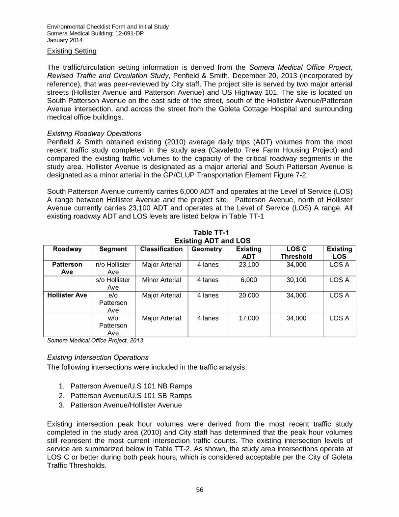
Environmental Checklist Form and Initial Study Somera Medical Building; 12-091-DP January 2014
56
Existing Setting The traffic/circulation setting information is derived from the Somera Medical Office Project, Revised Traffic and Circulation Study, Penfield & Smith, December 20, 2013 (incorporated by reference), that was peer-reviewed by City staff. The project site is served by two major arterial streets (Hollister Avenue and Patterson Avenue) and US Highway 101. The site is located on South Patterson Avenue on the east side of the street, south of the Hollister Avenue/Patterson Avenue intersection, and across the street from the Goleta Cottage Hospital and surrounding medical office buildings. Existing Roadway Operations Penfield & Smith obtained existing (2010) average daily trips (ADT) volumes from the most recent traffic study completed in the study area (Cavaletto Tree Farm Housing Project) and compared the existing traffic volumes to the capacity of the critical roadway segments in the study area. Hollister Avenue is designated as a major arterial and South Patterson Avenue is designated as a minor arterial in the GP/CLUP Transportation Element Figure 7-2. South Patterson Avenue currently carries 6,000 ADT and operates at the Level of Service (LOS) A range between Hollister Avenue and the project site. Patterson Avenue, north of Hollister Avenue currently carries 23,100 ADT and operates at the Level of Service (LOS) A range. All existing roadway ADT and LOS levels are listed below in Table TT-1
Table TT-1
Existing ADT and LOS Roadway Segment Classification Geometry Existing
ADT LOS C
Threshold Existing
LOS Patterson
Ave n/o Hollister
Ave Major Arterial 4 lanes 23,100 34,000 LOS A
s/o Hollister Ave
Minor Arterial 4 lanes 6,000 30,100 LOS A
Hollister Ave e/o Patterson
Ave
Major Arterial 4 lanes 20,000 34,000 LOS A
w/o Patterson
Ave
Major Arterial 4 lanes 17,000 34,000 LOS A
Somera Medical Office Project, 2013 Existing Intersection Operations The following intersections were included in the traffic analysis:
1. Patterson Avenue/U.S 101 NB Ramps 2. Patterson Avenue/U.S 101 SB Ramps 3. Patterson Avenue/Hollister Avenue
Existing intersection peak hour volumes were derived from the most recent traffic study completed in the study area (2010) and City staff has determined that the peak hour volumes still represent the most current intersection traffic counts. The existing intersection levels of service are summarized below in Table TT-2. As shown, the study area intersections operate at LOS C or better during both peak hours, which is considered acceptable per the City of Goleta Traffic Thresholds.
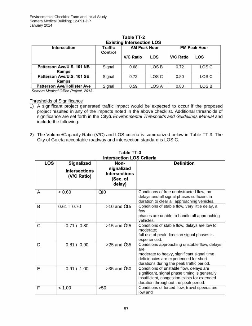
Environmental Checklist Form and Initial Study Somera Medical Building; 12-091-DP January 2014
57
Table TT-2
Existing Intersection LOS Intersection Traffic
Control AM Peak Hour
V/C Ratio LOS
PM Peak Hour V/C Ratio LOS
Patterson Ave/U.S. 101 NB Ramps
Signal 0.68 LOS B 0.72 LOS C
Patterson Ave/U.S. 101 SB Ramps
Signal 0.72 LOS C 0.80 LOS C
Patterson Ave/Hollister Ave Signal 0.59 LOS A 0.80 LOS B Somera Medical Office Project, 2013
Thresholds of Significance 1) A significant project generated traffic impact would be expected to occur if the proposed
project resulted in any of the impacts noted in the above checklist. Additional thresholds of significance are set forth in the City’s Environmental Thresholds and Guidelines Manual and include the following:
2) The Volume/Capacity Ratio (V/C) and LOS criteria is summarized below in Table TT-3. The City of Goleta acceptable roadway and intersection standard is LOS C.
Table TT-3
Intersection LOS Criteria LOS Signalized
Intersections (V/C Ratio)
Non-signalized
Intersections (Sec. of delay)
Definition
A < 0.60 ≤10 Conditions of free unobstructed flow, no delays and all signal phases sufficient in duration to clear all approaching vehicles.
B 0.61 – 0.70 >10 and ≤15 Conditions of stable flow, very little delay, a few phases are unable to handle all approaching vehicles.
C 0.71 – 0.80 >15 and ≤25 Conditions of stable flow, delays are low to moderate; full use of peak direction signal phases is experienced.
D 0.81 – 0.90 >25 and ≤35 Conditions approaching unstable flow, delays are moderate to heavy, significant signal time deficiencies are experienced for short durations during the peak traffic period.
E 0.91 – 1.00 >35 and ≤50 Conditions of unstable flow, delays are significant, signal phase timing is generally insufficient, congestion exists for extended duration throughout the peak period.
F < 1.00 >50 Conditions of forced flow, travel speeds are low and
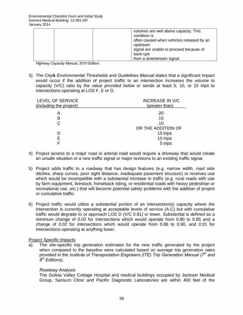
Environmental Checklist Form and Initial Study Somera Medical Building; 12-091-DP January 2014
58
volumes are well above capacity. This condition is often caused when vehicles released by an upstream signal are unable to proceed because of back-ups from a downstream signal
Highway Capacity Manual, 2010 Edition.
3) The City’s Environmental Thresholds and Guidelines Manual states that a significant impact
would occur if the addition of project traffic to an intersection increases the volume to capacity (V/C) ratio by the value provided below or sends at least 5, 10, or 15 trips to intersections operating at LOS F, E or D.
LEVEL OF SERVICE INCREASE IN V/C (including the project) (greater than)
A .20 B .15 C .10
OR THE ADDITION OF D 15 trips E 10 trips F 5 trips
4) Project access to a major road or arterial road would require a driveway that would create
an unsafe situation or a new traffic signal or major revisions to an existing traffic signal. 5) Project adds traffic to a roadway that has design features (e.g. narrow width, road side
ditches, sharp curves, poor sight distance, inadequate pavement structure) or receives use which would be incompatible with a substantial increase in traffic (e.g. rural roads with use by farm equipment, livestock, horseback riding, or residential roads with heavy pedestrian or recreational use, etc.) that will become potential safety problems with the addition of project or cumulative traffic.
6) Project traffic would utilize a substantial portion of an intersection(s) capacity where the intersection is currently operating at acceptable levels of service (A-C) but with cumulative traffic would degrade to or approach LOS D (V/C 0.81) or lower. Substantial is defined as a minimum change of 0.03 for intersections which would operate from 0.80 to 0.85 and a change of 0.02 for intersections which would operate from 0.86 to 0.90, and 0.01 for intersections operating at anything lower.
Project Specific Impacts a) The site-specific trip generation estimates for the new traffic generated by the project
when compared to the baseline were calculated based on average trip generation rates provided in the Institute of Transportation Engineers (ITE) Trip Generation Manual (7th and 8th Editions).
Roadway Analysis
The Goleta Valley Cottage Hospital and medical buildings occupied by Jackson Medical Group, Sansum Clinic and Pacific Diagnostic Laboratories are within 400 feet of the
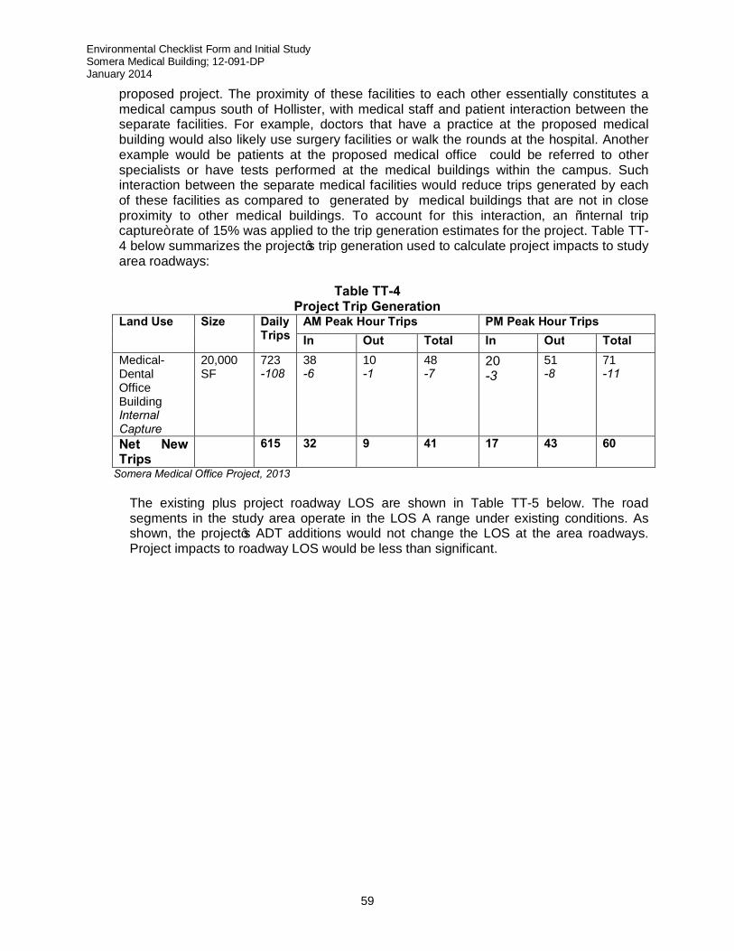
Environmental Checklist Form and Initial Study Somera Medical Building; 12-091-DP January 2014
59
proposed project. The proximity of these facilities to each other essentially constitutes a medical campus south of Hollister, with medical staff and patient interaction between the separate facilities. For example, doctors that have a practice at the proposed medical building would also likely use surgery facilities or walk the rounds at the hospital. Another example would be patients at the proposed medical office could be referred to other specialists or have tests performed at the medical buildings within the campus. Such interaction between the separate medical facilities would reduce trips generated by each of these facilities as compared to generated by medical buildings that are not in close proximity to other medical buildings. To account for this interaction, an “internal trip capture” rate of 15% was applied to the trip generation estimates for the project. Table TT-4 below summarizes the project’s trip generation used to calculate project impacts to study area roadways:
Table TT-4
Project Trip Generation Land Use Size Daily
Trips AM Peak Hour Trips PM Peak Hour Trips In Out Total In Out Total
Medical-Dental Office Building Internal Capture
20,000 SF
723 -108
38 -6
10 -1
48 -7
20 -3
51 -8
71 -11
Net New Trips
615
32 9 41 17 43 60
Somera Medical Office Project, 2013 The existing plus project roadway LOS are shown in Table TT-5 below. The road
segments in the study area operate in the LOS A range under existing conditions. As shown, the project’s ADT additions would not change the LOS at the area roadways. Project impacts to roadway LOS would be less than significant.
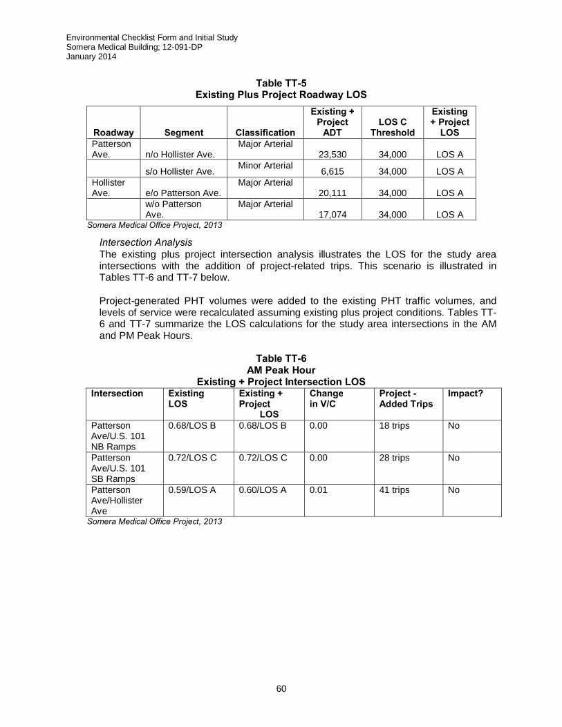
Environmental Checklist Form and Initial Study Somera Medical Building; 12-091-DP January 2014
60
Table TT-5
Existing Plus Project Roadway LOS
Roadway Segment Classification
Existing + Project
ADT LOS C
Threshold
Existing + Project
LOS Patterson Ave. n/o Hollister Ave.
Major Arterial 23,530 34,000 LOS A
s/o Hollister Ave. Minor Arterial 6,615 34,000 LOS A Hollister Ave. e/o Patterson Ave.
Major Arterial 20,111 34,000 LOS A
w/o Patterson Ave.
Major Arterial 17,074 34,000 LOS A
Somera Medical Office Project, 2013
Intersection Analysis The existing plus project intersection analysis illustrates the LOS for the study area intersections with the addition of project-related trips. This scenario is illustrated in Tables TT-6 and TT-7 below.
Project-generated PHT volumes were added to the existing PHT traffic volumes, and
levels of service were recalculated assuming existing plus project conditions. Tables TT-6 and TT-7 summarize the LOS calculations for the study area intersections in the AM and PM Peak Hours.
Table TT-6
AM Peak Hour Existing + Project Intersection LOS
Intersection Existing LOS
Existing + Project
LOS
Change in V/C
Project - Added Trips
Impact?
Patterson Ave/U.S. 101 NB Ramps
0.68/LOS B 0.68/LOS B 0.00 18 trips No
Patterson Ave/U.S. 101 SB Ramps
0.72/LOS C 0.72/LOS C 0.00 28 trips No
Patterson Ave/Hollister Ave
0.59/LOS A
0.60/LOS A 0.01
41 trips No
Somera Medical Office Project, 2013

Environmental Checklist Form and Initial Study Somera Medical Building; 12-091-DP January 2014
61
Table TT-7
PM Peak Hour Existing + Project Intersection LOS
Intersection Existing LOS
Existing + Project LOS
Change in V/C
Project - Added Trips
Impact?
Patterson Ave/U.S. 101 NB Ramps
0.72/LOS C 0.74/LOS C 0.02 23 trips No
Patterson Ave/U.S. 101 SB Ramps
0.80/LOS C 0.81/LOS D 0.01 43 trips YES
Patterson Ave/Hollister Ave
0.68/LOS C 0.70/LOS B 0.02 60 trips No
Bolded values exceed City acceptable standard. Somera Medical Office Project, 2013 Based on the City’s traffic thresholds, the LOS data contained in Table TT-7 indicates that the project would generate a potentially significant project specific impact at the Patterson Avenue/U.S. 101 Southbound Ramps intersection during the PM peak hour by changing the v/c ratio from 0.80 to 0.81 and adding more than 15 peak hour trips to the intersection, which would operate at LOS D. The project specific mitigations would include the restripe of the southbound approach (on the overpass) to provide duel left-turn lanes and installation of a ramp meter on the U.S. 101 Southbound On-ramp. Improvements would mitigate the project specific impact at this intersection to levels of insignificance.
b,d) Per the Santa Barbara County Association of Government’s (SBCAG) Guidelines, a Congestion Management Analysis was conducted to identify potential impacts to the Congestion Management Program (CMP) system if total trip generation at either a roadway or intersection exceeds 50 peak hour trips or 500 daily trips. A significant impact to the City’s CMP system may occur if:
i. any roadway or intersection currently operating at LOS A or B decreases operational
levels by two levels of service as a result of project added traffic; ii. any roadway or intersection operating at LOS C for which project added traffic results
in LOS D or worse; iii. intersections on the CMP system with existing congestion experience the following
as a result of project implementation:
LOS Added Peak Hour Trips
D 20 trips
E 10 trips
F 10 trips
iv. freeway or highway segments with existing congestion, the following project-added trips constitute a significant impact:
- 100 peak hour critical movement trips for LOS D. - 50 peak hour critical movement trips for LOS E or F.
Environmental Checklist Form and Initial Study Somera Medical Building; 12-091-DP January 2014
62
The intersections of Patterson Avenue with the U.S. 101 Northbound Ramps, the U.S. 101 Southbound Ramps and Hollister Avenue are part of the CMP network. Per the traffic analysis (Somera, 2013), the Patterson Avenue/U.S. 101 Northbound Ramps intersection is expected to operate at LOS D during the AM peak hour under future traffic conditions. LOS D is the minimum acceptable LOS for CMP intersections and preparation of a deficiency plan is not required. The project would not generate a CMP impact based on the criteria outlined above.
The intersection of Patterson Avenue with the U.S. 101 Southbound ramps is expected to operate at LOS D during the PM peak hours under existing plus project conditions and during the AM peak hour under future traffic conditions. LOS D is the minimum acceptable LOS for the CMP intersections and preparation of a deficiency plan is not required under these conditions. The intersection of Patterson Avenue with the U.S. 101 Southbound ramps intersection would operate at LOS E during the PM peak hour under future traffic conditions. The project would add more than 10 trips to the intersection during the PM peak hour, generating a cumulative CMP impact and as such, would be considered a potentially significant impact.
The project-specific mitigation developed for the Patterson Avenue/U.S. 101 Southbound Ramps (restripe of the southbound approach on the overpass to provide dual left-turn lanes and installation of a ramp meter on the U.S. 101 Southbound On-ramp) would also mitigate the project’s CMP a potentially significant impact at this intersection. Therefore, no additional improvement measures are required.
c) The site-specific trip generation estimates for the new traffic which would be generated by
the proposed project when compared to the baseline were determined using trip generation rate contained in the Institute of Transportation Engineers (ITE) Trip Generation Report (Ninth Edition) for the proposed medical office building.
The project trip generation estimates are summarized in Table TT-1. The proposed
development is expected to generate 723 new daily trips, with 48 trips occurring during the AM peak hour and 71 trips occurring in the PM peak hour. Of these, 615 total daily trips, of which 41 total AM peak hour trips and 60 total PM peak hour trips, would be added to the study-area roadways and intersections. Therefore the project would not generate any new impacts to the street system serving the project site above baseline levels.
e) The project site is partially located within the Airport Approach Zone of the Santa Barbara
Airport (see Hazards/Hazardous Materials, above, for a detailed discussion). The project would not generate any changes to existing air traffic patterns or impact access to the terminal. Given the project’s distance from the airport and its diffusion of traffic affecting the roadways serving the airport, there is a less than significant impact in safety risks.
f) The project will replace the existing driveway on the northwest corner of the site with a
new 25-feet wide driveway. The project also proposes to eliminate the existing driveway located directly north of the existing medical building. The existing egress-only driveway located along the southern boundary of the site will be retained. A sight distance analysis of the new driveway on the northwest corner of the site indicated that sufficient corner and
Environmental Checklist Form and Initial Study Somera Medical Building; 12-091-DP January 2014
63
stopping sight distance would be provided between the driveway and the southbound lanes on Patterson Avenue. Stopping sight distance requirements for a northbound vehicle on Patterson Avenue to the driveway are satisfied. The northerly driveway will be used as primary access for both medical buildings and the adjoining parcel to the east.
Conforming to existing conditions, signage should be installed at the driveway to indicate that this is the only access to the site. Review of the proposed access and circulation plan indicates that the site would accommodate the expected traffic volumes and turning movements by delivery trucks, trash trucks and other large vehicles. Ingress/egress using these driveways is not currently, nor would in the future as a result of project implementation, be subject to insufficient sight distance, excessive cross-traffic speeds, or unsafe roadway alignments (both horizontal and vertical). Pedestrian access is provided via the existing walkway that connects the site with the sidewalk along Patterson Avenue. This walkway would provide pedestrian access to both the proposed and existing medical office buildings. As such, there would no potential impact associated with hazards due to design features.
g) The project site plan was reviewed by the Fire Department staff for conformance with
emergency vehicle access requirements and was deemed acceptable (Dwight Peppin, Santa Barbara County Fire Department, August 6, 2012). Given the siting design, clearance and access to the building, the project would not result in inadequate emergency access.
h) The proposed project contains existing adequate sidewalks along South Patterson Avenue
and Hollister Avenue and does not conflict with any pedestrian policies, plans or programs. Pursuant to the Figure 7-6 in the Transportation Element of the GP/CLUP, South Patterson Avenue is identified as a location for Class II bike lanes once a Bicycle Transportation Plan (BTP) has been adopted. Therefore, the projects impacts to policies, plans or programs regarding pedestrian and bicycle facilities or safety are less than significant.
The project would not adversely affect any existing or planned bus stops in the area. Several MTD bus lines serve the Patterson/Hollister Avenue intersection, and there are existing bus stops on three of the four corners at the intersection, making public transportation access to the site feasible for employees and customers. The building’s location and function does not interfere with bus operations. As such, the project impacts on alternative transportation modes are less than significant.
Cumulative Impacts Cumulative Plus Project Roadway Operations
Project ADT volumes were added to the cumulative traffic forecasts to determine cumulative roadway LOS. Table TT-8 shows the cumulative plus project ADT volumes for the study area roadway segments:
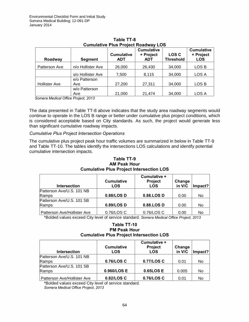
Environmental Checklist Form and Initial Study Somera Medical Building; 12-091-DP January 2014
64
Table TT-8
Cumulative Plus Project Roadway LOS
Roadway Segment Cumulative
ADT
Cumulative + Project
ADT LOS C
Threshold
Cumulative + Project
LOS
Patterson Ave n/o Hollister Ave 26,000 26,430 34,000 LOS B
s/o Hollister Ave 7,500 8,115 34,000 LOS A
Hollister Ave e/o Patterson Ave 27,200 27,311 34,000 LOS B
w/o Patterson Ave 21,000 21,474 34,000 LOS A
Somera Medical Office Project, 2013
The data presented in Table TT-8 above indicates that the study area roadway segments would continue to operate in the LOS B range or better under cumulative plus project conditions, which is considered acceptable based on City standards. As such, the project would generate less than significant cumulative roadway impacts. Cumulative Plus Project Intersection Operations
The cumulative plus project peak hour traffic volumes are summarized in below in Table TT-9 and Table TT-10. The tables identify the intersections LOS calculations and identify potential cumulative intersection impacts.
Table TT-9 AM Peak Hour
Cumulative Plus Project Intersection LOS
Intersection Cumulative
LOS
Cumulative + Project
LOS Change in V/C Impact?
Patterson Ave/U.S. 101 NB Ramps 0.88/LOS D 0.88.LOS D 0.00 No Patterson Ave/U.S. 101 SB Ramps 0.89/LOS D 0.88.LOS D 0.00 No
Patterson Ave/Hollister Ave 0.76/LOS C 0.76/LOS C 0.00 No *Bolded values exceed City level of service standard. Somera Medical Office Project, 2013
Table TT-10 PM Peak Hour
Cumulative Plus Project Intersection LOS
Intersection Cumulative
LOS
Cumulative + Project
LOS Change in V/C Impact?
Patterson Ave/U.S. 101 NB Ramps 0.76/LOS C 0.77/LOS C 0.01 No Patterson Ave/U.S. 101 SB Ramps 0.960/LOS E 0.65LOS E 0.005 No
Patterson Ave/Hollister Ave 0.82/LOS C 0.76/LOS C 0.01 No *Bolded values exceed City level of service standard. Somera Medical Office Project, 2013
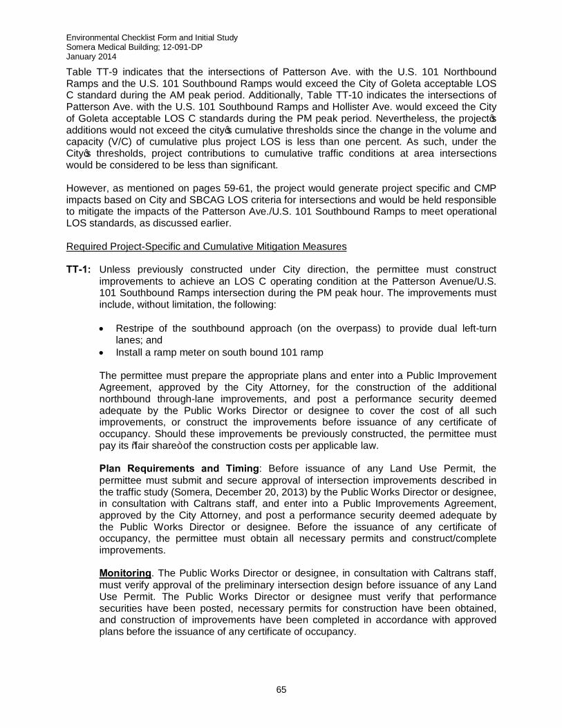
Environmental Checklist Form and Initial Study Somera Medical Building; 12-091-DP January 2014
65
Table TT-9 indicates that the intersections of Patterson Ave. with the U.S. 101 Northbound Ramps and the U.S. 101 Southbound Ramps would exceed the City of Goleta acceptable LOS C standard during the AM peak period. Additionally, Table TT-10 indicates the intersections of Patterson Ave. with the U.S. 101 Southbound Ramps and Hollister Ave. would exceed the City of Goleta acceptable LOS C standards during the PM peak period. Nevertheless, the project’s additions would not exceed the city’s cumulative thresholds since the change in the volume and capacity (V/C) of cumulative plus project LOS is less than one percent. As such, under the City’s thresholds, project contributions to cumulative traffic conditions at area intersections would be considered to be less than significant. However, as mentioned on pages 59-61, the project would generate project specific and CMP impacts based on City and SBCAG LOS criteria for intersections and would be held responsible to mitigate the impacts of the Patterson Ave./U.S. 101 Southbound Ramps to meet operational LOS standards, as discussed earlier. Required Project-Specific and Cumulative Mitigation Measures TT-1: Unless previously constructed under City direction, the permittee must construct
improvements to achieve an LOS C operating condition at the Patterson Avenue/U.S. 101 Southbound Ramps intersection during the PM peak hour. The improvements must include, without limitation, the following:
• Restripe of the southbound approach (on the overpass) to provide dual left-turn
lanes; and • Install a ramp meter on south bound 101 ramp
The permittee must prepare the appropriate plans and enter into a Public Improvement Agreement, approved by the City Attorney, for the construction of the additional northbound through-lane improvements, and post a performance security deemed adequate by the Public Works Director or designee to cover the cost of all such improvements, or construct the improvements before issuance of any certificate of occupancy. Should these improvements be previously constructed, the permittee must pay its “fair share” of the construction costs per applicable law.
Plan Requirements and Timing: Before issuance of any Land Use Permit, the
permittee must submit and secure approval of intersection improvements described in the traffic study (Somera, December 20, 2013) by the Public Works Director or designee, in consultation with Caltrans staff, and enter into a Public Improvements Agreement, approved by the City Attorney, and post a performance security deemed adequate by the Public Works Director or designee. Before the issuance of any certificate of occupancy, the permittee must obtain all necessary permits and construct/complete improvements.
Monitoring. The Public Works Director or designee, in consultation with Caltrans staff,
must verify approval of the preliminary intersection design before issuance of any Land Use Permit. The Public Works Director or designee must verify that performance securities have been posted, necessary permits for construction have been obtained, and construction of improvements have been completed in accordance with approved plans before the issuance of any certificate of occupancy.
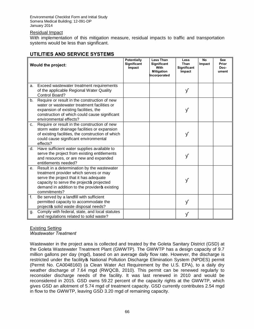
Environmental Checklist Form and Initial Study Somera Medical Building; 12-091-DP January 2014
66
Residual Impact With implementation of this mitigation measure, residual impacts to traffic and transportation systems would be less than significant. UTILITIES AND SERVICE SYSTEMS Would the project:
Potentially Significant
Impact Less Than Significant
With Mitigation
Incorporated
Less Than
Significant Impact
No Impact
See Prior Doc-
ument
a. Exceed wastewater treatment requirements of the applicable Regional Water Quality Control Board?
■
b. Require or result in the construction of new water or wastewater treatment facilities or expansion of existing facilities, the construction of which could cause significant environmental effects?
■
c. Require or result in the construction of new storm water drainage facilities or expansion of existing facilities, the construction of which could cause significant environmental effects?
■
d. Have sufficient water supplies available to serve the project from existing entitlements and resources, or are new and expanded entitlements needed?
■
e. Result in a determination by the wastewater treatment provider which serves or may serve the project that it has adequate capacity to serve the project’s projected demand in addition to the provider’s existing commitments?
■
f. Be served by a landfill with sufficient permitted capacity to accommodate the project’s solid waste disposal needs?
■
g. Comply with federal, state, and local statutes and regulations related to solid waste? ■
Existing Setting Wastewater Treatment Wastewater in the project area is collected and treated by the Goleta Sanitary District (GSD) at the Goleta Wastewater Treatment Plant (GWWTP). The GWWTP has a design capacity of 9.7 million gallons per day (mgd), based on an average daily flow rate. However, the discharge is restricted under the facility’s National Pollution Discharge Elimination System (NPDES) permit (Permit No. CA0048160) (a Clean Water Act Requirement by the U.S. EPA), to a daily dry weather discharge of 7.64 mgd (RWQCB, 2010). This permit can be renewed regularly to reconsider discharge needs of the facility. It was last renewed in 2010 and would be reconsidered in 2015. GSD owns 59.22 percent of the capacity rights at the GWWTP, which gives GSD an allotment of 5.74 mgd of treatment capacity. GSD currently contributes 2.54 mgd in flow to the GWWTP, leaving GSD 3.20 mgd of remaining capacity.
Environmental Checklist Form and Initial Study Somera Medical Building; 12-091-DP January 2014
67
At the present time the plant’s treatment system consists of primary settling, biofiltration, aeration, secondary clarification, chlorine disinfection, and dechlorination. Wastewater flows greater than 4.38 million gallons per day (MGD), receive primary treatment only and are blended with treated secondary wastewater prior to disinfection and discharge to the ocean. Treated wastewater is discharged to the Pacific Ocean through a diffuser 5,912 feet offshore at a depth of approximately 87 feet. The GSD treatment facilities are in the process of a major voluntary upgrade from the current partial secondary blended process to full secondary treatment, which consists of removing or reducing contaminants or growths that are left in the wastewater form the partial secondary treatment process and is expected to finish in 2014. When the treatment plant upgrades are completed, the plant will be able to discharge effluent that has been treated to full secondary standards as well have the capacity to treat wastewater to the tertiary standards required for recycled water use. Water Sources, Supply, and Demand 3 The Goleta Water District (GWD) is the water purveyor for the City of Goleta and surrounding areas. The GWD service area is located in the southern portion of Santa Barbara County with its western border adjacent to the El Capitan State Park, its northern border along the foothills of the Santa Ynez Mountains and the Los Padres National Forest, the City of Santa Barbara to the east, and the Pacific Ocean to the south. The service area encompasses approximately 29,000 acres and includes the City of Goleta, University of California, and Santa Barbara Airport (City of Santa Barbara property); the remainder of the service area is located in the unincorporated County of Santa Barbara. GWD provides water service to approximately 86,946 people through a distribution system that includes over 270 miles of pipeline, as well as eight reservoirs ranging in individual capacity from 0.3 million gallons to over 6 million gallons, with a total combined capacity of approximately 20.2 million gallons. Drainage Facilities There is an existing storm drain system along the north side of the existing building on the project site. The system will be modified as part of this proposed project. Since the site is currently tributary to the existing storm drain system, the runoff will continue to be discharged into the storm drain system. The site topography is relatively flat, sloping in a southwesterly direction at an average slope of 2% towards Patterson Avenue. Based on the drainage and water quality analysis, the existing site currently drains runoff through the parking lot to an existing storm drain system. The proposed project will cause some of the landscaped filtered runoff to drain in the existing storm drain system, and a portion of the runoff will drain towards Patterson Avenue into the street stormwater system. The post-project 25-year event for floods and rainfalls will generate a total of approximately 22.55 cubic feet per second (cfs) of runoff which is less than the pre-project 25 year-year event by a difference of -0.65 cfs. . In addition to the existing storm drain system, the project proposes vegetated swales and planters to accommodate runoff on the project site. Overland escape is drained to Patterson Avenue via the proposed driveways if the vegetated swales and planters overflow. Solid Waste Solid waste collection services in Goleta are provided by Marborg Industries. All nonhazardous solid waste in the City and the surrounding South Coast area is handled at two local facilities: the South Coast Recycling and Transfer Station (SCRTS) and Tajiguas Landfill. Both sites are
3 The source of the data provided in this section, except as otherwise noted, is Goleta Water District, Water Supply Assessment City of Goleta Proposed Amended General Plan/Coastal Land Use Plan, May 22, 2008.
Environmental Checklist Form and Initial Study Somera Medical Building; 12-091-DP January 2014
68
owned and operated by the Santa Barbara County Public Works Department, Resource Recovery and Waste Management Division. The annual per capita residential waste generation in Goleta is estimated to be 0.95 tons per person. The City averages about 2,400 tons each month, which is approximately 8 percent of the solid waste that goes to the Tajiguas Landfill where solid waste generated within the City is disposed.4 The Tajiguas Landfill is located approximately 26 miles west of Santa Barbara and is one of five landfills currently operating in the County. The Landfill’s total permitted operation area is 357 acres, with an approved and permitted waste disposal footprint of 118 acres comprised of both lined and unlined areas. Waste filling operations are currently being conducted in both the unlined and the lined lateral expansion areas. Santa Barbara County Environmental Health Services permits the landfill to accept up to 1,500 tons per day of municipal solid waste and yard waste.5 Based on current waste disposal rates, the landfill would reach permitted capacity in approximately 2023. The currently permitted landfill disposal capacity is 23.3 million cubic yards of waste, of which 71 percent is already utilized. Thresholds of Significance A significant impact on utilities and service systems would be expected to occur if the proposed project resulted in any of the impacts noted in the above checklist. Project Specific Impacts a,b,e) Wastewater Treatment
Applying the GSD’s wastewater generation factor for commercial uses of 100 gallons per day (gpd) per 1,000 square feet (City of Goleta General Plan FEIR, page 3.12-4), to the amount of new medical office space proposed (20,000 SF), project generated wastewater effluent would be 2,000 gpd. This represents approximately 0.03% of the 1.12 mgd remaining allocated capacity of the GSD. Therefore, the project’s incremental contribution to increased effluent flows into the GSD treatment plant would be less than significant. The applicant has obtained a Sewer Service Availability letter from the District (GSD memorandum, 6/29/2012) to ensure its capacity can be utilized. As such, the proposed project would have a less than significant impact on the availability and adequacy of sewage disposal service.
c) Drainage Facilities
The City of Goleta requires that drainage facilities (inlets, pipes, swales, etc.) for new projects be designed to accommodate the runoff from a 25-year storm event. Good engineering practice indicates that parking lots should be designed with adequate overland escape capacity to accommodate a peak 25-year rainfall runoff and/or that redundant or oversized systems be employed in anticipation of potential failure. Where grated catch basins are used, the normal design capacity is doubled to account for potential plugging. The proposed project will drain the sum of the landscaped filtered runoff through new storm drain pipes and inlets which will tie into the exiting storm drain system adjacent to South Patterson Avenue. The post-project 25-year event will generate a total of approximately 23.31 cfs of runoff. Overland escape is drained to
4 City of Goleta General Plan/Coastal Land Use Plan FEIR, September 2006, page 3.12-5. 5 Tajiguas Landfill operates 307 days per year and is closed on Sundays, and major holidays.
Environmental Checklist Form and Initial Study Somera Medical Building; 12-091-DP January 2014
69
South Patterson Avenue via the proposed driveways if the vegetated swales and planters overflow.
The site has an increase in impervious area of 2,096 square feet (0.05 acres). However, the site increases the effective impervious area by 15,852 square feet (0.36 acres) with the new building roof runoff and portions of the existing parking lot being directed to the landscaped drainage swale at the northwesterly portion of the project site. Volume reduction on the project site was accomplished by application of Low Impact Development techniques (US EPA) incorporated into the filtering devices. The increased absorption of storm flows and the slowing down on the runoff process along with the increased transpiration from plant material were modeled by using reasonable reductions in soil curve numbers and modest increases in time of concentration. Runoff calculations were made for the pre-project and post-project conditions for the 2, 5, 10, 25, 50 and 100 year storm events. The results indicate that the project will reduce the existing runoff by 11.4% in a 100-year storm event and up to 10.3% (approximately 0.20 cubic feet per second) in a 25-year storm event. (Penfield and Smith, Drainage and Water Quality Analysis, March 2013) Due to the proposed project being tied to the existing storm water drain system, the reduction in post project run-off from the utilization of Low Impact Development techniques, such as landscaping swales, (which are depressions that follow the contour around the base of a slope (natural or created), channeling and to sink into the soil), the proposed project is within the expected demand requirements of the City of Goleta for site drainage design. Therefore, the project will not result in the need for new construction of storm water drainage facilities and/or expansion and would have less than significant impacts.
d) Water Supplies and Service
The project would be served by the GWD and would not involve the use of groundwater pumped from private wells. Current usage at the project site is 2.01 acre feet/year (AFY) for the existing building and 1.76 AFY for existing landscaping (Preliminary Conditions letter from Misty Williams of the GWD dated May 12, 2009). As a result of the proposed project, the GWD estimates that internal water consumption created by the project would increase the existing building AFY by 0.60 AFY to 2.61 AFY and landscaping water consumption would increase the existing landscaping AFY by 0.50 AFY to 2.26 AFY. Overall, projected water demand for the proposed MOB would increase by 1.1 AFY. The anticipated 1.1 AFY increase in water demand resulting from implementation of the MOB project represents 0.03% of this currently available supply over current yearly demand for District water. As such, project generated water on the water supply of the GWD would be less than significant. The project also meets the City’s projected water demand. Applying the water consumption rates for General Commercial zone districts provided in the City’s Environmental Thresholds and Guidelines Manual, projected water demand for the project would be 0.84 AFY. This represents approximately 0.006% of the water received by GWD in 2005, approximately 0.0005% of the water available to the GWD in the future, through to 2030. Since the GWD currently has a yearly water supply of 3,618 AFY above current demand levels, the addition of approximately 0.84 AFY of additional
Environmental Checklist Form and Initial Study Somera Medical Building; 12-091-DP January 2014
70
demand as a result of the proposed project represents only 0.02% of that existing excess supply. Given these projections, the GWD has sufficient supply to service this project. The project also would not contribute to groundwater overdraft as no wells are proposed onsite.
f,g) The City’s Environmental Thresholds and Guidelines Manual provides solid waste
generation factors. Using the rate for office projects, the proposed project would generate approximately 7.82 tons per year. The quantity of solid waste to be disposed of at landfills (non-recycled waste) is typically estimated at 50 percent of the total solid waste generation. The non-recycled waste from the proposed project is therefore estimated at 3.91 tons per year. This amount does not exceed the City’s project specific threshold of 196 tons per year. Therefore, the proposed project’s specific impact on solid waste disposal capacity at the Tajiguas Landfill would be less than significant.
Cumulative Impacts Project contributions to cumulative impacts on public utilities or service systems such as wastewater collection and treatment, potable water supplies, storm drain and runoff control infrastructure, and the Tajiguas Landfill would be less than significant. Required/Recommended Mitigation Measures Based on the above analysis and nature of the project, no mitigation measures are necessary. Residual Impact Residual impacts on utilities and services, as well as residual contributions to cumulative utilities and services impacts would be less than significant.
Environmental Checklist Form and Initial Study Somera Medical Building; 12-091-DP January 2014
71
MANDATORY FINDINGS OF SIGNIFICANCE Potentially
Significant Impact
Less Than Significant
With Mitigation
Incorporated
Less Than
Significant Impact
No Impact
See Prior Doc-
ument
a. Does the project have the potential to substantially degrade the quality of the environment, substantially reduce the habitat of a fish or wildlife species, cause a fish or wildlife population to drop below self-sustaining levels, threaten to eliminate a plant or animal community, substantially reduce the number or restrict the range of an endangered, rare, or threatened species, or eliminate important examples of the major periods of California history or prehistory?
■
b. Does the project have impacts that are individually limited, but cumulatively considerable? (“Cumulatively considerable” means that the incremental effects of a project are considerable when viewed in connection with the effects of past projects, the effects of other current projects, and the effects of probable future projects.)
■
c. Does the project have environmental effects which will cause substantial adverse effects on human beings, either directly or indirectly?
■
a) The information in the Biological Resources Section of this study indicates that there are
no candidate, sensitive, or endangered species that utilize the project site. The closest ESHA is the Maria Ygnacio Creek riparian corridor, which is approximately 500 feet east of the project site. Given this distance, the project would have less than significant impacts on the quality of the environment. The information in the Cultural Resources Section of this study indicates that no cultural resources were found on-site. However, in the event archaeological resources are encountered during grading, a mitigation measure requires that work must be stopped or re-directed for evaluation by a City–approved archaeologist and Native American representative. With this mitigation, cultural resource impacts would be less than significant.
b) The project’s impacts for each issue area were analyzed and determined to be less than significant.
c) Project effects on human beings related to cultural resources, noise and transportation/traffic have been analyzed in this study. Impacts on human beings would be less than significant with the incorporation of mitigation measures, where required.
Environmental Checklist Form and Initial Study Somera Medical Building; 12-091-DP January 2014
72
15. PREPARERS OF THE INITIAL STUDY, CONTACTS, AND REFERENCES
This document was prepared by City of Goleta Planning and Environmental Review Department staff. Contributors and Contacts: City of Goleta
Darryl Mimick, Associate Planner, Current Planning Division Shine Ling, AICP, Associate Planner, Current Planning Division Lisa Prasse, Current Planning Manager
Winnie Cai, Assistant City Attorney Marti Milan, Principal Civil Engineer Jim Biega, Contract Traffic Engineer
Public Agencies Carrie Bennett and Misty Williams, Goleta Water District Mark Nation, Goleta West Sanitary District Brian Hayden, Santa Barbara County Fire Department Tom Rezjek, Santa Barbara County Fire Department HMU Molly Pearson, Santa Barbara Air Pollution Control District Bill Yim, Santa Barbara County Association of Governments Andrew Bermond, Santa Barbara Municipal Airport Central Coast Information Center – California Archaeological Inventory
References:
Penfield & Smith; Preliminary Drainage and Water Quality Analysis for 454 South Patterson Avenue, March 2013 Penfield & Smith; Somera Medical Office Project Revised Traffic and Circulation Study, December 20, 2013 Bay Area Air Quality Management District, Resolution No. 2010-06, June 2010. CAPCOA – California Air Pollution Control Officers Association; CEQA and Climate Change; January 2008. California Air Pollution Control Officers Association (CAPCOA) Technical Advisory; CEQA and Climate Change: Addressing Climate Change Through the California Environmental Quality Act (CEQA) Review dated June 19, 2008, available at the OPR website, www.opr.ca.gov. CARB – California Air Resources Board (ARB); Recommended Approaches for Setting Interim Significance Thresholds for Greenhouse Gases Under the California Environmental Quality Act, Preliminary Draft Staff Proposal; October 24, 2008. City of Goleta, Inland Zoning Ordinance (Goleta Municipal Code Chapter 35, Article III) City of Goleta, Environmental Thresholds and Guidelines Manual, 2003 City of Goleta, General Plan/Coastal Land Use Plan, 2006
Environmental Checklist Form and Initial Study Somera Medical Building; 12-091-DP January 2014
73
City of Goleta General Plan/Coastal Land Use Plan Final EIR, September, 2006 Department of Justice, Office of the California Attorney General; Global Warming Measure, December 9, 2008
Earth Systems Pacific, Soils Engineering Report, Conoco Phillips Gas Station No. 5241, 6930 Hollister Avenue, Goleta, California, April 14, 2009 Goleta Water District Urban Water Management Plan, December 2005 Goleta Water District Water Assessment, May 2008 Preliminary Hydraulic Report for Storke-Hollister Business Center 76900 Hollister, prepared by MAC Design Associates, April 17, 2009 Governor Arnold Schwarzenegger, California Executive Order S-3-05, 2005 Governor Arnold Schwarzenegger, Assembly Bill 32, the California Global Warming Solutions Act of 2006, Assembly Bill 32, Health and Safety Code Section 38500 et. seq Governor’s Office of Planning and Research; CEQA and Climate Change: Addressing Climate Change through California Environmental Quality Act Review, June 2008 Governor’s Office of Planning and Research; OPR Proposed CEQA Guidelines Amendments, April 2009 Governor’s Office of Planning and Research; Senate Bill 97, 2007 ICF Jones and Stokes; Goleta General Plan/Coastal Land Use Plan Supplemental Environmental Impact Report, July 2009 Intergovernmental Panel on Climate Change: http://www.ipcc.ch/ Montreal Protocol: http://www.unep.org/ozone/pdfs/montreal-protocol2000.pdf Sacramento Metropolitan Air Quality Management District; CEQA Guide, June 2009 Santa Barbara County, Air Pollution Control District, Clean Air Plan, 2008: http://www.sbcapcd.org/cap.htm
Santa Barbara County, Final Environmental Impact Report, Storke/Hollister Research Center Development Plan and Tentative Parcel Map, prepared by McClellan Engineers, July 1987 (87-EIR-5) State of California, Air Resources Board, Preliminary Draft Staff Proposal Recommended Approaches for Setting Interim Significance Thresholds for Greenhouse Gases under the California Environmental Quality Act, 2008: http://www.arb.ca.gov/cc/localgov/ceqa/meetings/102708/prelimdraftproposal102408.pdf State of California, California Energy Commission: http://www.energy.ca.gov/
US Department of Energy, Oak Ridge National Laboratory, Carbon Dioxide Information Analysis Center, Global Fossil Fuel CO2 Emissions, 2003

Environmental Checklist Form and Initial Study Somera Medical Building; 12-091-DP January 2014
74
15. ATTACHMENTS:
A. Project Plans (11" x 17" reductions) B. Parcel Map No. 32,053 C. Mitigation Monitoring and Reporting Program