
3 ENVIRONMENTAL CHECKLIST AND ANALYSIS · 1 3 ENVIRONMENTAL CHECKLIST AND ANALYSIS ......
111
June 2013 3-1 DuPont Oakley Outfall Removal and Final Closure Project IS/MND 3 ENVIRONMENTAL CHECKLIST AND ANALYSIS 1 This document has been completed for the Project in accordance with CEQA. It 2 identifies site-specific conditions and impacts, evaluates their potential significance, and 3 discusses ways to avoid or lessen impacts that may be potentially significant. The 4 information, analysis, and conclusions included in this section provide the basis for 5 determining the appropriate document needed to comply with CEQA. 6 For the proposed Project, based on the analysis and information contained herein, the 7 CSLC finds substantial evidence that the Project may have a temporary potentially 8 significant effect on the environment that can be mitigated to a less than significant 9 level. As a result, the CSLC has concluded that this IS/MND is the appropriate CEQA 10 document for the Project. 11 3.1 ENVIRONMENTAL FACTORS POTENTIALLY AFFECTED 12 The evaluation of environmental impacts below (Section 3.3) is based, in part, on the 13 environmental impact thresholds provided by State CEQA Guidelines, Appendix G. An 14 impact assessment matrix is provided as part of the evaluation for each environmental 15 issue area. The column headings for each impact assessment matrix are defined below. 16 • Potentially Significant Impact. This column has been checked if there is 17 substantial evidence that a Project-related environmental effect would be 18 significant. If there are one or more “Potentially Significant Impacts” an 19 Environmental Impact Report (EIR) would be prepared. 20 • Less than Significant Impact with Mitigation. This column has been checked 21 when the proposed Project may result in a significant environmental impact, but 22 the incorporation of identified project-specific mitigation measures into the Project 23 would reduce the identified effect(s) to a less than significant level. 24 • Less than Significant Impact. This column has been checked when the 25 proposed Project would not result in any significant effects. The Project’s impact 26 would be less than significant even without the incorporation of a project-specific 27 mitigation measure. 28 • No Impact. This column has been checked when the proposed Project would not 29 result in any impact in the category or the category does not apply. 30 The environmental factors checked in Table 3-1.1 below would be potentially affected 31 by this Project, involving at least one impact that is a “Less than Significant Impact with 32 Mitigation” as indicated by the checklist in Section 3.3. However, the Project would not 33 result in any “Potentially Significant Impacts” that cannot be reduced to a less than 34
Transcript of 3 ENVIRONMENTAL CHECKLIST AND ANALYSIS · 1 3 ENVIRONMENTAL CHECKLIST AND ANALYSIS ......

June 2013 3-1 DuPont Oakley Outfall Removal and Final Closure Project IS/MND
3 ENVIRONMENTAL CHECKLIST AND ANALYSIS 1
This document has been completed for the Project in accordance with CEQA. It 2 identifies site-specific conditions and impacts, evaluates their potential significance, and 3 discusses ways to avoid or lessen impacts that may be potentially significant. The 4 information, analysis, and conclusions included in this section provide the basis for 5 determining the appropriate document needed to comply with CEQA. 6
For the proposed Project, based on the analysis and information contained herein, the 7 CSLC finds substantial evidence that the Project may have a temporary potentially 8 significant effect on the environment that can be mitigated to a less than significant 9 level. As a result, the CSLC has concluded that this IS/MND is the appropriate CEQA 10 document for the Project. 11
3.1 ENVIRONMENTAL FACTORS POTENTIALLY AFFECTED 12
The evaluation of environmental impacts below (Section 3.3) is based, in part, on the 13 environmental impact thresholds provided by State CEQA Guidelines, Appendix G. An 14 impact assessment matrix is provided as part of the evaluation for each environmental 15 issue area. The column headings for each impact assessment matrix are defined below. 16
• Potentially Significant Impact. This column has been checked if there is 17 substantial evidence that a Project-related environmental effect would be 18 significant. If there are one or more “Potentially Significant Impacts” an 19 Environmental Impact Report (EIR) would be prepared. 20
• Less than Significant Impact with Mitigation. This column has been checked 21 when the proposed Project may result in a significant environmental impact, but 22 the incorporation of identified project-specific mitigation measures into the Project 23 would reduce the identified effect(s) to a less than significant level. 24
• Less than Significant Impact. This column has been checked when the 25 proposed Project would not result in any significant effects. The Project’s impact 26 would be less than significant even without the incorporation of a project-specific 27 mitigation measure. 28
• No Impact. This column has been checked when the proposed Project would not 29 result in any impact in the category or the category does not apply. 30
The environmental factors checked in Table 3-1.1 below would be potentially affected 31 by this Project, involving at least one impact that is a “Less than Significant Impact with 32 Mitigation” as indicated by the checklist in Section 3.3. However, the Project would not 33 result in any “Potentially Significant Impacts” that cannot be reduced to a less than 34

Environmental Checklist and Analysis
DuPont Oakley Outfall Removal and 3-2 June 2013 Final Closure Project IS/MND
significant level. Federal and State regulations pertaining to each environmental issue 1 area and relevant to the proposed Project, if any, are presented in Table 3-1.2. 2
Table 3-1.1 3 Environmental Issues and Potentially Significant Impacts 4
Aesthetics Agricultural and Forest Resources Air Quality / Greenhouse Gas Emissions Biological Resources Cultural Resources Geology and Soils Hazards and Hazardous Materials Hydrology and Water Quality Land Use and Planning Mineral Resources Noise Population and Housing Public Services Recreation Transportation/Traffic Utilities and Service Systems Mandatory Findings of Significance
3.2 AGENCY DETERMINATION 5
I find that the proposed Project COULD NOT have a significant effect on 6 the environment, and a NEGATIVE DECLARATION will be prepared. 7
I find that although the proposed Project could have a significant effect on 8 the environment, there will not be a significant effect in this case because 9 revisions to the Project have been made that will avoid or reduce any potential 10 significant effects to a less than significant level. A MITIGATED NEGATIVE 11 DECLARATION will be prepared. 12
If find that the propose Project MAY have a significant effect on the environment, 13 and an ENVIRONMENTAL IMPACT REPORT is required. 14
June 6, 2013 Signature Date 15 Cynthia Herzog, Staff Environmental Scientist 16 Division of Environmental Planning and Management 17 California State Lands Commission 18

Environmental Checklist and Analysis
June 2013 3-3 DuPont Oakley Outfall Removal and Final Closure Project IS/MND
Table 3-1.2 Federal (U.S.) and State (CA) Laws, Regulations, and Policies Potentially Applicable to the Project Multiple Environmental Issue Areas CA The CSLC has jurisdiction and management authority over all ungranted tidelands, submerged lands, and the beds of navigable lakes and
waterways. The CSLC also has certain residual and review authority for tidelands and submerged lands legislatively granted in trust to local jurisdictions (Pub. Resources Code, §§ 6301, 6306). All tidelands and submerged lands, granted or ungranted, as well as navigable lakes and waterways, are subject to the protections of the Common Law Public Trust. As general background, the State of California acquired sovereign ownership of all tidelands and submerged lands and beds of navigable lakes and waterways upon its admission to the U.S. in 1850. The State holds these lands for the benefit of all people of the State for statewide Public Trust purposes, which include but are not limited to waterborne commerce, navigation, fisheries, water-related recreation, habitat preservation and open space. On tidal waterways, the State's sovereign fee ownership extends landward to the mean high tide line, except for areas of fill or artificial accretion.
3.3.1 Aesthetics U.S. None applicable. CA California Streets and
Highways Code The California Scenic Highway Program, managed by Caltrans, was created to preserve and protect scenic highway corridors from change that would diminish the aesthetic value of lands adjacent to highways. State highways identified as scenic, or eligible for designation, are listed in section 260 et seq. of the Code.
3.3.2 Agriculture and Forest Resources U.S. None applicable. CA Williamson Act (Gov.
Code §§ 51200-51207) This Act enables local governments to enter into contracts with private landowners to restrict specific parcels of land to agricultural or related open space use, and provides landowners with lower property tax assessments in return. Local government planning departments are responsible for the enrollment of land into Williamson Act contracts. Generally, any commercial agricultural use would be permitted within any agricultural preserve. In addition, local governments may identify compatible uses permitted with a use permit.
3.3.3 Air Quality and Greenhouse Gas (GHG) Emissions U.S. Federal Clean Air Act
(FCAA) (42 USC 7401 et seq.)
The FCAA requires the USEPA to identify National Ambient Air Quality Standards (NAAQS) to protect public health and welfare. National standards are established for ozone (O3), carbon monoxide (CO), nitrogen dioxide (NO2), sulfur dioxide (SO2), particulate matter (PM10 and PM2.5), and lead (Pb). In 2007, the U.S. Supreme Court ruled that carbon dioxide (CO2) is an air pollutant as defined under the FCAA, and that the USEPA has authority to regulate GHG emissions. Pursuant to the 1990 FCAA Amendments, the USEPA classifies air basins (or portions thereof) as in “attainment” or “nonattainment” for each criteria air pollutant, based on whether or not the NAAQS are achieved. The classification is determined by comparing monitoring data with State and Federal standards. • If a pollutant concentration is lower than the standard, the area is classified as in “attainment” for that pollutant. • If a pollutant concentration exceeds the standard, the area is classified as in “nonattainment” for that pollutant. • If there are not enough data available to determine whether the standard is exceeded in an area, the area is
designated “unclassified.” Mandatory Reporting
of Greenhouse Gases Rule (40 CFR 98)
This Rule, published in 74 Federal Register § 56260, establishes mandatory GHG reporting requirements (the GHG Reporting Program [GHGRP]) for owners and operators of certain facilities that directly emit GHG as well as for certain fossil fuel suppliers and industrial GHG suppliers. For suppliers, the GHGs reported are the quantity

Environmental Checklist and Analysis
DuPont Oakley Outfall Removal and 3-4 June 2013 Final Closure Project IS/MND
Table 3-1.2 Federal (U.S.) and State (CA) Laws, Regulations, and Policies Potentially Applicable to the Project that would be emitted from combustion or use of the products supplied. Gases covered by the GHGRP are CO2, methane (CH4), nitrous oxide (N2O), and fluorinated gases, including hydrofluorocarbons, perfluorocarbons, sulfur hexafluoride (F6S), nitrogen trifluoride (NF3), and hydrofluorinated ethers.
CA AB 1493 In 2002, with the passage of AB 1493, California launched an innovative and proactive approach to dealing with GHG emissions and climate change at the state level. AB 1493 requires the CARB to develop and implement regulations to reduce automobile and light truck GHG emissions. These stricter emissions standards were designed to apply to automobile and light trucks beginning with the model year 2009. Although litigation challenged these regulations and the USEPA initially denied California’s related request for a waiver, the waiver request was granted (USEPA 2010c).
California Clean Air Act of 1988 (CCAA) (AB 2595)
The CCAA requires all air districts in the State to endeavor to achieve and maintain State ambient air quality standards for O3, CO, SO2, NO2, and PM by the earliest practicable date. California's ambient air standards are generally stricter than national standards for the same pollutants. California also has established its own standards for sulfates, hydrogen sulfide (H2S), vinyl chloride (C2H3Cl), and visibility-reducing particles. Based on pollutant levels, the 1992 Amendments to the CCAA divide ozone nonattainment areas into four categories (moderate, serious, severe, and extreme) to which progressively more stringent requirements apply. The CCAA specified that attainment plans for areas which could not demonstrate attainment of State standards until after December 31, 1997, must include specified emission reduction strategies and meet milestones in implementing emission controls and achieving more healthful air quality.
California Global Warming Solutions Act of 2006 (AB 32)
AB 32 made the CARB responsible for monitoring and reducing GHG emissions in the State and required it to establish a statewide GHG emissions cap for 2020 that is based on 1990 emissions levels. The CARB (2009) adopted its AB 32 Climate Change Scoping Plan (Scoping Plan), which functions as a roadmap of the CARB’s plans to achieve GHG reductions in California required by AB 32 through subsequently enacted regulations. The Scoping Plan contains the main strategies California will implement to reduce CO2 equivalent (CO2e) emissions by 169 million metric tons (MMT), or approximately 30 percent, from the State’s projected 2020 emissions level of 596 MMT of CO2e under a business-as-usual scenario. The Scoping Plan also breaks down the amount of GHG emissions reductions the CARB recommends for each emissions sector of the State’s GHG inventory. The Scoping Plan does not include any direct discussion about GHG emissions generated by construction activity.
Diesel Fuel Regulations
This rule sets sulfur limitations for diesel fuel sold in California for use in on-road and off-road motor vehicles (CARB 2004). Harbor craft were originally excluded from the rule, but were later included by a 2004 rule amendment (CARB 2005a). Under this rule, diesel fuel used in motor vehicles, except harbor craft, has been limited to 500 parts per million (ppm) sulfur since 1993. The sulfur limit was reduced to 15 ppm beginning September 1, 2006, and harbor craft were included starting in 2009. (A Federal diesel rule similarly limited sulfur content to 15 ppm nationwide for on-road vehicles beginning October 15, 2006.)
EO S-01-07 With EO S-01-07, Governor Schwarzenegger set forth the low carbon fuel standard for California. Under this EO, the carbon intensity of California’s transportations fuels is to be reduced by at least 10 percent by 2020.
EO S-3-05 This EO proclaims that California is vulnerable to the impacts of climate change and declares that increased temperatures could reduce the Sierra Nevada snowpack, further exacerbate California’s air quality problems, and potentially cause a rise in sea level. The EO also established statewide GHG emission targets: reduce emissions

Environmental Checklist and Analysis
June 2013 3-5 DuPont Oakley Outfall Removal and Final Closure Project IS/MND
Table 3-1.2 Federal (U.S.) and State (CA) Laws, Regulations, and Policies Potentially Applicable to the Project to 2000 levels by 2010, to 1990 levels by 2020, and to 80 percent below the 1990 level by 2050.
Heavy Duty Diesel Truck Idling Regulation (Cal. Code Regs., tit. 13, § 2485)
The CARB Heavy Duty Diesel Truck Idling rule became effective on February 1, 2005, and prohibits heavy-duty diesel trucks from idling for longer than 5 minutes at a time. Truck idling for longer than 5 minutes while queuing is allowed, however, provided the queue is located beyond 100 feet (30 meters) from any homes or schools.
SB 97 SB 97 acknowledges that climate change is a prominent environmental issue that requires analysis under CEQA. This bill directed the State Office of Planning and Research to prepare, develop, and transmit to the California Natural Resources Agency guidelines for the feasible mitigation of GHG emissions or the effects of GHG emissions, as required by CEQA, by July 1, 2009; the guidelines, which the Natural Resources Agency adopted in 2009, became effective in March 2010. These amendments to the State CEQA Guidelines establish a framework to address global climate change impacts in the CEQA process, and include revisions to the Environmental Checklist Form (Appendix G) and the Energy Conservation Appendix (Appendix F). A new section was also added to the State CEQA Guidelines (§ 15064.4) that provides an approach to assessing impacts from GHGs.
SB 375 SB 375, which was signed into law in 2008 and became effective January 1, 2009, requires the CARB to develop regional reduction targets for GHG emissions, and prompts the creation of regional land use and transportation plans to reduce emissions from passenger vehicle use throughout the State. The targets apply to the regions in the State covered by California’s 18 metropolitan planning organizations (MPOs). The 18 MPOs have been tasked with creating the regional land use and transportation plans called Sustainable Community Strategies (SCS). The MPOs are required to develop the SCS through integrated land use and transportation planning and demonstrate an ability to attain the proposed reduction targets by 2020 and 2035. This would be accomplished through either the financially constrained SCS as part of their Regional Transportation Plan (RTP) or an unconstrained alternative planning strategy. If regions develop integrated land use, housing, and transportation plans that meet the SB 375 targets, new projects in these regions can be relieved of certain review requirements of CEQA.
Statewide Portable Equipment Registra-tion Program (PERP)
The PERP establishes a uniform program to regulate portable engines and portable engine-driven equipment units (CARB 2005b). Once registered in the PERP, engines and equipment units may operate throughout California without the need to obtain individual permits from local air districts.
3.3.4 Biological Resources U.S. Endangered Species
Act (FESA) (7 USC 136, 16 USC 1531 et seq.)
The FESA, which is administered in California by the USFWS and National Marine Fisheries Service (NMFS), provides protection to species listed as threatened or endangered, or proposed for listing as threatened or endangered. Section 9 of the FESA prohibits the “take” of any member of a listed species. Take is defined as “...to harass, harm, pursue, hunt, shoot, wound, kill, trap, capture, or collect, or to attempt to engage in any such conduct.” Harass is “an intentional or negligent act or omission that creates the likelihood of injury to a listed species by annoying it to such an extent as to significantly disrupt normal behavior patterns that include, but are not limited to, breeding, feeding, or sheltering.” Harm is defined as “...significant habitat modification or degradation that results in death or injury to listed species by significantly impairing behavioral patterns such as breeding, feeding, or sheltering.” When applicants are proposing projects with a Federal nexus that “may affect” a federally listed or proposed species, the Federal agency is required to consult with the USFWS or NMFS, as appropriate, under Section 7 of

Environmental Checklist and Analysis
DuPont Oakley Outfall Removal and 3-6 June 2013 Final Closure Project IS/MND
Table 3-1.2 Federal (U.S.) and State (CA) Laws, Regulations, and Policies Potentially Applicable to the Project the FESA. Section 7 of the FESA provides that each Federal agency must ensure, in consultation with the Secretary of the Interior or Commerce, that any actions authorized, funded, or carried out by the agency are not likely to jeopardize the continued existence of any endangered or threatened species or result in the destruction or adverse modification of areas determined to be critical habitat.
EO 13112 EO 13112 requires Federal agencies to use authorities to prevent introduction of invasive species, respond to and control invasions in a cost-effective and environmentally sound manner, and to provide for restoration of native species and habitat conditions in ecosystems that have been invaded.
EO 13158 EO 13158 requires Federal agencies to identify actions that affect natural or cultural resources that are within a MPA. It further requires Federal agencies, in taking such actions, to avoid harm to the natural and cultural resources that are protected by a MPA.
Magnuson-Stevens Fishery Conservation and Management Act (MSA) (16 USC 1801 et seq.)
The MSA is the primary law governing marine fisheries management in U.S. Federal waters. The MSA was first enacted in 1976 and amended in 1996. Amendments to the 1996 MSA require “the identification of Essential Fish Habitat for federally managed species and the implementation of measures to conserve and enhance this habitat.” Any project requiring Federal authorization, such as a U.S. Army Corps of Engineers (USACE) permit, is required to complete and submit an Essential Fish Habitat Assessment with the application and either show that no significant impacts to the essential habitat of managed species are expected or identify mitigations to reduce those impacts. Under the MSA, Congress defined Essential Fish Habitat (EFH) as “those waters and substrate necessary to fish for spawning, breeding, feeding, or growth to maturity” (16 USC section 1802(10)). The EFH provisions of the MSA offer resource managers a means to heighten consideration of fish habitat in resource management. The NMFS Office of Protected Resources is required to consult with the NMFS Office of Habitat Conservation for any action it authorizes (such as research permits), funds, or undertakes, or proposes to authorize, fund, or undertake that may adversely affect EFH. This includes renewals, reviews, or substantial revisions of actions. Pursuant to section 305, subdivision (b)(2) of the MSA, Federal agencies shall consult with the NMFS regarding any action they authorize, fund, or undertake that might adversely affect EFH.
Marine Mammal Protection Act (MMPA) (16 USC section 1361 et seq.)
The MMPA is a national policy designed to protect and conserve marine mammals and their habitats. The MMPA prohibits takes of all marine mammals in the U.S. (including territorial seas) with few exceptions. The NMFS may issue a take permit under section 104 of the MMPA if the activities are consistent with the purposes of the MMPA and applicable regulations at 50 CFR, part 216. The NMFS must also find that the manner of taking is “humane” as defined in the MMPA. If lethal taking of a marine mammal is requested, the applicant must demonstrate that using a non-lethal method is not feasible.
Migratory Bird Treaty Act (MBTA) (16 USC 703-712)
The MBTA was enacted to ensure the protection of shared migratory bird resources. The MBTA prohibits the take, possession, import, export, transport, selling, purchase, barter, or offering for sale, purchase, or barter, of any migratory bird, their eggs, parts, and nests, except as authorized under a valid permit. The responsibilities of Federal agencies to protect migratory birds are set forth in EO 13186. The USFWS is the lead agency for migratory birds. The USFWS issues permits for takes of migratory birds for activities such as scientific research, education, and depredation control, but does not issue permits for incidental take of migratory birds.
Clean Water Act (33 USC 1251 et seq.) (See under Section 3.3.8, Hydrology and Water Quality) Rivers and Harbors Act (33 USC 401) (See under Section 3.3.8, Hydrology and Water Quality)

Environmental Checklist and Analysis
June 2013 3-7 DuPont Oakley Outfall Removal and Final Closure Project IS/MND
Table 3-1.2 Federal (U.S.) and State (CA) Laws, Regulations, and Policies Potentially Applicable to the Project CA California Endangered
Species Act (CESA) (Fish & G. Code, § 2050 et seq.)
The CESA provides for the protection of rare, threatened, and endangered plants and animals, as recognized by the California Department of Fish and Wildlife (CDFW), and prohibits the taking of such species without its authorization. Furthermore, the CESA provides protection for those species that are designated as candidates for threatened or endangered listings. Under the CESA, the CDFW has the responsibility for maintaining a list of threatened species and endangered species (Fish & G. Code, § 2070). The CDFW also maintains a list of candidate species, which are species that the CDFW has formally noticed as under review for addition to the threatened or endangered species lists. The CDFW also maintains lists of Species of Special Concern that serve as watch lists. Pursuant to the requirements of the CESA, an agency reviewing a proposed project within its jurisdiction must determine whether any State-listed endangered or threatened species may be present in the project site and determine whether the proposed project will have a potentially significant impact on such species. In addition, the CDFW encourages informal consultation on any proposed project that may affect a candidate species. The CESA also requires a permit to take a State-listed species through incidental or otherwise lawful activities pursuant to the CESA section 2081, subdivision (b).
California Native Plant Protection Act (Fish & G. Code, § 1900 et seq.)
This Act is intended to preserve, protect, and enhance endangered or rare native plants in California. This Act includes provisions that prohibit the taking of listed rare or endangered plants from the wild and a salvage requirement for landowners. The Act directs the CDFW to establish criteria for determining what native plants are rare or endangered. Under section 1901, a species is endangered when its prospects for survival and reproduction are in immediate jeopardy from one or more causes. A species is rare when, although not threatened with immediate extinction, it is in such small numbers throughout its range that it may become endangered. The Act also directs the Fish and Game Commission to adopt regulations governing the taking, possessing, propagation, or sale of any endangered or rare native plant.
California Lake and Streambed Alteration Program (Fish & G. Code, §§ 1600-1616)
The CDFW regulates activities that would interfere with the natural flow of, or substantially alter, the channel, bed, or bank of a lake, river, or stream. These regulations require notification of the CDFW for lake or stream alteration activities. If, after notification is complete, the CDFW determines that the activity may substantially adversely affect an existing fish and wildlife resource, the CDFW has authority to issue a Streambed Alteration Agreement.
Other relevant Fish and Game Code sections and Plans administered by the CDFW
• Sections 900-903 (California Species Preservation Act) provides for the protection and enhancement of the amphibians, birds, fish, mammals, and reptiles of California.
• Sections 3503 and 3503.5 prohibit the taking and possession of native birds’ nests and eggs from all forms of needless take. These regulations also provide that it is unlawful to take, possess, or destroy any birds in the orders Falconiformes or Strigiformes (birds-of-prey) or to take, possess, or destroy the nests or eggs of any such bird except as otherwise provided by this Code or any regulation adopted pursuant thereto.
• Sections 3511 (birds), 4700 (mammals), 5050 (reptiles and amphibians), and 5515 (fish) designate certain species as “fully protected.” Fully protected species, or parts thereof, may not be taken or possessed at any time without permission by the CDFW. Fish and Game Code section 3513 does not include statutory or regulatory mechanism for obtaining an incidental take permit for the loss of non-game, migratory birds.

Environmental Checklist and Analysis
DuPont Oakley Outfall Removal and 3-8 June 2013 Final Closure Project IS/MND
Table 3-1.2 Federal (U.S.) and State (CA) Laws, Regulations, and Policies Potentially Applicable to the Project 3.3.5 Cultural Resources U.S. Archaeological and
Historic Preservation Act (AHPA)
The AHPA provides for the preservation of historical and archaeological data that might be irreparably lost or destroyed as a result of (1) flooding, the building of access roads, the erection of workmen’s communities, the relocation of railroads and highways, and other alterations of terrain caused by the construction of a dam by an agency of the U.S. or by any private person or corporation holding a license issued by any such agency; or (2) any alteration of the terrain caused as a result of a Federal construction project or federally licensed project, activity, or program. This Act requires Federal agencies to notify the Secretary of the Interior when they find that any federally permitted activity or program may cause irreparable loss or destruction of significant scientific, prehistoric, historical, or archaeological data. The AHPA built upon the national policy, set out in the Historic Sites Act of 1935, "...to provide for the preservation of historic American sites, buildings, objects, and antiquities of national significance...." The AHPA expanded the policy by focusing attention on significant resources and data, but does not require that they be shown to be of “national” significance. The connection between the 1935 statute and the AHPA is mentioned explicitly in the first section of the statute.
Archaeological Resources Protection Act (ARPA)
The ARPA of 1979 was specifically designed to prevent looting and destruction of archeological resources. Like the Antiquities Act, the ARPA has enforcement and permitting components. The enforcement provision provides for the imposition of both criminal and civil penalties against violators of the Act. The ARPA's permitting component allows for the recovery of certain artifacts consistent with the standards and requirements of the National Park Service's Federal Archeology Program. The ARPA states that archaeological resources on public or Indian lands are an accessible and irreplaceable part of the nation’s heritage and: • Establishes protection for archaeological resources to prevent loss and destruction due to uncontrolled
excavations and pillaging; • Encourages increased cooperation and exchange of information between government authorities, the
professional archaeological community, and private individuals having collections of archaeological resources prior to the enactment of this Act;
• Establishes permit procedures to permit excavation or removal of archaeological resources (and associated activities) located on public or Indian land; and
• Defines excavation, removal, damage, or other alteration or defacing of archaeological resources as a “prohibited act” and provides for criminal and monetary rewards to be paid to individuals furnishing information leading to the finding of a civil violation or conviction of a criminal violator.
National Historic Preservation Act (NHPA) (16 USC 470 et seq.)
This applies only to Federal undertakings. Archaeological resources are protected through the NHPA, as amended, and its implementing regulation, Protection of Historic Properties (36 CFR section 800), the AHPA of 1974, and the ARPA of 1979. This Act presents a general policy of supporting and encouraging the preservation of prehistoric and historic resources for present and future generations by directing Federal agencies to assume responsibility for considering the historic resources in their activities. The State implements the NHPA through its statewide comprehensive cultural resource surveys and preservation programs. The California Office of Historic Preservation (OHP), as an office of the California Department of Parks and Recreation, implements the policies of the NHPA on a statewide level and advises Federal agencies regarding potential effects on historic properties. The OHP also maintains the California Historic Resources

Environmental Checklist and Analysis
June 2013 3-9 DuPont Oakley Outfall Removal and Final Closure Project IS/MND
Table 3-1.2 Federal (U.S.) and State (CA) Laws, Regulations, and Policies Potentially Applicable to the Project Inventory. The State Historic Preservation Officer (SHPO) is an appointed official who implements historic preservation programs within the State’s jurisdictions, including commenting on Federal undertakings.
CA California Environmental Quality Act (CEQA) (Pub. Resources Code, § 21000 et seq.)
As the CEQA lead agency, the CSLC is responsible for complying with all provisions of the CEQA and State CEQA Guidelines that relate to “historical resources.” A historical resource includes: 1) a resource that is listed in, or determined to be eligible for listing in the California Register of Historic Resources (CRHR); 2) a resource included in a local register of historical or identified as significant in an historical resource surveys; and, 3) any resource that a lead agency determines to be historically significant for the purposes of CEQA, when supported by substantial evidence in light of the whole record.
The CRHR was created to identify resources deemed worthy of preservation on a State level and was modeled closely after the National Register. The criteria are nearly identical to those of the National Register, but focus on resources of statewide significance. The criteria, which are set forth in the State CEQA Guidelines section 15064.5, subdivision (a)(3), are defined as any resource that meets any of the following criteria: • Is associated with events that have made a significant contribution to the broad patterns of California’s history
and cultural heritage; • Is associated with lives of persons important in our past; • Embodies the distinctive characteristics of a type, period, region, or method of construction, or represents the
work of an important creative individual, or possesses high artistic values; or • Has yielded, or may be likely to yield, information important in prehistory or history.
Properties listed, or formally designated as eligible for listing, on the National Register are automatically listed on the CRHR, as are certain State Landmarks and Points of Interest. In addition, the State CEQA Guidelines section 15064.5, subdivision (a)(4) states: “The fact that a resource is not listed in, or determined to be eligible for listing in the California Register of Historical Resources, not included in a local register of historical resources (pursuant to Section 5020.1(k) of the Public Resources Code), or identified in an historical resources survey (meeting the criteria in Section 5024.1(g) of the Public Resources Code) does not preclude a lead agency from determining that the resource may be an historical resource as defined in Public Resources Code Section 5020.1(j) or 5024.1.”
California Health and Safety Code (7050.5)
This Code states that if human remains are exposed during construction, no further disturbance shall occur until the County Coroner has made the necessary findings as to origin and disposition pursuant to Public Resources Code section 5097.998. The Coroner has 24 hours to notify the Native American Heritage Commission (NAHC) if the remains are determined to be of Native American descent. The NAHC will contact most likely descendants, who may recommend how to proceed.
3.3.6 Geology and Soils U.S. None applicable. CA Alquist-Priolo
Earthquake Fault Zoning Act (Pub. Resources Code, §§ 2621-2630)
This Act requires that "sufficiently active" and "well-defined" earthquake fault zones be delineated by the State Geologist and prohibits locating structures for human occupancy across the trace of an active fault.

Environmental Checklist and Analysis
DuPont Oakley Outfall Removal and 3-10 June 2013 Final Closure Project IS/MND
Table 3-1.2 Federal (U.S.) and State (CA) Laws, Regulations, and Policies Potentially Applicable to the Project California Building Code (CBC) (Cal. Code Regs., tit. 23)
The CBC contains requirements related to excavation, grading, and construction. According to the CBC, a grading permit is required if more than 50 cubic yards of soil are moved. Chapter 33 of the CBC contains requirements relevant to the construction of pipelines alongside existing structures. Sections 3301.2 and 3301.3 contain provisions requiring protection of the adjacent property during excavations and require a 10-day written notice and access agreements with the adjacent property owners.
California Seismic Hazards Mapping Act (Pub. Resources Code, § 2690 and following as Division 2, Chapter 7.8)
This Act and the Seismic Hazards Mapping Regulations (Cal. Code Regs., tit. 14, Div. 2, Ch. 8, Art. 10) are designed to protect the public from the effects of strong ground shaking, liquefaction, landslides, other ground failures, or other hazards caused by earthquakes. The Act requires that site-specific geotechnical investigations be conducted identifying the hazard and formulating mitigation measures prior to permitting most developments designed for human occupancy. Special Publication 117, Guidelines for Evaluating and Mitigating Seismic Hazards in California (CGS 2008), constitutes the guidelines for evaluating seismic hazards other than surface fault rupture and for recommending mitigation measures as required by section 2695, subdivision (a).
3.3.7 Hazards and Hazardous Materials U.S. California Toxics Rule
(40 CFR 131) In 2000, the USEPA promulgated numeric water quality criteria for priority toxic pollutants and other water quality standards provisions to be applied to waters in the State of California. USEPA promulgated this rule based on the Administrator's determination that the numeric criteria are necessary in the State of California to protect human health and the environment. (Under CWA section 303(c)(2)(B), the USEPA requires states to adopt numeric water quality criteria for priority toxic pollutants for which the USEPA has issued criteria guidance, and the presence or discharge of which could reasonably be expected to interfere with maintaining designated uses.) These Federal criteria are legally applicable in California for inland surface waters, enclosed bays, and estuaries for all purposes and programs under the CWA.
Hazardous Materials Transportation Act (HMTA) (49 USC 5901)
The HMTA delegates authority to the DOT to develop and implement regulations pertaining to the transport of hazardous materials and hazardous wastes by all modes of transportation. Additionally, the USEPA’s Hazardous Waste Manifest System is a set of forms, reports, and procedures for tracking hazardous waste from a generator’s site to the disposal site. Applicable Federal regulations are contained primarily in CFR Titles 40 and 49.
National Oil and Hazardous Substances Pollution Contingency Plan (NCP) (40 CFR section 300)
Authorized under the Comprehensive Environmental Response, Compensation, and Liability Act of 1980 (CERCLA), 42 USC section 9605, as amended by the Superfund Amendments and Reauthorization Act of 1986 (SARA), Pub. L. 99 through 499; and by section 311, subdivision (d) of the CWA, 33 USC, section 1321, subdivision (d), as amended by the Oil Pollution Act of 1990 (OPA), Pub. L. 101 through 380. The NCP outlines requirements for responding to both oil spills and releases of hazardous substances. It specifies compliance, but does not require the preparation of a written plan. It also provides a comprehensive system for reporting, spill containment, and cleanup. The USCG and the USEPA co-chair the National Response Team. In accordance with 40 CFR section 300.175, the USCG has responsibility for oversight of regional response for oil spills in “coastal zones,” as described in 40 CFR section 300.120.
Oil Pollution Act (OPA) (33 USC 2712)
The OPA requires owners and operators of facilities that could cause substantial harm to the environment to prepare and submit plans for responding to worst-case discharges of oil and hazardous substances. The passage of the OPA motivated California to pass a more stringent spill response and recovery regulation and the creation of the Office of Spill Prevention and Response (OSPR) to review and regulate oil spill plans and contracts.

Environmental Checklist and Analysis
June 2013 3-11 DuPont Oakley Outfall Removal and Final Closure Project IS/MND
Table 3-1.2 Federal (U.S.) and State (CA) Laws, Regulations, and Policies Potentially Applicable to the Project Resource
Conservation and Recovery Act (RCRA) (42 USC 6901 et seq.)
The RCRA authorizes the USEPA to control hazardous waste from “cradle-to-grave,” which encompasses its generation, transportation, treatment, storage, and disposal. RCRA’s Federal Hazardous and Solid Waste Amendments from 1984 include waste minimization and phasing out land disposal of hazardous waste as well as corrective action for releases. The Department of Toxic Substances Control (DTSC) is the lead State agency for corrective action associated with RCRA facility investigations and remediation.
Toxic Substances Control Act (TSCA) (15 USC 2601–2692)
The TSCA authorizes the USEPA to require reporting, record-keeping, testing requirements, and restrictions related to chemical substances and/or mixtures. The TSCA addresses the production, importation, use, and disposal of specific chemicals, such as polychlorinated biphenyls, asbestos-containing materials, lead-based paint, and petroleum.
Clean Water Act (33 USC 1251 et seq.) (See under Section 3.3.8, Hydrology and Water Quality) Rivers and Harbors Act (33 USC 401) (See under Section 3.3.8, Hydrology and Water Quality) CA California Seismic Hazards Mapping Act (Pub. Resources Code, § 2690 and following as Division 2, Chapter 7.8) and the Seismic Hazards
Mapping Regulations (Cal. Code Regs., tit. 14, Div. 2, Ch. 8, Art. 10) (See under Section 3.3.6, Geology and Soils) Hazardous Waste
Control Act (Cal. Code Regs., tit. 26)
This Act defines requirements for proper management of hazardous materials.
Lempert-Keene-Seastrand Oil Spill Prevention and Response Act (OSPRA) (Gov. Code § 8574.1 et seq. and Pub. Resources Code § 8750 et seq.)
The OSPRA established the Office of Spill Prevention and Response (OSPR) division within the CDFW. These regulations seek to protect the waters of the state from oil pollution and to plan for the effective and immediate response, removal, abatement, and cleanup in the event of an oil spill. This Act requires immediate cleanup of spills following approved contingency plans and fully mitigating impacts on wildlife, and requires vessel and marine facilities to have marine oil spill contingency plans and demonstrate financial responsibility. The Act assigns primary authority to the CDFW OSPR to direct prevention, removal, abatement, response, containment, and cleanup efforts with regard to all aspects of any oil spill in the marine waters of the State. The CSLC assists the CDFW OSPR with spill investigations and response.
Porter-Cologne Water Quality Control Act (Porter-Cologne) (Cal. Water Code, § 13000 et seq.) (See under Section 3.3.8, Hydrology and Water Quality)
3.3.8 Hydrology and Water Quality U.S. Clean Water Act
(CWA) (33 USC 1251 et seq.)
The CWA is a comprehensive piece of legislation that generally includes reference to the Federal Water Pollution Control Act of 1972, and its substantial supplementation by the CWA of 1977. Both Acts were subsequently amended in 1981, 1987, and 1993. Overall, the CWA seeks to protect the nation’s water from pollution by setting water quality standards for surface water and by limiting the discharge of effluents into waters of the U.S. These water quality standards are promulgated by the USEPA and enforced in California by the SWRCB and nine Regional Water Quality Control Boards (RWQCBs). The CWA also provides for development of municipal and industrial wastewater treatment standards and a permitting system to control wastewater discharges to surface waters. Under section 404 of the CWA, the USACE has primary Federal responsibility for administering regulations that concern waters of the U.S. wetlands, which are defined as those areas that are inundated or saturated by surface or groundwater at a frequency and duration that are sufficient to support, and that under normal circumstances do support, a prevalence of vegetation typically adapted for life in saturated soil conditions.

Environmental Checklist and Analysis
DuPont Oakley Outfall Removal and 3-12 June 2013 Final Closure Project IS/MND
Table 3-1.2 Federal (U.S.) and State (CA) Laws, Regulations, and Policies Potentially Applicable to the Project Rivers and Harbors Act
(33 USC 401) This Act governs specified activities in “navigable waters.”1 Specifically, it limits the construction of structures and the discharge of fill into navigable waters of the U.S. Under section 10 of the Rivers and Harbors Act, the building of any wharf, pier, jetty, or other structure is prohibited without Congressional approval, and excavation or fill within navigable waters requires approval from the USACE.
Oil Pollution Act (33 USC 2712) (See under Section 3.3.7, Hazards and Hazardous Materials) CA Porter-Cologne Water
Quality Control Act (Cal. Water Code § 13000 et seq.) (Porter-Cologne)
Porter-Cologne is the principal law governing water quality in California. The Act establishes a comprehensive program to protect water quality and the beneficial uses of State waters and established the SWRCB and the nine RWQCBs who implement SWRCB provisions and have primary responsibility for protecting State water quality. Porter-Cologne also implements many provisions of the Federal CWA, such as the National Pollutant Discharge Elimination System permitting program. Pursuant to the CWA § 401, applicants for a Federal license or permit for activities that may result in any discharge to waters of the U. S. must seek a Water Quality Certification (Certification) from the State in which the discharge originates. Such Certification is based on a finding that the discharge will meet water quality standards and other appropriate requirements of State law. In California, RWQCBs issue or deny certification for discharges within their jurisdiction. The SWRCB has this responsibility where projects or activities affect waters in more than one RWQCB’s jurisdiction. If the SWRCB or a RWQCB imposes a condition on its Certification, those conditions must be included in the Federal permit or license.
Water Quality Control Plans (Basin Plans). Section 13240 of Porter-Cologne requires each RWQCB to formulate and adopt a basin plan for all areas within the Region. Each RWQCB must establish water quality objectives to ensure the reasonable protection of beneficial uses and a program of implementation for achieving water quality objectives within the basin plans. 40 CFR 131 requires each State to adopt water quality standards by designating water uses to be protected and adopting water quality criteria that protect the designated uses. In California, the beneficial uses and water quality objectives are the State’s water quality standards.
California Code of Regulations, Title 23
The Central Valley Flood Protection Board (CVFPB) regulates specific river, creek, and slough crossings for flood protection. Title 23 requires that (1) new crossings maintain hydraulic capacity through such measures as in-line piers, adequate stream bank height (freeboard), and measures to protect against stream bank and channel erosion, and (2) improvements, including crossings, be constructed in a manner that does not reduce the channel’s capacity or functionality, or that of any Federal flood control project. The CVFPB issues and reviews encroachment permit applications for approval of a new channel crossing or other modification. For proposed crossings of Federal flood control projects, the CVFPB coordinates its review with the USACE and other agencies.
California Water Code section 8710
This section requires that a reclamation board permit be obtained prior to the start of any work, including excavation and construction activities, if projects are located within floodways or levee sections. Structures for human habitation are not permitted within designated floodways.
1 Navigable waters are defined as those waters that are subject to the ebb and flow of the tide or that are presently used, have been used in the
past, or may be susceptible for use to transport interstate or foreign commerce.

Environmental Checklist and Analysis
June 2013 3-13 DuPont Oakley Outfall Removal and Final Closure Project IS/MND
Table 3-1.2 Federal (U.S.) and State (CA) Laws, Regulations, and Policies Potentially Applicable to the Project 3.3.9 Land Use and Planning U.S. None applicable. CA See information on the CSLC at the top of this table under Multiple Environmental Issue Areas. 3.3.10 Mineral Resources U.S. None applicable. CA Surface Mining and
Reclamation Act (SMARA) (Pub. Resources Code, §§ 2710-2796)
The CGS classifies the regional significance of mineral resources in accordance with SMARA and assists in the designation of lands containing significant aggregate resources. Mineral Resource Zones (MRZs) have been designated to indicate the significance of mineral deposits. The MRZ categories are: • MRZ-1: Areas where adequate information indicates that no significant mineral deposits are present or where
it is judged that little likelihood exists for their presence. • MRZ-2: Areas where adequate information indicates significant mineral deposits are present, or where it is
judged that a high likelihood exists for their presence. • MRZ-3: Areas containing mineral deposits the significance of which cannot be evaluated from available data. • MRZ-4: Areas where available information is inadequate for assignment to any other MRZ.
3.3.11 Noise U.S. Noise Control Act (42
USC 4910) This Act required the USEPA to establish noise emission criteria, as well as noise testing methods (40 CFR Chapter 1, Subpart Q). These criteria generally apply to interstate rail carriers and to some types of construction and transportation equipment. The USEPA published a guideline (USEPA 1974) containing recommendations for acceptable noise level limits affecting residential land use of 55 dBA Ldn for outdoors and 45 dBA Ldn for indoors.
Department of Housing and Urban Develop-ment Environmental Standards (24 CFR Part 51)
These regulations set forth the following exterior noise standards for new home construction (for interior noise levels, a goal of 45 dBA is set forth and attenuation requirements are geared to achieve that goal): • 65 Ldn or less – Acceptable • 65 Ldn and < 75 Ldn – Normally unacceptable, appropriate sound attenuation measures must be provided • > 75 Ldn – Unacceptable
Federal Highway Administration Noise Abatement Procedures (23 CFR Part 772)
This regulation provides procedures for noise studies and noise abatement measures to help protect the public health and welfare, to supply noise abatement criteria, and to establish requirements for information to be given to local officials for use in the planning and design of highways. It establishes five categories of noise sensitive receptors and prescribes the use of the Hourly Leq as the criterion metric for evaluating traffic noise impacts.
FERC Guidelines On Noise Emissions From Compressor Stations, Substations, And Transmission Lines (18 CFR 157.206(d)5)
These guidelines require that “the noise attributable to any new compressor stations, compression added to an existing station, or any modification, upgrade or update of an existing station, must not exceed a Ldn of 55 dBA at any pre-existing noise sensitive area (such as schools, hospitals, or residences).”
NTIS 550\9-74-004, 1974 (“Information on Levels of Environ-
In response to a Federal mandate, the USEPA provided guidance in this document, commonly referenced as the, “Levels Document,” that establishes an Ldn of 55 dBA as the requisite level, with an adequate margin of safety, for areas of outdoor uses including residences and recreation areas. This document does not constitute USEPA
Environmental Checklist and Analysis
DuPont Oakley Outfall Removal and 3-14 June 2013 Final Closure Project IS/MND
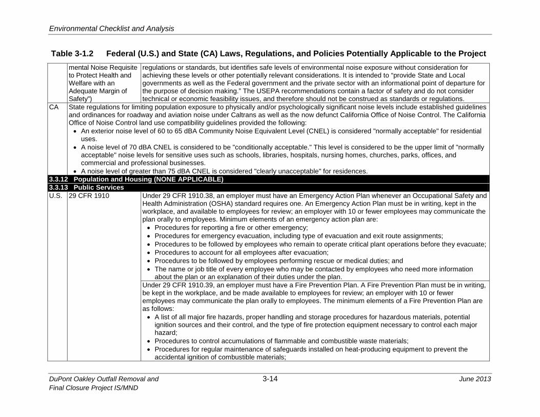
Table 3-1.2 Federal (U.S.) and State (CA) Laws, Regulations, and Policies Potentially Applicable to the Project mental Noise Requisite to Protect Health and Welfare with an Adequate Margin of Safety”)
regulations or standards, but identifies safe levels of environmental noise exposure without consideration for achieving these levels or other potentially relevant considerations. It is intended to “provide State and Local governments as well as the Federal government and the private sector with an informational point of departure for the purpose of decision making.” The USEPA recommendations contain a factor of safety and do not consider technical or economic feasibility issues, and therefore should not be construed as standards or regulations.
CA State regulations for limiting population exposure to physically and/or psychologically significant noise levels include established guidelines and ordinances for roadway and aviation noise under Caltrans as well as the now defunct California Office of Noise Control. The California Office of Noise Control land use compatibility guidelines provided the following: • An exterior noise level of 60 to 65 dBA Community Noise Equivalent Level (CNEL) is considered "normally acceptable" for residential
uses. • A noise level of 70 dBA CNEL is considered to be "conditionally acceptable." This level is considered to be the upper limit of "normally
acceptable" noise levels for sensitive uses such as schools, libraries, hospitals, nursing homes, churches, parks, offices, and commercial and professional businesses.
• A noise level of greater than 75 dBA CNEL is considered "clearly unacceptable" for residences. 3.3.12 Population and Housing (NONE APPLICABLE) 3.3.13 Public Services U.S. 29 CFR 1910 Under 29 CFR 1910.38, an employer must have an Emergency Action Plan whenever an Occupational Safety and
Health Administration (OSHA) standard requires one. An Emergency Action Plan must be in writing, kept in the workplace, and available to employees for review; an employer with 10 or fewer employees may communicate the plan orally to employees. Minimum elements of an emergency action plan are: • Procedures for reporting a fire or other emergency; • Procedures for emergency evacuation, including type of evacuation and exit route assignments; • Procedures to be followed by employees who remain to operate critical plant operations before they evacuate; • Procedures to account for all employees after evacuation; • Procedures to be followed by employees performing rescue or medical duties; and • The name or job title of every employee who may be contacted by employees who need more information
about the plan or an explanation of their duties under the plan. Under 29 CFR 1910.39, an employer must have a Fire Prevention Plan. A Fire Prevention Plan must be in writing,
be kept in the workplace, and be made available to employees for review; an employer with 10 or fewer employees may communicate the plan orally to employees. The minimum elements of a Fire Prevention Plan are as follows: • A list of all major fire hazards, proper handling and storage procedures for hazardous materials, potential
ignition sources and their control, and the type of fire protection equipment necessary to control each major hazard;
• Procedures to control accumulations of flammable and combustible waste materials; • Procedures for regular maintenance of safeguards installed on heat-producing equipment to prevent the
accidental ignition of combustible materials;

Environmental Checklist and Analysis
June 2013 3-15 DuPont Oakley Outfall Removal and Final Closure Project IS/MND
Table 3-1.2 Federal (U.S.) and State (CA) Laws, Regulations, and Policies Potentially Applicable to the Project • The name or job title of employees responsible for maintaining equipment to prevent or control sources of
ignition or fires; and • The name or job title of employees responsible for the control of fuel source hazards. • An employer must inform employees upon initial assignment to a job of the fire hazards to which they are
exposed. An employer must also review with each employee those parts of the Fire Prevention Plan necessary for self-protection.
Under 29 CFR 1910.155, Subpart L, Fire Protection, employers are required to place and keep in proper working order fire safety equipment within facilities.
CA California Code of Regulations, Title 19, Public Safety
The California State Fire Marshal (CSFM) develops regulations relating to fire and life safety under California Code of Regulations, Title 19, Public Safety. These regulations have been prepared and adopted to establish minimum standards for the prevention of fire and for protection of life and property against fire, explosion, and panic. The CSFM also adopts and administers the regulations and standards considered necessary under the California Health and Safety Code to protect life and property.
3.3.14 Recreation (NONE APPLICABLE) 3.3.16 Transportation/Traffic CA Caltrans is responsible for the design, construction, maintenance, and operation of the California State Highway System and the portion of
the Interstate Highway System within State boundaries. Chapter 2, Article 3 of the Vehicle Code defines the powers and duties of the California Highway Patrol, which has enforcement responsibilities for the vehicle operation and highway use in the State.
3.3.17 Utilities and Service Systems (NONE APPLICABLE)
Abbreviations used in this table (see also List of Abbreviations and Acronyms following the Table of Contents) include: AB = Assembly Bill; Caltrans = California Department of Transportation; CARB = California Air Resources Board; CDFW = California Department of Fish and Wildlife; CEQA = California Environmental Quality Act; CFR = Code of Federal Regulations; CGS = California Geological Survey; CSLC = California State Lands Commission; CWA = Clean Water Act; EO = Executive Order; FERC = Federal Energy Regulatory Commission; NMFS = National Marine Fisheries Service; NOAA = National Oceanic and Atmospheric Administration; RWQCB = Regional Water Quality Control Board; SB = Senate Bill; SWRCB = State Water Resources Control Board; USACE = U.S. Army Corps of Engineers; USC = U.S. Code; USCG = U.S. Coast Guard; USEPA = U.S. Environmental Protection Agency; USFWS = U.S. Fish and Wildlife Service.

Environmental Checklist and Analysis
DuPont Oakley Outfall Removal and 3-16 June 2013 Final Closure Project IS/MND
3.3 ENVIRONMENTAL CHECKLIST 1
3.3.1 Aesthetics 2
AESTHETICS – Would the Project: Potentially Significant
Impact
Less Than Significant
with Mitigation
Less Than Significant
Impact
No Impact
a) Have a substantial adverse effect on a scenic vista?
b) Substantially damage scenic resources, including, but not limited to, trees, rock outcroppings, and historic buildings within a State scenic highway?
c) Substantially degrade the existing visual character or quality of the site and its surroundings?
d) Create a new source of substantial light or glare which would adversely affect day or nighttime views in the area?
3.3.1.1 Environmental Setting 3
The Project site is located in the northwest corner of the DuPont Oakley property, a 4 decommissioned and demolished former manufacturing facility. The western and 5 southern portions of the property are occupied by a guard gate, an administration 6 building, and remnants of the former facilities that include building foundations, parking 7 lots and roads. To the east and north, approximately 6.5 acres of open water and 8 wetlands, known as the Central Slough, lie between the former core manufacturing area 9 and areas that were formerly wastewater ponds and basins, but are now open, grass-10 covered fields. Rows of mature eucalyptus trees, which are currently the most 11 prominent vertical visual element on the property, grow in several locations on the site. 12
The DuPont property adjoins the San Joaquin River system to the east and north. Areas 13 of property along the river are vegetated with a mix of brambles, willows and wetland 14 vegetation. Beyond the wetlands to the east are the northern portions of the Cline 15 Vineyards and Big Break Marina, which in turn are adjacent to single-family residential 16 neighborhoods. Highway 160 and several large industrial facilities in the city of Antioch 17 are located to the west. To the south are the Burlington Northern/Santa Fe (BNSF) 18 railroad line and the southern part of the Cline Vineyards. Lauritzen Yacht Harbor is 19 located adjacent to the northwestern corner of the property near the Project site. 20
The Project site and nearby lands are generally low-lying and of similar elevation, which 21 affords few sightlines to the Project site from nearby areas. Views to the Project site are 22

Environmental Checklist and Analysis
June 2013 3-17 DuPont Oakley Outfall Removal and Final Closure Project IS/MND
therefore primarily distant views from areas of higher elevation for which the site 1 represents a small fraction of the overall visual background. The site is visible in the 2 distant views from a short elevated segment of Highway 160 as it approaches the 3 Antioch Bridge and from the bridge itself. State Highway 160 is a designated State 4 scenic highway from the Sacramento County border with Contra Costa County (i.e., 5 from the approximate mid-point of the Antioch Bridge crossing of the San Joaquin River) 6 to Sacramento (California Department of Transportation [Caltrans] 2013). 7
3.3.1.2 Regulatory Setting 8
Federal/State 9
Federal and State regulations pertaining to aesthetics and relevant to the proposed 10 Project, if any, are presented in Table 3-1.2. 11
Local 12
Contra Costa County. The Contra Costa County General Plan 2005-2020 identifies 13 development goals and policies that promote protection of the scenic qualities of the 14 County. Specifically, the General Plan identifies the following scenic resource goals and 15 policies applicable to the Project site: 16
• Goal 9-10 - To preserve and protect areas of identified high scenic value, where 17 practical, and in accordance with the Land Use Element map. 18
• Goal 9-12 - To preserve the scenic qualities of the San Francisco Bay/Delta 19 estuary system and the Sacramento–San Joaquin River/Delta shoreline. 20
• Policy 9-27 - The appearance of the County shall be improved by eliminating 21 negative features such as non-conforming signs and overhead utility lines, and 22 by encouraging aesthetically designed facilities with adequate setbacks and 23 landscaping. 24
• Policy 9-28 - Maintenance of the scenic waterways of the County shall be 25 ensured through public protection of the marshes and riparian vegetation along 26 the shorelines and delta levees, as otherwise specified in the General Plan. 27
City of Oakley. The city of Oakley’s General Plan 2020 identifies the following scenic 28 resource goals and policies applicable to the Project site: 29
• Goal 6.7 - Seek to preserve the scenic qualities of the Delta Waterway, Marsh 30 Creek, and views of Mount Diablo. 31
• Policy 6.7.1 - Encourage preservation and enhancement of views of the Delta 32 and Mount Diablo to the extent possible. 33

Environmental Checklist and Analysis
DuPont Oakley Outfall Removal and 3-18 June 2013 Final Closure Project IS/MND
3.3.1.3 Impact Analysis 1
a) Have a substantial effect on a scenic vista? 2
Less than Significant Impact. The Project site is located on the San Joaquin River 3 shoreline, which Contra Costa County and the city of Oakley identify as a scenic 4 resource, and it is visible in distant views from a short segment of the designated scenic 5 portion of Highway 160 on the Antioch Bridge. Use of a barge in the river and operation 6 of trucks and a backhoe onshore would temporarily alter the visual environment at the 7 site; however, these activities would not constitute a substantial adverse effect on the 8 viewshed because the short-term presence of a barge is consistent with shipping 9 activities on the river, and the use of vehicles and equipment onshore is typical of 10 activities at the site and adjoining properties. Removal of the outfall pipe would not 11 permanently change the shoreline or substantially alter ground contours. Upon Project 12 completion, the site would be restored and appear unchanged from present conditions. 13
b) Substantially damage scenic resources, including, but not limited to tress, 14 rock outcroppings, and historic buildings within a State scenic highway? 15
No Impact. The Project would not damage any scenic resources along the shoreline or 16 within the State Highway 160 viewshed. Upon Project completion, the site would be 17 restored and appear unchanged from present conditions. 18
c) Substantially degrade the existing visual character or quality of the site and 19 its surroundings? 20
No Impact. The DuPont property is visually comprised of predominantly horizontal 21 landforms (wetlands and low-lying uplands), water forms (the San Joaquin River), trees, 22 and remnants of the former manufacturing facilities. The visual quality of the site and its 23 surroundings is generally poor, with the exception of the river and its shoreline. The mix 24 of remnant facilities and natural features lacks visual unity and integrity. Temporary 25 changes at the site during pipe removal and demolition would not substantially degrade 26 the existing visual character or quality of the site and its surroundings. Upon Project 27 completion, the site would be restored and appear unchanged from present conditions. 28
d) Create a new source of substantial light or glare, which would adversely 29 affect day or nighttime views in the area? 30
No Impact. Project activities would not use highly reflective materials or equipment that 31 would create glare, nor would artificial lighting be necessary to carry out the Project. 32
3.3.1.4 Mitigation Summary 33
The Project would not result in significant aesthetic impacts; no mitigation is required. 34

Environmental Checklist and Analysis
June 2013 3-19 DuPont Oakley Outfall Removal and Final Closure Project IS/MND
3.3.2 Agriculture and Forest Resources 1
AGRICULTURE AND FOREST RESOURCES - Would the Project:
Potentially Significant
Impact
Less Than Significant
with Mitigation
Less Than Significant
Impact
No Impact
In determining whether impacts to agricultural resources are significant environmental effects, lead agencies may refer to the California Agricultural Land Evaluation and Site Assessment Model (1997) prepared by the California Dept. of Conservation as an optional model to use in assessing impacts on agriculture and farmland. In determining whether impacts to forest resources, including timberland, are significant environmental effects, lead agencies may refer to information compiled by the California Department of Forestry and Fire Protection regarding the State’s inventory of forest land, including the Forest and Range Assessment Project and the Forest Legacy Assessment Project; and the forest carbon measurement methodology provided in Forest Protocols adopted by the California Air Resources Board. a) Convert Prime Farmland, Unique Farmland, or Farmland of Statewide Importance (Farmland), as shown on the maps prepared pursuant to the Farmland Mapping and Monitoring Program of the California Natural Resources Agency, to non-agricultural use?
b) Conflict with existing zoning for agricultural use, or a Williamson Act contract?
c) Conflict with existing zoning for, or cause rezoning of, forest land (as defined in Pub. Resources Code § 12220, subd. (g)), timberland (as defined by Pub. Resources Code § 4526), or timberland zoned Timberland Production (as defined by Gov. Code § 51104, subd. (g))?
d) Result in the loss of forest land or conversion of forest land to non-forest use?
e) Involve other changes in the existing environment which, due to their location or nature, could result in conversion of Farmland, to non-agricultural use or conversion of forest land to non-forest use?
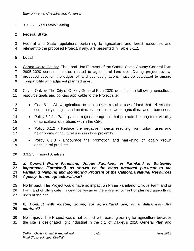
3.3.2.1 Environmental Setting 2
The DuPont Oakley site is a former industrial facility. The site is not mapped as 3 farmland or subject to a Williamson Act contract. The site is zoned heavy industrial and 4 designated light industrial in the city of Oakley’s 2020 General Plan (City of Oakley 5 2010). 6
Environmental Checklist and Analysis
DuPont Oakley Outfall Removal and 3-20 June 2013 Final Closure Project IS/MND
3.3.2.2 Regulatory Setting 1
Federal/State 2
Federal and State regulations pertaining to agriculture and forest resources and 3 relevant to the proposed Project, if any, are presented in Table 3-1.2. 4
Local 5
Contra Costa County. The Land Use Element of the Contra Costa County General Plan 6 2005-2020 contains policies related to agricultural land use. During project review, 7 proposed uses on the edges of land use designations must be evaluated to ensure 8 compatibility with adjacent planned uses. 9
City of Oakley. The City of Oakley General Plan 2020 identifies the following agricultural 10 resource goals and policies applicable to the Project site: 11
• Goal 6.1 - Allow agriculture to continue as a viable use of land that reflects the 12 community’s origins and minimizes conflicts between agricultural and urban uses. 13
• Policy 6.1.1 - Participate in regional programs that promote the long-term viability 14 of agricultural operations within the City. 15
• Policy 6.1.2 - Reduce the negative impacts resulting from urban uses and 16 neighboring agricultural uses in close proximity. 17
• Policy 6.1.3 - Encourage the promotion and marketing of locally grown 18 agricultural products. 19
3.3.2.3 Impact Analysis 20
a) Convert Prime Farmland, Unique Farmland, or Farmland of Statewide 21 Importance (Farmland), as shown on the maps prepared pursuant to the 22 Farmland Mapping and Monitoring Program of the California Natural Resources 23 Agency, to non-agricultural use? 24
No Impact. The Project would have no impact on Prime Farmland, Unique Farmland or 25 Farmland of Statewide Importance because there are no current or planned agricultural 26 uses at the site. 27
b) Conflict with existing zoning for agricultural use, or a Williamson Act 28 contract? 29
No Impact. The Project would not conflict with existing zoning for agriculture because 30 the site is designated light industrial in the city of Oakley’s 2020 General Plan and 31

Environmental Checklist and Analysis
June 2013 3-21 DuPont Oakley Outfall Removal and Final Closure Project IS/MND
zoned heavy industrial. The site is not operated under a Williamson Act contract with 1 any local governments for the purpose of restricting specific parcels of land to 2 agricultural or related open space use. 3
c) Conflict with existing zoning for, or cause rezoning of, forest land (as defined 4 in Pub. Resources Code § 12220, subd. (g)), timberland (as defined by Pub. 5 Resources Code § 4526), or timberland zoned Timberland Production (as defined 6 by Gov. Code § 51104, subd. (g))? 7
No Impact. No forest lands or timberlands are located in the vicinity of the site; 8 therefore, there would be no impact. 9
d) Result in the loss of forest land or conversion of forest land to non-forest 10 use? 11
No Impact. No forest lands or timberlands are located in the vicinity of the site; 12 therefore, there would be no impact. 13
e) Involve other changes in the existing environment which, due to their location 14 or nature, could result in conversion of Farmland to non-agricultural use or 15 conversion of forest land into non-forest use? 16
No Impact. The Project would not alter the existing environment such that farmland or 17 forest land would be converted to non-agricultural or non-forest uses. 18
3.3.2.4 Mitigation Summary 19
The Project would not result in significant impacts to agriculture and forest resources; 20 no mitigation is required. 21
Environmental Checklist and Analysis
DuPont Oakley Outfall Removal and 3-22 June 2013 Final Closure Project IS/MND
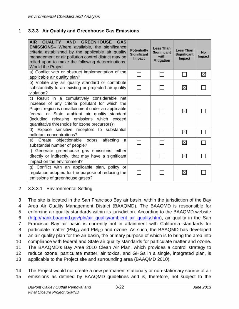
3.3.3 Air Quality and Greenhouse Gas Emissions 1
AIR QUALITY AND GREENHOUSE GAS EMISSIONS– Where available, the significance criteria established by the applicable air quality management or air pollution control district may be relied upon to make the following determinations. Would the Project:
Potentially Significant
Impact
Less Than Significant
with Mitigation
Less Than Significant
Impact
No Impact
a) Conflict with or obstruct implementation of the applicable air quality plan?
b) Violate any air quality standard or contribute substantially to an existing or projected air quality violation?
c) Result in a cumulatively considerable net increase of any criteria pollutant for which the Project region is nonattainment under an applicable federal or State ambient air quality standard (including releasing emissions which exceed quantitative thresholds for ozone precursors)?
d) Expose sensitive receptors to substantial pollutant concentrations?
e) Create objectionable odors affecting a substantial number of people?
f) Generate greenhouse gas emissions, either directly or indirectly, that may have a significant impact on the environment?
g) Conflict with an applicable plan, policy or regulation adopted for the purpose of reducing the emissions of greenhouse gases?
3.3.3.1 Environmental Setting 2
The site is located in the San Francisco Bay air basin, within the jurisdiction of the Bay 3 Area Air Quality Management District (BAAQMD). The BAAQMD is responsible for 4 enforcing air quality standards within its jurisdiction. According to the BAAQMD website 5 (http://hank.baaqmd.gov/pln/air_quality/ambient_air_quality.htm), air quality in the San 6 Francisco Bay air basin is currently not in attainment with California standards for 7 particulate matter (PM2.5 and PM10) and ozone. As such, the BAAQMD has developed 8 an air quality plan for the air basin, the primary purpose of which is to bring the area into 9 compliance with federal and State air quality standards for particulate matter and ozone. 10 The BAAQMD’s Bay Area 2010 Clean Air Plan, which provides a control strategy to 11 reduce ozone, particulate matter, air toxics, and GHGs in a single, integrated plan, is 12 applicable to the Project site and surrounding area (BAAQMD 2010). 13
The Project would not create a new permanent stationary or non-stationary source of air 14 emissions as defined by BAAQMD guidelines and is, therefore, not subject to the 15

Environmental Checklist and Analysis
June 2013 3-23 DuPont Oakley Outfall Removal and Final Closure Project IS/MND
thresholds of significance that apply to the operational impacts created by new 1 permanent sources. The Project is therefore evaluated in the context of construction-2 related impacts for which the BAAQMD has not established significance thresholds. 3
3.3.3.2 Regulatory Setting 4
Federal/State 5
Federal and State regulations pertaining to air quality and relevant to the proposed 6 Project, if any, are presented in Table 3-1.2. 7
The U.S. Environmental Protection Agency (USEPA) implements several programs 8 established under the CAA (42 U.S.C 85), such as establishing and reviewing the 9 NAAQS and judging the adequacy of State Implementation Plans (SIPs), while also 10 retaining an oversight role to ensure the implementation of Federal programs that the 11 USEPA has delegated implementation authority to the states. 12
The California Air Resources Board (CARB) is responsible for establishing and 13 reviewing the State standards, compiling the California SIP, securing approval of that 14 plan from the USEPA, and identifying toxic air contaminants. The CARB also regulates 15 mobile sources of emissions in California such as construction equipment, trucks, and 16 automobiles. For example, on-road vehicles with a gross vehicular weight rating of 17 10,000 pounds or greater cannot idle for longer than 5 minutes at any location (Cal. 18 Code Regs., tit. 13, § 2485); this restriction does not apply when vehicles remain 19 motionless during traffic or when vehicles are queuing. In addition, off-road equipment 20 engines, such as dozers, trenchers, etc., cannot idle for longer than 5 minutes (Cal. 21 Code Regs., tit. 13, § 2449, subd. (d)(3)). Exceptions to this rule include idling: 1) when 22 queuing; 2) to verify that the vehicle is in safe operating condition; 3) for testing, 23 servicing, repairing, or diagnostic purposes; 4) to accomplish work for which the vehicle 24 was designed (i.e., operating a crane); 5) to bring the machine to operating temperature 25 as specified by the manufacturer; and 6) to ensure safe operation of the vehicle. The 26 CARB also oversees the activities of California’s air quality management districts, which 27 are organized at the county or regional level. County or regional air quality management 28 districts are primarily responsible for regulating stationary sources at industrial and 29 commercial facilities within their geographic areas and for preparing the air quality plans 30 that are required under the CAA and CCAA. 31
Regional and Local 32
BAAQMD. Locally, air quality is regulated by air quality management districts or air 33 pollution control districts. The Project site is located in Contra Costa County, which is 34 within the jurisdiction of the BAAQMD. The BAAQMD has produced guidance for 35 evaluating potential air quality impacts of projects. These guidance documents are 36

Environmental Checklist and Analysis
DuPont Oakley Outfall Removal and 3-24 June 2013 Final Closure Project IS/MND
developed so that projects do not exceed any thresholds of significance in the guidance, 1 and thereby will be in conformity with BAAQMD air quality plans. The CAA and the 2 CCAA require plans to be developed for areas designated as nonattainment (with the 3 exception of areas designated as nonattainment for the State PM10 standard). The 4 BAAQMD adopted the 2010 Bay Area Clean Air Plan, which replaced the existing Bay 5 Area 2005 Ozone Strategy. This plan includes ozone (O3) control measures and also 6 considers the impacts of these control measures on particulate matter, air toxics, and 7 GHGs in a single, integrated plan (BAAQMD 2010). 8
Contra Costa County. The Conservation Element of the Contra Costa County General 9 Plan 2005-2020 includes goals and policies that aim to improve local and regional air 10 quality throughout the County. The following air resources policies may be applicable to 11 the proposed Project: 12
• Policy 8-103 - When there is a finding that a proposed project might significantly 13 affect air quality, appropriate mitigation measures shall be imposed. 14
• Policy 8-104 - Proposed projects shall be reviewed for their potential to generate 15 hazardous air pollutants. 16
City of Oakley. The city of Oakley’s General Plan 2020 identifies the following air quality 17 goals and policies that may be applicable to the Project site: 18
• Goal 6.2 - Maintain or improve air quality in the City of Oakley. 19
• Policy 6.2.1 - Support the principles of reducing air pollutants through land use, 20 transportation, and energy use planning. 21
3.3.3.3 Impact Analysis 22
a) Conflict with or obstruct implementation of the applicable air quality plan? 23
No Impact. The development of the Bay Area 2010 Clean Air Plan relied on projections 24 of population and employment forecasts made by the Association of Bay Area 25 Governments (ABAG) to inform the control strategies for attaining federal and State air 26 quality standards. The ABAG projections were in turn based on land use projections 27 made by local jurisdictions (e.g., the General Plan process of cities and counties within 28 the region). Conflicts with the air quality plan would arise if the Project’s activities 29 caused those projections to be exceeded by creating a substantial increase in 30 employment or population. Large population or employment increases could affect 31 transportation control strategies, which are among the most important in the air quality 32 plan, since transportation is a major contributor to PM2.5, PM10, and ozone, for which the 33 air basin is not in attainment. Because the Project does not propose activities that would 34 change population or employment levels within the air basin, the Project would not 35

Environmental Checklist and Analysis
June 2013 3-25 DuPont Oakley Outfall Removal and Final Closure Project IS/MND
conflict or obstruct implementation of the applicable air quality plan. The Project would 1 implement measures to control air emissions as described in the following sections. 2
b) Violate any air quality standard or contribute substantially to an existing or 3 projected air quality violation? 4
Less than Significant Impact. Project activities that would emit air pollutants include 5 use of cars and trucks to transport people and materials to and from the site and 6 operation of construction and other equipment (e.g., the motor used to maneuver the 7 barge, an excavator) to remove the outfall pipe, dig trenches, place backfill, and restore 8 the site. Construction activities would be of short duration, lasting a few days to a few 9 weeks during each phase of demolition, as summarized in Table 2-1. The Project would 10 not create a new permanent stationary or non-stationary source of air emissions as 11 defined by BAAQMD guidelines. As such, the Project is not subject to the thresholds of 12 significance that apply to operational impacts created by new permanent sources, and 13 is, therefore, evaluated in the context of construction-related impacts. Project emissions, 14 calculated using CalEEMod air emissions software, are presented in Table 3.3-1. 15
Table 3.3-1 16 Summary of Predicted Project-Related Emissions 17
ROG NOx PM10 PM2.5 Phase Component (pounds per day)
1 Barge-related 3.01 30.70 0.77 0.72 Other 1.41 10.82 6.53 0.98 Total 4.42 41.52 7.30 1.70
2 Barge-related 3.01 30.70 0.77 0.72 Other 2.73 21.55 8.44 1.51 Total 5.74 52.25 9.21 2.23
3 Barge-related 3.01 30.70 0.77 0.72 Other 1.39 10.92 6.58 2.11 Total 4.40 41.62 7.35 2.83
Notes: Emissions were estimated using the CalEEMod model and documentation associated with the Proposed Regulations to Reduce Emissions from Diesel Engines on Commercial Harbor Craft Operated within California Waters and 24 Nautical Miles of the California Baseline, with Amendments. They are based on the estimated work schedule and type of equipment noted in Table 2-1 of this document. ROG – reactive organic gases, NOx – oxides of nitrogen, PM10 – particulate matter less than 10 microns in diameter, PM2.5 – particulate matter less than 2.5 microns in diameter.
The proposed activities would not produce substantial daily amounts of particulate 18 matter and ozone or ozone precursors, such as reactive organic gases or oxides of 19 nitrogen. The Project would not violate any air quality standard or contribute 20 substantially to an existing or projected air quality violation. Nevertheless, BAAQMD 21 recommends that a project implement certain basic construction control measures for 22 sites of less than 4 acres and sites that are not expected to be particularly dusty or 23 located near sensitive receptors (the primary work area is approximately ¼ mile from 24 the nearest sensitive receptor). – to the extent applicable and needed (BAAQMD 2012). 25

Environmental Checklist and Analysis
DuPont Oakley Outfall Removal and 3-26 June 2013 Final Closure Project IS/MND
Most basic measures recommended by the BAAQMD are unlikely to be needed, such 1 as applying water to construction areas or sweeping public streets, given the nature of 2 the work, its location on the river and within wetlands adjacent to the river, and the small 3 size of the work area subject to ground disturbance. The following APMs are provided to 4 further reduce impacts to air quality. 5
APM-1. Dust Control Measures. The Bay Area Air Quality Management District’s 6 “basic measures” for dust control at construction sites will be implemented, as 7 needed, during soil excavation. The basic measures include the following: 8
• Water all active construction areas at least twice daily. 9
• Cover all trucks hauling soil, sand, and other loose materials or require all 10 trucks to maintain at least 2 feet of freeboard. 11
• Pave, apply water three times daily, or apply (non-toxic) soil stabilizers on all 12 unpaved access roads, parking areas and staging areas at construction sites. 13
• Sweep daily (with water sweepers) all paved access roads, parking areas and 14 staging areas at construction sites. 15
• Sweep streets daily (with water sweepers) if visible soil material is carried 16 onto adjacent public streets. 17
Site roads are generally paved, which would reduce dust emissions from vehicle 18 traffic. Construction equipment (e.g., excavator) would be inspected before leaving 19 the site to ensure that soil is not adhering to tires or other vehicle parts. Vehicles 20 would be brushed to remove loose dirt, as necessary. Manual sweeping and 21 housekeeping would be performed as needed to keep dirt off of roadways. 22
APM-2. Air Pollutant Control Measures. The Project shall include emission 23 reduction measures in the Project plans and specifications that will reduce the 24 emission of criteria air pollutants. These include: 25
• harborcraft such as derricks, barges and tug boats shall meet the most 26 stringent U.S. Environmental Protection Agency emission standard in place at 27 the time of bid (Tier II for marine engines and non-road engines over 750 28 horsepower (hp), Tier III for all other engines); 29
• portable equipment with engines 50 hp and over shall be permitted through 30 the California Air Resources Board’s Portable Equipment Registration 31 Program; 32
• use diesel oxidation catalysts and/or catalyzed diesel particulate traps; 33
• use high-pressure fuel injectors on diesel-powered equipment; and 34
• maintain equipment according to manufacturer specifications. 35

Environmental Checklist and Analysis
June 2013 3-27 DuPont Oakley Outfall Removal and Final Closure Project IS/MND
Based on the results presented in Table 3.3-1 and with implementation of the 1 BAAQMD’s applicable basic dust control measures and the emission reduction 2 measures (APM-1 and APM-2) included as part of the Project, the Project would not 3 violate any air quality standard or contribute substantially to an existing or projected air 4 quality violation. 5
c) Result in a cumulatively considerable net increase of any criteria pollutant for 6 which the project region is non-attainment under an applicable federal or State 7 ambient air quality standard (including releasing emissions which exceed 8 quantitative thresholds for ozone precursors)? 9
Less than Significant Impact. The San Francisco Bay air basin, within which the 10 Project is located, is not in attainment for particulate matter (PM2.5 and PM10) or ozone 11 under California’s air quality standards. Although there would be short-term emissions 12 of these pollutants from vehicles and equipment during construction, the emissions 13 would be temporary, of short duration, and small in quantity given the small numbers of 14 vehicles and construction equipment needed to complete the work. In addition, Project 15 emissions of particulate matter would be reduced by APM-1 and APM-2. The Project 16 would not generate long-term emissions of particulate matter or ozone and would not 17 cause a cumulatively considerable increase of particulate matter or ozone 18
d) Expose sensitive receptors to substantial pollutant concentrations 19
Less than Significant Impact. The nearest sensitive receptors are the occupants of 20 the house at Lauritzen Yacht Harbor, which is located approximately ¼ mile southwest 21 of the primary shoreline work area and 400 feet from the on-site access road and haul 22 route, which is paved in that area. A residential neighborhood is located approximately 23 1½ to 2 miles to the southeast. No schools, hospitals or day care centers are located 24 within 1 mile of the Project site. 25
Small numbers of vehicles and pieces of construction equipment, such as pick-up 26 trucks, a barge, an excavator and a dump truck would be used to transport people and 27 materials, remove and transport the outfall pipe and concrete anchors, dig trenches, 28 and place backfill. Emissions from the vehicles and equipment would be of short 29 duration and occur more than ¼ mile from the nearest school, hospital, or neighborhood 30 in which a substantial number of people reside. The onshore portion of the work would 31 occur within ¼ mile of the residence at Lauritzen Yacht Harbor. Activity in the vicinity of 32 the residence would include occasional vehicle trips to and from the shoreline work 33 area. The majority of the trips would be by pick-up trucks or personal vehicles as they 34 take workers to and from the site. A few trips would be by medium duty trucks to 35 transport equipment and supplies (e.g., transport the excavator to and from the site), a 36 dump truck to bring backfill to the work area, and larger trucks to transport the pieces of 37 pipe and the concrete anchors should the structure be pulled on shore for demolition. 38

Environmental Checklist and Analysis
DuPont Oakley Outfall Removal and 3-28 June 2013 Final Closure Project IS/MND
With the implementation of APM-1 included as part of the Project, and because 1 emissions of dust or vehicle exhaust fumes associated with removing the outfall pipe 2 would be of short-term duration, the Project would not expose sensitive receptors to 3 substantial pollutant concentrations. 4
e) Create objectionable odors affecting a substantial number of people? 5
Less than Significant Impact. Diesel fumes, which may be considered an 6 objectionable odor by some, would be emitted by equipment and vehicles during pipe 7 removal (e.g., the excavator or the motor used to maneuver the barge). These 8 emissions would be of short duration, have a localized area of impact because only one 9 or two pieces of equipment would operate at any given time, and all activities would 10 occur more than ¼ mile from the nearest school, hospital, or residential neighborhood. 11 The barge and excavator would operate approximately ¼ mile down- or cross-wind of 12 the single residence located at Lauritzen Yacht Harbor (prevailing winds are from the 13 west-northwest). Activities nearer to the residence, along the site access road, would be 14 infrequent and of very short duration. The Project would therefore not expose a 15 substantial number of people to objectionable odors. 16
f) Generate GHG emissions, either directly or indirectly, that may have a 17 significant impact on the environment? 18
Less than Significant Impact. Temporary activities associated with the Project, such 19 as conventional construction activities, would be relatively brief – approximately 6 20 weeks in this case. Demolition activities would not produce substantial amounts of 21 GHGs. The removal, demolition and disposal of the outfall pipe is expected to generate 22 approximately 41.0 metric tons of CO2e – 11.2 metric tons of CO2e would be generated 23 by the barge and the remaining 29.8 metric tons of CO2e would be generated by 24 equipment, trucks and other vehicles. Comparison of the emissions from the Project 25 with the community-wide annual emissions estimate provided in the city of Oakley’s 26 2005 Community-Wide Greenhouse Gas Emissions Inventory (City Emission Inventory) 27 can illustrate the scale of the temporary Project contribution. That ratio is 0.03%. The 28 Project’s temporary relative contribution to county-wide, region-wide, State-wide, nation-29 wide, and world-wide GHG emissions would be progressively smaller still. In addition, 30 the Project would include emission reduction measures as identified in the following 31 section. Project GHG emissions would be temporary and very low as compared to 32 projects that create permanent sources of GHG emissions. 33
g) Conflict with an applicable plan, policy or regulation adopted for the purpose 34 of reducing GHG emissions? 35
Less than Significant Impact. The California Environmental Protection Agency 36 Climate Action Team (CAT) and CARB have developed several reports to achieve the 37

Environmental Checklist and Analysis
June 2013 3-29 DuPont Oakley Outfall Removal and Final Closure Project IS/MND
GHG targets identified by the State in Executive Order S-3-05 and AB32. These include 1 the CAT’s 2006 Report to Governor Schwarzenegger and the Legislature, ARB’s 2007 2 Expanded List of Early Action measures to Reduce Greenhouse Gas Emissions in 3 California, and ARB’s Climate Change Proposed Scoping Plan: a Framework for 4 Change. The reports identify strategies to reduce California’s emissions to the levels 5 proposed in Executive Order S-3-05 and AB 32. The adopted Scoping Plan includes 6 proposed GHG emissions reduction from direct regulations, alternative compliance 7 mechanisms, monetary and non-monetary incentives, voluntary actions, and market-8 based mechanisms 9
The Project does not conflict with the State’s plans, policies or regulations for GHG 10 emissions because it includes measures to reduce and minimize GHG emissions as 11 identified in the Scoping Plan and other reports. Emission reduction measures 12 incorporated into the Project plans and specifications as APM-2 include: 1) harborcraft 13 such as derricks, barges and tug boats shall meet the most stringent USEPA emission 14 standard in place at the time of bid (Tier II for marine engines and non-road engines 15 over 750 hp, Tier III for all other engines); 2) portable equipment with engines 50 hp and 16 over shall be permitted through the CARB’s Portable Equipment Registration Program; 17 3) use diesel oxidation catalysts and/or catalyzed diesel particulate traps; 4) use high-18 pressure fuel injectors on diesel-powered equipment; and 5) maintain equipment 19 according to manufacturer specifications. Given the above measures, the Project would 20 be consistent with the State’s goal to offset or reduce GHG emissions and does not 21 conflict with an applicable plan, policy or regulation adopted for the purpose of reducing 22 GHG emissions. 23
3.3.3.4 Mitigation Summary 24
Implementation of the following measures will reduce Project-related emissions to less 25 than significant. 26
• APM-1. Dust Control Measures; and 27
• APM-2. Air Pollutant Control Measures. 28

Environmental Checklist and Analysis
DuPont Oakley Outfall Removal and 3-30 June 2013 Final Closure Project IS/MND
3.3.4 Biological Resources 1
BIOLOGICAL RESOURCES – Would the Project: Potentially Significant
Impact
Less Than Significant
with Mitigation
Less Than Significant
Impact
No Impact
a) Have a substantial adverse effect, either directly or through habitat modifications, on any species identified as a candidate, sensitive, or special status species in local or regional plans, policies, or regulations, or by the California Department of Fish and Wildlife or U.S. Fish and Wildlife Service?
b) Have a substantial adverse effect on any riparian habitat or other sensitive natural community identified in local or regional plans, policies, regulations or by the California Department of Fish and Wildlife or U.S. Fish and Wildlife Service?
c) Have a substantial adverse effect on federally protected wetlands as defined by Section 404 of the Clean Water Act (including, but not limited to, marsh, vernal pool, coastal, etc.) through direct removal, filling, hydrological interruption, or other means?
d) Interfere substantially with the movement of any native resident or migratory fish or wildlife species or with established native resident or migratory wildlife corridors, or impede the use of native wildlife nursery sites?
e) Conflict with any local policies or ordinances protecting biological resources, such as a tree preservation policy or ordinance?
f) Conflict with the provisions of an adopted Habitat Conservation Plan, Natural Community Conservation Plan, or other approved local, regional, or State habitat conservation plan?
3.3.4.1 Environmental Setting 2
Overview 3
The Project site is located in the northwest quadrant of the DuPont property and on 4 adjoining State land within the San Joaquin River. Many onshore components of the 5 Project, including access roads, haul routes and a staging area, would be located on 6 developed uplands occupied by paved roads and parking areas, foundations and other 7 remnants of the former manufacturing facilities. A soil stockpile is located in a fallow, 8 former agricultural field with a cover of primarily non-native grasses and forbs. A small, 9 isolated wetland is located a few feet north of the soil stockpile. An east-west row of 10

Environmental Checklist and Analysis
June 2013 3-31 DuPont Oakley Outfall Removal and Final Closure Project IS/MND
eucalyptus (Eucalyptus globulis) and beach sheoak (Casuarina equisetifolia) trees is 1 located between the soil stockpile and staging area. In the area where the outfall pipe is 2 located, an approximately 50-foot-wide band of wetlands is present between the San 3 Joaquin River and the upland portion of the DuPont property. The outfall pipe passes 4 beneath the band of wetlands and extends into the San Joaquin River about 200 feet. 5
Information Sources Used to Development Environmental Setting 6
Two wetland delineations and several plant, bird and wildlife surveys have been 7 conducted at the DuPont property during the past 12 years. Information collected during 8 the surveys and delineations and other sources such as the California Natural Diversity 9 Database (CNDDB) and environmental documents prepared for the Oakley Generating 10 Station (OGS) were used to prepare the description of terrestrial plant communities and 11 wildlife that are present, and special-status species that may be present, at the Project 12 site. The primary references include the following: 13
• Reconnaissance-Level Biological Survey Report (Parsons 2010) – special-status 14 plants, invertebrates, reptiles, and birds (Appendix C) 15
• Delineation Report for Potential Jurisdictional Waters of the United States 16 Including Wetlands (URS 2007) – wetlands, plant communities and special-17 status plants; this delineation was verified by the USACE in December 2008 18
• Delineation of Wetlands at the DuPont Oakley Plant (URS 2000a) – wetlands, 19 plant communities, and special-status plants 20
• Rare Plant Survey, Final Memorandum (URS 2002) – special-status plants 21
• Bird Survey Memorandum (URS 2000b) – special-status birds 22
• Oakley Generating Station, Final Staff Assessment (CEC 2011) – plant 23 communities, special-status plants, invertebrates, reptiles, birds and mammals 24
• CNDDB searches were completed in March 2012 and June 2010 25
Descriptions of special-status fish species that are known to be present in the San 26 Joaquin River system and may be present at the Project site during at least some of 27 their developmental phases are summarized from life histories prepared by the CDFW, 28 USFWS, and NMFS (CDFW 2013a, NMFS 2013a, USFWS 2013a, USFWS 2013b). 29
Wetlands and Waters of the U.S. 30
Wetland delineations conducted at the site have identified two potential wetland areas 31 within the Project vicinity – the Little Break wetlands adjacent to the San Joaquin River 32 and an isolated wetland identified as the fallow vineyard wetland, which is located north 33 of the soil stockpile (Figures 3-1 and 3-2). 34
35

%
LauritzenYacht
Harbor
San Joaquin River
Little Break WetlandsTidal and adjacentwetlands above the
ordinary high water mark.
Tidal wetlands between the hightide line and ordinary high water mark
are subject to Section 404 of theClean Water Act.
Waters of the U.S. (including tidal wetlands)below the ordinary high water mark are subject
to Section 10 of the Rivers and Harbors Actand Section 404 of the Clean Water Act.
TidalWetlandsTidal
Wetlands
Ordinary HighWater Mark
Waters of the U.S., Temporary Impact Area0.079 Acres
High Tide Linein Project Vicinity
Tidal wetlands, low marsh, Temporary Impact Area0.037 Acres
Tidal wetlands, high marsh, Temporary Impact Area0.039 Acres
³
LEGEND
% HeadwallHigh Tide Line in Project VicinityOrdinary High Water MarkAccess Road and Haul RouteAreas of ImpactApproximate Area of Demolition ActivityWetlandsProperty Boundary
Obsolete NPDES Outfall Pipe:36-inch Diameter Steel Pipe24-inch Diameter PVC Pipe
2121 North California BoulevardSuite 500
Walnut Creek, California 94596
Parsons Environment & Infrastructure
0 100 200Feet
Title: Wetlands and Waters of the U.S. in theShoreline Work AreaRemoval of Obsolete NPDES Outfall PipeDuPont Oakley SiteOakley, Contra Costa County, California
File Name:
Date:
Revised:
Figure Number:
3-1
Figure 3-1 Wetlands&Waters
4/22/2013
PDS/DJB 446381Drawn/Approved: File Project Number:

3-

Environmental Checklist and Analysis
DuPont Oakley Outfall Removal and 3-34 June 2013 Final Closure Project IS/MND
The Little Break wetlands are identified in the 2007 delineation report as waters of the 1 U.S. because they meet the USACE’s criteria for wetlands and they have a visible 2 connection to navigable waters (the San Joaquin River). The Little Break wetlands, as 3 delineated in the 2007 report, extend inland from the river’s OHWM, which is the line on 4 the shore established by fluctuations of water and indicated by physical characteristics 5 such as a clear, natural line impressed on the bank or other means. The boundary 6 between the river and the wetlands as delineated by the OHWM of the river generally 7 corresponds to the DuPont property line. While the 2007 delineation report identified 8 only the high marsh tidal wetlands located above the OHWM, low marsh tidal wetlands 9 are present below the OHWM. Wetlands located above the OHWM are subject to CWA 10 Section 404. Wetlands located below the OHWM are subject to CWA Section 404 and 11 Rivers and Harbors Act Section 10. The outfall pipe passes beneath a narrow strip of 12 the Little Break wetlands and extends another approximately 200 feet into and along the 13 riverbed to the pipe’s terminus. The Little Break wetlands in this area are classified as 14 “palustrine emergent semipermanent tidal wetland.” Below the OHWM, the San Joaquin 15 River is classified as “riverine tidal unconsolidated bottom permanent tidal.” 16
North of the soil stockpile, the 2007 delineation report mapped an area in the fallow 17 vineyard as wetland, but because this small wetland has no visible connection to 18 navigable waters, it is considered an isolated system and is not subject to USACE 19 jurisdiction. The delineation report notes however, that the fallow vineyard wetland may 20 be regulated through the RWQCB’s Section 401 Water Quality Certification program. 21 Although the Project is near the fallow vineyard wetland, the wetland is not within the 22 Project footprint. Protections previously installed around the soil stockpile as part of 23 another project would remain in place and the Project would not affect the wetland. 24
Plant Communities 25
Two plant communities predominate at the Project site. A ruderal grassland community 26 is present around the staging area, soil stockpile, and access roads and in the upland 27 portion of the shoreline work area. An emergent wetland plant community dominated by 28 tules (Schoenoplectus sp.) occupies the wetlands in the shoreline work area. 29
Ruderal grassland is present in the area around the soil stockpile. The vegetation here 30 is typical of most upland areas on the DuPont property. The ruderal grassland is 31 dominated by rattail fescue (Vulpia myuros) and contains species such as red maids 32 (Calandrinia ciliata) and common groundsel (Senecio vulgaris). The fallow vineyard 33 wetland located north of the soil stockpile is dominated by saltgrass (Distichlis spicata), 34 hyssop loosestrife (Lythrum hyssopifolium) and Bermuda grass (Cynodon dactylon). 35 The 2007 wetlands delineation noted that the presence of hyssop loosestrife and 36 common tule (Schoenoplectus acutus) differentiate this community from the surrounding 37 uplands. The vegetation surrounding the staging and access roads, which are paved 38 and devoid of vegetation themselves, is also ruderal grassland and contains remnants 39

Environmental Checklist and Analysis
June 2013 3-35 DuPont Oakley Outfall Removal and Final Closure Project IS/MND
of landscape plantings that are no longer actively maintained – eucalyptus, beach 1 sheoak and oleander (Nerium oleander). 2
The shoreline work area transitions from ruderal grassland in the upland at the southern 3 end of the work area to emergent wetland dominated by tules at the shoreline. The 4 sloped river bank that demarcates the boundary between the ruderal grassland and 5 wetland is dominated by brambles (Rubus sp.). No substantial non-wetland riparian 6 habitat is present on the shore at the Project site. The Schoenoplectus plant community 7 as described in the 2007 wetlands delineation report occupies the high marsh and low 8 marsh wetlands at the river’s edge within the riparian zone. Based on a recent survey of 9 the Project site, the low marsh vegetation is similar to the high marsh vegetation but 10 becomes sparser as the water becomes deeper and the frequency and duration of 11 inundation increases below the OHWM (Parsons 2012). At the Project site, the 12 Schoenoplectus plant community is dominated by California tule (Schoenoplectus 13 californicus). Other species present along the shore include common tule, common 14 cattail (Typha latifolia), narrow-leaved cattail (T. angustifolia) and willows (Salix sp.). 15
Special-Status Species 16
A list of special-status plant and animal species that may occur at the Project site was 17 compiled by reviewing output from the CNDDB, previous surveys conducted on the 18 DuPont property and vicinity, and by consulting other information sources available from 19 the CDFW, USFWS and NMFS (Table 3.3-1). 20
Plants 21
Rare plant surveys of the DuPont property, including the Little Break wetlands and San 22 Joaquin River shoreline, were conducted in 2001 (URS 2002). The 2001 surveys were 23 timed to coincide with the flowering periods of most target species. USFWS records and 24 the CNDDB were reviewed prior to the surveys. Five of the special-status plants listed in 25 Table 3.3-2 were observed on the DuPont property during the 2001 rare plant survey, 26 including Suisun Marsh aster (Symphyotrichum lentum), northern California black 27 walnut (Juglans hindsii), Delta tule pea (Lathyrus jepsonii var. jepsonii), Mason’s 28 lilaeopsis (Lilaeopsis masonii), and Delta mudwort (Limosella subulata). The identities 29 of the species were confirmed by comparing specimens from the DuPont property with 30 specimens at the Antioch Dunes National Wildlife Refuge, which is located along the 31 San Joaquin River approximately 2 miles downstream of the DuPont property. The 32 locations of the specimens is not recorded in the survey report, but among the five 33 species, the shoreline work area provides potential habitat for Suisun Marsh aster, Delta 34 tule pea, Mason’s lilaeopsis and Delta mudwort. The upland Project area is potential 35 habitat for northern California black walnut. 36

Environmental Checklist and Analysis
DuPont Oakley Outfall Removal and 3-36 June 2013 Final Closure Project IS/MND
Table 3.3-2 1 Special-Status Species with the Potential to Occur On Site 2
Common name
Scientific name Status Habitat Potential to Occur
Plants
Soft bird’s beak Chloropyron molle ssp. molle
FE,SR 1B Coastal salt marsh
Absent: Suitable habitat does not occur on site or adjacent to Project area
Bolander’s water-hemlock Cicuta maculata var. bolanderi 2 Freshwater or brackish
marsh
Moderate: Suitable habitat present, but not observed during surveys of DuPont property
Woolly rose mallow Hibiscus lasiocarpos var. occidentalis 1B Freshwater marsh
Moderate: Suitable habitat present, but not observed during surveys of DuPont property
Northern California black walnut Juglans hindsii 1B Riparian forest and
woodland Absent: Not observed during surveys of the Project site
Delta tule pea Lathyrus jepsonii var. jepsonii 1B Freshwater or brackish
marsh
Present: Specimen observed at Project site near shoreline work area
Mason’s lilaeopsis Lilaeopsis masonii SR 1B
Freshwater or brackish marsh
Moderate: Suitable habitat present and observed on the DuPont property
Delta mudwort Limosella subulata 2 Freshwater marsh Moderate: Suitable habitat present and observed on the DuPont property
Antioch dunes evening primrose
Oenothera deltoides ssp.howellii
FE,SE 1B Riverine sand dunes
Absent: Suitable habitat does not occur on site or adjacent to Project area
Eel-grass pondweed Potamogeton zosteriformis 2 Freshwater marsh Moderate: Suitable habitat present, but not observed during surveys of DuPont property
Side-flowering skullcap Scutellaria lateriflora 2 Mesic meadows, freshwater marsh
Moderate: Suitable habitat present, but not observed during

Environmental Checklist and Analysis
June 2013 3-37 DuPont Oakley Outfall Removal and Final Closure Project IS/MND
Common name
Scientific name Status Habitat Potential to Occur
surveys of DuPont property
Suisun Marsh aster Symphyotrichum lentum 1B Freshwater and brackish marsh
Moderate: Suitable habitat present and observed on the DuPont property
Invertebrates
Lange’s metalmark butterfly Apodemia mormo langei FE Riverine sand dunes
Absent: Suitable habitat (host plant) not present on site or adjacent to Project area
Fish Green sturgeon (southern DPS) Acipenser medirostris FT Aquatic, San Joaquin
River High: San Joaquin River provides habitat for species
Delta smelt Hypomesus transpacificus FT,SE Aquatic, San Joaquin River
High: San Joaquin River provides habitat for species
Chinook salmon (Central Valley Fall- and late Fall-run ESU)
Oncorhynchus tshawytscha SC Aquatic, San Joaquin River
High: San Joaquin River provides habitat for species
Chinook salmon (Sacramento River Winter-run ESU)
Oncorhynchus tshawytscha FE,SE Aquatic, San Joaquin River
High: San Joaquin River provides habitat for species
Chinook salmon (Central Valley Spring-run ESU) Oncorhynchus tshawytscha FT,ST Aquatic, San Joaquin
River High: San Joaquin River provides habitat for species
Steelhead trout (Central Valley DPS) Oncorhynchus mykiss FT Aquatic, San Joaquin
River High: San Joaquin River provides habitat for species
Sacramento splittail Pogonichthys macrolepidotus SSC Aquatic, San Joaquin
River High: San Joaquin River provides habitat for species
Longfin smelt Spirinchus thaleichthys ST Aquatic, San Joaquin River
High: San Joaquin River provides habitat for species

Environmental Checklist and Analysis
DuPont Oakley Outfall Removal and 3-38 June 2013 Final Closure Project IS/MND
Common name
Scientific name Status Habitat Potential to Occur
Reptiles and Amphibians
Silvery legless lizard Anniella pulchra SSC Sandy or rocky areas with open space and shrubs
Absent: Suitable habitat does not occur on site or adjacent to Project area
Western pond turtle Emys marmorata SSC Aquatic, prefers slow-moving waters
High: Species observed at adjacent marina
Giant garter snake Thamnophis gigas FT,ST Aquatic, prefers slow-moving waters
Moderate: Suitable habitat present in Project area, but not observed during surveys of DuPont property
Birds
Swainson’s hawk Buteo swainsoni ST
Open habitats with suitable nest trees and proximity to high-quality foraging habitat
Present: Species observed in Project area
Northern harrier Circus cyaneus SSC
Freshwater or brackish marsh, wet meadows, weedy borders of rivers and streams, annual and perennial grasslands
Present: Species observed in Project area
Saltmarsh yellow warbler Dendroica petechia brewsteri SSC Riparian vegetation in
close proximity to water Moderate: Suitable habitat present in Project area
Saltmarsh common yellowthroat Geothlypis trichas sinuosa SSC Freshwater or brackish
marsh Moderate: Suitable habitat present in Project area
California black rail Laterallus jamaicensis coturniculus ST,FP
Saline, brackish, and fresh emergent marshes usually dominated by dense pickleweed
Low: Suitable habitat present in Project area; more likely to occur in wetland areas located distant from Project area
Loggerhead shrike Lanius ludovicianus SSC
Shrublands or open woodlands with nearby areas of grass cover and bare ground
Low: Species observed on DuPont property but outside of Project area.

Environmental Checklist and Analysis
June 2013 3-39 DuPont Oakley Outfall Removal and Final Closure Project IS/MND
Common name
Scientific name Status Habitat Potential to Occur
Bank swallow Riparia riparia ST Nesting habitat (river banks)
Absent: Suitable habitat not present on site or adjacent to Project area
Burrowing owl Athene cuncularia SSC Sparse grassland
Absent: Soil stockpile and access roads with sparse grasses are regularly disturbed by other site investigation and maintenance activities
Mammals
Western red bat Lasiurus blossevillii SSC Roosts primarily in trees Low: Suitable roost trees present in Project area (eucalyptus near soil stockpile)
Source: CNPS Inventory of Rare and Endangered Plants (www.rareplants.cnps.org); CDFW, State and Federally Listed Endangered and Threatened Animals in California, January 2013. NOTES: Federal
FE = federally listed as endangered under the federal Endangered Species Act FT = federally listed as threatened under the federal Endangered Species Act SC=NMFS species of concern
State SE = listed as endangered under the California Endangered Species Act ST = listed as threatened under the California Endangered Species Act SR = rare under California Native Plant Protection Act SSC = species of special concern FP = fully protected
California Native Plant Society 1B = List 1B species: rare, threatened, or endangered in California and elsewhere 2 = List 2 species: rare, threatened, or endangered in California but more common elsewhere
Definitions Regarding Potential Occurrence: Present: Species or sign of its presence observed on the site High: Species or sign not observed on the site, but reasonably certain to occur on the site

Environmental Checklist and Analysis
DuPont Oakley Outfall Removal and 3-40 June 2013 Final Closure Project IS/MND
Common name
Scientific name Status Habitat Potential to Occur
Moderate: Species or sign not observed on the site, but conditions suitable for occurrence Low: Species or sign not observed on the site, conditions marginal for occurrence Absent: Species or sign not observed on the site, conditions unsuitable for occurrence

Environmental Checklist and Analysis
June 2013 3-41 DuPont Oakley Outfall Removal and Final Closure Project IS/MND
Subsequent surveys were conducted of the DuPont property in 2010 and of the Project 1 site in 2012 (Parsons 2010, 2012). The 2010 survey of the DuPont property looked 2 specifically for occurrences of the Antioch Dunes evening primrose. The Antioch Dunes 3 evening primrose is protected as endangered by both the ESA and the CESA. It favors 4 active dynamic sand dunes – a type of habitat that is not present on the DuPont 5 property. The evening primrose has not been observed in plant surveys and does not 6 appear to grow on the DuPont property given the lack of appropriate habitat. The 7 primary purpose of the 2012 survey was to observe whether sensitive plants or 8 appropriate habitat for their growth are present in the vicinity of the shoreline work area. 9 The survey was timed to occur during the late summer bloom of sensitive plant species 10 listed in Table 3.3-2, including Bolander’s water hemlock (Cicuta maculata var. 11 bolanderi), woolly rose mallow (Hibiscus lasiocarpos var. occidentalis), side-flowering 12 skullcap (Scutellaria lateriflora), Suisun Marsh aster, Delta tule pea and Mason’ 13 lilaeopsis. Plant lists were also compiled in the reports prepared for the wetlands 14 delineations that were conducted in 2000 and 2007, but no special-status plant species 15 were reported in these inventories. 16
The Suisun Marsh aster, Delta tule pea, Mason’s lilaeopsis and Delta mudwort are 17 relatively common in the Sacramento-San Joaquin Delta, but their limited distribution 18 outside of the Delta has warranted their listing as special-status plants. Within the San 19 Joaquin-Sacramento Delta, these four species occur in the specific tide zones between 20 the bulrushes (Scirpus californicus) and the mud flats below mean sea level. Mason’s 21 lilaeopsis and Delta mudwort grow in the intertidal zone that becomes submerged 22 during high tide. Suisun Marsh aster and Delta tule pea inhabit the middle and upper 23 marsh zones. Appropriate conditions for the plants’ growth are present at the Project 24 site within the shoreline work area and among the four species, Delta tule pea was 25 observed near the shoreline work area during the September 2012 plant survey. A 26 specimen of the plant was growing among brambles (Rubus sp.) located near the top of 27 the river bank approximately 25 feet west of the center line of the outfall pipe. The other 28 three species were not observed during the survey, although they have a moderate 29 potential to occur at the Project site given that appropriate habitat is present in the 30 shoreline work area and that they grow elsewhere on the DuPont property. Although 31 northern California black walnut was observed during the 2001 survey, no specimens of 32 black walnut were observed at the Project site or in nearby areas during the 2012 33 survey. 34
Among the other plants listed in Table 3.3-2 there is potential habitat for Bolander’s 35 water-hemlock, woolly rose mallow, eel-grass pondweed (Potamogeton zosteriformis) 36 and side-flowering skullcap in the shoreline work area of the Project site. Although these 37 plants have not been observed on the DuPont property, they grow in the intertidal 38 shoreline and marsh zones that are also favored by the Suisun Marsh aster, Delta tule 39

Environmental Checklist and Analysis
DuPont Oakley Outfall Removal and 3-42 June 2013 Final Closure Project IS/MND
pea, Mason’s lilaeopsis and Delta mudwort. They have a moderate potential to grow at 1 the Project site. 2
Invertebrates 3
The 2010 survey of the DuPont property looked specifically for occurrences of Lange’s 4 metalmark butterfly (Apodemia mormo langei). Lange’s metalmark butterfly is a federal-5 listed endangered species. This species is not State listed. The butterfly occurs only 6 where active dunes persist, with minimal growth of grasses and shrubby species which 7 overcrowd the open spaces. The butterfly depends critically on buckwheats (Eriogonum 8 nudum and E. fasciculatum) as host plants for caterpillars. Very few butterflies of any 9 species were seen during 2010 survey. Butterflies that were seen were all common 10 species. No buckwheat plants were found anywhere during the 2010 survey probably 11 because upland areas of the site are highly disturbed due to historical agricultural and 12 industrial uses and contain no remnant dunes. Lack of the habitat features critical in the 13 life cycle of Lange’s metalmark butterfly indicates it does not occur on the DuPont 14 property. 15
Fish 16
Several special-status fish species occur in the southern San Joaquin-Sacramento 17 River Delta in the vicinity of the Project site. These include Chinook salmon 18 (Oncorhynchus tshawytscha), steelhead trout (Oncorhynchus mykiss), Delta smelt 19 (Hypomesus transpacificus), green sturgeon (Acipenser medirostris), longfin smelt 20 (Spirinchus thaleichthys), and Sacramento splittail (Pogonichthys macrolepidotus) 21 (CDFW 2013b, NMFS 2013f). Delta smelt, green sturgeon, and steelhead trout are 22 classified as threatened under the ESA and Chinook salmon are classified as 23 endangered, threatened, or as a species of concern under the ESA and CESA, 24 depending upon the evolutionarily significant unit (ESU). For Pacific salmon, NMFS has 25 identified ESUs for consideration as “species” under the ESA. Species of concern are 26 those species about which National Oceanic and Atmospheric Administration’s (NOAA) 27 NMFS has some concerns regarding status and threats, but for which insufficient 28 information is available to indicate a need to list the species under the ESA (NMFS 29 2013e). NMFS draws proactive attention and conservation action to fish designated as 30 "species of concern", but the status does not carry any procedural or substantive 31 protections under the ESA. Delta smelt is classified as endangered and longfin smelt is 32 classified as threatened by the CDFW. The Sacramento splittail is not currently 33 classified by the services, but is designated as a California species of special concern 34 by the CDFW. 35
The southern Delta is designated by NMFS as critical habitat for the Central Valley 36 Spring-run and Sacramento River Winter-run ESUs of Chinook, for steelhead trout, and 37 for green sturgeon (NMFS 2013f). All water and submerged lands below the OHWM 38

Environmental Checklist and Analysis
June 2013 3-43 DuPont Oakley Outfall Removal and Final Closure Project IS/MND
and the entire water column bounded by and contained in the San Joaquin-Sacramento 1 River Delta, as defined in California Water Code section 12220, are designated as 2 critical habitat for Delta smelt by USFWS. Critical habitat consists of specific areas 3 within the geographical area occupied by the species at the time of listing under the 4 ESA, which contains physical or biological features essential to the conservation of the 5 species, and which may require special management considerations or protections. The 6 southern Delta is also essential fish habitat for Pacific salmon (NMFS 2013f). Essential 7 fish habitat includes all types of aquatic habitat, including wetlands, streams, and rivers 8 where fish spawn, breed, feed or grow to maturity. 9
In-water work windows have been established for Chinook salmon and other fish that 10 are listed under the ESA and CESA. Based on the project location and potential species 11 presence, each project has an in-water work window each year during which impacts to 12 listed species would be unlikely and individual consultations with the resource agencies 13 are not needed. In the southern Delta, an in-water work window runs from June 1 14 through October 31 for green sturgeon and for salmonids listed by NMFS under the 15 ESA (NMFS 2013f). The in-water work window for Delta smelt – a USFWS- and CDFW-16 listed species – and for all other State-listed species runs from August 1 through 17 November 30 in the southern Delta (USFWS 2004, CDFW 2013c). The CDFW and 18 NMFS do not designate in-water work windows for Sacramento splittail and Central 19 Valley Fall- and late Fall-run ESU of Chinook salmon, which are species of concern but 20 not State or federally listed under the CESA or ESA. Additional information about each 21 species is provided in the following paragraphs. 22
Chinook salmon is one of several species of salmon that are extant along the Pacific 23 coast. The San Joaquin River at the Project site provides potential habitat for the 24 Central Valley Spring-run ESU, which is classified as threatened under the ESA and 25 CESA, the Sacramento River Winter-run ESU, which is classified as endangered under 26 the ESA and CESA, and the Central Valley Fall- and late Fall-run ESU, which is 27 considered a species of concern by NMFS (NMFS 2013a, 2013c, 2013f). At present, 28 there is no Spring-run ESU of Chinook in the San Joaquin River. However, the Project 29 site is within the legal Delta and NMFS considers their presence likely in the area. 30 Chinook are the largest of any salmon, with adults often exceeding 40 pounds. Chinook 31 mature at about 36 inches and 30 pounds. Adults emigrate from a marine environment 32 into the freshwater streams and rivers of their birth in order to mate. They spawn only 33 once and then die. Juveniles feed on terrestrial and aquatic insects, amphipods, and 34 other crustaceans, while adults feed primarily on other fishes. Juveniles or adults may 35 be present in the river at the Project site during emigration between the ocean and 36 spawning areas. 37
Steelhead trout belong to the family Salmonidae, which includes all salmon, trout, and 38 chars. For Pacific steelhead, the NMFS has identified distinct population segments 39 (DPSs) for consideration as “species” under the ESA. The San Joaquin River at the 40

Environmental Checklist and Analysis
DuPont Oakley Outfall Removal and 3-44 June 2013 Final Closure Project IS/MND
Project site provides habitat for the California Central Valley Steelhead DPS, which is 1 classified as threatened under the ESA (NMFS 2006, 2013a, 2103d). They are born in 2 fresh water streams, where they spend their first 1 to 3 years of life. They then migrate 3 to the ocean where most of their growth occurs. After spending between one to four 4 growing seasons in the ocean, steelhead return to their native fresh water stream to 5 spawn. Unlike Pacific salmon, steelhead do not necessarily die after spawning and are 6 able to spawn more than once. Juveniles or adults may be present in the river at the 7 Project site during emigration between the ocean and spawning areas. 8
Green sturgeon, are long-lived, slow-growing fish. The southern DPS of green sturgeon, 9 which occurs in the southern Delta, is classified as threatened under the ESA (CDFW 10 2013b, NMFS 2013g). Green sturgeon is the most marine-oriented of the sturgeon 11 species. Mature males range from 4.5 to 6.5 feet in “fork length” and do not mature until 12 they are at least 15 years old, while mature females range from 5 to 7 feet in fork length 13 and do not mature until they are at least 17 years old (NMFS 2013g). (Fork length is a 14 measurement from the tip of the snout to the fork of the tail.) They can weigh up to 15 350 pounds. Green sturgeons are believed to spend the majority of their lives in near-16 shore oceanic waters, bays and estuaries. Younger green sturgeons reside in fresh 17 water, with adults returning to freshwater to spawn when they are about 15 years of age 18 and more than 4 feet in size. Adults typically migrate into fresh water beginning in late 19 February, and spawning occurs from March to July, with peak activity from April to June. 20 Juvenile green sturgeons spend a few years in fresh and estuarine waters before they 21 leave for saltwater. They then disperse widely in the ocean. Juveniles or adults may be 22 present in the river at the Project site during emigration between the ocean and 23 spawning areas. 24
Delta smelt, a small fish that is 2.4 to 2.8 inches in length when mature, is found only in 25 the Sacramento-San Joaquin Estuary and has historically been observed as far 26 upstream as Isleton on the Sacramento River and Mossdale on the San Joaquin River 27 (USEPA 2010, USFWS 2013a). The San Joaquin River at the Project site has been 28 designated as critical habitat for Delta smelt by the USFWS, which classifies the 29 species as threatened throughout its range (USFWS 1994). The CDFW classifies the 30 fish as endangered under the CESA. The species was formerly one of the most 31 common in the estuary but due to reductions in outflow from the estuary, varying outflow 32 conditions, water diversions, and changes in food organisms, the population has been 33 greatly reduced. This euryhaline (saltwater tolerant) species lives at the interface of 34 fresh and salt water for most of the year before spawning upstream in brackish streams 35 and sloughs where the eggs attach to tules, cattails, and tree roots. The spawning 36 period varies, but is typically from March to about mid-May. The river near the Project 37 site is potential foraging habitat for Delta smelt. 38
Longfin smelt are present in the San Francisco Bay estuary and the southern Delta, 39 including the lower San Joaquin River. Individuals of this species typically grow to 3.5 to 40

Environmental Checklist and Analysis
June 2013 3-45 DuPont Oakley Outfall Removal and Final Closure Project IS/MND
4.3 inches in length, with the largest females reaching 6 inches in their third year 1 (USFWS 2013b). They tolerate salinities ranging from freshwater to nearly pure 2 seawater and most longfin smelt occupy the middle or bottom of the water column 3 (University of California 2013b). The species spatial distribution within the estuary is 4 seasonally variable. Longfin smelt are typically found closer to the ocean during 5 summer whereas they move upstream in cool seasons. Longfin smelt may also make 6 daily migrations; remaining deep during the day and rising to the surface at night in 7 order to avoid predation from birds, marine mammals, and other fish. Longfin smelt 8 move into freshwater to spawn, with the peak breeding season occurring between 9 February and April. Males are first to move into areas with gravel or sandy substrate 10 where rocks and aquatic plants are present. Spawning occurs at night. Smelt typically 11 die after spawning though a few females may survive another year. The eggs hatch in 12 around 40 days and the larvae are washed downstream into the estuary. Juveniles or 13 adults may be present in the river near the Project site during emigration between the 14 bay and freshwater spawning areas. 15
Sacramento splittail is native to central California and represents the only extant species 16 in its genus. Individuals can grow to a length of 15 inches (University of California 17 2013a). The splittail was previously listed as threatened by the USFWS, but in October 18 2010, the USFWS concluded that the listing of splittail under the ESA was not 19 warranted at the time (USFWS 2010). The splittail is a CDFW species of special 20 concern. Splittail occur in the San Francisco estuary and its tributaries and are found 21 most often in slow moving sections of rivers and sloughs including dead end sloughs 22 and shallow edge habitats. Splittail is primarily a freshwater species, but tolerates 23 brackish water with salinities as high as 10 to 18 parts per thousand. For comparison, 24 seawater has a salinity of 35 parts per thousand. Salinity tolerance appears to increase 25 with body length. Splittail spawn in floodplains. Adults migrate upstream from brackish 26 areas in the late winter and spring to spawn in freshwater. Splittail are benthic foragers 27 (feeding in the bottom of the water column) that mainly feed in the daytime. The river 28 bed near the Project site is potential foraging habitat for Sacramento splittail. 29
Reptiles 30
The California silvery legless lizard (Anniella pulchra) is a CDFW species of special 31 concern. It is not listed under either the ESA or the CESA. Legless lizards usually 32 inhabit sandy or rocky areas with open space and native perennial shrubs, often 33 frequenting the duff around such shrubs or small trees. The 2010 survey of the DuPont 34 property looked specifically for occurrences of the species. Historical agricultural 35 practices and industrial use and ongoing site maintenance practices have resulted in 36 the virtual absence from upland areas of shrubs that would provide suitable habitat for 37 the silvery legless lizard. In addition to a general lack of appropriate habitat, the 38 presence of house cats (Felis catus) around the administration building and at nearby 39 marinas make it unlikely that legless lizards persist on site because the lizards move 40
Environmental Checklist and Analysis
DuPont Oakley Outfall Removal and 3-46 June 2013 Final Closure Project IS/MND
rather slowly in a snake-like manner and are thus easy prey for house cats. No silvery 1 legless lizards were encountered anywhere on the DuPont property during the 2010 2 survey and it is unlikely that silvery legless lizards inhabit any part of the DuPont 3 property. 4
The giant garter snake (Thamnophis gigas) is a federal- and State-listed threatened 5 species. It is an exceptionally aquatic garter snake, usually encountered in water-filled 6 channels, ditches, wet swales, sloughs, and slow-moving creeks. Areas containing this 7 type of habitat, which is present in the Little Break wetlands and Central Slough, were 8 surveyed for the snake. No snakes of any species were seen at suitable wet features on 9 the site during the survey. The biologist observed no shed snake skins, none of the 10 distinctive tracks made by snakes when they cross loose dirt or damp soil, and no scat 11 indicative of snakes. The large area encompassed by the open water and wetlands 12 within Little Break present the most suitable habitat for this species on the DuPont 13 property. Areas of open water within the Little Break wetlands that would provide the 14 most suitable habitat for the snake are located 800 to 1,000 feet east of the north-south 15 road that provides access to the outfall pipe and the river’s shoreline. The shoreline 16 work area at the Project site provides marginal habitat for the snake due to the stronger 17 current in this area as compared to nearby wetlands. 18
Western pond turtle (Emys marmorata) is a CDFW species of special concern. It is not 19 listed under either the ESA or the CESA. This species prefers freshwater marsh and 20 slow moving rivers. Appropriate habitat for western pond turtle is present in the vicinity 21 of the shoreline work area along the San Joaquin River at the Project site. A turtle, 22 believed to be a western pond turtle, was observed in 2012 at Lauritzen Yacht Harbor. 23
Birds 24
Bird surveys were conducted in 2001 on 3 days in late fall. The surveys covered three 25 general locations: the tidal areas of Little Break and levees; the Central Slough; and 26 upland areas of the DuPont property (URS 2000b). At least one of the survey events 27 was conducted at low tide, during which it was noted that intertidal mud or sand flats, if 28 present, were not revealed. A total of 44 bird species were observed during the survey 29 period. Among the observed bird species, 33 were present in Little Break, 10 were at 30 the Central Slough and 17 were present in the grasslands and eucalyptus groves of 31 upland areas. Two species noted during the survey are considered by the CDFW as 32 species of special concern: northern harrier (Circus cyaneus) and loggerhead shrike 33 (Lanius ludovicianus). The 2010 survey of the DuPont property specifically evaluated 34 potential occurrences of the California black rail (Laterallus jamaicensis coturniculus) 35 and Swainson’s hawk (Buteo swainsoni). Incidental observations of other species were 36 recorded. 37

Environmental Checklist and Analysis
June 2013 3-47 DuPont Oakley Outfall Removal and Final Closure Project IS/MND
Periodic wildlife surveys have been conducted in the vicinity of the soil stockpile as part 1 of the environmental compliance and permit requirements for the construction phase of 2 the OGS project. Each month, the OGS project publishes a cumulative list of wildlife 3 species, all of which were observed on the DuPont property, but not necessarily at the 4 Project site (i.e., in the vicinity of the soil stockpile). Avian species of note that have 5 been observed during the surveys include loggerhead shrike along the southern 6 property boundary, northern harrier as a fly-over, Swainson’s hawk nesting in 7 eucalyptus near the soil stockpile, red-tailed hawk (Buteo jamaicensis) nesting in 8 eucalyptus near the OGS construction area and other species of raptors as fly-overs. 9 Information about special-status bird species is presented in the following paragraphs. 10
Swainson’s hawk is a State-listed threatened species. It hunts over open grassy areas 11 in the Delta region. Swainson’s hawks nest in large trees. Such hawk nests are 12 distinctive in their size and, at the time of the spring reconnaissance of the site, likely 13 would have chicks in them. During the 2010 survey, no hawk nests were found in any 14 trees on the DuPont property. No areas under any particular group of trees showed 15 extensive whitewash in one particular spot, as is usually the habit of large hawks. Two 16 solitary Swainson’s hawks were seen at a considerable distance on 2 separate days. In 17 2011, a pair of Swainson’s hawks was observed nesting in a dead redwood tree 18 adjacent to the administration building. Shortly after the young fledged, the nest was 19 destroyed by a wind storm and the dead tree was subsequently removed for safety 20 reasons due to its proximity to the administration building and parking lot. In May 2012, 21 a pair of Swainson’s hawks was observed engaging in nest-building activity in a 22 eucalyptus tree located on the DuPont property approximately 1,600 feet south of the 23 primary work area and 300 feet from the on-site soil stockpile. 24
Northern harrier is a CDFW species of special concern. Northern harriers breed and 25 forage in a variety of open (treeless) habitats that provide adequate vegetative cover, an 26 abundance of suitable prey, and scattered hunting, plucking, and lookout perches such 27 as shrubs or fence posts. At the DuPont property, such habitats include freshwater and 28 brackish marsh and the shoreline of the San Joaquin River. Harriers nest on the ground, 29 mostly within patches of dense, often tall, vegetation in undisturbed areas. A female 30 northern harrier was seen foraging over taller grasses on mesic soils southwest of Little 31 Break during the 2010 survey and a male northern harrier was observed as a flyover at 32 the shoreline work area of the Project site during the 2012 survey. Nesting habitat is not 33 present at the Project site because the ruderal grassland on the DuPont is mowed for 34 fire management purposes. The vegetated margin of the San Joaquin River provides 35 potential foraging habitat for the species. 36
California black rail is a fully protected and State-listed threatened bird species. Black 37 rails nest in grassy places adjacent to marshlands. Nesting begins in February and 38 continues through June. Suitable habitat for California black rails exists at the DuPont 39 property in the Little Break wetlands where grassy areas gradually shift to the upper part 40

Environmental Checklist and Analysis
DuPont Oakley Outfall Removal and 3-48 June 2013 Final Closure Project IS/MND
of freshwater marsh. The best habitat for the species occurs on the east side of the 1 DuPont property where wetlands and adjacent grassy areas are extant. Records from 2 refuges and wildlife sanctuaries in the Delta indicate that California black rails nest in 3 similar areas in the appropriate season and are present throughout the year. During the 4 2010 survey, a passive audio survey for black rails was conducted from different spots 5 on the three short dirt roads that lead from the upland to the Little Break wetlands on the 6 eastern portion of the DuPont property. No black rails were seen or heard. 7
Loggerhead shrike is a CDFW species of special concern. Loggerhead shrike breeds 8 mainly in shrublands or open woodlands with a fair amount of grass cover and areas of 9 bare ground. They require tall shrubs or trees (or fences) for hunting perches, territorial 10 advertisement, and pair maintenance, open areas of short grasses, forbs, or bare 11 ground for hunting, and large shrubs or trees for nest placement. An observation of 12 loggerhead shrike was recorded during the 2001 bird surveys and a nesting pair was 13 observed on the DuPont property during the 2010 survey. The nest was located in a 14 large coyote brush (Baccharis pilularis) growing immediately adjacent to the fence line 15 on the south side of the DuPont property about 4,000 feet south of the primary work 16 area and 2,000 feet south of the staging area and soil stockpile. The birds have not 17 been observed at the Project site, which generally lacks one or more important 18 elements of the bird’s preferred habitat. There are no shrubs at the staging area, on the 19 access roads or soil stockpile, for example, and the shoreline area lacks open area of 20 short grasses. There is a low potential for loggerhead shrike to occur at the Project site. 21
While listening for black rails during the 2010 survey, many common yellowthroat 22 warblers (Geothylpis trichas) were seen and heard in the bulrushes of the Little Break 23 wetlands. A subspecies of the common yellowthroat, the saltmarsh common 24 yellowthroat (G. trichas sinuosa), which is difficult to distinguish from the common 25 yellowthroat, occurs in the upper reaches of San Francisco Bay and lower part of the 26 Delta. The subspecies is a species of special concern to CDFW. In addition to common 27 yellowthroats, yellow warblers (Dendroica petechia) were seen and heard in willow 28 thickets adjacent to the central and eastern access roads in the Little Break wetlands. 29 The areas where the warblers were heard are located 1,200 feet or more southeast of 30 the Project site. The willow stands appear well suited for nesting by yellow warblers, 31 although no attempt to locate nests was made during the survey. A subspecies of 32 yellow warbler (D. petechia brewsteri) is a species of special concern to CDFW. 33
Bank swallow (Riparia riparia) is a State-listed threatened bird species. The species 34 requires fine-textured or sandy banks or cliffs near streams, rivers, or other bodies of 35 water for nesting. The bank of the San Joaquin River at the Project site and nearby 36 areas is vegetated and gently sloped. It does not provide nesting habitat for this 37 species. 38

Environmental Checklist and Analysis
June 2013 3-49 DuPont Oakley Outfall Removal and Final Closure Project IS/MND
Burrowing owl (Athene cuncularia) is a CDFW species of special concern. The 1 burrowing owl is primarily a grassland species but persists in some landscapes highly 2 altered by human activity. Suitable habitat for roosting and nesting consists of burrows 3 dug in areas with relatively short vegetation with only sparse shrubs and taller 4 vegetation. Nest and roost burrows of the burrowing owl are most commonly dug by 5 ground squirrels. Burrowing owl has not been recorded during any surveys conducted 6 on site, including recent surveys conducted for the OGS in the vicinity of the soil 7 stockpile. The soil stockpile was created in 2012 and is periodically disturbed to obtain 8 soil for other projects on site. As such, it does not provide suitable habitat for the owl. 9 Access roads and the staging area are paved and do not provide owl habitat. The work 10 area near the river does not provide suitable habitat for the owl – the upland area in the 11 shoreline work area is an active road used to access other DuPont facilities near the 12 river. The Project site does not provide suitable conditions for burrowing owl. 13
Mammals 14
Western red bat (Lasiurus blossevillii) is a CDFW species of special concern. The 15 species roosts singly in trees and shrubs, preferring cottonwoods and sycamores in 16 riparian areas. The western red bat is also known to use eucalyptus trees as day roosts. 17 No roost trees are present on the Project site; however, the eucalyptus trees located 18 south of the soil stockpile provide potential roost sites. 19
3.3.4.2 Regulatory Setting 20
Federal/State 21
Federal and State regulations pertaining to biological resources and relevant to the 22 proposed Project, if any, are presented in Table 3-1.2. 23
Local 24
Contra Costa County. The Conservation Element of the Contra Costa County General 25 Plan 2005-2020 includes goals and policies that aim to preserve and protect biological 26 resources throughout the County. The following biological resources goals and policies 27 were considered in the analysis of the proposed Project: 28
• Goal 8-E - To protect rare, threatened and endangered species of fish, wildlife 29 and plants, significant plant communities, and other resources which stand out as 30 unique because of their scarcity, scientific value, aesthetic quality or cultural 31 significance. Attempt to achieve a significant net increase in wetland values and 32 functions within the County over the life of the General Plan. The definition of 33 rare, threatened and endangered includes those definitions provided by the 34 Federal Endangered Species Act, the California Endangered Species Act, the 35

Environmental Checklist and Analysis
DuPont Oakley Outfall Removal and 3-50 June 2013 Final Closure Project IS/MND
California Native Plant Protection Act, and the California Environmental Quality 1 Act. 2
• Goal 8-F - To encourage the preservation and restoration of the natural 3 characteristics of the San Francisco Bay/Delta estuary and adjacent lands, and 4 recognize the role of Bay vegetation and water area in maintaining favorable 5 climate, are and water quality, fisheries and migratory waterfowl. 6
• Policy 8-6 - Significant trees, natural vegetation, and wildlife populations 7 generally shall be preserved. 8
• Policy 8-7 - Important wildlife habitats which would be disturbed by major 9 development shall be preserved, and corridors for wildlife migration between 10 undeveloped lands shall be retained. 11
• Policy 8-13 - The critical ecological and scenic characteristics of rangelands, 12 woodlands, and wildlands shall be recognized and protected. 13
• Policy 8-15 - Existing vegetation, both native and non-native, and wildlife habitat 14 areas shall be retained in the major open space areas sufficient for the 15 maintenance of a healthy balance of wildlife populations. 16
• Policy 8-17 - The ecological value of wetland areas, especially the salt marshes 17 and tidelands of the bay and delta, shall be recognized. Existing wetlands in the 18 County shall be identified and regulated. Restoration of degraded wetland areas 19 shall be encouraged and supported whenever possible. 20
• Policy 8-24 - The County shall strive to identify and conserve remaining upland 21 habitat areas which are adjacent to wetlands and are critical to the survival and 22 nesting of wetland species. 23
• Policy 8-25 - The County shall protect marshes, wetlands, and riparian corridors 24 from the effects of potential industrial spills. 25
City of Oakley. The city of Oakley’s 2020 General Plan identifies the following biological 26 resources goals and policies that were considered in the analysis of the proposed 27 Project: 28
• Goal 6.3 - Encourage preservation of important ecological and biological 29 resources. 30
• Policy 6.3.5 - Encourage preservation and enhancement of Delta wetlands, 31 significant trees, natural vegetation, and wildlife populations. 32
• Policy 6.3.6 - Encourage preservation of portions of important wildlife habitats 33 that would be disturbed by major development, particularly adjacent to the Delta. 34

Environmental Checklist and Analysis
June 2013 3-51 DuPont Oakley Outfall Removal and Final Closure Project IS/MND
3.3.4.3 Impact Analysis 1
a) Have a substantial adverse effect, either directly or through habitat 2 modifications, on any species identified as a candidate, sensitive, or special 3 status species in local or regional plans, policies, or regulations, or by the 4 California Department of Fish and Wildlife or U.S. Fish and Wildlife Service? 5
Less than Significant Impact with Mitigation. Several special-status plant and animal 6 species are known to occur, or have the potential to occur, on or near the Project site. 7 With implementation of the measures identified below, potential impacts would be 8 avoided or reduced such that activities associated with the Project would have a less 9 than significant impact on sensitive habitat and species identified as a candidate, 10 sensitive, or special-status species in local or regional plans, policies, or regulations, or 11 by the CDFW, USFWS or NMFS. 12
Potential Impact. Worker Environmental Awareness 13
Worker awareness plays an important role in successfully implementing protections and 14 avoiding impact to special-status species and sensitive habitat during demolition work. 15 The following MM would reduce significant impacts to biological resources due to 16 construction activities: 17
MM BIO-1. Worker Environmental Awareness Program (WEAP). A qualified 18 biologist shall conduct pre-construction training (WEAP) for work crew members 19 prior to any Project site activities. The training shall include a discussion of sensitive 20 biological resources within the Project area and the potential presence of special-21 status species, special-status species’ habitats, and protection measures to ensure 22 species are not impacted by Project activities and Project boundaries. Interpretation 23 shall be provided for non-English speakers. 24
Potential Impact. Destruction of Special-Status Plant Species 25
The observed specimen of Delta tule pea or other wetland and aquatic special-status 26 plants could be damaged or uprooted during equipment use in the shoreline work area. 27 The following mitigation measures are recommended to avoid impacts to the Delta tule 28 pea and other special-status plants: 29
MM BIO-2. Delta Tule Pea Avoidance and Construction Protections. Prior to the 30 start of mobilization, a qualified botanist shall confirm the presence and location of 31 the Delta tule pea observed in September 2012. If present, the area where the plant 32 is located shall be isolated from the shoreline work area with temporary fencing. 33 During onshore activities to remove and demolish the outfall pipe, including the 34 premobilization phase to install the silt fence and other protections and to create the 35

Environmental Checklist and Analysis
DuPont Oakley Outfall Removal and 3-52 June 2013 Final Closure Project IS/MND
construction entrance, a biological monitor shall be present to monitor work activities 1 and to ensure that the area where the plant is located is not disturbed. Upon 2 demobilization, the temporary fencing shall be removed and the biological monitor 3 shall prepare a status report for submittal to the California State Lands Commission 4 and the California Department of Fish and Wildlife (CDFW) within 30 days of 5 demobilization from the site documenting the plant’s status and that protections have 6 been removed. If impact cannot be avoided by isolating the plant from the work area 7 by temporary fencing or other means, and with concurrence of the CDFW, a 8 qualified botanist shall be consulted to identify an appropriate location for relocating 9 the plant or for temporarily holding it for restoration of the site or to collect seeds for 10 use during restoration. 11
MM BIO-3, Special-Status Plant Species Avoidance and Minimization 12 Measures. A qualified botanist shall conduct a survey for special-status plants that 13 have the potential to occur in the Project area within 1 year prior to initiation of 14 Project activities and during the appropriate blooming period. If a special-status plant 15 or stand of special-status plants is found, it shall be flagged, and the California 16 Department of Fish and Wildlife (CDFW) and the California State Lands Commission 17 shall be notified. If impact cannot be avoided by isolating the plant from the work 18 area by temporary fencing or other means, with concurrence from the CDFW, a 19 qualified botanist shall be consulted to identify an appropriate location for relocating 20 the plants or for temporarily holding them for future restoration of the site or to collect 21 seeds or cuttings for use during restoration. 22
If special-status plant species are observed in Project surveys, the Project Applicant 23 shall submit California Natural Diversity Database (CNDDB) forms to the CDFW 24 Biogeographic Data Branch ([email protected]) with all pre-construction survey 25 data within 5 working days of the sightings and shall provide CDFW’s Bay Delta 26 Region with copies of the CNDDB forms and survey maps. 27
In addition, potential impacts to the Delta tule pea will be reduced by the implementation 28 of MM BIO-1, Worker Environmental Awareness Program (WEAP). 29
Potential Impact. Impacts to Delta Smelt, Green Sturgeon, Salmonids, Longfin 30 Smelt, and Sacramento Splittail. 31
Project activities within the San Joaquin River, which provides spawning and foraging 32 habitat and emigration routes for several special-status species of fish, including Delta 33 smelt, southern DPS of green sturgeon, California Central Valley DPS of steelhead 34 trout, longfin smelt, and Central Valley Fall- and late Fall-run, Central Valley Spring-run 35 and Sacramento River Winter-run ESUs of Chinook salmon, could degrade water 36 quality, entrap fish or otherwise cause harm to the special-status fish species. Specific 37 impacts for each species are as follows (NMFS 2013b): 38

Environmental Checklist and Analysis
June 2013 3-53 DuPont Oakley Outfall Removal and Final Closure Project IS/MND
• Delta smelt – direct entrainment by dredging activities and degradation of 1 spawning habitat. 2
• Steelhead – interference with migration, degradation of water quality, loss or 3 degradation of habitat and interference with foraging or food resources. 4
• Chinook salmon – interference with migration and degradation of water quality 5 for both adults and juveniles and the additional potential impacts of interference 6 with foraging or food resources and entrainment during dredging for juveniles. 7
• Green sturgeon – interference with migration, degradation of water quality, loss 8 or degradation of habitat and interference with foraging or food resources. 9
• Longfin smelt – interference with migration, degradation of water quality and 10 interference with foraging or food resources. 11
• Sacramento splittail – degradation of water quality and interference with 12 foraging. 13
The implementation of demolition activities in the river during in-water work windows 14 and other protections, as outlined in the following MM, are recommended to avoid or 15 reduce impacts to special-status fish species: 16
MM BIO-4. In-Water Work Windows and Protections. The Project shall conduct 17 in-water construction activities within the in-water work windows established by the 18 National Marine Fisheries Service, the U.S. Fish and Wildlife Service and the 19 California Department of Fish and Wildlife (CDFW) for Delta smelt, southern distinct 20 population segment (DPS) of green sturgeon, California Central Valley DPS of 21 steelhead trout, longfin smelt, and Central Valley Fall- and late Fall-run, Central 22 Valley Spring-run and Sacramento River Winter-run evolutionarily significant units of 23 Chinook salmon. To avoid impacts to critical life stages of these species, all in-water 24 Project construction, including the placement and removal of water quality 25 protections (e.g., silt curtains), shall occur after August 1 and before October 31. 26
A silt curtain shall be installed to exclude fish (including Sacramento splittail) from 27 the work area and to protect water quality. The silt curtain shall be placed around the 28 work area in the river prior to removal of the pipe. The suspension of any sediment 29 within the work zone shall be contained by the silt curtain, protecting water quality 30 and aquatic species. No activities, such as suction dredging, that would entrain or 31 impinge fish shall be used. 32
The Applicant and Project contractor shall comply with the requirements of the 33 Streambed Alteration Agreement from the CDFW, which may require additional 34 protections beyond the installation of the silt curtain for the protection of fish and 35 other wildlife. 36

Environmental Checklist and Analysis
DuPont Oakley Outfall Removal and 3-54 June 2013 Final Closure Project IS/MND
Potential Impact. Temporary Construction Impacts to Western Pond Turtle and 1 Giant Garter Snake 2
Aquatic reptiles that may be present in the shoreline work area could be struck by 3 equipment or trapped within the silt fence or silt curtain. The following MM would reduce 4 impacts to western pond turtle and giant garter snake due to Project construction: 5
MM BIO-5. Surveillance and Monitoring of Western Pond Turtle and Giant 6 Garter Snake. A pre-construction survey for western pond turtle and giant garter 7 snake shall be conducted within 1 week prior to construction to ensure that 8 individuals are not present in the work area. A copy of the survey results shall be 9 submitted to the California State Lands Commission and California Department of 10 Fish and Wildlife (CDFW) upon completion. 11
If western pond turtles or giant garter snakes are observed prior to construction, a 12 biologist shall monitor the work area daily during construction. If individuals of either 13 species are present and require removal to avoid harm, a qualified wildlife biologist 14 shall be employed to trap individuals in accordance with methods approved the 15 CDFW. A relocation site shall be identified by the wildlife biologist, in consultation 16 the CDFW, and the individual shall be relocated. 17
Potential Impact. Temporary Construction Impacts to Swainson’s Hawk 18
Noise and motion associated with work activities in the vicinity of the eucalyptus near 19 the staging area and soil stockpile could disrupt breeding and nesting of Swainson’s 20 hawks, should they return to the nesting location they used in 2012. The following MM 21 would reduce impacts to nesting Swainson’s hawk due to Project construction activities: 22
MM BIO-6. Swainson’s Hawk Surveillance and Monitoring Program. For work 23 that begins between March 1 and September 15 a qualified biologist with expertise 24 in Swainson’s hawk biology, shall conduct surveys of potential nesting habitat within 25 0.25-mile of any earth-moving activities prior to initiation of such activities. Surveys 26 shall be conducted during the recommended survey periods for Swainson’s hawk in 27 accordance with the Recommended Timing and Methodology for Swainson’s Hawk 28 Nesting Surveys in California’s Central Valley (Swainson’s Hawk Technical Advisory 29 Committee 2000). Surveys shall be completed for at least the two survey periods 30 immediately prior to the start of Project-related construction work at the 31 recommended frequency in the guidance document or until the hawks and nesting 32 activities are observed, whichever occurs first. Surveys shall be conducted during 33 diurnal periods when hawks are most active, which are typically early to mid-morning 34 and late afternoon. Due to the difficulty of detecting nests after mid-April, surveys 35 shall not be initiated during this phase of the hawk nesting season. The proposed 36 survey methodology shall be submitted to the California Department of Fish and 37

Environmental Checklist and Analysis
June 2013 3-55 DuPont Oakley Outfall Removal and Final Closure Project IS/MND
Wildlife (CDFW) for review and approval, with a copy to the California State Lands 1 Commission, a minimum of 15 days prior to the proposed start of survey activities. 2
If nesting Swainson’s hawks are observed, all Project-related activities with the 3 potential to cause nest abandonment or forced fledging of young within a minimum 4 of 0.25 mile of nesting hawks shall be avoided between March 1 and September 15. 5 The Project Applicant shall be required to obtain a California Endangered Species 6 Act permit from CDFW if Project activities with the potential to cause disturbance to 7 nesting Swainson’s hawks are proposed to be conducted within the 0.25-mile buffer. 8
If demolition work begins after September 15 and ends before March 1, outside of 9 the breeding and nesting season, impacts to the Swainson’s hawk would be 10 avoided. Surveys would not be required for work conducted during this part of the 11 year. 12
Potential Impact. Temporary Construction Impacts to California Black Rail 13
Noise from construction equipment could disrupt California black rail that may nest in 14 nearby wetlands. The following MM would reduce the disturbance of California black rail 15 due to the construction noise: 16
MM BIO-7. California Black Rail Surveillance and Avoidance Program. For work 17 that begins between February 1 and August 15, a qualified biologist shall conduct a 18 breeding season survey to identify nesting locations for California black rail. Surveys 19 shall be conducted between February 1 and August 1 in accordance with the 20 protocol for California black rail developed by the Point Reyes Bird Observatory 21 (PRBO 2013). Surveys shall be repeated on four separate dates. 22
If nesting locations for rails are found during the surveys, all work within 250 feet of 23 nest locations shall be conducted between August 15 and February 1, outside of the 24 black rail breeding season. Vegetation shall be cleared from the Project area prior to 25 February 1 to prevent rails from nesting in the footprint of disturbance. A biological 26 monitor shall be present during construction and shall have the authority to stop 27 work if rails exhibit distress. The biological monitor shall contact the California 28 Department of Fish and Wildlife directly if there is potential cause for stop work. 29
If demolition work begins after August 15 and ends before February 1, outside of the 30 breeding and nesting season, impacts to the California black rail would be avoided. 31 Surveys would not be required for work conducted during this part of the year. 32
Potential Impact. Destruction of Native and Migratory Bird Nests 33

Environmental Checklist and Analysis
DuPont Oakley Outfall Removal and 3-56 June 2013 Final Closure Project IS/MND
Equipment used to remove the outfall pipe within the shoreline could destroy nests of 1 birds that nest in wetland habitat (e.g., warblers). The following MM would reduce 2 impacts to nesting migratory birds due to removal of the outfall pipe: 3
MM BIO-8. Nest Surveys and Impact Avoidance and Minimization Measures for 4 Breeding Birds. For work that begins between February 1 and September 15, a 5 qualified biologist shall conduct a nesting native bird survey no more than 14 days 6 prior to commencing demolition work. Surveys shall be conducted a minimum of 3 7 days during the 14 days prior to disturbance and shall encompass all potential 8 habitats within 100 feet of the Project area where work activities would occur. The 9 biologist shall be familiar with breeding behaviors and nest structures for birds 10 known to nest in the Project area. Surveys shall be conducted during periods of 11 peak activity (early morning, dusk) and shall be of sufficient duration to observe 12 movement patterns. Survey results, including a description of timing, duration and 13 methods used, shall be submitted to the California Department of Fish and Wildlife 14 (CDFW) for review, with a copy to the California State Lands Commission. If a lapse 15 in Project activity of more than 1 week occurs, the survey shall be repeated. 16
If nests are identified within the Project area, the Project Applicant will contact 17 CDFW regarding appropriate buffer sizes and shall fence off a non-disturbance 18 radius around the nest according to this recommendation. The buffer area shall be 19 fenced off from work activities and avoided until the young have fledged, as 20 determined by a qualified biologist. Active nests found within the vicinity of the 21 Project area shall be monitored by the Project biologist during all work activities for 22 changes in bird behavior. The biologist shall perform at least 2 hours of pre-23 construction monitoring to characterize “normal” bird behavior. At the first indication 24 of potential nest abandonment, the biologist shall stop work immediately and consult 25 directly with CDFW on how to proceed. 26
If demolition work begins after September 15 and ends before February 1, outside of 27 the breeding and nesting season, impacts to nesting and breeding birds would be 28 avoided. Surveys would not be required for work conducted during this part of the 29 year. 30
In addition, impacts to breeding birds would be reduced by the implementation of: 31
• MM BIO-6, Swainson’s Hawk Surveillance and Monitoring Program; and 32
• MM BIO-7, California Black Rail Surveillance and Avoidance Program. 33
The eucalyptus trees located adjacent to the Project site near the soil stockpile and the 34 associated haul route are potential roost trees for the western red bat. The Project 35 would not remove or affect the potential roost trees. Equipment and vehicle use in this 36 area would be of short duration and limited in scale. Intermittent activity on 1 or 2 days 37

Environmental Checklist and Analysis
June 2013 3-57 DuPont Oakley Outfall Removal and Final Closure Project IS/MND
may be required to remove soil from the stockpile and transport it to the shoreline work 1 area. Alternative roost sites are located in the general area, further from the stockpile 2 and access road, to which the bats could relocate if disturbed by noise or activity. Given 3 these conditions, the Project would not have a substantial effect on this species. 4
b) Have a substantial adverse effect on any riparian habitat or other sensitive 5 natural community identified in local or regional plans, policies, regulations or by 6 the California Department of Fish and Wildlife or U.S. Fish and Wildlife Service? 7
Less than Significant Impact with Mitigation. The river bank in the work area is 8 narrow and vegetated with brambles, and does not contain substantial riparian habitat. 9 Thus, there would be no adverse effect of the Project on riparian habitat. However, the 10 Project may have a temporary adverse effect on sensitive natural communities. With the 11 implementation of the MM below, potential impacts would be avoided or reduced to a 12 less than significant level. 13
Potential Impact. Disturbance of Sensitive Natural Communities 14
Potential impacts to the wetland community are identified and mitigation measures for 15 those impacts are recommended in Section 3.3.4(c). In addition to wetlands, the San 16 Joaquin River in the Project area supports a sensitive aquatic community. The open 17 water of the San Joaquin River is designated as critical habitat for Delta smelt by the 18 USFWS and supports species regulated by the NMFS and CDFW, including salmonids, 19 Sacramento splittail, western pond turtle and giant garter snake. Potential impacts to the 20 aquatic community are identified and mitigation measures for those impacts are 21 recommended in Section 3.3.4(a). 22
Implementation of the following MMs would reduce impacts to sensitive natural 23 communities: 24
• MM BIO-4, In-Water Work Windows and Protections 25
• MM BIO-5, Surveillance and Monitoring of Western Pond Turtle and Giant Garter 26 Snake, and 27
• MM BIO-9, Avoidance and Minimization Measures for Impacts to Wetlands and 28 Waters of the United States. 29
c) Have a substantial adverse effect on federally protected wetlands as defined 30 by Section 404 of the Clean Water Act (including, but not limited to, marsh, vernal 31 pool, coastal, etc.) through direct removal, filling, hydrological interruption, or 32 other means? 33
Less than Significant Impact with Mitigation. Activities associated with the outfall 34 pipe removal and demolition would create temporary, localized disturbances in upland 35

Environmental Checklist and Analysis
DuPont Oakley Outfall Removal and 3-58 June 2013 Final Closure Project IS/MND
areas, low and high marsh tidal wetlands along the shoreline, and within, the San 1 Joaquin River. With implementation of the measure identified below, potential impacts 2 would be avoided or reduced such that activities associated with the Project would have 3 a less than significant impact on federally protected wetlands and waters within the 4 Project area. 5
Potential Impact. Temporary Construction Impacts to Wetlands and Waters of the 6 United States. 7
Excavation of a small area of upland would be needed to expose the headwall, cut the 8 pipe and remove the headwall. Pulling the pipe from the river would cause subsidence 9 and some disruption of the ground surface in the tidal wetlands and along the river bed. 10 It is estimated that the Project would temporarily impact approximately 0.039 acre of 11 high marsh tidal wetlands located above the OHWM, 0.037 acre of low marsh tidal 12 wetlands located below the OHWM and 0.079 acre of waters of the U.S. (San Joaquin 13 River) (Figure 3-1). The ground surface and work area would be restored when the 14 demolition work is complete. The portion of the work within jurisdictional wetlands and 15 waters of the U.S. requires a CWA Section 404 permit from the USACE. That portion of 16 the work area below the OHWM also requires a Rivers and Harbors Act Section 10 17 permit from the USACE, which is usually combined with the CWA Section 404 permit. It 18 is likely that a nationwide (rather than an individual permit) would be required from the 19 USACE prior to disturbing the ground surface along the shoreline. The proposed 20 activities might be eligible for Nationwide Permit (NWP) 12, Utility Line Activities, or 21 NWP 33, Temporary Construction, Access and Dewatering. Prior construction in this 22 area, the USACE will be contacted, the appropriate permit will be obtained, as 23 necessary, and the permit requirements will be implemented, including any 24 compensatory mitigation for temporary impacts to wetlands. Compliance with the 25 following MM would ensure that the Project results in no adverse impacts and no net 26 loss of wetlands or waters of the U.S: 27
MM BIO-9. Avoidance and Minimization Measures for Impacts to Wetlands and 28 Waters of the United States. The Applicant shall conduct and schedule operations 29 so as to avoid or minimize siltation and muddying of waterbodies and shall 30 implement avoidance measures including, but not limited to, temporary fencing and 31 signage. 32
In addition, implementation of MM BIO-1 shall ensure that site workers are aware of the 33 biological resources that are potentially present in the work area, and implementation of 34 MM WQ-1 shall protect the river, its tributaries and wetlands from fuels, oils, bitumens, 35 sediment and other harmful materials. 36
Environmental Checklist and Analysis
June 2013 3-59 DuPont Oakley Outfall Removal and Final Closure Project IS/MND
d) Interfere substantially with the movement of any native resident or migratory 1 fish or wildlife species or with established native resident or migratory wildlife 2 corridors, or impede the use of native wildlife nursery sites? 3
Less than Significant Impact with Mitigation. The Project would not create barriers 4 that substantially interfere with the movement of native resident or migratory wildlife 5 species. No migration corridors for terrestrial or avian wildlife would be impeded by the 6 temporary activities associated with removal of the outfall pipe. However the 7 implementation of the following measure would further reduce Project impacts to 8 migratory fish to a less than significant level. 9
Potential Impact. Impair Movements of Emigrating Fish 10
The work area in the San Joaquin River is within critical habitat for Delta smelt as noted 11 in Section 3.3.4(a). Potential impacts to Delta smelt and other special-status species of 12 fish that inhabit or emigrate in the San Joaquin River in the vicinity of the Project site 13 would be avoided by scheduling demolition activities in the river within in-water work 14 windows. Potential impacts to Delta smelt and other special-status species of fish are 15 discussed in Section 3.3.4(a), above. 16
Implementation of MM BIO-4, In-Water Work Windows and Protections, would reduce 17 impacts to emigrating fish during the removal of the outfall pipe. 18
e) Conflict with any local policies or ordinances protecting biological resources, 19 such as a tree preservation policy or ordinance? 20
No Impact. No trees would be removed as part of the Project. The Project area does 21 not contain any mature trees or endangered species of trees that would trigger a tree 22 preservation policy. The Project does not conflict with other city of Oakley or Contra 23 Costa County policies intended to preserve or protect biotic resources. 24
f) Conflict with the provisions of an adopted Habitat Conservation Plan, Natural 25 Community Conservation Plan, or other approved local, regional, or State habitat 26 conservation plan? 27
Less than Significant Impact. The upland portion of the Project site located south of 28 Lauritzen Yacht Harbor is within the urban development area (UDA) of the planning 29 area for the East Contra Costa County Habitat Conservation Plan/Natural Community 30 Conservation Plan (ECCC HCP/NCCP); the river, wetlands and upland area (access 31 road) located east of the yacht harbor are outside this planning area. The requirements 32 of the ECCC HCP/NCCP are generally applicable to development projects that affect 33 open space and wildlife habitat within the ECCC HCP/NCCP planning area, including 34 the UDA. Within the UDA, compliance with the ECCC HCP/NCCP is accomplished by 35 the payment of development fees by project sponsors to cover the costs of public 36

Environmental Checklist and Analysis
DuPont Oakley Outfall Removal and 3-60 June 2013 Final Closure Project IS/MND
facilities needed to mitigate the cumulative impacts from development projects. ECCC 1 HCP/NCCP requirements, including a development fee schedule, are codified by an 2 Implementing Ordinance that was adopted by the Oakley city council in 2007. The 3 requirements of the Implementing Ordinance are not applicable to projects that 4 permanently disturb less than 1 acre of land within the planning area (section 9.2.708). 5
Project features within the UDA include the soil stockpile, the staging area and access 6 roads. The soil stockpile is located in an area designated as “ruderal” in the ECCC 7 HCP/NCCP. The access roads and staging area, which are paved, are located in an 8 area designated as “urban land.” Lands designated as urban within the UDA are not 9 subject to ECCC HCP/NCCP development fees within the city of Oakley. Thus, only the 10 soil stockpile is within an area subject to ECCC HCP/NCCP development fees. 11
The soil stockpile was created from soil excavated during the construction of the OGS 12 that is being built at the southwest corner of the DuPont property. As part of the OGS 13 project, the project sponsor for the generating station paid development fees in 14 accordance with the requirements of the city of Oakley’s Implementing Ordinance. 15 Among the development fees paid by the OGS project were fees for the impacts caused 16 by the temporary stockpiling of soil. The retrieval of soil from the stockpile for the 17 purpose of backfilling would disturb much less than an acre of the stockpile and would 18 not constitute a new disturbance. Given that a development fee was paid previously for 19 the temporary disturbance caused by the stockpile on wildlife habitat and that the 20 anticipated disturbance caused by the Project would be less than an acre, no additional 21 development fee would be required. The Project would not conflict with any provisions 22 of the ECCC HCP/NCCP. 23
3.3.4.4 Mitigation Summary 24
Implementation of the following measures will reduce Project-related impacts to 25 biological resources to less than significant. 26
• MM BIO-1: Worker Environmental Awareness Program (WEAP); 27
• MM BIO-2: Delta Tule Pea Avoidance and Construction Protections; 28
• MM BIO-3: Special-Status Plant Species Avoidance and Minimization Measures; 29
• MM BIO-4: In-Water Work Windows and Protections; 30
• MM BIO-5: Surveillance and Monitoring of Western Pond Turtle and Giant Garter 31 Snake; 32
• MM BIO-6. Swainson’s Hawk Surveillance and Monitoring Program; 33
• MM BIO-7. California Black Rail Surveillance and Avoidance Program; 34

Environmental Checklist and Analysis
June 2013 3-61 DuPont Oakley Outfall Removal and Final Closure Project IS/MND
• MM BIO-8: Nest Surveys and Impact Avoidance and Minimization Measures for 1 Breeding Birds; and 2
• MM BIO-9: Avoidance and Minimization Measures for Impacts to Wetlands and 3 Waters of the United States. 4
• MM WQ-1: Prepare Storm Water Pollution Prevention Plan (SWPPP) and 5 Implement Best Management Practices (BMPs) 6

Environmental Checklist and Analysis
DuPont Oakley Outfall Removal and 3-62 June 2013 Final Closure Project IS/MND
3.3.5 Cultural and Paleontological 1
CULTURAL AND PALEONTOLOGICAL - Would the Project:
Potentially Significant
Impact
Less Than Significant
with Mitigation
Less Than Significant
Impact
No Impact
a) Cause a substantial adverse change in the significance of a historical resource as defined in § 15064.5?
b) Cause a substantial adverse change in the significance of an archaeological resource pursuant to § 15064.5?
c) Directly or indirectly destroy a unique paleontological resource or site or unique geologic feature?
d) Disturb any human remains, including those interred outside of formal cemeteries?
3.3.5.1 Environmental Setting 2
The following cultural resources setting discussion is based on the Cultural Resources 3 Inventory of the DuPont Bridgehead Road prepared by Garcia and Associates (GANDA) 4 in 2004. The Project site is located on DuPont’s Bridgehead Road property within the 5 study area of the inventory. The cultural resources inventory included reviews of historic 6 maps and the Historic Property Data File, which contains historic properties that are on 7 both the California Register of Historical Resources and the National Register of Historic 8 Places, a search of cultural resource records at the Northwest Information Center at 9 Sonoma State University (NWIC), inquiries to the Contra Costa County Historical 10 Society and the Antioch Historical Society, consultation with the Native American 11 Heritage Commission (NAHC) and Native American individuals and organizations, and 12 a field survey of the DuPont property, excluding wetland areas. 13
The DuPont property is in an area that in general was once reclaimed from marshes for 14 agricultural use. DuPont purchased the property in 1955, constructing and operating 15 manufacturing facilities until 1999 when all manufacturing areas were closed and 16 decommissioned. All former facilities have subsequently been demolished to their 17 foundations, except for the administration building, a guard house and a small 18 warehouse. The administration building and guard shack were constructed in 1956 or 19 1957. The warehouse was constructed within the past 20 years. None of these buildings 20 would be affected by the Project. 21
Ethnography and History 22
Before 1772, hunter/gatherer Bay Miwok-speaking peoples, in whose ethnographic 23 territory the Project site lies, occupied the eastern portions of Contra Costa County from 24

Environmental Checklist and Analysis
June 2013 3-63 DuPont Oakley Outfall Removal and Final Closure Project IS/MND
Walnut Creek east to the Sacramento-San Joaquin Delta. The primary political unit of 1 the Bay Miwok was the tribelet. Prehistoric settlements tended to be located near the 2 edge of the Delta, principally on naturally occurring high spots not subject to annual 3 flooding. The Julpun tribelet held the northern portion of present-day Contra Costa 4 County along the San Joaquin River. 5
In 1772, the Pedro Fages expedition traveled through Contra Costa County in search of 6 a land route to Point Reyes. The expedition camped near the San Joaquin River in the 7 vicinity of Antioch in March 1772. In 1776, Juan Bautista de Anza and Pedro Font, a 8 Franciscan priest, led an expedition through the Antioch area, camping in the present-9 day Antioch Bridge area in the spring of 1776, before continuing on southeastwardly 10 past present-day Oakley. 11
Contra Costa County was one of the original 27 counties of California, created by an act 12 of legislature confirmed in April 1851. Early development in the county included ranchos 13 (such as that of the Castro and Marsh families), coal mining and shipment (through 14 Pittsburg), steel milling, and sugar refining. In modern times, dairy and poultry 15 production, farming of fruits, nuts and field crops, large-scale nurseries, petroleum 16 refining, natural gas production, and varied manufacturing industries drive the local 17 economy. Much of the upland portion of the DuPont property was an almond orchard 18 prior to development with the chemical manufacturing facilities. 19
Records Searches and Field Surveys 20
The 2004 records search and field survey identifies no cultural or historical resources in 21 the vicinity of the Project site. Only one study identified cultural resources within a ½-22 mile radius of the DuPont property. This site, designated as P-07-002614, consisted of 23 a concentration of historic debris and a sparse scatter of prehistoric artifacts. No 24 indicators of prehistoric or historic use or occupation were observed within the 25 intensively-surveyed portions of the DuPont property. No local, State or federal 26 historically or architecturally significant structures, landmarks, or points of interest have 27 been identified within or adjacent to the Project site. 28
On February 7, 2013, the NWIC was contacted to determine whether any local, State or 29 federal historically or architecturally significant structures, landmarks, or points of 30 interest have been reported in the Project site or vicinity subsequent to the 2004 cultural 31 resources inventory. On March 11, 2013, the NWIC replied to the request and indicated 32 that none are recorded within the Project area. However, the NWIC also indicated that 33 there is a moderate potential of identifying unrecorded historic-period archaeological 34 resources given that Native American resources in this part of Contra Costa County 35 have been found along the general margin of the Delta and its associated wetlands and 36 that historic literature and maps indicate the possibility of historic-period archaeological 37 resources in the general Project area. 38

Environmental Checklist and Analysis
DuPont Oakley Outfall Removal and 3-64 June 2013 Final Closure Project IS/MND
The CSLC shipwreck database was accessed on February 5, 2013. No shipwrecks 1 were identified within 1 mile of the Project site. The nearest listed shipwreck is the 2 Forester, a four-masted schooner built in 1900, which is located approximately 3.5 miles 3 west of the Project site in Antioch. 4
The NAHC was contacted on February 7, 2013, to request a search of the sacred lands 5 file and to request a list of Native American individuals and organizations that may have 6 knowledge of cultural resources in the Project area. On February 26, 2013, the NAHC 7 replied to the request and indicated that a search of the file had failed to identify Native 8 American cultural resources in the immediate Project area. The NAHC also provided a 9 list of three tribal contacts that may have knowledge of cultural resources in the Project 10 area. On February 28, 2013, representatives of the Trina Marine Ruano family, the 11 Ohlone tribe, and the Native American Northern Valley Yokuts were contacted by mail 12 and asked to provide information regarding known Native American cultural or historical 13 resources at or very near the Project site. Follow-up phone calls were made to the 14 representatives on March 25, 2013. To date one of the three representatives has 15 responded indicating that she has no specific concerns but requesting consultation 16 should Native American cultural resources be discovered as a result of the Project. 17
3.3.5.2 Regulatory Setting 18
Federal/State 19
Federal and State regulations pertaining to cultural resources and relevant to the 20 proposed Project, if any, are presented in Table 3-1.2. 21
Local 22
Contra Costa County. The Contra Costa County General Plan 2005-2020 identifies 23 Open Space goals and policies that promote protection of the cultural resources of the 24 County. Specifically, the General Plan identifies the following cultural resource goals 25 and policies that were considered in the analysis of the proposed Project: 26
• Goal 9-A - To preserve and protect the ecological, scenic and cultural/historic, 27 and recreational resource lands of the County. 28
• Policy 9-1 - Historic and scenic features, watersheds, natural waterways, and 29 areas important for the maintenance of natural vegetation and wildlife 30 populations shall be preserved and enhanced. 31
City of Oakley. The city of Oakley’s 2020 General Plan identifies the following cultural 32 resources goal and policy that were considered in the analysis of the proposed Project: 33

Environmental Checklist and Analysis
June 2013 3-65 DuPont Oakley Outfall Removal and Final Closure Project IS/MND
• Goal 6.4 - Encourage preservation of cultural resources within the Plan Area. 1
• Policy 6.4.1 - Preserve areas that have identifiable and important archaeological 2 or paleontological significance. 3
3.3.5.3 Impact Analysis 4
a) Cause a substantial adverse change in the significance of an historical 5 resource as defined in State CEQA Guidelines §15064.5? 6
No Impact. California Code of Regulations, title 14, section 15064.5 defines the term 7 "historical resources” to include those sites listed in, or determined to be eligible by the 8 State Historical Resources Commission, a resource included in a local register of 9 historical resources, or any object, building, structure, site, area, place, record, or 10 manuscript which a lead agency determines to be historically significant or significant in 11 the architectural, engineering, scientific, economic, agricultural, educational, social, 12 political, military, or cultural annals of California. No object has been found in the Project 13 area that meet the definition of a historical resource in Section 15064.5, and the 14 potential for finding historical resources on the Project site as defined in 15064.5 has 15 been identified as very low (GANDA 2004). 16
b) Cause a substantial adverse change in the significance of an archaeological 17 resource pursuant to the State CEQA Guidelines §15064.5? 18
No Impact. No archaeological sites were identified on the DuPont property by the 19 NWIC or CLSC records searches or by the 2004 field survey. Although the NWIC 20 indicated that there is a moderate potential of identifying unrecorded historic-period 21 archaeological resources in the general Project area, given that the outfall pipe’s 22 extraction is the only proposed subsurface disturbance and that the work area was 23 previously disturbed to install the pipe, it is unlikely that Project activities would 24 encounter or otherwise disturb archaeological resources. 25
c) Directly or indirectly destroy a unique paleontological resource or site or 26 unique geologic feature? 27
No Impact. The upland area of the Project site within which the pipe is located and the 28 only area where excavation would occur is comprised of relatively recent (20th century) 29 fill. In addition, the Project site was previously disturbed during the outfall pipe’s 30 installation to the depth of excavation that would be required to extract the pipe. Thus, 31 unique paleontological or geologic resources would not be encountered or otherwise 32 disturbed during the proposed Project activities. 33
d) Disturb any human remains, including those interred outside of formal 34 cemeteries? 35

Environmental Checklist and Analysis
DuPont Oakley Outfall Removal and 3-66 June 2013 Final Closure Project IS/MND
No Impact. The site is not located within or near a location where human remains are 1 expected, and no formal cemeteries are located within ½ mile of the site (GANDA 2 2004). The Project site was previously disturbed during the outfall pipe’s installation to 3 the depth of excavation that would be required to extract the pipe. Thus, it is unlikely 4 that Project activities would encounter or otherwise disturb human remains, including 5 those of Native Americans who inhabited the area during prehistory. 6
3.3.5.4 Mitigation Summary 7
The Project would not result in significant impacts to cultural resources; no mitigation is 8 required. 9

Environmental Checklist and Analysis
June 2013 3-67 DuPont Oakley Outfall Removal and Final Closure Project IS/MND
3.3.6 Geology and Soils 1
GEOLOGY AND SOILS – Would the Project: Potentially Significant
Impact
Less Than Significant
with Mitigation
Less Than Significant
Impact
No Impact
a) Expose people or structures to potential substantial adverse effects, including the risk of loss, injury, or death involving:
i) Rupture of a known earthquake fault, as delineated on the most recent Alquist-Priolo Earthquake Fault Zoning Map issued by the State Geologist for the area or based on other substantial evidence of a known fault? Refer to Division of Mines and Geology Special Publication 42.
ii) Strong seismic ground shaking? iii) Seismic-related ground failure, including liquefaction?
iv) Landslides? b) Result in substantial soil erosion or the loss of topsoil?
c) Be located on a geologic unit or soil that is unstable, or that would become unstable as a result of the Project, and potentially result in on- or off-site landslide, lateral spreading, subsidence, liquefaction or collapse?
d) Be located on expansive soil, as defined in Table 18-1-B of the Uniform Building Code (1994), creating substantial risks to life or property?
e) Have soils incapable of adequately supporting the use of septic tanks or alternative waste water disposal systems where sewers are not available for the disposal of waste water?
3.3.6.1 Environmental Setting 2
The Project site is located in the generally flat alluvial plain of the San Joaquin River 3 within a region where the ground surface slopes from hills a few miles southwest of the 4 DuPont property north toward the San Joaquin River. Historically, the upland 5 topography of the DuPont property was gently undulating, inactive, eolian (wind-6 deposited) dunes with 2 to 9 percent slopes. However, most of the property has been 7 graded flat and lacks topographic relief, except around water bodies. Upland elevations 8 in the Project area vary from approximately 9 feet above mean sea level (msl) near the 9

Environmental Checklist and Analysis
DuPont Oakley Outfall Removal and 3-68 June 2013 Final Closure Project IS/MND
soil stockpile and staging area to 6 feet msl at the headwall on the southern end of the 1 outfall pipe. 2
South of Lauritzen Yacht Harbor the upland surface soil in the Project area is mapped 3 as Delhi Sands (DaC). East of the yacht harbor along the outfall pipe access road the 4 upland surface soil is fill. Wetland soils east of the access road are mapped as Joice 5 Muck (Ja) at the south end of the road. These soils taper out and are replaced by Shima 6 Muck (Se) at the north end of the access road in the area around the headwall where 7 the steel outfall pipe terminates. 8
Delhi Sand is typically Holocene to Pleistocene age wind-modified stream deposits 9 (sand dunes), consisting of sand with less than 5% to 10% fines. Based on texture, the 10 United States Department of Agriculture designation is sand, and the Unified Soil 11 Classification System designation ranges from sand, poorly graded to sand, poorly 12 graded with silt. Overland flow is rarely observed with this soil because of the very high 13 permeability and high rates of infiltration. Based on borings at the site, the sand dune 14 deposits extend to about 15 feet below ground surface (bgs). 15
Joice Muck consists of nearly level soils present in and adjacent to marshes influenced 16 by tides. This soil is typically saline silty clay (peaty muck) with as much as 45 percent 17 organic matter or organic debris. The textures for this soil observed at the site include 18 organic-rich fat clay to peat. During high rainfall periods, areas with the Joice Muck tend 19 to flood due to lack of topographic relief, a shallow water table, and very low 20 permeability precluding significant infiltration. 21
Shima Muck consists of nearly level soils typically found in fresh water marshes and 22 river channels of the San Joaquin-Sacramento Delta. At the Project site, Shima Muck is 23 present in the wetlands adjacent to the San Joaquin River, with Joice Muck generally 24 positioned between upland soils and the Shima Muck. Shima Muck may contain as 25 much as 65 percent organic or organic debris; the typical range is from 40 to 55 26 percent. It is typically a very deep, very poorly drained soil formed in highly decomposed 27 organic materials underlain by coarse textured alluvium. 28
The nearest earthquake faults are the Concord-Green Valley Fault, which is located 29 approximately 15 miles west of the Project site, and the Greenville Fault, which is 30 located approximately 12 miles southwest of the Project site. The urban and wetland 31 soils at the Project site are mapped as highly or very highly susceptible to liquefaction; 32 Delhi Sand is mapped as moderately susceptible to liquefaction. The Project site has 33 been assigned a ground shaking rating of 50 to 70 (very strong shaking) by the 34 Association of Bay Area Governments based on information compiled by the United 35 States Geological Survey, California Geological Survey, and others (ABAG 2013). 36

Environmental Checklist and Analysis
June 2013 3-69 DuPont Oakley Outfall Removal and Final Closure Project IS/MND
3.3.6.2 Regulatory Setting 1
Federal/State 2
Federal and State regulations pertaining to geology and soils and relevant to the 3 proposed Project, if any, are presented in Table 3-1.2. 4
Local 5
Contra Costa County. The Safety Element of the Contra Costa County General Plan 6 2005-2020 includes goals and policies to address seismic hazards within the County. 7 There are no seismic hazard goals or policies that are applicable to the Project site. 8
City of Oakley. The city of Oakley’s 2020 General Plan Health and Safety Element 9 identifies the goals and policies related to seismic and other earth movement hazards. 10 There are no policies applicable to the proposed Project. 11
3.3.6.3 Impact Analysis 12
a) Expose people or structures to potential substantial adverse effects, 13 including the risk of loss, injury, or death involving: 14
(i) Rupture of a known earthquake fault, as delineated on the most recent 15 Alquist-Priolo Earthquake Fault Zoning Map issued by the State Geologist for 16 the area or based on other substantial evidence of a known fault? Refer to 17 Division of Mines and Geology Special Publication 42. 18
No Impact. The Project site is not within or adjacent to a delineated Alquist-19 Priolo Earthquake Fault Zone. The nearest earthquake fault is the Greenville 20 Fault, which is located 12 miles southwest of the Project site. 21
(ii) Strong seismic ground shaking? 22
No Impact. Although the Project site is located in an area that is subject to 23 strong seismic ground shaking, the proposed removal of the obsolete outfall pipe 24 would not create substantial adverse effects to people or structures related to 25 ground shaking. 26
(iii) Seismic-related ground failure, including liquefaction? 27
No Impact. Although the Project site is located in an area that is moderately to 28 very highly susceptible to liquefaction, removal of the obsolete outfall pipe would 29 not create substantial ground-failure or liquefaction effects to people or 30 structures. 31

Environmental Checklist and Analysis
DuPont Oakley Outfall Removal and 3-70 June 2013 Final Closure Project IS/MND
(iv) Landslides? 1
No Impact. The Project site is flat and not subject to landslides. 2
b) Result in substantial soil erosion or the loss of topsoil? 3
No Impact. Soil erosion is discussed in Section 3.3.9, Hydrology and Water Quality. 4
c) Be located on a geologic unit or soil that is unstable, or that would become 5 unstable as a result of the project, and potentially result in on- or off-site 6 landslide, lateral spreading, subsidence, liquefaction or collapse? 7
No Impact. The Project would remove an obsolete outfall pipe from the San Joaquin 8 River. No structures would be constructed on a geologic unit or soil that is unstable or 9 would become unstable. 10
d) Be located on expansive soil, as defined in Table 18-1-B of the Uniform 11 Building Code (1994), creating substantial risks to life or property? 12
No Impact. The Project would remove an obsolete outfall pipe from the San Joaquin 13 River. No structures would be constructed that would create a substantial risk to life or 14 property if they failed due to the presence of expansive soils. 15
e) Have soils incapable of adequately supporting the use of septic tanks or 16 alternative waste water disposal systems where sewers are not available for the 17 disposal of waste water? 18
No Impact. No septic tank or wastewater disposal systems are proposed. 19
3.3.6.4 Mitigation Summary 20
The Project would not result in significant impacts to geology and soils; no mitigation is 21 required. 22

Environmental Checklist and Analysis
June 2013 3-71 DuPont Oakley Outfall Removal and Final Closure Project IS/MND
3.3.7 Hazards and Hazardous Materials 1
HAZARDS AND HAZARDOUS MATERIALS – Would the Project:
Potentially Significant
Impact
Less Than Significant
with Mitigation
Less Than Significant
Impact
No Impact
a) Create a significant hazard to the public or the environment through the routine transport, use, or disposal of hazardous materials?
b) Create a significant hazard to the public or the environment through reasonably foreseeable upset and accident conditions involving the release of hazardous materials into the environment?
c) Emit hazardous emissions or handle hazardous or acutely hazardous materials, substances, or waste within one-quarter mile of an existing or proposed school?
d) Be located on a site which is included on a list of hazardous materials sites compiled pursuant to Government Code section 65962.5 and, as a result, would it create a significant hazard to the public or the environment?
e) For a project located within an airport land use plan or, where such a plan has not been adopted, within two miles of a public airport or public use airport, would the project result in a safety hazard for people residing or working in the project area?
f) For a project within the vicinity of a private airstrip, result in a safety hazard for people residing or working in the project area?
g) Impair implementation of or physically interfere with an adopted emergency response plan or emergency evacuation plan?
h) Expose people or structures to a significant risk of loss, injury or death involving wildland fires, including where wildlands are adjacent to urbanized areas or where residences are intermixed with wildlands?
3.3.7.1 Environmental Setting 2
Many commonly used chemicals have hazardous properties (fuels, for example, are 3 flammable) and if handled improperly they could endanger workers, the public or the 4 environment. Compliance with local, State and federal hazardous materials laws and 5

Environmental Checklist and Analysis
DuPont Oakley Outfall Removal and 3-72 June 2013 Final Closure Project IS/MND
regulations minimizes the risk to the public and the environment presented by the 1 potential hazards from these commonly used materials. These laws and regulations 2 include California’s statues such as the Accidental Release Prevention and Hazardous 3 Waste Control laws, and federal statues such as the RCRA, CAA, and Emergency 4 Preparedness and Community Right to Know Act. 5
The former manufacturing areas on the DuPont property that have been closed and 6 decommissioned since 1999 are believed to be the source of chemical contaminants in 7 groundwater and soil at the site. In accordance with the June 17, 2003, Corrective 8 Action Consent Agreement entered into with the DTSC, DuPont is conducting studies 9 and evaluating resulting data to assess potential interim measures and long-term 10 corrective action measures that will be used to control or abate threats to human health 11 and/or the environment, and to prevent and/or minimize the spread of hazardous 12 materials. 13
As part of the investigation of historic chemical releases at the facility, DuPont collected 14 sediment samples from ten locations in the river bed in the vicinity of the outfall pipe in 15 2006. The samples were analyzed for metals, site-related volatile and semi-volatile 16 organic compounds, pesticides and other compounds. The sampling results were 17 reported by DuPont in the Phase III Surface Water and Sediment RFI Report, dated 18 December 27, 2007 (CRG 2007). Analytical results indicate constituent concentrations 19 are below sediment quality guidelines and the concentrations for site inorganic data sets 20 are at or below ambient regional sediment concentrations. The report concludes that the 21 concentrations of chemicals detected in the samples do not warrant further investigation 22 or trigger the need for remediation. On April 18, 2008, the DTSC found the report, which 23 was prepared to satisfy closure requirements of the former NPDES permitted outfall, to 24 be acceptable. 25
The Project site is located in the San Joaquin River and on nearby upland areas that 26 are occupied by paved roads and parking lots or by fallow fields that are mowed 27 periodically to reduce the threat of grass fires. Shoreline areas adjoining the work area 28 from which the outfall pipe would be removed are wetlands. 29
The nearest school facilities are the Orchard Elementary School located approximately 30 1¼ miles south of the Project site and several preschool facilities located in the 31 residential neighborhoods 1½ to 2 miles southeast of the Project site. 32
The nearest airfields are the Rio Vista Municipal Airport (Jack Bauman Field) located 33 about 11 miles northeast of the Project site and the privately owned Funny Farm Airstrip 34 located in Brentwood about 7 miles southeast of the DuPont property. 35

Environmental Checklist and Analysis
June 2013 3-73 DuPont Oakley Outfall Removal and Final Closure Project IS/MND
3.3.7.2 Regulatory Setting 1
Federal/State 2
Federal and State regulations pertaining to hazards and hazardous materials and 3 relevant to the proposed Project, if any, are presented in Table 3-1.2. 4
Local 5
Contra Costa County. The following goals and policies regarding hazardous materials 6 uses from the Contra Costa County General Plan 2005-2020 were considered in this 7 analysis. 8
• Safety Element 9
o Goal 10-I - To provide public protection from hazards associated with use, 10 transport, treatment, and disposal of hazardous substances. 11
o Policy 10-61 - Hazardous waste releases from both private companies 12 and from public agencies shall be identified and eliminated. 13
o Policy 10-62 - Storage of hazardous materials and wastes shall be strictly 14 regulated. 15
o Policy 10-63 - Secondary containment and periodic examination shall be 16 required for all storage of toxic materials. 17
o Policy 10-68 - When an emergency occurs in the transportation of 18 hazardous materials, the County OES shall be notified as soon as 19 possible. 20
• Public Facilities/Services Element – Hazardous Waste Management 21
o Goal 7-AM - To eliminate the generation and disposal of hazardous waste 22 materials to the maximum extent feasible by: 23
Reducing the use of hazardous substances and the generation of 24 hazardous wastes; 25
Recovering and recycling the remaining waste for reuse; 26
Treating those waste not amenable to source reduction or recycling 27 so that the environment and community health are not threatened 28 by their ultimate disposal; 29
Incinerating those wastes amenable to this technology; and 30
Properly disposing of residuals in approved residual repositories. 31

Environmental Checklist and Analysis
DuPont Oakley Outfall Removal and 3-74 June 2013 Final Closure Project IS/MND
o Policy 7-116 - The accelerated clean-up of contaminated sites, including 1 containment of the sites as quickly as possible, shall be supported, 2 commensurate with minimizing the risk to the environment and to public 3 health. 4
City of Oakley. The city of Oakley’s 2020 General Plan Health and Safety Element 5 identifies the following goals and policies for hazardous materials that were considered 6 in the analysis of the proposed Project: 7
• Goal 8.3 - Provide protection from hazards associated with the use, transport, 8 treatment, and disposal of hazardous substances. 9
• Policy 8.3.1 - Hazardous waste releases from both private companies and public 10 agencies shall be identified and eliminated. 11
• Policy 8.3.2 - Storage of hazardous materials and wastes shall be strictly 12 regulated. 13
• Policy 8.3.3 - Secondary containment and periodic examination shall be required 14 for all storage of toxic materials. 15
3.3.7.3 Impact Analysis 16
a) Create a significant hazard to the public or the environment through the 17 routine transport, use, or disposal of hazardous materials? 18
Less than Significant Impact with Mitigation. The Project has the potential to create 19 a hazard to the public or the environment through the routine transport, use, or disposal 20 of hazardous materials. With implementation of the measure identified below, potential 21 impacts would be avoided or reduced to a less than significant level. 22
Potential Impact. Release Hazardous Materials during Project Activities. 23
Fuels, lubricants, and hydraulic fluid are needed to operate vehicles, equipment and 24 machinery during demolition activities. Because work is proposed on and near the 25 water, an upset or accidental release of these hazardous materials has the potential to 26 adversely affect surface water and nearby ecological receptors. SWPPP would be 27 prepared and BMPs would be implemented to control discharges and respond to 28 releases during the demolition process (e.g., a leak of hydraulic fluid or fuel from the 29 barge or construction equipment). The plans and specifications that would be included 30 in the Project plans and specifications require that the contractor prepare an SWPPP. 31 The routine transport, use and disposal of these chemicals in accordance with the 32 SWPPP and local, State and federal laws would not present a substantial hazard to the 33 public or the environment. The SWPPP and BMPs are described further in Section 34

Environmental Checklist and Analysis
June 2013 3-75 DuPont Oakley Outfall Removal and Final Closure Project IS/MND
3.3.9, Hydrology and Water Quality. The following MM WQ-1 would avoid significant 1 impacts due to the release of hazardous materials during Project activities: 2
MM WQ-1. Prepare Stormwater Pollution Prevention Plan (SWPPP) and Implement 3 Best Management Practices (BMPs). 4
b) Create a significant hazard to the public or the environment through 5 reasonably foreseeable upset and accident conditions involving the release of 6 hazardous materials into the environment? 7
Less than Significant Impact with Mitigation. The potential for upset or accidental 8 release of hazardous materials is discussed in Section 3.3.8a, above, and Section 9 3.3.9, Hydrology and Water Quality. 10
c) Emit hazardous emissions or handle hazardous or acutely hazardous 11 materials, substances, or waste within ¼ mile of an existing or proposed school? 12
No Impact. There are no schools within ¼ mile of the Project site. 13
d) Be located on a site which is included on a list of hazardous materials sites 14 compiled pursuant to Government Code Section 65962.5 and, as a result, would it 15 create a significant hazard to the public or the environment? 16
No Impact. The Cal EPA Hazardous Waste and Substances Site List (Cortese List), 17 which is compiled pursuant to Government Code section 65962.5, was reviewed, and 18 the DuPont property is not listed (Cal EPA 2013). 19
e) For a project located within an airport land use plan or, where such a plan has 20 not been adopted, within 2 miles of a public airport or public use airport, would 21 the project result in a safety hazard for people residing or working in the project 22 area? 23
No Impact. The Project site is not within an airport land use planning area or within 2 24 miles of a public airport or public use airport. 25
f) For a project within the vicinity of a private airstrip, would the project result in 26 a safety hazard for people residing or working in the project area? 27
No Impact. The Project site is not within 2 miles of a private air strip. 28
g) Impair implementation of or physically interfere with an adopted emergency 29 response plan or emergency evacuation plan? 30
No Impact. The Project would not interfere with an emergency response plan because 31 it would occur entirely within the DuPont property or on the San Joaquin River and 32

Environmental Checklist and Analysis
DuPont Oakley Outfall Removal and 3-76 June 2013 Final Closure Project IS/MND
would not affect any roads or other facilities that are part of an adopted emergency 1 response plan or emergency evacuation route. Facility staff stationed at the guard 2 house and in the administration building would provide access to all emergency 3 personnel from all public agencies during the Project. See Section 3.3.16 (e) in 4 Transportation/Traffic for a discussion of potential temporary impacts to marine police 5 services and emergency response. 6
h) Expose people or structures to a significant risk of loss, injury or death 7 involving wildland fires, including where wildlands are adjacent to urbanized 8 areas or where residences are intermixed with wildlands? 9
No Impact. The Project site is not subject to wildland fires or in an area where 10 residences are intermixed with wildlands. 11
3.3.7.4 Mitigation Summary 12
Implementation of the following measure will reduce Project-related impacts associated 13 with hazards and hazardous materials to less than significant. 14
• MM WQ-1: Prepare Storm Water Pollution Prevention Plan (SWPPP) and 15 Implement Best Management Practices (BMPs). 16

Environmental Checklist and Analysis
June 2013 3-77 DuPont Oakley Outfall Removal and Final Closure Project IS/MND
3.3.8 Hydrology and Water Quality 1
HYDROLOGY AND WATER QUALITY – Would the Project:
Potentially Significant
Impact
Less Than Significant
with Mitigation
Less Than Significant
Impact
No Impact
a) Violate any water quality standards or waste discharge requirements?
b) Substantially deplete groundwater supplies or interfere substantially with groundwater recharge such that there would be a net deficit in aquifer volume or a lowering of the local groundwater table level (e.g., the production rate of pre-existing nearby wells would drop to a level which would not support existing land uses or planned uses for which permits have been granted)?
c) Substantially alter the existing drainage pattern of the site or area, including through the alteration of the course of a stream or river, in a manner which would result in substantial erosion or siltation on- or off-site?
d) Substantially alter the existing drainage pattern of the site or area, including through the alteration of the course of a stream or river, or substantially increase the rate or amount of surface runoff in a manner which would result in flooding on- or off-site?
e) Create or contribute runoff water which would exceed the capacity of existing or planned stormwater drainage systems or provide substantial additional sources of polluted runoff?
f) Otherwise substantially degrade water quality? g) Place housing within a 100-year flood hazard area as mapped on a federal Flood Hazard Boundary or Flood Insurance Rate Map or other flood hazard delineation map?
h) Place within a 100-year flood hazard area structures which would impede or redirect flood flows?
i) Expose people or structures to a significant risk of loss, injury or death involving flooding, including flooding as a result of the failure of a levee or dam?
j) Inundation by seiche, tsunami, or mudflow?

Environmental Checklist and Analysis
DuPont Oakley Outfall Removal and 3-78 June 2013 Final Closure Project IS/MND
3.3.8.1 Environmental Setting 1
Surface Water 2
The San Joaquin River is the major surface water feature in the Project vicinity and 3 most Project activities would be performed on the river and adjacent shore. The Project 4 site lies approximately 6 miles upstream from the confluence of the northward-flowing 5 San Joaquin River and southward-flowing Sacramento River, which together form the 6 Sacramento-San Joaquin Delta. The San Francisco Bay estuary lies west of the site – 7 Suisun Bay located approximately 15 miles downstream. Surface water levels in the 8 river at Oakley are tidally influenced. Local tides exhibit a mixed semidiurnal cycle 9 wherein the two high and the two low tides are of unequal height. Typical surface water 10 levels near the site vary during each tidal cycle. Typically there is tidal amplitude of 3 to 11 5 feet. Water depth in the San Joaquin River varies from mean seal level at the 12 shoreline to about 40 feet below mean sea level at the dredged ship channel. 13
Much of the land within the Delta is below sea level and relies on levees for protection 14 against flooding. The predicted 100-year flood stage elevation in the vicinity of the site is 15 approximately 6.5 feet above mean sea level. The DuPont property is not protected by 16 flood-control levees and all wetlands on the DuPont property are within the Federal 17 Emergency Management Agency (FEMA) designation of Zone A (100-year flood plain). 18 At the Project site, the area adjacent to the shore and approximately 1,200 feet of 19 access road lie within the 100-year flood plain. The soil stockpile, staging area and 20 other haul routes and access roads lie outside of the flood plain. 21
Groundwater 22
Hydrogeologically, the subsurface at the Project site has been divided into three primary 23 aquifer intervals – in order of increasing depth, the Surficial, Upper and Lower Aquifers. 24 The near surface dune sands extend to approximately 15 feet bgs and constitute the 25 Surficial Aquifer. The Surficial Aquifer consists of moderate to high permeability silty 26 sand and sand. Throughout the site, the Surficial Aquifer is underlain by the 27 Surficial/Upper (S/U) Aquitard. The S/U Aquitard is less than 5 to 20 feet thick, consists 28 of silt to silty clay, and is absent in the eastern portion of the site. The S/U Aquitard is 29 underlain by the Upper Aquifer, typically 10 to 20 feet thick, which is divided into the U1 30 and U2 based on a silty interval that is locally present. The Upper Aquifer consists of 31 high permeability, fine- to medium-grained sand. The Upper Aquifer is separated from 32 the Lower Aquifer by the Upper/Lower (U/L) Aquitard. The U/L Aquitard varies locally 33 from 5 feet of thinly interbedded sand and clayey silt, to more than 10 feet of dense silty 34 clay. The Lower Aquitard is 45 to 65 feet thick, and appears to consist of three major 35 fining-upward sequences. The Lower Aquifer is underlain by the Montezuma Formation, 36 which acts as a hydrogeological basement at the Project site and regionally. Project 37 activities would occur in the shallow surface soils located about the Surficial Aquifer. 38

Environmental Checklist and Analysis
June 2013 3-79 DuPont Oakley Outfall Removal and Final Closure Project IS/MND
3.3.8.2 Regulatory Setting 1
Federal/State 2
Federal and State regulations pertaining to hydrology and water quality and relevant to 3 the proposed Project, if any, are presented in Table 3-1.2. 4
Regional and Local 5
Contra Costa County Watershed Program. The Contra Costa County Watershed 6 Program (CWP) is a collaboration between the County, the 19 incorporated cities and 7 towns of the County, and the County Flood Control and Water Conservation District. 8 The CWP is responsible for ensuring that the County’s unincorporated areas comply 9 with its municipal stormwater NPDES permits, as authorized by Contra Costa County 10 Ordinance 96-21, Title 1014 Stormwater Management and Discharge Control. The 11 County currently holds two NPDES permits: the Municipal Regional Permit for 12 discharges to the San Francisco Bay and the East Contra Costa County Permit for 13 discharges to the Delta. The CWP oversees new development and construction 14 projects; provides municipal maintenance, inspection activities, public education, and 15 industrial outreach; and implements stormwater/urban run-off monitoring programs, 16 pollution prevention programs, and illicit discharge control activities. 17
Contra Costa County Drainage Ordinance. The 1010 Drainage Ordinance of Contra 18 Costa County regulates work on watercourses and drainage facilities in unincorporated 19 areas of the county. Any work that involves man-made drainage facilities or natural 20 watercourses may require a drainage permit from the County. Some of the activities 21 covered by this permit requirement include: 22
• Construction of creek improvements or bank stabilization; 23
• Creek cleanup; 24
• Removal / alteration of creek bank-stabilizing vegetation; 25
• Construction of improvements within drainage easements or within natural 26 watercourses; and 27
• Construction / modification. 28
Contra Costa County. Contra Costa County General Plan 2005-2020 policies 29 considered in the analysis of the proposed Project include the following: 30
• Water Resources Goal 8-T - To conserve, enhance, and manage water 31 resources, protect their quality, and assure an adequate long-term supply of 32 water for domestic, fishing, industrial, and agricultural use. 33

Environmental Checklist and Analysis
DuPont Oakley Outfall Removal and 3-80 June 2013 Final Closure Project IS/MND
• Water Resources Goal -V - To preserve and restore remaining natural waterways 1 in the county which have been identified as important and irreplaceable natural 2 resources. 3
• General Water Resources Policy 8-75 - Preserve and enhance the quality of 4 surface and groundwater resources. 5
City of Oakley. The city of Oakley’s 2020 General Plan Health and Safety Element 6 identifies the following goal for flood control that was considered in the analysis of the 7 proposed Project: 8
• Health and Safety Goal 8.2 - Protect public safety and minimize the risk to life 9 and property from flooding. 10
3.3.8.3 Impact Analysis 11
a) Violate any water quality standards or waste discharge requirements? 12
Less than Significant Impact with Mitigation. The Project has the potential to violate 13 water quality standards or waste discharge requirements. With implementation of the 14 measure identified below, potential impacts would be avoided or reduced to a less than 15 significant level. 16
Potential Impact. Sedimentation and Deterioration of Water Quality 17
The Project would temporarily cause localized turbidity increases within the San 18 Joaquin River as the pipe and anchor supports are pulled from the riverbed. As shown 19 on the 65% design drawing provided in Appendix A, the segment of pipe is buried as it 20 extends into the river from the DuPont property line, with a minimum of about 2 feet of 21 cover. Pulling the pipe out of the riverbed would generate localized suspension of 22 sediment in the water column. The Project plans and specifications require the use of a 23 silt curtain and containment boom during construction in order to prevent the migration 24 of silts outside the Project area. A hydrocarbon containment boom is required to be 25 maintained on site for possible use in the unexpected event of a spill (e.g. leak of 26 hydraulic fluid or fuel from the barge or construction equipment). 27
Work along the shore would create the potential for discharge of sediment into the river 28 from the upland area. An SWPPP would be prepared and BMPs would be used to 29 control the discharge of sediment from the Project site. The contractor would be 30 required to prepare the SWPPP and implement the BMP’s described in the SWPPP, in 31 accordance with the State’s construction storm water NPDES permit requirements. The 32 SWPPP would include site inspections, employee training, and BMPs including, but not 33 limited to, the following features: 34

Environmental Checklist and Analysis
June 2013 3-81 DuPont Oakley Outfall Removal and Final Closure Project IS/MND
• Erosion control 1
• Inlet protection 2
• Waste and material management 3
• Equipment management and fueling 4
• Silt Fencing 5
• Silt Curtains 6
• Stabilized construction entrance 7
Any fill needed to restore surface contours would be placed in accordance with the 8 CWA Section 404 permit and Section 401 water quality certification, which are 9 described in Section 3.3.4, Biological Resources. With implementation of BMPs in 10 accordance with the Project plans and specifications and SWPPP and implementation 11 of the CWA Nationwide Permit and Water Quality Certification requirements, the Project 12 activities would not introduce contaminants into surface water in violation of water 13 quality standards. The following MM would avoid significant impacts due to 14 sedimentation and deterioration of water quality: 15
MM WQ-1. Prepare Stormwater Pollution Prevention Plan (SWPPP) and 16 Implement Best Management Practices (BMPs). The Project contractor shall 17 prepare a SWPPP in accordance with the State’s construction storm water National 18 Pollutant Discharge Elimination System permit requirements and the Project plans 19 and specifications. An approved copy of the SWPPP shall be submitted to the 20 California State Lands Commission (CSLC) 2 weeks prior to the commencement of 21 Project activities. The Project contractor shall ensure that the BMPs described in the 22 SWPPP are implemented. Documentation that the BMPs are being implemented 23 shall be maintained on site and shall be readily accessible for review by CSLC and 24 any other authorities having jurisdiction. BMPs shall include, but not be limited to: 25
• A floating boom and skirt shall be deployed around the Project site during in-26 water pipe removal activities. 27
• Erosion and sediment shall be controlled with the application of materials 28 such as silt fences and straw waddles. 29
• Waste, such as removed materials, chemicals, litter, and sanitary waste at the 30 deconstruction site, shall be properly disposed of at an off-site facility. 31
• Vessel fueling shall be required at the staging area or at an approved docking 32 facility, and no cross-vessel fueling shall be allowed. 33

Environmental Checklist and Analysis
DuPont Oakley Outfall Removal and 3-82 June 2013 Final Closure Project IS/MND
• All fuels and lubricants aboard the work vessel(s) shall have a double 1 containment system. Chemicals used within the Project area and on work 2 vessels shall be stored using secondary containment. 3
• The Applicant shall not store fuel or oil at the proposed Project’s parking and 4 staging area upland of the work site. Fuel containment at the contractor’s 5 existing shore base may store quantities of oil and fuel. 6
See also MM BIO-9, Avoidance and Minimization Measures for Impacts to Wetlands 7 and Waters of the United States. 8
b) Substantially deplete groundwater supplies or interfere substantially with 9 groundwater recharge such that there would be a net deficit in aquifer volume or 10 a lowering of the local groundwater table level (e.g., the production rate of pre-11 existing nearby wells would drop to a level which would not support existing land 12 uses or planned uses for which permits have been granted)? Result in a 13 potentially significant adverse impact on groundwater quality? 14
No Impact. The Project would not use groundwater or create new impermeable 15 surfaces that would interfere with groundwater recharge. 16
c) Substantially alter the existing drainage pattern of the site or area, including 17 through the alteration of the course of a stream or river, in a manner which would 18 result in substantial erosion or siltation on- or off-site? 19
Less than Significant Impact. The obsolete NPDES outfall pipe is plugged at its inlet 20 and no longer carries wastewater or stormwater. The pipe’s removal would not alter the 21 existing drainage pattern of the site or surrounding area. The Project would implement 22 the SWPPP and BMPs described in Section 3.3.9a, above, to ensure that Project 23 activities do not produce substantial erosion or siltation. 24
d) Substantially alter the existing drainage pattern of the site or area, including 25 through the alteration of the course of a stream or river, or substantially increase 26 the rate or amount of surface runoff in a manner which would result in flooding 27 on- or off-site, or place structures within a 100-year flood hazard area which 28 would impede or redirect flood flows? 29
No Impact. Project activities would not alter the drainage pattern of the site, place 30 structures in the flood plain that might impede of redirect flood waters, or create new 31 impervious surfaces that might alter the rate of surface runoff. The obsolete NPDES 32 outfall pipe is plugged at its inlet and no longer carries wastewater or stormwater. The 33 pipe’s removal would not alter the existing drainage pattern of the site or surrounding 34 area. Site contours would be restored to pre-construction conditions once the outfall 35 pipe has been removed. Hence the Project would not substantially increase the rate or 36 amount of surface runoff in a manner resulting in flooding on- or off-site. 37

Environmental Checklist and Analysis
June 2013 3-83 DuPont Oakley Outfall Removal and Final Closure Project IS/MND
e) Create or contribute runoff water which would exceed the capacity of existing 1 or planned stormwater drainage systems or provide substantial additional 2 sources of polluted runoff? 3
Less than Significant Impact with Mitigation. Project activities would not create new 4 discharges of water to a storm water drainage system. The Project would implement the 5 SWPPP and BMPs described in Section 3.3.9a, above, to ensure that Project activities 6 do not produce substantial additional sources of polluted runoff during demolition 7 activities. 8
f) Otherwise substantially degrade water quality? 9
Less than Significant Impact with Mitigation. The Project would implement the 10 SWPPP and BMPs described in Section 3.3.9a, above, to ensure that Project activities 11 do not produce substantial additional sources of polluted runoff during demolition 12 activities. No other elements of the Project would generate contaminants that would 13 cause substantial degradation of water quality. 14
g) Place housing within a 100-year flood hazard area as mapped on a federal 15 Flood Hazard Boundary or Flood Insurance Rate Map or other flood hazard 16 delineation map? 17
No Impact. The Project does not include the construction of housing. 18
h) Place within a 100-year flood hazard areas structures which would impede or 19 redirect flood flows? 20
No Impact. The Project does not include the construction of structures within the 100-21 year flood hazard area. The temporary use of a barge, equipment and materials on the 22 San Joaquin River and within the 100-year flood plain would not impede or redirect 23 flood flows. 24
i) Expose people or structures to a significant risk of loss, injury or death 25 involving flooding, including flooding as a result of the failure of a levee or dam? 26
No Impact. No buildings or other structures would be constructed that would expose 27 people or structures to a significant risk of loss, injury or death due to flooding, including 28 flooding as a result of the failure of a levee or dam. 29
j) Inundation by seiche, tsunami, or mudflow? 30
No Impact. The Project site is not located on a lake or embayment or in a coastal area 31 subject to inundation by seiche or tsunami. The flat terrain at the Project site is not 32 subject to mudflows. 33

Environmental Checklist and Analysis
DuPont Oakley Outfall Removal and 3-84 June 2013 Final Closure Project IS/MND
3.3.8.4 Mitigation Summary 1
Implementation of the following measures will reduce Project-related impacts 2 associated with hydrology and water quality to less than significant. 3
• MM WQ-1: Prepare Storm Water Pollution Prevention Plan (SWPPP) and 4 Implement Best Management Practices (BMPs); and 5
• MM BIO-9: Avoidance and Minimization Measures for Impacts to Wetlands and 6 Waters of the United States. 7

Environmental Checklist and Analysis
June 2013 3-85 DuPont Oakley Outfall Removal and Final Closure Project IS/MND
3.3.9 Land Use and Planning 1
LAND USE AND PLANNING – Would the Project:
Potentially Significant
Impact
Less Than Significant
with Mitigation
Less Than Significant
Impact
No Impact
a) Physically divide an established community?
b) Conflict with any applicable land use plan, policy, or regulation of an agency with jurisdiction over the Project (including, but not limited to the general plan, specific plan, local coastal program, or zoning ordinance) adopted for the purpose of avoiding or mitigating an environmental effect?
c) Conflict with any applicable habitat conservation plan or natural community conservation plan?
3.3.9.1 Environmental Setting 2
The DuPont property is bounded on the north by the San Joaquin River, on the south by 3 the BNSF railroad, on the west by State Highway 160 and Bridgehead Road, and on the 4 east by Big Break Road (Figure 1-1). The site is currently comprised of approximately 5 378 acres of which more than 173 acres are wetlands; 50 acres are parking lots, 6 vineyards, and administrative facilities; and the remaining 155 acres are former 7 manufacturing and manufacturing support activities, now demolished except for building 8 foundations. 9
Land uses of areas surrounding the DuPont property are varied. To the north is the San 10 Joaquin River. To the east are the northern portions of the Cline Vineyards and Big 11 Break Marina, which in turn are adjacent to single-family residential neighborhoods. 12 Directly west of the site is Highway 160 and several large industrial sites within the City 13 of Antioch. Lauritzen Yacht Harbor is located adjacent to the northwestern corner of the 14 DuPont property and the Project site. Directly south of the DuPont property is the BNSF 15 railroad line and the southern part of the Cline Vineyards, which are envisioned for 16 development into retail space. Further south, beyond the Cline Vineyards, is Main 17 Street, or State Highway 4, which runs directly into downtown Oakley. Development 18 along Main Street near the DuPont property is low density with numerous vacant and 19 under-utilized parcels. 20
The Project site is located in the city of Oakley in Contra Costa County. The city was 21 incorporated in 1999. Before that time, the DuPont property was considered part of the 22 city of Antioch. DuPont’s manufacturing facility at the site operated until 1999. At the 23 height of its operation, the facility employed nearly 600 people. Of the original 552 acres 24

Environmental Checklist and Analysis
DuPont Oakley Outfall Removal and 3-86 June 2013 Final Closure Project IS/MND
owned by DuPont, approximately 176 acres adjacent to the San Joaquin River are 1 marshland (tidal wetlands). The remaining areas of the facility were used as a chemical 2 manufacturing plant that produced chlorofluorocarbons (CFCs), fuel-additive anti-knock 3 compounds (AKCs), and titanium dioxide (TiO2), and as farmland. A parcel of 4 approximately 170 acres (to the south of the Project site) was sold to Cline Cellars for 5 grape production. 6
The DuPont property is located in an area that is designated as the Northwest Oakley 7 Planning Area, a Special Planning Area of the city of Oakley. The area has historically 8 been dominated by heavy industrial uses, predominantly the DuPont facility. The area is 9 also part of the city’s Redevelopment Plan. According to the city’s Community 10 Development Department, although the DuPont property is currently zoned for heavy 11 industrial use, it is likely to be converted to a light industrial use designation. The city’s 12 General Plan 2020 envisions the surrounding uses for the area to be a mix of light 13 industrial, light manufacturing and a business park, and research and development 14 offices. There would likely be a 100-foot buffer around sensitive areas, such as 15 wetlands, that would contain no buildings or structures, but would be used as open 16 space or recreational space (e.g., walking path). A single-family residence is located at 17 Lauritzen Yacht Harbor. The nearest residential neighborhood is located approximately 18 1½ miles to the east-southeast. In the future, some public access may be allowed on 19 the DuPont property in the form of recreational use walking trails along the edge of the 20 wetlands areas. 21
3.3.9.2 Regulatory Setting 22
Federal/State 23
Federal and State regulations pertaining to land use and planning and relevant to the 24 proposed Project, if any, are presented in Table 3-1.2. 25
Regional and Local 26
Association of Bay Area Governments (ABAG). ABAG is a regional planning agency for 27 the San Francisco Bay region, which consists of nine counties and 101 cities and more 28 than 7 million people. ABAG works to address regional issues such as housing, 29 transportation, economic development, education, and environment through advocacy 30 and collaboration among local governments. As an advisory organization, ABAG has 31 limited statutory authority. 32
Contra Costa County. The following goals and policies from the Contra Costa County 33 General Plan 2005-2020 were considered in this analysis: 34

Environmental Checklist and Analysis
June 2013 3-87 DuPont Oakley Outfall Removal and Final Closure Project IS/MND
• Land Use Element Goal 3-C - To encourage aesthetically and functionally 1 compatible development which reinforces the physical character and desired 2 images of the County and its subregions. 3
• Land Use Element Policy 3-16 - Community appearance shall be upgraded by 4 encouraging redevelopment, where appropriate, to replace inappropriate uses. 5
• Conservation Element Goal 8-A - To preserve and protect the ecological 6 resources of the County. 7
• Conservation Element Policy 8-3 - Watersheds, natural waterways, and areas 8 important for the maintenance of natural vegetation and wildlife populations shall 9 be preserved and enhanced. 10
• Open Space Element Goal 9-A - To preserve and protect the ecological, scenic 11 and cultural/historic, and recreational resource lands of the County. 12
• Open Space Element Policy 9-2 - Historic and scenic features, watersheds, 13 natural waterways, and areas important for the maintenance of natural vegetation 14 and wildlife populations shall be preserved and enhanced. 15
• Open Space Element Goal 9-12 - To preserve the scenic qualities of the San 16 Francisco Bay/Delta estuary system and the Sacramento-San Joaquin 17 River/Delta Shoreline. 18
City of Oakley. The city of Oakley’s 2020 General Plan Land Use Element identifies the 19 following policies for land use planning that were considered in the analysis of the 20 proposed Project: 21
• Policy 2.6.2 - Preserve, enhance and/or restore selected existing natural habitat 22 areas, as feasible. 23
• Policy 2.6.3 - Create new wildlife habitat areas in appropriate locations, which 24 may serve multiple purposes of natural resource preservation and passive 25 recreation, as feasible. 26
3.3.9.3 Impact Analysis 27
a) Physically divide an established community? 28
No Impact. The upland portion of the Project site is a vacant, former manufacturing 29 facility. Implementation of the Project would not divide an established community 30 because none exists on the DuPont property. 31
b) Conflict with any applicable land use plan, policy, or regulation of an agency 32 with jurisdiction over the Project (including, but not limited to the general plan, 33

Environmental Checklist and Analysis
DuPont Oakley Outfall Removal and 3-88 June 2013 Final Closure Project IS/MND
specific plan, local coastal program, or zoning ordinance) adopted for the 1 purpose of avoiding or mitigating an environmental effect? 2
No Impact. Physical changes to the Project site such as the small excavation, removal 3 of the outfall pipe and retrieval of borrow material from the soil stockpile would not 4 conflict with present or future uses of the site. Upon completion of the Project, the 5 Project site could accommodate the same uses as it does presently. Thus the Project 6 would not conflict with any applicable land use plan, policy, or regulation of an agency 7 with jurisdiction over the Project (including, but not limited to the general plan, specific 8 plan, local coastal program, or zoning ordinance) adopted for the purpose of avoiding or 9 mitigating an environmental effect. 10
c) Conflict with any applicable habitat conservation plan or natural community 11 conservation plan? 12
No Impact. See discussion of this topic in Section 3.3.4(f) in Biological Resources. 13
3.3.9.4 Mitigation Summary 14
The Project would not result in significant land use and planning impacts; no mitigation 15 is required. 16

Environmental Checklist and Analysis
June 2013 3-89 DuPont Oakley Outfall Removal and Final Closure Project IS/MND
3.3.10 Mineral Resources 1
MINERAL RESOURCES - Would the Project: Potentially Significant
Impact
Less Than Significant
with Mitigation
Less Than Significant
Impact
No Impact
a) Result in the loss of availability of a known mineral resource that would be of value to the region and the residents of the State?
b) Result in the loss of availability of a locally important mineral resource recovery site delineated on a local general plan, specific plan or other land use plan?
3.3.10.1 Environmental Setting 2
No known mineral resources are present at the Project site. See Section 3.3.6, Geology 3 and Soils for a discussion of the near surface soil that would be disturbed by the 4 Project. 5
3.3.10.2 Regulatory Setting 6
Federal/State 7
Federal and State regulations pertaining to mineral resources and relevant to the 8 proposed Project, if any, are presented in Table 3-1.2. 9
Local 10
Contra Costa County. The Conservation Element of the Contra Costa County General 11 Plan 2005-2020 includes goals and policies to assist the County in meeting its defined 12 mineral resource conservation and utilization needs. There are no Conservation goals 13 or policies that are applicable to the Project site. 14
City of Oakley. The city of Oakley’s 2020 General Plan does not identify goals or 15 policies for mineral resources that are applicable to the proposed Project: 16
3.3.10.3 Impact Analysis 17
a) Result in the loss of availability of a known mineral resource that would be of 18 value to the region and the residents of the State? 19
No Impact. Shallow earth work and the removal of the outfall pipe would not result in 20 the loss of availability of a known mineral resource. 21

Environmental Checklist and Analysis
DuPont Oakley Outfall Removal and 3-90 June 2013 Final Closure Project IS/MND
b) Result in the loss of availability of a locally important mineral resource 1 recovery site delineated on a local general plan, specific plan, or other land use 2 plan? 3
No Impact. The Project site is not delineated on a general plan, specific plan or other 4 land use plan as an important mineral resource recovery site. 5
3.3.10.4 Mitigation Summary 6
The Project would not result in significant impacts to mineral resources; no mitigation is 7 required. 8

Environmental Checklist and Analysis
June 2013 3-91 DuPont Oakley Outfall Removal and Final Closure Project IS/MND
3.3.11 Noise 1
NOISE – Would the Project result in: Potentially Significant
Impact
Less Than Significant
with Mitigation
Less Than Significant
Impact
No Impact
a) Exposure of persons to or generation of noise levels in excess of standards established in the local general plan or noise ordinance, or applicable standards of other agencies?
b) Exposure of persons to or generation of excessive ground-borne vibration or ground-borne noise levels?
c) A substantial permanent increase in ambient noise levels in the project vicinity above levels existing without the project?
d) A substantial temporary or periodic increase in ambient noise levels in the project vicinity above levels existing without the project?
e) For a project located within an airport land use plan or, where such a plan has not been adopted, within two miles of a public airport or public use airport, would the project expose people residing or working in the project area to excessive noise levels?
f) For a project within the vicinity of a private airstrip, would the project expose people residing or working in the project area to excessive noise levels?
3.3.11.1 Environmental Setting 2
The decibel (dB) is a unit of measurement that indicates the relative intensity of a 3 sound. Higher intensity sound is perceived as louder. Sound intensity is commonly 4 measured on a weighted scale (dBA) to correct for the relative frequency response of 5 the human ear. The “A-weighted” noise level de-emphasizes low and very high 6 frequencies of sound in a manner similar to the human ear’s de-emphasis of these 7 frequencies. The zero point on the dBA scale is based on the lowest sound level that 8 the healthy, unimpaired human ear can detect. Audible increases in noise levels 9 generally refer to a change of 3 dBA or more, as this level has been found to be barely 10 perceptible to the human ear in outdoor environments. Sound levels in dB are 11 calculated on a logarithmic basis. Each 10-dB increase in sound level is perceived as 12 approximately a doubling of loudness – a 20-dB sound level is perceived as twice as 13 loud as a 10-dB sound level, a 30-db sound level is perceived as twice as loud as a 20-14 dB sound level, and so on. 15

Environmental Checklist and Analysis
DuPont Oakley Outfall Removal and 3-92 June 2013 Final Closure Project IS/MND
As noise spreads from a source, it loses energy so that as the noise receiver moves 1 farther from the noise source, the perceived noise level decreases. Geometric 2 spreading causes the sound level to attenuate or decrease generally resulting in a 6 dB 3 reduction in the noise level for each doubling of distance between the noise point 4 source and receptor. Intervening barriers, such as sound walls, buildings, solid panel 5 fences, and topography would further reduce noise levels. 6
Many cities have noise standards for daytime and nighttime activities. The city of Oakley 7 municipal code prohibits operation or performance of construction or repair work (which 8 creates noise) within or adjacent to a residential land use district except during the 9 following hours: (1) Monday through Friday: 7:30 a.m. to 7:00 p.m. and (2) Saturday, 10 Sunday, and holidays: 9:00 a.m. to 7:00 p.m. Oakley’s 2020 General Plan Noise Element 11 includes noise performance standards, reported as equivalent continuous sound levels 12 (Leq), for new projects affected by or including non-transportation noise sources (Table 13 3.3-3). The Leq is the total sound energy as averaged over a sample period. 14
Table 3.3-3 15 City of Oakley Noise Standards 16
Noise Level Descriptor
Daytime (7:00 a.m. to 10:00 p.m.)
Nighttime (10:00 p.m. to 7:00 a.m.)
Hourly Leq, dBA 55 45 Leq – average sound level over a specified period of time, in this case 1 hour dBA – decibels Noise standards are based on the city of Oakley’s 2020 General Plan Noise Element.
For comparison purposes, traffic noise levels along major streets in Oakley vary from 17 about 55 to 70 dBA reported as Ldn, which is a day-night average level for a 24-hour 18 period to which weighting factors have been applied for evening and nighttime hours. 19 Traffic noise in the Project vicinity would be lower than this as the Project site is located 20 approximately 1,500 to 2,000 feet from the nearest busy roadways, Highway 160, 21 Wilbur Avenue and Bridgehead Road. Boats leaving and entering Lauritzen Yacht 22 Harbor are primary sources of noise near the shoreline work area of the Project site. 23 Depending on the engine size, instantaneous noise levels produced by a boat passing 24 at 50 feet of an onshore receptor are estimated to range from about 70 to 80 dBA for a 25 small, 100 to 150 hp inboard or outboard motor boat up to 90 or more dBA or more for 26 boats equipped with larger motors. 27
3.3.11.2 Regulatory Setting 28
Federal/State 29
Federal and State regulations pertaining to noise and relevant to the proposed Project, 30 if any, are presented in Table 3-1.2. 31

Environmental Checklist and Analysis
June 2013 3-93 DuPont Oakley Outfall Removal and Final Closure Project IS/MND
Local 1
Contra Costa County. The following goals and policy from the Contra Costa County 2 General Plan 2005-2020 were considered in the analysis of the proposed Project: 3
• Goal 11-B - To maintain appropriate noise conditions in all areas of the County. 4
• Goal 11-E - To recognize citizen concerns regarding excessive noise levels, and 5 to utilize measures through which the concerns can be identified and mitigated. 6
• Policy 11-8 - Construction activities shall be concentrated during the hours of the 7 day that are not noise-sensitive for adjacent land uses and should be 8 commissioned to occur during normal work hours of the day to provide relative 9 quiet during the more sensitive evening and early morning periods. 10
City of Oakley. The city of Oakley’s 2020 General Noise Element identifies the following 11 goal for noise that was considered in the analysis of the proposed Project: 12
• Goal 9.1 - Protect residents from the harmful and annoying effects of exposure to 13 excessive noise. 14
3.3.11.3 Impact Analysis 15
a) Exposure of persons to or generation of noise levels in excess of standards 16 established in the local general plan or noise ordinance, or applicable standards 17 of other agencies? 18
Less than Significant Impact. The use of equipment that generates noise (e.g., 19 excavating) would take place during daylight between the hours of 7:30 a.m. and 7:00 20 p.m. on weekdays in accordance with the Project plans and specifications. This work 21 schedule would not conflict with the requirements of the city’s municipal code for 22 construction noise. 23
The nearest receptor for Project-related noise is the residence at Lauritzen Yacht 24 Harbor located about 1,000 feet from the area where the backhoe and barge would 25 operate. Sound levels produced by construction equipment would vary with engine 26 speed and the load placed on the equipment – higher speeds and loads produce 27 greater sound levels. Maximum noise levels created when backhoe engines are 28 operated at maximum load would be in the range of 80 to 85 dB at 50 feet for a 29 backhoe. Due to geometric spreading of noise, at the distance to the nearest residence 30 the maximum sound levels would be about 53 to 58 dBA. The presence of intervening 31 buildings (boat shelters and a maintenance building) between the work area and the 32 residence would further diminish Project-related noise levels at the residence. In 33 addition, the 1-hour Leq created by Project demolition activities at the nearest residential 34

Environmental Checklist and Analysis
DuPont Oakley Outfall Removal and 3-94 June 2013 Final Closure Project IS/MND
receptor would be less than the maximum levels of 53 to 58 dB because the equipment 1 would not operate continuously at maximum power. 2
b) Exposure of persons to or generation of excessive ground-borne vibration or 3 ground-borne noise levels? 4
No Impact. Impacts from ground-borne vibration occur when intense construction 5 activities such as pile driving or the movement of large earthmoving equipment occurs 6 in close proximity to sensitive receptors, either people or structures. No activities that 7 would generate substantial ground-borne vibration or noise are included as part of the 8 Project and no sensitive receptors are located in close proximity to Project activities. 9
c) A substantial permanent increase in ambient noise levels in the project 10 vicinity above levels existing without the project? 11
No Impact. The Project would last approximately 6 weeks and would not create a 12 permanent source of noise. 13
d) A substantial temporary or periodic increase in ambient noise levels in the 14 project vicinity above levels existing without the project? 15
Less than Significant Impact. Temporary construction noise impacts are discussed in 16 Section 3.3.12(a), above. 17
e) For a project located within an airport land use plan or, where such a plan has 18 not been adopted, within 2 miles of a public airport or public use airport, would 19 the project expose people residing or working in the project area to excessive 20 noise levels? 21
No Impact. The Project site is not within an airport land use planning area or within 2 22 miles of a public airport or public use airport. 23
f) For a project within the vicinity of a private airstrip, would the project expose 24 people residing or working in the project area to excessive noise levels? 25
No Impact. The Project site is not within 2 miles of a private air strip. 26
3.3.11.4 Mitigation Summary 27
The Project would not result in significant noise impacts; no mitigation is required. 28

Environmental Checklist and Analysis
June 2013 3-95 DuPont Oakley Outfall Removal and Final Closure Project IS/MND
3.3.12 Population and Housing 1
POPULATION AND HOUSING – Would the Project:
Potentially Significant
Impact
Less Than Significant
with Mitigation
Less Than Significant
Impact
No Impact
a) Induce substantial population growth in an area, either directly (for example, by proposing new homes and businesses) or indirectly (for example, through extension of roads or other infrastructure)?
b) Displace substantial numbers of existing housing, necessitating the construction of replacement housing elsewhere?
c) Displace substantial numbers of people, necessitating the construction of replacement housing elsewhere?
3.3.12.1 Environmental Setting 2
The Project site is located in the city of Oakley in eastern Contra Costa County. It is a 3 former chemical manufacturing facility that is zoned heavy industrial. There is no 4 housing on the Project site. 5
3.3.12.2 Regulatory Setting 6
Federal/State 7
Federal and State regulations pertaining to population and housing and relevant to the 8 proposed Project, if any, are presented in Table 3-1.2. 9
Local 10
The Housing Elements of the General Plans for Contra Costa County and the city of 11 Oakley include goals and policies to assist the County and City in meeting their defined 12 housing needs. There are no housing goals or policies that are applicable to the Project 13 site. 14
3.3.12.3 Impact Analysis 15
a) Induce substantial population growth in an area, either directly (for example, 16 by proposing new homes and businesses) or indirectly (for example, through 17 extension of roads or other infrastructure)? 18
Environmental Checklist and Analysis
DuPont Oakley Outfall Removal and 3-96 June 2013 Final Closure Project IS/MND
No Impact. The Project would not change the site zoning or general plan designation 1 and does not include the construction of homes or businesses. It would not extend 2 infrastructure that could accommodate future growth into areas that are currently 3 undeveloped. The Project would have no effect on growth. 4
b) Displace substantial numbers of existing housing, necessitating the 5 construction of replacement housing elsewhere? 6
No Impact. The removal of the outfall pipe would not displace housing, necessitating 7 the construction of replacement housing elsewhere. 8
c) Displace substantial numbers of people, necessitating the construction of 9 replacement housing elsewhere? 10
No Impact. The removal of the outfall pipe would not displace people, necessitating the 11 construction of replacement housing elsewhere. 12
3.3.12.4 Mitigation Summary 13
The Project would not result in significant impacts to population and housing; no 14 mitigation is required. 15

Environmental Checklist and Analysis
June 2013 3-97 DuPont Oakley Outfall Removal and Final Closure Project IS/MND
3.3.13 Public Services 1
PUBLIC SERVICES Potentially Significant
Impact
Less Than Significant
with Mitigation
Less Than Significant
Impact
No Impact
a) Would the Project result in substantial adverse physical impacts associated with the provision of new or physically altered governmental facilities, need for new or physically altered governmental facilities, the construction of which could cause significant environmental impacts, in order to maintain acceptable service ratios, response times or other performance objectives for any of the public services:
Fire protection? Police Protection? Schools? Parks? Other public facilities?
3.3.13.1 Environmental Setting 2
The Project site is accessible to emergency vehicles via paved roads. Police protection 3 in the vicinity is provided by the Oakley Police Department at 210 O’Hara Avenue. 4 Oakley Disposal Service provides garbage recycling and green waste collection service. 5 The Ironhouse Sanitary District operates the city’s sewer system and a facility to treat 6 and dispose of wastewater. The Contra Costa Sheriff Department operates a Marina 7 Patrol Support Services facility on Bridgehead Road and launches boats from Lauritzen 8 Yacht Harbor. 9
3.3.13.2 Regulatory Setting 10
Federal/State 11
Federal and State regulations pertaining to public services and relevant to the proposed 12 Project, if any, are presented in Table 3-1.2. 13
Local 14
Contra Costa County. The Public Facilities/Services Element of the Contra Costa 15 County General Plan 2005-2020 includes goals and policies to assist the County in 16 meeting its defined public protection, fire protection, school, and public facility needs. 17 There are no Public Services goals or policies that are applicable to the Project site. 18

Environmental Checklist and Analysis
DuPont Oakley Outfall Removal and 3-98 June 2013 Final Closure Project IS/MND
City of Oakley. The city of Oakley’s 2020 General Plan Growth Management Element 1 identifies goals and policies for public services. There are no goals or policies that are 2 applicable to the Project site. 3
3.3.13.3 Impact Analysis 4
a) Result in substantial adverse physical impacts associated with the provision 5 of new or physically altered governmental facilities, need for new or physically 6 altered governmental facilities, the construction of which could cause significant 7 environmental impacts, in order to maintain acceptable service ratios, response 8 times or other performance objectives for any of the public services: 9
No Impact. The Project would not create new demand for facilities or public services 10 personnel. It would not create new demand for schools or overburden existing school 11 facilities. Much of the material removed, such as the steel pipe, would be sent to a 12 recycler. Waste generated by the Project would be minimal and would be transported to 13 the appropriate waste disposal facility. Service ratios would not be affected by the 14 Project and existing public facilities would be adequate to serve the Project needs. See 15 Section 3.3.16 (e) in Transportation/Traffic for a discussion of potential temporary 16 impacts to marine police services and emergency response. 17
3.3.13.4 Mitigation Summary 18
The Project would not result in significant impacts to public services; no mitigation is 19 required. 20

Environmental Checklist and Analysis
June 2013 3-99 DuPont Oakley Outfall Removal and Final Closure Project IS/MND
3.3.14 Recreation 1
RECREATION Potentially Significant
Impact
Less Than Significant
with Mitigation
Less Than Significant
Impact
No Impact
a) Would the project increase the use of existing neighborhood and regional parks or other recreational facilities such that substantial physical deterioration of the facility would occur or be accelerated?
b) Does the project include recreational facilities or require the construction or expansion of recreational facilities which might have an adverse physical effect on the environment?
3.3.14.1 Environmental Setting 2
Lauritzen Yacht Harbor, a privately owned marina, is located adjacent to the Project 3 site. It provides covered and uncovered berths for recreational boaters who operate in 4 the Sacramento-San Joaquin Delta. The yacht harbor also has a gas dock and boat 5 launch. It generally operates 8:00 a.m. to 5:00 p.m. Monday through Friday with longer 6 hours on Friday and weekends. The entrance of the yacht harbor from the San Joaquin 7 River is located about 50 feet west of the proposed work area on the river. 8
Driftwood Marina, a privately owned marina, is located adjacent and west of Lauritzen 9 Yacht Harbor. It also provides covered and uncovered berths and other services for 10 recreational boaters. The entrance to Driftwood Marina is located about 700 feet west of 11 the entrance to Lauritzen Yacht Harbor. Hours of operation vary during the year. The 12 marina is open more days and maintains longer hours during non-winter months. 13
The Antioch/Oakley Regional Shoreline Pier, which is operated by the East Bay 14 Regional Parks District, is located in the river between Driftwood Marina and the 15 Highway 160 (Antioch) bridge. It is located approximately 1,000 feet west of the Project 16 site. The park is open from 5:00 a.m. to 10:00 p.m. but fishing is allowed 24 hours a 17 day. The 550-foot pier was built on the footings of the original bridge over the river at 18 this location, which was replaced when the new bridge was built in 1979. 19
The Project would create a temporary work zone along the shoreline in the area upriver 20 of Lauritzen Yacht Harbor entrance. See Section 3.3.16, Transportation/Traffic for a 21 discussion of impacts related to entering and exiting the harbor while the outfall pipe is 22 being removed and demolished. 23

Environmental Checklist and Analysis
DuPont Oakley Outfall Removal and 3-100 June 2013 Final Closure Project IS/MND
3.3.14.2 Regulatory Setting 1
Federal/State 2
Federal and State regulations pertaining to recreation and relevant to the proposed 3 Project, if any, are presented in Table 3-1.2. 4
Regional/Local 5
City of Oakley. The city of Oakley’s 2020 General Plan Parks and Recreation Element 6 identifies the following policy for recreation that was considered in the analysis of the 7 proposed Project: 8
• Policy 7.4.5 - Support and encourage boat access and marinas. Consider 9 additional marina facilities if proposed and appropriate. 10
3.3.14.3 Impact Analysis 11
a) Would the project increase the use of existing neighborhood and regional 12 parks or other recreational facilities such that substantial physical deterioration 13 of the facility would occur or be accelerated? 14
No Impact. The Project would not increase the use of parks or other recreational 15 facilities or cause or accelerate substantial physical deterioration of such a facility. 16
b) Does the project include recreational facilities or require the construction or 17 expansion of recreational facilities which might have an adverse physical effect 18 on the environment? 19
No Impact. The Project does not include recreational facilities or require the 20 construction or expansion of recreational facilities that might have an adverse physical 21 effect on the environment. 22
3.3.14.4 Mitigation Summary 23
The Project would not result in significant recreational impacts; no mitigation is required. 24

Environmental Checklist and Analysis
June 2013 3-101 DuPont Oakley Outfall Removal and Final Closure Project IS/MND
3.3.15 Transportation/Traffic 1
TRANSPORTATION / TRAFFIC – Would the Project:
Potentially Significant
Impact
Less Than Significant
with Mitigation
Less Than Significant
Impact
No Impact
a) Conflict with an applicable plan, ordinance or policy establishing measures of effectiveness for the performance of the circulation system, taking into account all modes of transportation including mass transit and non-motorized travel and relevant components of the circulation system, including but not limited to intersections, streets, highways and freeways, pedestrian and bicycle paths, and mass transit?
b) Conflict with an applicable congestion management program, including, but not limited to level of service standards and travel demand measures, or other standards established by the county congestion management agency for designated roads or highways?
c) Result in a change in air traffic patterns, including either an increase in traffic levels or a change in location that results in substantial safety risks?
d) Substantially increase hazards due to a design feature (e.g., sharp curves or dangerous intersections) or incompatible uses (e.g., farm equipment)?
e) Result in inadequate emergency access? f) Conflict with adopted policies, plans or programs regarding public transit, bicycle, or pedestrian facilities, or otherwise decrease the performance or safety of such facilities?
3.3.15.1 Environmental Setting 2
The DuPont property is served by major arterials (e.g., Highway 160, Wilbur Avenue) 3 that formerly handled substantially more facility-related traffic when the chemical 4 manufacturing plant was active. At its peak, the facility employed approximately 600 5 people. 6
Peak traffic hours on highways and roads near the facility are generally from 7:00 a.m. 7 to 9:00 a.m. and from 4:00 p.m. to 6:00 p.m. Peak traffic does not approach roadway 8 capacities in the Project vicinity (e.g., the Highway 160-Wilbur Avenue intersection) 9 because the DuPont facility is not in operation and most businesses in the immediate 10

Environmental Checklist and Analysis
DuPont Oakley Outfall Removal and 3-102 June 2013 Final Closure Project IS/MND
vicinity, such as the marinas, do not have a peak traffic pattern associated with them. 1 Some peak traffic is generated by the power plants and industrial facilities located west 2 of Highway 160 along Wilbur Avenue. All intersections in the Project vicinity are 3 unsignalized and operate below capacity. The nearest area of traffic congestion occurs 4 in Antioch about 5 miles west of the site, where an East Contra Costa Bay Area Rapid 5 Transit (eBART) extension and widening of State Route 4 are under construction. 6
The San Joaquin River is an important commercial and recreational waterway in the 7 Sacramento-San Joaquin Delta. The main 40-foot deep shipping channel on the San 8 Joaquin River lies approximately 3,000 feet north of the Project site near the opposite 9 shore of the river. Two marinas, Lauritzen Yacht Harbor and Driftwood Marina that 10 serve recreational boaters and fisherman are located on the river immediately west of 11 the Project site. The Contra Costa Sheriff Department operates a Marina Patrol Support 12 Services facility on Bridgehead Road and launches boats from Lauritzen Yacht Harbor. 13
3.3.15.2 Regulatory Setting 14
Federal/State 15
Federal and State regulations pertaining to transportation and traffic and relevant to the 16 proposed Project, if any, are presented in Table 3-1.2. 17
Local 18
Contra Costa Transportation Authority. The Contra Costa Transportation Authority 19 (CCTA) is a public agency formed in 1988 responsible for County-wide transportation 20 planning. Its mission is to deliver a comprehensive transportation system that enhances 21 mobility and accessibility while promoting a healthy environment and strong economy. 22 One of the CCTA’s duties is to develop and implement the Congestion Management 23 Plan (CMP), which identifies comprehensive strategies necessary for the development 24 of appropriate responses to transportation needs. The CMP includes the following: 25
• Traffic LOS standards for State highways and principal arterials within the County 26
• Multi-modal performance measures to evaluate current and future systems 27
• A seven-year capital improvement program to maintain or improve the system or 28 to mitigate any regional impacts of land use projects 29
• A travel demand element that promotes transportation alternatives to the single-30 occupant vehicle. 31
There are no traffic or transportation objectives or goals within the Contra Costa County 32 General Plan 2005-2020 relevant to the proposed Project. 33

Environmental Checklist and Analysis
June 2013 3-103 DuPont Oakley Outfall Removal and Final Closure Project IS/MND
City of Oakley. There are no traffic or transportation goals or policies in the city of 1 Oakley’s 2020 General Plan Circulation Element relevant to the proposed Project. 2
3.3.15.3 Impact Analysis 3
a) Conflict with an applicable plan, ordinance or policy establishing measures of 4 effectiveness for the performance of the circulation system, taking into account 5 all modes of transportation including mass transit and non-motorized travel and 6 relevant components of the circulation system, including but not limited to 7 intersections, streets, highways and freeways, pedestrian and bicycle paths, and 8 mass transit? 9
Less than Significant Impact with Mitigation. A very small number of vehicle trips 10 would be generated by the Project. Four to eight workers would travel to and from the 11 area daily using personal vehicles during the mobilization, demolition and 12 demobilization work phases. Equipment, such as an excavator, would be mobilized and 13 demobilized one time. Some equipment would be brought by barge to the Project site 14 on the river. If the outfall pipe is brought on shore for demolition, the concrete anchor 15 blocks and resulting segments of pipe would require an estimated two to four flatbed 16 trailers to transport them for disposal or to a recycler (a typical flatbed is 48-feet-long 17 and 102-inches-wide and could accommodate three 40- to 45-foot segments of the 18 approximately 250-foot-long pipe). Because only four to eight workers would be on site 19 for the work, vehicle trips generated by the Project would not adversely impact traffic in 20 the site vicinity. Based on the limited number of trips needed to transport equipment and 21 employees, peak traffic and normal traffic patterns would not be affected by the Project. 22 However, the Project has the potential to impact traffic on the San Joaquin River during 23 Project construction. With implementation of the measure identified below, potential 24 impacts would be avoided or reduced to a less than significant level. 25
Potential Impact. Temporarily Impede Access to Marinas. 26
A temporary silt curtain encompassing the Project river work area would be installed 27 about 50 feet east of the entrance to Lauritzen Yacht Harbor and would present a 28 potential hazard to mariners entering and exiting the harbor. The following MM would 29 avoid significant impacts due to the potential of impeded access to the local marinas: 30
MM TRAF-1. Coast Guard Local Notice to Mariners and Notice to Marinas. Prior 31 to in-water activity, DuPont or its designated contractor shall provide the U.S. Coast 32 Guard (USCG), Contra Costa County Marine Patrol Support Services, and the 33 owners/operators of Lauritzen Yacht Harbor and Driftwood Marina with Project 34 details—including information on Project locations, times, and other details of 35 activities that may pose hazards to boaters and shipping (e.g., barges, buoys). 36

Environmental Checklist and Analysis
DuPont Oakley Outfall Removal and 3-104 June 2013 Final Closure Project IS/MND
At all times while construction activities are taking place in the San Joaquin River, 1 warning signs and buoys shall be installed upstream and downstream of the 2 construction site to provide notice to the public that construction activities are taking 3 place and to exercise caution. 4
b) Conflict with an applicable congestion management program, including, but 5 not limited to level of service standards and travel demand measures, or other 6 standards established by the county congestion management agency for 7 designated roads or highways? 8
Less than Significant Impact. Level of service (LOS) is a measure of the capacity at 9 which a roadway or intersection is operating with regard to traffic flow. Intersection or 10 roadway segment LOS values range from LOS A, which indicates free flow or excellent 11 conditions with short delays, to LOS F, which indicates congested or overloaded 12 conditions with extremely long delays. LOS values A through C indicate that an 13 intersection or roadway segment is operating at acceptable levels. Wilbur Avenue east 14 of Bridgehead Road, the nearest roadway or intersection for which data are available, 15 operates at LOS C or better and at about ½ capacity. As noted in item 3.3.16(a), above, 16 the Project would generate only a very small number of trips. This small number of trips 17 would not affect the LOS of the nearby roads or at intersections; the impact would be 18 less than significant both individually and cumulatively. 19
c) Result in a change in air traffic patterns, including either an increase in traffic 20 levels or change in location that result in substantial safety risks? 21
No Impact. The Project site is not within an airport land use planning area or within 2 22 miles of a public airport, private airstrip or public use airport. It would not change air 23 traffic patterns. 24
d) Substantially increase hazards due to a design feature (e.g., sharp curves or 25 dangerous intersections) or incompatible uses (e.g., farm equipment)? 26
No Impact. The Project would not increase hazards due to design features or 27 incompatible uses. Existing roadway systems would not be modified by this work. 28
e) Result in inadequate emergency access? 29
Less than Significant. The outfall pipe demolition would not block or impede 30 emergency access to or from the site via roads and streets. Daily construction traffic 31 would consist of personal vehicles entering through the front plant gate, parking 32 adjacent to the site administrative building and leaving through the front gate. Because 33 this traffic is limited to few vehicles, they would not impact off-site traffic flow or impede 34 emergency access. See Section 3.3.16 (e), above, for a discussion of potential 35 temporary impacts to marine police services and emergency response. 36

Environmental Checklist and Analysis
June 2013 3-105 DuPont Oakley Outfall Removal and Final Closure Project IS/MND
f) Conflict with adopted policies, plans, or programs regarding public transit, 1 bicycle, or pedestrian facilities, or otherwise decrease the performance or safety 2 of such facilities? 3
No Impact. The demolition of the outfall pipe would not conflict with any plans, policies 4 or programs in place for the Project site. Project activities are not located within an area 5 that would disrupt local public transportation or reduce support involving alternative 6 transportation routes or equipment. 7
3.3.15.4 Mitigation Summary 8
Implementation of the following measure will reduce Project-related impacts associated 9 with transportation/traffic to less than significant. 10
• MM TRAF-1: Coast Guard Local Notice to Mariners and Notice to Marinas List. 11

Environmental Checklist and Analysis
DuPont Oakley Outfall Removal and 3-106 June 2013 Final Closure Project IS/MND
3.3.16 Utilities and Service Systems 1
UTILITIES AND SERVICE SYSTEMS – Would the Project:
Potentially Significant
Impact
Less Than Significant
with Mitigation
Less Than Significant
Impact
No Impact
a) Exceed wastewater treatment requirements of the applicable Regional Water Quality Control Board?
b) Require or result in the construction of new water or wastewater treatment facilities or expansion of existing facilities, the construction of which could cause significant environmental effects?
c) Require or result in the construction of new storm water drainage facilities or expansion of existing facilities, the construction of which could cause significant environmental effects?
d) Have sufficient water supplies available to serve the Project from existing entitlements and resources, or are new or expanded entitlements needed?
e) Result in a determination by the wastewater treatment provider which serves or may serve the Project that it has adequate capacity to serve the Project’s projected demand in addition to the provider’s existing commitments?
f) Be served by a landfill with sufficient permitted capacity to accommodate the Project’s solid waste disposal needs?
g) Comply with federal, State, and local statutes and regulations related to solid waste?
3.3.16.1 Environmental Setting 2
The city of Oakley provides residents with residential and commercial garbage, 3 recycling, and green waste collection and recycling service. Sewer and wastewater 4 treatment services are provided by the Ironhouse Sanitary District. The Diablo Water 5 District provides water to the site. Electricity is provided to the site by the Pacific Gas 6 and Electric Company. Contractors would have access to all utilities when performing 7 the demolition activities. 8

Environmental Checklist and Analysis
June 2013 3-107 DuPont Oakley Outfall Removal and Final Closure Project IS/MND
3.3.16.2 Regulatory Setting 1
Federal/State 2
Federal and State regulations pertaining to utilities and service systems and relevant to 3 the proposed Project, if any, are presented in Table 3-1.2. 4
Local 5
This Project would occur in several local jurisdictions. Demolition activities would occur 6 in the city of Oakley. Disposal and recycling sites for materials associated with the 7 proposed Project have not yet been selected, but landfill facilities exist in Alameda, 8 Marin, Solano, and Contra Costa Counties. Other recycling facilities such as scrap 9 metal processing yards exist in most of the nine Bay Area counties. The demolition 10 contractor would determine which facilities are used. Should the Project require the 11 removal and disposal of hazardous wastes, DuPont and its contractors will comply with 12 all appropriate Federal, State, and local regulations (see Section 3.3.7 Hazards and 13 Hazardous Materials). 14
Contra Costa County Construction and Demolition Ordinance. Each County is required 15 to prepare and adopt a Countywide Integrated Waste Management Plan that must 16 include source reduction and recycling elements. Contra Costa County has a 17 Construction and Demolition Ordinance that became effective in 2004. It applies to all 18 construction sites that are greater than 5,000 square feet. To obtain a County 19 Demolition Permit, Contra Costa County requires the preparation of a Debris Recovery 20 Plan that indicates that at least 50% of construction debris generated at the jobsite are 21 reused, recycled, or otherwise diverted. Additionally, a Debris Recovery Report must be 22 submitted prior to receiving a final inspection. If the applicant fails to meet mandates or 23 prove good faith efforts, the applicant is subject to fines and civil penalties. 24
City of Oakley. The city of Oakley’s 2020 General Plan Health and Safety Element 25 identifies the following goal and policy for hazardous materials that were considered in 26 the analysis of the proposed Project: 27
• Goal 8.3 - Provide protection from hazards associated with the use, transport, 28 treatment, and disposal of hazardous substances. 29
• Policy 8.3.1 - Hazardous waste releases from both private companies and public 30 agencies shall be identified and eliminated. 31
There are no goals or policies relevant to utilities at the Project site. 32

Environmental Checklist and Analysis
DuPont Oakley Outfall Removal and 3-108 June 2013 Final Closure Project IS/MND
3.3.16.3 Impact Analysis 1
a) Exceed wastewater treatment requirements of the applicable Regional Water 2 Quality Control Board? 3
No Impact. No treatment of wastewater by a publicly owned wastewater treatment 4 facility is proposed for the Project. 5
b) Require or result in the construction of new water or wastewater treatment 6 facilities or expansion of existing facilities, the construction of which could cause 7 significant environmental effects? 8
No Impact. No new wastewater treatment facilities or expansion of existing facilities 9 would be necessary to conduct the Project. 10
c) Require or result in the construction of new storm water drainage facilities or 11 expansion of existing facilities, the construction of which could cause significant 12 environmental effects? 13
No Impact. The Project would not create new storm water sources, construct new 14 storm water drainage facilities or modify existing storm water drainage facilities. 15
d) Have sufficient water supplies available to serve the project from existing 16 entitlements and resources, or are new or expanded entitlements needed? 17
No Impact. Municipal water supplies would be sufficient to address the needs of the 18 Project (e.g., for sanitation). No long-term water supplies would be required to perform 19 the work. 20
e) Result in a determination by the wastewater treatment provider which serves 21 or may serve the project that it has adequate capacity to serve the project’s 22 projected demand in addition to the provider’s existing commitments? 23
No Impact. The Project would not generate wastewater that would require treatment at 24 a wastewater service provider. 25
f) Be served by a landfill with sufficient permitted capacity to accommodate the 26 project’s solid waste disposal needs? 27
Less than Significant Impact. The bulk of the waste generated by the Project (steel 28 pipe and concrete anchors) would be recycled. It would not be shipped to a landfill. 29 DuPont would contract for disposal with approved vendors with the capacity and 30 regulatory permitting to receive the classifications of waste to be disposed (e.g., the 31 Keller Canyon Landfill located in Pittsburg, California). 32

Environmental Checklist and Analysis
June 2013 3-109 DuPont Oakley Outfall Removal and Final Closure Project IS/MND
g) Comply with federal, State, and local statutes and regulations related to solid 1 waste? 2
Less than Significant Impact. The steel pipe and concrete anchors would be recycled. 3 Solid waste would be disposed of in accordance with local, State and federal laws and 4 regulations as required by the Project plans and specifications. DuPont would dispose 5 of all hazardous waste, should any be generated, through a permitted hazardous waste 6 treatment, storage, or disposal facility. Non-hazardous waste would be transported to 7 the nearby landfill facility. 8
3.3.16.4 Mitigation Summary 9
The Project would not result in significant impacts to utilities and service systems; no 10 mitigation is required. 11

Environmental Checklist and Analysis
DuPont Oakley Outfall Removal and 3-110 June 2013 Final Closure Project IS/MND
3.3.17 Mandatory Findings of Significance 1
The lead agency shall find that a project may have a significant effect on the 2 environment and thereby require an EIR to be prepared for the project where there is 3 substantial evidence, in light of the whole record, that any of the following conditions 4 may occur. Where prior to commencement of the environmental analysis a project 5 proponent agrees to mitigation measures or project modifications that would avoid any 6 significant effect on the environment or would mitigate the significant environmental 7 effect, a lead agency need not prepare an EIR solely because without mitigation the 8 environmental effects would have been significant (per Section 15065 of the State 9 CEQA Guidelines). 10
MANDATORY FINDINGS OF SIGNIFICANCE – Potentially Significant
Impact
Less Than Significant
with Mitigation
Less Than Significant
Impact
No Impact
a) Does the project have the potential to degrade the quality of the environment, substantially reduce the habitat of a fish or wildlife species, cause a fish or wildlife population to drop below self-sustaining levels, threaten to eliminate a plant or animal community, substantially reduce the number or restrict the range of a rare or endangered plant or animal or eliminate important examples of the major periods of California history or prehistory?
b) Does the project have impacts that are individually limited, but cumulatively considerable? (“Cumulatively considerable” means that the incremental effects of a project are significant when viewed in connection with the effects of past projects, the effects of other current projects, and the effects of past, present and probable future projects)?
c) Does the project have environmental effects which will cause substantial adverse effects on human beings, either directly or indirectly?
3.3.17.1 Impact Analysis 11
a) Does the project have the potential to degrade the quality of the environment, 12 substantially reduce the habitat of a fish or wildlife species, cause a fish or 13 wildlife population to drop below self-sustaining levels, threaten to eliminate a 14 plant or animal community, reduce the number or restrict the range of a rare or 15 endangered plant or animal or eliminate important examples of the major periods 16 of California history or prehistory? 17

Environmental Checklist and Analysis
June 2013 3-111 DuPont Oakley Outfall Removal and Final Closure Project IS/MND
Less than Significant Impact with Mitigation. Implementation of mitigation measures 1 identified in the Initial Study checklist and measures incorporated as part of the Project 2 to avoid or reduce impacts to wildlife, plants and water quality would ensure that the 3 Project avoids or minimizes impacts to biological resources. No impacts to cultural 4 resources were identified. 5
b) Does the project have impacts that are individually limited, but cumulatively 6 considerable? ("Cumulatively considerable" means that the incremental effects of 7 a project are considerable when viewed in connection with the effects of past 8 projects, the effects of other current projects, and the effects of probable future 9 projects)? 10
Less than Significant Impact. Other past, current and probable future projects at the 11 DuPont property include remediation projects associated with cleaning up contaminated 12 soil, groundwater and sediments at the site, filling of a former storm water basin, and 13 the construction of the OGS. Impacts of the remediation projects would be temporary 14 and most are expected to occur after the outfall pipe is removed. The construction 15 periods for the remediation projects would occur at intervals for periods of a few weeks 16 to a few months over approximately 3 years beginning in 2014. Filling of the former 17 storm water basin is expected to occur over a period of a few weeks in the summer of 18 2013, prior to removal of the outfall pipe. Each project would be subject to requirements 19 to avoid or minimize construction impacts (e.g., BAAQMD dust control measures, limits 20 to the hours of operation). As such, the proposed Project to remove the obsolete 21 NPDES outfall would not have a cumulatively considerable incremental effect when 22 viewed in connection with past, current or probable future remediation projects. 23
Construction of the OGS began in late 2011 and was initially expected to take 24 approximately 33 months to complete (CEC 2011). Most construction activities are 25 currently suspended. If the construction process recommences, the outfall pipe 26 demolition activities would overlap for a short time with construction activities for the 27 generating station. However, the size and short duration of the outfall pipe demolition 28 activities would not cause a cumulatively considerable effect when considered in 29 combination with the impacts associated with the generating station. 30
c) Does the project have environmental effects which will cause substantial 31 adverse effects on human beings, either directly or indirectly? 32
Less than Significant Impact with Mitigation. Mitigation measures identified in the 33 Initial Study and measures incorporated as part of the Project would avoid or fully 34 mitigate potential adverse effects on human beings, either directly or indirectly. These 35 measures include dust control measures to protect air quality and measures to protect 36 water quality. 37