City of Buda COMPREHENSIVE PLAN - WordPress.com · City of Buda Comprehensive Plan, 2002-2012...
106
City of Buda COMPREHENSIVE PLAN 2 2 0 0 0 0 2 2 - - 2 2 0 0 1 1 2 2
Transcript of City of Buda COMPREHENSIVE PLAN - WordPress.com · City of Buda Comprehensive Plan, 2002-2012...
City of Buda COMPREHENSIVE PLAN
22000022--22001122
City of Buda Comprehensive Plan, 2002-2012 Chapter 1-1
11 IInnttrroodduuccttiioonn Each of us has a vision of what Buda should be like in the future. Although our visions are different, they share common qualities. We aspire to plan for the growth and development of the Buda community while maintaining, preserving, and promoting the area’s unique identity, historic character, and existing high quality of life. We aspire to enhance the quality and quantity of water and other natural resources and foster an environment where people want to rear their children and grow old. The Buda Comprehensive Plan strives to consolidate a coherent vision of the City’s future from the visions of a diverse population. It integrates the desires and needs of the City’s residents, businesses, neighborhoods, and officials into a strategy for managing change. The Comprehensive Plan is the primary tool for guiding the future development of the City. On a daily basis the City is faced with tough choices about growth, housing, and transportation. A Comprehensive Plan provides a guide for making these choices by describing long-term goals for the City’s future as well as policies and programs to guide day-to-day decisions.
Purpose of the Comprehensive Plan The Buda Comprehensive Plan contains the City’s official policies on land use and urban design, transportation, housing, historic preservation, environment, economic development, town center, and parks and recreation. Its policies apply to both public and private properties. Its focus is on the physical form of the City. The Plan is used by the City Council to evaluate land use changes and to make funding and budget decisions. It is used by City Staff to regulate building and development and to make recommendations on projects. It is used by citizens to understand the City’s long-range plans and proposals for different areas in the City. The Plan provides the basis for the City’s development regulations and the foundation for its capital improvements program.

City of Buda Comprehensive Plan, 2002-2012 Chapter 1-2
Major Themes of the Comprehensive Plan The Buda Comprehensive Plan has six major themes, summarized here. Maintaining and Enhancing Community Character The community treasures the special qualities of the City, including its historic buildings, pedestrian scale, architecture, and parks. Maintaining the physical qualities of the City is an overarching consideration, incorporated in all parts of the Plan. The Land Use and Urban Design Elements include specific provisions to maintain Buda’s best features and enhance and improve those areas where these features are lacking. Meeting Residential and Commercial Needs Buda is well known as a desirable residential community and a City with an incredible opportunity to improve upon a healthy, competitive business community. Meeting the demands of the residents while encouraging business growth is a major theme of the Plan. The Plan establishes the physical boundaries of residential and commercial areas and sets limits where necessary to ensure that business and housing remain compatible. It encourages commercial enterprise, but not at the expense of the City’s residential neighborhoods. Maintaining the quality of life and mitigating the impacts of new development on existing neighborhoods and infrastructure will be a fine balance that Buda will walk in the future. Expand the Economy Buda is situated along a major Interstate and between the two large urban areas of Austin and San Marcos. This geographical situation makes Buda a prime location for business development. The Plan addresses appropriate locations for commercial, retail and industrial development, as well as priority growth areas where the City can direct growth in a proactive manner. Buda envisions that the potential sales and property tax revenues generated from new business development will more than adequately allow them to provide quality city services and amenities for its residents and businesses. The City is committed to retaining existing businesses, maintaining vital commercial areas, and attracting quality new businesses. Improving the Transportation System The Plan provides policies and specific actions for reducing the impacts of cars on the environment, improving the transportation network, and providing options for pedestrians, bicyclists, and transit-users. The City will strive to create a development pattern where people can walk or bicycle as an alternative to driving.

City of Buda Comprehensive Plan, 2002-2012 Chapter 1-3
Meeting Housing Supply Challenges Buda has very little multi-family or duplex housing. Residential development has been mostly single-family housing on a range of lot sizes but mostly larger lots. Increasing the housing supply and maintaining the diversity and quality of Buda's housing stock are challenges. This Comprehensive Plan seeks to meet these challenges by increasing the supply of housing at all price levels. The plan safeguards existing single-family neighborhoods and rental housing. It proposes new map designations where higher densities are allowed in appropriate locations and new policies to ensure that the remaining housing sites are used efficiently. Protecting and Repairing Natural Features The City’s creeks will continue to be protected for health and safety reasons. The City of Buda relies wholly on ground water, so it is in the City’s best interest to protect and diversify its water sources. The Edwards Aquifer lies beneath certain areas of Buda and is recharged from areas near major creeks. Effects of construction and land use practices along the creeks can have an impact on water quality and flooding in Buda and communities downstream. The Plan also addresses the need to develop a water conservation ordinance and tree and landscape ordinance to improve upon the existing natural and built environment throughout the City.
Use and Organization of the Plan Buda’s Comprehensive Plan is to be used by all members of the community, as well as any other person or organization interested in the future of the City. A key concept in the Plan is the idea of a Vision for Buda — a shared dream of Buda in the future. A vision is not a binding goal, and in fact may not be achievable in the lifetime of those participating in drafting the Comprehensive Plan, or even the next generation. However, the long-term idealistic thinking embodied in the vision statement was the foundation of the development of the Plan. City staff and elected officials should continue to review the Plan to fully understand the policies and programs that will help the City to achieve its Vision for the future. Comprehensive Plan Elements The Elements of the Plan share a common format and use similar terms and references. Most Elements contain background information on specific subjects to make the Comprehensive Plan more useful as a reference document and to provide the
Comprehensive Plan Elements
�� Parks and Recreation �� Town Center/Main Street
Revitalization �� Transportation �� Historic Preservation �� Housing �� Economic Development �� Future Land Use �� Urban Design �� Implementation
City of Buda Comprehensive Plan, 2002-2012 Chapter 1-4
technical basis for its policies and programs. Each Element contains maps and figures that provide current information about the City, or graphic illustrations of the City’s policies for specific geographic areas, or the major proposals for transportation or economic development. Each Element includes goals, policies and programs that are the essence of the Plan and are to be consulted to guide decisions on a wide range of issues. As you use this Comprehensive Plan, keep in mind that the goals, policies and programs are just as important as the maps in making land use and development decisions. To be consistent with the Plan, a project must not only follow the guidelines of the zoning and future land use maps, but it must also meet the intent of the Plan’s policies. The meaning of goals, policies and programs is described below. A Goal is a general end towards which the City will direct effort. A Policy is a specific statement of principle or of guiding actions that implies clear commitment but is not mandatory. A Program is an action, activity, or strategy carried out in response to an adopted policy to achieve a specific goal or objective.
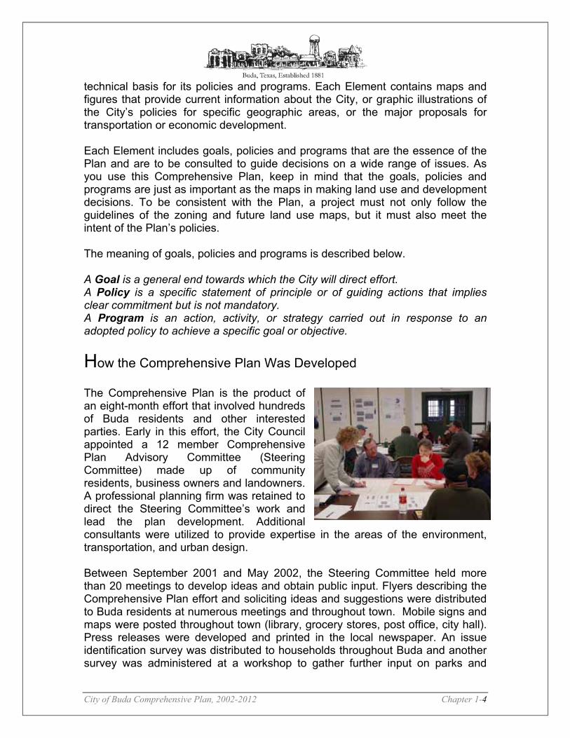
How the Comprehensive Plan Was Developed The Comprehensive Plan is the product of an eight-month effort that involved hundreds of Buda residents and other interested parties. Early in this effort, the City Council appointed a 12 member Comprehensive Plan Advisory Committee (Steering Committee) made up of community residents, business owners and landowners. A professional planning firm was retained to direct the Steering Committee’s work and lead the plan development. Additional consultants were utilized to provide expertise in the areas of the environment, transportation, and urban design. Between September 2001 and May 2002, the Steering Committee held more than 20 meetings to develop ideas and obtain public input. Flyers describing the Comprehensive Plan effort and soliciting ideas and suggestions were distributed to Buda residents at numerous meetings and throughout town. Mobile signs and maps were posted throughout town (library, grocery stores, post office, city hall). Press releases were developed and printed in the local newspaper. An issue identification survey was distributed to households throughout Buda and another survey was administered at a workshop to gather further input on parks and

City of Buda Comprehensive Plan, 2002-2012 Chapter 1-5
recreation related issues. Four weekend workshops were held to gather input from the community on issues such as urban design, parks and recreation, future land use, and community Vision. On average, approximately 50-75 people participated in each workshop. The Steering Committee, City Council and Citizens developed the Vision Statement and prepared the draft Goals, Policies and Programs based on a series of meetings, announcements, educational forums, mail-out surveys, and workshops, as well as hearings before the City Council. The Plan document was written by combining the extensive public input with consultant expertise and Steering Committee and City Council feedback into a cohesive planning document. These Goals, Policies and Programs have been supplemented with maps, text and graphics to create a plan that clearly lays out how the City expects to achieve its Vision for the future. The Land Use and Transportation Map is included by reference as a part of this document. It is probably the most familiar part of the Plan and identifies land use designations for each area within the City. The type of development allowed within each designation shown on the Map is described in the Future Land Use Plan Element. The Future Land Use Map does not constitute a zoning map, but is the precursor for the development of the zoning map. The Plan also includes an Implementation Chapter that identifies specific actions to be taken to carry out the Plan. The Implementation Chapter is not a Plan Element, but is intended as a description of the steps to be taken in order to achieve the Plan’s goals.
Implementing the Plan The Comprehensive Plan will be implemented through the actions of City Staff, the Planning and Zoning Commission, and the City Council. Plan policies will be carried out through the adoption and revision of ordinances, through annual budgeting and capital improvement programming, and through decisions on future development proposals. Planning for the future of Buda does not end with the adoption of this document. It is important to continue the steps necessary to bring forth the vision of the Plan. The Plan is intended to be a living document, to grow and change as local conditions change. As such, the Plan must be a flexible document and it may, at times, be necessary to amend the Plan. While most amendments change the land use designation of a particular property, any part of the Plan may be amended as circumstances change. Only through continuing to use, evaluate and amend the Plan can Buda reach towards the vision sought by all the dedicated people who contributed to the development of the Plan.
City of Buda Comprehensive Plan, 2002-2012 Chapter 2-1
22 BBaasseelliinnee AAnnaallyyssiiss The Baseline Analysis section of the Comprehensive Plan is intended to provide an overview of the past and current physical and demographic environment – as well as a historical background and geographical reference. The following components will help in the development of other aspects of this plan:
�� Historical Background �� Relationship to Region �� Existing Housing, Demographic and Economic Characteristics �� Physical Characteristics �� Existing Land Use
The primary objective of the Baseline Analysis is to document current conditions, and to identify opportunities and constraints that Buda must consider in shaping its future form and character. The secondary objective of the Baseline Analysis is to ensure that the information being used in the planning process accurately portrays the community and its needs. Historical Background1 The City of Buda is located on Interstate Highway 35 - seventeen miles south of downtown Austin in northeastern Hays County. The City was formally established on April 1, 1881, when Cornelia Trimble donated land for a town site at an International-Great Northern Railroad depot there. Phillip J. Allen had settled the area, originally part of the Mexican land grant to Stephen B. von Eggleston, as early as 1846.
The first community center in this part of the county, Mountain City, developed before the Civil War, but it was rapidly depopulated as its residents and businesses flocked to the new rail depot, which took the name of Du Pre. Folklore has it that this name originated in 1880, when, as the railroad pushed into Hays County, the postmaster at Mountain City approached a railroad official and requested, "Do, pray, give us a depot." In 1887, at the request of the post office department, the name was changed to Buda. The common explanation for the new name is that it derives from Spanish viuda, or widow. The town had gained a reputation as a popular eating stop for rail travelers, and the name may refer to a pair of widows who cooked at the Carrington Hotel in the 1880s.
1 Mary Starr Barkley, A History of Central Texas (Austin: Austin Printing, 1970). Dudley Richard Dobie, A Brief History of Hays County and San Marcos, Texas (San Marcos, 1948). Vertical Files, Barker Texas History Center, University of Texas at Austin.
City of Buda Comprehensive Plan, 2002-2012 Chapter 2-2
The provision of supplies and services to surrounding dairy farms and ranches was the basis of the local economy, and at different times the community supported mills, hotels, banks, a lumberyard, two newspapers, a cheese factory, a movie theater, and a skating rink. In 1928 local businesses organized a chamber of commerce. Buda remained an active commercial center and railroad depot until the Great Depression.
In 1929 its population was estimated at 600, but by 1933 it fell to 300. Only in the mid-1980s, as the growth of Austin began to be felt in Buda, did its population once again approach pre-depression levels. The town was incorporated in 1948, and in 1967 Buda, Kyle, and Wimberley formed the Hays Consolidated Independent School District (only Buda and Kyle remained in the district after 1986). By the mid-1980s Buda had attracted a cement plant and some craft industry, but the community was still primarily rural and residential. Its population in 1990 was 1,795. Relationship to the Region It is important to understand how Buda’s geographic location affects its quality of growth and it’s growth potential. Having an understanding of where future growth may be occurring and what the factors are resulting in growth can allow the city to plan it’s future annexations and zoning accordingly. Buda is located (see Illustration 2-1) in northern Hays County along Interstate 35. Buda is approximately 17 miles from downtown Austin, 15 miles from San Marcos, 60 miles from downtown San Antonio, and 6 miles from Kyle. Buda’s location on an Interstate, a Railroad, and two additional major highways is ideal for economic development. The location also provides Buda residents within commuting distances to two of Texas’ largest cities and several small cities for employment opportunities not currently provided within Buda. Buda has had certain constraints to growth, one of which is being land locked by other cities’ boundaries. The City recently reached an agreement with the City of Austin, in which the City of Austin will disannex approximately 5,446 acres of land to Buda over several years based on an agreement reached between the two cities in 2001.2
2 The Disannexation Agreement can be found in the Appendix. Portions of this land were released immediately upon 1) signing the resolution and 2) adopting a water quality ordinance.

City of Buda Comprehensive Plan, 2002-2012 Chapter 2-3
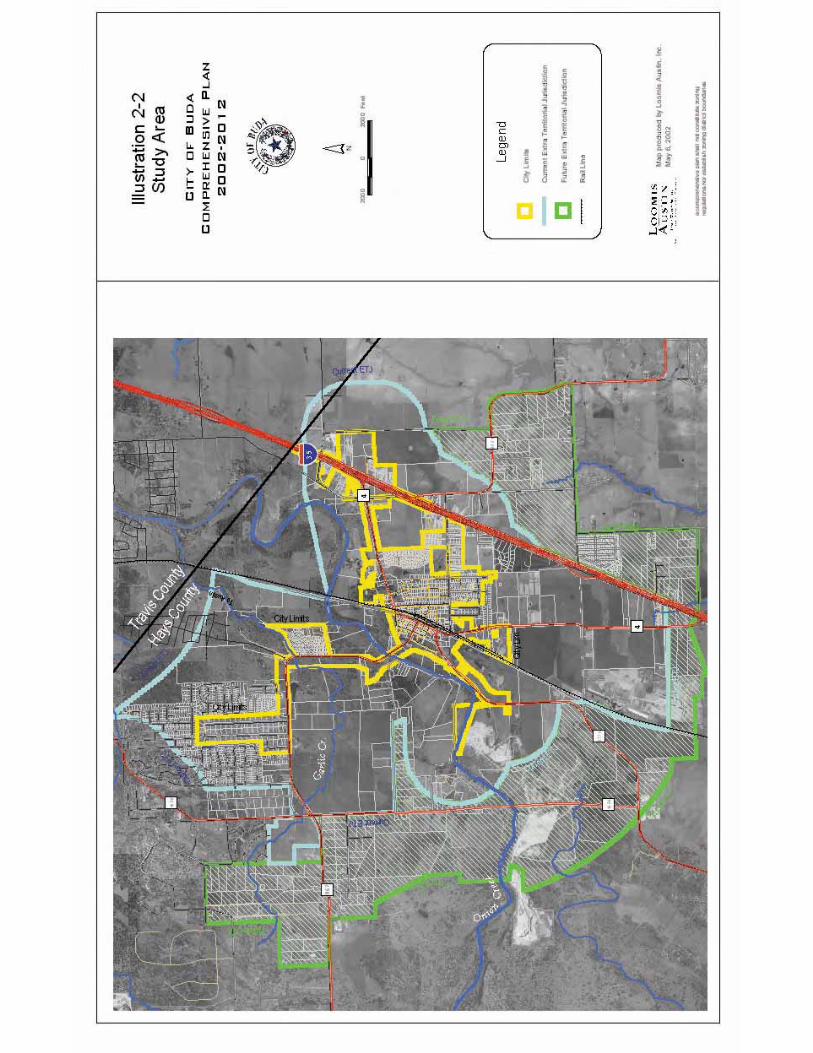
Study Area The Study Area includes the city limits and current Extra-territorial Jurisdiction (ETJ3) as well as the land that was recently disannexed by the City of Austin to the City of Buda (see Illustration 2-2). Areas outside the current ETJ may become part of another municipality’s jurisdiction depending on future annexations. The total acreage for the study area is approximately 12,878 acres. Physical Characteristics Several factors exist that can impact the direction and type of growth for the City of Buda. These characteristics can be thought of as both constraints and opportunities. For example, areas that may be deemed as undevelopable (e.g., Floodplains or Slopes greater than 15%) could be used for greenspace or hike and bike trails. The following is a description of both natural and man-made features impacting development in the Buda area. Natural Features Soils4 The soils in and around Buda are predominantly clay. Those east of the railroad tracks are mostly Branyon, Heiden, Houston, and Altoga clays. The soil along Onion creek, Garlic Creek, and their tributaries are gravelly loams, clay loams, and silty clays in the Real, Rumple-Comfort, Doss, Krum, Lewisville, Orif, and Tinn series. Farther west and north, Krum and Doss silty clays give way to Tarpley clays and Comfort, Eckrant, and Medlin Rock Outcrop and clay complexes with pockets of Denton Silty clays and Sunev clay loams.
1. Branyon, Heiden, and Houston Clays. The Branyon, Heiden, and Houston clays are characterized as very deep, dark, and very tight clays. They are commonly referred to as “black gumbo” and are typical of the coastal blackland prairie. They have a very high shrink/swell potential and severe limitations for septic tanks because of their slow percolation rates.
2. Altoga Clays. The Altoga clays are very deep soils with only moderate shrink/swell potential. They are found amongst the Branyon, Heiden, and Houston clays mostly east of I-35. They have only moderate limitations for septic tanks and residential construction.
3. Krum and Lewisville Clays. The Krum and Lewisville clays are also very deep, highly expansive soils. They are not quite as tight as the Branyon,
3 The Extraterritorial Jurisdiction (ETJ) is the contiguous unincorporated land adjacent to its corporate limits that is not within another city’s ETJ. The size of a city’s ETJ varies according to its population. Buda is a General Law City (<5,000 population) and hence its ETJ is ½ mile from the city limits. 4 The information from this section was obtained from the Texas Almanac (2000-2001) and the City of Buda 1985 Comprehensive Plan.
City of Buda Comprehensive Plan, 2002-2012 Chapter 2-4
Heiden, and Houston clays, however. Although the Krum clays are still considered to have severe limitations for septic tanks because of slow percolations, the Lewisville clays have only moderate limitations. The range of the Lewisville clays is limited to small areas close to Onion Creek, whereas, the Krum clays pervade the mostly level lands to the west and northwest of the creek.
4. Real Gravelly Loam, Rumple-Comfort Clay Loam, Doss Silty Clay, and Greune Clay. These gravelly loams, clay loams, silty clays, and clays often occur in complex association with each other or at least in proximate association. These soils are less expansive than the other clay soils in the area, but still have moderate shrink/swell potential. Although the gravelly loams, clay loams, and silty clays are not as tight as the clays in the blackland prairie, they are shallower and rest atop bedrock that impede adequate percolation of septic tanks. The Greune Clay has only moderate shrink/swell potential, also; but it lies over a cemented caliche hard pan an average of 13 inches below the surface.
5. Tarpley Clays and Comfort, Eckrant, and Medline Rock Outcrop/Clay Complexes. These clays and outcrop complexes pervade the north/northwest portion of the planning area. They are very shallow soils with bedrock less than 20 inches below the surface and frequently outcropping. These soils have severe limitations for septic tanks and residential construction because of the shallow depth to bedrock. The Tarpley Clays are also very highly expansive.
6. Denton Silty Clays and Sunev Clay Loams. These soils, which are found in isolated pockets among the larger expanses of the Tarpley Clays and Comfort, Eckrant, and Medlin Rock Outcrop Complexes, have the least amount of limitation for septic tanks and residential construction of any of the soils found in the Buda area. The Denton Silty Clays have only moderate shrink/swell limitations for septic tanks due to slow percolation. The Sunev Clay Loams have only slight to moderate limitations for both factors. Both soil types are deep to very deep.
7. Orif Soils and Tinn Clays. These soils are frequently flooded and reflect the floodplains of Onion and Garlic Creeks and their tributaries.
Significant Water Bodies Buda has two primary creeks running through its jurisdiction, the Onion and Garlic Creeks with the most significant creek being Onion Creek. Topography and Slope Analysis There are areas within the Buda Study Area that have significant slopes. Illustration 2-3 shows the topography of the area. It is important to understand the extent to which the topography becomes a limiting factor and where those areas may exist.

City of Buda Comprehensive Plan, 2002-2012 Chapter 2-5
RELATIONSHIP TO THE REGION ILLUSTRATION

City of Buda Comprehensive Plan, 2002-2012 Chapter 2-6
STUDY AREA ILLUSTRATION

City of Buda Comprehensive Plan, 2002-2012 Chapter 2-7
CONTOURS/TOPO ILLUSTRATION

City of Buda Comprehensive Plan, 2002-2012 Chapter 2-8
Floodplain Illustration 2-4 shows the 100-Year and 500-Year floodplains that lie within Buda. Aquifer Certain portions of the study area lie within the Barton Springs segment of the Edwards Aquifer (see Illustration 2-4: Floodplains, Creeks, and Aquifer). Since development is limited over certain portions of the Edwards Aquifer, it is important to have a thorough understanding of the significance of the Aquifer and its location within the study area.
The Edwards Aquifer5 is located in the south-central part of Texas. [The aquifer extends from near Temple, in Bell County, south to San Antonio in Bexar County then arcs west toward Del Rio in Kinney County.
The aquifer can be divided into three subregions; the San Antonio Pool, the Austin Pool (Barton springs segment), and the Northern Edwards. The Northern Edwards extends from the Colorado River in Austin to the Northern extreme of the Edwards Limestone in Bell County. The San Antonio Pool extends from a groundwater divide near the City of Kyle, about 20 miles south of Austin, to near Del Rio in McKinney County. Major outflows in this region include Comal, Hueco, and San Marcos Springs; three of the most significant springs in Texas. The last segment is located between the groundwater divide in Kyle to the Colorado River. The major outflow of this segment (the Barton Springs segment) is, of course, Barton Springs. Barton Springs is near and dear to many people in the Austin area for its' cool, waters and Barton Springs Pool. Barton Springs The Barton Springs segment of the Edwards Aquifer includes approximately 90 square miles of recharge zone and 264 square miles of contributing zone in southern Travis and northern Hays counties. Rain falling in this catchment area and draining from the contributing zone to the recharge zone infiltrates the limestone and travels underground to Barton Springs. 5 Text and maps on the Edwards Aquifer are courtesy of the Barton Springs-Edwards Aquifer Conservation District (BSEACD). http://www.bseacd.org/about%20aquifer.htm

City of Buda Comprehensive Plan, 2002-2012 Chapter 2-9
A portion of the drinking and utility water for the City of Austin comes from Barton Springs as it drains from Barton Creek into Town Lake. This segment of the aquifer is a federally designated Sole-Source aquifer. Approximately 45,000 residents of southern Travis and northern Hays Counties depend on the Barton Springs segment as their only readily available source of drinking water. The State of Texas has ranked the aquifer as one of the most vulnerable underground water sources in the state. This lifeblood of Central Texas is highly susceptible to the effects of pollution from urbanization, roadway construction and operation, and countless other sources. Geology and Hydrogeology Important characteristics of the Edwards Aquifer, relative to the quantity and quality of water that is stored in it, include a contributing zone. The contributing zone includes creeks and rivers that drain watersheds and flow to areas where the Edwards and associated limestones are exposed at the surface. As the water flows over and rain falls upon the surface of the Edwards Limestone, it infiltrates through the faulted and jointed cracks, the highly porous rock, and the caves and sinkholes of the Edwards limestone. These characteristics classify the Edwards as a karst aquifer and allow water to rapidly recharge into and through the limestone.
This area, where Edwards Limestone is exposed at the surface, is called the recharge zone. Eventually, the Edwards Limestone dips below the surface where it is capped by a relatively impermeable layer. The pressure of the water flowing into this portion of the aquifer causes water to rise to a level higher than the level of the Edwards Limestone itself. This is called the artesian zone. Where the confining layer is penetrated by cracks in the limestone or wells through the capping layers, we will find artesian wells and springs. In the extreme eastern section of the aquifer is an area of decreasing water quality. This water has a higher mineral content and is referred to as the bad water zone. The Transition Zone is a thin strip of land south and southeast of the recharge zone from San Antonio to Austin where limestones that overlie the Edwards are faulted and fractured and have caves and sinkholes, so it is possible that surface water can still go into the Edwards limestone below.
City of Buda Comprehensive Plan, 2002-2012 Chapter 2-10
Aquifer and Floodplain Illustration
City of Buda Comprehensive Plan, 2002-2012 Chapter 2-11
It is important to maintain high standards of water quality as water flows through the contributing zone. Any pollution allowed to enter the creeks and rivers in this area may find its way to the recharge zone where it can contaminate the water entering the aquifer, where cleanup or removal is virtually impossible. Care must be taken to ensure that the fractures, caves and sinkholes of the recharge zone are free to allow clean water to enter the aquifer. Covering these recharge features will decrease the amount of water replenishing the aquifer. Allowing polluted water to enter these features will degrade the quality of water stored in the aquifer. Knowing where these features are and how they transmit water through the aquifer may allow us to provide some control over the quantity and quality of water that enters the aquifer. Endangered Species/Habitat No endangered species or habitat has been identified within the study area. Man-Made Features I-35 This major four-lane Interstate highway has had an enormous impact on Buda’s growth through the years. Buda has two exit ramps in each direction from I-35. Union Pacific Railroad Buda has a North-South railroad line running directly through downtown and stops both pedestrian and vehicular traffic throughout the day. State Highway Loop 4 This State Highway loops from I-35 into downtown Buda, crossing over the railroad and right along Main Street. Loop 4 continues out of town and connects back up to I-35 south of Buda. Truck traffic from local industry travels along Loop 4 through downtown. FM 1626 This road connects southern Travis County with northern Hays County. FM 1626 runs North-South on the western side of Buda. RR 967 The primary East-West route into downtown from the west is RR 967. This road continues out of town and towards western Hays County. FM 2001 This road connects Buda and I-35 with those primarily rural areas east of the Interstate.

City of Buda Comprehensive Plan, 2002-2012 Chapter 2-12
FM 2770 Fm 1626 connects to FM 2770 southwest of downtown Buda. FM 2770 Begins from Loop 4 near downtown and continues southwest of town and towards Kyle. State Highway (SH) 45 SH 45 is anticipated to be the road that will connect MoPac (Route 1) with I-35 and eventually SH 130 and 183. Certain portions of the proposed alignment of SH 45 from 1626 West towards I-35 could provide an alternate route for commuting traffic from Hays County into Travis County. Travis County voters in a recent bond election approved purchase of Right-of-Way (ROW) for SH 45 west of FM 1626. The Capital Area Metropolitan Planning Organization (CAMPO) Board may vote to delay its completion until SH 130 is complete so as not to create a bypass out of Loop 1. SH 45 (both east and west of IH 35) has received significant support from land owners wishing to donate ROW. TxDOT is going forward with development of the roadway as a 2-lane facility west of FM 1626 - over the recharge zone There is a consortium of developers and financiers wishing to do a design-build on the roadway and operate it as a toll road (like a business franchised from the state). The TxDOT Commission gave their preliminary approval for this during early 2002. Existing Demographic, Housing and Economic Characteristics Just as it is important to examine Buda’s physical attributes and position within Hays County and the region-at-large, it is equally important to have a clear understanding of the area’s demographic, social and economic composition in order to plan effectively for Buda’s future. It is therefore appropriate to examine the characteristics of the population and changes that have taken place in recent years and decades. The following is a review of the various characteristics of Buda’s Population. Population Characteristics Understanding and agreeing upon a base population figure and a projected population Graph are two of the most critical decisions to make in developing a comprehensive plan. The City must know how many people to expect within its city limits and Extraterritorial Jurisdiction (ETJ) to effectively plan for growth. Therefore, one must arrive at the following:
1. A base population figure, or the current estimate of population. (See Graph 2-1) �� Buda is fortunate in undertaking this planning study immediately
following a census year since census data is thought to be the most accurate data for population and demographics.
City of Buda Comprehensive Plan, 2002-2012 Chapter 2-13
2. The amount of acreage that is either vacant or being used mostly as agriculture (this land can be used for future residential growth as well as other uses). (See Graph 2-2) �� This study is looking at a geographic area that extends beyond the
City Limits and the Current ETJ. 3. An understanding of how many people live in each household (Table
2-1) 4. An understanding of the per capita land use (ie., the number of people
living within the City Limits per the total amount of acreage within the City Limits). (Table 2-1)
Listed below are a number of Tables and Graphs that portray Buda’s historical and projected population.
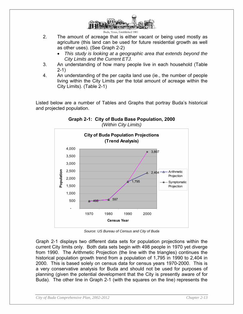
Graph 2-1: City of Buda Base Population, 2000 (Within City Limits)
City of Buda Population Projections(Trend Analysis)
498 597
1,795
2,404
3,807
-
500
1,000
1,500
2,000
2,500
3,000
3,500
4,000
1970 1980 1990 2000
Census Year
Popu
latio
n ArithmeticProjection
SymptomaticProjection
Source: US Bureau of Census and City of Buda
Graph 2-1 displays two different data sets for population projections within the current City limits only. Both data sets begin with 498 people in 1970 yet diverge from 1990. The Arithmetic Projection (the line with the triangles) continues the historical population growth trend from a population of 1,795 in 1990 to 2,404 in 2000. This is based solely on census data for census years 1970-2000. This is a very conservative analysis for Buda and should not be used for purposes of planning (given the potential development that the City is presently aware of for Buda). The other line in Graph 2-1 (with the squares on the line) represents the

City of Buda Comprehensive Plan, 2002-2012 Chapter 2-14
Symptomatic Method for calculating population forecasts that was developed by analyzing water connections from 1990 to 2000. A ratio was then developed which was applied to 2000 to obtain a forecast for the current population. Note that this curve is significantly higher than the Census curve and probably a more realistic base population projection growth within the City Limits of Buda. Another factor to consider in understanding why the population in Buda has been increasing steadily since 1980 is the amount of acreage in Buda (see Graph 2-2). The jump in population from 1980 to 2000 can be accounted for by the tripling of the land area within the City Limits resulting from major annexations during the last 30 years.
Graph 2-2: City of Buda Acreage
1465
420
1391
1118
0
200
400
600
800
1000
1200
1400
1600
1980 1990 1998 2001
Year
Acr
eage
Source: U.S. Census and Texas State Data Center, 1990/2000.
As a reminder, the Study Area includes the city limits and current ETJ as well as the land that was recently disannexed by the City of Austin to the City of Buda (future ETJ). Table 2-1 shows the Per Capita Land Use by city. When this information is combined with the current total amount of vacant and agriculture land in the Study Area (See Table 2-2), it is possible to develop population projections under different land use scenarios. Based upon this data, it is clear that the population in the Study Area is significantly higher than the Census data for just the area within the City Limits of Buda.

City of Buda Comprehensive Plan, 2002-2012 Chapter 2-15
Table 2-1: Per Capita Land Use6
City Population Total Land Area within City Limits
(Acres)
Per Capita
Acreage
Household Size of Owner
Occupied Buda 2,440 1,464 1.7 2.88 Kyle 5,314 2,500 2.1 3.15 Pflugerville 16335 7377 2.2 San Marcos 34,733 8,000 4.3 2.75 Austin 656,262 70,172 9.4 2.65
Source: US Census, 2000 Table 2-2 shows four scenarios for future population within the Study Area. Scenario 1 illustrates a conservative population projection; if Buda maintains the same per capita land consumption that they currently have, they can expect an additional 11,393 individuals over the next 10 years. 7 This is a relatively conservative estimate since the per capita land consumption rate of 1.7 is extremely low. Scenario 4 is probably a much higher per capita land consumption rate than the Buda community would like. Using the conservative Scenario 1 estimate, Buda could expect at least 18,767 people to live in the Study Area at total buildout.
Table 2-2: Population Projection to 2010
Scenarios Current Population
Buildout Acreage
(Vacant & Ag)
Per Capita Land
Consumption
Additional People for Buildout
Buildout Population
Scenario 1 7,374 6,702 1.7 11,393 18,767 Scenario 2 7,374 6,702 2.1 14,074 21,448 Scenario 3 7,374 6,702 4.3 28,819 36,193 Scenario 4 7,374 6,702 9.4 62,999 70,373
Source: Loomis Austin; US Census
In Chapter 8, the Future Land Use Plan Element, a discussion and table (Table 8-1) illustrates the total buildout by Planning Sector. Calculations of the population estimates, based on the Future Land Use Plan, yield approximately 48,000 people in the Buda study area when all the current Agriculture and Vacant lands have been developed (see Land Use Assumptions, page 8-17). Total buildout may take more than 20 years, but this is a figure that City leaders should recognize and use when planning for future infrastructure improvements.
6 Population and Household Size is based on Census 2000 data. 7 This assumes that buildout of the Study Area will occur within the next 20 years.

City of Buda Comprehensive Plan, 2002-2012 Chapter 2-16
Graph 2-3 shows Buda’s population growth from 1990-2000 in comparison with other cities and Hays County during the same time period. Based on Census data only, Buda’s population grew 33.9% from 1990 to 2000. This represents an annual average increase of only 3.39%. Kyle and Niederwald had the highest population increase from 1990 to 2000. Kyle experienced an average annual increase of 13.8% while Niederwald experienced an average annual increase of 15%. Buda was not far behind Hays County in its population growth. The County experienced an increase in population from 65,614 in 1990 to 97,589 in 2000. This represents an average annual increase of approximately 4.8%.
Graph 2-3: City Population Growth Rates (1990-2000)
-20.00%
0.00%
20.00%
40.00%
60.00%
80.00%
100.00%
120.00%
140.00%
160.00%
Hays County
Dripping Springs
Mountain City
Niederwald
San Marcos
Wimberley CDP
Woodcreek
% C
hang
e
Percent Change
Source: U.S. Census and Texas State Data Center, 1990/2000.
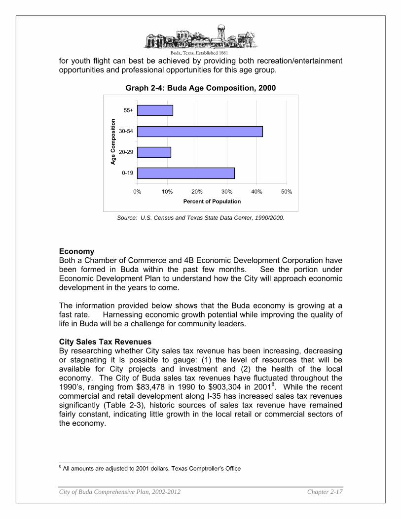
Age and Race Composition Future demands for city services and jobs can often be predicted and planned for by analyzing the age composition of a community’s population (Graph 2-4). Although the majority of the population (72%) is below 55 years of age, a shift in this demographic will likely occur over the next 10 years as many baby boomers retire. Buda will need to plan for this demographic change in terms of providing transportation alternatives and other city services to the elderly population. In addition, Buda has a significant population below 30 years of age (43%). A challenge for small communities is to retain their youth. Many communities experience youth flight – members of the community leave after high school and do not return due to better job opportunities elsewhere. Addressing the potential
City of Buda Comprehensive Plan, 2002-2012 Chapter 2-17
for youth flight can best be achieved by providing both recreation/entertainment opportunities and professional opportunities for this age group.
Graph 2-4: Buda Age Composition, 2000
0% 10% 20% 30% 40% 50%
0-19
20-29
30-54
55+A
ge C
ompo
sitio
n
Percent of Population
Source: U.S. Census and Texas State Data Center, 1990/2000.
Economy Both a Chamber of Commerce and 4B Economic Development Corporation have been formed in Buda within the past few months. See the portion under Economic Development Plan to understand how the City will approach economic development in the years to come. The information provided below shows that the Buda economy is growing at a fast rate. Harnessing economic growth potential while improving the quality of life in Buda will be a challenge for community leaders. City Sales Tax Revenues By researching whether City sales tax revenue has been increasing, decreasing or stagnating it is possible to gauge: (1) the level of resources that will be available for City projects and investment and (2) the health of the local economy. The City of Buda sales tax revenues have fluctuated throughout the 1990’s, ranging from $83,478 in 1990 to $903,304 in 20018. While the recent commercial and retail development along I-35 has increased sales tax revenues significantly (Table 2-3), historic sources of sales tax revenue have remained fairly constant, indicating little growth in the local retail or commercial sectors of the economy.
8 All amounts are adjusted to 2001 dollars, Texas Comptroller’s Office
City of Buda Comprehensive Plan, 2002-2012 Chapter 2-18
Graph 2-5: Historical Sales Tax Allocation to Buda9
$0$100,000$200,000$300,000$400,000$500,000$600,000$700,000$800,000$900,000
$1,000,000
1990
1991
1992
1993
1994
1995
1996
1997
1998
1999
2000
2001
Year
Ann
ual S
ales
Tax
Allo
catio
n
Source: Texas Comptrollers Office, 2001
Compared to other Hays County communities, Buda is prospering. Buda had the highest percent change (122.7%) in City Sales Tax Revenue from 2000 to 2001 (See Table 2-3). Other communities in Hays County, such as Hays and Uhland experienced a decline. Additionally, when all city sales taxes are combined for Hays County, the total percent change was only 12.34%. New commercial development along I-35 in Buda has obviously had an impact on Buda’s growth and shows the City of Buda what a tremendous economic opportunity that highway frontage provides a community. The challenge for Buda will be to harness that growth along the Interstate while maintaining a healthy community within the downtown core of Buda.
Table 2-3: City Sales Tax Revenue, 2001
City Current Rate
Net Payment this Period
Comparable Payment Prior Year
% Change 2001
Payments to Date
2000 Payments to
Date % Change
Buda 1.50% 53,381.11 47,139.72 13.24% 903,304.46 405,539.99 122.74%
Dripping Springs 1.25% 33,178.33 32,976.54 0.61% 302,579.10 268,568.93 12.66%
Hays 1.00% 1,066.62 1,218.37 -12.45% 9,118.51 16,868.95 -45.94%
Kyle 1.50% 52,780.66 48,431.86 8.97% 519,484.22 465,315.80 11.64%
Niederwald 1.00% 1,086.24 928.17 17.03% 10,092.63 9,417.80 7.16%
San Marcos 1.50% 1,018,168.91 1,032,466.09 -1.38% 11,188,251.58 10,499,258.88 6.56%
Uhland 1.00% 582.15 558.18 4.29% 5,417.00 5,710.45 -5.13%
Wimberley 1.00% 38,542.12 0 U/C 169,072.70 0 U/C
Woodcreek 1.00% 1,414.62 1,401.75 0.91% 21,117.86 14,716.21 43.50%
Hays County Total 1,200,200.76 1,165,120.68 3.01% 13,128,438.06 11,685,397.01 12.34% Source: Texas Comptrollers Office, 2001
9 2001 Graph excludes the allocation for December.

City of Buda Comprehensive Plan, 2002-2012 Chapter 2-19
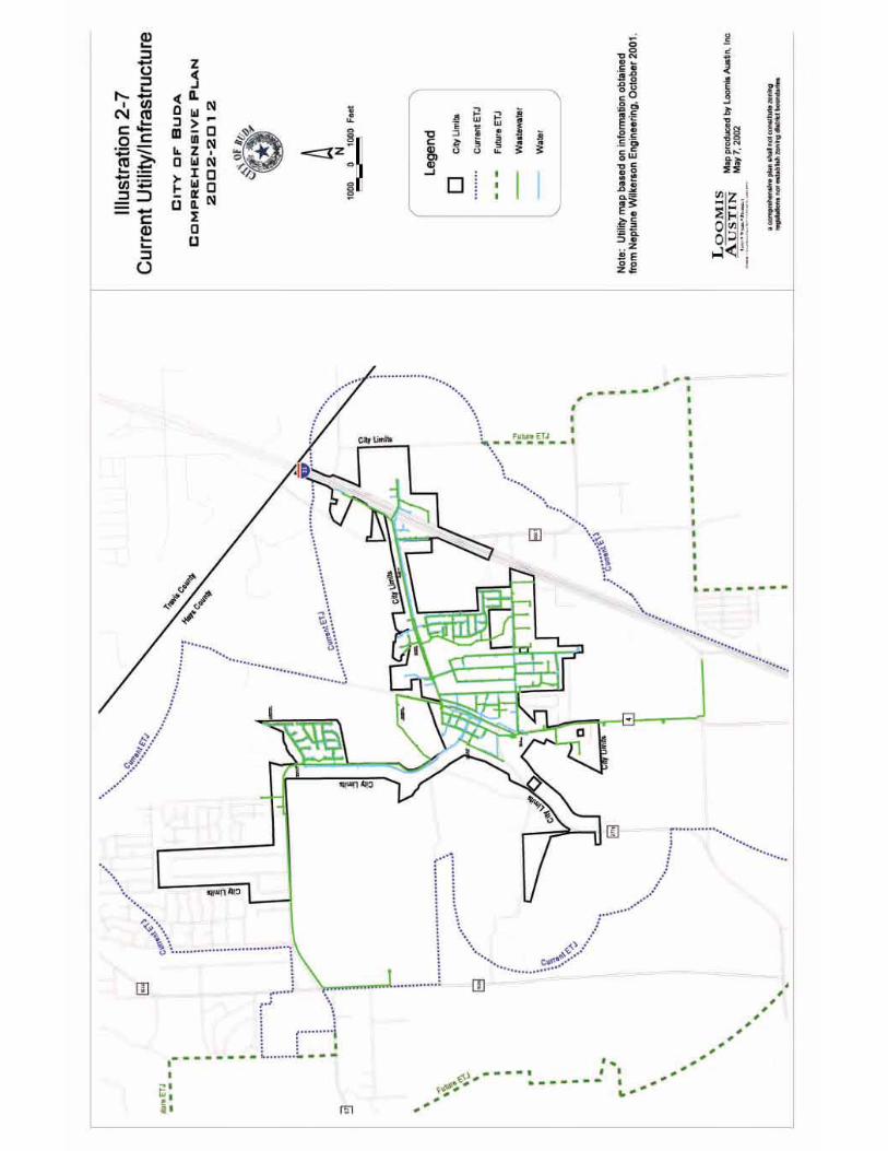
Existing Land Use The purpose of identifying and mapping the Current Land Use is to determine where certain uses exist in Buda and what percentage each land use comprises (eg., Agricultural comprises 39.4%). This initial assessment will assist the community in understanding how the community is growing and where there are opportunities for future growth. In October of 2001, an inventory conducted by automobile was completed for every property in the Buda study area (approximately 2700 parcels). Each property was identified according to its general Land Use (see Land Use Districts below). Every residential structure on the property was also categorized based on its condition (Standard, Substandard, or Dilapidated). This information was put into a database that was used in the development of the Current Land Use Map (see Illustration 2-5) and the Housing Inventory (below). Determining a land use can be tricky. Researchers classify a parcel based on the primary use of that parcel. Where more than one residential use occupied the same property, researchers identified the property based on the predominant residential use. For example, if a mobile home and a single family home were on the same property and the single family home was the predominant use, then the property would be labeled as Rural Residential (RR), Low-Density Residential (LR), or Medium-Density Residential (MR) (depending on the size of the property) or as High Density Residential if there were more than four units on the property. The Current Zoning Map and Utility/Infrastructure Maps are found at the end of this chapter.

City of Buda Comprehensive Plan, 2002-2012 Chapter 2-20
CURRENT LAND USE ILLUSTRATION
City of Buda Comprehensive Plan, 2002-2012 Chapter 2-21
Land Use Districts Each property was identified and color-coded based on the following categories: Agricultural District Land used for agricultural purposes (e.g., ranching, orchards or farming). This use could have residence(s) or even a commercial or industrial building but the primary use is agricultural. Park/Open Space District Areas designated as public (although not necessarily owned by the public) parkland or open space, and any areas intended for this purpose in the future. Areas designated as preserve land and any areas intended for this purpose in the future. Residential District Includes activities that occur in all types of residential uses, structures, ownership characteristics, or the character of the development. �� Low Density Residential – Below 1 unit per acre. Characterized mostly by
large lot, low density residential characterized by single-family detached homes;
�� Medium Density Residential – Between 1-4 units per acre. Provide for smaller residential lot sizes, possibly including dwelling units such as patio homes, town homes, or condominiums. Up to four dwelling units per acre.
�� High Density Residential – More than four dwelling units per acre.
Table 2-4: Residential Land Use Classification Table Low Density (LD) <1 unit / acre Medium Density (MD) 1 – 4 units / acre High Density (HD) >4 unit / acre
LUE = Living Unit Equivalent (similar to housing unit) Public Use District Areas owned by the city, county, school district, state, or church (e.g., City Hall, fire station, school buildings, library, storage sites, cemeteries). This does not include railroad right of ways. Office District Areas designated for Professional/ Administrative Offices – doctors, dentists, real estate, architects, banks/financial institutions accountants, secretarial service, etc. Retail District Areas used primarily for Retail activity, intended to serve both regional consumers and local citizens of Buda. Uses include grocery stores, pharmacies, personal service shops (i.e., hair salons, dry cleaners, tailors, florists, etc.), day

City of Buda Comprehensive Plan, 2002-2012 Chapter 2-22
care centers, small restaurants and cafes, a few convenience stores with gasoline sales, a farmers market, a car wash, grocery stores, restaurants, large bookstores and similar establishments. Large retail establishments, including shopping malls, large single-tenant retail users, motels and hotels. Commercial District Areas allow for commercial amusements, building materials yards, automobile garages and sales lots, automobile body repair, warehouses, telecommunications/broadcasting towers and facilities, wholesale establishments, and the sale of used merchandise and welding shops. Industrial District Areas might include light industry which entails unenclosed operations or storage, heavy industry with limited external effects or light industry with no outdoor storage (e.g. industrial park) Vacant Land that had previously been developed but currently has no structure or use on the property. Rights of Way (ROW) Areas that include roads, highways, railroad, and utility easements. Land Use Analysis As Table 2-5 illustrates, Buda has approximately 1,464 acres within the City Limits, 6,790 acres within the ETJ (outside of the Buda City Limits), and an additional 4,624 acres in the area to be disannexed by the City of Austin. In all, 12,879 acres exist in the Study Area for this comprehensive plan. Approximately 10,744 acres, or 83.4% of the total acreage within the Study Area is developed. Due to the high number of federal and state highways, and the railroad, Buda has a high percentage of land within the Study Area that is Right-of-Way (5.4%). Buda also has a significant amount of Vacant land (10.8%, or 1,452 acres), which includes all land with the city limits that has no use on the property. Of Buda's developed land, Agriculture has the largest share (39.4%) of Developed Property. Residential (19.6%) and Industrial (15.6%) uses comprise the next largest shares of developed land in Buda. It is important to note that Agricultural uses are both working farms as well as open spaces with livestock. Some of these lands could be well suited for future industrial or commercial uses.

City of Buda Comprehensive Plan, 2002-2012 Chapter 2-23
Table 2-5: Existing Land Use, 2001 (Entire Study Area)
Land Use Category Acres Percent of Total
Land Percent of
Developed Land Acres/100 People(1)
Agricultural 5,072 39.4% 47.2% 68.8 Commercial 638 5.0% 5.9% 8.7 Industrial 2,012 15.6% 18.7% 27.3 Office 13 0.1% 0.1% 0.2 Parks / Open Space 103 0.8% 1.0% 1.4 Public 360 2.8% 3.4% 4.9 Residential 2,523 19.6% 23.5% 34.2 Retail 23 0.2% 0.2% 0.3 Total Developed 10,744 83.4%
Vacant 1,390 10.8% 18.9 Rights of Way 744 5.8% 10.1
Within City Limits 1,464 11.4% Within Current ETJ 6,790 52.7% Within Future ETJ 4,624 35.9%
Total Area 12,878 100.0%
Source: Loomis Austin, Inc., 2001 (inventory) The following summarizes features of Buda's existing land use:
�� Agricultural and Vacant parcels represent approximately 50% of the total amount of land within the Study Area. This is a tremendous opportunity for Buda to determine what uses should occur in these areas. Additionally, it means that there is room for growth (see Population Projections).
�� Residential districts are distinct (dense versus larger lots). �� Office uses comprise 0.2 acres per 100 persons in Buda. This is a very
low figure and accounts for professional uses that serve the public such as doctors and lawyers. It appears that many professional services are provided for Buda residents outside of the Study Area (such as in Austin or San Marcos). This is an obvious focus area for economic development interests.
�� Industrial acreage per 100 persons is very high compared to other cities. However, many of the industrial parcels also have a significant amount of agricultural land on the property, which may skew the industrial acreage amount slightly.
�� Buda has 103 acres of parkland. Buda’s acreage dedicated for Parks comprises 1.0% of total developed land. This translates into 1.4 acres per 100 persons. A commonly accepted measure of municipal parkland is

City of Buda Comprehensive Plan, 2002-2012 Chapter 2-24
between 1.0-1.5 acres/100 persons.10 Therefore, Buda has an accepted amount of parkland. Yet, much of this space is not yet accessible to the public (e.g., the YMCA Rainbow Ranch and the Historical Stagecoach properties).
�� Very few commercial and retail uses occur near residential uses. This has a significant impact on the number of vehicular trips. Adopting land use measures that encourage local retail, office and commercial in or around residential areas will help in reducing vehicular traffic.
Housing Of the 12,878 acres in the Study Area, approximately 2,523 acres are Residential. Of this Residential acreage, 67% is considered Rural Residential, 16% Low Density, 11% Medium Density, and 5% High Density.11 More than 83% of all residential property within the Buda Study Area is more than ½ acre. One can see by the Current Land Use Map that most of the larger lot subdivisions are outside the City core. A consideration for the policymakers and elected officials in Buda will be what is an appropriate density for certain areas within Buda. Obviously, dense development should not be placed near significant environmental areas for water quality reasons. However, low-density development has been found to contribute to increased infrastructure costs (transportation, water, wastewater). Therefore, finding a mix of residential types that is appropriate to the environment and taxpayer is the challenge in developing a future land use map and zoning map.
Table 2-6: Residential Use Composition Residential
Land Use Category Number of
Parcels Acres Average Parcel Size
Percent of Total Residential Use
Rural 276 1811.49 6.56 67% Low Density 634 423.79 0.67 16% Medium Density 761 308.76 0.41 11% High Density 791 147.51 0.19 5%
Total Residential 2,462 2,692 1.09 100.00% Source: Loomis Austin, Inc., 2001 (inventory)
Few multi-family properties exist; only eight duplexes and one apartment complex exists within the Study Area. Manufactured housing is scattered throughout the city. 10 City of Arlington, Texas Park Master Plan (1998). 11 Rural Residential (RR) = 1 LUE/2 acres; Low Density (LD) = 1 LUE/1 acre; Medium Density (MD) = 1 LUE/.5 acres (2 LUE/acre); and High Density (HD) = 1 LUE/.25 acres (4 LUE/acre).
City of Buda Comprehensive Plan, 2002-2012 Chapter 2-25
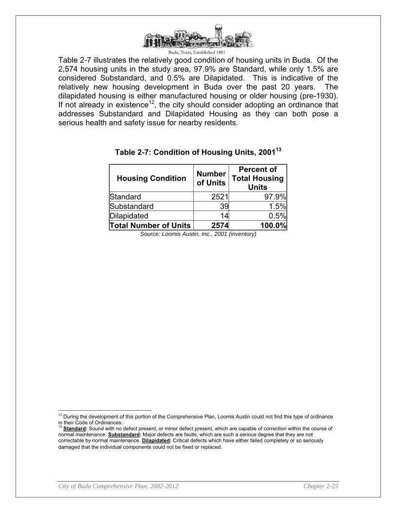
Table 2-7 illustrates the relatively good condition of housing units in Buda. Of the 2,574 housing units in the study area, 97.9% are Standard, while only 1.5% are considered Substandard, and 0.5% are Dilapidated. This is indicative of the relatively new housing development in Buda over the past 20 years. The dilapidated housing is either manufactured housing or older housing (pre-1930). If not already in existence12, the city should consider adopting an ordinance that addresses Substandard and Dilapidated Housing as they can both pose a serious health and safety issue for nearby residents.
Table 2-7: Condition of Housing Units, 200113
Source: Loomis Austin, Inc., 2001 (inventory)
12 During the development of this portion of the Comprehensive Plan, Loomis Austin could not find this type of ordinance in their Code of Ordinances. 13 Standard: Sound with no defect present, or minor defect present, which are capable of correction within the course of normal maintenance. Substandard: Major defects are faults, which are such a serious degree that they are not correctable by normal maintenance. Dilapidated: Critical defects which have either failed completely or so seriously damaged that the individual components could not be fixed or replaced.
Housing Condition Number of Units
Percent of Total Housing
Units Standard 2521 97.9% Substandard 39 1.5% Dilapidated 14 0.5% Total Number of Units 2574 100.0%

City of Buda Comprehensive Plan, 2002-2012 Chapter 2-26
CURRENT ZONING ILLUSTRATION
City of Buda Comprehensive Plan, 2002-2012 Chapter 2-27
CURRENT UTILITY/INFRASTRUCTURE ILLUSTRATION


City of Buda Comprehensive Plan, 2002-2012 Chapter 3-1
33 TToowwnn CCeenntteerr PPllaann Introduction The Town Center generally includes the area along Main Street from the City Park adjacent to Loop 4 north to the Old Cotton Mill to the south. An interactive workshop was held included input from citizens and other stakeholders in a series of focus groups. The workshop included several phases.
�� Input from stakeholders �� Produce and propose alternative design solutions �� Get feedback from stakeholders on alternatives �� Refine and synthesize designs into final concept plan �� Get final feedback from community on final concept
Primary Goals developed from Workshop:
1. Create more choices for those coming to the Buda Town Center. A combination of tourist boutiques (antiques and jewelry stores) and local goods and services.
2. Create a safe place for pedestrians to stroll along Main Street. 3. Enhance parks, plazas and other public places for people to gather. 4. Create a Main Street environment that is clean and visually appealing. 5. Create a place for Budafest.
City Hall Expansion Detail Plan
Town Center Plan Goal To preserve and enhance the Town Center of Buda, making it a safe place for locals and visitors to live and work.

City of Buda Comprehensive Plan, 2002-2012 Chapter 3-2
Strategies Stakeholders, with assistance from the design team, identified 12 general strategies for the Town Center Master Plan.
1. Anchor the ends of Main Street to encourage pedestrian movement along the stores. The Concept Plan includes a library / community center as part of the City park to the north and the redevelopment of the Old Cotton Mill as a mixed-use development.
2. Form a continuous retail edge along Main Street to keep shoppers engaged in the retail environment. Empty shops and interruptions in the streetscape discourage pedestrian shoppers from moving on to other shops.
3. Calm traffic on Main Street with stop signs at intersections, rerouting trucks, and pavement textures.
4. Reuse the existing library as a civic building. 5. Infill blank spaces on Main Street with new businesses and mixed-use
development.
Typical Infill Elevation
6. Consider “deed swaps” to bring existing businesses on the fringe into the Town
Center. 7. Reinforce edge along east side of Main Street with permeable edge including
planting, fencing, and other elements that help to define the public realm. 8. Enhance public spaces including the green currently used for Budafest with new
planting, shelters, and other amenities. 9. Enhance City Park with amenities that appeal to both families and the teens. 10. Add public parking areas adjacent to the railroad and vacant places behind Main
Street buildings to support more commercial redevelopment. 11. Organize on-street parking into parallel spaces along Main Street. 12. Create a unified design for Main Street with common elements for the
streetscape including lighting, signage, and street furniture.

City of Buda Comprehensive Plan, 2002-2012 Chapter 3-3
Typical Section of Main Street Components of Plan (see I l lustration 3-7 for Town Center Plan)
1. A “gateway” element at the north and south ends of Main Street is proposed to create symbolic entries to the Town Center that creates a sense of arrival and cues drivers to slow down for pedestrians.
2. At the far south end of Main Street is the Old Cotton Mill, a historic industrial structure that is no longer in use. Conceptual plans have been commissioned by its current owner for an ambitious redevelopment with shops and restaurants. The owner is looking for investors in the project. The Town Center Concept Plan includes the redevelopment as part of a later phase. The Old Cotton Mill redevelopment could include a mix of housing, shopping, restaurants and office. It could become a festive place that would make a destination anchor, drawing tourists from Austin, San Antonio, and Houston.
3. A new public parking lot just west of the railroad tracks would provide overflow parking for visitors to the Town Center. A centralized and well landscape parking lot would help to make shopping more convenient along Main Street. A shared parking approach will encourage shoppers to park once and shop along Main Street, much like shoppers do in a shopping mall. Ultimately this shared approach will reduce the overall parking needed.
4. A planned expansion to the City Hall is shown as a part of an effort to anchor the central part of the Town Center with an important civic function.
View of City Hall

City of Buda Comprehensive Plan, 2002-2012 Chapter 3-4
5. New parking lots in vacant areas behind Main Street buildings will support more commercial redevelopment.
6. The existing water well facility next to the City Hall is shown screened with a masonry wall. The water tank is depicted sheathed in stone like a rustic water cistern.
7. Along Main Street, the Concept Plan proposed infilling gaps between buildings with new structures housing new businesses.
8. Intersections along Main Street should be designed for pedestrian crossings with bulb outs, special paving accents, and other urban design features.
9. Existing and new buildings on Main Street should permit and encourage housing above shops below.
10. If the library is relocated, the current library should be reused for an important civic purpose. Suggestions include offices for the chamber of commerce, a visitor’s center, early learning center, and/or a museum.
11. The open space area currently used for Budafest should be enhanced with new landscaping, pavilions, and other amenities that would make the area into a more usable park.
12. Abandoned structures and vacant parcels should be redeveloped to create new opportunities for mixed use development and attached housing.
13. The intersection of Loop 4 and Main Street is proposed in a reconfigured geometry to increase safety for cars and pedestrians. The new configuration will improve sight lines and help to slow dangerous high-speed traffic into downtown.
14. At the end of Main Street is the proposed relocated library and community center, which will serve as an active gathering place for the community. The existing park pavilion is proposed to be renovated into an enclosed and expanded recreation center with sports activities and multipurpose rooms. The library/community center and recreation center are depicted as part of an overall campus.
Library/ City Park Plan

City of Buda Comprehensive Plan, 2002-2012 Chapter 3-5
Recommendations The City of Buda should proceed with any grants that would help to finance needed pedestrian streetscape improvements. The grant being pursued through TXDOT could jumpstart a more comprehensive effort including the relocation of the library, park enhancements, and other public improvements that will attract more commerce on Main Street. It is also important to remember that Buda, like Rome, cannot be built in a day. A strategic approach to the Town Center will focus on improvements that can be done in phases. The LDS team recommends concentrating on the central 3 blocks in the Main Street before branching out to include the far north and south ends of the Town Center. A more focused approach will allow funding from grants and public funds to make a more significant and effective impact towards improving the Town Center. It is important to note that improvements to the Town Center should ultimately help to promote commerce in the Town Center that is compatible with the small town charm of Buda. Any enhancements that reinforce the unique qualities of Buda will find a demand that can promote economic development. According to consultants specializing in successful Main Street retailing, shops need a minimum amount of drive-by traffic at slow speeds to capture enough potential shoppers to sustain a profitable business. Robert Gibbs, a nationally known main street retail consultant recommends a minimum of 20,000 cars per day is needed to sustain destination main street retail. Buda only has approximately 7000 cars per day.
Successful urban design components, parks, and civic amenities will contribute greatly to enhanced quality of life for the citizens of Buda. The implementation of the Town Center Master Plan can be made incrementally over time without sacrificing the overall community vision.
City of Buda Comprehensive Plan, 2002-2012 Chapter 3-6
TOWN CENTER PLAN

City of Buda Comprehensive Plan, 2002-2012 Chapter 3-7
BEAUTIFICATION PLAN


City of Buda Comprehensive Plan, 2002-2012 Chapter 4-
44 PPaarrkkss,, RReeccrreeaattiioonn,, aanndd OOppeenn SSppaaccee Purpose The Purpose of the City of Buda Parks, Recreation, and Open Space Master Plan is to:
�� Develop a useful, workable plan to guide decisions that will impact Buda’s Park and Recreation System’s future growth
�� Integrate, examine and analyze existing recreational opportunities by reviewing governmental policies and ordinances that are consistent with present and future community needs for Buda, Texas.
�� Provide and ensure that the Buda Parks System Master Plan is approved and adopted by the Texas Parks and Wildlife Department (TPW) for local grant programs.
The Buda Parks System Master Plan is intended to provide guidance on future decisions concerning capital improvement needs, recreation programming needs, and other park programs for the citizens of Buda, Texas. Once adopted, this plan will provide the City of Buda with the ability to plan for short term and long-term goals designed to meet the Buda community needs for parks, recreation, and open space. The City of Buda does not presently have a plan on file with Texas Parks and Wildlife. This Buda Parks System Master Plan is needed to qualify for additional points within the TPW Grant process. This plan will be a guide for decision making through 2012. Introduction The City of Buda recognizes that parks and open spaces are an integral component of what makes a community a great place to live. Therefore, this plan element addresses the current and future recreational and open space needs of Buda-area residents by providing Policies and Programs/Actions that
Parks and Recreation Goal To enhance and develop parks and recreation opportunities in order to meet the needs of all residents of Buda.
Buda City Park

City of Buda Comprehensive Plan, 2002-2012 Chapter 4-
will be implemented in order to attain the goal for Parks, Recreation, and Open Space and to ensure its implementation. This Plan Element outlines a set of community park and recreation priorities, identifies specific park development projects, and includes a schedule for carrying out the identified park projects. The primary goal of this plan element is to greatly enhance the quality of life enjoyed by the citizens of Buda, thereby ensuring that Buda remains a great place to live, work, visit, and raise a family. City of Buda Population Estimates, Trends and Forecast for Growth Buda is experiencing growth because of it’s proximity to Austin, Texas. The 2000 Census puts the City of Buda at 2,440, but more insightful estimates of the broader Buda community put the population at approximately 7,340.1 The annual growth rate according to the 2000 U. S. Census from 1990 to 2000 was 3.9%. However, estimates predict that Buda will experience close to 467% growth over the next 10-20 years based on a projected build-out of 35,000 people. The median age of Buda residents was reported to be 32.3. Pre-School Children accounted for approximately 8.3% of the population. Census figures also indicates 30% of the population is under the age of 18, and 7.4% for persons over the age of 65. Over 75% percent of the Buda population will utilize the parks and recreation system of the city of Buda. The Median Household income for Buda is $39,8752, compared to the statewide average of $34,478. Approximately 6% of the population or 91 people earns a wage that is below poverty. The U. S. Census Bureau provides the following data with respect to population Demographics by race:
White .......... .......... ......... .......... .......... 68.6% Hispanic or Latino Origin .. .......... .......... 26.8% Black or African American. .......... .......... . 1.6% American Indian or Native American ...... . 0.5% Asian. .......... .......... ......... .......... .......... . 0.9% Other. .......... .......... ......... .......... .......... . 1.6%
It is believed that Buda residents will continue to request and utilize recreational services during the next ten years given population and demographic projections.
1 The area of study for the Comprehensive Plan (including the Parks and Recreation Plan) is the City Limits, ETJ and area recently disannexed by the City of Austin. The population estimate for this area is 7,340.
2Median Household Income and Poverty Status data are from 1990 Census. 2000 Detailed Census (SF2) was not available at the place level (City level) at the time of print.

City of Buda Comprehensive Plan, 2002-2012 Chapter 4-
Parks and Recreation Master Plan Goals and Objectives3 Policy PR-1: Connect Existing and Future Parks The top park and recreational need, based on community feedback, was to develop hike/bike trails for recreation but also as a means to connect existing and future parks, businesses, schools, churches, libraries, and historical sites.
Program P . Identify uture Trails on Parks and ecreation Map see Illustration as well as uture Land se Map.
Program P . Identify unding for Trail Development. Program P . Identify uture Trails. Program P . Encourage sidewalks as well as hike and bike trails in
future developments. Program P . Expand sidewalks along all of oforth oad. Program P . Develop sidewalk standards that can accommodate both
walkers and bicycles ft width . Program P . Develop shelters along trails. Program P . ork with community to develop and offer an education
program about the concept of connecting City property that is on nion Creek safety issues should be considered and addressed .
Policy PR-2: Ensure Successful Implementation and Maintenance of Parks and Recreation Resources
Program P . Create a Parks dvisory Committee that is appointed by the City Council.
Program P . Create positions for City Employees dedicated to Parks Development, Parks Maintenance, and Park Programming
Program P . Improve upon the existing Park Dedication ee by increasing the dollar amount for the impact fee
Program P . Provide incentives for developers and landowners to develop parks and trails as well as preserve open space.
Program P . Explore partnerships with HCISD, County, Barton Springs Edwards uifer Conservation District, Lower Colorado
iver uthority, uadalupe Blanco iver uthority, MC of ustin, and Pedernales Electric Cooperative in order to leverage resources for expanded park, recreation, and open space development/preservation.
Program P . Develop park standards for any new private development.
Policy PR-3: Preserve Open Space The City of Buda recognizes the need to preserve open space for today and for future generations. Currently, the city owns open space (the term “open space” is used to identify publicly owned land of one acre or more with a minimal amount of development) adjacent to the existing park (48 acres) as well as an area known as the Historical Stagecoach Property (53acres). These lands are currently classified as city-owned land are not currently used for passive recreation purposes such as walking and picnicking and for the preservation of unique, rare, or easily damaged natural resources such as
3 Texas Parks and Wildlife Department (TPWD) uses “Goals and Objectives”, yet the City of Buda uses the terms “Policies and Programs”. These are somewhat interchangeable.
City of Buda Comprehensive Plan, 2002-2012 Chapter 4-
wetlands, riparian woodlands, steep slopes, and natural drainage ways. However, these areas have been identified as areas for future park, recreation, and open space areas.
Program P . Identify reas to be preserved. Current areas to pursue include acres along oforth oad that is currently not in City Limits.
Program P . Develop standards and programs for open space use eg., passive recreation .
Policy PR-4: Develop New Recreation Opportunities
Program P . Identify potential areas for future multipurpose facility current areas of focus include the MC property .
Program P . Identify partner for development see partner list above . Program P . Identify potential areas for future outdoor ball field complex
current areas of focus include acres at corner of and ,
Program P . Identify partner for development of ball field complex see partner list above .
Program P . Secure funds for new recreational development. Plan Development Process The development of the Buda Park System Master Plan began in September of 2001. A steering committee was formed by Council appointment, to guide and review each step of the planning process. The City Council determined that a Parks and Recreation master Plan was necessary to provide future direction and to focus all necessary resources towards comprehensive planning for the Buda Parks System In an effort to provide a comprehensive park plan a series of meetings were held to provide a forum to discuss the parks system of Buda, Texas. In addition, a survey was provided and survey results were shared with local newspapers, committee members and citizens during open meetings to discuss the need of the Buda Parks system. The plan also developed a critical need that is the current inventory of public and private recreational facilities in Buda, Texas. The steering committee was educated and made familiar with the different park classifications of the plan. The plan also addressed the different classifications of city parks. This classification is based on type, size and use of a facility and/or park. Five classifications will exist for the Buda Parks system. In addition, Open Space was given a classification and will be represented in the priority needs table found below (Table 4-2). A Comprehensive Parks System Master Plan defines and identifies needs as they relate to the satisfaction of the goals and objectives of the plan. It is difficult to define a standard that exactly meets the needs of all its users. A commonly used standard measures parkland to population. The National Park and Recreation Association recommends approximately 10 acres of parkland per 1,000 population for local governmental entities. Presently Buda has a ratio of 43.3 acres of City parkland for 7,500 population, or 5.7 acres per 1000 people.

City of Buda Comprehensive Plan, 2002-2012 Chapter 4-
Comparing the ratio of acres to population is easier than comparing the need to adequately serve the many youth and seniors who might need and could use additional services for recreation. However, it is equally important to recognize the need and social profile of the community of Buda that is to be served and the age and composition of the population as well as the social needs and educational levels of the citizenship. By understanding these factors the Parks and Recreation Master Plan can establish a more integrated approach to serving community needs. Area and Facility Classifications The Parks System for Buda, Texas is unique with respect to size, use, and type of facilities located within each park. The park system has evolved with the growth of the city to provide greenspace and open space for the citizens of Buda, Texas. The parks developed where land existed and when money was available for the development of the park. It is important to analyze Buda’s parks and proposed parks and recreational facilities to determine how the existing parks meet and fulfill community needs. Park facilities meeting local needs are usually identified as those that are receiving near maximum use. Park Classifications are utilized to help provide an analysis of each type of park. These classifications identify each park based on its predominate facilities or uses. Parks sometimes have several types of facilities that exist in one or more classifications. NEIGHBOORHOOD PARKS Definition Neighborhood parks are the basic unit of a park system. Their sizes range from 1 to 15 acres. They normally have a service area of approximately .25 to .50 mile radius. They normally provide for approximately 1.25-2.5 acres per 1000 population
acilities/ menities eighborhood parks may include one or more of the following amenities
�� Playground �� Basketball/multi use court �� Park Toilet �� Trail �� tilities �� Picnic Tables �� pen Space/ Informal play fields �� Curbside Parking �� Landscaping
COMMUNITY PARKS Definition
Community Parks normally serve several neighborhoods and may preserve open space and other unique landscape features. Their sizes range from 16 to 99 acres. They
City of Buda Comprehensive Plan, 2002-2012 Chapter 4-
normally have a service area of approximately 1 to 2 mile radiuses. They normally provide for approximately 5.0- 8.0 acres per 1000 population
acilities/ menities Community Parks may include one or more of the following amenities
�� Large playground �� Basketball/multi use court �� Park estroom acility �� Tennis court �� Volleyball court �� outh thletic ields �� Swimming Pool/ Bathhouse �� Trail �� tilities �� Picnic Tables �� ecreation Center �� Parking Lot �� Landscaping
METROPOLITIAN PARKS Definition Metropolitan Parks are usually a large park. Their sizes range from 100 to 500+ acres. They normally have a service area of approximately 10 square miles. They normally provide for approximately 5.0- 10.0 acres per 1000 population
acilities/ menities Metropolitan Parks may include one or more of the following amenities
�� Large playground �� Basketball/multi use court �� Park estroom acility �� Lighted Trail �� tilities �� Lighted Sports fields tournament level �� Swimming pool �� Large roup Pavilions �� Picnic Tables �� ecreation Center �� ni ue landscape feature �� Creek/river corridor �� oad System �� Parking Lot �� ccessible walkways �� Landscaping

City of Buda Comprehensive Plan, 2002-2012 Chapter 4-
SPECIAL PARKS Definition Special parks have a broad range of uses. Their size varies with use of the park. Normally their service area is community-wide. They serve the entire population.
acilities/ menities Special Parks may include one or more of the following amenities
�� Memorial Gardens �� Unique City/County feature �� Botanical Center �� Plazas �� Amphitheater �� Cemeteries
LINEAR PARK/GREENSPACE/OPENSPACE Definition Linear Park greenspace have a broad range of uses. Their size varies with their use. They may serve the entire community. These areas are normally unable to be developed and remain remnant public property that can be utilized for recreational use.
acilities/ menities Linear Parks/ reenspace/ penspace may include one or more of the following amenities
�� Parkways �� Hike/Bike Trails �� Ornamental areas �� Traffic Islands �� Impact Landscaping �� Drainageways �� Creeks �� Ravines �� Lakes �� Rivers
Open Space Plan Open Space serves a variety of important functions with the Buda Community. These Functions are representative of the following:
�� Preserve, Conserve, and Maintain natural formations and Features �� Utilize open space for recreational opportunities and programs �� Preserve and enhance features within areas of developments that may be
protected and secured for quality of life opportunities
�� Protect and enhance the public health, safety and welfare

City of Buda Comprehensive Plan, 2002-2012 Chapter 4-
�� Conserve and reserve land not adequate for development for commercial land/or residential opportunities.
The open Space plan describes the components of an open space inventory and the standards and process to compile a plan that preserves and identifies open space within Buda, Texas. The following criteria have been considered, reviewed and established as areas suitable for Open Space planning.
1. All areas that completely fall within the flood plain, and significant Drainageways in Buda, Texas.
2. All areas that are adjacent to or include one acre or more bodies of natural surface water.
3. Areas that preserve, enhance, or create views of vistas adjacent to road-ways, especially urban corridors and thoroughfares.
4. Areas of naturally occurring Karst topography. 5. Areas that have historical or archeological geological of environmental
significance. 6. Areas along utility easements, abandoned railroad lines pipelines or right-of-ways 7. Areas with slopes greater than 12% 8. Areas that contain wetlands at least 30 days of the year 9. Areas that provide linkage to open space parks, community facilities,
neighborhoods and schools. Improvements to these areas are contingent upon availability of land and financial resources as well as local interest in developing each specific area.

City of Buda Comprehensive Plan, 2002-2012 Chapter 4-
Inventory Of Park And Recreation Facilities and Future Opportunities The Steering Committee and consultants inventoried all of the recreation facilities available to Buda citizens. The consultants and committee also reviewed potential park and open space opportunities throughout the City. The following exhibits in this section provide detailed information regarding:
1) Existing recreational facilities available to the public and at local schools (Table 4-1),
2) A comparison of park acres and number of recreational assets per thousand persons, and
3) A map depicting existing parks as well as potential park and open space opportunities.
Table 4-1: Existing Recreational Facilities
Site Property Owner Facility Number Condition Buda City Park (6.3 acres)
City of Buda Multi-sport slab Pavilion Picnic Tables Playscape Ball Field
1 2 2 1 1
Good Good Good Good Good
Bradfield Park (25 acres including pond)
City of Buda Picnic Tables Benches
1 2
Good Good
Ashford Park (5 acres) City of Buda Bonita Vista Park (2 acres)
City of Buda Swing set Picnic Tables Rocker toys
1 1 3
Good Fair Fair
Creekside Park (5 acres)
Creekside Neighborhood Association
Swimming Pool Picnic table Benches Playscape Barbeque Pit
1 2 2 1 2
Fair Excellent Excellent Excellent Excellent
Buda Upper Elementary School (HCISD) Playground
HCISD Playscape Ball Field
1 1
Good Good
Basil Anthony Moreau Memorial Library Visitors Area
Library/City of Buda Picnic table Benches
2 2
Excellent Excellent

City of Buda Comprehensive Plan, 2002-2012 Chapter 4-
Park and Recreation Needs Identification and Assessment Parks and Recreation surveys were distributed to area residents as part of another Comprehensive Plan workshop that was widely advertised in Buda, and approximately 40 people returned surveys. In addition, parks-related questions were part of a citywide survey that was mailed to area residents during Fall 2001. 2,234 surveys were mailed out to random addresses obtained from the City of Buda and various Water Supply Corporations that serve the Buda area. The goal was to have a confidence level of 95%. Based on the mail out size, 306 correctly completed surveys were necessary to achieve the desired confidence level. 326 surveys of the total mail out were used to generate the survey results. In the survey, citizens were given a list of recreation facilities and asked to place a checkmark next to the most desired facilities. This information as well as other questions was used as the starting point for determining the City priority needs. Survey samples and results are found in the Appendix. In order to develop the final needs list, the Steering Committee reviewed the results of the citizen survey and the citizen workshop and developed the priority list shown in Table 4-2. The committee then assessed the available resources of the city to build and maintain these facilities, as well as previous (pre-survey) facility requests, available land for park development, and park grant opportunities. The final prioritized list of Buda’s park and recreation needs is shown in Table 4-5.
Table 4-2: Priority Needs
Priority
Facility Type
1
Trails for walking, jogging, and biking
2
Open space preservation
3
Athletic fields (soccer, baseball, softball)
4
Multi-purpose facility (gymnasium, weights, aerobics)
5
Playground equipment
6
Landscaping
7
Volleyball
8 Benches
9 Picnic Tables
10 Drinking Fountains ote In addition to these items, Library expansion is of critical concern to most area residents.

City of Buda Comprehensive Plan, 2002-2012 Chapter 4-
Park and Recreation Facility Deficit / Surplus The Steering Committee adopted park and recreation facility standards similar to those recommended by the National Recreation and Park Association (NRPA) in its Park and
pen Space Standards and uidelines. The Committee used the NRPA standards (Table 4-3) as the starting point and adjusted them to reflect local needs. The result of applying the Committee’s facility standards to the priority projects is a current surplus/deficit for all priority recreation facilities as shown Table 4-4.
Table 4-3: City of Buda Park And Recreation Facility Standards
Facility Type Space Required
Number of Units per Population
Notes
Trail (multi-use)
varies
.5 mile per 1,000
Picnic Site
varies
15 tables per 1,000
Nature Area / Open Space
1 acre minimum
2 acres per 1,000
wildlife viewing, walking, etc.
Picnic Pavilion
50' x 75' average
1 per 1,000
Playground
0.25 - 0.5 acre average
1 per 1,000
Swimming Pool
0.5-2 acres
1 per city less than 50,000 population
Tennis Court
60' x 120'
1 per 1,000
Volleyball Court
4,000 s.f. minimum
1 per 750
Basketball Court
5,000-8,000 s.f.
1 per 1,000
Soccer Field
1.5-2 acres
1 per 2,000
Baseball / Softball Field
up to 300' outfield
1 per 750
Golf Course
varies
1 per county
Football Field
1.5-2 acres
1 per 2000
City of Buda adopted the ational Parks and ecreation Standards

City of Buda Comprehensive Plan, 2002-2012 Chapter 4-
Table 4-4: Priority Deficits
Priority
Facility Type
Current Number
Condition
Facility Standard
Current Facility Deficit / Surplus
1
Trails for walking, jogging, and biking
0 miles
NA
3.75 miles
-3.75 miles 2 Open space preservation 14 acres -14 acres
3 Ball fields (soccer, baseball, softball)
4 Good 10 -6
4
Multi-purpose facility (gymnasium, weights, aerobics)
0 NA Na Na
5 Playground Equipment 5 Good 7.5 -2.5
6 Landscaping Na Na Na Na
7 Picnic Tables 8 Good 112 -104
8 Benches 6 Good Na Na
9 Volleyball 0 Na 10 -10
10 Drinking Fountains 4 Na Na Na
Note: The acility Standard and Current acility Deficit / Surplus numbers are rounded to the nearest whole unit of measure.
The Priority Deficits Table above clearly demonstrates that by applying the National Park and Recreation Standards to Buda’s park and recreation priorities one can see that there is a per capita deficit for all but playground equipment. Buda is currently underserved in terms of picnic tables, trails for walking/jogging/biking, open space, and ball fields. Applying these standards has provided evidence to the City Council and Steering Committee that the priority park and recreation needs are, in fact, areas that the City should concentrate resources to meet the needs of current residents. Buda will need to be proactive to effectively provide the park and recreation facilities to serve the population growth that is anticipated in Buda and northern Hays County,
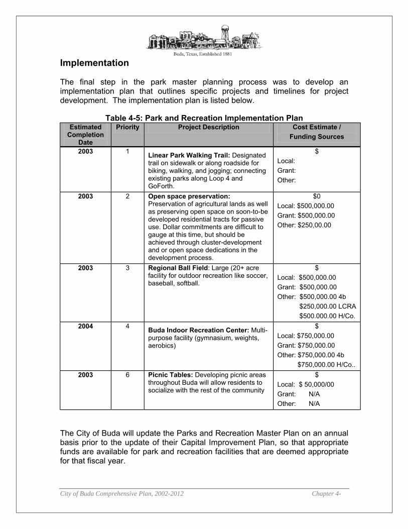
City of Buda Comprehensive Plan, 2002-2012 Chapter 4-
Implementation The final step in the park master planning process was to develop an implementation plan that outlines specific projects and timelines for project development. The implementation plan is listed below.
Table 4-5: Park and Recreation Implementation Plan Estimated
Completion Date
Priority Project Description Cost Estimate / Funding Sources
2003 1 Linear Park Walking Trail: Designated trail on sidewalk or along roadside for biking, walking, and jogging; connecting existing parks along Loop 4 and GoForth.
$ Local: Grant: Other:
2003 2 Open space preservation: Preservation of agricultural lands as well as preserving open space on soon-to-be developed residential tracts for passive use. Dollar commitments are difficult to gauge at this time, but should be achieved through cluster-development and or open space dedications in the development process.
$0 Local: $500,000.00 Grant: $500,000.00 Other: $250,00.00
2003 3 Regional Ball Field: Large (20+ acre facility for outdoor recreation like soccer, baseball, softball.
$ Local: $500,000.00 Grant: $500,000.00 Other: $500,000.00 4b $250,000.00 LCRA $500.000.00 H/Co.
2004 4 Buda Indoor Recreation Center: Multi-purpose facility (gymnasium, weights, aerobics)
$ Local: $750,000.00 Grant: $750,000.00 Other: $750,000.00 4b $750,000.00 H/Co..
2003 6 Picnic Tables: Developing picnic areas throughout Buda will allow residents to socialize with the rest of the community
$ Local: $ 50,000/00 Grant: N/A Other: N/A
The City of Buda will update the Parks and Recreation Master Plan on an annual basis prior to the update of their Capital Improvement Plan, so that appropriate funds are available for park and recreation facilities that are deemed appropriate for that fiscal year.

City of Buda Comprehensive Plan, 2002-2012 Chapter 4-
Illustration 4-1: Parks and Recreation
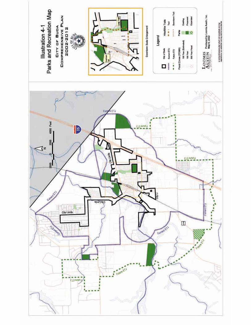

City of Buda Comprehensive Plan, 2002-2012 Chapter 5-1
55 HHiissttoorriicc PPrreesseerrvvaattiioonn Introduction In 1881, Cornelia Trimble donated land for the new town of “DuPre”. Within twenty years, the town had adopted the current name of Buda. Although the city has seen significant change over the past 120 years, it still retains much of the charm that attracted the first residents. Buda currently has the second largest concentration of historic structures in Hays County.1 Many of these historic buildings are located along Main Street in downtown Buda and form the backbone of a potential Historic District. The Federal Historic Preservation Act of 1966 gave communities the power to save many of these important cultural artifacts. Subsequently, preservation efforts were focused on integrating these historic resources into the living community. More recently, Chapter 221 of the Texas Local Government Code authorizes municipalities to engage in the “protection, enhancement, and perpetuation of landmarks or districts of historical and cultural importance…”2 Historic preservation can also be an effective economic development tool. In Texas, historic designation has been shown to improve property values by as much as 20 percent. Furthermore, historic preservation attracts reinvestment, creates jobs, and attracts tourists and associated spending.3 The Historic Preservation Element of the 2002-2012 Comprehensive Plan focuses on preserving and promoting Buda’s wonderful heritage by encouraging adaptive reuse of existing properties while maintaining the special character of the region.
1 Only San Marcos has more. Source: Terri Myers- Historic Preservation Consultant currently engaged in a project to have the downtown Buda “Historic District” listed on the National Register of Historic Places. 2 Taken from the Texas Historical Commission’s Model Historic Landmark and District oning rdinance. 3 Historic Preservation at ork for the Texas Economy. (1999). Texas Historical Commission.
Historic Preservation Goal To preserve specific historic properties in Buda and the city’s unique character while affording opportunities for economic development and facility improvement.
istori o nto n Buda oday oo in orth from the City ffi es on ain treet

City of Buda Comprehensive Plan, 2002-2012 Chapter 5-2
HISTORIC DISTRICT/DOWNTOWN REGION ILLUSTRATION
City of Buda Comprehensive Plan, 2002-2012 Chapter 5-3
Historic Preservation Policies and Programs Policy HP-1: Preserve and protect Buda’s rich heritage. The first policy specific to Historic Preservation in Buda is the listing of the Buda Historic District on the National Register of Historic Places. This process is currently underway. In order to be eligible for listing, at least 50% of the properties in the district must be “contributing.” In most cases, contributing structures must be at least 50 years old and must not have any externally visible architectural improvements. The district listed with the National Register would extend along the west side of Main Street from Elm Street to at least Peach Street and possibly to FM 2770 and no further west than Austin Street. Listing with the National Register, while offering elevated status, does not impose any restriction on what property owners can and cannot do with their own property. The district listed with the National Register would occupy a limited stretch of downtown Buda. This is due to the requirement that a minimum of 50% of the properties must be contributing. Extending the district further would essentially dilute the number of contributing properties and reduce the likelihood of listing. While listing with the National Register places recognition upon significant structures and districts, it affords little protection to these valuable cultural resources. In order to manage activities affecting historic buildings and the Historic District, the city must adopt local ordinances that ensure preservation of these significant structures without placing undue burdens on individual property owners. In addition to being an asset to the individual property owner, these properties are a benefit to the entire Buda community. When asked to describe what about the town they find so appealing, many residents refer to the character of “old Buda”. Furthermore, historic tourism attracts spending to the region as well as direct investment. Subsequently, the city should develop incentive programs that encourage owners of historic properties to improve and maintain these buildings. All too often, the cost of updating and maintaining old buildings prevents owners from pursuing this route in favor of more affordable methods that result in buildings that lose their historic charm and detract from the overall appeal of downtown Buda. Assistance can take many forms such as relaxed zoning regulations, waiving of certain permitting fees, guaranteeing of loans, and more. The city should also ensure that historic Buda is a priority in the economic development planning process. In order to ensure effective implementation of a preservation ordinance and assist property owners with the responsibilities of improving and maintaining historic structures, the City Council should appoint a Historic Preservation Board. Members of the board would come from the Buda community with possible
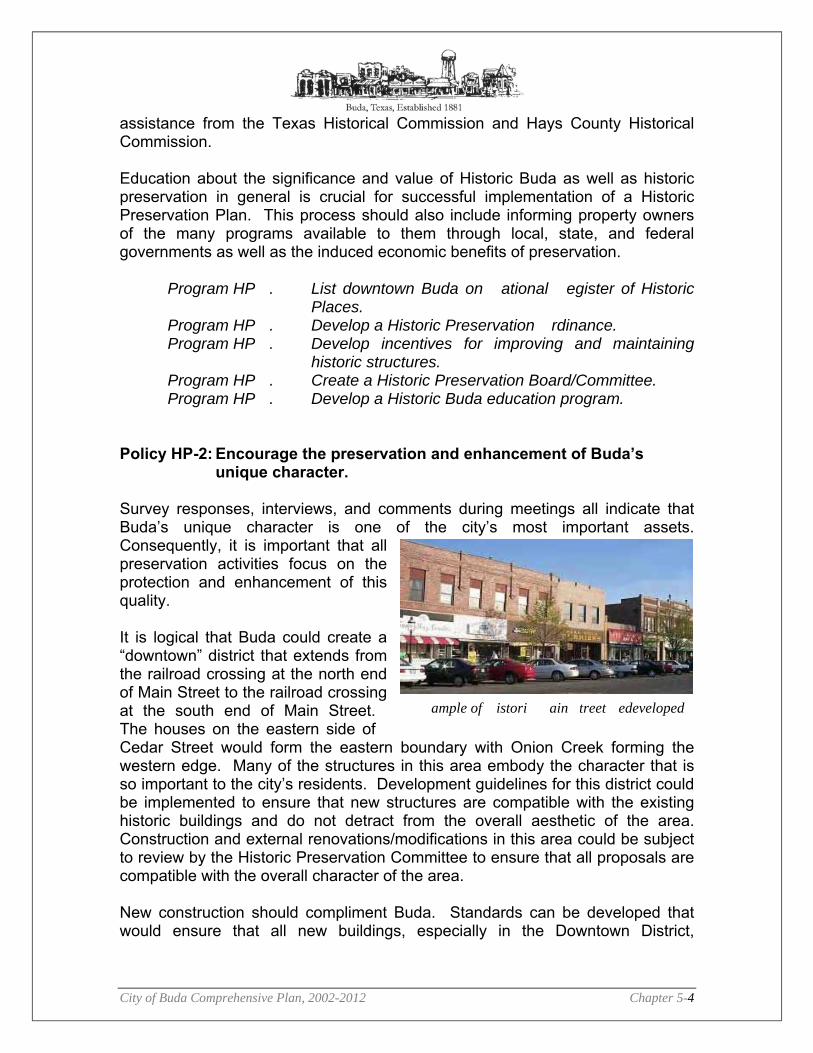
City of Buda Comprehensive Plan, 2002-2012 Chapter 5-4
assistance from the Texas Historical Commission and Hays County Historical Commission. Education about the significance and value of Historic Buda as well as historic preservation in general is crucial for successful implementation of a Historic Preservation Plan. This process should also include informing property owners of the many programs available to them through local, state, and federal governments as well as the induced economic benefits of preservation.
Program HP . List downtown Buda on ational egister of Historic Places.
Program HP . Develop a Historic Preservation rdinance. Program HP . Develop incentives for improving and maintaining
historic structures. Program HP . Create a Historic Preservation Board/Committee. Program HP . Develop a Historic Buda education program.
Policy HP-2: Encourage the preservation and enhancement of Buda’s
unique character. Survey responses, interviews, and comments during meetings all indicate that Buda’s unique character is one of the city’s most important assets. Consequently, it is important that all preservation activities focus on the protection and enhancement of this quality. It is logical that Buda could create a “downtown” district that extends from the railroad crossing at the north end of Main Street to the railroad crossing at the south end of Main Street. The houses on the eastern side of Cedar Street would form the eastern boundary with Onion Creek forming the western edge. Many of the structures in this area embody the character that is so important to the city’s residents. Development guidelines for this district could be implemented to ensure that new structures are compatible with the existing historic buildings and do not detract from the overall aesthetic of the area. Construction and external renovations/modifications in this area could be subject to review by the Historic Preservation Committee to ensure that all proposals are compatible with the overall character of the area. New construction should compliment Buda. Standards can be developed that would ensure that all new buildings, especially in the Downtown District,
ample of istori ain treet edeveloped

City of Buda Comprehensive Plan, 2002-2012 Chapter 5-5
enhances the character and appeal of this historic community. These guidelines should apply to both the structures and the lot layout. These standards could include building material and appearance guidelines that ensure that new facades blend with the existing historic structures. New buildings should be close to the street with parking behind or to the side. These guidelines could also serve to ensure that modifications to existing structures would be compliment the overall character. Signage in the downtown district should not detract from the aesthetic quality of the area. Guidelines could be implemented to ensure that signage in the district is compatible with the overall character.
Program HP . Designate a Downtown District. Program HP . Develop Compatibility Standards. Program HP . Develop a Downtown District Sign rdinance.


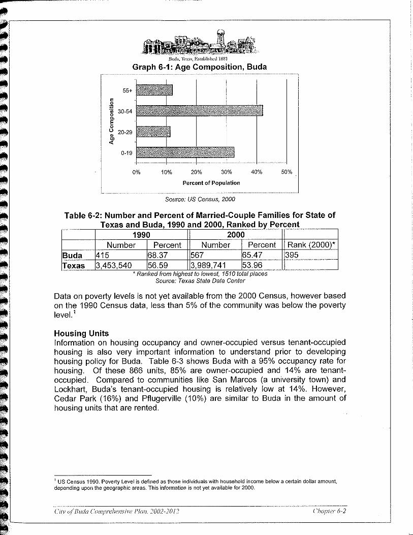


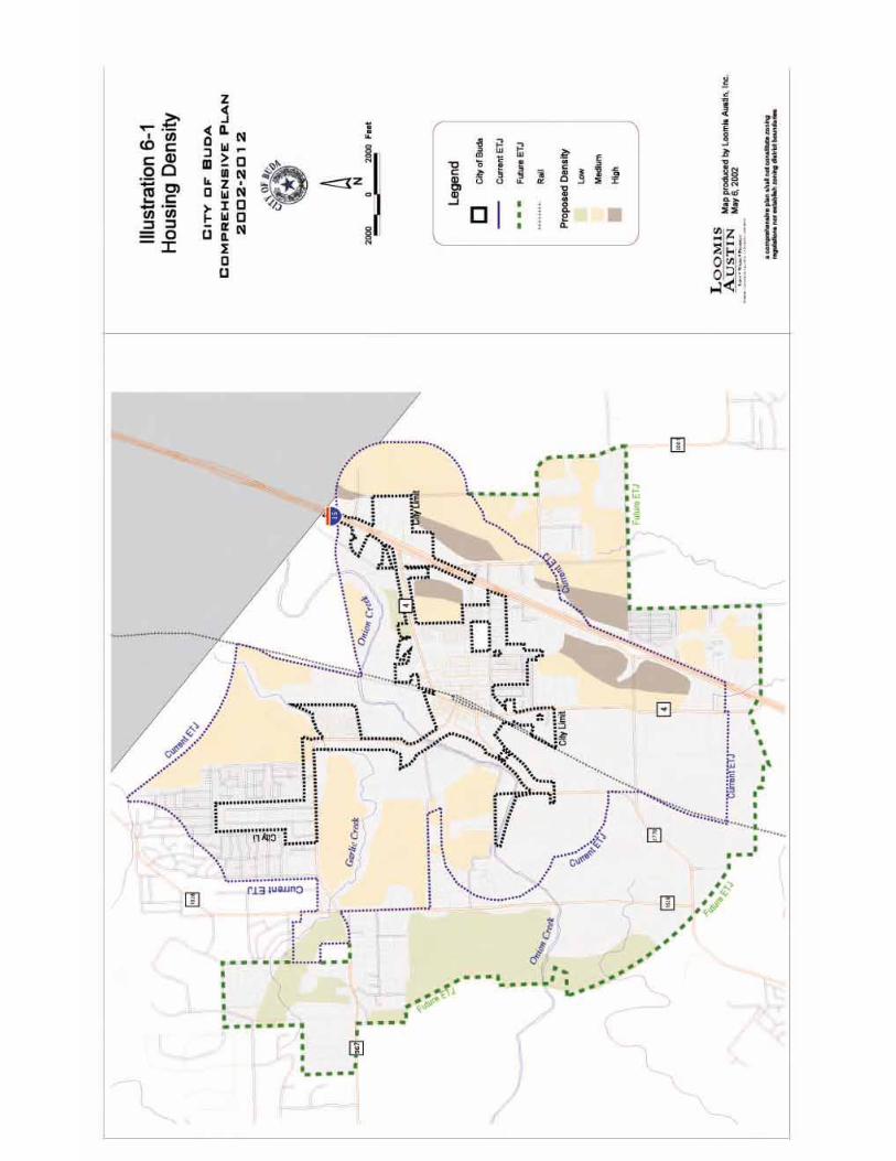
City of Buda Comprehensive Plan, 2002-2012 Chapter -1
77 EEccoonnoommiicc DDeevveellooppmmeenntt Introduction Buda has a unique opportunity in pursuing their economic development goal. The City has a newly formed 4B Economic Development Corporation1 and a Chamber of Commerce. Developing an overarching Economic Development Plan for the whole city will allow both of these organizations, as well as the City to identify the best organizational strategies for implementing the policies described below. Furthermore, a strong partnership among these three entities will ultimately lead to a successful implementation of this plan element. A Strategic Plan for implementing the Economic Development Policies and Actions listed below can be found in the Appendix. Economic Development Policies and Programs Policy ED-1: Encourage diverse business development and expansion. New business development as well as existing business expansion is a primary focus for economic development in Buda. This policy addresses issues such as infrastructure improvements and partnership fostering which will ultimately positively position the City of Buda to effectively recruit new business as well as help existing business expand.
Program ED-1.1: Plan and provide adequate and reliable infrastructure including water, wastewater, electric, telecommunications, roads, fire and police.
Program ED-1.2: Identify and foster partnerships for developing economic infrastructure.
Program ED-1.3: Develop funding mechanisms (eg., tax abatements, tax increment financing (TIFs), tax incentive reinvestment zones (TIRZ)) to encourage desirable economic development. Incentive programs can be geared towards promoting business development that is “clean” and or interested in becoming a community
1 A city-wide referendum was approved in 2001 adopting a ½ cent sales tax for purposes of Economic Development. The referendum approved what is known as a 4B sales tax and will be administered by a 4B Board of Directors in Buda. For more information on this see http://www.window.state.tx.us/taxinfo/taxpubs/tx96_302.html
Economic Development Goal To increase the tax base and job opportunities, while enhancing the community character and natural resources.

City of Buda Comprehensive Plan, 2002-2012 Chapter -2
partner by participating in park and open space development and similar activities.
Program ED-1.4: Focus diversity downtown by using incentives (see ED-1.3) in order to preserve the character of downtown and make it a focal point for the community.
Program ED-1.5: Identify appropriate and specific improvement districts throughout Buda.
Program ED-1.6: Encourage higher education facilities to develop in the Buda area.
Program ED-1.7: Support the development of commuter rail through Buda and facilitate the development of a commuter rail depot in Buda.
Policy ED-2: Preserve and enhance Buda’s natural resources while
expanding the economy. Some of the most important values that have been identified by the public are natural resource and community character protection and enhancement. Therefore, economic development policies and programs have been crafted to enhance the economy while adhering to these important community values. This can be a difficult balancing act, yet a very important policy for the community.
Program ED-2.1: Identify businesses that are not detrimental to Buda’s natural resources.
Program ED-2.2: Identify the most appropriate locations within the City where business development should be encouraged.
Program ED-2.3: Create a Planning and Zoning (P&Z) Commission to assist the City in adhering to this policy as well as other land development policy and ordinances.
Policy ED-3: Enhance Buda’s character and quality of life. The character and quality of life of the community continue to be priority issues for Buda residents. Quality of life issues such as urban design, parks and recreation and library facilities, as well as public services such as fire and police protection are also priorities for businesses and their employees. Preserving and enhancing these aspects of the community will enable the City to retain existing businesses and residents as well as appeal to new businesses and residents who share the quality of life priority.
Program ED-3.1: Develop a plan to address encroachment on
residential areas; create a buffer zone between I-35 and Buda CBD.
Program ED-3.2: Develop transitional zones for Loop 4 approaching old town Buda North and South.

City of Buda Comprehensive Plan, 2002-2012 Chapter -3
Program ED-3.3: Develop theme for transitional zones that reflects historic Buda (eg., Historic Corridor).
Program ED-3.4: Implement the results of the community survey to include: beautification, parks, stagecoach property, 48 acres (recently aquired by the City), swimming pool, youth recreation center/YMCA.
Program ED-3.5: Develop Bed & Breakfast business. Program ED-3.6: Clean up quonset hut area along railroad line.
Policy ED -4: Promote Buda as a Tourist Destination Tourism can be one of the cleanest industries and has a multiplier effect on a community’s economy. Texas tourism is a growing industry and has become one of the top income producers for the economy.2 Tourism can also take many forms such as Bed & Breakfasts, arts and crafts shows/festivals, sports events, and museum attractions. All of these, as well as other similar projects, have been identified as programs to pursue.
Program ED-4.1: Develop an Indoor/Outdoor Regional Recreational
Youth center including a sports complex. Program ED-4.2: Develop a Children’s Discovery Center and Museum. Program ED-4.3: Agressively pursue a program to redevelop the
Feedmill property (see the Town Center Plan Element).
Program ED-4.4: Adopt Safe Tourist Policies such as parking, traffic calming/flow, and walkways.
Program ED-4.5: Develop a Central Texas biking center. Program ED-4.6: Develop a train depot watching/viewing area. Program ED-4.7: Develop Buda’s natural and historic treasures. Program ED-4.8: Develop a unique downtown restaurant development
and support. Program ED-4.9: Obtain Historic Designation. Program ED-4.10: Support future performing arts centers by bringing in
local and varied art forms. Program ED-4.11: Promote ongoing and established festivals and
encourage additional community festivals. Program ED-4.12: Provide incentives for hotels and Bed & Breakfasts. Program ED-4.13: Provide a Ruby ranch/TDS – type lodge with meeting
rooms, cottages, pavilions, and dance floors. Program ED-4.14: Promote Amtrack / light rail / commuter facility in
conjunction with depot recreation (see ED-4.6 above). Program ED-4.15: Develop a Show barn – arenas, meeting rooms, stalls
(indoor/outdoor).
2 See reports on Texas Tourism Industry produced by the Texas Department of Economic Development. http://research.travel.state.tx.us/

City of Buda Comprehensive Plan, 2002-2012 Chapter 8-1
88 FFuuttuurree LLaanndd UUssee PPllaann Introduction The Future Land Use Plan Element is perhaps the most important aspect of a Comprehensive Plan. The Future Land Use Plan provides not only a map indicating future land use preferences, but also background and guidance to City staff and elected officials, the public, and private developers on why and how land should be utilized in certain ways for particular areas of the community. Normally, a Future Land Use Map/Plan is generated with each parcel getting a future land use associated with it. This type of land use planning can create isolated uses with little or no compatibility with the surrounding community. Recognizing this as a potential impediment to Buda enhancing the character of their community, Buda has chosen a different strategy for land use planning that involves urban design, compatibility standards, buffers, and connectivity. In order to achieve these land planning objectives, the Future Land Use Plan has been divided into four major components: 1) General Land Use Policies, 2) Sectors and Corridors (map), 3) Priority Growth Areas (map), and 4) Specific Land Use Classifications (map). These maps are coarse in nature and the text is somewhat generalized for purposes of developing a Future Land Use Strategy. Specifics for these items will be developed and will eventually manifest themselves in the land development ordinances. The General Land Use Policies are listed below, followed by a discussion of Sectors/Corridors, Priority Growth Areas, Future Land Use Classifications, and finally a Chart indicating Future Land Use Acreage by Sector (see Table 6-1). General Land Use Policies: These policies provide generalized principles for all of Buda. These principles have been developed through numerous public input processes and represent the major interests of the community, as well as the policies presented in each Plan Element. These are meant to help guide decision-making as it relates to future land development. Growth Management
1. New developments must be compatible with existing development and community character.
2. New development must maintain small town character, look and feel of community.
City of Buda Comprehensive Plan, 2002-2012 Chapter 8-2
3. Priority Growth Areas should be recognized and planned for by developing an infrastructure plan to encourage development in specific areas of the community. See Priority Growth Areas Map for more detail.
4. The City should encourage desirable development and construct infrastructure in the Priority Growth Areas.
5. New development must occur in a fiscally responsible manner for the City. Environmental Protection
1. Preserve and protect waterways and floodplains 2. Preserve and protect surface and ground water resources and
hydrologically-active areas 3. Cooperate with area governmental entities to ensure water quantity 4. Seek public acquisition of open space or develop conservative
development options for areas of environmental concern 5. Preserve and protect air quality. 6. Agricultural and ranch lands should be priority areas for open space
preservation. The City will work with landowners who are interested in conservation easements and/or transfer of development rights.
7. Promote and incentivize water conservation practices. 8. Promote awareness and implementation of Best Management Practices
(BMPs) for purposes of water quality and land conservation (ie., increase awareness of the impacts of the use of certain pesticides on the drinking water supply).
Housing
1. Provide housing alternatives for all income levels within Buda 2. Improve existing housing stock 3. Ensure safe housing construction 4. Ensure housing is compatible with existing neighborhoods and land uses 5. Promote cluster development when/where appropriate
Economic Development
1. Seize economic opportunity along I-35 and along major arterials 2. Promote quality development that is compatible with neighboring areas 3. Promote development that is consistent with community character 4. Enhance downtown area for area residents and tourists 5. Promote economic development consistent with other land use policies. 6. Encourage and support existing business expansion through the use of
incubators or other business expansion programs. Historic Preservation
1. Preserve and enhance historic areas throughout the City 2. Preserve the community character (e.g., residential street setbacks and
layouts) 3. Use history to promote tourism and economic development.
City of Buda Comprehensive Plan, 2002-2012 Chapter 8-3
4. Preserve significant archaeological sites throughout Buda. Parks and Recreation
1. Connect existing and future parks. 2. Ensure maintenance and safety of parks and recreation resources. 3. Provide and preserve open space and parkland in new neighborhoods
and associated with new schools. 4. Develop new recreation opportunities.
Circulation
1. Provide more east-west connectivity. 2. Reduce truck traffic through downtown and encourage alternative routes
South of downtown. 3. Provide for safe and ample pedestrian connectivity throughout new and/or
existing developments. 4. Improve access across and under I-35. 5. Ensure that streets and street networks are designed with a focus on
interconnectivity to provide ample, safe, and appropriately-scaled access through and between neighborhoods and to commercial centers.
6. Ensure that necessary amounts and layouts of parking are provided for new commercial, office and retail development, but that the parking fields do not deter ease of pedestrian access into and through new developments, and that do not deter or detract from community character (eg., maximum parking limits).
7. Access management – safe and integrated. Urban Design
1. Encourage and provide incentives for blending of land uses and mixed use development
2. Neighborhoods should be the primary organizing element of new, higher density developments, each including civic spaces and access to commercial districts
3. Develop compatibility standards for adjoining land uses (e.g., landscape and buffer standards)
4. Develop streetscape design criteria to ensure safe and desirable pedestrian access and community attractiveness.
5. Develop height restrictions for commercial and multifamily development 6. Develop appropriate building area and bulk regulations, configurations,
project scales and some architectural design guidelines for new developments within the community
7. Signage should not detract from the visual integrity of the community. 8. Lighting associated with signage or development should not pose a safety
or environmental concern, and should be addressed in an aesthetically pleasing manner, when possible and appropriate – particularly as it relates to the impact on existing or new residential development.
City of Buda Comprehensive Plan, 2002-2012 Chapter 8-4
Civic and Public Spaces
1. Civic buildings and civic space should be given prominent sites. 2. Elementary school sites should be provided as new neighborhood
developments are approved, so as to be within walking distance of a majority of the dwelling units in adjoining neighborhoods.
Sector and Corridor Planning The land use policies described above apply to the community at large. However, the following Sectors and Corridors provide specific principles of urban design and planning for specific areas in the community. Sectors – Every tract of land within the study area falls within a unique area because of various cultural, environmental, or infrastructure issues. Because of the uniqueness of these areas, specific principles have been applied to each area – ensuring that the unique qualities of each sector are protected and enhanced. Six sectors have been identified that hold unique qualities distinct from the other sectors.
The Sector/Corridor Map (Illustration 8-1) delineates the sectors and their respective relationship with other sectors. However, specific sector descriptions follow: 1. Interstate-35 Commercial/Industrial Sector:
�� This area is going to be an important future revenue generator for the City. The area will extend about 1,250 ft from the frontage road of I-35 on both the east and west side of I-35 (the distance from the frontage road can be increased depending upon the aesthetic quality of the development). The corridor length will extend from the Travis/Hays County line, south to the southern end of the study area. This sector stubs out to the West slightly near the Park-35 Commercial/Industrial Area out to Loop 4.
�� The purpose of this Sector is to provide a Commercial district along I-35 taking advantage of the economic opportunity that I-35 provides.
�� Building footprints greater than 50,000ft2 must meet certain design guidelines that may include an articulated façade that breaks the building into multiple smaller units, articulated roofs (ie., no flat roofs), and color/material variation. The purpose of these types of design standards is to foster visually pleasing development at the front entrance to Buda.
�� Buffers/Compatibility/Connectivity: Commercial construction must be compatible with existing developments, provide landscape buffers with existing and future residential development, and provide connectivity
City of Buda Comprehensive Plan, 2002-2012 Chapter 8-5
for vehicular, pedestrian and bike traffic to the development from major roadways, as well as from existing neighborhoods.
2. Aquifer Sector: �� The area that falls within the Recharge Zone of the Edwards Aquifer. �� Purpose: This sector is designated for the purpose of establishing
protective measures for the city’s drinking water supply. Development in this sector may only occur in accordance with regulations and guidelines adopted in accordance with an interlocal agreement between the cities of Buda and Austin.
�� Existing agricultural land is encouraged to be held in its current use and tax status.
�� Encourage recharge enhancements with new and existing developments.
3. Transition Zone North Sector: �� The area that falls within the Transition Zone of the Edwards Aquifer. �� Purpose: This sector is designated for the purpose of establishing
protective measures for the city’s drinking water supply. �� In this sector, development guidelines will be established to ensure the
safe operation of wastewater collection, treatment and discharge systems. The shallow subsurface extent of the Edwards Limestone formations makes it highly vulnerable to subsurface contamination from leaking sewer lines and onsite septic systems.
4. Heritage Sector: �� Area from Onion Creek east to the Commercial District, south to
Goforth Road and then southwest to Loop 4, and north to Onion Creek, to include Black Colony Road and the Antioch Cemetery.
�� Purpose: This sector encompasses historic and scenic roadways, residences and commercial buildings, and other areas that have constituted the town of Buda for many decades. Any future development within this sector must be carefully and thoughtfully planned and designed in order to be compatible with existing uses and buildings, in terms of bulk, height and area, exterior materials, setbacks from scenic roadways, and overall appearance of buildings and spaces.
5. East Buda Sector: �� Area east of the I-35 Commercial/Industrial Sector, extending eastward
and north and south to the limits of the Buda ETJ. �� This sector is to be developed primarily residential land use with some
arterial- and neighborhood-scale commercial, office, and recreational/parkland development. Existing agricultural land is encouraged to be held in its current use and tax status.
�� Purpose: This sector will ultimately be a suburban expansion zone for the metropolitan area, depending on the availability of centralized utility services.
6. Loop 4 South Sector:
City of Buda Comprehensive Plan, 2002-2012 Chapter 8-6
�� Area along Loop 4, running south from the Heritage Sector to the southern End of the Study Area, and abutting the Aquifer Sector
�� Purpose: This sector is distinguished from other sectors by the existing industrial and allied commercial uses in the sector. Compatibility standards will be established between future residential uses and other uses (such as industrial or heavy commercial), as they may encounter conflicts in land use.
�� New east-west roadway alignments will be planned to enable truck traffic from industrial activities to connect with I-35 as directly as possible and to avoid driving through urban residential and retail areas to the north.

City of Buda Comprehensive Plan, 2002-2012 Chapter 8-7
SECTOR ILLUSTRATION

City of Buda Comprehensive Plan, 2002-2012 Chapter 8-8
Corridors – The purpose of a corridor is to either protect the visual and/or environmental integrity of the corridor and/or to ensure connectivity between sectors through the corridors. Two corridors have been identified that overlay themselves through all sectors.
The Corridor Map (Illustration 8-1) shows the two corridor areas. The following provides a description of each: 1. Gateway Corridors – These are areas that will be used and experienced by
both residents and visitors of Buda as they enter the community. The City desires to maintain and enhance the visual integrity of these corridors in order to make the community attractive. Major arterials that fall within this category include Loop 4, 967, 2770, 2001 and 1626 (Other future roads, or road expansions, may eventually fall within the guidelines of Gateway Corridors.) All development within these corridors shall follow the following categories of guidelines (to be specified in Buda’s Land Development Code):
�� Building setbacks from the principal roadway �� Height restrictions �� Building Material Usage �� Landscaping �� Parking �� Site Orientation
2. Floodplain Corridor – The purpose of this corridor is floodplain protection and water quality and environmental protection along creeks and floodplains. Floodplain Corridors are for Onion and Garlic Creeks as well as other tributary creeks and floodplains throughout Buda.
Important Background Information Pertaining to Floodplains:
�� The Housing Element describes in detail that floodplains should be considered in density calculations. This policy will allow landowners with portions of their land within the 100-year floodplain to use the floodplain area when calculating the density for development (and given what zoning allows in the specific area, if within the City limits).
�� Hike and Bike trails have been considered throughout the Comprehensive Plan. However the Plan does not recommend that the City of Buda take land from landowners for purposes of a hike and bike trail. There is a policy recommendation in the Parks and Recreation Plan Element to try to connect existing and future parks with trails. Condemnation of land for purposes of a hike and bike trail is NOT the recommendation.
All development along these corridors should adhere to the following (to be specified in Buda’s Land Development Code):

City of Buda Comprehensive Plan, 2002-2012 Chapter 8-9
Land use and Construction Management:
�� For Subdivisions, development should follow the current City of Buda Subdivision Ordinance, Section 12, N-10, page 33) describing setbacks from the 100-year floodplain.
�� Land subdivided to pass on to family heirs should be encouraged to be preserved for family use.
�� Floodplain should be considered as part of density calculations (per the Housing Plan Element).
�� Best Management Practices (BMPs) should be encouraged in areas along creeks.
Utilities and Infrastructure:
�� Minimize road, bridge and utility construction within the floodplain in order to minimize potential damage and environmental degradation, as well as safeguard public investment of utilities.
�� Vegetative clearing restrictions should exist in floodplains to maintain the natural character of creekside areas, and provide vegetative buffers between development and creeks.
�� Storm drainage discharge restrictions should exist to maintain the natural character and capacity of creek channels.
Priority Growth Areas Identifying areas as Priority Growth Areas provides guidance to development interests and the City that infrastructure improvements (eg., water and wastewater infrastructure) will be aggressively constructed to serve these areas. What follows are recommendations on which areas of the community should receive infrastructure improvements first, so as to guide development in certain non-critical environmental areas and areas that would be fiscally beneficial to the City (the Priority Growth Map can be found in Figure 6-3.). Priority Growth Area 1: Interstate-35 Commercial Industrial
�� This will be the area in Buda that will generate substantial sales tax and property tax revenues from associated Retail and Commercial Uses that will likely be located in this area, as well as jobs. Infrastructure including water, wastewater and transportation should be planned in advance in this area to accommodate the potential growth and land uses. The City may want to build the infrastructure through bond financing and then recuperate costs through various development-related fees. This strategy will ensure that development occurs in a timely fashion and within the guidelines for growth that the City envisions.

City of Buda Comprehensive Plan, 2002-2012 Chapter 8-10
�� Because of Buda’s topography, this southern end of the I-35 Commercial Sector appears to be a logical collection and termination point for sanitary and storm sewer collection systems. Following the Master Drainage Study, the priority growth area boundary may change slightly.
Priority Growth Area 2: Loop 4 South
�� This will be another area in Buda that will generate significant sales tax, property tax and jobs. However, this area will more than likely be developed with heavy commercial and light industrial uses. Infrastructure including water, wastewater and transportation should be planned in this area to accommodate the potential growth and land uses. The City may want to build the infrastructure through bond financing and then recuperate costs through various development-related fees. This strategy will ensure that development occurs within the guidelines for growth that the City envisions.
Priority Growth Area 3: East Buda
�� This area of Buda has relatively few environmental constraints (eg., little or no Aquifer-related issues, no endangered species). Hence, this is an area of the community that can bear significant Residential, Office, Retail, and Commercial Uses. In conjunction with Priority Growth Area 1, Area 3 should be developed but with more private sector support for infrastructure (TBD later through various impact fee discussions and ordinance updates) provided that appropriate safeguards are in place to mitigate the developmental impacts on the existing environment (ie., drainage, flooding, water quality).

City of Buda Comprehensive Plan, 2002-2012 Chapter 8-11
PRIORITY GROWTH AREA ILLUSTRATION

City of Buda Comprehensive Plan, 2002-2012 Chapter 8-12
Specific Land Use Options1 (to be used with the Future Land Use Map): Every parcel can be identified and color-coded based on the following Land Use Districts, or combination of districts. While each land use is described as a unit independent of other uses, combinations of uses are actually encouraged with the designation of areas in a Multi-use Overlay District. The Future Land Use Map identifies where there are mixtures of uses (not necessarily “Mixed Use”). This map is a fairly coarse map at this point, and will be clearly demarcated by parcels when developing a zoning map for Buda. Agricultural Land used for agricultural purposes (e.g., ranching, orchards or farming). This use could have residence(s) or even a commercial or industrial building but the primary use is agricultural. This use has not been identified as an independent use that will occur within Buda. However, open space preservation is encouraged, particularly in areas where Cluster Development may occur. The City would like to encourage landowners to continue utilizing their land for agricultural and/or ranching use. Park/Open Space Areas designated as public (although not necessarily owned by the public) parkland or open space, and any areas intended for this purpose in the future. Areas designated as preserve land and any areas intended for this purpose in the future.
PR. Parks and Recreation 1. Neighborhood Park (5% of residential areas) 2. City Park (15-50 acres) 3. Regional Park (50-100 acres) 4. Private Park (variable) 5. Open Space/Agricultural (30% of Clustered Development) (PR5
is not on a map since Clustered Development will be encouraged throughout the City where residential subdivision will occur)
Residential Includes activities that occur in all types of residential uses, structures, ownership characteristics, or the character of the development. �� Low Density Residential – Below 1 unit per acre. Characterized mostly by
large lot, low density residential and single-family detached homes;
1 Examples: �� HR/C-1/PR-1/FZ-1 -> A clustered residential development with an average density of 4+ units/acre, some
neighborhood commercial, some neighborhood park �� HR-MF/C-2/PR-2/FZ-2 -> A high density MF development, mixed with some larger retail and a city park
City of Buda Comprehensive Plan, 2002-2012 Chapter 8-13
�� Medium Density Residential – Between 1-4 units per acre. Provide for smaller residential lot sizes, possibly including dwelling units such as patio homes, town homes, or condominiums. Up to four dwelling units per acre.
�� High Density Residential – More than four dwelling units per acre.
Low Density (LR) <1 unit / acre Medium Density (MR) 1 – 4 units / acre High Density (HR) >4 unit / acre Duplex Residential (DR) >4 unit / acre MultiFamily Residential (MFR) >4 unit / acre Manufactured Home Residential (MHR) >4 unit / acre Manufactured Home Residential Park (MHPR)
>4 unit / acre
R. Residential
1. Low Density (LR) - <1 unit/acre; mostly single family 2. Medium Density (MR) - 1-3.9 units/acre; mostly single family 3. High Density (HR) - >4 units/acre; all residential uses 4. Duplex (DR) - blended with other residential uses and not to
exceed 15% of total residential. 5. MultiFamily (MFR) - blended with other residential uses and
includes rowhouses, townhomes, and condominiums; typical acreage is <10 acres.
a. MF1 – maximum of 15 units/acre b. MF2 – between 15-20 units/acre
6. Manufactured Housing Park (MHR) – should be less than 100 acres.
Public Areas owned by the city, county, school district, state, or church (e.g., City Hall, fire station, school buildings, library, storage sites, cemeteries). This does not include railroad right of ways.
P. Public 1. Community Facility 2. Infrastructure Facility (e.g., Water plant)
Retail Areas used primarily for Retail activity, intended to serve both regional consumers and local citizens of Buda. Uses include grocery stores, pharmacies, personal service shops (i.e., hair salons, dry cleaners, tailors, florists, etc.), day care centers, small restaurants and cafes, a few convenience stores with gasoline sales, a farmers market, a car wash, grocery stores, restaurants, large bookstores and similar establishments; large retail establishments, including shopping malls, large single-tenant retail users, motels and hotels.

City of Buda Comprehensive Plan, 2002-2012 Chapter 8-14
Retail Retail Use Building Size (ft2) Land Area FAR2
Neighborhood Retail (R1) 20,000 0-3 acres < .25
Arterial Retail (R2) 0-50,000 0-10 acres < .25 Interstate Retail (R3) >50,000 >10 acres < .5
Commercial Areas allow for commercial amusements, building materials yards, automobile garages and sales lots, automobile body repair, warehouses, telecommunications/broadcasting towers and facilities, wholesale establishments, and the sale of used merchandise and welding shops.
C. Commercial/Service/Office
Commercial Use Building Size (ft2)
Land Area FAR
Neighborhood Commercial (C1) 20,000 0-3 acres < .25
Arterial Commercial (C2) 0-50,000 0-10 acres < .25 Interstate Commercial (C3) >50,000 >10 acres < .5
Industrial Areas might include light industry which entails unenclosed operations or storage, heavy industry with limited external effects or light industry with no outdoor storage (e.g. industrial park).
I. Industrial 1. Light Industrial/Warehousing 2. Manufacturing/Processing 3. Mining
Floating Zones This type of zone “floats” because there are areas that have been generally identified as areas, for example, where there should be a school, but until development occurs, and the school district chooses its best location, the school must float over a general area.
FZ. Floating Zones 1. Cluster Development – ordinances should contain specific
requirements for open space percentages in a clustered development (this may be as much as 50%)
2. Mixed Use – mixed uses should be compatible uses and proportionate.
2 Floor to Area Ratio (FAR) – the ratio of the total building square footage to the lot size)

City of Buda Comprehensive Plan, 2002-2012 Chapter 8-15
3. School Site – school sites should be approximately 15 acres (10 acres of which should be dedicated to a neighborhood park).
Overlay Districts Overlays are meant to provide some guiding principles for development to encourage , in this case, historical preservation in certain areas of Buda.
OD. Overlay Districts 1. Historical District Overlay

City of Buda Comprehensive Plan, 2002-2012 Chapter 8-16
FUTURE LAND USE ILLUSTRATION

City of Buda Comprehensive Plan, 2002-2012 Chapter 8-17
Carrying Capacity by Sector As development occurs throughout Buda, it will be important and helpful for City Staff, Officials, and the public to understand what the proposed and existing infrastructure system (roads and utilities) will support so that a particular Sector is not built out beyond the capacity for infrastructure. In addition, having an understanding of the appropriate mixture of development (ie., residential, retail, commercial) will help decision-makers keep cumulative tabs as developments are proposed and realized. Table 8-1 shows the total amount of Current Agricultural and Vacant lands applied to Future Land Use by Sector. These Sector development thresholds provide the guidance described above. Any proposal that seeks to develop beyond the Sector threshold may become a Planned Unit Development (PUD. This table was developed by taking the total agricultural and vacant (AG/VA) acreage by sector, and applying the future land use classifications to the AG/VA lands. Population projections based on the land use assumptions listed below and the current number of persons per household, yield a total buildout population of the existing study area of approximately 48,000 persons. It is important to underline that this table depicts final buildout, which more than likely will not occur over the next 10 or even 20 years. Nevertheless, this will be extremely helpful for infrastructure planning in Buda. The following are specific assumptions incorporated into the analysis: Landuse Assumptions Road R.O.W. and other transportation uses would account for approximately 5-20% depending on the area of the community (eg., I-35 Sector will have approximately 20%) Residential Use accounted for between 50% and 90% of the development in a landuse category. Multifamily (MFR) and Manufactured Housing (MHR) were assigned lower percentages of between 10% and 25%. The number of units was calculated using the following ratios: LR .7 unit/acre; MR 2.5 units/acre; HR 5 units/acre; DR 8 unit/acre; MFR 15 unit/acre; MHR 4 unit/acre. Parks and Recreation was estimated at between 3% and 10 % for PR1; 95% for PR2; 95% for PR3; and 95% for PR4. The exception is the Sequoiah/Bradfield Village area where PR2 was estimated at 10% of the total area because of the existing floodplain and the proposed city park on the 22 acres. In addition, Open Space is achieved where there is an FZ1 (or Cluster Development) designation. In this case, 10-30% was applied to accomplish preservation of open space and or agriculture. Retail and Commercial was estimated as between 5% and 10% for R1/C1 and R2/C2 and 30% to 40% for R3/C3.

City of Buda Comprehensive Plan, 2002-2012 Chapter 8-18
Retail Site Sizes = R1 0-5 acres; R2 5-15 acres; r3 15+acres) Retail Floor Area Sizes = R1 up to 20K ft2; R2 up to 50K ft2; R3 over 50K ft2) Commercial Site Sizes = C1 0-5 acres; C2 5-15 acres; C3 15+acres) Commercial Floor Area Sizes = C1 up to 20K ft2; C2 up to 50K ft2; C3 over 50K ft2) Industrial was assumed to be one of the primary users on land where industrial use is permitted. For areas that are rated solely industrial, I1 and/or I2 were alloted 90% of the total area. For areas that combined Industrial with Commercial, Retail, or Housing, I1 and/or I2 were assigned between 40% and 70% of the total area. Areas that are currently being used as industrial were assumed to maintain that percentage of landuse. Floating Zones In areas for Cluster Development (FZ1) 10-30% of land should be preserved for open space.

Tabl
e 8-
1: F
utur
e La
nd U
se C
ompo
sitio
n by
Sec
tor -
Tot
al B
uild
out
��������������������������������������������������������������������������������������������
��������������������������������������������������������������������������������������������
��������������������������������������������������������������������������������������������
��������������������������������������������������������������������������������������������
��������������������������������������������������������������������������������������������
��������������������������������������������������������������������������������������������
��������������������������������������������������������������������������������������������
��������������������������������������������������������������������������������������������
��������������������������������������������������������������������������������������������
��������������������������������������������������������������������������������������������
��������������������������������������������������������������������������������������������
��������������������������������������������������������������������������������������������
��������������������������������������������������������������������������������������������
��������������������������������������������������������������������������������������������
��������������������������������������������������������������������������������������������
��������������������������������������������������������������������������������������������
��������������������������������������������������������������������������������������������
��������������������������������������������������������������������������������������������
��������������������������������������������������������������������������������������������
��������������������������������������������������������������������������������������������
��������������������������������������������������������������������������������������������
��������������������������������������������������������������������������������������������
��������������������������������������������������������������������������������������������
��������������������������������������������������������������������������������������������
��������������������������������������������������������������������������������������������
��������������������������������������������������������������������������������������������
��������������������������������������������������������������������������������������������
��������������������������������������������������������������������������������������������
��������������������������������������������������������������������������������������������
��������������������������������������������������������������������������������������������
��������������������������������������������������������������������������������������������
��������������������������������������������������������������������������������������������
��������������������������������������������������������������������������������������������
��������������������������������������������������������������������������������������������
��������������������������������������������������������������������������������������������
��������������������������������������������������������������������������������������������
��������������������������������������������������������������������������������������������
��������������������������������������������������������������������������������������������
��������������������������������������������������������������������������������������������
��������������������������������������������������������������������������������������������
��������������������������������������������������������������������������������������������
��������������������������������������������������������������������������������������������
��������������������������������������������������������������������������������������������
��������������������������������������������������������������������������������������������
��������������������������������������������������������������������������������������������
��������������������������������������������������������������������������������������������
��������������������������������������������������������������������������������������������
��������������������������������������������������������������������������������������������
��������������������������������������������������������������������������������������������
��������������������������������������������������������������������������������������������
��������������������������������������������������������������������������������������������
��������������������������������������������������������������������������������������������
��������������������������������������������������������������������������������������������
��������������������������������������������������������������������������������������������
��������������������������������������������������������������������������������������������
��������������������������������������������������������������������������������������������
��������������������������������������������������������������������������������������������
��������������������������������������������������������������������������������������������
��������������������������������������������������������������������������������������������
��������������������������������������������������������������������������������������������
��������������������������������������������������������������������������������������������
��������������������������������������������������������������������������������������������
��������������������������������������������������������������������������������������������
��������������������������������������������������������������������������������������������
��������������������������������������������������������������������������������������������
Agr
icul
ture
(A
G)
Vaca
nct
(VA
)A
G +
VA
Acr
es%
of
Tota
l Se
ctor
Acr
es%
of
Tota
l Se
ctor
Acr
es%
of
Tota
l Se
ctor
Acr
es%
of
Tota
l Se
ctor
Acr
es%
of
Tota
l Se
ctor
Acr
es%
of
Tota
l Se
ctor
Acr
es%
of
Tota
l Se
ctor
Acr
es
% o
f To
tal
Bud
a La
nd
Are
a
I-35
Cur
rent
618
33
1
94
9
98
4
0 16
297
9825
776
9
Fu
ture
00
-
86
19
-
181
261
212
189.
894
9
Fi
nal B
uild
out
618
33
1
94
9
18
4
11
%23
1%
0
0%19
7
11
%55
8
32
%30
9
18
%44
7
26%
1,71
8
13%
Aqu
ifer
Cur
rent
999
48
5
1,
484
57
1
48
-
0
4977
273
1,51
3
Futu
re0
0-
1,00
0
11
185
2319
167
78.5
81,
484
Fi
nal B
uild
out
999
48
5
1,
484
1,
571
52
%60
2%
185
6%23
1%
68
2%
940
31%
152
5%
2,99
7
23%
Tran
sitio
n Cur
rent
1,88
1
18
7
2,
068
1,
069
11
9
1
7 0
210
183
1,40
9
Futu
re0
0-
1,23
4
22
420
7255
026
5.82
2,06
8
Fina
l Bui
ldou
t1,
881
187
2,06
8
2,30
3
66%
141
4%
43
7 13
%72
2%
76
2%
-
0%
449
13
%3,
477
27
%H
erita
geC
urre
nt34
0
32
37
2
51
1
15
1
6
4 4
3155
128
943
Futu
re0
0-
200
2
5
5 27
320
55.8
372
Fina
l Bui
ldou
t34
0
32
37
2
71
1
54
%15
3
12
%
11
9 9%
31
2%63
5%55
4%18
4
14%
1,31
5
10%
East
Bud
a Cur
rent
1,17
6
63
1,23
9
219
23
-
041
5568
407
Futu
re0
0-
691
15
135
8514
30
169.
751,
239
Fi
nal B
uild
out
1,17
6
63
1,23
9
910
55%
39
2%
13
5 8%
85
5%18
4
11
%55
3%23
8
14%
1,64
6
13%
Loop
4 S
outh
Cur
rent
58
292
350
37
15
2
2 0
219
1034
351,
361
Fu
ture
00
-
12
4
3
9 23
4620
030
.57
354
Fina
l Bui
ldou
t58
29
2
35
0
49
3%19
1%
61
4%23
1%
265
16%
1,23
4
72%
66
4%
1,71
5
13%
GR
AN
D T
OTA
LS5,
072
1,39
0
6,46
2
5,72
7
44%
434
3%
93
7 7%
431
3%1,
213
9%
2,59
3
20%
1,53
4
12
%12
,869
10
0%
*
Agr
icul
tura
l and
Vac
ant L
ands
are
for t
hose
are
as o
f the
com
mun
ity th
at a
re c
urre
ntly
bei
ng u
sed
prim
arily
for A
gric
ultu
re o
r are
Vac
ant.
The
se la
nds
have
bee
n co
nver
ted
to L
and
C
lass
ifica
tions
for F
utur
e La
nd U
se p
urpo
ses.
** C
urre
nt s
tatis
tics
for R
esid
entia
l, P
arks
and
Rec
reat
ion,
Ret
ail,
Com
mer
cial
, Ind
ustri
al a
nd R
oads
repr
esen
t acr
es a
nd p
erce
ntag
es o
f lan
d th
at h
as b
een
deve
lope
d as
of O
ctob
er 2
001.
***
This
tabl
e re
pres
ents
the
Fina
l Bui
ldou
t for
all
of th
e B
uda
Are
a, w
hich
will
mor
e th
an li
kely
not
occ
ur d
urin
g th
e ne
xt 1
0 ye
ars
(by
2012
). T
hese
num
bers
will
ass
ist i
n ac
cura
tely
pla
nnin
g
Bud
a's
infra
stru
ctur
e.
Ag/
Va L
and
for F
utur
e La
nd U
se
SEC
TOR
Com
mer
cial
Indu
stria
lR
oads
Tota
lR
esid
entia
lPu
blic
Ope
n Sp
ace
Agr
icul
ture
Pa
rks
&
Rec
reat
ion
Ret
ail


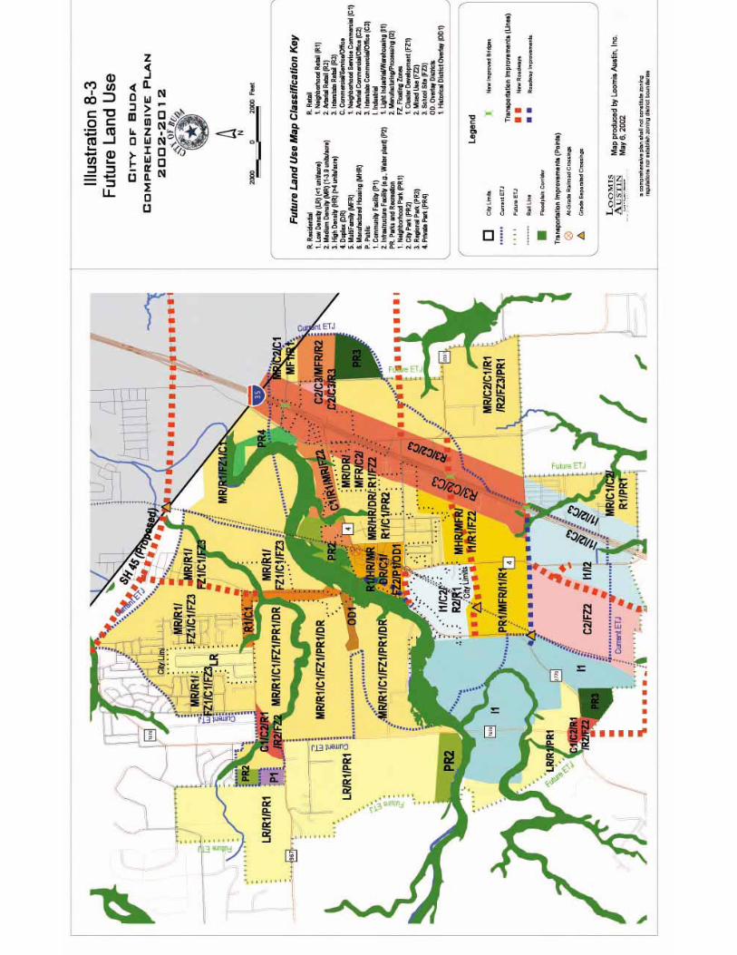


City of Buda Comprehensive Plan, 2002-2012 Chapter 10-1
1100 IImmpplleemmeennttaattiioonn Introduction The City of Buda’s comprehensive plan was developed over an eight-month period and incorporates a broad list of topics and issues to direct future growth and development that have been identified to be of importance for Buda over the next 10 years. However, the work of the Plan does not stop here. Planning is an ongoing process because the City will continually change in the years to come. The Plan must be reviewed and updated periodically to ensure that goals and policies contained in this Plan remain relevant. With implementation and regular updating, the time and effort involved with the development of this Plan will have a lasting impact. This chapter will outline general implementation tools that can be used to work towards the goals, policies and programs contained in this Plan. Plan Implementation Tools A variety of tools are available for Plan implementation. These tools include the following:
�� Ordinances �� Capital Improvements Plan (CIP) �� Staff and Resource Allocation �� Creating a Planning & Zoning Commission (P&Z) �� Annexation Plan �� Impact Fee Assessment and Adjustment �� Utility Plan �� Implementation Roles and Responsibilities �� Plan Review, Update and Amendment �� Intergovernmental and Regional Cooperation
Ordinances Zoning is the primary tool used by local government to implement land use policies. It consists of the zoning map and supporting ordinance text. The legal basis for zoning is to protect the health, safety and welfare of the citizens. Zoning also protects property values by minimizing incompatible land uses and providing clear standards on what type of development can occur where. The City should review their zoning map with the adopted goals and strategies included in this Plan to identify and reconcile areas of discrepancy. When reviewing requests for rezoning the land use categories, guidelines and map should form the basis for decision making. Any changes in municipal boundaries, will need to be amended in the future land use map and then the zoning map. Subdivision regulations are another regulatory tool that may be utilized for the implementation of this Plan. The subdivision ordinance regulates the

City of Buda Comprehensive Plan, 2002-2012 Chapter 10-2
development of land and the provision of public infrastructure within. Properly enforced subdivision regulations, coupled with zoning, can help ensure that the proper physical development and the provision of adequate public infrastructure are available to areas of growth. Standards for easements and right-of-ways, street improvements, lot setbacks and layouts, and utility infrastructure are normally identified in the subdivision regulations. They can also ensure that the costs of public improvements within growth areas are assessed to the developer and new residents, rather than paid for by the established community. Capital Improvement Programs A Capital Improvement Program (CIP) establishes schedules and priorities for capital improvements and usually identifies projects five to ten years out. Projects included in a CIP typically include larger projects such as roads, recreational facilities, community structures, and utilities. The City’s financial resources are limited and therefore competition exists for funding among various projects. The CIP allows the City to provide the most critical public improvements while staying within budgetary constraints. Since utility infrastructure will more than likely comprise the majority of the capital costs for Buda, the City should ensure that the CIP adequately estimates the costs for utility infrastructure to support potential developments, especially in the Priority Growth Areas. Staff and Resources Allocation The Plan identifies a number of implementation policies and initiatives that require City resources and staff time. The City Planning & Zoning Commission and staff will need to review the recommended policies and programs to determine which initiatives can be accommodated based on available staff and resources, and make adjustments to staff resources if deemed necessary and appropriate. Creating a Planning and Zoning Commission The City of Buda does not yet have a Planning or a Zoning Commission (P&Z). Currently the City staff and Council make all the decisions regarding development permits, development review and variance requests. The State of Texas requires a Home Rule City (>5,000 population) to have a P&Z, but a General Law City (<5,000 population) like Buda can adopt a P&Z at their discretion. Buda will quickly become a Home Rule City but should act now to create a P&Z and begin training a group of volunteers to serve as commissioners. This body will help the Council and staff in their decision-making. It should be a requirement for all P&Z Commissioners to read and understand the Comprehensive Plan and all Land Development Ordinances prior to their serving on the Commission. Additionally, the P&Z and staff should annually provide recommendations to the Council on Plan amendments.
City of Buda Comprehensive Plan, 2002-2012 Chapter 10-3
Annexation Plan As a General Law City, Buda can only annex property on a consensual basis. In addition to other stipulations described in the Texas Local Government Code (regarding annexation), a City must supply certain services within a specified timeframe. It would be best for the city’s long-term future to make decisions now on where the City would like to annex, begin working with those landowners, and begin developing a plan for supplying utility infrastructure and services to those areas so that after annexation, the City can meet the minimum regulatory standards for annexation. Impact Fee Assessment and Adjustment The basic premise behind impact fees is that new development should pay for itself, rather than existing taxpayers paying for future development. Chapter 395 (created after 1987) of the Local Government Code outlines the process for developing impact fees. In order for cities to develop impact fees that directly relate to the cost of capital construction, a city must prepare land use assumptions for specified service areas. Once this has been done, a capital improvements budget and plan must be developed to show the total capital costs for new development. It is only then (and after certain legal requirements such as public hearings) that a City should adopt impact fees. Buda should follow this process and adopt impact fees, and associated ordinances, for development-related capital costs. Utility Plan Developing a utility plan will help the City determine exactly what infrastructure is necessary to support anticipated growth. It will put Buda in a proactive, rather than reactive role. The costs of the utilities can be incorporated into the CIP and impact fees, so that residents will know that new development is, in fact, paying for itself. Absent a utility plan, growth will occur and the City will pay for that infrastructure with existing taxpayer dollars. Implementation Roles and Responsibilities Although the City of Buda is the primary agency responsible for implementing the plan, other groups also have implementation roles. The Chamber of Commerce, the Economic Development Corporation, and the Hays Consolidated Independent School District, along with the City, will help to address economic development policies; neighborhood groups and citizens will help to address many policies in the plan related to land use, parks and recreation, and transportation. The ultimate success of the implementation of the plan lies on the citizenry and the leadership of Buda. The likelihood that the Plan will be implemented becomes greater with more individuals familiar with the Plan. Educational forums on new aspects of the ordinances should be carried out throughout the City with residents and business owners, as well as student.
City of Buda Comprehensive Plan, 2002-2012 Chapter 10-4
Plan Review and Updating The Plan should be reviewed and updated periodically to ensure that land use categories, goals, and implementation measures reflect current conditions and that the Plan is achieving its stated goals. The City should adopt a Plan for Comprehensive Plan Review with a schedule and procedure for reviewing and updating the Plan. The review should assess the successes and challenges of implementing the Plan, and any changes in public needs or opinion. The Plan review and update should consist of the City Council, Planning & Zoning Commission, City staff, and the public. This Plan review process should include:
�� An initial training session, and yearly training and strategic planning sessions thereafter, on the content and implementation of the Comprehensive Plan for the City Council, Planning & Zoning Commission and City staff.
�� Development and tracking of short-term implementation goals. A yearly strategic planning session can be used to identify available resources and opportunities to work on strategies as identified in the Plan, as well as, identify new initiatives that work towards achieving the Plan’s goals and objectives.
�� A yearly progress report on Plan implementation presented by City staff to the City Council, Planning & Zoning Commission, and other appropriate committee’s.
�� Establishment of an ad hoc citizens committee, with some members of the original steering committee, convened by the Planning Commission and City Council on a yearly basis to assess Plan progress and ensure accountability.
�� Regular review of adequacy of background information. Much of the demographic data contained in the background materials were based on 2000 U.S. Census data. However, much of the detailed Business and Demographic Data is not yet available. So, as new Census data becomes available, it should be analyzed and compared with the Plan’s assumptions that were based on the 2000 data. As more in-depth studies are being developed for issue areas identified in the Plan, such as housing, economic development and a community services needs assessment, more detailed information will become available for decision-making and can be amended into the Plan.
Intergovernmental and Regional Cooperation Intergovernmental cooperation can be another tool to work on implementation of the Goals, Policies, and Programs contained in this Plan. The City should develop outreach efforts to educate cities, the Hays Consolidated Independent School District, Hays City, Water Supply Corporations, Utility Providers (GBRA, LCRA, and PEC), Capital Area Metropolitan Planning Organization (CAMPO), Capital Area Planning Council (CAPCO), Cap Metro, and other entities on the

City of Buda Comprehensive Plan, 2002-2012 Chapter 10-5
goals of the Comprehensive Plan. The goal of this effort is to promote intergovernmental cooperation in the implementation of the Plan. A variety of state and federal agencies provide financial and technical assistance through various programs. Coordination of initiatives can be a tool to pool resources and technical expertise to work towards a common goal. It is important to continue to coordinate with these entities to ensure the local interests regarding the management of these lands are represented.