Earthquake disaster resilience disaster resilience dividends

sustainability
Article
Circular Economy and Resilience Thinking forHistoric Urban Landscape Regeneration: The Case ofTorre Annunziata, Naples
Katia Fabbricatti * and Paolo Franco Biancamano
Department of Architecture, University of Naples Federico II, 80135 Naples, Italy; [email protected]* Correspondence: [email protected]; Tel.: +39-3398814015
Received: 6 May 2019; Accepted: 14 June 2019; Published: 19 June 2019�����������������
Abstract: The landscape, as an archive of the traces of the history of man and nature, can beconsidered a holistic indicator of sustainable, inclusive, safe, resilient cities as set out in Agenda 2030for Sustainable Development. The UNESCO Recommendations on Historic Urban Landscape (HUL)reflect it as a dynamic/evolving system that changes over time to meet social needs: it requires to bemanaged in a sustainable way, not only as a resource to be preserved. The beauty of the landscape isa common element in the development policies of many small-medium European and Italian cities.However, the state of abandonment and decay, the lack of investments, of often emigrated skills arethe detractors. The circular economy model applied to the HUL leads to the ability to maximize thevalue of settlements, activating social, economic and environmental synergies. The research identifiesthe relationship among Circularity, Productivity and Resilience as an effective key to achieve the goalsof Agenda 2030. The methodological approach tested on the case study of Torre Annunziata, Napleshas reached a system of resilience performance indicators to express the complex nature of HULand define a scenario of circular regeneration, based on the recreation of a virtuous circuit betweenphysical, environmental, social, economic systems.
Keywords: circular urban regeneration; historic urban landscape; resilience performance indicators;collaborative economy
1. Introduction
Global and local risks (climate crisis, scarcity of resources, migratory emergency, weakening ofthe share capital, erosion of cultural capital and identity of places, etc.) make it urgent to identifyoperational tools that enhance the responsiveness of urban landscapes to disruptions and acceleratechange towards local, regional and global sustainability and resilience.
The Agenda 2030 for Sustainable Development created and promoted by the UN for the nextfuture [1] specifically direct one of the 16+1 strategic goals towards "making cities and humansettlements inclusive, safe, resilient and sustainable" (SDGs 11). In particular, the goal number 11highlights the need “to enhance inclusive and sustainable urbanization and capacity for participatory,integrated and sustainable human settlement planning and management in all countries” (11.3),“[ . . . ] to strengthen efforts to protect and safeguard the world’s cultural and natural heritage” (11.4),“[ . . . ] to increase the number of cities and human settlements adopting and implementing integratedpolicies and plans towards inclusion, resource efficiency, mitigation and adaptation to climate change,resilience to disasters, and develop and implement, in line with the Sendai Framework for DisasterRisk Reduction 2015–2030, holistic disaster risk management at all levels” (11.B).
The landscape, as an archive of the traces of the history of man and nature [2–4], can beconsidered a holistic indicator of the sustainable, inclusive, safe, resilient city [5]. The perspective
Sustainability 2019, 11, 3391; doi:10.3390/su11123391 www.mdpi.com/journal/sustainability

Sustainability 2019, 11, 3391 2 of 29
of landscape offers an integrated, holistic, and systemic approach to analyze urban transformationstoward sustainable development.
There is an empirical evidence that a poor and degraded landscape determines a loss of economic,social/ cultural, touristic attractiveness. The quality of the landscape has often been considered asa pre-condition for urban regeneration, capable of delivering different benefits (not only economic).This uniqueness of the landscape can become a catalyst for productive activities, especially creative/
innovative, if achieved with careful governance [5].The Historic Urban Landscape, characterized by a high aesthetic quality, has been considered
and managed as a great attractor. It is defined by the UNESCO Recommendations 2011 [4] as “[ . . . ]the result of a historic layering of cultural and natural values and attributes, extending beyond thenotion of ‘historic center’ or ‘ensemble’ to include the broader urban context and its geographicalsetting” (point 8). The Recommendations on the Historic Urban Landscape, based on the relationalprinciple among the physical forms of the urban contexts, “their spatial organization and connection,their natural features and settings, and their social, cultural and economic values” [4] (point 5), suggestthe search for creative combinations of different forms of landscape to activate new urban dynamics.The EU Convention [2] and UNESCO Recommendations on HUL [4] reflect the landscape as a dynamic/
evolving system that changes over time to meet social needs: it requires to be managed wisely/
sustainably, not only as a resource to be preserved.The quality of the landscape, understood as the beauty of both natural and man-made systems, is a
common element in the local development policies of many small and medium Italian and Europeancities (less than 50,000 inhabitants) [6,7]. However, the contribution of this “beauty” to sustainabledevelopment is often hampered by the state of abandonment and degradation of the urban landscape,uncontrolled changes in urban density and growth, the lack of investment in the renovation andmaintenance of buildings, and the lack of skills that are often emigrated. Moreover, this conditionundermines the perception of places and values that communities attributed to it.
In order to preserve “the quality of the human environment, enhancing the productive andsustainable use of urban spaces, while recognizing their dynamic character, and promoting socialand functional diversity” [4] (point 11), the Recommendations ask the different actors to supportcommunities in their demand for development and change, while contributing to preserving thecharacteristics and values linked to their history, collective memory and environment. In particular,Academic, university institutions, centers of research are encouraged to develop aspects of HUL“to document the state of urban areas and their evolution, to facilitate the evaluation of proposals forchange, and to improve protective and managerial skills and procedures” (point 26).
In relation to the requirements of the Recommendations, the paper, developed as part of theProjects of National Relevance (PRIN 2010–2011), identifies the relationships between the concepts ofCircularity, Productivity and Resilience as an effective key to interpreting the phenomena that occurin the HUL to achieve the goals of Agenda 2030 of inclusive, safe, resilient and sustainable cities(Figure 1).
A circular city model can be interpreted as a long term process of coherent co-evolution betweenman and his living environment [8], whose values must be rediscovered and regenerated. Appliedto HUL, it can be a helpful tool to maximize the value of settlements, activating social, economicand environmental synergies [9]. Productivity, intended in its broadest sense, not only economic,as the ratio between input and output of multiple types of resources, underlines in this context theability of a circular economy model to activate new chains of value creation. The plurality of valuesrecognized in the cultural heritage/ landscape contribute to multiplying the flows of benefits in avirtuous circuit. Finally, resilience as a dynamic concept, focused on how to persist and evolvewith change [10,11], expresses in this context the regenerative capacity of HUL. In our research itis understood not only as an attribute but also as an approach to the themes of HUL. Resiliencethinking [10,12] “can be viewed as a subset of sustainability science and has a strong focus on complexadaptive and truly intertwined social-ecological systems of people, communities, economies, societies,

Sustainability 2019, 11, 3391 3 of 29
and cultures interacting across spatial and temporal scales with ecosystems” [13]. It well interprets themultidimensional and dynamic nature of HUL and the need to respond to urban challenges throughthe balance between conservation and innovation, strengthening the relationships among physical/environmental, social and economic components. Resilience thinking seeks to understand the lifecycles and complexity of systems (including the innovation systems) in order to better manage them,for system productivity and process circularity.
Sustainability 2019, 11, x FOR PEER REVIEW 3 of 30
Figure 1. Conceptual framework for the regeneration of HUL (author’s elaboration).
A circular city model can be interpreted as a long term process of coherent co-evolution between man and his living environment [8], whose values must be rediscovered and regenerated. Applied to HUL, it can be a helpful tool to maximize the value of settlements, activating social, economic and environmental synergies [9]. Productivity, intended in its broadest sense, not only economic, as the ratio between input and output of multiple types of resources, underlines in this context the ability of a circular economy model to activate new chains of value creation. The plurality of values recognized in the cultural heritage/ landscape contribute to multiplying the flows of benefits in a virtuous circuit. Finally, resilience as a dynamic concept, focused on how to persist and evolve with change [10,11], expresses in this context the regenerative capacity of HUL. In our research it is understood not only as an attribute but also as an approach to the themes of HUL. Resilience thinking [10,12] “can be viewed as a subset of sustainability science and has a strong focus on complex adaptive and truly intertwined social-ecological systems of people, communities, economies, societies, and cultures interacting across spatial and temporal scales with ecosystems” [13]. It well interprets the multidimensional and dynamic nature of HUL and the need to respond to urban challenges through the balance between conservation and innovation, strengthening the relationships among physical/ environmental, social and economic components. Resilience thinking seeks to understand the life cycles and complexity of systems (including the innovation systems) in order to better manage them, for system productivity and process circularity.
On the basis of this theoretical model, the research proposes new tools to describe the systemic and complex nature of the HUL and, entrusting productive value to the complex system of resources generated by the landscape, promote and evaluate actions to make the organization of the city more efficient and less wasteful through processes of circularization.
The methodological process has been tested on the case study of the small-medium municipality of Torre Annunziata, Naples. The HUL of this port city is in fact characterized by the presence of world famous sights, such as the volcano Vesuvius, the excavations of Pompeii, the UNESCO World Heritage Site of the villa of Oplontis, by a peculiar historical productive vocation of the urban landscape and by an abandoned port that expresses a great potential within the Gulf of Naples. On the other hand, the urban landscape presents high rates of social distress and building degradation, showing minimum levels of resilience, sustainability, security and equality.
The research develops an operational approach through the case study aimed at interpreting and regenerating HUL and, at the same time, produces a methodological approach for possible replicability in homogeneous areas with similar problems.
Figure 1. Conceptual framework for the regeneration of HUL (author’s elaboration).
On the basis of this theoretical model, the research proposes new tools to describe the systemicand complex nature of the HUL and, entrusting productive value to the complex system of resourcesgenerated by the landscape, promote and evaluate actions to make the organization of the city moreefficient and less wasteful through processes of circularization.
The methodological process has been tested on the case study of the small-medium municipalityof Torre Annunziata, Naples. The HUL of this port city is in fact characterized by the presence of worldfamous sights, such as the volcano Vesuvius, the excavations of Pompeii, the UNESCO World HeritageSite of the villa of Oplontis, by a peculiar historical productive vocation of the urban landscape andby an abandoned port that expresses a great potential within the Gulf of Naples. On the other hand,the urban landscape presents high rates of social distress and building degradation, showing minimumlevels of resilience, sustainability, security and equality.
The research develops an operational approach through the case study aimed at interpreting andregenerating HUL and, at the same time, produces a methodological approach for possible replicabilityin homogeneous areas with similar problems.
The paper is organized in the following sections, after this introduction: first, a literature reviewon the HUL and the perspective of the circular economy model and resilience thinking; then, a briefpresentation of the case study; a third section defines the materials and methods of the research; in thefourth section are presented and discussed the results of the experimentation on the case study of TorreAnnunziata; finally the conclusions of this research effort and future steps for improving it.
2. Literature Review
Historic Urban Landscape, Circular Urban Regeneration Processes and Resilience Thinking
The role of landscapes as an archive of the traces of the history of man and nature and for thesurvival of local cultures is internationally recognized [2–4]. In these documents, interactions betweenman and nature are declared "cultural landscapes" or “cultural heritage”, as illustrative of the evolution
Sustainability 2019, 11, 3391 4 of 29
of human society and settlement over time, recognized unique and authentic. “Landscapes, whetherof aesthetic value or not, provide the setting for our daily lives; they are familiar and the concept oflandscape links people to nature, recognizing their interaction with the environment. The very notionof landscape is highly cultural, and it may seem redundant to speak of cultural landscapes; but thedescribing term ‘cultural’ has been added to express the human interaction with the environmentand the presence of tangible and intangible cultural values in the landscape” [14]. The Charter ofKrakow again reads: “Landscapes as cultural heritage result from and reflect a prolonged interactionin different societies between man, nature and the physical environment. They are testimony tothe evolving relationship of communities, individuals and their environment. In this context theirconservation, preservation and development focus on human and natural features, integrating materialand intangible values” [15].
The European Landscape Convention [2] underlines the uniqueness of each landscape and itssystemic and relational nature. It is “a specific part of territory as it is perceived by the populations,whose character derives from the action of natural and/or human factors and from their interrelations” [2](art.1). Landscape in this sense is a collective creation whose forms of realization are not only a historicalnarrative but also a physiognomic expression of the identity peculiarities of a specific culture. For thisreason, the landscape must be managed with this specificity in mind and must be recognised as a "socialconstruction" [16]. By expressing the diversity of the cultural and natural heritage of each population,it represents its identity [2] (art. 5a). The UNESCO Recommendations recognise the complex anddynamic nature of the landscape system, that includes “not only the representation of the materialculture of peoples, the so-called material heritage, but also the cultural and social practices and values,the economic processes and the dimensions of the intangible heritage as a vehicle for diversity andidentity” [4]. The recognition by the community of the value of "heritage" of this landscape turns itinto a resource that can improve the quality of life of populations, strengthening social cohesion andtriggering processes of economic development [17].
The innovative contribution of the Recommendations is to identify in the "development"the opportunity to preserve the sedimented values, overcoming the traditional conflict betweenconservation and transformation [18]. The UNESCO Recommendations on HUL recognise that a highlandscape quality can contribute to the increase of urban productivity. “The Historic Urban Landscapeapproach is aimed at preserving the quality of the human environment, enhancing the productiveand sustainable use of urban spaces, while recognizing their dynamic character, and promoting socialand functional diversity. It integrates the goals of urban heritage conservation and those of social andeconomic development” [4] (point 11). In this perspective, the Recommendations open the way to thedefinition of an "integrated" conservation strategy based on the principle of relationality [9]. Actionson the landscape must be based on a systemic vision and on a dynamic/ productive interpretation ofthe territory as an innovative aspect, as a process of use and creation of value (in terms of use values,social values, symbolic values, market values) [5]. The recognition of the dynamic/ productive natureof the landscape implies the ability to respond to the challenges posed by the changes taking place ona global scale with strategies that wisely integrate conservation with innovation, strengthening therelations between the physical/ environmental, social and economic components. The systemic logic ofthe HUL allows for a reinterpretation of the traditional economic model in a circular perspective that,creatively integrating conservation and development, promotes synergies between different agents/institutions in a dynamic proactive way. In this context, the circular economy model leads to the abilityto maximize the value of settlements, activating social, economic and environmental synergies [19].
In the context of the HUL, as result of historic layering, transition processes produce waste notonly in terms of sub-system and component residues but also in terms of unsustainable pressureson the urban landscape [8]. Differently from the linear economy model, the circular paradigm canrespond switching trade-offs between users’ needs and design requirements accounting for our planet’sneeds [20]. It reduces wastes rebalancing pressures on urban landscape due to the climate change,users’ and market’s expectations changes, increasing age of the built environment.

Sustainability 2019, 11, 3391 5 of 29
The circular economy model is the condition for achieving most of the goals of Agenda 2030and the New Urban Agenda [21]. The circular economy model is closely interdependent with theregeneration of the landscape. It renews its values through recovery actions and contributes to itsquality by increasing the density of relationships, symbiosis and synergies that multiply the flows ofbenefits in a virtuous circuit [9]. This model can be implemented at different levels, diversifying actionsand identifying relationships and synergies between different actors involved [22]. By placing the localcultural resources at the base of the objectives of resilience and sustainable development, the HULperspective stimulates synergies and circular processes to obtain, through a process of mediationbetween the different forces in conflict, the greatest good for all the actors in terms of improving thequality of life, conditions of productive efficiency, sense of identity [9]. The HUL suggests a newunitary vision that encourages change, variability, diversity and also hybrid solutions, in order toimprove overall systemic resilience [4].
In 2015 and for the first time, cultural heritage was recognized as playing a role in addressingglobal risks within the new international policy for disaster risk reduction, adopted during theThird United Nations World Conference Disaster Risk Reduction (WCDRR), at Sendai, Japan (SendaiFramework 2015–2030) [23]. The conference highlighted the effectiveness of cultural heritage inunderstanding disaster risks and strengthening governance, investing in resilience and preparing forresponse, recovery and reconstruction. Cultural heritage, both tangible and intangible, as the resultof long periods of adaptation between man and his environment, incorporates useful elements toovercome potential risks. It can be a powerful catalyst for interacting with local populations, bringingthem together and reinforcing the sense of belonging in the preventive and recovery phases; moreover,the protection of the cultural heritage can sustain a rapid recovery through the economy it can generate.The active role the community can play in the protection of its cultural heritage and in the enhancementof the resilience of the socio-urban system (phase of prevention, response, recovery and reconstruction)is precisely because it is the repository of local culture. This is the meaning of "heritage community",identified in 2005 by the Faro Convention [16]. It is composed by “people who value specific aspectsof cultural heritage which they wish, within the framework of public action, to sustain and transmitto future generations” (art. 2b). In this way the social value of the cultural heritage is highlighted;it becomes the element that characterizes and holds together a community [24].
Resilience, in its development towards socio-ecological complex adaptive systems, has becomenot only a desirable state, but above all a dynamic vision [25], of adaptive and transformative actions,where the values that constitute the identity and authenticity of landscapes are strengthened andinnovate [26]. The thought and practice of resilience can offer an innovative way to describe andunderstand the complex dynamic nature of the HUL, proposing creative and innovative solutions.“Resilience thinking seeks to understand the life cycles and complexity of systems (including theinnovation systems) in order to better manage them, placing specific issues within a comprehensivecontext. Adaptation should be understood as a component of resilience—the ability of the system tochange or assume different behavioural properties when reacting to the stimuli” [27].
With its flexibility, a resilience thinking-based approach provides a toolbox to improve innovationpolicy management and ensure that governance and regulatory systems can adjust and become moresustainable [27].
The main reference of the research was the City Resilience Framework, developed by theRockefeller Foundation and Arup [28]. It, on the basis of the previous City Resilience Index [29],is a tool that should enable to convene around a common idea of “who and what make cities moreresilient” [28]. Both the framework and the index are intended to facilitate a process of engagementwith cities that generates new ideas and opportunities to involve new actors in civil society, governmentand business to make cities resilient. The City Resilience Framework provides tools through whichthe complexity of cities and the different factors that contribute to their resilience can be understood.It comprises 12 key goals (minimal human vulnerability; diverse livelihoods and employment; effectivesafeguards to human health and life; collective identity and community support; comprehensive

Sustainability 2019, 11, 3391 6 of 29
security and rule of law; sustainable economy; reduced exposure and fragility; effective provisionof critical services; reliable communications and mobility; effective leadership and management;empowered stakeholders; integrated development planning) that describe the outcomes of a resilientcity, complemented by seven qualities that “distinguish a resilient city from one that is simply livable,sustainable or prosperous” [28]:
• Reflectiveness, expressing the quality of the system to accept the inherent and ever-increasinguncertainty and change in today’s world;
• Robustness, which expresses the quality of a well-designed, built and managed system, so that itcan withstand the impacts of hazardous events without significant damage or loss of functionality;
• Redundancy, expressing in a system “the presence of multiple ways to achieve a given need orfulfill a particular function”;
• Flexibility, as the capacity of the system to “change, evolve, adapt in response to changing circumstances”;• Resourcefulness, instrumental to “a city’s ability to restore functionality of critical systems,
potentially under severely constrained conditions”;• Inclusiveness, emphasizing “the need for broad consultation and engagement of communities,
including the most vulnerable groups”;• Integration, expressing the need to exchange of information between systems to enable them
“to function collectively and respond rapidly through shorter feedback loops throughout thecity” [28].
By placing HUL perspective and the circular economy model at the base of the resilience qualitiesdefined by Arup, the research aims to combine the systemic, evolutionary and productive nature of thelandscape with the objectives of urban resilience and sustainability.
3. Case Study: The Productive Historic Urban Landscape of Torre Annunziata, Naples
The research develops a methodological process and new tools to describe the systemic andcomplex nature of the HUL and promote and evaluate actions to make the organization of the citymore efficient and less wasteful through processes of circularization. The methodological process andnew tools have been tested on the case study of the small-medium municipality of Torre Annunziata,Naples. It extends into the Gulf of Naples to an area of 7.33 square kilometers with a populationdensity of 5961 inhabitants for square km. It is part of an area identified by the Ministry of CulturalHeritage and Activities and the Campania Region as Buffer Zone of Pompeii. It comprises the areasurrounding the UNESCO sites of Pompeii, Oplontis and Herculaneum. The municipalities in this areahave a high degree of complexity: on the one hand, landscapes of great beauty, a social capital withhigh-potential, an archaeological heritage of inestimable value, a production system with significantpeculiarities (gardening, quality food and wine productions, pasta and coral industry, commercialand leisure shipbuilding); on the other hand, underused and degraded buildings, without adequategreen spaces, unclean and unsafe public spaces, youth unemployment and crime, negative dynamicsof associationism and volunteering.
The municipality of Torre Annunziata is an important example of a pattern that is generatedand renewed, developing a productive propensity offered by its climatic and morphologic position,as well as by technological progress. The social-urban system of Torre Annunziata is in fact stronglycharacterized by its original manufacturing vocation and by a dense system of tangible and intangiblerelations between the physical/ environmental, social and economic components [30,31]. In particular,its historic center has a precise connotation resulting from the interaction between the environmentalcharacteristics of the landscape and the manufacturing and residential production needs; it representsthe expression of the changes over time due to the technological innovation in the manufacture ofpasta. For centuries, the entire municipal economy has revolved around the synergies between placesand resources: exposure to the sun and winds, the construction characteristics of the settlement are thefactors that allowed production, increased by the presence of the port area for the import of wheat

Sustainability 2019, 11, 3391 7 of 29
from Russia and the export of dry pasta. Authors have interpreted this peculiar settlement systemas Productive Urban Landscape: “complex and adaptive system, result over time of procedures andmethods for the supply of resources, their processing and distribution of the finished product, wheretechnological opportunities are connotative aspect” [31]. The post-war productive divestment andthe residential re-use of the historical center have exposed the urban system to conditions of physical,social and economic vulnerability over time. The port area, a great potential within the Gulf of Naples,has also been abandoned and cut off from the city. Currently the municipality is in a state of socialdiscomfort and physical degradation, generated by the processes of transition.
4. Materials and Methods
4.1. Operationalising the UNESCO Recommendations on the Historic Urban Landscape
In order to interpret the complexity of the historic urban landscape of Torre Annunziata,an interrelated system of indicators has been defined. According to the ninth paragraph of UNESCORecommendations on HUL [4], the multi-scale indicators define the layers of which the landscapeis composed.
The content of the landscape can be defined from the "hard" data:
• topography;• geomorphology;• hydrology;• natural features;• built environment (historical and contemporary);• infrastructure (above and below ground);• open spaces and gardens;• land use (land use patterns);• spatial organization.
To these, perceptual data are added (soft):
• perceptions;• visual relationships;• all the other elements of the urban structure.
It also includes:
• practices and social and cultural values;• economic processes;• intangible dimensions of heritage as related to diversity and identity.
The data are structured on three main dimensions that describe the general characteristics of theproductive and historical urban landscape of Torre Annunziata, common to the municipalities of theBuffer Zone of Pompeii:
1. Physical/environmental dimension: the main criteria considered are related to environmental andgeographical characteristics (including environmental risk data - geological, seismic, volcanic- physical size, and other data describing spatial aspects). The environmental quality of theterritory affects its ability to retain and to attract individuals and companies. In fact, someenvironmental and geographical characteristics can affect the production guidelines and theactivities of companies;
2. Social dimension: stands for indicators that describe the productive potential of the municipalitiesof the Buffer Zone, in order to assess their contribution to local economic growth (populationdensity, unemployment, supply of employment and housing opportunities, etc.);

Sustainability 2019, 11, 3391 8 of 29
3. Economic dimension: groups together indicators that describe the economic and commercialvitality and attractiveness of the reference context (economic value of public and private property,real estate market, liveliness of the entrepreneurial system, etc.).
The indicators are based on publicly available information and data, which can be gatheredthrough queries to the databases of the National Institute of Statistics (ISTAT), to the portal of theRevenue Agency, to the Ministry of Environment, but also to the local databases of the supra-municipalinstitutions and of the municipal and academic research studies and of the third sector. The collectionof territorial data, although not limited to the assessment of individual sites, is a useful tool for thepreliminary analysis.
The collection of data is supplemented by a fourth group of indicators that represent a scale ofgreater detail:
4. Productive dimension: is the set of indicators that describe the productive and manufacturingsectors prevailing in the municipalities.
The nature of the landscape system suggests a multidimensional approach, also in relation tosocio-economic well-being [32]. The following synthetic criteria have been identified on the base ofsocial data, not only quantitative data, inspired by the theory of adaptive systems [33]:
• demographic structure;• workforce;• education and human capital;• civic commitment;• collaborative resource management.
Economic data can be divided into two major categories: vivacity of the real estate market andeconomy of the enterprise system. The spatial variability of the criteria, determined by the spatialinhomogeneity of the development processes and by the existence of local factors, significantly affectsthe income, wealth, individual opportunities and development of the enterprises [34,35]. The maincriteria are:
• Vivacity of the real estate market: this is the set of indicators of the real estate value of assets,such as the value per square meter, the percentage change, the NNT (Number of NormalizedTransactions), the index of attractiveness and all available and comparable indicators on the areas;
• Economics of the entrepreneurial system: this is the second macro-category. It is made up ofmany factors linked not only to the vitality of the enterprise in the areas considered, but also toeconomic networks with external systems.
The detection of the physical/environmental dimension involves the search for elements thatdescribe the ability of a system to maintain self-regeneration capacity (autopoiesis) or, on the contrary,factors of greater structural fragility. The available factors describing the physical/environmentaldimension in relation to the productive system can be grouped in:
• security and land management;• quality of the built environment;• infrastructural services;• energy and wastes;• safeguard and green areas.
In addition, there are elements that belong to the productive dimension of HUL that describeits peculiarity:
• agricultural and floricultural sector;

Sustainability 2019, 11, 3391 9 of 29
• DOP (Protected Designation of Origin) and IGP (Protected Geographical Indication) productions;• DOC (Controlled Designation of Origin) and IGT (Territorial Geographical Indication) productions;• shipbuilding enterprise.
Multiscale analysis allows us to turn our attention to the specific context of Torre Annunziata andGIS tools support the construction of thematic maps for the definition of multidimensional systems.The Geographic Information System (GIS) allows to overlay the knowledge of spatial data [36] reducingthe information (numerical indicators, open data, points of interest, etc.) in the complex and systemicterritorial context. The integration of knowledge tools through GIS allows to build complex mapscontaining information on the quality of the environment and landscape [37].
On the basis of the identified indicators, the Social Discomfort Index (IDS) and the BuildingDiscomfort Index (IDE), defined by the Prime Minister’s Decree (DPCM) directives 10/15/2015 (OfficialGazette n. 249 10/26/15) as the weighted average of the deviations of the indicator values by theirrespective national averages, allow an initial definition of the processes that take place on the territory.For research purposes, this data provides information to define the pressures and transition processesof physical/ environmental, social and economic systems and, at the same time, provides informationabout the “waste” to be reintegrated into the circular process of urban regeneration.
According to the directives of the DPCM, the indices, divided into census boxes, were calculatedas follows:
IDS = 0.40 ∗ (DIS (i) − DISNAZ) + 0.30 ∗ (OCCNAZ - OCC (i)) +
0.15 ∗ (GIOV (i) − GIOVNAZ) + 0.15 ∗ (SCOLNAZ − SCOL (the))
where:DIS (i) = unemployment rateOCC (i) = employment rateGIOV (i) of juvenile concentration ratio =
SCOL (i) = schooling rate
IDE = [(ERP + ERM)/Tot ER]/0.168
where:ERP = residential buildings of the degraded urban area in poor conditionERM = residential buildings of the degraded urban area in mediocre conditionTot ER = Total residential buildings of the degraded urban areaSubsequently, in order to identify the relationships between the indicators of the urban context
and to observe what criteria can determine direct or indirect impacts, positive or negative, on thelandscape, a correlation matrix has been elaborated. The correlation indicates a relationship betweentwo variables, each value of the first corresponds to a linear relationship with the values of the second,i.e., the tendency of a variable to change depending on another, and not necessarily a cause-effectrelationship [38].
The correlation matrix has a double objective: to identify the relationships between the indicatorsin the urban context; to allow the construction of scenarios, which take into account the effects oftransformations not only on the criteria concerned, but also on those closely related.
The data collection of indicators at different spatial scales and at different time intervals allows toanalyze the processes of transition and transformations of the socio-urban system over time, in orderto define the possible drivers. These, together with the data processed through the correlative analysis,inform the potential evolutionary dimension of HUL.
4.2. Performance Indicators for a Circular Regeneration of the Historical Urban Landscape
The research proposes a system of performance indicators as a tool to guide and monitor theactions to be taken on HUL. They must be able to interpret the interrelationships between the valuesof HUL and define the actions of regeneration and management to make the organization of the city

Sustainability 2019, 11, 3391 10 of 29
“less wasteful” and more reactive and regenerative, through processes of circularization involving alldimensions (social, environmental, economic, cultural) of the urban landscape. In this perspective,it is possible to consider degraded and abandoned spaces and social distress no longer as a waste,but as an opportunity for experimentation and potential for the development of circular regenerationprocesses [39].
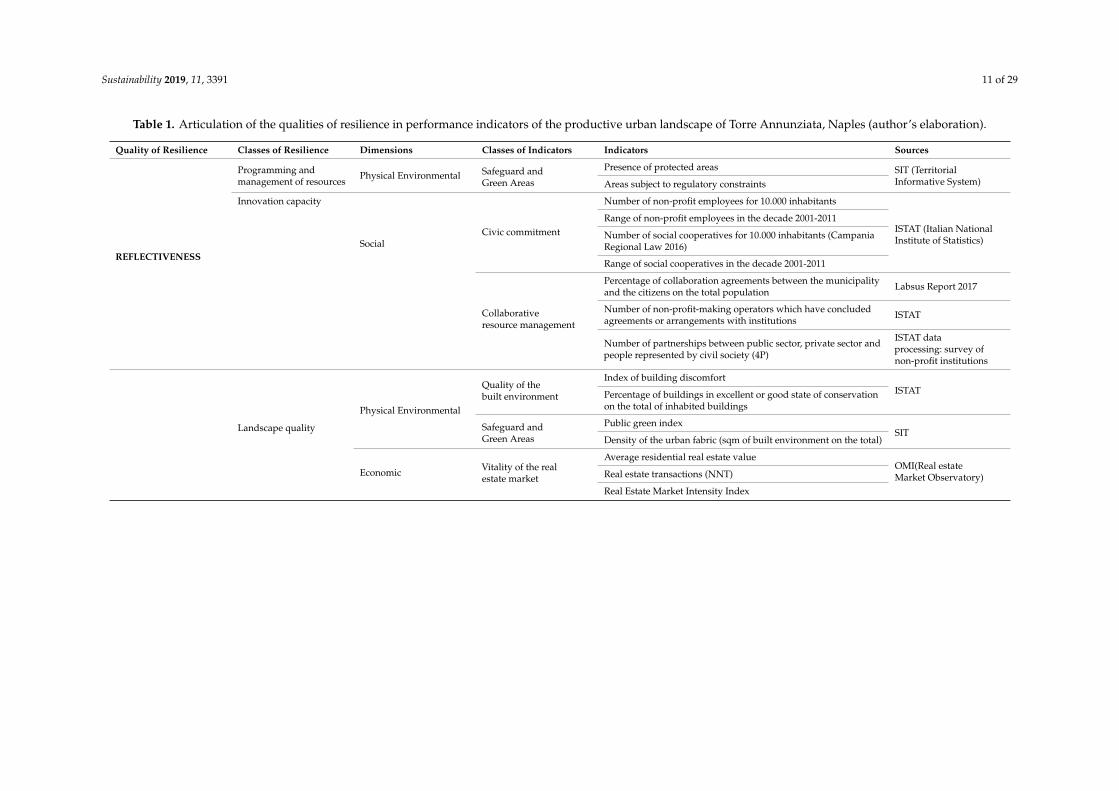
The seven qualities of resilience, as defined by the Rockefeller Foundation City ResilienceFramework [28], represent in this research the seven classes of performance for a resilient andsustainable historical urban landscape. They have been made explicit by grouping the measurabledescriptive indicators, previously elaborated (Section 4.1), first into resilience classes, then into classesof indicators, divided by physical-environmental, social, economic, productive dimensions.
Meetings between stakeholders of the social and entrepreneurial systems with the research groupand the facilitators have supported the explication of the qualities of resilience for the circular urbanregeneration of Torre Annunziata. The results of the correlation matrix, in which the relationshipsbetween the indicators in the context emerged, were useful for grouping the indicators into performanceclasses (Table 1).
Sustainability 2019, 11, 3391 11 of 29
Table 1. Articulation of the qualities of resilience in performance indicators of the productive urban landscape of Torre Annunziata, Naples (author’s elaboration).
Quality of Resilience Classes of Resilience Dimensions Classes of Indicators Indicators Sources
REFLECTIVENESS
Programming andmanagement of resources
Physical Environmental Safeguard andGreen Areas
Presence of protected areas SIT (TerritorialInformative System)Areas subject to regulatory constraints
Innovation capacity
SocialCivic commitment
Number of non-profit employees for 10.000 inhabitants
ISTAT (Italian NationalInstitute of Statistics)
Range of non-profit employees in the decade 2001-2011
Number of social cooperatives for 10.000 inhabitants (CampaniaRegional Law 2016)
Range of social cooperatives in the decade 2001-2011
Collaborativeresource management
Percentage of collaboration agreements between the municipalityand the citizens on the total population Labsus Report 2017
Number of non-profit-making operators which have concludedagreements or arrangements with institutions ISTAT
Number of partnerships between public sector, private sector andpeople represented by civil society (4P)
ISTAT dataprocessing: survey ofnon-profit institutions
Landscape quality
Physical Environmental
Quality of thebuilt environment
Index of building discomfortISTATPercentage of buildings in excellent or good state of conservation
on the total of inhabited buildings
Safeguard andGreen Areas
Public green indexSIT
Density of the urban fabric (sqm of built environment on the total)
Economic Vitality of the realestate market
Average residential real estate valueOMI(Real estateMarket Observatory)Real estate transactions (NNT)
Real Estate Market Intensity Index

Sustainability 2019, 11, 3391 12 of 29
Table 1. Cont.
Quality of Resilience Classes of Resilience Dimensions Classes of Indicators Indicators Sources
ROBUSTNESS
Security andResource Management
Physical Environmental
Risk andlandscape management
Population exposed to seismic risk
ISTATPopulation exposed to hydrogeological risk
Population exposed to volcanic risk
Planning tools (Regional Law 16/2004 and upgrades) Web site
Infrastructure services
Motorway junctions
SITDistance from airports
Railway stations
Provision of ICT resources ISTAT
Energy and waste
Approval of the Sustainable Energy Action Plan (SEAP) Web site
Annual municipal production of electricity from renewablesources (photovoltaic)
GSE (EnergyServices Manager)
Separate Waste Collection Index (2014)ISPRA (Higher Institutefor EnvironmentalSafeguard and Research)
SocialCollaborativeresource management
Percentage of collaboration agreements between the municipalityand the citizens on the total population Labsus Report 2017
Number of non-profit-making operators which have concludedagreements or arrangements with institutions ISTAT
Number of partnerships between public sector, private sector andpeople represented by civil society (4P)
ISTAT dataprocessing: survey ofnon-profit institutions
Cultural Identity
Physical Environmental
Safeguard andGreen Areas
Presence of protected areasSIT
Areas subject to regulatory constraints
Consistency of thehistorical urban fabric
Percentage of buildings in excellent or good state of conservationon the total of inhabited buildings built before 1919 ISTAT
Social
Education andhuman capital
Schooling rate
ISTATResident population with old and new system of degree +university degrees + non-academic tertiary degrees old andnew regulations
Civic commitmentNumber of non-profit employees for 10.000 inhabitants
ISTATRange of non-profit employees in the decade 2001-2011
Number of social cooperatives for 10.000 inhabitants (CampaniaRegional Law 2016)

Sustainability 2019, 11, 3391 13 of 29
Table 1. Cont.
Quality of Resilience Classes of Resilience Dimensions Classes of Indicators Indicators Sources
Range of social cooperatives in the decade 2001-2011
Collaborativeresource management
Number of contractual agreements between public authority(regional, provincial or local) and higher education institutions
ISTAT: survey ofnon-profit institutions
EconomicEconomy of theentrepreneurial system
Percentage of active companies
ISTAT
Percentage of employees
Entrepreneurial density
Entrepreneurial propensity
Average value of residential properties
Number of Normalized Real estate Transactions (NNT)
Real Estate Market Intensity Index (Ratio between NNT and thequantity of existing real estate units)
Productive
Agricultureand floriculture
Utilized Agricultural Area - SAU (ha)MIBACT (Ministryof Cultural Heritageand Activities)
SAU - Floriculture
Number of farms
Percentage of floriculture companies
Products D.O.P. and I.G.P.(Reg. CE 510/06)
DOP products (Y/N)MIBACT
IGP products (Y/N)
Wines D.O.C. and I.G.T.DOC products (Y/N)
MIBACTIGT products (Y/N)
Shipbuilding industryNautical entrepreneurial (Y/N)
MIBACTNautical staff (Y/N)

Sustainability 2019, 11, 3391 14 of 29
Table 1. Cont.
Quality of Resilience Classes of Resilience Dimensions Classes of Indicators Indicators Sources
REDUNDANCY
Diversificationof resources
Physical Environmental
Safeguard andGreen Areas
Presence of protected areas
SITAreas subject to regulatory constraints
Public green index
Density of the urban fabric (sqm of built environment on the total)
Risk and landscapemanagement
Population exposed to seismic risk
ISTATPopulation exposed to hydrogeological risk
Population exposed to volcanic risk
Planning tools (Regional Law 16/2004 and upgrades) Web site
Infrastructure services
Motorway junctions
SITDistance from airports
Railway stations
Provision of ICT resources ISTAT
Energy and waste
Approval of the Sustainable Energy Action Plan (SEAP) Web site
Annual municipal production of electricity from renewablesources (photovoltaic) GSE
Separate Waste Collection Index (2014) ISPRA
SocialEducation andhuman capital
Schooling rate
ISTATResident population with old and new system of degree +university degrees + non-academic tertiary degrees old andnew regulations
Economic
Vitality of the realestate market
Average residential real estate value
OMIReal estate transactions (NNT)
Real Estate Market Intensity Index
Economy of theentrepreneurial system
Percentage of active companies
ISTAT
Percentage of employees
Entrepreneurial density
Entrepreneurial propensity
Average value of residential properties
Number of Normalized Real estate Transactions (NNT)
Real Estate Market Intensity Index (Ratio between NNT and thequantity of existing real estate units)

Sustainability 2019, 11, 3391 15 of 29
Table 1. Cont.
Quality of Resilience Classes of Resilience Dimensions Classes of Indicators Indicators Sources
Productive
Agricultureand floriculture
Utilized Agricultural Area - SAU (ha)
MIBACTSAU - Floriculture
Farms (n)
Percentage of floriculture companies
Products D.O.P. and I.G.P.(Reg. CE 510/06)
DOP products (Y/N)MIBACT
IGP products (Y/N)
Wines D.O.C. and I.G.T.DOC products (Y/N)
MIBACTIGT products (Y/N)
Shipbuilding industryNautical entrepreneurial (Y/N)
MIBACTNautical staff (Y/N)
Diversification ofinfrastructure systems
Physical Environmental Infrastructure services
Motorway junctions
SITDistance from airports
Railway stations
Provision of ICT resources ISTAT
FLEXIBILITY
Modularity anddecentralization ofinfrastructure andurban management
Physical Environmental
Safeguard andGreen Areas
Presence of protected areasSIT
Areas subject to regulatory constraints
Infrastructure services
Motorway junctions
SITDistance from airports
Railway stations
Provision of ICT resources ISTAT
Energy and waste Approval of the Sustainable Energy Action Plan (SEAP) Web site
Annual municipal production of electricity from renewablesources (photovoltaic) GSE
SocialCollaborativeresource management
Percentage of collaboration agreements between the municipalityand the citizens on the total population Labsus Report 2017
Number of non-profit-making operators which have concludedagreements or arrangements with institutions ISTAT
Number of partnerships between public sector, private sector andpeople represented by civil society (4P)
ISTAT dataprocessing: survey ofnon-profit institutions

Sustainability 2019, 11, 3391 16 of 29
Table 1. Cont.
Quality of Resilience Classes of Resilience Dimensions Classes of Indicators Indicators Sources
Innovation capacitySocial
Education andhuman capital
Schooling rateISTAT
Resident population with old and new system of degree +university degrees + non-academic tertiary degrees old andnew regulations
Collaborativeresource management
Number of contractual agreements between heritage entrepreneursand higher education institutions
ASIA (Statistical registerof active enterprises)
Number of contractual agreements between cultural heritageentrepreneurs and public authorities
ISTAT: survey ofnon-profitinstitutions;survey ofpublic institutions
Economic Research anddevelopment Number of active R&S units ISTAT
Adaptability tonew functions
Physical Environmental
Safeguard andGreen Areas
Public green indexSIT
Density of the urban fabric (sqm of built environment on the total)
Quality of thebuilt environment Percentage of empty dwellings over total ISTAT
EconomicEconomy of theentrepreneurial system
Percentage of active companies
ISTAT
Percentage of employees
Entrepreneurial density
Entrepreneurial propensity
Average value of residential properties
Number of Normalized Real estate Transactions (NNT)
Real Estate Market Intensity Index (ratio between NNT and thequantity of existing real estate units)

Sustainability 2019, 11, 3391 17 of 29
Table 1. Cont.
Quality of Resilience Classes of Resilience Dimensions Classes of Indicators Indicators Sources
RESOURCEFULNESS
Availability of resources
Physical Environmental Infrastructure services
Motorway junctions
SITDistance from airports
Railway stations
Provision of ICT resources ISTAT
Social
Demographic structure
Number of residents
ISTAT
Percentage of resident immigrants
Population density (inhabitant/sq.km)
Average age of the population
Youth concentration rate
Workforce
Percentage of labor force in total population
ISTAT
Percentage of non-work force in total populationPercentage of employees in the total workforce
Percentage of non-employed in total labor force
Unemployment rate
Civic commitment
Number of non-profit employees for 10.000 inhabitants
ISTATRange of non-profit employees in the decade 2001-2011
Number of social cooperatives for 10.000 inhabitants (CampaniaRegional Law 2016)
Range of social cooperatives in the decade 2001-2011
Education andhuman capital
Schooling rate
ISTATResident population with old and new system of degree +university degrees + non-academic tertiary degrees old andnew regulations
Coordination in themanagement of resources
Physical Environmental Risk andlandscape management
Population exposed to seismic risk
ISTATPopulation exposed to hydrogeological risk
Population exposed to volcanic risk
Planning tools (Regional Law 16/2004 and upgrades) Web site
SocialCollaborativeresource management
Percentage of collaboration agreements between the municipalityand the citizens on the total population Labsus Report 2017
Number of non-profit-making operators which have concludedagreements or arrangements with institutions ISTAT
Number of partnerships between public sector, private sector andpeople represented by civil society (4P)
ISTAT data processing:survey of non-profitinstitutions

Sustainability 2019, 11, 3391 18 of 29
Table 1. Cont.
Quality of Resilience Classes of Resilience Dimensions Classes of Indicators Indicators Sources
INCLUSIVENESS Sharing and commitmentto choose
Social
Collaborativeresource management
Percentage of collaboration agreements between the municipalityand the citizens on the total population Labsus Report 2017
Number of non-profit-making operators which have concludedagreements or arrangements with institutions ISTAT
Number of partnerships between public sector, private sector andpeople represented by civil society (4P)
ISTAT data processing:survey of non-profitinstitutions
Civic commitment
Number of non-profit employees for 10.000 inhabitants
ISTATRange of non-profit employees in the decade 2001-2011
Number of social cooperatives for 10.000 inhabitants (CampaniaRegional Law 2016)
Range of social cooperatives in the decade 2001-2011
INTEGRATION
Network connectivity
Physical Environmental Infrastructure services Provision of ICT resources ISTAT
SocialCollaborativeresource management
Percentage of collaboration agreements between the municipalityand the citizens on the total population Labsus Report 2017
Number of non-profit-making operators which have concludedagreements or arrangements with institutions ISTAT
Number of partnerships between public sector, private sector andpeople represented by civil society (4P)
ISTAT dataprocessing: survey ofnon-profit institutions
Economic Research anddevelopment Number of active R&S units ISTAT
Intermodality oftransport systems
Physical Environmental Infrastructure services
Motorway junctions
SITDistance from airports
Railway stations
Interscalar modeof functions Social Collaborative
resource managementNumber of contractual agreements between authorities at differentlevels (regional - local, provincial - local, provincial - local, etc.)
Website ofCampania Region

Sustainability 2019, 11, 3391 19 of 29
According to the City Resilience Framework, the Reflectiveness expresses the quality of a systemto accept the inherent and ever-increasing uncertainty and change in today’s world. To this end,a reflective cities “has mechanisms to continuously evolve and will modify standards or norms basedon emerging evidence, rather than seeking permanent solutions based on the status quo” [28]. In ourresearch, the Reflectiveness has been defined through groups of indicators that concern, in particular,the Programming and management of resources and the Innovation capacity related to the Civiccommitment and the Collaborative resource management. The Robustness expresses the qualityof a well-designed, built and managed system, so that it can withstand the impacts of hazardousevents without significant damage or loss of functionality. In this meaning, the Robustness can beinterpreted and defined by indicators that belong to the classes of Landscape quality, Security andResource Management and Cultural Identity. These elements represent the complex system of factors,of a perceptive, morphological, relational, functional nature, through which the uniqueness of thelandscape system is manifested. They must be rediscovered, reinterpreted and innovated to prefigureits evolving nature. In a long-term, circular strategic vision, it is essential to combine the attributes/performance of Robustness with those of Flexibility. The latter, intended as the capacity of the system to“change, evolve, adapt in response to changing circumstances”, has an innovative factor by enhancingthe capacity of HUL to regenerate its own identity. It can be interpreted trough groups of indicatorsexpressing the Modularity and decentralization of infrastructure and environmental management,the Innovation capacity of the system and the Adaptability to new functions. The latter is understoodto be both the ability of the system to accommodate changes due to technological development or newmarket demands. Redundancy was defined as “the presence” - in a system - “of multiple ways toachieve a given need or fulfill a particular function”. It has been expressed through indicators thatarticulate its ability for diversification to “accommodate disruption, extreme pressures or surges indemand”, such as the classes of Diversification of resources, tangible and intangible, and Diversificationof infrastructure systems. The Resourcefulness “implies that people and institutions are able to rapidlyfind different ways to achieve their goals or meet their needs during a shock or when under stress.[...] It is instrumental to a city’s ability to restore functionality of critical systems, potentially underseverely constrained conditions” [28]. In this study, the Resourcefulness was understood as the abilityto address change through the coherence of the decision-making process and the systematization ofresources at different scales, measurable through classes of indicators that describe the Availabilityof resources and the Coordination in their management. The Inclusiveness was understood as theability to deal with change through Sharing and commitment to choose. This attribute highlights thestrategic role of the community in the processes of protection, management and maintenance of HUL.Together with the quality of the Integration, it defines the importance of “exchanging informationbetween systems, to enable them to function collectively and respond rapidly through shorter feedbackloops throughout the city” [28]. Community participation, commitment and relations are an engine forimproving social cohesion, the ability to respond to difficulties and the capacity for innovation. In thecircular regenerative processes of HUL, in particular, the quality of Integration has been interpreted asNetwork connectivity, Intermodality of transport systems, Interscalar mode of functions. These classesof indicators also express the link between the increase in partnerships between the different actors andthe quality of urban regeneration actions. It is also about the characteristics of infrastructure and publicor open spaces, which stimulate relational activities, and, in particular in the Mediterranean area, tell ofa priority value of use and social interaction. In this research, the landscape is a dimension that "unites"and allows the comparison between multiple identities, represented by traditions, skills and talents ofthe communities, mediating between different points of view, in a perspective of common interest [24].
5. Results and Discussion
This section discusses the results of the methodological approach and the tools developed andtested on the case of Torre Annunziata. The discussion focuses on the process of analysis and diagnosis

Sustainability 2019, 11, 3391 20 of 29
of the productive historic urban landscape of Torre Annunziata up to the phase of definition andevaluation of the scenarios of urban regeneration.
The first step was to analyze and describe the complex and multidimensional nature of the historicurban landscape of Torre Annunziata, through the system of descriptive indicators elaborated in theresearch (Section 4.1). The Social Discomfort Index (IDS) (Figure 2) and the Building Discomfort Index(IDE) (Figure 3) have allowed a first definition of the processes underway in the territory.
Sustainability 2019, 11, x FOR PEER REVIEW 11 of 30
difficulties and the capacity for innovation. In the circular regenerative processes of HUL, in particular, the quality of Integration has been interpreted as Network connectivity, Intermodality of transport systems, Interscalar mode of functions. These classes of indicators also express the link between the increase in partnerships between the different actors and the quality of urban regeneration actions. It is also about the characteristics of infrastructure and public or open spaces, which stimulate relational activities, and, in particular in the Mediterranean area, tell of a priority value of use and social interaction. In this research, the landscape is a dimension that "unites" and allows the comparison between multiple identities, represented by traditions, skills and talents of the communities, mediating between different points of view, in a perspective of common interest [25].
5. Results and Discussion
This section discusses the results of the methodological approach and the tools developed and tested on the case of Torre Annunziata. The discussion focuses on the process of analysis and diagnosis of the productive historic urban landscape of Torre Annunziata up to the phase of definition and evaluation of the scenarios of urban regeneration.
The first step was to analyze and describe the complex and multidimensional nature of the historic urban landscape of Torre Annunziata, through the system of descriptive indicators elaborated in the research (Section 4.1). The Social Discomfort Index (IDS) (Figure 2) and the Building Discomfort Index (IDE) (Figure 3) have allowed a first definition of the processes underway in the territory.
Figure 2. Municipality of Torre Annunziata: Social Discomfort Index (IDS). Figure 2. Municipality of Torre Annunziata: Social Discomfort Index (IDS).
Sustainability 2019, 11, x FOR PEER REVIEW 12 of 30
Figure 3. Municipality of Torre Annunziata: Building Discomfort Index (IDE).
The two indexes have been summarized in a single synthetic indicator showing the presence of degraded areas (Figure 4).
Figure 4. Municipality of Torre Annunziata: degraded areas.
Taking the oldest part of Torre Annunziata as a sample discussion area (Figure 4), it shows the high level of physical degradation and social discomfort. This area is strongly characterized by the presence of ancient pasta manufacturing. The surrounding landscape, marked by the skyline with the volcano Vesuvius, is degraded by the poor quality of the built environment characterized by
Figure 3. Municipality of Torre Annunziata: Building Discomfort Index (IDE).
The two indexes have been summarized in a single synthetic indicator showing the presence ofdegraded areas (Figure 4).

Sustainability 2019, 11, 3391 21 of 29
Sustainability 2019, 11, x FOR PEER REVIEW 12 of 30
Figure 3. Municipality of Torre Annunziata: Building Discomfort Index (IDE).
The two indexes have been summarized in a single synthetic indicator showing the presence of degraded areas (Figure 4).
Figure 4. Municipality of Torre Annunziata: degraded areas.
Taking the oldest part of Torre Annunziata as a sample discussion area (Figure 4), it shows the high level of physical degradation and social discomfort. This area is strongly characterized by the presence of ancient pasta manufacturing. The surrounding landscape, marked by the skyline with the volcano Vesuvius, is degraded by the poor quality of the built environment characterized by
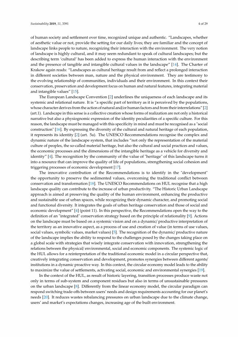
Figure 4. Municipality of Torre Annunziata: degraded areas.
Taking the oldest part of Torre Annunziata as a sample discussion area (Figure 4), it shows thehigh level of physical degradation and social discomfort. This area is strongly characterized by thepresence of ancient pasta manufacturing. The surrounding landscape, marked by the skyline with thevolcano Vesuvius, is degraded by the poor quality of the built environment characterized by abandonedbuildings, industrial warehouses, service stations, fast roads. After the war, the development, especiallyin the 1970s and 1980s, caused the overall degradation of the landscape accompanied by a socialmalaise. It is one of the areas with the highest rate of unemployment and crime, which constitute afurther obstacle to development. In recent years, the economic crisis has led to the systematic closure ofbusinesses in the area. The presence of industrial establishments strongly characterizes the landscape:the buildings have a predominantly linear development and are characterized by a considerable volume,with inaccessible walls, reflecting the settlement methods of traditional industry. The degradationmakes these spaces alien to the city; the abandonment has consequently an impact on the landscape,already characterized by heavy road infrastructure, now insignificant and partially abandoned.
In order to identify the relationships between urban context indicators and to observe whichcriteria can determine the direct or indirect impacts, positive or negative, on the landscape, a correlationmatrix has been developed (Figure 5).
By placing the productive and economic dimensions as a privileged observer, it is possible tohighlight the following interdependencies (Figure 5):
• the vitality of the real estate market is positively influenced by a high population density;• medium/high incomes are located in areas with a higher number of elderly people;• civic engagement is stronger in areas of higher average income;• the level of unemployment is higher where there is a higher concentration of youth rates;• the rate of urban decay is not linked to any particular indicator, with the (weak) exception of the
viability of the real estate market;• the economic dimension (real estate values and entrepreneurial vitality) improves considerably
where the schooling rate is higher;• the vitality of the real estate market is strongly linked to the vitality of the entrepreneurial system.

Sustainability 2019, 11, 3391 22 of 29
Sustainability 2019, 11, x FOR PEER REVIEW 13 of 30
abandoned buildings, industrial warehouses, service stations, fast roads. After the war, the development, especially in the 1970s and 1980s, caused the overall degradation of the landscape accompanied by a social malaise. It is one of the areas with the highest rate of unemployment and crime, which constitute a further obstacle to development. In recent years, the economic crisis has led to the systematic closure of businesses in the area. The presence of industrial establishments strongly characterizes the landscape: the buildings have a predominantly linear development and are characterized by a considerable volume, with inaccessible walls, reflecting the settlement methods of traditional industry. The degradation makes these spaces alien to the city; the abandonment has consequently an impact on the landscape, already characterized by heavy road infrastructure, now insignificant and partially abandoned.
In order to identify the relationships between urban context indicators and to observe which criteria can determine the direct or indirect impacts, positive or negative, on the landscape, a correlation matrix has been developed (Figure 5).
Figure 5. Correlation among criteria (author’s elaboration).
By placing the productive and economic dimensions as a privileged observer, it is possible to highlight the following interdependencies (Figure 5): • the vitality of the real estate market is positively influenced by a high population density; • medium/ high incomes are located in areas with a higher number of elderly people; • civic engagement is stronger in areas of higher average income; • the level of unemployment is higher where there is a higher concentration of youth rates; • the rate of urban decay is not linked to any particular indicator, with the (weak) exception of the
viability of the real estate market;
Figure 5. Correlation among criteria (author’s elaboration).
Finally, the productive dimension (horticultural, DOP, DOC wines and boating) has closerelationship with the level of education, which seems to be the link for the multidimensional readingof the productive landscape.
In order to define the possible drivers and the current development trajectories of the Municipalityof Torre Annunziata, the data of the indicators have been analyzed at different spatial scales (buffer-zone,municipal, local) and at different time intervals (before the ’900, after the Second World War, after the’80 s). This, together with the results of the correlative analysis, allowed to interpret the processes oftransition and transformations over time of the socio-urban system. In the absence of a municipal andlarge-scale planning, the results of the study report the perspective of a progressive deterioration ofHUL and the sale of existing properties. In the short term, the redevelopment of a neighborhood in thenorthern area and the upgrading of port infrastructure aimed at improving existing entrepreneurialactivities could be hypothesized. In the long term, actions for the implementation of the existingregulatory tools to be financed are predictable.
5.1. Performance Indicators for the Circular Urban Regeneration of the Historic Urban Landscape ofTorre Annunziata
This step of the research was aimed to assess the development trajectories of the historic urbanlandscape of Torre Annunziata and to define a circular regeneration scenario as collective opportunityto increase both the potential for communities’ cohesion and the capacity to produce innovation.
The system of classes of resilience and of classes of indicators, previously elaborated (Section 4),was made explicit thanks to the measurable descriptive indicators and to the results of the correlativeanalysis. The table shows the articulation of the qualities of resilience in performance indicators of theproductive urban landscape of Torre Annunziata (Table 1). The quality of Robustness, for example,

Sustainability 2019, 11, 3391 23 of 29
is the most significant quality in our research. It expresses the characteristics of the social-urbansystem, which on the one hand give it a capacity for resistance and on the other, if properly managed,an innovative and productive capacity. This quality, at municipal scale, is made explicit through theclasses of resilience of Landscape quality, of Security and Resource Management, of Cultural Identity.
The first was developed through groups of indicators that express the physical/environmentaldimension of Quality of the built environment and of the Green areas, but also, as suggested by thecorrelation analysis, the economic dimension related to the Vitality of the real estate market.
The class of Security and Resource Management was developed through groups of indicatorsthat express the ability to manage Risk and Landscape, the availability of Infrastructure servicesand to manage Energy and Waste in the physical/environmental dimension, and the Collaborativeresource management in the social dimension. This last class of indicators expresses partnershipsbetween multiples and multilevel actors (collaboration pacts, public private people partnership,community cooperative, etc.) as tools for new governance and as a driver for improving social cohesion,responsiveness to difficulties, innovation capacity [38].
The class of resilience Cultural Identity was investigated through groups of indicators thathighlight the Safeguard and Green Areas and the Consistency of the historical urban landscape in thephysical/environmental dimension, then through social data expressing Education and human capital,Civic commitment and Collaborative resources management relating to heritage entrepreneurs andhigher education institutions. The social dimension of cultural identity, in fact, highlights the value ofheritage for the community to improve the quality of life, and especially the active role of communitiesin the protection and promotion of their cultural heritage [17]. Furthermore, the partnership betweenpublic authorities and higher education institutions focuses on the strategic role that these institutionscan play as providers and promoters of knowledge capital [8,39]. This partnership activates astrategic decision making process to increase site attractiveness and to reinforce the overall virtuoussocio-economic circle: the local authority provides financial support, investing resources in favorof higher education institutions and enhancing local culture, while the higher education institutionsupports urban development and stimulates innovation and civic engagement. Finally, the economicand productive dimensions of the resilience class of Cultural Identity have been articulated byindicators that express the Economy of the entrepreneurial system, and the peculiar resources ofHUL, represented by Agriculture and floriculture, Products DOP and IGP, Wines DOC and IGT,and Shipbuilding industry.
Thanks to the standardization and aggregation of indicators with the methodology of perfectpoint [40], for each of the resilience indicators the values at the municipal scale have been identified.In this way it was possible to measure and compare the resilience qualities expressed by the differentmunicipalities belonging to the Buffer zone of Pompeii. The ideal point on which the model is basedidentifies the ideal value assigned to a given criterion, which represents the optimal value the decisionmaker should strive for. This parameter coincides with the maximum value of the criterion examined.The worst point is the opposite of the ideal point and the default value is the worst in the attributetable. The following spider diagram [41] permits to compare the performance in terms of resilienceexpressed by different municipalities belonging to the buffer zone (Figure 6):
The graph shows a different behavior between the municipalities located directly on the coastand those inland. The Municipality of Torre Annunziata has an average behavior in relation toall the municipalities of the buffer zone, but worse than the other coastal municipalities. In fact,a predominantly homogeneous behavior is observed for the seven qualities of resilience, with theexception, in negative, for the quality of Flexibility and in positive for the quality of Reflexivity.

Sustainability 2019, 11, 3391 24 of 29
Sustainability 2019, 11, x FOR PEER REVIEW 24 of 30
Figure 6. Comparison between the municipalities of the buffer zone.
The graph shows a different behavior between the municipalities located directly on the coast and those inland. The Municipality of Torre Annunziata has an average behavior in relation to all the municipalities of the buffer zone, but worse than the other coastal municipalities. In fact, a predominantly homogeneous behavior is observed for the seven qualities of resilience, with the exception, in negative, for the quality of Flexibility and in positive for the quality of Reflexivity.
5.2. Comparison among Regeneration Scenarios
The perspective of HUL, thanks to the elaborated tools, allows unusual interpretations of the Torre Annunziata urban landscape. It is useful for developing innovative regenerative strategies that can contribute to new sustainable urban processes. In the implementation phase, the circular approach allows the resources present in the studied area to be put into system, reactivating the existing ones and recovering those with unexpressed potential. Their systematic identification represents the potential for urban development. This approach is indispensable to orient regeneration strategies aimed at creating new dynamic balances between safeguard and development actions [8]. The circular economy model, in line with the HUL perspective, encourages the creation of a "community of relationships", a strategic element in determining the quality of life, but also for the generation of new economic value chains [43]. The activation of a multilevel network, in which multiple actors are involved in a process of capacity building in doing together, accompanies the community in the acquisition of a shared awareness of material culture, as a decisive factor for the protection, management and development of the urban and human environment in which it lives [44].
Within this framework, the definition of a scenario of circular regeneration for the productive urban landscape of Torre Annunziata was aimed at ensuring, through innovative governance tools, new spaces of autonomy and leadership for local communities, consistent with the values attributed to the landscape.
The qualities of resilience, together with the analysis of the best practices of public-private partnership and social cooperation aimed at promoting local (productive) resources, have guided a collaborative construction of the settlement demand towards a productive-entrepreneurial scenario for the settlement system. The working group of the research unit of the PRIN project converges on the need to rebalance the symbiosis between construction and production processes, restoring a productive identity to the settlement system to combat physical degradation and social discomfort.
Figure 6. Comparison between the municipalities of the buffer zone.
5.2. Comparison among Regeneration Scenarios
The perspective of HUL, thanks to the elaborated tools, allows unusual interpretations of theTorre Annunziata urban landscape. It is useful for developing innovative regenerative strategies thatcan contribute to new sustainable urban processes. In the implementation phase, the circular approachallows the resources present in the studied area to be put into system, reactivating the existing ones andrecovering those with unexpressed potential. Their systematic identification represents the potentialfor urban development. This approach is indispensable to orient regeneration strategies aimed atcreating new dynamic balances between safeguard and development actions [8]. The circular economymodel, in line with the HUL perspective, encourages the creation of a “community of relationships”,a strategic element in determining the quality of life, but also for the generation of new economic valuechains [42]. The activation of a multilevel network, in which multiple actors are involved in a processof capacity building in doing together, accompanies the community in the acquisition of a sharedawareness of material culture, as a decisive factor for the protection, management and development ofthe urban and human environment in which it lives [43].
Within this framework, the definition of a scenario of circular regeneration for the productiveurban landscape of Torre Annunziata was aimed at ensuring, through innovative governance tools,new spaces of autonomy and leadership for local communities, consistent with the values attributed tothe landscape.
The qualities of resilience, together with the analysis of the best practices of public-privatepartnership and social cooperation aimed at promoting local (productive) resources, have guided acollaborative construction of the settlement demand towards a productive-entrepreneurial scenariofor the settlement system. The working group of the research unit of the PRIN project convergeson the need to rebalance the symbiosis between construction and production processes, restoring aproductive identity to the settlement system to combat physical degradation and social discomfort.The proposed scenario of “Urban District of Sustainable Productions” overcomes the contrast between“heritage to conserve” and “resources to enhance”, stimulating circular processes between landscapeand community and promoting a new capacity for self-organization/ self-management. The scenario isbased on a collaborative economy, an adaptive model in which the local community is co-starring inthe productive-entrepreneurial development of the municipality of Torre Annunziata. Partnershipsbetween multiples and multilevel actors (collaboration pacts, public private people partnership,

Sustainability 2019, 11, 3391 25 of 29
community cooperative, etc.) are proposed as tools for new governance and as a driver for improvingsocial cohesion, responsiveness to difficulties, innovation capacity. The system of large-scale land useis characterized by “poles and networks” of self-sustaining and self-reinforcing functions (Figure 7).In the short and medium-long term, this scenario foresees the connection with the projects in progressor planned in the area. For example, it is expected that the port system, the driving source of thehistoric urban landscape of Torre Annunziata, currently disused, can be positively integrated into theproductive, commercial and touristic development. The involvement of the port area in the processof urban development allows to trigger circular regeneration actions because of its ability to relateresources at different scales.
Sustainability 2019, 11, x FOR PEER REVIEW 25 of 30
The proposed scenario of "Urban District of Sustainable Productions" overcomes the contrast between "heritage to conserve" and "resources to enhance", stimulating circular processes between landscape and community and promoting a new capacity for self-organization/ self-management. The scenario is based on a collaborative economy, an adaptive model in which the local community is co-starring in the productive-entrepreneurial development of the municipality of Torre Annunziata. Partnerships between multiples and multilevel actors (collaboration pacts, public private people partnership, community cooperative, etc.) are proposed as tools for new governance and as a driver for improving social cohesion, responsiveness to difficulties, innovation capacity. The system of large-scale land use is characterized by "poles and networks" of self-sustaining and self-reinforcing functions (Figure 7). In the short and medium-long term, this scenario foresees the connection with the projects in progress or planned in the area. For example, it is expected that the port system, the driving source of the historic urban landscape of Torre Annunziata, currently disused, can be positively integrated into the productive, commercial and touristic development. The involvement of the port area in the process of urban development allows to trigger circular regeneration actions because of its ability to relate resources at different scales.
Figure 7. Scenario 1. Strategic plan of an "Urban District of Sustainable Productions" drawn up within the Research Projects of National Relevance (PRIN 2010-2011).
The productive-entrepreneurial scenario was compared with the current scenario and with a cultural-touristic scenario developed in 2011 by the Industrial Union of Naples and by Industrial Association of Naples.
Scenario 2 (Figure 8): strategic cultural-touristic plan, based on "Restoring the project life of Pompeii: a sustainable development project for the Vesuvius area". The project involves the creation of a cultural-tourist district, with public and private funding, focused on the enhancement of archaeological sites in five municipalities in the buffer zone (Pompeii, Herculaneum and Torre Annunziata, Castellammare di Stabia and Boscoreale) and services located in an abandoned industrial site, on the east coast of Torre Annunziata, near the archaeological excavations of Pompeii.
Figure 7. Scenario 1. Strategic plan of an “Urban District of Sustainable Productions” drawn up withinthe Research Projects of National Relevance (PRIN 2010-2011).
The productive-entrepreneurial scenario was compared with the current scenario and with acultural-touristic scenario developed in 2011 by the Industrial Union of Naples and by IndustrialAssociation of Naples.
Scenario 2 (Figure 8): strategic cultural-touristic plan, based on “Restoring the project lifeof Pompeii: a sustainable development project for the Vesuvius area”. The project involves thecreation of a cultural-tourist district, with public and private funding, focused on the enhancementof archaeological sites in five municipalities in the buffer zone (Pompeii, Herculaneum and TorreAnnunziata, Castellammare di Stabia and Boscoreale) and services located in an abandoned industrialsite, on the east coast of Torre Annunziata, near the archaeological excavations of Pompeii.
On the basis of the qualities of resilience, the comparison between urban regeneration scenarioshas been conducted with the aim of interpreting the impacts of different strategies and definingpriorities in the actions to be taken in the area.
The comparison covered general characteristics, such as objectives, users, strategic approach,client, economic model, financing model, leading resources and qualities of resilience. The maindifferences between the scenarios emerge with reference to: the strategic approach (top-down forscenarios 0 and 2 vs. bottom-up and top-down for the proposed Scenario 1); the economic model(classic for scenarios 0 and 2 vs. based on models of collaborative and sharing economy for the proposedScenario 1); the leading resources (building and infrastructure assets for scenario 0, archaeologicalassets for Scenario 2, vs. productive, built, natural and social resources for Scenario 1).

Sustainability 2019, 11, 3391 26 of 29
Sustainability 2019, 11, x FOR PEER REVIEW 26 of 30
Figure 8. Scenario 2. Strategic cultural-touristic plan, based on "Restoring the project life in of Pompeii: a sustainable development design project for the area of Vesuvius area", drawn up in 2011 by the Industrial Union of Naples and by Industrial Association of Naples.
On the basis of the qualities of resilience, the comparison between urban regeneration scenarios has been conducted with the aim of interpreting the impacts of different strategies and defining priorities in the actions to be taken in the area.
The comparison covered general characteristics, such as objectives, users, strategic approach, client, economic model, financing model, leading resources and qualities of resilience. The main differences between the scenarios emerge with reference to: the strategic approach (top-down for scenarios 0 and 2 vs bottom-up and top-down for the proposed Scenario 1); the economic model (classic for scenarios 0 and 2 vs based on models of collaborative and sharing economy for the proposed Scenario 1); the leading resources (building and infrastructure assets for scenario 0, archaeological assets for Scenario 2, vs productive, built, natural and social resources for Scenario 1).
The results of the comparative model have been summarized in a conceptual framework that identifies, for each scenario, the qualities of resilience, in four dimensional domains: • Community: mainly as a unified group of people currently residing in the municipality and
which, as recommended by numerous international documents, should play an active role in landscape management;
• Buffer zone: the area surrounding the UNESCO sites of Pompeii, Oplontis and Herculaneum; • Settlement system: the physical/ environmental dimension limited to the area of the case study; • Productive activities: including activities closely related to the district of sustainable
productions, and that productive activities, not only economic, directly and indirectly linked to the production chain. The following graphs show the impacts that each scenario can produce in the different domains,
in relation to the qualities of resilience (Figure 9).
Figure 8. Scenario 2. Strategic cultural-touristic plan, based on "Restoring the project life in of Pompeii:a sustainable development design project for the area of Vesuvius area", drawn up in 2011 by theIndustrial Union of Naples and by Industrial Association of Naples.
The results of the comparative model have been summarized in a conceptual framework thatidentifies, for each scenario, the qualities of resilience, in four dimensional domains:
• Community: mainly as a unified group of people currently residing in the municipality andwhich, as recommended by numerous international documents, should play an active role inlandscape management;
• Buffer zone: the area surrounding the UNESCO sites of Pompeii, Oplontis and Herculaneum;• Settlement system: the physical/environmental dimension limited to the area of the case study;• Productive activities: including activities closely related to the district of sustainable productions,
and that productive activities, not only economic, directly and indirectly linked to theproduction chain.
The following graphs show the impacts that each scenario can produce in the different domains,in relation to the qualities of resilience (Figure 9).
Sustainability 2019, 11, x FOR PEER REVIEW 27 of 30
(a) (b) (c)
Figure 9. Conceptual framework of comparison among scenarios in four domains. (a) Scenario 0, of non-intervention; (b) Scenario 1, of sustainable productions; (c) Scenario 2, of cultural touristic development.
The comparison showed relevant differences between the scenarios (Figure 9). A diversified strategic vision emerges from the objectives and the end users of the regeneration actions (residents, city-users vs. tourists). In particular, a different role of the community emerges (Inclusiveness): in scenario 0, non-intervention, and in the cultural-tourist Scenario 2 the community is the subject on which part of the benefits of the development process falls, in Scenario 1 it is a privileged observer, it participates in all the phases of the process of construction of the new model of circular city. Moreover, the scenarios show a different approach, above all in relation to the values attributed to the landscape and their role in the regeneration process (Robustness, Flexibility). In the planned Scenario 1, a large and diversified system of resources (productive, built, natural, social, etc.) is involved, set in motion through a circular economic model, compared with classic one, not inspired by resilient and sustainable systems. A different territorial vision also characterizes the scenarios (poles and networks vs radial): Scenario 1 involves local and inter-municipal processes in an interscalar mode and is developed by poles of "production-attraction” and networks of connections, compared to models mainly radial or fragmentary (Resourcefulness and Integration). Finally, differences emerge in the prediction of the dissemination of results (short term vs. long term).
In summary, starting from a mixed bottom-up and top-down approach, from an inter-scalar model, from small scale to large area, and from the regeneration of different, mostly endogenous, resources, Scenario 1 foresees a process of construction of a Sustainable Urban Production District. It aims to trigger resilient development processes, linking productivity to culture and creativity, and sustainable, through the circular and regenerative use of resources and fair choices.
6. Conclusions
The research identifies landscape as a holistic indicator of sustainable, inclusive, safe, resilient cities as advocated by Agenda 2030 for Sustainable Development. The Recommendations on the Historic Urban Landscape have been understood as requests for the valorization of the peculiar resources and capacities of the sites, through the promotion of virtuous circular dynamics based on the strengthening and regeneration of the collective identity, the capacity for innovation and the self-sufficiency. The perspective proposed by HUL indicates the thresholds within which change continues to guarantee a coherence (continuity) with the past, with identity, with memory [43].
The conceptual framework in which Circularity, Productivity and Resilience are related has guided the development of the model and tools proposed by the research. They are paradigms embedded in the UNESCO Recommendations on HUL, which have proved to be an effective key to interpreting the phenomena that occur in urban landscapes to achieve the goals of Agenda 2030 of inclusive, safe, resilient and sustainable cities (SDGs 11). In this context, resilience, as a paradigm of
Figure 9. Conceptual framework of comparison among scenarios in four domains. (a) Scenario0, of non-intervention; (b) Scenario 1, of sustainable productions; (c) Scenario 2, of culturaltouristic development.
The comparison showed relevant differences between the scenarios (Figure 9). A diversifiedstrategic vision emerges from the objectives and the end users of the regeneration actions (residents,

Sustainability 2019, 11, 3391 27 of 29
city-users vs. tourists). In particular, a different role of the community emerges (Inclusiveness):in scenario 0, non-intervention, and in the cultural-tourist Scenario 2 the community is the subject onwhich part of the benefits of the development process falls, in Scenario 1 it is a privileged observer,it participates in all the phases of the process of construction of the new model of circular city. Moreover,the scenarios show a different approach, above all in relation to the values attributed to the landscapeand their role in the regeneration process (Robustness, Flexibility). In the planned Scenario 1, a largeand diversified system of resources (productive, built, natural, social, etc.) is involved, set in motionthrough a circular economic model, compared with classic one, not inspired by resilient and sustainablesystems. A different territorial vision also characterizes the scenarios (poles and networks vs. radial):Scenario 1 involves local and inter-municipal processes in an interscalar mode and is developed bypoles of “production-attraction” and networks of connections, compared to models mainly radial orfragmentary (Resourcefulness and Integration). Finally, differences emerge in the prediction of thedissemination of results (short term vs. long term).
In summary, starting from a mixed bottom-up and top-down approach, from an inter-scalar model,from small scale to large area, and from the regeneration of different, mostly endogenous, resources,Scenario 1 foresees a process of construction of a Sustainable Urban Production District. It aims totrigger resilient development processes, linking productivity to culture and creativity, and sustainable,through the circular and regenerative use of resources and fair choices.
6. Conclusions
The research identifies landscape as a holistic indicator of sustainable, inclusive, safe, resilientcities as advocated by Agenda 2030 for Sustainable Development. The Recommendations on theHistoric Urban Landscape have been understood as requests for the valorization of the peculiarresources and capacities of the sites, through the promotion of virtuous circular dynamics basedon the strengthening and regeneration of the collective identity, the capacity for innovation and theself-sufficiency. The perspective proposed by HUL indicates the thresholds within which changecontinues to guarantee a coherence (continuity) with the past, with identity, with memory [42].
The conceptual framework in which Circularity, Productivity and Resilience are related has guidedthe development of the model and tools proposed by the research. They are paradigms embedded inthe UNESCO Recommendations on HUL, which have proved to be an effective key to interpretingthe phenomena that occur in urban landscapes to achieve the goals of Agenda 2030 of inclusive, safe,resilient and sustainable cities (SDGs 11). In this context, resilience, as a paradigm of reflective, robust,redundant, flexible, resourceful, inclusive, integrated city [28], contains within itself the premises tomaximize the value of HUL by activating social, economic and environmental synergies [19]. Moreover,resilience thinking represents an interpretative paradigm, intentional and future-oriented, with theaim of reading in the urban landscape its own evolutionary potential [44].
Experimentation on the case study of the small-medium town of Torre Annunziata, in the Gulf ofNaples, underlines the productive interpretation of the landscape, attributing to this term a broadermeaning: in this systemic and regenerative perspective, productivity is considered not only in itseconomic meaning but also as a cultural and social attribute. The regeneration of the landscapecontributes to the creation of synergistic relationships activated between different systems, and alsobetween different forms of capital, which constitute the “complex urban landscape” [9].
The interconnected system of descriptive and performance indicators elaborated in the paperrepresents a proposal to define the complexity and changing values of the urban landscape and at thesame time to direct regeneration actions towards sustainability and innovation. Although both themodels developed for the descriptive indicators and the performance indicators need to be furthertested in urban contexts, the findings of the research confirm our hypothesis that the combination ofHUL perspective and resilience thinking have the potential to trigger virtuous circular dynamics andto overcome the dichotomy between identity preservation and development.

Sustainability 2019, 11, 3391 28 of 29
The circular economy model, extended to the multiple, multidimensional and interconnectedelements of the urban landscape, now allow to identify creative, collaborative and innovative dynamicsand successful regenerative mechanisms towards sustainable, inclusive, safe, resilient cities.
Author Contributions: The authors jointly contributed to the conception and design of the work. Conceptualization,P.F.B. and K.F.; Methodology, K.F.; Data curation P.F.B.; Validation, K.F.; Writing—review & editing, K.F.
Acknowledgments: The study has been developed starting with the results of the research project “LandscapeProtection between Preservation and Change. Economy and Beauty for a Sustainable Development”, Projects ofNational Relevanc (PRIN 2010-2011). The authors thank the Research Unit of Naples, Department of Architecture,for the data support.
Conflicts of Interest: The authors declare no conflict of interest.
References
1. UNESCO. Transforming Our World: The 2030 Agenda for Sustainable Development. 2015. Available online:https://sustainabledevelopment.un.org/ (accessed on 19 February 2019).
2. Council of Europe. European Landscape Convention. 2000. Available online: http://www.coe.int/en/web/
landscape (accessed on 19 February 2018).3. ICOMOS. World Heritage Cultural Landscapes. 2011. Available online: https://www.icomos.org/centre_
documentation/bib/2011_Cultural_landscapes_complete.pdf (accessed on 19 February 2019).4. UNESCO. Recommendation on the Historic Urban Landscape. 2011. Available online: https://whc.unesco.
org/uploads/activities/documents/activity-638-98.pdf (accessed on 19 February 2018).5. Angrisano, M.; Biancamano, P.; Bosone, M.; Carone, P.; Daldanise, G.; De Rosa, F.; Franciosa, A.;
Gravagnuolo, A.; Iodice, S.; Nocca, F.; et al. Towards operationalizing UNESCO Recommendationson “Historic Urban Landscape”. Aestimum 2016, 69, 165–210.
6. Cadell, C.; Falk, N.; King, F. Regeneration in European Cities; Joseph Rowntree Foundation: York, UK, 2008.7. Evans, G. Measure for Measure: Evaluating the Evidence of Culture’s Contribution to Regeneration.
Urban Stud. 2005, 42, 959–983. [CrossRef]8. De Medici, S.; Riganti, P.; Viola, S. Circular Economy and the Role of Universities in Urban Regeneration:
The Case of Ortigia, Syracuse. Sustainability 2018, 10, 4305. [CrossRef]9. Fusco Girard, L. The role of cultural urban landscape towards a new urban economics: New structural assets
for increasing economic productivity through hybrid processes. Hous. Policies Urban Econ. 2014, 1, 3–27.10. Folke, C.; Carpenter, S.R.; Walker, B.; Scheffer, M.; Chapin, T.; Rockström, J. Resilience thinking: Integrating
resilience, adaptability and transformability. Ecol. Soc. 2010, 15, 20. [CrossRef]11. Walker, B.; Holling, C.S.; Carpenter, S.R.; Kinzig, A. Resilience, adaptability and transformability in
social–ecological systems. Ecol. Soc. 2004, 9, 5. [CrossRef]12. Walker, B.; Salt, D. Resilience Thinking; Island Press: Washington, DC, USA, 2006.13. Folke, C. Resilience; Oxford Research Encyclopedia of Environmental Science: Oxford, UK, 2016.14. Mitchell, N.; Rössler, M.; Tricaud, P.M. World Heritage Cultural Landscapes. A Handbook for Conservation
and Management; UNESCO World Heritage Centre: Paris, France, 2009; p. 17. Available online: https://whc.unesco.org/documents/publi_wh_papers_26_en.pdf (accessed on 19 February 2018).
15. ICOMOS. The Charter of Krakow. 2000. Available online: http://smartheritage.com/wp-content/uploads/2015/03/KRAKOV-CHARTER-2000.pdf (accessed on 19 February 2019).
16. Kirshenblatt-Gimblett, B. Intangible heritage as metacultural production. Mus. Int. 2006, 56, 52–65. [CrossRef]17. Council of Europe. Framework Convention on the Value of Cultural Heritage for Society (Faro Convention).
2005. Available online: https://rm.coe.int/1680083746 (accessed on 19 February 2019).18. Gabrielli, B. Personal Communication at the International Seminar at the Order of Architects, Planners,
Landscape Architects and Conservatories of the Province of Bari. Rigenerare nel Paesaggio Storico Urbano.2013. Available online: http://www.ordarchbari.it/Public/allegati/FormazioneCorsi/relazione_gabrielli_bari_22_marzo.pdf (accessed on 19 February 2019).
19. Fusco Girard, L.; De Rosa, F.; Nocca, F. Creative cities: The challenge of ‘humanization’ in the city development.BDC-Bollettino del Centro Calza Bini 2013, 13, 9–33.
20. Raworth, K. Doughnut Economics: Seven Ways to Think Like a 21st Century Economist; Chelsea Green Publishing:Chelsea, VT, USA, 2017.

Sustainability 2019, 11, 3391 29 of 29
21. United Nations. New Urban Agenda. 2017. Available online: http://www.habitat3.org (accessed on 19 April 2019).22. Chen, X.; Fujita, T.; Ohnishi, S.; Fujii, M.; Geng, Y. The Impact of Scale, Recycling Boundary, and Type of
Waste on Symbiosis and Recycling. J. Ind. Ecol. 2012, 16, 129–141. [CrossRef]23. UNISDR. Sendai Framework 2015–2030; United Nations Office for Disaster Risk Reduction: Geneva,
Switzerland, 2015.24. Nocca, F.; Fusco Girard, L. Towards an Integrated Evaluation Approach for Cultural Urban Landscape
Conservation/Regeneration. Region 2018, 5, 33–51. [CrossRef]25. Meerow, S.; Newell, J.P.; Stults, M. Defining urban resilience: A review. Landsc. Urban Plan. 2016, 147, 38–49.
[CrossRef]26. Pinto, M.R. Recupero e Manutenzione. Techne 2013, 6, 169–170.27. High Level Group and Stockholm Resilience Centre. Through Resilience Thinking towards Sustainability
and Innovation: Recommendations for Policy Makers in the EU. 2016. Report Brussels. Available online:https://docs.wixstatic.com/ugd/4bc46b_d7e342c1418b4fbdb042f27d73ff713c.pdf (accessed on 19 April 2019).
28. The Rockefeller Foundation and Arup. City Resilience Framework. 2014. Available online: https://www.rockefellerfoundation.org/report/city-resilience-framework/ (accessed on 19 February 2019).
29. The Rockefeller Foundation and Arup. City Resilience Index. 2013. Available online: https://www.arup.com/
perspectives/city-resilience-index (accessed on 19 February 2019).30. Diano, D. Le pressioni perturbative del sistema insediativo di Torre Annunziata (Na). BDC 2015, 15, 39–60.31. Pinto, M.R.; Viola, S. Identità e prosperità per il paesaggio urbano produttivo. BDC 2015, 15, 71–91.32. Ferrara, A.R.; Nisticò, R. Well-being indicators and convergence across Italian regions. Appl. Res. Qual. Life
2013, 8, 15–44. [CrossRef]33. Cutter, S.L.; Finch, C. Temporal and spatial changes in social vulnerability to natural hazards. Proc. Natl.
Acad. Sci. USA 2008, 105, 2301–2306. [CrossRef] [PubMed]34. Naudé, W.A.; McGillivray, M.; Rossouw, S. Measuring the vulnerability of sub-national regions in South
Africa. Oxf. Dev. Stud. 2009, 37, 249–276. [CrossRef]35. Turvey, R. Vulnerability Assessment of Developing Countries: The Case of Small-island Developing States.
Dev. Policy Rev. 2007, 25, 243–264. [CrossRef]36. Sessa, S.; Di Martino, F. Le funzionalità ArcMap, AecCatalog e ArcToolbox del tool Esri/ArcGIS; Aracne Editrice:
Napoli, Italy, 2011.37. Cerreta, M.; De Toro, P. Urbanization suitability maps: A dynamic spatial decision support system for
sustainable land use. Earth Syst. Dyn. 2012, 3, 157–171. [CrossRef]38. Stock, J.H.; Watson, M.W. Introduzione All’econometria; Pearson Education: Milano, Italy, 2005.39. Pinto, M.R.; Fabbricatti, K.; Bosone, M. Heritage Community Resilience for sustainable and resilient human
settlements. In World Heritage and Legacy: Culture, Creativity, Contamination; Gambardella, C., Ed.; GangemiEditore International: Rome, Italy, 2019; pp. 1120–1129.
40. Masseim, G.; Rocchi, L.; Paolotti, L.; Greco, S.; Boggia, A. Decision support systems for environmentalmanagement: A case study on wastewater from agriculture. J. Environ. Manag. 2014, 146, 491–504. [CrossRef]
41. Biancamano, P.F.; Gravagnuolo, A.; Angrisano, M.; Cancelliere, A. Assessment of waterfront attractivenessin port cities—Facebook 4 Urban Facelifts. J. Glob. Environ. Issues 2018, 14, 56–88.
42. Fusco Girard, L.; Cerreta, M.; De Toro, P. Towards a Local Comprehensive Productive Development Strategy:A Methodological Proposal for the Metropolitan City of Naples. Qual. Innov. Prosper. 2017, 21, 223–240.[CrossRef]
43. Onesti, A.; Bosone, M. From tangible to intangible and return: Hybrid tools for operationalising HULapproach. BDC 2017, 2, 239–256.
44. Fabbricatti, K. Le Sfide della Città Interculturale. La Teoria della Resilienza per il Governo dei Cambiamenti; FrancoAngeli: Milano, Italy, 2013.
© 2019 by the authors. Licensee MDPI, Basel, Switzerland. This article is an open accessarticle distributed under the terms and conditions of the Creative Commons Attribution(CC BY) license (http://creativecommons.org/licenses/by/4.0/).