Aberdeenshire Historic Bridges Trail€¦ · North East Coastline, the Aberdeenshire Historic...
20
1 From mountain to sea Aberdeenshire Historic Bridges Trail
Transcript of Aberdeenshire Historic Bridges Trail€¦ · North East Coastline, the Aberdeenshire Historic...

1
From mountain to sea
Aberdeenshire Historic Bridges Trail

2
Introduction
From an Iron Age route over the Cairn O’ Mount to the Hanoverian Military Roads between Deeside and Donside and along the dramatic 130 mile North East Coastline, the Aberdeenshire Historic Bridges Trail takes you
through 2,800 years of history on a 300 mile circular route around Aberdeenshire. A suggested starting point is at Bridge of Alford, but you can join and leave at one of the many junctions along the route.
Early HistoryAcross Aberdeenshire there has always been a need to get safely over the many rivers and burns that flow between the mountains in the South and West, and the sea in the North and East. Initially these crossing points would be where a ferry could be easily operated or where a ford could be constructed simply due to sloping river banks and a shallowness of water in normal conditions. When these Watercourses were in spate however, these crossings were anything but safe, and tales tell of a number of drownings when storms raged across the North East (often attributed to river demons called Kelpies).
The location of these fords and ferries dictated where the roads were placed as they began to criss-cross Aberdeenshire, and it is likely that by the time of the Iron Age - around 800 BC - there would have been an established main road network between the Celtic tribes of the area. The Cairn O’ Mount Road between Fettercairn and Banchory over the eastern range of the Grampian Mountains is attributed to this period (see Bridge of Dye - No.8 in the series).
The Roman invasions of the area between 77 AD and around 300 AD left little trace of the overland routes that would have existed between their North East Scotland marching camps from Stracathro near Brechin up to Auchinhove near Keith.

3
The Medieval Builders
It is not until the Norman migration north several decades after their arrival in England in 1066, in what we call the medieval period, that a system of feudal and church administration was introduced which provided the necessary means to develop a more robust road network - but still lining up with early ford and ferry locations. It is likely that the first large bridge crossings built during this time would have been timber beam decks on top of stone piers, with one of the first bridges of this type being over the River Dee at Kincardine O’ Neil around 1230 (no trace exists today). The earliest bridge in this trail is the Gannochy Bridge (No. 7) completed around 1460.
This joint endeavour between the church and the nobility for bridge building continued right up until the Scottish Reformation in 1560.
County Commissioners of Supply
After the Reformation, responsibility for bridges and roads fell to the Commissioners of Supply for each Scottish County, in combination with the local Justices of the Peace. During the covenanting troubles of the middle and late 1600’s it appears that very few new bridges were built and the repair of existing roads and bridges fell to individual communities under the Statute Labour Acts. Some bridge building started after the Glorious Revolution of 1689 with the new land owning gentry looking to develop estates and provide access to markets.
Military Bridges and Roads
The Jacobite Rebellion of 1715 brought General George Wade to Scotland and so began the Military Road Building Era. Between 1725 and 1739 General Wade’s troops built 250 miles of road and 40 Bridges across the Highlands, but none in the North East. It was left to his successor Major William Caulfeild to extend the road network by 800 miles, including the strategic Blairgowrie to Fort George Road (see Gairnshiel Bridge – No.11). By the late 1700’s the military began to extricate themselves from responsibility for these strategic roads, with the mantle being picked up by the UK parliament.
Highland Roads and Bridges Act of 1803
In 1801 the government instructed Thomas Telford to make a survey of the Roads and Bridges in the Highlands which eventually led to the Highland Roads and Bridges Act of 1803 and the establishment of Commissioners for Highland Roads and Bridges. The arrangement was that the government should pay half the expense of what roads and bridges were deemed necessary, with the other half being met by local landowners and others that might benefit. Between 1803 and 1816 over £450,000 (£270 Million in today’s money) was spent on the making of roads and building of bridges (see Bridge of Alford - No. 1).

4
Turnpike Roads (1794 to 1865)
At the same time as responsibility for strategic roads was being handed over from the Military to Parliament, the less strategic roads were either being taken over by Turnpike Trusts, which were established across the country, or new roads were being built. (see Ellon Bridge - No.4). Through individual Acts of Parliament for each toll road, the established trustees sought to recoup their investment by charging tolls. A distinct feature of these toll roads are the small but picturesque toll keeper cottages at regular intervals and the distinctive milestones for each mile travelled from Aberdeen.
Today’s Network
The Aberdeenshire Roads Act of 1865 dissolved the Turnpike Trusts and set up instead a body of Trustees financed out of the rates, with powers over all the county’s roads and bridges. These were then transferred to elected County Councils in Scotland in 1889. Today, responsibility for Roads and Bridges sits with Transport Scotland for trunk roads and Local Authorities for local roads.
Aberdeenshire Council looks after 1,307 bridges on a public road network which extends to some 3400 miles. 123 of the bridges are heritage listed including 11 with the highest Grade A listing. Annually the Council spends on average around £3.5 Million on inspection, maintenance, and repair of its bridges. The Council is also responsible for the design and construction of new bridges where and when necessary (see Waterside Bridge - No. 3).
For further information please contact Donald Macpherson, Bridges Manager(email [email protected]).
Exploring the Trail
The Grampian Transport Museum
The suggested starting point on the trail is Bridge of Alford. A nearby point of interest in the village of Alford is the Grampian Transport Museum, which boasts an impressive range of transport exhibits, from travelling chariots of the 1800’s, to some of the fastest cars ever made. A great place to find out more about historic transport and road networks, the museum is also home to the Visitor Information Centre for the area. http://www.gtm.org.uk/

5
Points to note
• Please take care when accessing some of the bridge sites due to the historic nature of the structures, and risk of traffic. It is advisable to keep dogs on leads when crossing bridges.
• The Postcode Boundaries given are to the closest building, and may not be the exact site of the bridge. Grid references will give more accurate locations.
• The maps show a variety of ways to experience the bridges – some with suggested stopping places and some with suggested parking places. A small number of the bridges which do not have a stopping or parking places marked will require discretion on how to experience the bridges, for safety reasons.
Key for Maps
When exploring Aberdeenshire, please follow the Scottish Outdoor Access Code:
Respect the interests of othersRespect the needs of other people enjoying or working in the outdoors and follow any reasonable advice from land managers.
Care for the environment Take your rubbish home and consider picking up other litter as well. Don’t disturb or damage wildlife or historic places. Keep your dog on a short lead or under close control where needed.
Take responsibility for your own actionsThe outdoors is a great place to enjoy but it’s also a working environment and natural hazards exist. Make sure you are aware of this.www.outdooraccess-scotland.com

6
HB1 Bridge of AlfordThomas Telford and William MintoGrid Ref: NJ 5613 1717 // Postcode Boundary: AB33 8PB
The Old Great North Road from Edinburgh to Fochabers passes through the Vale of Alford with the historic crossing of the River Don at Bridge of Alford. An important route since medieval times, then part of the 18th Century Military Road Network, there wasn’t a bridge built over the River Don until the early part of the 19th Century. It fell to Thomas Telford, as Engineer to the Commissioners for Parliamentary Roads and Bridges
in the Highlands of Scotland to first survey, then develop a Road network fit for promoting trade and commerce across the Highlands. Between 1804 and his death in 1834 Thomas was responsible for 920 miles of road and 120 major bridges throughout the Highlands of Scotland. Thomas’s design for the Bridge of Alford was a strong three span granite arch structure which had internal hollow chambers within the arches and supports. This helped to reduce the weight on the foundations and helped to speed up the rate of construction and hence keep down costs. Extra space for pedestrians is achieved by semi-hexagonal pedestrian refuges above each cutwater both upstream and downstream.
To build the bridge, Thomas turned to one of his most trusted contractors in the North East, William Minto of Alford. William had built up considerable expertise in the construction of masonry arches and very quickly had a reputation for rapid construction, way in excess of what was typical for the period. As a rule of thumb it was considered typical to construct one arch per year, however, at Bridge of Alford, William was able to construct all three arches between March 1811 and November of the same year. The total cost of the bridge was £2,000.
Thomas and William went on to build three further major bridges in the North East; Potarch Bridge (1814), Keig Bridge (1817) and Bridge of Don Aberdeen (1830).
Obstacle; River Don, Year Completed; 1811Carries; A944 Alford to Mossat Road,Heritage Listing; Class B.

7
HB2 Banff BridgeJohn Smeaton, the Father of Civil EngineeringGrid Ref: NJ 6947 6377 // Postcode Boundary: AB45 3JS
Banff Bridge was designed by the English engineer John Smeaton (1724-1792), most famous for his design of the third Eddystone Lighthouse 22 km south of Plymouth (completed 1759) and often regarded as the “father of civil engineering”. A new bridge was necessary because the previous bridge, constructed between 1763 and 1765, was washed away during a spate on 16th September 1768 when the River rose 14 feet
above its normal level. John had already designed two other major bridges in Scotland; at Coldstream over the Tweed (completed 1767) and at Perth over the Tay (completed 1771) as well as assisting in the design of the major bridge over the North Esk near Montrose (completed 1774) (Bridge 6 in this guide – Lower North Water).
The bridge has seven red sandstone masonry arch spans varying in size from 46 feet 6 inches at each end to the largest span of 54 feet (5th span from the Banff side). Construction began in late 1772 and the bridge was built under the direction of an engineer called James Kyle. Great care was taken during the construction of the piers due to the poor ground conditions which likely led to a change in the span lengths of the seven arches from John’s original design. The bridge was finally completed on the 17th June 1780 at a cost of nearly £9,000, almost double John’s original estimate, even though the contractor was able to reuse a great quantity of stone from the earlier collapsed bridge.
100 years later, the volume of traffic using the bridge had drastically increased and in 1881 the Banff and Aberdeen Road Trustees accepted a scheme designed by Aberdeenshire bridge engineer John Willet, who was also responsible for the design of Buchaam Bridge in Strathdon (Bridge 12 in this guide). The bridge was widened by 4 feet on either side, using semi elliptical brick and stone arches in front of the original bridges semi-circular arches. The Macduff contractor J. Anderson and William Dawson constructed the widening at a cost of £1,850.
Obstacle: River Deveron Year Completed: 1780, (Widening 1881), Total Length 410 feet Carriageway Width: Originally 18 feet, widened to 26 feet, Carried; A98 Fraserburgh to Fochabers Road,Heritage Listing; Class A.

8
HB3 Waterside BridgeSpanning an EstuaryGrid Ref: NK 0021 2681 // Postcode Boundary: AB41 6AD
The current Waterside Bridge replaced a 7 span reinforced concrete bridge, built C1925, which was in an extremely poor condition by the mid 1980’s due to the aggressive marine environment.
The new bridge, completed in late 1987 lies within the Sands of Forvie and the Ythan Estuary Nature Reserve, renowned for its plants, birds and land forms. In order for it to be as unobtrusive as possible, a 3 span arrangement was chosen, with the central supports placed towards the edge of low tide waterline, with as low a bridge deck as possible. The bridge was designed by Grampian Regional Council Bridges Section (now Aberdeenshire Council) as a Steel Plate Girder Beam and Reinforced Concrete Deck Slab, with spans of 28 meters, 49 meters and 28 metres. The arrangement uses 4 main steel beams to achieve a total carriageway and footway width of 11.3 meters. The total weight of the plate girder beams is 246 Tonnes.
The main contractor for the works was Whatling Construction Ltd with steelwork sub-contracted to Sir William Arrol & Co, one of the contractors who had been involved in the construction of the Forth Railway Bridge 100 years earlier.
Obstacle: River Ythan Estuary Month/Year Completed: November 1987, Carried; A975 Newburgh to Cruden Bay Road,Heritage Listing; Not Listed.

9
HB4 Old Ellon BridgeKey to BuchanGrid Ref: NJ 9570 3031 // Postcode Boundary: AB41 9DS
Described as the ‘key to the whole of Buchan’, Ellon stands at the lowest fording point on the River Ythan. A castle protected the ford and the town grew up around the castle, but it was not until the late 1700’s that plans were put forward for a bridge to carry the rapidly increasing
wheeled traffic springing up throughout the North East. The bridge was funded entirely by subscription of private individuals, most notably the Earl of Aberdeen and as this was in the years immediately preceding the coming of the Turnpike Roads to Aberdeenshire, use of the bridge was free. The Contractor chosen to build the bridge was James Robertson of Banff, who also built the first Bridge of Don at Inverurie, completed spring of 1791. The foundation stone for the bridge was laid in August 1791, with much of the timber centring for the arches suspected of coming from the Don Bridge Works. The bridge was completed in 1793 and this date is carved onto the circular pillar at the town end of the bridge.
Shortly after, the bridge was incorporated into the new turnpike toll road from Aberdeen to Peterhead and Fraserburgh, which was constructed between the years 1797 and 1813, with the cost of upkeep and repairs taken over by the Turnpike Trust.
The old bridge comprises three masonry arches with two outer spans of 43 feet and a central span of 46 feet. A flood relief span was also provided on the south bank to deal with water flow when the river was in spate. Note the larger projecting keystones on each of the arches as an architectural feature. The bridge was bypassed by a new reinforced concrete bridge built immediately upstream in 1940, and now the Old Ellon Bridge only carries pedestrian and cycle traffic.
Obstacle: River Ythan Year Completed: 1793 Length 200 feet,Carriageway Width: 16 feet. Carried; Originally the main Aberdeen to Peterhead and Fraserburgh Road,Heritage Listing; Class A
10
HB5 Old Inverbervie BridgeThe Hollow BridgeGrid Ref: NO 8315 7291 // Postcode Boundary: DD10 0SR
The Old Bridge of Inverbervie was completed in 1799 and was the third bridge to span the Bervie Water at this location. The first bridge was completed in 1474, possibly the handywork of Carmelite monks who had a friary at Inverbervie. The second bridge was a two span masonry arch,
built in 1695 promoted by William Beattie, a Baillie of the Burgh.
The 1799 Bridge was designed by James Burn of Haddington, with the foundation stone laid with masonic ceremony on the 20th September 1797. The bridge spans a deep sided valley in a single span of 102 feet, which at the time made it the largest arch in North East Scotland. An interesting feature of the bridge is the large hollow chambers within, with doors and windows provided, which are now bricked up. Local lore has these chambers used as a prison, but more likely it was used as an occasional store for coal and lime. The old bridge was bypassed in 1935 by a new 8 span reinforced concrete bridge, 1700 feet long and on a curve. It is known as the Jubilee Bridge because the opening coincided with the Silver Jubilee of King George the Fifth’s reign. It took 3 years to build, during which time, in April 1934, a major spate on the river carried much of the props and scaffolding out to sea.
Obstacle: Bervie Water Year Completed: 1799 Type: Single Span Masonry Arch with Hollow Internal Chambers each end,Overall Length: 280 feet,Carriageway Width: 22 feet. Height of Carriageway Above River: 75 feet, Carried: Old Coast Road, now designated A92,Heritage Listing: Class A
11
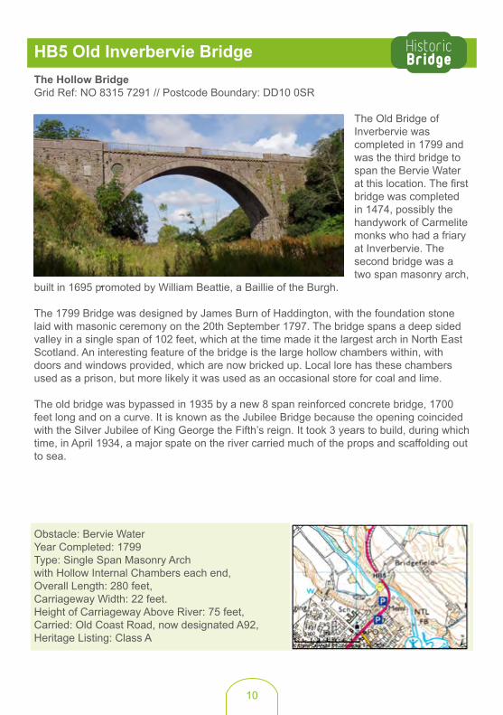
HB6 Lower North Water BridgeHow Many Masons? Grid ref: NO 6526 6615 // Postcode DD10 0AA
“Traveller Pass Safe and Free Along this Bridge”. This is the first line of the inscription on the plaque that was put up at the Montrose side of the bridge when the bridge was opened on the 18th October 1775. Exactly 5 years earlier, work had begun with the laying of the foundation stone of the bridge which was to replace the main ford of the North Esk at Kinnaber, closer to the coast.
It was the Christie family of Montrose who promoted a scheme for a new bridge. First the father
Thomas, Provost of Montrose, who was succeeded on his death by his son Alexander who also became Provost. The designers of the bridge were John Smeaton, Engineer (see No.2 - Banff Bridge) John Adams, Architect, and Andrew Barrie, contractor in Montrose, who along with Patrick Brown of Dryburgh went on to actually carry out the building of the bridge.
The cost of the bridge was £6,500 for which King George III provided £800 from the annexed estates of Jacobite supporters. The other plaque on the bridge is in Latin and informs travellers “Pass on in Safety and be Mindful of the Kings Bounty”.
The bridge has seven segmental arches with triangular shaped cut waters with an extra arch towards the Aberdeenshire end to accommodate the river when it is in spate. The spandrels above the two central cutwaters having decorative occuli but only on the Montrose side (It is rumoured that the Aberdeenshire citizens would not pay the extra for these embellishments). A survey undertaken during repair work in 2007 recorded over 946 ‘masons marks’ belonging to 22 different masons.
Obstacle: River North Esk Year Completed: 1775 Overall Length: 640 feet,Carriageway Width: 19 feet. Carried: Old Coast Road (now designated A92), Heritage Listing: Class A

12
HB7 Gannochy BridgeA Bridge of two Halves Grid Ref: NO 6001 7089 // Postcode Boundary: DD9 7US
Gannochy Bridge is on the border between Angus and Aberdeenshire. From the images you will see it is ‘a bridge of two halves’, with the right hand (upstream) side being a rare surviving example
of a medieval 3 ribbed arch bridge which gave an original width of only 10 feet. As this bridge likely had no parapets, this would have been a scary crossing 50 feet above the River North Esk. A late 18th century story attributes its construction to a local farmer, James Black, who is said to have built the bridge in 1731 almost single handed after being visited by the ghosts of those drowned crossing the river by a ford or ferry nearby. The large span and narrow width of the original bridge, together with a number of mason’s marks on the stonework, and the fact that it is on the line of the early medieval route North from Strathmore, suggest a more likely construction date of circa 1460.
The bridge was widened in 1795 to give a new overall width of 21ft. The widening was carried out by local landowners, Lord Panmure and Lord Adam Gordon, at a reputed cost of £300.
Obstacle: River North Esk, Year Completed: Circa 1480, (Major Repair 1731, Widening 1795),Carriageway Width: Originally 10 feet, Now 21 feet,Carries: B966 Edzell to Fettercairn Road,Heritage Listing: Class B.
13
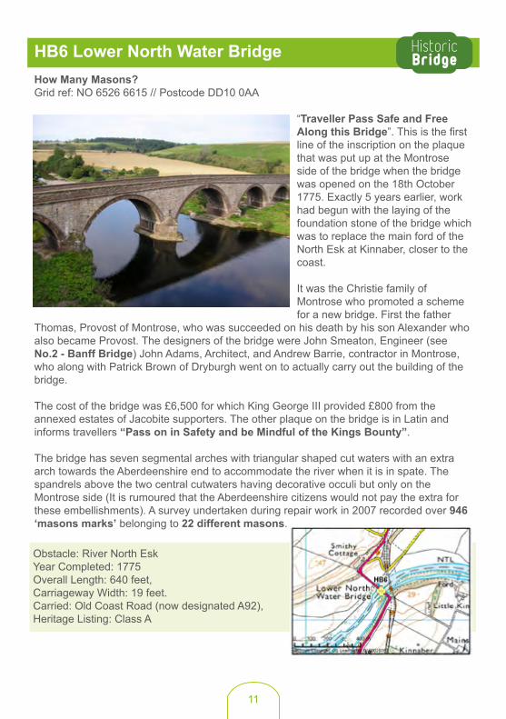
HB8 Old Bridge of DyeRobbers and Thieves RoadGrid Ref: NO 6509 8607 // Postcode Boundary: AB31 6LT
The Old Bridge of Dye must have been an imposing sight for early travellers crossing the important Cairn O’ Mount section of the Great North Road between Edinburgh and Fochabers. That whole area had a rather evil reputation as a haunt of dangerous persons, ready to rob and even slay innocent wayfarers. The bridge is reputed to have been built by Sir Alexander Fraser of Durris in 1681 and he immediately got permission from parliament to temporarily extract a toll for the upkeep and maintenance of the bridge which was soon after made perpetual in 1685. The bridge has two pillars at each side at the crown of the arch through which a chain was passed to assist in making sure all those who crossed payed up.
The bridge itself is a single span four ribbed granite masonry arch harking back to late medieval times as exemplified by Gannochy Bridge in this trail. It has now been bypassed by a new bridge alongside carrying the B974 road, however this is one of the first roads in Scotland to get blocked by snow each winter.
Obstacle: Water of Dye.Year Completed: C1681 (May be earlier). Bridge span: 43 feet.Carriageway Width: 11 feet between toll posts at centre of bridge.Carries: Bypassed Fettercairn to Banchory Road (now B974). Heritage Listing: Class A.
14
HB9 Bridge of FeughA Bridge to Watch the Salmon LeapGrid Ref: NO 7019 9499 // Postcode Boundary: AB31 6NH
There are two separate bridges over the tempestuous Water of Feugh just before it meets the mightier River Dee at the Falls of Feugh. The older of the two bridges was built in 1790 by Mr
Russell of Blackhall to provide better access into Banchory from South of the River Dee. Shortly after, the bridge and the section of road to the East was taken up to form part of the new toll road between Stonehaven and Banchory in about 1798. This road is known as the Slug Road and the original Toll House is still lived in at the west end of the bridge.
The bridge roadway is only 11 feet wide and is carried by three different sized stone arches. Pointed cutwaters at the middle supports are carried up to deck level to form very small pedestrian refuges. The lack of space for pedestrians when vehicles are crossing has always been a real problem as the bridge sits immediately downstream from the Falls of Feugh, an impressive waterfall providing an 18 feet drop into the deep basin below. This provides a challenging barrier to the Atlantic Salmon making their way up to the spawning grounds and the old bridge is ideally located to watch them make their spectacular leaps. Eventually in the early 1960’s a new pedestrian footbridge was erected between the falls and the old bridge to provide a neat, safe viewing platform. This novel steel girder truss footbridge spans the Feugh in a single leap of 100 foot and was designed and erected by IG Engineering of Cumbran in Wales.
The location provides a scenic setting for romancing couples, and the recent craze across the world to adorn bridge parapets with padlocks led to the footbridge becoming festooned with locks, putting the bridge structure at risk. In early autumn of 2015, Aberdeenshire Council and local company Rubberatkins commissioned Lethenty Cabinetmakers to carve an Aberdeenshire oak wooden heart with two salmon leaping, and couples are now the invited to take a selfie with the sculpture. Obstacle; Water of Feugh Year Completed: Masonry Arch; 1790 ; Steel Girder Truss; 1964,1790 Bridge Type; 3 Span Masonry Arch, 20 feet, 31 feet, 24 feet,1964 Bridge Type; 1 Span Steel Girder Truss, 100 feet, Height of Carriageway above river: 24 feet,Carriageway Width: Masonry Arch 11 feet; Steel girder Truss, 9 feet, Carries: C36K Road (Previously Slug Road A957), Heritage Listing: Class B.

15
HB10 Balmoral Bridge A Royal BridgeGrid Ref: NO 2620 9492 // Postcode Boundary: AB35 5UL
When Queen Victoria and Prince Albert needed a new bridge across the River Dee to get to their new home at Balmoral Castle, they turned to Isambard Kingdom Brunel, the great Victorian engineer and friend of Prince Albert. Isambard visited Balmoral in 1854 with his wife Mary to see the site before commencing his design. He settled on a design for a single 125 foot span riveted wrought iron plate girder bridge with his trade mark curved top and bottom flanges, which provides additional strength to the beams. The beams are pierced by diamond openings to give a
more aesthetic appearance. The design was recommended to the Prince as “the cheapest and most easily erected bridge that I can suggest and if the appearance of it is considered not objectionable I should strongly recommend it”. The Prince did not find the appearance objectionable and Isambard quickly went about obtaining tenders for construction. The lowest was submitted by one of his most trusted contractor’s, Rowland Brotherhood Iron Founder of Chippenham at £1,650.
As the bridge neared completion in the autumn of 1857 the first hints of the Queen’s displeasure at its appearance started to surface and Isambard was compelled to respond “the perfect simplicity of the construction and absence of any attempt at ornament would secure it from being in any way unsightly or offensive”. There was, however, a growing fashion for gothic ornamentation which was to become dominant in the following decades. It was not until the 20th Century that the aesthetics of functional elegance and perfect simplicity shown by Isambard at Balmoral became widely accepted, and it was not until 2006 that a plaque was unveiled by The Duke of Edinburgh on the bridge, recognising Isambard as the designer.
Obstacle: River Dee Year Completed: 1857Type: 125 feet, Single Span, Wrought Iron Plate-Girder, Carriageway Width: 13 feet, Carried; B976 South Deeside Road,Heritage Listing; Class A.
16
HB11 Gairnshiel BridgeAfter CullodenGrid Ref: NJ 2949 0086 // Postcode Boundary: AB35 5UQ
The Battle of Culloden on the 16 April 1746 ended the hopes of Bonnie Prince Charlie and the Jacobites to regain the crown of Great Britain. Immediately after the battle, the Hanovarians stepped up their efforts to introduce new forts and to expand the military road network in Scotland, which had been started by General George Wade in 1725. The General had left Scotland by 1740, having secured 250 miles of new roads. By the time of Culloden, the person in charge of
providing new military roads was Major William Caulfeild. A key new ‘Caulfeild’ road was the 100 miles constructed between 1747 and 1756 linking Couper Angus via Blairgowrie, Braemar and the Lecht to Fort George, which was under construction on the Moray Firth. Gairnshiel Bridge was central to the new road, providing a now iconic humped backed military bridge across the River Gairn. Although the roadway and smaller bridges were built by regular soldiers specifically tasked to carry out this work, the bigger bridges such as Gairnshiel and Old Invercauld were built by civilian contractors under contract to the military. Major Caulfeild remained responsible for building and maintaining the military road network up to his death in 1767, by which time he had overseen the construction of 750 miles of new roads in Scotland.
The bridge is built of coursed rubble with long thin stones used in the arch ring itself. The parapet edging is thin stone flags, which are constantly needing to be reset after being knocked off by large vehicles manoeuvring round the sharp corner at the North end of the bridge. The bridge is best seen from a short distance away where the simplicity of the arch can be seen to perfectly compliment the grand lines of the surrounding countryside.
Obstacle: River Gairn Year Completed: 1751 Type: 57 feet, Single Span, Humped Back Masonry Arch Carriageway Width: 12 feet, Carried; A939 Ballater to Corgarff Road,Heritage Listing; Class A.

17
HB12 Bridge of BuchaamA Bridge for the Landed GentryGrid Ref: NJ 3909 1281 // Postcode Boundary: AB36 8TL
The long graceful lines of Buchaam Bridge are testament to the baronial ambitions of the landed gentry in the early years of Queen Victoria’s reign. Built in 1858 on the instruction of Sir Charles Forbes, 3rd Baronet and Captain of the 17th Lancers, the Forbes’ did for Strathdon what the Prince Consort was to do for Deeside 30 years later. Sir Charles built Buchaam
Bridge and two other major bridges within a short distance in order to shift the important Donside Toll Road to the opposite side of the River Don, and away from his newly built stately home at Castle Newe. Originally the road had been the Military Road from Corgarff to Aberdeen built by Major Caulfeild in the mid-18th Century.
Sir Charles chose local civil engineer John Willets to design the bridge. John’s design maximises the spans that can be achieved using stone arches by creating flatter semi-elliptical arches instead of the more typical rounder circular arches. He was thus able to span the river using only two low symmetrical arches. The masonry is a curious mixture of lighter sandstone and darker granite with the colour contrast used to create a strong rusticated appearance. There is a World War II pill box at the north end of the bridge, a reminder of the strategic importance of this route west into the Cairngorm Mountains.
The ethereal beauty of Castle Newe proved to be more fleeting than the three new bridges built by Sir Charles. Castle Newe was demolished in 1927 whereas all three bridges continue to carry modern day traffic.
Obstacle: River Don Year Completed: 1858Type: Two Span Masonry Arch, both spans 50 feet, Carriageway Width: 19 feet 9 inches, Carried; A97 Kildrummy to Strathdon Road,Heritage Listing; Class B.

18
Cra
thie
Coc
k Br
idge
Gle
nkin
die
Balla
ter
Gla
ss
Stra
thd
on
Kint
ore
1811
1858
1751 18
5717
90
1681
1480
1775
1799
1793
1987
1780
Brec
hin
Mon
trose
Pete
rhea
d
Inve
rurie
& P
ort
Elp
hins
tone
Ello
n
Ston
ehav
enPortl
ethe
n
Fras
erb
urg
h
Banc
hory
Wes
thill
Min
tlaw
Banf
f Laur
ence
kirk
Turri
ff
Ab
oyne
Hunt
ly
Kem
nay
Insc
h
Cru
den
Bay
Ma
cduf
f
Alfo
rd
Old
mel
drum
New
burg
h
Torp
hins
Ports
oy
Ma
ryw
ell
Inve
rber
vie
Bla
ckb
urn
Stric
hen
Met
hlic
k
Balm
edie
Bod
da
m
Bla
ckd
og
St C
yrus
New
ma
cha
r
Ab
erch
irder
Fett
erca
irn
Cai
rnb
ulg
&In
vera
lloch
y
Da
viot
New
Dee
r
New
Pits
ligo
Ma
ud Pott
erto
n
John
sha
ven
Crim
ond
St F
erg
us
Hatt
on
Tarv
es
Tarla
nd
Luth
erm
uir
Kinc
ard
ine
O'N
eil
Dru
moa
k Gou
rdon
Lum
pha
nan
Roth
ieno
rma
n
Fyvi
e
Auc
henb
lae
Ytha
nban
k
Old
Rayn
e
Mem
sie
King
sea
t
Tipp
erty
Oyn
e
Fett
eran
gus
Rhyn
ie
Belh
elvi
e
Finze
an
Stra
cha
n
Dun
echt
Cor
nhill
Sauc
hen
& C
luny
Cru
die
Dru
mlit
hie
Keig
Auc
hlev
en
Auc
hnag
att
Ford
oun
Mon
ymus
k
Ma
ryki
rk
Ford
yce
Millb
ank
Arb
uthn
ott
Logi
eC
old
ston
e
Kirk
ton
ofM
ary
culte
r
Mui
r of
Fow
lis
Echt
Muc
halls
Cai
rnie
Col
liest
on
Gar
mon
d
Woo
dla
nds
of D
urris
Lum
sden
Gar
tly
Kinm
uck
Cat
terli
ne
Portl
ethe
nV
illage
New
Leed
s
Tow
ie
Cro
vie
Coo
kney
Rora
Fintry
Ruth
ven
Long
have
n
Park
Cha
pelto
n
Ard
allie
Cha
pel o
fG
ario
ch
Forg
ue
B91
19
B9002
B976
B966
B99 9
B907
7
B994
B90
05
B9022
B9170
B90
25
B9
93
B9031
B900
0
B997
B9024
B91
25
B9033
B912
6
B9030
B974
B900
1
B90 23
B979
B9117
B909
3
B992
B91
39
B977
B903
2
B 91
21
B9120
B909
4
B902
9
B910
5
B97
2
A96
A93
A97
A952
A90
A98
A937
A950
A92
A941
A948
A939
A981
A947A957
A920
A980
A975
A944
A93
A98
A90
A90
A98
A90
A92
A90
A952
A96
A96
Cai
rngo
rms
Nat
iona
lPa
rk
Mor
ay
Ang
us
Abe
rdee
n C
ity
HB
7
HB
8
HB
9
HB
1
HB
12
HB
10
HB
11
HB
2
HB
3
HB
4
HB
5
HB
6
±©
Cro
wn
Cop
yrig
ht. O
S L
icen
ce N
o. 0
1000
2076
70
1020
5K
M
His
toric
Brid
ges
His
toric
Brid
ges
Trai
l
Abe
rdee
nshi
re H
isto
ric B
ridge
s Tr
ail

19
Cra
thie
Coc
k Br
idge
Gle
nkin
die
Balla
ter
Gla
ss
Stra
thd
on
Kint
ore
1811
1858
1751 18
5717
90
1681
1480
1775
1799
1793
1987
1780
Brec
hin
Mon
trose
Pete
rhea
d
Inve
rurie
& P
ort
Elp
hins
tone
Ello
n
Ston
ehav
enPortl
ethe
n
Fras
erb
urg
h
Banc
hory
Wes
thill
Min
tlaw
Banf
f Laur
ence
kirk
Turri
ff
Ab
oyne
Hunt
ly
Kem
nay
Insc
h
Cru
den
Bay
Ma
cduf
f
Alfo
rd
Old
mel
drum
New
burg
h
Torp
hins
Ports
oy
Ma
ryw
ell
Inve
rber
vie
Bla
ckb
urn
Stric
hen
Met
hlic
k
Balm
edie
Bod
da
m
Bla
ckd
og
St C
yrus
New
ma
cha
r
Ab
erch
irder
Fett
erca
irn
Cai
rnb
ulg
&In
vera
lloch
y
Da
viot
New
Dee
r
New
Pits
ligo
Ma
ud Pott
erto
n
John
sha
ven
Crim
ond
St F
erg
us
Hatt
on
Tarv
es
Tarla
nd
Luth
erm
uir
Kinc
ard
ine
O'N
eil
Dru
moa
k Gou
rdon
Lum
pha
nan
Roth
ieno
rma
n
Fyvi
e
Auc
henb
lae
Ytha
nban
k
Old
Rayn
e
Mem
sie
King
sea
t
Tipp
erty
Oyn
e
Fett
eran
gus
Rhyn
ie
Belh
elvi
e
Finze
an
Stra
cha
n
Dun
echt
Cor
nhill
Sauc
hen
& C
luny
Cru
die
Dru
mlit
hie
Keig
Auc
hlev
en
Auc
hnag
att
Ford
oun
Mon
ymus
k
Ma
ryki
rk
Ford
yce
Millb
ank
Arb
uthn
ott
Logi
eC
old
ston
e
Kirk
ton
ofM
ary
culte
r
Mui
r of
Fow
lis
Echt
Muc
halls
Cai
rnie
Col
liest
on
Gar
mon
d
Woo
dla
nds
of D
urris
Lum
sden
Gar
tly
Kinm
uck
Cat
terli
ne
Portl
ethe
nV
illage
New
Leed
s
Tow
ie
Cro
vie
Coo
kney
Rora
Fintry
Ruth
ven
Long
have
n
Park
Cha
pelto
n
Ard
allie
Cha
pel o
fG
ario
ch
Forg
ue
B91
19
B9002
B976
B966
B99 9
B907
7
B994
B90
05
B9022
B9170
B90
25
B9
93
B9031
B900
0
B997
B9024
B91
25
B9033
B912
6
B9030
B974
B900
1
B90 23
B979
B9117
B909
3
B992
B91
39
B977
B903
2
B 91
21
B9120
B909
4
B902
9
B910
5
B97
2
A96
A93
A97
A952
A90
A98
A937
A950
A92
A941
A948
A939
A981
A947A957
A920
A980
A975
A944
A93
A98
A90
A90
A98
A90
A92
A90
A952
A96
A96
Cai
rngo
rms
Nat
iona
lPa
rk
Mor
ay
Ang
us
Abe
rdee
n C
ity
HB
7
HB
8
HB
9
HB
1
HB
12
HB
10
HB
11
HB
2
HB
3
HB
4
HB
5
HB
6
±©
Cro
wn
Cop
yrig
ht. O
S L
icen
ce N
o. 0
1000
2076
70
1020
5K
M
His
toric
Brid
ges
His
toric
Brid
ges
Trai
l
Abe
rdee
nshi
re H
isto
ric B
ridge
s Tr
ail

Aberdeenshire Historic Bridges Trail
Produced by Aberdeenshire Council August 2017 GDT24385
www.aberdeenshire.gov.uk