Chesapeake and Ohio Canal National Historical Park
142
Chesapeake and Ohio Canal National Historical Park Volunteers’ Handbook A Guidebook to the Volunteers-in-Parks (VIP) Program 2010 Edition
Transcript of Chesapeake and Ohio Canal National Historical Park

Chesapeake and Ohio Canal
National Historical Park
Volunteers’ Handbook
A Guidebook to the
Volunteers-in-Parks (VIP) Program
2010 Edition
1
Table of Contents
WELCOME ........................................................................................................................ 4 Preface to the 2009 Handbook ............................................................................................ 5 Introduction ......................................................................................................................... 6
The Purpose of National Parks ....................................................................................... 6 A Brief History of the National Park Service ................................................................. 8 A Brief History of the Chesapeake and Ohio Canal National Historical Park ............... 8 1971 Enabling Legislation; The Park’s Mission Statement ............................................ 9
Volunteer Service in the C&O Canal National Historical Park ........................................ 10
Mission of the C&O Canal National Historical Park’s VIP Program .......................... 10 Volunteer Positions in the C&O Canal National Historical Park ................................. 10 Who Can Volunteer?..................................................................................................... 14 NPS Employees and Family Members as Volunteers .................................................. 15
What Can Volunteers Do? ............................................................................................ 15 Rights and Responsibilities: .............................................................................................. 18
The Volunteer Bill of Rights......................................................................................... 18 Reasonable Expectations of All Volunteers ................................................................. 19
Volunteer Program Operations ......................................................................................... 20
Legal Protections for Volunteers .................................................................................. 20 Use of a Volunteer’s Personal Equipment .................................................................... 21
Volunteer Agreement (VIP Agreement Form (10-85).................................................. 21 Volunteer Uniforms ...................................................................................................... 23 Orientation and Training ............................................................................................... 23
Reporting Volunteer Time, Activities and Statistics .................................................... 24 Recognition and Rewards ............................................................................................. 24
Termination of Voluntary Service ................................................................................ 25
Emergency Responses by Volunteers ............................................................................... 27
Emergency Preparedness .............................................................................................. 27 Training Classes ........................................................................................................ 27
Preparedness Checklist ............................................................................................. 27
Emergency Equipment and Supplies ............................................................................ 27
First-Aid Equipment and Supplies ............................................................................ 27
Communications Equipment ..................................................................................... 28
Emergency Situations ................................................................................................... 28 Critical Incident ........................................................................................................ 28
Threatening Incidents................................................................................................ 28
Weather Emergencies ............................................................................................... 28
Volunteers as First Responders ..................................................................................... 29
Safety of Volunteers ................................................................................................. 29
Protecting the Scene .................................................................................................. 29
Entering and Leaving the Scene ............................................................................... 29
Witnesses and Bystanders ......................................................................................... 29
2
Making Notes ............................................................................................................ 30
A Checklist for Volunteer First Responders ............................................................. 30
Threatening Incident Scene ........................................................................................... 31 Safety of Volunteers ................................................................................................. 31
Fire Scenes ................................................................................................................ 31
Burned-Out or Extinguished Fire .............................................................................. 31
An Active Burning Fire ............................................................................................ 31
Making Notes ............................................................................................................ 31
A Checklist for Volunteer First Responders ............................................................. 31
Weather Emergencies ................................................................................................... 32 Safety of Volunteers ................................................................................................. 32
Monitoring the Weather ............................................................................................ 32
Severe Weather Watches .......................................................................................... 32
Severe Weather Warnings......................................................................................... 33
NOAA Weather Radio All Hazards (NWR) ............................................................. 33
Monitoring NOAA Weather Radio in the Park ........................................................ 34
Advice for All Park Visitors ......................................................................................... 36
Helping Visitors Planning a Long-Distance Towpath Trip ...................................... 37
Frequently-Asked Questions about the C&O Canal ................................................. 40
Frequently Asked Questions about the C&O Canal National Historical Park: ........ 43
Other National Park Service Sites that are Accessible from the C&O Canal:.......... 44
Communication for Volunteers......................................................................................... 46
Preferred Method of Communication ....................................................................... 46
Communication Training for Volunteers: ................................................................. 46
Communication by Cell Phone ................................................................................. 46
Communication by Radio ......................................................................................... 47
Internet Resources and E-mail Communication ....................................................... 57
Appendices ................................................................................................................ 59
C&O Canal NHP....................................................................................................... 65
Great Falls District .................................................................................................... 65
Chesapeake Ohio Canal National Historical Park - Important Phone
Numbers .................................................................................................................. 66
The C&O Canal NHP Volunteer Bike Patrol – ................................................................ 69 A Brief History ................................................................................................................. 69
Mission of the Bike Patrol ........................................................................................ 69
JOB DESCRIPTION: BIKE PATROL VOLUNTEER .......................................... 70
CONDUCTING BIKE PATROLS ........................................................................... 72

3
Park Rules and Regulations ...................................................................................... 78
Communication for Bike Patrol Volunteers ............................................................. 79
Bicycle Maintenance and Repairs ............................................................................. 80
2008 Billy Goat Trail Stewards Manual ........................................................................... 84 Appendix ....................................................................................................................... 97 The 8 Plant Communities of Bear Island .................................................................... 105
Compendium of Relevant Federal Regulations (2006) .................................................. 118

4
WELCOME
Welcome to the volunteer corps of the National Park Service and The C&O Canal
National Historical Park! Whether you are someone who is considering
volunteering for the first time or you are one of our many experienced volunteers
returning for a new season, we hope that you will find this handbook to be a
helpful guide and source of answers to most of your questions.
The success of the C&O Canal National Historical Park’s Volunteers-in-the-Parks
program is a result of the hard work and dedication of the volunteers who
choose to serve at the park. The park relies on the skills, talents, and abilities of
many individuals to assist park staff in providing a quality visitor experience
while preserving and protecting the natural and cultural resources of the park.
There are many ways in which volunteers donate service to the park. Our
volunteers are rewarded in turn by getting to know the park’s resources in a
deep and meaningful way, meeting people from all different walks of life, and
assisting National Park Service employees in making every visitor’s experience a
positive and memorable one.
This Volunteers’ Handbook is dedicated to all of the volunteers, past and present,
who have helped to make the C&O Canal National Historical Park the valuable
national asset that it is today.
With special thanks to Dick Paye, Jamie Noblin, and Brenda King
for their dedicated assistance in the final completion of this handbook.

5
Preface to the 2009 Handbook
This handbook has been prepared by Park Service staff with the advice and
assistance of many volunteers. For the first time in 2009 the handbook will be
distributed electronically to active volunteers who have an e-mail address on file
with the Park Service. Printed copies will be available to volunteers who do not
have e-mail service. If you are considering becoming a volunteer for the first
time, you may also receive a copy by e-mail or you may pick up a printed copy at
a Park Service Visitor Center.
Errors, omissions, corrections and suggestions for improving future editions of
this handbook should be forwarded to the park’s Volunteer Coordinator:
Ranger Daniel M. Filer
Volunteer Coordinator
C&O Canal National Historical Park
1850 Dual Highway, Suite 100
Hagerstown, MD 21740
(301)714-2218 (Office)
(301)491-2465 (Cell)
(301)745-5805 (Fax)
6
Introduction
The Purpose of National Parks
Yellowstone, Grand Canyon, Great Smokey Mountains – these national parks
and monuments of the United States are some of the best-known places on this
earth. Each is a special place that preserves and exhibits cultural and natural
resources of recognized value.
America’s still-expanding national park system is the result of more than a
century of effort by countless dedicated citizens. The modern national park
concept did not come into the world fully developed. The concept of preserving
resources or special features made no sense in the past when things changed
slowly. In this sense, the national park idea was one of the products of the great
industrial revolution of the 19th century. By the middle of the last century,
Americans had begun to realize that they had the power to make immense
changes in their world. But the power to change also had awakened the need to
preserve. Even to the individual-oriented culture of 19th century America, it
seemed obvious that certain special places ought to be shared by all, rather than
locked up to benefit a lucky few. It was this urge to share and preserve that led
to America’s initial experiments in national parks.
In 1864, during the midst of the Civil War, the federal government took time to
transfer California’s increasingly-popular Yosemite Valley to state control, with
the specific provision, that the area be operated as a public park. Less than a
decade later in 1872, when the wonders of Yellowstone Park became apparent,
Congress again acted to prevent private ownership. But this time, since no state
government yet existed in the region in question, the government had no choice
but to undertake the operation of the new reserve itself. The result was
America’s first formally-titled “national park”.
As the century came to a close, other areas attracted similar attention. In 1890,
Congress created three national parks in California: Sequoia, General Grant, and
Mesa Verde. As the number of national parks increased and arguments
continued as to what exactly they should be, a campaign began to bring all the

7
parks together under the administration of one central office with one well-
defined idea of park management goals. Out of this effort, in 1916, came the
National Park Service, and ultimately the national park model we still employ
today.
National Parks serve two primary purposes:
1. To preserve natural, cultural, and historical features of special significance,
while at the same time …
2. Allowing for their non-destructive enjoyment.
It has been said that these two objectives are contradictory – that preservation
and enjoyment are mutually incompatible. But to believe such is to misperceive
our parks, for the modern history of our parks is the story of the relationship
between these two goals. National parks are not just zones of preservation, and
they are not merely areas set aside to be enjoyed. Successful park management
lies in the combination of these two goals. It is your job as a volunteer at the
C&O Canal NHP to facilitate and promote both of these primary purposes.
8
A Brief History of the National Park Service
The National Park System consists of 391 individual units which are
administered by the National Park Service (NPS) for their inherent natural,
cultural and recreational values.
The Department of the Interior, of which the National Park Service is a
constituent, was created on March 3, 1849. However, the National Park Service
itself was not founded until 1916, forty-four years subsequent to the
establishment of America’s first National Park. During this interim period there
were multiple debates about the purpose of national parks, as well as
considerable deliberation over which agency should be responsible for their
management. In 1916, the Organic Act was passed which stated:
“the service thus established shall promote and regulate the use of Federal areas
known as national parks, monuments and reservations… by such means and
measures as conform to the fundamental purpose of said parks, monuments, and
reservations, which purpose is to conserve the scenery and the natural and
historic objects and wildlife therein and to provide for the enjoyment of the
same in such manner as will leave them unimpaired for the enjoyment of future
generations.”
A Brief History of the Chesapeake and Ohio Canal National Historical Park
(Excerpted from Official National Park Handbook)
After the canal stopped operating in 1924, it lay dormant for many years. At the
time, it was owned and operated by the B&O Railroad. The canal was acquired
by the Federal Government for $2 million in 1938 as a result of the financial
difficulties experienced by the railroad during the Great Depression. It was
placed under the National Park Service.
After much soul-searching on what to do with it, the Park Service, with public
support, proposed building a parkway for automobiles modeled after the Skyline
Drive and Blue Ridge Parkway. What more perfect roadbed than a level right-of-
way already federally owned?
Although eminently practical, the road proposal turned out to be anathema to
those who saw the canal environs as an antidote to the Potomac River Valley’s

9
rampant urbanization. In 1954, Associate Supreme Court Justice William O.
Douglas challenged the editors of The Washington Post and The Evening Star
newspapers to walk the length of the canal with him to assess its beauty and
historical significance. “One who walked the canal its full length could plead
that cause with the eloquence of a John Muir,” Douglas wrote to the newspapers.
Two editors took up the challenge. Douglas, six fellow stalwarts, and the two
editors completed the March 1954 hike of some 180 miles amidst much public
hoopla. Fifty thousand canal converts welcomed them to Georgetown. The
Washington Post changed its editorial mind in favor of preserving the canal, and
the property was saved by popular appeal.
Today the canal and its towpath with beautiful bordering forests and Potomac
riverscapes attract legions of outdoor enthusiasts. Charles F. Mercer and The
Georgetown passengers, joggers, cyclists, winter skiers, hikers, backpackers, rock
climbers, boaters, canoeists, anglers, artists, philosophers, and poets all turn out
in their respective seasons. In the tranquil company of history they revel in the
green ribbon of natural wealth that is the serendipitous legacy – a renewing
internal improvement – of this national project.
1971 Enabling Legislation; The Park’s Mission Statement
To understand the canal’s reason for being, its construction, its role in
transportation, economic development and westward expansion, the way
of life which evolved upon it, the history of the region through which it
passes and to gain an insight into the era of canal building in the country,
To appreciate the setting in which it lies and the natural and human
history that can be studied along its way, and
To enjoy the recreational use of the canal, the parklands and the adjacent
Potomac River.

10
Volunteer Service in the C&O Canal National
Historical Park
The Volunteers in Parks (VIP) Program was authorized by Congress in 1970.
Since then, thousands of individuals have helped the Park Service to preserve,
manage and interpret our American Heritage.
As a volunteer, you will not be paid by the Federal Government. But you will
have the benefit of working in a national park, meeting people from all over the
United States and potentially enhancing your current or new careers.
Mission of the C&O Canal National Historical Park’s VIP Program
The Mission of the VIP program at the C&O Canal National Historical Park is to
involve individuals and groups in the stewardship and enhancement of the
park’s resources in an atmosphere of respect and cooperation. The program will
provide opportunities for increasing knowledge while fostering commitment to
National Park Service goals and recognizing the contributions of all park
volunteers. We will accomplish these goals by:
Fortifying park programs through the use of volunteers in a manner that
complements basic park resources to better accomplish the park’s mission;
and
Providing an enriching and diverse work experience for participating
volunteers.
Volunteer Positions in the C&O Canal National Historical Park
Volunteers in the C&O Canal NHP serve in the following groups and individual
positions:
Bike Patrol
Bike Patrol members ride their bicycles on the towpath and assist visitors
with information, minor bicycle repairs, and first-aid. They also monitor
conditions along the towpath and report problems.

11
Billy Goat Trail Stewards
Billy Goat Trail Stewards assist and educate visitors along the trail which
traverses Bear Island, an ecologically diverse landscape co-owned by the
National Park Service and the Nature Conservancy.
Canal Quarters - Quartermasters
Quartermasters will be responsible for the canal quarters assigned to
them, overseeing the general housekeeping of structures, including
interior, exterior, and surrounding grounds. They should follow the park’s
routine maintenance plan to ensure the property is properly maintained.
They should perform all work concerning routine maintenance and report
problems to C&O Canal Trust. They should be able to oversee groups of
volunteers also assigned to assist in the routine maintenance of these
structures. They should keep a log book of these activities and also keep
record of visitor use.
o Routine maintenance duties:
Cleaning of interior, painting, inspecting structure, as well as
typical skills of any homeowner
o Skills/ Training required:
N/A Any specialized training will be provided
Canal Quarters - Quarters Crews
Assist quartermasters with maintenance and housekeeping efforts. They
may be organized by quartermaster directly or from other organizations.
They should report to Quartermaster for assignments and report
subsequent activity.
Canal Steward Program - Caretakers of the Canal
Dotted along the 184.5 miles of the historic Chesapeake and Ohio Canal
towpath are countless opportunities for volunteers to connect to our
national resources that exceed an hour-long boat ride, an afternoon of
biking or a weekend camping trip.
The Canal Steward Program will engage volunteers in a long-term
relationship in which they become the caretakers of a designated site
within the park. The Canal Steward Program will provide significant
value to the park and in return the stewards will benefit from the deep
attachment to special places along the towpath.

12
The Canal Steward Site Adoption Program’s focus will be the completion
of maintenance projects to maintain and enhance the facilities and
resources of areas which have been adopted. Volunteers will formally
adopt the site and will be presented with an adoption package that details
their commitment and the tasks they are responsible for completing at the
designated site. Adoption of a site in the park will foster ownership and
pride in the resource and in the mission the National Park Service strives
to uphold.
There are abundant adoption possibilites for volunteers interested in
becoming Canal Stewards. Possible adoption sites include, but are not
limited to:
o Camping Areas o Day Use Areas o Mile sections of the towpath o Visitor Center grounds
Canal Steward Job Description
When pledging to monitor and maintain an area in the park through the
Canal Steward Site Adoption Program, the volunteer is taking on a great
responsibility. Adoption of a site can be very rewarding, but it is essential
that the position is a good fit for the volunteer and/or their group. After
completing training with park staff to orient the group to the site tasks,
volunteers will work on their own schedules under their own leadership.
This independence would require the adopting group to possess good
communication and organizational skills.
Maintenance tasks will vary depending on site, but some common
activites could include:
o Mowing and pruning o Painting o Repairing picnic tables and signs o Picking up trash o Raking leaves o Cleaning and repairing grills
Volunteers who are able to provide their own tools and resources will
have the greatest flexibility in their work schedules and increase the
independence of the Stewards.
INDIVIDUAL VOLUNTEER POSITIONS
13
Docents
Docents have extensive knowledge of various buildings, canal structures,
or natural features in the park. They make periodic presentations to
visitor groups.
Living History Interpreters
Living History Interpreters, appearing in period dress, make presentations
or enact roles to educate visitors about the canal and the lives of people
who depended on it.
Visitor Center Assistants
Visitor Center Assistants welcome visitors, provide local and park
information, make sales of books, souvenirs, and other items and
generally assist the interpretive staff.
In addition to these group and individual positions, the park has other volunteer
needs which change from year to year. Up-to-date information regarding
volunteer opportunities in the C&O Canal National Historical Park can be found
at:
http://www.nps.gov/choh/supportyourpark/volunteer.htm
Links on this page will enable viewers to access forms necessary to apply for
specific volunteer positions.
To view details on open volunteer positions go to:
http://www.nps.gov/choh/supportyourpark/currentvolunteeropportunities.htm
By clicking on a volunteer job title you will be linked to
http://www.volunteer.gov/gov
Complete information about volunteer opportunities as well as contact
information and application procedures are displayed on this website.

14
Who Can Volunteer?
Almost anyone can be a volunteer in the National Park Service VIP program. A
VIP is anyone who performs work for the National Park Service for which he or
she receives no pay from the NPS. (Reimbursement for out-of-pocket expenses is
not considered pay.) It does not matter if the person is receiving pay, work credit,
academic credit, or other types of compensation from sources outside of the NPS; if
the NPS is not paying that person for the work he or she is doing, he or she can be
considered a VIP. Off-duty NPS employees can be VIPs as long as they are
volunteering in a capacity other than their paid duties. So can family members of
NPS employees, student interns, and individuals from the private sector whose
employer is donating their services to the NPS while still keeping them on their
payroll (for example, Eastman Kodak personnel giving evening programs on
photography). Legal aliens may serve as VIPs. Foreign nationals may serve as
VIPs as long as they have a J-1 visa allowing them to volunteer in the U.S. Children
under the age of 18 years may be VIPs provided they have the written consent of
their parent or guardian. Individuals convicted of minor crimes who are
participating in court approved probation without sentencing, work release, or
alternative sentencing programs can serve as volunteers at the discretion of the
Park Superintendent. However, no person who has been convicted of any violent
crime, crime against persons, or crime involving use of a weapon shall be
utilized in the NPS Volunteer in Parks program in any manner whatsoever.
Volunteers are recruited and accepted from the public without regard to race,
creed, religion, sexual orientation, age, sex, color, national origin or OPM
classification laws, rules, and regulations. But, they must be physically able to
perform the work they volunteer to do. The Superintendent of the park may
request that the volunteer complete a standard Form 256 (Self-Identification of
Medical Disability) or obtain a medical examination at government expense, if
there is a question regarding the volunteer’s ability to perform the assigned duties.
Cooperating association employees can be VIPs if they perform functions that are
normally carried out by NPS employees. However, cooperating association
employees performing work on behalf of the NPS must function under a signed
"Agreement for Individual Voluntary Services" (Form 10-85) in which their duties
are clearly identified and described. This type of arrangement is permitted only
when (1) the NPS and an association mutually agree that association employees
may perform work on behalf of the NPS (such as issuing Golden Age or Golden
Eagle Passports, operating an information desk during NPS staff breaks, issuing
backcountry permits), and (2) the association employees performing such functions

15
receive appropriate training from the NPS. Under no circumstances should
association employees be signed up as VIPs merely to circumvent requirements for
association insurance.
NPS Employees and Family Members as Volunteers
A NPS employee can serve as a volunteer within the NPS as long as the duties he
or she performs as a volunteer are not the same types of duties for which he or she
is paid. For example, a secretary in the superintendent’s office can volunteer to
give an interpretive program in the park on his or her own time, but cannot
volunteer to do secretarial work for the chief ranger.
Family members and relatives of NPS employees may serve as volunteers as long
as the Park Service representative signing the agreement for voluntary services is
not an immediate family member. However, if reimbursement is involved, the
regional ethics counselor should be consulted before any such agreement is signed.
The creation of a conflict of interest could result if a family member or relative of an
employee receives financial benefit from the program. Even the appearance of a
conflict of interest is a violation of the department's employee conduct regulations
and should be avoided.
What Can Volunteers Do?
Volunteers can work in any and all parts of the park. All levels and types of skills
can be used, and almost any type of work can be performed as long as it is work
that:
1. Would not otherwise get done during a particular fiscal year because of
funding or personnel limitations;
or
2. Enables paid employees to accomplish work that would not otherwise get
done during a particular fiscal year because of funding or personnel
limitations;
and
3. Does not result in the displacement of any paid employees.
For example, the park might recruit volunteers to organize and catalog a
photograph file, conduct research on an endangered species, or paint picnic
tables and signs in a campground -- all work that needed to be accomplished
but had been cut out by reduced funding and personnel limitations. Another

16
example might be recruiting a volunteer to man an information desk on off
season week days so that a park interpreter can be freed to provide other
interpretive services to the public -- services that had been cut for lack of staff.
A third example might be recruiting a retired couple with a trailer to live in a
campground as campground hosts and register campers, give out information,
check the campground and restrooms, and do minor maintenance. These
volunteer assignments would release a ranger to perform other necessary duties
that would otherwise not get done.
The following additional constraints must be considered when assigning
volunteers to work projects:
A volunteer must never be required to perform any type of work for which
he or she is not qualified, has not been adequately trained, does not feel
comfortable doing, or does not willingly agree to. These warnings apply
especially to medical and law enforcement activities.
Volunteers who are assigned to operate machinery or equipment (such as
chain saws, power shop tools, and specialized equipment or vehicles) first
must have demonstrated their proficiency in the operation of that
equipment to the satisfaction of the responsible supervisor. All applicable
age restrictions relating to the operation of machinery or equipment must be
considered.
Volunteers may assist in the visitor protection functions of the park. But
they must not be assigned duties that would place them in a life-threatening
situation, even as an observer (for example, accompanying Law
Enforcement on towpath patrol). Volunteers may not issue citations or carry
firearms.
Volunteers working in the park must observe the same safety precautions
and use the same safety equipment as do paid employees. If volunteers are
to be placed in a work environment that has occupational hazards, then
personal protective equipment must be provided at no cost to the
volunteers. Failure to provide such equipment significantly increases NPS
exposure to potential violation notices of federal health and safety
regulations, violates existing labor-management relations agreements,
escalates the number of workers' compensation claims, and heightens the
potential of tort liability for supervisors' acts of omission.
Volunteers should generally not be assigned to hazardous work conditions,
such as those that would qualify a paid employee for hazardous duty pay.
Any use of volunteers in jobs considered to be hazardous for federal pay
purposes must be evaluated on a case-by-case basis, taking into account the

17
volunteer's training and qualifications to perform such work. A Job Hazard
Analysis for each of these questionable work assignments should be used to
help the supervisor judge whether the individual volunteer can do the job
safely and efficiently. When the Job Hazard Analysis indicates the need for
operational or safety training, the volunteer will not be allowed to perform
the job until all training is completed, the supervisor knows the volunteer's
work capability, and the volunteer understands the job and its hazards.

18
Rights and Responsibilities:
The Volunteer Bill of Rights
As a C&O Canal NHPVolunteer you have:
The right to be treated as a co-worker, not just free help.
The right to a suitable assignment with consideration for
personal preferences, temperament, life experience, education,
and work history.
The right to know as much about the organization as possible:
its policies, people, and programs.
The right to proper job training.
The right to continuing education on the job as follow-up to
initial training, information on new developments, and training
to prepare for greater responsibility.
The right to sound guidance and direction by someone who is
experienced, well-informed, patient and thoughtful, and who
has the time to invest in giving guidance.
The right to a place to work: an orderly, designated place
conducive to work and worthy of the job to be done.
The right to a variety of assignments, and increasing levels of
responsibility and challenge.
The right to be heard, to have a part in planning, to feel free to
make suggestions, and to have respect shown for honest
opinions.
The right to recognition in the form of promotion and awards,
through day-to-day expressions of appreciation, and by being
treated as a bonafide team member.

19
Reasonable Expectations of All Volunteers
C&O Canal NHP Volunteers are reasonably expected to:
Make an annual commitment to volunteering a minimum of 40
hours to working on a mutually-understood and agreed-to
schedule.
Communicate promptly with a supervisor or coordinator any
time they cannot comply with their work schedule or time
committment.
Communicate changes in their e-mail address, postal address
or phone number to their supervisor or coordinator in a timely
manner.
Make an accurate record of activities and hours spent
volunteering in the park, and turn this record over to a
supervisor or coordinator promptly.
Attend training sessions provided by the Park Service and keep
current on all certifications or licenses that are specified by the
Park Service as necessary for volunteer activities.
Understand the Park Service’s uniform standards, and appear
in a neat and clean uniform or period clothing that is
appropriate to volunteer activities when representing the Park
Service to the public.
Be personally responsible and accountable for government
property entrusted to them, understand its proper and safe use,
and return it in the same condition in which it was received.
Give reasonable advance notice should they desire to terminate
their volunteer relationship with the park.

20
Volunteer Program Operations
Legal Protections for Volunteers
Volunteers receive the same protection as NPS employees under the Federal
Employees Compensation Act (5 USC, Chapter 81) and the Federal Tort Claims Act
(28 USC, 2671-2680), and are considered to be federal employees for those purposes
only. These two acts provide the following protection:
FEDERAL EMPLOYEES COMPENSATION ACT: Volunteers are entitled to
first aid and medical care for on-the-job injuries as well as hospital care when
necessary. When travel is necessary to receive medical care, transportation
may be furnished and the travel and incidental expenses associated with it
may be reimbursable. When death results from an on-the-job injury, burial
and funeral expenses, not to exceed $800, may be paid. In addition, other
compensation benefits may be approved by the Office of Workers
Compensation Programs on a case-by-case basis.
A volunteer who suffers an on-the-job injury should contact his or her immediate
supervisor immediately. The supervisor is responsible for helping the volunteer to
thoroughly document the incident. The supervisor is also responsible for helping the
volunteer obtain and complete the proper claim forms (if the volunteer desires to file a
claim for compensation). The supervisor is responsible for certifying the authenticity of
the claim and for submitting the claim to the servicing personnel office for processing.
Specific information on this procedure and process, including information on the various
forms that are required, can be obtained from the responsible Personnel Specialist.
FEDERAL TORT CLAIMS ACT: This act provides a means whereby
damages may be awarded as a result of claims against the National Park
Service for injury or loss of property or personal injury or death caused by
the negligent or wrongful act or omission of any employee of the NPS while
acting within the scope of his or her office or employment under
circumstances where the NPS, if a private person, would be liable for the
claimant in accordance with the law of the place where the act or omission
occurred. Since volunteers are considered employees for the purpose of this
act, they are offered the protection of the Act for personal liability as long as
they are within the scope of their assigned responsibilities.
For these reasons, it is imperative that volunteers be properly signed up and operating
under written job descriptions that contain specific information on the type of work they
are assigned to do. This is necessary in case questions arise about whether a volunteer
was acting within his or her assigned responsibilities.

21
Use of a Volunteer’s Personal Equipment
Whenever possible, volunteers should use government-owned equipment and
property in their work, rather than using their own personal property. In the C&O
Canal NHP there are exceptions to this rule. Bike Patrol members, for example, are
expected to own and use their own bicycle when on duty.
If a volunteer does use his or her own personal property or equipment for official
purposes and that property is lost, damaged or destroyed in the process, the
volunteer may be reimbursed for the loss. Title 16 U.S.C. - 18i (d) deals with the
reimbursement to volunteers for personal property that was lost, damaged, or
destroyed while being used for official purposes for the National Park Service. But
in order to be eligible for reimbursement under this act, the volunteer must have
been required by an authorized NPS employee (usually the VIP program manager)
to furnish his or her own personal property for use in the assigned work. A
statement to this effect must be included on the VIP Agreement Form (10-85). Such
statement must specifically identify and describe the personal property involved
and state that the volunteer is required to provide and use this particular equip-
ment as part of his or her official duties.
Volunteer Agreement (VIP Agreement Form (10-85)
The single most important document that a volunteer must complete is the
Volunteer Agreement. Without a Volunteer Agreement, a volunteer will not be
covered by any of the protections previously discussed.
If a volunteer serves in more than one position, (e.g., a Bike Patrol member who
also serves as a Visitor Center Assistant on busy weekends or special occasions)
then the volunteer must sign a separate agreement for each position. Therefore,
a volunteer may have more than one Volunteer Agreement in effect.
The Volunteer Agreement is also a very important communication tool. Before
signing it, the volunteer should carefully read the duties included in the
Agreement as well as the full Position Description (which should be attached to
the Agreement). The Position Description must include the following:
Detailed description of the job to be performed, including pertinent
duties and responsibilities;
Required skills, experience, and other factors;

22
Working conditions and physical demands;
Time commitment; and
The name of the supervisor or coordinator who oversees and evaluates
the volunteer’s activities.
Any questions concerning these aspects of the job should be clarified with the
supervisor before the Volunteer Agreement is signed. This process will ensure
that both the supervisor and the volunteer completely understand what is
involved in that particular volunteer position before it begins.
Finally, the Volunteer Agreement tells the supervisor and the park’s Volunteer
Coordinator who to contact in case of an emergency. The volunteer is
responsible for advising their supervisor of any changes of mailing address,
e-mail address, or telephone number as they occur.
An example of a Volunteer Agreement is included in the Forms Section at the
end of this handbook.
23
Volunteer Uniforms
The first park rangers were cavalrymen who patrolled the parks. They were
easily identified by early visitors as a result of their military uniforms. The
uniform has been a part of the National Park Service since the early years and
visitors today can quickly recognize a ranger by their uniform. The C&O Canal
NHP has always maintained a high standard of uniform dress. Many
volunteers are responsible for regular public contact and, in fact, may be the only
direct contact visitors make with park staff. Volunteers who will be in contact
with the public are expected to comply with the park’s standard on uniforms:
All interpretation volunteers who are not in period clothing will be
issued a uniform shirt and nameplate to be worn while working in the
park. Tan slacks with a belt or tan skirts should be worn with the
uniform shirt. From mid-April to mid-October, when park staff is in
their summer dress, volunteers will have the option to wear tan shorts.
The shorts should be loose fitting, dresstype shorts, and have a
minimum inseam of eight inches. Jeantype shorts or pants are not
allowed. There is no standard for footwear. Volunteers should wear
whatever footwear is comfortable.
Uniforms must be clean and free of wrinkles at the start of the shift.
This standard will not apply to Bike Patrol volunteers.
Orientation and Training
Each volunteer is invited to attend an orientation, given at the start of every park
season. Orientation may consist of a group meeting or a one-on-one session with
a supervisor. At this orientation, volunteers will be given important information,
including updates on current events in the park. Also, volunteers will receive an
orientation about the volunteer program in general and have necessary paper-
work to complete.
In addition to the seasonal orientation, volunteers will receive information and
training for their specific volunteer positions. This training will be either in the
form of classroom training or one-on-one training given by the supervisor or
another employee or volunteer who performs that job. Volunteers should

24
contact their supervisor or the park’s Volunteer Coordinator as soon as possible
if additional training is desired.
Reporting Volunteer Time, Activities and Statistics
It is important that all volunteer time and activities be logged. The Park Service
keeps track of volunteer time in order to give recognition for the number of
hours a volunteer has contributed. Accurate statistical records of visitor contacts,
for example, are needed for budget appropriation requests and project planning.
Statistics to be recorded and forms to be used vary with the assignment that a
volunteer is performing. Supervisors are responsible for updating volunteers
during the preseason orientation session on:
(1) Forms the volunteers should use to record their time and activities;
(2) Requirements for turning in time and activity reports
(3) Procedures to use (such as e-mail, on-line, or telephone reporting) if
exceptional or emergency situations should arise
Recognition and Rewards
Each year the park recognizes the invaluable services of its volunteers with social
events held at the eastern and western ends of the park. Recognition events are
held at Carderock and at Ferry Hill, usually in mid-September, and a dinner or
picnic is held in Cumberland, usually in early November. These events provide
an opportunity for volunteers to get to know each other better as well as an
opportunity for park employees to personally thank volunteers for their help and
support. Tokens of appreciation are presented to all volunteers at these annual
functions.
The C&O Canal NHP also recognizes that it has benefitted greatly from the long-
term service of numerous volunteers. These volunteers are recognized with a
service pin for each 5year service period, from 5 to 35 years.
Each year three outstanding volunteers, one each in the eastern and western ends
of the park and one park-wide, are recognized as Volunteers of the Year. These
individuals receive a plaque and a special uniform item.

25
Termination of Voluntary Service
Volunteers who wish to terminate their service to the park or their performance
of a particular volunteer assignment may do so at any time. It is expected that
such a terminating volunteer would (1) give reasonable notice of this decision to
their supervisor or coordinator, and (2) return any government property in their
possession in the same condition in which it was received.
On its part, the National Park Service may, at any time and without any cause
whatsoever, terminate the service of any volunteer.

26
Reference Guide:
Emergency Responses by Volunteers

27
Emergency Responses by Volunteers
Emergency Preparedness
Training Classes
The Park Service makes emergency-response training classes available to
volunteers, usually at the beginning of the park season. Volunteers have
the responsibility to discuss their training needs with a Park Service staff
member and to be available for classes when scheduled. Every volunteer
should have current certifications in CPR and First-Aid.
Preparedness Checklist
Don’t venture into the park without (1) a reliable means of
communication – a cell phone or radio, and (2) emergency
supplies, like a first-aid kit.
Know where you are in the park. As you move along the towpath
make a mental note of mileposts, campsites, road crossings.
Watch the weather.
In the event of an emergency, stay calm. Other people may be
relying on you.
Don’t put yourself in danger. You are not expected to be a
firefighter or law enforcement ranger. However, you are expected
to report situations calmly and correctly and do your best to alert
and protect park visitors.
Emergency Equipment and Supplies
First-Aid Equipment and Supplies
Volunteers, like Bike Patrol Members or Billy Goat Trail Stewards, whose
duties take them out into the park regularly are responsible for signing
out and carrying a first-aid kit.
Visitor Centers have first-aid kits and supplies on hand and volunteers
serving as docents or Visitor Center Assistants are responsible for
knowing where these items are located and being able to make use of
them in an emergency. A volunteer may be asked to check kits and
inventory first-aid supplies periodically.

28
Park Service vehicles are also equipped with first-aid kits.
Communications Equipment
Volunteers should have a reliable means of communication on hand at all
times, especially when they are in the field. The Park Service prefers that
volunteers carry their personal cell phones. If a volunteer does not have
a personal cell phone, they should sign out a Park Service cell phone or
radio before going on duty. Early in the park season each volunteer
should add three phone numbers to their cell phones dialing directory:
Central Dispatch (Non-Emergency) (301)714-2235
Central Dispatch (Emergency Only) (866)677-6677
Your Local Park Service Visitor Center:
Georgetown Visitor Center (202)653-3190
Great Falls Visitor Center (301)767-3714
Brunswick Visitor Center (301)834-7100
Williamsport Visitor Center (301)582-0813
Hancock Visitor Center (301)678-5463
Cumberland Visitor Center (301)722-8226
In addition to a cell phone or radio every volunteer should be carrying a
small notebook (or note cards or paper) and a pen or pencil while on
duty.
Emergency Situations
Critical Incident
A “critical incident” is a serious accident, a crime, or an as-yet-undefined
similar incident that has resulted in serious injury or death. A critical
incident in the park calls for an immediate emergency response by
trained personnel.
Threatening Incidents
A “threatening incident” is something like a fire or rising uncontrolled
water. If there are injuries, they can be dealt with through first-aid and
self-care. However, if it is not dealt with promptly, a threatening
incident will almost certainly escalate, and serious injuries or deaths
could result.
Weather Emergencies
The National Weather Service uses the words "watches" and "warnings"
to alert people to potentially dangerous weather. Volunteers need to

29
monitor the weather while on duty, be prepared to advise visitors about
weather conditions, and take steps to protect themselves.
Volunteers as First Responders
Safety of Volunteers
Safety is of paramount importance at any crime or critical incident
scene. Take common-sense measures to protect yourself. Be alert and
avoid anything that could injure you.
Protecting the Scene
Law enforcement personnel are trained to establish and protect the
boundaries of a crime or critical incident scene. Pending the arrival of
trained personnel at the scene, volunteers should do their best to
establish scene perimeters with these definitions in mind:
An inner perimeter is the immediate area where a crime was
committed or a critical incident occurred.
An outer perimeter is the surrounding area which includes any
entry and exit points or, in the case of a shooting, any area where
spent ammunition might be found.
There is also an extended perimeter, which is where any evidence
might have been discarded by someone leaving the scene.
Entering and Leaving the Scene
Law enforcement, EMS and fire-fighting personnel are also trained to
sensibly enter crime or critical incident scenes so that they follow a safe
pathway which is where the least evidence is disturbed. Every effort
should be made not to disturb a crime scene, and to preserve it in as
pristine a condition as possible. A volunteer who is first on the scene
should not enter the immediate area of a crime or critical incident unless
it is necessary to check for signs of life or to render aid to a live victim. If
you do enter the immediate area, try to avoid the entry and exit paths
used by victims or others involved in the incident. Exit the immediate
area by the same path you entered on. When emergency personnel
arrive, show them the path you have used.
Witnesses and Bystanders
There is a lot to do and think about in dealing with a crime or critical
incident scene. Volunteers should get help from reliable adult
bystanders, but do your best to keep everyone outside the outer
perimeter of the incident.
30
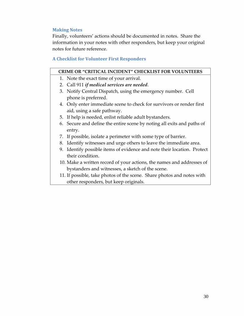
Making Notes
Finally, volunteers’ actions should be documented in notes. Share the
information in your notes with other responders, but keep your original
notes for future reference.
A Checklist for Volunteer First Responders
CRIME OR “CRITICAL INCIDENT” CHECKLIST FOR VOLUNTEERS
1. Note the exact time of your arrival.
2. Call 911 if medical services are needed.
3. Notify Central Dispatch, using the emergency number. Cell
phone is preferred.
4. Only enter immediate scene to check for survivors or render first
aid, using a safe pathway.
5. If help is needed, enlist reliable adult bystanders.
6. Secure and define the entire scene by noting all exits and paths of
entry.
7. If possible, isolate a perimeter with some type of barrier.
8. Identify witnesses and urge others to leave the immediate area.
9. Identify possible items of evidence and note their location. Protect
their condition.
10. Make a written record of your actions, the names and addresses of
bystanders and witnesses, a sketch of the scene.
11. If possible, take photos of the scene. Share photos and notes with
other responders, but keep originals.
31
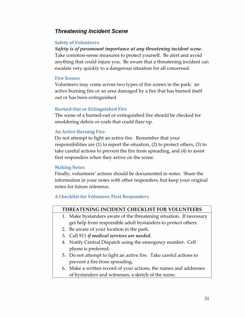
Threatening Incident Scene
Safety of Volunteers
Safety is of paramount importance at any threatening incident scene.
Take common-sense measures to protect yourself. Be alert and avoid
anything that could injure you. Be aware that a threatening incident can
escalate very quickly to a dangerous situation for all concerned.
Fire Scenes
Volunteers may come across two types of fire scenes in the park: an
active burning fire or an area damaged by a fire that has burned itself
out or has been extinguished
Burned-Out or Extinguished Fire
The scene of a burned-out or extinguished fire should be checked for
smoldering debris or coals that could flare up.
An Active Burning Fire
Do not attempt to fight an active fire. Remember that your
responsibilities are (1) to report the situation, (2) to protect others, (3) to
take careful actions to prevent the fire from spreading, and (4) to assist
first responders when they arrive on the scene.
Making Notes
Finally, volunteers’ actions should be documented in notes. Share the
information in your notes with other responders, but keep your original
notes for future reference.
A Checklist for Volunteer First Responders
THREATENING INCIDENT CHECKLIST FOR VOLUNTEERS
1. Make bystanders aware of the threatening situation. If necessary
get help from responsible adult bystanders to protect others.
2. Be aware of your location in the park.
3. Call 911 if medical services are needed.
4. Notify Central Dispatch using the emergency number. Cell
phone is preferred.
5. Do not attempt to fight an active fire. Take careful actions to
prevent a fire from spreading.
6. Make a written record of your actions, the names and addresses
of bystanders and witnesses, a sketch of the scene.

32
Weather Emergencies
Safety of Volunteers
Take common-sense measures to protect yourself. Be alert and avoid
anything that could injure you. Be aware that a threatening incident can
escalate very quickly to a dangerous situation for all concerned.
Monitoring the Weather
The National Weather Service, private forecasters, newspapers, radio
and television normally try to alert the public to potential weather
dangers ahead of time. Often, forecasters begin issuing bulletins on
hurricanes and winter storms three or four days before the storm hits.
But forecasters can't issue alerts for the danger of severe thunderstorms,
tornadoes and flash floods that far ahead. Usually, the Storm Prediction
Center sends out alerts the day before dangerous weather is likely. Most
television weathercasters highlight these alerts on the evening news the
day before threatening weather.
Severe Weather Watches
A watch means conditions are right for dangerous weather. In other
words, a "watch" means watch out for what the weather could do and
be ready to act.
For events that come and go quickly, such as severe
thunderstorms, tornadoes or flash floods, a watch means that the
odds are good for the dangerous weather, but it's not yet
happening.
For longer-lived events, such as hurricanes or winter storms, a
watch means that the storm isn't an immediate threat.
For either kind of event, a watch means you should keep up with
the weather and be ready to act.
When a severe thunderstorm, tornado or flash flood watch is in effect, it
means you should watch the sky for signs of dangerous weather.
Sometimes a severe thunderstorm, tornado or flash flood happens so
quickly that warnings can't be issued in time. Many areas don't have
civil-defense sirens or other warning methods. People who live near
streams that quickly reach flood levels should be ready to flee at the first
signs of a flash flood.
Hurricane or winter storm watches mean it's time to prepare by
stocking up on emergency supplies and making sure you know what to

33
do if a warning is issued. For those who live near the ocean, a hurricane
watch may mean it's time to prepare for evacuation.
Severe Weather Warnings
A warning means that the dangerous weather is threatening the area.
For severe thunderstorms, tornadoes and flash floods, a warning means
the event is occurring. Since tornadoes are small - a half-mile wide
tornado is considered huge - a tornado will miss many more buildings
than it hits in the area warned.
Still, a tornado warning means be ready to take shelter immediately if
there are any indications a tornado is approaching. Severe
thunderstorms are larger, maybe 10 or 15 miles across.
A hurricane warning means either evacuate or move to safe shelter.
A winter storm warning means it's not safe to venture out. If traveling,
head for the nearest shelter.
NOAA Weather Radio All Hazards (NWR)
NWR is a nationwide network of radio stations broadcasting continuous
weather information directly from the nearest National Weather Service
office. NWR broadcasts official Weather Service warnings, watches,
forecasts and other hazard information 24 hours a day, 7 days a week.
Working with the Federal Communication Commission's (FCC)
Emergency Alert System, NWR is an "All Hazards" radio network,
making it a single source for comprehensive weather and emergency
information. In conjunction with Federal, State, and Local Emergency
Managers and other public officials, NWR also broadcasts warning and
post-event information for all types of hazards – including natural (such
as earthquakes or avalanches), environmental (such as chemical releases
or oil spills), and public safety (such as AMBER alerts or 911 telephone
outages).
Known as the "Voice of NOAA's National Weather Service," NWR is
provided as a public service by the National Oceanic and Atmospheric
Administration (NOAA), part of the Department of Commerce. NWR
includes more than 985 transmitters, covering all 50 states, adjacent
coastal waters, Puerto Rico, the U.S. Virgin Islands, and the U.S. Pacific

34
Territories. NWR requires a special radio receiver or scanner capable of
picking up the signal. Broadcasts are found in the VHF public service
band at these seven frequencies (MHz):
162.400 162.425 162.450 162.475 162.500 162.525 162.550
Monitoring NOAA Weather Radio in the Park
The new Motorola XTS-5000 digital radios issued by the Park Service in
2008 have Channel 5 set up as a weather monitoring channel. You can
monitor NOAA Weather Radio broadcasts by switching your radio to
Channel 5. Channel 5 allows you to monitor (listen) only. Remember to
set the radio back to its original channel setting in order to
communicate.

35
Advice and Information
for Park Visitors
A Reference Guide for Volunteers

36
Advice for All Park Visitors
Everyone who serves as a volunteer at the park performs a valuable service, to
the Park Service and to the park’s visitors, by communicating this common-sense
advice to all the visitors they encounter:
Obey park rules.
The park is U.S. Government property, and federal law governs its safe use
and stewardship. Regulations are posted throughout the park and
published on park maps and brochures. Law enforcement rangers patrol
the park regularly to assist visitors and to ensure that rules are complied
with.
Know where you are in the park.
Maps of the park are available at Visitor Centers and at many businesses in
towns adjacent to the park. Maps are also posted in the park. As you
travel along the towpath notice the milepost markers. Locks are also
numbered. Campsite names are shown on maps and on signs near those
sites.
Carry your cell phone.
Check your phone to be sure that it is charged and working properly. If
you are planning to be in the park often or for a long period of time, add
the park’s emergency phone number (866-677-6677) to your phone’s
dialing directory. Remember, this number is for emergencies only. Visitors
should also be aware that there are areas of the park where cellular
communication is unreliable.
Carry drinking water.
Water is available from pumps located at campsites. The Park Service tests
this water and, if it is not safe to drink, a lock is placed on the pump. A
tiny amount of iodine is added to pump water to insure its safety. This
may give the water a slight chemical taste.
Protect your pets.
Pets must be leashed while in the park. This rule is for the protection of all
visitors’ pets and park wildlife.

37
Watch the weather.
Tips for Cyclists:
Check your bike before you set out.
In the park bikes must be equipped with a bell, horn, or other
sound-making device to be used when approaching and passing
others on the towpath.
Every cyclist should be carrying a tire patch kit and an air pump.
There is a 15 MPH speed limit on the towpath.
Cyclists must yield right-of-way to horseback riders and
pedestrians.
Helping Visitors Planning a Long-Distance Towpath Trip
With the joining of the Allegheny Highlands Trail to the canal towpath to form
the Great Allegheny Passage, cycling between Pittsburgh or Cumberland and
Washington, DC is becoming more popular every year. Good planning,
especially for first-time travelers, is critical to having a safe and enjoyable long-
distance trip. Here is a checklist for volunteers who encounter visitors planning
long-distance trips:
Decide when you want to make your trip.
Many youth groups plan their trips for the summer months when school
is not in session. Adults traveling alone or in small groups might prefer to
travel during the spring or fall.
Plan a “Daily Distance” to cover.
The towpath is about 185 miles long. Cyclists who want to make the
entire trip usually plan in terms of how many miles per day they want to
cover:
30 miles per day = a 6-day trip
45 miles per day = a 4-day trip
60 miles per day = a 3-day trip
Allow time for side trips and sightseeing.
The C&O Canal Towpath is in the center of an area that is rich in history,
scenery, and recreational opportunities. Make visitors aware of the other
national park sites that can be accessed from the canal towpath.
Allow plenty of time to plan your trip.
Use the Internet.
Call ahead to Park Service Visitor Centers along the route of your

38
trip to check on trail conditions and get information on local
attractions or accommodations.
Free maps, brochures and advice are available at Park Service
Visitor Centers, local bike shops and outdoor clubs.
Know where and how you are going to spend nights during your trip.
If you are planning to camp in the park that will affect the “daily
distance” you will need to cover. Have alternatives in mind in case of bad
weather. There are plenty of motels and B&Bs outside the park, but you
will need advance reservations, especially during the summer months.
Know what you are going to do when you reach your destination.
If Washington, DC, is your destination you will find that accommodations
are very expensive and, during the summer months, they may be limited
in number. Consider staying outside the city or being picked up by
friends or relatives after you arrive.
Be aware of hazards and detours along the towpath.
During the 2009 park season there are two detours in effect that force
visitors off the towpath temporarily. Visitors traveling in these areas must
be prepared to walk or cycle over local roads with vehicular traffic.
Eastbound (Traveling Downstream) Detours
Milepost Landmark
90.9 Opequon Junction Hiker/Biker
88.1 McMahon’s Mill – Begin Detour
Charles Mill Road > Right onto Delinger Road > Right onto
Dam #4 Road (MD 632). (Left onto Dam #4 Road will take
visitors to Downsville, MD in about 1 mile. Downsville has
a small deli/convenience store.)
84.4 Exit Dam #4 Road, Rejoin Canal Towpath – End Detour
82.5 Big Woods Hiker/Biker Campsite
14.4 Great Falls Tavern, Lock 20

39
Westbound (Traveling Upstream) Detours
Milepost Landmark
11.4 Sign for Marsden Tract Day Use Area
14.4 Great Falls Tavern, Lock 20
82.5 Big Woods Hiker/Biker Campsite
84.4 Exit towpath onto Dam #4 Road (MD 632) – Begin Detour
Left onto Delinger Road > Left onto Charles Mill Road.
(Continuing on Dam #4 Road will take visitors to
Downsville, MD in about 1 mile. Downsville has a small
deli/ convenience store.)
88.1 McMahon’s Mill – End Detour
90.9 Opequon Junction Hiker/Biker
Plan to carry plenty of drinking water.
Water is available from pumps located at park campsites. The Park
Service tests this water and, if it is not safe to drink, a lock is placed on the
pump. A tiny amount of iodine is added to pump water to insure its
safety. This may give the water a slight chemical taste.
Train for your trip.
Pedaling a bicycle fully loaded with food and equipment 30 miles a day or
more is a strenuous activity. Be sure you are physically ready, and then
load your bike with all the gear you expect to take and take a short
practice ride.
Review and follow all the suggestions in “Advice for All Park Visitors”,
above.
Check your bike before you set out.
In the park bikes must be equipped with a bell, horn, or other
sound-making device to be used when approaching and passing
others on the towpath.
Every cyclist should be carrying a tire patch kit and an air pump.
There is a 15 MPH speed limit on the towpath.
Yield right-of-way to horseback riders and pedestrians.

40
Frequently-Asked Questions about the C&O Canal
Why was the canal built?
To provide transportation by water for the commercial development of
the Potomac River valley
Did You Know?
The Great Falls of the Potomac River is the second largest in the state of
Maryland. It is a series of cascading falls. Water drops 76 feet in two-
thirds of a mile. Natural hazards in the Potomac such as waterfalls and
rapids created the need for canals for reliable water transportation.
When was construction started?
On July 4, 1828 Construction was begun with the first spadeful of earth
turned by President John Quincy Adams at Little Falls, Lock #5, 5 miles
from Georgetown.
When was the canal completed?
The canal was completed and dedicated at Cumberland, MD, on October
10, 1850.
What was the cost of the canal?
The canal cost almost $12 million, not including interest costs on loans.
How many people comprised the labor force?
At the height of construction activity, 4,000 workmen were employed.
How long and deep is the canal?
The canal is 184.5 miles long and generally 6 feet deep.
How wide is the Canal?
The canal is 60 to 80 feet wide, depending upon the section.
How wide is the towpath?
The towpath was originally 12 feet wide, now 7 feet in some areas.
What is the gain in elevation?
From Georgetown to Cumberland the canal climbs 605 feet.
How many locks are on the Canal?
There are 74 lift locks over the length of the canal.

41
What are the dimensions of the locks?
Locks were 100 feet long; 14 feet wide; 16 feet deep
What was the average number of feet that lift locks raised a canal boat?
A boat was raised approximately 8 feet at each lift lock.
How long did it take to “lock through?”
Approximately 10 minutes
What was the size of the boats?
Canal boats were 90 feet long with a 125 ton capacity.
Did You Know?
Most freight boats on the C&O Canal were approximately 95 feet long and
14.5 feet wide, while most locks were 100 feet long and 15 feet wide. This
gave boat captains little margin for error as they steered their boats into
the locks, trying to avoid the $5.00 fine for damaging lock masonry.
How big was the family’s cabin on the boat?
The family’s cabin was 12 x 12 feet.
How many dams were built along the Canal?
Seven dams were built along the canal.
How many aqueducts and culverts were built along the Canal?
Eleven aqueducts and over 160 culverts were built along the canal.
Did You Know?
Aqueducts are water-filled bridges. Aqueducts carried the canal and boat
traffic over major waterways, like rivers. Of the 11 aqueducts built along
the canal, the Monocacy Aqueduct is the longest at 516 feet, its seven
arches constructed mainly of stone quarried from nearby Sugarloaf
Mountain.
What are the dimensions of the Paw Paw Tunnel?
3,118 feet long; 27 feet wide; 24.5 feet high
How long did it take to construct the tunnel?
Building the tunnel took from 1836-1850, 14 years total, with 8-9 years of
actual construction, at an average of 1 foot per day

42
Did You Know?
The Paw Paw Tunnel is 3,118 feet long and is lined with over six million
bricks. The 3/4 mile long tunnel saved the canal builders almost six miles
of construction along the Paw Paw bends of the Potomac River. It took
twelve years to build and was only wide enough for single lane traffic.
The Paw Paw Tunnel is the second largest canal tunnel ever built.
What were the years of canal operation?
The canal was in operation from 1850-1924.
How long was the journey down the Canal?
The journey averaged 7 days, working 18 hours per day.
How many trips did a boat take per year?
A boat averaged 15-20 trips per year.
What months was the canal in operation?
The canal was in operation from the end of March to December – then
drained for the winter.
How much coal did a boat haul per trip?
About 100 – 120 tons
How much money did a boat make per trip?
$25 for a 100–ton haul
When was the peak year of the Canal?
1871 with 850,000 tons of coal transported
How many boats operated on the Canal?
800 during peak operating years
What were salaries like for canal company employees?
Locktenders: $100 per year to $75 per month (with a house and garden)
Boat Captains: $0.40 per ton to Georgetown
Laborers: $10 to $20 per month, with poor food, housing, and medical
care.
How many mules worked on the Canal?
2000 during the canal’s peak years
43
What was the speed limit on the Canal?
4 miles per hour
How long is the towline?
35 yards or about 100 feet long
A mule is a cross between what two animals?
A female horse and a male donkey
How many mules needed per boat?
2 sets of 2 to 3 mules
How long did the mules work before they needed a break?
6 hours
Did You Know?
A mule is a hybrid animal, a mix of a female horse (a mare) and a male
donkey (a jack). Remember, "M" for mom, "M" for mare and "D" for dad,
"D" for donkey. Switching the parents will produce a hinny – an animal
that more closely resembles a horse. The mule is the superior work
animal, preferred by canal boat captains.
Frequently Asked Questions about the C&O Canal National Historical Park:
When did the government acquire the Canal?
1938
When did the Canal become a national park?
1971
How many acres does the Park Service own?
Approximately 12,000 acres
What is the condition of the Canal today?
Much intact; undergoing restoration and stabilization in areas

44
Other National Park Service Sites that are Accessible from the C&O Canal:
The C&O Canal National Historical Park is one of many sites administered by
the National Park Service and making up the Park Service’s Capital District.
Other sites that are easily accessible from the C&O Canal towpath include:
Antietam National Battlefield and Cemetery:
http://www.nps.gov/anti/
Clara Barton National Historic Site:
http://www.nps.gov/clba/
Glen Echo Park:
http://www.nps.gov/glec/
Great Falls Park:
http://www.nps.gov/grfa/
Harpers Ferry National Historical Park
http://www.nps.gov/hafe/
Potomac Heritage Trail:
http://www.nps.gov/pohe/
Theodore Roosevelt Island:
http://www.nps.gov/this/
National park sites in the city of Washington, D.C., include the National Mall,
White House, Washington Monument, Lincoln Memorial, Thomas Jefferson
Memorial, Vietnam Veterans Memorial, Korean War Veterans Memorial,
National Law Enforcement Memorial, Mary McLeod Bethune Memorial, Ford's
Theatre and the House Where Lincoln Died National Historic Site, Frederick
Douglass National Historic Site.

45
Communication Guide for
Volunteers

46
Communication for Volunteers
Preferred Method of Communication
The Park Service prefers that volunteers use their personal cell phones to
communicate while on duty. If you do not have your cell phone with you
when you go on duty, you may sign out a Park Service radio or cell phone at
your local Visitor Center.
Communication Training for Volunteers:
New volunteers will receive training in use of Park Service radios and cell
phones. Refresher training for volunteers who feel they need it should be
conducted early in the park season.
It is every volunteer’s responsibility to (1) be able to communicate from the
field using either radio or cell phone, and (2) inform Park Service staff if they
need further communication training.
Communication by Cell Phone
Volunteers’ Personal Cell Phones:
If you use a personal cell phone while on duty as a volunteer, be sure that you
add the following numbers to your phone’s dialing directory:
Central Dispatch (Non-Emergency) (301)714-2235
Central Dispatch (Emergency Only) (866)677-6677
Your Local Park Service Visitor Center:
Georgetown Visitor Center (202)653-5190
Great Falls Visitor Center (301)767-3714
Brunswick Visitor Center (301)834-7100
Williamsport Visitor Center (301)582-0813
Hancock Visitor Center (301)678-5463
Cumberland Visitor Center (301)722-8226
Park Service’s Cell Phones:
If you do not have a cell phone, or do not have your phone with you, you may
sign out a Park Service cell phone at your local Visitor Center. Before going on
duty check to see that the cell phone is charged and is working properly. Do
not change any of the phone’s settings or its dialing directory. After
completing your volunteer duty return the phone and place it in a charger,

47
ready for the next volunteer to use.
Cell Phone Use in the Field:
The major cell phone service providers expand their coverage areas and
improve the reliability of their service every year. However, there are several
areas of the park where cell phones do not work or where cellular service is
unreliable. Volunteers should try out their phones in areas of the park that
they frequent and know where their particular phones will and will not work.
If you are riding a bicycle in the park, stop and dismount before answering or
calling on your cell phone.
Cell Phone Use in Emergencies:
Use a cell phone, rather than a radio, to discuss details of a situation that has
resulted in fatalities or injuries.
Communication by Radio
Radio communication throughout the park relies on a network of handheld
portable radios and repeaters feeding into the Park Service’s National Capital
Region All-Risk Communication Center at Park Headquarters. The center’s
radio call sign is “Central.”
Volunteers should use radio only (1) to report serious or emergency situations
to Central, or (2) to report themselves on- or off-duty when they have no other
means of communication.
Radio Spoken-Usage Conventions- Communicating Time by Radio:
In order to avoid errors, time of day is stated in radio transmissions in 24-hour
or “military” time. This system makes no distinction between “A.M.” and
“P.M.” times. The 24-hour or military clock begins each day at midnight, or
0000 hours. On the park’s radio network, 8:00 AM is stated as “zero eight
hundred hours”. Noon is stated as “twelve hundred hours”, and 12:30 PM is
stated as “twelve thirty hours”, and written “1230”. Once noon has occurred,
the 24-hour time system simply continues to count hours:
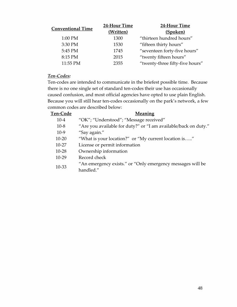
48
Conventional Time
24-Hour Time
(Written)
24-Hour Time
(Spoken)
1:00 PM 1300 “thirteen hundred hours”
3:30 PM 1530 “fifteen thirty hours”
5:45 PM 1745 “seventeen forty-five hours”
8:15 PM 2015 “twenty fifteen hours”
11:55 PM 2355 “twenty-three fifty-five hours”
Ten-Codes:
Ten-codes are intended to communicate in the briefest possible time. Because
there is no one single set of standard ten-codes their use has occasionally
caused confusion, and most official agencies have opted to use plain English.
Because you will still hear ten-codes occasionally on the park’s network, a few
common codes are described below:
Ten-Code Meaning
10-4 “OK”; “Understood”; “Message received”
10-8 “Are you available for duty?” or “I am available/back on duty.”
10-9 “Say again.”
10-20 “What is your location?” or “My current location is<..”
10-27 License or permit information
10-28 Ownership information
10-29 Record check
10-33
“An emergency exists.” or “Only emergency messages will be
handled.”

49
Phonetic Alphabet:
Occasionally, when it is necessary to communicate alphabetic information like
the spelling of a person’s name, words should be spelled out phonetically.
Following is the standard phonetic alphabet endorsed by the Association of
Public-Safety Communications Officials (APCO) which should be used on the
park’s radio network:
Letter Phonetic Letter Phonetic Letter Phonetic
A Adam J John S Sam
B Boy K King T Tom
C Charles L Lincoln U Union
D David M Mary V Victor
E Edward N Nora W William
F Frank O Ocean X X-ray
G George P Paul Y Young
H Henry Q Queen Z Zebra
I Ida R Robert
Handheld Radios and Repeaters:
A repeater is a radio transceiver that receives input signals from the low-power
portable radios in its coverage area, and then repeats those signals at higher
power so that they can be heard over long distances. In order to communicate
with its nearest repeater, a handheld radio has to be set to the correct channel.
During the spring of 2008, the Park Service issued new Motorola XTS-5000
digital handheld radios. Before attempting to use your radio be sure that it is
set to the proper channel:
Channel Repeater Coverage Area
1 Lamb’s Knoll (South
Mountain)
White’s Ferry to Sideling Hill
2 Maderia School Georgetown to White’s Ferry
3 Cacapon State Park Sideling Hill toward Cumberland
4 Irons Mountain Cumberland Area
5 (None) NOAA Weather Channel
6 (None) Line-of-Sight Communication
7 (None) Line-of-Sight Communication

50
Motorola XTS-5000 Handheld Radio:
The Motorola 5000 Series Mobile (vehicular) Radio and the Motorola XTS-5000
portable radio are the new primary radios for the park. The new radio
network is digital rather than analog. Radio users should be able to hear
transmissions clearly, without the static noise that the analog network had.
Pre-Operation Checks for Handheld Radios:
Figure 1.
XTS-5000 Controls
1. Holding the radio as in the picture,
turn the radio on by rotating the
On/Off/Volume knob (top of radio,
left-hand side) clockwise.
2. If necessary, move the concentric
switch (top of radio, middle) from
the clear circle to the circle with
the line through it.
3. Note that both the ABC switch and
Emergency button on top of the
radio have NOT been activated.
The radio will function properly
regardless of what letter (A, B, or
C) it is set on. Pushing the orange
emergency button will do nothing.
4. If necessary, set the radio to the
correct channel (See Section 3.2,
above.)
5. Visually inspect the radio to see
that the battery is installed
properly.
6. If you are ready to communicate with Central, step outside. The radio is
activated with the oval-shaped Push-To-Talk (PTT) switch on its left-hand
side.
51
Protecting a Radio:
When signing out a handheld radio, check that the radio’s battery is charged
and installed properly on the radio.
If you hear a beeping sound from your radio, the battery power is low
and you will need to change the battery or get a different radio.
Do not remove the battery from a radio while the radio is turned on.
Portable radios should be carried clipped to your belt or inside a radio
carrying case fastened to your belt. Do not carry them in pants or jacket
pockets.
Radio Use in the Field – Good Radio Practices:
Observe these common-sense rules for radio use in the field:
If you are riding a bicycle, stop and dismount before using a radio.
Before transmitting, listen for 2-3 seconds to make sure that there is no
incident in progress, or someone else is not transmitting a message.
Make sure the transmit switch is fully depressed and pause for 2-3
seconds before speaking. Hold the radio close but not touching the
mouth. Speak in a normal tone of voice; don’t shout. When finished
speaking, hold the transmit button for another 2-3 seconds to make sure
your entire message was transmitted.
Keep all transmissions brief and to the point. If subject matter is
extensive, broadcast the essential information by radio and call the rest
of the information in by phone later.
The radio system is for emergency and official massages only. Do not
make unnecessary or unidentified transmissions. An example of such
unnecessary traffic is asking someone to meet you for lunch.
Terminology such as “Five by Five”, “Good Buddy”, “Over and out”,
“Roger” and other CB/Ham/Military radio procedures are not
authorized. Limit use of Ten Codes, except “10-4” which means
“Okay” or “I understand” and the few other 10-codes specified in this
guide. Use plain English in all radio transmissions.
Do not use profane, indecent, or obscene language on the radio.
Do not cause unlawful or malicious interference with any other radio
communication, such as recorded sounds of music. Horseplay is not

52
only unprofessional but dangerous to others.
It is unlawful to intercept and use or publish the contents of any radio
message without the expressed permission of the park.
The park radio system is monitored by other agencies and the public.
Be professional in all radio messages and do not transmit sensitive
information such as phone numbers, names of injured people, or other
such information unless there is no alternative.
Volunteers need to monitor their radios and be aware of what is going on in
other areas of the park. At times, there are on-going incidents that need to
take priority over normal radio traffic. Examples are when law enforcement
rangers are in contact with subjects, or conducting vehicle stops. If your radio
message is normal or routine (checking in or out for Bike Patrol members),
hold your traffic until the ranger clears from their vehicle stop or contact. You
may then proceed with your transmission.
Transmitting and Receiving Messages:
To begin a radio message, first identify the person/station you are calling, then
yourself, using proper radio call signs.
In this example a volunteer is reporting on-duty by radio, since he does not
have a cell phone:
Transmission: “Central; 592 Thompson”
Reply: “Central”
Transmission: “592 Thompson. At Spring Gap. Beginning bike patrol
downstream.”
Reply: “10-4. 1330 hours.”
Later, the same volunteer reports completion of his patrol:
Transmission: “Central; 592 Thompson”
Reply: “Central”
Transmission: “592 Thompson. At Paw Paw. Bike patrol complete.”
Reply: “10-4. 1645 hours.”
If two volunteers were riding together, they would check in as follows:
Transmission: “Central; 592 Smith”
Reply: “Central”
Transmission: “592 Smith and Thompson. At Town Creek. Beginning
53
Bike Patrol upstream.”
Reply: “10-4. 1330 hours.”
Occasionally Central will not be able to hear a unit clearly, and will ask for
retransmission this way :
Transmission: “Central; 592 Johnson”
Reply: “Unit calling Central…”
Transmission: “Central; 592 Johnson. “
Reply: “Go ahead.”
When an error is made in transmission, use the word “correction”, as follows :
Transmission: “Central; 591 Brown”
Reply: “Central”
Transmission: Central; 591 Brown and Smith. 10-8 Williamsport VC,
patrolling Cumberland to Four Locks. Correction.
Williamsport to Four Locks.
Reply: “10-4. 1135 hours”
Monitoring NOAA Weather Forecasts and Alerts:
To monitor NOAA weather forecasts and alerts, switch your XTS-5000 radio
to channel 5. If a severe weather watch or warning is being broadcast, take
action to protect yourself and park visitors you may encounter.
Radio Use in Emergencies:
During emergencies, remain calm when speaking over a radio. Seconds
count, and having someone ask you to repeat your transmission takes
precious time that could cost lives.
When carrying a radio in the field, two kinds of emergencies might occur:
Central Dispatch might declare an emergency situation or you might be
involved in an emergency and need to communicate it with a dispatcher.
Central Dispatch Declares an Emergency:
At times, Central may declare a “10-33” or “Emergency” over the radio. This
10-code will be used when there is an immediate threat to someone’s life. All
radio traffic will halt except for those personnel taking part in the incident.
Not until Communications advises that the “10-33” has been lifted should you
transmit, unless you have a life-threatening emergency.
For most incidents where there is no immediate threat to life, Central may
advise using radio courtesy. Radio courtesy means to refrain from broad-

54
casting most radio traffic. For volunteers, this means to hold your radio traffic
until Central advises radio courtesy has been lifted, unless you have a life-
threatening emergency.
Reporting an Emergency by Radio:
Use radio only to report an emergency, i.e. sick or injured person, crime,
wildfire, or a sick/injured animal that is a threat to people. Report mainten-
ance problems and sick/injured animals that are not a threat to people by cell
phone to Central or in person to Visitor Center personnel at the end of your
patrol. If you have Internet access, report problems you observed to the
CHOH Hazard In-Box at [email protected]
Serious incident reporting by radio:
Transmission: “Central; 591 Johnson”
Reply: “Central”
Transmission: “591 Johnson. I have a person with an ankle injury
needing medical attention at Milepost 108.”
Reply: “591 Johnson; Central. 10-4. Will dispatch ranger and
ambulance to your location.”
In the event of a life threatening emergency, use “10-33 Emergency” or
“Emergency” to get an emergency response.
. Correcting Transmission Problems:
If you have trouble transmitting or receiving radio messages, try the following
procedures:
Change location. Sometimes moving only 2 or 3 feet has an effect on
radio transmission.
Change channels.
If another park employee or volunteer advises they can hear you, ask
them to relay your message to the person you were calling.

55
Problem Areas for Radio Communication:
Even if your radio is working properly, there are several areas of the park
where handheld radios might not work properly:
Area Vicinity of Milepost
Mather Gorge 13.50
Edward’s Ferry 31.84
Warmwater area 40.44
Weverton area 58.01
Pleasantville area 62.50
Dargan Bend 64.89
Mountain Lock 66.95
McCoy’s Ferry 110.43
Licking Creek area 116.05
Hancock 124.10
Pearre 136.22
Cumberland 184.50
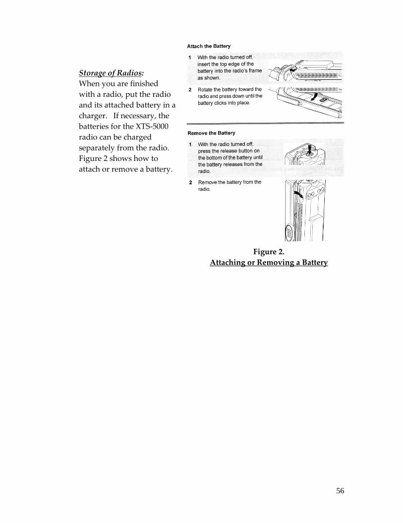
56
Storage of Radios:
When you are finished
with a radio, put the radio
and its attached battery in a
charger. If necessary, the
batteries for the XTS-5000
radio can be charged
separately from the radio.
Figure 2 shows how to
attach or remove a battery.
Figure 2.
Attaching or Removing a Battery

57
Internet Resources and E-mail Communication
Park Website:
http://www.nps.gov/choh/.htm
Safety Hazard Reporting System:
http://www.nps.gov/choh/safetyhazardsreportingsystem.htm
Through the C & O Canal National Historical Park’s Safety Hazard Reporting
System (HAZARDS) visitors and volunteers can quickly and conveniently
report safety hazards through email. The HAZARDS system uses a special
address to accept incoming reports and then forwards them to the Park Safety
Officer and appropriate staff members.
To report a safety hazard use the CHOH HAZARDS link above or address an
email to ʺ[email protected]ʺ. In the subject line enter the number of
the milepost immediately downstream from the safety hazard. For example, if
you encountered a downed tree just upstream from White’s Ferry (mile 35.5),
you would type ʺabove mile marker 35ʺ or ʺbetween mile marker 35 and 36ʺ,
in the subject heading of your email. In the body of the message describe the
hazard and any pertinent information. In this case, you might write in the
body of the message, ʺOn April 12, I encountered a downed tree, 24 inches in
diameter, across the towpath just upstream from the road leading to White’s
Ferry.ʺ
Every report will be reviewed when received. The Safety Officer will contact
the appropriate staff persons to ensure they have also received the report. The
hazard will then be stabilized or resolved depending on the nature of the
hazard and the scope of the remedy.
You are encouraged to provide contact information in the body of your email
in case more information is needed to locate and/or fix the problem. As the
park addresses your report, you will be kept apprised of the actions to
stabilize or mitigate the hazard.
If you encounter any problems with the HAZARDS reporting system and need
assistance, contact a Park Service employee.
58
Communication and Reporting by E-mail:
If you do not check out at a Visitor Center at the end of your volunteer duty
you should report promptly to the Park Service ranger responsible for your
area. This is an example of a Bike Patrol report submitted by e-mail:
PATROL DATE (MM/DD/YY): 04/22/09
BEGAN (TIME – LOCATION): 9:30AM – Canal Place, Cumberland
COMPLETED (TIME – LOCATION): 1:15PM – Canal Place, Cumberland
VISITOR CONTACTS: 9
REMARKS:
Cumberland North Branch Cumberland
Trash bag dispensers at Evitts Creek and North Branch are empty.
TOWPATH CONDITIONS (HAZARDS ENCOUNTERED):
Towpath clear and dry.
59
Appendices
C&O Canal National Historical Park Districts and Sub-Districts:
Division of Visitor Protection:
Mile 0 to Mile 72.8 - Palisades District
o Mile 0 to Mile 4.72 is located within the District of Columbia
o Mile 4.72 to Mile 42 is located within Montgomery County, MD
o Mile 42 to Mile 58 is located within Frederick County, MD
o Mile 58 to Mile 72.8 is located within Washington County, MD
Mile 72.8 to Mile 184.5 - Western Maryland District
o Mile 72.8 to Mile 124.0, Williamsport Sub-District, Washington
County, MD
o Mile 124.0 to Mile 156.2, Hancock Sub-District, Washington
County, MD
o Mile 156.2 to Mile 184.5, Cumberland Sub-District, Allegany
County, MD
Maintenance Division:
Mile 0 to Mile 22.8 - Palisades District (Great Falls)
Mile 22.8 to Mile 64 – Monocacy District (Pleasantville Shop)
Mile 64 to Mile 106 – Conococheague District (Williamsport
Maintenance)
Mile 106 to 141 – Four Locks District (Hancock Maintenance)
Mile 141 to Mile 184.5 – Paw Paw District (Oldtown Maintenance)
C&O Canal NHP Radio Call Signs:
National Capital Region All Risk Communication Center,
Hagerstown, MD
Radio Call Sign: “Central”
Telephone Numbers: 301-714-2235 (business line)
1-866-677-6677 (emergency line)
The Center dispatches by radio for the following parks:
o Antietam NB
o Catoctin Mountain Park
o C&O Canal NHP
o Harpers Ferry NHP
o Manassas NBP
o Monocacy NB
o Prince William Forest Park

60
The Center provides non-radio communications for the following parks:
o Appalachian National Scenic Trail
o Fort McHenry NM & HS
o Hampton NHS
The Center provides alarm monitoring for National Park Units/Sites in the
National Capital Region and for several parks/sites East of the Mississippi
River.
The Center dispatches firefighters and other NPS personnel from all the
NCR Parks to fires and other emergency incidents anywhere inside the
United States.
Volunteer Group Call signs:
Volunteer group members use a radio call sign that is a three-digit number
followed by the volunteer’s last name. The following numbers are volunteer
call sign prefixes:
531 Palisades District Bike Patrol
532 Billy Goat Trail Stewards
591 Western Maryland (Ferry Hill – Allegany County Line)
Bike Patrol
592 Cumberland Sub-District (Allegany County)
Bike Patrol Sub-district is preferred (capitalize the second word only
when it would normally be capitalized i.e. Pan-American). But choose
one and make it consistent throughout.
C&O Canal NHP, Division of Visitor Protection Call Signs:
District/Sub-district Title Name
500 Chief Ranger Brad Clawson
510 Palisades District District Ranger (Vacant)
521 Palisades District Elizabeth Shuster
522 Palisades District Brad Sones
523 Palisades District Nathan Hurley
524 Palisades District Margaret Anderson
525 Palisades District (Vacant)
541 Palisades District Alex Negron
542 Palisades District Joshua Cunningham
543 Palisades District Darius Jones
544 Palisades District (Vacant)
550 Western Maryland District District Ranger Leigh Zahm
61
551 Western Maryland District Lead Ranger Martin Gallery
560 Williamsport Sub-District Dan Johnson
565 Williamsport Sub-District Michael Clarke
570 Hancock Sub-District Dan Albus
575 Hancock Sub-District Phil Amoroso
580 Cumberland Sub-District Matt Huelskamp
585 Cumberland Sub-District Brandon Brown
C&O Canal NHP, Maintenance Division Call Signs:
District/Sub-district Title Name
300 Chief of Maintenance Bradley Hofe
310 Supervisor Larry Umberger
340 Monocacy District Supervisor (Vacant)
350 Conococheague District Supervisor Ron Bricker
370 Four Locks District Supervisor Nathan Hurley
390 Paw Paw District Supervisor Glen Gossert

62
C&O CANAL NHP
EMPLOYEE OFFICE PHONE & RADIO LIST
EFFECTIVE 8/17/09
ALBUS, Dan Park Ranger LE 722-0544 585
ALT, Keith Administrative Technician 678-5548 371
ANDERSON, Kyle Trails Coordinator 767-3736 108
ASTARB, Randall Engineering Technician 745-5819 309
BAKER, Fred Motor Vehicle Operator 413-0719 324
BARKER, Scott Mason 592-1071 356
BARNHOUSE, Charles Maintenance Mechanic
Supervisor
432-5164 340
BALTRUS, Alyssa Supervisory Park Ranger 491-24521 410
BEARD, Mary Dispatcher 714-2235 927
BELL, Scott NRM Program Director 714-2224 801
BISHOP, John Equipment Operator 582-1071 357
BRANDT, KEVIN Superintendent 714-2202 100
BRICKER, Ron Maintenance Mechanic
Supervisor
582-1070 350
BROWN, Brandon Park Ranger LE 678-5795 575
BRUZA, Jennifer Assistant Volunteer
Coordinator
739-6914 107
BUCHANAN, Elizabeth Visitor Use Assistant 767-3722 518
BYERS, Matt Laborer 582-1071 3127
CAMPELLO, Tony Information Technology
Specialist
714-2206 N/A
CARLSTROM, Brian Deputy Superintendent 714-2200 101
CARR, Jay Maintenance Mechanic Leader 767-3723 330
CARR, Michelle Dispatcher 714-2225 924
CARROLL, Jerry Mason 582-1071 369
CARTER, Michelle Biologist 714-2225 805
CHAMBERS, Adam Laborer 432-5164 348
CLARKE, Michael Park Ranger LE 582-0126 565
CLAWSON, Beth Park Guide 582-0813 453
CLAWSON, Brad Chief Ranger 714-2222 500
CLEARY, Sharon Assistant Superintendent &
Administrative Officer
714-2204 102
CLINE, Ted Park Guide 722-8226 466
COOK, Eugene Maintenance Worker 767-3704 326
COONS, Kelli Administration Technician 582-1071 351
COOPER, Willie Plumber 767-3705 334
COPENHAVER, Daniel Civil Engineer 745-5818 302
COXE, David Visitor Use Assistance (Fee) 767-3722 516
CROUSE, Brittany Park Ranger 582-1285 552
1 Cell Phone

63
CUNNINGHAM,
Joshua
Park Ranger LE 491-62792 510
CUTLIP, Dave Carpenter 582-1071 360
CYHANICK, Mark Cartographic Technician 714-2231 806
De La FUENTE,
Manuel
Dispatcher 714-2235 923
DITTMAN, Lisa Park Ranger 582-0813 451
EDWARDS, Mark Park Ranger 767-3714 414
FAHRNEY, Ronald Carpenter 582-1071 362
FILER, Daniel Volunteer Coordinator 714-2218 106
FISHER, Keshia Maintenance Worker 678-5548 382
FLORO, Lori Dispatcher 714-2235 922
GALLERY, David IT Program Manager 745-5801 111
GALLERY, Martin Park Ranger LE 582-1285 551
GASKIN, Jason Park Ranger LE 767-3718 524
GAUL, Curt Supervisory Park Ranger 582-0813 450
GAUL, Peggie YCC Crew Leader 491-17433 817
GIFFIN, Michael Motor Vehicle Operator 432-5164 344
GILLIAM, Michelle GIS Intern 714-2211 811
GLENNY, Nathan Park Ranger (LE) 722-0544 581
GOERNER, Megan Park Guide 582-0813 454
GOSSERT, Glen Maintenance Mechanic
Supervisor
478-5519 390
GRAY, Karen VIP Librarian 714-2220 N/A
GRIM, Terrie Budget Analyst 714-2205 N/A
GUELL, Sam Park Guide 582-0813 452
HADY, Andrew Park Ranger 722-0544 582
HAGEN, Harry Park Ranger 491-24584 412
HAGER, Emily Park Guide 722-8226 468
HARRIS, Stew Park Guide 722-8226 469
HASKETT, Kristie Contract Specialist 714-2212 N/A
HEWITT, Emily Park Guide 582-0813 462
HITCHCOCK, John Special Use Coordinator 745-5817 803
HIXON, Brian Motor Vehicle Operator 582-1071 364
HIXON, David Maintenance Mechanic 678-5548 370
HOFE, Bradley Chief of Maintenance 714-2239 300
HOOE Jr., David Engineering Equipment
Operator
582-1071 353
HOUDERSHELDT,
Tom
Administrative Technician 714-2215 N/A
HOUGH, Nancy Management Analyst 714-2207 N/A
HUELSKAMP, Matt Park Ranger LE 722-0543 580
2 Cell Phone
3 Cell Phone
4 Cell Phone
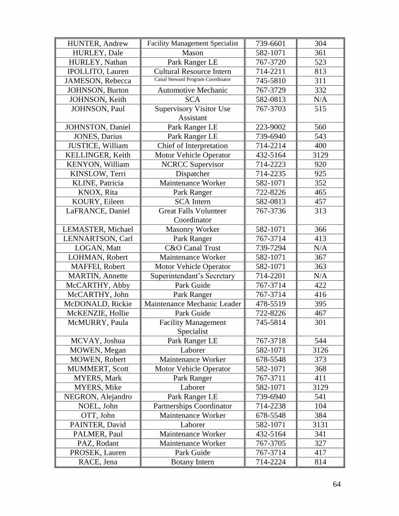
64
HUNTER, Andrew Facility Management Specialist 739-6601 304
HURLEY, Dale Mason 582-1071 361
HURLEY, Nathan Park Ranger LE 767-3720 523
IPOLLITO, Lauren Cultural Resource Intern 714-2211 813
JAMESON, Rebecca Canal Steward Program Coordinator 745-5810 311
JOHNSON, Burton Automotive Mechanic 767-3729 332
JOHNSON, Keith SCA 582-0813 N/A
JOHNSON, Paul Supervisory Visitor Use
Assistant
767-3703 515
JOHNSTON, Daniel Park Ranger LE 223-9002 560
JONES, Darius Park Ranger LE 739-6940 543
JUSTICE, William Chief of Interpretation 714-2214 400
KELLINGER, Keith Motor Vehicle Operator 432-5164 3129
KENYON, William NCRCC Supervisor 714-2223 920
KINSLOW, Terri Dispatcher 714-2235 925
KLINE, Patricia Maintenance Worker 582-1071 352
KNOX, Rita Park Ranger 722-8226 465
KOURY, Eileen SCA Intern 582-0813 457
LaFRANCE, Daniel Great Falls Volunteer
Coordinator
767-3736 313
LEMASTER, Michael Masonry Worker 582-1071 366
LENNARTSON, Carl Park Ranger 767-3714 413
LOGAN, Matt C&O Canal Trust 739-7294 N/A
LOHMAN, Robert Maintenance Worker 582-1071 367
MAFFEI, Robert Motor Vehicle Operator 582-1071 363
MARTIN, Annette Superintendant’s Secretary 714-2201 N/A
McCARTHY, Abby Park Guide 767-3714 422
McCARTHY, John Park Ranger 767-3714 416
McDONALD, Rickie Maintenance Mechanic Leader 478-5519 395
McKENZIE, Hollie Park Guide 722-8226 467
McMURRY, Paula Facility Management
Specialist
745-5814 301
MCVAY, Joshua Park Ranger LE 767-3718 544
MOWEN, Megan Laborer 582-1071 3126
MOWEN, Robert Maintenance Worker 678-5548 373
MUMMERT, Scott Motor Vehicle Operator 582-1071 368
MYERS, Mark Park Ranger 767-3711 411
MYERS, Mike Laborer 582-1071 3129
NEGRON, Alejandro Park Ranger LE 739-6940 541
NOEL, John Partnerships Coordinator 714-2238 104
OTT, John Maintenance Worker 678-5548 384
PAINTER, David Laborer 582-1071 3131
PALMER, Paul Maintenance Worker 432-5164 341
PAZ, Rodant Maintenance Worker 767-3705 327
PROSEK, Lauren Park Guide 767-3714 417
RACE, Jena Botany Intern 714-2224 814

65
REYNOLDS, Matt Park Ranger 582-1285 553
RITZ, Michael Laborer 678-5548 383
SAYLOR, Rodney Maintenance Mechanic Leader 432-5164 345
SCHNEIDER, Sydney Park Guide 678-5463 461
SCHUSTER, Elizabeth Park Ranger LE 767-3728 521
SECORD, Shawna SCA Intern 582-0813 456
SEIBERT, Mike Exhibit Specialist 714-2217 303
SHIFLER, Cameron Laborer 432-5164 349
SHIFLER, Zach Laborer 432-5164 3130
SIDERAS, Paul Park Guide 767-3714 418
SMILEY, Vanessa Park Guide 767-3714 419
SONES, Brad Park Ranger LE 739-6940 522
SPINRAD, William Lands Coordinator 714-2221 804
STOTTLEMYER, T.J. Engineering Technician 714-2216 307
STUBBS, Chris Chief, NRM & CRM 714-2210 800
SUITER, Geoff Park Ranger 767-3714 415
SUTPHIN, Wade Engineer Equipment Operator 767-3705 312
TAMBURRO, Sam Cultural Resources Program
Manager
714-2211 810
TROUCHE, Timothy Park Ranger 722-0544 583
TUCKER, Richard Motor Vehicle Operator 767-3704 336
UMBERGER, Larry Maintenance Mechanic
Supervisor
767-3705 310
UNGER, Dennis Maintenance Mechanic 678-5548 377
VIET, Mike Park Guide 767-3714 424
VILLALOBOS, Mike Park Guide 767-3714 423
WARRENFELTZ,
Jenna
C&O Canal Trust 714-2233 N/A
WEST, Ralph Motor Vehicle Operator 432-5164 347
WIGFIELD, Lynne Compliance Officer 745-5802 809
WILLIAMSON, Blair Lead Dispatcher 714-2235 921
WILSON, Ahna Historian 714-2236 802
WINSLOW, Andrew Park Ranger LE 739-6940 542
WITTE, Ty Maintenance Worker 767-3704 338
WORK, Justin Park Guide 582-0813 463
YOUNGER, Mildred Motor Vehicle Operator 478-5519 391
ZAHM, Leigh Park Ranger LE 745-5815 550
C&O Canal NHP
Great Falls District Revised 2/16/08
(Area Code 301)
RANGER ACTIVITIES
Audix (Phone Service) 767-3730
Boat Staff Work Station 767-3707

66
Carderock/Marsden Reservations 767-3731
Entrance Station 767-3722
Exercise Room (Ranger Station) 767-3721
Fax Machine (LE Rangers) 413-2660
Fax Machine (Visitor Center) 767-3733
Fee Office Computer Room 767-3734
Mail/Copier Room (E-House) 767-3717
Phone Room (E-House) 767-3716
Reception Area (E-House) 767-3727
VISITOR PROTECTION DIVISION
ANDERSON, Margaret Park Ranger LE 767-3718
BUCHANAN, Elizabeth Visitor Use Assistant 767-3722
JOHNSON, PAUL Fee Supervisor 767-3703
HURLEY, Nathan Park Ranger LE 767-3720
SCHUSTER, Elizabeth Park Ranger LE 767-3728
SONES, Brad Park Ranger LE 767-3721
THIBAULT, Mike Visitor Use Assistant 767-3722
MAINTENANCE DIVISION
Break room 767-3725
Fax Machine 413-0984
CARR, Jay Maintenance Mechanic Leader 767-3723
JOHNSON, Burt Mechanic 767-3729
UMBERGER, Larry Maintenance Mech. Supervisor 767-3705
VISITOR SERVICES DIVISION
Computer/Radio Room 767-3710
Eastern National Office 767-3708
Library 767-3706
Lunch Room 767-3713
Staff/Conference Room 767-3707
Visitor Center Desk 767-3714
BALTRUS, Alyssa Supervisory Park Ranger 491-24525
HAGEN, Harry Park Ranger 491-24586
MYERS, Mark Park Ranger 767-3711
Chesapeake Ohio Canal National Historical Park - Important Phone Numbers
Great Falls Tavern 301-767-3714
5 Cell Phone
6 Cell Phone

67
If you need further assistance, contact:
Aly Baltrus (Supervisory Park Ranger) 301-491-2452

68
Bike Patrol Handbook
for Volunteers

69
The C&O Canal NHP Volunteer Bike Patrol –
A Brief History
The C&O Canal NHP Volunteer Bike Patrol was started in 1999. The idea for the
bike patrol actually came from another national park with a canal, Cuyahoga
Valley, which had great success utilizing a volunteer bike patrol.
The C&O Canal NHP Volunteer Bike Patrol started with a hearty group of 8
members, and has grown since then to over 150 members. The Bike Patrol
consists of local volunteer groups in four districts: Georgetown, Great Falls,
Williamsport, and Cumberland. Bike Patrol activities are coordinated by a Park
Service Ranger at the local visitor center in each district.
Mission of the Bike Patrol
The Bike Patrol is comprised of members of the community working with C&O
Canal National Historical Park to provide a professional presence along the
towpath and thus enhance visitors’ time spent in the park. Members patrol the
canal on bicycles and offer information to visitors, answer questions, report
hazards, and serve as resource protection stewards. Bike Patrol Volunteers are
highly visible and are often visitors’ most easily-approached park
representatives.

70
JOB DESCRIPTION: BIKE PATROL VOLUNTEER
Position: Bike Patrol Volunteer
Time Commitment: 40 hours per year is requested
Bike Patrol members will assist park operations by:
• Providing information and informal interpretation about the park’s
history and its natural resources to visitors.
• Providing efficient and courteous service to park visitors.
• Addressing minor regulatory issues (e.g., children cycling without
helmets) by informing visitors of park regulations. Patrol members do not
enforce park regulations.
• Responding to first-aid requests for assistance and first-aid emergencies.
• Providing or assisting with basic bicycle repairs.
• Relaying visitor comments and concerns to park staff.
• Alerting park staff to potential problems and hazards on the towpath.
• Assisting Law Enforcement personnel only at the request of said
personnel.
Benefits to Bike Patrol volunteers:
• Personal enrichment and experience while working in a national park
setting.
• Active involvement in the preservation and enhancement of the park’s
resources.
• Experience in communicating with people of diverse cultures.
• Continual training to improve knowledge of the resource, sharpen skills,
and increase effectiveness in serving park visitors.
• Building relationships with staff members, visitors, and other volunteers.

71
Knowledge and skills desired in Bike Patrol volunteers:
• Excellent communication and inter-personal skills.
• Ability to use a two-way radio according to NPS standards.
• Ability to successfully complete first-aid and CPR training courses and
willingness to provide aid to visitors.
• Ability to work outdoors for up to 4 hours, occasionally in inclement
weather.
• Ability to learn basic bike maintenance and repair skills and provide
repair assistance to visitors.
• Willingness to learn and provide knowledge of the local area, the park,
and other resources of interest to visitors.
• Ability to demonstrate skill in the safe operation of a bicycle as well as
knowledge of and compliance with park and local bicycle regulations.
Mandatory Training for Bike Patrol volunteers:
• Park Orientation/Intro to Bike Patrol
• Adult CPR and First-Aid
Bike Patrol Members will be expected to own and use on duty:
• Their own bicycle in safe operating condition and equipped with all
locally-required safety equipment. (The Park Service requires that
bicycles used in the park be equipped with an audible warning device.
Additionally, a tire pump, personal water bottle and portable light will all
be needed while on duty in the park.)
• Their own bicycle helmet and any other personal protective gear or
clothing in good condition.
Bike Patrol Members will also be expected to:
• Provide up-to-date emergency phone contact information to their Bike
Patrol Sub-District Coordinator annually, at the beginning of a season,
and as changes occur thereafter. This information is provided to
“Central” (the National Capital Region Communication Center
(NCRCC)), the park’s dispatch center located at park headquarters in
Hagerstown, MD to be used in the event a member is injured, missing, or
fails to report in at the end of a shift.

72
CONDUCTING BIKE PATROLS
Before Your Patrol Begins:
Bike Patrol shifts will be a suggested tour of from 1 to 4 hours.
It is preferred that Bike Patrol members check in at the start of their patrol and
check out at the end of their patrol at a local Park Service Visitor Center.
Members will report to duty by signing in a log, where their date and time on-
and off-duty, as well as various statistics required by the Park Service are
recorded. If you do not complete your patrol at a Visitor Center, please e-
maila report to your area Bike Patrol Coordinator as soon as possible after
completing your patrol. Coordinators are required to report these statistics to
the Park Service on a timely basis.
Here’s a Good Practice:
If you check-in at a Visitor Center, use this opportunity to communicate with
the Park Service staff. Here are some common-sense questions to ask someone
on duty at the Visitor Center before you set out on the towpath:
Is there anything special going on in the park today that I should be
aware of?
Is Law Enforcement on duty in our area today?
Is there an area of the towpath that I should pay special attention to
today?
Is there an area of the towpath that I should avoid?
In addition to filling out paperwork, tell someone where you are going and
about what time you expect to return.
The Park Service will supply the following equipment, which must be signed
out and carried by Bike Patrol Members while on-duty:
Communications equipment (either a radio or a cell phone for
volunteers who do not have a personal cell phone)
First-aid kit
Bike and tire repair tools and supplies
Park literature
At Great Falls there is a rope throw bag to be carried
Park-supplied cell phones are available on a first-come-first-served basis for
bike patrol members who do not have a personal cell phone. Please do not

73
take a park cell phone if you have a personal cell phone. The park’s phone is
property of the NPS and must be cared for in the same manner as a park radio.
If you carry a Park Service phone, please use it only for communicating with
park staff. No personal calls are allowed.
More information on communications is found in Communication Guide for
Volunteers, a Reference Guide which is included as an attachment to this
handbook.
Another Good Practice…
Check your equipment and supplies before you leave the Visitor Center, and
be sure to do the following:
Check your radio or cell phone to be sure that it is turned on, has power,
and is working properly.
If you are carrying a cell phone (your own or the Park Service’s) write
down your cell phone number on your check-in form(s).
Check your first-aid supplies and bike repair tools.
Have one or more copies of a park map and of the park Visitors’ Guide
with you.
Carry some blank paper and a pen or pencil.
Be sure that your water bottle is full.
Check your own bike and its equipment before you set out.
Visitors reasonably expect that Bike Patrol members comply with the park’s
rules for bikes ridden on the towpath. Paragraph 4.2 of this handbook is a pre-
ride checklist for Bike Patrol members.
Check In With “Central”.
Whether they have checked in at the local Visitor Center or not, Bike Patrol
members must check in and check out from the field by communicating with
“Central” (the National Capital Region Communication Center (NCRCC)), the
park’s dispatch center located at park headquarters in Hagerstown, MD.
Routine telephonic communication, like checking-in and checking-out,
between Bike Patrol Members and Central must use Central’s non-emergency
number: (301)714-2235.

74
Carrying Your Own Cell Phone?
If you use a personal cell phone while on Bike Patrol be sure that you have the
following numbers in your phone’s dialing directory:
Central Dispatch (Non-Emergency) (301)714-2235
Central Dispatch (Emergency Only) (866)677-6677
Your Local Park Service Visitor Center:
Georgetown Visitor Center (202)653-5190
Great Falls Visitor Center (301)767-3714
Brunswick Visitor Center (301)834-7100
Williamsport Visitor Center (301)582-0813
Hancock Visitor Center (301)678-5463
Cumberland Visitor Center (301)722-8226
PATROLLING THE TOWPATH
Professional Appearance for Bike Patrol Members:
Bike Patrol members are required to wear their helmet and the Park Service’s
identifying vest while on patrol. Because the Bike Patrol represents the NPS,
members’ dress must be professional and appropriate.
A sound-producing device is required on member’s bikes.
Riding in Pairs or Riding Solo:
The Park Service prefers that Bike Patrol members ride in pairs. However, it is
understood that schedules are sometimes not conducive to riding with
someone else, so you may ride solo if there are no other options. Please keep
the following items in mind when riding solo:
Notify Central Dispatch that you will be riding solo when you check in.
Note which direction you will be traveling. If you are going on a longer
ride, it is recommended that you check in after being out a couple of
hours.
Solo riders must be at least 18 years old.
A cell phone or park radio must be carried at all times.
Solo riders will only make visitor services and interpretive contacts.
They will not contact persons violating regulations (dogs off leash,
illegal activity, etc.) unless they are specifically trained in these types of
contacts and are comfortable in doing so.

75
Know where you are on the towpath.
Use trailheads, mile markers, towpath features like locks and aqueducts,
and road or trail crossings to orient yourself.
Be prepared to identify where you are if you need to contact Central
(dispatch). Be exact about your location and, if you need help, it will
arrive faster.
While on patrol, expect to ride slower than usual, and to stop more often.
Make contacts with visitors coming in both directions.
Stop at busy roadway crossings or parking lots.
Pay special attention to the park’s many parking lots and campsites.
Be approachable. Remember you are out there to make visitor contacts
and help people.
Extra Attention to Campers:
If you notice that a campground is occupied, turn off the towpath and
ride through the campground. Campers often have questions, and
people camping alone are generally glad to know someone is checking
on their well-being.
Other Duties for Bike Patrol Members:
Great Falls Bike Patrol members may be requested by the fee staff or by Central
to assist when the parking lot at Great Falls is full. When such a request is
received, report to the Fee Booth for instructions. Members will assist at the
front gate on MacArthur Boulevard and will patrol the lot and notify fee staff
of the current capacity of the lot.
MAKING CONTACTS, INFORMAL INTERPRETATION
See the Reference Guide, Advice and Information for Park Visitors, which is
enclosed with this handbook, for more information including answers to
questions that visitors commonly ask.
Do not enforce laws and regulations.
If you see major violations, report them immediately to Central. Do not try to
intervene, follow, or stop someone from leaving. Report the incident including
location, description of people involved, and direction they were heading.
Remember, you are the eyes and ears of the park, not law enforcement rangers.
Examples of incidents to report include:

76
Alcohol and drug use
Weapons
Indecent exposure
Dogs running loose
Vandalism
Assault and battery
Irrational behavior
Vehicle accidents
Visitor Complaints:
Undoubtedly, during the course of the year, you will encounter unhappy or
angry visitors. There is much you can do on your part to defuse the situation.
However, if you ever feel someone is threatening you or another’s personal
safety, immediately remove yourself from the situation and call Dispatch.
Here are some helpful suggestions:
Smile, greet visitors.
Always treat everyone with courtesy and respect.
Listen. This is an under‐rated skill. Just letting people vent and say
what they need to say can often calm them down. Strive to be a good
listener, without interrupting or dismissing what they are saying. Try
not to get defensive. Open your ears, close your mouth and listen until
they are completely done.
Agree with them. You might say something like “I understand why you
feel frustrated,” or “I understand why you feel that way.” It’s important
for people to have their feelings validated.
Problem. Identify the problem. What is it that they want? Find out what
would make them feel better.
Solve. Solve the problem. Perhaps it’s something simple – like they need
a map, or a place to get a drink. Often the simplest things make people
feel better.
Responding to Emergencies and Critical Incidents:
A Bike Patrol member may be the first person on the scene of an emergency or
critical incident in the park. Bike Patrol members have training and equipment
to deal with most situations they encounter. A “critical incident”, however, is
a serious accident, a crime, or an as-yet-undefined similar incident that has
resulted in serious injury or death. A critical incident in the park calls for an
immediate emergency response by trained personnel.

77
See the reference guide Emergency Responses by Volunteers which is enclosed
with this handbook.
Contacts With Through Travelers:
Many of the contacts made by Bike Patrol members are with cyclists who are
traveling the length of the towpath, or otherwise spending several days and
camping overnight in the park. These visitors may contact you ahead of time
for help with planning their trip, or you may encounter them along the
towpath. The Reference Guide, Advice and Information for Park Visitors,
which is enclosed with this handbook, has information that will answer many
of the questions these visitors will ask.
Other Items to Note and Report:
During your patrol:
Record all first‐aid you provide.
o Take the person’s name, phone number, date of birth, and a brief
description of what happened and what kind of first aid you
provided.
o For serious injuries, contact Central (dispatch) immediately. If
you know you need an ambulance, let Central know this.
o Wait with visitor until help arrives.
Report Safety Hazards.
o Look for obstacles – Report to Central (dispatch) hazards that
need to be flagged and addressed immediately. Other hazards
may be reported via email to the park’s hazard reporting system
Report Damage to the Resource
o If you see evidence of vandalism or damage, note the location
and report it at the end of the shift.
o If you witness damage occurring, remove yourself from sight and
contact Central (dispatch).
o Handle all situations based on your experience, training, and
comfort level. Never, ever put yourself in harm’s way. Avoid
confrontations.
78
ENDING PATROLS AND REPORTING
Contact Central by cell phone or radio.
At the end of your ride, before you leave the park, contact Central. Give your
callsign, location, and report that you have completed your patrol. Failing to
check out with Central may initiate a follow-up by Law Enforcement to
determine your location or check on your well-being,
Other Items to Report:
When you check out at your local Visitor Center you will be expected to report
on these items regarding your completed bike patrol:
When and where your patrol began and ended.
The number of visitor contacts you made.
All first‐aid you provided.
Safety Hazards.
o Hazards may be reported via email to the park’s hazard
reporting system at [email protected].
Damage to the Resource.
Any other statistics the Park Service requests.
If you do not check out at a Visitor Center, you should report this information
to your local Sub-District Bike Patrol coordinator by e-mail.
Return Park Service supplies or equipment.
If you have used supplies, like a tire patch kit or first aid supplies,
during your patrol make someone at the Visitor Center aware of this.
Return Park Service cell phones or radios to their chargers so that they
will be ready for use by others.
Park Rules and Regulations
The park has rules and regulations designed to make the park a safe and
enjoyable place for visitors. Your job as a member of the Bike Patrol is to help
rangers by informing visitors of the rules of the park, not enforcing them. As
you ride the towpath, remind visitors in a courteous and friendly manner of
the park’s regulations. Remember that you represent the Park Service, and
being a good example is the best way to get others to follow. The purpose of
the Bike Patrol is to inform and educate visitors of park policy and rules, not
enforcement of these. The bike patrol is not “bike cops.” Members serve the
park best by staying out of danger and away from confrontational situations.

79
Safety of park volunteers is one of the highest priorities of the park.
Following is a summary of park rules and regulations that Bike Patrol
members should find helpful. More complete information is contained in the
Volunteer Reference Guide Compendium of Federal Regulations (2006) which
is enclosed with this handbook.
Helmets for cyclists. The State of Maryland requires helmets for
children under the age of 16. The park requires all Bike Patrol members
to wear helmets in order to set a good example for visitors.
Pets on leashes. Pet owners may need to be reminded that their pets
must be leashed while within park boundaries. The Park Service has a
reminder card which can be given to pet owners.
Cyclists keep to the right; pass on the left. Ride single file. Observe
15 MPH speed limit.
Cyclists yield right‐of‐way to all pedestrians, horses, and mules.
A good suggestion…
Horseback riding is a popular activity on the towpath. When you
are approached by a mounted rider, pull to the side and stop
until they have passed. Both the horse and rider will appreciate
your courtesy.
Don’t block the towpath – remind folks who have stopped to talk and
are blocking the towpath to please step to the side.
Walk bikes over aqueducts.
Trash‐free park. There are no trash receptacles available to visitors.
There are bag dispensers along the towpath so visitors may collect their
trash and carry it home. We recommend Bike Patrol members carry
extra bags to make available to visitors.
Communication for Bike Patrol Volunteers
See the Reference Guide, Communication Guide for Volunteers, which is
enclosed with this handbook for detailed instructions on communication while
on duty in the park.
Cell Phones are Preferred for Field Communication:
The Park Service prefers that Bike Patrol members use their personal cell
phones while on duty. If you do not have your cell phone with you when you
go on duty, you may sign out a Park Service radio or cell phone at your local
Visitor Center.

80
Communication Availability in the Park:
There are several areas of the park in which either cell phones or radios will
not work. With experience, you will become aware of these locations. Be
aware that in an emergency you or a bystander may need to change location in
order to communicate with Central or with first responders.
Communication Training for Bike Patrol Members:
New volunteers in the Bike Patrol will receive training in the use of Park
Service radios and cell phones. Refresher training for volunteers who feel they
need it should be conducted early in the park season.
It is every volunteer’s responsibility to (1) be able to communicate from the
field using either radio or cell phone, and (2) inform Park Service staff if they
need further training.
Bicycle Maintenance and Repairs
Before Cycling Season Begins:
During March and early April, Bike Patrol groups hold their preseason
meetings and training sessions. This is also the time that Bike Patrol members
should be getting a preseason tune-up for their bikes. Bike shops located near
the canal welcome Bike Patrol members as customers, and some give
discounts on services or purchases. Another reason to have your bike checked
out at a shop at least once a year is that your local bike mechanic has tools and
equipment available to him that very few of us have at home.
Included in this handbook is a Preseason Bike Maintenance Checklist, which
you can use yourself or take with you to your local bike shop.
Before Cycling in the Park:
Before setting out check your bike and your personal gear, as well as the tools
and equipment that you will need to assist other cyclists on the towpath:
Check your bike and personal gear:
Before setting out on the towpath all cyclists should make these checks:
Tires inflated to correct pressure
Seat and handlebars aligned correctly and secure
Chain and sprockets clean and lubricated
Gears shifting smoothly

81
Brakes grip wheel rims firmly without noise
Clothing and safety gear:
o Helmet and gloves
o Clothing for inclement weather
o Water bottle full and secure on frame
o Flashlight or installed bicycle light
Check your bike repair toolkit:
In addition to the checks suggested above, Bike Patrol members should check
their park-supplied bike repair tools and supplies:
Tire patch kit(s)
Screwdrivers
o Standard (slotted), 1/8” and ¾”
o Phillips, small- and medium-sized
Wrenches
o An adjustable wrench or vise-grip pliers
o Allen wrenches, standard 1/8” to 3/8” or 4 to 8 millimeters
Air pump and/or CO2 tire inflator
Tire leavers
Chain tool
In addition to the items supplied by the Park Service, these other items might
be useful on patrol:
A good Swiss Army-type knife
Since you must remove a wheel in order to repair a flat tire, you must
have a way to support a bike’s frame while you are making repairs to
the wheel. Carry a 6 to 8-foot piece of rope so you can lash a bike
frame to a support, like a tree, signpost or fencepost with one wheel far
enough off the ground so that you can remove it.
A clean piece of sturdy plastic or nylon cloth, about 3x3 feet, to lay
wheels or parts on while you are making repairs.
If your air pump does not fit both Schrader and Presta valves, an
adapter nut for Presta valves can be purchased at a bike shop.
Assisting Cyclists in the Park:
If you encounter a cyclist who is repairing a bike or walking a disabled bike
along the towpath, the first thing to do is simply to ask if your help is needed.
Maybe all a visitor needs is your help in making a phone call, or some advice
on how to make a particular repair. Some visitors in this situation might
simply ask you to “hang out” with them until they have finished their repairs.
A cyclist may need the loan of a tool or may not have a patch kit to fix a flat

82
tire. Just be aware that there are many ways you can help without making
repairs yourself.
Repairing a Flat Tire in the Field:
Flat tires are the most common problem that disables bikes on the towpath.
You should feel confident that you can repair a flat, either your own or
someone else’s. Here are general steps to repair a flat tire in the field:
Remove the flat tire, inner tube and wheel:
1. Deflate the inner tube completely.
2. If the flat is on the rear wheel, turn the crank by hand and shift to the
smallest cog on both the cassette and chain ring.
3. Release the brakes, if possible, to get the space necessary to remove the
wheel.
4. Loosen wheel nuts, open quick-release levers and, on rear wheels
equipped with a derailleur, depress the derailleur to release chain
tension and remove the wheel from the bike’s frame.
5. Using bicycle tire levers, unhook one side of the tire bead from the
wheel.
6. Start at a point opposite the valve and remove the inner tube from the
tire.
7. Inspect the valve to see if it is the reason for the flat. If the valve is
defective or damaged, the tube will have to be replaced.
8. Inspect the edges of the rim and the inside of the tire looking for any
sharp object that caused the flat.
Follow instructions which should be included with your patch kit to patch
the deflated inner tube.
Using a boot: If there is a hole in the tire casing that is bigger than the head
of a straight pin, you should repair the tire to prevent the tube from
squeezing through the hole and bursting. A “boot” can be made from duct
tape, a scrap of denim, a tire patch, or a folded dollar bill. Place the boot
over the hole on the inside the tire before you reinstall the tube.
Replace the inner tube and remount the tire:
1. Slightly inflate the patched inner tube.
2. Insert the tube into the tire so that the valve stem is aligned with the
label on the tire.
3. Working with the tire and tube as a unit, insert the valve stem into the
hole in the wheel, and work one side (bead) of the tire onto the wheel.

83
4. If you must use a tool to flip the tire onto the rim, be careful not to cut
the tube. Adjust the tube so that it is not pinched between the tire
casing and the wheel rim, and so that the valve stem is perpendicular to
the wheel rim.
5. Starting at a point opposite the valve stem, mount the other side (bead)
of the tire onto the wheel. Check to make sure that the tube is inside the
tire.
6. Inflate the tire to about 30 psi and check to be sure that it is holding air
and that the tire is aligned properly on the wheel.
Remount the wheel on the frame:
1. Remount the wheel on the frame and tighten the wheel nuts. If you
have repaired a rear tire, thread the chain through the sprockets and
check that the shifter is working properly.
2. Reinflate the tire to the pressure range shown on its sidewall. Check
again to be sure that it is holding air.
3. If you released a brake to remove the wheel, be very sure that you
reconnect the brake mechanism. Test the brake to be sure that it is
working properly.
Bike Repair Training:
Cycling is increasing in popularity and there are several bike shops in
communities along the canal. Bike shop owners often help the Park Service by
teaching informal classes in bike repair for Bike Patrol members.
The best place to learn basic bike repairs is at home. If you have never
repaired a flat tire, for example, practice on an old inner tube, which you can
get from another Bike Patrol member if you do not have one of your own.

Page 84 of 142 – Billy Goat Trail Stewards Manual (Rev. Feb 2010)
2010 Billy Goat Trail Stewards Manual
Welcome to the volunteer corps of the National Park Service and The Nature Conservancy, and thank you for becoming a Trail Steward! The Trail Steward program is designed to train and support volunteers who can pass on Leave No Trace messages and educate and protect visitors to the trails, particularly the Billy Goat Trail on Bear Island, in the Great Falls area of the Chesapeake and Ohio (“C&O”) Canal National Historic Park. The C&O Canal NHP Billy Goat Trail Steward Program was started in 2004 by the Potomac Appalachian Trail Club, The Nature Conservancy, and park staff. REI awarded a $2,000 conservation grant to the PATC, the volunteer organization that maintains the Billy Goat Trail, to support the training and outfitting of ten volunteer trail stewards. An estimated 50,000 hikers use the 1.7 mile trail each year, and our role is to help ensure that the visitors are safe, educated, and prepared to protect this resource as they enjoy their experience on this trail or others in the area. The Potomac Gorge, from Great Falls to Georgetown, is one of the most biologically significant natural areas in the eastern United States. The park is home to more than 400 recorded occurrences of 200 rare species and many globally rare plant communities. Over 60 rare plants are found on Bear Island alone, and the entire 90-acre area is globally rare plant habitat. The popularity of the Billy Goat Trail has led to overcrowding, eroded trails, off-trail use, and trampling of the plant species of Bear Island. The Billy Trail Steward Program was created under the park’s Interpretation Division as an education program for visitors. Trail Stewards educate hikers on the ecology of the island and the need for Leave No Trace ethics. They also remind visitors that pets are banned on the island and the hike is strenuous. Trail Stewards also report emergencies to park staff. Trail Stewards do not enforce park regulations and are not expected to do so. They are encouraged to avoid conflicts with visitors and may choose not to remind visitors of laws on the trails, but are encouraged to report violations to the park.

Page 85 of 142 – Billy Goat Trail Stewards Manual (Rev. Feb 2010)
JOB DESCRIPTION
Position: Billy Goat Trail Steward Time Commitment: 40 hours per year is requested Billy Goat Trail Stewards will assist park operations by: Providing information and informal interpretation about the park’s history and its
natural resources to visitors. Providing efficient and courteous service to park visitors. Addressing minor regulatory issues by informing visitors of park regulations.
Volunteers do not enforce park regulations. Responding to basic first-aid and first-aid emergencies. Providing Leave No Trace education. Leading LNT educational hikes for organized groups Relaying visitor comments and concerns to park staff. Alerting park staff to potential problems and hazards on the trails and towpath. Assisting Law Enforcement personnel only at the request of said personnel.
Benefits to Billy Goat Trail Steward volunteer: Personal enrichment and experience while working in a national park setting. Involvement in the preservation and enhancement of the park’s resources. Experience in communicating with people of diverse cultures. Continual training to improve knowledge of the resource, sharpen skills and increase
effectiveness along the trail. Build relationships with staff members, visitors, and other volunteers
Qualifications, Knowledge & Skills Desired: Excellent communication and inter-personal skills. Use of a cell phone for emergency reporting according to NPS standards. Ability to pass first-aid and CPR (optional) and willingness to provide aid to visitors. Ability to work outdoors for up to 4 hours under strenuous conditions, occasionally in
inclement weather, while carrying a 10 to 20 pound day pack. Ability to learn and provide Leave No Trace ethics. Willingness to learn and provide knowledge of local area, park, and resources. Volunteers must be 16 years of age or older. Volunteers 16-17 years old must be
accompanied with a volunteer over 18 years old or with park staff. Mandatory Training: Billy Goat Trail Steward Training.

Page 86 of 142 – Billy Goat Trail Stewards Manual (Rev. Feb 2010)
EMERGENCY PROCEDURES
There are separate telephone numbers below for emergencies and for non-emergencies. If you or someone else needs immediate help, call the emergency numbers as listed. Do not put yourself in danger to try to help someone else, but remain at the scene to meet emergency personnel and to help direct them. To report illegal activity, note the location, get away from the activity, and then call the Park Dispatch at the numbers listed below. What might count as an emergency:
You or another person has been injured and needs an ambulance or medical help. You or another person have become trapped in a dangerous situation. Any situation where life or limb is in danger. You are being threatened by another person or by an animal. Incident that needs response by law enforcement, including injured animals.
Reportable illegal activity:
Alcohol and drug use. Fights and loud arguments. Weapons. Indecent exposure. Illegal camping. Property damage. Swimming in the river or canal. Aggressive dogs or dog biting. (If you or another person is bitten by a dog, call
Central and/or U.S. Park Police. Be sure to get the person’s contact info or ask them to remain until law enforcement arrives.
Telephone numbers: EMERGENCY: 1-866-677-6677 (Park Central Dispatch) From any phone: 911 Non-Emergency: 301-714-2235 Great Falls Tavern: 301-767-3714 Great Falls Fee Booth: 301-767-3722Great Falls Visitor Center: 301-767-3714 Park Headquarters: 301-739-4200 U.S. Park Police: 202-619-7300

Page 87 of 142 – Billy Goat Trail Stewards Manual (Rev. Feb 2010)
STANDARD PROCEDURES A Trail Steward usually will hike for 2 to 4 hours. A first-aid kit, park cell phone, and park literature are made available by the park and must be carried while on patrol. Your personal cell phone and first aid kit may be used in place of park cell phone and kit. Trail Stewards trained in their use may carry a radio. Trail Stewards are required to wear a Volunteer in the Park (“VIP”) hat and other NPS volunteer uniform items while on duty. You represent the National Park Service, so your dress must be professional and appropriate. 1. Check your gear before you leave the Visitor Center or volunteer trailer. Remember to: Inventory your first-aid supplies. Check your cell phone battery. Check you have enough water. Stock up on park maps, information cards, trash bags. Take interpretive materials, counters, and emergency numbers with you. Report for duty by contacting Central (non-emergency dispatch 301-714-2235 or, if
trained, by radio) and state your intended route. 2. Know where you are at all times. Use trailheads, Trail Markers 1, 2 or 3, canal mile markers, and lock numbers and trail
crossings to orient yourself. Be prepared to identify where you are if you need to contact Central (dispatch). Be
exact, and help will arrive faster. 3. Expect to hike more slowly than usual and to stop more often. Make contacts with visitors hiking in both directions. You may decide to stay at one of the three Billy Goat trailheads. Remember you are out there to make visitor contacts and help people. On very busy days, consider spending time at the traverse to direct traffic or turn back
people who are unable to follow the trail. Count the number of hikers you see on Section A of the Billy Goat using a counter and
record the number in the log book. 4. Offer alternative trail ideas. On crowded weekends, be prepared to share other trail alternatives to visitors wanting
a quieter experience. Inform visitors with dogs or visitors unprepared for the hike of alternate trails they may
use. Provide park visitors with trail maps.
5. Report all first-aid you provide.

Page 88 of 142 – Billy Goat Trail Stewards Manual (Rev. Feb 2010)
Take the person’s name, phone number, date of birth, and a brief description of what happened and what kind of first aid you provided.
For serious injuries, contact Central (dispatch) immediately. If you know you need an ambulance, let Central know this.
Wait with visitor until help arrives. 6. Report Safety Hazards. Look for obstacles such as downed trees and report to Central (non-emergency dispatch 301-714-2235) hazards that need to be flagged and addressed immediately. Other hazards may be reported via email to the park’s hazard reporting system at [email protected]. 7. Report Damage to the Resource If you see evidence of vandalism or damage, note the location and report it at the end of
your hike. If you witness damage occurring, remove yourself from sight and contact Central.
Handle all situations based on your experience, training, and comfort level. Never, ever
put yourself in harm’s way. Avoid confrontations. 8. Upon completion of your hike, fill out the logbook. Report that you are finished with your hike by contacting Central non-emergency dispatch at 301-714-2235 (or, if trained, by radio) when you are ready to leave the park. 9. Trail Stewards must provide up-to-date emergency phone contact information to the park volunteer coordinator. This information is provided to Central to use in the event Steward is injured, missing, or fails to report in at the end of a hike. Phone number changes must be submitted as soon as possible to the volunteer coordinator.

Page 89 of 142 – Billy Goat Trail Stewards Manual (Rev. Feb 2010)
SAFETY GENERALLY: When going out on your own, always tell someone where you are going and when you
expect to return. Call them upon your return so they do not worry unnecessarily. Bring another volunteer along—safety in numbers!
Carry a first aid kit.
Carry extra water, snacks, warm clothing, and raingear.
Wash your clothing after your hike in case you have contacted poison ivy.
Do not approach illegal activity or hostile persons. If you are concerned about your
safety, call the numbers above as appropriate. Take breaks, drink water and eat, and do not overexert yourself. Stop work if you are
feeling fatigued or strained. Wear long pants and long sleeves, when it is not too hot, to protect from poison ivy,
ticks, snake bites, and scratches. Do not stay out past dark and do not hike when lightning is nearby.
POISON IVY: Learn to recognize poison ivy growing as a groundcover and vine. Know the “fickle
finger of death” bud, the white berries, the three-part leaf, and the hairy climbing vine.
Wash with soap and water immediately if you think you have contacted poison ivy. Carry alcohol swabs to wipe your skin in the field if you have touched the plant.
Products called Tecnu and Ivy Block can be purchased at pharmacies and garden supply
stores and used to remove the plant oils as well.
Wash clothing after each field visit and wash gloves if they are made of cloth or washable fabrics.
Avoid wiping your face and eyes with work gloves—carry or wear a bandana to wipe
away sweat instead.
Some people are sensitive to toxins in other plants, always wear gloves when working. TICKS: Light colored clothing makes it easier to detect ticks.

Page 90 of 142 – Billy Goat Trail Stewards Manual (Rev. Feb 2010)
Check yourself regularly in the field for ticks, before getting into your car and
thoroughly when you get home. Wash clothing after each field visit.
Ticks can be active year-round, so be sure to check year-round.
Familiarize yourself with Lyme disease.
HIKING-RELATED HAZARDS: Personal strain and fatigue can result from travel on trails.
Travel carefully, watch where you put your feet, and avoid unstable slopes and slippery
areas. Watch for snakes, especially in sunny and rocky places—copperheads do inhabit the
Potomac Gorge—especially watch where you put your feet and hands. Your training will include additional information about these and other issues. If you have any questions, do not hesitate to ask experienced Trail Stewards, a volunteer coordinator or park staff. Billy Goat Trail Steward training consists of: (1) either a “full day workshop” or “Leave no Trace Principles”, “Interpretation 101”, & “Habitats” training sessions; (2) watch the film in the Visitor Center and look at the exhibits on the canal history; and (3) take at least 2 hikes on the Billy Goat with experienced Trail Stewards; and (4) a sit down with the Billy Goat Trail Steward volunteer coordinator.

Page 91 of 142 – Billy Goat Trail Stewards Manual (Rev. Feb 2010)
PARK RULES AND REGULATIONS The park has rules and regulations designed to make the park a safe and enjoyable place for visitors. Your job is to inform visitors of the rules and regulations in a courteous and helpful way, but not to enforce any of the park’s rules and policies. You are under no obligation to address anyone regarding compliance with any park regulation if you feel at all uncomfortable doing so. Remember that you represent the park, and being a good example is the best way to get others to follow. Volunteers serve the park best by staying out of danger. Pets:
Dogs must be on a 6-foot or shorter leash while within park boundaries.
No pets are allowed at all on Bear Island (including the Billy Goat Trail) or the Olmsted Island boardwalks.
Bicycle use:
Helmets. The State of Maryland requires helmets for children under the age of 16. (The park requires all Bike Patrollers to wear helmets, in order to set a good example for visitors.)
15-mph maximum speed limit on the Towpath.
Ride single file.
Walk bikes over aqueducts.
No swimming or ice skating in the Widewater area. No swimming or wading in the Potomac River or Canal. Trash-free park. There are no trash receptacles available to visitors. There are bag dispensers along the towpath so visitors may collect their trash and carry it home. We recommend Trail Stewards carry extra bags to make available to visitors. Do not enforce laws and regulations. If you see major violations, report them immediately to Central. Do not try to intervene, follow, or stop someone from leaving. Report the incident including location, description of people involved, and direction they were heading. Remember, you are the eyes and ears of the park, not law enforcement rangers. Examples of incidents to report include: Alcohol and drug use Weapons Indecent exposure Dogs running loose, acting aggressive or fighting, or bites Vandalism

Page 92 of 142 – Billy Goat Trail Stewards Manual (Rev. Feb 2010)
Assault and battery Irrational behavior Vehicle accident
The C&O NHP has a full set of regulations governing a wide variety of activities. Trail Stewards should try to become familiar with all the park regulations.
VISITOR COMPLAINTS Undoubtedly, during the course of the year, you will encounter unhappy or angry visitors. There is much you can do on your part to defuse the situation. However, if you ever feel someone is threatening you or another’s personal safety, immediately remove yourself from the situation and call Dispatch. Here are some helpful suggestions: Smile, greet visitors. Think about your body language (remove sunglasses and don’t
fold your arms when speaking to visitors). Always treat everyone with courtesy and respect.
Ask them to “help you” by following regulations.
Listen. This is an under-rated skill. Just letting people vent and say what they need to
say can often calm them down. Strive to be a good listener, without interrupting or dismissing what they are saying. Try not to get defensive. Open your ears, close your mouth and listen until they are completely done.
Agree with them. You might say something like “I understand why you feel frustrated,”
or “I understand why you feel that way.” It’s important for people to have their feelings validated.
Problem. Identify the problem. What is it that they want? Find out what would make
them feel better. Solve. Solve the problem. Perhaps it’s something simple – like they need a map, or a
place to get a drink. Often the simplest things make people feel better. Don’t be overbearing. Remember, people are out to enjoy their experience. Share
what you must for education, but expect that not every visitor will want to learn more.

Page 93 of 142 – Billy Goat Trail Stewards Manual (Rev. Feb 2010)
INTERPRETATION What is it? As Trail Steward volunteers you are working with the Division of Interpretation for the C&O Canal National Historical Park. Does that mean we are translating for people who speak foreign languages? No, we are interpreting the environment of the park so that visitors will gain a greater understanding and appreciation of the park. Interpreters have the job of communicating basic messages to the public:
o What are the special features of the park? o Why is C&O Canal NHP a national park? o What do I need to know so that I can enjoy this place without harming it?
These messages tend to fall into two groups: 1. Things the visitor is naturally curious about…. 2. Things we believe visitors should know…. Interpreters must fill both these needs. You must answer the questions of visitors, meeting their basic informational needs as they perceive them, and communicate resource concerns to them. Only when both these goals are achieved, are you successful. Successful interpretation will accomplish the following results in the minds of visitors:
o Orientation o Appreciation and understanding of natural resources o Learned skills – basic to understanding and appreciation. o Protection of resources/stewardship – resources are fragile and need protection. o Visitor safety
Key traits of a successful NPS interpreter:
o Appearance o Attitude o Personal safety o Approachability
Informal Interpretation/Roving So now that you know what interpretation is, what kind of interpretation will you be doing as Stewards? Roving rewards the park and visitors. Benefits to the park:
o Uniformed presence/image o Monitoring of resources o Reaches visitors who might not otherwise interact with NPS

Page 94 of 142 – Billy Goat Trail Stewards Manual (Rev. Feb 2010)
o Eyes and ears of the park o Provides increased knowledge, and understanding of visitor needs o Because it’s FUN!
Benefits to visitors:
o Provides welcome, orientation, and interpretation o Provides safety/security o Provides advocacy o Part of a national park experience
How to initiate roving or informal interpretation:
o Be friendly! o Assess and Approach – ask open open-ended questions? Where are you from?
Where are you heading today? o Carry props
PRIDE IN TRADITION The National Park Service and the Chesapeake & Ohio Canal National Historical Park have undergone many changes since their inception. However, the image of the Park Service as the steward of some of America’s most beautiful and unique landscapes and historic sites, has remained steadfast in the eyes of the world. Visitors, old and young, national and international, from all parts of the world revere America’s national parks and the people that work in them. Park Rangers are often viewed as an icon, and are photographed by visitors as part of their experience while visiting our parks. The NPS insignia, whether on the sleeve of a Ranger, an intern, or a volunteer is symbolic of all the NPS stands for, and should be worn accordingly. When you are out patrolling the trails, wearing the hat and/or shirt with the National Park Service patch, please remember that you are representing not just our park, but the entire NPS. Good judgment should be exercised in all situations, and especially around the public. DO US PROUD!!!

Page 95 of 142 – Billy Goat Trail Stewards Manual (Rev. Feb 2010)
QUESTIONS Questions - people never think to ask or often ask about the Billy Goat Trail on Bear Island and the Potomac Gorge How long is the trail and how long will it take to hike? The trail one way is 1.7 miles and the loop with the towpath is 3.5 miles. Confident hikers can do the loop in two hours. Some people need four hours. How old is the trail? The trail is older than the Appalachian Trail (AT), and has been here since the early 1900s. In the 1930’s it was encouraged as a “practice hike” for the AT. Why can’t the trail be made easier? The park provides a variety of trails in the area. This is the hardest trail in the D.C. Metro area, and is enjoyed by hikers seeking a challenge. If people wish to hike along the river on an easier trail, there are many other options. Who owns and manages Bear Island? The National Park Service and The Nature Conservancy have shared ownership of the Island. What is the primary community type that the trail traverses? The Potomac Gorge Bedrock Terrace-Oak Hickory forest. This plant community is found nowhere else in the world than in the Mather Gorge. There are 7 other communities on the island, many of which are rare. How many rare plants are there? There are over 60 rare plants recorded on Bear Island. Over 200 have been recorded in the Potomac Gorge. Some have gone extinct. Why is it named Bear Island? The belief is that it was originally called “Bare” Island, for its sparse vegetation. It was once an island prior to the construction of the canal. The canal here follows an old flood channel. Why is the Mather Gorge so narrow and straight? The Mather Gorge is thought to be a fault line that the river took advantage of during its downward cut through the hard bedrock. When does the Billy Goat Trail on Bear Island get closed for flooding? When the Little Falls Gauge reads 5.4. Where was the highest water velocity ever recorded in nature? At Little Falls, 5 miles downstream of Bear Island, during the floods of 1936. What kinds of animals are out here? Deer, squirrels, chipmunks, fox, beaver, raccoon, possum, coyote. Vultures, hawks, eagles, herons, woodpeckers. Rat snakes, corn snakes, copperhead snakes.
Page 96 of 142 – Billy Goat Trail Stewards Manual (Rev. Feb 2010)
Skunks, frogs, snails, amphipods, beetles, dragonflies, damselflies, moths, spiders, ticks, chiggers. Why are dogs not allowed on Bear Island? Some reasons: Dogs can add to many impacts to plants on the island, and many plants are rare. Dogs have injured wildlife, people, and other dogs on the trail. Dogs can become exhausted and some have been hurt on the trail. The trail is hazardous for many dogs, and for people to walk dogs on a 6’ leash safely. This is the only trail in the region where people can come and not experience dogs. Why are there no trash cans? The C&O Canal is a trash-free park. Not only has this greatly reduced operating costs and allowed workers to address other priorities, it has substantially reduced the amount of litter in the park. Please take your garbage, including pet waste, home for disposal. Why should I stay on the blue-blazed trail? All the plant communities on along the trail are rare or have rare plants. They are vulnerable to disturbance and we are all trying to reduce our impact. There are already 9 extra miles of impacted surfaces on the island in addition to the 1.7 mile official trail. Managers are asking you to help them restore these damaged areas by staying on the blue-blazed trail and not creating any impacts. How many people use the Billy Goat Trail on Bear Island? We think around 50,000 hikers a year. We hope to have official counts soon. That is a lot of footsteps in a small area. Please help us protect this area and keep the trail open by staying on the blue-blazed trail.
Page 97 of 142 – Billy Goat Trail Stewards Manual (Rev. Feb 2010)
Appendix
Safety Hazards Reporting System
From the park’s website:
http://www.nps.gov/choh/safetyhazardsreportingsystem.htm
You—as one of our visitors—are extremely important to us at C & O Canal National
Historical Park. Along with our employees, you are the people most directly affected by
the presence of safety hazards in the park. Very often visitors to the C & O Canal
National Historical Park are the first to encounter a safety hazard. The National Park
Service needs and wants your help. Have you ever been somewhere in the park and
noticed a hazardous condition that could result in injury? Have you ever wondered to
whom to report it so the particular hazard can be corrected?
Through the C & O Canal National Historical Park's Safety Hazard Reporting System
(HAZARDS) visitors can quickly and conveniently report safety hazards through email.
HAZARDS uses a special address to accept incoming reports and then forwards them to
the Park Safety Officer and appropriate staff members.
To report a safety hazard use the CHOH HAZARDS link above or address an email to
"[email protected]". In the subject line enter the number of the milepost
immediately downstream from the safety hazard. For example, if you encountered a
downed tree just upstream from White's Ferry (mile 35.5), you would type "above mile
marker 35" or "between mile marker 35 and 36", in the subject heading of your email. In
the body of the message describe the hazard and any pertinent information. In this case,
you might write in the body of the message, "On April 12, I encountered a downed tree,
24 inches in diameter, across the towpath just upstream from the road leading to White's
Ferry."
Every report will be reviewed when received. The Safety Officer will contact the
appropriate staff persons to ensure they have also received the report. The Hazard will
then be stabilized or resolved depending on the nature of the Hazard and the scope of
the remedy.
You are encouraged to provide contact information in the body of your email in case
more information is needed to locate and/or fix the problem. As the park addresses your
report, you will be kept apprised of the actions to stabilize or mitigate the Hazard.
If you encounter any problems with the HAZARDS reporting system and need assistance
please contact a park ranger or maintenance employee at the visitor’s center.
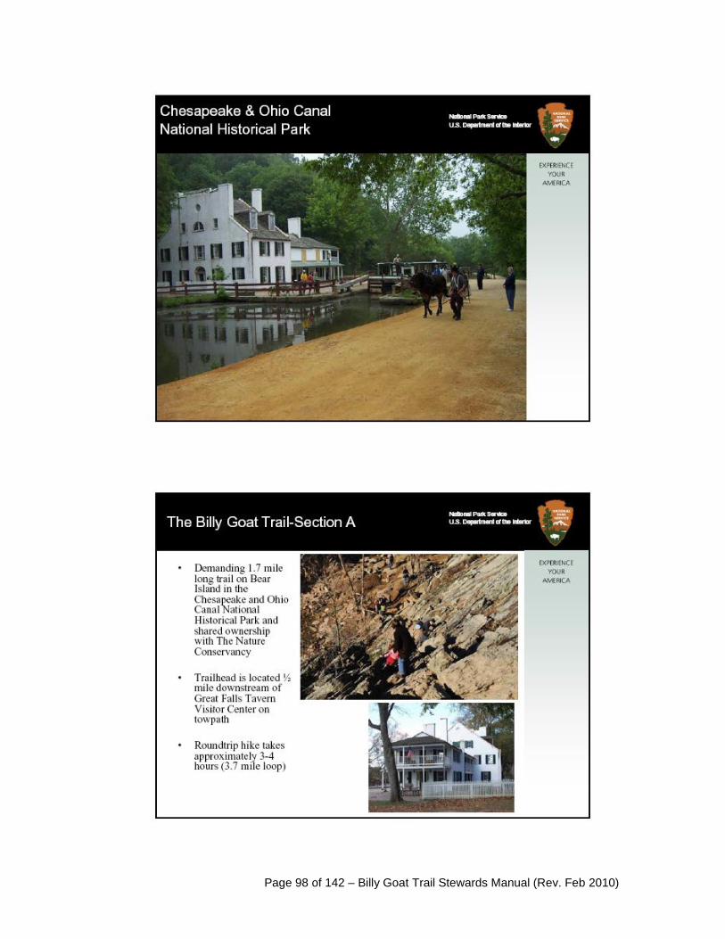
Page 98 of 142 – Billy Goat Trail Stewards Manual (Rev. Feb 2010)

Page 99 of 142 – Billy Goat Trail Stewards Manual (Rev. Feb 2010)
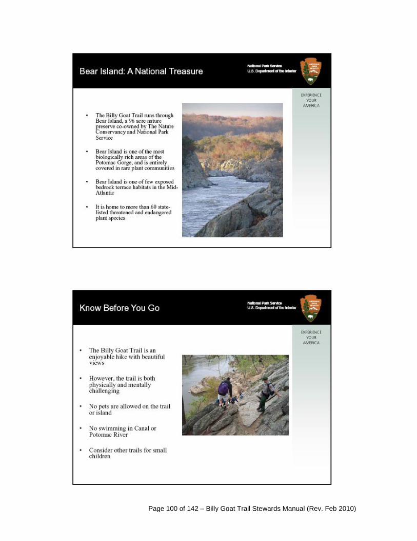
Page 100 of 142 – Billy Goat Trail Stewards Manual (Rev. Feb 2010)

Page 101 of 142 – Billy Goat Trail Stewards Manual (Rev. Feb 2010)
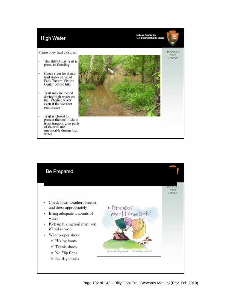
Page 102 of 142 – Billy Goat Trail Stewards Manual (Rev. Feb 2010)

Page 103 of 142 – Billy Goat Trail Stewards Manual (Rev. Feb 2010)

Page 104 of 142 – Billy Goat Trail Stewards Manual (Rev. Feb 2010)

Page 105 of 142 – Billy Goat Trail Stewards Manual (Rev. Feb 2010)
The 8 Plant Communities of Bear Island
Excerpts from Fleming, Gary, Ecological Communities of the Potomac River Gorge in Virginia.
VA Department of Consevation and Recreation, Natural Heritage Technical Report 07-12,
June, 2007.
1. Carya glabra – Quercus (rubra, prinus) – Fraxinus americana / Viburnum rafinesquianum /
Piptochaetium avenaceum Forest Pignut Hickory – (Northern Red Oak, Chestnut Oak) – White Ash / Downy Arrow-wood / Eastern
Needlegrass Forest
POTOMAC RIVER BEDROCK TERRACE OAK – HICKORY FOREST
Global (Range-Wide) Summary: This dry oak-hickory forest is known only from the level to gently
sloping tops of elevated bedrock terraces flanking the Potomac River from Great Falls downstream
for about 3 km (1.9 mi). These terraces are formed of metasedimentary rocks of the Mather Gorge
Formation, with irregular intrusive bodies of amphibolite and granodiorite also present. Their
summits lie 14 to 21m (45 to 70 ft) above the river level and are subject to rare, catastrophic flood
events. The community is a stunted forest co-dominated by variable combinations of Carya glabra
(pignut hickory), Quercus rubra (northern red oak), Quercus prinus (chestnut oak), Quercus alba
(white oak), and Fraxinus americana (white ash). Other characteristic woody species include
Juniperus virginiana var. virginiana (eastern redcedar), Ostrya virginiana (eastern hop-hornbeam),
Chionanthus virginicus (fringetree), Viburnum rafinesquianum (downy arrow-wood), Vaccinium
stamineum (deerberry), Vaccinium pallidum (early lowbush blueberry), and Ptelea trifoliata (hop-
tree). The herb layer is patchy to moderately dense, species-rich, and usually dominated by grasses
and sedges, especially Piptochaetium avenaceum (eastern needlegrass), Danthonia spicata (poverty
oat-grass), and Carex albicans var. albicans (bellow-beaked sedge). Spring ephemerals such as
Cardamine angustata (= Dentaria heterophylla; slender toothwort), Erythronium americanum ssp.
americanum (yellow trout-lily), Claytonia virginica (spring-beauty), Corydalis flavula (yellow
corydalis) are frequent but patchy, while lithophytes on and around rock outcrops include Arabis
lyrata (lyre-leaf rockcress), Phacelia dubia var. dubia (Appalachian phacelia), Cardamine parviflora
var. arenicola (small-flowered bittercress), Scutellaria saxatilis (rock skullcap), and Asplenium
platyneuron (ebony spleenwort). The introduced plants Microstegium vimineum (Japanese stiltgrass),
Lonicera japonica (Japanese honeysuckle), Alliaria petiolata (garlic mustard), and Vinca minor
(periwinkle) are problematic invaders of this type. This community is distinguished by its unique
environmental setting on ancient river terraces, its species composition, and its high species richness,
with values frequently ranging between 70 to 100 species per 400 m2.
Potomac Gorge (VA) Distribution and Habitat: The Potomac River Bedrock Terrace Oak –
Hickory Forest has a very limited distribution on the Virginia side of the Gorge. It occupies the
narrow top of the bedrock terrace from the vicinity of Great Falls to just below Sandy Landing, where
the terrace pinches out and terminates. An additional stand occurs at higher elevations of the bedrock
terrace at Madeira School. The total coverage of all patches on the Virginia side is less than 8 ha (20
ac). Although the habitat of this community is scoured by the largest flood events (mean return
interval = 30 to 85 years; Lea 2000), droughty, sandy soil that is rocky and shallow to bedrock (0 to >
40 cm [16 in]) appears to be the primary environmental factor controlling the distribution and
composition of the type. This is reflected by the low mean TMI values and 14% mean rock cover at
plot-sampling sites. Bedrock is mapped as schist, metagrawacke, or migmatite of the Mather Gorge
Formation (Southworth and Denenny 2005). Fort the most part, soils lack well-developed profiles and
appear to be little-altered alluvial deposits. Wide variation in soil pH (range 4.5 to 6.8), calcium
(range 250 to 1,617 ppm), and total base saturation (range 8.6% to 100%) at these sites may reflect

Page 106 of 142 – Billy Goat Trail Stewards Manual (Rev. Feb 2010)
different rates in the leaching of these deposits. Alternatively, unmapped intrusive bodies of mafic
rock and large quantities of mollusk shells (primarily of the introduced Asian clam, Corbicula
fluminea) deposited on the terrace tops in catastrophic floods may also be local calcium contributors.
On the widest part of the Great Falls terrace, the topography is punctuated with shallow, deeper-soiled
swales interlaced with more elevated rocky surfaces. This ridge-and-swale pattern is more
pronounced and better developed across the river on Bear Island.
Potomac Gorge (VA) Composition and Physiognomy: Mean Species Richness = 93
Homoteneity = 0.628
Constant Species (constancy ≥ 75%):
Acer rubrum, Asimina triloba, Brachyelytrum erectum, Carpinus caroliniana, Carya glabra,
Chionanthus virginicus, Claytonia virginica, Danthonia spicata, Dichanthelium boscii,
Dichanthelium dichotomum var. dichotomum, Dioscorea quaternata, Eurybia divaricata, Fraxinus
americana, Juniperus virginiana var. virginiana, Lonicera japonica, Microstegium vimineum,
Parthenocissus quinquefolia, Piptochaetium avenaceum, Quercus alba, Quercus prinus, Quercus
rubra, Rosa carolina var. carolina, Rubus flagellaris, Smilax glauca, Smilax rotundifolia, Solidago
ulmifolia var. ulmifolia, Toxicodendron radicans, Vaccinium pallidum, Vaccinium stamineum,
Viburnum prunifolium, Viburnum rafinesquianum.
Dominant Species (mean cover ≥ 6):
Carya glabra (7), Quercus alba (6), Quercus rubra (6), Quercus stellata (6), Fraxinus americana (6),
Fraxinus americana (6).
Indicator Species (highest unscaled adj. DVs):
Piptochaetium avenaceum, Viburnum rafinesquianum, Quercus stellata, Dichanthelium boscii, Carex
planispicata, Carex woodii, Chionanthus virginicus, Dirca palustris, Anthoxanthum odoratum,
Hypericum hypericoides ssp. multicaule, Carex pensylvanica, Carya glabra.
The vegetation of this community is an open, relatively short (mean canopy height = 19 m [62 ft])
forest with mean canopy cover < 50% and mean cover contributed by all tree layers < 75%.
Maximum tree diameters are also small for the area, ranging from 40 to 55 cm (16 to 22 in) dbh.
Carya glabra (stems up to 40 cm [16 in] dbh) is the leading dominant in both the canopy and sub-
canopy, occurring in mixed stands with co-dominant Quercus rubra (stems up to 40 cm [16 in] dbh),
Quercus prinus (stems up to 40 cm [16 in] dbh), and Fraxinus americana (stems up to 46 cm [18 in]
dbh). Quercus alba (stems up to 55 cm [22 in] dbh) and Quercus stellata (post oak; stems up to 30
cm [12 in] dbh) are less frequent co-dominants. Quercus falcata (southern red oak; stems up to 44 cm
[17 in] dbh), Carya cordiformis (bitternut hickory; stems up to 30 cm [12 in] dbh), Nyssa sylvatica
(black gum; stems up to 25 cm [10 in] dbh), and Pinus virginiana (Virginia pine; stems up to 41 cm
[16 in] dbh) are very minor overstory associates. The sub-canopy tree layers are composed largely of
recruitment of the canopy species and Juniperus virginiana var. virginiana, with Acer rubrum (red
maple) and Nyssa sylvatica very minor components. The shrub layer is diverse and variable (45%
mean stratum cover), with Carpinus caroliniana (American hornbeam), Ostrya virginiana, Viburnum
rafinesquianum, Chionanthus virginicus, Cornus florida (flowering dogwood), Dirca palustris
(leatherwood), Viburnum prunifolium (smooth black haw), Ptelea trifoliata, and Asimina triloba
(pawpaw) all characteristic. The latter is most abundant in the shallow, Pleistocene age swales on the
widest part of the terrace near Great Falls.
The herb layer is open to dense (55% mean stratum cover) but usually interrupted by bedrock cover.
Low patches of Vaccinium pallidum, Vaccinium stamineum, and Rosa carolina var. carolina (pasture
rose) frequently contribute up to 10% of herb-layer cover. Graminoids are prevalent, with
Dichanthelium boscii (Bosc's panic grass), Piptochaetium avenaceum, Danthonia spicata,
Dichanthelium dichotomum var. dichotomum (small-fruited panic grass), Brachyelytrum erectum

Page 107 of 142 – Billy Goat Trail Stewards Manual (Rev. Feb 2010)
(common shorthusk), Carex pensylvanica (Pennsylvania sedge), Chasmanthium latifolium (river-
oats), Carex planispicata (a sedge), Melica mutica (two-flower melic), and Bromus pubescens
(common eastern brome grass) the most constant and/or abundant species. The sedge Carex woodii
(Wood's sedge) dominates the herb-layer of one plot. Forbs that are characteristic of the type include
Solidago ulmifolia var. ulmifolia (elm-leaf goldenrod), Amphicarpaea bracteata (hog-peanut),
Erigeron pulchellus var. pulchellus (Robin's plantain), Helianthus divaricatus (woodland sunflower),
Scutellaria nervosa (veined skullcap; not captured in plots), and the spring ephemeral Claytonia
virginica (spring-beauty), but many additional forbs occur at low cover and constancy. Although not
captured in plots, an assemblage of lithophytic herbs similar to that described by Lea (2000) was
observed on rock outcrops and large boulders, including Phacelia dubia var. dubia (Appalachian
phacelia), Arabis lyrata (lyre-leaf rockcress), Corydalis flavula (yellow corydalis), and Cardamine
parviflora var. arenicola (small-flowered bittercress). Overall species richness varies from moderate
to extraordinary (56 to 126 taxa per 400 m2).
Distinguishing Features: The Potomac River Bedrock Terrace Oak – Hickory Forest can be
distinguished from other upland forests of the study area by its restriction to the sublevel, rocky top of
the high bedrock terrace below Great Falls; its somewhat stunted overstory of Carya glabra, Fraxinus
americana, and Quercus spp.; and its graminoid-dominated herb layer. It usually occurs adjacent to
the Appalachian / Northern Piedmont Riverside Outcrop Woodland (4.2), which occupies the very
rocky rims of the bedrock terrace and has an overstory dominated by Pinus virginiana. The
boundaries between these two types are fairly sharp in the study area, with compositional
intergradation more common on the Maryland side of the Gorge (Bear Island), where patch sizes are
much larger. This community also has some compositional similarities to the Piedmont Dry-Mesic
Acidic Oak-Hickory Forest (2.2), a more closed, larger-statured forest of submesic to subxeric,
upland slopes and ridges.
Global Conservation Rank: G1G2
Synonymy with other Potomac Gorge studies: Carya glabra – Quercus (rubra, alba, prinus) /
Ostrya virginiana / Panicum boscii Forest (Lea 2000); Quercus (prinus, rubra, alba) – Carya glabra
/ Ostrya virginiana Forest (Thomson et al. 1999); Rich Xeric Bedrock Terrace Forest (Allen and
Flack 2001). Requisite bedrock terrace habitats for this community type are much more extensive on
the Maryland side of the Gorge, particularly on Bear Island. The Maryland-side stands cover
approximately five times the area (roughly 40 ha [100 ac]) of those in Virginia
.
Comments: A large part of the habitat of this community type in Great Falls Park was destroyed or
severely altered by construction of the Patowmack Canal and the community of Matildaville in the
1800's, by various recreational developments and buildings starting in the early 1900's, and by
continued occupation of these areas by the park visitor center, picnic grounds and south parking area.
The intact habitats that remain are small and heavily invaded by exotic plants, especially Vinca minor
(near the Matildaville ruins), Lonicera japonica, and Microstegium vimineum. It was difficult to
locate even three sites with minimal disturbance for plot-sampling, and two of the selected sites
represented compromises that had trails immediately adjacent to or traversing them. Even the
Madeira School stands, which have not been impacted by similar disturbances, are being rapidly
invaded by Microstegium vimineum. For example, during the field season of 2003, a discrete patch of
Microstegium vimineum in plot MADS007 increased in cover from about 4 m2 to 20 m2 between
May 13 and September 9. Each of the five plots, representing the least disturbed examples of this
community that could be located, contained an average of eight exotic taxa contributing about 9% of
the mean 55% herb-layer cover.
Additional evidence of disturbance recorded in plots included pervasive top-grazing of woody shrubs
(Smilax rotundifolia, Vaccinium pallidum, Euonymus americanus) and forbs by white-tailed deer
(four plots); stump-sprouted trees indicating past logging or flood damage (two plots); dead and dying

Page 108 of 142 – Billy Goat Trail Stewards Manual (Rev. Feb 2010)
Cornus florida stems from dogwood anthracnose (two plots); blow-downs and wind damage to trees
(one plot), and beaver cutting on saplings (one plot). Oak and hickory snags were also seen in and
around several plots, possibly the victims of drought stress.
This community is a true oak-hickory forest with abundant recruitment of the overstory species
present in most stands. Acer rubrum, Fagus grandifolia, Nyssa sylvatica and other mesophytic
invaders that now characterize the understory of other upland oak forests in the area are infrequent
and apparently heavily constrained by the shallow, rocky soils. It is not clear to what degree the
relatively rare but powerful floods that reach these stands influence vegetation physiognomy and
composition. According to Lea (2000), some mechanical damage to trees could be seen at an
elevation corresponding to a 50-year return interval on the Maryland side following the 1996 flood.
Lea (2000) also hypothesized that floods of high energy and scouring capability limit soil
development to a median depth of 2 to 30 cm, presumably because of equilibrium in deposition and
removal of material during great floods. An alternative hypothesis, at least for the Virginia side, is
that the thin soils present were mostly deposited and built up by floods. In this scenario, deposition
exceeds removal (but perhaps very slowly), contrasting with the adjacent rimrock habitats of the
Appalachian / Northern Piedmont Riverside Outcrop Woodland (4.2), where more frequent and
powerful flooding greatly limits any soil development. It is quite possible that soil formation and
removal is highly variable on the terrace tops. Soil profiles at several locations on the Virginia side
indicated uniform sandy loam or loamy sand with no profile development and highly variable depths
(mostly > 30 cm), even within a single plot. At plot MADS013, which is positioned in a high swale
between two large, protective outcrops, soil was apparently weathered in-situ. Here, horizons were
well developed, with an A-horizon of reddish-brown silt loam abruptly grading to a reddish, silty clay
subsoil. Permanent plots with thorough baseline data on environmental conditions, vegetation
structure, and floristics would assist in evaluating the ecological dynamics of this community and its
habitat. Such plots would allow precise resampling and comparison with data collected following
future floods that reach these elevations.
This community type is strikingly similar in physiognomy and composition to other oak-hickory
forests growing on never-flooded upland soils that are shallow to bedrock or subsoil hardpans. One of
these, the Quercus alba – Carya glabra – Fraxinus americana / Cercis canadensis / Muhlenbergia
sobolifera – Elymus hystrix Forest (Northern Hardpan Basic Oak-Hickory Forest; USNVC
CEGL006216) is characteristic of rocky upland flatwoods on diabase of the northern Virginia Triassic
Basin (Fleming and Patterson 2004, Fleming and Weber 2003). It differs from the Potomac River
Bedrock Terrace Oak – Hickory Forest primarily in its shrub and herb-layer composition, while
sharing a similar physiognomy, overstory, and prevalence of graminoids in the herbaceous flora.
Nevertheless, analysis of plot data collected from various oak-hickory stands throughout the Mid-
Atlantic Region demonstrates conclusively that the Potomac River Bedrock Terrace Oak – Hickory
Forest is distinct at the association level. The restriction of the type to the Potomac Gorge and its
unusual geomorphic setting make it one of the region's narrowest endemic communities.

Page 109 of 142 – Billy Goat Trail Stewards Manual (Rev. Feb 2010)
2. Pinus virginiana – Juniperus virginiana var. virginiana – Quercus stellata / Amelanchier
stolonifera / Danthonia spicata / Leucobryum glaucum Woodland Virginia Pine – Eastern Redcedar – Post Oak / Low Serviceberry / Poverty Oat-grass / Common
White Cushion Mass Woodland
APPALACHIAN / NORTHERN PIEDMONT RIVERSIDE OUTCROP WOODLAND
Global (Range-Wide) Summary: This community occupies exposed, xeric outcrops along high-
gradient reaches of the New River in West Virginia and the Potomac River in Maryland and northern
Virginia. It has an open to nearly closed canopy dominated by a mixture of evergreen coniferous and
deciduous trees, moderately diverse shrub and herb layers, and often a heavy ground cover of mosses
and lichens. The West Virginia stands occupy flat sandstone outcrops. The Potomac Gorge stands
cover the rimrock of metasedimentary bedrock terraces that extend downstream from Great Falls for
about 3 km (1.9 mi). The type is a woodland or open forest of stunted trees with Pinus virginiana
(Virginia pine) dominant and Juniperus virginiana var. virginiana (eastern redcedar) occupying a
sub-canopy position. Associated deciduous trees include Quercus stellata (post oak), Fraxinus
americana (white ash), Carya glabra (pignut hickory), Quercus prinus (chestnut oak), Quercus rubra
(northern red oak), Celtis occidentalis (common hackberry), Ulmus americana (American elm), and
Cercis canadensis var. canadensis (eastern redbud). Shrubs include Amelanchier stolonifera (low
serviceberry), Rhus copallinum (winged sumac), Rosa carolina var. carolina (pasture rose),
Viburnum prunifolium (smooth black-haw), Chionanthus virginicus (fringetree), Vaccinium pallidum
(early lowbush blueberry), and Hypericum prolificum (shrubby St. John's-wort). Vines include
Toxicodendron radicans (poison ivy), Parthenocissus quinquefolia (Virginia creeper), and Vitis
aestivalis (summer grape). The herb layer is somewhat sparse to moderately dense, with a high
representation of grasses, including Andropogon virginicus var. virginicus (broomsedge), Danthonia
spicata (poverty oat grass), Leersia virginica (Virginia cutgrass), Melica mutica (two-flower melic),
and Piptochaetium avenaceum (eastern needlegrass). The fern ally Selaginella rupestris (ledge
spikemoss) may also contribute significant herbaceous cover in the West Virginia stands. Other
xerophytic species such as Helianthus divaricatus (woodland sunflower), Comandra umbellata
(bastard toadflax), Solidago ulmifolia var. ulmifolia (elm-leaf goldenrod), Potentilla canadensis
(Canada cinquefoil), Silene caroliniana ssp. pensylvanica (wild pink), Stylosanthes biflora
(pencilflower), Dichanthelium laxiflorum (open-flower panic grass), Dichanthelium depauperatum
(starved panic grass), Dichanthelium commutatum (variable panic grass), Houstonia caerulea
(common bluets), and Houstonia longifolia (longleaf bluets) are scattered. Cover by mosses and
lichens is variable and can approach 90%.
Potomac Gorge (VA) Distribution and Habitat: The Appalachian / Northern Piedmont Riverside
Outcrop Woodland is restricted to the rocky rims and high ledges of the bedrock terraces from the
vicinity of Great Falls to Sandy Landing, reappearing at Madeira School on high outcrops bordering
the river and Black Pond. The patches are linear and discontinuous, and their total coverage is
probably less than 2 ha (5 ac). The habitat of this community is characterized by massive, resistant
exposures of Mather Gorge schist, metagrawacke, and migmatite that are violently scoured by flood
events with a mean return interval of 12 to 30 years (Lea 2000). Site curvature is typically convex
while microtopography and slope inclination are highly variable. Soils are very shallow, sandy, and
only locally developed in depressions and interstices. Low mean TMI values and very high (75%)
mean rock cover at plot-sampling sites indicate a xeric moisture regime. Soil samples collected from
plots were consistently extremely acidic, with low calcium, magnesium, and total base saturation, and
high iron and aluminum.
Potomac Gorge (VA) Composition and Physiognomy: Mean Species Richness = 35 (34 per 400 m2, 36 per 200 m2)
Homoteneity = 0.709

Page 110 of 142 – Billy Goat Trail Stewards Manual (Rev. Feb 2010)
Constant Species (constancy ≥ 75%):
Acer rubrum, Amelanchier stolonifera, Carex pensylvanica, Carya glabra, Chionanthus virginicus,
Danthonia spicata, Dichanthelium dichotomum var. dichotomum, Fraxinus americana, Juniperus
virginiana var. virginiana, Parthenocissus quinquefolia, Pinus virginiana, Polygonatum biflorum var.
biflorum, Prunus serotina var. serotina, Quercus prinus, Quercus rubra, Rubus flagellaris,
Schizachyrium scoparium, Smilax glauca, Vaccinium pallidum.
Dominant Species (mean cover ≥ 6):
Pinus virginiana (8)
Indicator Species (highest unscaled adj. DVs):
Pinus virginiana, Juniperus virginiana var. virginiana, Amelanchier stolonifera, Aristida dichotoma
var. dichotoma, Andropogon virginicus var. virginicus, Dichanthelium depauperatum, Chionanthus
virginicus, Eupatorium hyssopifolium var. laciniatum, Dichanthelium dichotomum var. dichotomum,
Quercus stellata, Solidago bicolor, Vaccinium pallidum.
The vegetation is an open, stunted woodland of small trees between 9 and 12 m (30 and 39 ft) tall.
The total mean cover contributed by trees in all height classes is about 50%. Pinus virginiana (stems
up to 40 cm [16 in] dbh) is strongly dominant in the canopy, with younger recruitment also present in
gaps. Juniperus virginiana var. virginiana (stems up to 30 cm [12 in] dbh), Carya glabra (stems up to
25 cm [10 in] dbh), Quercus rubra (stems up to 20 cm [8 in] dbh), Quercus prinus (stems up to 20 cm
[8 in] dbh), Quercus stellata (stems up to 15 cm [6 in] dbh), and Fraxinus americana are less
important trees that are often confined to a sub-canopy layer. The shrub layer is very open (34% mean
stratum cover) and includes tree saplings, Chionanthus virginicus, Amelanchier stolonifera,
Vaccinium pallidum, Vaccinium stamineum (deerberry), and other species at low constancy. The herb
layer is rather sparse (11% mean stratum cover) and consists of low patches of Vaccinium pallidum
and scattered xerophytic grasses and forbs. The most constant of these are Carex pensylvanica
(Pennsylvania sedge), Danthonia spicata, Dichanthelium dichotomum var. dichotomum (small-fruited
panic grass), Polygonatum biflorum var. biflorum (Solomon's-seal), and Schizachyrium scoparium
(little bluestem). Additional, less constant herbs that have relatively high fidelity to this type in the
study area include Aristida dichotoma var. dichotoma (fork-tip three-awn grass), Andropogon
virginicus var. virginicus, Dichanthelium depauperatum, Comandra umbellata ssp. umbellata, Silene
caroliniana ssp. pensylvanica, Cardamine parviflora var. arenicola (small-flowered bittercress), and
Coreopsis verticillata (whorled coreopsis). Lithophytes such as Arabis lyrata (lyre-leaf rockcress)
and Solidago simplex var. racemosa (sticky goldenrod) are often present in rock crevices. Prominent
lichens growing on rocks in this community include Xanthoparmelia conspersa, Flavoparmelia
baltimorensis, Dimelaena oreina, and Lasallia papulosa. Cladonia spp. (reindeer lichens) and the
bryophytes Leucobryum glaucum, Dicranum spp., Hedwigia ciliata, and Polytrichum sp. often grow
on rocks and soils that are sheltered from trampling. Total species richness is low to moderate,
ranging from 25 to 50 taxa/plot.
Distinguishing Features: This community is readily distinguished by its rimrock habitat, open
woodland physiognomy, and dominance by the evergreen trees Pinus virginiana and Juniperus
virginiana var. virginiana. In the study area it mostly occurs adjacent to, but is usually sharply
distinct from, the Potomac River Bedrock Terrace Oak-Hickory Forest (4.1), which is a more diverse,
open deciduous forest. On the Maryland side of the river (particularly on Bear Island), where these
types are much more extensive, compositional intergradation is more frequent.
Global Conservation Rank: G2?
Synonymy with other Potomac Gorge studies: Pinus virginiana – Quercus stellata / Vaccinium
vacillans / Helianthus divaricatus Forest (Lea 2000); Pinus virginiana – Carya glabra – Quercus
(rubra, stellata) / Chasmanthium latifolium Woodland (Thomson et al. 1999); Bedrock Terrace Rim

Page 111 of 142 – Billy Goat Trail Stewards Manual (Rev. Feb 2010)
Xeric Forest (Allen and Flack 2001). Because of the more extensive terrace development, Maryland-
side stands of this community type cover a much larger area (possibly > 20 ha [50 ac]) than their
Virginia counterparts.
Comments: Exotic plants were recorded in four of the five plots but occur in very low numbers. The
extremely thin, impoverished, and drought-prone soils supporting this type heavily constrain most
exotics. The principal threats to this community, at least at Great Falls Park, are anthropogenic. The
stands are all located along a popular cliff-top trail that runs from the Visitor Center to Sandy Landing
in Mather Gorge. Trampling impacts are generally so severe from years of heavy visitation that it was
difficult to find representative plot-sampling sites, and the two that were established had to be limited
to 200 m2 quadrats. At virtually all overlooks along this trail, bryophyte cover, vascular vegetation
and soil mats have been mostly removed and the substrate worn down to rock and gravel. Recovery
and restoration of such areas is difficult, but apparently possible in some situations (Gibson et al.
2000).
In addition, the most heavily used rock-climbing routes in the Park are located on the cliffs
immediately below this community's habitat, which is used as a staging area. However, there is little
doubt that the great majority of damage done to the rimrock areas over the years has been by hikers
and casual visitors. Studies of a similar site in Shenandoah National Park have demonstrated that the
increasingly wide dispersal of visitors on crowded cliff overlooks is the most significant factor
leading to destruction of soils and vegetation. (Marion and Carr 2007; Lawson et al. 2006; Wood et
al. 2006).
The Maryland-side plots sampled by Lea (2000) have a much a higher mean species richness (n = 72)
and contain more species typical of the adjacent oak-hickory forest (4.1) than the Virginia-side plots
sampled during this study (n = 35). A number of species listed by Lea (2000) as characteristic of the
Maryland stands – e.g., Carex nigromarginata (black-edge sedge), Solidago ulmifolia var. ulmifolia
(elm-leaf goldenrod), Dichanthelium laxiflorum (open-flower panic grass), Stylosanthes biflora
(pencilflower), and Houstonia longifolia (longleaf bluets) – were entirely absent from the Virginia
stands. These differences may have resulted partly from the different purposes and protocols of the
two studies, and partly from the degraded condition of some Virginia sites. Nevertheless, the Virginia
and Maryland plots together formed a clear and interpretable group in the regional analysis conducted
for the NCR Parks vegetation mapping project.
Yanosky (1982a) found that a much higher percentage of Pinus virginiana than of associated
hardwoods were uprooted or damaged by the powerful flood which followed Hurricane Agnes in
1972. Although this species' shallow root system and inability to sprout following injury make it
highly susceptible to flood-related mortality, its ability to outcompete hardwoods on the very xeric
terrace rimrock allows it to regenerate quickly and maintain a dominant or co-dominant position in
this community (Lea 2000).
The natural distribution of the Appalachian / Northern Piedmont Riverside Outcrop Woodland has no
doubt always been extremely limited by its high environmental specificity and restriction to high-
gradient river gorges. Although known from just two sites, the compositional similarities between
stands at these sites is striking given the roughly 300 km distance between them and their locations in
entirely different watersheds. Unfortunately, this community's long-term viability in the New River
Gorge is uncertain due to the reduction of flooding since construction of the Bluestone Dam in 1949.
It is reported, however, that replacement of the stand by deciduous woodland has been very slow
because of edaphic stresses and occasional catastrophic floods (Vanderhorst et al. 2007).

Page 112 of 142 – Billy Goat Trail Stewards Manual (Rev. Feb 2010)
3. Fraxinus americana / Andropogon gerardii – Sorghastrum nutans – Schizachyrium scoparium
– Pycnanthemum tenuifolium Herbaceous Vegetation White Ash / Big Bluestem – Indian Grass – Little Bluestem – Narrow-leaved Mountain-mint
Herbaceous Vegetation
PIEDMONT / CENTRAL APPALACHIAN RIVERSIDE OUTCROP PRAIRIE
Global (Range-Wide) Summary: This association is known only from scattered sites along the
Potomac River in Maryland and Virginia, and the Shenandoah River in Virginia. The type occupies
steeply sloping riverside outcrops and eroded bedrock terraces along high-gradient, rocky river
reaches where depositional features are very poorly developed. These habitats are exposed to
considerable scouring during major floods and are seasonally xeric. Bedrock parent material of sites
in the fall-zone Gorge of the Potomac River includes schist, migmatite, and metagrawacke, with local
mafic and ultramafic intrusive bodies. An additional site on the upper Potomac (Allegany Co., MD) is
on shale, and another site on the Shenandoah River is located on an exposure of dolomite. This
vegetation occupies sites ranging from about 2 to 17 m (7 to 56 ft) above mean water level, and the
mean flood return interval has been estimated at 2.5 to 7 years (Lea 2000). Fifteen to 90% of the
substrate consists of exposed bedrock, and soils are sandy loams or loamy sands with relatively high
base status. Stands are dominated by warm-season grasses, with moderate to locally dense total
herbaceous cover. Andropogon gerardii (big bluestem) is the most abundant species, with
Sorghastrum nutans (indian grass), Schizachyrium scoparium (little bluestem), and Panicum virgatum
(switchgrass) each occurring constantly and achieving co-dominance in a subset of stands. Other
characteristic, but less constant, graminoid associates include Sporobolus clandestinus (rough
dropseed), Aristida purpurascens (purple three-awn grass), Dichanthelium depauperatum (starved
panic grass), Dichanthelium dichotomum (small-fruited panic grass), Chasmanthium latifolium (river-
oats), Danthonia spicata (poverty oat-grass), Eragrostis spectabilis (purple lovegrass), Tripsacum
dactyloides (northern gamagrass), Scleria triglomerata (tall nutrush), and Muhlenbergia capillaris
var. capillaris (long-awn hairgrass). The type also contains a number of characteristic xerophytic
forbs, the most constant of which are Pycnanthemum tenuifolium (narrow-leaved mountain-mint),
Solidago simplex var. racemosa (sticky goldenrod), Symphyotrichum patens var. patens (= Aster
patens var. patens; late purple aster), Euphorbia corollata (flowering spurge), Allium cernuum
(nodding onion), Cerastium arvense var. velutinum (field chickweed), Phlox subulata (moss phlox),
Coreopsis tripteris (tall tickseed), Ionactis linariifolius (stiff aster), Lespedeza virginica (slender
bushclover), Potentilla canadense (Canada cinquefoil), Veronicastrum virginicum (Culver's-root),
Lathyrus venosus (smooth veiny peavine), and Helianthus divaricatus (woodland sunflower). Other
noteworthy herbs occurring less frequently include Asclepias verticillata (whorled milkweed),
Cheilanthes lanosa (hairy lipfern), Dichanthelium laxiflorum (open-flower panic grass), Eupatorium
hyssopifolium (two vars.; hyssop-leaved thoroughwort), Galactia volubilis (downy milkpea),
Helianthus occidentalis ssp. occidentalis (western sunflower), Lespedeza capitata (round-headed
bushclover), Lespedeza violacea (violet bushclover), Liatris spicata var. spicata (dense blazing-star),
Onosmodium virginianum (Virginia false-gromwell), Paronychia virginica (yellow nailwort),
Physostegia virginiana ssp. virginiana (northern obedient-plant), Selaginella rupestris (ledge spike-
moss), Solidago nemoralis (gray goldenrod), Stylosanthes biflora (pencilflower), and Tridens flavus
var. flavus (redtop). Scattered, stunted, flood-damaged trees and shrubs occasionally achieve 25%
aggregate cover in an individual 400 m2 plot. Species richness of this community is typically high to
exceptional, averaging 88 taxa (range 51 to 138 taxa) in 16 plot samples.
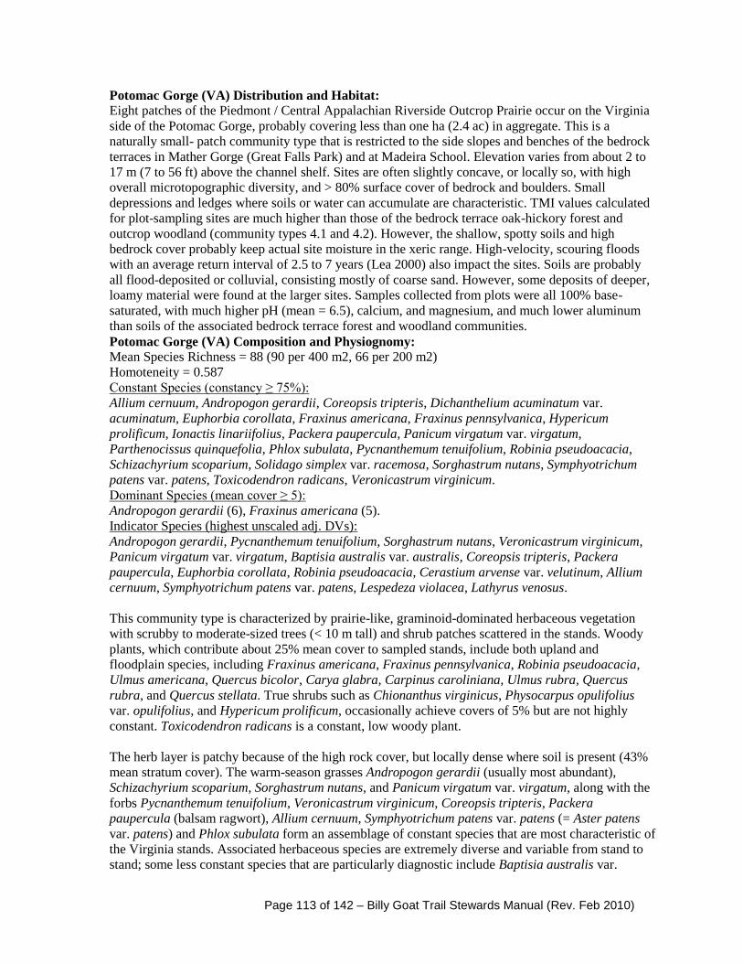
Page 113 of 142 – Billy Goat Trail Stewards Manual (Rev. Feb 2010)
Potomac Gorge (VA) Distribution and Habitat: Eight patches of the Piedmont / Central Appalachian Riverside Outcrop Prairie occur on the Virginia
side of the Potomac Gorge, probably covering less than one ha (2.4 ac) in aggregate. This is a
naturally small- patch community type that is restricted to the side slopes and benches of the bedrock
terraces in Mather Gorge (Great Falls Park) and at Madeira School. Elevation varies from about 2 to
17 m (7 to 56 ft) above the channel shelf. Sites are often slightly concave, or locally so, with high
overall microtopographic diversity, and > 80% surface cover of bedrock and boulders. Small
depressions and ledges where soils or water can accumulate are characteristic. TMI values calculated
for plot-sampling sites are much higher than those of the bedrock terrace oak-hickory forest and
outcrop woodland (community types 4.1 and 4.2). However, the shallow, spotty soils and high
bedrock cover probably keep actual site moisture in the xeric range. High-velocity, scouring floods
with an average return interval of 2.5 to 7 years (Lea 2000) also impact the sites. Soils are probably
all flood-deposited or colluvial, consisting mostly of coarse sand. However, some deposits of deeper,
loamy material were found at the larger sites. Samples collected from plots were all 100% base-
saturated, with much higher pH (mean = 6.5), calcium, and magnesium, and much lower aluminum
than soils of the associated bedrock terrace forest and woodland communities.
Potomac Gorge (VA) Composition and Physiognomy: Mean Species Richness = 88 (90 per 400 m2, 66 per 200 m2)
Homoteneity = 0.587
Constant Species (constancy ≥ 75%):
Allium cernuum, Andropogon gerardii, Coreopsis tripteris, Dichanthelium acuminatum var.
acuminatum, Euphorbia corollata, Fraxinus americana, Fraxinus pennsylvanica, Hypericum
prolificum, Ionactis linariifolius, Packera paupercula, Panicum virgatum var. virgatum,
Parthenocissus quinquefolia, Phlox subulata, Pycnanthemum tenuifolium, Robinia pseudoacacia,
Schizachyrium scoparium, Solidago simplex var. racemosa, Sorghastrum nutans, Symphyotrichum
patens var. patens, Toxicodendron radicans, Veronicastrum virginicum.
Dominant Species (mean cover ≥ 5):
Andropogon gerardii (6), Fraxinus americana (5).
Indicator Species (highest unscaled adj. DVs):
Andropogon gerardii, Pycnanthemum tenuifolium, Sorghastrum nutans, Veronicastrum virginicum,
Panicum virgatum var. virgatum, Baptisia australis var. australis, Coreopsis tripteris, Packera
paupercula, Euphorbia corollata, Robinia pseudoacacia, Cerastium arvense var. velutinum, Allium
cernuum, Symphyotrichum patens var. patens, Lespedeza violacea, Lathyrus venosus.
This community type is characterized by prairie-like, graminoid-dominated herbaceous vegetation
with scrubby to moderate-sized trees (< 10 m tall) and shrub patches scattered in the stands. Woody
plants, which contribute about 25% mean cover to sampled stands, include both upland and
floodplain species, including Fraxinus americana, Fraxinus pennsylvanica, Robinia pseudoacacia,
Ulmus americana, Quercus bicolor, Carya glabra, Carpinus caroliniana, Ulmus rubra, Quercus
rubra, and Quercus stellata. True shrubs such as Chionanthus virginicus, Physocarpus opulifolius
var. opulifolius, and Hypericum prolificum, occasionally achieve covers of 5% but are not highly
constant. Toxicodendron radicans is a constant, low woody plant.
The herb layer is patchy because of the high rock cover, but locally dense where soil is present (43%
mean stratum cover). The warm-season grasses Andropogon gerardii (usually most abundant),
Schizachyrium scoparium, Sorghastrum nutans, and Panicum virgatum var. virgatum, along with the
forbs Pycnanthemum tenuifolium, Veronicastrum virginicum, Coreopsis tripteris, Packera
paupercula (balsam ragwort), Allium cernuum, Symphyotrichum patens var. patens (= Aster patens
var. patens) and Phlox subulata form an assemblage of constant species that are most characteristic of
the Virginia stands. Associated herbaceous species are extremely diverse and variable from stand to
stand; some less constant species that are particularly diagnostic include Baptisia australis var.

Page 114 of 142 – Billy Goat Trail Stewards Manual (Rev. Feb 2010)
australis (blue wild-indigo), Cerastium arvense var. arvense, Lathyrus venosus, Lespedeza violacea
(violet bushclover), Helianthus occidentalis ssp. occidentalis, Lespedeza virginica, Sporobolus
clandestinus, Lespedeza capitata (round-headed bushclover), Solidago nemoralis, and Tripsacum
dactyloides. A number of additional herbaceous and woody species, including Liatris spicata var.
spicata, Salix humilis var. humilis (prairie willow), Scleria triglomerata, Spiraea alba var. latifolia
(broad-leaved meadowsweet), Physostegia virginiana ssp. virginiana, and Trautvetteria caroliniensis
(tassel-rue), were not found in any other community type in the study area.
Total species richness ranges from 51 to 110 taxa per 400 m2. As evidenced by the relatively low
homoteneity and Bray-Curtis similarity values, the composition of this unit is more heterogeneous
than most study area communities. However, a wide flux of low-cover associates is typical of
isolated, environmentally specific, small-patch vegetation types. The high constancy of dominant and
other characteristic species, as well as the recurrent structure and habitat, leave little doubt that it is
appropriately classified.
Distinguishing Features: This community type is structurally and compositionally unique in the
study area, and is not likely to be confused with other units. It appears to be environmentally
distinguished from wooded bedrock terrace communities (i.e., types 4.1 and 4.2) by its more fertile
soils and more frequent susceptibility to scouring floods, which increases damage to and removal of
woody vegetation. In addition, although the overall moisture regime of sites can probably be
considered xeric, the availability of local and/or ephemeral moisture in slow-draining bedrock
depressions and pools may be a factor contributing to the high species diversity. This community
often co-occurs in small-scale mosaics, and shares some species, with the Potomac Gorge Riverside
Outcrop Barren (4.5). The latter, however, differs in its sparse vascular vegetation that rarely exceeds
30 species in a 100 m2 quadrat. See also p. 289 for a discussion of the related Piedmont / Central
Appalachian Channel-Shelf Riverside Prairie that occurs only on the Maryland / D.C. side of the
Gorge, primarily at Chain Bridge Flats.
Global Conservation Rank: G1
Synonymy with other Potomac Gorge studies: Quercus stellata / Andropogon gerardii –
Schizachyrium scoparium – Aristida purpurascens Wooded Herbaceous Vegetation (Lea 2000);
Bedrock Terrace Xeric Savanna (Allen and Flack 2001). This community type appears to be equally
rare on both sides of the Potomac gorge.
Comments: Exotic plants were found in all nine plots but only Lonicera japonica (Japanese
honeysuckle) attained a mean cover across all plots of 1% or a cover > 2% in an individual plot.
Overall, each plot contained an average of ten exotic taxa contributing an aggregate cover of about
6%. Lespedeza cuneata (sericea lespedeza; Stevens 2002), a tough-rooted, drought-resistant perennial
that forms dominance patches just outside one of the larger prairies near the Great Falls Park picnic
area, may be the most potentially invasive exotic in the type. Minor white-tailed deer herbivory and
minor hiker trampling impacts were each documented in two plots.
Traces of this vegetation too small to plot sample were found well downstream of Mather Gorge at
Prospect Rock near the mouth of Bullneck Run. There are some minor compositional differences
between stands of this community on the Maryland and Virginia sides of the river. Quercus stellata,
Danthonia spicata, and Aristica purpurascens are more characteristic of the Maryland stands, while
Physocarpus opulifolius var. opulifolius, Veronicastrum virginicum, and Baptisia australis var.
australis are more frequent on the Virginia side.

Page 115 of 142 – Billy Goat Trail Stewards Manual (Rev. Feb 2010)
The Piedmont / Central Appalachian Riverside Outcrop Prairie is one of several similar
vegetation types, dominated by some combination of warm-season grasses and forbs
characteristic of true midwestern prairies, that occur in the eastern United States on riverside
gravel bars or outcrops. Further study is needed to intensively compare these types and determine
whether some of them should be merged. However, there is little question that this community is
naturally rare and has biogeographic affinities that differ from most other Potomac Gorge
vegetation.

Page 116 of 142 – Billy Goat Trail Stewards Manual (Rev. Feb 2010)

Page 117 of 142 – Billy Goat Trail Stewards Manual (Rev. Feb 2010)

Page 118 of 142 – Billy Goat Trail Stewards Manual (Rev. Feb 2010)
Compendium of Relevant Federal Regulations (2006)

Page 119 of 142 – Billy Goat Trail Stewards Manual (Rev. Feb 2010)
United States Department of the Interior
National Park Service
Chesapeake and Ohio Canal
National Historical Park
Code of Federal Regulations
Title 36, Chapter 1.7 (b)
2006 Superintendent’s Compendium Compendium of designations, closures, request requirements, and other restrictions
imposed under the discretionary authority of the Superintendent.
In accordance with regulations and the designated authority provided in Title 36, Code of
Federal Regulations, Chapter I, Part 1 through 7, authorized by Title 16, United States
Code, Section 3, the following regulatory provisions are established for the proper
management, protection, government and public use of the Chesapeake and Ohio Canal
National Historical Park under the jurisdiction of the National Park Service.
These discretionary regulations are in addition to other regulations published in Title 36,
CFR, Chapter 1, Parts 2 through 7. Unless otherwise stated, these regulatory provisions
apply, in addition to the requirements contained in Title 36, CFR, Chapter I.
Recommended:
/s/Dwight D. Dixon December 5, 2005
Dwight D. Dixon Date
Acting Chief Park Ranger
Approved:
/s/Kevin D. Brandt December 5, 2005
Kevin Brandt Date
Superintendent
SECTION 1.5 - CLOSURES & PUBLIC USE LIMITS The following areas are closed or restricted as indicated below. Additional locations may
be closed or restricted (between annual revisions of the document) by the posting of
appropriate signs.
(1) Areas closed to visitation:
A. Maryland gold mine enclosures, the interior of the Ford and the Round Top mines.
B. Other park structures (e.g., barns, mills, maintenance yards, and houses) unless
otherwise/elsewhere designated.
C. The access road to and the area within ¼ mile of the Fours Locks firing range
(Costlow property).
D. Waters within the C&O Canal NHP are closed to motorized vessels, except electric
motors may be used at Big Pool, Little Pool, and in canal waters from Lock 68 to Town
Creek Aqueduct.
E. Swains Lock parking lot. (10 p.m. to 6 a.m.)
(2) Areas with public use limits:

Page 120 of 142 – Billy Goat Trail Stewards Manual (Rev. Feb 2010)
A. All park offices, maintenance facilities, and office complexes; Georgetown, Great
Falls, Brunswick, Williamsport, Hancock, and Cumberland visitor centers; and the Abner
Cloud House are closed to the public during non-business hours or when un-staffed.
B. All of Falls and Olmsted Islands are closed to public use except for designated
walkways, footbridges, overlooks, and a 25-foot wide area along the river shoreline on
barren rock or sand necessary for boaters to portage, scout, or rest.
C. Falls and Olmsted Islands are closed for boat, canoe, or kayak put-in or take-out for
the Potomac River.
D. Falls and Olmsted Islands are closed to rock climbing, rappelling, and rock
scrambling.
E. Falls and Olmsted Islands are closed to picnicking, food, and beverages.
F. From Georgetown to Seneca, all parklands are closed at dark. From Seneca to
Cumberland, parking lots, picnic areas, and developed recreational sites are closed at
dark. Designated overnight camping areas are excluded from this section. Visitors may
leave vehicles in parking areas after dark while utilizing the back country campsites,
towpath, riverbank, or other areas that are not closed for recreational purposes, including
fishing, camping, boating, hiking, biking, etc. Darkness is defined as one-half hour after
sunset to one-half hour before sunrise.
G. Foot trails, horse trails, and towpath are closed to all unauthorized motorized vehicles,
and hoofed animal-drawn vehicles (except by special use permit). The towpath is closed
to horseback riding after dark. Canine-drawn sleds/gigs are permitted on the towpath
between November 1 and March 15 between Whites Ferry (Mile 35.5) and Town Creek
(Mile 162.2).
H. Section “A” of the Billy Goat Trail may be closed with little or no notice when
flooding occurs. Flooding normally occurs at 5.4 feet on the Little Falls gauge.
I. Entering Seneca Creek from National Park Service property for the purpose of
swimming, wading, or bathing is prohibited.
J. Pets are prohibited on Falls and Olmsted Islands, boardwalks, bridges, overlooks,
section “A” of the Billy Goat Trail, and all of Bear Island.
K. Bikes must be dismounted and walked in the pedestrian areas signed as such, in front
of the Great Falls Tavern and all other designated areas.
L. Lock 34 parking area is closed to parking on weekends and holidays from May 15 to
September 15.
M. Ice skating is permitted at your own risk park-wide, except where prohibited by
signage.
N. Golf Equipment – The Park is closed to the use of golf equipment including golf balls.
O. Model Aircraft, Rockets, Vessels, and Vehicles – All parklands, waterways, and
airspace are closed to the use of model aircraft, rockets, vessels, vehicles, and similar
motorized devices.
P. Hash House Harrier Games – The establishment of hash house harrier games is
prohibited. The dropping of flour or other marking materials for the use of marking a path
or trail is prohibited.
Q. Geocaching games – The establishment of geocaches is prohibited except for virtual
geocaches, which may be established only under permit by the park superintendent.

Page 121 of 142 – Billy Goat Trail Stewards Manual (Rev. Feb 2010)
SECTION 1.6 - PERMITS In accordance with 36 CFR 1.7, the following is a compilation of activities requiring
special use permits:
1. Use of the Marsden Tract group day use and camping
facilities.
2. Use of the Carderock Pavilion.
3. Display of commercial notices or advertisements.
4. Collection of research specimens and conducting scientific
research.
5. Commercial filming or photography.
6. Sale or distribution of printed matter.
7. Special events.
8. Public assemblies, including first amendment right
activities.
9. Scattering human ashes in C&O Canal National Historical
Park.
10. Entering closed areas.
11. Possession of alcoholic beverages.
12. Camping at hiker/biker sites by trail rider groups with
more than four horses.
13. Operating a public address system or other sound
amplified audio devices.
14. Conducting commercial business operations.
15. Guiding.
16. Explosives.
17. Non-commercial soliciting.
18. Weddings.
Page 122 of 142 – Billy Goat Trail Stewards Manual (Rev. Feb 2010)
19. Group and individual site camping. The Superintendent
may suspend services or remove disorderly persons or groups
or permit violators from the park.
SECTION 2.1 - PRESERVATION OF NATURAL, CULTURAL, &
ARCHEOLOGICAL
RESOURCES (a)(4) Dead wood on the ground may be collected for use as fuel for campfires
within the immediate vicinity of designated picnic and camping areas, as
permitted by 36 CFR 2.13 and this compendium, and may not be removed
from the Park.
(5) Tying objects to trees, aqueducts, bridges or historic structures; jumping from
or swinging by rope or other means from aqueducts, bridges, historic
structures, or trees is prohibited.
(c)(1) Edible fruits, nuts, berries, and mushrooms may be gathered by hand for
personal use or consumption. Commercial use is prohibited. Removal of
fruits, nuts, berries, and mushrooms cannot disturb the remainder of the plant.
Possession of plant fruits, nuts, berries, and mushrooms are limited to the
following quantities:
Fruit/Nut/Berry Daily/Person Limit Walnuts 1 Bushel
Hickory Nuts (sp.) 1 Bushel
Acorns (Oak sp.) 1 Bushel
Apples 1 Bushel
Cherries 1/2 Gallon
Blackberries 1/2 Gallon
Raspberries 1/2 Gallon
Dewberries 1/2 Gallon
Strawberries 1/2 Gallon
Huckleberry species 1/2 Gallon
Elderberries 1/2 Gallon
Paw Paws 1/2 Gallon
Mushroom species 1/2 Gallon
SECTION 2.2 - WILDLIFE PROTECTION (d) Hunters can transport legally taken, properly tagged and identified wildlife
ACROSS C&O Canal NHP property at the following authorized locations:
MONTGOMERY COUNTY Swains Lock - Mile 16.64: Access directly from parking lot to Potomac River by crossing
bridge over lock and proceeding directly to river.
Pennyfield Lock - Mile 20.01: Access to Potomac River via Muddy Branch at ramp only
Violettes Lock - Mile 22.12: Access directly from parking lot to Potomac River by
crossing bridges over locks and proceeding directly to river.
Seneca Creek - Mile 22.82: Access to Potomac River via Seneca Creek from county boat
ramp off Riley's Lock Road.

Page 123 of 142 – Billy Goat Trail Stewards Manual (Rev. Feb 2010)
Sycamore Island Landing - Mile 27.21: Access directly from parking lot and across
towpath to Potomac River.
Edwards Ferry - Mile 30.84: Access via boat ramp to Potomac River.
Whites Ferry - Mile 35.50: Access via privately owned boat ramp.
FREDERICK COUNTY Monocacy River - Mile 42.19: Access via boat ramp to Potomac River via Monocacy
River.
Nolands Ferry - Mile 44.58: Access via boat ramp to Potomac River.
Point of Rocks - Mile 48.20: Access via boat ramp to Potomac River.
Lander (Lock 29) - Mile.50.89: Access via direct route on roadway from Lock 29 to boat
ramp and Potomac River.
Brunswick - Mile 55.00: Access via boat ramp to Potomac River.
WASHINGTON COUNTY Weverton - Mile 58.18: Access carry-in via direct route from cul-de-sac at end of Keep
Tryst Road.
Lock 34 (Goodhearts Lock) - Mile 61.57: Access directly from parking area and across
towpath to Potomac River.
Dargan Bend - Mile 64.89: Access via boat ramp to Potomac River.
Antietam Creek - Mile 69.36: Access by boat via Antietam Creek from Harpers Ferry
Road, upstream of aqueduct.
Snyders Landing - Mile 76.65: Access via boat ramp to Potomac River.
Taylors Landing - Mile 80.90: Access via boat ramp to Potomac River.
Dam 4 Road - Mile 84.2: Access via direct route to river around gate, just past 90-degree
bend in road.
Big Slackwater - Mile 85.40: Access via boat ramp to Potomac River.
Potomac Fish and Game - Mile 93.88: Access via private ramp.
Funkstown Rod and Gun Club - Mile 96.7: Access for current club members via their
current river access.
Williamsport - Mile 99.79: Access via ramp at River Bottom Park (City of Williamsport)
Four Locks - Mile 108.74: Access via boat ramp to Potomac River.
McCoys Ferry - Mile 110.42: Access via boat ramp to Potomac River.
Licking Creek - Mile 116.04: Access by boat via Licking Creek.
Hancock (Little Tonoloway) - Mile 124.33: Access via boat ramp to Potomac River.
Cohill Station - Mile 129.99: Access from park footbridge across canal on Deneen Road
directly to river.
ALLEGANY COUNTY Fifteenmile Creek - Mile 140.90: Access via boat ramp to Potomac River.
Higgins Tract - Mile 146.80 to Mile 148.80: Access by foot across towpath to Green
Ridge State Forest/Wildlife Management Area.
Bonds Landing - Mile 148.80: Access by foot or vehicle directly across canal lands at
Kasecamp Road to and from the State campground/boat ramp.
Paw Paw Tunnel Road Corridor - Mile 154.20 to Mile 154.70: Access by foot across top
of Paw Paw Tunnel via Tunnel Hill Road only to Green Ridge State Forest/WMA.
Kifer Tract - Mile 157.27: Access to private property.
Town Creek - Access to Town Creek permitted via direct route at end of cul-de-sac past
pole gate. Access to river via creek in vessels carried/portaged.

Page 124 of 142 – Billy Goat Trail Stewards Manual (Rev. Feb 2010)
Stegmaier Farm - Mile 164.80: Retained hunting rights (private).
Buckley Island - Mile 170.90: Access by foot on road to Buckley Island in Potomac
River.
Spring Gap - Mile 173.37: Access via boat ramp to Potomac River.
All mile references are made utilizing the Towpath Guide to the C&O Canal by Thomas
F. Hahn. Hunters are advised that lateral travel on the towpath is prohibited.
(e) C&O Canal NHP is closed to viewing of wildlife with the use of artificial light.
SECTION 2.4 - WEAPONS, TRAPS AND NETS (d)(4) Hunters, during designated state hunting seasons, with firearms unloaded,
traditional bows unstrung, compound bows with arrows un-nocked, and dogs
leashed, may cross C&O Canal National Historical Park lands by the most direct
route only at the locations IDENTIFIED IN 36 CFR 2.2.
All mile references are made utilizing the Towpath Guide to the C&O Canal by Thomas
F. Hahn. Hunters are advised that lateral travel on the towpath is prohibited.
SECTION 2.10 - CAMPING AND FOOD STORAGE (9) 1. Camping or overnight use by organized groups at Marsden Tract is allowed by
advance permit only.
2. Camping or overnight use at all drive-in, walk-in, hiker/biker, and group area
campsites is permitted only on a first-come, first-served basis.
HIKER/BIKER CAMPSITE LOCATIONS (Mile) Swains Lock 16.6
Horsepen Branch 26.1
Chisel Branch 30.5
Turtle Run 34.4
Marble Quarry 38.2
Indian Flats 42.5
Calico Rocks 47.6
Bald Eagle Island 50.3
Huckleberry Hill 62.9
Killiansburg Cave 75.2
Horseshoe Bend 79.2
Big Woods 82.7
Opequon Junction 90.9
Cumberland Valley 95.2
Jordan Junction 101.2
North Mountain 110.0
Licking Creek 116.0
Little Pool 120.6
White Rock 126.4
Leopards Mill 129.9
Cacapon Junction 133.6
Indigo Neck 139.2
Devils Alley 144.5
Stickpile Hill 149.4
Sorrel Ridge 154.1
Page 125 of 142 – Billy Goat Trail Stewards Manual (Rev. Feb 2010)
Purslane Run 157.4
Town Creek 162.1
Potomac Forks 164.8
Pigmans Ferry 169.1
Irons Mountain 175.3
Evitts Creek 180.1
DRIVE-IN CAMPGROUND LOCATIONS (Mile) McCoys Ferry 110.4
Fifteenmile Creek 140.9
Spring Gap 173.3
WALK-IN CAMPGROUND LOCATIONS (Mile) Antietam Creek 69.7
Paw Paw 156.2
GROUP CAMP SITE LOCATIONS (Mile)
Marsden Tract 11.0
McCoys Ferry 110.4
Fifteenmile Creek 141.0
Spring Gap 173.3
Paw Paw 156.2
3. Camping or overnight use with vehicles and trailers is permitted only at the following
locations on a first-come, first-served basis:
a. McCoys Ferry Drive-in Campground
b. Fifteenmile Creek Drive-in Campground
c. Spring Gap Drive-in Campground
4. Camping is limited to eight persons, two vehicles, and two tents per walk-in or drive-in
campsite.
a. Claimed campsites may not be left unattended for longer than 24 hours.
b. Portable engines, generators, power mowers, and chainsaws are not
permitted to be operated in any campgrounds.
c. All wheeled vehicles except bicycles and wheelchairs must be kept off
the grass.
d. Pitching of horseshoes is prohibited except in designated areas.
e. The maximum trailer length in drive-in campgrounds is 20 feet.
f. If camping gear and/or any personal gear is left at a campsite, that
campsite is considered occupied and camping fees apply.

Page 126 of 142 – Billy Goat Trail Stewards Manual (Rev. Feb 2010)
5. Camping at drive-in and walk-in campsites, including group campsites, is limited
to 14 days between May 1 and October 1 and may not exceed 30 days in a calendar
year. Camping at hiker/biker sites is limited to one night and six persons for each site.
SECTION 2.11 - PICNICKING 1. The use of portable engines, chainsaws, generators, and power mowers is
prohibited in picnic areas.
2. The pitching of horseshoes is prohibited, except in designated areas.
SECTION 2.13 - FIRES (a)(1) Fires are permitted ONLY in designated picnic and camping areas where grills or
fire rings are provided or personal, self-contained portable grills/stoves may be used off
the ground and away from overhanging vegetation.
SECTION 2.14 - SANITATION (a)(9) Toilets must be used where they are provided.
SECTION 2.15 – PETS (a)(5) Visitors with pets in the park are required to pick up and dispose of their pet's
excrement by carrying it out of the park. Pets are prohibited on Falls, Bear, and Olmsted
Islands, section “A” of the Billy Goat Trail, boardwalks, bridges, and overlooks. *(See
section 1.5,2,J)*
SECTION 2.16 - HORSES AND PACK ANIMALS (b) Horseback riding is permitted on the towpath from Swains Lock (Mile 16.6) to the Offutt
Street crossing at Candoc (Mile 181.8) in Cumberland and on the Paw Paw
Tunnel Hill trail. Access to the river for watering is authorized at public river
access points (boat ramps).
(g)1. Horses are not allowed in the Paw Paw Tunnel, park drive-in and walk-in
campgrounds, or picnic areas.
2. Feed for horses must be carried by the group. No grazing is permitted in the
park. We encourage the use of pellets or certified clear feed for your animals,
since oats and hay can bring non-native grass species into the park.
3. Trail riders and groups are responsible for keeping the park areas clean. All
manure should be removed from the park, parking areas, and campsites.
4. Horses may be loaded or unloaded in parking areas. Loading/unloading
must be kept in those portions of parking areas furthermost from
campgrounds or picnic areas. Groups must carry a loading ramp.
5. Riders must dismount and walk their horses across the aqueducts. Horses are
restricted from crossing narrow wooden footbridges as they are not
designed to carry the concentrated weight of the horses.
6. Trail rider camping is allowed only in hiker/biker campsites and is limited to
six persons, four horses, and one night per visit per site. Horses must be
tethered at the furthermost portion of the campsite away from the tent and
picnic table locations. Groups are responsible for removing manure, and
left over feed, etc. from the park.
7. Horse trailers are not allowed in drive-in camping areas.
8. Horses/riders are not to exceed the speed of a slow trot.
Page 127 of 142 – Billy Goat Trail Stewards Manual (Rev. Feb 2010)
9. Watering, cleaning, or tethering horses at park wells is prohibited. By use of
a bucket or other container, water may be taken from park hand pump wells
located at hiker/biker campsites and used for watering horses.
10. Horses may be loaded/unloaded and enter/exit the towpath at public access
points only. Access from private property is prohibited.
11. Horseback riding is prohibited after dark.
SECTION 2.20 – SKATING, SKATEBOARDS, AND SIMILAR DEVICES Roller skates, roller blades, and similar devices are allowed only on the
Capital Crescent Trail and the Western Maryland Rail Trail.
SECTION 2.21 - SMOKING (a) The use of any lighted tobacco products within the boundaries of C&O
Canal NHP shall be in accordance with the Directors Order 50D dated
12/01/03, entitled "Smoking Policy."
SECTION 2.22 - PROPERTY a)(2)Visitors on towpath hiker/biker trips are permitted to leave vehicles unattended for
the period of their camping trips.
SECTION 2.23 - RECREATION FEES (a) Areas where recreation fees are established:
1. Carderock Pavilion (Reservation Fee)
2. Georgetown Canal Boat trips
3. Great Falls Canal Boat trips
4. Great Falls, Maryland (Entrance Fee)
5. Marsden Tract Group Campsite (Res.Camping Fee)
6. Antietam Creek Campground (Camping Fee)
7. McCoys Ferry Campground (Camping Fee)
8. Fifteenmile Creek Campground (Camping Fee)
9. Fifteenmile Creek Group Campground (Camping Fee)
10. Paw Paw Tunnel Campground (Camping Fee)
11. Spring Gap Campground (Camping Fee)
SECTION 2.35 - ALCOHOLIC BEVERAGES AND CONTROLLED
SUBSTANCES (a)(3)(i) The possession and/or consumption of alcoholic beverages including
beer, wine, or spirituous liquors within the C&O Canal NHP is
prohibited except under a permit issued by the Park Superintendent.
This does not apply to leased structures and those being used as
residences. Consumption of alcoholic beverage is prohibited within the
park and all park facilities.
SECTION 2.51 - PUBLIC ASSEMBLIES, MEETINGS (e) Permits for this type of activity will be issued by the Superintendent and
limited to areas designated on maps contained in the Superintendents Office.
Written application must be submitted to the Superintendent and received at
least 60 days prior to the date desired for commencement of the activity.
Those areas with designated locations include Great Falls Tavern area,
Monocacy Aqueduct, Brunswick, Williamsport (Cushwa), Little Tonoloway

Page 128 of 142 – Billy Goat Trail Stewards Manual (Rev. Feb 2010)
(Hancock), Fifteenmile Creek, Paw Paw Tunnel, North Branch, and
Oldtown.
SECTION 2.52 - SALE AND DISTRIBUTION OF PRINTED MATTER (e) Permits for this type of activity will be issued by the Superintendent and
limited to areas designated on maps contained in the Superintendent’s Office.
Written application must be submitted to the Superintendent and received at
least 7 days prior to the date desired for commencement of the activity. Those
areas with designated locations include Great Falls Tavern area, Monocacy
Aqueduct, Brunswick, Williamsport (Cushwa), Little Tonoloway (Hancock),
Fifteenmile Creek, Paw Paw Tunnel, North Branch, and Oldtown.
Permits for special events, public assemblies, and for distribution of printed matter will
be issued pursuant to standards established in Director’s Order 53 (Special Park Use
Guidelines).
Permit Conditions:
- In addition to public assemblies/special events and meetings, gatherings, parades,
demonstrations, or other public expressions of views are subject to the conditions of
this regulation.
- No more than two public assembly/first amendment permits will be issued for any
one day.
- The maximum number of participants in a public assembly/first amendment event
will be limited to 20 persons.
- Public assemblies/first amendments shall not exceed 4 hours in duration.
- A public assembly/special event may be canceled at the discretion of the
Superintendent when emergency or potentially hazardous conditions exist.
- All costs incurred by the park, as a result of a special event, will be recovered
from the permit holder.
- Public assemblies/special events shall not interfere with normal public use or
pedestrian flow.
- Public assemblies/special events shall not take place during hours of darkness,
except by permit.
- Noise levels must not exceed the limits established in 36 CFR 2.12, Audio
disturbances.
- The maximum number of participants engaged in the sale or distribution of printed
matter is 10.
- The commercial sale of items, other than the printed matter approved for sale with
a permit, is prohibited.
- The permit holder is responsible for cleaning the public assembly/special event
area upon the completion of the event.
SECTION 4.30 - BICYCLES (a) Bicycle riding is permitted only on the towpath, Burma Road, Capital Crescent
Trail, and the Western Maryland Rail Trail from Polly Pond to Pearre.
Bicycles must be dismounted and walked across aqueducts and all foot
bridges providing access to the towpath.

Page 129 of 142 – Billy Goat Trail Stewards Manual (Rev. Feb 2010)
Justifications for implementing closures, public use limits, and permit requirements
as established by the superintendent in accordance with 36 CFR, parts 1 through 5.
36 CFR, SECTION 1.5 - CLOSURES AND PUBLIC USE LIMITS
(1) Areas closed to visitation: A. Maryland gold mine enclosures, the interior of the Ford and the Round
Top mines.
B. Other park structures (e.g., barns, mills, maintenance yards, and
houses) unless otherwise/elsewhere designated.
C. The access road to and the area within ¼ mile of the Four Locks firing
range (Costlow property).
D. Waters within the C&O Canal NHP are closed to motorized vessels,
except electric motors may be used at Big Pool, Little Pool, and in canal
waters from Lock 68 to Town Creek Aqueduct.
E. Swains Lock parking lot. (10 p.m. to 6 a.m.)
Justification - These areas are closed to visitation for security, visitor safety, and
protection of park resources. Motorized vessels are prohibited to reduce the impacts the
noise would have on the aesthetic experience most visitors come to the area to enjoy.
Additionally the use of motors on many areas would be hazardous due to the shallow
water conditions and submerged obstacles.
(2) Areas with public use limits: A. All park offices, maintenance facilities, and office complexes; Georgetown,
Great Falls, Brunswick, Williamsport, Hancock, and Cumberland visitor centers;
and the Abner Cloud House are closed to the public during non-business hours or
when un-staffed.
Justification - The security and accountability of government property can best be
protected by limiting access to these areas to government employees and/or business
hours.
B. All of Falls and Olmsted Islands are closed to public use except for
designated walkways, footbridges, overlooks, and a 25-foot wide area along
the river shoreline on barren rock or sand necessary for boaters to portage,
scout, or rest.
C. Falls and Olmsted Islands are closed for boat, canoe, or kayak put-in or
take-out for the Potomac River.
D. Falls and Olmsted Islands are closed to rock-climbing, rappelling, and rock
scrambling.
E. Falls and Olmsted Islands are closed to picnicking, food, and beverages.

Page 130 of 142 – Billy Goat Trail Stewards Manual (Rev. Feb 2010)
Justification - Public safety would be compromised by allowing visitors to enter these
areas. This closure is to protect plant and animal species and the natural environment of
the islands Trash and debris often left on the islands is aesthetically unpleasant. Picnic
tables are provided near the parking area.
F. From Georgetown to Seneca, all parklands are closed at dark. From Seneca
to Cumberland, parking lots, picnic areas, and developed recreational sites are
closed at dark. Designated overnight camping areas are excluded from this
section. Visitors may leave vehicles in parking areas after dark while utilizing
the back country campsites, towpath, riverbank, or other areas that are not
closed, for recreational purposes including fishing, camping, boating, hiking,
biking, etc. Darkness is defined as one-half hour after sunset to one-half hour
before sunrise.
Justification - Overnight parking and after hours use create a number of impacts that
would be inconsistent with the protection of C&O Canal resources. There is no legitimate
recreational use of the parking areas after dark.
G. Foot trails, horse trails, and towpath are closed to all unauthorized
motorized vehicles, and hoofed, animal-drawn vehicles (except by special use
permit). The towpath is closed to horseback riding after dark. Canine-drawn
sleds/gigs are permitted on the towpath between November 1 and March 15
between Whites Ferry (Mile 35.5) and Town Creek (Mile 162.2).
Justification - The use of horses and pack animals is detrimental to natural resources
such as plant and animal communities. 36 CFR 2.16 (c) prohibits the use of horses and
pack animals on park roads (paved public highways) outside of designated areas, except
where such travel is necessary to cross to or from designated trails or areas. The riding of
horses after dark is prohibited for public safety.
H. Section “A” of the Billy Goat Trail may be closed with little or no notice
when flooding occurs. Flooding normally occurs at 5.4 feet on the Little Falls
gauge.
Justification - To protect the public during high water events.
I. Entering Seneca Creek from National Park Service property for the purpose
of swimming, wading, or bathing is prohibited.
Justification - It is hazardous to swim, wade, or bathe in this portion of the river.
J. Pets are prohibited on Falls and Olmsted Islands, boardwalks, bridges,
overlooks, section “A” of the Billy Goat Trail, and all of Bear Island.
K. Bikes must be dismounted and walked in the pedestrian areas signed as
such, in front of the Great Falls Tavern and all other designated areas.
Justification - Due to the popular use, often crowded conditions and terrain in these
areas, pets are prohibited and bikes must be walked for public safety.
L. Lock 34 parking area is closed to parking on weekends and holidays from
May 15 to September 15.

Page 131 of 142 – Billy Goat Trail Stewards Manual (Rev. Feb 2010)
Justification - During the summer months, use of this area exceeds its physical
capabilities. The overuse creates hazardous conditions in traffic and pedestrian
movements. This limitation reduces vehicular traffic in the area by allowing business
permitees an area to unload customers going to the river. These customers would
otherwise arrive in individual vehicles.
M. Ice skating is permitted park-wide except where closed by signage.
Justification - Areas may be closed to protect park visitors and resources.
N. Golf Equipment – Although the park is a national recreation area, not all
recreational uses are compatible. The use of golf equipment, specifically using
open areas in the park for driving golf balls produces several problems. Lost
golf balls produce litter in the natural environment. Driven balls fly a great
distance, so one person may, by virtue of the potential injury from being
struck, exclude other visitors from the use of an entire open field area. The
divots created in the grass from swinging clubs would, in sufficient quantity,
cause bare areas and erosion problems.
O. Model Aircraft, Rockets, Vessels, and Vehicles – Model aircraft are
usually propelled by small, gasoline-driven engines. They are usually remote
controlled by the operator does not have complete control over the craft due to
winds or operator error. There is potential for injury to bystanders, visitors,
wildlife, and vegetation from being struck by a fast moving aircraft. The use
of aircraft may exclude other visitors from the use of an entire open field area.
The small engines are noisy and produce exhaust into the air, which affects
the quality visit of park visitors. The wildlife is often disturbed due to the
noise associated with these devices.
Model rockets are usually propelled by small, chemical-driven engines. They are
usually not controlled by the operator. There is potential for injury to bystanders,
visitors, wildlife, and vegetation from being struck by a fast moving rocket. The
use of rockets may exclude other visitors from the use of an entire open field area.
The small engines are noisy and produce exhaust into the air, which affects the
quality visit of other park visitors. The wildlife is often disturbed due to the noise
associated with these devices.
Model vessels are usually propelled by small, gasoline- and oil-driven engines.
They are usually remote-controlled, but the operator does not have complete
control over the craft due to currents or operator error. The small engines are
noisy and leave gasoline and oil residue in the water, which affects the quality
visit of other park visitors. The wildlife is often disturbed due to the noise
associated with these devices.
Model vehicles tend to need a lot of open space, such as a parking lot, to operate.
Usage in a parking lot presents a safety hazard to bystanders and traffic alike.
There are no acceptable locations in the park for a visitor to use a remote-
controlled vehicle in an enjoyable and safe manner. The wildlife can be disturbed
due to the noise and movement associated with these devices.

Page 132 of 142 – Billy Goat Trail Stewards Manual (Rev. Feb 2010)
P. Hash House Harrier Games – This game involves running along a pre-
marked route that is marked with flour or other marking material. These
markers are usually called “Hashes.” Runners chase the person marking the
route who is usually called the “Hare.” The “Hare” drops flour or other
material to mark the trail. The marking material is not readily identifiable and
causes concern to both visitors and park staff. This game encourages players
to move off trail that leads to vegetative damage and erosion problems.
Organizers of this type of activity are known to hold events in the park
without prior approval or any attempt to obtain a Special Use Permit.
Q. Geocaching games – Geocaches typically are hidden in natural areas or
archeological sites. The object of this game is to locate well-hidden caches
that may be buried. This game encourages participants to move off trail that
leads to vegetative damage and erosion problems. Digging disturbs park
resources and damages archeological sites. This activity can be alarming to
bystanders who misidentify the individuals when they observe participants
hiding or acting in a suspicious manner to avoid detection. Organizers of this
type of activity are known to hold events in the park without prior approval or
any attempt to obtain a Special Use Permit.
36 CFR, SECTION 2.35 – ALCOHOLIC BEVERAGES AND CONTROLLED
SUBSTANCES a)(3)(i) The possession and consumption of alcoholic beverages including beer,
wine, or spirituous liquors within the C&O Canal NHP are prohibited, except
under a permit issued by the park superintendent. This does not apply to leased
structures and those being used as residences. Consumption of alcoholic
beverages is prohibited within the park and all park facilities.
Justification - Pursuant to 36 CFR 2.35 (3)(I)(B), the park superintendent may close all
or a portion of a public use area or facility to the consumption of alcoholic beverages
and/or the possession of a bottle, can or other receptacle containing an alcoholic beverage
that is open, or has been open, or whose seal is broken or the contents of which have been
partially removed. Provided that such a closure may only be implemented following a
determination made by the superintendent that incidents of aberrant behavior related to
the consumption of alcoholic beverages are of such magnitude that diligent application of
the authorities in this section and 1.5 and 2.34 of 36 CFR, over a reasonable time period,
does not alleviate the problem. Since the mid 1980s, the park has restricted the use of
alcoholic beverages in picnic areas, parking areas, boat ramps, campgrounds, Monocacy
Aqueduct to Mile 42.5, Mile 106.8 to 107.4, Mile 87.6 to 88.6 and the shoreline and
waters of Town Creek to deter alcohol related incidents. Furthermore to coincide with
local restrictions and regulations consumption of alcoholic beverages are prohibited in
Washington D.C. and Montgomery County, and the towns of Brunswick, Williamsport,
Hancock, and Cumberland. These restrictions have reduced the number of alcohol

133
related incidents in some areas, but problems continue to exist. Restrictions posed in
some areas have forced additional problems on unrestricted areas. The regulations and
restrictions are not clear to the visiting public or those faced with enforcing them. A
permit is now required from the park superintendent to possess and/or consume alcohol
in the park to maintain consistency within the park and local adjoining jurisdictions, to
further reduce the number of alcohol-related incidents, and to control the consumption of
alcohol in the park.
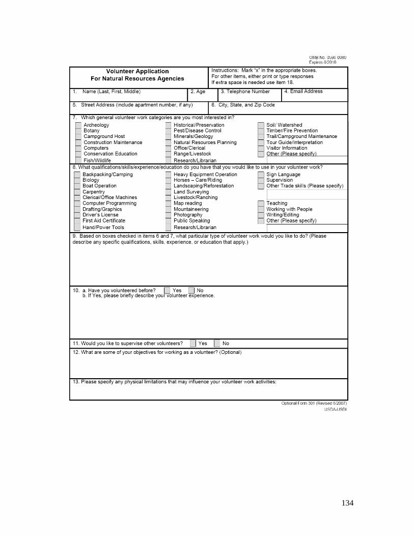
134
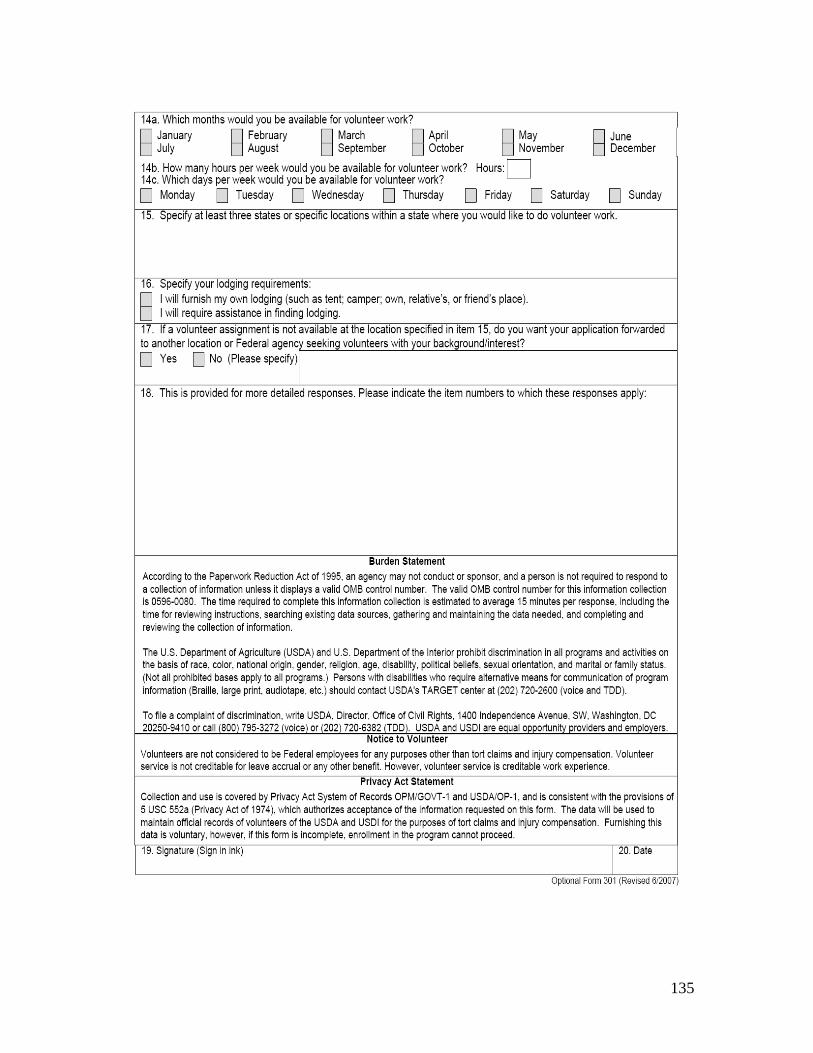
135

136

137

138

139
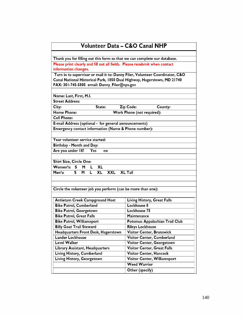
140

141