Chapter 7 – Atmospheric Circulations...• Many mesoscale phenomena are the result of a thermal...
76
Chapter 7 - Title Chapter 7 – Atmospheric Circulations (pp. 165-195)
Transcript of Chapter 7 – Atmospheric Circulations...• Many mesoscale phenomena are the result of a thermal...
Chapter 7 - Title
Chapter 7 –Chapter 7 –
Atmospheric Circulations(pp. 165-195)
Contents
• scales of motion and turbulence
• local winds
• the General Circulation of the atmosphere
• ocean currents• ocean currents
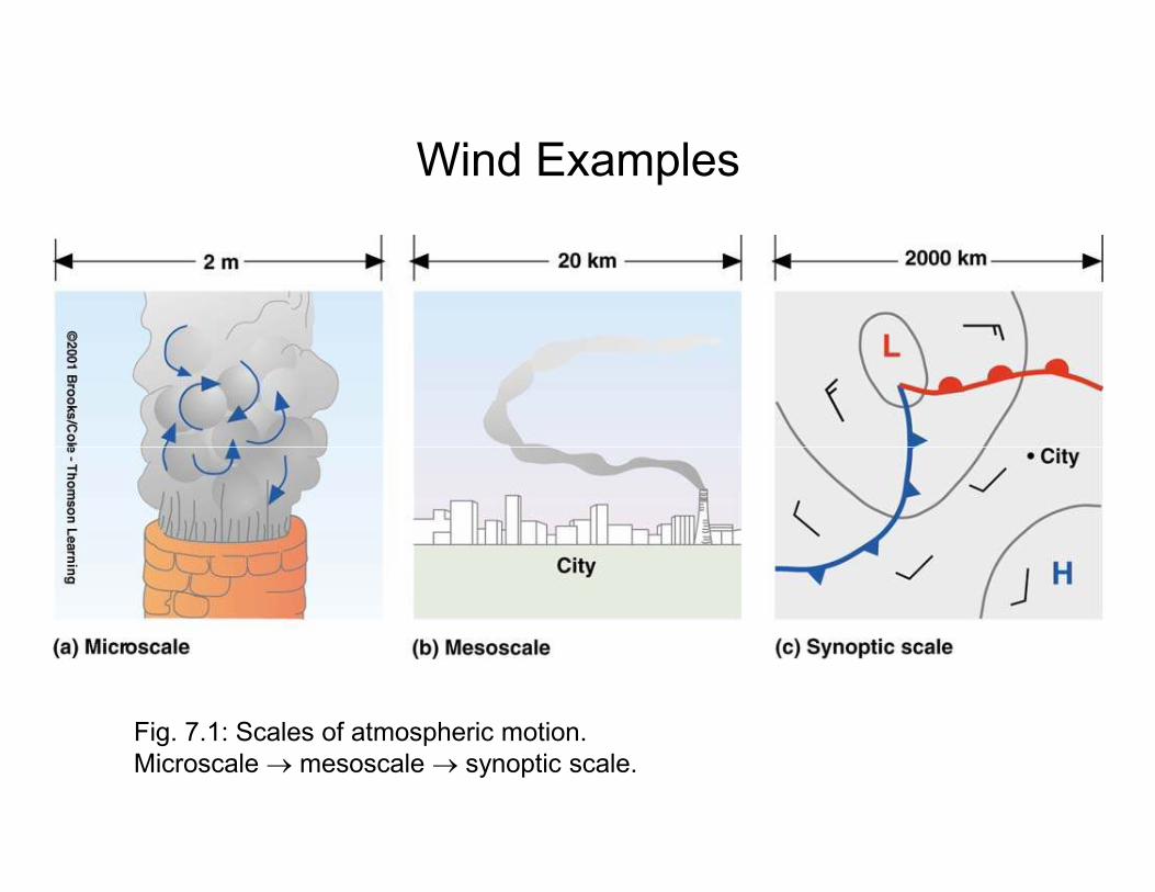
Wind Examples
Fig. 7.1: Scales of atmospheric motion.
Microscale → mesoscale → synoptic scale.
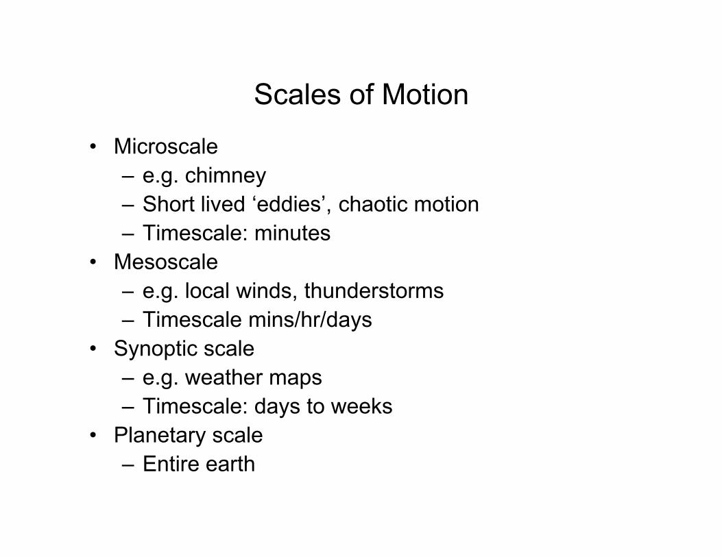
Scales of Motion
• Microscale
– e.g. chimney
– Short lived ‘eddies’, chaotic motion
– Timescale: minutes
• Mesoscale
– e.g. local winds, thunderstorms– e.g. local winds, thunderstorms
– Timescale mins/hr/days
• Synoptic scale
– e.g. weather maps
– Timescale: days to weeks
• Planetary scale
– Entire earth
Scales of Motion
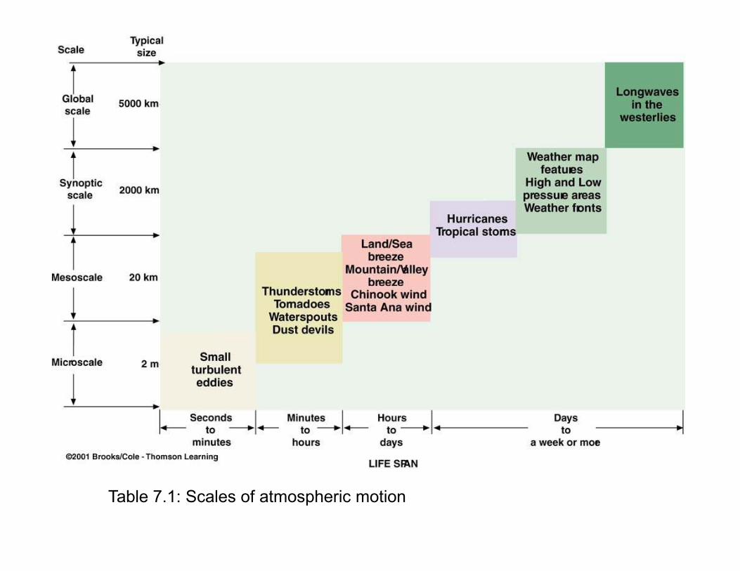
Table 7.1: Scales of atmospheric motion
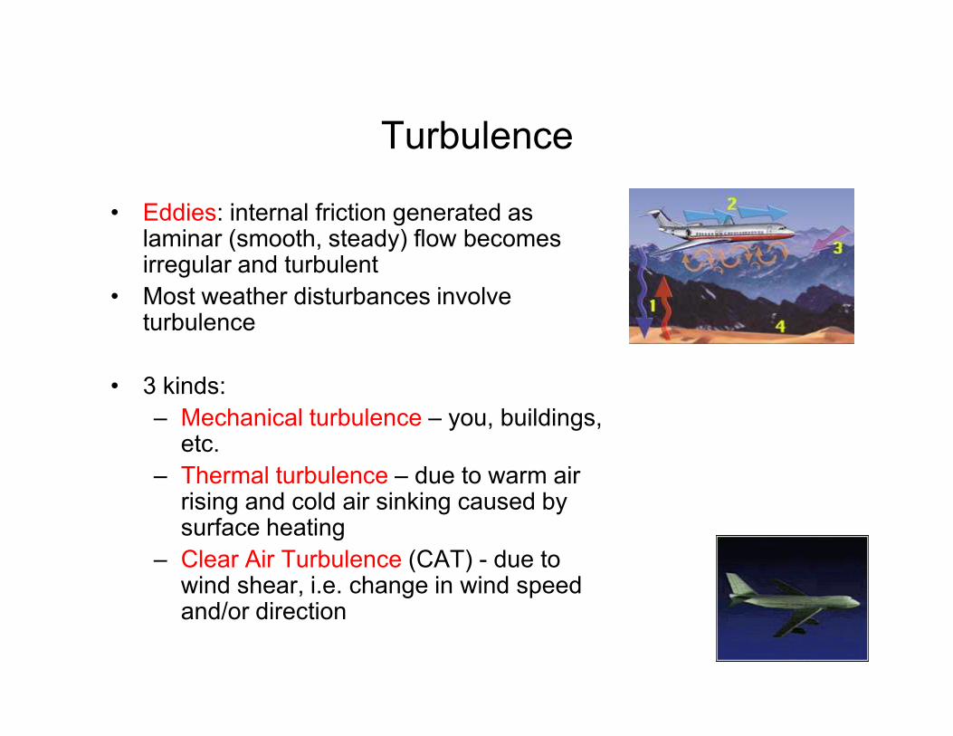
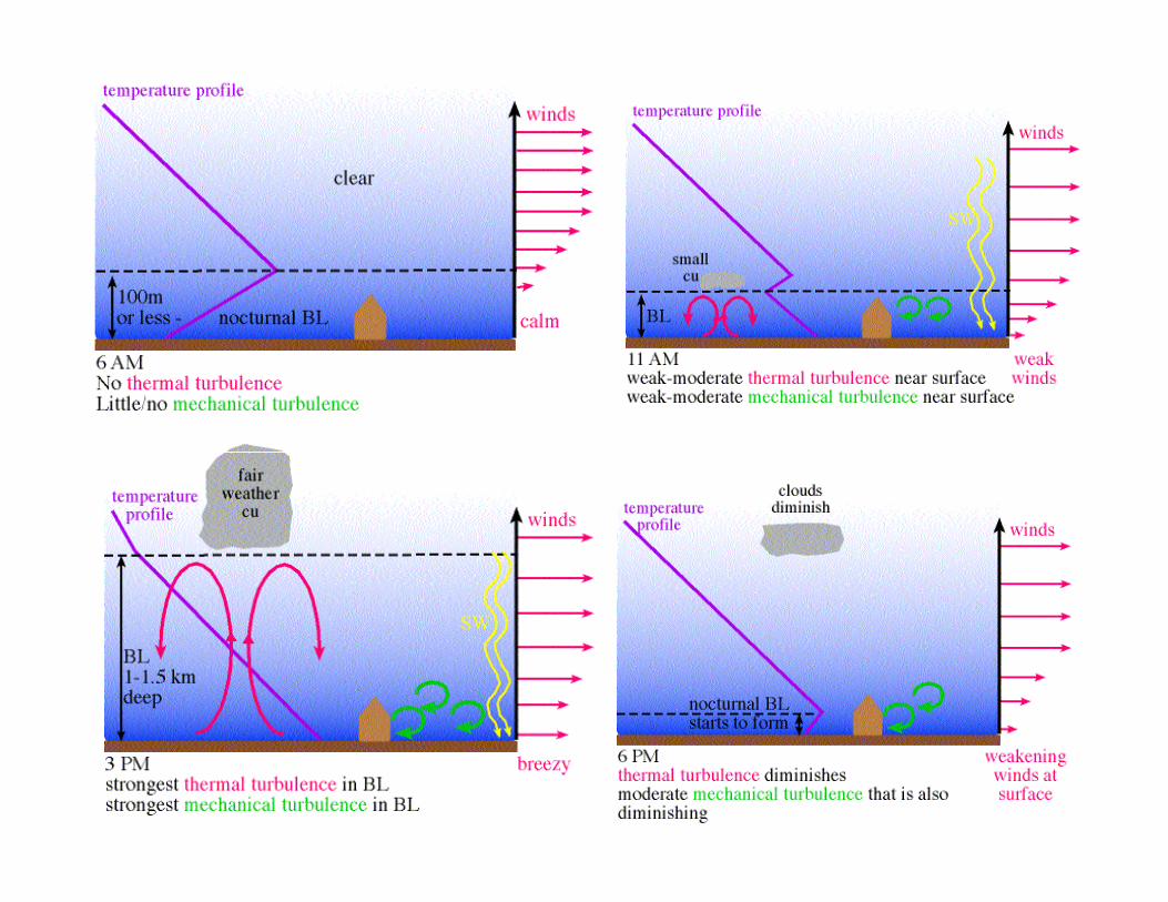
Turbulence
• Eddies: internal friction generated as laminar (smooth, steady) flow becomes irregular and turbulent
• Most weather disturbances involve turbulence
• 3 kinds:
– Mechanical turbulence – you, buildings, etc.
– Thermal turbulence – due to warm air rising and cold air sinking caused by surface heating
– Clear Air Turbulence (CAT) - due to wind shear, i.e. change in wind speed and/or direction
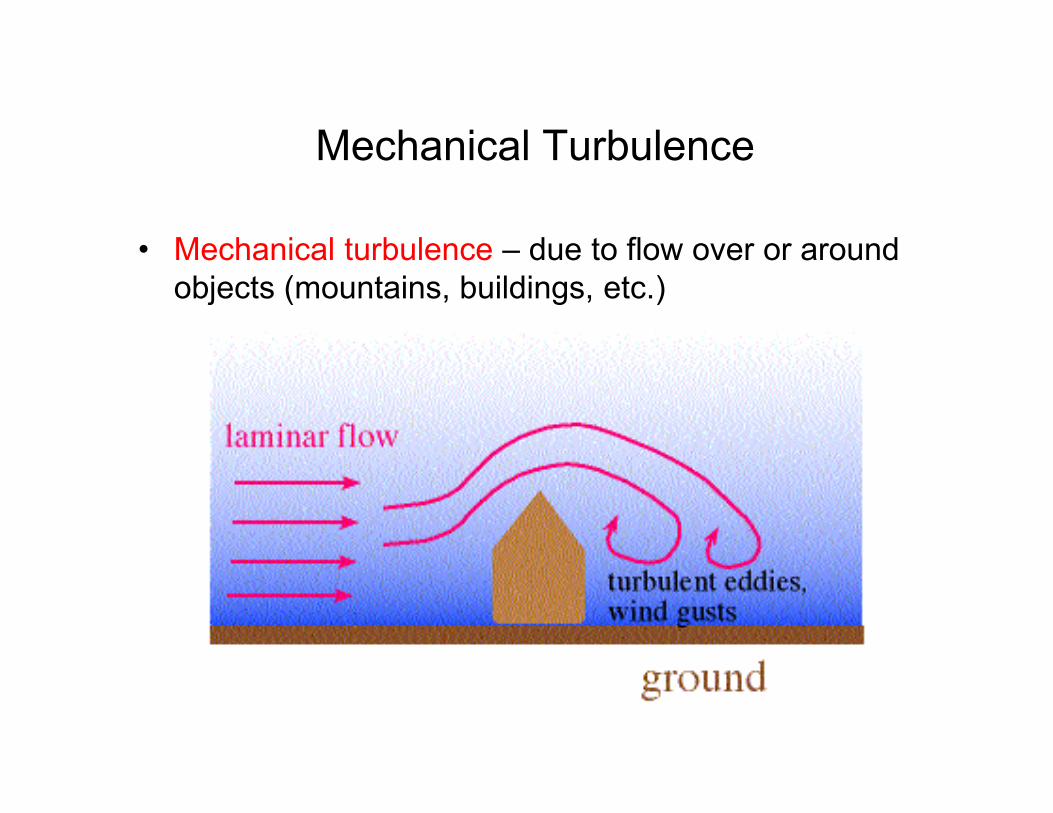
Mechanical Turbulence
• Mechanical turbulence – due to flow over or around
objects (mountains, buildings, etc.)
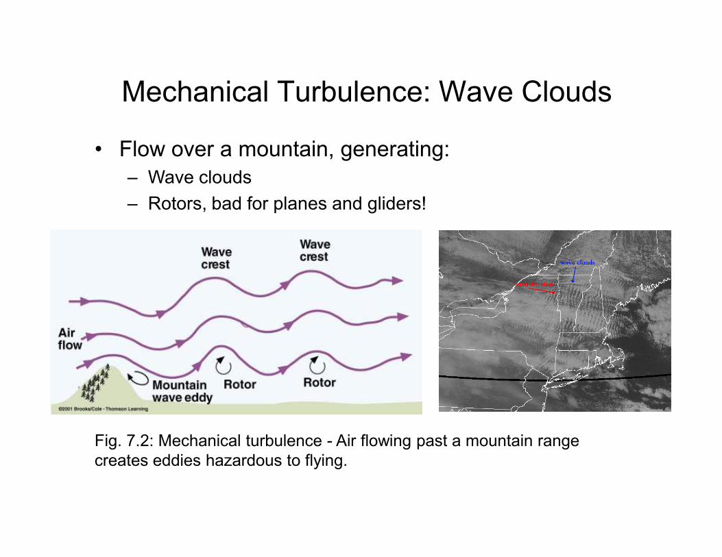
Mechanical Turbulence: Wave Clouds
• Flow over a mountain, generating:
– Wave clouds
– Rotors, bad for planes and gliders!
Fig. 7.2: Mechanical turbulence - Air flowing past a mountain range
creates eddies hazardous to flying.
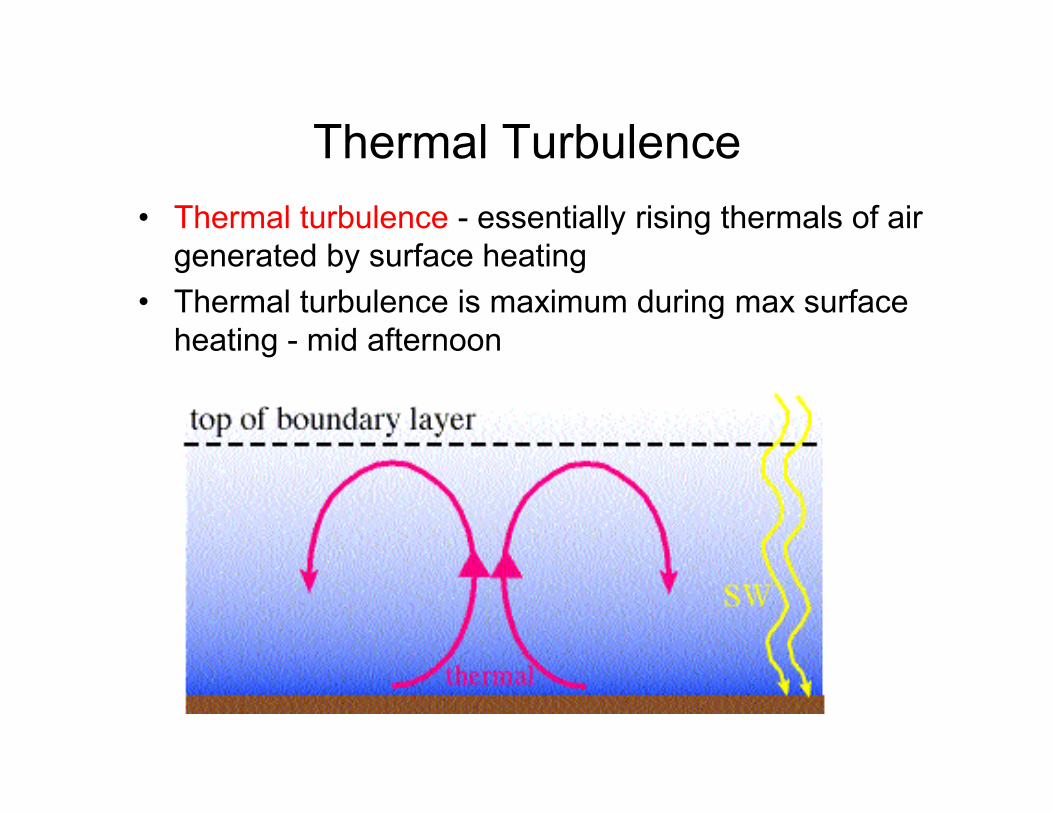
Thermal Turbulence
• Thermal turbulence - essentially rising thermals of air
generated by surface heating
• Thermal turbulence is maximum during max surface
heating - mid afternoon
Questions
1. A pilot enters the weather service office and wants to know what time of the day she can expect to encounter the least turbulent winds at 760 m above central Kansas. If you were the weather forecaster, what would you tell her?
2. Why is the difference in surface wind speed between morning and afternoon typically greater on a clear, sunny day than on a cloudy, overcast day?
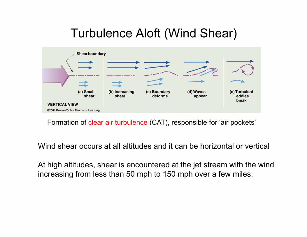
Turbulence Aloft (Wind Shear)
Formation of clear air turbulence (CAT), responsible for ‘air pockets’Formation of clear air turbulence (CAT), responsible for ‘air pockets’
Wind shear occurs at all altitudes and it can be horizontal or vertical
At high altitudes, shear is encountered at the jet stream with the wind
increasing from less than 50 mph to 150 mph over a few miles.
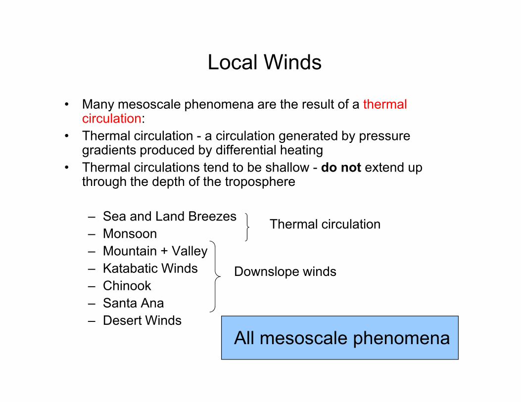
Local Winds
• Many mesoscale phenomena are the result of a thermal circulation:
• Thermal circulation - a circulation generated by pressure gradients produced by differential heating
• Thermal circulations tend to be shallow - do not extend up through the depth of the troposphere
– Sea and Land Breezes
– Monsoon
– Mountain + Valley
– Katabatic Winds
– Chinook
– Santa Ana
– Desert Winds
All mesoscale phenomena
Downslope winds
Thermal circulation
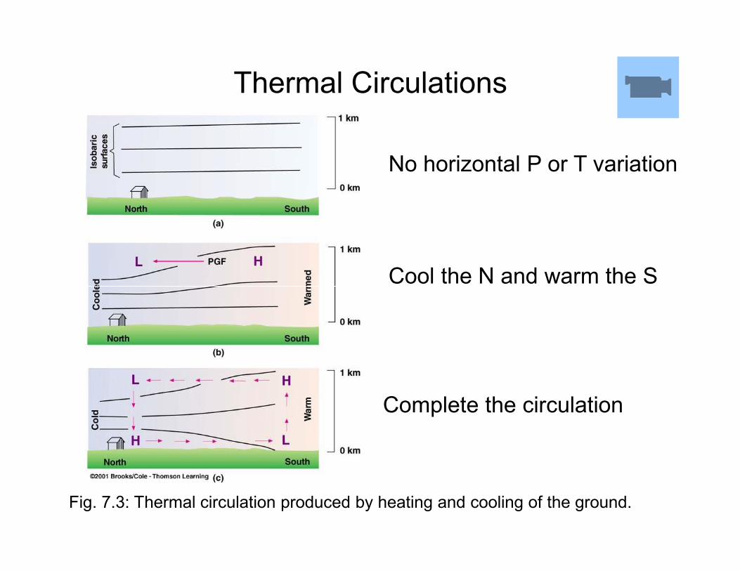
Thermal Circulations
No horizontal P or T variation
Cool the N and warm the S
Fig. 7.3: Thermal circulation produced by heating and cooling of the ground.
Cool the N and warm the S
Complete the circulation
Thermal Circulations: Sea and Land
Breezes
• Consider the land/sea interface in the morning
• Assume that the ocean and land surfaces have the
same temperature
• Also assume that synoptic-scale phenomena are • Also assume that synoptic-scale phenomena are
absent
• As solar heating increases during the morning, which
surface heats quicker and why?
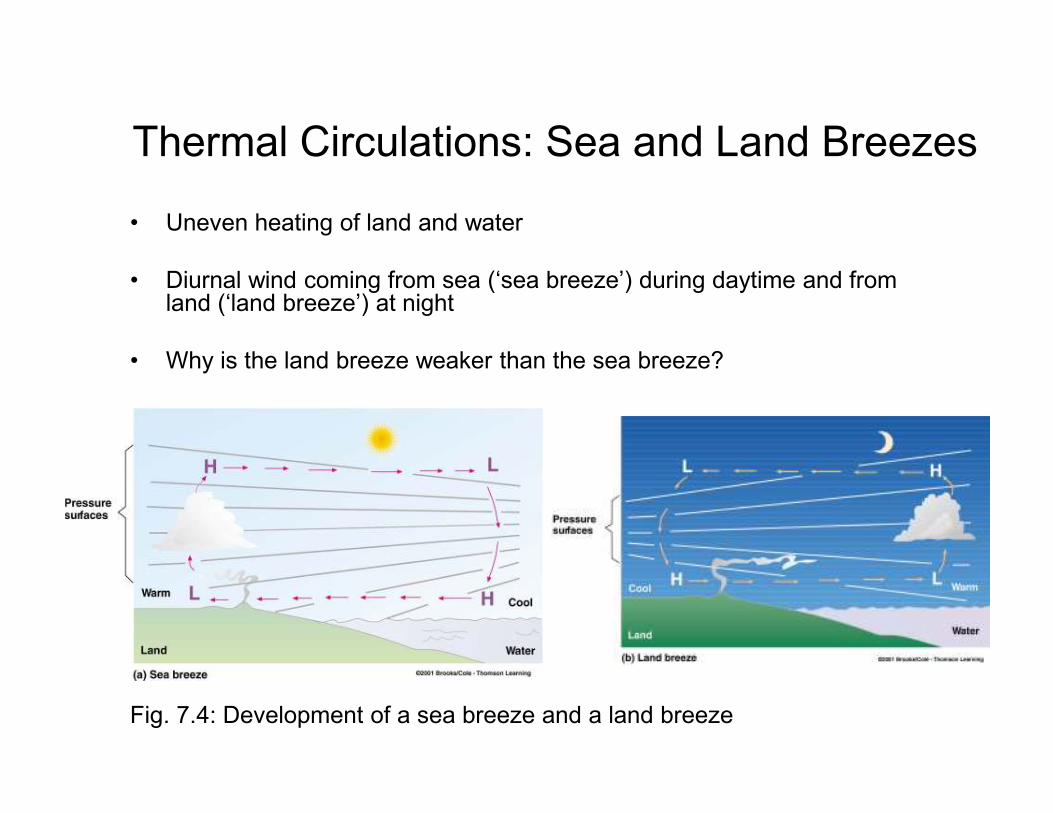
Thermal Circulations: Sea and Land Breezes
• Uneven heating of land and water
• Diurnal wind coming from sea (‘sea breeze’) during daytime and from land (‘land breeze’) at night
• Why is the land breeze weaker than the sea breeze?
Fig. 7.4: Development of a sea breeze and a land breeze
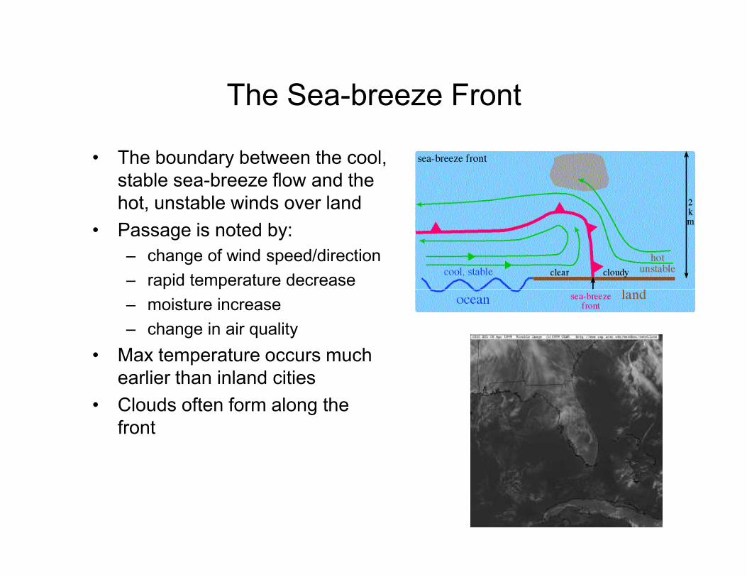
The Sea-breeze Front
• The boundary between the cool,
stable sea-breeze flow and the
hot, unstable winds over land
• Passage is noted by:
– change of wind speed/direction
– rapid temperature decrease – rapid temperature decrease
– moisture increase
– change in air quality
• Max temperature occurs much
earlier than inland cities
• Clouds often form along the
front
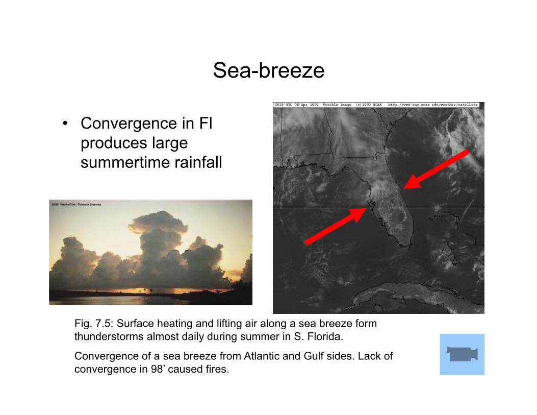
Sea-breeze
• Convergence in Fl
produces large
summertime rainfall
Fig. 7.5: Surface heating and lifting air along a sea breeze form
thunderstorms almost daily during summer in S. Florida.
Convergence of a sea breeze from Atlantic and Gulf sides. Lack of
convergence in 98’ caused fires.
Questions
1. Explain why cities near large bodies of cold water in
summer experience well-developed sea breezes, but only
poorly-developed land breezes.
2. The prevailing winds in southern Florida are northeasterly. 2. The prevailing winds in southern Florida are northeasterly.
Knowing this, would you expect the strongest sea breezes
to be along the east or west coast of southern Florida?
What about the strongest land breezes.
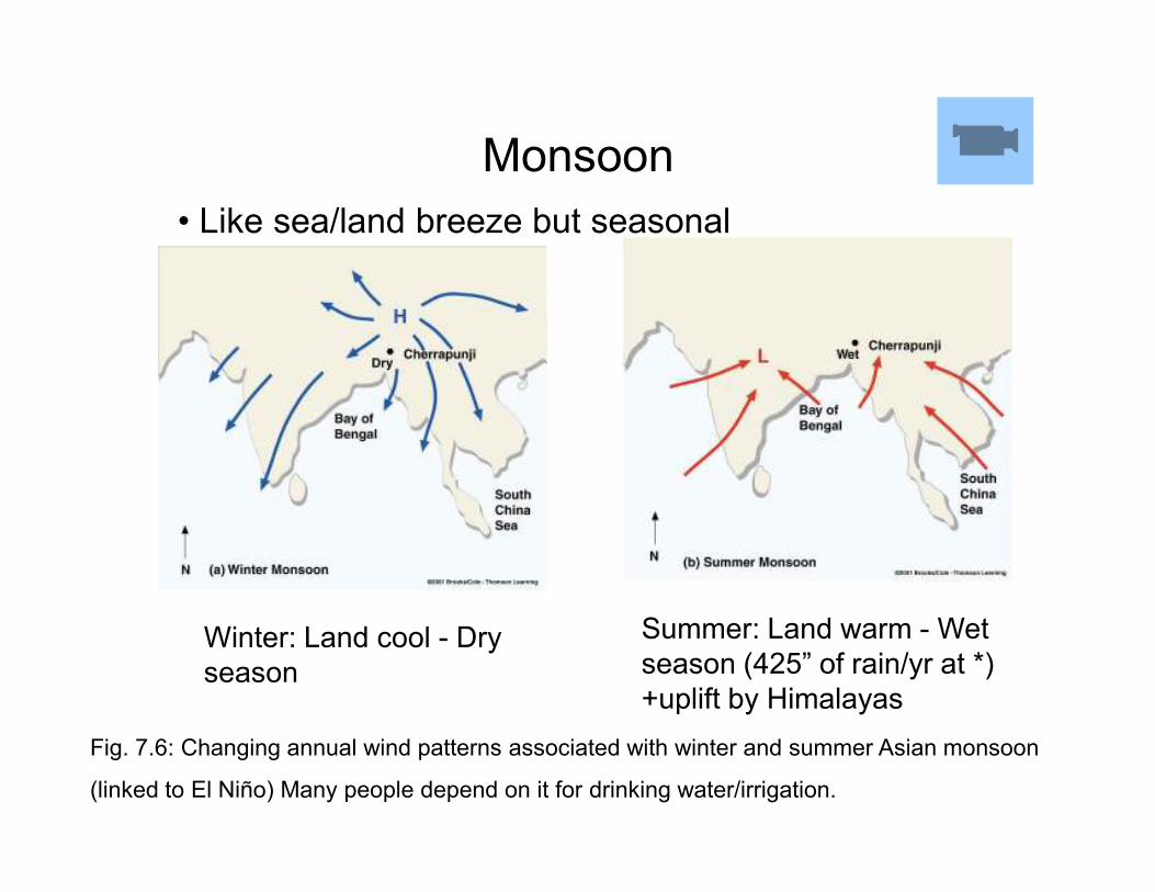
Monsoon
• Like sea/land breeze but seasonal
Fig. 7.6: Changing annual wind patterns associated with winter and summer Asian monsoon
(linked to El Niño) Many people depend on it for drinking water/irrigation.
Winter: Land cool - Dry
season
Summer: Land warm - Wet
season (425” of rain/yr at *)
+uplift by Himalayas
Downslope Winds
• Mountain breezes belong to a group of winds more generally as Katabatic winds.
• These are winds driven by cold air flowing down a slopeslope
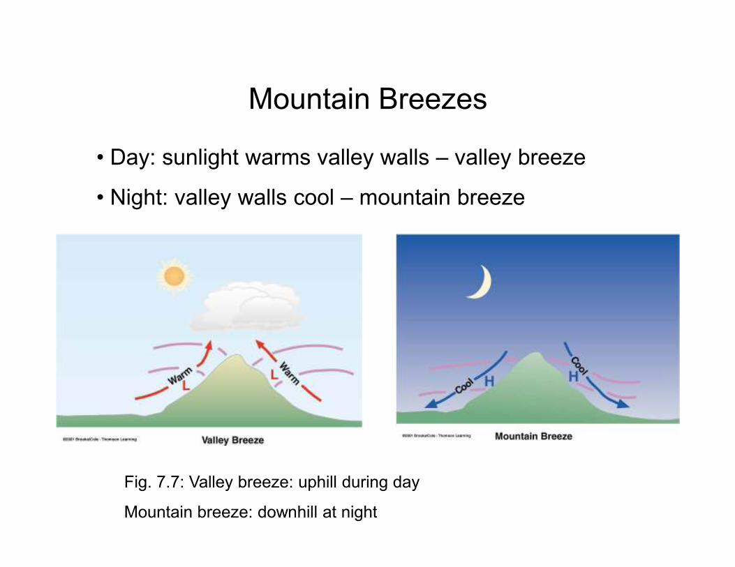
Mountain Breezes
• Day: sunlight warms valley walls – valley breeze
• Night: valley walls cool – mountain breeze
Fig. 7.7: Valley breeze: uphill during day
Mountain breeze: downhill at night
Question
If campfire smoke is blowing uphill along the east-
facing side of the hill and downhill along the west-
facing side of the same hill, are the fires cooking
breakfast or dinner? breakfast or dinner?
From the drift of the smoke, how were you able to
tell?
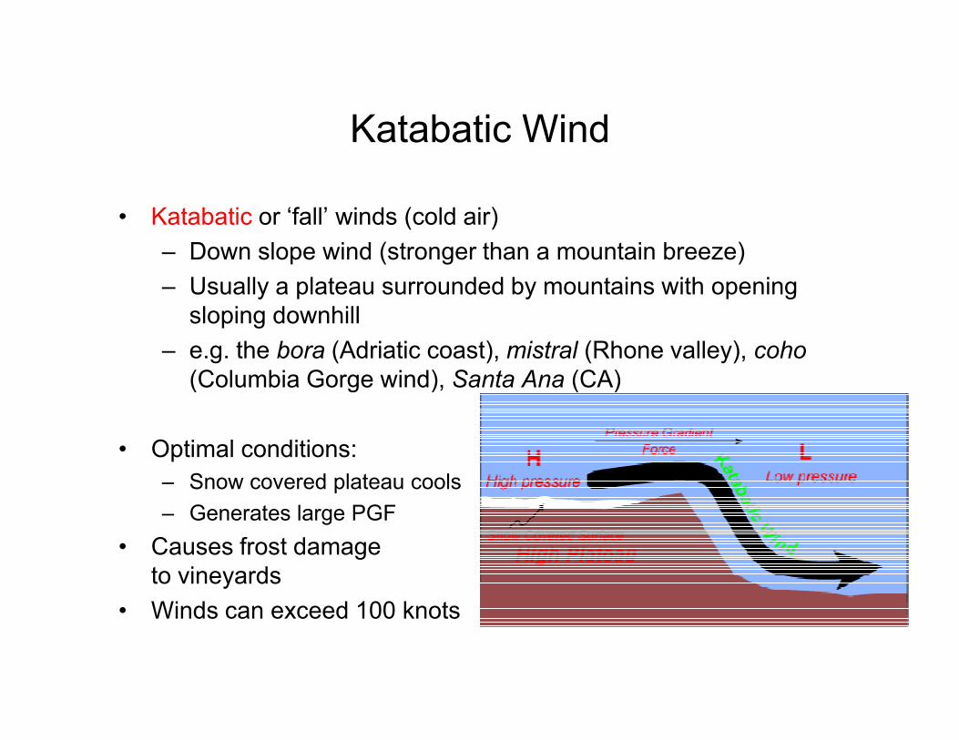
Katabatic Wind
• Katabatic or ‘fall’ winds (cold air)
– Down slope wind (stronger than a mountain breeze)
– Usually a plateau surrounded by mountains with opening
sloping downhill
– e.g. the bora (Adriatic coast), mistral (Rhone valley), coho
(Columbia Gorge wind), Santa Ana (CA)(Columbia Gorge wind), Santa Ana (CA)
• Optimal conditions:
– Snow covered plateau cools
– Generates large PGF
• Causes frost damage
to vineyards
• Winds can exceed 100 knots
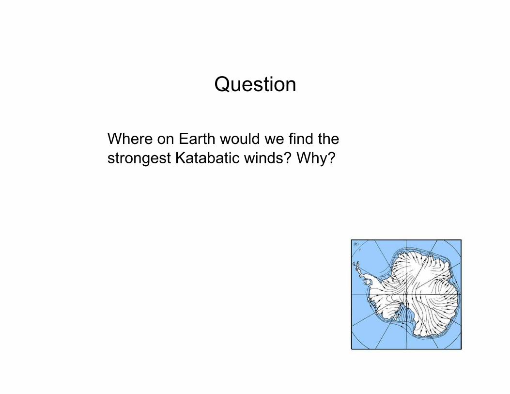
Question
Where on Earth would we find the
strongest Katabatic winds? Why?
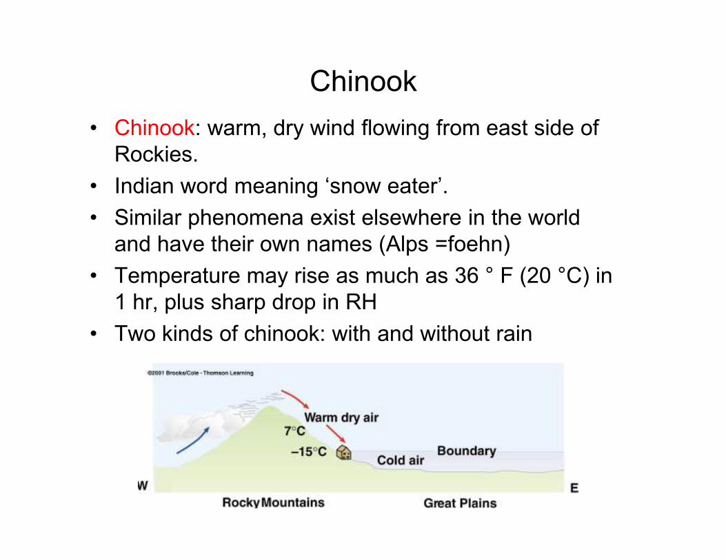
Chinook
• Chinook: warm, dry wind flowing from east side of
Rockies.
• Indian word meaning ‘snow eater’.
• Similar phenomena exist elsewhere in the world
and have their own names (Alps =foehn)
• Temperature may rise as much as 36 ° F (20 °C) in • Temperature may rise as much as 36 ° F (20 °C) in
1 hr, plus sharp drop in RH
• Two kinds of chinook: with and without rain

Pros and Cons
• Pros: relief from winter cold (main source is
compressional heating), uncovers prairie grass,
railroads
• Cons: fire hazard, crop failure (parched soil), high
speed wind may do damage, human behavior?
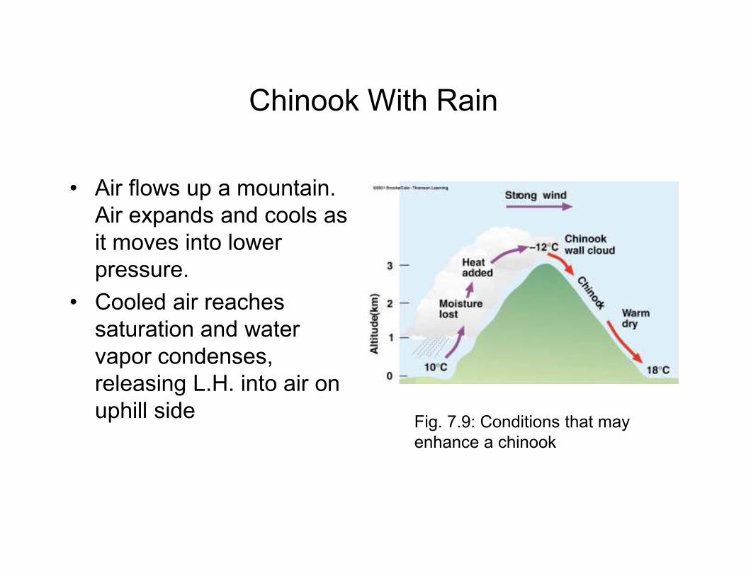
Chinook With Rain
• Air flows up a mountain.
Air expands and cools as
it moves into lower
pressure.
• Cooled air reaches
saturation and water
vapor condenses,
releasing L.H. into air on
uphill sideFig. 7.9: Conditions that may
enhance a chinook
Chinook With Rain
• Cooling on upwind side is reversed as air is
compressed downwind - compressional heating
• Net effect on the air after passing over the mountain:• Net effect on the air after passing over the mountain:
– Air is fairly dry since moisture lost on upwind side
– Air is warm (sometimes a great deal warmer)
because of L.H. released + compressional heating
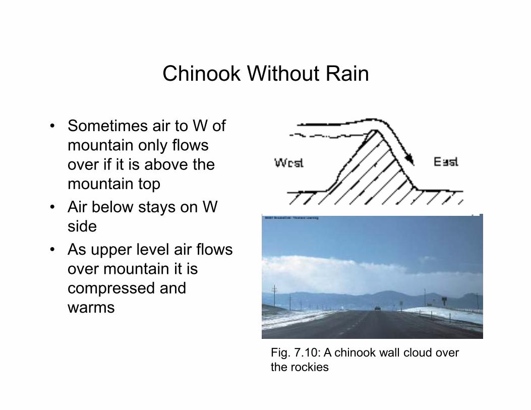
Chinook Without Rain
• Sometimes air to W of
mountain only flows
over if it is above the
mountain top
• Air below stays on W • Air below stays on W
side
• As upper level air flows
over mountain it is
compressed and
warms
Fig. 7.10: A chinook wall cloud over
the rockies
Question
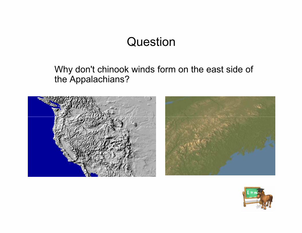
Why don't chinook winds form on the east side of the Appalachians?
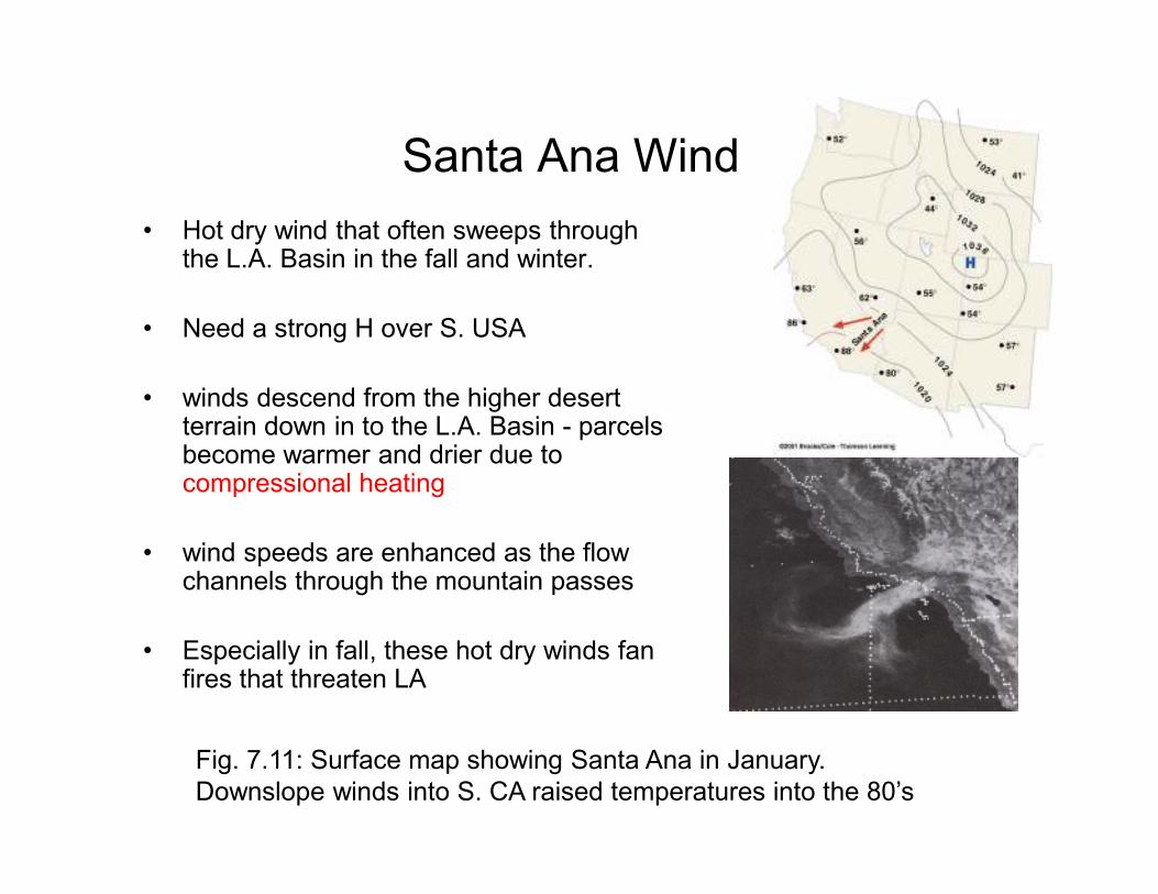
Santa Ana Wind
• Hot dry wind that often sweeps through the L.A. Basin in the fall and winter.
• Need a strong H over S. USA
• winds descend from the higher desert terrain down in to the L.A. Basin - parcels become warmer and drier due to become warmer and drier due to compressional heating
• wind speeds are enhanced as the flow channels through the mountain passes
• Especially in fall, these hot dry winds fan fires that threaten LA
Fig. 7.11: Surface map showing Santa Ana in January.
Downslope winds into S. CA raised temperatures into the 80’s
Question
In what ways is the Santa Ana similar to the
Chinook wind?
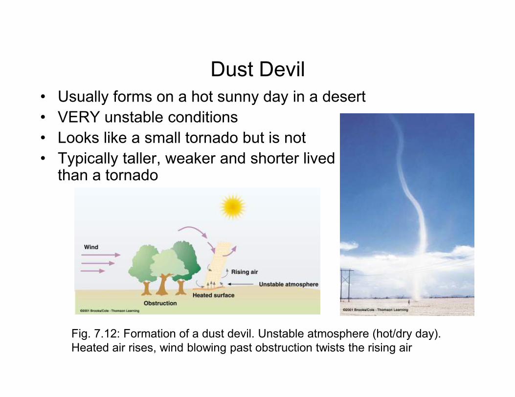
Dust Devil
• Usually forms on a hot sunny day in a desert
• VERY unstable conditions
• Looks like a small tornado but is not
• Typically taller, weaker and shorter lived than a tornado
Fig. 7.12: Formation of a dust devil. Unstable atmosphere (hot/dry day).
Heated air rises, wind blowing past obstruction twists the rising air
Global Scale Winds
• Wind is determined by pressure
– Fast wind where isobars are close (lg. PGF)
– High to Low pressure, deflection to right in N. hemisphere with CCW flow around lows, CW around highs
– High to Low pressure, deflection to left in S. – High to Low pressure, deflection to left in S. hemisphere with CW flow around lows, CCW around highs
• Upper-level pressure distribution is determined by temperature
– Upper-level high pressure where warm, because warm air expands
– Upper-level low where cold
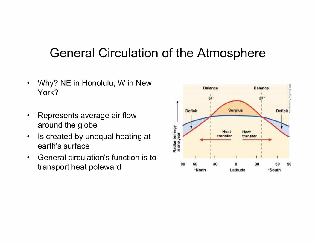
General Circulation of the Atmosphere
• Why? NE in Honolulu, W in New
York?
• Represents average air flow
around the globe around the globe
• Is created by unequal heating at
earth's surface
• General circulation's function is to
transport heat poleward
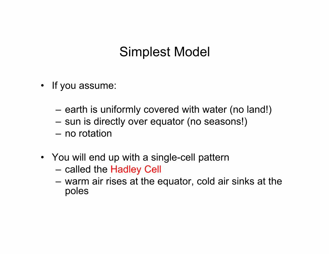
Simplest Model
• If you assume:
– earth is uniformly covered with water (no land!)
– sun is directly over equator (no seasons!)
– no rotation
• You will end up with a single-cell pattern
– called the Hadley Cell
– warm air rises at the equator, cold air sinks at the poles
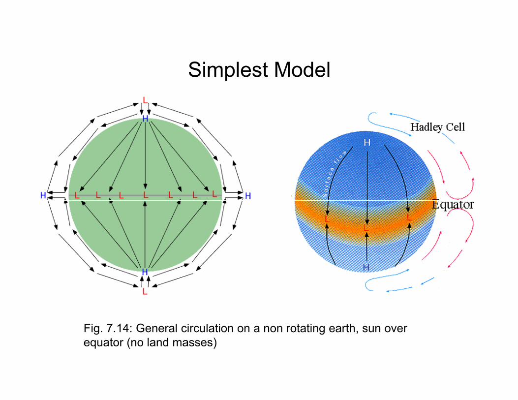
Simplest Model
Fig. 7.14: General circulation on a non rotating earth, sun over
equator (no land masses)
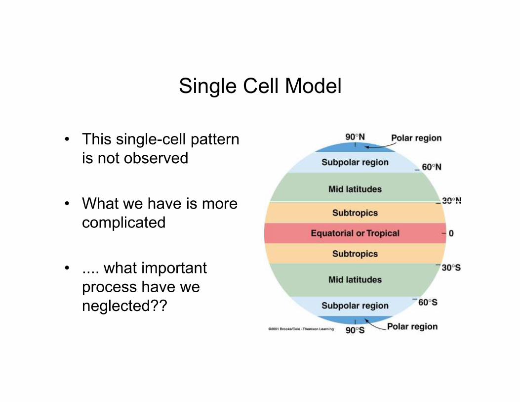
Single Cell Model
• This single-cell pattern
is not observed
• What we have is more • What we have is more
complicated
• .... what important
process have we
neglected??
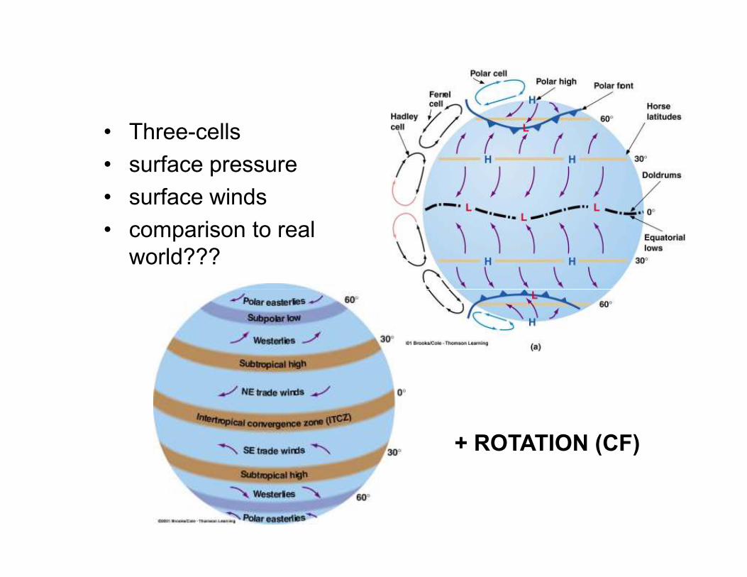
Three Cell
Model• Three-cells
• surface pressure
• surface winds
• comparison to real
world???
+ ROTATION (CF)
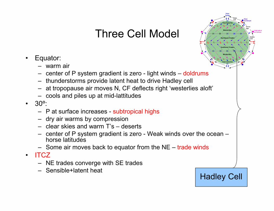
Three Cell Model
• Equator:– warm air
– center of P system gradient is zero - light winds – doldrums
– thunderstorms provide latent heat to drive Hadley cell
– at tropopause air moves N, CF deflects right ‘westerlies aloft’
– cools and piles up at mid-lattitudes
• 30º:• 30º:– P at surface increases - subtropical highs
– dry air warms by compression
– clear skies and warm T’s – deserts
– center of P system gradient is zero - Weak winds over the ocean –horse latitudes
– Some air moves back to equator from the NE – trade winds
• ITCZ– NE trades converge with SE trades
– Sensible+latent heatHadley Cell
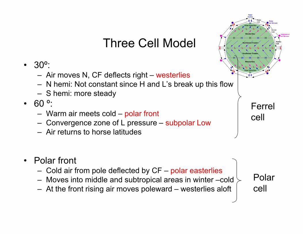
Three Cell Model
• 30º:– Air moves N, CF deflects right – westerlies
– N hemi: Not constant since H and L’s break up this flow
– S hemi: more steady
• 60 º:– Warm air meets cold – polar front
Ferrel
cell– Warm air meets cold – polar front
– Convergence zone of L pressure – subpolar Low
– Air returns to horse latitudes
• Polar front– Cold air from pole deflected by CF – polar easterlies
– Moves into middle and subtropical areas in winter –cold
– At the front rising air moves poleward – westerlies aloft
Polar
cell
cell
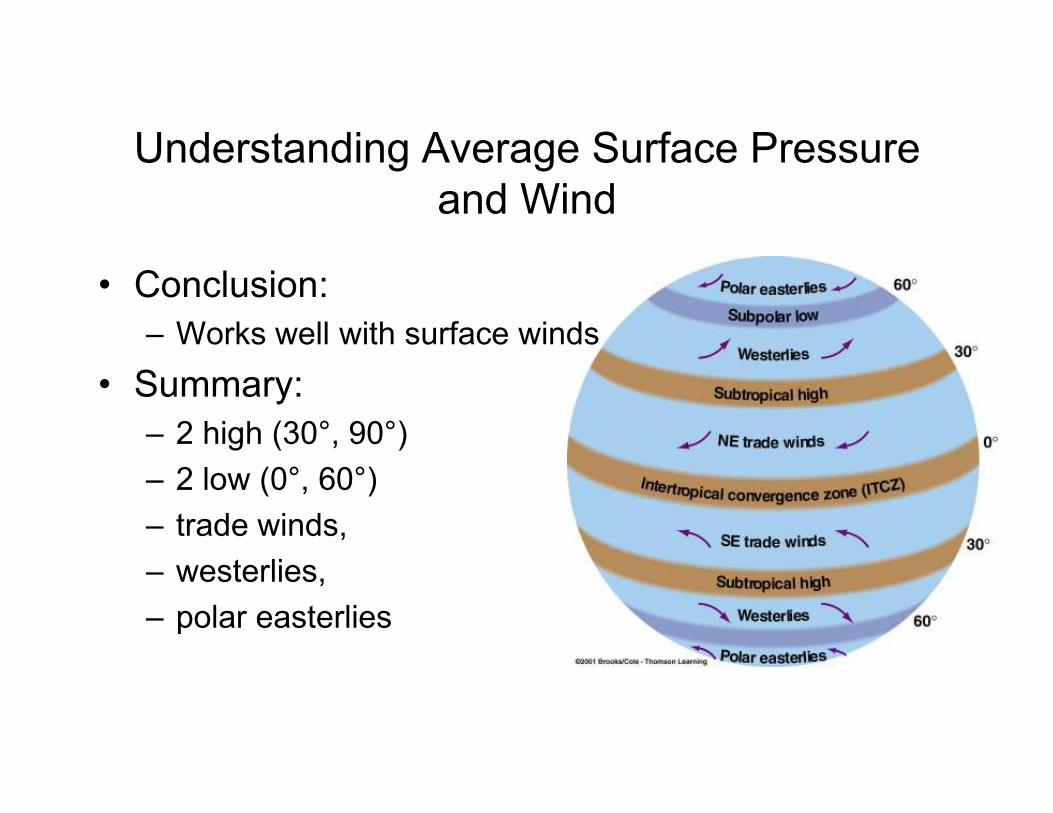
Understanding Average Surface Pressure
and Wind
• Conclusion:
– Works well with surface winds
• Summary:
– 2 high (30°, 90°)
– 2 low (0°, 60°)
– trade winds,
– westerlies,
– polar easterlies
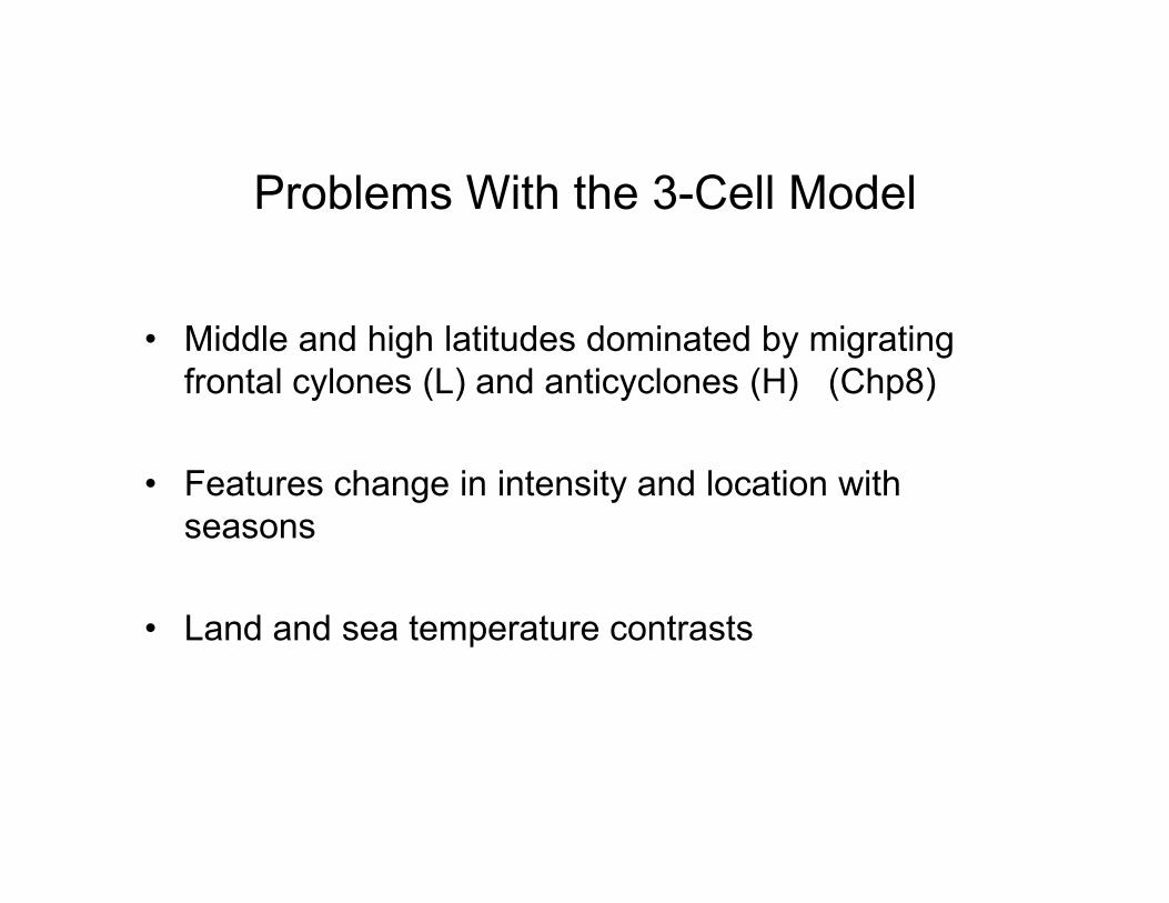
Problems With the 3-Cell Model
• Middle and high latitudes dominated by migrating
frontal cylones (L) and anticyclones (H) (Chp8)
• Features change in intensity and location with
seasons
• Land and sea temperature contrasts
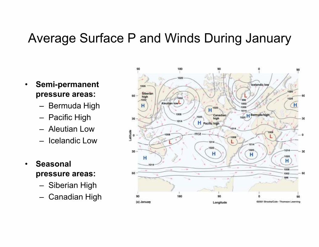
Average Surface P and Winds During January
• Semi-permanent
pressure areas:
– Bermuda High
– Pacific High
– Aleutian Low
– Icelandic Low
• Seasonal
pressure areas:
– Siberian High
– Canadian High
Average Surface P and Winds During July
• Semi-permanent
pressure areas:
• Bermuda High
• Pacific High• Pacific High
• Icelandic Low
• Seasonal
pressure areas:
• Monsoon Low
• Thermal Low
over SW US Sub-tropical H pressure belt breaks
up: surface heating forms L’s over
land
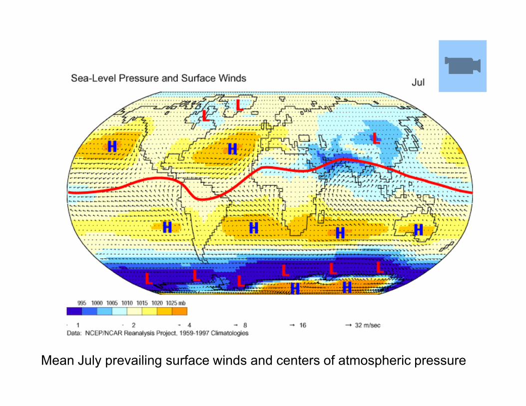
Surface Map For July
Mean July prevailing surface winds and centers of atmospheric pressure
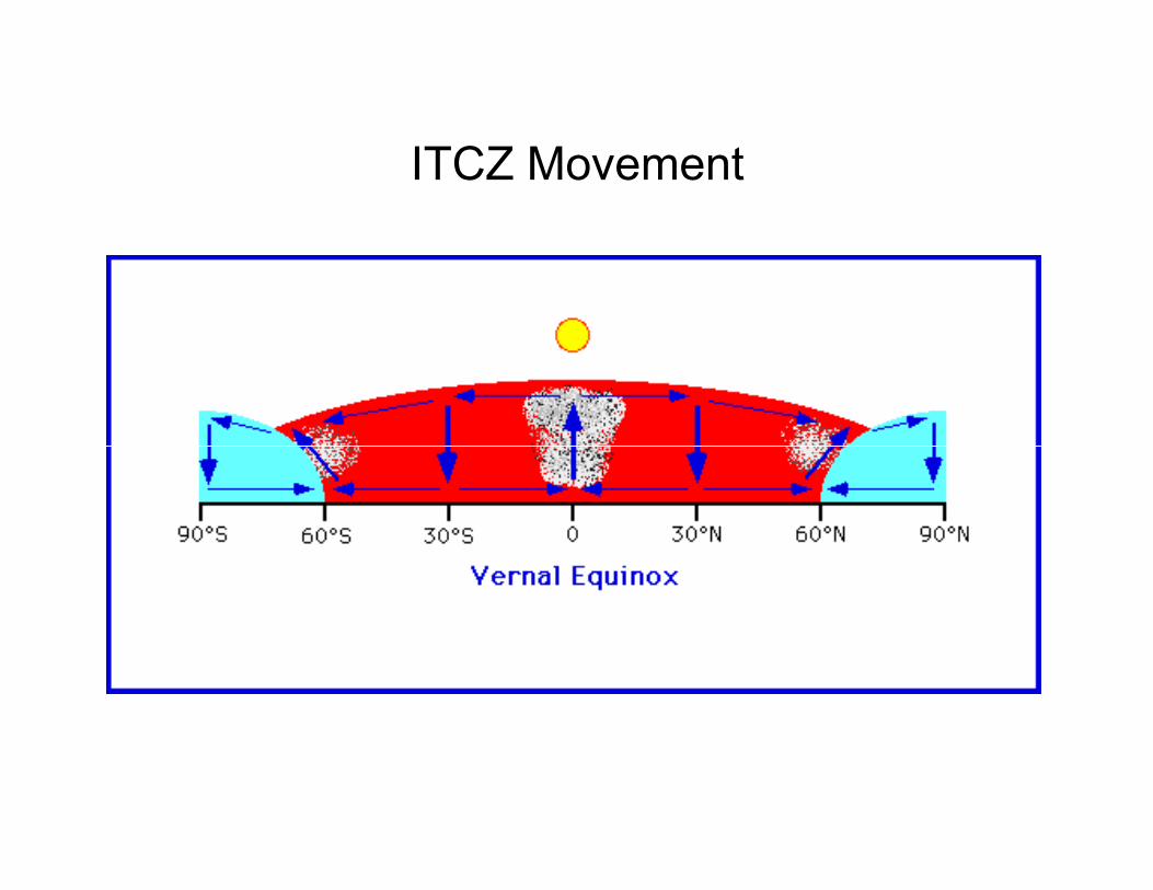
ITCZ Movement
Questions
How do the strength and position of these
feature differ from July to January? Why?
Why is the ITCZ further North in July than Why is the ITCZ further North in July than
January?
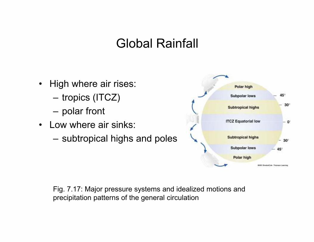
Global Rainfall
• High where air rises:
– tropics (ITCZ)
– polar front
• Low where air sinks:• Low where air sinks:
– subtropical highs and poles
Fig. 7.17: Major pressure systems and idealized motions and
precipitation patterns of the general circulation
Latitudinal Displacement
• 10- 15º Latitudinal displacement of major features
• Affects climate
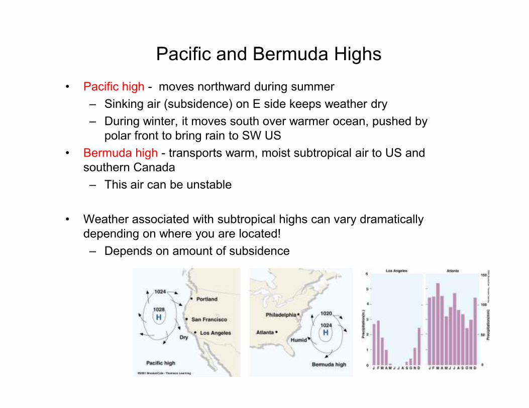
Pacific and Bermuda Highs
• Pacific high - moves northward during summer
– Sinking air (subsidence) on E side keeps weather dry
– During winter, it moves south over warmer ocean, pushed by
polar front to bring rain to SW US
• Bermuda high - transports warm, moist subtropical air to US and
southern Canada
– This air can be unstable
• Weather associated with subtropical highs can vary dramatically
depending on where you are located!
– Depends on amount of subsidence
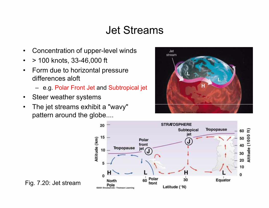
Jet Streams
• Concentration of upper-level winds
• > 100 knots, 33-46,000 ft
• Form due to horizontal pressure
differences aloft
– e.g. Polar Front Jet and Subtropical jet
• Steer weather systems
• The jet streams exhibit a "wavy" • The jet streams exhibit a "wavy"
pattern around the globe....
Fig. 7.20: Jet stream
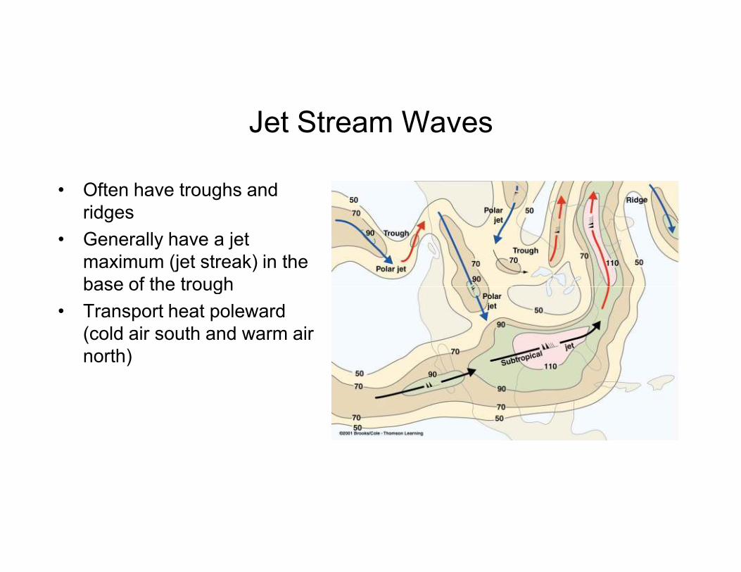
Jet Stream Waves
• Often have troughs and
ridges
• Generally have a jet
maximum (jet streak) in the
base of the troughbase of the trough
• Transport heat poleward
(cold air south and warm air
north)
Question
How is the polar jet stream formed????
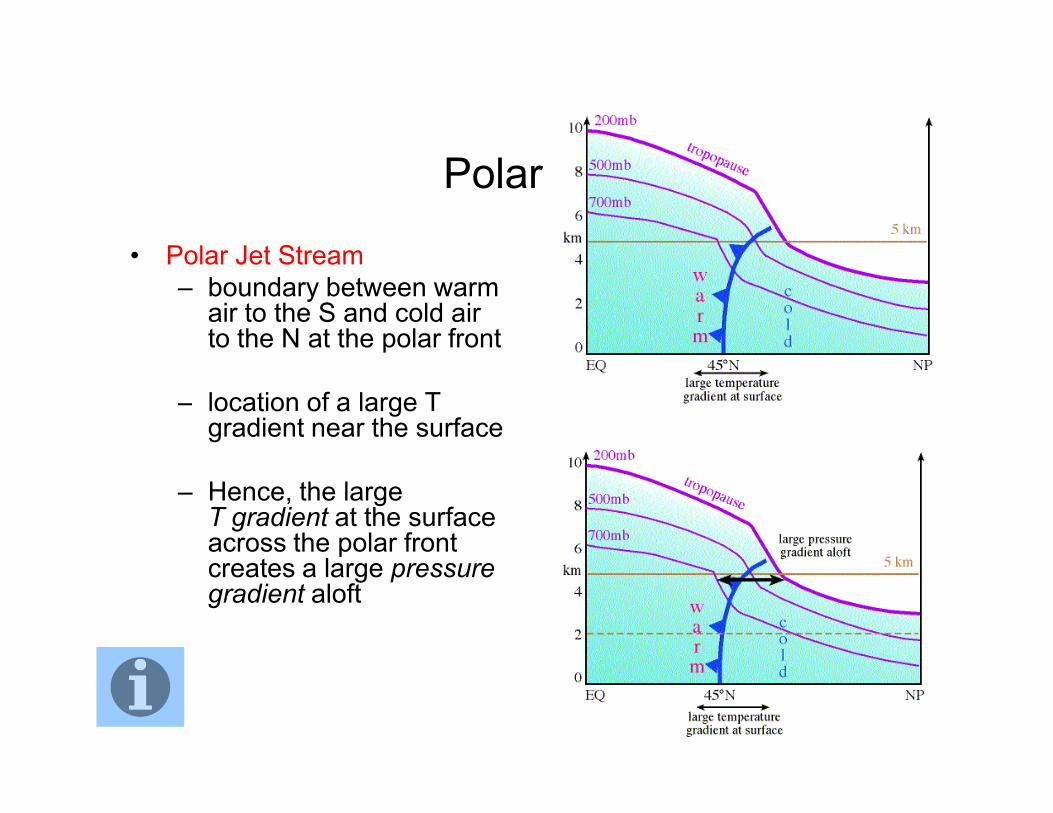
Polar Jet
• Polar Jet Stream
– boundary between warm air to the S and cold air to the N at the polar front
– location of a large T – location of a large T gradient near the surface
– Hence, the large T gradient at the surface across the polar front creates a large pressure gradient aloft
Question
1. During which season is the jet stream stronger,
winter or summer?
2. Why does the polar jet stream shift northward 2. Why does the polar jet stream shift northward
during the summer?
Question
When they are hitting the beaches in Southern
California in January, they are probably digging out in
New York City True or False?
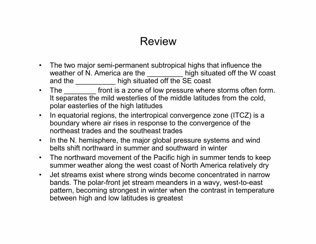
Review
• The two major semi-permanent subtropical highs that influence the weather of N. America are the _________ high situated off the W coast and the __________ high situated off the SE coast
• The ________ front is a zone of low pressure where storms often form. It separates the mild westerlies of the middle latitudes from the cold, polar easterlies of the high latitudes
• In equatorial regions, the intertropical convergence zone (ITCZ) is a boundary where air rises in response to the convergence of the boundary where air rises in response to the convergence of the northeast trades and the southeast trades
• In the N. hemisphere, the major global pressure systems and wind belts shift northward in summer and southward in winter
• The northward movement of the Pacific high in summer tends to keep summer weather along the west coast of North America relatively dry
• Jet streams exist where strong winds become concentrated in narrow bands. The polar-front jet stream meanders in a wavy, west-to-east pattern, becoming strongest in winter when the contrast in temperature between high and low latitudes is greatest
Ocean Currents
• Ocean currents are generally CW in N.
hemisphere and CCW in S. hemisphere
• Reason why: ocean water is pushed by water • Reason why: ocean water is pushed by water
flowing around high pressure
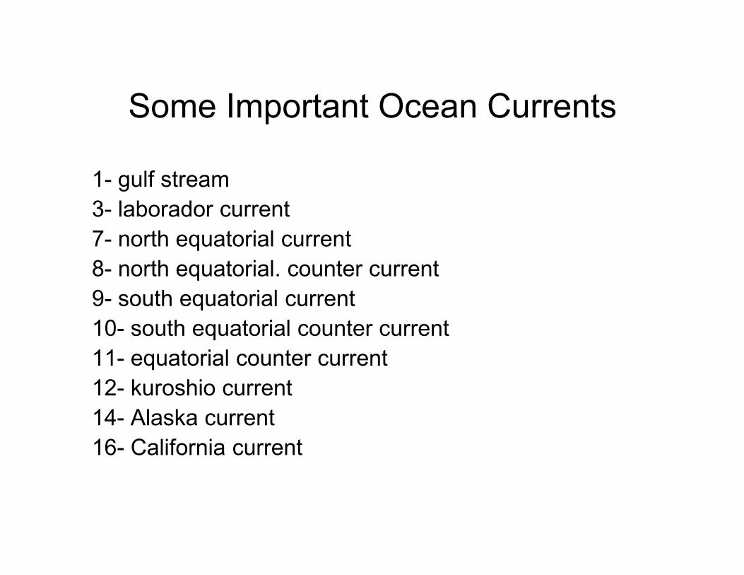
Some Important Ocean Currents
1- gulf stream
3- laborador current
7- north equatorial current
8- north equatorial. counter current
9- south equatorial current 9- south equatorial current
10- south equatorial counter current
11- equatorial counter current
12- kuroshio current
14- Alaska current
16- California current
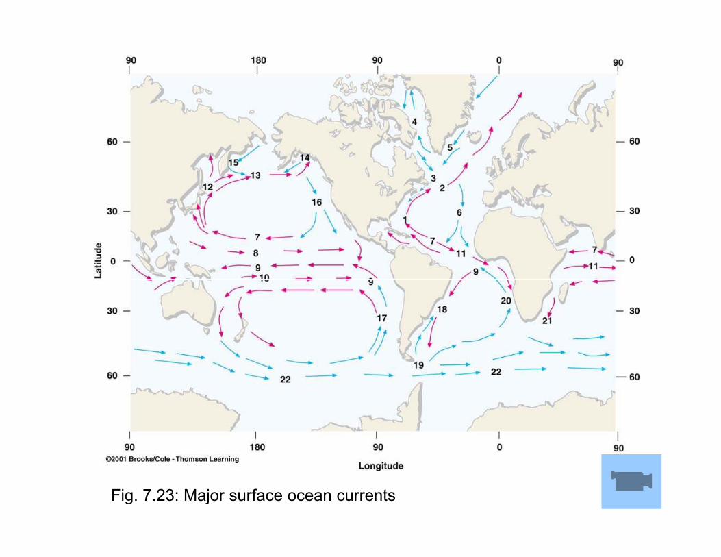
Fig. 7.23: Major surface ocean currents
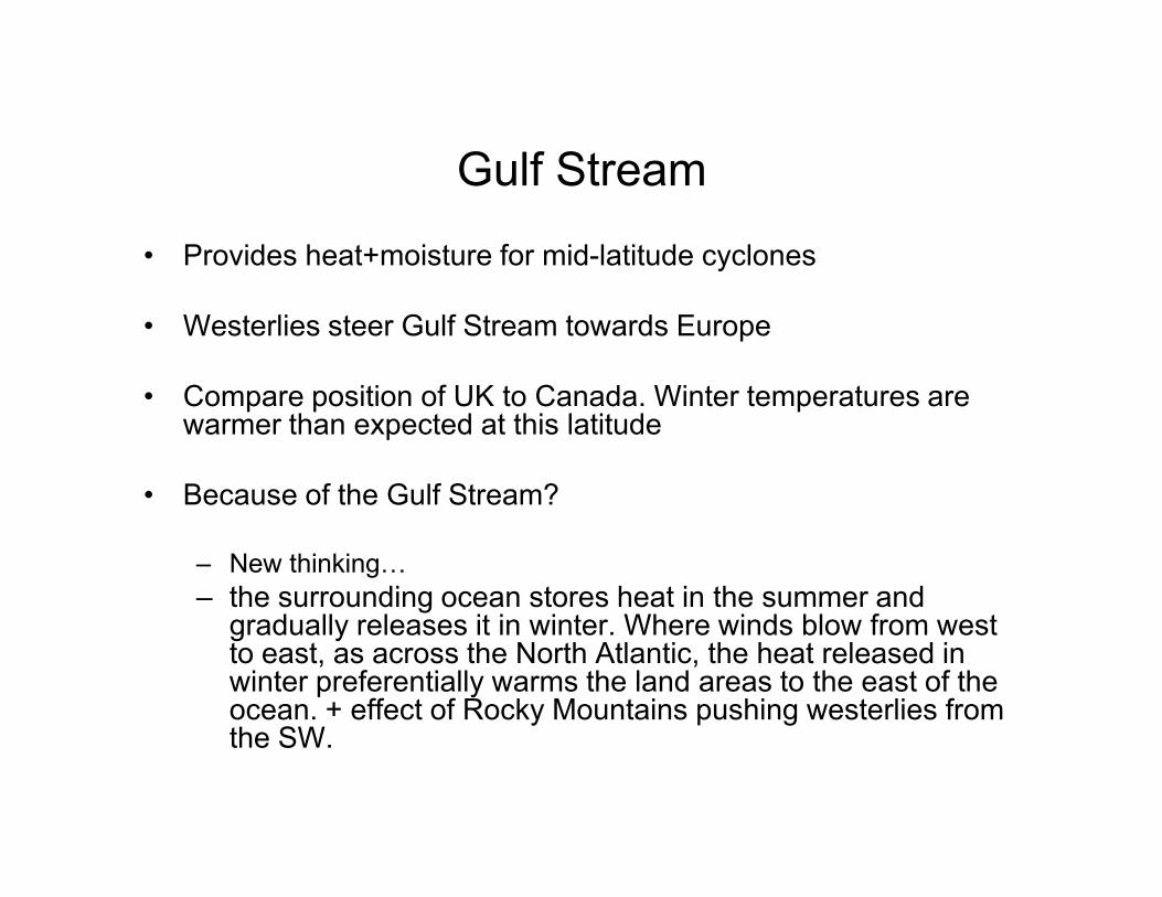
Gulf Stream
• Provides heat+moisture for mid-latitude cyclones
• Westerlies steer Gulf Stream towards Europe
• Compare position of UK to Canada. Winter temperatures are warmer than expected at this latitude
• Because of the Gulf Stream?
– New thinking…
– the surrounding ocean stores heat in the summer and gradually releases it in winter. Where winds blow from west to east, as across the North Atlantic, the heat released in winter preferentially warms the land areas to the east of the ocean. + effect of Rocky Mountains pushing westerlies from the SW.
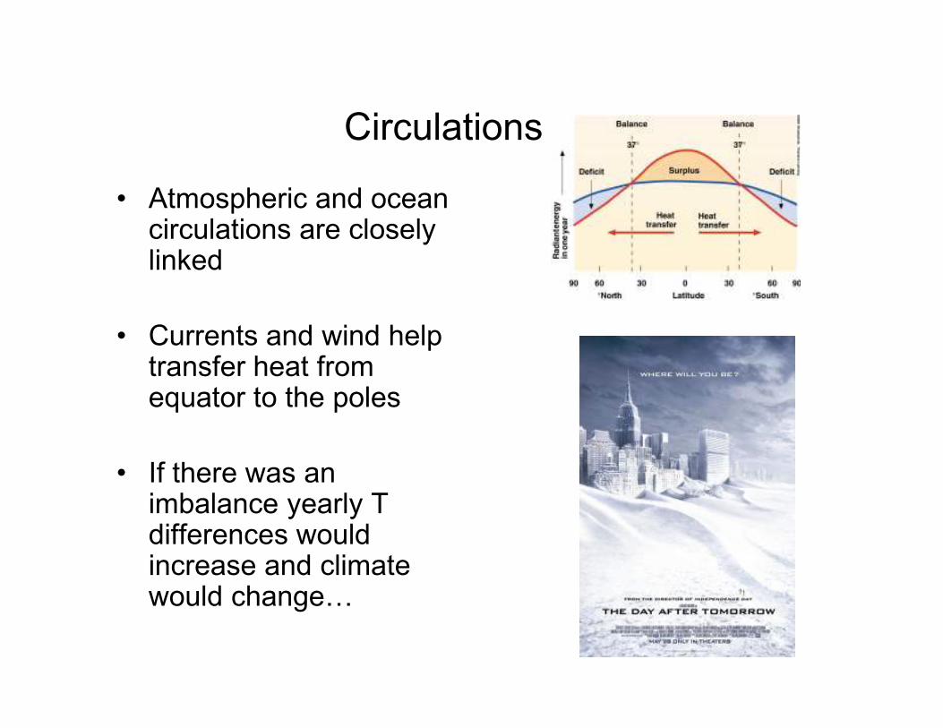
Circulations
• Atmospheric and ocean circulations are closely linked
• Currents and wind help transfer heat from transfer heat from equator to the poles
• If there was an imbalance yearly T differences would increase and climate would change…
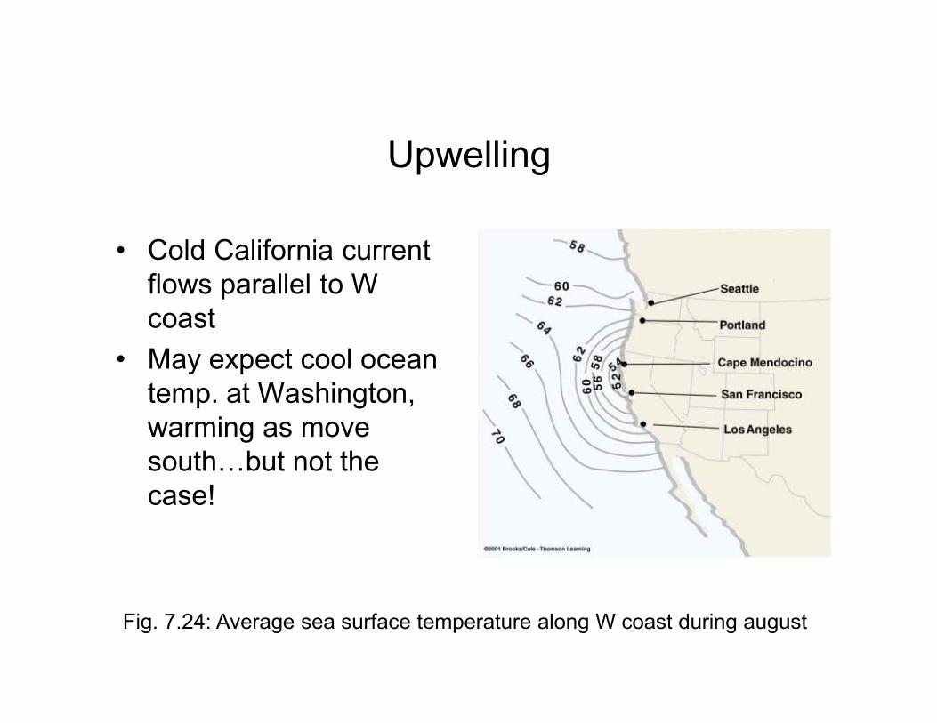
Upwelling
• Cold California current
flows parallel to W
coast
• May expect cool ocean • May expect cool ocean
temp. at Washington,
warming as move
south…but not the
case!
Fig. 7.24: Average sea surface temperature along W coast during august
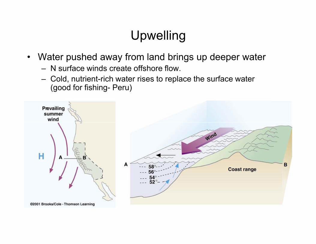
Upwelling
• Water pushed away from land brings up deeper water– N surface winds create offshore flow.
– Cold, nutrient-rich water rises to replace the surface water (good for fishing- Peru)
Question
Why do the major ocean currents in the North
Indian Ocean reverse direction between summer
and winter?
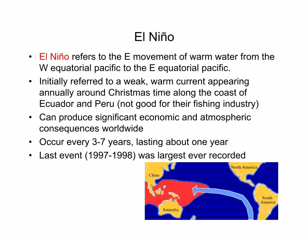
El Niño
• El Niño refers to the E movement of warm water from the
W equatorial pacific to the E equatorial pacific.
• Initially referred to a weak, warm current appearing
annually around Christmas time along the coast of
Ecuador and Peru (not good for their fishing industry)
• Can produce significant economic and atmospheric • Can produce significant economic and atmospheric
consequences worldwide
• Occur every 3-7 years, lasting about one year
• Last event (1997-1998) was largest ever recorded

Southern Oscillation• Observation:
– air pressures at sea level in the South Pacific seesaws back and forth between two distinct patterns.
• “High index" (upper map) pressure is higher to the east of Tahiti than to the west near Australia.
– The pressure difference along the equator causes surface air to flow
• “Low index" phase (lower map for November 1982)
–barometers rise in the west and fall in the east, a reduction or even a reversal of the pressure difference between Australia and Tahiti.
–The flattening of the seesaw causes the easterly surface winds equator causes surface air to flow
westward, as indicated by the long arrow.
causes the easterly surface winds to weaken and retreat eastward as shown.
–We now know that the "low index" phase is usually accompanied by El Nino
conditions.
http://www.pmel.noaa.gov/toga-tao/figure9.html
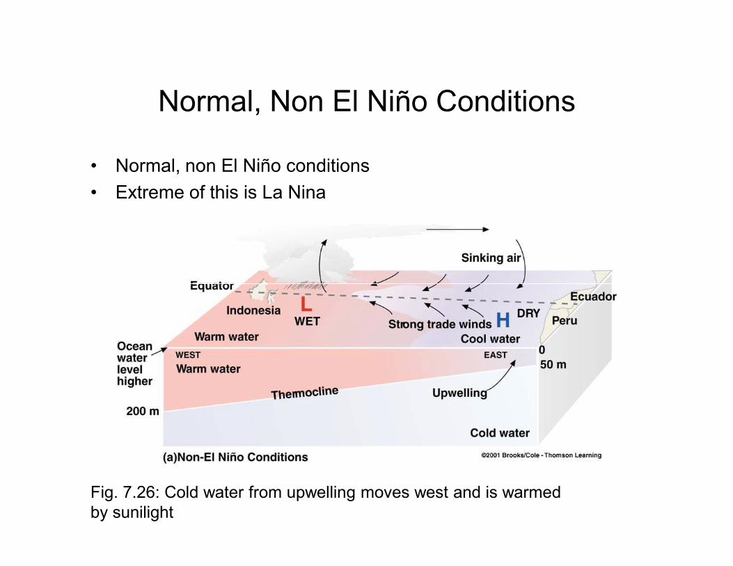
Normal, Non El Niño Conditions
• Normal, non El Niño conditions
• Extreme of this is La Nina
Fig. 7.26: Cold water from upwelling moves west and is warmed
by sunilight
Onset of El Niño
• During a normal year, there is a large pool of warm water in the
W pacific.
• Winds relax, allowing water from W pacific to slosh along
equator toward S. America
Fig. 7.27: (a) upwelling along
equator and S. Amer. Coast
keeps water cool
Fig. 7.27: (b) El Niño sea
surface temperatures (from
satellites)
keeps water cool
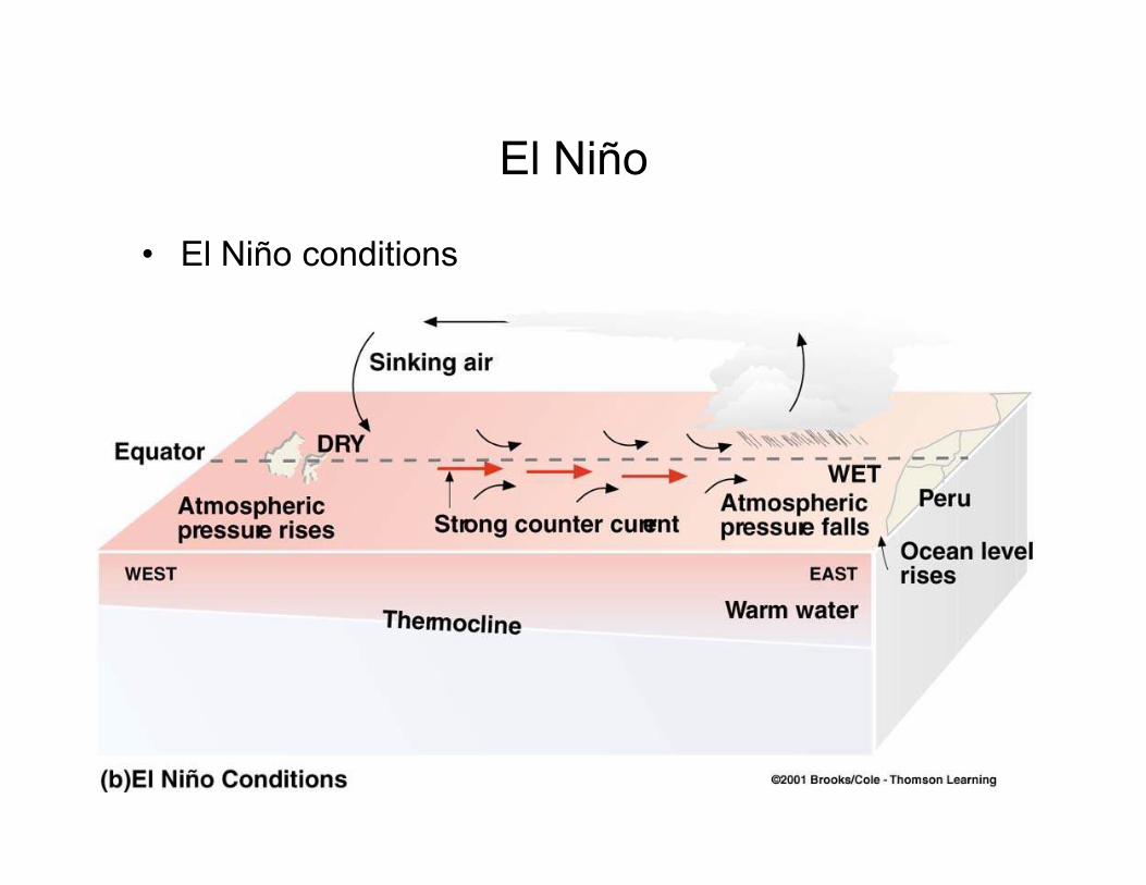
El Niño
• El Niño conditions
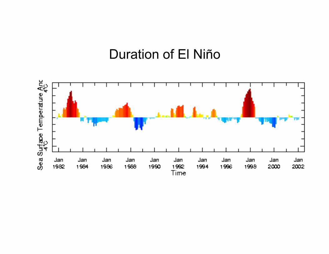
Duration of El Niño
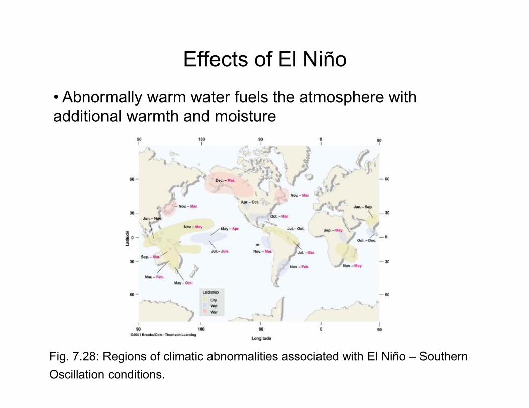
Effects of El Niño
• Abnormally warm water fuels the atmosphere with
additional warmth and moisture
Fig. 7.28: Regions of climatic abnormalities associated with El Niño – Southern
Oscillation conditions.
Question
• Adisappointing fishing season in the normally rich
fishing region off Peru can mean flooding rains for
Florida and mudslides in California True or False?
• The failure of the monsoon in India can mean a mild
winter is coming for the United States True or False?
Web Sites of Interest
• www.ElNino.noaa.gov
• www.pmel.noaa.gov(Pacific Marine Env. Lab.)
• www.coaps.fsu.edu• www.coaps.fsu.edu(Center for Ocean-Atmosphere Prediction Studies)
• http://www.pmel.noaa.gov/tao/jsdisplay/plots/mpeg/TAO_SST_Wind.mpeg(Movie)