CHAPTER 15 NAVIGATIONAL ASTRONOMY
50
225 CHAPTER 15 NAVIGATIONAL ASTRONOMY PRELIMINARY CONSIDERATIONS 1500. Definition Astronomy predicts the future positions and motions of celestial bodies and seeks to understand and explain their physical properties. Navigational astronomy, deal- ing principally with celestial coordinates, time, and the apparent motions of celestial bodies, is the branch of as- tronomy most important to the navigator. The symbols commonly recognized in navigational astronomy are given in Table 1500. Table 1500. Astronomical symbols.
Transcript of CHAPTER 15 NAVIGATIONAL ASTRONOMY

es-
lsre
CHAPTER 15
NAVIGATIONAL ASTRONOMY
PRELIMINARY CONSIDERATIONS
1500. Definition
Astronomy predicts the future positions and motionsof celestial bodies and seeks to understand and explaintheir physical properties. Navigational astronomy, deal-
ing principally with celestial coordinates, time, and thapparent motions of celestial bodies, is the branch of atronomy most important to the navigator. The symbocommonly recognized in navigational astronomy agiven in Table 1500.
Table 1500. Astronomical symbols.
225

226 NAVIGATIONAL ASTRONOMY
thetetheor
nsut
he
di-arelp-ld
30t
1501. The Celestial Sphere
Looking at the sky on a dark night, imagine that celes-tial bodies are located on the inner surface of a vast, earth-centered sphere. This model is useful since we are only in-terested in the relative positions and motions of celestialbodies on this imaginary surface. Understanding the con-cept of the celestial sphere is most important whendiscussing sight reduction in Chapter 20.
1502. Relative And Apparent Motion
Celestial bodies are in constant motion. There is nofixed position in space from which one can observe abso-lute motion. Since all motion is relative, the position of theobserver must be noted when discussing planetary motion.From the earth we see apparent motions of celestial bodieson the celestial sphere. In considering how planets followtheir orbits around the sun, we assume a hypothetical ob-
server at some distant point in space. When discussingrising or setting of a body on a local horizon, we must locathe observer at a particular point on the earth becausesetting sun for one observer may be the rising sun fanother.
Motion on the celestial sphere results from the motioin space of both the celestial body and the earth. Withospecial instruments, motions toward and away from tearth cannot be discerned.
1503. Astronomical Distances
Consider the celestial sphere as having an infinite raus because distances between celestial bodiesremarkably vast. The difficulty of illustrating astronomicadistances is indicated by the fact that if the earth were reresented by a circle one inch in diameter, the moon woube a circle one-fourth inch in diameter at a distance ofinches, the sun would be a circle nine feet in diameter a
Figure 1501. The celestial sphere.

NAVIGATIONAL ASTRONOMY 227
d
hends,its00hee
sasise
en
.1ctedg-tlledarer,
iveusareag-
bycharenets
ede
-
e
ly am-
r, itns,
.
a distance of nearly a fifth of a mile, and Pluto would be acircle half an inch in diameter at a distance of about sevenmiles. The nearest star would be one-fifth the actual dis-tance to the moon.
Because of the size of celestial distances, it is inconve-nient to measure them in common units such as the mile orkilometer. The mean distance to our nearest neighbor, themoon, is 238,900 miles. For convenience this distance issometimes expressed in units of the equatorial radius of theearth: 60.27 earth radii.
Distances between the planets are usually expressed interms of theastronomical unit (AU), the mean distancebetween the earth and the sun. This is approximately92,960,000 miles. Thus the mean distance of the earth fromthe sun is 1 A.U. The mean distance of Pluto, the outermostknown planet in our solar system, is 39.5 A.U. Expressed inastronomical units, the mean distance from the earth to themoon is 0.00257 A.U.
Distances to the stars require another leap in units. Acommonly-used unit is thelight-year, the distance lighttravels in one year. Since the speed of light is about 1.86×10⁵ miles per second and there are about 3.16× 10⁷ secondsper year, the length of one light-year is about 5.88× 10¹²
miles. The nearest stars, Alpha Centauri and its neighborProxima, are 4.3 light-years away. Relatively few stars areless than 100 light-years away. The nearest galaxies, theClouds of Magellan, are 150,000 to 200,000 light yearsaway. The most distant galaxies observed by astronomersare several billion light years away.
1504. Magnitude
The relative brightness of celestial bodies is indicateby a scale of stellarmagnitudes. Initially, astronomers di-vided the stars into 6 groups according to brightness. T20 brightest were classified as of the first magnitude, athe dimmest were of the sixth magnitude. In modern timewhen it became desirable to define more precisely the limof magnitude, a first magnitude star was considered 1times brighter than one of the sixth magnitude. Since tfifth root of 100 is 2.512, this number is considered thmagnitude ratio. A first magnitude star is 2.512 times abright as a second magnitude star, which is 2.512 timesbright as a third magnitude star,. A second magnitude2.512× 2.512 = 6.310 times as bright as a fourth magnitudstar. A first magnitude star is 2.51220 times as bright as astar of the 21st magnitude, the dimmest that can be sethrough a 200-inch telescope.
Brightness is normally tabulated to the nearest 0magnitude, about the smallest change that can be deteby the unaided eye of a trained observer. All stars of manitude 1.50 or brighter are popularly called “firsmagnitude” stars. Those between 1.51 and 2.50 are ca“second magnitude” stars, those between 2.51 and 3.50called “third magnitude” stars, etc. Sirius, the brightest stahas a magnitude of –1.6. The only other star with a negatmagnitude is Canopus, –0.9. At greatest brilliance Venhas a magnitude of about –4.4. Mars, Jupiter, and Saturnsometimes of negative magnitude. The full moon hasmagnitude of about –12.6, but varies somewhat. The manitude of the sun is about –26.7.
THE UNIVERSE
1505. The Solar System
Thesun, the most conspicuous celestial object in the sky,is the central body of the solar system. Associated with it are atleast nine principalplanetsand thousands of asteroids, com-ets, and meteors. Some planets like earth have satellites.
1506. Motions Of Bodies Of The Solar System
Astronomers distinguish between two principal mo-tions of celestial bodies.Rotation is a spinning motionabout an axis within the body, whereasrevolution is themotion of a body in its orbit around another body. The bodyaround which a celestial object revolves is known as thatbody’sprimary . For the satellites, the primary is a planet.For the planets and other bodies of the solar system, the pri-mary is the sun. The entire solar system is held together bythe gravitational force of the sun. The whole system re-volves around the center of the Milky Way galaxy (section1515), and the Milky Way is in motion relative to its neigh-boring galaxies.
The hierarchies of motions in the universe are causedthe force of gravity. As a result of gravity, bodies attract eaother in proportion to their masses and to the inverse squof the distances between them. This force causes the plato go around the sun in nearly circular, elliptical orbits.
In each planet’s orbit, the point nearest the sun is calltheperihelion. The point farthest from the sun is called thaphelion. The line joining perihelion and aphelion is calledtheline of apsides. In the orbit of the moon, the point nearest the earth is called theperigee, and that point farthestfrom the earth is called theapogee. Figure 1506 shows theorbit of the earth (with exaggerated eccentricity), and thorbit of the moon around the earth.
1507. The Sun
The sun dominates our solar system. Its mass is nearthousand times that of all other bodies of the solar system cobined. Its diameter is about 866,000 miles. Since it is a stagenerates its own energy through thermonuclear reactiothereby providing heat and light for the entire solar system

228 NAVIGATIONAL ASTRONOMY
s,ttic
ndiocu-
fasin
ter
,
The distance from the earth to the sun varies from91,300,000 at perihelion to 94,500,000 miles at aphelion.When the earth is at perihelion, which always occurs earlyin January, the sun appears largest, 32.6' in diameter. Sixmonths later at aphelion, the sun’s apparent diameter is aminimum of 31.5'.
Observations of the sun’s surface (called thephoto-sphere) reveal small dark areas calledsunspots. These areareas of intense magnetic fields in which relatively cool gas (at7000°F.) appears dark in contrast to the surrounding hotter gas(10,000°F.). Sunspots vary in size from perhaps 50,000 milesin diameter to the smallest spots that can be detected (a fewhundred miles in diameter). They generally appear in groups.Large sunspots can be seen without a telescope if the eyes areprotected, as by the shade glasses of a sextant.
Surrounding the photosphere is an outercorona ofvery hot but tenuous gas. This can only be seen during aneclipse of the sun, when the moon blocks the light of the
photosphere.The sun is continuously emitting charged particle
which form thesolar wind. As the solar wind sweeps pasthe earth, these particles interact with the earth’s magnefield. If the solar wind is particularly strong, the interactiocan produce magnetic storms which adversely affect rasignals on the earth. At such times the auroras are partilarly brilliant and widespread.
The sun is moving approximately in the direction oVega at about 12 miles per second, or about two-thirdsfast as the earth moves in its orbit around the sun. This isaddition to the general motion of the sun around the cenof our galaxy.
1508. Planets
The principal bodies orbiting the sun are calledplanets.Nine principal planets are known: Mercury, Venus, Earth
Figure 1506. Orbits of the earth and moon.

NAVIGATIONAL ASTRONOMY 229
rr.
sofde-ne-lag
n-rth
eetheti-ree-not
yrent
Mars, Jupiter, Saturn, Uranus, Neptune, and Pluto. Ofthese, only four are commonly used for celestial navigation:Venus, Mars, Jupiter, and Saturn.
Except for Pluto, the orbits of the planets lie in nearlythe same plane as the earth’s orbit. Therefore, as seen fromthe earth, the planets are confined to a strip of the celestialsphere called theecliptic.
The two planets with orbits smaller than that of the earthare calledinferior planets, and those with orbits larger thanthat of the earth are calledsuperior planets. The four planetsnearest the sun are sometimes called the inner planets, and theothers the outer planets. Jupiter, Saturn, Uranus, and Neptuneare so much larger than the others that they are sometimesclassed as major planets. Uranus is barely visible to the unaid-ed eye; Neptune and Pluto are not visible without a telescope.
Planets can be identified in the sky because, unlike thestars, they do not twinkle. The stars are so distant that theyare virtually point sources of light. Therefore the tiny streamof light from a star is easily scattered by normal motions ofair in the atmosphere causing the affect of twinkling. The na-ked-eye planets, however, are close enough to presentperceptible disks. The broader stream of light from a planetis not easily disrupted unless the planet is low on the horizonor the air is especially turbulent.
The orbits of many thousands of tiny minor planets oasteroids lie chiefly between the orbits of Mars and JupiteThese are all too faint to be seen with the naked eye.
1509. The Earth
In common with other planets, the earthrotates on itsaxis andrevolvesin its orbit around the sun. These motionare the principal source of the daily apparent motionsother celestial bodies. The earth’s rotation also causes aflection of water and air currents to the right in the NortherHemisphere and to the left in the Southern Hemisphere. Bcause of the earth’s rotation, high tides on the open seabehind the meridian transit of the moon.
For most navigational purposes, the earth can be cosidered a sphere. However, like the other planets, the eais approximately anoblate spheroid, or ellipsoid of revo-lution , flattened at the poles and bulged at the equator. SFigure 1509. Therefore, the polar diameter is less thanequatorial diameter, and the meridians are slightly ellipcal, rather than circular. The dimensions of the earth arecomputed from time to time, as additional and more prcise measurements become available. Since the earth isexactly an ellipsoid, results differ slightly when equallprecise and extensive measurements are made on diffe
Figure 1507. Whole solar disk and an enlargement of thegreat spot group of April 7, 1947.
Courtesy of Mt. Wilson and Palomar Observatories.
Figure 1509. Oblate spheroid or ellipsoid of revolution.
230 NAVIGATIONAL ASTRONOMY
ckt,rst-
n.zonesees
valan,n-a
r to
-ern.
parts of the surface.
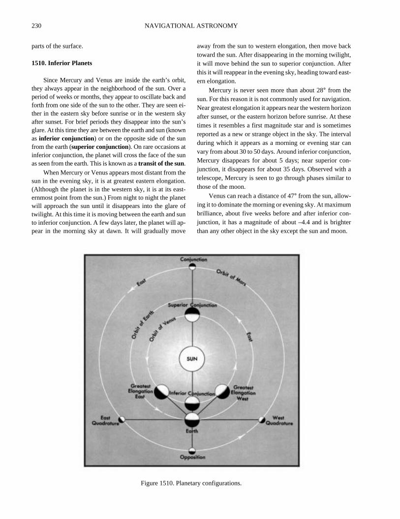
1510. Inferior Planets
Since Mercury and Venus are inside the earth’s orbit,they always appear in the neighborhood of the sun. Over aperiod of weeks or months, they appear to oscillate back andforth from one side of the sun to the other. They are seen ei-ther in the eastern sky before sunrise or in the western skyafter sunset. For brief periods they disappear into the sun’sglare. At this time they are between the earth and sun (knownas inferior conjunction ) or on the opposite side of the sunfrom the earth (superior conjunction). On rare occasions atinferior conjunction, the planet will cross the face of the sunas seen from the earth. This is known as atransit of the sun.
When Mercury or Venus appears most distant from thesun in the evening sky, it is at greatest eastern elongation.(Although the planet is in the western sky, it is at its east-ernmost point from the sun.) From night to night the planetwill approach the sun until it disappears into the glare oftwilight. At this time it is moving between the earth and sunto inferior conjunction. A few days later, the planet will ap-pear in the morning sky at dawn. It will gradually move
away from the sun to western elongation, then move batoward the sun. After disappearing in the morning twilighit will move behind the sun to superior conjunction. Aftethis it will reappear in the evening sky, heading toward eaern elongation.
Mercury is never seen more than about 28° from thesun. For this reason it is not commonly used for navigatioNear greatest elongation it appears near the western horiafter sunset, or the eastern horizon before sunrise. At thtimes it resembles a first magnitude star and is sometimreported as a new or strange object in the sky. The interduring which it appears as a morning or evening star cvary from about 30 to 50 days. Around inferior conjunctionMercury disappears for about 5 days; near superior cojunction, it disappears for about 35 days. Observed withtelescope, Mercury is seen to go through phases similathose of the moon.
Venus can reach a distance of 47° from the sun, allow-ing it to dominate the morning or evening sky. At maximumbrilliance, about five weeks before and after inferior conjunction, it has a magnitude of about –4.4 and is brightthan any other object in the sky except the sun and moo
Figure 1510. Planetary configurations.

NAVIGATIONAL ASTRONOMY 231
,is-ndsi-.2.
asisw
si-
i-
ys,
hheth.ithly
ar-
n’s.216be
ple
r,ilenverr-dxt
new
andn-in
ofy,; asis-re),th-
eri-ely
At these times it can be seen during the day and is sometimesobserved for a celestial line of position. It appears as a morn-ing or evening star for approximately 263 days in succession.Near inferior conjunction Venus disappears for 8 days;around superior conjunction it disappears for 50 days. Whenit transits the sun, Venus can be seen to the naked eye as asmall dot about the size of a group of sunspots. Through bin-oculars, Venus can be seen to go through a full set of phases.
1511. Superior Planets
As planets outside the earth’s orbit, the superior plan-ets are not confined to the proximity of the sun as seen fromthe earth. They can pass behind the sun (conjunction), butthey cannot pass between the sun and the earth. Instead wesee them move away from the sun until they are oppositethe sun in the sky (opposition). When a superior planet isnear conjunction, it rises and sets approximately with thesun and is thus lost in the sun’s glare. Gradually it becomesvisible in the early morning sky before sunrise. From day today, it rises and sets earlier, becoming increasingly visiblethrough the late night hours until dawn. Approaching oppo-sition, the planet will rise in the late evening, until atopposition, it will rise when the sun sets, be visible through-out the night, and set when the sun rises.
Observed against the background stars, the planets nor-mally move eastward in what is calleddirect motion.Approaching opposition, however, a planet will slow down,pause (at a stationary point), and begin moving westward(retrograde motion), until it reaches the next stationarypoint and resumes its direct motion. This is not because theplanet is moving strangely in space. This relative, observedmotion results because the faster moving earth is catchingup with and passing by the slower moving superior planet.
The superior planets are brightest and closest to theearth at opposition. The interval between oppositions isknown as thesynodic period. This period is longest for theclosest planet, Mars, and becomes increasingly shorter forthe outer planets.
Unlike Mercury and Venus, the superior planets do notgo through a full cycle of phases. They are always full orhighly gibbous.
Mars can usually be identified by its orange color. Itcan become as bright as magnitude –2.8 but is more oftenbetween –1.0 and –2.0 at opposition. Oppositions occur atintervals of about 780 days. The planet is visible for about330 days on either side of opposition. Near conjunction it islost from view for about 120 days. Its two satellites can onlybe seen in a large telescope.
Jupiter , largest of the known planets, normally out-shines Mars, regularly reaching magnitude –2.0 or brighterat opposition. Oppositions occur at intervals of about 400days, with the planet being visible for about 180 days be-fore and after opposition. The planet disappears for about32 days at conjunction. Four satellites (of a total 16 current-ly known) are bright enough to be seen in binoculars. Theirmotions around Jupiter can be observed over the course ofseveral hours.
Saturn, the outermost of the navigational planetscomes to opposition at intervals of about 380 days. It is vible for about 175 days before and after opposition, adisappears for about 25 days near conjunction. At oppotion it becomes as bright as magnitude +0.8 to –0Through good, high powered binoculars, Saturn appearselongated because of its system of rings. A telescopeneeded to examine the rings in any detail. Saturn is noknown to have at least 18 satellites, none of which are vible to the unaided eye.
Uranus, NeptuneandPluto are too faint to be used fornavigation; Uranus, at about magnitude 5.5, is faintly visble to the unaided eye.
1512. The Moon
Themoon is the only satellite of direct navigational in-terest. It revolves around the earth once in about 27.3 daas measured with respect to the stars. This is called thesi-dereal month. Because the moon rotates on its axis witthe same period with which it revolves around the earth, tsame side of the moon is always turned toward the earThe cycle of phases depends on the moon’s revolution wrespect to the sun. This synodic month is approximate29.53 days, but can vary from this average by up to a quter of a day during any given month.
When the moon is in conjunction with the sun (newmoon), it rises and sets with the sun and is lost in the suglare. The moon is always moving eastward at about 12°per day, so that sometime after conjunction (as little ashours, or as long as two days), the thin lunar crescent canobserved after sunset, low in the west. For the next couof weeks, the moon willwax, becoming more fully illumi-nated. From day to day, the moon will rise (and set) latebecoming increasingly visible in the evening sky, unt(about 7 days after new moon) it reaches first quarter, whthe moon rises about noon and sets about midnight. Othe next week the moon will rise later and later in the aftenoon until full moon, when it rises about sunset andominates the sky throughout the night. During the necouple of weeks the moon willwane, rising later and laterat night. By last quarter (a week after full moon), the moorises about midnight and sets at noon. As it approaches nmoon, the moon becomes an increasingly thin crescent,is seen only in the early morning sky. Sometime before cojunction (16 hours to 2 days before conjunction) the thcrescent will disappear in the glare of morning twilight.
At full moon, the sun and moon are on opposite sidesthe ecliptic. Therefore, in the winter the full moon rises earlcrosses the celestial meridian high in the sky, and sets latethe sun does in the summer. In the summer the full moon res in the southeastern part of the sky (Northern Hemispheremains relatively low in the sky, and sets along the souwestern horizon after a short time above the horizon.
At the time of the autumnal equinox, the part of thecliptic opposite the sun is most nearly parallel to the hozon. Since the eastward motion of the moon is approximatalong the ecliptic, the delay in the time of rising of the full

232 NAVIGATIONAL ASTRONOMY
as
ed-’s
theetto
ye.
nce-
cle
tedeenthisct
n
.
moon from night to night is less than at other times of theyear. The full moon nearest the autumnal equinox is calledtheharvest moon; the full moon a month later is called thehunter’s moon. See Figure 1512.
1513. Comets And Meteors
Although cometsare noted as great spectacles of na-ture, very few are visible without a telescope. Those thatbecome widely visible do so because they develop long,glowing tails. Comets are swarms of relatively small solidbodies held together by gravity. Around the nucleus, a gas-eous head or coma and tail may form as the cometapproaches the sun. The tail is directed away from the sun,so that it follows the head while the comet is approaching thesun, and precedes the head while the comet is receding. Thetotal mass of a comet is very small, and the tail is so thin thatstars can easily be seen through it. In 1910, the earth passedthrough the tail of Halley’s comet without noticeable effect.
Compared to the well-ordered orbits of the planets,comets are erratic and inconsistent. Some travel east to westand some west to east, in highly eccentric orbits inclined atany angle to the ecliptic. Periods of revolution range fromabout 3 years to thousands of years. Some comets may
speed away from the solar system after gaining velocitythey pass by Jupiter or Saturn.
The short-period comets long ago lost the gasses need to form a tail. Long period comets, such as Halleycomet, are more likely to develop tails. The visibility of acomet depends very much on how close it approachesearth. In 1910, Halley’s comet spread across the sky. Ywhen it returned in 1986, the earth was not well situatedget a good view, and it was barely visible to the unaided e
Meteors, popularly calledshooting stars, are tiny, sol-id bodies too small to be seen until heated to incandesceby air friction while passing through the earth’s atmosphere. A particularly bright meteor is called afireball .One that explodes is called abolide. A meteor that survivesits trip through the atmosphere and lands as a solid partiis called ameteorite.
Vast numbers of meteors exist. It has been estimathat an average of about 1,000,000 bright enough to be senter the earth’s atmosphere each hour, and many timesnumber undoubtedly enter, but are too small to attraattention.
Meteor showersoccur at certain times of the year whethe earth passes throughmeteor swarms, the scattered re-
Figure 1512. Phases of the moon. The inner figures of the moon represent its appearance from the earth

NAVIGATIONAL ASTRONOMY 233
nd—
atde.ni-nyo-cetarsv-
0 of
de
is
re
mains of comets that have broken up. At these times the
number of meteors observed is many times the usual number.A faint glow sometimes observed extending upward
approximately along the ecliptic before sunrise and aftersunset has been attributed to the reflection of sunlight fromquantities of this material. This glow is calledzodiacallight . A faint glow at that point of the ecliptic 180° from thesun is called thegegenschein or counterglow.
1514. Stars
Stars are distant suns, in many ways resembling thebody which provides the earth with most of its light andheat. Like the sun, stars are massive balls of gas that createtheir own energy through thermonuclear reactions.
Although stars differ in size and temperature, these dif-ferences are apparent only through analysis by astronomers.Some differences in color are noticeable to the unaided eye.While most stars appear white, some (those of lower temper-ature) have a reddish hue. In Orion, blue Rigel and redBetelgeuse, located on opposite sides of the belt, constitutea noticeable contrast.
The stars are not distributed uniformly around the sky.
Striking configurations, known asconstellations, were not-ed by ancient peoples, who supplied them with names amyths. Today astronomers use constellations—88 in allto identify areas of the sky.
Under ideal viewing conditions, the dimmest star thcan be seen with the unaided eye is of the sixth magnituIn the entire sky there are about 6,000 stars of this magtude or brighter. Half of these are below the horizon at atime. Because of the greater absorption of light near the hrizon, where the path of a ray travels for a greater distanthrough the atmosphere, not more than perhaps 2,500 sare visible to the unaided eye at any time. However, the aerage navigator seldom uses more than perhaps 20 or 3the brighter stars.
Stars which exhibit a noticeable change of magnituare calledvariable stars. A star which suddenly becomesseveral magnitudes brighter and then gradually fadescalled a nova. A particularly bright nova is called asupernova.
Two stars which appear to be very close together acalled adouble star. If more than two stars are included inthe group, it is called amultiple star . A group of a few doz-
Figure 1513. Halley’s Comet; fourteen views, made between April 26 and June 11, 1910.Courtesy of Mt. Wilson and Palomar Observatories.

234 NAVIGATIONAL ASTRONOMY
i-hesble
n-ionheripone.onles
s ainthee-igerse-ired
ci.
en to several hundred stars moving through space togetheris called anopen cluster. The Pleiades is an example of anopen cluster. There are also spherically symmetric clustersof hundreds of thousands of stars known asglobular clus-ters. The globular clusters are all too distant to be seen withthe naked eye.
A cloudy patch of matter in the heavens is called aneb-ula. If it is within the galaxy of which the sun is a part, it iscalled agalactic nebula; if outside, it is called anextraga-lactic nebula.
Motion of a star through space can be classified by itsvector components. That component in the line of sight iscalledradial motion , while that component across the lineof sight, causing a star to change its apparent position rela-tive to the background of more distant stars, is calledproper motion.
1515. Galaxies
A galaxyis a vast collection of clusters of stars and cloudsof gas. The earth is located in the Milky Way galaxy, a slowlyspinning disk more than 100,000 light years in diameter. Allthe bright stars in the sky are in the Milky Way. However, themost dense portions of the galaxy are seen as the great, broadband that glows in the summer nighttime sky. When we looktoward the constellation Sagittarius, we are looking toward thecenter of the Milky Way, 30,000 light years away.
Despite their size and luminance, almost all other gal-axies are too far away to be seen with the unaided eye. Anexception in the northern hemisphere is the Great Galaxy(sometimes called the Great Nebula) in Andromeda, whichappears as a faint glow. In the southern hemisphere, the
Large and Small Magellanic Clouds (named after Ferdnand Magellan) are the nearest known neighbors of tMilky Way. They are approximately 1,700,000 light yeardistant. The Magellanic Clouds can be seen as sizaglowing patches in the southern sky.
APPARENT MOTION
1516. Apparent Motion Due To Rotation Of The Earth
Apparent motion caused by the earth’s rotation ismuch greater than any other observed motion of celestialbodies. It is this motion that causes celestial bodies to ap-pear to rise along the eastern half of the horizon, climb tomaximum altitude as they cross the meridian, and set alongthe western horizon, at about the same point relative to duewest as the rising point was to due east. This apparent mo-tion along the daily path, ordiurnal circle , of the body isapproximately parallel to the plane of the equator. It wouldbe exactly so if rotation of the earth were the only motionand the axis of rotation of the earth were stationary in space.
The apparent effect due to rotation of the earth varieswith the latitude of the observer. At the equator, where theequatorial plane is vertical (since the axis of rotation of theearth is parallel to the plane of the horizon), bodies appearto rise and set vertically. Every celestial body is above thehorizon approximately half the time. The celestial sphere asseen by an observer at the equator is called the right sphere,
shown in Figure 1516a.
For an observer at one of the poles, bodies having costant declination neither rise nor set (neglecting precessof the equinoxes and changes in refraction), but circle tsky, always at the same altitude, making one complete taround the horizon each day. At the North Pole the motiis clockwise, and at the South Pole it is counterclockwisApproximately half the stars are always above the horizand the other half never are. The parallel sphere at the pois illustrated in Figure 1516b.
Between these two extremes, the apparent motion icombination of the two. On this oblique sphere, illustratedFigure 1516c, circumpolar celestial bodies remain abovehorizon during the entire 24 hours, circling the elevated clestial pole each day. The stars of Ursa Major (the BDipper) and Cassiopeia are circumpolar for many observin the United States. An approximately equal part of the clestial sphere remains below the horizon during the entday. Crux is not visible to most observers in the Unite
Figure 1515. Spiral nebula Messier 51, In Canes VenetiSatellite nebula is NGC 5195.
Courtesy of Mt. Wilson and Palomar Observatories.

NAVIGATIONAL ASTRONOMY 235
the
terts-se.s-
States. Other bodies rise obliquely along the eastern horizon,
climb to maximum altitude at the celestial meridian, and setalong the western horizon. The length of time above the horizonand the altitude at meridian transit vary with both the latitude ofthe observer and the declination of the body. At the polar circlesof the earth even the sun becomes circumpolar. This is the landof the midnight sun, where the sun does not set during part of thesummer and does not rise during part of the winter.
The increased obliquity at higher latitudes explains
why days and nights are always about the same length in
tropics, and the change of length of the day becomes greaas the latitude increases. It also explains why twilight laslonger in higher latitudes. Twilight is the period of incomplete darkness following sunset and preceding sunriEvening twilight starts at sunset, and morning twilight endat sunrise. The darker limit of twilight occurs when the cen
Figure 1516a. The right sphere. Figure 1516b. The parallel sphere.
Figure 1516c. The oblique sphere at latitude 40°N. Figure 1516d. The various twilight at latitude 20°N andlatitude 60°N.

236 NAVIGATIONAL ASTRONOMY
own
ev-yrb-esgh-yearrneddo
theo-ialgingm
nd
darkeinldun,tost,
arensel-byof
ar-entenotilyrop-.3
ter of the sun is a stated number of degrees below thecelestial horizon. Three kinds of twilight are defined: civil,
nautical and astronomical.
The conditions at the darker limit are relative and varyconsiderably under different atmospheric conditions
In Figure 1516d, the twilight band is shown, with thedarker limits of the various kinds indicated. The nearly ver-tical celestial equator line is for an observer at latitude20°N. The nearly horizontal celestial equator line is for anobserver at latitude 60°N. The broken line in each case isthe diurnal circle of the sun when its declination is 15°N.The relative duration of any kind of twilight at the two lat-itudes is indicated by the portion of the diurnal circlebetween the horizon and the darker limit, although it is notdirectly proportional to the relative length of line shownsince the projection is orthographic. The duration of twi-light at the higher latitude is longer, proportionally, thanshown. Note that complete darkness does not occur at lati-tude 60°N when the declination of the sun is 15°N.
1517. Apparent Motion Due To Revolution Of TheEarth
If it were possible to stop the rotation of the earth sothat the celestial sphere would appear stationary, the effectsof the revolution of the earth would become more notice-able. In one year the sun would appear to make onecomplete trip around the earth, from west to east. Hence, itwould seem to move eastward a little less than 1° per day.This motion can be observed by watching the changing po-sition of the sun among the stars. But since both sun andstars generally are not visible at the same time, a better wayis to observe the constellations at the same time each night.On any night a star rises nearly four minutes earlier than onthe previous night. Thus, the celestial sphere appears toshift westward nearly 1° each night, so that different con-stellations are associated with different seasons of the year.
Apparent motions of planets and the moon are due to acombination of their motions and those of the earth. If the ro-tation of the earth were stopped, the combined apparentmotion due to the revolutions of the earth and other bodieswould be similar to that occurring if both rotation and revolu-tion of the earth were stopped. Stars would appear nearlystationary in the sky but would undergo a small annual cycleof change due to aberration. The motion of the earth in its orbitis sufficiently fast to cause the light from stars to appear to shiftslightly in the direction of the earth’s motion. This is similar tothe effect one experiences when walking in vertically-falling
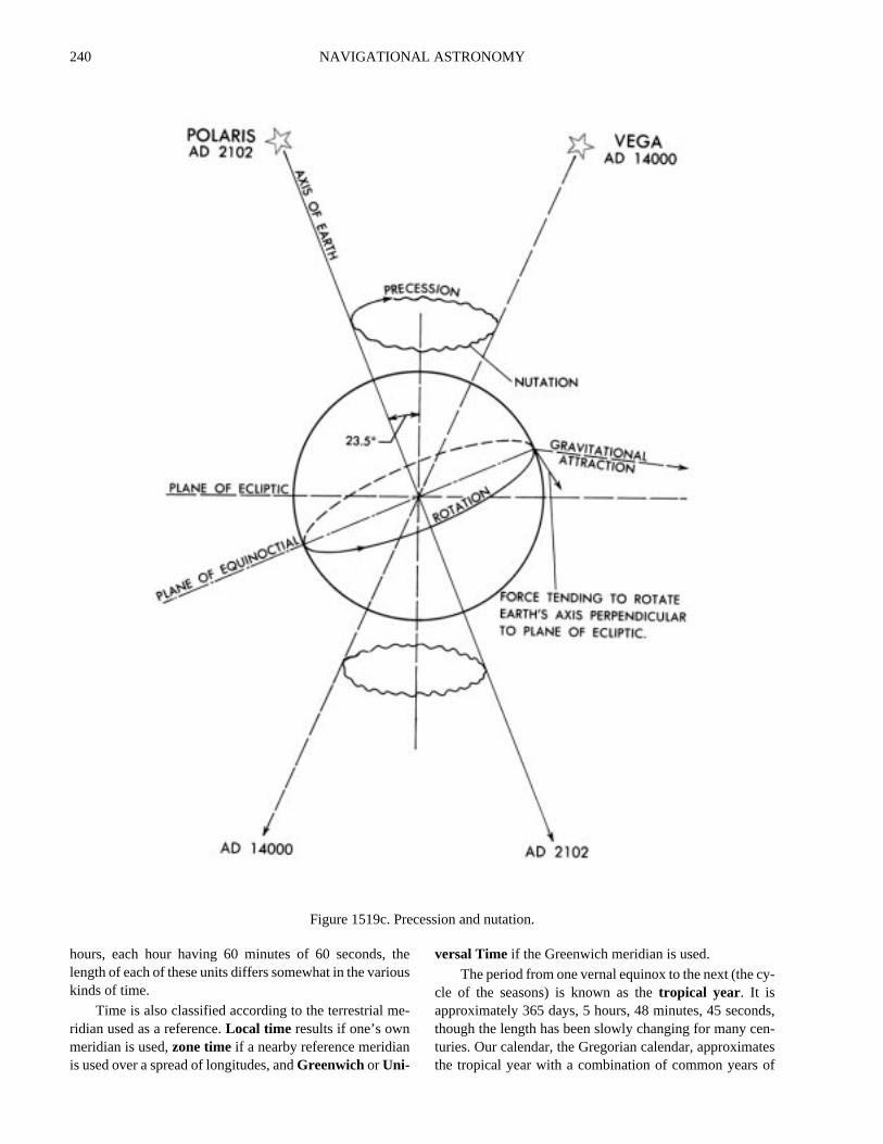
rain that appears to come from ahead due to the observer’sforward motion. The apparent direction of the light ray fromthe star is the vector difference of the motion of light and thmotion of the earth, similar to that of apparent wind on a moing vessel. This effect is most apparent for a bodperpendicular to the line of travel of the earth in its orbit, fowhich it reaches a maximum value of 20.5". The effect of aerration can be noted by comparing the coordinat(declination and sidereal hour angle) of various stars throuout the year. A change is observed in some bodies as theprogresses, but at the end of the year the values have retualmost to what they were at the beginning. The reason theynot return exactly is due to proper motion and precession ofequinoxes. It is also due to nutation, an irregularity in the mtion of the earth due to the disturbing effect of other celestbodies, principally the moon. Polar motion is a slight wobblinof the earth about its axis of rotation and sometimes wanderof the poles. This motion, which does not exceed 40 feet frothe mean position, produces slight variation of latitude alongitude of places on the earth.
1518. Apparent Motion Due To Movement Of OtherCelestial Bodies
Even if it were possible to stop both the rotation anrevolution of the earth, celestial bodies would not appestationary on the celestial sphere. The moon would maone revolution about the earth each sidereal month, risingthe west and setting in the east. The inferior planets wouappear to move eastward and westward relative to the sstaying within the zodiac. Superior planets would appearmake one revolution around the earth, from west to eaeach sidereal period.
Since the sun (and the earth with it) and all other starsin motion relative to each other, slow apparent motiowould result in slight changes in the positions of the stars rative to each other. This space motion is, in fact, observedtelescope. The component of such motion across the linesight, called proper motion, produces a change in the appent position of the star. The maximum which has beobserved is that of Barnard’s Star, which is moving at the raof 10.3 seconds per year. This is a tenth-magnitude star,visible to the unaided eye. Of the 57 stars listed on the dapages of the almanacs, Rigil Kentaurus has the greatest per motion, about 3.7 seconds per year. Arcturus, with 2
Twilight Lighter limit Darker limit At darker limit
civil –0°50' –6° Horizon clear; bright stars visiblenautical –0°50' –12° Horizon not visibleastronomical –0°50' –18° Full night

NAVIGATIONAL ASTRONOMY 237
rdhendi-ofy,th.oralm
ris-izone-ye
n a
lunea-
d.in
ckox.
i-ndur-the-reasonionisay,tes,e-rthto
ev-athees
o
seconds per year, has the greatest proper motion of the navi-gational stars in the Northern Hemisphere. In a few thousandyears proper motion will be sufficient to materially altersome familiar configurations of stars, notably Ursa Major.
1519. The Ecliptic
Theecliptic is the path the sun appears to take amongthe stars due to the annual revolution of the earth in its orbit.It is considered a great circle of the celestial sphere, in-clined at an angle of about 23°26' to the celestial equator,but undergoing a continuous slight change. This angle iscalled theobliquity of the ecliptic . This inclination is dueto the fact that the axis of rotation of the earth is not perpen-dicular to its orbit. It is this inclination which causes the sunto appear to move north and south during the year, givingthe earth its seasons and changing lengths of periods ofdaylight.
Refer to Figure 1519a. The earth is at perihelion earlyin January and at aphelion 6 months later. On or about June21, about 10 or 11 days before reaching aphelion, the north-ern part of the earth’s axis is tilted toward the sun. The northpolar regions are having continuous sunlight; the NorthernHemisphere is having its summer with long, warm days andshort nights; the Southern Hemisphere is having winterwith short days and long, cold nights; and the south polarregion is in continuous darkness. This is thesummer sol-stice. Three months later, about September 23, the earth hasmoved a quarter of the way around the sun, but its axis ofrotation still points in about the same direction in space.The sun shines equally on both hemispheres, and days andnights are the same length over the entire world. The sun issetting at the North Pole and rising at the South Pole. TheNorthern Hemisphere is having its autumn, and the South-ern Hemisphere its spring. This is theautumnal equinox.In another three months, on or about December 22, theSouthern Hemisphere is tilted toward the sun and condi-tions are the reverse of those six months earlier; theNorthern Hemisphere is having its winter, and the SouthernHemisphere its summer. This is thewinter solstice. Threemonths later, when both hemispheres again receive equalamounts of sunshine, the Northern Hemisphere is havingspring and the Southern Hemisphere autumn, the reverse ofconditions six months before. This is thevernal equinox.
The word “equinox,” meaning “equal nights,” is ap-plied because it occurs at the time when days and nights are
of approximately equal length all over the earth. The wo“solstice,” meaning “sun stands still,” is applied because tsun stops its apparent northward or southward motion amomentarily “stands still” before it starts in the opposite drection. This action, somewhat analogous to the “stand”the tide, refers to the motion in a north-south direction onland not to the daily apparent revolution around the earNote that it does not occur when the earth is at perihelionaphelion. Refer to Figure 1519a. At the time of the vernequinox, the sun is directly over the equator, crossing frothe Southern Hemisphere to the Northern Hemisphere. Ites due east and sets due west, remaining above the horfor approximately 12 hours. It is not exactly 12 hours bcause of refraction, semidiameter, and the height of the eof the observer. These cause it to be above the horizo
little longer than below the horizon. Following the vernaequinox, the northerly declination increases, and the sclimbs higher in the sky each day (at the latitudes of thUnited States), until the summer solstice, when a declintion of about 23°26' north of the celestial equator is reacheThe sun then gradually retreats southward until it is agaover the equator at the autumnal equinox, at about 23°26'south of the celestial equator at the winter solstice, and baover the celestial equator again at the next vernal equin
The sun is nearest the earth during the northern hemsphere winter; it is not the distance between the earth asun that is responsible for the difference in temperature ding the different seasons. The reason is to be found inaltitude of the sun in the sky and the length of time it remains above the horizon. During the summer the rays amore nearly vertical, and hence more concentrated,shown in Figure 1519b. Since the sun is above the horizmore than half the time, heat is being added by absorptduring a longer period than it is being lost by radiation. Thexplains the lag of the seasons. Following the longest dthe earth continues to receive more heat than it dissipabut at a decreasing proportion. Gradually the proportion dcreases until a balance is reached, after which the eacools, losing more heat than it gains. This is analogousthe day, when the highest temperatures normally occur seral hours after the sun reaches maximum altitudemeridian transit. A similar lag occurs at other seasons of tyear. Astronomically, the seasons begin at the equinoxand solstices. Meteorologically, they differ from place tplace.

238 NAVIGATIONAL ASTRONOMY
an
ece:ond
esarshellels-
id
x-
,
unisin
ndri-
Since the earth travels faster when nearest the sun, thenorthern hemisphere (astronomical) winter is shorter thits summer by about seven days.
Everywhere between the parallels of about 23°26'Nand about 23°26'S the sun is directly overhead at some timduring the year. Except at the extremes, this occurs twionce as the sun appears to move northward, and the sectime as it moves southward. This is thetorrid zone. Thenorthern limit is theTropic of Cancer, and the southernlimit’s the Tropic of Capricorn . These names come fromthe constellations which the sun entered at the solsticwhen the names were first applied more than 2,000 yeago. Today, the sun is in the next constellation toward twest because of precession of the equinoxes. The paraabout 23°26' from the poles, marking the approximate limits of the circumpolar sun, are calledpolar circles, the onein the Northern Hemisphere being theArctic Circle and theone in the Southern Hemisphere theAntarctic Circle . Theareas inside the polar circles are the north and southfrigidzones. The regions between the frigid zones and the torrzones are the north and southtemperate zones.
The expression “vernal equinox” and associated epressions are applied both to thetimes and points ofoccurrenceof the various phenomena. Navigationallythe vernal equinox is sometimes called thefirst point ofAries because, when the name was given, the sentered the constellation Aries, the ram, at this time. Thpoint is of interest to navigators because it is the origfor measuringsidereal hour angle. The expressionsMarch equinox, June solstice, September equinox, aDecember solstice are occasionally applied as approp
Figure 1519a. Apparent motion of the sun in the ecliptic.
Figure 1519b. Sunlight in summer and winter. Comparethe surface covered by the same amount of sunlight on
the two dates.

NAVIGATIONAL ASTRONOMY 239
tor,r)
an-to
les-tivee
lesal-2.u-
v-nto
thein
-ndmes)
thece.he
ehein
id-lybeof
hisuseayandeBe-theonelarith
ef-
ate, because the more common names are associatedwith the seasons in the Northern Hemisphere and are sixmonths out of step for the Southern Hemisphere.
The axis of the earth is undergoing a precessionalmotion similar to that of a top spinning with its axis tilt-ed. In about 25,800 years the axis completes a cycle andreturns to the position from which it started. Since thecelestial equator is 90° from the celestial poles, it too ismoving. The result is a slow westward movement of theequinoxes and solstices, which has already carried themabout 30°, or one constellation, along the ecliptic fromthe positions they occupied when named more than2,000 years ago. Since sidereal hour angle is measuredfrom the vernal equinox, and declination from the celes-tial equator, the coordinates of celestial bodies would bechanging even if the bodies themselves were stationary.This westward motion of the equinoxes along the eclipticis calledprecession of the equinoxes. The total amount,called general precession, is about 50.27 seconds peryear (in 1975). It may be considered divided into twocomponents: precession in right ascension (about 46.10
seconds per year) measured along the celestial equaand precession in declination (about 20.04" per yeameasured perpendicular to the celestial equator. Thenual change in the coordinates of any given star, dueprecession alone, depends upon its position on the cetial sphere, since these coordinates are measured relato the polar axis while the precessional motion is relativto the ecliptic axis.
Due to precession of the equinoxes, the celestial poare slowly describing circles in the sky. The north celestipole is moving closer to Polaris, which it will pass at a distance of approximately 28 minutes about the year 210Following this, the polar distance will increase, and eventally other stars, in their turn, will become the Pole Star.
The precession of the earth’s axis is the result of graitational forces exerted principally by the sun and moon othe earth’s equatorial bulge. The spinning earth respondsthese forces in the manner of a gyroscope. Regression ofnodes introduces certain irregularities known as nutationthe precessional motion.
1520. The Zodiac
Thezodiac is a circular band of the sky extending 8°on each side of the ecliptic. The navigational planets andthe moon are within these limits. The zodiac is divided into12 sections of 30° each, each section being given the nameand symbol (“sign”) of a constellation. These are shown inFigure 1520. The names were assigned more than 2,000years ago, when the sun entered Aries at the vernal equinox,Cancer at the summer solstice, Libra at the autumnal equi-nox, and Capricornus at the winter solstice. Because ofprecession, the zodiacal signs have shifted with respect tothe constellations. Thus at the time of the vernal equinox,the sun is said to be at the “first point of Aries,” though it isin the constellation Pisces. The complete list of signs andnames is given below.
1521. Time And The Calendar
Traditionally, astronomy has furnished the basis formeasurement of time, a subject of primary importance tothe navigator. Theyear is associated with the revolution ofthe earth in its orbit. Theday is one rotation of the earthabout its axis.
The duration of one rotation of the earth depends uponthe external reference point used. One rotation relative tothe sun is called asolar day. However, rotation relative tothe apparent sun (the actual sun that appears in the sky)does not provide time of uniform rate because of variationsin the rate of revolution and rotation of the earth. The errordue to lack of uniform rate of revolution is removed by us-ing a fictitiousmean sun. Thus, mean solar time is nearlyequal to the average apparent solar time. Because the accu-mulated difference between these times, called the
equation of time, is continually changing, the period ofdaylight is shifting slightly, in addition to its increase or decrease in length due to changing declination. Apparent amean suns seldom cross the celestial meridian at the satime. The earliest sunset (in latitudes of the United Stateoccurs about two weeks before the winter solstice, andlatest sunrise occurs about two weeks after winter solstiA similar but smaller apparent discrepancy occurs at tsummer solstice.
Universal Time is a particular case of the measurknown in general as mean solar time. Universal Time is tmean solar time on the Greenwich meridian, reckoneddays of 24 mean solar hours beginning with 0 hours at mnight. Universal Time and sidereal time are rigorousrelated by a formula so that if one is known the other canfound. Universal Time is the standard in the applicationastronomy to navigation.
If the vernal equinox is used as the reference, asidere-al day is obtained, and from it,sidereal time. Thisindicates the approximate positions of the stars, and for treason it is the basis of star charts and star finders. Becaof the revolution of the earth around the sun, a sidereal dis about 3 minutes 56 seconds shorter than a solar day,there is one more sidereal than solar days in a year. Onmean solar day equals 1.00273791 mean sidereal days.cause of precession of the equinoxes, one rotation ofearth with respect to the stars is not quite the same asrotation with respect to the vernal equinox. One mean soday averages 1.0027378118868 rotations of the earth wrespect to the stars.
In tide analysis, the moon is sometimes used as the rerence, producing alunar day averaging 24 hours 50minutes (mean solar units) in length, and lunar time.
Since each kind of day is divided arbitrarily into 24
240 NAVIGATIONAL ASTRONOMY
y-
ds,n-tesof
hours, each hour having 60 minutes of 60 seconds, thelength of each of these units differs somewhat in the variouskinds of time.
Time is also classified according to the terrestrial me-ridian used as a reference.Local time results if one’s ownmeridian is used,zone timeif a nearby reference meridianis used over a spread of longitudes, andGreenwichor Uni-
versal Time if the Greenwich meridian is used.
The period from one vernal equinox to the next (the ccle of the seasons) is known as thetropical year. It isapproximately 365 days, 5 hours, 48 minutes, 45 seconthough the length has been slowly changing for many ceturies. Our calendar, the Gregorian calendar, approximathe tropical year with a combination of common years
Figure 1519c. Precession and nutation.

NAVIGATIONAL ASTRONOMY 241
ndly aeit.dnceb-
theun,eous-een
m
of
t-s tollyenis
ar-theon
365 days and leap years of 366 days. A leap year is any yeardivisible by four, unless it is a century year, which must bedivisible by 400 to be a leap year. Thus, 1700, 1800, and1900 were not leap years, but 2000 will be. A critical mis-take was made by John Hamilton Moore in calling 1800 aleap year, causing an error in the tables in his book,ThePractical Navigator. This error caused the loss of at leastone ship and was later discovered by Nathaniel Bowditchwhile writing the first edition ofThe New American Practi-cal Navigator.
See Chapter 18 for an in-depth discussion of time.
1522. Eclipses
If the orbit of the moon coincided with the plane of theecliptic, the moon would pass in front of the sun at everynew moon, causing a solar eclipse. At full moon, the moonwould pass through the earth’s shadow, causing a lunareclipse. Because of the moon’s orbit is inclined 5° with re-spect to the ecliptic, the moon usually passes above or belowthe sun at new moon and above or below the earth’s shadowat full moon. However, there are two points at which theplane of the moon’s orbit intersects the ecliptic. These arethe nodesof the moon’s orbit. If the moon passes one ofthese points at the same time as the sun, asolar eclipsetakesplace. This is shown in Figure 1522.
The sun and moon are of nearly the same apparent sizeto an observer on the earth. If the moon is at perigee, the
moon’s apparent diameter is larger than that of the sun, aits shadow reaches the earth as a nearly round dot onfew miles in diameter. The dot moves rapidly across thearth, from west to east, as the moon continues in its orbWithin the dot, the sun is completely hidden from view, ana total eclipse of the sun occurs. For a considerable distaaround the shadow, part of the surface of the sun is oscured, and apartial eclipseoccurs. In the line of travel ofthe shadow a partial eclipse occurs as the round disk ofmoon appears to move slowly across the surface of the shiding an ever-increasing part of it, until the total eclipsoccurs. Because of the uneven edge of the mountainmoon, the light is not cut off evenly. But several last illuminated portions appear through the valleys or passes betwthe mountain peaks. These are calledBaily’s Beads. A totaleclipse is a spectacular phenomenon. As the last light frothe sun is cut off, the solarcorona, or envelope of thin, il-luminated gas around the sun becomes visible. Wispsmore dense gas may appear assolar prominences. Theonly light reaching the observer is that diffused by the amosphere surrounding the shadow. As the moon appearcontinue on across the face of the sun, the sun finaemerges from the other side, first as Baily’s Beads, and thas an ever widening crescent until no part of its surfaceobscured by the moon.
The duration of a total eclipse depends upon how nely the moon crosses the center of the sun, the location ofshadow on the earth, the relative orbital speeds of the mo
Figure 1520. The zodiac.

242 NAVIGATIONAL ASTRONOMY
eov-n
veereTheeedthanusele.
iness
p-th,
e
t ach.les-usfac-
and earth, and (principally) the relative apparent diametersof the sun and moon. The maximum length that can occuris a little more than seven minutes.
If the moon is near apogee, its apparent diameter is lessthan that of the sun, and its shadow does not quite reach the
earth. Over a small area of the earth directly in line with thmoon and sun, the moon appears as a black disk almost cering the surface of the sun, but with a thin ring of the suaround its edge. Thisannular eclipseoccurs a little moreoften than a total eclipse.
If the shadow of the moon passes close to the earth, butnot directly in line with it, a partial eclipse may occur with-out a total or annular eclipse.
An eclipse of the moon (orlunar eclipse) occurs whenthe moon passes through the shadow of the earth, as shownin Figure 1522. Since the diameter of the earth is about 31/2times that of the moon, the earth’s shadow at the distance ofthe moon is much larger than that of the moon. A total eclipseof the moon can last nearly 13/4 hours, and some part of themoon may be in the earth’s shadow for almost 4 hours.
During a total solar eclipse no part of the sun is visiblebecause the moon is in the line of sight. But during a lunareclipse some light does reach the moon, diffracted by the at-mosphere of the earth, and hence the eclipsed full moon isvisible as a faint reddish disk. A lunar eclipse is visible overthe entire hemisphere of the earth facing the moon. Anyone
who can see the moon can see the eclipse.During any one year there may be as many as fi
eclipses of the sun, and always there are at least two. Thmay be as many as three eclipses of the moon, or none.total number of eclipses during a single year does not excseven, and can be as few as two. There are more solarlunar eclipses, but the latter can be seen more often becaof the restricted areas over which solar eclipses are visib
The sun, earth, and moon are nearly aligned on the lof nodes twice each eclipse year of 346.6 days. This is lethan a calendar year because ofregression of the nodes. Ina little more than 18 years the line of nodes returns to aproximately the same position with respect to the sun, earand moon. During an almost equal period, called thesaros,a cycle of eclipses occurs. During the following saros thcycle is repeated with only minor differences.
COORDINATES
1523. Latitude And Longitude
Latitude andlongitude are coordinates used to locatepositions on the earth. This section discusses three differentdefinitions of these coordinates.
Astronomic latitude is the angle (ABQ, Figure 1523)between a line in the direction of gravity (AB) at a station
and the plane of the equator (QQ').Astronomic longitudeis the angle between the plane of the celestial meridian astation and the plane of the celestial meridian at GreenwiThese coordinates are customarily found by means of cetial observations. If the earth were perfectly homogeneoand round, these positions would be consistent and satis
Figure 1522. Eclipses of the sun and moon.

NAVIGATIONAL ASTRONOMY 243
he
theeo-edforfor
s
torf
heansto
atetricti-
the,
tou-
at
i-alrid-
yhisf
l.
o-
he-eyly
u-
e..
in
tory. However, because of deflection of the vertical due to
uneven distribution of the mass of the earth, lines of equalastronomic latitude and longitude are not circles, althoughthe irregularities are small. In the United States the primevertical component (affecting longitude) may be a littlemore than 18", and the meridional component (affectinglatitude) as much as 25".
Geodetic latitudeis the angle (ACQ, Figure 1523) be-tween a normal to the spheroid (AC) at a station and tplane of the geodetic equator (QQ').Geodetic longitudeisthe angle between the plane defined by the normal tospheroid and the axis of the earth and the plane of the gdetic meridian at Greenwich. These values are obtainwhen astronomical latitude and longitude are correcteddeflection of the vertical. These coordinates are usedcharting and are frequently referred to asgeographic lati-tude andgeographic longitude, although these expressionare sometimes used to refer to astronomical latitude.
Geocentric latitude is the angle (ADQ, Figure 1523)at the center of the ellipsoid between the plane of its equa(QQ') and a straight line (AD) to a point on the surface othe earth. This differs from geodetic latitude because tearth is a spheroid rather than a sphere, and the meridiare ellipses. Since the parallels of latitude are consideredbe circles, geodetic longitude is geocentric, and a separexpression is not used. The difference between geocenand geodetic latitudes is a maximum of about 11.6' at latude 45°.
Because of the oblate shape of the ellipsoid, the lengof a degree of geodetic latitude is not everywhere the samincreasing from about 59.7 nautical miles at the equatorabout 60.3 nautical miles at the poles. The value of 60 natical miles customarily used by the navigator is correctabout latitude 45°.
MEASUREMENTS ON THE CELESTIAL SPHERE
1524. Elements Of The Celestial Sphere
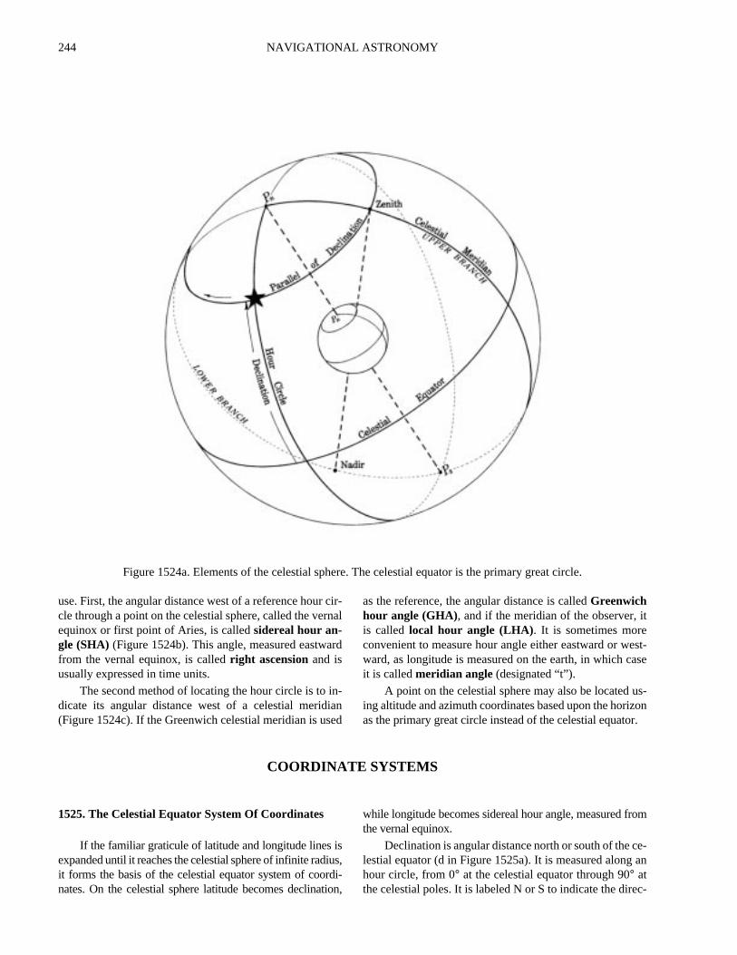
The celestial sphere(section 1501) is an imaginarysphere of infinite radius with the earth at its center (Figure1524a). The north and south celestial poles of this sphere arelocated by extension of the earth’s axis. Thecelestial equa-tor (sometimes calledequinoctial) is formed by projectingthe plane of the earth’s equator to the celestial sphere. Ace-lestial meridian is formed by the intersection of the plane ofa terrestrial meridian and the celestial sphere. It is the arc ofa great circle through the poles of the celestial sphere.
The point on the celestial sphere vertically overhead ofan observer is thezenith, and the point on the opposite sideof the sphere vertically below him is thenadir . The zenithand nadir are the extremities of a diameter of the celestialsphere through the observer and the common center of theearth and the celestial sphere. The arc of a celestial meridianbetween the poles is called theupper branch if it containsthe zenith and thelower branch if it contains the nadir. Theupper branch is frequently used in navigation, and referencesto a celestial meridian are understood to mean only its upperbranch unless otherwise stated. Celestial meridians take thenames of their terrestrial counterparts, such as 65° west.
An hour circle is a great circle through the celestial
poles and a point or body on the celestial sphere. It is simlar to a celestial meridian, but moves with the celestisphere as it rotates about the earth, while a celestial meian remains fixed with respect to the earth.
The location of a body on its hour circle is defined bthe body’s angular distance from the celestial equator. Tdistance, calleddeclination, is measured north or south othe celestial equator in degrees, from 0° through 90°, simi-lar to latitude on the earth.
A circle parallel to the celestial equator is called apar-allel of declination, since it connects all points of equadeclination. It is similar to a parallel of latitude on the earthThe path of a celestial body during its daily apparent revlution around the earth is called itsdiurnal circle . It is notactually a circle if a body changes its declination. Since tdeclination of all navigational bodies is continually changing, the bodies are describing flat, spherical spirals as thcircle the earth. However, since the change is relativeslow, a diurnal circle and a parallel of declination are usally considered identical.
A point on the celestial sphere may be identified at thintersection of its parallel of declination and its hour circleThe parallel of declination is identified by the declination
Two basic methods of locating the hour circle are
Figure 1523. Three kinds of latitude at point A.
244 NAVIGATIONAL ASTRONOMY
t
st-se
s-onr.
om
e-an
c-
use. First, the angular distance west of a reference hour cir-cle through a point on the celestial sphere, called the vernalequinox or first point of Aries, is calledsidereal hour an-gle (SHA) (Figure 1524b). This angle, measured eastwardfrom the vernal equinox, is calledright ascensionand isusually expressed in time units.
The second method of locating the hour circle is to in-dicate its angular distance west of a celestial meridian(Figure 1524c). If the Greenwich celestial meridian is used
as the reference, the angular distance is calledGreenwichhour angle (GHA), and if the meridian of the observer, iis called local hour angle (LHA). It is sometimes moreconvenient to measure hour angle either eastward or weward, as longitude is measured on the earth, in which cait is calledmeridian angle (designated “t”).
A point on the celestial sphere may also be located uing altitude and azimuth coordinates based upon the horizas the primary great circle instead of the celestial equato
COORDINATE SYSTEMS
1525. The Celestial Equator System Of Coordinates
If the familiar graticule of latitude and longitude lines isexpanded until it reaches the celestial sphere of infinite radius,it forms the basis of the celestial equator system of coordi-nates. On the celestial sphere latitude becomes declination,
while longitude becomes sidereal hour angle, measured frthe vernal equinox.
Declination is angular distance north or south of the clestial equator (d in Figure 1525a). It is measured alonghour circle, from 0° at the celestial equator through 90° atthe celestial poles. It is labeled N or S to indicate the dire
Figure 1524a. Elements of the celestial sphere. The celestial equator is the primary great circle.

NAVIGATIONAL ASTRONOMY 245
Figure 1524b. A point on the celestial sphere can be located by its declination and sidereal hour angle.
Figure 1524c. A point on the celestial sphere can be located by its declination and hour angle.
246 NAVIGATIONAL ASTRONOMY
of
hem
-ur
ialan-
ce, and
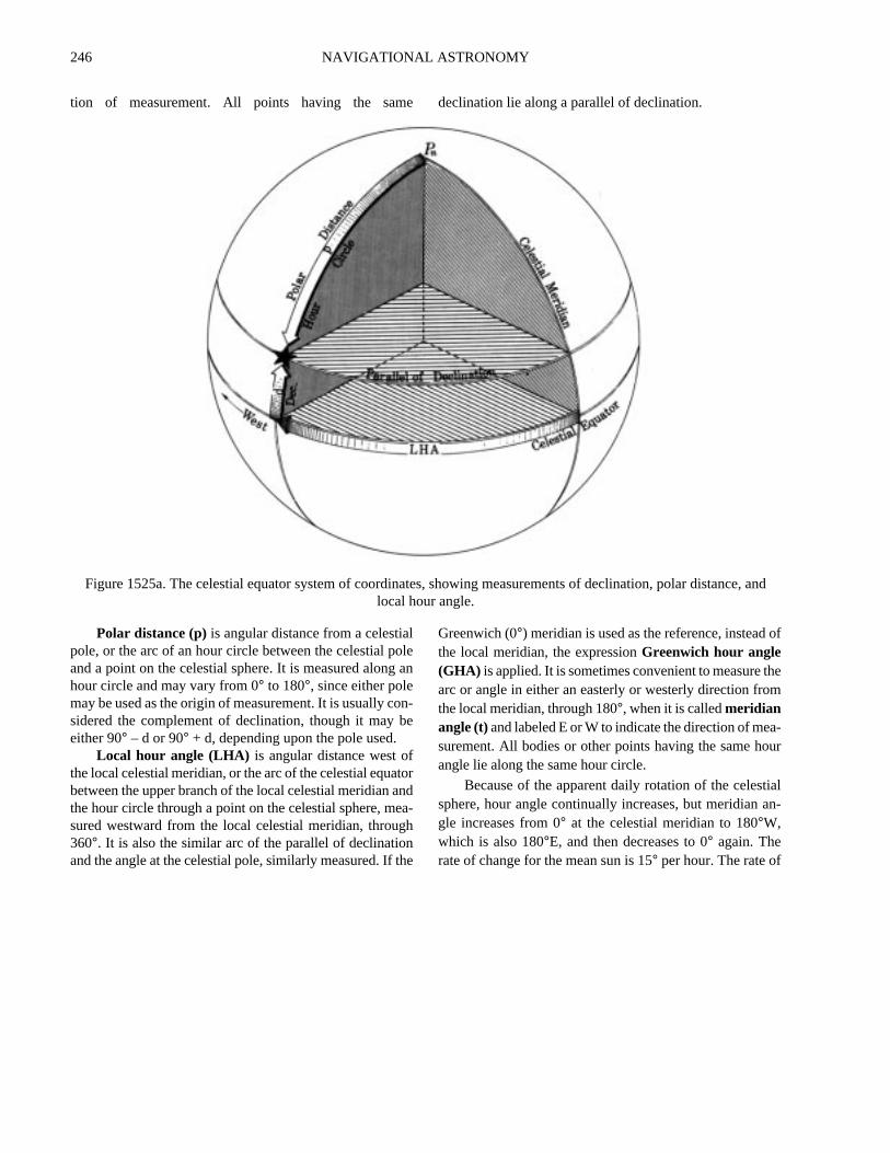
tion of measurement. All points having the same declination lie along a parallel of declination.
Polar distance (p)is angular distance from a celestialpole, or the arc of an hour circle between the celestial poleand a point on the celestial sphere. It is measured along anhour circle and may vary from 0° to 180°, since either polemay be used as the origin of measurement. It is usually con-sidered the complement of declination, though it may beeither 90° – d or 90° + d, depending upon the pole used.
Local hour angle (LHA) is angular distance west ofthe local celestial meridian, or the arc of the celestial equatorbetween the upper branch of the local celestial meridian andthe hour circle through a point on the celestial sphere, mea-sured westward from the local celestial meridian, through360°. It is also the similar arc of the parallel of declinationand the angle at the celestial pole, similarly measured. If the
Greenwich (0°) meridian is used as the reference, insteadthe local meridian, the expressionGreenwich hour angle(GHA) is applied. It is sometimes convenient to measure tarc or angle in either an easterly or westerly direction frothe local meridian, through 180°, when it is calledmeridianangle (t)and labeled E or W to indicate the direction of measurement. All bodies or other points having the same hoangle lie along the same hour circle.
Because of the apparent daily rotation of the celestsphere, hour angle continually increases, but meridiangle increases from 0° at the celestial meridian to 180°W,which is also 180°E, and then decreases to 0° again. Therate of change for the mean sun is 15° per hour. The rate of
Figure 1525a. The celestial equator system of coordinates, showing measurements of declination, polar distanlocal hour angle.
NAVIGATIONAL ASTRONOMY 247
asnter-on
ed
lev-dse
les-theterhisee-
di-ofsed,ho-
th,alhisthetial
all other bodies except the moon is within 3' of this value.
The average rate of the moon is about 15.5°.As the celestial sphere rotates, each body crosses each
branch of the celestial meridian approximately once a day.This crossing is calledmeridian transit (sometimes calledculmination). It may be calledupper transit to indicate cross-ing of the upper branch of the celestial meridian, andlowertransit to indicate crossing of the lower branch.
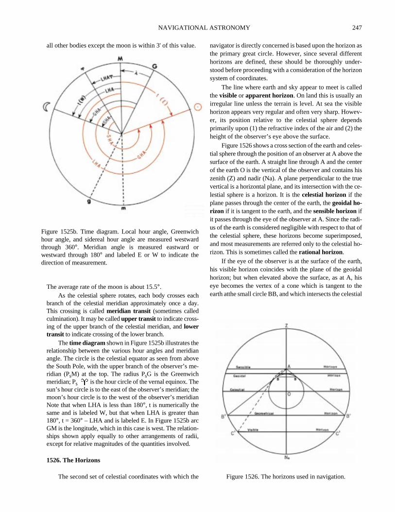
Thetime diagram shown in Figure 1525b illustrates therelationship between the various hour angles and meridianangle. The circle is the celestial equator as seen from abovethe South Pole, with the upper branch of the observer’s me-ridian (PsM) at the top. The radius PsG is the Greenwichmeridian; Ps is the hour circle of the vernal equinox. Thesun’s hour circle is to the east of the observer’s meridian; themoon’s hour circle is to the west of the observer’s meridianNote that when LHA is less than 180°, t is numerically thesame and is labeled W, but that when LHA is greater than180°, t = 360° – LHA and is labeled E. In Figure 1525b arcGM is the longitude, which in this case is west. The relation-ships shown apply equally to other arrangements of radii,except for relative magnitudes of the quantities involved.
1526. The Horizons
The second set of celestial coordinates with which the
navigator is directly concerned is based upon the horizonthe primary great circle. However, since several differehorizons are defined, these should be thoroughly undstood before proceeding with a consideration of the horizsystem of coordinates.
The line where earth and sky appear to meet is callthevisible or apparent horizon. On land this is usually anirregular line unless the terrain is level. At sea the visibhorizon appears very regular and often very sharp. Howeer, its position relative to the celestial sphere depenprimarily upon (1) the refractive index of the air and (2) thheight of the observer’s eye above the surface.
Figure 1526 shows a cross section of the earth and cetial sphere through the position of an observer at A abovesurface of the earth. A straight line through A and the cenof the earth O is the vertical of the observer and containszenith (Z) and nadir (Na). A plane perpendicular to the truvertical is a horizontal plane, and its intersection with the clestial sphere is a horizon. It is thecelestial horizon if theplane passes through the center of the earth, thegeoidal ho-rizon if it is tangent to the earth, and thesensible horizonifit passes through the eye of the observer at A. Since the raus of the earth is considered negligible with respect to thatthe celestial sphere, these horizons become superimpoand most measurements are referred only to the celestialrizon. This is sometimes called therational horizon.
If the eye of the observer is at the surface of the earhis visible horizon coincides with the plane of the geoidhorizon; but when elevated above the surface, as at A,eye becomes the vertex of a cone which is tangent toearth atthe small circle BB, and which intersects the celes
Figure 1525b. Time diagram. Local hour angle, Greenwichhour angle, and sidereal hour angle are measured westwardthrough 360°. Meridian angle is measured eastward orwestward through 180° and labeled E or W to indicate thedirection of measurement.
Figure 1526. The horizons used in navigation.

248 NAVIGATIONAL ASTRONOMY
ir-of
ureor,thalndri-calob-ideareAt
cele,
aro-ee
-
sphere in B'B', thegeometrical horizon. This expression issometimes applied to the celestial horizon.
Because of refraction, the visible horizon C'C' appearsabove but is actually slightly below the geometrical horizonas shown in Figure 1526.
For any elevation above the surface, the celestial hori-zon is usually above the geometrical and visible horizons,the difference increasing as elevation increases. It is thuspossible to observe a body which is above the visible hori-zon but below the celestial horizon. That is, the body’saltitude is negative and its zenith distance is greater than 90°.
1527. The Horizon System Of Coordinates
This system is based upon the celestial horizon as the
primary great circle and a series of secondary vertical ccles which are great circles through the zenith and nadirthe observer and hence perpendicular to his horizon (Fig1527a). Thus, the celestial horizon is similar to the equatand the vertical circles are similar to meridians, but wione important difference. The celestial horizon and verticcircles are dependent upon the position of the observer ahence move with him as he changes position, while the pmary and secondary great circles of both the geographiand celestial equator systems are independent of theserver. The horizon and celestial equator systems coincfor an observer at the geographical pole of the earth andmutually perpendicular for an observer on the equator.all other places the two are oblique.
The vertical circle through the north and south pointsof the horizon passes through the poles of the celestial equa-tor system of coordinates. One of these poles (having thesame name as the latitude) is above the horizon and is calledtheelevated pole. The other, called thedepressed pole, isbelow the horizon. Since this vertical circle is a great circlethrough the celestial poles, and includes the zenith of theobserver, it is also a celestial meridian. In the horizon sys-tem it is called theprincipal vertical circle . The verticalcircle through the east and west points of the horizon, andhence perpendicular to the principal vertical circle, is called
theprime vertical circle, or simply theprime vertical.As shown in Figure 1527b, altitude is angular distan
above the horizon. It is measured along a vertical circfrom 0° at the horizon through 90° at the zenith. Altitudemeasured from the visible horizon may exceed 90° becauseof the dip of the horizon, as shown in Figure 1526. Anguldistance below the horizon, called negative altitude, is prvided for by including certain negative altitudes in somtables for use in celestial navigation. All points having thsame altitude lie along a parallel of altitude.
Zenith distance (z) is angular distance from the ze
Figure 1527a. Elements of the celestial sphere. The celestial horizon is the primary great circle.

NAVIGATIONAL ASTRONOMY 249
e
hets
s.s toe
are-is
ard
o
, and
nith, or the arc of a vertical circle between the zenith and apoint on the celestial sphere. It is measured along a verticalcircle from 0° through 180°. It is usually considered thecomplement of altitude. For a body above the celestial ho-rizon it is equal to 90° – h and for a body below the celestialhorizon it is equal to 90° – (– h) or 90° + h.
The horizontal direction of a point on the celestialsphere, or the bearing of the geographical position, is calledazimuth or azimuth angledepending upon the method ofmeasurement. In both methods it is an arc of the horizon (orparallel of altitude), or an angle at the zenith. It isazimuth(Zn) if measured clockwise through 360°, starting at thenorth point on the horizon, andazimuth angle (Z) if mea-sured either clockwise or counterclockwise through 180°,
starting at the north point of the horizon in north latitudand the south point of the horizon in south latitude.
The ecliptic system is based upon the ecliptic as tprimary great circle, analogous to the equator. The poin90° from the ecliptic are the north and south ecliptic poleThe series of great circles through these poles, analogoumeridians, are circles of latitude. The circles parallel to thplane of the ecliptic, analogous to parallels on the earth,parallels of latitude or circles of longitude. Angular distance north or south of the ecliptic, analogous to latitude,celestial latitude. Celestial longitude is measured eastwalong the ecliptic through 360°, starting at the vernal equi-nox. This system of coordinates is of interest chiefly tastronomers.
Figure 1527b. The horizon system of coordinates, showing measurement of altitude, zenith distance, azimuthazimuth angle.
Earth Celestial Equator Horizon Ecliptic
equator celestial equator horizon eclipticpoles celestial poles zenith; nadir ecliptic polesmeridians hours circle; celestial meridians vertical circles circles of latitudeprime meridian hour circle of Aries principal or prime vertical circle circle of latitude through Ariesparallels parallels of declination parallels of altitude parallels of latitudelatitude declination altitude celestial altitudecolatitude polar distance zenith distance celestial colatitude
Figure 1528. The four systems of celestial coordinates and their analogous terms.

250 NAVIGATIONAL ASTRONOMY
retheasialtor
icmtialre-
wn.
1528. Summary Of Coordinate Systems
The four systems of celestial coordinates are analogousto each other and to the terrestrial system, although each hasdistinctions such as differences in directions, units, and lim-its of measurement. Figure 1528 indicates the analogousterm or terms under each system.
1529. Diagram On The Plane Of The Celestial Meridian
From an imaginary point outside the celestial spheand over the celestial equator, at such a distance thatview would be orthographic, the great circle appearingthe outer limit would be a celestial meridian. Other celestmeridians would appear as ellipses. The celestial equa
would appear as a diameter 90° from the poles, and parallelsof declination as straight lines parallel to the equator. Theview would be similar to an orthographic map of the earth.
A number of useful relationships can be demonstratedby drawing a diagram on the plane of the celestial meridianshowing this orthographic view. Arcs of circles can be sub-
stituted for the ellipses without destroying the basrelationships. Refer to Figure 1529a. In the lower diagrathe circle represents the celestial meridian, QQ' the celesequator, Pn and Ps the north and south celestial poles,spectively. If a star has a declination of 30° N, an angle of30° can be measured from the celestial equator, as sho
longitude SHA; RA; GHA; LHA; t azimuth; azimuth angle; amplitude celestial longitude
Earth Celestial Equator Horizon Ecliptic
Figure 1528. The four systems of celestial coordinates and their analogous terms.
Figure 1529a. Measurement of celestial equator system ofcoordinates.
Figure 1529b. Measurement of horizon system ofcoordinates.

NAVIGATIONAL ASTRONOMY 251
atom
llyeir-isin-e.er
hece
othmslo-the
-thehestct-
thbe
nd
re-hh'ti-rcmr-
ed,e
ynli-bys..
It could be measured either to the right or left, and wouldhave been toward the south pole if the declination had beensouth. The parallel of declination is a line through this pointand parallel to the celestial equator. The star is somewhereon this line (actually a circle viewed on edge).
To locate the hour circle, draw the upper diagram sothat Pn is directly above Pn of the lower figure (in line withthe polar axis Pn-Ps), and the circle is of the same diameteras that of the lower figure. This is the plan view, lookingdown on the celestial sphere from the top. The circle is thecelestial equator. Since the view is from above the north ce-lestial pole, west is clockwise. The diameter QQ' is thecelestial meridian shown as a circle in the lower diagram. Ifthe right half is considered the upper branch, local hour an-gle is measured clockwise from this line to the hour circle,as shown. In this case the LHA is 80°. The intersection ofthe hour circle and celestial equator, point A, can be pro-jected down to the lower diagram (point A') by a straightline parallel to the polar axis. The elliptical hour circle canbe represented approximately by an arc of a circle throughA', Pn, Ps. The center of this circle is somewhere along thecelestial equator line QQ', extended if necessary. It is usu-ally found by trial and error. The intersection of the hourcircle and parallel of declination locates the star.
Since the upper diagram serves only to locate point A' inthe lower diagram, the two can be combined. That is, the LHAarc can be drawn in the lower diagram, as shown, and point Aprojected upward to A'. In practice, the upper diagram is notdrawn, being shown here for illustrative purposes.
In this example the star is on that half of the sphere to-ward the observer, or the western part. If LHA had beengreater than 180°, the body would have been on the easternor “back” side.
From the east or west point over the celestial horizon,the orthographic view of the horizon system of coordinateswould be similar to that of the celestial equator system froma point over the celestial equator, since the celestial meridianis also the principal vertical circle. The horizon would ap-pear as a diameter, parallels of altitude as straight linesparallel to the horizon, the zenith and nadir as poles 90° fromthe horizon, and vertical circles as ellipses through the ze-nith and nadir, except for the principal vertical circle, whichwould appear as a circle, and the prime vertical, whichwould appear as a diameter perpendicular to the horizon.
A celestial body can be located by altitude and azimuthin a manner similar to that used with the celestial equator sys-tem. If the altitude is 25°, this angle is measured from thehorizon toward the zenith and the parallel of altitude is drawnas a straight line parallel to the horizon, as shown at hh' in thelower diagram of Figure 1529b. The plan view from above
the zenith is shown in the upper diagram. If north is takenthe left, as shown, azimuths are measured clockwise frthis point. In the figure the azimuth is 290° and the azimuthangle is N70°W. The vertical circle is located by measuringeither arc. Point A thus located can be projected verticadownward to A' on the horizon of the lower diagram, and thvertical circle represented approximately by the arc of a ccle through A' and the zenith and nadir. The center of thcircle is on NS, extended if necessary. The body is at thetersection of the parallel of altitude and the vertical circlSince the upper diagram serves only to locate A' on the lowdiagram, the two can be combined, point A located on tlower diagram and projected upward to A', as shown. Sinthe body of the example has an azimuth greater than 180°, itis on the western or “front” side of the diagram.
Since the celestial meridian appears the same in bthe celestial equator and horizon systems, the two diagracan be combined and, if properly oriented, a body can becated by one set of coordinates, and the coordinates ofother system can be determined by measurement.
Refer to Figure 1529c, in which the black lines represent the celestial equator system, and the red lineshorizon system. By convention, the zenith is shown at ttop and the north point of the horizon at the left. The wepoint on the horizon is at the center, and the east point direly behind it. In the figure the latitude is 37°N. Therefore, thezenith is 37° north of the celestial equator. Since the zeniis established at the top of the diagram, the equator canfound by measuring an arc of 37° toward the south, along thecelestial meridian. If the declination is 30°N and the LHA is80°, the body can be located as shown by the black lines, adescribed above.
The altitude and azimuth can be determined by theverse process to that described above. Draw a linethrough the body and parallel to the horizon, NS. The altude, 25°, is found by measurement, as shown. Draw the aof a circle through the body and the zenith and nadir. FroA', the intersection of this arc with the horizon, draw a vetical line intersecting the circle at A. The azimuth, N70°W,is found by measurement, as shown. The prefix N is applito agree with the latitude. The body is left (north) of ZNathe prime vertical circle. The suffix W applies because thLHA, 80°, shows that the body is west of the meridian.
If altitude and azimuth are given, the body is located bmeans of the red lines. The parallel of declination is thedrawn parallel to QQ', the celestial equator, and the decnation determined by measurement. Point L' is locateddrawing the arc of a circle through Pn, the star, and PFrom L' a line is drawn perpendicular to QQ', locating L

252 NAVIGATIONAL ASTRONOMY
rsax-
c-de.e
nvi-isst.f-heest-
itsets
”to
tial).otha-dy0
elestial
The meridian angle is then found by measurement. The dec-
lination is known to be north because the body is betweenthe celestial equator and the north celestial pole. The merid-ian angle is west, to agree with the azimuth, and hence LHAis numerically the same.
Since QQ'and PnPs are perpendicular, and ZNa and NSare also perpendicular, arc NPn is equal to arc ZQ. That is,the altitude of the elevated pole is equal to the declinationof the zenith, which is equal to the latitude. This relation-ship is the basis of the method of determining latitude by anobservation of Polaris.
The diagram on the plane of the celestial meridian isuseful in approximating a number of relationships. ConsiderFigure 1529d. The latitude of the observer (NPn or ZQ) is45°N. The declination of the sun (Q4) is 20°N. Neglectingthe change in declination for one day, note the following: Atsunrise, position 1, the sun is on the horizon (NS), at the“back” of the diagram. Its altitude, h, is 0°. Its azimuth an-gle, Z, is the arc NA, N63°E. This is prefixed N to agree withthe latitude and suffixed E to agree with the meridian angleof the sun at sunrise. Hence, Zn = 063°. The amplitude, A,is the arc ZA, E27°N. The meridian angle, t, is the arc QL,110°E. The suffix E is applied because the sun is east of themeridian at rising. The LHA is 360° – 110° = 250°.
As the sun moves upward along its parallel of declina-tion, its altitude increases. It reaches position 2 at about0600, when t = 90°E. At position 3 it is on the prime verti-cal, ZNa. Its azimuth angle, Z, is N90°E, and Zn = 090°.The altitude is Nh' or Sh, 27°.
Moving on up its parallel of declination, it arrives at po-sition 4 on the celestial meridian about noon-when t and
LHA are both 0°, by definition. On the celestial meridian abody’s azimuth is 000° or 180°. In this case it is 180° becausethe body is south of the zenith. The maximum altitude occuat meridian transit. In this case the arc S4 represents the mimum altitude, 65°. The zenith distance, z, is the arc Z4, 25°.A body is not in the zenith at meridian transit unless its delination’s magnitude and name are the same as the latitu
Continuing on, the sun moves downward along th“front” or western side of the diagram. At position 3 it is agaion the prime vertical. The altitude is the same as when preously on the prime vertical, and the azimuth anglenumerically the same, but now measured toward the weThe azimuth is 270°. The sun reaches position 2 six hours ater meridian transit and sets at position 1. At this point, tazimuth angle is numerically the same as at sunrise, but werly, and Zn = 360° – 63° = 297°. The amplitude is W27°N.
After sunset the sun continues on downward, alongparallel of declination, until it reaches position 5, on thlower branch of the celestial meridian, about midnight. Inegative altitude, arc N5, is now greatest, 25°, and its azi-muth is 000°. At this point it starts back up along the “backof the diagram, arriving at position 1 at the next sunrise,start another cycle.
Half the cycle is from the crossing of the 90° hour circle(the PnPs line, position 2) to the upper branch of the celesmeridian (position 4) and back to the PnPs line (position 2When the declination and latitude have the same name (bnorth or both south), more than half the parallel of declintion (position 1 to 4 to 1) is above the horizon, and the bois above the horizon more than half the time, crossing the 9°
Figure 1529c. Diagram on the plane of the celestial meridian. Figure 1529d. A diagram on the plane of the cmeridian for lat. 45°N.

NAVIGATIONAL ASTRONOMY 253
.
etial-in
ur-
the
ern
hedrit
i-ssof
li-at
betheear-
hour circle above the horizon. It rises and sets on the sameside of the prime vertical as the elevated pole. If the declina-tion is of the same name but numerically smaller than thelatitude, the body crosses the prime vertical above the hori-zon. If the declination and latitude have the same name andare numerically equal, the body is in the zenith at upper tran-sit. If the declination is of the same name but numericallygreater than the latitude, the body crosses the upper branch ofthe celestial meridian between the zenith and elevated poleand does not cross the prime vertical. If the declination is ofthe same name as the latitude and complementary to it (d + L= 90°), the body is on the horizon at lower transit and doesnot set. If the declination is of the same name as the latitudeand numerically greater than the colatitude, the body is abovethe horizon during its entire daily cycle and has maximumand minimum altitudes. This is shown by the black dottedline in Figure 1529d.
If the declination is 0° at any latitude, the body isabove the horizon half the time, following the celestialequator QQ', and rises and sets on the prime vertical. If thedeclination is of contrary name (one north and the othersouth), the body is above the horizon less than half thetime and crosses the 90° hour circle below the horizon. Itrises and sets on the opposite side of the prime verticalfrom the elevated pole. If the declination is of contraryname and numerically smaller than the latitude, the bodycrosses the prime vertical below the horizon. This is thesituation with the sun in winter follows when days areshort. If the declination is of contrary name and numeri-cally equal to the latitude, the body is in the nadir at lowertransit. If the declination is of contrary name and comple-mentary to the latitude, the body is on the horizon at uppertransit. If the declination is of contrary name and numeri-
cally greater than the colatitude, the body does not rise
All of these relationships, and those that follow, can bderived by means of a diagram on the plane of the celesmeridian. They are modified slightly by atmospheric refraction, height of eye, semidiameter, parallax, changesdeclination, and apparent speed of the body along its dinal circle.
It is customary to keep the same orientation in soulatitude, as shown in Figure 1529e. In this illustration thlatitude is 45°S, and the declination of the body is 15°N.Since Ps is the elevated pole, it is shown above the southhorizon, with both SPs and ZQ equal to the latitude, 45°.The body rises at position 1, on the opposite side of tprime vertical from the elevated pole. It moves upwaralong its parallel of declination to position 2, on the uppebranch of the celestial meridian, bearing north; and thenmoves downward along the “front” of the diagram to postion 1, where it sets. It remains above the horizon for lethan half the time because declination and latitude arecontrary name. The azimuth at rising is arc NA, the amptude ZA, and the azimuth angle SA. The altitude circlemeridian transit is shown at hh'.
A diagram on the plane of the celestial meridian canused to demonstrate the effect of a change in latitude. Aslatitude increases, the celestial equator becomes more n
Figure 1529e. A diagram on the plane of the celestialmeridian for lat. 45°S.

254 NAVIGATIONAL ASTRONOMY
ly parallel to the horizon. The colatitude becomes smaller,
Figure 1529f. Locating a point on an ellipse of a diagramon the plane of the celestial meridian.
NAVIGATIONAL COORDINATES
Coordinate SymbolMeasured
fromMeasured along
Direc-tion
Measured to UnitsPreci-sion
Maximumvalue
Labels
latitude L, lat. equator meridian N, S parallel °, ′ 0′.1 90° N, S
colatitude colat. poles meridian S, N parallel °, ′ 0′.1 90° —
longitude λ, long. prime meridian parallel E, W local meridian °, ′ 0′.1 180° E, W
declination d, dec.celestialequator
hour circle N, Sparallel ofdeclination °, ′ 0′.1 90° N, S
polardistance
p elevated pole hour circle S, Nparallel ofdeclination °, ′ 0′.1 180° —
altitude h horizon vertical circle upparallel ofaltitude °, ′ 0′.1 90°* —
zenithdistance
z zenith vertical circle downparallel ofaltitude °, ′ 0′.1 180° —
azimuth Zn north horizon E vertical circle ° 0°.1 360° —
Figure 1529g. Navigational Coordinates.

NAVIGATIONAL ASTRONOMY 255
ltsllele
fer-
byof
th
helaryin
increasing the number of circumpolar bodies and thosewhich neither rise nor set. It also increases the difference inthe length of the days between summer and winter. At thepoles celestial bodies circle the sky, parallel to the horizon.At the equator the 90° hour circle coincides with the hori-zon. Bodies rise and set vertically; and are above thehorizon half the time. At rising and setting the amplitude isequal to the declination. At meridian transit the altitude isequal to the codeclination. As the latitude changes name,the same-contrary name relationship with declination re-verses. This accounts for the fact that one hemisphere haswinter while the other is having summer.
The error arising from showing the hour circles andvertical circles as arcs of circles instead of ellipses increases
with increased declination or altitude. More accurate resucan be obtained by measurement of azimuth on the paraof altitude instead of the horizon, and of hour angle on thparallel of declination instead of the celestial equator. Reto Figure 1529f. The vertical circle shown is for a body having an azimuth angle of S60°W. The arc of a circle is shownin black, and the ellipse in red. The black arc is obtainedmeasurement around the horizon, locating A' by meansA, as previously described. The intersection of this arc withe altitude circle at 60° places the body at M. If a semicir-cle is drawn with the altitude circle as a diameter, and tazimuth angle measured around this, to B, a perpendicuto the hour circle locates the body at M', on the ellipse. Bthis method the altitude circle, rather than the horizon, is,
azimuthangle
Z north, south horizon E, W vertical circle ° 0°.1 180° or 90° N, S...E, W
amplitude A east, west horizon N, S body ° 0°.1 90° E, W...N, S
Greenwichhour angle
GHAGreenwichcelestialmeridian
parallel ofdeclination
W hour circle °, ′ 0′.1 360° —
local hourangle
LHA local celestialmeridian
parallel ofdeclination
W hour circle °, ′ 0′.1 360° —
meridianangle
t local celestialmeridian
parallel ofdeclination
E, W hour circle °, ′ 0′.1 180° E, W
sidereal hourangle
SHA hour circle ofvernal equinox
parallel ofdeclination
W hour circle °, ′ 0′.1 360° —
rightascension
RA hour circle ofvernal equinox
parallel ofdeclination
E hour circle h, m, s 1s 24h —
Greenwichmean time
GMTlower branchGreenwichcelestialmeridian
parallel ofdeclination
Whour circlemean sun
h, m, s 1s 24h —
local meantime
LMTlower branchlocal celestialmeridian
parallel ofdeclination
Whour circlemean sun
h, m, s 1s 24h —
zone time ZTlower branchzone celestialmeridian
parallel ofdeclination
Whour circlemean sun
h, m, s 1s 24h —
Greenwichapparenttime
GATlower branchGreenwichcelestialmeridian
parallel ofdeclination
Whour circleapparent sun
h, m, s 1s 24h —
localapparenttime
LATlower branchlocal celestialmeridian
parallel ofdeclination
Whour circleapparent sun
h, m, s 1s 24h —
Greenwichsiderealtime
GSTGreenwichcelestialmeridian
parallel ofdeclination
Whour circlevernal equinox
h, m, s 1s 24h —
localsiderealtime
LSTlocal celestialmeridian
parallel ofdeclination
Whour circlevernal equinox
h, m, s 1s 24h —
*When measured from celestial horizon.
NAVIGATIONAL COORDINATES
Coordinate SymbolMeasured
fromMeasured along
Direc-tion
Measured to UnitsPreci-sion
Maximumvalue
Labels
Figure 1529g. Navigational Coordinates.

256 NAVIGATIONAL ASTRONOMY
e-d
-or
toea
dto
toi-
hee-led
re
effect, rotated through 90° for the measurement. This re-finement is seldom used because actual values are usuallyfound mathematically, the diagram on the plane of the me-ridian being used primarily to indicate relationships.
With experience, one can visualize the diagram on theplane of the celestial meridian without making an actualdrawing. Devices with two sets of spherical coordinates, oneither the orthographic or stereographic projection, pivotedat the center, have been produced commercially to providea mechanical diagram on the plane of the celestial meridian.However, since the diagram’s principal use is to illustratecertain relationships, such a device is not a necessary partof the navigator’s equipment.
Figure 1529g summarizes navigation coordinate systems.
1530. The Navigational Triangle
A triangle formed by arcs of great circles of a sphere iscalled aspherical triangle. A spherical triangle on the ce-lestial sphere is called acelestial triangle. The sphericaltriangle of particular significance to navigators is called thenavigational triangle, formed by arcs of acelestial meridi-an, anhour circle, and avertical circle. Its vertices are theelevated pole, thezenith, and apoint on the celestial sphere(usually a celestial body). The terrestrial counterpart is alsocalled a navigational triangle, being formed by arcs of twomeridians and the great circle connecting two places on theearth, one on each meridian. The vertices are the two placesand a pole. In great-circle sailing these places are the pointof departure and the destination. In celestial navigation theyare the assumed position (AP) of the observer and the geo-graphical position (GP) of the body (the place having thebody in its zenith). The GP of the sun is sometimes called thesubsolar point, that of the moon thesublunar point, that ofa satellite (either natural or artificial) thesubsatellite point,and that of a star itssubstellar or subastral point. Whenused to solve a celestial observation, either the celestial orterrestrial triangle may be called theastronomical triangle.
The navigational triangle is shown in Figure 1530a ona diagram on the plane of the celestial meridian. The earthis at the center, O. The star is at M, dd' is its parallel of dec-lination, and hh' is its altitude circle.
In the figure, arc QZ of the celestial meridian is the lat-itude of the observer, and PnZ, one side of the triangle, isthe colatitude. Arc AM of the vertical circle is the altitudeof the body, and side ZM of the triangle is the zenith dis-tance, or coaltitude. Arc LM of the hour circle is thedeclination of the body, and side PnM of the triangle is thepolar distance, or codeclination.
The angle at the elevated pole, ZPnM, having the hourcircle and the celestial meridian as sides, is the meridian an-gle, t. The angle at the zenith, PnZM, having the verticalcircle and that arc of the celestial meridian, which includesthe elevated pole, as sides, is the azimuth angle. The angleat the celestial body, ZMPn, having the hour circle and the
vertical circle as sides, is the parallactic angle (X) (somtimes called the position angle), which is not generally use
by the navigator.
A number of problems involving the navigational triangle are encountered by the navigator, either directlyindirectly. Of these, the most common are:
1. Given latitude, declination, and meridian angle,find altitude and azimuth angle. This is used in threduction of a celestial observation to establishline of position.
2. Given latitude, altitude, and azimuth angle, to findeclination and meridian angle. This is usedidentify an unknown celestial body.
3. Given meridian angle, declination, and altitude,find azimuth angle. This may be used to find azmuth when the altitude is known.
4. Given the latitude of two places on the earth and tdifference of longitude between them, to find thinitial great-circle course and the great-circle distance. This involves the same parts of the triangas in 1, above, but in the terrestrial triangle, anhence is defined differently.
Both celestial and terrestrial navigational triangles ashown in perspective in Figure 1530b.
Figure 1530a. The navigational triangle.
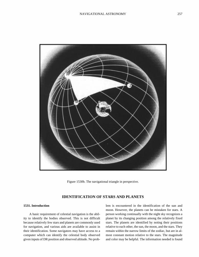
NAVIGATIONAL ASTRONOMY 257
d. Aadnsheyl-ded
IDENTIFICATION OF STARS AND PLANETS
1531. Introduction
A basic requirement of celestial navigation is the abil-ity to identify the bodies observed. This is not difficultbecause relatively few stars and planets are commonly usedfor navigation, and various aids are available to assist intheir identification. Some navigators may have access to acomputer which can identify the celestial body observedgiven inputs of DR position and observed altitude. No prob-
lem is encountered in the identification of the sun anmoon. However, the planets can be mistaken for starsperson working continually with the night sky recognizesplanet by its changing position among the relatively fixestars. The planets are identified by noting their positiorelative to each other, the sun, the moon, and the stars. Tremain within the narrow limits of the zodiac, but are in amost constant motion relative to the stars. The magnituand color may be helpful. The information needed is foun
Figure 1530b. The navigational triangle in perspective.

258 NAVIGATIONAL ASTRONOMY
byfe
d,
shena-n
dheg-er,.ga-
i-
od
a-
m ofght
ofir-s
tel-calar
ine
ion
n-ere-tedthelo-four
in the Nautical Almanac. The “Planet Notes” near the frontof that volume are particularly useful.
Sometimes the light from a planet seems steadier than thatfrom a star. This is because fluctuation of the unsteady atmo-sphere causes scintillation or twinkling of a star, which has nomeasurable diameter with even the most powerful telescopes.The navigational planets are less susceptible to the twinklingbecause of the broader apparent area giving light.
Planets can also be identified by planet diagram, starfinder, sky diagram, or by computation.
1532. Stars
The Nautical Almanac lists full navigational informa-tion on 19 first magnitude stars and 38 second magnitudestars, plus Polaris. Abbreviated information is listed for 115more. Additional stars are listed in The Astronomical Al-manac and in various star catalogs. About 6,000 stars of thesixth magnitude or brighter (on the entire celestial sphere)are visible to the unaided eye on a clear, dark night.
Stars are designated by one or more of the followingnaming systems:
• Common Name:Most names of stars, as now used,were given by the ancient Arabs and some by theGreeks or Romans. One of the stars of the NauticalAlmanac, Nunki, was named by the Babylonians.Only a relatively few stars have names. Several ofthe stars on the daily pages of the almanacs had noname prior to 1953.
• Bayer’s Name: Most bright stars, including thosewith names, have been given a designation consist-ing of a Greek letter followed by the possessive formof the name of the constellation, such asα Cygni(Deneb, the brightest star in the constellation Cyg-nus, the swan). Roman letters are used when thereare not enough Greek letters. Usually, the letters areassigned in order of brightness within the constella-tion; however, this is not always the case. Forexample, the letter designations of the stars in UrsaMajor or the Big Dipper are assigned in order fromthe outer rim of the bowl to the end of the handle.
This system of star designation was suggestedJohn Bayer of Augsburg, Germany, in 1603. All othe 173 stars included in the list near the back of thNautical Almanac are listed by Bayer’s name, anwhen applicable, their common name.
• Flamsteed’s Number:This system assigns numberto stars in each constellation, from west to east in torder in which they cross the celestial meridian. Aexample is 95 Leonis, the 95th star in the constelltion Leo. This system was suggested by JohFlamsteed (1646-1719).
• Catalog Number: Stars are sometimes designateby the name of a star catalog and the number of tstar as given in the catalog, such as A. G. Washinton 632. In these catalogs, stars are listed in ordfrom west to east, without regard to constellationstarting with the hour circle of the vernal equinoxThis system is used primarily for fainter stars havinno other designation. Navigators seldom have occsion to use this system.
1533. Star Charts
It is useful to be able to identify stars by relative postion. A star chart (Figure 1533) is helpful in locating theserelationships and others which may be useful. This methis limited to periods of relatively clear, dark skies with littleor no overcast. Stars can also be identified by the Air Almnac sky diagrams, a star finder , Pub. No. 249, or bycomputation by hand or calculator.
Star charts are based upon the celestial equator systecoordinates, using declination and sidereal hour angle (or riascension). The zenith of the observer is at the intersectionthe parallel of declination equal to his latitude, and the hour ccle coinciding with his celestial meridian. This hour circle ha
an SHA equal to 360° – LHA (or RA = LHA . Thehorizon is everywhere 90° from the zenith. Astar globe issimilar to a terrestrial sphere, but with stars (and often conslations) shown instead of geographical positions. The NautiAlmanac includes instructions for using this device. On a st
globe the celestial sphere is shown as it would appear to anobserver outside the sphere. Constellations appear reversed.Star charts may show a similar view, but more often they arebased upon the view from inside the sphere, as seen from theearth. On these charts, north is at the top, as with maps, buteast is to the left and west to the right. The directions seemcorrect when the chart is held overhead, with the top towardthe north, so the relationship is similar to the sky.
The Nautical Almanac has four star charts. The twoprincipal ones are on the polar azimuthal equidistant pro-jection, one centered on each celestial pole. Each chartextends from its pole to declination 10° (same name aspole). Below each polar chart is an auxiliary chart on the
Mercator projection, from 30°N to 30°S. On any of thesecharts, the zenith can be located as indicated, to determwhich stars are overhead. The horizon is 90° from the ze-nith. The charts can also be used to determine the locatof a star relative to surrounding stars.
The Air Almanac contains a folded chart on the rectagular projection. This projection is suitable for indicating thcoordinates of the stars, but excessive distortion occurs ingions of high declination. The celestial poles are represenby the top and bottom horizontal lines the same length ascelestial equator. To locate the horizon on this chart, firstcate the zenith as indicated above, and then locate thecardinal points. The north and south points are 90° from the

NAVIGATIONAL ASTRONOMY 259
Figure 1531a. Navigational stars and the planets.

260 NAVIGATIONAL ASTRONOMY
Figure 1531b. Constellations.

NAVIGATIONAL ASTRONOMY 261
Figure 1533. Star chart.

262 NAVIGATIONAL ASTRONOMY
acof
hein
byandthe-n
er,erce-atetheup
er inerper-in
ond
ofond
eer
ise-isus
rst
susat
zenith, along the celestial meridian. The distance to the ele-vated pole (having the same name as the latitude) is equal tothe colatitude of the observer. The remainder of the 90° (thelatitude) is measured from the same pole, along the lowerbranch of the celestial meridian, 180° from the upper branchcontaining the zenith. The east and west points are on the ce-lestial equator at the hour circle 90° east and west (or 90° and270° in the same direction) from the celestial meridian. Thehorizon is a sine curve through the four cardinal points. Di-rections on this projection are distorted.
The star charts shown in Figure 1534 through Figure1537, on the transverse Mercator projection, are designedto assist in learning Polaris and the stars listed on the dailypages of the Nautical Almanac. Each chart extends about20° beyond each celestial pole, and about 60° (four hours)each side of the central hour circle (at the celestial equator).Therefore, they do not coincide exactly with that half of thecelestial sphere above the horizon at any one time or place.The zenith, and hence the horizon, varies with the positionof the observer on the earth. It also varies with the rotationof the earth (apparent rotation of the celestial sphere). Thecharts show all stars of fifth magnitude and brighter as theyappear in the sky, but with some distortion toward the rightand left edges.
The overprinted lines add certain information of use inlocating the stars. Only Polaris and the 57 stars listed on thedaily pages of the Nautical Almanac are named on thecharts. The almanac star charts can be used to locate the ad-
ditional stars given near the back of the Nautical Almanand the Air Almanac. Dashed lines connect stars of somethe more prominent constellations. Solid lines indicate tcelestial equator and useful relationships among starsdifferent constellations. The celestial poles are markedcrosses, and labeled. By means of the celestial equatorthe poles, one can locate his zenith approximately alongmid hour circle, when this coincides with his celestial meridian, as shown in the table below. At any time earlier thathose shown in the table the zenith is to the right of centand at a later time it is to the left, approximately one-quartof the distance from the center to the outer edge (at thelestial equator) for each hour that the time differs from thshown. The stars in the vicinity of the North Pole can bseen in proper perspective by inverting the chart, so thatzenith of an observer in the Northern Hemisphere isfrom the pole.
1534. Stars In The Vicinity Of Pegasus
In autumn the evening sky has few first magnitudstars. Most are near the southern horizon of an observethe latitudes of the United States. A relatively large numbof second and third magnitude stars seem conspicuous,haps because of the small number of brighter stars. Highthe southern sky three third magnitude stars and one secmagnitude star form a square with sides nearly 15° of arc in
length. This is Pegasus, the winged horse.Only Markab at the southwestern corner and Alpheratz
at the northeastern corner are listed on the daily pages of theNautical Almanac. Alpheratz is part of the constellationAndromeda, the princess, extending in an arc toward thenortheast and terminating at Mirfak in Perseus, legendaryrescuer of Andromeda.
A line extending northward through the eastern side ofthe square of Pegasus passes through the leading (western)star of M-shaped (or W-shaped) Cassiopeia, the legendarymother of the princess Andromeda. The only star of thisconstellation listed on the daily pages of the Nautical Alma-nac is Schedar, the second star from the leading one as theconfiguration circles the pole in a counterclockwise direc-
tion. If the line through the eastern side of the squarePegasus is continued on toward the north, it leads to secmagnitude Polaris, the North Star (less than 1° from thenorth celestial pole) and brightest star of Ursa Minor, thLittle Dipper. Kochab, a second magnitude star at the othend of Ursa Minor, is also listed in the almanacs. At thseason Ursa Major is low in the northern sky, below the clestial pole. A line extending from Kochab through Polarleads to Mirfak, assisting in its identification when Pegasand Andromeda are near or below the horizon.
Deneb, in Cygnus, the swan, and Vega are bright, fimagnitude stars in the northwestern sky.
The line through the eastern side of the square of Pegaapproximates the hour circle of the vernal equinox, shown
Fig. 1534 Fig.1535 Fig. 1536 Fig. 1537
Local sidereal time 0000 0600 1200 1800LMT 1800 Dec. 21 Mar. 22 June 22 Sept. 21LMT 2000 Nov. 21 Feb. 20 May 22 Aug. 21LMT 2200 Oct. 21 Jan. 20 Apr. 22 July 22LMT 0000 Sept. 22 Dec. 22 Mar. 23 June 22LMT 0200 Aug. 22 Nov. 22 Feb. 21 May 23LMT 0400 July 23 Oct. 22 Jan 21 Apr. 22LMT 0600 June 22 Sept. 21 Dec. 22 Mar. 23
Table 1533. Locating the zenith on the star diagrams.

NAVIGATIONAL ASTRONOMY 263
Figure 1534. Stars in the vicinity of Pegasus.

264 NAVIGATIONAL ASTRONOMY
ri-rdll
dea-
n,l-ayrdeirde-
orlyrs
thehondings,n-
her.a-ith
r-t.r inrt.re
s,it.dardon-
yethngofor
vechsten
Aries on the celestial equator to the south. The sun is at Arieson or about March 21, when it crosses the celestial equatorfrom south to north. If the line through the eastern side of Pe-gasus is extended southward and curved slightly toward theeast, it leads to second magnitude Diphda. A longer andstraighter line southward through the western side of Pegasusleads to first magnitude Fomalhaut. A line extending north-easterly from Fomalhaut through Diphda leads to Menkar, athird magnitude star, but the brightest in its vicinity. Ankaa,Diphda, and Fomalhaut form an isosceles triangle, with theapex at Diphda. Ankaa is near or below the southern horizonof observers in latitudes of the United States. Four stars farthersouth than Ankaa may be visible when on the celestial merid-ian, just above the horizon of observers in latitudes of theextreme southern part of the United States. These are Acamar,Achernar, Al Na’ir, and Peacock. These stars, with each otherand with Ankaa, Fomalhaut, and Diphda, form a series of tri-angles as shown in Figure 1534. Almanac stars near thebottom of Figure 1534 are discussed in succeeding articles.
Two other almanac stars can be located by their posi-tions relative to Pegasus. These are Hamal in theconstellation Aries, the ram, east of Pegasus, and Enif, westof the southern part of the square, identified in Figure 1534.The line leading to Hamal, if continued, leads to the Pleiades(the Seven Sisters), not used by navigators for celestial obser-vations, but a prominent figure in the sky, heralding theapproach of the many conspicuous stars of the winterevening sky.
1535. Stars In The Vicinity Of Orion
As Pegasus leaves the meridian and moves into thewestern sky, Orion, the hunter, rises in the east. With thepossible exception of Ursa Major, no other configuration ofstars in the entire sky is as well known as Orion and its im-mediate surroundings. In no other region are there so manyfirst magnitude stars.
The belt of Orion, nearly on the celestial equator, isvisible in virtually any latitude, rising and setting almost onthe prime vertical, and dividing its time equally above andbelow the horizon. Of the three second magnitude starsforming the belt, only Alnilam, the middle one, is listed onthe daily pages of the Nautical Almanac.
Four conspicuous stars form a box around the belt. Ri-gel, a hot, blue star, is to the south. Betelgeuse, a cool, redstar lies to the north. Bellatrix, bright for a second magni-tude star but overshadowed by its first magnitudeneighbors, is a few degrees west of Betelgeuse. Neither thesecond magnitude star forming the southeastern corner ofthe box, nor any star of the dagger, is listed on the daily pag-es of the Nautical Almanac.
A line extending eastward from the belt of Orion, andcurving toward the south, leads to Sirius, the brightest starin the entire heavens, having a magnitude of –1.6. OnlyMars and Jupiter at or near their greatest brilliance, the sun,moon, and Venus are brighter than Sirius. Sirius is part of
the constellation Canis Major, the large hunting dog of Oon. Starting at Sirius a curved line extends northwathrough first magnitude Procyon, in Canis Minor, the smahunting dog; first magnitude Pollux and second magnituCastor (not listed on the daily pages of the Nautical Almnac), the twins of Gemini; brilliant Capella in Auriga, thecharioteer; and back down to first magnitude Aldebarathe follower, which trails the Pleiades, the seven sisters. Adebaran, brightest star in the head of Taurus, the bull, malso be found by a curved line extending northwestwafrom the belt of Orion. The V-shaped figure forming thoutline of the head and horns of Taurus points toward thmagnitude Menkar. At the summer solstice the sun is btween Pollux and Aldebaran.
If the curved line from Orion’s belt southeastward tSirius is continued, it leads to a conspicuous, small, neaequilateral triangle of three bright second magnitude staof nearly equal brilliancy. This is part of Canis Major. OnlyAdhara, the westernmost of the three stars, is listed ondaily pages of the Nautical Almanac. Continuing on witsomewhat less curvature, the line leads to Canopus, secbrightest star in the heavens and one of the two stars hava negative magnitude (–0.9). With Suhail and MiaplaciduCanopus forms a large, equilateral triangle which partly ecloses the group of stars often mistaken for Crux. Tbrightest star within this triangle is Avior, near its centeCanopus is also at one apex of a triangle formed with Adhra to the north and Suhail to the east, another triangle wAcamar to the west and Achernar to the southwest, andanother with Achernar and Miaplacidus. Acamar, Achenar, and Ankaa form still another triangle toward the wesBecause of chart distortion, these triangles do not appeathe sky in exactly the relationship shown on the star chaOther daily-page almanac stars near the bottom of Figu1535 are discussed in succeeding articles.
In the winter evening sky, Ursa Major is east of PolariUrsa Minor is nearly below it, and Cassiopeia is west ofMirfak is northwest of Capella, nearly midway between it anCassiopeia. Hamal is in the western sky. Regulus and Alphare low in the eastern sky, heralding the approach of the cfigurations associated with the evening skies of spring.
1536. Stars In The Vicinity Of Ursa Major
As if to enhance the splendor of the sky in the vicinitof Orion, the region toward the east, like that toward thwest, has few bright stars, except in the vicinity of the soucelestial pole. However, as Orion sets in the west, leaviCapella and Pollux in the northwestern sky, a numbergood navigational stars move into favorable positions fobservation.
Ursa Major, the great bear, appears prominently abothe north celestial pole, directly opposite Cassiopeia, whiappears as a “W” just above the northern horizon of moobservers in latitudes of the United States. Of the sevstars forming Ursa Major, only Dubhe, Alioth, and Alkaid

NAVIGATIONAL ASTRONOMY 265
Figure 1535. Stars in the vicinity of Orion.

266 NAVIGATIONAL ASTRONOMY
il is,tondtoern
st-ers
ndl.eht
-tha,n.htstarheagm
ificitstole.iss,lyewoedatom
are listed on the daily pages of the Nautical Almanac.The two second magnitude stars forming the outer part
of the bowl of Ursa Major are often called the pointers be-cause a line extending northward (down in spring evenings)through them points to Polaris. Ursa Minor, the Little Bear,contains Polaris at one end and Kochab at the other. Rela-tive to its bowl, the handle of Ursa Minor curves in theopposite direction to that of Ursa Major.
A line extending southward through the pointers, andcurving somewhat toward the west, leads to first magnitudeRegulus, brightest star in Leo, the lion. The head, shoul-ders, and front legs of this constellation form a sickle, withRegulus at the end of the handle. Toward the east is secondmagnitude Denebola, the tail of the lion. On toward thesouthwest from Regulus is second magnitude Alphard,brightest star in Hydra, the sea serpent. A dark sky and con-siderable imagination are needed to trace the long, windingbody of this figure.
A curved line extending the arc of the handle of UrsaMajor leads to first magnitude Arcturus. With Alkaid andAlphecca, brightest star in Corona Borealis, the NorthernCrown, Arcturus forms a large, inconspicuous triangle. Ifthe arc through Arcturus is continued, it leads next to firstmagnitude Spica and then to Corvus, the crow. The bright-est star in this constellation is Gienah, but three others arenearly as bright. At autumnal equinox, the sun is on the ce-lestial equator, about midway between Regulus and Spica.
A long, slightly curved line from Regulus, east-south-easterly through Spica, leads to Zubenelgenubi at thesouthwestern corner of an inconspicuous box-like figurecalled Libra, the scales.
Returning to Corvus, a line from Gienah, extending di-agonally across the figure and then curving somewhattoward the east, leads to Menkent, just beyond Hydra.
Far to the south, below the horizon of most northernhemisphere observers, a group of bright stars is a prominentfeature of the spring sky of the Southern Hemisphere. This isCrux, the Southern Cross. Crux is about 40° south of Corvus.The “false cross” to the west is often mistaken for Crux.Acrux at the southern end of Crux and Gacrux at the northernend are listed on the daily pages of the Nautical Almanac.
The triangles formedbySuhail,Miaplacidus,andCanopus,
and by Suhail, Adhara, and Canopus, are west of Crux. Suhain line with the horizontal arm of Crux. A line from Canopusthrough Miaplacidus, curved slightly toward the north, leadsAcrux. A line through the east-west arm of Crux, eastward athen curving toward the south, leads first to Hadar and thenRigil Kentaurus, both very bright stars. Continuing on, thcurved line leads to small Triangulum Australe, the SoutheTriangle, the easternmost star of which is Atria.
1537. Stars In The Vicinity Of Cygnus
As the celestial sphere continues in its apparent weward rotation, the stars familiar to a spring evening observsink low in the western sky. By midsummer, Ursa Major hamoved to a position to the left of the north celestial pole, athe line from the pointers to Polaris is nearly horizontaUrsa Minor, is standing on its handle, with Kochab abovand to the left of the celestial pole. Cassiopeia is at the rigof Polaris, opposite the handle of Ursa Major.
The only first magnitude star in the western sky is Arcturus, which forms a large, inconspicuous triangle wiAlkaid, the end of the handle of Ursa Major, and Alpheccthe brightest star in Corona Borealis, the Northern Crow
The eastern sky is dominated by three very brigstars. The westernmost of these is Vega, the brightestnorth of the celestial equator, and third brightest star in theavens, with a magnitude of 0.1. With a declination oflittle less than 39°N, Vega passes through the zenith alona path across the central part of the United States, froWashington in the east to San Francisco on the Paccoast. Vega forms a large but conspicuous triangle withtwo bright neighbors, Deneb to the northeast and Altairthe southeast. The angle at Vega is nearly a right angDeneb is at the end of the tail of Cygnus, the swan. Thconfiguration is sometimes called the Northern Croswith Deneb at the head. To modern youth it more nearresembles a dive bomber, while it is still well toward theast, with Deneb at the nose of the fuselage. Altair has tfainter stars close by, on opposite sides. The line formby Altair and its two fainter companions, if extended innorthwesterly direction, passes through Vega, and onsecond magnitude Eltanin. The angular distance fro

NAVIGATIONAL ASTRONOMY 267
Vega to Eltanin is about half that from Altair to Vega.

268 NAVIGATIONAL ASTRONOMY
Figure 1536. Stars in the vicinity of Ursa Major.

NAVIGATIONAL ASTRONOMY 269
Figure 1537. Stars in the vicinity of Cygnus.

270 NAVIGATIONAL ASTRONOMY
dyayhee ob-ernn-nandllytheinge
e-
i-
eat
st;e
At
k-stbe
-thee
infors ofr,
es,tic
g-theighttethe
ofdi-e
isionhee
an,
Vega and Altair, with second magnitude Rasalhague to thewest, form a large equilateral triangle. This is less conspic-uous than the Vega-Deneb-Altair triangle because thebrilliance of Rasalhague is much less than that of the threefirst magnitude stars, and the triangle is overshadowed bythe brighter one.
Far to the south of Rasalhague, and a little toward thewest, is a striking configuration called Scorpius, the scorpi-on. The brightest star, forming the head, is red Antares. Atthe tail is Shaula.
Antares is at the southwestern corner of an approxi-mate parallelogram formed by Antares, Sabik, Nunki, andKaus Australis. With the exception of Antares, these starsare only slightly brighter than a number of others nearby,and so this parallelogram is not a striking figure. At wintersolstice the sun is a short distance northwest of Nunki.
Northwest of Scorpius is the box-like Libra, the scales,of which Zubenelgenubi marks the southwest corner.
With Menkent and Rigil Kentaurus to the southwest,Antares forms a large but unimpressive triangle. For mostobservers in the latitudes of the United States, Antares islow in the southern sky, and the other two stars of the trian-gle are below the horizon. To an observer in the SouthernHemisphere Crux is to the right of the south celestial pole,which is not marked by a conspicuous star. A long, curvedline, starting with the now-vertical arm of Crux and extend-ing northward and then eastward, passes successivelythrough Hadar, Rigil Kentaurus, Peacock, and Al Na’ir.
Fomalhaut is low in the southeastern sky of the southernhemisphere observer, and Enif is low in the eastern sky at near-ly any latitude. With the appearance of these stars it is not longbefore Pegasus will appear over the eastern horizon during theevening, and as the winged horse climbs evening by eveningto a position higher in the sky, a new annual cycle approaches.
1538. Planet Diagram
The planet diagram in the Nautical Almanac shows, ingraphical form for any date during the year, the LMT of me-ridian passage of the sun, for the five planets Mercury,Venus, Mars, Jupiter, and Saturn, and of each 30° of SHA.The diagram provides a general picture of the availability ofplanets and stars for observation, and thus shows:
1. Whether a planet or star is too close to the sun forobservation.
2. Whether a planet is a morning or evening star.3. Some indication of the planet’s position during
twilight.4. The proximity of other planets.5. Whether a planet is visible from evening to morn-
ing twilight.
A band 45m wide is shaded on each side of the curvemarking the LMT of meridian passage of the sun. Any planetand most stars lying within the shaded area are too close to
the sun for observation.When the meridian passage occurs at midnight, the bo
is in opposition to the sun and is visible all night; planets mbe observable in both morning and evening twilights. As ttime of meridian passage decreases, the body ceases to bservable in the morning, but its altitude above the easthorizon during evening twilight gradually increases; this cotinues until the body is on the meridian at twilight. From theonwards the body is observable above the western horizonits altitude at evening twilight gradually decreases; eventuathe body comes too close to the sun for observation. Whenbody again becomes visible, it is seen as a morning star lowthe east. Its altitude at twilight increases until meridian passaoccurs at the time of morning twilight. Then, as the time of mridian passage decreases to 0h, the body is observable in thewest in the morning twilight with a gradually decreasing alttude, until it once again reaches opposition.
Only about one-half the region of the sky along thecliptic, as shown on the diagram, is above the horizonone time. At sunrise (LMT about 6h) the sun and, hence, theregion near the middle of the diagram, are rising in the eathe region at the bottom of the diagram is setting in thwest. The region half way between is on the meridian.sunset (LMT about 18h) the sun is setting in the west; theregion at the top of the diagram is rising in the east. Maring the planet diagram of the Nautical Almanac so that eais at the top of the diagram and west is at the bottom canuseful to interpretation.
If the curve for a planet intersects the vertical line connecting the date graduations below the shaded area,planet is a morning star; if the intersection is above thshaded area, the planet is an evening star.
A similar planet location diagram in the Air Almanacrepresents the region of the sky along the ecliptic withwhich the sun, moon, and planets always move; it shows,each date, the sun in the center and the relative positionthe moon, the five planets Mercury, Venus, Mars, JupiteSaturn and the four first magnitude stars Aldebaran, AntarSpica, and Regulus, and also the position on the eclipwhich is north of Sirius (i.e. Sirius is 40° south of this point).The first point of Aries is also shown for reference. The manitudes of the planets are given at suitable intervals alongcurves. The moon symbol shows the correct phase. A straline joining the date on the left-hand side with the same daof the right-hand side represents a complete circle aroundsky, the two ends of the line representing the point 180° fromthe sun; the intersections with the curves show the spacingthe bodies along the ecliptic on the date. The time scale incates roughly the local mean time at which an object will bon the observer’s meridian.
At any time only about half the region on the diagramabove the horizon. At sunrise the sun (and hence the regnear the middle of the diagram), is rising in the east and tregion at the end marked “West” is setting in the west; thregion half-way between these extremes is on the meridias will be indicated by the local time (about 6h). At the time

NAVIGATIONAL ASTRONOMY 271
olece-
ilyzi-itenyrsorleteofto
the10
di--er
of sunset (local time about 18h) the sun is setting in the west,and the region at the end marked “East” is rising in the east.
The diagram should be used in conjunction with theSky Diagrams.
1539. Star Finders
Various devices have been devised to help an observerfind individual stars. The most widely used is theStarFinder and Identifier , formerly published by the U.S.Navy Hydrographic Office, and now published commer-cially. The current model, No. 2102D, as well as theprevious 2102C model, patented by E. B. Collins, employsthe same basic principle as that used in the Rude Star Finderpatented by Captain G. T. Rude, USC&GS, and later soldto the Hydrographic Office. Successive models reflect var-ious modifications to meet changing conditions andrequirements.
The star base of No. 2102D consists of a thin, white,
opaque, plastic disk about 81/2 inches in diameter, with asmall peg in the center. On one side the north celestial pis shown at the center, and on the opposite side the southlestial pole is at the center. All of the stars listed on the dapages of the Nautical Almanac are shown on a polar amuthal equidistant projection extending to the oppospole. The south pole side is shown in Figure 1539a. Macopies of an older edition, No. 2102C, showing the stalisted in the almanacs prior to 1953, and having other mindifferences, are still in use. These are not rendered obsoby the newer edition, but should be corrected by meansthe current almanac. The rim of each side is graduatedhalf a degree of LHA ( ) (or 360° – SHA).
Ten transparent templates of the same diameter asstar base are provided. There is one template for each°of latitude, labeled 5°, 15°, 25°, etc., plus a 10th (printed inred) showing meridian angle and declination. The older etion (No. 2102C) did not have the red meridian angledeclination template. Each template can be used on eith
Figure 1539a. The south pole side of the star base of No. 2102D.
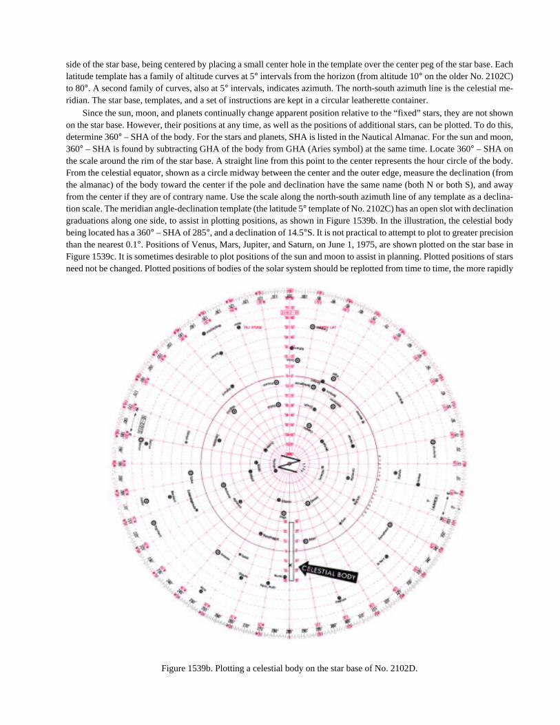
ase. Each
me-
t showndo this,
moon,
e body.ion (fromnd awaydeclina-n
al bodynbase inof starsrapidly
side of the star base, being centered by placing a small center hole in the template over the center peg of the star blatitude template has a family of altitude curves at 5° intervals from the horizon (from altitude 10° on the older No. 2102C)to 80°. A second family of curves, also at 5° intervals, indicates azimuth. The north-south azimuth line is the celestialridian. The star base, templates, and a set of instructions are kept in a circular leatherette container.
Since the sun, moon, and planets continually change apparent position relative to the “fixed” stars, they are noon the star base. However, their positions at any time, as well as the positions of additional stars, can be plotted. Todetermine 360° – SHA of the body. For the stars and planets, SHA is listed in the Nautical Almanac. For the sun and360° – SHA is found by subtracting GHA of the body from GHA (Aries symbol) at the same time. Locate 360° – SHA onthe scale around the rim of the star base. A straight line from this point to the center represents the hour circle of thFrom the celestial equator, shown as a circle midway between the center and the outer edge, measure the declinatthe almanac) of the body toward the center if the pole and declination have the same name (both N or both S), afrom the center if they are of contrary name. Use the scale along the north-south azimuth line of any template as ation scale. The meridian angle-declination template (the latitude 5° template of No. 2102C) has an open slot with declinatiograduations along one side, to assist in plotting positions, as shown in Figure 1539b. In the illustration, the celestibeing located has a 360° – SHA of 285°, and a declination of 14.5°S. It is not practical to attempt to plot to greater precisiothan the nearest 0.1°. Positions of Venus, Mars, Jupiter, and Saturn, on June 1, 1975, are shown plotted on the starFigure 1539c. It is sometimes desirable to plot positions of the sun and moon to assist in planning. Plotted positionsneed not be changed. Plotted positions of bodies of the solar system should be replotted from time to time, the more
Figure 1539b. Plotting a celestial body on the star base of No. 2102D.

NAVIGATIONAL ASTRONOMY 273
or-
ofheo-asthetarti-nt
be
ofhet
moving ones more often than others. The satisfactory inter-val for each body can be determined by experience. It isgood practice to record the date of each plotted position ofa body of the solar system, to serve later as an indication ofthe interval since it was plotted.
To orient the template properly for any given time, pro-ceed as follows: enter the almanac with GMT, and
determine GHA at this time. Apply the longitude to
GHA , subtracting if west, or adding if east, to deter-
mine LHA . If LMT is substituted for GMT in entering
the almanac, LHA can be taken directly from the alma-nac, to sufficient accuracy for orienting the star findertemplate. Select the template for the latitude nearest that ofthe observer, and center it over the star base, being carefulthat the correct sides (north or south to agree with the lati-tude) of both template and star base are used. Rotate thetemplate relative to the star base, until the arrow on the ce-
lestial meridian (the north-south azimuth line) is over LHA
on the star based graduations. The small cross at the
igin of both families of curves now represents the zeniththe observer. The approximate altitude and azimuth of tcelestial bodies above the horizon can be visually interplated from the star finder. Consider Polaris (not shown)at the north celestial pole. For more accurate results,template can be lifted clear of the center peg of the sbase, and shifted along the celestial meridian until the latude, on the altitude scale, is over the pole. This refinemeis not needed for normal use of the device. It should notused for a latitude differing more than 5° from that forwhich the curves were drawn. If the altitude and azimuthan identified body shown on the star base are known, ttemplate can be oriented by rotating it until it is in correcposition relative to that body.
Figure 1539c. A template in place over the star base of No. 2102D.

274 NAVIGATIONAL ASTRONOMY
aln,n
re-ry
-
ti-ichuse
he
ofure
gleA
omThex-
anredes
-Sal-ofuththeofA
1540. Sight Reduction Tables for Air Navigation (Pub.No. 249)
Volume I of Pub. No. 249can be used as a star finderfor the stars tabulated at any given time. For these bodiesthe altitude and azimuth are tabulated for each 1° of latitudeand 1° of LHA (2° beyond latitude 69°). The principallimitation is the small number of stars listed.
1541. Air Almanac Sky Diagram
Near the back of the Air Almanac are a number of skydiagrams. These are azimuthal equidistant projections of thecelestial sphere on the plane of the horizon, at latitudes 75°N,50°N, 25°N, 0°, 25°S, and 50°S, at intervals of 2 hours of lo-cal mean time each month. A number of the brighter stars, thevisible planets, and several positions of the moon are shownat their correct altitude and azimuth. These are of limited val-ue to marine navigators because of their small scale; the largeincrements of latitude, time, and date; and the limited numberof bodies shown. However, in the absence of other methods,particularly a star finder, these diagrams can be useful. Al-lowance can be made for variations from the conditions forwhich each diagram is constructed. Instructions for use of thediagrams are included in the Air Almanac.
1542. Identification By Computation
If the altitude and azimuth of the celestial body, and theapproximate latitude of the observer, are known, the navi-gational triangle can be solved for meridian angle anddeclination. The meridian angle can be converted to LHA,and this to GHA. With this and GHA at the time of ob-servation, the SHA of the body can be determined. WithSHA and declination, one can identify the body by refer-
ence to an almanac. Any method of solving a spherictriangle, with two sides and the included angle being giveis suitable for this purpose. A large-scale, carefully-drawdiagram on the plane of the celestial meridian, using thefinement shown in Figure 1529f, should yield satisfactoresults.
Although no formal star identification tables are included in Pub. No. 229, a simple approach to staridentification is to scan the pages of the appropriate latudes, and observe the combination of arguments whgive the altitude and azimuth angle of the observation. Ththe declination and LHA Z are determined directly. Thstar’s SHA is found from SHA★ = LHA ★ – LHA .From these quantities the star can be identified from tNautical Almanac.
Another solution is available through an interchangearguments using the nearest integral values. The procedconsists of enteringPub. No. 229with the observer’s latitude(same name as declination), with the observed azimuth an(converted from observed true azimuth as required) as LHand the observed altitude as declination, and extracting frthe tables the altitude and azimuth angle respondents.extracted altitude becomes the body’s declination; the etracted azimuth angle (or its supplement) is the meridiangle of the body. Note that the tables are always entewith latitude of same name as declination. In north latitudthe tables can be entered with true azimuth as LHA.
If the respondents are extracted from above the CLine on a right-hand page, the name of the latitude is actuly contrary to the declination. Otherwise, the declinationthe body has the same name as the latitude. If the azimangle respondent is extracted from above the C-S Line,supplement of the tabular value is the meridian angle, t,the body. If the body is east of the observer’s meridian, LH= 360° – t; if the body is west of the meridian, LHA = t.