
Chapter: 11 States: Oregon and Washington … Grande Ronde.pdfChapter: 11 States: Oregon and...
106
Chapter: 11 States: Oregon and Washington Recovery Unit Name: Grande Ronde River Region 1 U.S. Fish and Wildlife Service Portland, Oregon
Transcript of Chapter: 11 States: Oregon and Washington … Grande Ronde.pdfChapter: 11 States: Oregon and...
Chapter: 11
States: Oregon and Washington
Recovery Unit Name: Grande Ronde River
Region 1U.S. Fish and Wildlife Service
Portland, Oregon

ii
DISCLAIMER
Recovery plans delineate reasonable actions that are believed necessary to recoverand/or protect the species. Recovery plans are prepared by the U.S. Fish andWildlife Service and, in this case, with the assistance of recovery unit teams, Stateand Tribal agencies, and others. Objectives will be attained and any necessaryfunds made available subject to budgetary and other constraints affecting theparties involved, as well as the need to address other priorities. Recovery plans donot necessarily represent the views or the official positions or indicate theapproval of any individuals or agencies involved in the plan formulation, otherthan the U.S. Fish and Wildlife Service. Recovery plans represent the officialposition of the U.S. Fish and Wildlife Service only after they have been signed bythe Director or Regional Director as approved. Approved recovery plans aresubject to modification as dictated by new findings, changes in species status, andthe completion of recovery tasks.
Literature Citation: U.S. Fish and Wildlife Service. 2002. Chapter 11, GrandeRonde River Recovery Unit, Oregon and Washington. 95 p. In: U.S. Fish andWildlife Service. Bull Trout (Salvelinus confluentus) Draft Recovery Plan.Portland, Oregon.

iii
ACKNOWLEDGMENTS
Members of the Grande Ronde River Recovery Unit Team who assisted in the preparation of this chapter include:
Tim Cummings, U.S. Fish and Wildlife Service, Bob Danehy, Boise Cascade CorporationColleen Fagan, Oregon Department of Fish and WildlifeMary Hanson, Oregon Department of Fish and WildlifeChristine Kelly, Environmental Protection AgencyBill Knox, Oregon Department of Fish and WildlifeLyle Kuckenbecker, Grande Ronde Model Watershed CouncilJim Leal, U.S. Forest ServiceBill Lovelace, Powder Basin Watershed Council, John Manwell, Boise Cascade CorporationBob Mason, U.S. Forest ServiceGlen Mendel, Washington Department of Fish and WildlifeMike Northrup, U.S. Forest ServiceCraig River, U.S. Forest ServiceMark Robertson, U.S. Fish and Wildlife ServiceWade Sams, U.S. Forest ServicePaul Sankovich, Oregon Department of Fish and WildlifeGretchen Sausen, U.S. Forest ServiceTim Walters, Oregon Department of Fish and WildlifeJeff Zakel, Oregon Department of Fish and Wildlife
Additional review and comments were provided by:
Mike McLean, Confederated Tribes of the Umatilla Indian Reservation

iv
GRANDE RONDE RECOVERY UNIT CHAPTEROF THE BULL TROUT RECOVERY PLAN
EXECUTIVE SUMMARY
Current Species Status
The U.S. Fish and Wildlife Service issued a final rule listing the ColumbiaRiver population of bull trout as a threatened species on June 10, 1998 (63 FR31647). To facilitate the recovery planning process and avoid duplication ofeffort, the recovery unit team considered the frameworks put forth in Kostow(1995) and Buchanan et al. (1997) to develop recovery units in Oregon. TheGrande Ronde River subbasin was identified as one of 22 recovery units for bulltrout within the Columbia River Distinct Population Segment. Use of theseexisting frameworks will allow for better coordination during both salmon andbull trout recovery planning and implementation.
The Grande Ronde River Recovery Unit Team identified two core areas,the Grande Ronde and the Little Minam. Wenatchee Creek (also referred to asMenatchee Creek) is potentially a core area but lacks sufficient survey data toinclude it as a core area at this time. Inclusion of other areas within the GrandeRonde River Recovery Unit (e.g., the Wallowa River upstream of the dam atWallowa Lake) have been identified as research needs. Research needs apply toareas where the recovery unit team feels more information is needed to accuratelyplan and implement recovery actions.
Based on survey data and professional judgement as well as Kostow(1995) and Buchanan et al. (1997), the Grande Ronde River Recovery Unit Teamhas identified local populations of bull trout within each core area. In the GrandeRonde Core Area, local populations include the Upper Grande Ronde complex,Catherine Creek, Indian Creek, the Minam River/Deer Creek complex, theLostine River/Deer Creek complex, upper Hurricane Creek, the Wenaha River,and Lookingglass Creek. One local population, the Little Minam complex, wasidentified in the Little Minam Core Area. The Little Minam Core Area is definedat the lower end by a barrier waterfall. Additional distribution and genetic
Chapter 11 - Grande Ronde River
v
information within the Grande Ronde River Recovery Unit will help refine thecurrent classification.
Habitat Requirements and Limiting Factors
A detailed discussion of bull trout biology and habitat requirements isprovided in Chapter 1 of this recovery plan. Within the Umatilla-Walla WallaRecovery Unit, historic and current land use activities have impacted bull troutlocal populations. Historic land use activities that have impacted bull trout localpopulations include construction and operation of dams and roads, forestrypractices, agricultural development, and mining. Some of the historic activitiesthat resulted in passage barriers may have significantly reduced important fluvialpopulations. Lasting effects from some of these early land use activities still limitbull trout distribution/abundance in the Grande Ronde Recovery Unit. Existingland use activities that contribute to fish habitat problems include operation andmaintenance of dams, riparian road construction and use, riparian grazing,agricultural development, residential developments, recreational use of riparianareas, and competition with nonnative species.
Recovery Goal and Objectives
The goal of the bull trout recovery plan is to ensure the long-termpersistence of self-sustaining, complex, interacting groups of bull troutdistributed throughout the species’ native range, so that the species can bedelisted. To achieve this goal the following objectives have been identified forbull trout in the Grande Ronde River Recovery Unit:
• Maintain current distribution of bull trout and restore distribution inpreviously occupied areas within the Grande Ronde River Recovery Unit.
• Maintain stable or increasing trends in abundance of bull trout.
• Restore and maintain suitable habitat conditions for all bull trout lifehistory stages and strategies.

Chapter 11 - Grande Ronde River
vi
• Conserve genetic diversity and provide opportunity for genetic exchange.
Recovery Criteria
Recovery criteria identified for the Grande Ronde River Recovery Unit are asfollows.
1. Bull trout are distributed among at least nine local populations in theGrande Ronde River Recovery Unit. In a recovered condition therecovery unit would include at least nine local populations. In the GrandeRonde Core Area local populations would include the Upper GrandeRonde complex, Catherine Creek, Indian Creek, the Minam River/DeerCreek complex, The Lostine River/Bear Creek complex, Hurricane Creek,Lookingglass Creek, and the Wenaha River. In the Little Minam CoreArea a local population of resident bull trout would exist in the LittleMinam River above the barrier waterfall. Designation of localpopulations is based upon the professional judgement of Grande RondeRiver Recovery Unit Team members. Further genetic studies are neededto more accurately delineate local populations and quantify spawning sitefidelity and straying rates.
2. Estimated abundance of bull trout among all local populations in theGrande Ronde River Recovery Unit is at least 6,000 adults. Recoveredabundance was derived using the professional judgement of the recoveryunit team and estimation of productive capacity of identified localpopulations. Resident and migratory life history forms are included in thisestimate, but the relative proportions of each are considered a researchneed. As more data is collected, recovered population estimates will berevised to more accurately reflect both the migratory and resident lifehistory components.
3. Adult bull trout populations exhibit a stable or increasing trend for atleast two generations at or above the recovered abundance level.

Chapter 11 - Grande Ronde River
vii
4. Specific barriers to bull trout migration in the Grande Ronde RiverRecovery Unit have been addressed. Passage barriers within the GrandeRonde Core Area need to be addressed to ensure opportunities forconnectivity among local populations within the core area. In the GrandeRonde Core Area this includes evaluating and addressing dams (e.g.,Wallowa River Dam and Beaver Creek Dam) and diversions (e.g., UpperAlder Slope/Moonshine ditch in Hurricane Creek, South Fork CatherineCreek, upper Wallowa River near Joseph), as well as culverts which arepotential passage barriers to bull trout (e.g., Sage Creek, Sand Pass Creek,and near the Indian Creek hydropower facility). Potential impacts fromweirs (e.g., Upper Grande Ronde River, Catherine Creek, LookingglassCreek, and Lostine River) and hatchery intakes (e.g., Wallowa andLookingglass fish hatcheries, Big Canyon satellite facility, and satellitefacilities in the Lostine River, Upper Grande Ronde River, and CatherineCreek) also need to be addressed. This also includes evaluating possiblethermal barriers from warm water temperatures (e.g., Upper GrandeRonde River, Bear Creek watershed, Lostine River, and Hurricane Creekbelow the upper Alder Slope irrigation ditch). This also includes impactassessments of the Lower Granite and Hells Canyon dams, both in themainstem Snake River.
Actions Needed
Recovery for bull trout will entail reducing threats to the long-termpersistence of populations and their habitats, ensuring the security of multipleinteracting groups of bull trout, and providing habitat conditions and access tothem that allow for the expression of various life-history forms. Seven categoriesof actions needed are discussed in Chapter 1; tasks specific to this recovery unitare provided in this chapter.

viii
Estimated Cost of Recovery
Total estimated cost of bull trout recovery in the Grande Ronde RiverRecovery Unit is estimated at $17 million spread over a 25 year recovery period. Total costs include estimates of expenditures by local, Tribal, State, and Federalgovernments and by private business and individuals. These costs are attributedto bull trout conservation but other aquatic species will also benefit. Costestimates are not provided for tasks which are normal agency responsibilitiesunder existing authorities. Successful recovery of bull trout in theaforementioned core areas is contingent on removing barriers, improving habitatconditions, and removal of nonnative species within the recovery unit.
Estimated Date of Recovery
Time required to achieve recovery depends on bull trout status, factorsaffecting bull trout, implementation and effectiveness of recovery tasks, andresponses to recovery tasks. A tremendous amount of work will be required torestore impaired habitat, reconnect habitat, and eliminate threats from nonnativespecies. Three to five bull trout generations (15 to 25 years), or possibly longer,may be necessary before identified threats to the species can be significantlyreduced and bull trout can be considered eligible for delisting. In the GrandeRonde River Recovery Unit several local populations are relatively strong, but themajority are at relatively low numbers. Degradation and fragmentation of bulltrout habitat have resulted in populations that are at high risk. Ultimately, thesethreats must be addressed in the near future for recovery to be achieved.

ix
TABLE OF CONTENTS
DISCLAIMER PAGE . . . . . . . . . . . . . . . . . . . . . . . . . . . . . . . . . . . . . . . . . . . . . ii
ACKNOWLEDGMENTS . . . . . . . . . . . . . . . . . . . . . . . . . . . . . . . . . . . . . . . . . . iii
EXECUTIVE SUMMARY . . . . . . . . . . . . . . . . . . . . . . . . . . . . . . . . . . . . . . . . . iv
TABLE OF CONTENTS . . . . . . . . . . . . . . . . . . . . . . . . . . . . . . . . . . . . . . . . . . . ix
INTRODUCTION . . . . . . . . . . . . . . . . . . . . . . . . . . . . . . . . . . . . . . . . . . . . . . . . . 1Recovery Unit Designation . . . . . . . . . . . . . . . . . . . . . . . . . . . . . . . . . . . . 1Geographic Description . . . . . . . . . . . . . . . . . . . . . . . . . . . . . . . . . . . . . . . 5
DISTRIBUTION AND ABUNDANCE . . . . . . . . . . . . . . . . . . . . . . . . . . . . . . . 10Status of Bull Trout at the Time of Listing . . . . . . . . . . . . . . . . . . . . . . . 10Current Distribution and Abundance . . . . . . . . . . . . . . . . . . . . . . . . . . . . 10
REASONS FOR DECLINE . . . . . . . . . . . . . . . . . . . . . . . . . . . . . . . . . . . . . . . . 22Dams . . . . . . . . . . . . . . . . . . . . . . . . . . . . . . . . . . . . . . . . . . . . . . . . . . . . 22Forest Management Practices . . . . . . . . . . . . . . . . . . . . . . . . . . . . . . . . . 23Livestock Grazing . . . . . . . . . . . . . . . . . . . . . . . . . . . . . . . . . . . . . . . . . . 24Agricultural Practices . . . . . . . . . . . . . . . . . . . . . . . . . . . . . . . . . . . . . . . 24Transportation Network . . . . . . . . . . . . . . . . . . . . . . . . . . . . . . . . . . . . . . 26Mining . . . . . . . . . . . . . . . . . . . . . . . . . . . . . . . . . . . . . . . . . . . . . . . . . . . 27Residential Development . . . . . . . . . . . . . . . . . . . . . . . . . . . . . . . . . . . . . 27Fisheries Management . . . . . . . . . . . . . . . . . . . . . . . . . . . . . . . . . . . . . . . 27Isolation and Habitat Fragmentation . . . . . . . . . . . . . . . . . . . . . . . . . . . . 30
ONGOING RECOVERY UNIT CONSERVATION MEASURES . . . . . . . . . . 31
RELATIONSHIP TO OTHER CONSERVATION EFFORTS . . . . . . . . . . . . . 34State of Oregon . . . . . . . . . . . . . . . . . . . . . . . . . . . . . . . . . . . . . . . . . . . . 34State of Washington . . . . . . . . . . . . . . . . . . . . . . . . . . . . . . . . . . . . . . . . . 35Columbia River Intertribal Fish Commission . . . . . . . . . . . . . . . . . . . . . 37
Chapter 11 - Grande Ronde River
x
Confederated Tribes of the Umatilla Indian Reservation . . . . . . . . . . . . 37Nez Perce Tribe . . . . . . . . . . . . . . . . . . . . . . . . . . . . . . . . . . . . . . . . . . . . 38
STRATEGY FOR RECOVERY . . . . . . . . . . . . . . . . . . . . . . . . . . . . . . . . . . . . . 40Recovery Goals and Objectives . . . . . . . . . . . . . . . . . . . . . . . . . . . . . . . . 42Recovery Criteria . . . . . . . . . . . . . . . . . . . . . . . . . . . . . . . . . . . . . . . . . . . 47Research Needs . . . . . . . . . . . . . . . . . . . . . . . . . . . . . . . . . . . . . . . . . . . . 51
ACTIONS NEEDED . . . . . . . . . . . . . . . . . . . . . . . . . . . . . . . . . . . . . . . . . . . . . . 56Recovery Tasks Narrative . . . . . . . . . . . . . . . . . . . . . . . . . . . . . . . . . . . . 56
IMPLEMENTATION SCHEDULE . . . . . . . . . . . . . . . . . . . . . . . . . . . . . . . . . . 73
REFERENCES . . . . . . . . . . . . . . . . . . . . . . . . . . . . . . . . . . . . . . . . . . . . . . . . . . 88
APPENDIX A: List of Chapters . . . . . . . . . . . . . . . . . . . . . . . . . . . . . . . . . . . . . 95
List of Figures
Figure 1. Bull trout recovery units in the United States. . . . . . . . . . . . . . . . . . . . 2
Figure 2. Grande Ronde River Recovery Unit (Grande Ronde and Little MinamCore Areas) for bull trout in Oregon and Washington. . . . . . . . . . . . . . . . 3
Figure 3. Fluvial bull trout captured moving upstream in the Lostine River during2001. . . . . . . . . . . . . . . . . . . . . . . . . . . . . . . . . . . . . . . . . . . . . . . . . . . . . 16
Figure 4. Number of redds observed in the Little Minam River watershed from1997 to 2000. . . . . . . . . . . . . . . . . . . . . . . . . . . . . . . . . . . . . . . . . . . . . . 20

Chapter 11 - Grande Ronde River
xi
List of Tables
Table 1. Bull trout spawning ground survey schedule in the Grande Ronde RiverRecovery Unit during 2001. . . . . . . . . . . . . . . . . . . . . . . . . . . . . . . . . . . . 12
Table 2. Local populations and streams with potential to expand existing bulltrout distribution in the Grande Ronde River Recovery Unit. . . . . . . . . . 43

Chapter 11 - Grande Ronde River
1
INTRODUCTION
Recovery Unit Designation
The U.S. Fish and Wildlife Service issued a final rule listing the ColumbiaRiver and Klamath River populations of bull trout (Salvelinus confluentus) as athreatened species under the Endangered Species Act on June 10, 1998 (63 FR31647). An emergency rule listing the Jarbidge River population as endangereddue to road construction activities was published on August 11, 1998 (63 FR42757), and the population was subsequently listed as threatened on April 8, 1999(64 FR 17110), when the emergency rule expired. The Coastal-Puget Sound andSt. Mary-Belly River populations were listed as threatened on November 1, 1999(64 FR 58910), which resulted in all bull trout in the coterminous United Statesbeing listed as threatened (Figure 1). The five populations discussed above arelisted as distinct population segments, i.e., the U.S. Fish and Wildlife Service hasconcluded that they meet the requirements of the joint policy with the NationalMarine Fisheries Service regarding the recognition of distinct vertebratepopulations (61 FR 4722).
As required by the Endangered Species Act, the U.S. Fish and WildlifeService has developed a plan which, when implemented, will lead to the recoveryand ultimate delisting of the Columbia River Distinct Population Segment of bulltrout. An overall recovery unit team with membership from the states ofWashington, Oregon, Idaho, and Montana as well as Tribes was established todevelop a framework for the recovery plan, provide guidance on technical issues,and insure consistency through the recovery planning process. Within theColumbia River distinct population segment, the recovery unit team has identified22 recovery units. Recovery unit teams were established to identify specificreasons for decline and develop actions necessary to recover bull trout.
Recovery units were identified based on three factors: (1) recognition ofjurisdictional boundaries, (2) biological and genetic factors common to bull troutwithin a specific geographic area, and (3) logistical concerns for coordination,

Chapter 11 - Grande Ronde River
2
Figure 1. Bull trout recovery units in the United States. The Grande Ronde RiverRecovery Unit is highlighted.
development, and implementation of the recovery plan. To facilitate therecovery planning process and avoid duplication of effort, the recovery unit team considered the frameworks put forth in Kostow (1995) and Buchanan et al. (1997)to develop recovery units in Oregon. The Grande Ronde River subbasin wasidentified as one of the 22 recovery units for bull trout within the Columbia RiverDistinct Population Segment.
The Grande Ronde River Recovery Unit includes bull trout from onewatershed, the Grande Ronde River (Figure 2). The majority of this watershed isin the State of Oregon. The lower portion of the Grande Ronde River, tributariesto this portion of the river, as well as tributaries to the mainstem of the WenahaRiver (a major tributary to the Grande Ronde River) are located in the State ofWashington.

Chapter 11 - Grande Ronde River
3
������������������������������
������������������������������������
Wenaha River
Wall ow
a RiverM
in am River
Minam River
L ittle Minam
R
Deer Cree
k
Bear C
reek
Wallowa R
iver
Los tine R
iver
Hu
rric
ane
Cre
ek
#
Wallowa Lake
Gra
nde
Ron
de R
iver
Lo okingglass Cr
Indi a
n Creek
Catherine Creek
Snake River
Washington
Oregon
Ore
gon
Idah
o
#
Upp
er G
rand
e
Ronde River
# Upper Grande Ronde River
#
Wenatchee Creek
#
Lower Granite Dam
##
Hells Canyon Dam
#
Joseph CreekLower Gra
nde
Ron
de River
Grande Ronde Recovery Unit BoundaryGrande Ronde River Core Area
�������Wenatchee Creek Research Need
�������������� Little Minam River Core Area
Streams and RiversWaterbodies
Grande Ronde Recovery Unit
N
EW
S
0 10 20 30 Miles
Figure 2. Grande Ronde River Recovery Unit (Grande Ronde and Little Minam CoreAreas) for bull trout in Oregon and Washington.
After considering information that is currently available, including that inRatliff and Howell (1992), Kostow (1995), Buchanan et al. (1997), andWashington Department of Fish and Wildlife (1998), the recovery unit teamidentified nine extant, local populations (or stocks) of bull trout within the GrandeRonde River subbasin. A local population is considered to be fish of a givenspecies which spawn in a particular lake or stream(s) at a particular season, andwhich to a substantial degree do not interbreed with any group spawning in adifferent place, or in the same place at a different season (see Chapter 1).

Chapter 11 - Grande Ronde River
4
The risk of any given local population going extinct varies within therecovery unit. The risk of the Little Minam River and Wenaha River localpopulations going extinct is low (Ratliff and Howell 1992; WashingtonDepartment of Fish and Wildlife 1998). Relative to extinction, the MinamRiver/Deer Creek complex is composed of a low risk component (Minam River)(Ratliff and Howell 1992) and a component of special concern (Deer Creek) (seeBuchanan et al. 1997). The risk of the Upper Hurricane Creek local populationgoing extinct is of special concern (Ratliff and Howell 1992). Relative toextinction, the Lostine River/Bear Creek complex is composed of a moderate riskcomponent (Lostine River) and a component of special concern (Bear Creek)(Ratliff and Howell 1992). The risk of the local populations in the Upper GrandeRonde River complex and Indian Creek (Ratliff and Howell 1992) as well asCatherine Creek and Lookingglass Creek (Buchanan et al. 1997) going extinct ismoderate. A local population of bull trout previously from Wallowa Lake/Riveris now considered to be extinct (Ratliff and Howell 1992). From the Washingtonportion of the Grande Ronde River subbasin, anecdotal reports also exist of bulltrout in Wenatchee Creek. However, Washington Department of Fish andWildlife (1998) did not describe or distinguish bull trout from Wenatchee Creekas a distinct local population. Additional research needs to be conducted onwhether such a local population exists and its relative risk of extinction.
All local populations identified in the recovery unit are believed to benative fish. There have been no known releases of hatchery-origin bull troutanywhere in the recovery unit. In the 1990's, one transfer of bull trout from LittleSheep Creek (Imnaha River subbasin) did occur into Wallowa Lake. There is noevidence, however, that these fish established a self-sustaining population or stillexist (B. Smith, Oregon Department of Fish and Wildlife, pers. comm., 2002). Inthe 1970's bull trout/Dolly Varden from Alaska were also released into WallowaLake. Again, there is no evidence that these fish still exist or established a self-sustaining population (Buchanan et al. 1997).
This recovery unit geographically overlaps ceded lands of both theConfederated Tribes of the Umatilla Indian Reservation and the Nez Perce Tribe. These Tribes have guaranteed treaty fishing rights for both anadromous and

Chapter 11 - Grande Ronde River
5
resident fish species. When the Grande Ronde River Recovery Unit has achievedits recovery goal, the Oregon and Washington departments of fish and wildlife aswell as the Tribal Nations will determine the location and level of bull troutharvest which can be sustained while maintaining healthy populations.
Geographic Description
The Grande Ronde River subbasin is located in the southwest portion ofthe Blue Mountains ecological province, encompassing an area of about 10,240square kilometers (4,000 square miles) in northeastern Oregon and southeasternWashington (see Northwest Power Planning Council 2001). The subbasin ischaracterized by rugged mountains and two major river valleys, and is defined bythe Blue Mountains to the west and northwest, and the Wallowa Mountains to thesoutheast. It is in these mountain ranges, with peaks as high as 7,700 feet (2,347meters) in the Blue Mountains and nearly 10,000 feet (3,048 meters) in theWallowa Mountains, where the headwater streams of the Grande Ronde Riverbegin. The Grande Ronde River flows generally northeast 212 miles (339kilometers) from its origin to join the Snake River at River Mile 169 (Riverkilometer 270), about 20 miles (32 kilometers) upstream of Asotin, Washingtonand 493 miles (789 kilometers) from the mouth of the Columbia River. TheGrande Ronde River begins in the Blue Mountains near the Anthony Lakesrecreation area, flows north, then northeast and through the cities of La Grandeand Island City (River Mile 157, River kilometer 251). In the valley, the riverslows and meanders the valley floor before continuing north-northeast through thetowns of Imbler, and Elgin. A State ditch, which eliminated approximately 20River Miles (32 River kilometers), was developed to channelize the river throughthe Grande Ronde valley. Downstream of Elgin the river enters into a canyon,passes through Troy, Oregon (River Mile 46, River kilometer 74), then it crossesinto Washington at River Mile 38.7 (River kilometer 62) before joining the SnakeRiver. There are eight dams on the Columbia and Snake rivers between theGrande Ronde River and the Pacific Ocean. Major streams flowing into theGrande Ronde are Catherine and Joseph creeks and the Wallowa and Wenaharivers.

Chapter 11 - Grande Ronde River
6
GeologyThe Grande Ronde subbasin has a complex geologic history (see
Northwest Power Planning Council 2001). Rocks of the Columbia River BasaltGroup dominate the surface geology of the area. Rocks older than the ColumbiaRiver Basalts occur only in the headwaters areas of the Grande Ronde River, theWallowa River and Catherine Creek. These rocks consist of granitic intrusivesand older volcanics with associated sedimentary deposits. Some of these olderrocks are visible in the Wallowa Mountains where the andesitic core was exposedduring uplift of the mountain range (Baldwin 1964). Some older rocks may bevisible near the mouth of the Grande Ronde River where the channel cuts intorock below the basalt layers. The structural geology of the area is also complex. Regional deformation has included easterly and southeasterly tilting and upliftand northwesterly compression. Because of these forces, many faults cut thebedrock formations. These faults follow a general northwest-southeast trend. Some structural deformation continues in the area as evidenced by offsets inmodern alluvial and colluvial deposits. The southern portion of the subbasin issubsiding faster than the northern portion as demonstrated by the large bend in theGrande Ronde River to the south. The presence of hot springs and regional, deepgroundwater flow systems also indicate ongoing tectonic activity.
ClimateThe relief of the Blue and Wallowa mountains creates several localized
climatic effects (see Northwest Power Planning Council 2001). The diversity oflandscapes between mountain ranges, rolling topography and deep, dissectedcanyons influences local climatic patterns. However, the major influence to theregional climate comes from the Cascade Mountains lying nearly 200 miles (320kilometers) to the west. These mountains form a barrier against the modifyingeffects of moist winds from the Pacific Ocean, resulting in a modified Continentalclimate in the Grande Ronde River subbasin. Winters are cold and moist. January is the coldest month, with an average daily minimum temperature of 24degrees Fahrenheit (-4 degrees Celsius). Summers in the subbasin are warm anddry. July is the warmest month with an average daily maximum of 84 degreesFahrenheit (29 degrees Celsius). Temperature and precipitation vary considerablywith elevation. In winter, valleys tend to be colder than lower slopes of adjacent

Chapter 11 - Grande Ronde River
7
mountains due to cold air drainage. Average annual precipitation increases from14 inches (36 centimeters) on the valley floor to more than 60 inches (152centimeters) in some mountain areas. On average, precipitation increasesapproximately 5 inches (13 centimeters) with each 1,000-foot (305 meter) rise inelevation. Precipitation occurs in the mountains throughout the year but fallsprimarily as winter snow. The average annual frost-free period in the GrandeRonde River is 160 days. The cooler Wallowa River valley may experience frostat any time of the year but the average frost-free period is 130 days.
HydrologyDue to the varying physiography in the Grande Ronde River subbasin, the
timing of spring runoff and peak discharge is also variable (see Northwest PowerPlanning Council 2001). The upper Grande Ronde River, flowing out of therelatively low elevation Blue Mountains, generally experiences seasonal peakflows in March or April while peak flows in Catherine Creek, originating in theWallowa Mountains, usually occur in May or June. Flows in the Wallowa River,which also originates from mostly north-facing slopes of the higher elevationWallowa Mountains, generally do not peak until late May or June.
Gauging stations operated by the U.S. Geological Survey, the OregonWater Resources Department, Oregon Watershed Enhancement Board and theWallowa Soil and Water Conservation District, measure and record stream flowsthroughout the subbasin (see Northwest Power Planning Council 2001). Averageannual discharge of the Grande Ronde River at Troy, Oregon, the lowest gaugingstation presently in use, is approximately 2.25 million acre feet (3101 cubic feetper second or 88 cubic meters per second). The only major tributary adding to theGrande Ronde River below this station is Joseph Creek, which is ungauged. Daily flows at gauging stations throughout the basin can vary 100-fold in as littleas one month and differences between the annual minimum and maximum flowscan be even greater. The gaging station on Catherine Creek near Union, Oregon,recorded a minimum flow in 1998 of 1.4 cubic feet per second (0.04 cubic metersper second) and a maximum the same year of 2,160 cubic feet per second (61.13

Chapter 11 - Grande Ronde River
8
cubic meters per second). The average annual discharge of Catherine Creek atthis gaging station is approximately 85,500-acre feet (3.34 cubic meters persecond).
Most surface- and ground-water use is for irrigation (see Northwest PowerPlanning Council 2001). Information regarding the number of water diversionsfor irrigation is unavailable, as is the number of water rights holders in thesubbasin. Sales and subdivision of water rights over the years has created asituation where there are many small water rights holders and few accuraterecords. Despite the lack of information regarding water rights and diversions, itis known that the water in the Grande Ronde River subbasin is fully appropriated;during the summer, there is no remaining unappropriated water.
Water QualityThe Oregon Department of Environmental Quality has identified many
stream segments within the Grande Ronde subbasin as water quality limited (seeNorthwest Power Planning Council 2001). Many of these streams include habitatareas important for chinook salmon, summer steelhead and bull trout. Waterquality limited means instream water quality fails to meet established standardsfor certain parameters for a portion of the year. Oregon’s 1998, 303(d) List ofWater Quality Limited Waterbodies identifies nine parameters of concern in theupper Grande Ronde River subbasin: algae, bacteria, dissolved oxygen, flowmodification, habitat modification, nutrients, pH, sedimentation and temperature. All of these concerns exist within the Grande Ronde River valley portion of thesubbasin. Three of these nine concerns – temperature, sediment and habitatmodification – are widespread throughout the rest of the subbasin outside theGrande Ronde River valley.
Land UsesUntil the mid-1800’s, the Grande Ronde subbasin was utilized solely by
the Cayuse, Umatilla, Walla Walla and Nez Perce Tribes (James 1984). TheConfederated Tribes of the Umatilla Indian Reservation ceded all of their lands innortheast Oregon and southeast Washington to the Federal government under theTreaty of 1855 (Confederated Tribes of the Umatilla Indian Reservation 1996).

Chapter 11 - Grande Ronde River
9
The Nez Perce Tribe retained claim to its lands in the subbasin until the Treaty of1863, when all of the Oregon territory was removed from the Nez PerceReservation. The tribes maintain reserved rights for these lands that includeharvesting salmon, wildlife and vegetative resources (USACE 1997). AsEuropean settlers moved into the area, significant timber harvest, livestockgrazing and agricultural production began (McIntosh 1992).
The U.S. Forest Service and the Bureau of Land Management manageabout 46 percent (1,901 square miles or 4,867 square kilometers) of the land inthe Grande Ronde River subbasin, with a small amount of additional public landmanaged by the states of Oregon and Washington (see Northwest Power PlanningCouncil 2001). The percentage of public land is higher in Wallowa County thanin Union County with 65 percent of the county in public ownership (U.S. ForestService, Bureau of Land Management, State of Oregon). The Grande RondeRiver, Catherine Creek, Wallowa River and its tributaries, and Joseph Creekoriginate in the Wallowa-Whitman National Forest. The Wenaha River originatesin the Umatilla National Forest. With the exception of those areas that lie withinthe Eagle Cap and Wenaha-Tucannon Wilderness Areas, the National Forests aremanaged for multiple use including, primarily, timber production, livestockgrazing, and recreation. Seasonal recreation use of the forest, including big gamehunting and mushroom harvest is economically significant to communities in thesubbasin.
Privately owned land is generally at lower elevations along streams and onthe valley floors (see Northwest Power Planning Council 2001). Nearly all of theagricultural lands of the Grande Ronde and Wallowa valleys are privately owned,as are portions of the Joseph Creek headwaters and high elevation meadows of theUpper Grande Ronde River. Primary uses of private land are forest, range andcropland.

Chapter 11 - Grande Ronde River
10
DISTRIBUTION AND ABUNDANCE
Status of Bull Trout at the Time of Listing
In the final listing rule (63 FR 31647) the U.S. Fish and Wildlife Serviceidentified one bull trout subpopulation in the Grande Ronde River subbasin. Thissubpopulation included both resident and migratory fish as well as fish that spawnand rear in (for example) the Upper Grande Ronde River, Catherine Creek,Lookingglass Creek, Wallowa River, Minam River, and Wenaha River. Although believed to be extirpated, bull trout used to spawn and rear in theWallowa Lake/River complex in Oregon and Wenatchee Creek in Washington. At the time of listing (June 1998), the status of and trend in the Grande RondeRiver subpopulation was unknown. The subpopulation was not considered to beat risk of extirpation due to natural events.
The U.S. Fish and Wildlife Service determined there were four majorthreats to the Grande Ronde River subpopulation of bull trout: agriculturalpractices, grazing, quality issues, and nonnative brook trout. Althoughsubpopulations were an appropriate unit upon which to base the 1998 listingdecision, the recovery plan has revised the biological terminology to better reflectthe current understanding of bull trout life history and conservation biologytheory. Therefore, subpopulation terms will not be used in this chapter.
Current Distribution and Abundance
In the past, wild bull trout occurred throughout the Grande Ronde Riversubbasin. Although bull trout were probably never as abundant as othersalmonids in the subbasin, they were certainly more abundant and more widelydistributed than they are today. Currently, the U.S. Fish and Wildlife Serviceconsiders there to be two core areas in the Grande Ronde River subbasin: theupper Grande Ronde River, and the Little Minam River. Although WenatcheeCreek has the potential to be a core area, it is currently considered a researchneed.

Chapter 11 - Grande Ronde River
11
The Oregon Department of Fish and Wildlife recognizes nine localpopulations of bull trout within the Oregon portion of the basin (Buchanan et al.1997). Distinct local populations are present in the Upper Grande Ronde River,Catherine Creek, Indian Creek, Minam River/Deer Creek complex, LostineRiver/Bear Creek complex, upper Hurricane Creek, Wenaha River, LookingglassCreek, and the Little Minam River. While Washington Department of Fish andWildlife also recognizes the Wehana River local population of bull trout, they areuncertain about the existence of bull trout in Wenatchee Creek (WashingtonDepartment of Fish and Wildlife 1998). Finally, although the original localpopulation of bull trout in the Wallowa River/Lake complex is believed to havebeen extirpated (Buchanan et al. 1997), bull trout from the Imnaha River subbasinwere recently introduced into this complex (B. Smith, Oregon Department of Fishand Wildlife, pers. comm., 2002). The current status of bull trout that wereintroduced into the Wallowa River/Lake comples is unknown. All extant localpopulations of bull trout in the Grande Ronde River subbasin are native fishsustained by wild production. There is very little information to indicate whetherthese local populations are genetically distinct. The Oregon Department of Fishand Wildlife separated local populations based on geographical, physical andthermal isolation of the spawning populations.
For purposes of the recovery plan local populations of bull trout within theGrande Ronde River subbasin have been aggregated based on the potential toreestablish connectivity and reduce threats (see Strategy for Recovery). TheOregon Department of Fish and Wildlife in cooperation with the U.S. Fish andWildlife Service, U.S. Forest Service, the Confederated Tribes of the UmatillaIndian Reservation and the Nez Perce Tribe conduct annual bull trout spawningground surveys in selected locations within the basin (Table 1). This informationrepresents the best census information available for bull trout distribution andabundance within the Grande Ronde River subbasin.
Upper Grande Ronde RiverIn the upper portion of the Grande Ronde River subbasin, small groups of
bull trout appear to be present all year in the mainstem, in Limber Jim, Indianaand Clear creeks (Buchanan et al. 1997), as well as Hoodoo Creek (a tributary to

Chapter 11 - Grande Ronde River
12
Beaver Creek) and Lookout Creek (a tributary to Fly Creek) (J. Zakel, OregonDepartment of Fish and Wildlife, pers. comm., 2002). An isolated sighting hasalso been reported from Five Points Creek (Zakel, in litt. 1995). On anintermittent basis, bull trout can also be found distributed throughout themainstem, perhaps migrating to and from various tributaries or following sourcesof food. Limited information is available on the abundance of bull trout in theupper Grande Ronde River. Standard redd counts or creel surveys are notconducted on a regular basis. Buchanan et al. (1997) reported that these fish wereat moderate risk of extinction. Spawning and rearing appears to occur inrelatively small, headwater areas including the upper Grande Ronde River,Limber Jim, Indiana and Clear creeks. Essentially no information is available onthe size of these fish at spawning, age at maturation, sex ratio, fecundity, time ofemergence, and survival rates. It seems likely that bull trout in this populationexhibit a resident life history form. Although little information is available on theprevalence of fluvial bull trout in the Upper Grande Ronde River, theConfederated Tribes of the Umatilla Indian Reservation have trapped fluvial fishat a weir during the late summer and early fall (P. Lofy, Bonneville PowerAdministration, pers. comm., 2002).
Table 1. Bull trout spawning ground survey schedule in the Grande RondeRiver Recovery Unit during 2001.
Core Area Stream Survey Area Survey Time
Little Minam Little Minam River Complete Every other week, mid-September through theend of October.
Grande Ronde Lostine River Complete Once in September andOctober.
Lookingglass Creek Complete(NationalForest only)
Once in September andOctober.
Wenaha River Partial Once in October.

Chapter 11 - Grande Ronde River
13
Catherine CreekBull trout in Catherine Creek have been observed throughout the
mainstem as well as in the North Fork Catherine Creek, South Fork CatherineCreek, Middle Fork Catherine Creek, Sand Pass Creek, Collins Creek and PoleCreek (Buchanan et al. 1997). Although presence/absence surveys suggest thatnumbers are low (West and Zakel, in litt. 1993), no specific population estimateshave been conducted in Catherine Creek. Buchanan et al. (1997) considered bulltrout in Catherine Creek at moderate risk of extinction. Although bull trout areoccasionally observed during the summer as low in the watershed as the town ofUnion, the majority of summer rearing appears to occur above river kilometer 50(River Mile 31) in the mainstem or in the headwater tributaries (Zakel, in litt.1995). Presumably spawning also occurs in these headwater tributaries. Bulltrout migrating downstream have been captured near the town of Union (M.Keefe., Montgomery-Watson-Harza, pers. comm., 2002). These fish ranged from121 to 255 mm (4.76 to 10 inches) in fork length and were captured during themonths of September and October. Otherwise, very little information is availableon the size of these fish at spawning, age at maturation, sex ratio, fecundity, timeof emergence, and survival rates. It seems likely that bull trout in this populationexhibit a resident life history form. Although little information is available on theprevalence of fluvial bull trout in Catherine Creek, the Confederated Tribes of theUmatilla Indian Reservation have also trapped fluvial fish at an upstream weirduring the late summer and early fall (P. Lofy, Bonneville Power Administration,pers. comm., 2002).
Indian CreekBull trout have been observed in the mainstem of Indian Creek as well as
the East Fork of Indian Creek and Camp Creek (Buchanan et al. 1997). Allknown holding and rearing areas are on National Forest lands in the headwatersof the drainage. Presumably spawning also occurs in these headwater tributaries. Historically, fish were probably distributed throughout the mainstem of IndianCreek and connected to the Grande Ronde River. However, habitat in the lowerreaches of Indian Creek is severely degraded and there are no recent reports ofbull trout in these reaches. No information is available on the abundance of bulltrout in Indian Creek. Standard redd counts or creel surveys are not conducted on

Chapter 11 - Grande Ronde River
14
a regular basis. No information is available on the size of these fish at spawning,age at maturation, sex ratio, fecundity, time of emergence, and survival rates. Itseems likely that bull trout in this population exhibit a resident life history form.
Minam River/Deer Creek complexThe Minam River and Deer Creek are both tributaries to the Wallowa
River. The mouths of the Minam River and Deer Creek are separated by less than3 River kilometers (1.86 River Miles). Given the potential for fluvial fish in thesestreams as well as their relative proximity, the U.S. Fish and Wildlife Service hasgrouped bull trout from the Minam River and Deer Creek as one local populationcomplex (bull trout from more than one tributary that presumably function, bothdemographically and genetically, as one unit).
Bull trout have been observed throughout the mainstem of the MinamRiver, the North Fork Minam River and Elk Creek (Buchanan et al. 1997). Allknown summer rearing and holding areas in the Minam River are on NationalForest lands (designated wilderness) above River kilometer 35 (River Mile 21.7). Spawning presumably occurs in these headwater areas as well as in headwatertributaries. Based on radiotelemetry data on bull trout from drainages adjacent tothe Minam River (i.e. Lookingglass Creek and the Lostine River), fish found inthe Minam River below River kilometer 35 (River Mile 21.7) are probablymoving between summer or spawning habitat and overwinter habitat in theWallowa, Grande Ronde or Snake Rivers. Although the La Grande District ofOregon Department of Fish and Wildlife conducted some surveys in the mid-1990's, limited information is available on the abundance of bull trout in theMinam River. Standard redd counts or creel surveys are not conducted on aregular basis. Buchanan et al. (1997) considered fish from the Minam River atlow risk of extinction. No information is available on the size of these fish atspawning, age at maturation, sex ratio, fecundity, time of emergence, or survivalrates. It seems likely that bull trout in this population complex exhibit bothresident and fluvial life history forms.
Bull trout have been observed throughout the mainstem of Deer Creek andin the mouth of Sage Creek. All known summer rearing and holding areas in the

Chapter 11 - Grande Ronde River
15
Deer Creek watershed are on National Forest lands (designated wilderness)between River kilometer 15 and River kilometer 25 (River Miles 9.3 and 15.5). Spawning presumably occurs in these headwater areas as well as in headwatertributaries. Between fall and spring, bull trout have also been observed betweenRiver kilometer 0 and River kilometer 15 (River Miles 0 and 9.3) of Deer Creek. Based on radiotelemetry data on bull trout from drainages adjacent to the DeerCreek (i.e. Lookingglass Creek and the Lostine River), fish found in Deer Creekbelow River kilometer 15 (River Mile 9.3) are probably moving between summeror spawning habitat and overwinter habitat in the Wallowa, Grande Ronde orSnake Rivers.
Limited information is available on the abundance of bull trout in DeerCreek. One recent sampling effort observed 18 fish/100 square meters as well as6.5 kilometers (4 miles) of habitat supporting that density (Oregon Department ofFish and Wildlife, in litt. 1993). Approximately 50 percent of these fish werelonger than 160 millimeters (6.3 inches) in fork length, which is the approximatesize when resident fish in the Grande Ronde River subbasin become mature(Hemmingsen et al. 2001c). Given this and other habitat data, it has beenestimated that the summer rearing population of bull trout in Deer Creek isapproximately 3,000 yearling or older fish. Standard redd counts or creel surveysare not conducted on a regular basis. Buchanan et al. (1997) listed the status offish from Deer Creek as special concern. No information is available on age atmaturation, sex ratio, fecundity, time of emergence, or survival rates. It seemspossible that bull trout in Deer Creek exhibit both resident and fluvial life historyforms.
Lostine River/Bear Creek complexThe Lostine River and Bear Creek are both tributaries to the Wallowa
River. The mouths of the Lostine River and Bear Creek are separated by less than11 River kilometers (6.8 River Miles). Given that fluvial fish exist in the LostineRiver and may exist in Bear Creek as well as the relative proximity of thestreams, the U.S. Fish and Wildlife Service has grouped bull trout from theLostine River and Bear Creek as one local population complex.

Chapter 11 - Grande Ronde River
16
0
25
50
75
100
04/20 05/04 05/18 06/01 06/15 06/29 07/13
Date
Cum
ulat
ive
num
ber
Figure 3. Fluvial bull trout captured moving upstream in the Lostine River during2001. Fish were captured in a weir operated near the river’s mouth by the NezPerce Tribe (J. Harbeck, Nez Perce Tribe, pers. comm., 2002).
Bull trout have been observed throughout the mainstem of the LostineRiver, as well as the mouths of Silver and Lake creeks (Buchanan et al. 1997). All known summer rearing and holding areas in the Lostine River are on NationalForest lands (that are bounded by designated wilderness) above River kilometer20 (River Mile 12.4). Spawning presumably occurs in these headwater areas aswell as in some headwater tributaries. Based on recent radiotelemetry data (P.Sankovich, Oregon Department of Fish and Wildlife, pers. comm., 2002), fishfound in the Lostine River below River kilometer 20 (River Mile 12.4) areprobably moving between summer or spawning habitat and overwinter habitat inthe Wallowa, Grande Ronde or Snake rivers. Fluvial adults appear to move intothe Lostine River in the months of June, July, and August. Fluvial adults appearto move out of the Lostine in the months of September, October, and November. Limited information is available on the abundance of bull trout in the LostineRiver. Standard redd counts as well as counts of migratory adults captured at

Chapter 11 - Grande Ronde River
17
salmon weirs (Figure 3); data provided by have been conducted only recently. Standard creel surveys are not conducted on a regular basis. Ratliff and Howell(1992) considered fish from the Lostine River at moderate risk of extinction. Little information is available on the size of these fish at spawning, age atmaturation, sex ratio, fecundity, time of emergence, or survival rates. It seemslikely that bull trout in this population complex exhibit both resident and fluviallife history forms. River at moderate risk of extinction.
Bull trout have been observed throughout the mainstem of Bear Creek aswell as throughout Little Bear Creek and the mouth of Goat Creek (below awaterfall). All known summer rearing and holding areas in the Bear Creekdrainage are on National Forest lands (much of which is designated wilderness). This distribution occurs primarily above River kilometer 19 (River Mile 11.8) inBear Creek and above River kilometer 5 (River Mile 3.1) in Little Bear Creek. Summer distribution is currently (and presumably historically) disrupted by a lossof surface flow between Goat and Granite creeks. Spawning presumably occursin the headwaters of Bear and Little Bear creeks. Between fall and spring, bulltrout have also been observed between River kilometers 0 and 19 (River Miles 0and 11.8) of Bear Creek and between River kilometers 0 and 5 (River Miles 0 and3.1) of Little Bear Creek. Given radiotelemetry data on bull trout from drainagesadjacent to the Bear Creek (i.e. the Lostine River), fish found in thesedownstream reaches are probably moving between summer or spawning habitatand overwinter habitat in the Wallowa, Grande Ronde or Snake Rivers. Limitedinformation is available on the abundance of bull trout in Bear Creek. Standardredd counts or creel surveys are not conducted on a regular basis. Ratliff andHowell (1992) listed the status of fish from Bear Creek as special concern. Noinformation is available on age at maturation, sex ratio, fecundity, time ofemergence, or survival rates. It seems probable that bull trout in Bear Creekexhibit both resident and fluvial life history forms.
Upper Hurricane CreekBull trout have been observed in the mainstem of Hurricane Creek
(Buchanan et al. 1997). All known holding and rearing areas are above Riverkilometer 16 (River Mile 9.9) and about half of this distribution is on National

Chapter 11 - Grande Ronde River
18
Forest lands that are designated wilderness. Spawning presumably occurs in theheadwaters of Hurricane Creek. Between fall and spring, bull trout have alsobeen observed between River kilometers 0 and 16 (River Miles 0 and 9.9) ofHurricane Creek. Given radiotelemetry data on bull trout from drainages adjacentto the Hurricane Creek (i.e. the Lostine River), fish found in these downstreamreaches are probably moving between summer or spawning habitat andoverwinter habitat in the Wallowa, Grande Ronde or Snake Rivers. Noinformation is available on the abundance of bull trout in Hurricane Creek. Standard redd counts or creel surveys are not conducted on a regular basis. Noinformation is available on the size of these fish at spawning, age at maturation,sex ratio, fecundity, time of emergence, and survival rates. It seems likely thatbull trout in this population exhibit both resident and fluvial life history forms.
Wenaha RiverThe Wenaha River drainage may have the most abundant and well
distributed population of bull trout in the Grande Ronde River subbasin(Buchanan et al. 1997). Bull trout have been observed throughout the mainstemof the Wenaha River, South Fork Wenaha River, North Fork Wenaha River, ButteCreek, and Crooked Creek, as well as Milk Creek (tributary to South ForkWenaha River), First Creek and Third Creek (tributaries to Crooked Creek)(Buchanan et al. 1997). All known summer rearing and holding areas in theWenaha River or its tributaries are on National Forest lands (designatedwilderness) above River kilometer 9 (River Mile 5.6) of the Wenaha River. Spawning occurs in the headwater areas of the Wenaha River and many of itstributaries. Radiotelemetry data on bull trout from the Wenaha River (forexample see Hemmingsen et al. 2001b) suggests that fish found below Riverkilometer 9 (River Mile 5.6) appear to be moving between summer or spawninghabitat and overwinter habitat in the Grande Ronde and Snake rivers. In at leastone case, a bull trout tagged in the Wenaha River also moved up the GrandeRonde River and entered Lookingglass Creek (Hemmingsen et al. 2001a). Limited information is available on the abundance of bull trout in the WenahaRiver. Standard redd counts or creel surveys are not conducted on a regular basis. Buchanan et al. (1997) considered fish from the Wenaha River at low risk ofextinction. Little information is available on the size of these fish at spawning,

Chapter 11 - Grande Ronde River
19
age at maturation, sex ratio, fecundity, time of emergence, or survival rates. Itseems likely that bull trout in this population exhibit both resident and fluvial lifehistory forms.
Lookingglass CreekBull trout have been observed throughout the mainstem of Lookingglass
Creek as well as in the lower half of Little Lookingglass Creek (Buchanan et al.1997). Lookingglass Creek is primarily spring-fed with relatively moderate watertemperatures. Bull trout are known to rear and hold during the summer in allareas of Lookingglass Creek. The upper half of this distribution is on NationalForest lands. Spawning occurs in the headwater areas of Lookingglass and LittleLookingglass creeks and may also occur in other tributaries. Radiotelemetry dataon bull trout from the Lookingglass Creek (for example see Hemmingsen et al.2001a) suggests that fluvial bull trout may overwinter in the Grande Ronde orSnake rivers. In at least one case, a bull trout tagged in the Wenaha River alsomoved up the Grande Ronde River and entered Lookingglass Creek(Hemmingsen et al. 2001a). Limited information is available on the abundance ofbull trout in the Lookingglass Creek. Spawning ground surveys of index areashave been conducted recently. In 2001, 54 redds were observed during bull troutspawning ground surveys on National Forest land (P. Sankovich, OregonDepartment of Fish and Wildlife, pers. comm., 2002). In general, spawningground and presence/absence surveys have suggested that bull trout abundance islow in the Lookingglass Creek drainage (West and Zakel, in litt. 1993). Standardcreel surveys are not conducted on a regular basis. Buchanan et al. (1997)considered fish from Lookingglass Creek at moderate risk of extinction. Littleinformation is available on the size of these fish at spawning, age at maturation,sex ratio, fecundity, time of emergence, or survival rates. It seems likely that bulltrout in this population exhibit both resident and fluvial life history forms.
Little Minam RiverBull trout have been observed in the Little Minam River as well as in the
lower portion of Boulder Creek and throughout Dobbin Creek, both tributaries tothe Little Minam River (Buchanan et al. 1997). A waterfall exists atapproximately River kilometer 9 (River Mile 5.6) of the Little Minam River
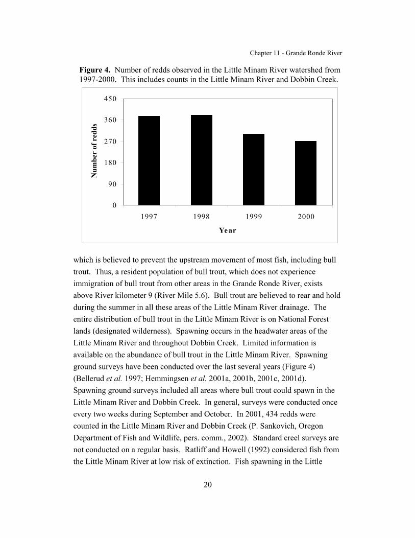
Chapter 11 - Grande Ronde River
20
0
90
180
270
360
450
1997 1998 1999 2000
Year
Num
ber
of r
edds
Figure 4. Number of redds observed in the Little Minam River watershed from1997-2000. This includes counts in the Little Minam River and Dobbin Creek.
which is believed to prevent the upstream movement of most fish, including bulltrout. Thus, a resident population of bull trout, which does not experienceimmigration of bull trout from other areas in the Grande Ronde River, existsabove River kilometer 9 (River Mile 5.6). Bull trout are believed to rear and holdduring the summer in all these areas of the Little Minam River drainage. Theentire distribution of bull trout in the Little Minam River is on National Forestlands (designated wilderness). Spawning occurs in the headwater areas of theLittle Minam River and throughout Dobbin Creek. Limited information isavailable on the abundance of bull trout in the Little Minam River. Spawningground surveys have been conducted over the last several years (Figure 4)(Bellerud et al. 1997; Hemmingsen et al. 2001a, 2001b, 2001c, 2001d). Spawning ground surveys included all areas where bull trout could spawn in theLittle Minam River and Dobbin Creek. In general, surveys were conducted onceevery two weeks during September and October. In 2001, 434 redds werecounted in the Little Minam River and Dobbin Creek (P. Sankovich, Oregon Department of Fish and Wildlife, pers. comm., 2002). Standard creel surveys arenot conducted on a regular basis. Ratliff and Howell (1992) considered fish fromthe Little Minam River at low risk of extinction. Fish spawning in the Little

Chapter 11 - Grande Ronde River
21
Minam River and Dobbin Creek are generally between 150 and 250 millimeters(5.9 to 9.8 inches) in fork length (Bellerud et al. 1997). Little additionalinformation is available on the size of these fish by age, age at maturation, sexratio, fecundity, time of emergence, or survival rates. Given that fluvial fish areunlikely to immigrate to the Little Minam River (above River kilometer 9 orRiver Mile 5.6) for spawning it seems likely that this population of bull troutfunctions as a resident life history form. However, bull trout produced in theLittle Minam River may emigrate to other areas (i.e. the Minam, Wallowa, andGrande Ronde rivers) in the Grande Ronde River subbasin.
Wallowa Lake/RiverHistorically, bull trout were present in the Wallowa River above Wallowa
Lake, however, this population is believed to have been extirpated by the 1950's(Buchanan et al. 1997). Although a reintroduction program using bull trout andDolly Varden (from Alaska) was initiated in 1968, this program was unsuccessfuland terminated in 1978 (Buchanan et al. 1997). No bull trout or Dolly Vardenwere captured in the Wallowa Lake fishery between 1980 and 1996 (B. Smith,Oregon Department of Fish and Wildlife, pers. comm., 2002). In 1997, 600 bulltrout from Big Sheep Creek, a tributary to the Imnaha River, were introduced intoWallowa River above Wallowa Lake (B. Smith, Oregon Department of Fish andWildlife, pers. comm., 2002). The current status of these fish is unknown.
Wenatchee CreekHistorically, fluvial-sized bull trout (longer than 46 centimeters or 18
inches) were be found far up into Wenatchee Creek (D. Groat, U.S. ForestService, pers. comm., 2002). However, in the 1960's a barrier waterfall formednear River kilometer 4 (River Mile 2.5) of Wenatchee Creek and currently, it isunlikely that fluvial bull trout would be able to get above this waterfall (D. Groat,U.S. Forest Service, pers. comm., 2002). In the mid-1980's, one account ofresident bull trout existing above the barrier waterfall in Wenatchee Creek waspublished in the Lewiston Tribune (G. Mendel, Washington Department of Fishand Wildlife, pers. comm., 2002). However, recent surveys have not been able toconfirm the presence of resident bull trout in Wenatchee Creek.

Chapter 11 - Grande Ronde River
22
REASONS FOR DECLINEDams
Dams can affect bull trout by altering habitats; flow, sediment, andtemperature regimes; migration corridors; and interspecific interactions,especially between bull trout and introduced species (Rode 1990; WashingtonDepartment of Wildlife 1992; Craig and Wissmar 1993; Oregon Department ofFish and Wildlife, in litt. 1993; Rieman and McIntyre 1993; Wissmar et al. 1994). In addition, hydroelectric facilities can directly impact bull trout via entrainment,and by direct injury or mortality by passing through turbines. Impassable damsand other barriers have caused declines of bull trout primarily by preventingaccess of migratory fish to spawning and rearing areas in headwaters andprecluding recolonization of areas where bull trout have been extirpated (Riemanand McIntyre 1993; Montana Bull Trout Scientific Group 1998).
The construction and operation of dams, both within and outside theGrande Ronde River Recovery Unit, has contributed to the decline of bull troutpopulations. Within the Grande Ronde River subbasin, dams exist in theWallowa River and in Beaver Creek. The dam in the Wallowa River was built atapproximately River kilometer 97 (River Mile 60.3), completed in 1931, currentlymaintains Wallowa Lake and provides multiple stream diversions into theWallowa River valley. The dam in Beaver Creek was built at River kilometer 20(River Mile 12.4), completed in 1915, and currently maintains a reservoir thatsupplies water to the city of La Grande, Oregon. Both of these dams wereconstructed without fish passage facilities and prevent bull trout from access tohistoric spawning habitat within the Grande Ronde River subbasin. In addition,the Grande Ronde River flows into the Snake River between Lower Granite andHells Canyon dams. Bull trout from the Grande Ronde River that express afluvial life history form may migrate to and overwinter in the mainstem of theSnake River (for example see Baxter 2002). Dams in the Snake River haveimpaired the connectivity between bull trout from the Grande Ronde River andthose from below Lower Granite Dam or above Hells Canyon Dam. LowerGranite Dam has also changed the habitat where bull trout potentially overwinterfrom a free-flowing river to a reservoir. The specific impacts of these dams tobull trout from the Grande Ronde River Recovery Unit are unclear.

Chapter 11 - Grande Ronde River
23
Forest Management Practices
Past and present forest management practices on Federal, private and Statelands have and continue to adversely affect riparian and stream habitat as well asbull trout. Past practices such as thinning of riparian vegetation, the constructionof splash dams utilizing the stream to transport logs, the construction of logflumes and diversion of streamflow from the creek, the destruction of riparianvegetation through the building of timber railroads and forest roads, the use ofsmaller side drainages as skid trails and harvest-related wildfire have decreasedthe function of the existing riparian vegetation in many areas. Bull trout intributaries, for example Bear Creek, have been impacted through significanthabitat degradation from road development and logging. Bull trout in mainstemareas, for example the upper Grande Ronde River (Oregon Department of Fishand Wildlife, in litt. 1993), have been impacted through increased watertemperatures resulting in thermal barriers, siltation of spawning gravel, and lossof instream structure (i.e. large wood).
The riparian functions that have been historically compromised includethe ability of the vegetation to act as a sediment filter and provide streambankstability, overhead shade, detritus and a source of instream wood. Riparianspecies size and composition have decreased from historic conditions and bufferwidths between roads and streams are too narrow in many drainages to filter outall soil movement before reaching the stream. The abundance of large instreamwood is low in many drainages due to the lack of recruitment sources in riparianareas logged in the past or burned in historic wildfires. Bank erosion hasoccurred where timber harvest and/or wildfire has removed vegetation with rootsintegral to the bank stability.
Streambank conditions, in certain areas, are poor with low vegetativecoverage and high erosiveness due to past timber harvest and/or the imprint of aroad located within the riparian vegetation. Soil movement from harvest sites androad systems add to the existing high embeddedness level of the streambedsubstrate where riparian vegetation is insufficiently wide to intercept thismaterial. This high embeddedness decreases the amount of suitable spawning and

Chapter 11 - Grande Ronde River
24
rearing habitat through the filling of interstitial spaces and filling of pool habitat. The combination of eroding streambanks, high sediment loading and lack of largewoody debris have caused sections of stream channel to have higher bankfullwidth/depth ratios than would be expected of the channel type. These degradedstream segments are wider and shallower than normal. Furthermore, diversebenthic fauna is beneficial to native trout species at all life stages and embeddedsubstrates can have detrimental effects on density and species diversity.
Livestock Grazing
Livestock grazing has contributed to the decline of bull trout throughimpacts to both upland and riparian areas of many tributaries in the recovery unit. For examples, significant livestock grazing (as well as some feedlot development)exists in the upper Grande Ronde River, the upper Wallowa River and the lowerportion of Bear Creek. The result of poor livestock management is theovergrazing of the riparian vegetation and excessive nutrient inputs to waterways. This overutilization leads to the reduced effectiveness of species that cover andstabilize streambanks. The compacting and cutting action of the hooves oflivestock on moist soils causes the sloughing of banks where localized use forfeeding, watering and crossing occurs. The indirect effect is to increase bankerosion and embeddedness of the streambed substrate, widening of the streamchannel and an increase in water temperature due to lack of overhangingvegetation. Livestock may also cause direct mortality of eggs or alevin if the redd(spawning bed) is trampled during watering or crossing.
Agricultural Practices
Bull trout within the Grande Ronde River Recovery Unit have been andcontinue to be adversely affected by irrigation diversions and water withdrawals. Unscreened or inadequately screened irrigation diversions strand bull trout (andother fish) in irrigation canals, sometimes resulting in high mortality. In addition,water withdrawals from streams for irrigation, particularly in late summer,exacerbate natural low-flow conditions in some streams. Low flows in latesummer can prevent bull trout, which are preparing to spawn from reaching

Chapter 11 - Grande Ronde River
25
spawning grounds and can also strand them. Low stream flows can also strandrearing juvenile fish in dry channel beds and result in elevated water temperatureswhich can delay spawning. When irrigation water is returned to streams andrivers, it carries sediment and nonpoint pollution from agricultural chemicalswhich degrade water quality.
Specific concerns include many of the watersheds in the Grande RondeRiver subbasin. Much of the Bear Creek watershed has little or no flow duringthe summer due to irrigation diversions. In the Lostine River the lower reaches ofsuspected historic summer distribution are substantially impacted by irrigationwithdrawal, erosion control activities and irrigation return flow. Between Riverkilometer 0 and 10 (River Mile 0 to 5.6) of the Lostine River, low summer flowsresulting (in part) from water diversions appear to impair the upstream movementof bull trout from July through September. This impact is especially significantduring low flow years. The U.S. Forest Service and Oregon Department of Fishand Wildlife have begun a radiotelemetry investigation to examine thisrelationship further (see Oregon Department of Fish and Wildlife 2001a). Belowthe Upper Alder Slope Irrigation Ditch, Hurricane Creek is currently separatedfrom the remainder of the habitat, substantially simplified due to channelization,impacted by warm water and sediment, and a 5 kilometer (2.6 mile) reach isdewatered by the irrigation withdrawal. Historically, the Lookingglass Creek,Catherine Creek, and Indian Creek watersheds experienced significant riparianloss and channel alterations which resulted in increased water temperatures,siltation, and loss of instream structure (Oregon Department of Fish and Wildlife,in litt. 1993). Since the 1970's, however, riparian loss and channel alteration inthe Lookingglass Creek watershed has been minimized and water temperature hasremained unchanged (M. McLean, Confederated Tribes of the Umatilla IndianReservation, pers. comm., 2002). In addition, grazing has been limited to a 3kilometer (1.6 mile) section of Lookingglass Creek and the Boise CascadeCorporation has eliminated grazing by the creek (M. McLean., ConfederatedTribes of the Umatilla Indian Reservation, pers. comm., 2002).
Culverts and diversions have contributed to the decline of bull troutpopulations within the Grande Ronde River Recovery Unit. Numerous diversions

Chapter 11 - Grande Ronde River
26
and culverts exist throughout the recovery unit and may act as barriers to bulltrout movement. For example, the Upper Alder Slope/Moonshine Ditch diversionin Hurricane Creek and the culvert at the Indian Creek hydropower facility(Oregon Department of Fish and Wildlife, in litt. 1993) are likely barriers to theupstream movement of bull trout. Low flows during the summer and fall mayexacerbate the impact of these culverts and diversions as barriers by contributingto elevated water temperatures that result in a thermal barrier. In any event, thesebarriers have reduced both the connectivity between local populations as well asthe habitat available to bull trout.
Transportation Network
Road densities are high in many watersheds in the Grande Ronde RiverRecovery Unit. Federal, State and county road construction, reconstruction andmaintenance had and continue to have impacts on water quality and aquatichabitat as well as contribute to the decline of bull trout. Depending upon theirlocation, roads have contributed to the reduction of riparian vegetation anddisconnected the habitat at stream crossings. In addition, culverts, dependingupon condition and position, may be blockages to upstream fish passage. Poorlylocated and designed roads, through maintenance and use, are constant sources ofsoil movement into adjacent stream systems. Soil that enters a stream mayincrease the level of turbidity and embeddedness of the streambed substrate, fillpool habitat and widen channels within low gradient areas.
Fragmentation of habitat by culvert installation and sediment input are themajor problems caused by road maintenance and construction. As with otherwatersheds with a history of timber harvest, many of the roads are within theriparian zone are causing sedimentation in streams. These problems are apparentin many watersheds of the recovery unit. For example, roads parallel most of thestreams in the Deer Creek watershed and the Bear Creek watershed (excepting theupper-most reaches). The presence and maintenance of these roads contribute toincreased stream temperatures during the summer, increased sediment and lack ofchannel diversity, particularly in the lower portions of the creeks. In addition,there are culverts (for examples: on Sage Creek, a tributary to Deer Creek, and
Chapter 11 - Grande Ronde River
27
Sand Pass Creek (Road 650), a tributary to Catherine Creek) which may bepassage barriers at certain times of the year (Oregon Department of Fish andWildlife, in litt. 1993).
Mining
Past mining activities likely contributed to the decline of bull trout. Mining in the Lostine River, Hurricane Creek and Upper Grande Ronde Riverwatersheds has resulted in decreased channel stability which may result indisrupted or lost habitat for bull trout. Little mining currently occurs in theGrande Ronde River Recovery Unit.
Residential Development
Residential development has contributed to the decline of bull trout. Areas within the Grande Ronde River Recovery Unit have grown in popularity aspreferred areas for home sites and recreation areas. For example, a State park andpopular tourist site have been developed around Wallowa Lake and the riverabove the lake. In part as a result of this development, the river above the lakehas been channelized. Additional stream channelization has occurred asresidential developments have encroached the lower reaches of the Lostine Riverand Hurricane Creek (below the National Forest boundary). As the humanpopulation in the recovery unit increases more development and subsequentimpacts to riparian areas, water quality and bull trout are likely. Impacts to bulltrout from previous and future development may include loss of riparian habitat,increases in nutrient loading from septic systems and chemical applications.
Fisheries Management
HarvestBull trout tend to be aggressive and easily caught through angling.
Historic harvest of bull trout may have eliminated populations in small tributariesand contributed to the overall decline. For example, before the 1990's bull troutangling was permitted in the State of Oregon. Angling in the Grande Ronde

Chapter 11 - Grande Ronde River
28
River watershed was controlled by standard Statewide seasons and limits fortrout. Over the course of the 1990's, fishing for bull trout in Oregon becameseverely restricted. By 1994, angling for bull trout in the Grande Ronde Riverwatershed was prohibited. Currently, both the states of Oregon and Washingtonprohibit angling for bull trout in the Grande Ronde River watershed (see OregonDepartment of Fish and Wildlife 2001b; Washington Department of Fish andWildlife 2001).
Although regulations prohibit it, harvest of bull trout still occurs in the GrandeRonde River subbasin. Anglers have been known to harvest bull trout from theWallowa, Lostine, Grande Ronde, and Wenaha Rivers as well as Hurricane, Bear,Lookingglass, Catherine, and Deer Creeks. Some of this unauthorized harvestresults from the difficulty in distinguishing between bull trout and brook trout. As a result, anglers sometimes mistake a bull trout for a brook trout andaccidentally harvest the fish.
HatcheriesBarriers associated with hatchery operations may also be contributing to
the decline of bull trout populations within the Grande Ronde River RecoveryUnit. Weirs to capture adult chinook exist in the upper Grande Ronde River andCatherine Creek (operated by Confederated Tribes of the Umatilla IndianReservation), Lookingglass Creek (operated by Oregon Department of Fish andWildlife), and the Lostine River (operated by Nez Perce Tribe). These weirs aredesigned to operate at a time when fluvial bull trout would also be movingupstream and they do capture bull trout. By impeding the migration of fish, theseweirs may alter when and where bull trout spawn. Weirs also exist in Deer Creekand Spring Creek (in the Wallowa River watershed). However, these weirs aredesigned to capture adult steelhead and do not typically operate when fluvial bulltrout are moving upstream. The major hatcheries in the Grande Ronde RiverRecovery Unit are the Wallowa Fish Hatchery and Lookinglass Fish Hatchery. Intakes to these hatcheries, and screens associated with these intakes, may alsoimpact the migration of juvenile bull trout.

Chapter 11 - Grande Ronde River
29
Brook TroutBrook trout (Salvelinus fontinalis) are an exotic species that was
introduced into the Grande Ronde River subbasin before the turn of the century. Brook trout were stocked in streams, rivers and high mountain lakes. Recently,brook trout that were stocked illegally into Langdon Lake were discovered anderadicated by the Oregon Department of Fish and Wildlife (T. Walters, OregonDepartment of Fish and Wildlife, pers. comm., 2002). Brook trout have donerelatively well in these nonnative habitats and are now abundant in many of thetributaries in the Grande Ronde River subbasin. Brook trout can be found in theWallowa, Minam, Lostine, and Grande Ronde Rivers as well as Hurricane, Bear,Lookingglass, and Beaver creeks. Brook trout can be found in both public andprivate areas. Brook trout have contributed to the decline of bull troutpopulations primarily through competition and hybridization (for description, seeGunckel 2001). Brook trout are difficult to eradicate from a watershed and willlikely impact bull trout well into the future.
Anadromous SalmonidsAnadromous salmonids have declined throughout the Grande Ronde River
subbasin and are either extinct (coho Oncorhynchus kisutch, sockeye O. nerka) orlisted under the Endangered Species Act (chinook O. tshawytscha, steelhead O.mykiss) (see National Marine Fisheries Service 2000). Juvenile salmonidsproduced by anadromous parents are considered to have been a primary foodsource of bull trout. This reduction in prey base has contributed to the decline ofbull trout in the Grande Ronde River Recovery Unit. A reduced prey base is ofparticular concern in the Upper Grande Ronde River, Catherine Creek and IndianCreek watersheds.
DiseaseThere are no significant fish disease issues known in the recovery unit at
this time. Bull trout populations, although low in abundance, generally appear tobe in good health. However, diseases which may impact bull trout are present inthe recovery unit (i.e. whirling disease has been present since the 1980's) andmonitoring and screening efforts currently underway should continue. Although
Chapter 11 - Grande Ronde River
30
bull trout in the recovery unit have not exhibited symptoms, disease issues can bedifficult to detect in the natural environment.
Bull trout may be inherently resistant to some diseases that are moredevastating to other salmonids. In studies conducted by Oregon State Universityresearchers, Metolius (Deschutes) bull trout exposed to high and low doses of theinfectious stages of Myxobolus cerebralis (causative agent in whirling disease)showed no signs of infection as measured by presence of spores, clinical diseasesigns, or histopathology. Rainbow trout exposed simultaneously showed highinfection prevalence and disease severity. Nor were infections detected inMetolius (Deschutes) bull trout exposed to infection by Ceratamyosis shasta(Bartholomew 2001). Disease studies conducted on bull trout from the DeschutesRiver subbasin, showed them to be relatively resistant to all strains of InfectiousHematopeietic Necrosis Virus tested. Bull trout had detectable levels of antigento Renibacter salmoninarum (bacterial kidney disease) but no evidence of thedisease.
Isolation and Habitat Fragmentation
Isolation through habitat fragmentation has resulted from a variety ofevents. Habitat fragmentation has primarily occurred due to road and damconstruction. For example, resident populations of bull trout in Hurricane Creekhave been isolated above irrigation diversions. Culvert placement preventingupstream migration has precluded bull trout from some tributaries in thewatershed. Loss of riparian habitat, primarily, has also resulted in watertemperatures during the summer that are warmer than they were historically. Ona seasonal basis, this warm water can act as a thermal barrier to isolate bull trout.
For example, warm water temperatures in the Grande Ronde River (particularlybetween the towns of La Grande and Elgin) may inhibit the ability of fluvial bulltrout to migrate from the lower Grande Ronde River to spawning habitat in theupper Grande Ronde River.

Chapter 11 - Grande Ronde River
31
ONGOING RECOVERY UNIT CONSERVATION MEASURES
Efforts to recover salmonid species, including bull trout, are ongoing inthe Grande Ronde River subbasin. There is good cooperation between fisheryentities on various projects. For example, spawning surveys to assess andmonitor status and abundance have been a cooperative effort for many yearsinvolving Oregon Department of Fish and Wildlife, Oregon State Police, U.S.Forest Service, Confederated Tribes of the Umatilla Indian Reservation, NezPerce Tribe, and local volunteers. The Grande Ronde River subbasin also has anactive local watershed group dedicated to finding workable solutions to restoringnative fish runs. The following represents many of the ongoing efforts within therecovery unit.
Oregon Department of Fish and WildlifeOregon Department of Fish and Wildlife initiated a bull trout research
project in 1994 in the Grande Ronde subbasin. This research involves thegenetics, habitat needs, limiting factors, and life history of bull trout in the basin. The project has contributed to status assessments as well as recovery planning andis ongoing. Oregon Department of Fish and Wildlife hired a bull troutcoordinator in 1995 to complete Statewide bull trout status assessment, map bulltrout distribution, and develop conservation strategies for bull trout. When bulltrout were listed the effort shifted to recovery planning.
The Oregon Department of Fish and Wildlife modified fishing regulationsfor bull trout in the Grande Ronde River subbasin. In 1994 it became illegal toangle for bull trout in this watershed. Oregon Department of Fish and Wildlifehas also modified regulations on other fisheries to reduce incidental take, reducedor eliminated brook trout stocking programs, made changes to instream workperiods to better address bull trout needs, and developed and distributed bull troutidentification posters to provide information to anglers. Oregon Department ofFish and Wildlife has a section 6 cooperative agreement with the U.S. Fish andWildlife Service. Funding through section 6 has, in part, enabled spawningground surveys to be conducted.

Chapter 11 - Grande Ronde River
32
The Oregon Department of Fish and Wildlife implemented a project toeradicate brook trout from Langdon Lake to prevent their establishment inLookingglass Creek. The Oregon Department of Fish and Wildlife also modifiedhatchery operations at Lookingglass Creek to provide timely passage for bulltrout migrating upstream.
Oregon Department of Environmental QualityIn 2000, the Oregon Department of Environmental Quality completed a
water quality management plan for the Grande Ronde basin. High watertemperatures have been identified as a threat to bull trout recovery. Watertemperature is also one of the parameters identified in the total maximum dailyload process and its improvement would benefit bull trout populations in thebasin.
U.S. Forest ServiceThe U.S. Forest Service has ongoing riparian enhancement projects in the
upper reaches of the Grande Ronde River. Improved riparian structure will bebeneficial to all aquatic species, including bull trout.
TribesThe Nez Perce Tribe is planning to initiate a gene conservation effort
through application of cryogenic technology for bull trout in the Grande RondeRiver subbasin. This technology seeks to preserve genetic diversity of listed bulltrout subpopulations before further population decline and loss of geneticdiversity occurs.
The Nez Perce Tribe and Confederated Tribes of the Umatilla IndianReservation operate weirs on the Lostine River as well as Catherine Creek and theupper Grande Ronde River, respectively. Both tribes collect information onabundance and timing of fluvial bull trout migrating upstream to spawn.
Multi-agency EffortsOregon Department of Fish and Wildlife, Oregon State Police, Nez Perce
Tribe, Confederated Tribes of the Umatilla Indian Reservation, and U.S. Forest

Chapter 11 - Grande Ronde River
33
Service staff work cooperatively on spawning and habitat surveys, research,telemetry, and abundance projects.
Bonneville Power Administration, the State of Oregon, and other Federalagencies have provided funding for numerous anadromous and bull trout habitatand research projects by the Oregon Department of Fish and Wildlife, Nez PerceTribe, and the Confederated Tribes of the Umatilla Indian Reservation in therecovery unit.

Chapter 11 - Grande Ronde River
34
RELATIONSHIP TO OTHER CONSERVATION EFFORTS
State of Oregon
On January 14, 1999, Governor Kitzhaber expanded the Oregon Plan forSalmon and Watersheds to include all at-risk wild salmonids throughout the Statethrough Executive Order 99-01. The goal of the Oregon Plan is to “restorepopulations and fisheries to productive and sustainable levels that will providesubstantial environmental, cultural, and economic benefits”. Components of thisplan include (1) coordination of efforts by all parties, (2) development of actionplans with relevance and ownership at the local level, (3) monitoring progress,and (4) making appropriate corrective changes in the future. It is a cooperativeeffort of State, local, Federal, Tribal and private organizations, and individuals.
Oregon Department of Fish and Wildlife and Oregon Water ResourcesDepartment have established priorities for restoration of streamflow as part of theOregon Plan for Salmon and Watersheds (Measure IV.A.8). Oregon Departmentof Fish and Wildlife has prioritized streamflow restoration needs by rankingbiophysical factors, water use patterns, and the extent that water limits fishproduction in a particular area. Oregon Water Resources Departmentwatermasters will incorporate the priorities into their field work activities as ameans to implement flow restoration measures. The needs priorities will be usedby the Oregon Watershed Enhancement Board as one criterion in determiningfunding priorities for enhancement and restoration projects. Watershed councilsand other entities may also use the needs priorities as one piece of information todetermine high priority restoration projects. Bull trout occupied streams in therecovery unit are included in the highest priority designation for streamflowrestoration (Northwest Power Planning Council 2001).
Opportunities to convert existing out-of-stream flows to instream flows inOregon are available through a variety of legislatively mandated programsadministered by Oregon Water Resources Department, e.g., transfers of type andplace of use (ORS 536.050(4)), voluntary written agreement among water users torotate their use of the supply to which they are collectively entitled (ORS 540.150

Chapter 11 - Grande Ronde River
35
and OAR 690-250-0080), allocation of “conserved water” to instream use (ORS537.455 to 537.500), lease all or a portion of consumptive water rights to instreampurposes (ORS 537.348, OAR 690-77-070 to 690-77-077, exchange of a waterright for an instream purpose to use water from a different source, being storedwater, surface or ground water (ORS 540.533 to 540.543), and substitute a groundwater right for a primary surface water right (ORS 540.524). Oregon Water Trustprovides purchase of water rights from willing landowners for conversion toinstream water rights.
Under an agreement with the Environmental Protection Agency, the Stateof Oregon’s Department of Environmental Quality is conducting total maximumdaily load surveys and developing Water Quality Management Plans. In theGrande Ronde River subbasin, total maximum daily load surveys have beencompleted throughout the subbasin(http://www.deq.state.or.us/wq/TMDLs/UprGR/UprGRTMDL.pdf). In April2000, a water quality management plan was also developed for the Upper GrandeRonde River (http://www.deq.state.or.us/wq/TMDLs/UprGR/UprGRWQMP.pdf). This plan addresses forest, agricultural, urban and transportation sources of waterquality impairment.
The Agricultural Water Quality Management Program, establishedthrough the State Senate Bill 1010 process (ORS 568.900 through 568.933),addresses water pollution associated with agricultural lands and activities.
The Oregon Department of Fish and Wildlife developed a managementplan for native trout (Oregon Department of Fish and Wildlife 1988), whichincludes bull trout. Oregon’s trout plan focuses on protecting native fish and thehabitats in which they exist. The plan provides specific guidance to managers andis consistent with much of the recovery plan.
State of Washington
The Governor’s office in Washington State has developed a Statewidestrategy that describes how State agencies and local governments will work

Chapter 11 - Grande Ronde River
36
together to address habitat, harvest, hatcheries, and hydroelectric powergeneration as they relate to recovery of listed species. The Salmon Recovery Act,passed in 1998, provides the structure for salmonid protection and recovery at thelocal level (counties, cities, and watershed groups).
The Washington Department of Fish and Wildlife has developed a bulltrout management plan that addresses both bull trout and Dolly Varden(Washington Department of Fish and Wildlife 1992). The WashingtonDepartment of Fish and Wildlife no longer stocks brook trout in streams or lakesconnected to bull trout waters. Fishing regulations prohibit harvest of bull trout,except for a few areas where populations are considered healthy, within the State. The Washington Department of Fish and Wildlife is also currently involved in amapping effort to update bull trout distribution data within the State ofWashington, including all known occurrences, spawning and rearing areas, andpotential habitats. The salmon and steelhead inventory and assessment programis currently updating their database to include the entire State, which consists ofan inventory of stream reaches and associated habitat parameters important for therecovery of salmonid species and bull trout.
In January 2000, the Washington Forest Practices Board (2000) adoptednew emergency forest practice rules based on the Forest and Fish Report. Theserules address riparian areas, roads, steep slopes, and other elements of forestpractices on non-Federal lands. Although some provisions of forest practice rulesrepresent improvements over previous regulations, the plan will have to rely onan adaptive management program for assurance that the new rules will meet theconservation needs of bull trout. Research and monitoring being conducted toaddress areas of uncertainty for bull trout include protocols for detection of bulltrout, habitat suitability, forestry effects on groundwater, field methods or modelsto identify areas influenced by groundwater, and forest practices influencing coldwater temperatures. The Forest and Fish Report development process relied onbroad stakeholder involvement and included State agencies, counties, Tribes,forest industry and environmental groups. A similar process is also being usedfor agricultural communities in Washington and is known as Agriculture, Fish,and

Chapter 11 - Grande Ronde River
37
Water. The U.S. Fish and Wildlife Service is considering the possible impactsand potential benefits from both of these State processes relative to bull troutrecovery.
The Washington Department of Ecology is responsible for maintainingstream flows and does this by (1) supporting development of water restorationplans, (2) conducting technical studies and adopting instream flow rules, (3)buying water rights to restore flows, (4) using the hydro power relicensingprogram to restore flows, (5) obtaining trust water through the Trust Water RightProgram (RCW 90.42) in Endangered Species Act areas, and (6) developing aState position to Federal management of the Columbia and Snake rivers(http://www.ecy.wa.gov/programs/wr/wrhome.html).
Columbia River Intertribal Fish Commission
The Columbia River Intertribal Fish Commission developed the TribalColumbia River Fish Restoration Plan, or Wy-Kan-Ush-Mi Wa-Kish-Wit(http://ccrh.org/comm/river/docs/critfcp.htm). Recommendations set forth in thisplan for salmon recovery address three types of actions: institutional, technical,and watershed, with the overriding goal of simply putting fish back in the river. Objectives and strategies specific to the Grande Ronde basin are included in thisrestoration plan and will ultimately benefit bull trout.
Confederated Tribes of the Umatilla Indian Reservation
The Confederated Tribes of the Umatilla Indian Reservation is responsiblefor protecting and enhancing treaty fish and wildlife resources and habitats. Members of the Confederated Tribes of the Umatilla Indian Reservation haveFederal reserve fishing and hunting rights. Confederated Tribes of the UmatillaIndian Reservation comanages fishery resources with Oregon Department of Fishand Wildlife and implements restoration and mitigation activities throughout theareas of northeast Oregon and southeast Washington. Confederated Tribes of theUmatilla Indian Reservation holds aboriginal title and exercised usual andaccustomed use to lands including but not limited to the Grande Ronde subbasin.
Chapter 11 - Grande Ronde River
38
Nez Perce Tribe
The Nez Perce Tribe is responsible for managing, protecting, andenhancing treaty fish and wildlife resources and habitats in the Grande Rondesubbasin. The Tribe individually and/or jointly implements restoration andmitigation activities in the subbasin. The Tribe’s Department of FisheriesResources Management is responsible for managing fisheries resources to providefor healthy self sustaining populations of historically present species, and promotehealthy ecosystem processes and rich species diversity.
Local Planning EffortsThe Grande Ronde Model Watershed Program
(http://www.fs.fed.us/pnw/modelwatershed/) was selected in 1992 by theNorthwest Power Planning Council as the model watershed project in Oregon. The Grande Ronde Model Watershed Program has a Board of Directors,composed of local representatives, Tribes and natural resource managementagencies, to coordinate policy of the program. For the last nine years the GrandeRonde Model Watershed Program has served as an example of a watershedmanagement partnership among local residents, agency staffs and public interestgroups. The program coordinates the implementation, maintenance andmonitoring of habitat restoration projects. To date the program has facilitated theimplementation of nearly 300 restoration projects.
The Nature Conservancy protects the lands and waters, which plant andanimal species need to survive. It is instrumental in purchasing lands for habitatprotection, working with agencies with similar objectives, and has been involvedin the Grande Ronde River subbasin.
Northwest Power Planning Council’s Subbasin PlanningAs part of the Pacific Northwest Electric Power Planning and
Conservation Act of 1980, the Bonneville Power Administration has theresponsibility to protect, mitigate and enhance fish and wildlife resources affectedby operation of Federal hydroelectric projects in the Columbia River andtributaries. The Northwest Power Planning Council develops and coordinates the

Chapter 11 - Grande Ronde River
39
Columbia River Basin Fish and Wildlife Program that is implemented by theBonneville Power Administration, U.S. Army Corps of Engineers, U.S. Bureau ofReclamation, and Federal Energy Regulatory Commission. Coordination ofBonneville Power Administration’s responsibilities for protection, enhancement,and mitigation and incorporation of recommendations by Northwest PowerPlanning Council is in part done through the development of subbasin summaries, which identify status of fish and wildlife resources, limiting factors, andrecommended actions at the subbasin level.
A draft of the Grande Ronde subbasin summary was completed in June2001 (http://www.cbfwa.org/files/province/blue/subsum/010601Grande.pdf). Thesummary encompasses the Grande Ronde River Recovery Unit, and is consistentwith bull trout recovery planning efforts to identify limiting factors. The draftGrande Ronde subbasin summary identifies temperature, channel conditions,instream habitat diversity, flow, riparian, and passage as contributing to thedecline of bull trout. The Grande Ronde River Recovery Unit Team will continueto utilize this planning process to identify and seek funding for projects to aid bulltrout recovery.

Chapter 11 - Grande Ronde River
40
STRATEGY FOR RECOVERY
A core area represents the closest approximation of a biologicallyfunctioning unit for bull trout. The combination of core habitat (i.e., habitat thatcould supply all the necessary elements for the long-term security of bull trout,including for both spawning and rearing, as well as for foraging, migrating, andoverwintering) and a core population (i.e., bull trout inhabiting a core habitat)constitutes the basic core area upon which to gauge recovery within a recoveryunit. Within a core area, many local populations may exist.
Two core areas were defined for the recovery unit, one for the GrandeRonde, one for the Little Minam (Figure 2). Whether bull trout exist inWenatchee Creek was identified as a research need. If bull trout do exist inWenatchee Creek, it would be a third core area in the recovery unit. The areaabove the barrier waterfall near the mouth of Wenatchee Creek is the area whereresearch is needed.
Little Minam Core AreaThis core area includes the local population complex defined as the Little
Minam. Most, if not all, of the current spawning activity appears to occur in themainstem of the Little Minam River above the barrier waterfall or in DobbinCreek.
Grande Ronde Core AreaThis core area includes eight extant, local populations: Upper Grande
Ronde complex, Catherine Creek and tributaries, Indian Creek and tributaries,Minam River/Deer Creek complex, Lostine River/Bear Creek complex, UpperHurricane Creek, Wenaha River, and Lookingglass Creek. This core area alsoincludes Wallowa Lake and the Wallowa River above the lake where native bulltrout are believed to have been extirpated. The Upper Grande Ronde, MinamRiver/Deer Creek, and Lostine River/Bear Creek populations may consist of morethan one local population. For example, The Minam River/Deer Creek complexmay have one local population in the Minam River and another local populationin Deer Creek. For the present, or until research shows otherwise, they are

Chapter 11 - Grande Ronde River
41
considered one local population, referred herein as various complexes. TheUpper Grande Ronde, Catherine Creek and Indian Creek systems have thepotential to become separate core areas if further research shows the localpopulations cannot or do not connect with the rest of the Grande Ronde localpopulations.
Current distribution of bull trout in the Grande Ronde River RecoveryUnit includes the mainstem Grande Ronde River from its headwaters to theconfluence with the Snake River; tributaries including Catherine Creek, IndianCreek, Lookingglass Creek, Wallowa River and its tributaries (Minam, Deer,Bear, Lostine, and Hurricane creeks), and the Wenaha River and its tributaries. To the best of our knowledge, with the exception of the Wallowa River aboveWallowa Dam, historic distribution is closely reflected by the current distribution.
For purposes of recovery, the Grande Ronde River Recovery Unit containstwo core areas: the Grande Ronde Core Area and the Little Minam Core Area(Figure 2). The Grande Ronde Core Area encompasses tributaries containinglocal populations (both current and potential as identified by the recovery unitteam) and the mainstem Grande Ronde River from headwaters downstream to theSnake River. The Little Minam Core Area encompasses tributaries containinglocal populations and the mainstem above the barrier waterfall at approximatelyRiver kilometer 9 (River Mile 5.6). Wenatchee Creek has been defined as an areathat needs to be surveyed for bull trout occurrence. It encompasses tributaries andthe mainstem above the barrier waterfall at approximately River kilometer 4. Itmay not currently contain bull trout, but did historically. Additional assessment isneeded to determine its suitability as a core area. The survey has been defined asa primary research need. Should surveys identify suitable habitat and thepresence of bull trout, this recovery unit chapter will be revised to includeWenatchee Creek as a third core area.
Although we know Grande Ronde bull trout migrate to the Snake Riverand back, we do not have a clear understanding of the extent of their use anddistribution in the Snake River mainstem. Once this information is available, theGrande Ronde Core Area may be extended to include portions of the Snake River

Chapter 11 - Grande Ronde River
42
mainstem. Until then bull trout use patterns in the Snake River mainstem hasbeen defined as a primary research need.
Recovery Goals and Objectives
The goal of the bull trout recovery plan is to ensure the long-termpersistence of self-sustaining, complex, interacting groups of bull troutdistributed throughout the species’ native range, so that the species can bedelisted. To achieve this goal the following objectives have been identified forbull trout in the Grande Ronde River Recovery Unit:
5. The current number and distribution of bull trout populations within theGrande Ronde River Recovery Unit is maintained in the Little Minamand, potentially, Wenatchee core areas, as well as expanded in the GrandeRonde Core Area to suitable habitat (as noted in Table 2).
6. Stable or increasing trends in abundance of bull trout within the GrandeRonde River Recovery Unit are achieved.
7. Suitable habitat conditions for all bull trout life history stages andstrategies are restored and maintained within the Grande Ronde RiverRecovery Unit.
8. Bull trout within the Grande Ronde River Recovery Unit are conserved byproviding opportunities for genetic exchange between the localpopulations.
The current and recovered status of bull trout in the recovery unit wereevaluated based on four population elements. These elements were derived fromthe best scientific information available concerning bull trout populationdynamics and habitat requirements (Rieman and McIntyre 1993; Rieman andAllendorf 2001). The four elements were: 1) number of local populations, 2)
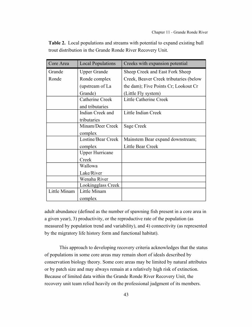
Chapter 11 - Grande Ronde River
43
Table 2. Local populations and streams with potential to expand existing bulltrout distribution in the Grande Ronde River Recovery Unit.
Core Area Local Populations Creeks with expansion potential
GrandeRonde
Upper GrandeRonde complex(upstream of LaGrande)
Sheep Creek and East Fork SheepCreek, Beaver Creek tributaries (belowthe dam); Five Points Cr; Lookout Cr(Little Fly system)
Catherine Creekand tributaries
Little Catherine Creek
Indian Creek andtributaries
Little Indian Creek
Minam/Deer Creekcomplex
Sage Creek
Lostine/Bear Creekcomplex
Mainstem Bear expand downstream;Little Bear Creek
Upper HurricaneCreekWallowaLake/RiverWenaha RiverLookingglass Creek
Little Minam Little Minamcomplex
adult abundance (defined as the number of spawning fish present in a core area ina given year), 3) productivity, or the reproductive rate of the population (asmeasured by population trend and variability), and 4) connectivity (as representedby the migratory life history form and functional habitat).
This approach to developing recovery criteria acknowledges that the statusof populations in some core areas may remain short of ideals described byconservation biology theory. Some core areas may be limited by natural attributesor by patch size and may always remain at a relatively high risk of extinction.Because of limited data within the Grande Ronde River Recovery Unit, therecovery unit team relied heavily on the professional judgment of its members.

Chapter 11 - Grande Ronde River
44
Local PopulationsMetapopulation theory is important to consider in bull trout recovery. A
metapopulation is an interacting network of local populations with varyingfrequencies of migration and gene flow among them (Meffe and Carroll 1994)(see Chapter 1). Multiple local populations distributed and interconnectedthroughout a watershed provide a mechanism for spreading risk from stochasticevents. In part, distribution of local populations in such a manner is an indicatorof a functioning core area. Based in part on guidance from Rieman and McIntyre(1993), bull trout core areas with fewer than 5 local populations are at increasedrisk, core areas with between 5 and 10 local populations are at intermediate risk,and core areas with more than 10 interconnected local populations are atdiminished risk. In the Grande Ronde Core Area, there are currently eight knownlocal populations (although additional information is needed to better characterizelocal populations in the core area); the Little Minam Core Area currently containsone local population. Based on the above guidance, bull trout in the GrandeRonde Core Area are at an intermediate risk category, and bull trout in the LittleMinam Core Area are at an increasing risk. Additional local populations may beneeded in the Grande Ronde Core Area, and are needed in the Little Minam CoreArea, to reduce the risk from deterministic or stochastic events which maythreaten bull trout.
Evaluation of the status of bull trout in Wenatchee Creek was identified asa research need. If a population of bull trout exists in Wenatchee Creek, thispopulation would be in a similar situation to that in the Little Minam Core Area. The level of extinction risk and threats are currently unknown.
Adult AbundanceThe recovered abundance levels in the Grande Ronde River Recovery
Unit were determined by considering theoretical estimates of effective populationsize, historical census information, and the professional judgment of recoveryteam members. In general, effective population size is a theoretical concept thatallows us to predict potential future losses of genetic variation within a populationdue to small population sizes and genetic drift (see Chapter 1). For the purpose ofrecovery planning, effective population size is the number of adult bull trout that

Chapter 11 - Grande Ronde River
45
successfully spawn annually. Based on standardized theoretical equations (Crowand Kimura 1970), guidelines have been established for maintaining minimumeffective population sizes for conservation purposes. Effective population sizesof greater than 50 adults are necessary to prevent inbreeding depression and apotential decrease in viability or reproductive fitness of a population (Franklin1980). To minimize the loss of genetic variation due to genetic drift and tomaintain constant genetic variance within a population, an effective populationsize of at least 500 is recommended (Franklin 1980; Soule 1980; Lande 1988). Effective population sizes required to maintain long-term genetic variation thatcan serve as a reservoir for future adaptations in response to natural selection andchanging environmental conditions are discussed in Chapter 1 of the recoveryplan.
For bull trout, Rieman and Allendorf (2001) estimated that a minimumnumber of 50 to 100 spawners per year is needed to minimize potential inbreedingeffects within local populations. In addition, a population size of between 500and 1,000 adults in a core area is needed to minimize the deleterious effects ofgenetic variation from drift.
For the purposes of bull trout recovery planning, abundance levels wereconservatively evaluated at the local population and core area levels. Localpopulations containing fewer than 100 spawning adults per year were classified asat risk from inbreeding depression. Bull trout core areas containing fewer than1,000 spawning adults per year were classified as at risk from genetic drift.
Bull trout in the Grande Ronde River Recovery Unit persist at moderatenumbers. In the Grande Ronde Core Area the best estimates are thatapproximately 4,000 bull trout spawned in each of the past few years. Themajority of spawning likely occurs in the Wenaha River and Minam River/DeerCreek complex, both which exists primarily in wilderness areas. In the LittleMinam Core Area the best estimates are that approximately 750 bull troutspawned in each of the past few years. All of this spawning occurred in awilderness area above the barrier waterfall in the Little Minam River. Based on

Chapter 11 - Grande Ronde River
46
the aforementioned guidance, bull trout in the Grande Ronde and Little MinamCore Areas are at a diminished risk of genetic drift.
ProductivityA stable or increasing population is a key criterion for recovery under the
requirements of the Endangered Species Act. Measures of the trend of apopulation (the tendency to increase, decrease, or remain stable) includepopulation growth rate or productivity. Estimates of population growth rate (i.e.,productivity over the entire life cycle) that indicate a population is consistentlyfailing to replace itself also indicate an increased risk of extinction. Therefore,the reproductive rate should indicate that the population is replacing itself, orgrowing.
Since estimates of the total population size are rarely available, theproductivity or population growth rate is usually estimated from temporal trendsin indices of abundance at a particular life stage. For example, redd counts areoften used as an index of a spawning adult population. The direction andmagnitude of a trend in the index can be used as a surrogate for the growth rate ofthe entire population. For instance, a downward trend in an abundance indicatormay signal the need for increased protection, regardless of the actual size of thepopulation. A population that is below recovered abundance levels, but that ismoving toward recovery, would be expected to exhibit an increasing trend in theindicator.
The population growth rate is an indicator of probability of extinction. This probability cannot be measured directly, but it can be estimated as theconsequence of the population growth rate and the variability in that rate. For apopulation to be considered viable, its natural productivity should be sufficient forthe population to replace itself from generation to generation. Evaluations ofpopulation status will also have to take into account uncertainty in estimates of population growth rate or productivity. For a population to contribute torecovery, its growth rate must indicate that the population is stable or increasingfor a period of time.
Chapter 11 - Grande Ronde River
47
Given the overall lack of long-term population census information in theGrande Ronde and Little Minam Core Areas (trend information in both is basedon less than 5 years of data), and the variability in abundance estimates, bull troutin the Lower Columbia Recovery Unit were classified at increased risk.
ConnectivityThe presence of the migratory life history form within the Grande Ronde
River Recovery Unit was used as an indicator of the functional connectivity of therecovery unit and both core areas. If the migratory life form was absent, or if themigratory form is present but local populations lack connectivity, the core areawas considered to be at increased risk. If the migratory life form persists in atleast some local populations, with partial ability to connect with other localpopulations, the core area was judged to be at intermediate risk. Finally, if themigratory life form was present in all or nearly all local populations, and had theability to connect with other local populations, the core area was considered to beat diminished risk.
There are few physical or thermal barriers obstructing connectivity andmigratory forms are present in many local populations within the Grande RondeCore Area. Assuming all of the local populations in the Grande Ronde Core Areaare connected, bull trout in this core area are currently at an intermediate threatlevel. If bull trout from (for example) Catherine Creek are not connected to thosein the rest of the core area, the level of threat would increase accordingly. Incontrast, the local population in the Little Minam Core Area contains resident lifehistory forms only as they are isolated from other bull trout populations in theMinam River by a barrier waterfall. Although this local population currentlycontains relatively high numbers of spawners, this population is not connectedwith other local populations and is at increased risk.
Recovery Criteria
Recovery criteria for bull trout in the Grande Ronde River Recovery Unit arethe following:

Chapter 11 - Grande Ronde River
48
1. Bull trout are distributed among nine local populations in the recoveryunit, eight in the Grande Ronde Core Area and one in the Little MinamCore Area. In a recovered condition the recovery unit would include ninelocal populations. In the Grande Ronde Core Area local populations wouldinclude the Upper Grande Ronde complex, Catherine Creek, Indian Creek,the Minam River/Deer Creek complex, The Lostine River/Bear Creekcomplex, Hurricane Creek, Lookingglass Creek, and the Wenaha River. Inthe Little Minam Core Area a local population of resident bull trout wouldexist in the Little Minam River above the barrier waterfall. Native bull troutare believed to have been extirpated above the dam at Wallowa Lake and bulltrout distribution above this point would not be considered necessary forrecovery. Additional research is needed in the Wenatchee Creek Core Area. If resident bull trout currently exist above the barrier waterfall in WenatcheeCreek, then a recovered condition would also include a local population ofresident bull trout in Wenatchee Creek, or a total of 10 local populations. Additional population studies and a better understanding of bull trout fidelityto their natal streams is needed to better define local populations in therecovery unit. There is potential to further separate the population within theUpper Grande Ronde complex into multiple local populations, the MinamRiver/Deer Creek complex into two local populations, and the LostineRiver/Bear Creek complex into two local populations.
2. Estimated abundance of adult bull trout is at least 6,000 adults in therecovery unit distributed in each core area as follows: Grande RondeCore Area (5,000), Little Minam Core Area (1,000). Recoveredabundance was derived using the professional judgement of the recoveryunit team, an estimation of productive capacity of identified localpopulations, and conservation biology theory. Estimates of the residentand fluvial life history component within the recovery unit are considereda research need. Recovered abundance levels do not include estimates forthe Wenatchee Creek Core Area, which are considered a research need. These goals may be refined as more information becomes available,through monitoring and research.

Chapter 11 - Grande Ronde River
49
In the Grande Ronde Core Area, increased population abundance isexpected to occur by securing the distribution in Hurricane andLookingglass creeks as well as the Wenaha River, and by securing andexpanding seasonal distribution in the Upper Grande Ronde, Minam/Deer,and Lostine/Bear complexes as well as in Catherine and Indian creeks. Spawning habitat in the Wenaha River needs to be protected, and in theother local populations it needs to be protected and expanded. There areopportunities to protect and expand rearing and migration habitat in theUpper Grande Ronde complex and Catherine Creek on private, Tribal andpublic lands. To insure that fish from the Upper Grande Ronde complex,Catherine Creek, and the lower Grande Ronde River populations areconnected, it will be necessary to monitor and possibly improve themigration of fluvial fish through the Grande Ronde River valley.
In the Little Minam Core Area, increased population abundance is expectedto occur within the existing population complex. The recovery unit teamestimated that 750 adult bull trout occur in this core area. However, theonly information we have to make this estimate is from spawning groundsurveys for resident fish. These surveys can yield highly variable results.
3. Adult bull trout exhibit stable or increasing trends in abundance in therecovery unit, at the recovered abundance level, for at least twogenerations. In the Grande Ronde River Recovery Unit, long-term,reliable information is not available on the trends in bull trout populationabundance. In addition, for bull trout in general, current methods to assessthe population status of bull trout are often inadequate. Existingmonitoring efforts should continue and new methods should be developedand implemented. Trends in abundance should be evaluated over at least a10 year period.
4. Specific barriers inhibiting recovery have been addressed. Passagebarriers within the Grande Ronde Core Area need to be addressed, ensuringopportunities for connectivity among local populations within the corearea. In the Grande Ronde Core Area this includes evaluating and

Chapter 11 - Grande Ronde River
50
addressing dams (e.g., Wallowa River Dam and Beaver Creek Dam) anddiversions for irrigation and channelization (e.g., upper AlderSlope/Moonshine ditch in Hurricane Creek, South Fork Catherine Creek,upper Wallowa River near Joseph) as well as culverts which are potentialpassage barriers to bull trout throughout the core area (e.g., Sage Creek,Sand Pass Creek, and near the Indian Creek hydropower facility). Thisalso includes addressing potential impacts from weirs (e.g., upper GrandeRonde River, Catherine Creek, Lookingglass Creek, and Lostine River) andhatchery intakes (e.g., Wallowa and Lookingglass fish hatcheries, BigCanyon satellite facility, and satellite facilities in the Lostine River, UpperGrande Ronde River, and Catherine Creek). This also includesassessments of the impacts of Lower Granite Dam and Hells Canyon Dam,both in the mainstem of the Snake River. This also includes evaluatingpossible thermal barriers from warm water temperatures (e.g., upperGrande Ronde River, Bear Creek watershed, Lostine River, and HurricaneCreek below the upper Alder Slope irrigation ditch). In particular,connectivity between local populations via the Grande Ronde River whereit flows through the Grande Ronde valley (between the towns of La Grandeand Elgin) may become an important factor in bull trout recovery. Additional monitoring and research is needed to assess whether this sectionof river functions as a passage barrier and its relative importance.
Most likely, there are additional barriers that have not yet been identifiedand are important to recovery of bull trout. A list of all barriers should bedeveloped in the first 5 years of implementation of this recovery plan. Substantial progress must be made in providing passage over the majorityof these sites, consistent with the protection of other native fishes, in orderto meet the bull trout recovery criteria for connectivity.
Identification of these barriers does not imply that other actions associatedwith passage and habitat degradation are not crucial for recovery to occur. Toachieve recovery in the Grande Ronde River Recovery Unit, all four recoverycriteria (local populations, abundance, population trends, and barrier removal)

Chapter 11 - Grande Ronde River
51
must be achieved. It is likely that meeting all four recovery criteria will not beaccomplished by addressing these barriers.
The Grande Ronde Recovery Unit Team expects that the recovery processwill be dynamic and will be refined as more information becomes available. Future adaptive management will play a major role in recovery implementationand refinement of recovery criteria. While removal of bull trout as a species underthe Act (i.e., delisting) can only occur for the entity that was listed (ColumbiaRiver Distinct Population Segment), the recovery unit criteria listed above will beused to determine when the Grande Ronde Recovery Unit is fully contributing torecovery of the population segment.
Research Needs
Based on the best scientific information available, the recovery unit teamhas identified recovery criteria, and actions necessary for recovery of bull troutwithin the Grande Ronde River Recovery Unit. However, the recovery unit teamrecognizes that many uncertainties exist regarding bull trout populationabundance, distribution, and recovery actions needed. The recovery unit teamfeels that if effective management and recovery are to occur, the recovery plan forthe Grande Ronde River Recovery Unit should be viewed as a “living” document,to be updated as new information becomes available. As part of this adaptivemanagement approach, the Grande Ronde River Recovery Unit Team hasidentified essential research needs within the recovery unit.
General Information NeedsThe Snake River
A primary research need is a complete understanding of the current, andfuture, role that the Snake River should play in the recovery of bull trout. It islikely that fluvial bull trout life histories involved, at the very least, seasonal use ofthe mainstem Snake River. Bull trout from the Grande Ronde River RecoveryUnit are known to use the Snake River for part of their life history. It is essentialto establish with greater certainty the current bull trout distribution and seasonaluse areas of the Snake River by bull trout from the Grande Ronde River Recovery
Chapter 11 - Grande Ronde River
52
Unit. To this end, the recovery unit team recommends the development andapplication of a scientifically accepted, statistically rigorous, standardized protocolfor determining the present distribution of bull trout. Application of such aprotocol will improve the recovery team’s ability to identify additional core areas,or revise the current classification. Specifically, tributaries from which there areisolated or anecdotal reports of bull trout using the mainstem of the Snake Rivershould be targeted to clarify bull trout distribution within the recovery unit. Thisincludes, but is not limited to the Wenaha River.
The Grande Ronde River flows into the Snake River between LowerGranite and Hells Canyon dams. Both of these dams could be a barrier to bulltrout as could the reservoir created by Lower Granite Dam. Although LowerGranite Dam has a ladder for passage of anadromous species, Hells Canyon Damdoes not provide for fish passage. Hells Canyon Dam is an Idaho Power facilitythat is a terminal barrier to upstream movement. Whether bull trout are attemptingto move upstream in the Snake River and being blocked by Hells Canyon Damneeds to be further evaluated. Lower Granite Dam is part of the Federal ColumbiaRiver Power System. Incidental catch of bull trout at Federal Columbia RiverPower System facilities has only been recorded in the Fish Passage Centerdatabase since 1997. Prior to 1997, a bull trout sighting could have been noted asa “comment”, but would not have been recorded in the database. Records prior to1997 need to be examined for any documentation of bull trout in the comments. Passage facilities and reservoir operations at Lower Granite Dam need to beevaluated as to their suitability for bull trout.
Distribution and Abundance The Grande Ronde River Recovery Unit Team based estimates of
recovered abundance levels and number of local populations on the best availableinformation and professional judgement. Information about historic abundancelevels and distribution of spawning populations is very limited. The recovery unitteam realizes that recovery criteria will most likely be revised as recovery actionsare implemented and bull trout populations begin to respond. The recovery unitteam will rely on adaptive management to better refine both abundance anddistribution criteria. Adaptive management is a continuing process of planning,

Chapter 11 - Grande Ronde River
53
monitoring, evaluating management actions, and research. This adaptivemanagement approach will identify actions that maximize the ability to achieverecovery objectives. In addition, this approach will provide a better understandingof key uncertainties, crucial to long term management actions.
The Grande Ronde River Recovery Unit Team has identified an urgent needfor the development of a standardized monitoring and assessment program thatwould more accurately describe current status of bull trout within the recovery unit,as well as identify improvements in current sampling protocols that would allow formonitoring the effectiveness of recovery actions. This recovery unit chapter is thefirst step in the planning process for bull trout recovery in the Grande Ronde Riversubbasin. Monitoring and evaluation of population levels and distribution will bean important component of any adaptive management approach. The U.S. Fish andWildlife Service will take the lead in developing a comprehensive monitoringapproach that will provide guidance and consistency in evaluating bull troutpopulations. An important component in recovery implementation and the use ofadaptive management will be the evaluation of recommended actions. Development and application of models that assess population trend and extinctionrisk will be useful in refining recovery criteria as the recovery process proceeds.
Specific Information NeedsThere are a number of research needs regarding the use of the mainstem
Snake River by Grande Ronde bull trout and its importance in their life history. One such research need is data on the movement and seasonality of use of differenthabitat types in the Snake River by adult and subadult bull trout. For fluvial bulltrout using the mainstem of the Snake, the timing of use (arrival and departure), thehabitat conditions in the mainstem associated with these movements, the manner inwhich fish use the mainstem (including the reservoir behind Lower Granite Dam),the frequency with which fish enter or leave the mainstem, and the fidelity that fishhave to a particular tributary all need to be determined. In addition, the impact ofhydropower facilities on the mainstem Snake River on bull trout and their habitatshould be evaluated. These studies should be done in conjunction with studies onbull trout from adjacent recovery units, e.g., Imnaha-Snake, Clearwater, etc. todetermine areas of overlapping use and possible interactions. Studies are also

Chapter 11 - Grande Ronde River
54
needed to determine the migration timing and pathways in and between tributarieswithin the Grande Ronde Recovery Unit.
As discussed in Chapter 1, a standardized, statistically sound bull troutpopulation monitoring program should be designed and implemented. Methodsshould include techniques appropriate for monitoring the abundance of fluvial,resident, and mixed local populations. Monitoring should include potential habitat(core habitat) where the status of bull trout is unknown or recolonization isanticipated.
A centralized database repository should be developed and maintained forall bull trout distribution and monitoring data. This activity needs to be supporteddirectly and should include data from Tribal, State and Federal activities.
Research should be conducted to determine life histories of both localresident and migratory bull trout (including limiting factors), and to evaluaterelationships among bull trout distribution and abundance, bull trout habitat, andrecovery tasks. To assess progress and response of habitat/local populations toimplementation of recovery tasks, baseline data on historic and present conditionsin each habitat type should be gathered for each watershed (particularly BearCreek, Deer Creek, and Wallowa River watersheds). Studies should includeassessment of habitat potential for expanding or reestablishing local populations(i.e. Little Catherine Creek, Indian Creek and Little Indian Creek), evaluation ofpopulation structure (life table) of existing local populations, and evaluation ofthe relationship between life history forms. Additional information is needed onthe distribution and abundance of bull trout in the Upper Grande Ronde, IndianCreek, and Wenatchee Creek. Further sampling in the mainstem Indian Creek isneeded to identify lower distribution limits of spawning and rearing habitat.
Another research need is to evaluate connectivity of local populations,especially in Catherine Creek, the Upper Grande Ronde River, and the lowerGrande Ronde River, and to determine whether this connectivity is essential forrecovery. The consequences of genetic fragmentation/population isolation due tohuman-made barriers, or from natural barriers (i.e. Little Minam River) should

Chapter 11 - Grande Ronde River
55
also be evaluated. Additional data is needed on the impacts of diversions (low,warm water) on migrations of fluvial fish (for example, in the Lostine River andHurricane Creek).
Food webs in drainages occupied by bull trout should be evaluated todetermine whether introduced species are impacting bull trout and to assess whether the prey base necessary for increased bull trout abundance is available.
An additional research need is to determine the effects of whirling diseaseon bull trout. If it is a concern, monitoring for presence of whirling disease inimportant bull trout spawning and rearing areas is needed. Screening should alsobe conducted in potential habitat prior to reestablishment of any local populations. General fish health screening and transplant protocols should be maintained toreduce the chance of disease transmission.

Chapter 11 - Grande Ronde River
56
ACTIONS NEEDED
Recovery Tasks Narrative
In this chapter and all other chapters of the bull trout recovery plan, therecovery measures narrative consists of a hierarchical listing of actions thatfollows a standard template. The first-tier entries are identical in all chapters andrepresent general recovery tasks under which specific (e.g., third-tier) tasksappear when appropriate. Second-tier entries also represent general recovery tasksunder which specific tasks appear. Second-tier tasks that do not include specificthird-tier actions are usually programmatic activities that are applicable across thespecies’ range; they appear in italic type. These tasks may or may not have third-tier tasks associated with them; see Chapter 1 for more explanation. Some second-tier tasks may not be sufficiently developed to apply to the recovery unit at thistime; they appear in a shaded italic type (as seen here). These tasks are includedto preserve consistency in numbering tasks among recovery unit chapters andintended to assist in generating information during the comment period for thedraft recovery plan, a period when additional tasks may be developed. Third-tierentries are tasks specific to the Grande Ronde River Recovery Unit. They appearin the implementation schedule that follows this section and are identified bythree numerals separated by periods.
The Grande Ronde River Recovery Unit chapter should be updated orrevised as recovery tasks are accomplished, environmental conditions change, ormonitoring results or other new information becomes available. Revisions to theGrande Ronde River Recovery Unit Chapter will likely focus on priority streamsor stream segments within core areas where restoration activities occurred, andhabitat or bull trout populations have shown a positive response. The GrandeRonde River Recovery Unit Team should meet annually to review annualmonitoring reports and summaries, and make recommendations to the U.S. Fishand Wildlife Service.

Chapter 11 - Grande Ronde River
57
1 Protect, restore, and maintain suitable habitat conditions for bull trout.
1.1 Maintain or improve water quality in bull trout core areas orpotential core habitat.
1.1.1 Identify and reduce sources of excessive fine sedimentdelivery. Roads, grazing, agricultural practices, and urbandevelopment are main sources of excessive fine sedimentin the Grande Ronde River Recovery Unit. Use existingOregon Department of Transportation as well as proposedU.S. Forest Service and Boise Cascade road assessments toidentify areas where action is necessary to correct problemsassociated with roads.
1.1.2 Assess effects on bull trout from nonpoint sourcepollution. Impacts to bull trout in terms of nutrients(winter feeding of livestock in valley bottoms in WallowaValley) and chemicals (agricultural use in Grande RondeValley in summer) are unknown. At least in part, theycould be determined through the total maximum daily loador SB1010 processes.
1.2 Identify barriers or sites of entrainment for bull trout andimplement tasks to provide passage and eliminate entrainment.
1.2.1 Assess whether tributary diversions act as migrationbarriers and restore passage where necessary. Numerousirrigation diversions in the Wallowa River watershed need tobe assessed for their effects on bull trout movement. Anassessment of diversions in the Lostine watershed has beenfunded through the Grande Ronde Model WatershedProgram. Diversions which are currently consideredmigration barriers include the upper Alder Slope/MoonshineDitch diversion on Hurricane Creek.

Chapter 11 - Grande Ronde River
58
1.2.2 Assess whether tributary diversions and irrigation ditchesare screened appropriately and remediate wherenecessary. Assess diversions and irrigation ditches aboveanadromous fish distribution for screening needs to protectbull trout. For example, South Fork Catherine Creek ditchmay be a problem, and diversions in the upper Wallowa Rivernear Joseph have not been assessed. Screen needs in upperHurricane Creek are currently being assessed by OregonDepartment of Fish and Wildlife.
1.2.3 Evaluate, and where necessary, reduce impacts ofhatchery weirs on bull trout. Hatchery weirs inLookingglass Creek (Oregon Department of Fish andWildlife), the Upper Grande Ronde River and CatherineCreek (Confederated Tribes of the Umatilla IndianReservation), and the Lostine River (Nez Perce Tribe) actingas passage barriers may be influencing the spawningdistribution and spawning time of bull trout. This potentialimpact should be evaluated and remediated where necessary.
1.2.4 Ensure that hatchery intakes are not impacting bull trout. Assess the impacts to bull trout of operating hatchery intakes atLookingglass Fish Hatchery, Wallowa Fish Hatchery, the BigCanyon satellite facility, and satellite facilities in the LostineRiver, Upper Grande Ronde River, and Catherine Creek. Insurethat these intakes are screened properly.
1.2.5 Assess whether road and trail crossings are acting asbarriers to bull trout movement and provide passagewherever feasible. Assess structures associated with road andtrail crossings in tributaries in the Grande Ronde RiverRecovery Unit. For example, tributaries of the lower GrandeRonde need to be assessed, as well as the culvert on Sage Creek

Chapter 11 - Grande Ronde River
59
(Deer Creek) and on Sand Pass Creek (Catherine Creek). Usethe Oregon Department of Transportation culvert inventory onState and county roads, as well as the U.S. Forest Serviceculvert inventory and the Boise Cascade Corporation roadassessment. Provide passage where feasible.
1.2.6 Salvage stranded bull trout. In areas where fish becomestranded because of low water conditions (e.g., MoonshineDitch), conduct salvage operations.
1.2.7 Secure appropriate instream flows. Work with landownerson a voluntary basis to secure more instream water rights forfish use. Securing instream flows and water rights will helprestore connectivity and opportunities for migration.
1.2.8. Monitor the effects of diversions and withdrawals on streamtemperature and bull trout migration, and modify asnecessary. For example, manage the Lostine River to provideflows and water temperatures necessary for the upstreammigration of bull trout from July through September.
1.3 Identify impaired stream channel and riparian areas and implement tasksto restore their appropriate functions.
1.3.1 Restore riparian zones associated with bull trout habitat. Revegetate to restore shade and canopy, riparian cover, and nativevegetation (e.g., in the Wallowa subbasin, Little Bear Creek frommouth to Allen Canyon ditch, Bear Creek downstream of mouth ofLittle Bear Creek, Catherine Creek between Union and the StatePark, Indian Creek below the forest boundary, and LookingglassCreek as well as those areas included in the total maximum dailyload report).

Chapter 11 - Grande Ronde River
60
1.3.2. Maintain riparian zones associated with bull trout habitat. Manage streams (i.e. Bear Creek and Deer Creek) in a mannerdesigned to maintain existing riparian growth and function.
1.3.3. Reduce grazing impacts. Management alternatives exist (e.g.,fencing, changes in timing and use of riparian pastures, off sitewatering and salting) which have been proven to reduce grazingimpacts. These should be employed in (for example) Little BearCreek from mouth to Allen Canyon ditch, Bear Creek downstreamof mouth of Little Bear Creek, the Wallowa River upstream ofEnterprise, South Fork Catherine Creek, and Indian Creek belowthe forest boundary.
1.3.4. Assess the need for stream channel restoration activities andimplement where necessary. National Forest lands and privatelands need to be assessed for areas that are potential bull trouthabitat. Some action has already been taken on National Forestlands in bull trout occupied habitat. Stream channel restorationwould include recruitment of large wood to improve streamhydraulics and fish habitat where warranted and cost-effective.
1.3.5 Protect, maintain, and enhance anadromous fish habitat toincrease available forage species for bull trout. Juvenilesalmonids are considered to have been a primary food source ofbull trout. This reduction in prey base has contributed to thedecline of bull trout in the Grande Ronde River Recovery Unit andis of particular concern in the Upper Grande Ronde River,Catherine Creek and Indian Creek watersheds.
1.4 Operate dams to minimize negative effects on bull trout in reservoirs anddownstream.
1.4.1. Evaluate the impacts of Lower Granite Dam and Hells CanyonDam. Bull trout from the Grande Ronde River Recovery Unit

Chapter 11 - Grande Ronde River
61
enter the mainstem of the Snake River. However, how bull troutuse the mainstem of the Snake River, whether they attempt to passeither dam has not been determined, and impacts of hydropowerfacility operation has not been well defined.
1.4.2. Review reservoir operations at Federal Columbia River powersystem facilities, and revise as necessary. The impacts to bulltrout of (for example) water level manipulation, physicalentrainment, and gas entrainment resulting from reservoiroperations need to be thoroughly investigated. The results of thesestudies should be incorporated in operational recommendationsprovided through the Federal Energy Regulatory Commission,State relicensing processes, and Federal consultations. Forexamples, the operations of Lower Granite Dam and the East ForkWallowa hydropower project should be assessed for impacts tobull trout.
1.4.3. Evaluate and reduce the impacts of tributary dams. Evaluatecurrent conditions above the dam in the Wallowa River and thedam in Beaver Creek. Assess the benefits and detriments ofconnecting bull trout local populations in these areas anddetermine whether such a connection is essential for recovery. Reduce adverse impacts of tributary dams wherever feasible.
1.5 Identify upland conditions negatively affecting bull trout habitats andimplement tasks to restore appropriate functions.
1.5.1 Assess current risk of catastrophic fire to bull troutpopulations and reduce where necessary.
2 Prevent and reduce negative effects of nonnative fishes and other nonnative taxaon bull trout.

Chapter 11 - Grande Ronde River
62
2.1 Develop, implement, and enforce public and private fish stocking policiesto reduce stocking of nonnative fishes that affect bull trout.
2.2 Enforce policies for preventing illegal transport and introduction ofnonnative fishes.
2.2.1 Review efficacy of and compliance with fish stockingregulations. Improve enforcement of laws governing illegaltransport and introduction of live fish. For example, in Oregonillegal transport of live fish is a priority for the CoordinatedEnforcement Program. Develop standard and effective proceduresfor responding to illegal introductions of nonnative fishes.
2.3 Provide information to the public about ecosystem concerns of illegalintroductions of nonnative fishes.
2.4 Evaluate biological, economic, and social effects of control of nonnativefishes.
2.5 Implement control of nonnative fishes where found to be feasible andappropriate.
2.5.1 Assess the interactions between bull trout and introducedfishes. Determine site-specific levels of competition andhybridization of bull trout with introduced fish and assess impactsof those interactions; especially lake trout, rainbow trout, brooktrout, brown trout, northern pike, largemouth and smallmouth bass,and walleye.
2.6 Develop tasks to reduce negative effects of nonnative taxa on bull trout.
2.6.1 Where necessary, implement management actions to reducethe distribution and abundance of nonnative species where bull

Chapter 11 - Grande Ronde River
63
trout are likely to benefit. Task 2.5.1 will provide information todetermine locations in which actions to reduce thedistribution/abundance of nonnative species are necessary.
3 Establish fisheries management goals and objectives compatible with bull troutrecovery, and implement practices to achieve goals.
3.1 Develop and implement State and Tribal native fish management plansintegrating adaptive research.
3.1.1 Coordinate plans associated with fish management. Incorporate bull trout recovery actions and adaptively integrateresearch results into The Oregon Plan for Salmon and Watersheds,the Northwest Power Planning Council’s subbasin plans, Federalland management plans, the Wallowa County and Nez Perce multi-species plan, local watershed council action plans, and otherrelevant fish and habitat management plans. Request assistancewith implementation of recovery strategies for bull trout throughall relevant plans.
3.1.2 Coordinate recovery efforts on bull trout, salmon, andsteelhead. Coordinate bull trout recovery with recovery effortsbeing developed for other listed species (e.g., Snake RiverSpring/Summer chinook salmon). Implement recovery plans forother listed species.
3.2 Evaluate and prevent overharvest and incidental angling mortality of bulltrout.
3.2.1 Evaluate the impact of current sport angling regulations onbull trout. These regulations should attempt to minimize theeffects of incidental mortality on recovery of bull trout in fisheriesclosed to bull trout harvest. For example, implement management

Chapter 11 - Grande Ronde River
64
actions to reduce angler pressure in areas where incidentalmortality continues to be detrimental to recovery.
3.2.2 Enforce sport angling regulations. Ensure compliance withregulations and policies and target problem areas for enforcement. Work with Oregon State Police through the CoordinatedEnforcement Program to determine enforcement priorities andneeds.
3.2.3 Provide information to the public about low-impact angling. Provide information to anglers about bull trout identification,special regulations, how to reduce hooking mortality of bull troutcaught incidentally, and the value of bull trout and their habitat andtheir place in the ecosystem.
3.3 Evaluate potential effects of introduced fishes and associated sportfisheries on bull trout recovery and implement tasks to minimize negativeeffects on bull trout.
3.4 Evaluate effects of existing and proposed sport fishing regulations on bulltrout.
4 Characterize, conserve, and monitor genetic diversity and gene flow among localpopulations of bull trout.
4.1 Incorporate conservation of genetic and phenotypic attributes of bull troutinto recovery and management plans.
4.1.1 Document and monitor genetic baselines for each localpopulation. Assess the population structure and relatedness ofbull trout form various watersheds and tributaries withing therecovery unit.

Chapter 11 - Grande Ronde River
65
4.2 Maintain existing opportunities for gene flow among bull troutpopulations.
4.2.1 Manage local populations (numbers and life forms) tomaintain long-term viability. Once local populations areidentified, they should be managed as specific units.
4.3 Develop genetic management plans and guidelines for appropriate use oftransplantation and artificial propagation.
4.3.1 Assess the potential for re-establishment of local populations inWenatchee Creek and above the Wallowa Lake Dam. Assessthe feasibility and appropriateness of reestablishing localpopulations in previously occupied habitat.
4.3.2 Reestablish bull trout in Wenatchee Creek and above theWallowa Lake Dam if feasible. If appropriate and feasible,propose and gain approval for specific reintroductions. Monitoring and criteria for evaluating results should follow Stateand Federal guidelines for public process, donor stocks, diseasefactors, impacts on other native species, and genetic concerns. Proceed with reintroductions after obtaining State and Federalapproval and funding.
5 Conduct research and monitoring to implement and evaluate bull trout recoveryactivities, consistent with an adaptive management approach using feedback fromimplemented, site-specific recovery tasks.
5.1 Design and implement a standardized monitoring program to assess theeffectiveness of recovery efforts affecting bull trout and their habitats.
5.1.1 Design and implement a standardized, statistically sound bulltrout population monitoring program.

Chapter 11 - Grande Ronde River
66
5.1.2 Assess habitat restoration techniques. Evaluate effectiveness ofdifferent active and passive habitat restoration techniques inrestoring watershed function and local bull trout populations. Forexample, Bonneville Power Administration and U.S. ForestService fencing and grazing management projects.
5.2 Conduct research evaluating relationships among bull trout distributionand abundance, bull trout habitat, and recovery tasks.
5.2.1 Conduct further sampling in the mainstem Indian Creek toidentify lower distribution limits of spawning and rearinghabitat.
5.2.2. Evaluate habitat condition and determine bull trout use of theGrande Ronde valley. Assess habitat conditions in the GrandeRonde River between La Grande and Elgin. Determine how, whenand in what capacity bull trout use this portion of the river. Determine if conditions (i.e. thermal) in this area prevent or inhibitthe migration of fluvial bull trout. Determine if bull trout from theUpper Grande Ronde River and Catherine Creek are connected toeach other as well as to other local populations within the recoveryunit.
5.2.3. Assess habitat potential for expanding local populations. Asidentified in Table 2, bull trout have the potential to expand intovarious areas within the Grande Ronde River Recovery Unit. Thisis particularly true in Little Catherine Creek and Indian Creek aswell as on lands owned by Boise Cascade.
5.2.4. Conduct watershed assessments. Evaluate historic and presentconditions in each habitat type by watershed. This has beencompleted for the Grande Ronde and Lostine watersheds but needs
Chapter 11 - Grande Ronde River
67
to be done for Bear Creek, Deer Creek, and Wallowa Riverwatersheds.
5.2.5. Determine range of temperature tolerances for bull trout lifestages in different habitats. Use the results of ongoingtemperature studies to address the adequacy of existingregulations. The recovery unit team identified this as a needrangewide.
5.2.6. Determine the seasonal movement patterns of adult andsubadult migratory bull trout. This action would include bulltrout which use different habitat types, including the mainstemSnake River. This information is necessary to determine how bulltrout from the Grande Ronde River Recovery Unit are related toeach other as well as other bull trout populations in Snake Riverwatershed (e.g., Imnaha, Clearwater, and Salmon Rivers), and theextent of their habitat requirements.
5.2.7. Evaluate food web interactions. This action is particularlyrelevant in drainages most affected by introduced fishes, Mysisshrimp, and reservoir operations. For example, food webinteractions with Mysis shrimp and lake trout in Wallowa Lake.
5.3 Conduct evaluations of the adequacy and effectiveness of current and pastbasin management plans in maintaining or achieving habitat conditionsconducive to bull trout recovery.
5.3.1 Develop, implement, and evaluate basin management plans. These would address a variety of unregulated activities that can bedetrimental to bull trout recovery. For example, an inventory ofdispersed recreation in the National Forests has been scheduled.
5.4 Evaluate effects of diseases and parasites on bull trout, and develop andimplement strategies to minimize negative effects.

Chapter 11 - Grande Ronde River
68
5.4.1 Research effects of whirling disease on bull trout. If it is aconcern, monitor for presence of whirling disease in important bulltrout spawning and rearing areas. Currently the Grande RondeRiver subbasin is quarantined. The recovery unit team identifiedthis as a need rangewide.
5.4.2 Maintain fish health screening and transplant protocols. Thiswill help reduce risk of disease transmission. Include discussionof fish health in the terms and conditions in section 10 permits forhatchery operations for guidance.
5.4.3 Provide information to the public about fish disease issues. Produce a whirling disease informational pamphlet for publicdistribution. This would contain current information of thisparasite’s distribution in Oregon and Washington and listprecautions that should be taken by the fishing public to helpprevent its spread to other watersheds.
5.4.4 Survey for whirling disease. Continue Oregon’s Statewidesurvey of hatchery and wild fish populations for the presence ofMyxobolus cerebralis, agent of whirling disease. Periodic plannedsurveys should be conducted in watersheds where past knownexposure of infected fish occurred, e.g., Grande Ronde Basin.
5.4.5 Monitor for effects of fish pathogens on Oregon bull troutpopulations. Follow Oregon Department of Fish and Wildlifeprotocols (in development) for handling and disposition of bulltrout mortalities, e.g., submission to Oregon Department of Fishand Wildlife fish pathology laboratories for disease assessment.
5.5 Develop and conduct research and monitoring studies to improveinformation concerning the distribution and status of bull trout.
Chapter 11 - Grande Ronde River
69
5.5.1 Determine life history requirements. Local, resident andmigratory bull trout populations both exist in the recovery unit andmay have different requirements. The recovery unit teamidentified this as a need rangewide.
5.5.2. Investigate the relationship between bull trout andanadromous species. This relationship is particularly importantrelative to predator-prey interactions. Evaluate the dependence ofbull trout on anadromous prey.
5.5.3. Continue to survey for bull trout. Periodically monitor forpresence/absence of bull trout in potential habitat where theirstatus is unknown or recolonization is anticipated.
5.5.4 Maintain a central database. Identify funding and personnel todevelop and centralize all distribution and monitoring data for bulltrout in the recovery unit. Review and periodically updatedatabases for bull trout distribution records.
5.5.5 Compare characteristics of weak and strong populations ofbull trout. The characteristics of relatively strong and relativelyweak but otherwise similar populations (for example, the WenahaRiver and Lookingglass Creek) may be very different. Thisinformation is necessary to understand the factors limiting bulltrout populations.
5.6 Identify evaluations needed to improve understanding of relationshipsamong genetic characteristics, phenotypic traits, and local populations ofbull trout.
5.6.1 Determine the mechanism by which migratory life formsundergo transition to resident forms. The recovery unit teamidentified this as a need rangewide.

Chapter 11 - Grande Ronde River
70
5.6.2 Evaluate the relationship between life history forms. Specifically, address whether resident adults produce migratory(fluvial) progeny and whether migratory (fluvial) adults produceresident progeny.
5.6.3 Determine the consequences of genetic fragmentation andisolation. This isolation may be due to human-made or naturalbarriers (e.g., Little Minam River). The recovery unit teamidentified this as a need rangewide.
5.6.4 Investigate use of the mainstem Snake River by bull trout fromthe Grande Ronde River subbasin. It is essential to understandhow important this area is in the life history of bull trout from thisrecovery unit. This should be done in conjunction with studies onbull trout from adjacent recovery units, e.g., Imnaha-Snake,Clearwater, to determine areas of overlapping use and possibleinteractions.
5.6.5 Evaluate the population structure of bull trout in the recoveryunit. Assess whether the recovery unit consists of one largepopulation or multiple populations and whether there appears to beany metapopulation structuring.
5.6.6 Evaluate basic life history characteristics. Determine the age-and size- specific fecundity of fluvial and resident bull trout. Forboth fluvial and resident bull trout, determine the age at firstspawning, size at first spawning, longevity, and the number ofspawns during a life time.
5.6.7 Evaluate survival rates by life stage. Determine the embryo tofry, fry to age ‘X’, and age ‘X’ to first spawn survival rates as wellas parent to progeny ratios. Generate a life table. Identify whichlife stages have the greatest mortality and what factors may beassociated with that mortality.

Chapter 11 - Grande Ronde River
71
6 Use all available conservation programs and regulations to protect and conservebull trout and bull trout habitats.
6.1 Use partnerships and collaborative processes to protect, maintain, andrestore functioning core areas for bull trout.
6.1.1 Support collaborative efforts by local watershed groups. Thesegroups often accomplish site specific protection/restorationactivities.
6.1.2 Provide long-term habitat protection. This may beaccomplished through purchase, conservation easements,management plans, and land exchanges. Specifically, explorewhether these opportunities exist in the Lookingglass Creekdrainage.
6.1.3 Work cooperatively with neighboring States and governmentsto implement recovery actions. Many of these watersheds spaninterstate and Tribal boundaries; such cooperation is necessary toimplement recovery actions.
6.1.4 Provide educational and outreach opportunities to the publicabout bull trout habitat needs. Develop educational materials onbull trout and their habitat needs, e.g., watershed form andfunction, riparian and side channel restoration, large woodplacement, and marking storm drains in urban areas.
6.2 Use existing Federal authorities to conserve and restore bull trout.
6.3 Enforce existing Federal and State habitat protection standards andregulations and evaluate their effectiveness for bull trout conservation.
7 Assess the implementation of bull trout recovery by recovery units, and reviserecovery unit plans based on evaluations.

Chapter 11 - Grande Ronde River
72
7.1 Convene annual meetings of each recovery unit team to generate progressreports on implementation of the recovery plan for the U.S. Fish andWildlife Service.
7.1.1 Develop a Participation Plan to support implementation in therecovery unit. Consider a combined coordination meeting for theGrande Ronde and Imnaha-Snake recovery units. Share resultsand data, check progress toward recovery, and coordinate work forcoming field season.
7.2 Develop and implement a standardized monitoring program to evaluatethe effectiveness of recovery efforts (coordinate with 5.1).
7.3 Revise scope of recovery as suggested by new information.
7.3.1 Periodically assess progress and determine needs for changesin recovery unit plan.
7.3.2 Periodically assess the priority of actions in the context of howto emphasize actions in core areas.

Chapter 11 - Grande Ronde River
73
IMPLEMENTATION SCHEDULE
The Implementation Schedule that follows describes recovery task priorities, tasknumbers, task descriptions, duration of tasks, potential or participating responsibleparties, total cost estimate and estimates for the next 5 years, if available, and comments. These tasks, when accomplished, will lead to recovery of bull trout in the Grande RondeRiver Recovery Unit. The estimated time to recovery is 25 to 50 years and the totalestimated cost is $17 million.
Parties with authority, responsibility, or expressed interest to implement a specificrecovery task are identified in the Implementation Schedule. Where federally orprivately operated facilities have been included as a part of potential recovery tasks,potentially impacted entities have been identified as the lead or co-lead in assessing thefeasibility of the proposed action. Lead parties are designated in bold type. Listing aresponsible party does not imply that prior approval has been given or require that a partyparticipate or expend any funds. However, willing participants will benefit bydemonstrating that their budget submission or funding request is for a recovery taskidentified in an approved recovery plan, and is therefore part of a coordinated recoveryeffort to recover bull trout.
Following are definitions to column headings and keys to abbreviations and acronymsused in the implementation schedule:
Priority Number: All priority 1 tasks are listed first, followed by priority 2 and priority 3tasks.
Priority 1: All actions that must be taken to prevent extinction or to prevent the speciesfrom declining irreversibly in the foreseeable future.
Priority 2: All actions that must be taken to prevent a significant decline in speciespopulation, habitat quality, or some other significant negative effect short of extinction.

Chapter 11 - Grande Ronde River
74
Priority 3: All other actions necessary to provide for full recovery (or reclassification) ofthe species.
Task Number and Task Description: Recovery tasks as numbered in the recovery tasksnarrative. Refer to the action narrative for task descriptions.
Task Duration: Expected number of years to complete the corresponding task. Studydesigns can incorporate more than one task, which when combined can reduce the timeneeded for task completion.
Responsible or Participating Party: The following organizations are those with theresponsibility or capability to fund, authorize, or carry out the corresponding recoverytask. Lead agencies are indicated in bold type. Additional identified agencies or partiesare considered cooperators in restoration efforts. Identified parties include:
BCC Boise Cascade CorporationBLM Bureau of Land ManagementBPA Bonneville Power AdministrationBOR Bureau of ReclamationCTUIR Confederated Tribes of the Umatilla Indian Reservation EPA Environmental Protection AgencyFERC Federal Energy Regulatory CommissionGRMWP Grande Ronde Model Watershed Program NMFS National Marine Fisheries ServiceNPPC Northwest Power Planning CouncilNPT Nez Perce TribeODEQ Oregon Department of Environmental QualityODFW Oregon Department of Fish and WildlifeODOT Oregon Department of TransportationOSP Oregon State PoliceUSFWS U.S. Fish and Wildlife ServiceWDFW Washington Department of Fish and WildlifeUSACE U.S. Army Corp of Engineers

Chapter 11 - Grande Ronde River
75
USFS U.S. Forest ServiceUSFWS U.S. Fish and Wildlife ServiceWDFW Washington Department of Fish and Wildlife
Cost Estimates: Cost estimates are rough estimates and are only provided for generalguidance. Total costs are estimated for both the duration of the task, are itemizedannually for the next 5 years, and include estimates of expenditures by local, Tribal,State, and Federal governments and by private business and individuals.
An asterisk (*) in the total cost column indicates ongoing tasks that are currently beingimplemented as part of normal agency responsibilities under existing authorities. Becausethese tasks are not being done specifically or solely for bull trout conservation, they arenot included in the cost estimates. Some of these efforts may be occurring at reducedfunding levels and/or in only a small portion of the watershed.
Double asterisk (**) in the total cost column indicates that estimated costs for these tasksare not determinable at this time. Input is requested to help develop reasonable costestimates for these tasks.
Triple asterisk (***) indicates costs are combined with or embedded within other relatedtasks.

Chapter 11 - Grande Ronde River
76
GRANDE RONDE RECOVERY UNIT - IMPLEMENTATION SCHEDULE
Prioritynumber
Tasknumber
Task description Taskduration(years)
Responsibleparties
(Alphabetical)
Cost estimates ($1,000)Comments
Totalcost
Year1
Year2
Year3
Year4
Year5
1 1.2.1 Assess whether tributarydiversions act as migration barriersand restore passage wherenecessary
2 ODFW,USFS,WDFW
100 50 50 Install appropriate fishpassage structuresaround diversions orremove related migrationbarriers
1 1.2.5 Assess whether road and trailcrossings are acting as barriers tobull trout movement and providepassage wherever feasible
2 BCC, ODFW,ODOT, USFS,WDFW
200 100 100 Implement solutions toaddress those that impactbull trout
1 1.2.8 Monitor the effects of diversionsand withdrawals on streamtemperature and bull troutmigration, and modify asnecessary
3 ODFW,USFS, WDFW
450 150 150 150 Modify the managementof diversions andwithdrawals as necessaryfor bull trout
1 1.3.1 Restore riparian zones associatedwith bull trout habitat.
25 BCC, BLM,CTUIR,GRMWP,NPT, ODFW,USFS, WDFW
375 15 15 15 15 15
1 1.3.2 Maintain riparian zones associatedwith bull trout habitat.
25 BCC, BLM,CTUIR,GRMWP,NPT, ODFW,USFS, WDFW
*
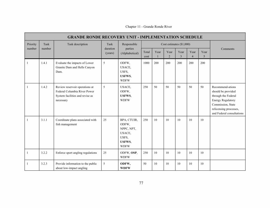
Chapter 11 - Grande Ronde River
GRANDE RONDE RECOVERY UNIT - IMPLEMENTATION SCHEDULE
Prioritynumber
Tasknumber
Task description Taskduration(years)
Responsibleparties
(Alphabetical)
Cost estimates ($1,000)Comments
Totalcost
Year1
Year2
Year3
Year4
Year5
77
1 1.4.1 Evaluate the impacts of LowerGranite Dam and Hells CanyonDam.
5 ODFW,USACE,USFS,USFWS,WDFW
1000 200 200 200 200 200
1 1.4.2 Review reservoir operations atFederal Columbia River PowerSystem facilities and revise asnecessary
5 USACE,ODFW, USFWS,WDFW
250 50 50 50 50 50 Recommend-ationsshould be providedthrough the FederalEnergy RegulatoryCommission, Staterelicensing processes,and Federal consultations
1 3.1.1 Coordinate plans associated withfish management
25 BPA, CTUIR,ODFW,NPPC, NPT,USACE,USFS,USFWS,WDFW
250 10 10 10 10 10
1 3.2.2 Enforce sport angling regulations 25 ODFW, OSP, WDFW
250 10 10 10 10 10
1 3.2.3 Provide information to the publicabout low-impact angling
5 ODFW,WDFW
50 10 10 10 10 10

Chapter 11 - Grande Ronde River
GRANDE RONDE RECOVERY UNIT - IMPLEMENTATION SCHEDULE
Prioritynumber
Tasknumber
Task description Taskduration(years)
Responsibleparties
(Alphabetical)
Cost estimates ($1,000)Comments
Totalcost
Year1
Year2
Year3
Year4
Year5
78
1 4.1.1 Document and monitor geneticbaselines for each local population
3 ODFW,USFWS,WDFW
500 100 200 200
1 4.2.1 Manage local populations(numbers and life forms) tomaintain long-term viability
25 ODFW,WDFW
*
1 5.1.1 Design and implement astandardized, statistically soundbull trout population monitoringprogram
25 BLM, ODFW,USFS, USFWS,WDFW
1950 150 75 75 75 75
1 5.2.1 Conduct further sampling in themainstem Indian Creek to identifylower distribution limits ofspawning and rearing habitat
3 BCC, ODFW,USFS
45 15 15 15
1 5.2.2 Evaluate habitat condition and bulltrout use of the Grande Rondevalley
3 GRMWP,ODFW
140 60 20 20 20 20
1 5.2.5 Determine range of temperaturetolerances for bull trout life stagesin different habitats
5 ODFW,USFS,USFWS,WDFW
75 15 15 15 15 15
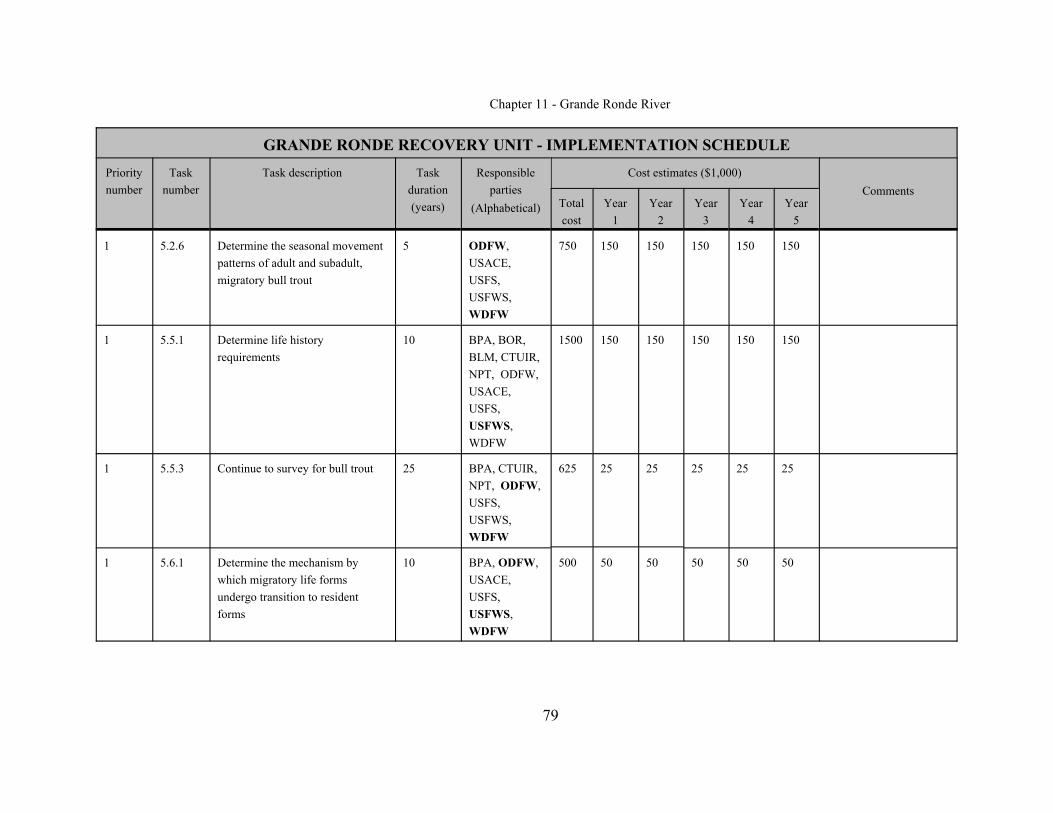
Chapter 11 - Grande Ronde River
GRANDE RONDE RECOVERY UNIT - IMPLEMENTATION SCHEDULE
Prioritynumber
Tasknumber
Task description Taskduration(years)
Responsibleparties
(Alphabetical)
Cost estimates ($1,000)Comments
Totalcost
Year1
Year2
Year3
Year4
Year5
79
1 5.2.6 Determine the seasonal movementpatterns of adult and subadult,migratory bull trout
5 ODFW,USACE, USFS,USFWS,WDFW
750 150 150 150 150 150
1 5.5.1 Determine life historyrequirements
10 BPA, BOR,BLM, CTUIR,NPT, ODFW,USACE, USFS,USFWS,WDFW
1500 150 150 150 150 150
1 5.5.3 Continue to survey for bull trout 25 BPA, CTUIR,NPT, ODFW,USFS,USFWS,WDFW
625 25 25 25 25 25
1 5.6.1 Determine the mechanism bywhich migratory life formsundergo transition to residentforms
10 BPA, ODFW,USACE,USFS, USFWS,WDFW
500 50 50 50 50 50

Chapter 11 - Grande Ronde River
GRANDE RONDE RECOVERY UNIT - IMPLEMENTATION SCHEDULE
Prioritynumber
Tasknumber
Task description Taskduration(years)
Responsibleparties
(Alphabetical)
Cost estimates ($1,000)Comments
Totalcost
Year1
Year2
Year3
Year4
Year5
80
1 5.6.2 Evaluate the relationship betweenlife history forms
10 BPA, ODFW,USACE,USFS, USFWS,WDFW
500 50 50 50 50 50
1 5.6.3 Determine the consequences ofgenetic fragmentation andisolation
10 BPA, ODFW,USACE,USFS, USFWS,WDFW
500 50 50 50 50 50
1 5.6.4 Investigate use of the mainstemSnake River by bull trout from theGrande Ronde River subbasin
5 ODFW,USACE, USFWS,WDFW
750 150 150 150 150 150
1 5.6.5 Evaluate the population structureof bull trout in the recovery unit
3 BPA, ODFW,USFS,USFWS,WDFW
500 100 200 200
1 5.6.7 Evaluate survival rates (by lifestage)
10 BPA, ODFW,USFS,USFWS,WDFW
1000 100 100 100 100 100

Chapter 11 - Grande Ronde River
GRANDE RONDE RECOVERY UNIT - IMPLEMENTATION SCHEDULE
Prioritynumber
Tasknumber
Task description Taskduration(years)
Responsibleparties
(Alphabetical)
Cost estimates ($1,000)Comments
Totalcost
Year1
Year2
Year3
Year4
Year5
81
1 6.1.2 Provide long-term habitatprotection
25 BCC, BLM,BOR, BPA,GRMWP,ODFW,USFS,USFWS,WDFW
500 25 25 25 25 25 This may beaccomplished throughpurchase, conservationeasements, managementplans, and landexchanges
1 6.1.4 Provide educational information tothe public about bull trout habitatneeds
5 GRMWP,ODFW,WDFW
50 10 10 10 10 10
2 1.1.1 Identify and reduce sources ofexcessive fine sediment delivery
3 BCC, BLM,BOR, ODFW,USFS,WDFW
45 15 15 15 Take corrective action ifnecessary andappropriate
2 1.1.2 Assess effects on bull trout fromnonpoint source pollution
5 BCC, BLM,BOR, ODFW,ODOT, USFS,WDFW
75 15 15 15 15 15 Implement the waterquality management planfor the Upper GrandeRonde, Wallowa andLower Grande Rondewatersheds
2 1.2.2 Assess whether tributarydiversions and irrigation ditchesare screened appropriately andremediate where necessary
3 ODFW,USFS,WDFW
45 15 15 15 Take action based onassessment

Chapter 11 - Grande Ronde River
GRANDE RONDE RECOVERY UNIT - IMPLEMENTATION SCHEDULE
Prioritynumber
Tasknumber
Task description Taskduration(years)
Responsibleparties
(Alphabetical)
Cost estimates ($1,000)Comments
Totalcost
Year1
Year2
Year3
Year4
Year5
82
2 1.2.3 Evaluate, and where necessaryreduce, impacts of hatchery weirson bull trout
5 CTUIR, NPT,ODFW,USFWS
125 25 25 25 25 25 If significant impacts arefound they should beaddressed
2 1.3.3 Reduce grazing impacts 10 BLM, BOR,ODFW, USFS,WDFW
200 10 15 20 15 10
2 1.3.5 Protect, maintain, and enhanceanadromous fish habitat toincrease available forage speciesfor bull trout
25 ODFW,USFWS,USFS,WDFW
* Ongoing
2 2.5.1 Assess the interactions betweenbull trout and introduced fishes
5 BPA, ODFW,USFWS,WDFW
125 25 25 25 25 25 If appropriate, designand implement programsto control or extirpatenonnative fishes
2 5.2.3 Assess habitat potential forexpanding local populations
3 BPA, BCC,ODFW,USFS,USFWS,WDFW
450 15 15 15

Chapter 11 - Grande Ronde River
GRANDE RONDE RECOVERY UNIT - IMPLEMENTATION SCHEDULE
Prioritynumber
Tasknumber
Task description Taskduration(years)
Responsibleparties
(Alphabetical)
Cost estimates ($1,000)Comments
Totalcost
Year1
Year2
Year3
Year4
Year5
83
2 5.3.1 Develop and evaluate basinmanagement plans
4 BPA, CTUIR,NPPC, NPT,ODFW,USFS,USFWS,WDFW
100 25 25 25 25
2 5.4.2 Maintain fish health screening andtransplant protocols
25 ODFW,WDFW
*
2 5.5.2 Investigate the relationshipbetween bull trout and anadromousspecies
3 BPA, NMFS,ODFW,USFS,USFWS,WDFW
150 50 50 50
2 5.5.4 Maintain a central database 25 ODFW 250 10 10 10 10 10
2 5.5.5 Compare characteristics of weakand strong populations of bulltrout
10 BPA, ODFW,USACE,USFS,USFWS,WDFW
250 25 25 25 25 25
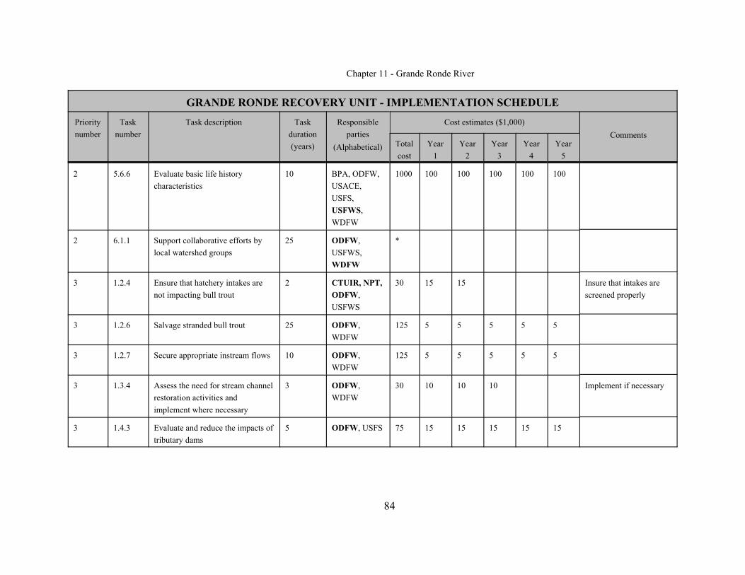
Chapter 11 - Grande Ronde River
GRANDE RONDE RECOVERY UNIT - IMPLEMENTATION SCHEDULE
Prioritynumber
Tasknumber
Task description Taskduration(years)
Responsibleparties
(Alphabetical)
Cost estimates ($1,000)Comments
Totalcost
Year1
Year2
Year3
Year4
Year5
84
2 5.6.6 Evaluate basic life historycharacteristics
10 BPA, ODFW,USACE, USFS,USFWS,WDFW
1000 100 100 100 100 100
2 6.1.1 Support collaborative efforts bylocal watershed groups
25 ODFW,USFWS,WDFW
*
3 1.2.4 Ensure that hatchery intakes arenot impacting bull trout
2 CTUIR, NPT,ODFW,USFWS
30 15 15 Insure that intakes arescreened properly
3 1.2.6 Salvage stranded bull trout 25 ODFW,WDFW
125 5 5 5 5 5
3 1.2.7 Secure appropriate instream flows 10 ODFW,WDFW
125 5 5 5 5 5
3 1.3.4 Assess the need for stream channelrestoration activities andimplement where necessary
3 ODFW,WDFW
30 10 10 10 Implement if necessary
3 1.4.3 Evaluate and reduce the impacts oftributary dams
5 ODFW, USFS 75 15 15 15 15 15

Chapter 11 - Grande Ronde River
GRANDE RONDE RECOVERY UNIT - IMPLEMENTATION SCHEDULE
Prioritynumber
Tasknumber
Task description Taskduration(years)
Responsibleparties
(Alphabetical)
Cost estimates ($1,000)Comments
Totalcost
Year1
Year2
Year3
Year4
Year5
85
3 1.5.1 Assess current risk of catastrophicfire to bull trout populations andreduce where necessary
3 BCC, USFS 45 15 15 15
3 2.2.1 Review efficacy of andcompliance with fish stockingregulations
25 ODFW, OSP,WDFW
*
3 2.6.1 Where necessary, implementmanagement actions to reduce thedistribution/abundance ofnonnative species
28 ODFW,USFWS,USFS,WDFW
*
3 3.1.23.1.2 Coordinate recovery efforts on bulltrout, salmon, and steelhead
25 NMFS,USFWS
*
3 3.2.1 Evaluate the impact of currentsport angling regulations on bulltrout
25 ODFW,WDFW
*
3 4.3.1 Assess the potential forreestablishment of localpopulations in Wenatchee Creekand above the Wallowa Lake Dam
3 BPA, ODFW,USFWS, WDFW
45 15 15 15
3 4.3.2 Reestablish bull trout inWenatchee Creek and above theWallowa Lake Dam if feasible
10 ODFW,WDFW
NA Dependent on 4.3.2.

Chapter 11 - Grande Ronde River
GRANDE RONDE RECOVERY UNIT - IMPLEMENTATION SCHEDULE
Prioritynumber
Tasknumber
Task description Taskduration(years)
Responsibleparties
(Alphabetical)
Cost estimates ($1,000)Comments
Totalcost
Year1
Year2
Year3
Year4
Year5
86
3 5.1.2 Assess habitat restorationtechniques
10 BLM, BOR,BPA,GRMWP,ODFW, USFS,WFDW
250 25 25 25 25 25
3 5.2.4 Conduct watershed assessments 3 ODEQ 225 75 75 75
3 5.2.7 Evaluate food web interactions 4 ODFW 300 100 100 100
3 5.4.1 Research effects of whirlingdisease on bull trout
3 ODFW 150 50 50 50 Monitor for the presenceof whirling disease inimportant areas
3 5.4.3 Provide educational opportunitiesto the public about whirlingdisease
5 ODFW 50 10 10 10 10 10
3 5.4.4 Survey for whirling disease 3 ODFW 90 30 30 30
3 5.4.5 Monitor for effects of fishpathogens on Oregon bull troutpopulations
25 ODFW 125 5 5 5 5 5
3 6.1.3 Work cooperatively withneighboring states andgovernments to implementrecovery actions
25 ALL *

Chapter 11 - Grande Ronde River
GRANDE RONDE RECOVERY UNIT - IMPLEMENTATION SCHEDULE
Prioritynumber
Tasknumber
Task description Taskduration(years)
Responsibleparties
(Alphabetical)
Cost estimates ($1,000)Comments
Totalcost
Year1
Year2
Year3
Year4
Year5
87
3 7.1.1 Develop a participation plan tosupport implementation in therecovery unit
25 USFWS *
3 7.3.1 Periodically assess progress anddetermine needs for changes inrecovery unit plan
25 USFWS *
3 7.3.2 Periodically assess the priority ofactions in the context of how toemphasize actions in core areas
25 USFWS *

Chapter 11 - Grande Ronde River
88
REFERENCES
Allendorf, F.W., and N. Ryman. 2002. The role of genetics in population viabilityanalysis. Pages 50 to 85 In: S.R. Beissinger and D.R. McCullough, eds. Population viability analysis. University of Chicago Press, Chicago, Illinois.
Baldwin, E. 1964. Geology of Oregon. Edwards Brothers, Inc., Ann Arbor, Michigan.
Bartholomew, J. 2001. Fish health risk assessment - Oregon State University 2000progress report. In: Portland General Electric, Pelton Round Butte FisheriesWorkshop, Spring, 2001. Portland General Electric Company. Portland, Oregon.
Baxter, C. 2002. Fish movement and assemblage dynamics in a Pacific Northwestriverscape. Dissertation, Department of Fisheries Science, Oregon StateUniversity, Corvallis, Oregon.
Bellerud, B.L., S.L. Gunckel, A.R. Hemmingsen, D.V. Buchanan, and P.J. Howell. 1997.Bull trout life history, genetics, habitat needs, and limiting factors in central andnortheast Oregon, 1996 Annual Report. Bonneville Power Administration, Portland,Oregon.
Buchanan, D.V., M.L. Hanson, and R.M. Hooton. 1997. Status of Oregon’s Bull Trout.Oregon Department of Fish and Wildlife, Portland, Oregon.
Confederated Tribes of the Umatilla Indian Reservation. 1996. The Comprehensive Plan.Mission, Oregon.
Craig, S.D., and R.C. Wissmar. 1993. Habitat conditions influencing a remnant bulltrout spawning population, Gold Creek, Washington. Draft report, FisheriesResearch Institute, University of Washington, Seattle, Washington.
Crow, J.F. and M. Kimura. 1970. An introduction to population genetics theory. Harperand Row, New York.

Chapter 11 - Grande Ronde River
89
Dunham, J.B., and B.E. Rieman. 1999. Metapopulation structure of bull trout:Influences of physical, biotic, and geometrical landscape characteristics. Ecological Applications 9: 642-655.
Franklin, I.R. 1980. Evolutionary changes in small populations. Pages 135 to 149 In: M.E. Soule and B.A. Wilcox, eds. Conservation Biology: An evolutionary-ecological perspective. Sinauer Associates, Sunderland, Massachusetts.
Gunckel, S. 2001. Feeding behavior and diet of native bull trout Salvelinus confluentusand introduced brook trout S. fontinalis in two eastern Oregon streams. MastersThesis, Department of Fisheries Science, Oregon State University, Corvallis,Oregon.
Hemmingsen, A.R., B.L. Bellerud, D.V. Buchanan, S.L. Gunckel, J.S. Shappart, and P.J.Howell. 2001a. Bull trout life history, genetics, habitat needs, and limitingfactors in central and northeast Oregon, 1997 Annual Report. Bonneville PowerAdministration, Portland, Oregon.
Hemmingsen, A.R., B.L. Bellerud, S.L. Gunckel, and P.J. Howell. 2001b. Bull trout lifehistory, genetics, habitat needs, and limiting factors in central and northeastOregon, 1998 Annual Report. Bonneville Power Administration, Portland,Oregon.
Hemmingsen, A.R., S.L. Gunckel, and P.J. Howell. 2001c. Bull trout life history,genetics, habitat needs, and limiting factors in central and northeast Oregon, 1999Annual Report. Bonneville Power Administration, Portland, Oregon.
Hemmingsen, A.R., S.L. Gunckel, P.M. Sankovich, and P.J. Howell. 2001d. Bull troutlife history, genetics, habitat needs, and limiting factors in central and northeastOregon, 2000 Annual Report. Bonneville Power Administration, Portland,Oregon.
Chapter 11 - Grande Ronde River
90
James, G. 1984. Grande Ronde River basin recommended salmon and steelhead habitatimprovement measures. Confederated Tribes of the Umatilla Indian Reservation,Mission, Oregon.
Kostow, K. 1995. Biennial report on the status of wild fish in Oregon. OregonDepartment of Fish and Wildlife, Portland, Oregon.
Lande, R. 1988. Genetics and demography in biological conservation. Science 241:1455 to 1460.
Lande, R. 2002. Incorporating stochasticity in population viability analysis. Pages 18-40 In: S.R. Beissinger and D.R. McCullough, eds. Population viability analysis. University of Chicago Press, Chicago, Illinois.
McIntosh, B. 1992. Historical changes in anadromous fish habitat in the upper GrandeRonde River, Oregon, 1941 to 1992. Masters Thesis, Oregon State University,Corvallis, Oregon.
Meffe, G.K. and C.R. Carroll. 1994. Principles of conservation biology. SinauerAssociates, Sunderland, Massachusetts.
Montana Bull Trout Scientific Group. 1998. The relationship between land managementactivities and habitat requirements of bull trout. Montana Bull Trout RestorationTeam, Helena, Montana.
National Marine Fisheries Service. 2000. National Oceanic and AtmosphericAdministration, Federal Register notice, 50 CFR Part 223, Endangered andThreatened Species; Salmon and Steelhead; Final Rules, Page 42422.
Northwest Power Planning Council. 2001. Draft Grande Ronde Subbasin Summary. Prepared by M.C. Nowak.
Oregon Department of Fish and Wildlife. 1988. Oregon’s trout plan, a plan for themanagement of Oregon’s trout. Portland, Oregon.

Chapter 11 - Grande Ronde River
91
Oregon Department of Fish and Wildlife. 2001a. Characterize the migratory patterns,population structure, food habits, and abundance of bull trout from subbasins inthe Blue Mountain Province. Blue Mountain Province, Proposal 199405400,Bonneville Power Administration, Portland, Oregon.
Oregon Department of Fish and Wildlife. 2001b. Fishing regulations for the State ofOregon. Portland, Oregon.
Ratliff, D.E. and P.J. Howell. 1992. The status of bull trout populations in Oregon. Pages 10 to 17 In: P.J. Howell and D.V. Buchanan, eds. Proceedings of theGearhart Mountain bull trout workshop. Oregon Chapter of the AmericanFisheries Society, Corvallis, Oregon.
Rieman, B.E., and F.W. Allendorf. 2001. Effective populations size and geneticconservation criteria for bull trout. North American Journal of FisheriesManagement 21: 756-764.
Rieman, B.E., and J.D. McIntyre. 1993. Demographic and habitat requirements forconservation of bull trout. U.S. Forest Service, Intermountain Research Station,General Technical Report INT-302, Ogden, Utah.
Rode, M. 1990. Bull trout, Salvelinus confluentus Suckley, in the McCloud River: status and recovery recommendations. Administrative Report Number 90-15,California Department of Fish and Game, Sacramento, California.
Soule, M.E. 1980. Thresholds for survival: Maintaining fitness and evolutionarypotential. Pages 151-170 In: M.E. Soule and B.A. Wilcox, editors. ConservationBiology: An evolutionary-ecological perspective. Sinauer and Associates,Sunderland, Massachusetts.
Spruell, P. and F. Allendorf. 1997. Nuclear DNA analysis of Oregon bull trout. Finalreport to the Oregon Department of Fish and Wildlife. Division of BiologicalSciences, University of Montana.

Chapter 11 - Grande Ronde River
92
U.S. Army Corps of Engineers. 1997. Walla Walla River Watershed Oregon andWashington Reconnaissance Report. Walla Walla District, Walla Walla,Washington.
U.S. Fish and Wildlife Service. 1998. Klamath River and Columbia River bull troutpopulation segments: status summary. Prepared by the U.S. Fish and WildlifeService’s bull trout listing team. Boise, Idaho.
U.S. Fish and Wildlife Service. 2000. Biological Opinion. Effects to listed species fromOperations of the Federal Columbia River Power System. U.S. Fish and WildlifeService, Region 1 (Portland, Oregon) and Region 6 (Denver, Colorado).
Waples, R.S. 2002. Definition and estimation of effective population size in theconservation of endangered species. Pages 147-168 In: S.R. Beissinger and D.R.McCullough, eds. Population viability analysis. University of Chicago Press,Chicago, Illinois.
Washington Department of Wildlife. 1992. Bull trout/Dolly Varden management andrecovery plan. Washington Department Number 92-22, Fisheries ManagementDivision, Olympia, Washington.
Washington Department of Wildlife. 1998. Washington State salmonid stock inventory,bull trout/Dolly Varden. Olympia, Washington.
Washington Department of Fish and Wildlife. 2001. Fishing regulations for the State ofWashington. Olympia, Washington.
Washington Forest Practices Board. 2000. Washington forest practices: rules – WAC222 (including emergency rules), board manual (watershed manual not included),Forest Practices Act, RCW 76.09. Washington Forest Practices Board, Olympia,Washington.
Wissmar, R.C., J.E. Smith, B.A. McIntosh, H.W. Li., G.H. Reeves, and J.R. Sedell. 1994. A history of resource use and distribution in riverine basins of eastern

Chapter 11 - Grande Ronde River
93
Oregon and Washington (Early 1800's-1900's). Northwest Science Special Issue68:1-34.
In Literature
Oregon Department of Fish and Wildlife. 1993. Northeast Oregon bull trout summary:1993.
Zakel, J. 1995. Fish stock status of the La Grande fish district. Unpublished report.Oregon Department of Fish and Wildlife, La Grande, Oregon.
West, D., and J. Zakel. 1993. Bull Trout Population summaries in the Grande Rondesubbasin. Unpublished report. Oregon Department of Fish and Wildlife, LaGrande, Oregon.
Personal Communications
Groat, D., 2002. U.S. Forest Service, Asotin, Washington.
Harbeck, J., 2002. Nez Perce Tribe, Enterprise, Oregon.
Keefe, M., Montgomery-Watson-Harza, 2002. Portland, Oregon.
Lofy, P., 2002. Bonneville Power Administration, Portland, Oregon.
Mendel, G., 2002. Washington Department of Fish and Wildlife, Asotin, Washington.
McLean, M., 2001. Confederated Tribes of the Umatilla Indian Reservation, La Grande,Oregon.
Sankovich, P., 2002. Oregon Department of Fish and Wildlife, La Grande, Oregon.
Smith, B., 2002. Oregon Department of Fish and Wildlife, Enterprise, Oregon.

Chapter 11 - Grande Ronde River
94
Walters, T., 2002. Oregon Department of Fish and Wildlife, La Grande, Oregon.
Zakel, J., 2002. Oregon Department of Fish and Wildlife, La Grande, Oregon.

Chapter 11 - Grande Ronde River
95
APPENDIX A: List of Chapters
Chapter 1 - IntroductoryChapter 2 - Klamath River Recovery Unit, OregonChapter 3 - Clark Fork River Recovery Unit, Montana, Idaho, and WashingtonChapter 4 - Kootenai River Recovery Unit, Montana and IdahoChapter 5 - Willamette River Recovery Unit, OregonChapter 6 - Hood River Recovery Unit, OregonChapter 7 - Deschutes River Recovery Unit, OregonChapter 8 - Odell Lake Recovery Unit, OregonChapter 9 - John Day River Recovery Unit, OregonChapter 10 - Umatilla-Walla Walla Rivers Recovery Unit, Oregon and WashingtonChapter 11- Grande Ronde River Recovery Unit, OregonChapter 12 - Imnaha-Snake Rivers Recovery Unit, OregonChapter 13 - Hells Canyon Complex Recovery Unit, Oregon and IdahoChapter 14 - Malheur River Recovery Unit, OregonChapter 15 - Coeur d’Alene River Recovery Unit, IdahoChapter 16 - Clearwater River Recovery Unit, IdahoChapter 17 - Salmon River Recovery Unit, IdahoChapter 18 - Southwest Idaho Recovery Unit, IdahoChapter 19 - Little Lost River Recovery Unit, IdahoChapter 20 - Lower Columbia River Recovery Unit, WashingtonChapter 21 - Middle Columbia River Recovery Unit, WashingtonChapter 22 - Upper Columbia River Recovery Unit, WashingtonChapter 23 - Northeast Washington Recovery Unit, WashingtonChapter 24 - Snake River Washington Recovery Unit, WashingtonChapter 25 - Saint Mary - Belly Recovery Unit, Montana