Chapter 06 INTEGRATED TRANSPORT
20
61 DRAFT EASTERN METRO LAND USE FRAMEWORK PLAN CHAPTER 06 INTEGRATED TRANSPORT Plan Melbourne Outcome 3: Melbourne has an integrated transport system that connects people to jobs and services and goods to market. As the Eastern Metro Region grows, this will require better integration of land use and transport planning, better use of existing roads, and increased investment in public transport, walking and cycling. Making better use of transport infrastructure, complemented by good precinct design, can improve connections without necessarily the expense and disruption of delivering new infrastructure. Land use decisions, as well as mode shift opportunities, can significantly improve access and reduce transport-generated emissions.
Transcript of Chapter 06 INTEGRATED TRANSPORT

61 D R A F T E A S T E R N M E T R O L A N D U S E F R A M E W O R K P L A N
Chapter 06 INTEGRATED TRANSPORT
Plan Melbourne Outcome 3: Melbourne has an integrated transport system that connects people to jobs and services and goods to market.
As the Eastern Metro Region grows, this will require better integration of land use and transport planning, better use of existing roads, and increased investment in public transport, walking and cycling. Making better use of transport infrastructure, complemented by good precinct design, can improve connections without necessarily the expense and disruption of delivering new infrastructure. Land use decisions, as well as mode shift opportunities, can significantly improve access and reduce transport-generated emissions.

62D R A F T E A S T E R N M E T R O L A N D U S E F R A M E W O R K P L A N
Photo credit: Tim Bell Studio
The Eastern Metro Region has good transport connections internally and to Melbourne’s CBD by road and rail networks. SRL will deliver significant transport benefits for the Eastern Metro Region improving access within the region and to the other metro regions.
State of playMap 4 outlines the current state of play for transport in the Eastern Metro Region.
Road networkThere are a range of road transport options for accessing jobs within the Eastern Metro Region, in adjacent regions and to Melbourne’s CBD. The region’s main north-south connection is EastLink which extends through the region connecting Ringwood to the Southern Metro Region. Other key north-south connections are Warrigal Road, Blackburn Road, Springvale Road and Stud Road.
There is a strong network of east-west connections across the region particularly in the western part of the region creating a ‘grid’ of arterial roads with the north-south routes. Major east-west road networks include Monash Freeway, Princes Highway, Maroondah Highway, Burwood Highway and the Eastern Freeway. The Maroondah and Warburton highways continue into the region’s rural east.
Congestion is increasing particularly during peak hours. By 2031, traffic volumes in the western part of the region are expected to increase by 22 per cent, while increases of about 19 per cent are expected in the outer eastern part of the region. Most arterial roads will be at or approaching capacity by 2031 (KPMG & ARUP, 2017).
Key road freight routes are the Eastern and Monash freeways linking to the Southern Industrial Precinct (SSIP) at Dandenong South, the Port of Hastings and west to Melbourne’s CBD. Construction of North East Link will better link the region to Melbourne Airport and the Northern Metro Region. There is no rail freight network in the region other than the Gippsland rail line.

DandenongNEIC
La TrobeNEIC
ParkvilleNEIC
FishermansBend NEIC
Refer toInner Metro
Region Maps
Refer toInner SouthEast Metro
Region Maps
Refer toNorthern MetroRegion Maps
Refer toSouthern Metro
Region Maps
Refer toWestern MetroRegion Maps
MonashNEIC
Clayton Rowville-StudPark
Brandon Park
Oakleigh
Mountain GateGlen Waverley
MountWaverley
WantirnaSouth-KnoxCentral
BoroniaBurwoodEast-Tally Ho
BurwoodHeights
Bayswater
Forest Hill ChaseNunawading
Croydon
DoncasterHill
DoncasterEast-ThePines
LilydaleChirnsidePark
Box Hill
Ringwood
Belgrave
Monbulk
HealesvilleYarra Glen
LaunchingPlace
EASTERN FREEWAY
EASTLINK
MONASH F REEWAY
N0 5 10
Kilometres
Precincts and Activity Centres
National employment & innovation cluster (NEIC)^
Metropolitan activity centre
Major activity centre
Regionally-significant industrial precinct - existing
Transport
State-significant road corridor
Road network
Train station
Rail network
Regional rail network
Tram network
Bus network
High frequency bus network
Strategic Cycling Corridor
Principal Freight Network
PFN road
PFN rail
Transport projects - committed
!ª( Level crossing removal site
Land use/Administration
Regional boundary
Green wedge land
Urban area
Urban growth boundary
Eastern
Location Map
^NEIC boundary is indicative only and subject to detailed planning.
Note: The Principal Freight Network reflects the version published in 2013 (Victoria the Freight State - the Victorian Freight and Logistics Plan, August 2013) in addition to Mordialloc Highway and West Gate Tunnel. East West Link has been removed. The Department of Transport is currently undertaking a review of the Principal Freight Network.
M A P 4 . eastern Metro region integrated transport state of play

DandenongNEIC
La TrobeNEIC
ParkvilleNEIC
FishermansBend NEIC
Refer toInner Metro
Region Maps
Refer toInner SouthEast Metro
Region Maps
Refer toNorthern MetroRegion Maps
Refer toSouthern Metro
Region Maps
Refer toWestern MetroRegion Maps
MonashNEIC
Clayton Rowville-StudPark
Brandon Park
Oakleigh
Mountain GateGlen Waverley
MountWaverley
WantirnaSouth-KnoxCentral
BoroniaBurwoodEast-Tally Ho
BurwoodHeights
Bayswater
Forest Hill ChaseNunawading
Croydon
DoncasterHill
DoncasterEast-ThePines
LilydaleChirnsidePark
Box Hill
Ringwood
Belgrave
Monbulk
HealesvilleYarra Glen
LaunchingPlace
EASTERN FREEWAY
EASTLINK
MONASH F REEWAY
N0 5 10
Kilometres
Precincts and Activity Centres
National employment & innovation cluster (NEIC)^
Metropolitan activity centre
Major activity centre
Regionally-significant industrial precinct - existing
Transport
State-significant road corridor
Road network
Train station
Rail network
Regional rail network
Tram network
Bus network
High frequency bus network
Strategic Cycling Corridor
Principal Freight Network
PFN road
PFN rail
Transport projects - committed
!ª( Level crossing removal site
Land use/Administration
Regional boundary
Green wedge land
Urban area
Urban growth boundary
Eastern
Location Map
^NEIC boundary is indicative only and subject to detailed planning.
Note: The Principal Freight Network reflects the version published in 2013 (Victoria the Freight State - the Victorian Freight and Logistics Plan, August 2013) in addition to Mordialloc Highway and West Gate Tunnel. East West Link has been removed. The Department of Transport is currently undertaking a review of the Principal Freight Network.

Refer toInner MetroRegion Maps
Refer toNorthern MetroRegion Maps
Refer toSouthern Metro
Region Maps
Refer toWestern MetroRegion Maps
Refer toInner South East Region
Maps
Clayton Rowville-StudPark
Brandon ParkOakleigh
Mountain GateGlen Waverley
MountWaverley
WantirnaSouth-KnoxCentral
Boronia
BurwoodEast-Tally Ho
BurwoodHeights
Bayswater
ForestHill Chase
Nunawading
Croydon
DoncasterHill
DoncasterEast-ThePines
LilydaleChirnsidePark
Box HillRingwood
N0 5 10
Kilometres
Public transport accessibility(train, tram and bus services)
Eastern
Location Map
F i gu R E 13 . public transport accessibility in the eastern Metro region

Refer toInner MetroRegion Maps
Refer toNorthern MetroRegion Maps
Refer toSouthern Metro
Region Maps
Refer toWestern MetroRegion Maps
Refer toInner South East Region
Maps
Clayton Rowville-StudPark
Brandon ParkOakleigh
Mountain GateGlen Waverley
MountWaverley
WantirnaSouth-KnoxCentral
Boronia
BurwoodEast-Tally Ho
BurwoodHeights
Bayswater
ForestHill Chase
Nunawading
Croydon
DoncasterHill
DoncasterEast-ThePines
LilydaleChirnsidePark
Box HillRingwood
N0 5 10
Kilometres
Public transport accessibility(train, tram and bus services)
Eastern
Location Map

67 D R A F T E A S T E R N M E T R O L A N D U S E F R A M E W O R K P L A N
CHAPTER 06
Public transport networkThe Eastern Metro Region has an established public transport network, especially in the western part of the region. Figure 13 shows the accessibility to public transport for people who live within the region based on how far they need to walk to access train, tram and bus services. Inner parts of the Eastern Metro Region are well connected to Melbourne’s CBD by train, bus and tram with multiple services each hour.
The region’s rail network includes three metro passenger services to Lilydale/Belgrave, Glen Waverley and a small section of the Cranbourne/Pakenham/Gippsland rail corridor. The outer sections of the Lilydale and Belgrave lines are single track with limited capacity. Inter-regional connectivity is limited although SmartBus routes fill this gap in some locations. The tram network extends to Box Hill, Wattle Park and Vermont South.
The region has an extensive bus network particularly in the western LGAs and western areas of Yarra Ranges LGA. Complementing the rail network is the SmartBus service that uses a well-spaced network of arterial roads, especially to the west of Dandenong Creek. All nine orbital SmartBus routes service the region providing north-south and east-west connections. Manningham LGA has the highest average number of bus services per hour, per stop for the region. Whitehorse LGA also has a high average compared to other LGAs in the region indicating the bus network fills gaps left by other forms of public transport. All activity centres and most education precincts contain multi-modal transport interchanges. The Eastern Freeway includes the Doncaster Park and Ride bus interchange.
Active transport networkThe Eastern Metro Region’s cycling network is well developed especially in the western, more populated part of the region including Strategic Cycling Corridors from Melbourne’s CBD to Scoresby, Box Hill to Ashburton and Chirnside Park to Mordialloc. However, further improvements are needed to make cycling a more attractive form of transport. Currently 0.5 per cent of weekday trips undertaken by residents in the region are by bicycle, compared to 1 per cent for metropolitan Melbourne. Two per cent of people walked to work in 2016, compared to 3 per cent for metropolitan Melbourne.
Regional access and movementFigure 14 shows journeys to and from the Eastern Metro Region for work. In 2016, 57 per cent of Eastern Metro Region residents also worked in the region. The most popular work destination after the region itself is the Inner Metro Region. Popular LGA work destinations within the region include Monash and Whitehorse LGAs. A significant amount of people from the Southern Metro Region travel to the Eastern Metro Region for work, in particular from the Casey, Greater Dandenong and Kingston LGAs. There is less but still substantial movement into the region from the Inner South East Region and the Northern Metro Region. There was little connection with the Western Metro Region for the purpose of travelling to work.

68D R A F T E A S T E R N M E T R O L A N D U S E F R A M E W O R K P L A N
inTEgRATEd TRAnsPORT
F i gu R E 14 . Journey to work in and out of the eastern Metro region
LIVE AND WORK IN EASTERN METRO
REGION
221,932 (57%)
169,034JOURNEYS FROM THE EASTERN METRO REGION FOR WORK TO OTHER METRO REGIONS
122,530JOURNEYS TO THE EASTERN METRO REGION FOR WORK FROM OTHER METRO REGIONS
WESTERN
SO
UT
HE
RN
59,937 (49%)
7,242(6%)
77,122(20%)
8,267(7%)
INNER METRO
34,955(9%)
26,182(21%)
INNER SOUTH EAST
5,474(1%)
20,902(17%)
Source: Australian Bureau of Statistics (2016) Census of Population and Housing, Commonwealth of Australia, Canberra, Australia.
36,217(9%)
NORTHERN15,266 (4%)
69 D R A F T E A S T E R N M E T R O L A N D U S E F R A M E W O R K P L A N
CHAPTER 06
Regional strengths• There is a strong freeway network linking the
region to the Southern Industrial Precinct at Dandenong South (SSIP), the Port of Hastings and Melbourne’s CBD.
• The region benefits from the foundations of a strong existing bus network, multi-modal transport interchanges at train stations and the Doncaster Park and Ride bus interchange.
• A strong network of east-west road connections, particularly in the western part of the region, creates a ‘grid’ of arterial roads with the north-south routes.
• Access improvements for walking, cycling and public transport will result from the development of SRL stations and supplement the existing transport network.
Regional challenges • There is limited opportunity to augment, expand
or extend existing major roads which are already subject to high vehicle use.
• High private vehicle use is resulting in increasing congestion in the region.
• There is a need to connect Monash NEIC more effectively into the broader transport network in the region.
• The region’s west has poor north-south connectivity, particularly between the key destinations of Doncaster Hill, Ringwood, Box Hill and Monash NEIC.
• Poor east-west connections in the eastern part of the region impacts upon access to health, education and employment areas.
• Cycling for commuting is lower than the Melbourne average, with take-up higher in the western part of the region compared to the east.
• There are more public transport options for residents in the western part of the region compared to the east.
Directions and strategiesThe directions identified to achieve the 2050 vision for the Eastern Metro Region in terms of Integrated transport and Outcome 3 of Plan Melbourne are:
Direction 11 Improve transport connections to support the productivity of the Eastern Metro Region
Direction 12 Improve public and active transport access to Monash NEIC, metropolitan and major activity centres and Suburban Rail Loop precincts
Direction 13 Improve regional cycling networks to increase the attractiveness of cycling in the region
Direction 14 Improve active and public transport options to promote mode shift and support 20-minute neighbourhoods
Direction 15 Allow more flexible use of the existing road network
Each direction is implemented through regionally-specific strategies identified in this LUFP.
Map 5 shows how integrated transport will be enhanced across the Eastern Metro Region by 2050 as a result of these directions and strategies, together with Plan Melbourne and other strategies and initiatives as outlined in appendix 01.

70D R A F T E A S T E R N M E T R O L A N D U S E F R A M E W O R K P L A N
inTEgRATEd TRAnsPORT
Photo credit: Tim Bell Studio

!
!
!!
!
(
ParkvilleNEIC
FishermansBend NEIC
DandenongNEIC
La Trobe NEIC
Refer toInner Metro
Region Maps
Refer toNorthern MetroRegion Maps
Refer toSouthern Metro
Region Maps
Refer toWestern MetroRegion Maps
MonashNEIC
Wantirna South-Knox Central
Bayswater
Boronia
Rowville-Stud Park
Doncaster East-The Pines
Doncaster Hill
Oakleigh
MountWaverley
Brandon Park
Clayton
GlenWaverley
Forest Hill Chase
BurwoodEast-Tally Ho
Nunawading
Croydon
Lilydale
Mountain Gate
Burwood Heights
ChirnsidePark
Box HillRingwood
Belgrave
Monbulk
HealesvilleYarra Glen
LaunchingPlace
EASTERN FREEWAY
EASTLINK
MONASH FREEWAY
N0 5 10
Kilometres
^NEIC boundary is indicative only and subject to detailed planning. *These layers are based on the state- and regionally-significant commercial land identified in MICLUP, 2019. The activity centre boundaries identified in local council planning schemes may differ.**Caulfield to Rowville Link Concept route subject to design and planning work to examine alignments
Note: The Principal Freight Network reflects the version published in 2013 (Victoria the Freight State - the Victorian Freight and Logistics Plan, August 2013) in addition to Mordialloc Highway and West Gate Tunnel. East West Link has been removed. The Department of Transport is currently undertaking a review of the Principal Freight Network.
Precincts and Activity Centres
National employment & innovationcluster (NEIC)^
Activity corridor
State-significant commercial land*
Regionally-significant commercialland*
Regionally-significant industrialprecinct - existing
Transport
State-significant road corridor
Road network
Train station
Rail network
Regional rail network
Strategic Cycling Corridor
Principal Public Transport Network
PPTN station
PPTN interchange
Bus
Tram
Principal Freight Network
PFN road
PFN rail
Suburban Rail Loop
SRL East (Cheltenham to Box Hill)
SRL North (Box Hill to Airport)
( SRL - interchange station
!( SRL - station
Transport projects - committed
North East Link
Road Project - Monash freewaycapacity upgrades
Transport projects - potential
Proposed Caulfield to Rowville Link**
Land use/Administration
Regional boundary
Green wedge land
Urban area
Urban growth boundary
Eastern
Location Map
M A P 5 . eastern Metro region integrated transport 2050

!
!
!!
!
(
ParkvilleNEIC
FishermansBend NEIC
DandenongNEIC
La Trobe NEIC
Refer toInner Metro
Region Maps
Refer toNorthern MetroRegion Maps
Refer toSouthern Metro
Region Maps
Refer toWestern MetroRegion Maps
MonashNEIC
Wantirna South-Knox Central
Bayswater
Boronia
Rowville-Stud Park
Doncaster East-The Pines
Doncaster Hill
Oakleigh
MountWaverley
Brandon Park
Clayton
GlenWaverley
Forest Hill Chase
BurwoodEast-Tally Ho
Nunawading
Croydon
Lilydale
Mountain Gate
Burwood Heights
ChirnsidePark
Box HillRingwood
Belgrave
Monbulk
HealesvilleYarra Glen
LaunchingPlace
EASTERN FREEWAY
EASTLINK
MONASH FREEWAY
N0 5 10
Kilometres
^NEIC boundary is indicative only and subject to detailed planning. *These layers are based on the state- and regionally-significant commercial land identified in MICLUP, 2019. The activity centre boundaries identified in local council planning schemes may differ.**Caulfield to Rowville Link Concept route subject to design and planning work to examine alignments
Note: The Principal Freight Network reflects the version published in 2013 (Victoria the Freight State - the Victorian Freight and Logistics Plan, August 2013) in addition to Mordialloc Highway and West Gate Tunnel. East West Link has been removed. The Department of Transport is currently undertaking a review of the Principal Freight Network.
Precincts and Activity Centres
National employment & innovationcluster (NEIC)^
Activity corridor
State-significant commercial land*
Regionally-significant commercialland*
Regionally-significant industrialprecinct - existing
Transport
State-significant road corridor
Road network
Train station
Rail network
Regional rail network
Strategic Cycling Corridor
Principal Public Transport Network
PPTN station
PPTN interchange
Bus
Tram
Principal Freight Network
PFN road
PFN rail
Suburban Rail Loop
SRL East (Cheltenham to Box Hill)
SRL North (Box Hill to Airport)
( SRL - interchange station
!( SRL - station
Transport projects - committed
North East Link
Road Project - Monash freewaycapacity upgrades
Transport projects - potential
Proposed Caulfield to Rowville Link**
Land use/Administration
Regional boundary
Green wedge land
Urban area
Urban growth boundary
Eastern
Location Map

73 D R A F T E A S T E R N M E T R O L A N D U S E F R A M E W O R K P L A N
CHAPTER 06
DIREcTION 11. improve transport connections to support the productivity of the Eastern Metro RegionSustainable population and economic growth in the Eastern Metro Region relies on improving public transport access to and between job-rich locations such as the Monash NEIC, metropolitan and major activity centres, regionally-significant industrial precincts and health and/or education precincts. This will support an expanded network of economic activity in the east which is less reliant on the car and provide more reliable, frequent public transport services to encourage mode shift and reduce road congestion.
Linking the Monash NEIC more effectively to the broader transport network will be critical to the region’s economy into the future. A number of projects are planned to better integrate and improve access to Monash NEIC including the proposed Caulfield to Rowville Link and SRL.
SRL will deliver five new train stations in the region which will intersect with the radial rail lines from Melbourne’s CBD. Linking major destinations, SRL will change the way people travel to and move around the Eastern Metro Region.
A potential road project of regional significance is the Westall Road extension. This would provide an extension of Westall Road between Dandenong Road and the Monash Freeway. This project would provide improved north-south connectivity through the Monash NEIC and between the Monash NEIC and regionally-significant employment areas in Moorabbin and Braeside.
As the region grows, resulting land use changes will alter the destinations and distances people travel, enabling more people to access jobs and education by public transport. The integration of SRL stations with surrounding land uses and public and active transport will also make sustainable modes of transport more attractive to residents and visitors to SRL destinations.
Knox and Yarra Ranges LGAs will require improved transport access to health, education and employment locations in the western part of the region. There are opportunities to better connect this area through enhancements to the public transport network and improved open space links through the Dandenong Valley Parklands. This will improve transport options for Knox residents, reduce the physical barrier of EastLink and better integrate the Bayswater Industrial Precinct to the north.
The capacity and frequency of the regional bus network needs to be enhanced to improve integration with train and tram services. This will also increase public transport options to key locations in the short to medium term until longer-term transport projects are delivered such as North East Link and SRL.
As part of the North East Link Project, a dedicated busway will provide separated lanes for buses along the Eastern Freeway from an upgraded Doncaster Park and Ride to the city.
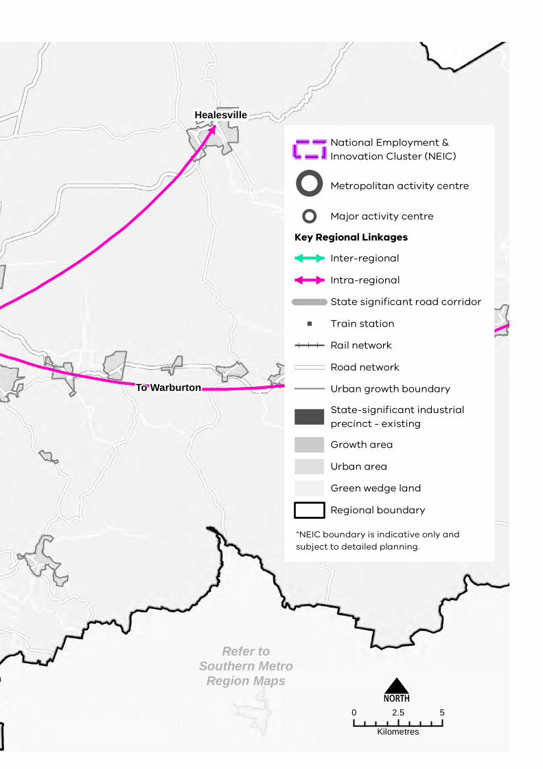
The key regional linkages are shown in Figure 15. Decisions regarding appropriate modes for these links should consider the capacity of existing infrastructure, ongoing sustainability and providing travel choices over a longer time period including evening and late-night travel.
Regionally-significant industrial precincts generate significant freight movement. These vehicles will continue to require fast, efficient and safe movement on arterial roads with direct connections to the freeway network. North East Link will better connect the region to major freight origins and destinations in Melbourne’s Northern and Western metro regions, to sea and air-based transport gateways and to interstate markets.
Metropolitan freight volumes are expected to grow at an average annual rate of 2.6 per cent each year between 2014 and 2051. This flow-on effect of population growth and higher levels of ecommerce will increase the potential for conflicting land use, requiring state and local government to work together to plan for more efficient use of the existing network, with technology and adapting operations likely a key component of this.
This requires ongoing assessment of how the planning scheme influences urban freight outcomes, with the need to manage the economic, community and environmental impacts of freight movements while supporting effective and efficient delivery of goods.

74D R A F T E A S T E R N M E T R O L A N D U S E F R A M E W O R K P L A N
inTEgRATEd TRAnsPORT
Photo credit: Tim Bell Studio
STRATEGY 33. Improve public and active transport access to job-rich areas such as Monash NeIC, Box hill and ringwood metropolitan activity centres and along activity corridors which link major activity centres along Maroondah highway, Burwood highway and princes highway/Wellington road.
STRATEGY 34. Improve public and active transport to Bayswater, Boronia, Brandon park, Croydon, Doncaster east (the pines), Doncaster hill, Forest hill Chase, Glen Waverley, Lilydale, Mount Waverley, Mountain Gate, Oakleigh, rowville (Stud park), and Wantirna South (Knox Central).
STRATEGY 35. Improve north-south public and active transport connections especially between Box hill and ringwood metropolitan activity centres and Doncaster hill Major activity Centre in the north, and Monash NeIC in the south.
STRATEGY 36. provide east-west public and active transport connections especially between Knox LGa to Burwood, Glen Waverley and Clayton.
STRATEGY 37. provide access to regionally-significant industrial precincts and health and/or education precincts by public transport, walking and cycling and better integrate these precincts into an expanded network of economic activity in the eastern Metro region.

MonashNEIC
Refer toNorthern MetroRegion Maps
Refer toSouthern Metro
Region Maps
Clayton Rowville-StudPark
Brandon ParkOakleigh
Mountain GateGlen Waverley
MountWaverley
WantirnaSouth-KnoxCentral
Boronia
BurwoodEast-Tally Ho
BurwoodHeights
Bayswater
ForestHill Chase
Nunawading
Croydon
DoncasterHill
DoncasterEast-ThePines
LilydaleChirnsidePark
Box HillRingwood
N0 2.5 5
Kilometres
National Employment &Innovation Cluster (NEIC)
Metropolitan activity centre
Major activity centre
Key Regional Linkages
Inter-regional
Intra-regional
State significant road corridor
Train station
Rail network
Road network
Urban growth boundary
State-significant industrialprecinct - existing
Growth area
Urban area
Green wedge land
Regional boundary
NorthEastLink
Eltham
Healesville
To Warburton
To Dandenong NEIC
ToCaufield
To La TrobeNEIC
^NEIC boundary is indicative only andsubject to detailed planning.
F i gu R E 1 5 . Key regional linkages – eastern Metro region
MonashNEIC
Refer toNorthern MetroRegion Maps
Refer toSouthern Metro
Region Maps
Clayton Rowville-StudPark
Brandon ParkOakleigh
Mountain GateGlen Waverley
MountWaverley
WantirnaSouth-KnoxCentral
Boronia
BurwoodEast-Tally Ho
BurwoodHeights
Bayswater
ForestHill Chase
Nunawading
Croydon
DoncasterHill
DoncasterEast-ThePines
LilydaleChirnsidePark
Box HillRingwood
N0 2.5 5
Kilometres
National Employment &Innovation Cluster (NEIC)
Metropolitan activity centre
Major activity centre
Key Regional Linkages
Inter-regional
Intra-regional
State significant road corridor
Train station
Rail network
Road network
Urban growth boundary
State-significant industrialprecinct - existing
Growth area
Urban area
Green wedge land
Regional boundary
NorthEastLink
Eltham
Healesville
To Warburton
To Dandenong NEIC
ToCaufield
To La TrobeNEIC
^NEIC boundary is indicative only andsubject to detailed planning.

77 D R A F T E A S T E R N M E T R O L A N D U S E F R A M E W O R K P L A N
CHAPTER 06
DIREcTION 12. improve public and active transport access to Monash nEiC, metropolitan and major activity centres and suburban Rail Loop precinctsIncreasing the proportion of people using public transport, walking and cycling means making these alternatives easier, more convenient and cheaper than car travel. Continued improvement of public and active transport infrastructure and services and new and improved infrastructure for cycling and walking is vital, in particular to job-rich locations such as Box Hill and Ringwood metropolitan activity centres and major activity centres in the region.
Plan Melbourne seeks to embed an approach to 20-minute neighbourhoods in major infrastructure projects, including SRL and level crossing removal projects. This ensures communities affected by new transport infrastructure benefit from investment and growth via placed-based planning of local services. These opportunities need to be carefully considered as part of the planning and delivery of SRL precincts at Clayton and Monash (in the Monash NEIC), Glen Waverley, Burwood and Box Hill.
The location and design of SRL precincts will link in closely with other public transport and active transport routes and existing and proposed land uses.
STRATEGY 38. Improve public and active transport in the Monash NeIC, activity centres and health and education precincts to support higher-density mixed-use walkable precincts.
STRATEGY 39. ensure the planning and design of Suburban rail Loop precincts maximises opportunities for public and active transport connections and links between key destinations and surrounding activity centres.
STRATEGY 40. Improve bus service connectivity prior to the delivery of the Suburban rail Loop.
DIREcTION 13. improve regional cycling networks to increase the attractiveness of cycling in the regionAs the metropolitan activity centres of Box Hill and Ringwood change to a more compact urban form and the Monash NEIC is further developed, these areas will require active transport networks that logically connect with public transport nodes. In established higher-density locations, networks should better connect to existing cycling and walking infrastructure to fill transport gaps.
A more cohesive network of active transport connections will be developed, including paths and trails, and along waterways and prioritising Strategic Cycling Corridors where they connect centres as part of the Principal Bicycle Network. Priority active transport projects will promote additional safe use of the region’s cycling and walking network.
Figure 16 shows the Strategic Cycling Corridor network for the Eastern Metro Region.
Primary routes provide a core network of Strategic Cycling Corridors that connect places of state significance – the Central City, metropolitan activity centres and National Employment and Innovation Centres (NEICs) within metropolitan Melbourne. Main routes are Strategic Cycling Corridors that provide additional connections to state significant destinations, as well as connections to major activity centres and key train stations within metropolitan Melbourne.
STRATEGY 41. Support cycling for transport through the development of Strategic Cycling Corridors in the eastern Metro region.

78D R A F T E A S T E R N M E T R O L A N D U S E F R A M E W O R K P L A N
inTEgRATEd TRAnsPORT
DIREcTION 14. improve active and public transport options to promote mode shift and support 20-minute neighbourhoodsAccess to public transport varies significantly across the region. Improvements to local bus, cycling and pedestrian access is needed to address gaps and support the delivery of 20-minute neighbourhoods across the Eastern Metro Region.
Thirty-six per cent of people in the region used a car when making a short trip under 5 kilometres in the region. Whereas 23 per cent of people walked, and only 1 per cent of people cycled for short trips (DELWP, 2021b). To reduce dependence on private vehicles, public transport, cycling and walking need to be more accessible. This means significant upgrades to public transport access, and improvements to pedestrian and cycling accessibility, better linking neighbourhoods to employment, and social and community services.
Priority locations for improving cycling links and pedestrian access are neighbourhoods around existing activity centres and along activity corridors.
Until SRL is completed, there are many transit-oriented development opportunities around the existing transport system and activity centre network that could accommodate growth and improve amenity of key locations.
Continued, innovative development of the bus network is a priority for the region to cater for communities with limited access to public transport.
STRATEGY 42. Create pedestrian-friendly neighbourhoods by enhancing major pedestrian links and expanding the network.
STRATEGY 43. Create a network of cycling links for local trips.
STRATEGY 44. provide walking and cycling routes and drop-off zones to health and community services and recreation facilities.
DIREcTION 15. Allow more flexible use of the existing road networkTo accommodate future travel needs and support the shift to active and sustainable modes of transport, flexible use of the existing road network will be required.
In doing so, a regional approach to the DoT’s Movement and Place Framework should be considered. This balances the needs of both transport users and place users, and designs a mix of transport modes that are appropriate to how roads and places are used by communities.
Opportunities to increase the capacity of the existing road network within this region are limited although some gains can be made through better use of existing roads for public and active transport. These alternatives need to be easier, more convenient and cheaper than car travel to increase the proportion of people using public transport, walking or cycling.
Making better use of the existing road infrastructure will be particularly important in high change locations and around key employment destinations. The potential for SRL to drive greater levels of employment and housing growth must be matched by more effective multi-modal streets and connections in key locations.
STRATEGY 45. Improve existing road infrastructure to provide for public transport, walking and cycling.
STRATEGY 46. Balance movement and place when designing and upgrading the region’s road network.
AcTI O NS – Integrated transport
AcTION 7. Undertake a review of the regional bus network including improvements to the SmartBus routes, Doncaster and Regional Transport (DART) and improved access to Deakin University to support regional access and movement in the short- to medium-terms and to plan integration with major public transport changes such as the SRL.

Fishermans NEIC
Parkville NEIC
Refer toInner Metro
Region Maps
Refer toInnerSouthEast Metro
Region Maps
Refer toNorthern MetroRegion Maps
Refer toSouthern Metro
Region Maps
Refer toWestern MetroRegion Maps
MonashNEIC
La TrobeNEIC
ParkvilleNEIC
FishermansBend NEIC
DandenongNEIC
Eastern Freeway
Eastlink
Monash Freeway
Clayton Rowville-StudPark
Brandon ParkOakleigh
Mountain GateGlen Waverley
MountWaverley
WantirnaSouth-KnoxCentral
BoroniaBurwoodEast-Tally Ho
BurwoodHeights
Bayswater
ForestHill Chase
Nunawading
Croydon
DoncasterHill
DoncasterEast-The
Pines Lilydale
ChirnsidePark
Box HillRingwood
N0 5 10
Kilometres
National Employment & InnovationCluster (NEIC)^
Metropolitan activity centre
Major activity centre
State significant road corridor
Road network
Train station
Rail network
Regional boundary
Green wedge land
Urban area
Urban growth boundary
Waterbody
Strategic Cycling Corridor
Primary route (C1)
Main route (C2)
Eastern
Location Map
^NEIC boundary is indicative only and subject to detailed planning.
F i gu R E 16 . Strategic Cycling Corridor network – eastern Metro region

Fishermans NEIC
Parkville NEIC
Refer toInner Metro
Region Maps
Refer toInnerSouthEast Metro
Region Maps
Refer toNorthern MetroRegion Maps
Refer toSouthern Metro
Region Maps
Refer toWestern MetroRegion Maps
MonashNEIC
La TrobeNEIC
ParkvilleNEIC
FishermansBend NEIC
DandenongNEIC
Eastern Freeway
Eastlink
Monash FreewayClayton Rowville-Stud
Park
Brandon ParkOakleigh
Mountain GateGlen Waverley
MountWaverley
WantirnaSouth-KnoxCentral
BoroniaBurwoodEast-Tally Ho
BurwoodHeights
Bayswater
ForestHill Chase
Nunawading
Croydon
DoncasterHill
DoncasterEast-The
Pines Lilydale
ChirnsidePark
Box HillRingwood
N0 5 10
Kilometres
National Employment & InnovationCluster (NEIC)^
Metropolitan activity centre
Major activity centre
State significant road corridor
Road network
Train station
Rail network
Regional boundary
Green wedge land
Urban area
Urban growth boundary
Waterbody
Strategic Cycling Corridor
Primary route (C1)
Main route (C2)
Eastern
Location Map
^NEIC boundary is indicative only and subject to detailed planning.