Chao Phraya River - Bureau of Meteorology · Main geological features: Phu Kradung and Phra Wihan...
16
203 Thailand ― 10 Chao Phraya River Map of River
Transcript of Chao Phraya River - Bureau of Meteorology · Main geological features: Phu Kradung and Phra Wihan...
203
Thailand―10
Chao Phraya River
Map of River

204
Thailand―10
Table of Basic Data
Serial No. : Thailand-10
Area: 21,725 km2
E 99° 31' 06" ~ 101° 01' 30"
Main geological features: Phu Kradung and Phra Wihan Formation, Rattburi Formation, Alluvium, Eluvium,Kanchanaburi Formation, Marine Formation, Andesite-Rhyorite, Porphyry and Tuff,Bassalt
Main Tributaries: Main Chao Phraya river (21,725 km2), Bung Boraphet (4,902 km2)
Main Lake: None
N 13° 29' 18" ~ 16° 02' 54"
Name: Chao Praya river
Length of Main stream: 712 km
Location: Central part of Thailand
Origin: Pak Nam Pho District, Nakhon SawanProvince
Highest point: 284 m
Population: 11,710,968 (1998) Main Cities: Bangkok, Nakhon Phathom, Ayutthaya, Samut Prakan, Ang Thong, Singburi, Lopburi, Chai Nat,Pathum Thani, Non Thaburi, Nakhon Sawan, Phet Chaboon, Samut Sakhon
Outlet: Gulf of Thailand Lowest point: 0 m
Main Reservoir: Chao Phraya Dam (1957)
Mean annual Precipitation: 1,487.3 mm.
Mean Annual Runoff: 117.0 m3/s at Sang Khla Buri District, Chainat Province
Land use: Forest 2.1 %, Agriculture & urban area 92.7 %, Water resource 5.2 %
1. General Description
The origin of the Chao Phraya River is the confluence of the Ping, Wang, Yom and Nan rivers about200 km north of Bangkok. From Nakhon Sawan, the river flows through the central plain passingBangkok toward the Gulf of Thailand. At Ayutthaya about 55 km North of Bangkok, the Chao Phrayariver is joined by the Pasak river which rises in the divide between the central alluvial plain and theNorth-east plateau. The Lower Chao Phraya river basin starts from Nakhon Sawan and has a drainagearea of 21,725 km2 the average annual precipitation is 1,487.3 mm and the average discharge at SangKhla Buri District, Chainat Province has been 117.0 m3/s. Chao Phraya reservoir built in 1957 is thelargest existing reservoir in this basin.

205
Thailand―10
2. Geographical Information
2.1 Geological Map
Source: Geological Map of Thailand: Jumchet C. and Javanaphet, 1969, Department of Mineral Resource

206
Thailand―10
Source: Landuse Map of Central of Thailand, 1998Landuse Planning DivisionDepartment of Land Development
2.2 Land-use Map

207
Thailand―10
Source: General Soil Map of Thiland, 1972.Soil Survey Division, Department of Land Development.
2.3 Soil Map

208
Thailand―10
2.4 Characteristic of River and Main Tributaries
No.
1
Name of River
Chao Phraya(Main River)
Length (km)Catchmentarea (km2)
37421,725
Highest Peak (m)
-
Cities
Bangkok, Samut Sakhon, Nakhon Phathom, Samut Prakan, , Ang Thong,Singburi, Lopburi, ChaiNat, Pathum Thani, Non Thaburi, NakhonSawan,
2Bung
Boraphet126
4,902-
(Phaisari, Nong Bua,Phayuhakhiri, ThatakoDistrict) Nakhon SawanProvince(Chai Dan District) Phet Chaboon Province
Land-Use[%] (1994)
Forest(2.1 %),Agriculture &Urban Area(92.7 %),WaterResources(5.2 %)
2.5 Longitudinal Profiles
209
Thailand―10
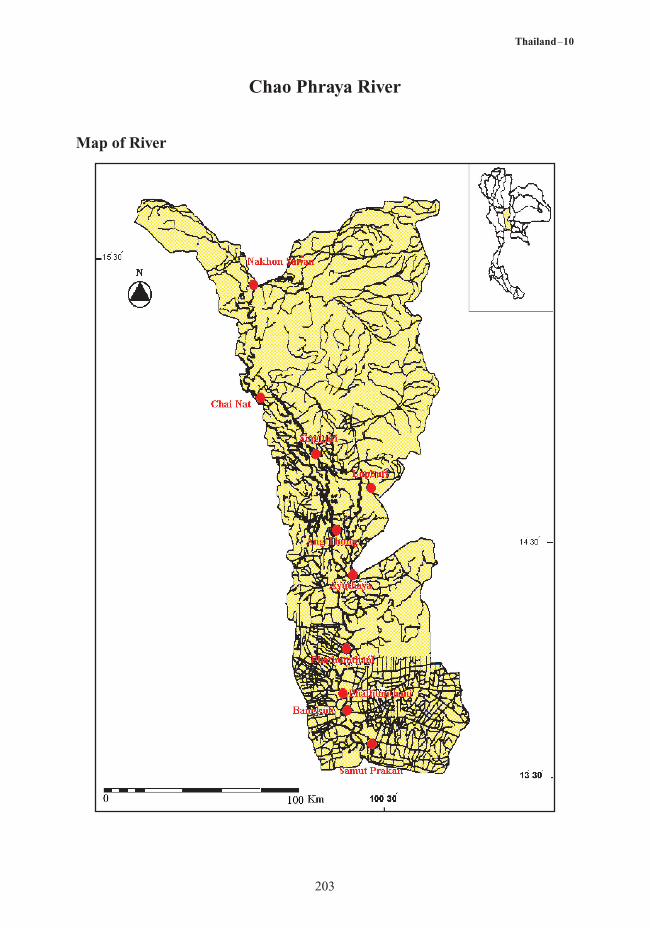
3. Climatological Information
3.1 Annual Isohyetal Map and Observation Stations

210
Thailand―10
StationNo.
03100201 Tha Ta Ko
Nong Bua
Muang, Nakhon Sawan
Phai Sari
Royal IrrigationDepartment, Bangkok
Pho Thong
Tha Wang
Kok Phra
Muang, Singburi
Muang, Ang Thong
Ayutthaya
Muang, Pha Thumthani
Muang, Nonthaburi
Muang, Samut Prakan
Station Name
N 15° 38' 25"E 100° 29' 12"
Location
1975 - 2002
Observationperiod
1,074.1
Mean annualPrecipitation
(mm)
P (S)
Observationitems1)
03100202N 15° 51' 47"E 100° 32' 50"
1975 - 2002 1,027.9 P (S)
03100203N 15° 39' 55"E 100° 08' 43"
1975 - 2002 1,068.2 P (S)
03100204N 15° 35' 41"E 100° 39' 39"
1975 - 2002 1,051.4 P (S)
01100312N 13° 47' 14"E 100° 30' 56"
1952 - 1996 1,459.9 P (S)
01100328N 14° 38' 31"E 100° 17' 42"
1975 - 2002 909.2 P (S)
03100301N 14° 48' 00"E 100° 37' 00"
1975 - 2002 886.6 P (S)
03100303N 15° 33' 19"E 100° 04' 35"
1975 - 2002 948.9 P (S)
03100309N 14° 53' 12"E 100° 24' 29"
1975 - 2002 979.5 P (S)
03100313N 14° 35' 14"E 100° 27' 22"
1975 - 2002 1,113.7 P (S)
03100319N 14° 21' 49"E 100° 34' 34"
1952 - 1996 1,035.0 P (S)
03100334N 14° 01' 04"E 100° 32' 11"
1978 - 2002 933.4 P (S)
03100343N 13° 50' 21"E 100° 29' 45"
1975 - 1999 1,059.8 P (S)
03100351N 13° 36' 00"E 100° 35' 59"
1956 - 2002 1,247.4 P (S)
3.2 List of Meteorological Observation Station
3.3 Monthly Climatic Data
Station: 03100360 Bang Na, Bangkok
1) P(S) : Precipitation from standard rain gauge
1 : Temperature [°C]2 : Precipitation [mm]3 : Evaporation [mm]
Jan Feb Mar Apr May Jun Jul Aug Sep Oct Nov Dec YearPeriod ofthe mean
1 26.2 27.5 28.9 29.9 29.5 28.9 28.5 28.2 27.9 27.6 27.0 25.7 28.0 1966 ~ 1996
2 8.1 18.8 29.3 63.3 212.6 157.1 156.8 205.1 331.5 250.0 44.9 9.8 1,487.3 1966 ~ 1996
3 138.7 145.4 188.3 191.3 173.3 154.5 152.2 152.3 132.9 127.7 127.6 135.4 1,819.6 1966 ~ 1996

211
Thailand―10
3.4 Long-term Variation of Monthly Precipitation Series
Station: 03100360 Meteorological Department, Bang Na, Bangkok
Station: 03100301 Amphoe Muang, Lopburi Province

212
Thailand―10
4. Hydrological Information
4.1 Map of Streamflow Observation Stations

213
Thailand―10
No.
01100302Muang District,
Nakhon Sawan Province
Huai Kot District, U-Thai Thani Province
Sanphaya District, Chai Nat province
Station
N 15° 40' 15"E 100° 06' 45"
Location
110,569
Catchmentarea [km2]
1950 - present
Observationperiod
Q (H1)
Observationitems1)
01100307N 14° 35' 05"E 100° 27' 12"
219 1983 - present Q (H1)
01100313N 15° 09' 57"E 100° 11' 32"
120,693 1971 - present Q (H1)
4.2 List of Hydrological Observation Stations
No.-Q2)
[m3/s]Qmax3)
[m3/s]
-Qmax4)
[m3/s]
-Qmin5)
[m3/s]
-Q/A[m3/s/100km2]
Qmax/A[m3/s/100km2]
01100302 705.2 4,820 2,440 150 0.64 4.36
01100313 460.89 4,538 2,359 49.3 0.38 3.76
1) H1 : Water level at recording chart2) -Q : Mean annual discharge3) Qmax : Maximum discharge4) -Qmax : Mean annual maximum Discharge5) -Qmin : Mean annual minimum Discharge
Period : 1956-2001
4.3 Long-term Variation of Monthly Discharge Series

214
Thailand―10
4.4 Annual Maximum and Minimum Discharge
Station: 01100302 Muang District, Nakhon Sawan Province (110,569 km2)
Year
1960 10 - 26 2,601 5 - 08 19.00 1979 10.01 1,412 2 - 23 113.00
1961 10 - 13 4,712 4 - 2 45.00 1980 10.09 4,350 4 - 18 151.00
1962 10 - 18 3,825 4 - 17 39.00 1981 8.18 1,663 1 - 15 260.00
1963 10 - 12 2,959 5 - 23 32.00 1982 10.10 1,600 1 - 02 250.00
1964 10 - 11 3,825 4 - 15 134.00 1983 10.22 2,290 7 - 01 250.00
1965 10 - 02 1,540 1 - 27 131.00 1984 10.27 1,260 1 - 05 195.00
1966 9 - 24 2,930 5 - 15 161.00 1985 10.28 2,142 1 - 15 216.00
1967 10 - 08 2,768 5 - 01 138.00 1986 5.13 1,471 1 - 15 134.00
1968 9 - 21 1,271 2 - 21 125.00 1987 10.12 1,652 1 - 09 144.00
1969 9 - 28 2,827 5 - 09 125.00 1988 10.25 1,916 1 - 07 183.00
1970 9 - 30 4,420 4 - 02 204.00 1989 10.23 1,458 1 - 06 145.00
1971 10 - 09 2,370 3 - 09 213.00 1990 6.11 1,158 1 - 18 179.00
1972 10 - 08 1,310 1 - 05 183.00 1991 9.07 1,440 7 - 20 94.00
1973 10 - 05 2,600 1 - 05 186.00 1992 10.21 1,401 7 - 18 71.00
1974 11 - 09 1,930 2 - 13 231.00 1993 9.29 1,070 1 - 21 83.00
1975 10 - 17 4,355 1 - 17 345.00 1994 10.03 2,539 4 - 15 52.00
1976 10 - 11 2,618 2 - 24 307.00 1995 9.30 4,280 1 - 06 153.00
1977 9 - 27 1,977 1 - 29 178.00 1996 10.20 3,011 1 - 16 215.00
1978 10 - 08 3,539 6 - 08 246.00 1997 10.10 1,318 1 - 08 114.00
Maximum
Date m3/s
Minimum
Date m3/sYear
Maximum
Date m3/s
Minimum
Date m3/s
215
Thailand―10
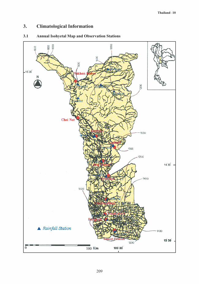
4.5 Hyetoghraphs and Hydrographs of Major Floods
Before Phumipol Dam Construction
Period (6 Aug-16 Dec 1961) (day)
5.0
0.05000.0
4000.0
3000.0
2000.0
1000.0
0.0
10.0
15.0
20.0
25.0
30.0
35.0
40.0
Rainfall (m
m/d
ay)R
unof
f (m
3 /s)
Period (11 Sep-16 Nov 1978) (day)
After Phumipol Dam Construction0.04000.0
3500.0
3000.0
2500.0
2000.0
1500.0
1000.0
500.0
0.0
5.0
10.0
15.0
20.0
25.0
30.0
Rainfall (m
m/d
ay)R
unof
f (m
3 /s)
216
Thailand―10
No.Discharge
m3/s m3/s/km2
Drainage Area(km2)
Date Period
01100302 110,569 4,820 0.044 10/1/1995 1950 - 1997
01100313 120,693 4,538 0.038 10/5/1995 1971 - 1997
4.6 Major Peak Discharge Experiences
Point Year pHDO
(mg/l)BOD(mg/l)
Coliform(MPN/100 ml)
Upper Chao Phraya River 1997 - 6.4 1.2 20,000
Middle Chao Phraya River - 4.1 1.5 2,000
Lower Chao Phraya River - 0.5 3.1 46,000
Chao Phraya River Muang District, Chainat
ProvinceChumsang District, Nakhonsawan Province
1999
7.0
7.0
10.2
8.3
-
-
-
-
Supunburi RiverA.Muang,Supunburee
6.7 6.1 - -
4.7 Water Quality
5. Water Resources
5.1 General Description
The Chao Phraya River Basin is divided into 2 sub-basins. The water level in Chao Phraya River isgreatly influenced by the operation of three main dams built in the basin, namely :
- Bhumipol dam on Ping River and Sirikit dam on tha Nan River for the reaches downstreamfrom the dams to Nakhon Sawan Province.
- Chao Phraya Dam on the Chao Phraya River from the reach from Chatnat Province to AngThong province.
Flood plains which are fertile for rice cultivation exist on both sides of the Chao Phraya River in thecentral plain covering an area of 1 million hectares.
Flooding in the basin usually occurs during the typhoon season i.e. from July to September.
217
Thailand―10
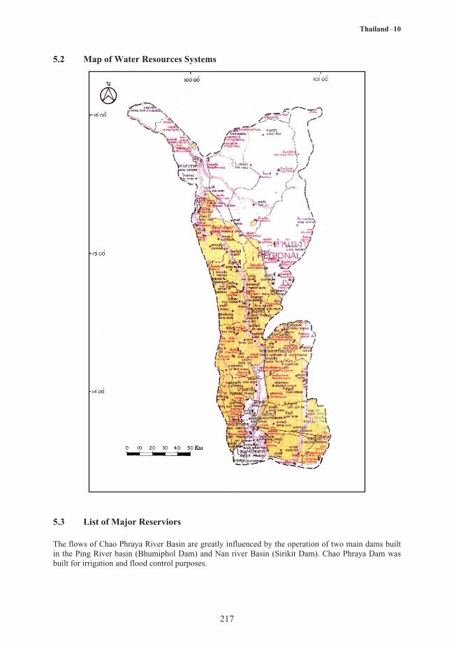
5.2 Map of Water Resources Systems
5.3 List of Major Reserviors
The flows of Chao Phraya River Basin are greatly influenced by the operation of two main dams builtin the Ping River basin (Bhumiphol Dam) and Nan river Basin (Sirikit Dam). Chao Phraya Dam wasbuilt for irrigation and flood control purposes.

218
Thailand―10
6. Socio-cultural Characteristics
The confluence of the Ping, Wang, Yom and Nan rivers at Nakhon Sawan Province is the beginning ofChao Phraya River. Siltation of these four rivers has enriched this river basin making Chao PhrayaRiver basin the most fertile plain of the country. Inhabitants of this river basin earn their living fromagricultural production of rice, vegetables and other major economic crops. Water related festivals areSongkhran water festival and the flower float festival. Inhabitants of this river basin are peace lovingand very proud of their inherited cultures. The capital city, Bangkok, is located in this basin thuscontributing to higher economic and social development than in other river basins.
7. References
Department of Mineral Resources, (1969): Geological map of Thailand.Meteorological Department, (2001): Climatological Data of Thailand. 1951-2001.Royal Irrigation Department, (2000): Hydrology Division: Thailand Hydrological Yearbook 1922-
2000.Department of Land Development. Soil of the Kingdom of Thailand, (1972): Explanatory Text of the
General Soil Map, Soil Survey Division.Electricity Generating Authority of Thailand, (1992): Surface runoff and specific yield of river basin in
Thailand, Survey and Ecology Department, Meteorology and Hydrology Division.