Changes in mangrove vegetation area and character in a war ...
11
Changes in mangrove vegetation area and character in a war and land use change affected region of Vietnam (Mui Ca Mau) over six decades T.T. Van a, b, c, * , N. Wilson d , H. Thanh-Tung e , K. Quisthoudt b , V. Quang-Minh f , L. Xuan-Tuan g , F. Dahdouh-Guebas a, b, 1 , N. Koedam a, 1 a Laboratory of Plant Biology and Nature Management, Vrije Universiteit Brussel-VUB, Brussels, Belgium b Laboratory of Systems Ecology and Resource Management, Universit e Libre de Bruxelles-ULB, Brussels, Belgium c Center for HydroMet and Climate Change, Vietnam Institute of Meteorology, Hydrology and Climate Change-IMHEN, Hanoi, Viet Nam d Centre for Sustainable Rural Development, Hanoi, Viet Nam e Division of Remote Sensing and GIS, Vietnam Institute of Meteorology, Hydrology and Climate Change -IMHEN, Hanoi, Viet Nam f Department of Land Resources, College of Environment and Natural Resources, Can Tho University-CTU, Can Tho, Viet Nam g Mangrove Ecosystem Research Centre, Hanoi National University of Education-HNUE, Hanoi, Viet Nam article info Article history: Received 10 December 2013 Received in revised form 27 November 2014 Accepted 28 November 2014 Available online 8 December 2014 Keywords: Mangrove Land cover change War Mangrove-shrimp farm Mui Ca Mau GIS abstract Aerial photographs and satellite images have been used to determine land cover changes during the period 1953 to 2011 in the Mui Ca Mau, Vietnam, especially in relation to changes in the mangrove area. The mangrove area declined drastically from approximately 71,345 ha in 1953 to 33,083 ha in 1992, then rose to 46,712 ha in 2011. Loss due to herbicide attacks during the Vietnam War, overexploitation, and conversion into agriculture and aquaculture encouraged by land management policies are being partially counteracted by natural regeneration and replanting, especially a gradual increase in plantations as part of integrated mangrove-shrimp farming systems. The nature of the mangrove vegetation has markedly been transformed over this period. The results are valuable for management planning to understand and improve the contribution of mangrove forests to the provision of ecosystem services and resources, local livelihood and global interest. © 2014 Elsevier Masson SAS. All rights reserved. 1. Introduction Mangrove forests cover an estimated 152,361,000 ha of the tropical and subtropical shorelines of the world (Spalding et al., 2010) and deliver important ecosystem functions, goods and ser- vices (Kathiresan, 2012; Lee et al., 2014). They form nursery grounds for numerous fish and shellfish (Lee et al., 2014); provide habitat for a diversity of birds, other vertebrates and invertebrates (Valiela et al., 2001; Nagelkerken et al., 2008; Cannicci et al., 2008); intercept land-derived nutrients, pollutants, and suspended matter before these contaminants reach deeper water (Semesi and Howell, 1992; Marshall, 1994; Rivera-Monroy and Twilley, 1996; Tam and Wong, 1999); and export material that support near-shore food webs (Kathiresan, 2012; Lee et al., 2014). Economically, mangrove ecosystems serve as a source of important products for livelihoods in coastal areas, such as poles and timber for building material and firewood, salt, tannins, dyes, charcoal and food (Abuodha and Kairo, 2001; FAO, 2007; Nfotabong-Atheull et al., 2009; Kathiresan, 2012). Mangroves systems also play an important role in coastal sta- bilization and protection (Mazda et al., 1997, 2002; Dahdouh- Guebas and Pulukkuttige, 2009; Mukherjee et al., 2010; Kathir- esan, 2012; Lee et al., 2014). Therefore, any loss of mangrove forest means a loss of subsistence and cash-based livelihoods and ecological and conservation function (Valiela et al., 2001). However, between 1980 and 2005, the world-wide mangrove forest area declined by 3.6 million ha (about 20% of the total area) (Spalding et al., 2010). Duke et al. (2007) indicated that a world without substantial areas of mangroves is a realistic forecast if the current destruction rate of mangrove ecosystems continues. At a global level, natural and anthropogenic drivers of mangrove destruction and degradation include sea-level rise (Di Nitto et al., 2008, 2014); the harvest of forest products for local (wood, char- coal, and tannins) and industrial (woodchips and lumber) * Corresponding author. E-mail address: [email protected] (T.T. Van). 1 These authors contributed equally to this work. Contents lists available at ScienceDirect Acta Oecologica journal homepage: www.elsevier.com/locate/actoec http://dx.doi.org/10.1016/j.actao.2014.11.007 1146-609X/© 2014 Elsevier Masson SAS. All rights reserved. Acta Oecologica 63 (2015) 71e81
Transcript of Changes in mangrove vegetation area and character in a war ...

lable at ScienceDirect
Acta Oecologica 63 (2015) 71e81
Contents lists avai
Acta Oecologica
journal homepage: www.elsevier .com/locate/actoec
Changes in mangrove vegetation area and character in a war and landuse change affected region of Vietnam (Mui Ca Mau) over six decades
T.T. Van a, b, c, *, N. Wilson d, H. Thanh-Tung e, K. Quisthoudt b, V. Quang-Minh f,L. Xuan-Tuan g, F. Dahdouh-Guebas a, b, 1, N. Koedam a, 1
a Laboratory of Plant Biology and Nature Management, Vrije Universiteit Brussel-VUB, Brussels, Belgiumb Laboratory of Systems Ecology and Resource Management, Universit�e Libre de Bruxelles-ULB, Brussels, Belgiumc Center for HydroMet and Climate Change, Vietnam Institute of Meteorology, Hydrology and Climate Change-IMHEN, Hanoi, Viet Namd Centre for Sustainable Rural Development, Hanoi, Viet Name Division of Remote Sensing and GIS, Vietnam Institute of Meteorology, Hydrology and Climate Change -IMHEN, Hanoi, Viet Namf Department of Land Resources, College of Environment and Natural Resources, Can Tho University-CTU, Can Tho, Viet Namg Mangrove Ecosystem Research Centre, Hanoi National University of Education-HNUE, Hanoi, Viet Nam
a r t i c l e i n f o
Article history:Received 10 December 2013Received in revised form27 November 2014Accepted 28 November 2014Available online 8 December 2014
Keywords:MangroveLand cover changeWarMangrove-shrimp farmMui Ca MauGIS
* Corresponding author.E-mail address: [email protected] (T.T. Van).
1 These authors contributed equally to this work.
http://dx.doi.org/10.1016/j.actao.2014.11.0071146-609X/© 2014 Elsevier Masson SAS. All rights res
a b s t r a c t
Aerial photographs and satellite images have been used to determine land cover changes during theperiod 1953 to 2011 in the Mui Ca Mau, Vietnam, especially in relation to changes in the mangrove area.The mangrove area declined drastically from approximately 71,345 ha in 1953 to 33,083 ha in 1992, thenrose to 46,712 ha in 2011. Loss due to herbicide attacks during the Vietnam War, overexploitation, andconversion into agriculture and aquaculture encouraged by land management policies are being partiallycounteracted by natural regeneration and replanting, especially a gradual increase in plantations as partof integrated mangrove-shrimp farming systems. The nature of the mangrove vegetation has markedlybeen transformed over this period. The results are valuable for management planning to understand andimprove the contribution of mangrove forests to the provision of ecosystem services and resources, locallivelihood and global interest.
© 2014 Elsevier Masson SAS. All rights reserved.
1. Introduction
Mangrove forests cover an estimated 152,361,000 ha of thetropical and subtropical shorelines of the world (Spalding et al.,2010) and deliver important ecosystem functions, goods and ser-vices (Kathiresan, 2012; Lee et al., 2014). They form nurserygrounds for numerous fish and shellfish (Lee et al., 2014); providehabitat for a diversity of birds, other vertebrates and invertebrates(Valiela et al., 2001; Nagelkerken et al., 2008; Cannicci et al., 2008);intercept land-derived nutrients, pollutants, and suspended matterbefore these contaminants reach deeper water (Semesi and Howell,1992; Marshall, 1994; Rivera-Monroy and Twilley, 1996; Tam andWong, 1999); and export material that support near-shore foodwebs (Kathiresan, 2012; Lee et al., 2014). Economically, mangrove
erved.
ecosystems serve as a source of important products for livelihoodsin coastal areas, such as poles and timber for building material andfirewood, salt, tannins, dyes, charcoal and food (Abuodha and Kairo,2001; FAO, 2007; Nfotabong-Atheull et al., 2009; Kathiresan, 2012).
Mangroves systems also play an important role in coastal sta-bilization and protection (Mazda et al., 1997, 2002; Dahdouh-Guebas and Pulukkuttige, 2009; Mukherjee et al., 2010; Kathir-esan, 2012; Lee et al., 2014). Therefore, any loss of mangrove forestmeans a loss of subsistence and cash-based livelihoods andecological and conservation function (Valiela et al., 2001). However,between 1980 and 2005, the world-wide mangrove forest areadeclined by 3.6 million ha (about 20% of the total area) (Spaldinget al., 2010). Duke et al. (2007) indicated that a world withoutsubstantial areas of mangroves is a realistic forecast if the currentdestruction rate of mangrove ecosystems continues.
At a global level, natural and anthropogenic drivers of mangrovedestruction and degradation include sea-level rise (Di Nitto et al.,2008, 2014); the harvest of forest products for local (wood, char-coal, and tannins) and industrial (woodchips and lumber)

T.T. Van et al. / Acta Oecologica 63 (2015) 71e8172
consumption (Ong, 1982; Abuodha and Kairo, 2001; Goessens et al.,2014); conversion of mangrove forest into agricultural, aquacul-tural, industrial and urban areas (Abuodha and Kairo, 2001; Alonso-Perez et al., 2003; Barbier, 2003; Gunawardena and Rowan, 2005;Luers et al., 2006; Rakotomavo and Fromard, 2010; Paul and Vogl,2011; Santos et al., 2014); and other activities such as riverdamming and herbicide use (Linden and Jernelov, 1980; Hong andSan, 1993; Abuodha and Kairo, 2001; Koedam et al., 2007).
The management of forest resources needs to be based onmapping and inventory, along with the monitoring of natural orhuman-induced impacts over time. One of the most widely usedmethods to look into the recent past, and which will undoubtedlyevolve into the single most important monitoring technology in thefuture is remote sensing (Dahdouh-Guebas and Koedam, 2008).Remote sensing and GIS has been widely used for the sustainablemanagement of tropical coastal ecosystems (Dahdouh-Guebas,2002; Neukermans et al., 2008; Satyanarayana et al., 2011;Nfotabong-Atheull et al., 2013) and integrated into trans-disciplinary retrospective research on mangroves and other eco-systems (Dahdouh-Guebas and Koedam, 2008). Remote sensingand GIS assist in the continuous monitoring of forests and detectchange that can be integrated into existing databases (Koedamet al., 2007). The results are valuable for the planning ofmangrove management to improve their contribution towardsnatural resources, ecotourism and local livelihoods (Dahdouh-Guebas, 2002; Koedam et al., 2007).
Utilisation of mangrove resources and often consequentdegradation has occurred in Vietnam for a long time (Hong and San,1993; FAO, 2007). In the lower Mekong River Delta, several studieshave applied remote sensing and GIS to detect changes of mangrovecover in relation to human impacts (NAS, 1974; Tong et al., 2004;Binh et al., 2005; Thu and Populus, 2007; Koedam et al., 2007;Lam-Dao et al., 2011; Hai-Hoa et al., 2013). However, time series
Fig. 1. Map of study area showing the location of t
of remotely sensed data was lacking before the Vietnam War(1962e1972), even though there was a major impact before thattime (Ross,1975; Stellman et al., 2003). In theMui CaMau, there is ascarcity of data from the 1970s (Tong et al., 2004; Hai-Hoa et al.,2013) and 1990s (Tong et al., 2004; Koedam et al., 2007; Lam-Daoet al., 2011). The time intervals between the images studied playsan important role in detecting and quantifying the nature andtiming of changes associated with anthropogenic impacts. Moresampling dates help to facilitate clear goals for conservation, eco-nomic activities and coastal protection management by betteridentifying the timing and causes of major changes and by recon-stituting baselines.
In this study, images from six occasions, from 1953 to 2011, wereused to determine land cover changes in mangrove vegetation inthe Mui Ca Mau, which were mostly caused by human impact.Remote sensing and GIS were applied. The approach is valuable formanagement planning to understand and improve the contributionof mangrove forests to the provision of ecosystem services andresources, local livelihood and global interest.
2. Materials and methods
2.1. Study area
Located at the southern tip of Vietnam on the Mekong RiverDelta, the Mui Ca Mau supported a substantial area of mangrovevegetation. It was originally the largest area and best developedmangrove vegetation in Vietnam (Hong and San, 1993). The studyarea is between 8�320N to 8�490N and 104�400E to 105�190E (Fig. 1).It covers all of Ngoc Hien District and part of Nam Can District of CaMau Province and was originally dominated by mangrovevegetation.
he study area in Ca Mau Province of Vietnam.

T.T. Van et al. / Acta Oecologica 63 (2015) 71e81 73
Themajor mangrove species are Avicennia alba Blume, Avicenniamarina (Forssk.) Vierh., Avicennia officinalis L., Rhizophora apiculataBl., Bruguiera parviflora Wight & Arnold ex Griffith, Ceriops zip-peliana Blume and Nypa fruticans (Thunb.) Wurmb. (Hung and Tan,1999; Mass�o i Alem�an et al., 2010). The natural ecosystem had ahigh conservation value for biodiversity and scenic beauty (MABVietnam, 2008). A large area of the Mui Ca Mau was designated aUNESCO International Biosphere Reserve in 2009 and 41,862 ha ofthe mangrove forest and shore at the Mui Ca Mau was declared asMui Ca Mau National Park in 2003 and included as a Ramsar site in2013.
Topographically, the study area is a low deltaic plain, stronglydivided by a system of natural rivers and now a dense network ofcanals. The water flow regime in the large intertidal area is underthe influence of the tidal disparity between the East Sea and theGulf of Thailand, with dominant tidal flows from the eastern side.On the east coast, the tide is semi-diurnal with an average ampli-tude of 3 m. On the Gulf of Thailand coast, the tidal regime isdiurnal with amplitudes ranging from 0.5 to 0.8 m. The whole areais characterized by soft muddy soils and some peat swamps (Hongand San, 1993).
2.2. Data sources
Aerial photographs from 1953 and remotely sensed image dataof Landsat (1975, 1979) and SPOT (1992, 2004 and 2011) were usedto detect the changes in land cover in the study area (Table 1). TheLandsat images were freely downloaded from the U.S. GeologicalSurvey at level 1T which is processed to standard terrain correction.Other images were purchased by the Laboratory of Plant Biologyand Nature Management, Vrije Universiteit Brussel and the Viet-nam Institute of Meteorology, Hydrology and Climate Change. TheSPOTs were processed at the level of orthorectific using groundcontrol points and a digital elevation model. Data were geo-referenced to the UTM WGS-1984 Zone 48N projection and coor-dinate system with further geometric correction using ENVIsoftware.
Together with ground truth data (2006, 2010 and 2011), avegetation map (1952) produced by the Service G�eographique de l'Indochine at 1:100,000 scale, a topographic map (1980) at1:250,000 scale and a digitized wetland map at 1:100,000 scale bythe National Remote Sensing Center (2008e2009) were used asbase maps for result validation.
2.3. Data processing
The grey scale aerial photographs of 1953 are at a scale of1:50,000, with clear sky. Visual interpretation was done using astereoscope. The map (after interpretation of land cover) was
Table 1Specifications of the remotely sensed data used in this study.
No. Name Path/row Acquired date Resolution (m)
1 Aerial photos 01/01/1953 202 Landsat 2 MSS 135/054 22/11/1975 793 Landsat 3 MSS 135/054 13/02/1979 794 SPOT 2 273/332 03/01/1992 205 SPOT 2 273/333 03/01/1992 206 SPOT 2 274/333 03/01/1992 207 SPOT 5 273/332 07/01/2004 108 SPOT 5 273/333 07/01/2004 109 SPOT 5 274/333 07/01/2004 1010 SPOT 5 273/332 19/02/2011 1011 SPOT 5 273/333 19/02/2011 1012 SPOT 5 274/333 19/02/2011 10
scanned and digitized. Very small areas dominated by mangrovegenera other than Rhizophora and Avicennia, such as Sonneratia,Nypa, Bruguiera or Ceriops were not distinguishable. Small areas offreshwater swamp or marshland and surface water were easilyrecognized by their colour (black).
ENVI and ArcGIS was used for Landsat/SPOT image processingand map manipulation. The band combination of 574, 754 and 321were used respectively in LANDSAT/MSS 1975, 1979 and SPOT im-ages. The image elements were analysed both by visual and digitalinterpretation. Firstly, a visual classification was applied to identifyand to draw obviously homogeneous land cover units throughinterpretation keys (hue, texture, morphology, and contrast effects)and field exploration (ground truthing). This provisional classifi-cation was considered the basis for the next step of superviseddigital classification.
The maximum likelihood method was used to obtain a super-vised classification. Representative training areas were identifiedand a numerical description of the spectral attributes of each landcover type of interest in the scene was developed. Next, each parcelin the image data set was categorised into the land cover class itmost closely resembled. The category label assigned to each parcelin this process was recorded in the corresponding cell of an inter-preted data set. After the entire data set was categorised, the resultswere presented in the output state.
‘Forest’, ‘shrimp monoculture’ and ‘mangrove-shrimp farm’
were clearly delineated. Mangrove forests are usually well delin-eated from a simple visual interpretation of a colour compositebased on image attributes such as colour, texture and structure(Dahdouh-Guebas et al., 2006b). The supervised classification wasable to differentiate Rhizophora and Avicennia forest at low tidallevel, where Avicennia forest gives less reflection or is darker thanRhizophora, and the pattern and texture of Avicennia is fine andsmooth while Rhizophora forests have a coarse and heterogeneoussurface.
In the field, a wide range of ground-truth information onmangrove conditions, density and species composition wascollected. Mangrove forest cover in mangrove-shrimp farmingsystems were retrieved through household interviews and furthervalidated by field observation. Integrated mangrove-shrimp qua-culture is a silvo-fishery system that mixes shrimp ponds andmangroves on farms. Shrimp pond areas have a range of 3e10 haand are surrounded by small dikes which control the water leveland form a border with neighbouring shrimp farms. Within theponds, the mangrove trees are typically planted in a row pattern,although some farms have remnant natural vegetation if they arecut fromnatural forests. Based on the regulations onmangrove areaon farms (discussed in Section 4.1.2), ground truth data and thewide variation of mangrove versus pond area on farms since the1990s, two categories were used for the mangrove-shrimp farmsystems: <50% versus 50e70% mangrove coverage on the farms.
The accuracy assessment was conducted for the 1953, 1979,2004 and 2011 images, as there were no ground truth data or basemaps for the years of 1975 and 1992. The Kappa coefficient appliedhere as an accuracy assessment was 0.80, 0.73, 0.69 and 0.77 for the1953, 1979, 2004 and 2011 images respectively. Meanwhile, theoverall classification accuracy ranged from 77.5% to 83.5%.
Eight land cover categories were identified:
1. Avicennia forest dominated by Avicennia spp., principally A. alba.2. Rhizophora forest dominated by R. apiculata.3. Mixed forest: dominated by a mixture of mangrove species like
A. alba, R. apiculata, Bruguiera spp. and Ceriops spp. naturallydevelops from colonising Avicennia vegetation.
4. Intensive shrimp monoculture with no mangrove trees in orbordering aquaculture ponds.
Table
2Eigh
tdifferentlandco
vercatego
ries
iden
tified
fortheMuiCaMau
betw
een19
53an
d20
11.C
han
geis
compared
tothepreviou
sye
ar.
No.
Landco
ver
Major
landco
vergrou
ps
1953
1975
Chan
ge19
53e19
7519
79Chan
ge19
75e19
7919
92Chan
ge19
79e19
9220
04Chan
ge19
92e20
0420
11Chan
ge20
04e20
11
ha
%ha
%ha
ha
%ha
ha
%ha
ha
%ha
ha
%ha
1Avicenn
iaFo
rest
5503
7.5
3129
4.5
�237
523
183.3
�810
280.0
�229
093
11.3
þ903
1157
1.6
þ227
2Rhizoph
ora
Forest
14,321
19.5
12,548
18.1
�177
328
434.1
�970
623
50.3
�260
813
,629
19.1
þ13,39
512
,414
17.3
�121
63
Mixed
man
grov
eforest
Forest
51,521
70.2
31,741
45.7
�19,78
157
,798
82.4
þ26,05
767
069.2
�51,09
264
059.0
�301
6930
9.7
þ525
4Sh
rimpfarm
ing
Shrimpmon
oculture
00.0
00.0
00
0.0
037
295.1
þ372
90
0.0
�372
90
0.0
05
<50
%man
grov
eMan
grov
e-sh
rimpfarm
00.0
00.0
00
0.0
037
,724
51.5
þ37,72
415
,153
21.2
�22,57
113
,448
18.8
�170
5Areaof
whichis
forested
00.0
00.0
00
0.0
011
,317
15.5
þ11,31
745
466.4
�677
140
345.6
�512
650
-70%
man
grov
eMan
grov
e-sh
rimpfarm
00.0
00.0
00
0.0
024
,663
33.7
þ24,66
334
,669
48.5
þ10,00
536
,962
51.6
þ229
4Areaof
whichis
forested
00.0
00.0
00
0.0
014
,798
20.2
þ14,79
820
,801
29.1
þ600
322
,177
31.0
þ137
67
Settlemen
t,ga
rden
,etc.
Ruralsettlemen
ts0
0.0
90.0
þ915
0.0
þ 647
0.1
þ33
696
1.0
þ649
656
0.9
�40
8W
aste
land
Waste
land
2003
2.7
21,964
31.7
þ19,96
171
6710
.2�1
4,79
658
0.1
�710
933
0.0
�25
100.0
�23
Totalofth
earea
73,348
100.0
69,390
100.0
70,141
100.0
73,189
100.0
71,515
100.0
71,577
100.0
Totalof
forested
area
71,345
97.3
47,417
68.3
�23,92
862
,959
89.8
þ15,54
233
,083
45.2
�29,87
646
,312
64.8
þ13,22
846
,712
65.3
þ401
T.T. Van et al. / Acta Oecologica 63 (2015) 71e8174
5. <50% mangrove: mangrove-shrimp farm with <50% mangrovecover in ponds and >50% clear water surface.
6. 50e70% mangrove: mangrove-shrimp farm with 50e70%mangrove cover in ponds and 30e50% clear water surface.
7. Rural settlements and gardens, including residential houses andadjoining fruit gardens.
8. Waste land: unvegetated land that was evidently unused at thetime of study.
In order to enhance readability, the eight categories weregrouped into five major land cover groups for mapping: forest(Avicennia, Rhizophora, and mixed forests), shrimp monoculture,mangrove-shrimp farm (both <50% mangrove and 50e70%mangrove categories), rural settlements, and waste land. This isadaptable to published categories on Ca Mau Province by Binh et al.(2005) and Koedam et al. (2007).
2.4. Spatio-temporal dynamics
Finally, the spatio-temporal dynamics of the land cover wereestimated and quantified. Special attention was given to the con-version of land into shrimp ponds and the floristic within theremaining mangrove areas. From this, a first set of recommenda-tions for furthermonitoring of mangrove land cover change and thedevelopment of aquaculture and related activities and of theirenvironmental impacts was generated.
3. Results
3.1. Land cover
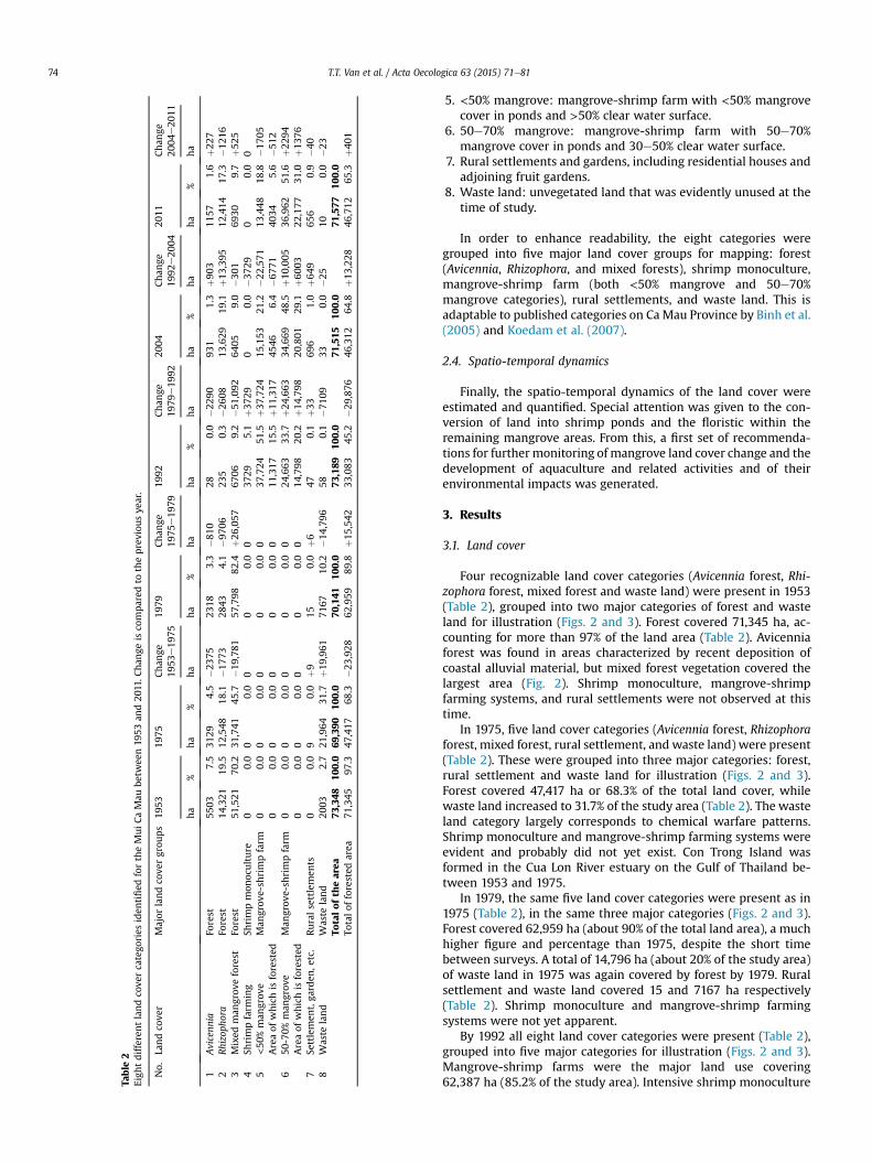
Four recognizable land cover categories (Avicennia forest, Rhi-zophora forest, mixed forest and waste land) were present in 1953(Table 2), grouped into two major categories of forest and wasteland for illustration (Figs. 2 and 3). Forest covered 71,345 ha, ac-counting for more than 97% of the land area (Table 2). Avicenniaforest was found in areas characterized by recent deposition ofcoastal alluvial material, but mixed forest vegetation covered thelargest area (Fig. 2). Shrimp monoculture, mangrove-shrimpfarming systems, and rural settlements were not observed at thistime.
In 1975, five land cover categories (Avicennia forest, Rhizophoraforest, mixed forest, rural settlement, and waste land) were present(Table 2). These were grouped into three major categories: forest,rural settlement and waste land for illustration (Figs. 2 and 3).Forest covered 47,417 ha or 68.3% of the total land cover, whilewaste land increased to 31.7% of the study area (Table 2). The wasteland category largely corresponds to chemical warfare patterns.Shrimp monoculture and mangrove-shrimp farming systems wereevident and probably did not yet exist. Con Trong Island wasformed in the Cua Lon River estuary on the Gulf of Thailand be-tween 1953 and 1975.
In 1979, the same five land cover categories were present as in1975 (Table 2), in the same three major categories (Figs. 2 and 3).Forest covered 62,959 ha (about 90% of the total land area), a muchhigher figure and percentage than 1975, despite the short timebetween surveys. A total of 14,796 ha (about 20% of the study area)of waste land in 1975 was again covered by forest by 1979. Ruralsettlement and waste land covered 15 and 7167 ha respectively(Table 2). Shrimp monoculture and mangrove-shrimp farmingsystems were not yet apparent.
By 1992 all eight land cover categories were present (Table 2),grouped into five major categories for illustration (Figs. 2 and 3).Mangrove-shrimp farms were the major land use covering62,387 ha (85.2% of the study area). Intensive shrimp monoculture
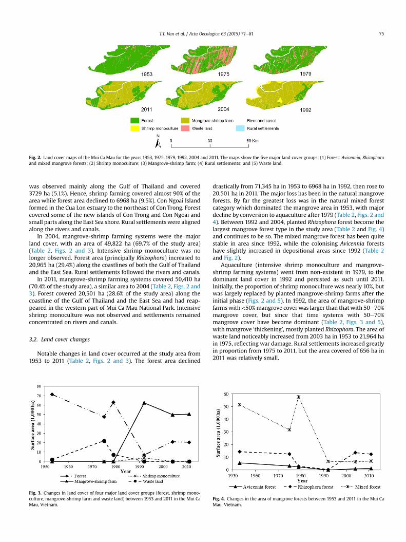
Fig. 2. Land cover maps of the Mui Ca Mau for the years 1953, 1975, 1979, 1992, 2004 and 2011. The maps show the five major land cover groups: (1) Forest: Avicennia, Rhizophoraand mixed mangrove forests; (2) Shrimp monoculture; (3) Mangrove-shrimp farm; (4) Rural settlements; and (5) Waste land.
T.T. Van et al. / Acta Oecologica 63 (2015) 71e81 75
was observed mainly along the Gulf of Thailand and covered3729 ha (5.1%). Hence, shrimp farming covered almost 90% of thearea while forest area declined to 6968 ha (9.5%). Con Ngoai Islandformed in the Cua Lon estuary to the northeast of Con Trong. Forestcovered some of the new islands of Con Trong and Con Ngoai andsmall parts along the East Sea shore. Rural settlementswere alignedalong the rivers and canals.
In 2004, mangrove-shrimp farming systems were the majorland cover, with an area of 49,822 ha (69.7% of the study area)(Table 2, Figs. 2 and 3). Intensive shrimp monoculture was nolonger observed. Forest area (principally Rhizophora) increased to20,965 ha (29.4%) along the coastlines of both the Gulf of Thailandand the East Sea. Rural settlements followed the rivers and canals.
In 2011, mangrove-shrimp farming systems covered 50,410 ha(70.4% of the study area), a similar area to 2004 (Table 2, Figs. 2 and3). Forest covered 20,501 ha (28.6% of the study area) along thecoastline of the Gulf of Thailand and the East Sea and had reap-peared in the western part of Mui Ca Mau National Park. Intensiveshrimp monoculture was not observed and settlements remainedconcentrated on rivers and canals.
3.2. Land cover changes
Notable changes in land cover occurred at the study area from1953 to 2011 (Table 2, Figs. 2 and 3). The forest area declined
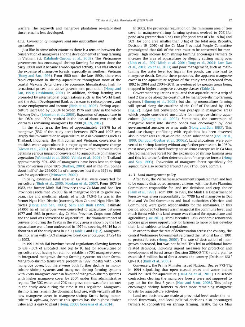
Fig. 3. Changes in land cover of four major land cover groups (forest, shrimp mono-culture, mangrove-shrimp farm and waste land) between 1953 and 2011 in the Mui CaMau, Vietnam.
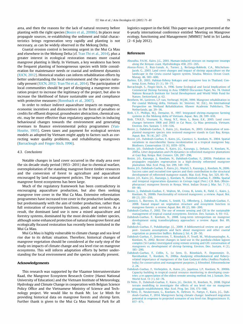
drastically from 71,345 ha in 1953 to 6968 ha in 1992, then rose to20,501 ha in 2011. The major loss has been in the natural mangroveforests. By far the greatest loss was in the natural mixed forestcategory which dominated the mangrove area in 1953, with majordecline by conversion to aquaculture after 1979 (Table 2, Figs. 2 and4). Between 1992 and 2004, planted Rhizophora forest become thelargest mangrove forest type in the study area (Table 2 and Fig. 4)and continues to be so. The mixed mangrove forest has been quitestable in area since 1992, while the colonising Avicennia forestshave slightly increased in depositional areas since 1992 (Table 2and Fig. 2).
Aquaculture (intensive shrimp monoculture and mangrove-shrimp farming systems) went from non-existent in 1979, to thedominant land cover in 1992 and persisted as such until 2011.Initially, the proportion of shrimp monoculture was nearly 10%, butwas largely replaced by planted mangrove-shrimp farms after theinitial phase (Figs. 2 and 5). In 1992, the area of mangrove-shrimpfarmswith<50%mangrove coverwas larger than that with 50e70%mangrove cover, but since that time systems with 50e70%mangrove cover have become dominant (Table 2, Figs. 3 and 5),with mangrove ‘thickening’, mostly planted Rhizophora. The area ofwaste land noticeably increased from 2003 ha in 1953 to 21,964 hain 1975, reflecting war damage. Rural settlements increased greatlyin proportion from 1975 to 2011, but the area covered of 656 ha in2011 was relatively small.
Fig. 4. Changes in the area of mangrove forests between 1953 and 2011 in the Mui CaMau, Vietnam.

Fig. 5. Changes in the area of shrimp monoculture and mangrove-shrimp farm be-tween 1953 and 2011 in the Mui Ca Mau, Vietnam.
T.T. Van et al. / Acta Oecologica 63 (2015) 71e8176
4. Discussion
4.1. Mangrove deforestation
Mangrove forests coveredmore than 97% of the study area in theMui Ca Mau in the early 1950s. Parts of the mangrove forest weredegraded for charcoal and tannin production before 1928 when theFrench colonial administration introduced forest managementincluding the replanting of 38,000 ha of degraded mangrove forest,usually with R. apiculata, which was the most economicallyimportant species (Moquillon, 1950; in NAS, 1974). This plantinglikely accounts for some of the area of Rhizophora-dominatedmangrove forest in 1953. In addition, slow natural development ofAvicennia cover may have favoured the prominence of Rhizophorain the canopy. Thus, it is possible that some natural forests withhigh cover of Rhizophora were mapped as Rhizophora rather thanmixed forests.
Since then, large areas of mangrove forests have been destroyedand converted to other land-uses. We registered a minimum offorested area in 1992 (45% of the study area; Table 2). The rate ofloss in mangrove area in both natural forest stands and inmangrove-shrimp farms was about 53% between 1953 and 1992,which is higher than the global (35%) and Asian (36%) estimates ofdecrease in mangrove area (Valiela et al., 2001). On an annual basis,it is also slightly higher than the estimated rate of loss of mangrovesin Vietnam (of 62% between 1945 and 1995; Turner et al., 1998).
The rate of loss of mangroves between 1979 and 2004 (26% ofthe study area) was higher than a global estimate of 20% between1980 and 2005 (Spalding et al., 2010). A small part of the decrease inmangrove cover is due to the fast and persistent erosion on theeastern coast of the Mui Ca Mau, with natural colonization andprogression of mangroves on accreted sediments on the westernside only compensating for part of themangrove loss on the easternside (Van Dam, 2010; Tran Thi et al., 2014).
Hydrological changes in the Mekong River and its delta (hy-droelectric dams upstream and canals and their levees crisscrossingthe delta and redirecting flows) are an extra factor of complexity inlocal dynamics of erosion versus sedimentation. Moreover, coastalmangrove ecosystems may be impacted by lower sediment loads(Lu and Siew, 2006) in the long-shore drift from the Mekong Rivermouths southwards towards Ca Mau (MAB Vietnam, 2008). Canalsmay direct the annual overland flows from the annual MekongRiver flooding and their sediment loads to the coast in a morespatially limited way than is natural. However, to date the majorityof the mangrove loss in the Mui Ca Mau is purely anthropogenicdriven by war strategies and conversion of land into aquaculture.Reforestation programmes have compensated for some loss, butnot with the natural suite of species.
4.1.1. Herbicides from chemical warfareThe forests under the study experienced significant damage
during the Vietnam War from the application of herbicides anddefoliants by the U.S. Air Force. As part of the war strategy(1962e1972), large tracts of forest, including mangrove forest, inthe southern provinces of Vietnamwere defoliated using herbicidesto reveal military shelters and food supplies (Stellman et al., 2003).NAS (1974) estimated that 104,939 ha or 36% of the area ofmangrove in southern Vietnam was subjected to one or morechemical attacks. Heavy defoliation not only devastated the vege-tation, but also affected heterotrophs changing the wholeecosystem (Hong and San, 1993).
The Mui Ca Mau was one of the most heavily impacted regionsby chemical warfare (Hong and San, 1993). From 1966 to 1970, itreceived high doses of herbicides and defoliants (Ross, 1975). Theprofound impact in the Mui Ca Mau is detected in this study by thelarge increase in bare waste land in 1975 over 1953. The pattern ofimpact has a similarity to the flight paths of spray missions (NAS,1974; Stellman et al., 2003).
Using 1972 aerial photography, NAS (1974) states that 52% of theMui CaMauwas then bare of mangrove trees, with 80% of the forestarea being Rhizophora-dominated. The percentage of Rhizophora-dominated forest in 1975 was lower than this in this study, perhapssuggesting differing categories of classification. The area of forestapparently lost from 1953 to1975 (Table 2) is less than that of NAS(1974) and Lam-Dao et al. (2011). However, there is a possible trendof mangrove area reestablishment, from approximately 48% of therespective study areas in 1972 (NAS, 1974), to 57% in early 1973(Lam-Dao et al., 2011), and 68.3% in late 1975 (this study). It is likelynatural or planted regeneration is showing, especially by 1975.Avicennia and Rhizophora grow rapidly from seedlings in goodhabitat and can show up in remote sensed images within a fewyears, for example natural regeneration of Avicennia in good con-ditions in breached aquaculture ponds in less than 3 years aftertidal flow was reinstated (Wilson, 2010).
NAS (1974) illustrates natural regeneration of Rhizophora andBruguiera within 200 m of waterways, notably the large Cua LonRiver, but lower natural regeneration elsewhere. Some of thisnatural regeneration, combined with some surviving Avicenniatrees (large Avicennia may be more resistant to chemical impact)and some planting may have contributed to the large increase in‘mixed forests’ found in this study between 1975 and 1979(26,057 ha).
Natural mangrove regeneration diminishes with distance frompropagule sources after catastrophic vegetation impact exposeslarge areas leaving open space and debris (even on the scale of tensof meters as observed in Can Gio, Vietnam after storm damage toRhizophora and Avicennia; Wilson, pers. obs.). The poor regenera-tion away from watercourses was ascribed by NAS (1974) to debrisremaining from dead trees constraining the large propagules ofRhizophora and Bruguiera from dispersing far from the river source.By October 1971, this debris was in advanced stages of decay, so anyimpedance was temporary (NAS, 1974).
Nam (1990, in Hong and San, 1993) ascribed uneven growth ofyoung planted R. apiculata to lingering toxicity, but this is notsupported by NAS (1974). However, large physical and chemicalchanges are to be expected when mangrove soils are exposed, andthese, along with insolation and exposure, might have been a factorin some poor seedling growth. However, the planted restoration oftree cover was very rapid, although many patches of waste landremained in 1979 (Fig. 2). Natural forests did remain in 1975 and1979, but many of the forests in the affected areas were secondarygrowth or plantations at the end of the 1970s (FAO, 2007). Thiscontrasts with the mostly mature forest affected by chemical
T.T. Van et al. / Acta Oecologica 63 (2015) 71e81 77
warfare. The regrowth and mangrove plantation re-establishedsince remains less developed.
4.1.2. Conversion of mangrove land into aquaculture andagriculture
Just like in some other countries there is a tension between theconservation of mangroves and the development of shrimp farmingin Vietnam (cf. Dahdouh-Guebas et al., 2002). The Vietnamesegovernment has encouraged shrimp farming for export since theearly 1980s and it became a wide-spread activity. This was often atthe expense of mangrove forests, especially in southern Vietnam(Hong and San, 1993). From 1980 until the late 1990s, there wasrapid expansion in shrimp aquaculture throughout most of thecoastal Mekong Delta, driven by economic liberalisation, high in-ternational prices, and active government promotion (Hong andSan, 1993; Hashimoto, 2001). In addition, shrimp farming waspromoted by international organizations such as the World Bankand the Asian Development Bank as a means to reduce poverty andcreate employment and income (Binh et al., 2005). Shrimp aqua-culture increased by 3500% between 1976 and 1992 in the wholeMekong Delta (Johnston et al., 2000). Expansion of aquaculture inthe 1980s and 1990s resulted in the loss of about two-thirds ofVietnam's remaining mangroves by 2000 (IUCN, 2012).
In the study area, the loss of approximately 29,876 ha ofmangrove (53% of the study area) between 1979 and 1992 waslargely due to conversion to aquaculture. In Asian countries such asThailand, Indonesia, the Philippines and Vietnam, conversion tobrackish water aquaculture is a major agent of mangrove change(Giesen et al., 2006). This study is consistent with numerous studiesdetailing serious impact of conversion to aquaculture on mangrovevegetation (Wolanski et al., 2000; Valiela et al., 2001). In Thailandapproximately 50%e65% of mangroves have been lost to shrimpfarm conversion since 1975 (Barbier, 2003) and in the Philippinesabout half of the 279,000 ha of mangroves lost from 1951 to 1988was for aquaculture (Primavera, 2000).
Initially, extensive tidal areas in Ca Mau were converted foragriculture (Binh et al., 2005; Koedam et al., 2007). From 1976 to1982, the former Minh Hai Province (now Ca Mau and Bac LieuProvinces) reclaimed 26,300 ha of mangrove forest to grow soy-bean, rice and medicinal plants, of which 17,645 ha was in theformer Ngoc Hien District (currently Nam Can and Ngoc Hien Dis-tricts) (Hong and San, 1993). Sam and Binh (1999) estimate24,000 ha of mangroves were converted to agriculture between1977 and 1983 in present day Ca Mau Province. Crops soon failedand the land was converted to aquaculture. The dramatic impact ofconversion during the 1980s in the study area is shown by the factaquaculture went from undetected in 1979 to covering 66,116 ha orabout 90% of the study area in 1992 (Table 2 and Fig. 2). Mangrove-shrimp farms with <50% mangrove forest cover occupied 37,724 hain 1992.
In 1991, Minh Hai Province issued regulations allowing farmersto use <30% of allocated land (up to 10 ha) for aquaculture oragriculture but having to retain or establish >70% mangrove coverin integrated mangrove-shrimp farming systems on their farms.Mangrove-shrimp farms were present in 1992, mostly with <50%mangrove cover, but there were both further decline in mono-culture shrimp systems and mangrove-shrimp farming systemswith <50% mangrove cover in favour of mangrove-shrimp systemswith higher mangrove cover by 2004 under this administrativeregime. The 30% water and 70% mangrove ratio was often not metin the study area during the time it was regulated. Mangrove-shrimp farms remain the dominant land use, with virtually all thenew mangrove cover in mangrove-shrimp farms being mono-culture R. apiculata, because this species has the highest timbervalue and is easy to plant (Hong, 2003; Goessens et al., 2014).
In 2002, the provincial regulation on the minimum area of treecover in mangrove-shrimp farming systems evolved to 70% (forpond area greater than 5 ha), 60% (for pond area of 3 hae5 ha) and50% (for pond area smaller than 3 ha) of the total area. Recently,Decision 19 (2010) of the Ca Mau Provincial People Committeepromulgated that 60% of the area must to be conserved for man-groves. High income from shrimp farming encourages farmers toincrease the area of aquaculture by illegally cutting mangroves(Binh et al., 1997; Minh et al., 2001; Tong et al., 2004; Lam-Daoet al., 2011; Vo et al., 2013) and poor management, such as main-taining the water level too high in the ponds, can also lead tomangrove death. Despite these pressures, the apparent mangrovecover in the aquaculture regions of the study area increased from1992 to 2004 and 2004e2011, as evidenced by greater areas beingmapped in higher mangrove coverage classes (Table 2).
Government regulations stipulated that aquaculture in a strip ofland 2 kmwide along the coast must be mangrove-shrimp farmingsystems (Nhuong et al., 2002), but shrimp monoculture farmingstill spread along the coastline of the Gulf of Thailand by 1992(Fig. 2). Illegal full conversion was perhaps in mangrove areaswhich people considered unsuitable for mangrove-shrimp aqua-culture (Nhuong et al., 2002). Sometimes, the conversion ofmangrove forest into shrimp ponds was encouraged by localgovernmental agencies or army units (Hong and San, 1993). Thisland-use change conflicting with regulations has been observedalso in other areas such as on the Indian subcontinent (Foell et al.,1999; Dahdouh-Guebas et al., 2006a). Land allocations were con-verted to shrimp farming without any further permission. In 1980s,most newly established forestry aquaculture enterprises in Ca Maucleared mangrove forest for the expansion of shrimp farming areaand this led to the further deterioration of mangrove forests (Hongand San, 1993). Conversion of mangrove forest specifically foraquaculture also occurred around 1990 (Thoi, pers. comm.).
4.1.3. Land management policyAfter 1975, the Vietnamese government stipulated that land had
to be equally distributed amongst citizens, with the State PlanningCommission responsible for land use decisions and crop choice(Sanh et al., 1998). From 1981 to 1985, the Minh Hai Department ofForestry was given responsibility for 7789 ha of mangrove in DatMui and Vo Doi Communes and local authorities (Districts andCommunes) were given responsibility for the remainder. In thisperiod, about 30% of forest wasmanaged at the commune level, andmuch forest with this land tenure was cleared for aquaculture andagriculture (Loc, 2013). From December 1986, economic renovationpolicies gave more opportunity for farmers to more or less developtheir land, subject to local regulations.
In order to slow the rate of deforestation across the country, thecentral Vietnamese Government reformed the national law in 1991to protect forests (Hong, 2000). The rate of destruction of man-groves decreased, but was not halted. This led to additional forestrelated decisions, including urgent measures for protection anddevelopment of forest areas (Decision 286/QD-TTG) and a plan toestablish 5 million ha of forest across the country (Decision 661/QD-TTG) (Binh et al., 2005).
Conversely, the Prime Minister issued National Decree 773-TTgin 1994 stipulating that open coastal areas and water bodiescould be used for aquaculture (Hai-Hoa et al., 2013). Householdcontractors clearing the mangrove forests were not supposed topay tax for the first 5 years (Hue and Scott, 2008). This policyencouraged shrimp farmers to clear more remaining mangroveforests for aquaculture activities.
Land use decisions are made at provincial level under the na-tional framework, and local political decisions also encouragedfarmers to concentrate on shrimp farming. Firstly, the Ca Mau

T.T. Van et al. / Acta Oecologica 63 (2015) 71e8178
coastal provincial aquaculture plan for the period 2000e2010demanded an expansion in shrimp farm area and an intensificationof shrimp aquaculture (Nhuong et al., 2002). Secondly, from 2000,farmers were encouraged to transform coastal saline rice fields toshrimp aquaculture (Government of Vietnam (2000)).
The contradictory regulatory environment and market pressureresulted in a rapid expansion of the shrimp area in Vietnam by2001, especially in Ca Mau Province where 202,000 ha was recor-ded under for shrimp production, accounting for 47.1% and 42.2% ofthe total shrimp area in the southern provinces and Vietnam,respectively (Nhuong et al., 2002). Mangrove-shrimp farms becamethe preferred model in Ca Mau, given the participatory forestryimpetus as well as wanting to foster aquaculture (Section 4.2), butthis was not always the case elsewhere in Vietnam.
4.2. Reforestation and natural regeneration
There is a long history of mangrove planting in CaMau. After theplanting efforts of the French colonial administration, the next largescale mangrove planting was in areas damaged by herbicideapplication after 1975 (Hong and San, 1993; Hashimoto, 2001). Theeffective scale of this effort contribute to increase of 15,542 ha offorest from 1975 to 1979 and the recovery of 19,961 ha of bare areascreated during the war years by 1992. From 1975 to 1996,148,705 ha mangrove was planted in Minh Hai Province (Hong,2003).
Much of the planting has been R. apiculata in mangrove-shrimpfarming systems for its ease and timber utility (Hong, 2003), but insome places, natural regeneration of trees has occurred and limitedtrials of other species have been undertaken. Central Vietnamesegovernment programmes for mangrove management activitiessuch as reforestation and conservation actions date to 1978 (Binhet al., 2005), but these had already commenced in Ca Mau, wherereplanting coincided with other conversion of mangrove forests foragriculture and aquaculture.
A rising number of population after 1975 led to concerns thatthe mangrove forests of the Mekong Delta would not be able tomeet demands for timber and charcoal (Johnston et al., 1998),adding to the interest in participatory forest plantings. This, plusdeclining shrimp productivity linked to mangrove loss and as ameasure to remediate abandoned and illegal pond areas, paved theway for the development of the dominant integrated mangrove-shrimp farming systems, with the aim of both timber productionand aquaculture.
Hence, a second large net increase in mangrove area ofapproximately 13,228 ha between 1992 and 2004 reflects pre-dominantly planting, plus a limited amount of natural regenera-tion. All the detected shrimpmonoculture area in 1992was gone by2004, replaced by mangrove-shrimp farms. Further, about22,571 ha of mangrove-shrimp farms with <50% mangrove areawas replaced by mangrove-shrimp farms with 50%e70% man-groves in the same period (Table 2). These results reflect theafforestation efforts of the government in the early 1990s, whenthey planted nearly 53,000 ha in Ca Mau Province according toIUCN (2012).
The national forest establishment plan from 1998 under Deci-sion 661 also provided motivation for coastal Mekong Delta prov-inces tomaintain and establishmangrove cover to deliver their partin the national plan. As well, several foreign-funded projects torehabilitate mangrove areas were established in Ca Mau during the1990s under the Mekong Delta Master Plan (Benthem et al., 1999).For example, the World Bank Coastal Wetlands Protection andDevelopment Programme planted 25,262 ha mangrove in Ca MauProvince (MAB Vietnam, 2008). Further, Giesen et al. (2006)
reported a replanting programme of about 6600 ha of formermangrove areas in five State Forestry/Fisheries Enterprises.
The fact much of the planting in the aquaculture zones has beenof R. apiculata means that mangrove-shrimp farming systems withR. apiculata accounts for the typical land use in the study area. Inrelatively small areas other mangrove species, such as Ceriops tagalor A. marina, are prominent when aquaculture ponds have been cutfrom natural forests. In limited places within the mangrove-shrimpaquaculture areas, natural regeneration has occurred, but this islimited over most of the area.
The Mui Ca Mau has suffered greatly in the loss of naturalmangrove forest. For example, Avicennia forest, the natural colo-nizing vegetation on newly accreted land, was reduced to 21% of the1953 figure in 2011, although there was recovery in the tiny area of28 ha in 1992. Even with planting programmes and limited naturalregeneration, the mangrove forest cover of the study area was only29% of the 1953 figure in 2011. Although mangroves planted inmonoculture qualify as ‘mangrove’ in national and internationaltallies, they may not have the development or full range of func-tions of natural mangrove forests for biodiversity and coastal pro-tection (Hashimoto, 2001; IUCN, 2012). It might take years beforeplanted forests become colonised by non-planted species (Bosireet al., 2003), and their faunistic composition, structuralcomplexity and natural processes turn out to be restored (Bosireet al., 2004, 2005a, 2005b, 2006, 2008a). R. apiculata and Bru-guiera sexangula reached 30 m tall in natural forests in optimal sitesin the Dat Mui area (Hong and San, 1993), the planted systems mayreach less than half that height. In addition, there is an intention toharvest much of the R. apiculata present in mangrove-shrimpfarming systems in about a 10e12 year rotation, albeit to bereplaced by new planting.
However, greater awareness of the natural values of mangroveforest is now apparent in Ca Mau Province, for example with thedeclaration of Mui Ca Mau National Park. This study shows therapid regaining of mangrove forest cover in the restoration areaswithin the National Park, beginning in 2004. Former aquacultureponds have been breached to allow natural processes to re-establish and natural regeneration is occurring. Some new naturalmangrove vegetation on recently accreted land is present, espe-cially on the islands at the mouth of the Cua Lon River, and it isrecommended such areas be retained as strictly protected areas toallow natural processes to occur, given the limited opportunities inmost of the former mangrove areas of the Mui Ca Mau. Questionsand problems remain, however even for the limited places on thecoast where accretion is occurring and in reserves, including thelooming issues of sea level rise and sediment loss from the MekongRiver.
By 1999, Vietnam had an estimated 155,290 ha of mangrove, ofwhich 96,876 ha were planted in a number of reforestation pro-grammes (Hong, 2003), showing both the historical forces ofdegradation in Vietnam, plus the willingness to undertake large-scale planting programmes. Ecological restoration, rather than forutility, has become more common in recent times, but questionsremain about how utility is applied to conservation plantings. Inplaces, easy and understood species (notably R. apiculata insouthern Vietnam)may still be used for restoration and in plantingsto counter coastal erosion, rather than optimal species or speciesmixes.
There have been many failures in mangrove planting worldwide(Elster, 2000; Erftemeijer and Lewis, 1999; Lewis, 2005; IUCN,2012). In Ca Mau, planting of R. apiculata in mangrove-shrimpfarms is well understood, but ecological or coastal protectionrestoration on coastal areas is more risky, as it is potentially subjectto failure through poor planning (Hashimoto, 2001). Restorationplans should first assess the cause of the loss of mangroves in an
T.T. Van et al. / Acta Oecologica 63 (2015) 71e81 79
area, and then the reasons for the lack of natural recovery beforeplanting with the right species (Bosire et al., 2008b). In places nearpropagule sources, re-establishing the sediment and tidal charac-teristics brings regeneration very rapidly and planting is notnecessary, as can be widely observed in the Mekong Delta.
Coastal erosion control is becoming urgent in the Mui Ca Mauand elsewhere in the Mekong Delta (cf. Tran Thi et al., 2014), plus agreater interest in ecological restoration means more coastalmangrove planting is likely. In Vietnam, a key weakness has beenthe frequent planting of homogeneous species with little consid-eration for maintenance needs or coastal and sediment dynamics(IUCN, 2012). Historical studies can inform rehabilitation efforts bybetter understanding the local environment and the species natu-rally present (IUCN, 2012; Tran Thi et al., 2014). The participation oflocal communities should be part of designing a mangrove resto-ration project to increase the legitimacy of the project, but also toincrease the likelihood of future sustainable use and compliancewith protective measures (Ronnback et al., 2007).
In order to reduce indirect aquaculture impacts on mangrove,economic incentives and disincentives in the form of penalties orcredits for effluent disposal, groundwater abstraction, chemical use,etc. may be more effective than regulatory approaches in inducingbehavioural changes towards the environment and generatingrevenues to finance environmental policy programmes (Van-Houtte, 1995). Green taxes and payment for ecological servicesmodels as adopted by Vietnam might apply to factors such as cor-recting water quality problems, and rehabilitating mangroves(Barraclough and Finger-Stich, 1996).
4.3. Conclusions
Notable changes in land cover occurred in the study area overthe six decade study period (1953e2011) due to chemical warfare,overexploitation of the standing mangrove forest timber resourcesand the conversion of forest to agriculture and aquacultureencouraged by land management policies. The impact on naturalmangrove forest ecosystems has been large.
Much of the regulatory framework has been contradictory inencouraging aquaculture production, but also then seekingmangrove tree cover in the Mui Ca Mau. Extensive reforestationprogrammes have increased tree cover in the productive landscape,but predominantly with the aim of timber production, rather thanfull restoration of ecosystem functions, goods and services. As aresult, the dominant land use is now a mixed aquaculture andforestry systems, dominated by the most desirable timber species,although some enhanced protection of natural mangrove forest andecologically focused restoration has recently been instituted in theMui Ca Mau.
Mui Ca Mau is highly vulnerable to climate change and sea-levelrise due to its deltaic situation. Therefore, historical changes ofmangrove vegetation should be considered at the early step of thestudy on impacts of climate change and sea level rise on mangroveecosystems. This will inform adaptation efforts by better under-standing the local environment and the species naturally present.
Acknowledgements
This research was supported by the Vlaamse InteruniversitaireRaad, the Mangrove Ecosystem Research Centre (Hanoi NationalUniversity of Education) and the Vietnam Institute of Meteorology,Hydrology and Climate Change in cooperationwith Belgian SciencePolicy Office and the Vietnamese Ministry of Science and Tech-nology project. We would like to thank Mr. Loc Le Minh forproviding historical data on mangrove forests and shrimp farm.Further thank is given to the Mui Ca Mau National Park for all
logistics support in the field. This paper was in part presented at the6-yearly international conference entitled ‘Meeting on Mangroveecology, functioning and Management (MMM3)’ held in Sri Lanka(2e6 July 2012).
References
Abuodha, P.A.W., Kairo, J.G., 2001. Human-induced stresses on mangrove swampsalong the Kenyan coast. Hydrobiologia 458, 255e265.
Alonso-Perez, F., Ruiz-Lunab, A., Turner, J., Berlanga-Roblesb, C.A., Mitchelson-Jacob, G., 2003. Land cover changes and impact of shrimp aquaculture on thelandscape in the Ceuta coastal lagoon system, Sinaloa, Mexico. Ocean Coast.Manag. 46, 583e600.
Barbier, E.B., 2003. Habitat-fishery linkages and mangrove loss in Thailand. Con-temp. Econ. Policy 21 (1), 59e77.
Barraclough, S., Finger-Stich, A., 1996. Some Ecological and Social Implications ofCommercial Shrimp Farming in Asia. UNRISD Discussion Paper, No. 74. UnitedNations Research Institute for Social Development and World Wide Fund forNature, Switzerland, p. 62.
Benthem, W., Lavieren, L.P. van, Verheugt, W.J.M., 1999. Mangrove rehabilitation inthe coastal Mekong delta, Vietnam. In: Streever, W. (Ed.), An InternationalPerspective on Wetland Rehabilitation. Kluwer Academic Publishers, TheNetherlands, pp. 29e36.
Binh, C.T., Phillips, M.J., Demaine, H., 1997. Integrated shrimp-mangrove farmingsystems in the Mekong delta of Vietnam. Aquac. Res. 28, 599e610.
Binh, T.N.K.D., Vromant, N., Hung, N.T., Hens, L., Boon, E.K., 2005. Land coverchanges between 1968 and 2003 in Cai Nuoc, Ca Mau peninsula, Vietnam.Environ. Dev. Sustain. 7, 519e536.
Bosire, J., Dahdouh-Guebas, F., Kairo, J.G., Koedam, N., 2003. Colonisation of non-planted mangrove species into restored mangrove stands in Gazi Bay, Kenya.Aquat. Bot. 76 (4), 267e279.
Bosire, J.O., Dahdouh-Guebas, F., Kairo, J.G., Cannicci, S., Koedam, N., 2004. Spatialvariations in macrobenthic fauna recolonisation in a tropical mangrove bay.Biodivers. Conservation 13 (6), 1059e1074.
Bosire, J.O., Dahdouh-Guebas, F., Kairo, J.G., Kazungu, J., Dehairs, F., Koedam, N.,2005a. Litter degradation and CN dynamics in reforested mangrove plantationsat Gazi Bay, Kenya. Biol. Conserv. 126, 287e296.
Bosire, J.O., Kazungu, J., Koedam, N., Dahdouh-Guebas, F., 2005b. Predation onpropagules regulates regeneration in a high-density reforested mangroveplantation. Mar. Ecol. Prog. Ser. 299, 149e155.
Bosire, J.O., Dahdouh-Guebas, F., Kairo, J.G., Wartel, S., Kazungu, J., Koedam, N., 2006.Success rates and recruited tree species and their contribution to the structuraldevelopment of reforested mangrove stands. Mar. Ecol. Prog. Ser. 325, 85e91.
Bosire, J.O., Kairo, J.G., Kazungu, J., Koedam, N., Dahdouh-Guebas, F., 2008a. Spatialand temporal regeneration dynamics in Ceriops tagal (Perr.) C.B. Rob. (Rhizo-phoraceae) mangrove forests in Kenya. West. Indian Ocean J. Mar. Sci. 7 (1),69e80.
Bosire, J., Dahdouh-Guebas, F., Walton, M., Crona, B., Lewis, R., Field, C., Kairo, J.,Koedam, N., 2008b. Functionality of restored mangroves: a review. Aquat. Bot.89 (2), 251e259.
Cannicci, S., Burrows, D., Fratini, S., Smith, T.J., Offenberg, J., Dahdouh-Guebas, F.,2008. Faunal impact on vegetation structure and ecosystem function inmangrove forests: a review. Aquat. Bot. 89 (2), 186e200.
Dahdouh-Guebas, F., 2002. The use of remote sensing and GIS in the sustainablemanagement of tropical coastal ecosystems. Environ. Dev. Sustain. 4, 93e112.
Dahdouh-Guebas, F., Koedam, N., 2008. Long-term retrospection on mangrovedevelopment using transdisciplinary approaches: a review. Aquat. Bot. 89,80e92.
Dahdouh-Guebas, F., Pulukkuttige, J.L., 2009. A bibliometrical review on pre- andpost- tsunami assumptions and facts about mangroves and other coastalvegetation as protective buffers. Ruhuna J. Sci. 4, 28e50.
Dahdouh-Guebas, F., Zetterstr€om, T., R€onnb€ack, P., Troell, M., Wickramasinghe, A.,Koedam, N., 2002. Recent changes in land-use in the pambala-chilaw lagooncomplex (Sri Lanka) investigated using remote sensing and GIS: conservation ofmangroves vs. development of shrimp farming. Environ. Dev. Sustain. 4 (2),185e200.
Dahdouh-Guebas, F., Collin, S., Lo Seen, D., R€onnb€ack, P., Depommier, D.,Ravishankar, T., Koedam, N., 2006a. Analysing ethnobotanical and fishery-related importance of mangroves of the East-Godavari delta (Andhra Pradesh,India) for conservation and management purposes. J. Ethnobiol. Ethnomedicine2, 24.
Dahdouh-Guebas, F., Verheyden, A., Kairo, J.G., Jayatissa, L.P., Koedam, N., 2006b.Capacity building in tropical coastal resource monitoring in developing coun-tries: a re-appreciation of the oldest remote sensing method. Int. J. Sustain. Dev.World Ecol. 13 (1), 62e76.
Di Nitto, D., Dahdouh-Guebas, F., Kairo, J.G., Decleir, H., Koedam, N., 2008. Digitalterrain modelling to investigate the effects of sea level rise on mangrovepropagule establishment. Mar. Ecol. Prog. Ser. 356, 175e188.
Di Nitto, D., Neukermans, G., Koedam, N., Defever, H., Pattyn, F., Kairo, J.G., Dah-douh-Guebas, F., 2014. Mangroves facing climate change: landward migrationpotential in response to projected scenarios of sea level rise. Biogeosciences 11,857e871.

T.T. Van et al. / Acta Oecologica 63 (2015) 71e8180
Duke, N.C., Meynecke, J.O., Dittmann, S., Ellison, A.M., Anger, K., Berger, U.,Cannicci, S., Diele, K., Ewel, K.C., Field, C.D., Koedam, N., Lee, S.Y., Marchand, C.,Nordhaus, I., Dahdouh-Guebas, F., 2007. A world without mangroves? Science317, 41e42.
Elster, C., 2000. Reasons for reforestation success and failure with three mangrovespecies in Colombia. For. Ecol. Manag. 131, 201e214.
Erftemeijer, P.L.A., Lewis, R.R., 1999. Planting mangroves on intertidal mudflats:habitat restoration or habitat conversion?. In: Ecotone, VIIIth Seminar,Enhancing Coastal Ecosystem Restoration for the 21st Century, Ranong andPhuket, May 1999, 1e11.
FAO (Food and Agriculture Organization of the United Nations), 2007. Mangroves ofAsia 1980-2005: Country Reports, Rome. Working Paper 137, p. 148.
Foell, J., Harrison, E., Stirrat, R.L., 1999. Participatory Approaches to Natural ResourceManagement e the Case of Coastal Zone Management in the Puttalam District,Summary Findings of DFID-funded Research “Participatory Mechanisms forSustainable Development of Coastal Ecosystems” (Project R6977). School ofAfrican and Asian studies, University of Sussex, Falmer, Brighton, U.K, p. 48.
Giesen, W., Wulffraat, S., Zieren, M., Scholten, L., 2006. Mangrove Guidebook forSoutheast Asia. FAO Regional Office for Asia and the Pacific, Bangkok, Thailand,p. 769.
Goessens, A., Satyanarayana, B., Van der Stocken, T., Quispe Zuniga, M., Mohd-Lokman, H., Sulong, I., Dahdouh-Guebas, F., 2014. Is Matang mangrove forest inMalaysia sustainably rejuvenating after more than a century of conservationand harvesting management? PLoS One 9 (8), e105069.
Government of Vietnam, 2000. Resolution No. 09 Regarding Guidelines and Policiesfor Transforming Economic Structure and Consuming Agriculture Products.Hanoi, Vietnam.
Gunawardena, M., Rowan, J.S., 2005. Economic valuation of a mangrove ecosystemthreatened by shrimp aquaculture in Sri Lanka. Environ. Manag. 36 (4),535e550.
Hashimoto, T.R., 2001. Environmental Issues and Recent Infrastructure Develop-ment in the Mekong Delta: Review, Analysis and Recommendations withParticular Reference to Large-scale Water Control Projects and the Develop-ment of Coastal Areas. University of Sydney, Australia, p. 70. Working Paper No.4.
Hai-Hoa, N., McAlpine, C., Pullar, D., Johansen, K., Duke, N.C., 2013. The relationshipof spatial e temporal changes in fringe mangrove extent and adjacent land-use:case study of Kien Giang coast, Vietnam. Ocean Coast. Manag. 76, 12e22.
Hong, P.N., 2000. Effects of mangrove restoration and conservation on the biodi-versity and environment in Can Gio district. In: Mangrove Management andConservation Workshop, Okinawa, Japan, 2004, pp. 111e137.
Hong, P.N., 2003. Mangrove forests in Vietnam e present status and challenges. In:International Symposium on Conservation and Wise Use of Mangroves inSoutheast Asia, Brunei Darussalam, 6-8 October 2003.
Hong, P.N., San, H.T., 1993. Mangroves of Vietnam. IUCN, Bangkok, Thailand.Hue, L.T.V., Scott, S., 2008. Coastal livelihood transitions: socio-economic conse-
quences of changing mangrove forest management and land allocation in acommune of central Vietnam. Geogr. Res. 46 (1), 62e73.
Hung, H.Q., Tan, D.T., 1999. Plants in Ca Mau Wetland. Department of Science,Technology and Environment, Ca Mau, Vietnam, p. 170.
IUCN (International Union for Conservation of Nature), 2012. Viet Nam nationalStrategy and Action Plan (2011-2013). Mangroves for the Future, Gland,Switzerland, p. 32.
Johnston, D., Clough, B., Xuan, T.T., Phillips, M., 1998. Mixed shrimp farming-mangrove forestry systems in the lower Mekong delta of Vietnam: overviewand recommendations. In: Tce-project Workshop No. II: Coastal EnvironmentalImprovement in Mangrove/wetland Ecosystems, Ranong, Thailand, 18-23August 1998.
Johnston, D., Trong, N.V., Tien, D.V., Xuan, T.T., 2000. Shrimp yields and harvestcharacteristics of mixed shrimpemangrove forestry farms in Ca Mau Province:factors affecting production. Aquaculture 188, 263e284.
Kathiresan, K., 2012. Importance of mangrove ecosystem. Int. J. Mar. Sci. 2 (10),70e89.
Koedam, N., Dahdouh-Guebas, F., Monbaliu, D., Merken, R., Ruyck, J. De, Minh, V.Q.,2007. Improvement of Shrimp Production Sustainability and Shrimp Safety inVietnam. Vrije Universiteit Brussel, Brussels, Belgium, p. 88. BelSPO ProjectReport.
Lam-Dao, N., Pham-Bach, V., Nguyen-Thanh, M., Pham-Thi, M.T., Hoang-Phi, P., 2011.Change detection of land use and riverbank in Mekong delta, Vietnam usingtime series remotely sensed data. J. Resour. Ecol. 2 (4), 370e374.
Lee, S.Y., Primavera, J.H., Dahdouh-Guebas, F., McKee, K., Bosire, J.O., Cannicci, S.,Diele, K., Fromard, F., Koedam, N., Marchand, C., Mendelssohn, I., Mukherjee, N.,Record, S., 2014. Ecological role and services of tropical mangrove ecosystems: areassessment. Glob. Ecol. Biogeogr. 23 (7), 726e743.
Lewis, R.R., 2005. Ecological engineering for successful management and restora-tion of mangrove forests. Ecol. Eng. 24, 403e418.
Linden, O., Jernelov, A., 1980. The mangrove swamps: an ecosystem in danger.Ambio 9, 81e88.
Loc, L.M., 2013. Forest changes in Ca Mau Province (Vietnam) from 1975 to 2008.Technical Report. Ca Mau Forestry Department, Ca Mau city, Vietnam, p. 7.
Lu, X.X., Siew, R.Y., 2006. Water discharge and sediment flux changes over the pastdecades in the lower Mekong River: possible impacts of the Chinese dams.Hydrology Earth Syst. Sci. 10, 181e195.
Luers, A.L., Naylor, R.L., Matson, P.A., 2006. A case study of land reform and coastalland transformation in southern Sonora, Mexico. Land Use Policy 23, 436e447.
MAB Vietnam (Man and the Biosphere Programme), 2008. Mui Ca Mau BiosphereReserve, Ca Mau Province. Biosphere Reserve Nomination Form to be submittedto UNESCO, p. 112.
Marshall, N., 1994. Mangrove conservation in relation to overall environmentalconsideration. Hydrobiologia 285, 303e309.
Mass�o i Alem�an, S., Bourgeois, C., Appeltans, W., Vanhoorne, B., De Hauwere, N.,Stoffelen, P., Heaghebaert, A., Dahdouh-Guebas, F., 2010. The ‘Mangrove refer-ence database and Herbarium’. Plant Ecol. Evol. 143 (2), 225e232.
Mazda, Y., Magi, M., Kogo, M., Hong, P.N., 1997. Mangroves as a coastal protectionfrom waves in the Tong King delta, Vietnam. Mangroves Salt Marshes 1,127e135.
Mazda, Y., Magi, M., Nanao, H., Kogo, M., Miyagi, T., Kanazawa, N., Kobashi, D., 2002.Coastal erosion due to long-term human impact on mangrove forests. Wetl.Ecol. Manag. 10, 1e9.
Minh, T.H., Yakupitiyage, A., Macintosh, D.J., 2001. Management of the IntegratedMangrove Aquaculture Farming Systems in the Mekong Delta of Vietnam.ITCZM Monograph No. 1, p. 24.
Mukherjee, N., Dahdouh-Guebas, F., Kapoor, V., Arthur, R., Koedam, N., Sridhar, A.,Shanker, K., 2010. From bathymetry to bioshields: a review of post-tsunamiecological research in India and its implications for policy. Environ. Manag.46 (3), 329e339.
Nagelkerken, I., Blaber, S.J.M., Bouillon, S., Green, P., Haywood, M., Kirton, L.G.,Meynecke, J.-O., Pawlik, J., Penrose, H.M., Sasekumar, a., Somerfield, P.J., 2008.The habitat function of mangroves for terrestrial and marine fauna: a review.Aquat. Bot. 89 (2), 155e185.
(NAS) National Academy of Sciences, 1974. The Effects of Herbicides in SouthVietnam, Part a e Summary and Conclusions. National Academy of Sciences,Washington.
Neukermans, G., Dahdouh-Guebas, F., Kairo, J.G., Koedam, N., 2008. Mangrovespecies and stand mapping in Gazi bay (Kenya) using quickbird satellite im-agery. J. Spatial Sci. 53 (1), 75e86.
Nfotabong-Atheull, A., Din, N., Dahdouh-Guebas, F., 2013. Qualitative and quanti-tative characterization of mangrove vegetation structure and dynamics in aperi-urban setting of Douala (Cameroon): an approach using air-borne imagery.Estuaries Coasts 36 (6), 1181e1192.
Nfotabong-Atheull, A., Din, N., Longonje, S.N., Koedam, N., Dahdouh-Guebas, F.,2009. Commercial activities and subsistence utilization of mangrove forestsaround the Wouri estuary and the Douala-Edea reserve (Cameroon).J. Ethnobiol. Ethnomedicine 5, 35.
Nhuong, T.V., Luu, L.T., Tu, T.Q., Tam, P.M., Nguyet, T.T.A., 2002. Vietnam ShrimpFarming Review. Research Institute for Aquaculture RIA-1, Bac Ninh province,Vietnam, p. 19. Partner Report for the Project: Policy research for sustainableshrimp farming in Asia.
Ong, J.E., 1982. Mangroves and aquaculture in Malaysia. Ambio 11, 252e257.Paul, B.G., Vogl, C.R., 2011. Impacts of shrimp farming in Bangladesh: challenges and
alternatives. Ocean Coast. Manag. 54 (3), 201e211.Primavera, J.H., 2000. Development and conservation of Philippine mangroves:
institutional issues. Ecol. Econ. 35 (1), 91e106.Rakotomavo, A., Fromard, F., 2010. Dynamics of mangrove forests in the Mangoky
River delta, Madagascar, under the influence of natural and human factors. For.Ecol. Manag. 259, 1161e1169.
Rivera-Monroy, V.H., Twilley, R.R., 1996. The relative role of denitrification andimmobilization in the fate of inorganic nitrogen in mangrove sediments. Lim-nol. Oceanogr. 41, 284e296.
Ronnback, P., Crona, I., Ingwall, L., 2007. The return of ecosystem goods and servicesin replanted mangrove forests: perspectives from local communities. Environ.Conserv. 4, 313e324.
Ross, P., 1975. The mangrove of southern Vietnam: the impact of military use ofherbicides. In: Proceedings of International Symposium on Biological andManagement of Mangroves, Hololulu, pp. 695e707.
Sam, D.D., Binh, N.N., 1999. Evaluation of Potential Use of Forest Land in the MekongRiver Delta. Agriculture Publishing House, Hanoi, p. 104.
Sanh, N.V., Xuan, V.T., Phong, T.A., 1998. History and future of farming systems inthe Mekong delta. In: Xuan, V.T., Matsui, S. (Eds.), Development of FarmingSystems in the Mekong Delta of Vietnam, pp. 16e80. Ho Chi Minh City, Vietnam.
Santos, L.C.M., Reis Matos, H., Schaeffer-Novelli, Y., Cunha-Lignon, M., DantasBitencourt, M., Koedam, N., Dahdouh-Guebas, F., 2014. Anthropogenic activitiesin mangrove areas (S~ao Francisco River Estuary, Brazil Northeast): a GIS-basedanalysis of CBERS and SPOT images to aid in local management. Ocean Coast.Manag. 89, 39e50.
Satyanarayana, B., Mohamad, K.A., Idris, I.F., Husain, M.L., Dahdouh-Guebas, F., 2011.Assessment of mangrove vegetation based on remote sensing and ground-truthmeasurements at Tumpat, Kelantan delta, East Coast of Peninsular Malaysia. Int.J. Remote Sens. 32 (6), 1635e1650.
Semesi, A.K., Howell, K., 1992. The Mangroves of the Eastern African Region. UNEP,p. 45, 92-807-1348-5.
Spalding, M., Kainuma, M., Collins, L., 2010. World Atlas of Mangroves. Earthscan,UK and USA, p. 319.
Stellman, J.M., Stellman, S.D., Christian, R., Weber, T., Tomasallo, C., 2003. The extentand patterns of usage of agent Orange and other herbicides in Vietnam. Nature422, 681e687.
Tam, N.F.Y., Wong, Y.S., 1999. Mangrove soils in removing pollutants from municipalwastewater of different salinities. J. Environ. Qual. 28, 556e564.
Thu, P.M., Populus, J., 2007. Status and changes of mangrove forest in Mekong delta:case study in Tra Vinh, Vietnam. Estuar. Coast. Shelf Sci. 71, 98e109.

T.T. Van et al. / Acta Oecologica 63 (2015) 71e81 81
Tong, P.H.S., Auda, Y., Populus, J., Aizpuru, M., Habshi, A. Al, Blasco, F., 2004.Assessment from space of mangroves evolution in the Mekong delta, in relationto extensive shrimp farming. Int. J. Remote Sens. 25 (21), 4795e4812.
Tran Thi, V., Tien Thi Xuan, A., Phan Nguyen, H., Dahdouh-Guebas, F., Koedam, N.,2014. Application of remote sensing and GIS for detection of long-termmangrove shoreline changes in Mui Ca Mau, Vietnam. Biogeosciences 11,3781e3795.
Turner, R.K., Adger, W.N., Lorenzoni, I., 1998. Towards Integrated Modelling andAnalysis in Coastal Zones: Principles and Practices. Land-Ocean Interactions inthe Coastal Zone Project, Texel (Netherlands). Reports and Studies no. 11.
Valiela, I., Bowen, J.L., York, J.K., 2001. Mangrove forests: one of the world'sthreatened major tropical environments. BioScience 51 (10), 807e815.
Van Dam, T., 2010. Potential Impacts of Climate Change Induced Sea Level Riseon Mangroves in Ca Mau, South Vietnam: Application of Remote Sensing
Techniques for Assessment (M.S. thesis). Vrije Universiteit Brussel, Belgium,p. 95.
Van-Houtte, A., 1995. Fundamental techniques of environmental law and aquacul-ture law. In: FAO/NACA Regional Study and Workshop on the EnvironmentalAssessment and Management of Aquaculture Development, Network of Aqua-culture Centres in Asia-Pacific, Bangkok, Thailand. TCP/RAS/2253.
Vo, Q., Oppelt, N., Leinenkugel, P., Kuenzer, C., 2013. Remote sensing in mappingmangrove ecosystems-an object-based approach. Remote Sens. 5 (1), 183e201.
Wilson, N., 2010. Biomass and Regeneration of Mangrove Vegetation in Kien GiangProvince, Vietnam. Report to GTZ, p. 53.
Wolanski, E., Spagnol, S., Thomas, S., Moore, K., Alongi, M.D., Trott, L., Davidson, A.,2000. Modelling and visualizing the fate of shrimp pond effluent in amangrove-fringed tidal creek. Estuar. Coast. Shelf Sci. 50, 85e97.