Central City Neighborhood Planning District 2 … Final/District_2...Central City Neighborhood,...
28
Central City Neighborhood Planning District 2 Rebuilding Plan
Transcript of Central City Neighborhood Planning District 2 … Final/District_2...Central City Neighborhood,...
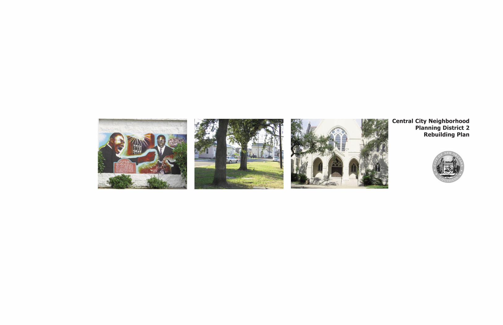
Central City Neighborhood Planning District 2
Rebuilding Plan

Central City Neighborhood, Planning District Two
Table of Contents
A. Central City Neighborhood 3Location and History 3Recovery Vision and Goals 4Planning Process and Neighborhood Participation 5Planning Efforts Pre-Hurricane Katrina 6
B. Pre-Hurricane Katrina Neighborhood ExistingConditions 7Land Use and Zoning 7Pre-Katrina Demographic Profile 7Recreation and Open Space 9 Roadway Hierarchy and Jurisdiction 9Housing, Architecture and Historic Preservation 10
C. Hurricane Katrina Neighborhood Impacts 13Extent of Flooding 13Damage Assessment
Residential Properties Damage Assessment 13Commercial Properties Damage Assessment 13Infrastructure Damage Assessment 13Parks and Open Space Damage Assessment 15Community Facilities 17
D. Neighborhood Rebuilding Scenarios 17Neighborhood Re-population 17
E. Neighborhood Recovery Plan 19Plan Elements
Key Recovery and Development Projects 19
F. Implementation and Funding Strategies 27
City Planning Commission:Planning DistrictDesignations
Introduction
Approximately 100 days after Hurricane Katrinastruck, Motion M-05-592 was unanimouslypassed by the City Council of New Orleans.This motion ensured that community-based,neighborhood-by-neighborhood planningwould be central to decisions associated withthe recovery of the most devastated areas ofNew Orleans. The City Council was adamantthat the people most impacted by the stormwould play a central role in defining the futureof their communities. Overall, 47 of the 73neighborhoods delineated by the City’sPlanning Commission have had plans preparedas part of this process.
The City Council charged a team of consultantsoverseen by Lambert Advisory & SHEDO withassisting neighborhoods flooded by HurricaneKatrina in developing revitalization plans thatare thoughtful and can be implemented, forincorporation into a citywide recovery andimprovement plan to be submitted to the Stateof Louisiana and federal funding agencies. Thisdocument is one of forty-two (42)neighborhood plans that meet that mandate.
Planning District 2, the subject of the followingreport, includes two geographically specificneighborhoods: Milan and Central City.
Basic assumptions also formed the basis for thePlanning District 2 Recovery Plan:
1) That a flood protection system will bedesigned to withstand future catastrophic lossfrom a 1 in 100 year storm and that this is acommitment by the Federal Government;
2) That stringent building codes will beimplemented to further limit wind damage;
3) That the basic urban structure of the city issound and that rebuilding will respect thisstructure;
4)That there is an organized, coherent andoperable Hurricane Evacuation Program.
2
Acknowledgements
With grateful appreciation the planning teamwould like to thank all the residents of District 2who participated in this planning process andwithout whose participation this plan would not bepossible.
Project Directory
City of New Orleans C. Ray Nagin, Mayor
New Orleans City Council:Oliver M. Thomas, PresidentArnie Fielkow, Vice-President Shelley Midura, District A Stacy S. Head, District BJames Carter, District C Cynthia Hedge-Morrell, District D Cynthia Willard-Lewis, District E
Project Management: Lambert Advisory, LLC Paul Lambert SHEDO, LLC Shelia Danzey
Overall Planning Consultant:
Bermello-Ajamil & Partners, Inc.Alfredo C. Sanchez, AIA, AICP
Hewitt-Washington, Inc. Lonnie Hewitt, AIA
Neighborhood Planners:
C. James & AssociatesCliff James
Byron J. Stewart & AssociatesByron Stewart
Cover Images from left to right:
A: Brown’s Velvet Dairy Fence B: La Salle Triangular ParkC: St. Charles Church

City of New Orleans Neighborhoods Rebuilding Plan
Location and History
The Central City Neighborhood occupies atriangular swath of Uptown New Orleans.Central City’s boundaries are, roughly, St.Charles Avenue to S. Broad and ToledanoStreet to the Pontchartrain Expressway. Theneighborhood also contains Zion City, atriangular shaped area north of S. Broad thatends at the vertex of Martin Luther King Jr.Boulevard and Washington Avenue. Alongwith the Milan Neighborhood, Central City iscontained within Planning District Two.
Though economically challenged, Central Cityis ideally located adjacent to the GardenDistrict and close to the Central BusinessDistrict. The neighborhood is ringed bymajor thoroughfares and delimited by thePontchartrain Expressway to the East.Primarily residential in character, Central Citywas once home to several thrivingcommercial corridors. Its strategic locationnear wealthy residential enclaves andbooming port facilities made it a naturalhome for the working class of all races and alogical entrepreneurial location for newlyarrived immigrants.
Long home to such a diverse population,Central City in recent years has becomeincreasingly racially homogeneous and,concurrently, economically depressed. Thisshift away from ethnic and economic diversitybelies Central City’s tradition of cross-culturalcommercial activity. Recent years havebrought to Central City the same sort of
social and economic strife that have plaguedother American cities’ urban cores. Poverty,drugs, and the violence associated with thedrug trade have combined to severely erodethe quality of life enjoyed by the residents ofCentral City.
According to research done by the CentralCity Renaissance Alliance as part of theirCommunity Plan, the area now referred to asCentral City was called “Back-of-Town.” Landin this area north of the inhabited St. CharlesAvenue corridor could not be settled until theinvention, by A. Baldwin Wood in 1915, of asystem of pumps capable of draining thisswampland. Prior to the introduction of thisnetwork of pumps, drainage of Central Citywas an uncertain proposition. Even thistentative balance of man and nature was notenough to stop the market-drivendevelopment of the land.
Because of unique social forces at work inNew Orleans, the Central City area was nevera physically segregated neighborhood.Laborers and artisans, black and white, allsettled in the areas near the docks, trainyards, and mills that were interspersedthroughout the neighborhood. The workingclass ethos of the neighborhood wasphysically manifested in traditional NewOrleans architectural styles. Shotgun housesdominate with larger homes occasionallydotting the landscape. As labor trendsshifted the number of unskilled workers inCentral City rose and, concurrently, thenumber of skilled laborers declined. This
3
A. Central City Neighborhood
Images from left to right:
A: Allie Mae Williams MSC CenterB: O.C. Haley Mixed-Use
Map: Old Map of New Orleans

Central City Neighborhood, Planning District Two
4
change led to an underutilization of theexisting housing stock and the creation oftenement-level housing conditions.Additional, external pressures were placed onCentral City by the construction, in the 1950’sand 1960’s, of large public housingdevelopments on the periphery of theneighborhood.
Prior to Hurricane Katrina, many in thecommunity believed that Central City hadturned the corner and was poised for arebirth. Newfound community activism,championed by groups such as the CentralCity Renaissance Alliance, had positioned theneighborhood for growth. Emphasis wasplaced on restoring commerce to traditionallocations such as Oretha Castle HaleyBoulevard and Claiborne Avenue andreturning civic institutions, such as theDryades YMCA, to the area. Combined withthe redevelopment of the adjacent housingdevelopments, Central City, prior to Katrina,was poised for dramatic redevelopment.
Recovery Vision and Goals
The Central City Neighborhood Rebuilding Planprovides a vision and framework for physicalimprovements, new service structures, andcommunity development opportunities inCentral City.
Vision
Central City is an historic, unique neighborhoodlocated in the heart of Uptown New Orleans.The residents of Central City envision acommunity in which people of varied racial andeconomic backgrounds can coexist and thrive inan environment that is fair, equitable, and just.The resulting redeveloped neighborhood shouldprovide a high quality of life and opportunitiesfor meaningful employment and homeownership. The restored Central Citycommunity will be rebuilt upon the same urbanframework that existed prior to HurricaneKatrina.
Neighborhood Recovery Goals
In an effort to rebuild and improve Central City’sbuilt-form environment to pre-Hurricane Katrinalevels, residents have communicated thefollowing, basic goals for their neighborhood:
• Rebuild and enhance the streets, sidewalks,and infrastructure of the Central CityNeighborhood;
• Remodel and restore the neighborhood’sexisting schools;
• Preserve and enhance Central City’sintricate, historic architectural fabric;
• Improve public safety by reconstructingCentral City’s First Responder network of policeand fire stations.
Above: Aerial Map of Central City Neighborhood
Images from left to right:
A: Carondelet Street ApartmentsB: Brown’s Velvet Dairy Fence C: 1519 Carondelet Residence
City of New Orleans Neighborhoods Rebuilding Plan
5
Images from left to right:
A-C: Milan ResidencesD: Louisiana & South Claiborne Avenue
In addition to these basic prerequisites forredevelopment, the Central City communityproffers the following specific recovery goals:
Create Equitable Redevelopment Options• The recovery of Central City should be just,humane, and democratically controlled by thepeople of Central City;
• When possible, Community BenefitsAgreements, such as the one agreed to by HomeDepot, should be negotiated between residentsand developers;
• Mixed-use buildings, with appropriate,locally owned businesses interspersed withprivate residences should be encouraged.
Restore and Redevelop ExistingCommercial Corridors• Turn O.C. Haley’s designation as a MainStreet Program designee into a catalyst foreconomic growth and cultural education;
• Reinforce Claiborne Avenue as a commercialcorridor;
• Redevelop St. Charles Avenue as CentralCity’s “Front Door;”
Provide Attractive Residential Options• Revitalize the C.J. Peete and B.W. Cooperhousing developments in a manner that benefitsboth the residents of Central City and the publichousing developments;
• Create attractive, architecturally
voice their concerns about theirneighborhood. The meetings were held asfollows:• Saturday, May 20th, 2006 – 2:00 P.M.at Holy Ghost Church, 2015 LouisianaAvenue. At this District Two meeting,residents from both the adjoining MilanNeighborhood and Central City werepresent to begin the community visioningprocess with the New OrleansNeighborhoods Rebuilding Teamconsultants.• Saturday, July 22nd, 2006 – 6:30 to8:30 P.M. at Israelite Baptist Church, 2100Martin Luther King Jr. Boulevard. At thismeeting input was sought from theleadership of the Central City RenaissanceAlliance. Prior to Katrina the CCRA hadbeen actively engaged in a neighborhoodplanning process for Central City.• Saturday, August 19th, 2006 2:00 to4:00 P.M. at Central City EOC, 2020Jackson Avenue. This was the secondformal meeting with members of the EOCand the CCRA.
appropriate, and affordable residential infillconstruction options;
• Develop affordable housing solutions thatinclude home ownership as well as rentaloptions;
• Aggressively restore blighted properties tothe marketplace or civic use;
Upgrade Existing Parks and Open Spaces• Adaptively reuse empty lots as public parks;
• Where appropriate, add attractivelandscaping to public spaces.
Planning Process andNeighborhood Participation
The Central City neighborhood is served byseveral active associations. Includedamong these are Central City Partnershipand the Central City Renaissance Alliance.More than any other New Orleansneighborhood, Central City is well servedby a multitude of Churches and faith-basedorganizations. Throughout this processinput was gleaned from these and othersources.
Schedule of Neighborhood Meetings
Over a period of four months, severalneighborhood and district-wide, meetingswere held by the SHEDO/ Lambert Advisoryplanning consultants to allow citizens to

Central City Neighborhood, Planning District Two
6
Planning Efforts Pre-Katrina
Pre-Katrina planning efforts in Central Citywere quite extensive due to the efforts ofthe Central City Renaissance Alliance andthe Central City Partnership. In 2004 theCity of New Orleans contracted withConcordia, LLC to begin a communityplanning initiative in Central City. Fundedby local and national organizations, theplanning team engaged various members ofthe community, including businesspersons,religious leaders, artists, laborers,students, and non-profit staff members.
At the conclusion of their nine-monthcommission, the CCRA Steering committeeissued key recommendations in thefollowing areas: Community Connections,Telling the Community Story, Housing in theCommunity, Community Beautification,Employing the Community, and CommunityWealth Building, An Educated Community,and A Healthy and Safe Community. Theirrecommendations are incorporated into thisreport’s Recovery Plan.
Additionally, a series of city-wide planninginitiatives were undertaken in recent yearsthat examined both district-wide andneighborhood-specific issues. Planningefforts included the City of New Orleans’1999 Land Use Plan, the New Century NewOrleans Parks Master Plan of 2002 and theTransportation Master Plan of 2004.
The 1999 Land Use Plan identified severalkey issues and challenges that affected thequality of life in Central City. Theseincluded:
• Disinvestment and blight in both residential and commercial areas
• Problems relative to improvements of public housing developments
• Pressure from institutional uses andarea hospitals
• Allowed uses that are incompatible with quality, residential life, i.e., bars, bed and breakfasts
• Inadequate respect for historical properties
In response, the Plan made several keyrecommendations for District Two andCentral City. The most significantrecommendation for the district was theapplication of two types of Mixed-Use landcategories in areas where residentialactivity has traditionally coexisted withcommercial interests (neighborhood-scalemixed-use) and in industrial areas such asalong the Pontchartrain Expressway(Urban-Scale Mixed-Use).
The New Century New Orleans Parks MasterPlan of 2002 inventoried and assessed thecondition of District Two’s 28 acres of parksand open spaces.
The Plan determined that Central Cityshould be considered for a multi-purposerecreation center and identified the old
Central City incinerator site at 7th Streetand Saratoga as a possible location.
The Transportation Master Plan of 2004recommended a variety of improvements inDistrict Two. In particular, it recommendedthe creation of bicycle lanes, a study ofpossible mass transit route extensions, anddesignation of specific roads as truckroutes.

City of New Orleans Neighborhoods Rebuilding Plan
7
B. Pre-Hurricane Katrina Neighborhood Existing Conditions
relatively high number of school-agedchildren is significant due to the per-pupilapportionment of education funds bygovernmental agencies.
The move toward racial homogeneity inCentral City continued, according to theCensus. In 2000, the neighborhood wasmore than 87% African-American withWhites comprising approximately 10% ofthe population.
Several indicators point to the persistenceof poverty and social distress in CentralCity. First, only 16.3 percent of CentralCity residents live in owner-occupiedhousing. The national home ownershipaverage is 66.2 percent.
Residents often point out that the lack ofowner-occupied housing contributes tomany ills in the neighborhood relating tocrime and safety. Secondly, the 2000Census identifies nearly one-fourth,21.2%, of all housing units in Central Cityas vacant, compared to the nationalvacancy average of 9%.
Most telling may be the number of childrenand others living below the federally-defined poverty line. Central City,regrettably, leads New Orleans in thiscategory with 75.2% of children under theage of five living below the poverty line.
This population of children in poverty mustbe considered by any recovery plan due to
Land Use and Zoning
Changing land uses and an organic growthpattern have resulted in a variety of zoningclassifications being present in Central City.The predominant classification is RS-1,which permits single-family detacheddwellings. This gives the majority of theneighborhood a residential character. TheC-1, or General Commercial District, zoningdesignation applies mainly to the portion ofCentral City from St. Charles Avenue toClaiborne and from Louisiana Avenue toMLK Boulevard.
When discounting open space, residentialuses account for about 59% of total land inDistrict Two while commercial uses accountfor about 29% of total land. As is the casein many older neighborhoods, Central Cityhas an opportunity to redevelop in a waythat that refocuses redevelopment arounda variety of land uses that enhance thecharacter of the neighborhood.
Pre-Katrina Demographic Profile
Prior to Hurricane Katrina, according toCensus 2000 data, the population ofCentral City was 19,072. The 2000 Censusidentified 8,147 households in the areawith an average household size of 2.34persons.
More than thirty percent of the populationwas under the age of eighteen. This
Image at right:
A: Erato and S. White in Zion City
Maps at center:Central City Neighborhood Present Land-Use Map (Above)
Central City Neighborhood PresentZoning Map (Below)

Central City Neighborhood, Planning District Two
8
their reliance upon an intricate network ofsocial programs for their survival. Thetotal percentage of residents living belowthe poverty line is 48.8%.
Mobility and Transportation
More than 56% of the total occupiedhousing units have no vehicle available. Ofthe total number of workers living in thearea, more than 29% rely on public buses,streetcars, taxis, and other modes oftransportation to get to their place ofemployment. Nearly 40% of the residentstravel less than thirty minutes to workwhile the remainder requires 30 to 60minutes travel time. More than residentsof other New Orleans neighborhoods,Central City residents’ ability to go to andfrom work is a function of a reliable publictransit system.
Source: U.S. Census 2000; the Greater New Orleans Community Data Center at http://gnocdc.org/orleans/
Recreation and Open SpaceCentral City offers relatively few recreationareas within the neighborhood. There are,however, several recreational areas inadjacent neighborhoods such as Milan andthe Lower Garden District. The 2002Parks, Recreation and open Space planidentified three formal parks/playgroundsin Central City:
• A. L. Davis Playground-Davis playground is a large, 4.59-acre city-owned park with a full list of amenitiesincluding playground equipment, basketballcourts, a multi-purpose field, baseballdiamond, and lights. Additionally, it servesa dual purpose as a gathering spot forseveral tribes of Mardi Gras Indians duringcarnival season and the springtimeparading season.
• Taylor Playground-Taylor Playground is a 3.23-acre NORDplayground that features a multi-purposefield, baseball diamond and swimmingpool. It is located in the Hoffman Trianglesection of Central City.
• Van McMurray Park-Van McMurray Park sits on a 2.61-acre siteand features a multi-purpose field, baseballdiamond, and a basketball court.
The Recreation Plan proposed the creationof new parks in the area including a majorcommunity park at the site of the SaratogaIncinerator.
Images from left to right:
A: Two-Family Home in Zion CityB: Freret near 3rdC: Triangular Park at at WashingtonAvenue and Toleda Avenue

City of New Orleans Neighborhoods Rebuilding Plan
9
Images from left to right:
A: Typical StreetB: Shotgun Row on Freret near 3rd
Roadway Hierarchy andJurisdiction
Central City is defined by a road networkthat includes almost every type of roadwayclassification and jurisdiction. There areroads under local control, a state highway(U.S. 90-Claiborne Avenue), and portionsof the federally funded Interstate HighwaySystem (I-10 and the PontchartrainExpressway).
Major arterials that bisect theneighborhood include St. Charles Avenue,South Claiborne, South Galvez, WashingtonAvenue, Jackson Avenue, and MartinLuther King Jr. Boulevard.
The most important commercial corridorsrun along an east/west vector. Theyinclude St. Charles Avenue, O.C. Haley,and Claiborne Avenue. Each, at varioustimes, has occupied an important, distinctniche in the city’s history. Currently,Claiborne Avenue serves primarily as atraffic throughway while St. CharlesAvenue retains more of an upscalecharacter. O.C. Haley’s recent designationas a Main Street will probably lead toincreased vehicular and pedestrian trafficalong its commercial corridor.
Central City is also bordered by the St.Charles Avenue Streetcar Line, whichprovides service to Carrollton as well asthe universities and downtown NewOrleans. Currently, the streetcar has beenCentral City Neighborhood - Major Thoroughfares
replaced by bus service while repairs tothe Carrollton Car Barn and streetcars areunderway.
In general, the neighborhood benefitsfrom its central geographic position whilenot suffering the fate of other centrally-located neighborhoods, such as Treme,that are bisected by elevatedexpressways. Central City’s street gridremains conducive to residential andcommercial development.
Housing, Architecture and HistoricPreservation
Housing
As previously noted, Central City is hometo a disproportionately high number,83.7%, of renters. Of the 8,147 totaloccupied housing units in Central City only16.3% were owner-occupied, according tothe 2000 Census. Significantly, 51.8% ofthe housing stock was constructed prior to1949. The high proportion of rental unitscombined with a high concentration of lowto moderate income renters partiallyexplains the relatively poor condition ofthe housing stock in the neighborhoodprior to the storm. Rents of these homes,generally, did not support the cost ofregular upkeep. This exacerbated thedamage done by absentee landlords whomay have purchased scatter-site unitswith the intention of maximizing profits by

Central City Neighborhood, Planning District Two
10
Images from left to right:
A: Daughters’ of Universal - St. JohnGrand Lodge on HaleyB: 1519 Carondelet - Single-FamilyResidence
putting as little investment into theproperty as possible or who inherited thehome but live elsewhere.
This convergence of factors led to CentralCity having the highest vacancy rate in thecity at 21.2%. A significant number ofthese homes, over the years, becameblighted and were either abandoned or tiedup in a cumbersome adjudication process.Blighted and adjudicated propertiesconsistently top the lists of residentconcerns.
Architecture
While the variety of house styles and typesprecludes the selection of a typical home,the native architectural language of NewOrleans is spoken in Central City. StatelyVictorian-era commercial buildings alongSt. Charles Avenue give way to morehumble shotgun-style accommodations asone penetrates further into theneighborhood. Almost all of the significanthomes feature above-grade constructionwith the older homes having unoccupiedfirst floors. Most commercial buildings in
the area are utilitarian in design and speaklittle to the local architectural vernacular.
Historic Preservation
The Central City Neighborhood, especiallynear St. Charles Avenue, is recognized as alocal historic district by the New OrleansHistoric Districts Landmarks Commissionand a National Register District by thefederal government. The nationaldesignation covers the majority of the landmass in Central City while the localdesignation applies only to the mosthistoric properties in the vicinity of St.Charles Avenue. Of the two, the localdesignation is the only one that hasenforcement power. Changes to theexterior of historic structures must beapproved by the HDLC. If the changes orbuilding plans are approved a Certificate ofAppropriateness is issued and work isallowed to begin.
The preservation of the historic structuresalong O.C. Haley is the key to rejuvenatinglarge swaths of Central City. The recentdesignation of Haley as a Main Street will
Central City Neighborhood - Community Gardens
City of New Orleans Neighborhoods Rebuilding Plan
11
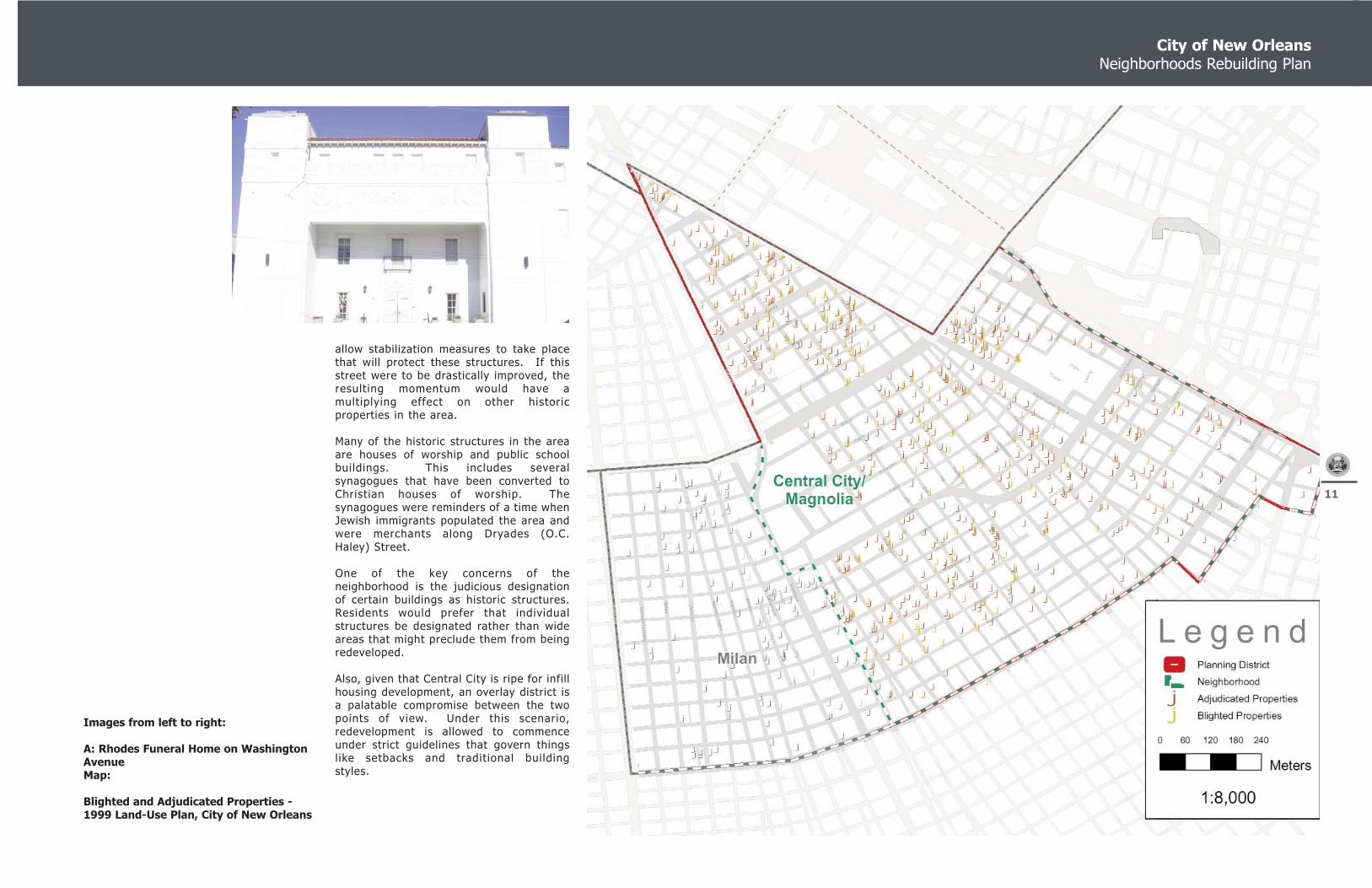
Images from left to right:
A: Rhodes Funeral Home on WashingtonAvenueMap:
Blighted and Adjudicated Properties -1999 Land-Use Plan, City of New Orleans
allow stabilization measures to take placethat will protect these structures. If thisstreet were to be drastically improved, theresulting momentum would have amultiplying effect on other historicproperties in the area.
Many of the historic structures in the areaare houses of worship and public schoolbuildings. This includes severalsynagogues that have been converted toChristian houses of worship. Thesynagogues were reminders of a time whenJewish immigrants populated the area andwere merchants along Dryades (O.C.Haley) Street.
One of the key concerns of theneighborhood is the judicious designationof certain buildings as historic structures.Residents would prefer that individualstructures be designated rather than wideareas that might preclude them from beingredeveloped.
Also, given that Central City is ripe for infillhousing development, an overlay district isa palatable compromise between the twopoints of view. Under this scenario,redevelopment is allowed to commenceunder strict guidelines that govern thingslike setbacks and traditional buildingstyles.

Central City Neighborhood, Planning District Two
12THIS PAGE LEFT BLANK INTENTIONALLY
City of New Orleans Neighborhoods Rebuilding Plan
13
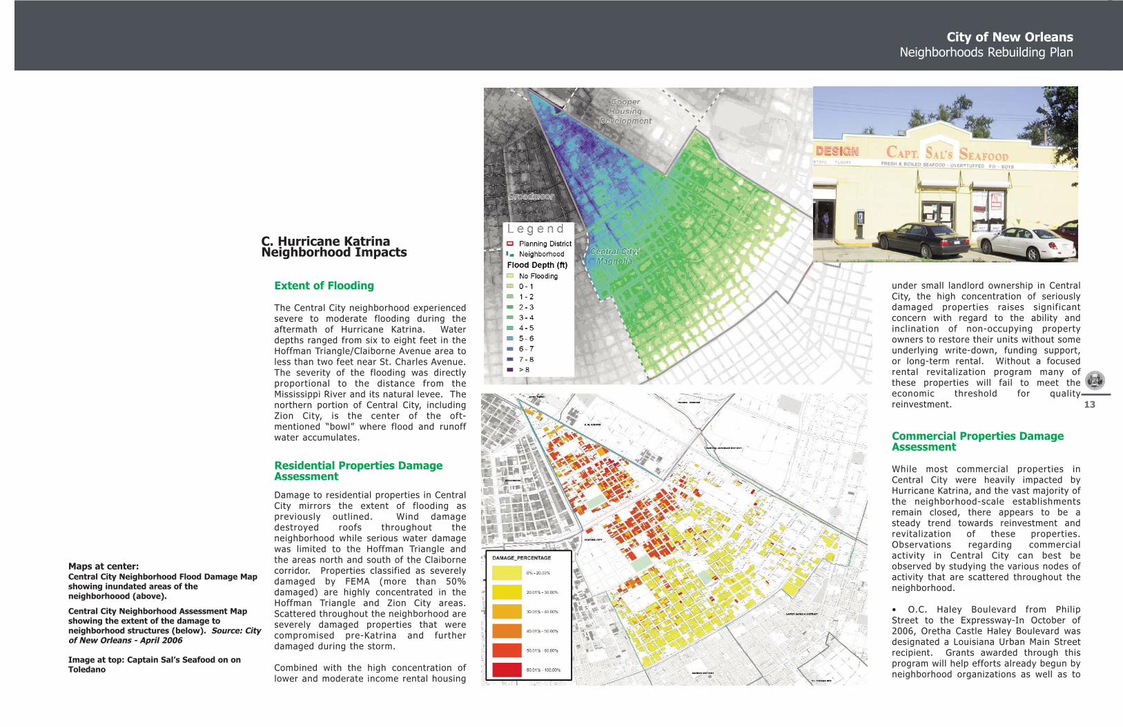
Maps at center:Central City Neighborhood Flood Damage Mapshowing inundated areas of theneighborhoood (above).
Central City Neighborhood Assessment Mapshowing the extent of the damage toneighborhood structures (below). Source: Cityof New Orleans - April 2006
Image at top: Captain Sal’s Seafood on onToledano
C. Hurricane Katrina Neighborhood Impacts
Extent of Flooding
The Central City neighborhood experiencedsevere to moderate flooding during theaftermath of Hurricane Katrina. Waterdepths ranged from six to eight feet in theHoffman Triangle/Claiborne Avenue area toless than two feet near St. Charles Avenue.The severity of the flooding was directlyproportional to the distance from theMississippi River and its natural levee. Thenorthern portion of Central City, includingZion City, is the center of the oft-mentioned “bowl” where flood and runoffwater accumulates.
Residential Properties DamageAssessment
Damage to residential properties in CentralCity mirrors the extent of flooding aspreviously outlined. Wind damagedestroyed roofs throughout theneighborhood while serious water damagewas limited to the Hoffman Triangle andthe areas north and south of the Claibornecorridor. Properties classified as severelydamaged by FEMA (more than 50%damaged) are highly concentrated in theHoffman Triangle and Zion City areas.Scattered throughout the neighborhood areseverely damaged properties that werecompromised pre-Katrina and furtherdamaged during the storm.
Combined with the high concentration oflower and moderate income rental housing
under small landlord ownership in CentralCity, the high concentration of seriouslydamaged properties raises significantconcern with regard to the ability andinclination of non-occupying propertyowners to restore their units without someunderlying write-down, funding support,or long-term rental. Without a focusedrental revitalization program many ofthese properties will fail to meet theeconomic threshold for qualityreinvestment.
Commercial Properties DamageAssessment
While most commercial properties inCentral City were heavily impacted byHurricane Katrina, and the vast majority ofthe neighborhood-scale establishmentsremain closed, there appears to be asteady trend towards reinvestment andrevitalization of these properties.Observations regarding commercialactivity in Central City can best beobserved by studying the various nodes ofactivity that are scattered throughout theneighborhood.
• O.C. Haley Boulevard from PhilipStreet to the Expressway-In October of2006, Oretha Castle Haley Boulevard wasdesignated a Louisiana Urban Main Streetrecipient. Grants awarded through thisprogram will help efforts already begun byneighborhood organizations as well as to

Central City Neighborhood, Planning District Two
14
Images from left to right:
A: Bohn Motor Company on S. Broad
At center: State of the Streets in theNeighborhood
begin new initiatives in the area. Theprogram is designed to restore oncethriving commercial corridors to economicviability. Fortunately, O.C. Haley anchorslike Café Reconcile and the Ashe Centerare open for business. As residentialdevelopments, such as the proposedFelicity Place on the Albertson’s site, inchtowards the Haley corridor a new mix ofbusinesses is expected to open. Thenature of these enterprises will be dictatedby the character and economic realities ofthe future and current residents.
• St. Charles Avenue from Toledano tothe Expressway-This stretch of St. CharlesAvenue is a mixed bag of commercialactivity. Fast food outlets, Walgreen’s, andseveral upscale restaurants have reopenedbut several large restaurants (Bravo,Cheesecake Bistro, and others) remainclosed. Given that these establishmentsserved the larger, citywide community it isexpected that, as local population rises,these locations will return to commerce.Properties along St. Charles Avenuesuffered no damage from floodwaters.
• S. Claiborne From Toledano to theExpressway- Extensive flooding ravaged allcommercial property along ClaiborneAvenue and most remains closed. Theformer scrap metal recycling yard at theintersection of S. Claiborne and thePontchartrain Expressway has closed andwill become the site of a Home Depotstore. Central City community leaders

City of New Orleans Neighborhoods Rebuilding Plan
15
have negotiated several key concessionsfrom Home Depot. Included among theseis a Community Benefits Agreement thatrequires the company to hire employeesfrom the area. Further, residents havereceived several design concessions withregards to scale and building materials inan effort lessen the big-box store’s impacton the community.
• MLK JR. Boulevard- This corridor ishome to two of New Orleans’ iconic culinaryinstitutions: Brown’s Velvet Dairy andLeidenheimer Bakery. Brown’s has returnedto full business, as damage to their plantwas minimal. The bakery has yet toresume full operations at the historiclocation.
• Industrial Corridors- The industrialactivity in the neighborhood, particularlyalong the Expressway and in the HoffmanTriangle/Zion City area, appears to belargely restored to the pre- Katrina levels.
Infrastructure DamageAssessment
The infrastructure damage assessmentcarried out was limited to drive-byevaluations of street conditions conductedby the Neighborhood Planning Consultant.No underground utilities were assessed;however the consultant and neighborhoodgroups were able to determine thatBellSouth has been working to install fiberoptic lines in the area. One planning
challenge has been the fact that fiberoptic lines require aboveground connectionbox installations, which are considered bythe neighborhood to be visually intrusivein exposed areas. Entergy has restoredpower to the entirety of Central City.
Information based upon visual inspectionincluded specific conditions as follows:missing street signs, damaged street lights,sidewalks and pedestrian circulation, etc.
Street Conditions
Damage to the streets of Central Cityduring Hurricane Katrina and thesubsequent clearing of debris wassubstantial. Based on a block-by-block,street-by-street assessment, it wasdetermined that many streets require somedegree of repair or resurfacing. While themain east-west thoroughfares of S.Claiborne Avenue and St. Charles avenueare still in relatively good condition, mostminor, north-south streets are is a severestate of disrepair. Streets in the Hoffmantriangle and Zion City, in particular, presenta hazard for motorists and pedestrians.
The CCRA Planning committee and generalmembership identified, on June 30th, 2006,several roadways that are in immediateneed of resurfacing and repair. Theseinclude: Jackson Avenue; Josephine Street(Hoffman Triangle); Washington Avenue; S.Galvez, Magnolia Street, Baronne, Erato,and Broad Street.
Street Signage and Way-Finding
Street signs and way-finding signssustained heavy loss in Central City. InOctober of 2006 the City of New Orleans,using a federal grant, began a systematicreplacement of damaged street sign in thecity. This process began in the moreheavily populated Uptown section and willcontinue until the Spring of 2007. In thisinstance, Central City’s location works toits advantage in that it will be one of thefirst areas to be targeted.
Street Lights
Individual installations sustained damagefrom wind, flooding, etc. Repairs havebeen made incrementally.
Sidewalks/Pedestrian CirculationDamage Assessment
There are broad areas of sidewalks withinCentral City that were damaged as a resultof Hurricane Katrina. The majority ofthese sidewalks were either broken byoverturned trees or the weight of debrisremoval equipment.
Parks and Open Space DamageAssessment
Hurricane Katrina had a tremendous impacton the parks of Central City. Parks areparticularly at risk, given that FEMA
allocates virtually no funding for therecovery of green space and trees.Compounding this is the fact that federalfunding for the removal of dead andpotentially missile canopy has beendifficult to obtain.
All of the parks in the neighborhood weredamaged including A.L. Davis Playground,Taylor Playground, and Van McMurray Park.Wholesale renewal of these open spaces isin order. Since Davis Playground is hometo a large FEMA trailer park the residentsbelieve that it should be restored to acondition that is better than what it wasbefore the storm.
Passive green spaces, such as the neutralgrounds in the area, suffered loss oflandscaping and tree canopy. In additionto their aesthetic benefit it has beenobserved that the planting of indigenoustrees near homes can be a buffer to thewinds and may even dissipate the force. Itis strongly encouraged that these trees bereplaced.
Community Facilities, Schoolsand Universities
There is a broad range of public andcommunity facilities located in Central City.As is expected of a neighborhood with alarge juvenile population, a large portion ofthe community facilities are public schools.All public schools in the area sustained

Central City Neighborhood, Planning District Two
16
some form of damage during HurricaneKatrina. One elementary school, Oretha C.Haley Elementary suffered serious firedamage in an October 2006 blaze. Again,the most serious damage was to schools inthe Hoffman Triangle area. New Orleansschools, Post-Katrina, are run by myriadagencies and schedules for reopening arein a state of flux. As of October 2006, thestatus of Central City’s public schools is asfollows:
• Edgar Harney Elementary School-now open as Dr. Martin Luther king Jr.
School for Science and Technology,RSD
• James M. Singleton Charter School-Open as RSD Charter
• Carter D. Woodson Middle School-Remains Closed
• Thomy Lafon School-Closed
• Joseph S. Clark Senior High School- Open as Recovery District School
• Sylvanie Williams School- Closed
• John Hoffman Elementary School-Closed
• William J. Guste Elementary School-Closed
Other major community facilities in thearea include the Allie Mae Williams
Community Center located at 2020 JacksonAvenue and the Dryades Street YMCAcomplex located at 2220 Oretha CastleHaley Boulevard. Both facilities sustaineda moderate amount of damage and haveresumed a limited schedule of activities.
One community facility that has assumed aprominent role in the post-Katrina culturallandscape is the Ashe Cultural Arts Centerat 1712 O.C. Haley Boulevard. The AsheCenter serves a variety of roles includingperforming arts venue, gallery and meetingspace.

City of New Orleans Neighborhoods Rebuilding Plan
17
Images from left to right:
A: View towards Downtown New Orleans
D. Neighborhood RebuildingScenarios
The proposed recovery plan will conform tothe existing neighborhood urban structure.The recovery plan is predicated upon thefact that residents, investors, andbusinesses can flourish and property valuescan be enhanced based upon the existingstreet grid and pattern of development withlimited intervention as it relates to zoningand other land use changes.
Changes that may occur will beconcentrated in areas that are conducive toa wide range of development options.Prime candidates for redevelopment includethe S. Claiborne Avenue corridor, a varietyof sites in the Hoffman Triangle area, andthe entirety of Zion City.
Central City benefits from having gonethrough two complete planning processes:the Central City Renaissance Alliance’sCommunity Plan before Katrina and the CityCouncil-sponsored Danzey/LambertNeighborhoods Rebuilding Plan afterKatrina. The community has identifiedseveral specific goals and over-archingpolicies for the recovery of theneighborhood.
• Manage issues and pressure relatedto gentrification. The community wants toassure that local CDC’s with the capacity todevelop affordable housing are given theopportunity to do so. This initiative,identified in the Concordia/CCRA plan, is anatural companion to the “Lot-Next-Door”policy that this plan proposes and will detail
in Section E. Central City residents desirenew and creative policy initiatives that willresult in increased home ownership andstake-holding in the community.
• Create a network of parks and greenspaces that afford all residents of CentralCity, regardless of economic condition,access to the health benefits afforded bypublic parks. Neighborhoods parks shouldbe made more user-friendly by includinghuman-scale amenities. Recreation shouldbe decentralized by shifting emphasis awayfrom large, group-oriented parks to thecreation of pocket parks and walking paths.
• Focus on both for-sale and rentalhousing redevelopment and reconstructionand the implementation of key policiesdetailed later in this document that willassist in ensuring that the housing stock ofthe neighborhood is restored in an sensitivefashion (particularly as it relates to thehistoric character) and the condition of thehousing stock and stability ofneighborhoods in improved to a housinglevel beyond that which existed prior toKatrina;
• Restoration of basic public servicesand utilities such as efficient trash anddebris collection and door-to-door postalservice serve as benchmarks and signal toresidents that the community is viable andworthy of reinvestment.
• Build community wealth byproviding financial services to residents.Hope Credit Union’s range of servicesshould be enhanced and extended to asmany residents as possible. Initiatives suchas the micro-loan program and training forentrepreneurs can provide the basis foreconomic growth.
• Create a safe community byinvolving residents in a variety of proactivecrime-fighting measures. Central Cityresidents desire a citizen-led solution tothe gripping waves of violence that plaguetheir community. In addition to traditionalNew Orleans Police Department techniquesit is suggested that crime in Central Citycan be combated by implementing quality-of-life measures such as litter abatement,empty lot management, and faith-basedinitiatives.
The economic future of Central City is thekey to its recovery. Long home to a widevariety of seemingly incompatible landuses, Central City’s organic growth patternmust be respected by future commercialand industrial enterprises. The communityis committed that any future commercialredevelopment scenario ensures:
• Full commitment to the O.C. HaleyMain Street project. Revitalization of thecore of Central City depends upon thesuccess of this project. The Main Streetdesignation is but the first step. Newbusinesses must be lured, new residents
must move in, and the community as awhole must be convinced that this is a safeand viable area.
• Central City is a walkableneighborhood and the qualities that make itsuch must be preserved. Code items suchas minimum setback rules must becombined with pedestrian amenities thatkeep people moving through public spacesand enhance public safety by keeping eyeson the street.
• The community will ensure asymbiotic relationship between residents'needs and concerns and the needs andconcerns of neighborhood businesses.
• Central City must encourage therecovery of the small business communityin any way possible.
• Central City must seek a way tocapitalize on the cultural assets embeddedwithin the community. An example of thisis the culture surrounding the Mardi GrasIndians, many of whom reside in theneighborhood. Locals and visitors come tothe area for an authentic experience.Central City must find a way to capture thisrevenue by adding value to the experience.Past plans have proposed the creation ofhistoric, resident-led tours that would beoffered to visitors. Solutions such as thesecapture tourist revenue and multiply itthrough the local economy by employingneighborhood residents.

Central City Neighborhood, Planning District Two
18THIS PAGE LEFT BLANK INTENTIONALLY
City of New Orleans Neighborhoods Rebuilding Plan
19
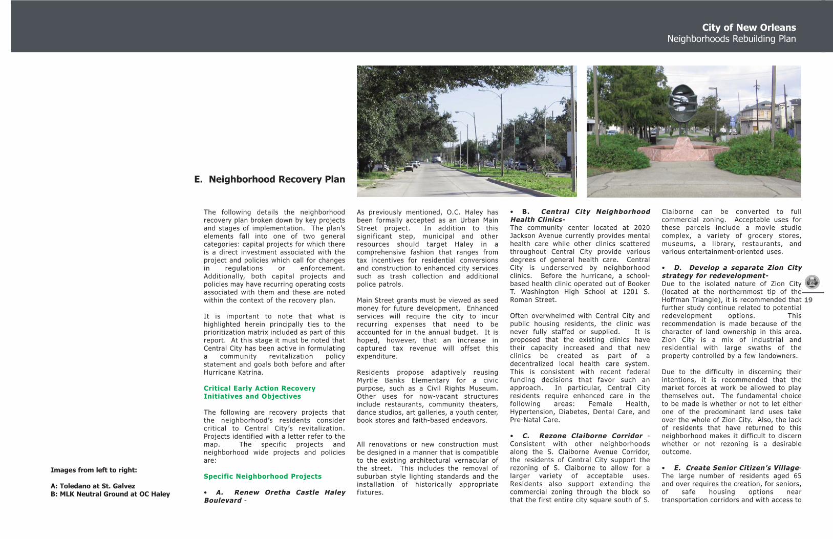
Images from left to right:
A: Toledano at St. GalvezB: MLK Neutral Ground at OC Haley
E. Neighborhood Recovery Plan
• B. Central City NeighborhoodHealth Clinics-The community center located at 2020Jackson Avenue currently provides mentalhealth care while other clinics scatteredthroughout Central City provide variousdegrees of general health care. CentralCity is underserved by neighborhoodclinics. Before the hurricane, a school-based health clinic operated out of BookerT. Washington High School at 1201 S.Roman Street.
Often overwhelmed with Central City andpublic housing residents, the clinic wasnever fully staffed or supplied. It isproposed that the existing clinics havetheir capacity increased and that newclinics be created as part of adecentralized local health care system.This is consistent with recent federalfunding decisions that favor such anapproach. In particular, Central Cityresidents require enhanced care in thefollowing areas: Female Health,Hypertension, Diabetes, Dental Care, andPre-Natal Care.
• C. Rezone Claiborne Corridor -Consistent with other neighborhoodsalong the S. Claiborne Avenue Corridor,the residents of Central City support therezoning of S. Claiborne to allow for alarger variety of acceptable uses.Residents also support extending thecommercial zoning through the block sothat the first entire city square south of S.
Claiborne can be converted to fullcommercial zoning. Acceptable uses forthese parcels include a movie studiocomplex, a variety of grocery stores,museums, a library, restaurants, andvarious entertainment-oriented uses.
• D. Develop a separate Zion Citystrategy for redevelopment- Due to the isolated nature of Zion City(located at the northernmost tip of theHoffman Triangle), it is recommended thatfurther study continue related to potentialredevelopment options. Thisrecommendation is made because of thecharacter of land ownership in this area.Zion City is a mix of industrial andresidential with large swaths of theproperty controlled by a few landowners.
Due to the difficulty in discerning theirintentions, it is recommended that themarket forces at work be allowed to playthemselves out. The fundamental choiceto be made is whether or not to let eitherone of the predominant land uses takeover the whole of Zion City. Also, the lackof residents that have returned to thisneighborhood makes it difficult to discernwhether or not rezoning is a desirableoutcome.
• E. Create Senior Citizen’s Village-The large number of residents aged 65and over requires the creation, for seniors,of safe housing options neartransportation corridors and with access to
The following details the neighborhoodrecovery plan broken down by key projectsand stages of implementation. The plan’selements fall into one of two generalcategories: capital projects for which thereis a direct investment associated with theproject and policies which call for changesin regulations or enforcement.Additionally, both capital projects andpolicies may have recurring operating costsassociated with them and these are notedwithin the context of the recovery plan.
It is important to note that what ishighlighted herein principally ties to theprioritization matrix included as part of thisreport. At this stage it must be noted thatCentral City has been active in formulatinga community revitalization policystatement and goals both before and afterHurricane Katrina.
Critical Early Action RecoveryInitiatives and Objectives
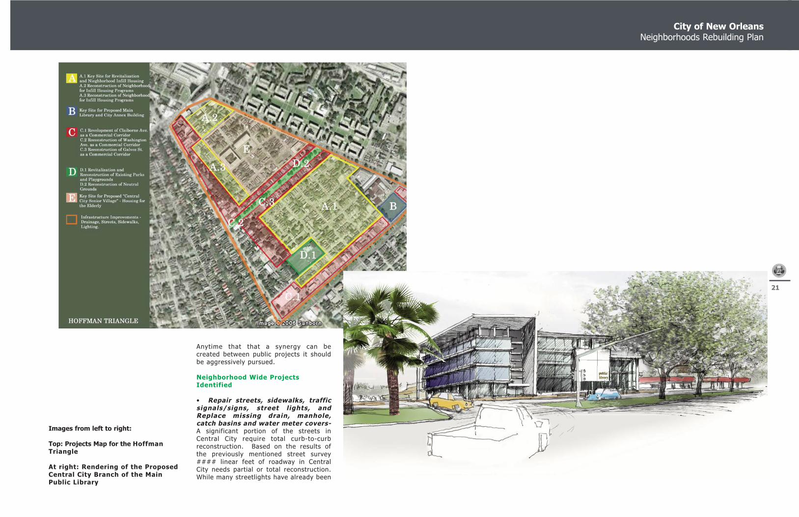
The following are recovery projects thatthe neighborhood’s residents considercritical to Central City’s revitalization.Projects identified with a letter refer to themap. The specific projects andneighborhood wide projects and policiesare:
Specific Neighborhood Projects
• A. Renew Oretha Castle HaleyBoulevard -
As previously mentioned, O.C. Haley hasbeen formally accepted as an Urban MainStreet project. In addition to thissignificant step, municipal and otherresources should target Haley in acomprehensive fashion that ranges fromtax incentives for residential conversionsand construction to enhanced city servicessuch as trash collection and additionalpolice patrols.
Main Street grants must be viewed as seedmoney for future development. Enhancedservices will require the city to incurrecurring expenses that need to beaccounted for in the annual budget. It ishoped, however, that an increase incaptured tax revenue will offset thisexpenditure.
Residents propose adaptively reusingMyrtle Banks Elementary for a civicpurpose, such as a Civil Rights Museum.Other uses for now-vacant structuresinclude restaurants, community theaters,dance studios, art galleries, a youth center,book stores and faith-based endeavors.
All renovations or new construction mustbe designed in a manner that is compatibleto the existing architectural vernacular ofthe street. This includes the removal ofsuburban style lighting standards and theinstallation of historically appropriatefixtures.

Central City Neighborhood, Planning District Two
20
health care facilities. The best option is tobuild upon the existing presence of seniorfacilities along the Louisiana Avenuecorridor. By concentrating resources inthis area a critical mass can be reached,thus allowing for a wide range of servicesfor seniors to be concentrated and aneconomy of scale to be obtained.
• F. Redevelop the Brownfield atthe Saratoga Street Incinerator site-Federal funds should be leveraged toremediated ground contamination at theSaratoga Street Incinerator site. CentralCity residents would like the remediatedsite to become a passive greenspace.
• G. New Public Library on S.Claiborne- It is becoming increasing clearthat parking limitations and buildingdisrepair have become major issues at theLoyola Avenue Main Library Branch.Combined with a shift westward of thecity’s center of population, Central Citybecomes the logical choice for a proposednew Main Public Library Branch.
The proposed change in zoning will allowfor a large parcel of land to be assembledfor the library. This would allow for thecreation of numerous parking options forcitizens as well as provide a location that isaccessible by a number of Regional TransitAuthority lines.
A key factor in library location ought to beproximity to the local public schools.
At right:
Central City Neighborhood Projects Map
City of New Orleans Neighborhoods Rebuilding Plan
21
Anytime that that a synergy can becreated between public projects it shouldbe aggressively pursued.
Neighborhood Wide ProjectsIdentified
• Repair streets, sidewalks, trafficsignals/signs, street lights, andReplace missing drain, manhole,catch basins and water meter covers-A significant portion of the streets inCentral City require total curb-to-curbreconstruction. Based on the results ofthe previously mentioned street survey#### linear feet of roadway in CentralCity needs partial or total reconstruction.While many streetlights have already been
Images from left to right:
Top: Projects Map for the HoffmanTriangle
At right: Rendering of the ProposedCentral City Branch of the MainPublic Library

Central City Neighborhood, Planning District Two
22
repaired, the introduction of moreattractive pedestrian-scale lighting ispreferred in areas where reasonable. Alldrain, manhole, catch basis and watermeter covers also require replacement.
• Restore Public Schools in theneighborhood- As part of the planning process, residentswere able to prioritize which schools theywould like to see open and the order inwhich they would accept students. Theyalso envisioned a completely restoredfeeder-school network in which schoolswould be opened on both the Lakeside andRiverside of S.Claiborne Avenues. Unusedschools should be placed in the control ofcommunity-based organizations that wouldutilize the sites for community benefitpurposes.
Specifically, Booker T. Washington shouldbe reopened as a city-wide access schoolfor career and vocational development.Carter G. Woodson should be rebuilt as thecenterpiece of a Central City feeder-schoolsystem. Residents living on the Lakeside ofS. Claiborne prioritize the reopening ofHoffman, Chester, and Sylvanie Williamsschools in the aforementioned order.Riverside schools to be reopened include,in order, Harney, Guste, Lafon, and MahaliaJackson.
If not reopened as public schools, MyrtleBanks, Durham, and Mahalia Jacksonschool sites can be converted to
Community Benefit locations. Adaptivereuse of these buildings and coordinationwith existing recreation facilities can createa variety of redevelopment or reuseoptions.
• Repair, Restore and Improve allUnderground Utilities – The City’s water system continues torequire repair despite significant progressin recent months. It is important that theFederal government and State entitiesinsure that the Sewage & Water Board hasthe necessary resources to quickly repairsystems and the Sewage & Water Boarddevelop a rational plan for addressing theleaks and breaks in the system so thatabove ground improvements can begin.
• Home Depot location at S.Claiborne and PontchartrainExpressway-Plans have recently been announced toconstruct a Home Depot in Central City. Itwill occupy an industrial site bordering onthe expressway. Currently, the site is beingremediated and cleared. Residents ofCentral City have secured severalconcessions from the developers withregards to building design and lotplacement.
To mitigate the fact that this is still a big-box store, Home Depot will go through adesign process that will ensureconstruction of a culturally andarchitecturally appropriate building.
• Public Safety -A decentralized Sixth District Police Station,with a Milan or Central City substationwould better serve the needs of therestored community. The NeighborhoodsRebuilding Plan promotes consistencybetween plans in adjoining neighborhoods.The Police Substation that is proposed for asite on Louisiana Avenue in the Milanneighborhood would go a long way towardsproviding enhanced safety for both areas. The Central City Plan additionally requestsa storefront substation along the O.C.Haley commercial corridor. The resultingincreased visibility promotes public safetyas well as fosters improvedpolice/community relations.
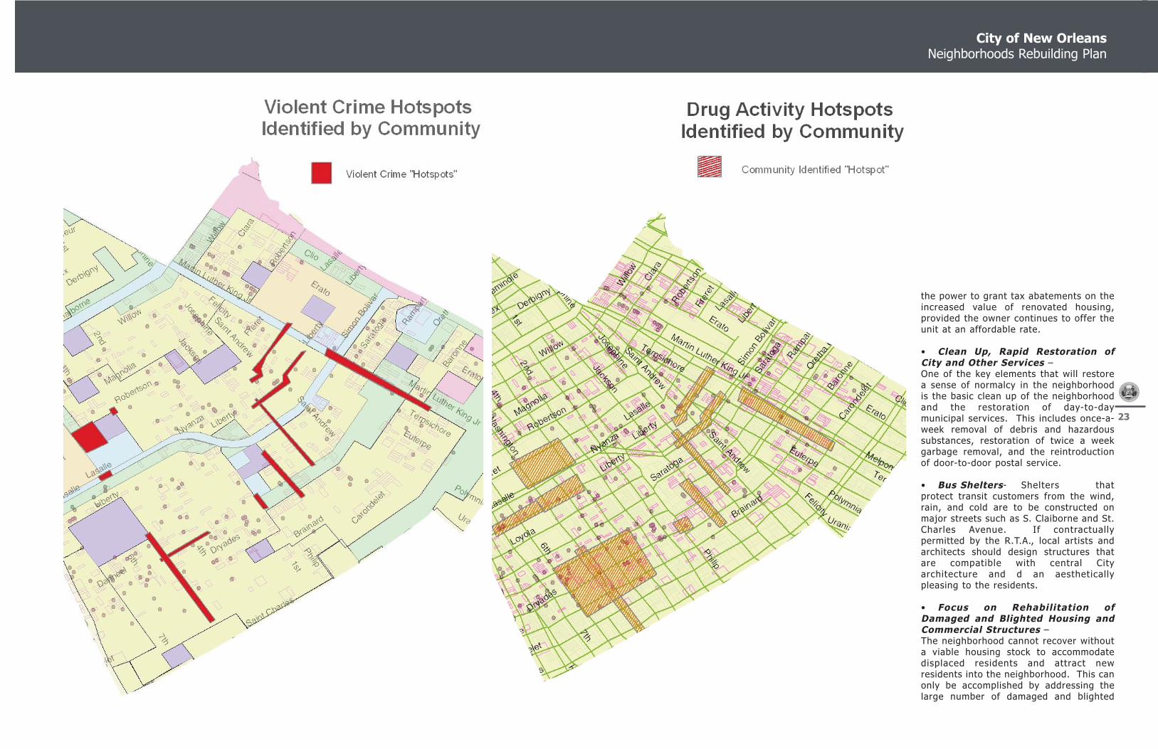
The CCRA community visioning process alsoidentified several crime “hotspots” in theneighborhood where residents would like tosee enhanced security or surveillancemeasures such as remotely monitoredcameras and Police/Fire Call Boxes.
• Develop an Infill Strategy-Severely damaged, yet highly accessible,areas of Central City will likely experience awave of demolition followed by infil lhousing construction.
A successful strategy for managing thisprocess must take into account the historyof the area, the local architectural styles,and the lifestyles and socio-economicconditions of potential residents.Architectural review and creation of a set
of style guidelines will result in infil lprojects that maintain and improve theintegrity of the neighborhood.
• Bike Paths - Where possible, bikelanes and paths should be created to allowresidents a variety of options to commuteto and from work or recreational activities.Aside from the health benefits associatedwith physical activity, post-Katrina bicycleshave become the primary mode oftransportation for many residents who livein areas that are underserved by NewOrleans Regional Transit Authority.
• Add street lighting and trees alongCentral City’s main corridors- The replacement of street lighting damagedin the storm, coupled with the addition ofnew lights in high-crime areas, canincrease pedestrian safety by providingwell-lit thoroughfares. The addition oftrees can make designated streets“pedestrian corridors”. The resultingincrease in foot traffic adds “eyes-on-the-street”.
• Create affordable homes andmixed-income developments- To encourage the development ofaffordable housing units municipalitiesmust take proactive measures to ensurethat the affordable units make fiscal senseto developers. Housing developers can begranted variances for projects that arededicated to the creation of affordableunits. Another tool at the city’s disposal is
City of New Orleans Neighborhoods Rebuilding Plan
23
the power to grant tax abatements on theincreased value of renovated housing,provided the owner continues to offer theunit at an affordable rate.
• Clean Up, Rapid Restoration ofCity and Other Services – One of the key elements that will restorea sense of normalcy in the neighborhoodis the basic clean up of the neighborhoodand the restoration of day-to-daymunicipal services. This includes once-a-week removal of debris and hazardoussubstances, restoration of twice a weekgarbage removal, and the reintroductionof door-to-door postal service.
• Bus Shelters- Shelters thatprotect transit customers from the wind,rain, and cold are to be constructed onmajor streets such as S. Claiborne and St.Charles Avenue. If contractuallypermitted by the R.T.A., local artists andarchitects should design structures thatare compatible with central Cityarchitecture and d an aestheticallypleasing to the residents.
• Focus on Rehabilitation ofDamaged and Blighted Housing andCommercial Structures – The neighborhood cannot recover withouta viable housing stock to accommodatedisplaced residents and attract newresidents into the neighborhood. This canonly be accomplished by addressing thelarge number of damaged and blighted

Central City Neighborhood, Planning District Two
24
homes in the neighborhood. While theneighborhood supports the Road Homeinitiatives at is relates to both homeownerand rental housing, the neighborhoodbelieves there needs to be a richer range ofhousing programs to address the blightingconditions that both existed before thestorm and which were exacerbated byKatrina.
The neighborhood supports the Lot NextDoor program, elderly housing initiative,and the reinvestment of second generationfunds from the sale of homes or propertiesin higher income areas into areas such asCentral City. These programs are morefully described below. An aggressive effortto support business development and therestoration of commercial properties needto be a focus of any revitalization effort aswell.
• Urge City Council to adopt therecommendations of the PlanningCommission’s Land Use Plan and theDevelopment of a ComprehensiveZoning Ordinance – Healthydevelopment in the neighborhood will bedefined by maintaining strong controls overdevelopment and this can only occurthrough the imposition of a thoughtful landuse plan and zoning code.
• Supermarkets- Currently no largesupermarkets are open in the Central Cityneighborhood. Consistently, residents citethe lack of affordable, convenient grocery
shopping as an impediment to their return.A large national chain should be pursuedfor a central location, such as near theMartin Luther King Jr. and S. Claiborneintersection
Needed and Mid-Term Initiatives andObjectives
Specific Neighborhood Projects
• I. Enhance MLK Jr. Boulevard, S.Claiborne, and other thoroughfares inCentral City - A complete landscape andtree planting initiative is necessary toreplace the tree canopy and flora that waslost in Hurricane Katrina. Residents shouldselect a menu of approved tree and plantspecies that, when planted, would giveCentral City a unified, recognizableappearance.
• J. Booker T. Washington HighSchool Auditorium - This New Orleansand African-American cultural landmarkshould be restored as a communityperforming arts and communicationcenter. Its location next to or nearseveral public housing developments thatare scheduled to be redeveloped, as wellas the school-based health clinic onsite,makes it a natural cultural and artisticredevelopment hub.
• K. Park Improvementso K.1 Redesign A. L. Davis Park-Davis
park should be reconfigured to meet theuses that residents demand. While teamsports are still popular and require fieldspace, Davis Park is also home to manySecond-Line celebrations and Mardi-GrasIndian events. With those given eventsfactored in, a new vision of the parkemerges. A redesign park has designatedparade grounds and stands that coexistwith other, traditional park amenities.
Neighborhood Wide Projects
• Code Enforcement- The City of NewOrleans and its agencies shouldaggressively enforce all code and ordinanceviolations, regardless of how small.Residents believe that enforcing minor,quality of life issues leads to a respect forthe rule of law. And the creation of acommunity that is clean and safe for all.
• Fund Youth Outreach, VocationalTraining, Crime PreventionTechniques and a Judicial LiaisonProgram to Ensure NeighborhoodSafety – It is important that a holistic strategy beundertaken to address crime in theneighborhood and that the strategy beimplemented at the neighborhood level.
Desired and Long-Term Initiatives andObjectives
• K. Parks - Renovate, Re-imagine, and
Reposition all Central City parks- Aspreviously discussed with A. L. Davis Park,neighborhood playgrounds should provideactivities and uses that are appropriate tothe local population. Areas with highconcentrations of senior citizens, forexample, should provide recreation optionsthat are age-appropriate. o K.2 Van McMurray Park o K3 Taylor Center Park
Neighborhood-Wide Projects
• Build Community Centers on ornear Public School complexes- Usingthe existing Dryades YMCA as a model,more large, multi-purpose communitycenters should be constructed in CentralCity. In addition to providing recreationalopportunities to residents, these centerscan offer a range of services to clientsincluding health screenings and counseling.The number and size of these centers shallbe directly proportional to the number ofresidents that return to each sub-neighborhood in Central City.
• Extend Existing TransportationOptions and Maintain NeighborhoodWalkability – A concerted effort should bemade to extend the various transportationoptions in the area through the extensionof streetcar lines and by adding pedestrianand bike paths wherever feasible.
• Study Construction of Internal
Images from left to right:
A: S. Galvez Neutral GroundB: Greater St. Stephen Full Baptist ChurchC: Woodson School Yard

City of New Orleans Neighborhoods Rebuilding Plan
25
Today, rapid escalation in constructioncosts in the post-Katrina period has furthereroded the degree to which the $25,000fills gaps in funding for new construction,let alone more costly historic rehabilitation.There is a need for expanded historic andblighted housing gap funding in order toensure the long term health and characterof these unique neighborhoods.
Assuming that the gap for new homeconstruction (maintaining affordability forlow and moderate income families) nowstands at $30,000, the amount required forthe restoration of a historic home could bein excess of $50,000 (covering theadditional cost of not only that portionaddressed by the $30,000 in newconstruction, but a widened gap associatedwith the entire unit reconstruction).
While gap financing of $50,000 per unit or$5.0 million for every 100 units of blightedunits of historic housing is quitesignificant, it is difficult to see how thehistoric fabric of many low and moderateincome neighborhoods will be maintainedwithout the provision of this funding.Otherwise, the character of manyneighborhoods will be placed at risk bydisplacement of the neighborhood’s lowand moderate income residents or thefurther erosion of a neighborhood’s historiccharacter.
Currently, no gap funding program isaddressing this challenge, and without
additional use of CDBG funds to fill thesegaps, the historic and community fabric ofmany of the historic moderate incomeneighborhoods of New Orleans remainsthreatened. Changes in the Road Homeand other gap funding efforts should takeinto account the historic nature of theneighborhood and make enhanced fundingavailable, which will allow theneighborhoods to retain their historiccharacter while concurrently continuing toserve moderate and low incomehouseholds.
LOT NEXT DOOR
The principal thrust of redevelopmentprograms and policies that encourage thespeedy redevelopment of neighborhoodsmust match various government powersand financing tools to the local housingand real estate market conditions.
A key question will be how to mosteffectively encourage the redevelopment ofhomes and residential lots that fall intopublic ownership.
The “Lot Next Door” program is one of aseries of proposed housing policies thathave been developed as part of theNeighborhoods Rebuilding Plan and takesdirect aim at some particular markethurdles that slow the redevelopment ofmany of these properties.
In its simplest form the Lot Next Door
Flood Protection Levees – While therestoration of the flood protection systemfor the City is currently underway, theresidents of the neighborhood believe thatit is critical to look at a layered system ofdefense with regard to hazard mitigationand flood protection and thereforeencourages the study of a secondaryinternal flood protection system that wouldprotect Central City and adjoiningneighborhoods in the event of a break inthe existing levee and the broaderCity/regional flood protection network.
• Faith-Based Policy- Central City ishome to a large number of churches andfaith-based organizations. Some of thesegroups, before and after the storm, wereactive in the housing and social servicesarena. As the hurricane recovery projectscontinue, special consideration should begiven to creating public-privatepartnerships with these groups.
Brown Derby and other establishmentspresent an opportunity to reduce thenumber of ABO permits and,simultaneously, eliminate several non-conforming uses in Milan.
A number of housing initiatives areproposed as part of the NeighborhoodsRebuilding Plan and are presented in theoverall policy element of the plan andissued under separate cover. Below is asummary of these policies.
HISTORIC NEIGHBORHOOD HOUSINGDEVELOPMENT
There are a number of general and specifichousing development and policyconsiderations within the historicneighborhoods of New Orleans thatreceived significant damage in HurricaneKatrina. The challenges of rebuilding areparticularly severe in those historicneighborhoods where a significant numberof low and moderate income householdsresided prior to the storm.
The City of New Orleans, prior to HurricaneKatrina, generally made $25,000 softsecond mortgages available through theHOME program to write down the cost ofacquisition for eligible families inCommunity Development neighborhoodsthroughout the City. However, even beforethe storm, this amount was generally notenough to cover the gap in funding thatwas required to rehabilitate units that werehistoric structures and required specialconsideration.
Typically construction costs related tohistoric buildings is as much as 30 percentabove non-historic new construction, andwhile the City made exceptions andincreased the maximum funding available insome cases due to historic considerations,given the limited funds available, theincrease in funding for historic homesmeant that fewer units would berehabilitated overall.
Images from left to right:
A: St. Charles ChurchB: St. John the Baptist Church on HaleyC: Church on La Salle Street
Central City Neighborhood, Planning District Two
26
program will offer homeowners who arecommitted to redeveloping their homes,the ability to purchase publicly ownedadjoining properties prior to theseproperties being offered to any otherbuyers. This option would be providedshould the property end up in publicownership either through the adjudicationprocess or through the sale of the propertyto a public entity through the Road Homeor other public acquisition program.
ELDERLY MODERATE INCOMECONDOMINIUM ROAD HOME TIE-IN
It has become quite apparent through theneighborhood planning process that seniorhouseholds, which have some of thestrongest ties to the community and haveexpressed some of the strongest voices forrebuilding and returning to the City, alsoface some of the most significantchallenges in redeveloping or rebuildingtheir homes.
First, there are many areas of the City thathad a high concentration of elderlyhomeowners (Lower Ninth, PontchartrainPark, and Lakeview) that sustainedsubstantial damage and which will requirethe demolition and reconstruction of manyhomes.
Historically, the challenges of dealing withcontractors, permit inspectors, lenders,etc. have proven particularly difficult forelderly households after they have
experienced similar trauma. Additionally, there are a substantialnumber of areas of the City whererebuilding homes with damage in excess of50 percent will require the totalreconstruction at three feet above grade orthe Base Flood Elevations, whichever isgreater. Many of these homes will have tobe raised close to one story making them adifficult housing product type for peoplewith physical frailties.
Elderly homeowners are clearly a specialgroup with specific needs, and currentlythere are no programs targeted to thissubgroup of homeowners.
A targeted elderly homeowner program,which will allow elderly households to tietheir Road Home grant to senior specificelevator multi-story condominium projectsto be developed throughout the City, isneeded. There has been wide support fordedicated multi-family senior housingproduct in many parts of the City, butparticularly in areas where youngerhomeowners have aging parents livingnearby.
In some cases, there may be a need toincrease the grant amount or provide a lowinterest loan to the household if there is agap between the value of the buyout (andinsurance proceeds) and the market valueprice of the condominium unit.
USE OF SECOND GENERATION FUNDSAND EXPANSION OF HOMEPURCHASER ASSISTANCE PROGRAMS
One of the principal issues that has comeup repeatedly in neighborhood meetings ishow properties that end up in publicownership either through the adjudicationor buy back process are going to be resoldin the marketplace.
While the Lot Next Door program providesone method for recycling lots in the market,there are going to be numerous lots thatare not acquired by next door neighborsthat are going to have to be sold to thirdparty purchasers.
Assuming that there are few newregulations associated with developinghousing (i.e., some requirement thatcertain units must be homeownership vs.rental) it is likely that the value placed onmany properties for sale will determine howquickly that property will be rebuilt forhousing.
Additionally, and realistically, there are avariety of neighborhoods throughout theCity where reducing the cost of a lot or unitto essentially zero will not be enough toensure the redevelopment of the property.These are generally those neighborhoodsprior to Hurricane Katrina where landvalues were quite low and homes were notbuilt unless there was significant targetedpublic assistance related to construction.
Given the different market factorsinfluencing the redevelopment of housing indifferent neighborhoods, there are a varietyof strategies that will have to be employedwith regard to the sale of lots acquiredthrough the acquisition program on theopen market. These strategies include thefollowing.
• Recycle second generation proceedsfrom higher income neighborhood propertysales to properties in neighborhoods wherevalues are lower. This will ensure thatmore housing redevelopment dollars willfollow to low-income areas than couldotherwise have be imagined prior toKatrina.
• Sell adjacent lots and blocks of lots inpublic ownership to experienced for-profitand not-for-profit developers when notpurchased through the Lot Next Doorprogram.
• Re-sell properties at fair market valueand reduce price of lots only when veryspecific policy objectives are being met,such as providing for mixed-income housingin a neighborhood.
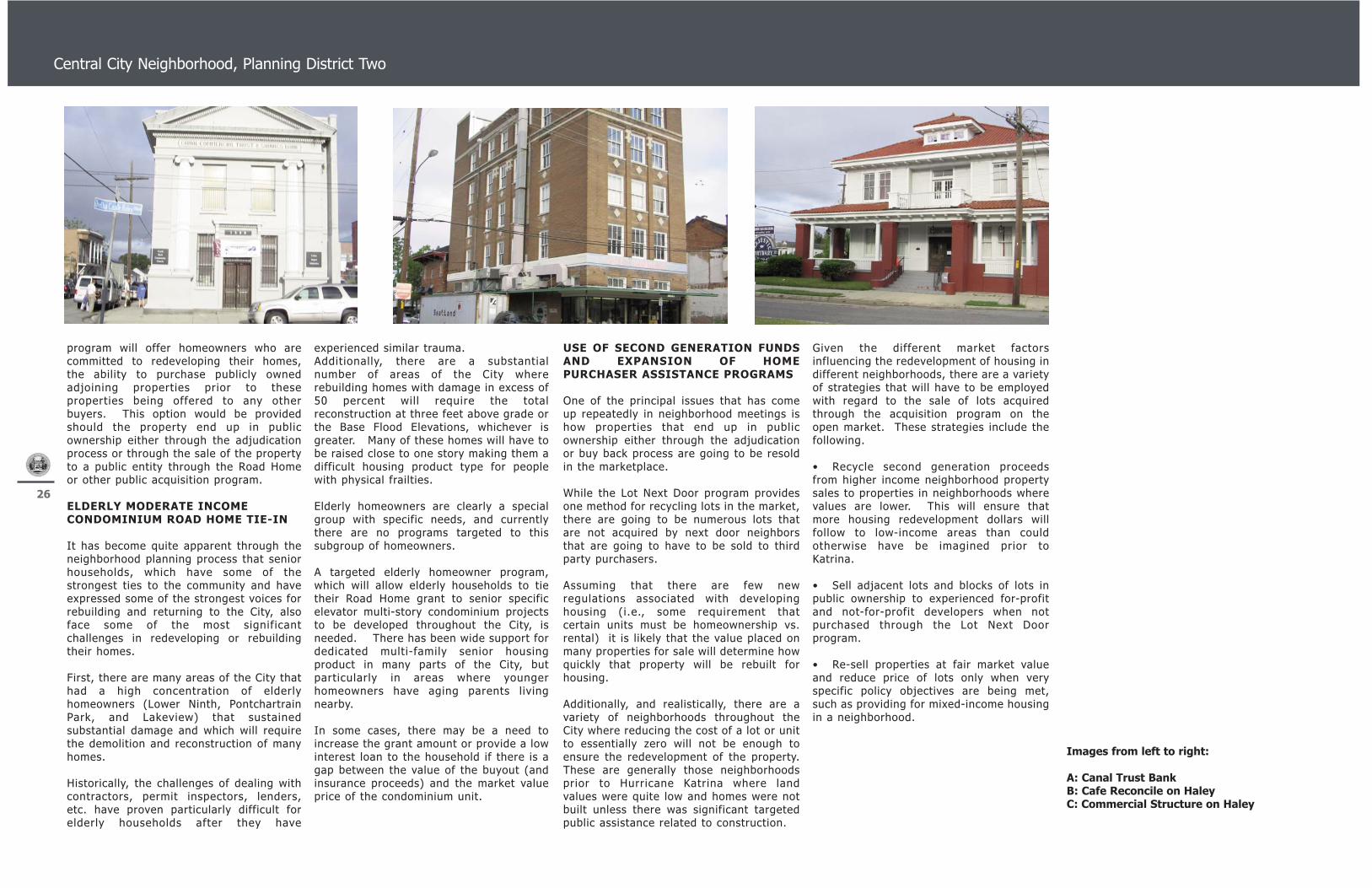
Images from left to right:
A: Canal Trust BankB: Cafe Reconcile on HaleyC: Commercial Structure on Haley

City of New Orleans Neighborhoods Rebuilding Plan
27
A. Central City Neighborhood
FUNDING MATRIX
The connection between the NeighborhoodsRebuilding Plan and potential fundingsources is graphically represented by theImplementation Priority Matrix. The costsestimates are provided on an order-of-magnitude basis. As such, variations as tothe scope of the project could result invariations in the final cost of construction.
In the process of cost analyses,consultations were carried out with the Cityof New Orleans Public Works Department toidentify general cost guidelines typicallyused for the calculation of streetimprovements and reconstruction. Othersources of cost identification included theMeans Cost Data and our team’sprofessional experience inside and outsideNew Orleans.
No single source of funding or financialplan will be capable of dealing with thecapital improvement needs for totalredevelopment and reconstruction of all theneighborhood projects and needs. However,the funding matrix included in this reportshows different funding sources that couldbe made available for specific projects andit should be expected that layering ofmultiple sources of funding will be requiredin most cases. The ability to obtain thesefunds will rest with the City of New Orleansand neighborhood groups and advisorycommittees.
Each matrix matches proposed projectswith potential funding sources identifiedthrough the planning process and while notexhaustive in its scope, it serves as a guideto where funds could originate. Substantialfinancial commitments by federal and stateentities are a vital ingredient in therecovery effort and will provide thenecessary economic infrastructure toattract the private investment required tocreate stable and vibrant communities.
Each funding matrix, based uponconsultation with neighborhood residentsthrough the community meeting process,also ranked projects based upon priority ofneed with regard to recovery: “EarlyAction/Critical”; “Mid-Term/Needed”; and“Long Term/Desired”. This ranking providesa general guide as to what communitiesbelieve are the most important prioritieswith regard to revitalization andredevelopment.
Finally, there are a variety of items orinitiatives listed on the funding matrixwhere a capital cost can not be attached ordetermined without further study, but thecommunity believed needed to be a centralpart of the plan. These include:
• Undertaking specific further studiesto determine the actual cost togovernmental entities for certainpublic/private initiatives (for which we havenoted the cost of the study);
• Housing initiatives for which theremay be dollars already allocated throughthe Road Home, LIHTC, private fundingsources, or other sources but where theadditional gap in funding is impossible todetermine at this point;
• Other policies, including land useand zoning regulations, which thecommunity believed to be in the short andlong term interest of the community; and
• Recurring operations (i.e.,expanded police patrols, library operations,park operations, etc.) that either tie tocertain capital improvements or areimportant to the health of the communitythrough the expansion of existing services.

Central City Neighborhood, Planning District Two
28