Indian Government makes fitment of ABS and CBS Compulsory - Official Draft
Upload
bruce-mansCategory
view
216download
0description
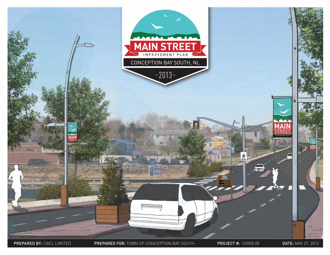
PREPARED BY: CBCL LIMITED PREPARED FOR: TOWN OF CONCEPTION BaY SOUTH PROjEct #: 133005.00 DAtE: MaY 27, 2013
CONCEPTION BAY SOUTH, NL

PROjEct PROPONENtS
cONSULtING tEAM
The Consulting Team would like to thank the many community members and organizations who contributed to this process by providing written feedback, attending
public meeting, participating in interviews, and embedding themselves into the vision of an Improved Main Street
In particular, we would like to thank the members of the Steering Committee and Town Council for their dedication, passion and enthusiasm for this process.
#MainStreetCBS
This study was initiated and funded by the Town of Conception Bay South and managed by:
CBCL Limited• Mary Bishop (Project Manager)
• Steffen Käubler• Bruce Mans
• Ann-Marie Cashin
Millier Dickinson Blais• Paul Blais
InfraCycle• Ray Esiambre
• Jennifer Lake• Elaine Mitchell
This report was prepared by CBCL Limited, in association with Millier Dickinson Blais and InfraCycle:
CBCL Limited1489 Hollis StreetHalifax, Nova ScotiaB3J 3M5
CONCEPTION BAY SOUTH MAIN STREET Improvement Plan
AckNOwLEDGMENtS
ii

TABLE OF
cONtENtSIntroduction 1 Project Impetus 2 Project Overview 4
Analysis 7 Natural Environment 8 Buildings & Infrastructure 14 Transportation 21 Economic & Business 28 People of Main Street 36 Consultation 39 SWOT Analysis 42
Improvement Strategies Vision for Main Street 46 Guiding Principles 47 Branding Main Street 50 Vehicular Circulation 52 Pedestrian Realm 58 Streetscaping 62 Wayfinding & Signage 72 Development Character 81 Demonstration Projects 86 Organization 98
Implementation 102 Phasing 103 Cost Estimates 106 Funding Programs 113
Appendices 114
iii

iv

INTRODUCTION1
PROJECT IMPETUSNo plan for the Main Street area was complet-ed, but the need was again identified in the most recent review of the Municipal Plan (completed in 2012). The 2001 policy to undertake a Main Street Improvement Plan is also included in the new Plan.
Today, there are in the order of 50-60 commer-cial premises along Main Street between Terminal Road and Manuels River, as well as four munici-pal buildings, a church, an elementary school, two banks (and a third in development), and 82 resi-dential properties that front onto the street. There are approximately 343 properties that are partially or entirely within the area with an assessed value in excess of $60 million.
The Town of Conception Bay South recognizes that its downtown commercial district is one of the most visible indicators of the community’s eco-nomic and social health. With a number of other priorities addressed, the Town now finds itself in a position to define and improve the appearance and amenity of its Main Street, and to seize on the potential to significantly advance the Town’s position as a progressive and vibrant community.
Since its incorporation in 1973, the Town of Con-ception Bay South has experienced growth and development that has made it the largest town and the second largest municipality in the province with a population of approximately 25,000 resi-dents. Development of the community has been largely of a suburban residential nature with a dis-proportionately high residential to commercial/in-dustrial tax base. Despite the presence of over 500 businesses, there is no cohesive, readily identifi-able business district in the community. Instead, commercial development is spread out along the Conception Bay Highway with concentrations of commercial uses in Long Pond/Manuels (around Villa Nova Plaza) and in Kelligrews.
In a 2001 review of the Municipal Plan, these ar-eas were identified as needing further study and improvement. A Main Street Improvement Plan was recommended to concentrate on methods to calm traffic, improve traffic circulation, park-ing and pedestrian mobility. Between 2001 and 2012, the Town’s Capital Works investment strat-egy focused on completing installation of water and sewer services throughout the community.
StUDY AREAThe area included in the Main Street Improve-ment Plan is largely the area that is designated Commercial in the Town’s Municipal Plan, and zoned Commercial Main Street – essentially the area along Conception Bay Highway between Terminal Road and the Manuels River. The Com-mercial Main Street Study Area consists of the area along Route 60 between Terminal Road and the Manuels River. The T’Railway, slated to be-come a linear park and pedestrian walkway, forms the southern boundary of the study area. The trail has potential to develop into the backbone of a ac-tive transportation network and important ameni-ty to the downtown area.
CBS MAIN STREET IMPROVEMENT PLAN2

INTRODUCTION
ST. JOHN’SCBS MAIN STREET
MAIN STREETStUDY AREA
CBCL LIMITED 3
INTRODUCTION
market in St. John’s. By 1900, almost all of the vegetables consumed in the city came from Con-ception Bay South. While not as significant as in the past, this area still retains some of its agricul-tural focus, with over 100 people employed in the industry, mostly on small market-vegetable farms.
Some mining is also associated with the area. From the late 19th century up to the 1960s, the Conception Bay South area served as a bedroom community not for St. John’s, but for the Wabana iron mines on Bell Island.
Up until incorporation, the small communities along the shoreline of Conception Bay experi-enced continuous growth and development, much of it unplanned and without the provision of mu-nicipal water and sewer services. Following in-corporation, the Town has continued to grow and considerable investment has been made to extend municipal services, upgrade streets and provide recreation amenities. Today, remnants of the com-munity’s agricultural heritage remain, while the railway is being converted to a pedestrian trailway. The Manuels River Linear Park has been devel-oped into an important piece of the Town’s open space area and a new Natural History Interpreta-tion Centre will be a showcase for the community.
A BRIEF HIStORYAlthough the Town of Conception Bay South was incorporated in 1971, permanent settlement in the area dates back to the early 1800s. By the 1830s, the communities of Topsail, Chamberlains, Manuels, Long Pond, Kelligrews, Upper Gullies, Foxtrap, Lawrence Pond and Seal Cove were sig-nificant enough to warrant a road to St. John’s. The first residents of the area subsisted on small-scale fishing, agriculture and woodcutting. Many of these residents came from Port de Grave in the summer in order to farm and cut wood in the rel-atively good agricultural soil of the area. Eventu-ally, some of them staked out permanent home-steads. Generally, these homesteaders built close to the shore, and then created side roads inland. This arrangement is reflected today in the urban pattern of much of Conception Bay South.
In 1881, the St. John’s-to-Topsail leg of the Newfoundland Railway was constructed, which brought an influx of wealthy St. John’s residents who built summer homes in the area, many of which were converted into year round dwellings in the 1950s.
Goods also flowed the other direction as well, as farmers were able to bring their products to the
tOwARD A BEttER MAIN StREEt The time is right to re-imagine Main Street. Re-cently, the Town has experienced unprecedented growth and development as new residents arrive and new businesses open their doors. Improve-ments to Main Street will help encourage addi-tional growth while also encouraging existing res-idents to stay in the Town.
Furthermore, global and local trends associated with climate change, energy sources, population preferences, changing lifestyle preferences and health are emerging that will change the way we think about our towns and cities. This section provides a very brief overview of some of these emerging trends and how they provide motivation for a better Main Street.
Changing Needs & PreferencesTwo age cohorts are going to have a major impact on cities. First, as baby boomers begin to retire they will require a variety of mobility and housing options. In order to accommodate this age cohort, towns will need to be able to allow seniors to “age-in-place” by providing a range of services and transportation and health infrastructure suited to their needs. Also, the emerging lifestyle preferenc-es of “Generation Y” seem to be notably different
PROJECT OVERVIEW
CBS MAIN STREET IMPROVEMENT PLAN4
than prior generations, with many younger adults preferring to live in communities that are more walkable, offer a mix of uses and are better-con-nected.
Health & SafetyImprovements along Main Street can have a pos-itive influence on public health and safety. In-creased opportunities for active recreation along Main Street can help increase physical activity rates and decrease overweight/obesity rates. Fur-thermore, traffic calming measures along Main Street can help reduce collision fatality rates and accidents. Air pollution can also be decreased through tree planting and reducing traffic volume.
Climate ChangeChanges in global climate are resulting in rising sea levels and more frequent and intense storm events. In low-lying coastal communities, vulnera-ble areas and infrastructure will require measures to protect property and adequately manage im-pacts such as storm surges and increased storm-water flows. Many municipalities are also taking measures to reduce greenhouse gas emissions that contribute to climate change by building more en-ergy efficient buildings, encouraging a reduction in vehicle usage through improving community walkability and us of public transit, for example.
Oil Prices and Peak OilAs global oil reserves dwindle, gas prices have, and will continue to increase. Such increase have the
potential to eventually trigger a shift in transpor-tation demand away from single vehicles to other options such as ride-sharing and public transit, or to alternative work arrangements such as telecom-muting.
ABOUt tHE PROjEctThe Conception Bay South Main Street Improve-ment Plan builds upon ideas and proposals from previous plans, identifies new opportunities and makes best use of existing infrastructure in design solutions.
The Plan is about more than simply “prettying up” the street. The Plan:• Presents a concept for future redevelopment
that will transform the Main Street area to an identifiable downtown commercial district that offers a range of goods and services, at-tracts business investment, people (residents and visitors), and provides opportunities for recreation and social interaction;
• Addresses pedestrian and vehicular safety through traffic calming and other measures;
• Identifies themes for signage, wayfinding and interpretation to and within the Main Street area;
• Shows how, through beautification efforts, the area can become a pleasant and inviting place;
• Includes a plan to market and promote the area; and
• Identifies costs associated with civic improve-
ments and a multi-year phased implementa-tion schedule.
In preparing the Plan, the Town and the consult-ing team: • Involved citizens, businesses and other stake-
holders in the development of the Plan; • Encouraged buy-in to the improvement con-
cepts from the business community; and • Initiated discussions around the formation of
a Main Street business improvement associa-tion to help implement the plan.
Overall, the Conception Bay South Main Street Improvement Plan responds to and boosts Coun-cil’s aspirations to create a recreational, cultural, tourism, entertainment and retail cluster where sectors can thrive on the synergy generated by each other.
CBCL LIMITED 5
INTRODUCTION
REPORt OUtLINEThis report is organized into three sections; Anal-ysis, Solutions, and Implementation.
The Analysis section determines “where we are”, by assessing existing characteristics of Main Street, including social, economic, geophysical, and urban structure conditions. This section also includes the results of an intensive community consultation strategy consisting of social media networks, a series of public events and face-to-face interviews with members of the business com-munity. The analysis section is concluded with a Strength Weaknesses Opportunities Threats (SWOT) Analysis summarizing the key findings.
The results of the analysis section are used to cre-ate a “Vision for Main Street” and a set of goals in the Solutions section. This Vision and set of goals will determine “where we want to go”. The remainder of the section identifies a collection of “Improvement Strategies” designed to accom-plish the vision and goals.
The report concludes with the Implementation section which determines “how we get there” with clear steps for implementation. The section includes cost estimates, funding opportunities, a phasing schedule and a list of responsibilities for the Town, stakeholders and other potential part-ners.
IMPROVEMENT STRATEGIES
PUBLIC INPUT
SWOTANALYSIS
HISTORY
EXISTINGCONDITIONS
CBS MAIN STREET IMPROVEMENT PLAN6

aNaLYSISMain Street is a complex environment defined by its users, the natural sur-roundings, global and local economic environments and historical urban development. In order to provide context-sensitive improvements to Main Street, it is first necessary to understand it in a comprehensive manner.
Our comprehensive analysis begins with the natural surroundings of the area, investigating geophysical conditions that will impact future development, such as elevation, slope, microclimates, and sea level rise. We then analyse
the urban structure of Main Street – how it developed, existing settlement patterns, traffic flow, land utilization, building uses, zoning and so on. Next, we take a look at the economic environment of Main Street, including its regional role, recent economic development initiatives, and future develop-ment plans. Finally, and most importantly, we conclude with the users of Main Street - examining population trends, socioeconomic characteristics, and assess their preferences and opinions through a consultation strategy.
7

NATURAL ENVIRONMENTELEVAtIONThe study area is tucked between the coastline of Conception Bay and the leeside of the Avalon Pla-teau. Within the study area, elevations reach ap-proximately 38 metres; however, the steep banks of the adjacent plateau climb to over 200 metres south of the Bypass Road. Recent residential de-velopment has worked its way up the slope of the plateau, taking advantage of the stable founda-tions and great views (see photo below).
ELEVATION200.0100.00.0
ConCeption Bay
avalonplateau
CBS MAIN STREET IMPROVEMENT PLAN8
SLOPE CHANGE (%)
ELEVATIONPROFILE
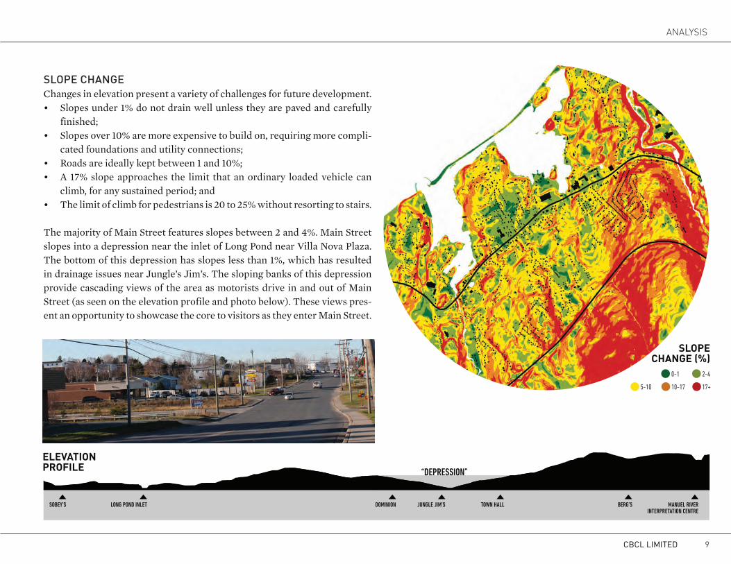
SLOPE cHANGEChanges in elevation present a variety of challenges for future development.• Slopes under 1% do not drain well unless they are paved and carefully
finished;• Slopes over 10% are more expensive to build on, requiring more compli-
cated foundations and utility connections;• Roads are ideally kept between 1 and 10%;• A 17% slope approaches the limit that an ordinary loaded vehicle can
climb, for any sustained period; and• The limit of climb for pedestrians is 20 to 25% without resorting to stairs.
The majority of Main Street features slopes between 2 and 4%. Main Street slopes into a depression near the inlet of Long Pond near Villa Nova Plaza. The bottom of this depression has slopes less than 1%, which has resulted in drainage issues near Jungle’s Jim’s. The sloping banks of this depression provide cascading views of the area as motorists drive in and out of Main Street (as seen on the elevation profile and photo below). These views pres-ent an opportunity to showcase the core to visitors as they enter Main Street.
0-1
17+
2-4
5-10 10-17
“Depression”
ToWn HALL BerG’sJUnGLe JiM’sDoMinionLonG ponD inLeTsoBeY’s MAnUeL riVerinTerpreTATion CenTre
CBCL LIMITED 9
aNaLYSIS

cLIMAtEAreas that are sloped toward the south/southwest receive the most solar exposure on an annual ba-sis. There are several “solar hotspots” on Main Street, particularly in and around the Villa Nova Plaza area.
The uplands of the Avalon Plateau protect Main Street from most winds, however, strong north-easterly and northwesterly winds are can occa-sionally generate wind gusts along Main Street. The Avalon Plateau also helps protect the area from fog and moisture-laden air masses, resulting in 250mm less annual rainfall than St. John’s.
From the perspective of the pedestrian, Main Street has one of the most attractive climatic char-acteristics in the province.
ASPECT
CBS MAIN STREET IMPROVEMENT PLAN10

Very high (-1.5) High (1.5-2.0)
Moderate (2.0-2.5) Low (2.5+)
SEA LEVEL RISE (M)Every year, the sea level rises approximately 3-5 mm and is expecting to rise over a metre by 2099. The Long Pond beach jetty protects low-lying areas from storm surge, however, future sea lev-el rise, plus storm surges, will potentially breach the system and leave developed areas along Main Street vulnerable - particularly the area between the Dominion supermarket and Villa Nova Plaza.
RISK OF SEA LEVEL RISE (m)
jetty
CBCL LIMITED 11
aNaLYSIS

VEGEtAtIONConception Bay South is home to diverse range of vegetation due to its deep soils and warm annual temperatures. The area features a mix of conifer-ous and deciduous tree and shrub species. The following is a list of the most common native tree and shrub species in the area:
Coniferous Trees:
BLACK SPRUCEPicea mariana
BALSAM FIRAbies balsamea
TREMBLING ASPEN
Populus tremuloides
Black spruce (Picea mariana)White spruce (Picea glauca)Balsam fir (Abies balsamea)Eastern larch (Larix laricina)
Deciduous Trees:Red maple (Acer rubrum)White birch (Betula papyrifera)
Trembling aspen (Populus tremuloides)Mountain ash (Sorbus americana)
Shrubs:Labrador tea (Ledum groenlandicum)Rhodora (Rhododendron canadense)Speckled alder (Alnus incana) Sweet gale (Myrica gale)
RED MAPLEAcer rubrum
SPECKLED ALDERAlnus incana
CBS MAIN STREET IMPROVEMENT PLAN12

wAtERFRONtAlthough Main Street is located in close proximity to the Conception Bay coastline, the street itself only has two small waterfront locations at the sep-arate tips of Long Pond.
LITERATURE REVIEWCBS HARBOUR POTENTIALSTUDY (2012)In 2012, the Small Craft Harbours Division of the Federal Department of Fisheries and Oceans approached the Town and asked whether it would be interested in becoming the recipient of the Inner Harbour at Long Pond. The Town, in considering this request, assessed the future potential of the Harbour, evaluated costs and lia-bilities of assuming ownership, and outlined op-tions for governance, management and opera-tion of the harbour following divestiture. As part of this study, concept designs were developed for five sites along the Harbour. These design details will be incorporated into the Main Street Improve-ment Plan.
Lambkill (Kalmia angustifolia)Common juniper (Juniperus communus)
Woody Sub-shrub:Blueberry (Vaccinium angustifolium)Black crowberry (Empetrum nigrum)Creeping juniper (Juniperus horizontalis)
CBCL LIMITED 13
aNaLYSIS

BUILDINGS & INFRASTRUCTUREThe built environment of Main Street is the result of hundreds of years of changing settlement pat-terns responding to both the natural environment and local economics.
LAND UtILIzAtIONAn analysis of surface infrastructure within the study area reveals how much land is allocated to specific types of purposes. The 97.7 hectares of land within the study area can be broken down into seven types of surfaces; open areas, parking lots, road surfaces, sidewalks, park/trail areas, building footprints and driveways/access roads. The breakdown offers a clearer picture of how much land is dedicated to specific purposes.
Open areas include public and private green space, undeveloped land and conservation areas. Approximately 59.9 hectares of open area exist with the study area, accounting for 61.3% of all surface types. The majority of this land is privately owned yard space.
Aside from open space, parking areas occupy the largest area, covering 10.8 hectares of land (11.1%). This is enough land for more than 3,500 parking stalls. Most parking areas are concentrat-ed around the Villa Nova Plaza area and the two
OPEN AREAS 61.3%
PARKING11.1%
ROADS 9.2%
SIDEWALKS0.5%
RECREATION5.8%
BUILDINGS7.2%
DRIVEWAYS4.9%
LAND UtILIzAtION
CBS MAIN STREET IMPROVEMENT PLAN14

grocery stores (Dominion/Sobeys). Strip mall de-velopments throughout Main Street also feature large parking areas.
Sidewalks occupy only 0.4 hectares or 0.5% of the study area. DEVELOPMENt PAttERNThe development pattern in the vicinity of Main Street still very much reflects the early settlement configuration of an era when homesteaders built close to the shore, and created slide roads back up into the woods. Homes were built by negotiating the natural landscape and topography resulting in different sized lots with varying setbacks and archi-tectural styles.
This traditional, organic settlement pattern is still evident in many of the small single-detached homes that front onto Main Street, particularly to the south of the road where residential develop-ment is more prevalent. In contrast, newer subdi-visions that have emerged in the area follow typical post-war suburban style of development, where lots are subdivided into equal-size lots, with similar setbacks and architectural styles.
Businesses on the south side of Main Street have development patterns similar to the surrounding residences. In fact, many of these businesses are tenants in former residential or auxiliary buildings. In contrast, the northern side of Main Street is BUILDING COVERAGE
home to many large footprint buildings such as su-permarkets, drugstores, and office buildings. While the current appearance of these mid- and big-box businesses leaves a lot to be desired, anchor stores
such as the Dominion, Sobeys and Shopper’s Drug Mart are valuable assets in the downtown commer-cial mix.
CBCL LIMITED 15
aNaLYSIS

EXIStING BUILDING USESThe Main Street area is predominantly commer-cial and residential. In fact, only 8% of ground floor area for buildings within in study area are not commercial or residential. Only 872 m2 (1.7%) of Main Street ground floor area is industrial and 4573 m2 (6.4%) is institutional.
Residential ground floor area accounts for 26,323 m2 (45.4%) of floor area. Most residential units are single-detached homes tucked between Main Street and the T’Railway corridor. Most recent residential development has occurred on newly constructed roads connecting into Main Street from the south. As a result, the majority of res-idential buildings fronting onto Main Street are older structures. While some of these buildings have been maintained by their owners, others have fallen into a state of unsightly disrepair.
Commercial buildings account for 31,504 m2 (45.1%) of ground floor area, which are central-ized in the Villa Nova Plaza area. There is also a strip development anchored by a Sobeys in the west corner of the study area. Commercial devel-opment in Conception Bay South includes a mix of retail outlets, fast-food and sit-down restau-rants, grocery stores, gas stations, office space, and banking services.
MIXED USE1.4%
COMMERCIAL45.1%
INDUSTRIAL1.7%
INSTITUTIONAL6.4%
RESIDENTIAL45.4%
BUILDING USES
CBS MAIN STREET IMPROVEMENT PLAN16

zONING & LAND USE PLANNINGThe Main Street study area is primarily zoned Commercial Main Street. Other zones include Open Space Conservation along Manuels River, Conway Brook and the T’Railway, Open Space Recreation surrounding the Recreation Complex on Stoney Hill Road, Public at St. George’s Elementary School site and Residential Medium Density in the residential area located between Main Street and the T’Railway.
The Commercial Main Street Zone permits a va-riety of uses that will allow for the growth and de-velopment of business activity in the Town. These include restaurants, shops, offices, as well as med-
town of CONCEPTION BAY SOUTH
Municipal Plan2011-2021
093114.00 Municipal Plan July 20, 2012
LITERATURE REVIEW2011 MUNICIPAL PLANThe Municipal Plan set recommendations for a Main Street Redevelopment Plan. It was rec-ognized that improvements to the Town’s Main Street were needed and the Main Street Plan should concentrate on methods to calm traffic flow, improve vehicle access, parking and pe-destrian circulation.
The Main Street Improvement Plan would also include measures for improving the appear-ance of the Main Street, through landscaping, signage and the development of public amenity spaces. The Development Regulations estab-lished a Commercial Main Street zone along the study area which permits a number of uses to encourage a diverse commercial strip
ZONINGCommercial Main Street
Public
Residential Mixed
Open Space Recreation
Residential Medium Density
Open Space Conservation
ical, professional and personal services such as clinics, law offices and hair salons - among oth-ers. A farmers market is permitted if it is located indoors but an outdoor market would be at the discretion of Council.
Single dwellings are limited to existing buildings. Apartment buildings and mixed-used develop-ments are permitted to encourage higher densities and a better mix of uses. As a result, amendments to the Commercial Main Street zone may be re-quired to accommodate new design standards. In the current Development Regulations, the only standards set are building setback requirements.
CBCL LIMITED 17
aNaLYSIS
INFRAStRUctUREStormwater drainage is currently an issue in some areas along Main Street. During rainfall events, stormwater quickly accumulates in low-lying ar-eas, particularly around Jungle Jim’s. During win-ter, large puddles form along the curb next to the sidewalk, which pose a safety hazard as passing cars splash water from the road into the path of pedestrians (see bottom left photo).
Above ground infrastructure, such as utility poles, overhead street lamps, or fire hydrants, can cause significant visual clutter if not managed properly. Overloaded utility poles along Main Street partic-ularly contribute to a cluttered and unsightly ap-pearance when combined with adjacent pylon and portable signs and the lack of trees and landscaping.
Street lighting along Main Street consists of tall, powerful streetlamps fastened to utility poles. While this is the cheapest way to provide on-street lighting, it also creates an environment that feels unwelcoming for pedestrians. Alternatively, pe-destrian-oriented lamp posts that are shorter and provide a full spectrum light at lower wattages provide a warmer and fuller light which is safer and more aesthetically pleasing for all users.
The road surface is generally in good condition, however, upgrades will need to occur if the Town decides to take over the road from the province. Paint markings along Main Street have worn off the surface to the point of being nearly invisible, par-ticularly at night or during rain or snowfall events.
The north side of the highway includes a 1.5m wide, concrete slab sidewalk. Although this is the minimum acceptable standard for sidewalks, wider right-of-ways should allow two pedestrians to walk abreast comfortably. The concrete surfaces are gen-erally in acceptable condition, however, curbs show signs of degradation due to passing snow plows. Snow clearance is an issue on sidewalks, particular-ly where utility poles or traffic signs are located in the middle of the sidewalk (see photo below).
A small portion of sidewalk near the Monument of Honour features a stamped, red-coloured con-crete texture, which is a better walking surface (the snows melts faster and the grip is better).
CBS MAIN STREET IMPROVEMENT PLAN18

ADVERtISEMENt SIGNSAdvertisement signs are signs that are private-ly owned or rented and advertise local business ventures or other business related messages. They consist of permanent pylon signs, ground signs, or portable signs. Although it is very important to provide opportunities for businesses to promote themselves, it is equally as important for the Town to establish clear and sensible regulations regard-ing the placement of such signs. Enforcement of these rules is also important.
A lack of rules and enforcement can lead to sever-al problems. A cluttered and random assortment of signs can lead to a phenomenon known as “sign clutter”. Studies have shown that an overabun-dance of signs with different messages posted at
LITERATURE REVIEWSIGN REGULATIONSThe Conception Bay Highway is a provincial highway and therefore all signs erected along the road must be approved in accordance with the Highway Signs Regulations and the Concep-tion Bay South Development Regulations. The Department of Transportation and Works are mostly concerned with directional and off-site promotional signs, and leaves on-site signs to be regulated by the municipality. Section 8.9 of the Town’s Development Regulations prohibits off-site promotional and directional signs and so majority of, if not all, sign approvals along Route 60 would not be required to have approv-al by the Department.
Within the Commercial Main Street Zone (C-1), permitted signs include portable signs, canopy signs, changeable message signs, facial and projecting wall signs, and ground signs. Any-one wishing to display a sign must first obtain a permit from the Town, unless it is a sign ex-empt from control as stated in Regulation 8.6. The permit for a portable sign is only valid for a period of 90 days, but may be renewed at the discretion of Council up to a maximum time pe-riod of 6 months per year in total.
various heights and locations can inadvertent-ly overstimulate users and cause them to ignore signs altogether. Sign clutter also results in general unsightliness and disrupts views of the surround-ing landscape.
The overabundance of signs is only an issue in certain areas along Main Street, particularly where businesses are concentrated in and around Villa Nova Plaza. If the Town intends to increase commercial and residential density in this area, it will need to develop fair rules for signs that strike a balance between promoting business and main-taining a clean and attractive streetscape. In areas where density is lower, sign clutter is not as much of an issue.
Signs along Main Street occupy a large amount of “visual real estate”, as seen in the illustration above.
CBCL LIMITED 19
aNaLYSIS

REcREAtIONTwo significant recreational facilities “bookend” Main Street study area. The Manuels River area, toward the eastern end of the study area, offers a beautiful trail system, outdoor swimming oppor-tunities in the summer and a new Interpretation Centre is under construction that will provide ed-ucational opportunities about the geologic signifi-cance of the area.
On the western end of the study area is the Rec-reation Complex which includes tennis courts, a baseball diamond, a swimming pool, squash courts, and a fitness program. This area is also the potential future site of the new Town Hall.
CBs reCreATion CoMpLeX
LonG ponD
sT. GeorGe’seLeMenTArY
sCHooL
innerHArBoUr
T’rAiLWAY
MAin sTreeT
T’rAiLWAY
MAnUeL’s riVer TrAiL
MAnUeL’s riVerinTerpreTiVe
CenTre
Connecting these two important recreational des-tinations is the T’Railway trail system. There are recommendations for significant upgrades to this trail link (see T’Railway Development Plan review to right) that will encourage more pedestrian and cyclist activity between these facilities.
Furthermore, an improved T’Railway will also open the opportunity to create a convenient “loop” by providing a safe route for pedestrians and cyclists alongside Main Street. This loop would connect the Manuel’s River Interpretation Centre and the Recreation Complex with ameni-ties along Main Street, such as St. George’s El-
ementary School, scenic areas along Long Pond and the Inner Harbour, and all of the businesses along Main Street.
Such a loop could quickly become an attractive recreational destination for locals and visitors due to the convenience of being able to park in one location, and walk along a trail that offers several scenic stopping points, including restaurants and shops. Additional trail “short-cuts” between the T’Railway and Main Street will also allow poten-tial trail users to customize the length and time of walks along the trail system.
TRAIL “LOOP”T’Railway Connection
Main Street ConnectionPotential “Short-Cuts”
Bookend Destinations
Main Street Destinations
CBS MAIN STREET IMPROVEMENT PLAN20

As the Town has grown, so too have concerns over traffic congestion and speed, the number of access-es and intersections, and the safety of vehicles and pedestrians. The Main Street Improvement Plan will need to strike a strategic balance between the needs of traffic and commuters from outside the study area, and those within the study area such as pedestrians, shoppers, employees, business own-ers, cyclists, and residents. The longer-distance, regional traffic requires safe and efficient mobili-ty through the area, while local users need Main Street to provide multi-mode facilities and safe, well-designed access to residential and commercial driveways. Even the current heavier traffic volumes on Route 60 do not mean that Main Street has to sacrifice the qualities that attract people to Con-ception Bay South’s downtown area. This section analyzes the circulation patterns and transportation characteristics of Main Street.
REGIONAL cIRcULAtIONRoute 60 is a 21km section of roadway that serves as the main thoroughfare for Conception Bay South. The road has numerous driveway cuts, intersections, cross-sections, and speed limits along its length. The ‘Main Street’ section of Route 60 has four trav-el lanes and a greater density of commercial/retail properties than the remainder of the Route. REGIONAL CIRCULATION BASE SOURCE: Google Maps
TRANSPORTATIONThe traffic composition along Route 60 in the Town is diverse, including local, commuter, and bypass traffic. Given that nearly two-thirds of the Town’s working population works outside of Conception Bay South, Route 60 serves as an important piece of road infra-
structure funneling regional traffic and commuters in and out of the Town via the Conception Bay Bypass Highway (Route 2). However, it is also called upon to handle local traffic needs and to provide access to the many properties along Main Street.
CBCL LIMITED 21
aNaLYSIS

LOcAL cIRcULAtIONIn the 3 km stretch included in the study area, there are 29 street intersections, 120 accesses including driveways and parking lot entries, and a total of 3.2 km of sidewalk. One of the greatest issues fac-ing Main Street is lack of connectivity. Connec-tivity refers to the density of connections in road networks, and the directness of links. A well-con-nected network has many short links, numerous intersections, and minimal cul-de-sacs or dead-ends. As connectivity increases, travel distances de-crease and route options increase, allowing more direct travel between destinations, and creating a more accessible and flexible system. Connectivity can apply both internally (streets within that area) and externally (connections with arterials and oth-er neighborhoods.
The map to the right illustrates poor connectivity along Main Street within the street network. Be-tween Kitty Ade’s Turn and Manuel’s River, there are countless long and dead-ended local streets that feed into the Main Street collector. All of the roads outlined in red depend solely on Main Street to move residents in and out of the area. Connectivity can be modestly improved by joining local roads to create more loops (as opposed to dead-end streets), or hypothetically by the costly endeavour of adding another road connection to the Bypass Road some-where between these two intersections.
Peak hour traffic movement in and out of Con-ception Bay South is predominantly commuter
CONNECTIVITYRoads that feed into Main Street
based, with most of these commuters funneling toward Route 2. This pattern highlights the im-portance of having adequate connections between Route 2 and Route 60.
Minerals Road and Manuels Road provide direct links between the study area section of Route 60
CBS MAIN STREET IMPROVEMENT PLAN22

and Route 2; however, the extent to which they facilitate this north-south movement varies. Min-erals Road is not particularly well suited to serve as collector and handle high traffic volumes, but both roads are capable of accommodating exist-ing volumes. As development increases, the op-erational efficiency of these roads may begin to diminish.
SPEED LIMItSTrue to its actual name, Conception Bay Highway, Main Street looks just like that, a highway. There is little or no reason for drivers to slow down. The posted 50 km/h speed limit is often exceeded by drivers because the design speed, the maximum safe speed that can be driven in free-flowing traf-fic and good weather is higher than the posted speed limit. Currently the street gives few to no visual clues that drivers should slow down.
StREEt cROSS SEctIONThe width of the Main Street right-of-way in the study area ranges form 19 to 20.5 meters. The roadway is the paved portion of the right-of-way primarily used by cars. It consists of four travel lanes, each 3.5 meters wide. Designated right or left turning lanes do not exist, with the result that the two center lanes essentially act as left turning lanes often blocked by cars awaiting their turn.
The sidewalk area is a 1.5 meter wide portion of the right-of-way dedicated to pedestrians on the north side of Main Street. On the south side of the roadway, about 4 to 5 meter of “unused” space remains within the right-of-way. Partially sodded, treed or paved depending on location, this public-ly owned land is an important asset for the pur-pose of re-envisioning the street cross section.
The building ares outside the public right-of-way is critical to how Main Street works. The appear-ance and function of this area is determined by building design and land use. Everything seen and experienced from the Main Street sidewalk - building fronts, signs, and lighting is currently not designed for human interaction at a pedestrian’s perspective. Building setbacks along Main Street are significant and the height to width ratio be-tween opposing buildings creates a scale uncom-fortable for pedestrians.
StOREFRONt tO StOREFRONt DRIVINGParking lots surrounding buildings and car-ori-ented uses like gas stations or drive-ins distort the human scale of Main Street. Even in areas with a high concentration of businesses, unsafe walking conditions have nurtured a culture of driving rath-er than walking short distances between stores.
CBCL LIMITED 23
aNaLYSIS

CURRENT MAIN STREET CROSS-SECTION (AT McDONALD’S)
CBS MAIN STREET IMPROVEMENT PLAN24

PEDEStRIAN cOMFORt & SAFEtYConception Bay South’s Main Street area is pri-marily an auto-dominated landscape. The current strip-like layout, with relatively long distances be-tween businesses make cars almost indispensable. As a result, Main Street is clearly not a pedestri-an-friendly place. Even though no data pertaining to pedestrian-vehicle collisions was available for this study, the perception of pedestrian safety is as important as actual data.
Despite recent efforts to provide pedestrian facil-ities in the downtown, people trying to walk find themselves having to navigate a number of hin-drances. In the late 1990s, the Town installed a new concrete sidewalk on the north side of Route 60 throughout the study area. However, sidewalks in the downtown are generally narrow and the de-lineation of sidewalks across many driveways is
unclear. At some locations, poles are placed within the sidewalk creating awkward situations for pe-destrians. Some of the key issues affecting pedes-trian comfort and safety along Main Street are:
Safety:• Challenging to walk to stores;• Large parking lots without designated walking
areas;• Succession of parking lots used by cars as ser-
vice road;• Too few designated road crossings with long
distances between them;• Deteriorating pavement marking of cross-
walks;• Inconsistent marking styles for pedestrian
crossings;• Long crossing distance due to road width;• Four lane roadway encourages high speed;
• Drivers don’t slow down for pedestrians;• Very narrow sidewalk only along northern
side of main street;• No sidewalk buffers separating pedestrians
from high-speed traffic;• Sidewalks are not wheelchair accessible due to
obstructions;• Many driveways crossing sidewalk; sand• Excessively wide driveway curb cuts.
Comfort:• Substantial noise;• Unsightly appearance;• Water splashing;• No places for chance encounters;• No places for children and the elderly;• Lack of pedestrian street furniture; and• Feeling of alienation for sidewalk users.
CBCL LIMITED 25
aNaLYSIS

ROAD OwNERSHIPRedeveloping the area hinges on negotiating a way forward with the Department of Transporta-tion and Works who own the highway right of way and control, through the Highway Traffic Act, all accesses to the street, as well as signage under the Provincial Highway Sign Regulations. For a num-ber of years, the province has been pushing the Town to take over jurisdiction and ownership of the road but the Town has resisted due to financial considerations. In 2007, a traffic study of Route 60 was completed by BAE-Newplan Group Limited. The purpose of the study was to examine existing highway conditions, establish future demands with-in Conception Bay South, and identify necessary improvements for the roadway in preparation for a potential ownership transfer from the province.
Recommendations for the study area include:• Repairs and re-grading of storm drainage man-
holes and catch basins;• Traffic signal upgrades;• Intersection capacity upgrades;• Parking area modifications to provide separa-
tion between Route 60 and adjacent parking;• Width reduction and consolidations of drive-
way locations;• Sidewalk widening at select locations;• Pavement resurfacing;• Installation of sidewalk on south side of Route
60; and• Installation of left turn auxiliary lanes.
tRANSItThere is currently no transit service in Concep-tion Bay South. The closest transit bus stop is lo-cated ten minutes away by car in Mount Pearl. A review of regional transit opportunities was con-ducted in 2011 (see literature review to the right), which recommended a regional transit service to extend to Conception Bay South.
LITERATURE REVIEWMETROBUS TRANSIT STUDY (2011)
Metrobus undertook a Market Assessment and Strategic Directions Study for the St. John’s transit system. The need for this study was precipitated by a decline in reported transit use since major service changes in 2007.
The report reviewed the need for regional transit services in Paradise and Conception Bay South and recommended that transit services be pro-vided in these areas.
Read the Metrobus Transit Study here:www.stjohns.ca/publications/metrobus-tran-sit-study
CBS MAIN STREET IMPROVEMENT PLAN26

wAYFINDINGA well designed and organized wayfinding strat-egy help visitors and residents navigate through a space easily and intuitively. On the other hand, a poorly organized wayfinding system may con-fuse, over stimulate or frustrate users. Wayfinding signs must provide the necessary information to direct drivers into an area.
Wayfinding signs should be located at key deci-sion points such as entry and exit areas, intersec-tions and destinations. There are four key decision points on the “feeder” streets that funnel traffic through Main Street. Signs have been erected in these locations, however, none of them include references to “Main Street”. Most signs have la-beled the area as “Manuels” or “Long Pond” and there is one sign along Manuel’s Arterial Road that indicates that “CBS Downtown” is approaching.
Consistent references at these decision points will contribute to identifying Main Street as a dis-
tinct place on the map, and will also improve navigation for visitors not familiar with the area.
KEY WAYFINDING DECISION POINTS BASE SOURCE & PHOTOS: Google MapsTarget = Main Street Feeder Streets Existing Wayfinding Signs
CBCL LIMITED 27
aNaLYSIS

ECONOMICS & BUSINESSAt the same time, investment has also been made in improving the amenity and attraction of the Town as a place to live by developing and improv-ing recreation and sports facilities, trailways and public open spaces. Some of these facilities also serve regional needs.
EcONOMIc DEVELOPMENt INItIAtIVESIn a recent Investment Attraction Strategy for Con-ception Bay South, the Town is portrayed as “well located to capitalize on surging capital investments and a wave of residential construction, having al-ready received $25 million dollars in commercial
REGIONAL ROLEConception Bay South plays an important role in the regional economy. First identified in the 1973 St. John’s Urban Region Regional Plan as a sub-re-gional centre, the Town has grown in prominence in the decades since to the region’s largest Town. Initially, the Town has developed as a suburban bedroom community with a high percentage of daily commuters to employment centres in St. John’s, Mount Pearl and Paradise. More recently, it has begun to pursue commercial and industrial development within its boundaries to increase local employment and the availability of local goods and services required by the growing population.
investment since the turn of the millennium.” Nev-ertheless, the Town is being described as being at a critical juncture as it grapples with defining its highest priority development opportunities. One of the key initiatives and development opportunities identified by the Study are improvements to Main Street. Some major competitive disadvantages af-fecting investment attraction and marketing efforts relate to the current state of the downtown area.
These include: • The Town has little control over the develop-
ment of Route 60 as it is currently owned by
CBS MAIN STREET IMPROVEMENT PLAN28
the Province;• Conception Bay South’s linear geography
makes it difficult to develop active transporta-tion (walking and biking) infrastructure; and
• Safety concerns along major roads.
The Investment Attraction Strategy further lists three functions that Main Street can contribute to Conception Bay South’s economic wellbeing.
These are:• First, a Main Street with boutiques, restau-
rants and public spaces can be a tourism as-set. Planned and promoted as such, the ar-ea’s shoreline and welcoming residents can be destination for tourists looking to experience the region’s culture and for Newfoundlanders looking to enjoy a day in a unique location;
• Secondly, Main Street can serve as the Town’s professional services district attracting small and medium size businesses that desire a public fac-ing location along a high volume traffic route; and
• Finally, the Main Street enhances the livabil-ity and attractiveness of the town to new res-idents. In a knowledge economy the ability to attract talented people is a necessary but not a sufficient condition to achieve future economic prosperity. The attraction of tal-ent must also go hand-in-hand with attracting new business or entrepreneurial ventures that create local employment opportunities.
BUSINESS ENVIRONMENtConception Bay South is home to a wide array of retail stores and personal services. However, given the town’s recent population growth, the depth and breadth of these services is widely in-adequate. Residential development has outpaced the rate of local commercial development over the last decade and residential growth is forecasted to remain strong. • Between 2006 and 2011, the town’s popula-
tion grew by 13.1% while the vast majority of local retail business categories showed little, if any, growth
• Looking forward to 2016, Conception Bay South’s population is expected to grow by 16.5%.
In this context, should the town wish to move away from its current status as a ‘bedroom’ com-munity to a more well-rounded environment where families live, work, shop and play, it must take proactive steps to ensure that the majority of its population’s retail needs are met locally.
With this goal in mind, a quantitative and quali-tative “gap” analysis of the town’s existing retail and commercial businesses was conducted. This analysis revealed a number of gaps by compar-ing the actual number of local businesses, within specific categories, to the number that should be in the community as indicated by the provincial average of number of people required to sustain such a business.
LITERATURE REVIEWTOURISM, MARKETING & INFRASTRUCTURE DEVELOPMENT PLAN (2002)
Recognizing that Conception Bay South has a variety of tourist-orientated infrastructure that are already built, under construction or in the planning process, the Town sought to establish a coordinated, market-driven approach to de-velopment.
The plan recommends a signage and wayfin-ding plan, linked recreational network, street-scaping in the commercial core, and reducing the number of lanes along Route 60 from four lanes to three.
This study first identified the shoreline area be-tween Jungle Jim’s and Villa Nova Plaza as a potential public recreation space.
CBCL LIMITED 29
aNaLYSIS

CBS BUSINESS CATEGORIES BY GROWTH AND REPRESENTATION
Source: Adapted and created by Millier Dickinson Blais inc. as derived from: December 2012 Statistics Canada Newfoundland and Labrador Business Patterns; Conception Bay South Business Directory 2013; Info Canada Custom Database, 2013; Statistics Canada. 2011. Retail trade, sales by the North American Industry Classification System (NAICS), monthly (dollars); Statistics Canada. 2011. Personal Services and Repair and Maintenance by the North American Industry Classification System (NAICS), annual (dollars).
CBS MAIN STREET IMPROVEMENT PLAN30

The figure on the previous page shows the results of the quantitative analysis. • Business categories on the far left of the figure
are the most underrepresented in Conception Bay South. These include food and beverage stores and food service and drinking places.
• Moving right along the horizontal axis, the next group of businesses is also considerably underrepresented (e.g. health and personal care stores, accommodation services, clothing and clothing accessories stores).
• The vertical axis represents the rate of indus-try growth for each business category. For example, between 2006 and 2011, sporting goods, hobby, book and music stores expe-rienced significant sector growth while, over the same period, the dry cleaning and laundry services sector has seen a notable decline.
• Accordingly, those business categories that fall into the top left quadrant of Figure 1represent potential investment targets as these business categories are not only underrepresented, but in recent years have shown growth across the province.
Moving beyond the statistics, the results of the gap analysis should be considered in light of the local population’s specific characteristics and spend-ing behaviour. Qualitative evidence suggests that a portion of these gaps in retail services persist because of the town’s large commuter popu-lation, which is serviced by businesses closer to their place of work. In addition, the town’s subur-
ban landscape and low population densities limit the general walkablity of the community, thereby reducing the viability of smaller boutique style stores; this reality, simultaneously increases the attractiveness of big box retails and large format operations.
One need that came was clearly heard during in-community consultations is the need for places that members of the community can come togeth-er. In the context of the gap analysis, this express-es itself in terms of wanting more restaurants, coffee shops, wine bars, book stores, bakeries, etc. The desire for ‘higher end’ options was em-phasized. This is consistent with the gap analysis which shows a distinct lack of “food services and drinking places”.
Professional ServicesWhile the focus of Main Street will be towards increasing the quality and diversity of local retail and commercial services, professional services firms should not be overlooked. Instead, Main Street can serve as the Town’s professional ser-vices district by attracting small and medium size businesses that desire a public facing location along a high volume traffic route. Offices of den-tists, lawyers and accountants, for example, are ideal candidates for Main Street office space. It is also worth noting that other professional service businesses with few locational requirements such as architects, graphic designers, engineers and professional consultants are attracted to active ar-
eas with a vibrant quality of place.
Creating an environment where professional ser-vices such as engineers, architects and software developers (who do not depend on Conception Bay South’s residents or businesses for their reve-nue) is critical to establishing a sustainable econo-my. These types of “export-oriented” businesses attract new money into the community and are the basis for redistributing income to retailers and other service providers.
While these businesses do not rely on the town for revenue, it will rely on Conception Bay South for its talented employees. In today’s knowl-edge-based economy it has been well established that the ability to attract talented people is a nec-essary but not a sufficient condition to achieve fu-ture economic prosperity. The town’s burgeoning population speaks to its capacity to successfully attract residents. Now that attraction should go hand-in-hand with attracting new business or en-trepreneurial ventures that create local employ-ment opportunities. Beyond retail and commer-cial services—a thriving Main Street can serve as a magnet to attract talent and new local businesses.
CBCL LIMITED 31
aNaLYSIS

FIScAL IMPActS OF LAND USESTo assist in understanding the fiscal benefits to the Town of land uses that may locate within the Main Street Improvement Plan Area, the average assessment for Non-Residential and Residential land uses was calculated by determining the av-erage for each land use category. These are Town wide averages that are intended to show the rela-tive differences between land uses. The assessment for a specific property may vary considerably from these averages. If the Town wants to consider the assessed value of a specific proposed development, the values in the figure should not be used.
Relative Values of Non-Residential Land UsesThe table below shows the Town wide average as-sessment for each non-residential land use category. It should be noted that the assessment value is an av-erage for the land and the improvements on the site.
Uses such as Major Food Stores generate the high-est assessment at an average of $4,591,000 per property because they are located on much larger sites than other uses. The Major Food Stores con-sume large amounts of land and they are not the most pedestrian friendly environments to have lo-cated on Main Street. A trend in newer retail cen-tres is to locate the large format stores furthest from
the sidewalk and locate more pedes-trian friendly uses such as clothing stores, specialty stores, banks and restaurants close to the sidewalks.
The Nursing Homes have an av-erage assessment of $2,343,000 per property and generate the sec-ond highest assessment. They can be located either inside or outside the Main Street Improvement Plan Area. Nursing Homes maybe locat-ed in retail areas providing the occu-pants with opportunities to walk and interact with the general public.
New format Drug Stores produce the third highest assessment of $1,693,000 per property offering a
wide range of retail items to the general public. Drug Stores also attract uses that compliment them such as doctors’ offices, dentists’ offices and health clinics. Although these complimentary uses might be smaller, they generate high assessments for their size. Drug Stores will make a valuable contribution within the Main Street Improvement Plan Area.
Gas Stations on average produce $1,401,000 of assessment per property. This may vary consid-erably between facilities depending on the size of the station and the product offering. Gas Stations will generally produce high assessments in com-parison to their size. Although Gas Stations are high revenue generators they are not pedestrian friendly and should be discouraged from locating within the Main Street Improvement Plan Area.
Hardware Stores provide a range of cash and carry retail items that serve the general public. They are relatively compact in size and produce an average assessment of $884,000 and should be encouraged in the Main Street Improvement Plan Area. Fast Food Restaurants generate on average $881,000 in assessment per property which is high value for this relatively small size use. These uses attract a lot of automobile traffic that may interfere with pedestrian friendly retail areas. De-sign of retail areas that provide an alternative to individual street access would be a better solution for the Main Street Improvement Plan Area.
RELATIVE VALUES OF NON-RESIDENTIAL LAND
CBS MAIN STREET IMPROVEMENT PLAN32

Banks, Discount Retail Stores, and Full Service Clinics produce average assessment values of be-tween $623,000 and $523,000 per property. All of these uses are compatible with the Main Street Improvement Plan Area.
Lumber Yards, Auto Parts, Auto Sales and Repair produce among the lowest commercial assets in between $485,000 and $325,000 per property. These uses are not compatible with the pedestri-an oriented Main Street Improvement Plan Area, and should be prohibited in this area
Guest Houses, Daycare and small clinics like Dental Clinics are among the lowest generators of assessment per property in between $348,000 and $213,000. These uses are all compatible with the Main Street Improvement Plan Area.
Relative Values of Residential Land UsesThe table below shows the average assessment for each residential land use category.
It should be noted that the assessment values are an average for the use on its own parcel of land. The values in this table are Town wide averages and within each category there are ranges. For example Residential Condo can range between $142,000 and $426,000 per unit. The assessed values are influenced by several factors such as the square footage of the unit, type of construc-tion and location. The Residential Condos with assessed values of $142,000 are located on local streets, away from amenities and they are not lo-cated near any significant natural features. The Condo units that are assessed at $426,000 per unit are newer units located adjacent to public open spaces with ocean views.
Implementation of the improvements for Main Street will significantly change and improve the character of this area. By adding a greater variety of retail uses such as: boutiques, coffee shops, spe-cialty stores and offices, it will be more attractive for people to live along Main Street. Residential condominiums are prime candidates for develop-ment within or immediately adjacent to the Main Street Improvement Plan Area. The assessed val-ue of the residential condominium units in the Main Street Improvement Plan Area would likely be near the higher end of the range for condo-miniums.
Another possibility for higher revenues is to per-mit development of condominiums north of the Main Street Improvement Plan Area on the west and east side of Bishops Road. This area would provide the condominium owners with ocean views and they would be within walking distance of retail and other facilities on Main Street.
RELATIVE VALUES OF RESIDENTIAL LAND
CBCL LIMITED 33
aNaLYSIS

EXIStING SIGNIFIcANt DEVELOPMENtSA number of developments have or are taking place that, together with an initiative to define and im-prove the appearance and amenity of the Main Street, have the potential to significantly advance the Town’s position as a progressive and vibrant community.
Public sector developments include:• Construction of an Interpretation Centre by
the Manuels River Natural Heritage Society at the intersection of the Manuels River and the Main Street;
• Placement of the Monument of Honour at the intersection at Kitty Ade’s Turn;
• Implementation of the Plan for the T’Railway Park as a pedestrian trail; and
• Plans to relocate the Town Hall and Depot, which will provide a redevelopment opportu-nity for this site.
There is also a growing demand for multi-unit residential, as well as mixed commercial/residen-tial developments. A number of older developed commercial sites have attracted recent private in-vestment, while others provide palpable opportu-nities for private sector development.
RECENT DEVELOPMENTKEY EXISTING DEVELOPMENTSSIGNIFICANT PLANNED DEVELOPMENTSOTHER POTENTIAL DEVELOPMENTS
CBS MAIN STREET IMPROVEMENT PLAN34

1 SOBEYS GROCERY STORE
5 VILLA NOVA PLAZA
1 NEW TOWN HALL
2 CBS RECREATION CENTRE
6 TOWN HALL / TOWN DEPOT
3 ST. GEORGE’S ELEMENTARY
7 RESIDENTIAL AREA
2 COFFEE CREEK RESIDENTIAL DEVELOPMENT
4 DOMINION SUPERSTORE
8 HIGH SCHOOL
3 INTERPRETATION CENTRE
SOURcE Google Maps, Bing Maps and the Town of CBS
CBCL LIMITED 35
aNaLYSIS

PEOPLE OF MAIN STREET2016 . Although the population has been growing, the Town has an increasing proportion of older residents. The median age of the population has increased from 36 in 2001 to 39.6 in 2011. This trend is not unique to Conception Bay South and is occurring both provincially and nationally.
Although the population is aging, the Town is retaining its younger population. Between 2006
POPULAtIONUnlike many communities in Newfoundland and Labrador, the population of Conception Bay South has been steadily increasing over the past twenty-five years. In 2011, the Town reached a population of 24,848, making it the largest Town and the second largest municipality in Newfound-land and Labrador. The Town’s growth is expect-ed to continue, reaching a population 28,946 by
POPULATION BY AGE AND GENDER, 2006 POPULATION BY AGE AND GENDER, 2011POPULATION GROWTH AND PROJECTION
and 2011, the percentage of residents under the age of 30 remained fairly consistent, comprising of 36.7% of the population in 2006 and 35.4% in 2011. This is likely due to the Town’s proximity to St. John’s, as well as local employment opportu-nities and the number of elementary, junior high and high schools located within the community, as well as public and private post-secondary in-stitutions.
2006
CBS MAIN STREET IMPROVEMENT PLAN36

EMPLOYMENtAccording to FP Markers, Canadian Demograph-ics 2011, the greatest percentage of Conception Bay South residents have sales and service occu-pations, followed by business and administration and trades or equipment operators. The same trend in occupations can be found within the St. John’s Census Metropolitan Region. These occu-pations have been the top three for residents over the past ten years and are expected to continue as Conception Bay South transitions from a rural suburb to a more urban center.
ment on undeveloped lands. Given the potential for population growth and the large numbers of commuters to St. John’s, a major recommenda-tion from this study advised Metrobus to request the Province to facilitate and assist municipalities in achieving regional cooperation in the provision of public transit services. This should include at a minimum transit services linking St. John’s, Mount Pearl, Paradise, Conception Bay South and Torbay. If regional transit is introduced, park and ride fa-cilities can also be explored along the highway cor-ridors near Conception Bay South. Semi-express services would be ideal to operate from this area to downtown St. John’s and other major destinations (i.e. Memorial University /CNA/ Confederation Building/Eastern Health Centre).
cOMMUtINGAccording to the 2006 Census, only approximate-ly 24% of the workforce population of Conception Bay South work within the Town, while 64% travel to a nearby community. Of the population travel-ing to work, either within or outside of the Town, 96% travel by car, truck or van, with only 2.9% walking or cycling to work.
Currently, there are no public transit systems in Conception Bay South. In 2011, Metrobus con-ducted a Market Assessment and Strategic Di-rections Study which recognized that the region-al population growth is mainly occurring in the un-serviced suburban areas of Paradise and Con-ception Bay South. In addition, both towns also have the greatest potential for residential develop-
WITHIN TOWN
OUTSIDE TOWN AUTOMOBILE
WORKPLACELOCATION
EMPLOYMENT BY INDUSTRY
MODE OFTRANSPORTATION
OTHER
95%64%
12%24%
3%0.2%
1%
TRANSIT
WALK/BIKE
OTHER
FemaleMale
CBCL LIMITED 37
aNaLYSIS

HEALtHThe graph to the right reveals modifiable health indicators comparing Conception Bay South to the rest of the province and country. Obesity rates account for the proportion of the population with a body mass index (BMI) over 30. Overweight and obesity rates account for those with a body mass index (BMI) over 25. Physical activity rates account for the proportion of the population that exercise during the week. Conception Bay South has some of the poorest health indicators in the country. Almost three-quarters of the population are overweight or obese (20.4% higher than the national rate). 41.8% of the population is obese and have high to extremely high health risks.
These are major health concerns and clearly demonstrate the need to inform, motivate and support individuals to be active in ways that are safe, accessible and enjoyable. Transport policies and systems that prioritize walking and cycling are practical and sustainable ways to increase physical activity on a daily basis. By incorporating active transportation into urban design and infra-structure plans, communities can provide equita-ble and safe access to recreational opportunities for residents of all ages.
cONcEPtION BAY SOUtH
NEwFOUNDLAND & LABRADOR
cANADAOBESITY RATE
OBESITY RATE
OBESITY RATE
OVERWEIGHT &OBESITY RATE
OVERWEIGHT &OBESITY RATE
OVERWEIGHT &OBESITY RATE
PHYSICAL ACTIVITY RATE
PHYSICAL ACTIVITY RATE
PHYSICAL ACTIVITY RATE *
18.1%
%
%
%
%
%
%
%
%
28.210.1 % above National Rate
23.7 % above National Rate
13.6 % above Provincial Rate
12.6 % above National Rate
20.4 % above National Rate
7.8 % above Provincial Rate
3.9 % Below National Rate
4.5 % Below National Rate
0.6 % Below Provincial Rate
41.8
52.1
64.7
72.5
53.8
49.9
49.3
More information on community health:
www.buildinghealthycommunities.ca * Proportion is of the entire Eastern Health authority
SOURCES: Community accounts Unit based on information from the Canadian Community Health Survey (CCHS), Statistics Canada.Eastern Heath’s Regional Health Promotion Plan 2012-17: Working in Health Promoting Ways
CBS MAIN STREET IMPROVEMENT PLAN38

wHAt wE HEARDFrom the outset of the project the Town Council recognized the importance of engaging residents and the business community in discussions about the future of the Main Street area. They have also recognized that creating a vibrant downtown area takes a community effort based on a common vi-sion.
The consultation process involved a variety of en-gagement methods designed to:• Engage the community in discussions of about
Main Streets, and the creation of an identifi-able “downtown”;
• Identify important issues and potential solu-tions;
CONSULTATION• Keep the community involved during the
project;• Work with the community to develop con-
cepts that reflect a shared vision;• Inspire the community to drive the vision for-
ward; and• Build capacity within the community to effec-
tively implement the plan.
Input received through the consultation process indicated a keen interest in creating a vibrant, at-tractive, safe Main Street area that provides a mix of products and services as well as opportunities for social interaction. By far the greatest concerns expressed related to traffic and pedestrian safety related to:
• A lack of turning lanes to access commercial premises along the highway;
• The speed of traffic, considered by many to be high;
• The number of commercial accesses and residential side streets intersecting the Main Street;
• A lack of controlled pedestrian crossings; and• No place for cyclists to use the street.
There is an interest in improving both the visual appearance of the Main Street area, through better landscaping, organization and design of accesses, public space amenities, as well as encouraging a greater mix of businesses that would provide op-portunities for citizens to access products and ser-
CBCL LIMITED 39
aNaLYSIS

vices not currently available in the Town. Walkability of the area, linked to other public space amenities such as the T’Railway were seen by many to be important factors in creating a focus for the Town.
At the same time, there is a desire to ensure that the roadway continues to function in a manner that moves traffic efficiently and safely through the Main Street area, with good access to commercial premises and side streets. Reliance on vehicles to move around within the community, as well as com-muting to other areas for work, shopping, school, recreation and services are important considerations for residents of Conception Bay South.
It was generally considered that the area around Villa Nova Plaza which has the highest concentration of business and services provides a focal point for a developing downtown. Redevelopment of the current Town Hall site was also recognized to present opportunities for future public, commercial, res-idential or mixed use that would complement efforts to create a downtown atmosphere.
For a compilation of comments received by the public, see Appendix XX.
HOw wE HEARD It
Public Walking TourThe walking tour was held on Monday, Feb-ruary 25th and was attended by four partici-pants. The walk began at TD Bank and con-cluded at Town Hall. While the group was small, there was excellent discussion about safety concerns of walking along the road, issues with access points and parking lots, as well as what residents would like to see in the area in the future.
CBS MAIN STREET IMPROVEMENT PLAN40

192FOLLOWERS
55RETWEETS
45MENTIONS
64TWEETS
TWITTER.COM/MaINSTREETCBS#MaINSTREETCBS
2,592HITS
8POSTS 22ENGAGED USERS
35COMMENTS
WWW.MaINSTREETCBS.COMWEBSITE
202POST LIKES
15,484TOTAL REACH
177COMMENTS
FaCEBOOk.COM/MaINSTREETCBSFaCEBOOk
114LIKES
Public Design CharretteOn Tuesday, February 26th a Public Design Charrette was held at St. George’s Elementary to introduce the project to the community, business and landowners, present background information and engage the partici-pants in an interactive workshop. The Charrette was attended by approxi-mately 40 people and commenced with a poster exhibition where attendees could write comments and provide feedback on the posters. This was fol-lowed by a short presentation, group work and discussion and concluded with a video presentation. A general theme from the evening was that the Plan should find ways to attract people to the area and make Main Street a destination.
Public Drop-In Sessions and Stakeholder MeetingsThe consulting team was available to meet with residents during lunchtime drop-in sessions on February 27th and 28th. This provided additional op-portunities for residents to speak with the team and voice their concerns or ideas. The consulting team also met with a number of business and property owners in the Main Street area to discuss future plans of their properties and to ensure that the Main Street Improvement Plan is designed collaboratively with the input from local stakeholders.
Social MediaAt the outset of the project a Main Street CBS website, Twitter account and Facebook page was created as a means to consult a broader audience. With-in a week of being online, traffic on the website was significant, the Twitter account had close to 100 followers and Facebook logged 50 likes. Currently, Twitter followers have reached 141 and there are 100 people connected to the Facebook page. These numbers are expected to further increase as the project progresses. The online tools have allowed the public to partake in an ongoing discussion about Main Street and stay current with the materials from the public consultation.
CBCL LIMITED 41
aNaLYSIS

SWOT ANALYSISA Strengths, Weaknesses, Opportunities and Threats (SWOT) analysis is a planning tool that guides users through a logical series of ques-tions and thinking focused around the perceived strengths, weaknesses, opportunities, and threats of Main Street. Strengths and weaknesses are things over which the Town has some degree of control and thus can make changes to improve the situation. Opportunities and threats are ex-ternal factors which the Town does not control, for which it will need to develop strategies to take advantage of opportunities or have plans to coun-teract the threats.
This SWOT analysis is the result of public con-sultation, meetings, interviews, desktop research, site visits and professional assessments by the study team.
STRENGTHS WEAKNESSES• A consistently growing and relatively young
population• An business environment that is in high
demand• A diverse mix of uses, including a wide
range of retail and grocery stores• T’Railway and surrounding recreational
facilities• New Manuel’s River Interpretive Centre
and trail system• An appealing micro-climate• Attractive natural setting between the
ocean, rivers and rocky hillscape• No significant ties to historical preserva-
tion or local traditions• Enthusiastic community that is excited for
a transition toward urbanism• Forward-thinking Council and staff• Enthusiastic and forward-thinking business
community• Growing tourism sector
• Traffic circulation is haphazard and, at times, dangerous
• Traffic circulation within commercial developments such as Villa Nova Plaza is poorly defined and haphazard
• Main Street is not yet perceived as a dis-tinct place
• Pedestrian realm is fragmented and mar-ginalized
• Cyclist realm is non-existent • Sense of safety and comfort for all users
is poor• Lack of tourist-based businesses (bou-
tiques, coffee shops, etc)• Poor connectivity within street grid and
pedestrian network• Several vacant, empty or abandoned lots• Lack of streetscaping (such as benches,
lighting, waste bins, landscaping, etc)• Poor and inconsistent wayfinding system• Cluttered signs and above ground infra-
structure contribute to unsightliness• Lack of transit
CBS MAIN STREET IMPROVEMENT PLAN42

OPPORTUNITIES THREATS• Relocating the Town Hall will provide an
opportunity area for the Town to attract a specific type of development from the private sector
• Flexibility in redeveloping the streetscape if road ownership is transferred to the Town
• To build on a growing local appetite for ar-chitectural urban quality generated by the attractive new Manuel’s River Interpretive Centre
• To create an attractive trail “loop” by improving T’Railway infrastructure and overhauling the pedestrian realm along Main Street
• Several potential infill or adaptive reuse development sites
• Increasing oil prices may improve interest in alternative forms of transportation
• Transit service could alleviate congestion along Main Street
• The Town can offer specialized services and infrastructure for older residents
• Retirees and young, enthusiastic and well-traveled people returning home
• Relocating the Town Hall may result in a lack of civic presence within the core of Main Street
• Lack of control over redevelopment if road remains owned by the province
• Potential financial burden of maintaining and operating Main Street
• Climate change will bring about more frequent and severe storms and higher sea levels
• The Doughnut effect - where new and better development continues to occur on the outskirts, leaving the core old, outdat-ed and irrelevant
• Non-favourable perceptions of the down-town
• Changing lifestyle preferences of younger populations may lead them elsewhere if they are not accommodated for
CBCL LIMITED 43
aNaLYSIS

44

IMPROVEMENT STRaTEGIESThis section outlines proposals for the future of Main Street including a vision (ie, where we want to go) and a set of principles (based on the in-put from the community) that guide a series of recommendations on areas for improvement. Strategies for improvement include a branding exercise, design solutions for vehicular and pedestrian circulation, streetscaping con-cepts, a signage and wayfinding plan, guidelines for improving the develop-
ment character, and recommendations for the organization and promotion of Main Street.
The section also includes a series of demonstration projects that help to visu-alize the design recommendations of this report and to illustrate what Main Street could become.
45

To establish Main Street as a distinct urban district within Conception Bay South. With a safe and attractive streetscape, interesting and accessible public spaces and a diverse mix of shops, services and housing, Main Street will be a significant core of a thriving local business community and an exciting destination for local residents and visitors alike.
VISION FOR MAIN STREETThe “Vision for Main Street” is a statement that summarizes the aspirations of the Town, business owners, stakeholders and residents who contributed to the planning process and brings together diverse opinions into a com-mon framework for improvement.
On the opposite page, nine “Guiding Prin-ciples” identify the main elements that will help realize the overall vision and the test against which recommendations for im-provement are measured.
CBS MAIN STREET IMPROVEMENT PLAN46

INTRODUCTION
FOcUS ON A StRONG cORE ANDBUILD FROM tHERE.
DEVELOP A cONSIStENt & AttRActIVE IDENtItY.
wALkABLE MAIN StREEtS IMPROVE cOMMUNItY HEALtH.
EFFIcIENt MOBILItY IS VItAL. FOR ALL USERS.
GENERAtE AN APPEtItE FOR IMPROVED BUILt FORM.
ENSURE MAIN StREEt IS SAFE At ALL tIMES OF tHE DAY AND YEAR.
IMPROVE tHE AEStHEtIc qUALItY OF MAIN StREEt.
PROVIDE OPPORtUNItIES FOR A VARIEtY OF ActIVItIES.
cAPItALIzE ON tHE NAtURAL BEAUtY OF cONcEPtION BAY SOUtH.
Main Street is large and needs a strong urban core. Once this has been accomplished, incre-mental improvements can occur that will build on the momentum of this core.
Main Street is a relatively unknown entity. A new Main Street brand will improve the image of the area while enhancing its ability to attract new residents, businesses and visitors.
Investment in improving walkability and the presence of quality of public spaces will have health benefits and provide opportunities to market the area as a leisure time destination.
Main Street is a vital multi-modal transpor-tation corridor. Thus, it must strike a balance between offering efficient vehicular circula-tion and a much-improved pedestrian realm.
Small urban interventions can capture the imaginations of the public and create an ap-petite for creative urbanism, which is vital for the implementation of this plan.
Main Street must feel safe and comfortable for all users at all times of the day and year, which can be accomplished with traffic management, good lighting and visible pedestrian amenities.
An attractive looking Main Street will im-prove the overall appeal of the area, draw people in, attract business investment and improve civic pride within the community.
In order to be seen an exciting regional des-tination, Main Street must offer a variety of activities by attracting businesses, residents and tourists.
Main Street is situated in close proximity to Manuel’s River, trails, and the waterfront which are assets that should be taken advan-tage of and highlighted.
VISION FOR MAIN STREET GUIDING PRINCIPLES
CBCL LIMITED 47
SOLUTIONS

IMPROVEMENT STRATEGIESThe remainder of this section is organized into seven improvement strategies that will enhance Main Street. These improvement strategies will enable the Town to effectively bundle its efforts and set priorities for the short, mid and long-term implementation goals of this plan.
Along the three kilometers of Main Street that are subject to this study, the character of the street, the adjacent uses, building types and intensity of retail activity vary greatly. Defining and delineat-ing a downtown area is a critical first step in ush-ering it towards an identifiable and easily legible district. Despite the absence of a tangible place called “the downtown”, the collective perception of Conception Bay South residents, the topogra-phy, the primary retail activity and demand for commercial land all concentrate around the area along Main Street bounded by the Dominion and Town Hall.
Focusing streetscape and public realm improve-ments and guiding the quality and scale of private development in this area will go a long way in cre-ating a true centre of town, one with which all res-idents of Conception Bay South can readily iden-tify and one to which visitors will gladly return.
1 BRANDING MAIN STREET 2 VEHICULAR CIRCULATION
4 STREETSCAPING3 PEDESTRIAN REALM
5 WAYFINDING & SIGNAGE 6 DEVELOPMENT CHARACTER
7 ORGANIZATION
A draft brand concept is proposed that can be devel-oped into a new identity for Main Street.
This improvement area focuses on ensuring vehi-cles move through Main Street in an efficient man-ner while providing space for alternative modes of transportation.
Measures to create a safe and comfortable pedes-trian realm by improving walkability along Main Street are proposed in this section.
A new wayfinding system will improve navigating through Main Street for motorists and pedestrians. It also presented strategies to reduce clutter and sign pollution.
Recommendations for mobilizing the business com-munity along Main Street for promotion, market-ing and undertaking improvement initiatives are the subject of this section.
Design guidelines for building setbacks exterior design and finish are recommended to addresses the potential of new development to reshape Main Street.
This section provides a number of recommenda-tions aimed at improving the aesthetic appearances of Main Street.
CBS MAIN STREET IMPROVEMENT PLAN48
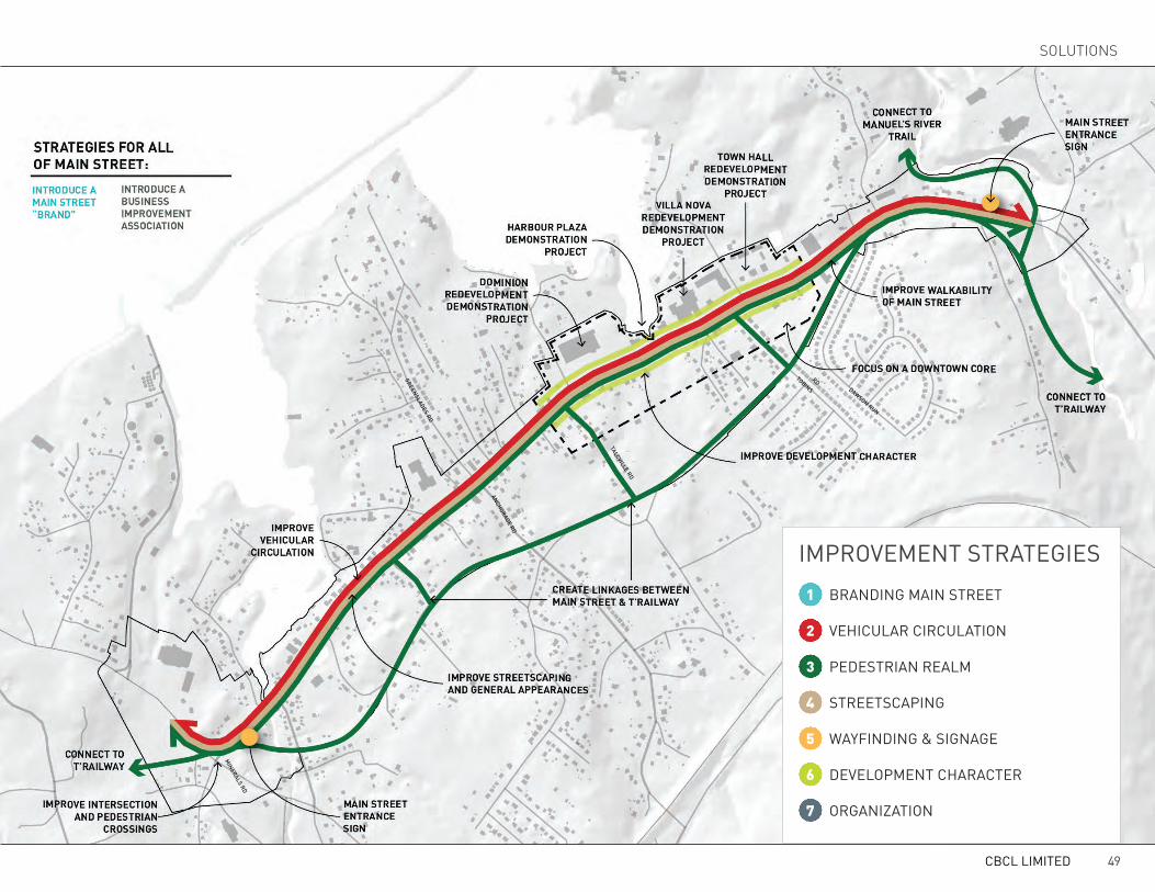
1 BRANDING MAIN STREET
4 STREETSCAPING
2 VEHICULAR CIRCULATION
5 WAYFINDING & SIGNAGE
3 PEDESTRIAN REALM
6 DEVELOPMENT CHARACTER
7 ORGANIZATION
IMPROVEMENT STRATEGIEStALcVILLE RD
DAwSON RUN
tOBINS RD
GREENSLADES RD
MINERALS RD
ANcHORAGE RD
CBCL LIMITED 49
SOLUTIONS

BRANDING MAIN STREETDeveloping a “brand” for Main Street will help build a recognizable identity for the area and con-tribute to establishing it as a distinct place in the minds of its users. A successful brand will com-municate local strengths, improve its public image, and attract new residents, business investment and visitors/tourists. Furthermore, a well developed and locally supported brand can establish a strong and long-lasting foundation from which to build on, and can be integrated into other Main Street initiatives including marketing material, signage and wayfinding concepts, urban design concepts, streetscape design, promotional events and more.
Public buy-in is the most important prerequisite in determining the ultimate success of a brand. Place branding, unlike marketing products or ser-vices, not only puts a brand on a physical place, but also on the people that live, work or use the area as part of their everyday life. As such, devel-oping a brand for a place requires the input and feedback of the community and stakeholders. The longevity and success of a brand will depend on how far the community will take it.
For the purpose of this study, we have developed a draft brand concept that can be used to begin the discussion of developing a brand for Main Street.
This brand may be accepted by the public imme-diately, it may evolve somewhat, or it may be com-pletely rejected altogether. Despite the potential outcomes, the primary purpose of this branding exercise is to highlight the benefits of an attractive brand, and how this brand should be incorporated into other elements of the Main Street Plan.
EXIStING tOwN BRANDThe Main Street brand builds on the strengths and aesthetic of the existing and successful Town branding strategy, but differentiates itself enough to establish itself as a distinct entity.
The new logo for the Town of Conception Bay South focuses on the
town as a place of beauty, rich with green spaces and opportunities for
leisure. The sun’s presence is suggested through the lush foliage, and
outdoor play. This logo communicates a relaxed, yet youthful energy and
positions Conception Bay South as a family orientated community to
visitors as well as the many people who call it home.
The logo was developed to compliment the Town’s slogan “Bright Town
Bright Future.” Its role is greater than just a slogan. “Bright Town Bright
Future” is the strategic driver behind promoting the Town and is based
on the following belief:
Conception Bay South is a “family oriented community, which values
its scenic coastline, landscape, waterways and recreational opportunities
that strives to ensure high standards of environmental protection,
a vibrant commercial sector and an efficient street network,
connecting safe, well designed neighbourhoods that enable healthy
and active lifestyles.”
CREATIVERATIONALE
Visual Identity created by WaterWerks Communications Inc. www.waterwerkscommunications.com
The Town logo consists of a green tree, with a young girl swinging on a tire with her dog watch-ing nearby. The words “the town of Conception Bay South: Bright town. Bright Future” are writ-ten below in a black, serif typeface. According to the Identity Guidelines prepared for the Town, this logo was intended to be family-oriented and com-municate feelings of leisure and youthful energy. The primary colour palette consists of two-tone greens and black, which exudes a safe, peaceful and rural setting. The Town brand also identified a secondary colour palette which consists of a bright blue and red, orange, brown, and gray tones.
R 200G 177B 139
R 216G 217B 218
R 92G 111B 124
R 253G 186
R 193G 216B 47
R 12G 12B 12
R 0G 112B 60
PRIM
aRY
CO
LOU
R P
aLET
TE
SEC
ON
DaR
Y C
OLO
UR
PaL
ETTE
B 81
R 74G 195B 204
R 210G 35B 42
TOWN OF CONCEPTION BAY SOUTH BRAND
CBS MAIN STREET IMPROVEMENT PLAN50

OBjEctIVES OF A MAIN StREEt BRANDThe draft Main Street brand aims to:• Fit into the existing Town brand while still dif-
ferentiating itself as a distinct place;• Portray Main Street as an urban place;• Establish Main Street as an ideal place to do
business;• Attract tourists and visitors;• Communicate the coastal beauty and attrac-
tive climate of Conception Bay South;• Communicate that Main Street is transform-
ing or in the process of evolving into a better place to live, work, shop and play; and
• Communicate the forward thinking and con-temporary characteristics of the area.
MAIN StREEt BRAND cONcEPtThe draft Main Street brand utilizes a combina-tion of colours, imagery and text to communicate the desired objectives listed above. The result is a bold, bright and exciting new look that builds on the success of the Town brand while establishing itself as a new and upcoming destination within Conception Bay South.
Colours can be used to differentiate one place from another and to symbolically represent local values. The Main Street brand borrows the same colour palette of the Town brand, but rearranges the colours into different primary and secondary groups. Where the Town brand focuses on neu-tral greens and black for its primary colour pal-ette, the Main Street brand emphasizes the cyan
blue, bright red, and forest green. The cyan blue represents the bright blue sky and waterfront lo-cation of Main Street. Blue is also used to symbol-ize peacefulness and hospitality. The dark green is used to symbolize the natural beauty of the surrounding landscape and the opportunity for outdoor leisure activity. Finally, the bright red is often used to communicate excitement and hu-man activity (representing the vibrant and diverse business community). The remaining colours from the Town brand are utilized in the secondary colour palette, and can be used for supplementa-ry materials where additional colours or tones are required (such as on maps, charts, graphics, etc).
The imagery of the new logo includes unique symbols, shapes and icons that convey the scenic and urban characteristics of Main Street. For ex-
ample, the round shape of the upper half of the logo subtly refers to a setting sun and open sky, alluding to the unique climate of Conception Bay South. A gliding seagull is used to strengthen the connection to the waterfront setting. A green, un-dulating plateau with white silhouetted building shapes in the foreground represents the attractive natural backdrop that the Avalon Plateau offers in relation to the urban setting of Main Street. Final-ly, the “Main Street” text is framed by a rectan-gular shape that subtlety resembles a street sign, reinforcing the urban qualities of the area.
The typeface used in the font is DINPro Bold. It is a strong, clean, legible sans-serif typeface that differentiates itself from the black serif typeface used in the Town brand.
R 193G 216B 47
R 200G 177B 139
R 216G 217B 218
R 92G 111B 124
R 12G 12B 12
R 253G 186
R 210G 35B 42
R 0G 112B 60
R 74G 195B 204
PRIM
aRY
CO
LOU
R P
aLET
TE
SEC
ON
DaR
Y C
OLO
UR
PaL
ETTE
B 81
DRAFT CONCEPTION FOR MAIN STREET BRAND
CBCL LIMITED 51
SOLUTIONS

VEHICULAR CIRCULATIONRIGHtSIzING tHE StREEtIn the past, the composition of Main Street was designed with one simple objective in mind - to move vehicles through as efficiently as possible. Now, as the diversity of needs and desires for the Town have evolved, so too have the diversity of needs and desires for Main Street. Aside from moving ve-hicles, Main Street must now accomplish a variety of objectives, including the ability to accommodate a variety of travel modes from pedestrians to cyclists to people in wheelchairs. By “rightsizing” Main Street through re-configuration of its layout, it can better satisfy these emerging needs and desires, whether they’re commuters driving, shoppers walking, or children bicycling. Rightsizing street reconfigurations can improve travel times (of-ten despite reduced traffic speeds), create more pedestrian friendly streets, increase sales revenue and property values for adjacent businesses, and im-prove safety by reducing vehicle and pedestrian accidents (see case study to the right for one example). This section will illustrate how right-sizing Main Street and other street network optimizations can accomplish the objective of moving vehicles, while also becoming an inviting and comfortable place for pedestrians of all ages.
CASE STUDYRIGHT-SIZING IN POUGHKEEPSIE, NYSimilar to Main Street, Raymond Avenue borders residences, a business district, open space and an elementary school. Raymond Avenue felt like a highway because the road was initially designed for high speeds, rather than safety and access. In 1999, the city set out to reconfigure 1.5 miles of Raymond Avenue to calm traffic, improve pedestrian experience and safety, increase aesthetic appeal and support a vibrant business district. By resizing the street, the four lane arterial road was reduce to two lanes, three roundabouts were constructed in order to slow traffic without impeding traffic flow, sidewalks and parking were made more consistent along the corridor, a centre median with plantings and tress was built, pedestrian infrastructure was added (textured sidewalks, district specific street lights) and a safer crossing at the elementary school was established. Phase 1 of the project was completed in 2007. By comparing traffic data from before and after the redesign, it was found that accidents decreased more than 50%, and vehicle speeds declined by about 24%, yet corridor travel time increased by 7% and traffic delays decreased by 56% at the roundabouts. Furthermore, many new businesses have opened or expanded in the district since the project was implemented.
Read more about right-sizing here:www.pps.org/reference/rightsizing
CBS MAIN STREET IMPROVEMENT PLAN52
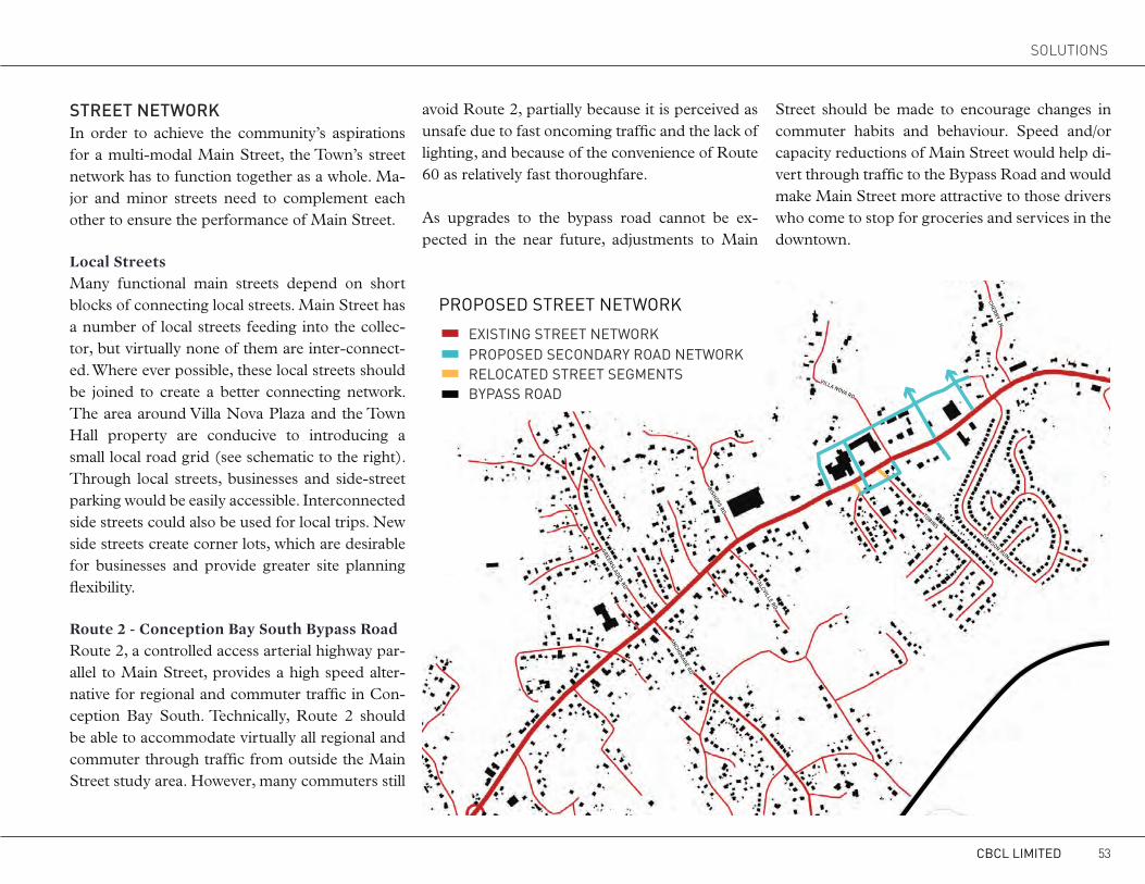
StREEt NEtwORkIn order to achieve the community’s aspirations for a multi-modal Main Street, the Town’s street network has to function together as a whole. Ma-jor and minor streets need to complement each other to ensure the performance of Main Street. Local StreetsMany functional main streets depend on short blocks of connecting local streets. Main Street has a number of local streets feeding into the collec-tor, but virtually none of them are inter-connect-ed. Where ever possible, these local streets should be joined to create a better connecting network. The area around Villa Nova Plaza and the Town Hall property are conducive to introducing a small local road grid (see schematic to the right). Through local streets, businesses and side-street parking would be easily accessible. Interconnected side streets could also be used for local trips. New side streets create corner lots, which are desirable for businesses and provide greater site planning flexibility. Route 2 - Conception Bay South Bypass RoadRoute 2, a controlled access arterial highway par-allel to Main Street, provides a high speed alter-native for regional and commuter traffic in Con-ception Bay South. Technically, Route 2 should be able to accommodate virtually all regional and commuter through traffic from outside the Main Street study area. However, many commuters still
avoid Route 2, partially because it is perceived as unsafe due to fast oncoming traffic and the lack of lighting, and because of the convenience of Route 60 as relatively fast thoroughfare. As upgrades to the bypass road cannot be ex-pected in the near future, adjustments to Main
Street should be made to encourage changes in commuter habits and behaviour. Speed and/or capacity reductions of Main Street would help di-vert through traffic to the Bypass Road and would make Main Street more attractive to those drivers who come to stop for groceries and services in the downtown.
EXISTING STREET NETWORKPROPOSED SECONDARY ROAD NETWORKRELOCATED STREET SEGMENTSBYPASS ROAD
PROPOSED STREET NETWORK
tALcVILLE RD
DAwSON RUN
tOBINS RD
VILLA NOVA RD
cHERRY LN
GREENSLADES RD
BISHOPS RD
ANcHORAGE RD
CBCL LIMITED 53
SOLUTIONS

tRAVEL LANESCurrently, Main Street is a four-lane undivided road with 3.5 metre travel lanes. When considering changes to the travel lanes, three important factors need to be considered: speed, width and sidewalk interface. Because of the envisioned pedestrian-friendly nature of Main Street, target speeds should be kept below 50 km/h. Lower speeds improve both the drivers’ perception and experience of Main Street and create a safer environment for everyone using the street. In many instances, travel lane removal from four to three with two travel lanes and one centre turning lane have proven to decrease speeds, smooth traffic flow and reduce the number of accidents. Drivers on four-lane roads tend to
OPTION 1PROS
• Median as pedestrian refuge• Landscape opportunity / visually pleasing
• Traffic calming / lower speeds• Access management opportunity
CONS• Requires special provisions for left turns and/or U-turns
• Minimum width for left turn bays: 3.0m (must terminate median rather than cut left turn lane into it)
• Cyclists would be forced to share the road with motorists, or ride on the sidewalk
CONSIDERATIONS• Left turn pockets should be minimum 20m long (including short taper)
for low volume left turns (residential streets, etc.) and 30-40m long for higher volume retail/commercial driveways
CBS MAIN STREET IMPROVEMENT PLAN54

speed up seeing an empty lane in their direction or trying to match the speed of faster drivers. Last-second lane swapping to avoid left-turning vehicles leads to side-swipe and rear-end crashes. Four lane road also pose significant difficulties for pedestrians trying to cross.
The 20 metre Main Street right-of-way allows for a number of travel lane configurations. The travel lane configurations presented are intended to rightsize the street in ways that fulfill the downtown vision for Main Street. In the absence of up-to-date vehicle counts, no one option is preferred until a detailed traffic impact assessment is conducted.
OPTION 2PROS• Traffic calming / lower speeds• Access management opportunity• Wide sidewalks• Landscaping and amenity strip separating sidewalks from roadway• Amenity zone provides opportunity for street furniture
CONS• Requires left turns be made from a shared through lane• 1.5m median width is quite narrow for pedestrian refuge• Median doesn’t provide room for wheelchairs, strollers, bikes, etc.• Would be very uncomfortable with 2 lanes of traffic on either side• Median limits access to properties (also a pro in terms of access manage-
ment)
CBCL LIMITED 55
SOLUTIONS
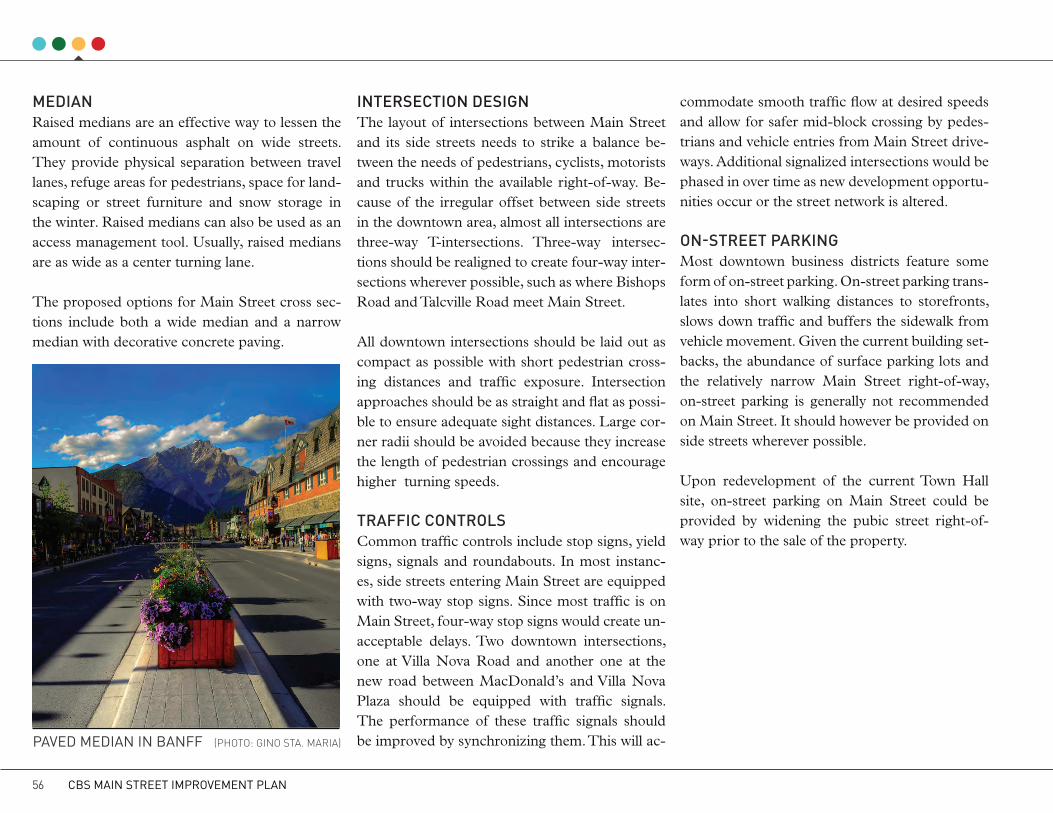
MEDIANRaised medians are an effective way to lessen the amount of continuous asphalt on wide streets. They provide physical separation between travel lanes, refuge areas for pedestrians, space for land-scaping or street furniture and snow storage in the winter. Raised medians can also be used as an access management tool. Usually, raised medians are as wide as a center turning lane.
The proposed options for Main Street cross sec-tions include both a wide median and a narrow median with decorative concrete paving.
INtERSEctION DESIGNThe layout of intersections between Main Street and its side streets needs to strike a balance be-tween the needs of pedestrians, cyclists, motorists and trucks within the available right-of-way. Be-cause of the irregular offset between side streets in the downtown area, almost all intersections are three-way T-intersections. Three-way intersec-tions should be realigned to create four-way inter-sections wherever possible, such as where Bishops Road and Talcville Road meet Main Street.
All downtown intersections should be laid out as compact as possible with short pedestrian cross-ing distances and traffic exposure. Intersection approaches should be as straight and flat as possi-ble to ensure adequate sight distances. Large cor-ner radii should be avoided because they increase the length of pedestrian crossings and encourage higher turning speeds.
tRAFFIc cONtROLSCommon traffic controls include stop signs, yield signs, signals and roundabouts. In most instanc-es, side streets entering Main Street are equipped with two-way stop signs. Since most traffic is on Main Street, four-way stop signs would create un-acceptable delays. Two downtown intersections, one at Villa Nova Road and another one at the new road between MacDonald’s and Villa Nova Plaza should be equipped with traffic signals. The performance of these traffic signals should be improved by synchronizing them. This will ac-
commodate smooth traffic flow at desired speeds and allow for safer mid-block crossing by pedes-trians and vehicle entries from Main Street drive-ways. Additional signalized intersections would be phased in over time as new development opportu-nities occur or the street network is altered. ON-StREEt PARkINGMost downtown business districts feature some form of on-street parking. On-street parking trans-lates into short walking distances to storefronts, slows down traffic and buffers the sidewalk from vehicle movement. Given the current building set-backs, the abundance of surface parking lots and the relatively narrow Main Street right-of-way, on-street parking is generally not recommended on Main Street. It should however be provided on side streets wherever possible.
Upon redevelopment of the current Town Hall site, on-street parking on Main Street could be provided by widening the pubic street right-of-way prior to the sale of the property.
PAVED MEDIAN IN BANFF (PHOTO: GINO STa. MaRIa)
CBS MAIN STREET IMPROVEMENT PLAN56

EXISTING SIGNALIZED INTERSECTION
FUTURE SIGNALIZED INTERSECTION
MAIN STREET WITH MEDIAN
MEDIAN GAP FOR LEFT HAND TURNS
MAIN STREET WITHOUT MEDIAN
FUTURE ROAD NETWORK
TRAFFIC CIRCULATION
tALcVILLE RD
DAwSON RUN
tOBINS RD
VILLA NOVA RD
cHERRY LN
GREENSLADES RD
cONwAYS BROOk RD
tERMINALS R
D
BISHOPS RD
tOPSAIL RD
ANcHORAGE RD
CBCL LIMITED 57
SOLUTIONS
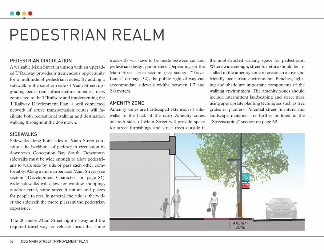
PEDESTRIAN REALMPEDEStRIAN cIRcULAtIONA walkable Main Street in unison with an upgrad-ed T’Railway provides a tremendous opportunity for a multitude of pedestrian routes. By adding a sidewalk to the southern side of Main Street, up-grading pedestrian infrastructure on side streets connected to the T’Railway and implementing the T’Railway Development Plan, a well connected network of active transportation routes will fa-cilitate both recreational walking and destination walking throughout the downtown.
SIDEwALkSSidewalks along both sides of Main Street con-stitute the backbone of pedestrian circulation in downtown Conception Bay South. Downtown sidewalks must be wide enough to allow pedestri-ans to walk side by side or pass each other com-fortably. Along a more urbanized Main Street (see section “Development Character” on page 81) wide sidewalks will allow for window shopping, outdoor retail, some street furniture and places for people to rest. In general, the rule is: the wid-er the sidewalk the more pleasant the pedestrian experience.
The 20 metre Main Street right-of-way and the required travel way for vehicles mean that some
trade-offs will have to be made between car and pedestrian design parameters. Depending on the Main Street cross-section (see section “Travel Lanes” on page 54), the public right-of-way can accommodate sidewalk widths between 1.7 and 2.0 meters.
AMENItY zONEAmenity zones are hardscaped extension of side-walks to the back of the curb. Amenity zones on both sides of Main Street will provide space for street furnishings and street trees outside if
the unobstructed walking space for pedestrians. Where wide enough, street furniture should be in-stalled in the amenity zone to create an active and friendly pedestrian environment. Benches, light-ing and shade are important components of the walking environment. The amenity zones should include intermittent landscaping and street trees using appropriate planting techniques such as tree grates or planters. Potential street furniture and landscape materials are further outlined in the “Streetscaping” section on page 62.
amenity zone
CBS MAIN STREET IMPROVEMENT PLAN58

EXISTING TRAIL NETWORK
EXISTING SIDEWALK PROPOSED SIDEWALK
FUTURE PUBLIC SPACE
EXISTING SIGNALIZED CROSSWALK
EXISTING CROSSWALK
TRANSIT STATION
PROPOSED CROSSWALK
PROPOSED SIGNALIZED CROSSWALK
PEDESTRIAN NETWORKPROPOSED TRAIL MARKERS
tALcVILLE RD
DAwSON RUN
tOBINS RD
VILLA NOVA RD
cHERRY LN
GREENSLADES RD
cONwAYS BROOk RD
tERMINALS R
D
BISHOPS RD
tOPSAIL RD
ANcHORAGE RD
CBCL LIMITED 59
SOLUTIONS

cROSSwALkSThe lack of properly marked crosswalks exempli-fies the inadequacy of pedestrian infrastructure and associated safety risks along Main Street. Even though crosswalks exist in some locations, a recent fatal accident has resulted in abandoning crosswalk maintenance encouraging pedestrians to not rely on them as safe crossings.
In the downtown area, crosswalks should be in-stalled at most intersections between Main Street and its side streets. Mid-block crossings should be considered to achieve a distance of 60 to 100 metres between crossings in the core area. Gen-erally crosswalks should align with the downtown pedestrian circulation pattern and should be in-stalled at important institutions such as the school and town hall. At a minimum, crosswalk markings should include a ladder pattern striping and the area should be well lid. High traffic volumes along justify the installation of button-operated warning lights. Traffic lights at downtown intersections in-terrupting the flow of vehicles and a median or refuge isles will generally improve the experience for pedestrians crossing Main Street.
REFUGE ISLANDSRefuge islands allow pedestrians to cross fewer lanes at once and allows them to predict possible conflicts with cars separately. Slower pedestrians can take a break while crossing a street and the total crossing distance gets reduced. In the event that the reconfiguration of Main Street results in a street cross section without a median, refuge islands large enough to provide space for several pedestrians should be installed.
tRANSItCurrently, Conception Bay South does not have a transit service, however, a recent study recent-ly recommended a regional commuter service for the area. If properly developed, the potential of a regional transit service could both reduce trips made by single-occupancy vehicles and boost the potential for a transit-oriented development along the core of Main Street. In order for such a transit service to be successful it will need to offer low travel times, high trip frequencies, comfortable seating, and a large parking area around the ter-minal. An ideal location for a park-and-ride type of transit terminal would be on the current Town Hall property which will likely be redeveloped when the facility moved west to Kitty Ade’s Turn.
cYcLINGThere are many environmental, social, health and even economic benefits to promoting cy-cling. Providing on-street bike lanes is one of the most effective way to encourage cycling, and can be accommodated on Main Street by removing travel lanes (see cross section to the right). Based on the current demand of traffic of Main Street, reducing the amount of travel lanes is not recom-mended at this point. The majority of residents in Conception Bay South work outside of the Town and do not use the bicycle to commute back and forth. Therefore, most cycling that would occur along Main Street would be recreational or er-rand-based. With this mind, the Town should fo-cus on the T’Railway as a major active transpor-tation corridor. Improved linkages to Main Street and upgraded surfaces that can comfortably ac-commodate cyclists will help encourage more people to cycle.
Furthermore, research also suggests that a frag-mented network of on-street bike paths are not ef-fective in encouraging cycling. In order to be suc-cessful, bike paths must link into a larger regional network which is currently non-existent.
CBS MAIN STREET IMPROVEMENT PLAN60

RIGHT-OF-WAY WITH BIKE LANESPROS
• Reduction to 2 travel lanes would have a significant traffic calming effect• Opportunity for bike lane
• Wide sidewalks• Landscaping and amenity zone separating sidewalks from roadway
• Amenity zone provides opportunity for street furniture
CONS• Reduced road capacity will not likely be sufficient to accommodate traffic volumes
• Cycling path may not be practical in terms of connecting with external areas.
CONSIDERATIONS• Left turn pockets should be minimum 20m long (including short taper) for low
volume left turns (residential streets, etc.) and 30-40m long for higher volume retail/commercial driveways
CBCL LIMITED 61
SOLUTIONS
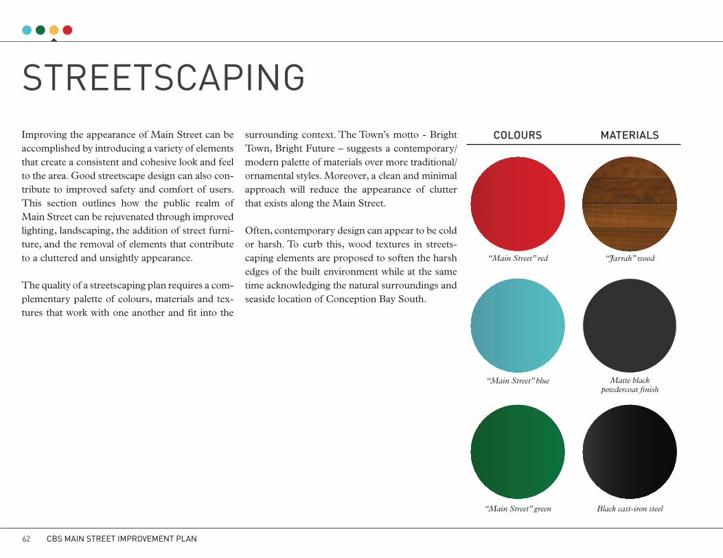
STREETSCAPINGImproving the appearance of Main Street can be accomplished by introducing a variety of elements that create a consistent and cohesive look and feel to the area. Good streetscape design can also con-tribute to improved safety and comfort of users. This section outlines how the public realm of Main Street can be rejuvenated through improved lighting, landscaping, the addition of street furni-ture, and the removal of elements that contribute to a cluttered and unsightly appearance.
The quality of a streetscaping plan requires a com-plementary palette of colours, materials and tex-tures that work with one another and fit into the
surrounding context. The Town’s motto - Bright Town, Bright Future – suggests a contemporary/modern palette of materials over more traditional/ornamental styles. Moreover, a clean and minimal approach will reduce the appearance of clutter that exists along the Main Street.
Often, contemporary design can appear to be cold or harsh. To curb this, wood textures in streets-caping elements are proposed to soften the harsh edges of the built environment while at the same time acknowledging the natural surroundings and seaside location of Conception Bay South.
cOLOURS
“Main Street” red “Jarrah” wood
“Main Street” blue Matte black powdercoat finish
“Main Street” green Black cast-iron steel
MAtERIALS
431 Lawndale A
ve, Kalam
azoo, MI 49048 | p 800.521.2546 | f 269.381.3455 | landscapeform
s.com | specify@
landscapeforms.com
materials / co
lors
IMP
OR
TAN
T N
OT
E: S
tandard
choices are sho
wn; co
lors are ap
pro
ximate. To
make final co
lor selectio
ns, please call fo
r material sam
ples.
materials / co
lors
IMP
OR
TAN
T N
OT
E: S
tandard
choices are sho
wn; co
lors are ap
pro
ximate. To
make final co
lor selectio
ns, please call fo
r material sam
ples.
po
wd
erc
oa
ted
me
tal
In add
ition to colors shown b
elow, a w
ide selection of op
tional and custom
colors may b
e specified
for an upcharge.
bro
nze
olive
steeltitan
ium
ston
e
black
cranb
erryivy
blu
e bell
bu
ttercup
grass
matte b
lack
ocean
silver
storm
clou
dw
hite
me
tallic
pu
rpleh
eart (P)
jarrah (P
)
plaza p
lanter
Exterior w
oods w
eather to a warm
, pew
ter gray; no finish is app
lied so no m
aintenance is required
. Op
tions: purp
leheart may b
e specified
as FSC
® certified
(may extend
lead tim
es). Sp
ecial stain may b
e specified
for interior wood
s. Pricing for stand
ard w
oods and
options varies, see P
rice Book.
(P) =
Prem
ium W
oods
wo
od
exterior
CBS MAIN STREET IMPROVEMENT PLAN62
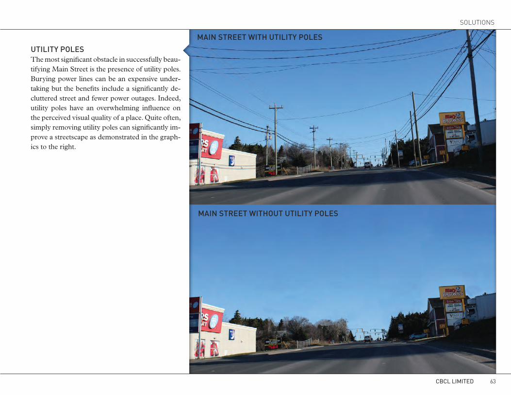
MAIN StREEt wItH UtILItY POLES
MAIN StREEt wItHOUt UtILItY POLES
UtILItY POLESThe most significant obstacle in successfully beau-tifying Main Street is the presence of utility poles. Burying power lines can be an expensive under-taking but the benefits include a significantly de-cluttered street and fewer power outages. Indeed, utility poles have an overwhelming influence on the perceived visual quality of a place. Quite often, simply removing utility poles can significantly im-prove a streetscape as demonstrated in the graph-ics to the right.
CBCL LIMITED 63
SOLUTIONS
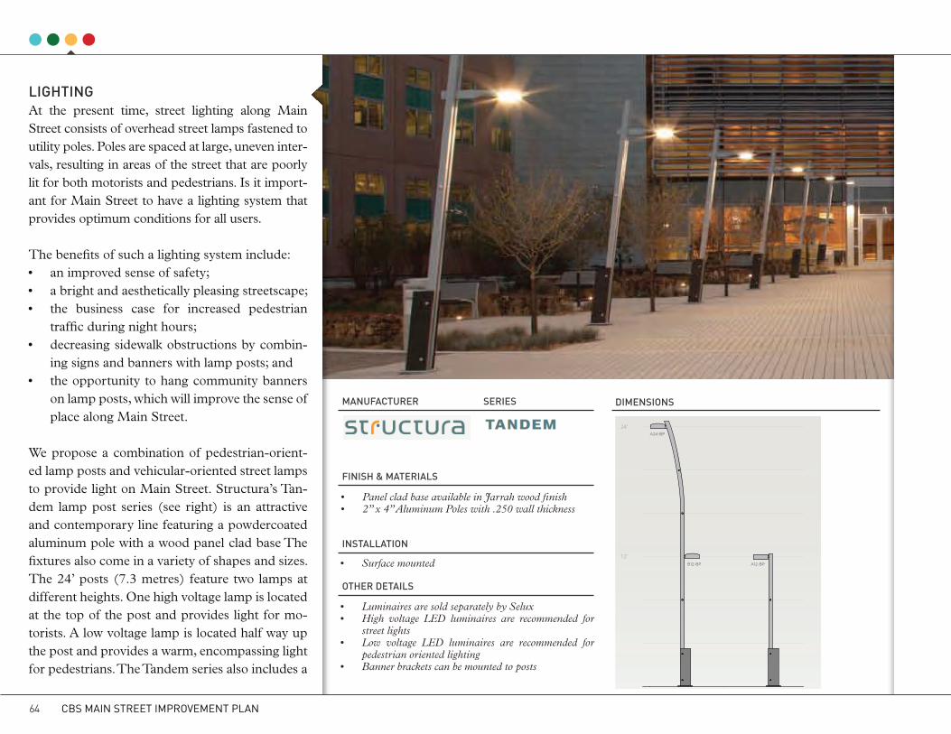
National Renewable Energy LabsGolden, ColoradoArchiteture by RNL
Tandem subtly articulates the
entry to the building. We were
very pleased with the result.
RAChEL PETRO RNL Lighting designer
“
”
tAndeM
© 2012 STRUCTURA INC.24 25 © 2012 STRUCTURA INC.
LIGHtINGAt the present time, street lighting along Main Street consists of overhead street lamps fastened to utility poles. Poles are spaced at large, uneven inter-vals, resulting in areas of the street that are poorly lit for both motorists and pedestrians. Is it import-ant for Main Street to have a lighting system that provides optimum conditions for all users.
The benefits of such a lighting system include:• an improved sense of safety;• a bright and aesthetically pleasing streetscape;• the business case for increased pedestrian
traffic during night hours; • decreasing sidewalk obstructions by combin-
ing signs and banners with lamp posts; and• the opportunity to hang community banners
on lamp posts, which will improve the sense of place along Main Street.
We propose a combination of pedestrian-orient-ed lamp posts and vehicular-oriented street lamps to provide light on Main Street. Structura’s Tan-dem lamp post series (see right) is an attractive and contemporary line featuring a powdercoated aluminum pole with a wood panel clad base The fixtures also come in a variety of shapes and sizes. The 24’ posts (7.3 metres) feature two lamps at different heights. One high voltage lamp is located at the top of the post and provides light for mo-torists. A low voltage lamp is located half way up the post and provides a warm, encompassing light for pedestrians. The Tandem series also includes a
MANUFActURER
FINISH & MAtERIALS
INStALLAtION
OtHER DEtAILS
SERIES DIMENSIONS
• Surface mounted
• Luminaires are sold separately by Selux• High voltage LED luminaires are recommended for
street lights• Low voltage LED luminaires are recommended for
pedestrian oriented lighting• Banner brackets can be mounted to posts
• Panel clad base available in Jarrah wood finish• 2” x 4” Aluminum Poles with .250 wall thickness
24'
12'
ORTHO 24 EVO 12 EVO 24
B12-BP
A24-BP18 A24-BP
B12-BPA12-BP18R
ORTHO 24 EVO 13.5 EVO 24
CONFIguREd yOuR wAy
24'
12'
ORTHO 24 EVO 12 EVO 24
B20-BP18
A12-BP18
A16-BP18R
A12-BP
TILT 17.5 TILT 21.5 ORTHO 12
Configure Tandem to uniquely respond to your project’s needs. Mount street side luminaires high
allowing for greater distance between poles and better light distribution. Mount low-wattage
pedestrian scale luminaires at lower heights to bring a more human scale to public spaces.
© 2012 STRUCTURA INC.30 31 © 2012 STRUCTURA INC.
24'
12'
ORTHO 24 EVO 12 EVO 24
B12-BP
A24-BP18 A24-BP
B12-BPA12-BP18R
ORTHO 24 EVO 13.5 EVO 24
CONFIguREd yOuR wAy
24'
12'
ORTHO 24 EVO 12 EVO 24
B20-BP18
A12-BP18
A16-BP18R
A12-BP
TILT 17.5 TILT 21.5 ORTHO 12
Configure Tandem to uniquely respond to your project’s needs. Mount street side luminaires high
allowing for greater distance between poles and better light distribution. Mount low-wattage
pedestrian scale luminaires at lower heights to bring a more human scale to public spaces.
© 2012 STRUCTURA INC.30 31 © 2012 STRUCTURA INC.
CBS MAIN STREET IMPROVEMENT PLAN64
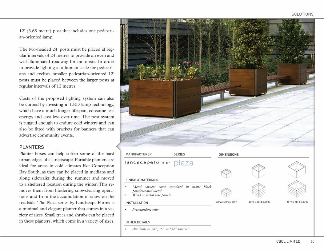
MANUFActURER
FINISH & MAtERIALS
INStALLAtION
OtHER DEtAILS
SERIES DIMENSIONS
• Freestanding only
• Available in 28”, 36” and 48” squares
• Metal corners come standard in matte black powdercoated metal
• Wood or metal side panels
15 1/2"39413/16"
21
60.0° 14"356
LENGTH OFBENCH
TOP VIEWOF BASEPLATE
2 1/4"57
8" MIN203 MIN
36" MINSQUARE
914 MIN
NOTE:SEE INSTALLATION GUIDE FOR ADDITIONAL FOOTING AND ANCHOR OPTIONS
GRADE
STEEL REINFORCED CONCRETE SLAB (f'c = 3000 psi)
74 3/4"1899
WOOD BOARDS
1 3/4"44
26 7/8"684
17 7/8"454
32"814
10 1/4"260
23 5/8"601
36" MINSQUARE
914 MIN
www.landscapeforms.com Ph: 800.521.2546
Drawing: AR422-06Date: 5/17/2010Dimensions are in Inches[mm]U.S. Patent Nos.: D453,424; D455,919; D451,296; D450,952
Backed Bench, Surface Mount, Wood, with Arms
Arcata®
CONFIDENTIAL DRAWING INFORMATION CONTAINED HEREIN IS THE PROPERTY OF LANDSCAPE FORMS, INC. INTENDED USE IS LIMITED TO DESIGN PROFESSIONALS SPECIFYING LANDSCAPE FORMS, INC. PRODUCTS AND THEIR DIRECT CLIENTS. DRAWING IS NOT TO BE COPIED OR DISCLOSED TO OTHERS WITHOUT THE CONSENT OF LANDSCAPE FORMS, INC. © 2010 LANDSCAPE FORMS, INC. ALL RIGHTS RESERVED.
Product Drawing plazaGiant square planters in three sizes bring green to urban streetscapes and plazas.
Installation GuidePlazawww.landscapeforms.com Ph: 800.521.2546Planter
28”w x 28”d x 18”h 36”w x 36”d x 32”h 48”w x 48”d x 32”h
Included components:•Planters ship fully assembled.•Planters are freestanding, with one drain hole
Planter Sizes
INSTALLATION:1. Set unit in place.2. Level the planter before adding planting material using
the threaded adjustable feet as shown
Adjustable leveling foot
the threaded adjustable feet, as shown.3. Fill planter liner to ledge with plants and planting soil;
fill the remaining portion of the liner with mulch.
Date: November 1, 2012Spanish Industrial Design 131.946 Page 1 of 1
12’ (3.65 metre) post that includes one pedestri-an-oriented lamp.
The two-headed 24’ posts must be placed at reg-ular intervals of 24 metres to provide an even and well-illuminated roadway for motorists. In order to provide lighting at a human scale for pedestri-ans and cyclists, smaller pedestrian-oriented 12’ posts must be placed between the larger posts at regular intervals of 12 metres.
Costs of the proposed lighting system can also be curbed by investing in LED lamp technology, which have a much longer lifespan, consume less energy, and cost less over time. The post system is rugged enough to endure cold winters and can also be fitted with brackets for banners that can advertise community events.
PLANtERSPlanter boxes can help soften some of the hard urban edges of a streetscape. Portable planters are ideal for areas in cold climates like Conception Bay South, as they can be placed in medians and along sidewalks during the summer and moved to a sheltered location during the winter. This re-moves them from hindering snowclearing opera-tions and from the accumulation of snow on the roadside. The Plaza series by Landscape Forms is a minimal and elegant planter that comes in a va-riety of sizes. Small trees and shrubs can be placed in these planters, which come in a variety of sizes.
CBCL LIMITED 65
SOLUTIONS
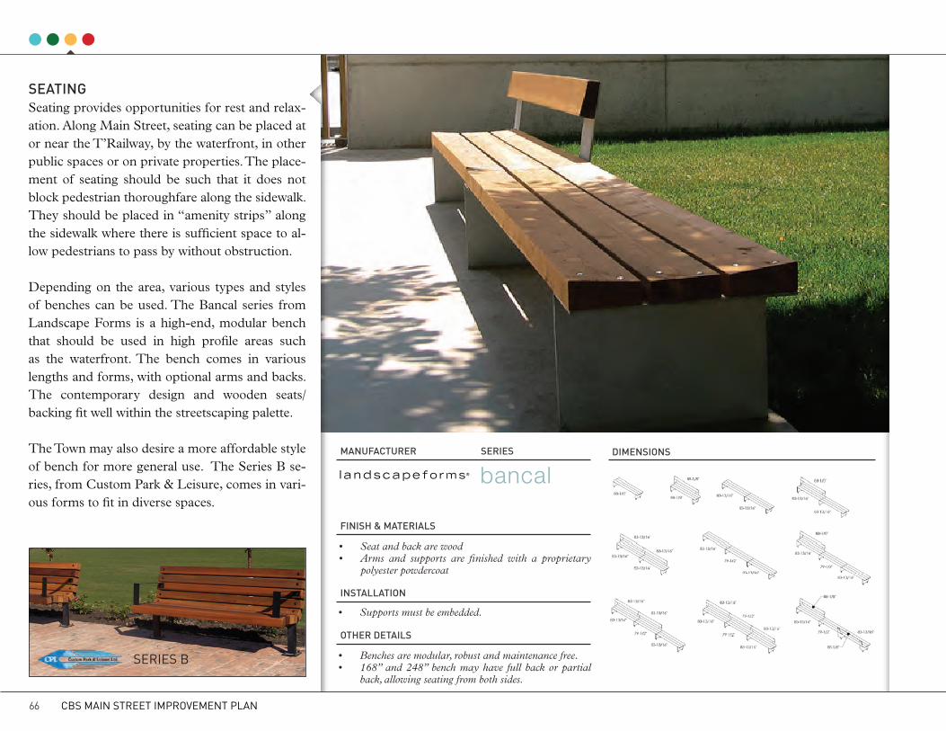
SEAtINGSeating provides opportunities for rest and relax-ation. Along Main Street, seating can be placed at or near the T’Railway, by the waterfront, in other public spaces or on private properties. The place-ment of seating should be such that it does not block pedestrian thoroughfare along the sidewalk. They should be placed in “amenity strips” along the sidewalk where there is sufficient space to al-low pedestrians to pass by without obstruction.
Depending on the area, various types and styles of benches can be used. The Bancal series from Landscape Forms is a high-end, modular bench that should be used in high profile areas such as the waterfront. The bench comes in various lengths and forms, with optional arms and backs. The contemporary design and wooden seats/backing fit well within the streetscaping palette.
The Town may also desire a more affordable style of bench for more general use. The Series B se-ries, from Custom Park & Leisure, comes in vari-ous forms to fit in diverse spaces.
MANUFActURER
FINISH & MAtERIALS
INStALLAtION
OtHER DEtAILS
SERIES DIMENSIONS
• Supports must be embedded.
• Benches are modular, robust and maintenance free.• 168” and 248” bench may have full back or partial
back, allowing seating from both sides.
• Seat and back are wood• Arms and supports are finished with a proprietary
polyester powdercoat
15 1/2"39413/16"
21
60.0° 14"356
LENGTH OFBENCH
TOP VIEWOF BASEPLATE
2 1/4"57
8" MIN203 MIN
36" MINSQUARE
914 MIN
NOTE:SEE INSTALLATION GUIDE FOR ADDITIONAL FOOTING AND ANCHOR OPTIONS
GRADE
STEEL REINFORCED CONCRETE SLAB (f'c = 3000 psi)
74 3/4"1899
WOOD BOARDS
1 3/4"44
26 7/8"684
17 7/8"454
32"814
10 1/4"260
23 5/8"601
36" MINSQUARE
914 MIN
www.landscapeforms.com Ph: 800.521.2546
Drawing: AR422-06Date: 5/17/2010Dimensions are in Inches[mm]U.S. Patent Nos.: D453,424; D455,919; D451,296; D450,952
Backed Bench, Surface Mount, Wood, with Arms
Arcata®
CONFIDENTIAL DRAWING INFORMATION CONTAINED HEREIN IS THE PROPERTY OF LANDSCAPE FORMS, INC. INTENDED USE IS LIMITED TO DESIGN PROFESSIONALS SPECIFYING LANDSCAPE FORMS, INC. PRODUCTS AND THEIR DIRECT CLIENTS. DRAWING IS NOT TO BE COPIED OR DISCLOSED TO OTHERS WITHOUT THE CONSENT OF LANDSCAPE FORMS, INC. © 2010 LANDSCAPE FORMS, INC. ALL RIGHTS RESERVED.
Product Drawing bancalModular, robust and maintenance free. Bancal withstands adverse weather with aplomb.
Installation GuideBancalwww.landscapeforms.com Ph: 800.521.2546Bench
Fig. 8 – Board length locations and support orientations
Page 3 of 3
Fig. 8 Board length locations and support orientations
Date: August 1, 2012Spanish Industrial Design 151.245
SERIES B
CBS MAIN STREET IMPROVEMENT PLAN66

BINSIn order to maintain a clean environment, an ap-propriate number of waste bins should be con-sistently and strategically placed in popular areas along Main Street. Maglin manufactures a typical urban dual receptacle clad in a black powdercoat-ed steel body. The receptacle is separated into two20 gallon bins, with one for waste and the other for recycling materials. A black molded plastic lid keeps contents inside and also provides an area for labeling. Maglin also manufactures an ash urn (for cigarette butts) that can be mounted to the side of the receptacle.
BIkE RAckSMore and more cities and towns are encouraging modes of active transportation such as walking and cycling, not only for the health benefits as-sociated with these activities, but as a means of reducing the use of vehicle trips and greenhouse gas emissions. Basic bicycle infrastructure such as bicycle racks should be located in key spots along Main Street, including key public gathering spaces such as along the waterfront and in front of public buildings, supermarkets and other local shops and restaurants.
LOcAL MANUFActURINGThe Town may wish to explore whether there is a local company or craftsperson who could manu-facture any of the recommended street furniture in sufficient quantity and specifications.
MANUFActURER
MANUFActURER
FINISH & MAtERIALS
FINISH & MAtERIALS
OtHER DEtAILS
OtHER DEtAILS
SERIES
SERIES
DIMENSIONS
DIMENSIONS
• 20 imperial gallon commercial grade plastic liners and a black molded ABS plastic lid are provided
• A variety of labeling options are available• Optional ash receptacle can be mounted on the side
• The bike rack is constructed using steel tubing and aluminum top casting
• Steel protected with rust proof powdercoating
• Steel protected with rust proof powdercoating
-All drawings, specifications, design and details on this page remain the property of Maglin Site Furniture Inc. and may not be used without Maglin authorization.-Details and specifications may vary due to continuing improvements of our products.
MATERIALS: The recycling station frame is constructed using heavy duty steel flatbar. 2 - 20 gallon commercial grade plastic liners and black molded plastic lid are provided.
FINISH: All steel components are protected with E-Coat rust proofing. The Maglin Powdercoat System provides a durable finish on all metal surfaces.
INSTALLATION: The recycling station is delivered pre-assembled. Holes (0.5") are provided in each mounting foot for securing to base.
TO SPECIFY: Select MRC252 Choose: - Powdercoat Color - Standard Lid (ST) or lid options shown belowOPTIONS: - Recycle Labels - Spun Metal Lids - Trash Opening (MTO) - Bottle/Can Lid (MBC) - Paper Slot Lid (MPS)
MRC252-ST
*also available in 3 unit configuration - MRC253
DIMENSIONS: Height: 35.875" (91.1 cm) Width: 21.50" (54.6 cm) Depth: 38.00" (96.5 cm) Weight: 250lbs (113kg) Liner Capacity(each): 2 x 20.0 Gallons 2 x 75.7 Litres
TM*
*Maglin is a registered trade mark of Maglin Site Furniture Inc.
T 800-716-5506F [email protected]
39.00”35.875”
21.50”
recycling stations
-All drawings, specifications, design and details on this page remain the property of Maglin Site Furniture Inc. and may not be used without Maglin authorization.-Details and specifications may vary due to continuing improvements of our products.
MATERIALS: The bike rack is constructed using H.S. steel tube and an aluminum top casting.
FINISH: All steel components are protected with E-Coat rust proofing. The Maglin Powdercoat System provides a durable finish on all metal surfaces. An optional galvanized finish is also available.
INSTALLATION: The bike rack is delivered pre-assembled. It is available with either a surface mount or direct burial installation option.
TO SPECIFY: Select: MBR100 Series Choose: - Powdercoat Color - Base Type - Direct Burial (MBR100-DB) - Surface Mount (MBR100-S) -Galvanized Finish - Direct Burial (MBR100-DB-G) - Surface Mount (MBR100-S-G)
MBR100 Series
Ø1.625"
Ø20.00"
4.00"
36.00"
*MBR100-S surface mount model shown
DIMENSIONS: Height: 36.00" (91.4 cm) Above Grade 18.00" (45.7 cm) Below Grade Diameter: 20.00" (50.8 cm) Weight: 17.0lbs (7.5kg)
* MAGLIN is a registered trade mark of Maglin Site Furniture Inc.
TM* T 800-716-5506F [email protected]
bike racks
CBCL LIMITED 67
SOLUTIONS

MOUNTAIN ASH
BALSAM FIR
RED MAPLE
WHITE BIRCH
OTHERTREES
Sorbus americana
Abies balsamea
Acer rubrum
Betula papyrifera
• Native deciduous tree• Grows on wet or dry sites up to 12m tall• Bark is light grey• Dark yellow-green, clear yellow leaves in fall• Bright red berries ripen in October and attract birds• Small, single trunk specimens can be lined along the
streetside
• Native coniferous tree• Adaptable to variety of soils and climates• Grows up to 25m tall• Shallow root system• Shiny dark green leaves and greyish-brown bark• Full form with regular branching pattern• Dwarfed specimens can be used along the street
• Native deciduous tree• Prefers moist acidic soil• Can grow up to 15m tall in urban environments• Bark is smooth and light grey• Dark red leaves, turning bright red in autumn• Provides excellent shade cover• Transplants well
• Native deciduous tree• Grows on a variety of soils• Grows up to 12m tall, with a high canopy and nar-
row trunk• Bark is brown/papery grey• Small triangular green leaves • Provides excellent shade cover
• Eastern Larch, Black Spruce, White Spruce, Trem-bling Aspen, Little Leaf Linden (non-native), Japa-nese Larch (non-native)
LANDScAPING & VEGEtAtIONThe introduction of attractive landscaping and vegetation can very effectively brighten a streetscape. The colour, texture and depth of natural plant material can soften the hard edges of urban infrastructure. Conventional streetscaping plans often consistent of foreign tree and plant species that can have difficulty growing in harsher climates. Despite its unique micro-climate, Conception Bay South still features difficult growing conditions for foreign species, including a cold and windy climate, salty air and roadways, and a busy street corridor. Not only may foreign species have difficulty growing, they usually appear out of place. For example, luscious hanging baskets with bright flowers and plants and freestanding, lollipop-style trees are usually not visually compatible with the natural surroundings and require a large amount of maintenance and upkeep.
A carefully chosen palette of trees, shrubs and ground vegetation that are accustomed to local conditions, such as the species listed to the right, offer lower upfront and ongoing costs and maintenance, a higher likelihood of survival, and attractive year-round colour and depth that complements the natural surroundings. These species are also more likely to be locally avail-able in nearby nurseries and greenhouses.
The following guidelines should also be considered for landscaped areas:• Freestanding planters should be preferred over hanging basket, which
are more expensive to maintain and susceptible to wind damage;• Avoid plantings near important sight lines, such as on street intersections
and near crosswalks and driveways;• Trees should be planted in small groups, underplanted with shrubs or
protected with a berm to reduce the damaging effects of wind;• Flush planters can be built into the sidewalks and medians in certain
areas around on-street parking or curb cuts; • Larger street trees should be planted in a curbed or protected landscaped
area or protected with a metal tree grate; and• Smaller trees and shrubs can be placed in freestanding planters or plant-
ed in the ground in landscaping areas.
CBS MAIN STREET IMPROVEMENT PLAN68

LABRADOR TEA CREEPING JUNIPER
SWEET GALE MOSSY STONECROP
STEEPLEBUSH BLACK CROWBERRY
OTHERSHRUBS
RHODORA COTONEASTER
Ledum groenlandicum Juniperus horizontalis
Myrica gale Sedum acre
Spiraea tomentosa Empetrum nigrum
Rhododendron canadense Cotoneaster horizontalis
• Native flowering shrub• Grows in wet areas or rock slopes• Grows up to 50 cm• White flowers have a nice fragrance• Evergreen leaves are bright green
• Native, low-growing coniferous shrub• Grows between 10-30 cm• Very long branches that trail over the ground• Leaves turn purplish over winter
• Native deciduous, flowering shrub• Thrives in wet, areas• Between 1 and 2 m• Blue-green leaves with yellow-orange flowers• Foliage has a nice scent
• Native, creeping, stonecrop plant• Grows in dry, sandy soils or rocky areas• Flowers are white or yellow• Easy to control• Shallow root system• Green, succulent leaves
• Native, deciduous shrub• Grows were soil is poor and acidic• Grows up to 80 cm• Reddish-purple flowers bloom in summer• Stems are a burned brown colour
• Native, creeping, evergreen shrub• Grows in shady, moist areas and in rocky, coastal
areas• Grows inconspicuous bluish-black berries• Berries have a lovely fragrance
• Speckled Alder, Lambkill, Common Juniper, Blue-berry, Steeplebush, Japanese Yew (non-native), Hy-drangea, Highbush Cranberry
• Native deciduous plant• Grows on wet or dry sites• Grows up to 12m tall• Bark is light grey• Dark yellow-green, clear yellow leaves in fall• Bright red berries ripen in October and attract birds• Single trunk trees preferred
• Non-native deciduous or evergreen shrub• Flat, fast spreading shrub• Requires very little soil depth• Small glossy green leaves that turn orange/red in
autumn• Features bright red berries• Should be contained due to its invasive nature
CBCL LIMITED 69
SOLUTIONS
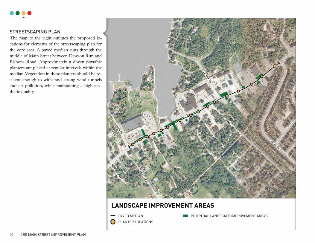
LANDSCAPE IMPROVEMENT AREASPAVED MEDIAN POTENTIAL LANDSCAPE IMPROVEMENT AREAS
PLANTER LOCATIONS
StREEtScAPING PLANThe map to the right outlines the proposed lo-cations for elements of the streetscaping plan for the core area. A paved median runs through the middle of Main Street between Dawson Run and Bishops Road. Approximately a dozen portable planters are placed at regular intervals within the median. Vegetation in these planters should be re-silient enough to withstand strong wind tunnels and air pollution, while maintaining a high aes-thetic quality.
tALcVILLE RD
tOBINS RD
DAwSON RUN
VILLA NOVA RD
BISHOPS RD
CBS MAIN STREET IMPROVEMENT PLAN70

LANDScAPE IMPROVEMENt PROGRAMThere are also several opportunities on private land alongside Main Street to improve the street-scape through improved landscaping features and tree planting. The Town can encourage local business owners along Main Street to improve the appearance of their properties through a Land-scape Improvement Program that would provide support in the form of design expertise, grants, and/or subsidies if the Town’s landscaping guide-lines are followed. Providing such incentives to local businesses will help create an attractive and continuous streetscape that will complement and support the Town’s Main Street improvements.
Design ServicesThe program should offer assistance to property owners to develop plans for landscape improve-ments that are consistent with landscaping guide-lines adopted by the Town. This could be in the form of an advisory service, provide free of change from the Town, or be included as part of a grant or subsi-dy to the applicant. The service could include assis-tance in developing a plan, identifying appropriate landscaping elements, preparing cost estimates and assisting applicants in completing their applications to the program.
Grants or SubsidiesOverall program budgets will depend on the avail-ability of funds. Landscape improvement programs typically offer reimbursements of up to a percent-age of total costs up to a maximum amount per
approved site. For example, some programs pro-vide reimbursements of approximately 60-75% of the total approved improvement costs, while others set a maximum reimbursement. For municipalities, setting a maximum program budget for each fiscal year and adjusting the budget based on success and demand is recommended.
EligibilityInitially, the program should open to businesses along Main Street between Dawson Run and Bish-op’s Road. As the core area expands beyond these boundaries, eligibility for the program can also ex-pand.
The improvement program would include, but are not limited to, the following eligible costs:
• Tree plantings;• Landscaped areas;• Repair or creation of fences and walls;• Street furniture such as benches, picnic tables,
waste receptacles, bike racks, etc;• Light standards;• Paved or sodded surfaces; and• Burying or screening utilities.
PromotionIn order to promote the program, it is recommend-ed that a meeting with Main Street business owners be held to introduce the program details and appli-cation process and discuss the advantages of par-
ticipating in it. Once one business begins to make improvements, it often inspires others to follow.
FundingThere are several funding programs that may be considered for supporting a landscape improvement program. These include ACOA’s Community Infra-structure Improvement Fund (CIIF) and Innovative Communities Fund; Infrastructure Canada’s Build-ing Canada Fund or Gas Tax Fund and the Depart-ment of Innovation, Business and Rural Develop-ment’s Regional/Sectoral Diversification Fund.
In many cases, streetscape improvements are funded entirely by a municipality or a business improvement association. However, when part of a larger re-development project such as the Main Street Improvement Program, various funding programs can be accessed for multiple elements of the project.
CBCL LIMITED 71
SOLUTIONS

WAYFINDING & SIGNAGESignage along commercial main streets and in downtown areas can have a major impact on ap-pearance and visual quality. A well designed and organized signage strategy will:• help people move through the area easily and
locate their destinations;• comply with provincial highway standards
when necessary;• effectively communicate messages to users;• provide opportunities for integrating a con-
sistent and attractive palette of sign types;• establish Main Street as a distinct place; and• provide clear direction for private businesses
regarding the placement and size and look of advertising signs.
On the other hand, if sign strategies are poorly or-ganized or neglected altogether, a proliferation of signs can easily and unintentionally cause confu-sion and unsightliness.
This section proposes a strategy that recognizes the need for a variety of signage in commercial areas. The strategy consists of two parts;• a wayfinding plan that legibly and intuitively di-
rects users within and through Main Street; and• recommendations for the placement of adver-
tising signs to prevent sign pollution.
wAYFINDING StRAtEGYThere are four types of signs that belong to an effective wayfinding system; directional, identifi-cation, orientation and regulatory signs.
Directional signs provide the necessary in-formation to circulate drivers and pedestrians through the area. These signs must be located at key decision points such as entry and exit points, intersections and destinations.
Identification signs mark the location and name of premises within the Main Street area.
They include the name or function of the building or space and also include entrance signs, markers or banners.
Orientation signs can be maps, directories, or kiosks that present information that helps people to orient themselves within an area. They typically include a “you are here” indicator for users to find their whereabouts quickly and easily.
Regulatory signs indicate the “rules” and pro-tocols of a place. Examples of regulatory signs in-clude parking signs, “no smoking” signs, or traffic control signs.
DIREctIONAL SIGN IDENtIFIcAtION SIGN ORIENtAtION SIGN REGULAtORY SIGN
CBS MAIN STREET IMPROVEMENT PLAN72

Consistent use of typography, colour, symbols and materials are commonly used to improve the effectiveness of wayfinding signs.
A legible and well designed typeface is import-ant for motorists, cyclists and pedestrians to read while traveling at their respective speeds. It is also important to be consistent with the typeface in or-der to improve recognizability from one sign to another.
Colour is another important design element that helps improve recognizability. A consistent and complementary colour palette can be used to code different types of destinations which helps people visualize how to find what they are look-ing for. Furthermore, it is important that colours maintain legibility by contrasting well with the typeface. The examples of sign colours below il-
lustrates successful and unsuccessful contrasting palettes.
Symbols or icons are a powerful, concise and non-verbal way to supplement a good wayfind-ing system. They are also useful for their ability to communicate without using a specific language. Many symbols or icons indicating washrooms or no smoking areas are recognized all over the world.
The consistent use of materials in sign design improves recognizability and overall aesthetic ap-pearance.
The following pages present a suite of wayfind-ing signs which utilize typeface, colour, symbols and unique materials that build on the draft Main Street brand and proposed streetscaping plan.
CASE STUDYWAYFINDING IN LONDON, UKAlthough London is a huge city on another continent, its municipal government has implemented a wayfinding system known as Legible London that can be used in any town or city. The underlying idea of the program was to better support wayfinding in the city through a unified and coordinated network of signs and maps. The maps and signs help people find their way by detailing the landmarks they’ll pass on their journey and by estimating the time it will take to reach their destinations. Internationally recognized symbols and colours are used to translate complex information quickly and easily. The program was so successful that information for cyclists are being applied as well.
Read more about Legible London here:www.legiblelondon.info
SIGN tYPEFAcES cOLOUR cONtRASt REcOGNIzABLE SYMBOLS
Exam
ples
from
Gib
son
(20
09)
.
CBCL LIMITED 73
SOLUTIONS

Waterfront Parking
Town Hall
Recreation Complex
2.2
m
1.25 m
1.0
m
1.4 m
0.1m
0.25m
3.0
m
2.3
m
2.5
m
8-6 PM ONLY
Villa Nova Plaza
Town Hall
T’Railway
Manuel’s River
Washrooms
Parking
LONG POND
HARBOURT’RAILWAYKILOMETER
2
DIR
ECTI
ON
AL S
IGN
S
cAR-ORIENtED DIREctIONAL SIGNBOARD
Signs are supported by galvanized structural steel.
The font for sign lettering is Univers 65 Bold.
It is important that lettering is large enough and contrasts against the background colour to maintain optimal legibility.
Wood panels provide an attractive backdrop for sign plaques, fit within the local vernacular and match the style of light posts and planter boxes.
• A medium sized signboard should be used at important intersections to direct motorists to key des-tinations. They should be placed in the middle of the proposed boulevard for optimum exposure.
• Signboards should be limited to three or four directions in order to maintain effectiveness.
A minimum clearance of one metre will ensure that sign messages are in the sightline of motorists and provide an area for snow clearance.
Signboards should be indirectly illuminated to ensure visibility at night.
CBS MAIN STREET IMPROVEMENT PLAN74
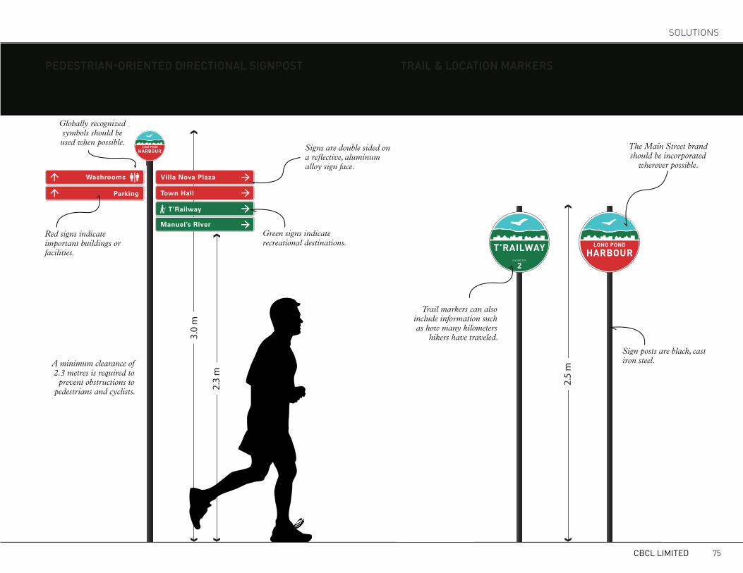
3.0
m
2.3
m
2.5
m
8-6 PM ONLY
Villa Nova Plaza
Town Hall
T’Railway
Manuel’s River
Washrooms
Parking
LONG POND
HARBOURT’RAILWAYKILOMETER
2
3.0
m
2.3
m
2.5
m
8-6 PM ONLY
Villa Nova Plaza
Town Hall
T’Railway
Manuel’s River
Washrooms
Parking
LONG POND
HARBOURT’RAILWAYKILOMETER
2
PEDEStRIAN-ORIENtED DIREctIONAL SIGNPOSt tRAIL & LOcAtION MARkERS
Signs are double sided on a reflective, aluminum alloy sign face.
Green signs indicate recreational destinations.
Sign posts are black, cast iron steel.A minimum clearance of
2.3 metres is required to prevent obstructions to
pedestrians and cyclists.
Globally recognized symbols should be used when possible.
Red signs indicate important buildings or facilities.
Trail markers can also include information such as how many kilometers
hikers have traveled.
• Pedestrian signposts should have no more than eight sign panels and be placed in key locations.
• Markers can be used to indicate that users are on the right trail or have arrived at a specific destination.
The Main Street brand should be incorporated
wherever possible.
CBCL LIMITED 75
SOLUTIONS

2.7
m
Main Street
Bishops Rd.
Talcville Rd.
Main Street
2.5
m
2.2
m
IDEN
TIFI
CATI
ON
SIG
NS
Street sign posts with one sign panel are
horizontally aligned.
At signalized intersections, street signs can be mounted on overhead traffic lights
Street signs that indicate Main Street should be spelled without abbreviations (ie, Main Street, not Main St.)
Street sign posts with two sign panels are left aligned. The top panel will include the Main Street logo, whereas the bottom panel will not.
Street banners can be swapped with seasonal banners or advertisements for upcoming events or festivals.
Avoid using dates on banners so they can be reused year after year.
A minimum clearance of
2.2 metres is required to prevent
obstructions to pedestrians and
cyclists.
An approximate clearance of 2.7 metres is
recommended for banners to maximize visibility for passing motorists, cyclists
and pedestrians.
Banners should include a wind flap to reduce potential damage from extreme wind events.
CBS MAIN STREET IMPROVEMENT PLAN76
OVERHEAD MOUNtED StREEt SIGN
StREEt BANNERStREEt SIGNS
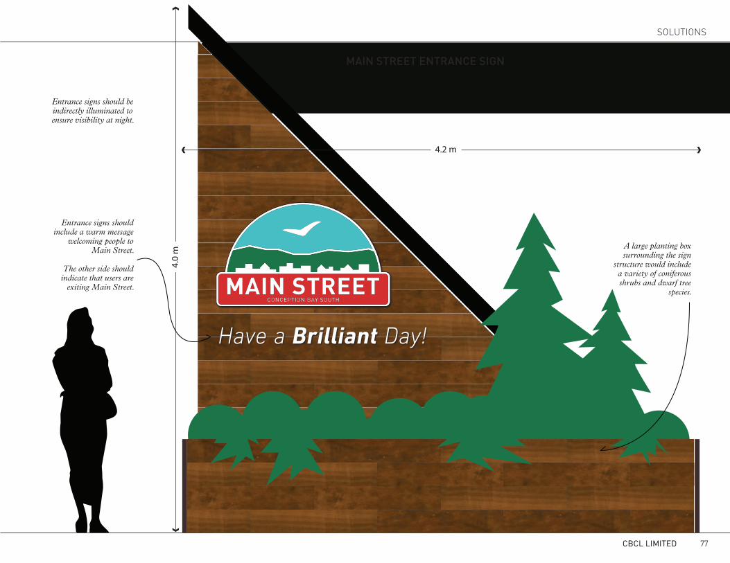
• Two entrance signs should be placed in visible locations at both ends of Main Street; one near the Manuels River Interpretation Centre and the other near the future Town Hall Site.Entrance signs should be
indirectly illuminated to ensure visibility at night.
Entrance signs should include a warm message
welcoming people to Main Street.
The other side should indicate that users are
exiting Main Street.
A large planting box surrounding the sign
structure would include a variety of coniferous shrubs and dwarf tree
species.
CBCL LIMITED 77
SOLUTIONS
Have a Brilliant Day!
4.0
m
4.2 m
MAIN StREEt ENtRANcE SIGN

2.8
m
1.8
m
1.4 m
1.25 m0.1m
Manuel’s River Trail
Town Hall
Villa Nova Plaza
Parking
0.25m
OR
IEN
TATI
ON
SIG
N
ORIENtAtION kIOSk
• Maps and directions will help pedestrians orient themselves. • Orientation kiosks should be placed in major pedestrian areas such as the Long Pond Harbour.
Sign placards that are removable allow for easy and affordable changes in the future.
An orientation kiosk should include the name of the district or place that it is located in.
Maps could provide visual references that indicate how long it would take to walk to other destinations in the area.
Orientation kiosks should be indirectly illuminated to ensure
visibility at night.
Paper tourist maps should match the map displayed at the orientation kiosk
Tourist Map.
Maps should be simple, easy to read, and highlight Main Street
attractions and businesses.
CBS MAIN STREET IMPROVEMENT PLAN78

REG
ULA
TOR
Y SI
GNS
REGULAtORY SIGNS
8-6 PM ONLY
NO
PLEASESWIMMING
NO
REG.23 (D)
SMOKING
3.0
m
2.3
m
2.5
m
8-6 PM ONLY
Villa Nova Plaza
Town Hall
T’Railway
Manuel’s River
Washrooms
Parking
LONG POND
HARBOURT’RAILWAYKILOMETER
2
WAYFINDING SITING PLANDIRECTIONAL SIGNPOSTS ORIENTATION KIOSKS
ENTRANCE SIGNS DIRECTIONAL SIGNBOARDS
tALcVILLE RDtOBINS RD
GREENSLADES RD
BISHOPS RD
tOPSAIL RD
CBCL LIMITED 79
SOLUTIONS

REDUcING SIGN POLLUtIONMany businesses along Main Street rely on the use of advertising signs to promote their prod-ucts and services to passing motorists. Most business premises have a free-standing premises sign. Buildings that house multiple tenants such as Villa Nova Plaza typically feature one or more large group signs that include the name and logo of each tenant business. The large building set-backs required on Main Street present a particu-lar challenge for businesses trying to increase their exposure to passing vehicular traffic. In an effort to further increase their street presence, many in-dividual businesses have hired portable signs and placed them along the street in order to commu-nicate with potential customers. As a result, there is an overabundance of group and portable signs
(as can be seen in the area of Villa Nova Plaza in the photo above), particularly in locations with multiple tenant buildings, resulting in a cluttered and unsightly streetscape. In addition to creating a cluttered appearance, the practice of hiring por-table signs has progressed to a point where mes-sages are so frequent that they become ignored or impossible to read by the traveling public.
In 2012, the Town conducted a review of its Sign Regulations and changes were made to address the density and number of permanent, free stand-ing and portable signs. In areas where there is a concentration of businesses such as at Villa Nova Plaza, the density of portable signs is an issue that needs to be addressed. The underlying issue of sign pollution on Main Street is the lack of a street
presence for businesses due to the obstruction of parked vehicles and large building setbacks from the street. It is recommended that the Town make further efforts to enforce existing sign regulations, and to ban the use of portable signs in the Main Street in the core area. Alternatively, conditions would be improved with a significant reduction in the density of portable signs, which could be achieved by increasing the minimum space be-tween them to 75m or greater. Consideration could also be given to allowing small, pedestri-an-oriented sandwich board signs (approximate-ly 3’ wide by 4.5’ high) on or next to sidewalks during business hours, provided they do not re-strict pedestrian flow.
CBS MAIN STREET IMPROVEMENT PLAN80

DEVELOPMENT CHARACTERGUIDING tHE MAIN StREEt EVOLUtIONThe treatment of the parts of Main Street with-in the public right-of-way and the design of the roadway and sidewalks are important down-town improvement elements. However, without a framework for attractive buildings and a mix of uses, the best sidewalk and street design will not be successful in creating a functional and attrac-tive downtown.
The commercial areas on the north side of Main Street in Conception Bay South’s downtown area are presently characterized by a suburban fabric and an automobile-oriented environment. Build-ings are low in profile, set back from the street, and separated from other buildings by large areas of asphalt. The south side of the street consists of a finer grain of businesses and residences, typical-ly placed closer to the road.
The current demand for commercial land in the downtown and the Town’s desire to create an identifiable downtown present significant oppor-tunities to improve development character in a manner that creates attractive pedestrian environ-ments and downtown area.
As the downtown evolves over time, the Town
should work towards providing urban design guidance at the planning application stage in or-der to assess, promote and achieve coherent de-velopment throughout Main Street.
BUILDING PLAcEMENt AND FRONtAGESNew development along Main Street should fos-ter true downtown character and break with the current form of suburban strip development. New downtown buildings should face the street and should be located close to the sidewalk and property line. Open and transparent pedestrian level facades with windows and entrances along the street are crucial elements for a comfortable pedestrian environment.
In instances where a building is further set back from the sidewalk, well-designed pedestrian-ori-ented walkways should extend the public space to the entrances of the building. “No man’s land” be-tween the building and the sidewalk used for park-ing or automobile circulation should be avoided.
Generally, new development should be based on an internal circulation pattern that allows logical movement throughout the site that will accommo-date, and not preclude, intensification over time.
HEIGHt, MASSING AND ScALEHuman scale development is an important ingre-dient of a vibrant Main Street. Buildings and trees bring a feeling of enclosure to a street and con-tribute to downtown’s sense of place. The height-to-width ratio is often used to describe the human scale of a street. The width is the horizontal dis-tance between opposing building facades, and the height is measured from the sidewalk to the top of the building. Generally, a height-to-width ratio between 1:1 and 1:3 is considered a comfortable human scale.
Recognizing that the current Main Street archi-tectural character is not going to change overnight, achieving a height-to-width ratio even close to 1:3 is not realistic in the near future. In the absence of a street wall comprised of buildings close to the sidewalk, street trees and pedestrian scale lighting can create a sense of enclosure to Main Street with a “disguised” height-to-width ratio of 2:1. As re-development occurs, particularly in the core com-mercial area of Main Street, buildings should be between two to four storeys tall and placed near the street to create a real sense of enclosure, main-taining a height-to-width ratio between 2:1 or 3:1 (see illustration on the following page).
CBCL LIMITED 81
SOLUTIONS

EXISTING HEIGHT TO
WIDTH RATIO
“DISGUISED” HEIGHT TO
WIDTH RATIO
LONG-TERMHEIGHT TO
WIDTH RATIO
LAN
ELA
NE
LAN
E
LAN
ELA
NE
LAN
E
LAN
ELA
NE
LAN
E
LAN
ELA
NE
LAN
E
SID
E wAL
kSI
DEw
ALk
SID
EwAL
k
SID
EwAL
k
SID
EwAL
k
BU
ILD
ING
FAcA
DE
BU
ILD
ING
FAcA
DE
BU
ILD
ING
FAcA
DE
BU
ILD
ING
FAcA
DE
BU
ILD
ING
FAcA
DE
BU
ILD
ING
FAcA
DE
PAR
kIN
GPA
Rk
ING
PAR
kIN
GPA
Rk
ING
MED
IAN
MED
IAN
1:10
1:2
1:2
A lack of vertical elements creates an intimidating environment for pedestrians
Adding trees and pedestrian-style street lamps on both sides of the street can create
a “disguised” sense of enclosure without having to move buildings
Future developments along Main Street should be built to a height of two to four storeys to create a real sense of enclosure
Attractive vertical elements, such as building facades and street lamps
help create a pleasant and comforting environment for pedestrians
CBS MAIN STREET IMPROVEMENT PLAN82

OFF-StREEt PARkINGThe location of off-street parking is closely linked to the placement and orientation of buildings along the street. In general, off-street parking located between a storefront and the street is vi-sually unappealing and obstructs the visual con-nection between the two, contributing to business exposure and advertising issues. New develop-ment along Main Street should be designed with surface parking spaces at the rear of buildings, or in the worst case scenario, at the side. Car parking spaces should be oriented to minimize the number of pedestrian crossings. Shared parking arrange-ments between adjacent properties should also be encouraged to reduce the number of driveways onto Main Street and the overall amount of paved parking surface. Parking lots between adjacent properties that are linked will allow circulation of cars between properties without the need to drive on and off the road network.
Off-street parking should include a safe and com-fortable pedestrian realm. Continuous landscap-ing should reinforce pedestrian walkways within parking areas. Street furniture and pedestrian amenity space can improve a property’s appear-ance from the street. Where parking areas are currently located between a building and Main Street, a landscaped area along the edge of the site with trees, shrubs and low walls should be used to screen cars from the sidewalk and create a sense of enclosure along the streetscape.
MIX OF USESBeyond an attractive public realm and welcoming storefronts and buildings, encouraging a mix of uses within Main Street is a vital step toward a viable downtown district. Successful downtowns include a variety of shops, offices, restaurants, public buildings, residences, entertainment and public spaces. The success of this commercial mix will also be determined by the residential densi-ties found in or adjacent to the downtown. By in-troducing multi-unit residential development on or near Main Street, the Town can not only ad-dress the growing shortage in this segment of the housing market, and support local business with a predictable stream of customers who are able to walk to shops and restaurants. “Vertical mixed use”, the stacking of housing over retail, can add round-the-clock business to Main Street.
PUBLIc SPAcESAttractive public spaces complimenting dense Main Street development can provide welcoming places for rest, quiet contemplation and chance encounters. These spaces can include small parks, playgrounds or landscaped areas. Semi-pub-lic space amenities such as benches along retail buildings and street cafes add to the character of downtown. Pedestrian circulation throughout the downtown should be facilitated not only through sidewalks but also pedestrian walkways between adjacent properties or across parking areas. Be-tween public sidewalks and building entrances,
clearly defined pedestrian areas should provide direct, safe and continuous access to buildings. Site furnishings, such as benches, bike racks and public art, should be part of the public space vo-cabulary.
CBCL LIMITED 83
SOLUTIONS
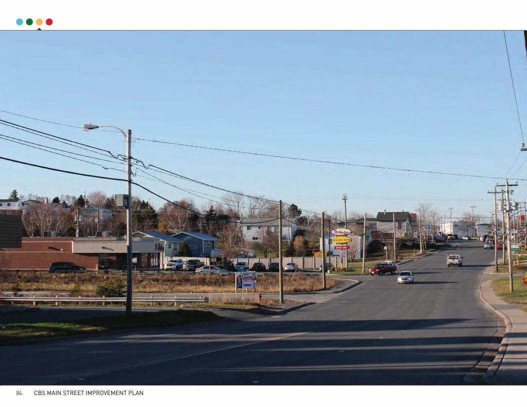
CBS MAIN STREET IMPROVEMENT PLAN84

CBCL LIMITED 85
SOLUTIONS

DEMONSTRATION PROJECTSDOwNtOwN URBAN DESIGN StRAtEGYAs outlined earlier, the improvement strategies for Main Street should be focused on the downtown section of the street between the old Town Hall and the Dominion. “Rightsizing” the street, bury-ing overhead power lines, streetscape improve-ments, the intensification of built-out character and all associated public investments should oc-cur in the downtown.
Beyond this section, Main Street should remain in its current four-lane state, with added sidewalks on both sides and improved pedestrian crossings in locations like the school. The signage strategy should also extend along the entire Main Street study area.
Four urban design demonstration projects illus-trate potential changes on private properties along Main Street that could complement the Town-led public realm improvements. These potential sce-narios illustrate how the area could evolve into a downtown precinct with a compact urban form and a mix of services, shops and housing. New buildings (yellow) on existing lots intensify the use of downtown land and provide additional commercial square footage to satisfy a growing demand. The downtown urban design concept
also emphasizes the notion of a new network of connected secondary streets. The new streets pro-posed in the Villa Nova Plaza and Town Hall are improve circulation, delineate vehicle and pedes-trian movement across parking lots and help re-duce the number of driveways entering onto Main Street.
The four urban design projects are:
1. Harbour Plaza2. Dominion Redevelopment3. Villa Nova Plaza4. Town Hall Redevelopment
CBS MAIN STREET IMPROVEMENT PLAN86

2 DOMINION REDEVELOPMENT
1 HARBOUR PLAZA
3 VILLA NOVA PLAZA
4 TOWN HALL REDEVELOPMENT
DOwNtOwN URBAN DESIGN cONcEPtS
CBCL LIMITED 87
SOLUTIONS

HARBOUR PLAzAA recurring theme throughout the consultation stage was the high demand for a quality public space along Main Street that could accommodate a variety of events and take advantage of the beau-ty of Long Pond. The waterfront area between the McDonald’s and Jungle Jim’s has been identified as a prime are to accommodate such a space, and has been the subject of several redevelopment concepts in the past. This concept builds on the most recent iteration provided in the Long Pond - Inner Harbour Development Concepts.
The key feature of the Harbour Plaza concept is a 20m wide pier that is centred between the prop-erty lines of McDonald’s and Jungle Jim’s above a small estuary that empties into Long Pond. Al-though this pier would be located on private prop-erty, this land is undevelopable due to its prox-imity to a waterbody and would be a welcomed addition to help attract customers to area for ad-jacent businesses.
The Harbour Plaza would extend approximately 75m from Main Street out into Long Pond, and would be flanked by 10m wide boardwalks along the coastline that would connect Villa Nova Plaza to the Dominion property. In order to connect the Dominion property to Harbour Plaza, the Town will need to negotiate with a private land owner to allow for pedestrian crossings over a residential driveway.
The main pier would wide enough to accommo-date a variety of public events, including an out-door market, public concerts and festivals. The space would also be used for recreational purpos-es, including fishing, walking and jogging. Small boat vessels, such as kayaks or canoes, could be launched from floating docks connected to the boardwalks, however, the shallow depth of the wa-ter would not accommodate larger vessels unless significant dredging occurred. This concept pro-vides an option for the adjacent restaurants to tie their buildings into the boardwalk space for use as an outdoor patio, which would increase the overall functionality and attraction of the space and en-hance business potential.
The Harbour Plaza will be a major attraction and public amenity for the Main Street area, and as such, should have exceptional aesthetic qualities. The main entrance of Harbour Plaza along Main Street should be as wide as possible and feature landscaping and a gateway that will help increase attraction and ensure passing motorists and pe-destrians take notice. An abundance of seating should be provided throughout the Harbour Pla-za development that will allow users to enjoy the views and get some rest. Waste and recycling re-ceptacles should also be provided liberally to en-sure the space remains clean and tidy. Finally, at-tractive accent lighting will allow Harbour Plaza to be an attractive and safe place at night.
CBS MAIN STREET IMPROVEMENT PLAN88

New waterfront boardwalk
Potential kayak or canoe slipway
New waterfront boardwalk
Floating finger piers for small boats
Jungle Jim’s
McDonald’s
Long Pond
New harbour plaza pier
Outdoor patio area
Outdoor patio area
HARBOUR PLAzA cONcEPt
CBCL LIMITED 89
SOLUTIONS

DOMINION REDEVELOPMENtThe Dominion Superstore is located on a large lot in a prominent location along Main Street. Redevelopment of the lot would benefit the Town through increased commercial floor space and street frontage, additional businesses and services, and a larger tax base in the downtown core. Al-though the Dominion lot is privately owned, re-development may be feasible in the near future. The lot is currently dominated by an abundance of underutilized parking stalls, which could be monetized through redevelopment.
The “Dominion Parking Lot Redevelopment” concept offers a scenario that would benefit the Town, landowner and community. Two, L-shaped building are placed in either corner of the lot along Main Street, which add attractive store frontage along the streetwall and conceal parking in the rear. These buildings are also placed in the corner to ensure maximum street exposure for the Do-minion. A landscaped entrance is also provided to give pedestrians direct access to the Dominion from Main Street and trail linkages are provided to the Harbour Plaza area. A new building is also proposed in the rear of the lot on the east side of the Dominion building. This building is located in a prime location to take advantage of the views of Long Pond and would be an ideal location for a restaurant or pub.
CBS MAIN STREET IMPROVEMENT PLAN90

New commercial building with groundfloor retail
New commercial building with groundfloor retail
New parking lot access point
New landscaped entrance pedestrian alley
New waterfront restaurantNew waterfront bardwalk
Dominion
DOMINION REDEVELOPMENt cONcEPt
CBCL LIMITED 91
SOLUTIONS
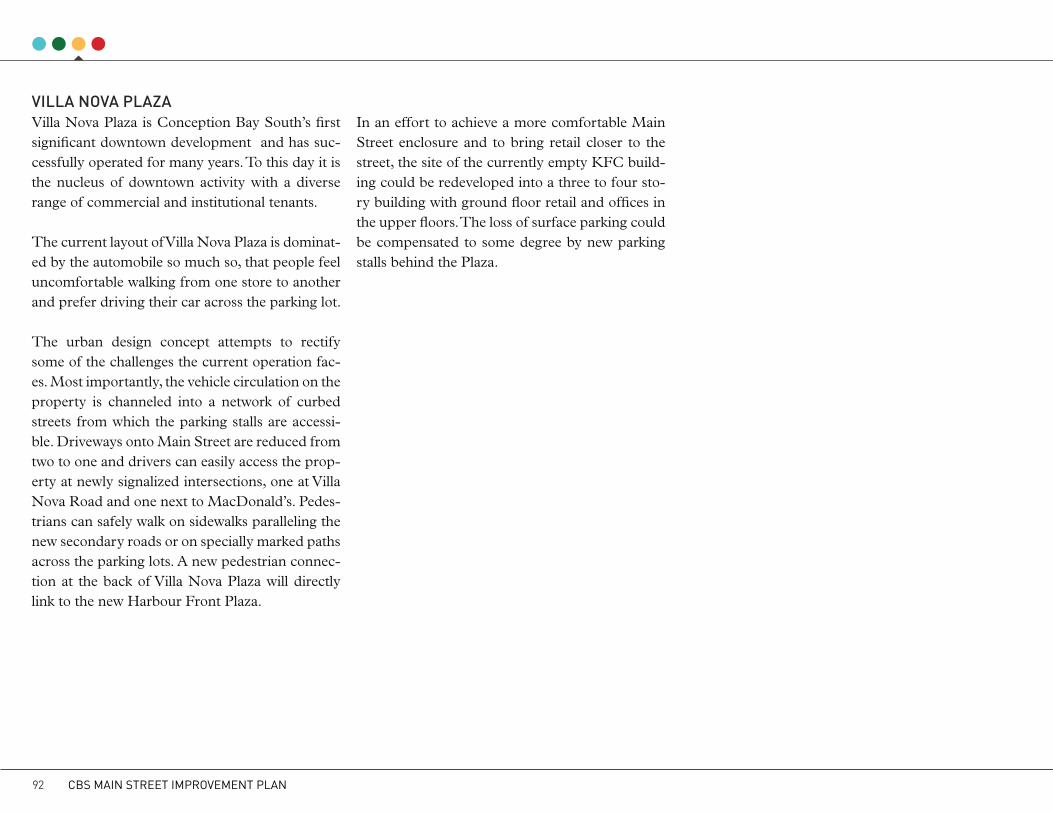
VILLA NOVA PLAzAVilla Nova Plaza is Conception Bay South’s first significant downtown development and has suc-cessfully operated for many years. To this day it is the nucleus of downtown activity with a diverse range of commercial and institutional tenants.
The current layout of Villa Nova Plaza is dominat-ed by the automobile so much so, that people feel uncomfortable walking from one store to another and prefer driving their car across the parking lot.
The urban design concept attempts to rectify some of the challenges the current operation fac-es. Most importantly, the vehicle circulation on the property is channeled into a network of curbed streets from which the parking stalls are accessi-ble. Driveways onto Main Street are reduced from two to one and drivers can easily access the prop-erty at newly signalized intersections, one at Villa Nova Road and one next to MacDonald’s. Pedes-trians can safely walk on sidewalks paralleling the new secondary roads or on specially marked paths across the parking lots. A new pedestrian connec-tion at the back of Villa Nova Plaza will directly link to the new Harbour Front Plaza.
In an effort to achieve a more comfortable Main Street enclosure and to bring retail closer to the street, the site of the currently empty KFC build-ing could be redeveloped into a three to four sto-ry building with ground floor retail and offices in the upper floors. The loss of surface parking could be compensated to some degree by new parking stalls behind the Plaza.
CBS MAIN STREET IMPROVEMENT PLAN92
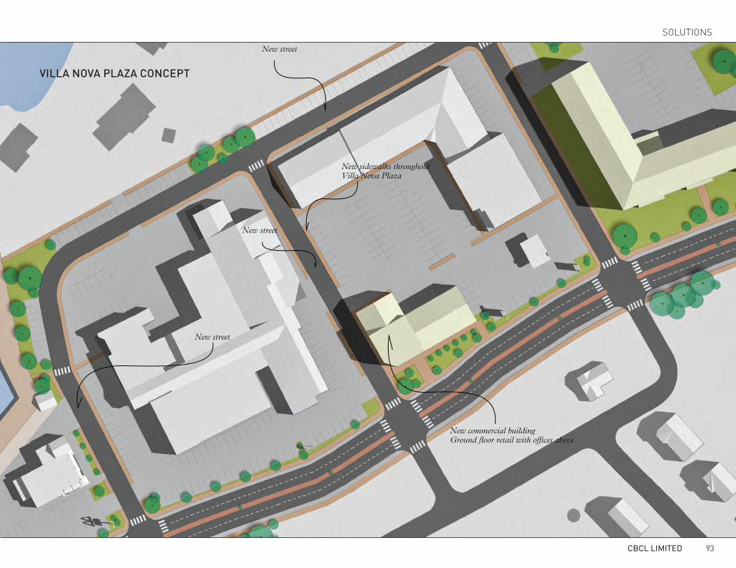
New street
New street
New street
New sidewalks throughoutVilla Nova Plaza
New commercial buildingGround floor retail with offices above
VILLA NOVA PLAzA cONcEPt
CBCL LIMITED 93
SOLUTIONS

tOwN HALL REDEVELOPMENtPlans for the relocation of Conception Bay South’s Town Hall and public library are well underway. Although not immediately planned, the reloca-tion of the municipal depot will, along with the town hall relocation, free up a key property in the downtown. There are several small parcels of land owned by Renu that are adjacent to the Town Hall site which would also be ideally included in a po-tential redevelopment. When the property is put on the market, the Town has a unique opportunity to influence the type of development through a conditional sale. The Town can stir both the use and urban form of the redevelopment of this ex-ceptional downtown site.
The shortage of multi-unit housing, be it con-dominiums, rental units or senior housing is a pressing issue in the Town. The proposed devel-opment addresses the deficiency with a four-sto-rey block development surrounded by a new net-work of secondary streets and internal parking. The currently existing green space and memorial is maintained by stepping a portion of the block back from Main Street. If the south-western cor-ner of the block was to become seniors housing, the green space with its slope towards Main Street could become a communal outdoors space for se-niors watching the activity on the street. A ground floor restaurant of coffee shop could also use the space for outdoor seating. The south-eastern portion of the block should include ground floor
retail that can benefit from the prominent expo-sure to Main Street. The north-western corner is a residential-only building. Surface parking is pro-vided in the interior of the block. The provision of seniors housing would significantly reduce the overall parking requirement of the development. If parking needs however exceed the available surface capacity, underground parking should be considered to maintain the compact urban form of the development.
By and large, the introduction of housing close to businesses in the downtown will create a new cus-tomer base for downtown businesses. These cus-tomers, many of which potentially empty nesters and seniors will appreciate short walking distanc-es to stores, doctor’s offices and restaurants facili-tated by convenient and safe pathways connecting the downtown.
The new secondary road network around the site is laid out in such fashion that it can be extended into currently undeveloped areas north of Main Street.
This proposed concept includes the Renu lands to the west of the Town property. In the event that the private land owner does not want to sell their land as part of the redevelopment, the general concept can be condensed to fit within the Town property.
CBS MAIN STREET IMPROVEMENT PLAN94

Residential - 4 storeys
Residential - 4 storeys with ground floor commercial
Residential - 4 storeys with ground floor commercial
Building setback to retain public open space
Interior Parking
Green space for residents
Playground
New street with possible extension to the North
New street
tOwN HALL REDEVELOPMENt cONcEPt
CBCL LIMITED 95
SOLUTIONS

MAIN StREEt OUtSIDE tHE cORE AREAWhile keeping an eye firmly on downtown street improvements, it is important for the Town to also extend basic pedestrian amenities across the en-tire length of Main Street between Topsail Road and Minerals Road.
Outside the downtown, Main Street should re-main in its current four-lane configuration. A sidewalk should be added to the south side of the street and gaps in the sidewalk on the north side should be closed. Safe pedestrian crossings should be provided at strategic locations (see page 59). The new sidewalk on the south side should be built along the street right-of-way boundary which will allow for the possibility to transition to a similar cross-section as the downtown core area without needed to tear out the sidewalk.
The signage strategy should also extend along the entire Main Street study area (page 77).
NORTH
CBS MAIN STREET IMPROVEMENT PLAN96
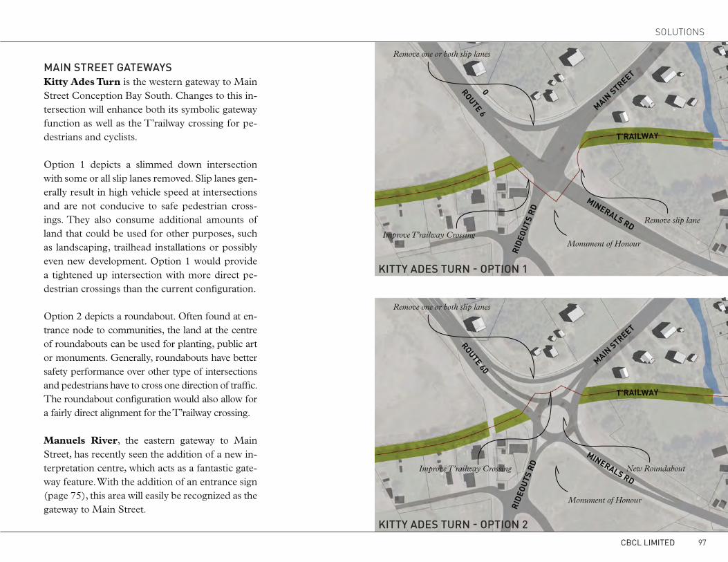
MAIN StREEt GAtEwAYSKitty Ades Turn is the western gateway to Main Street Conception Bay South. Changes to this in-tersection will enhance both its symbolic gateway function as well as the T’railway crossing for pe-destrians and cyclists.
Option 1 depicts a slimmed down intersection with some or all slip lanes removed. Slip lanes gen-erally result in high vehicle speed at intersections and are not conducive to safe pedestrian cross-ings. They also consume additional amounts of land that could be used for other purposes, such as landscaping, trailhead installations or possibly even new development. Option 1 would provide a tightened up intersection with more direct pe-destrian crossings than the current configuration.
Option 2 depicts a roundabout. Often found at en-trance node to communities, the land at the centre of roundabouts can be used for planting, public art or monuments. Generally, roundabouts have better safety performance over other type of intersections and pedestrians have to cross one direction of traffic. The roundabout configuration would also allow for a fairly direct alignment for the T’railway crossing.
Manuels River, the eastern gateway to Main Street, has recently seen the addition of a new in-terpretation centre, which acts as a fantastic gate-way feature. With the addition of an entrance sign (page 75), this area will easily be recognized as the gateway to Main Street.
Remove one or both slip lanes
Remove slip lane
Monument of Honour
Monument of Honour
Improve T’railway Crossing
kIttY ADES tURN - OPtION 1
kIttY ADES tURN - OPtION 2
New RoundaboutImprove T’railway Crossing
Remove one or both slip lanes
MAIN STREET
ROUTE 60
ROUTE 60
MAIN STREET
MINERALS RD
MINERALS RD
T’RAILWAY
T’RAILWAY
RIDE
OUTS
RD
RIDE
OUTS
RD
CBCL LIMITED 97
SOLUTIONS

ORGANIZATIONBUSINESS IMPROVEMENt ASSOcIAtIONA Business Improvement Association (BIA) is an association of business people within a specif-ic district who join, with approval from the mu-nicipality, to mutually support business activity. These associations are run by a BIA Board of Management that provides business promotion and improvement functions. Funded by their own money, the primary purpose of a BIA is to revi-talize and maintain a local neighbourhood and to promote the area as a destination for businesses
and retail activity. While the focus of a BIA’s ac-tivities are on a specific node or area of a munici-pality, surrounding businesses may and do benefit as well. The revitalization and maintenance of an area creates a safer and more attractive neighbour-hood for retail shopping and local service firms.
A BIA provides local businesses with a means to work together towards common goals alongside res-idents, the local Chamber of Commerce, the mu-nicipality and other stakeholders in the community.
Typically, once a BIA is approved by a Munic-ipal Council, every business within the defined boundaries of the BIA automatically becomes a member, with exceptions. Each community that decides to form a BIA has different goals and challenges to overcome. During the 40-plus years that BIAs have been operating, a core set of func-tions have been established, which are indicated in the graphic below.
7 Millier Dickinson Blais Inc.: Main Street Improvement Plan – Business Improvement Area & Gap Analysis
•Make a business area more pleasant for local businesses and the neighbouring residential area.
•Common improvements include: lighting, signage, furniture, planters and decorations
Beautification
•Improving and maintaining physical infrastructure. •Taking the lead in developing old Brownfields and improving building facades.Revitalization & Maintenance
•Development of specialized market and promotional materials to encourage local residents, day trippers and tourist to shop and use services in the BIA.Marketing & Promotion
•Organize and work with community partners to hold special events to promote and showcase businesses.
•Events range from arts and culture (street dance, music, theatre or dance festival, food fair, arts and crafts exhibition) to seasonal carnivals or parades.
Special Events
•Work with commercial and industrial property owners to help fill available space and to ensure that the businesses being attracted will add value to the mix of shopping/service.
Business Attraction
• Act as the collective voice of the business community in matters related to Council, municipal departments and institutions. Communication
BIA StAkEHOLDERS cORE FUNctIONS OF A BIA
CBS MAIN STREET IMPROVEMENT PLAN98

Impacts of a BIA on the CommunityProponents of BIAs often cite case studies of areas that have experienced economic growth through the BIA structure in the absence of direct empiri-cal validation. As a local level organization, BIAs provide direct leadership in shaping public policy in municipalities. In many instances, the mandate of these organizations is not limited to making the area more livable and physically welcoming but also to make it more competitive. When effective, a BIA benefits all the stakeholders found in the community.
• Businesses benefit from increased consumer activity and in some instance cooperative pur-chasing arrangements.
• A more vibrant and attractive business area increases the demand for retail and office space, leading to a decrease in vacancy and appreciation of asset value.
• Enhancements to public spaces often make the neighbourhood a more desirable place to live. BIAs can also play a role in improving the walk-ability, local shopping and services available.
• The success of a single neighbourhood can have a ripple effect that benefits the rest of the community. The BIA’s success may make the municipality more attractive to businesses and tourists. The additional revenue that flows to the municipality from business attraction al-lows for additional public service which fur-ther strengthens local quality of life assets and the business environment.
Implementing a BIAThe establishment of a BIA program needs to originate from the local business community. If they mutually agree that a BIA is the best way to improve their neighbourhood, then they can request that the Conception Bay South council designate the area along Route 60 between Termi-nal Road and the Manuals River, inclusive of the T’Railway to the south, as a Business Improve-ment Area.
The Municipalities Act (1999) of Newfoundland & Labrador allows municipalities, such as Con-ception Bay South, to form Business Improve-ment Areas. Council has the power to make the regulations pertaining to:
• The declaration and designation of a business improvement area(s) within a municipality;
• The enhancement and improvement of a business improvement area;
• Special projects, activities or events to im-prove the area;
• Respecting the power, duties, election and procedures of a board ;
• Grants to promote a BIA;• The imposition of a surcharge, no greater
than 10% of the business tax imposed, for the purpose of covering operating expense of a board;
• The allocation of funds;• The raising of funds;
CASE STUDYBELL’S CORNER BIA IN OTTAWA, ONWith over 300 member businesses located adjacent to major arterial roads, the Bells Corners BIA has helped to retain the charm of an old town, where shoppers are able to enjoy a walkable environment, supported by connections between plazas. Proximity to these high-traffic arterial roads has also been leveraged to support businesses that thrive on increased visibility such as Canadian Tire and Staples. These large scale retailers are complemented by smaller specialty and convenience oriented shops that cater to both convenience and regional shoppers. The area, however, has its challenges.
The Bells Corners BIA is providing a tool and forum for local businesses to work together to respond to these challenges in a coordinated fashion
CBCL LIMITED 99
SOLUTIONS
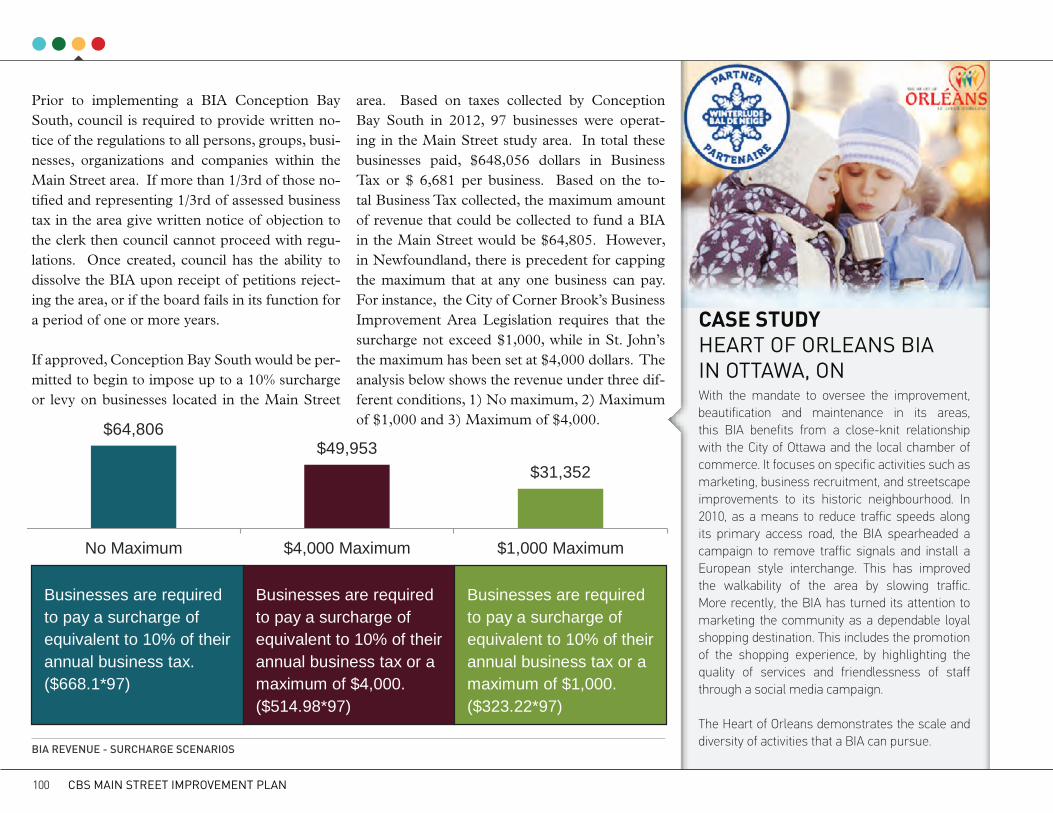
Prior to implementing a BIA Conception Bay South, council is required to provide written no-tice of the regulations to all persons, groups, busi-nesses, organizations and companies within the Main Street area. If more than 1/3rd of those no-tified and representing 1/3rd of assessed business tax in the area give written notice of objection to the clerk then council cannot proceed with regu-lations. Once created, council has the ability to dissolve the BIA upon receipt of petitions reject-ing the area, or if the board fails in its function for a period of one or more years.
If approved, Conception Bay South would be per-mitted to begin to impose up to a 10% surcharge or levy on businesses located in the Main Street
CASE STUDYHEART OF ORLEANS BIA IN OTTAWA, ONWith the mandate to oversee the improvement, beautification and maintenance in its areas, this BIA benefits from a close-knit relationship with the City of Ottawa and the local chamber of commerce. It focuses on specific activities such as marketing, business recruitment, and streetscape improvements to its historic neighbourhood. In 2010, as a means to reduce traffic speeds along its primary access road, the BIA spearheaded a campaign to remove traffic signals and install a European style interchange. This has improved the walkability of the area by slowing traffic. More recently, the BIA has turned its attention to marketing the community as a dependable loyal shopping destination. This includes the promotion of the shopping experience, by highlighting the quality of services and friendlessness of staff through a social media campaign.
The Heart of Orleans demonstrates the scale and diversity of activities that a BIA can pursue.
13 Millier Dickinson Blais Inc.: Main Street Improvement Plan – Business Improvement Area & Gap Analysis
$64,806$49,953
$31,352
No Maximum $4,000 Maximum $1,000 Maximum
the surcharge not exceed $1,000, while in St. John’s the maximum has been set at $4,000 dollars. The analysis below shows the revenue under three different conditions, 1) No maximum, 2) Maximum of $1,000 and 3) Maximum of $4,000.
FIGURE 5: BIA REVENUE, 3 SURCHARGE SCENARIO'S
Businesses are required to pay a surcharge of equivalent to 10% of their annual business tax. ($668.1*97)
Businesses are required to pay a surcharge of equivalent to 10% of their annual business tax or amaximum of $4,000. ($514.98*97)
Businesses are required to pay a surcharge of equivalent to 10% of their annual business tax or a maximum of $1,000. ($323.22*97)
area. Based on taxes collected by Conception Bay South in 2012, 97 businesses were operat-ing in the Main Street study area. In total these businesses paid, $648,056 dollars in Business Tax or $ 6,681 per business. Based on the to-tal Business Tax collected, the maximum amount of revenue that could be collected to fund a BIA in the Main Street would be $64,805. However, in Newfoundland, there is precedent for capping the maximum that at any one business can pay. For instance, the City of Corner Brook’s Business Improvement Area Legislation requires that the surcharge not exceed $1,000, while in St. John’s the maximum has been set at $4,000 dollars. The analysis below shows the revenue under three dif-ferent conditions, 1) No maximum, 2) Maximum of $1,000 and 3) Maximum of $4,000.
BIA REVENUE - SURcHARGE ScENARIOS
CBS MAIN STREET IMPROVEMENT PLAN100

MARkEtING & PROMOtIONMarketing and promotion is an important compo-nent of successful Main Street commercial areas and is used to attract customers as well as new business investment. Often spearheaded by local Business Improvement Associations working in cooperation with the municipality, a variety of ap-proaches have been used successfully to increase business activity in Main Street areas.
Marketing and promotion activities can include:• Creation of a consumer/tourist focused bro-
chure that highlights events, stores and activ-ities along the Main Street, including a map;
• A profile of the Main Street area that high-lights the demographics for potential inves-tors. In the form of an investment prospectus, the Profile could be similar to materials al-ready created for the Gateway development;
• Once the Plan has been accepted by Council, the use of press releases announcing the plan should be issued and regional media coverage sought. Ongoing public relations are recom-mended to get positive PR into the media as progress is made;
• A Social Media campaign to link residents, cus-tomers and others to events taking place with-in Main Street could be undertaken. Whether through a BIA or the Town’s economic devel-opment office, investment in a website using the Main Street logo would be a first step prior to initiating a social media campaign;
• A Banner Program could be developed. Ban-
ners placed on new light standards would help identify the Main Street area (See illus-tration page 85). The Town and/or the BIA could host a competition to design the ban-ners for any given year as a way of getting the community involved; and
• Signage and wayfinding along the soon-to-be improved T’Railway is recommended to di-rect people to the Main Street area. Such sig-nage would be in the form of directional sig-nage but should not include advertising signs.
Festivals and EventsFestivals and events are a means of drawing people into a downtown area. A variety of special events, festivals, outdoor markets, performances and so on, attract the interest of people of all ages. The spin-off benefits from such events include raised awareness of local goods and services and, where public space improvements and beautification ini-tiatives have been undertaken, increased potential for repeat traffic as people begin to regard the area as a pleasant place to visit.
A recent study prepared for the Town on ways to attract investment in Conception Bay South recommended that the Town pursue the creation of additional events along the Main Street to at-tract day trippers and additional interest in the area. Events need to be planned throughout the year and can be tied into Town-wide events (the 3 Hour Challenge), as partnerships with other events occurring in the Town such as the annual
Santa Claus Parade or Kelligrews Soiree for ex-ample, or through special events such as a coordi-nated street sales (side walk sales) with extended hours of operation. Events such as ‘Shop Local Days’ (as either a Main Street or Town-wide busi-ness initiative) will heighten awareness of the ex-tent of available goods and services.
Promotion could be done through ‘What’s Hap-pening on Main Street’ distributed through flyers, local media and through the use of the Town’s web site and social media such as Facebook and Twitter, while high quality pictures and video can be displayed through YouTube and Flickr.
kEEPING MAIN StREEt cLEANThe general appearance and tidiness is an import-ant consideration in the success of any Main Street. The absence of litter, swept streets and sidewalks, clean and inviting storefronts and public spac-es convey a sense of civic pride and confidence. The Town, through the Pride in Your Communi-ty Committee (PIYCC), has spearheaded several programs such as the “3 Hour Challenge” aimed at community cleanliness. Such efforts in the Main Street area could also be supported through a Business Improvement Association. Continued participation by the Town in beautification pro-grams such as Tidy Towns of Newfoundland and Labrador and Communities in Bloom also helps to raise civic pride and interest in landscaping and tidiness through participation of businesses, citi-zens and the municipality.
CBCL LIMITED 101
SOLUTIONS

IMPLEMENTaTIONThe solutions outlined in the previous section offer strategies to achieve the community vision and goals of downtown revitalization. However, positive action will not occur without clear directions on how to implement these solutions.
The section concludes the report with details and steps on “how we get there.” These steps include costing estimates, funding opportunities, a phas-ing schedule and a list of responsibilities for stakeholders and other potential partners.
102

The Improvement Strategies of the Main Street Improvement Plan are broken down into short, medium and long term phases. Each action item includes one of four broad categories, a reference to which Improvement Strategy the action item belongs to, and a list of the organizations/groups that will be responsible for implementation. While the proposed implementation road map of this re-port focuses on achieving the physical improve-ments that are at the core of this design study, it is
also intended to assist the Town in keeping an eye on the big picture and set in motion all necessary initiatives that help improve Main Street.
The phasing sequence for capital projects identi-fies the ideal sequence of improvements based on the relationship between them. However, should funding become available from an unexpected source, or other pressures surface, opportunities to implement should be capitalized upon. This
is of particular importance to road maintenance and improvement work that may have to be un-dertaken in the coming years, regardless of the phasing sequence proposed in this study. For ex-ample, road improvements required as a result of wear and tear, provide opportunities to incorpo-rate street right-of-way improvements such as those recommended as part of the Main Street Improvement Plan.
PHASING
Organization establishes consensus and coop-eration by building social and economic part-nerships among various groups who have a stake in Main Street. Provides management and advocacy for Main Street.
The “design” category is associated with fur-ther conceptualizing and planning physical Main Street improvements. Conducts investigation and due dili-gence of design concepts.
Build means the actual construction of phys-ical improvements, including public and pri-vate buildings, storefronts, signs, landscap-ing, public spaces, displays, etc. Realizes all of Main Street’s physical components.
Promotion creates a positive image that will rekindle community pride and improve con-sumer and investor confidence. It helps sell the image and promise of downtown to the community and the surrounding region. Communicates Main Street’s unique characteristics.
O RGANIZATION
KEY AREAS IMPROVEMENT STRATEGIES
D ESIGN
P ROMOTION
B UILD
1 BRANDING MAIN STREET
4 STREETSCAPING
2 VEHICULAR CIRCULATION
5 WAYFINDING & SIGNAGE
3 PEDESTRIAN REALM
6 DEVELOPMENT CHARACTER
7 ORGANIZATION
CBCL LIMITED 103
IMPLEMENTaTION
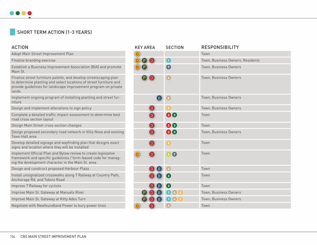
SHORt tERM ActION (1-3 YEARS)
ActION kEY AREA SEctION RESPONSIBILItYAdopt Main Street Improvement Plan Town
Finalize branding exercise Town, Business Owners, Residents
Establish a Business Improvement Association (BIA) and promote Main St.
Town, Business Owners
Finalize street furniture palette, and develop streetscaping plan to determine planting and select locations of street furniture and provide guidelines for landscape improvement program on private lands
Town, Business Owners
Implement ongoing program of installing planting and street fur-niture
Town, Business Owners
Design and implement alterations to sign policy Town, Business Owners
Complete a detailed traffic impact assessment to determine best road cross section layout
Town
Design Main Street cross section changes Town
Design proposed secondary road network in Villa Nova and existing Town Hall area
Town, Business Owners
Develop detailed signage and wayfinding plan that designs exact signs and location where they will be installed
Town
Implement Official Plan and Bylaw review to create legislative framework and specific guidelines / form-based code for manag-ing the development character in the Main St. area
Town
Design and construct proposed Harbour Plaza Town
Install unsignalized crosswalks along T'Railway at Country Path, Anchorage Rd. and Tobins Road
Town
Improve T'Railway for cyclists Town
Improve Main St. Gateway at Manuels River Town, Business Owners
Improve Main St. Gateway at Kitty Ades Turn Town, Business Owners
Negotiate with Newfoundland Power to bury power lines Town
O
O
O
O
O
P
P
P
P
P
D
D
D
D
D
D
D
D
D
D
D
D
D
D
B
B
B
B
B
B
1
1
1
4
4
4
4
4
4
2
2
2
5
5
5
5
3
3
3
3
3
6 7
7
CBS MAIN STREET IMPROVEMENT PLAN104

MID tERM ActION (4-6 YEARS)
ActION kEY AREA SEctION RESPONSIBILItYImplement road and sidewalk improvements along Main Street from Dawson Run to Villa Nova Rd.
Town
Implement road improvements along Main Street from Villa Nova Rd. to proposed Harbour Plaza area
Town
Relocate the Town Hall and prepare RFP for redevelopment of area Town
Build proposed secondary roads around Villa Nova Plaza Town, Business Owners
Implement road and sidewalk improvements along Main Street from proposed Harbour Plaza area to Bishops Rd. and provide trail markers along Talcville Rd. from Main St. to T'Railway
Town
Build proposed secondary roads north of Main St. east of Villa Nova Rd. and around the Shoppers Drug Mart
Town, Business Owners
LONG tERM ActION (4-6 YEARS)
ActION kEY AREA SEctION RESPONSIBILItYInstitute access control and install sidewalks along Main St. from Dawson Run to Manuels River
Town
Build proposed secondary roads south of Main St. from Elliots Place to an intersection aligned with Villa Nova Rd. including side-walk installation along Tobins Rd.
Town
Institute access control and install new sidewalk along Main Street from Bishops Road to Greenslades Rd. and provide trail markers along Anchorage Rd. from Main St. to T'Railway
Town
Pave sidewalks along Main St. from Country Path to Greenslades Rd., install traffic signals at Greenslades Rd., install signalized crosswalk at Dickens Lane, install unsignalized crosswalks at Pot-tles Lane and Dicks Place, and provide trail markers along Dicks Place from Main St. to T'Railway
Town
D B
B
B
B
B
B
B
B
B
B
2
2
2
2
2
2
2
2
2
5
5
5
3
3
3
3
3
3
3
3
3
6O
CBCL LIMITED 105
IMPLEMENTaTION
The following pages outline the estimate opinion of probably costs for the Main Street Improvement Plan. Not included in this budget are the environmen-tal remediation costs or costs (or revenue) from property transactions.
It should be noted that this opinion of probable costs is presented on the basis of experience, qualifications, and best judgement. It has been prepared in ac-cordance with acceptable principles and practices. Market trend changes, non-competitive bidding situations, unforeseen labour and material adjustments, availability and the like are beyond the control of CBCL Limited and as such cannot warrant or guarantee that actual costs will not vary from the opinion provided.
COST ESTIMATES
CBS MAIN STREET IMPROVEMENT PLAN106
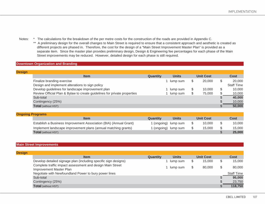
Notes: * The calculations for the breakdown of the per metre costs for the construction of the roads are provided in Appendix C.** A preliminary design for the overall changes to Main Street is required to ensure that a consistent approach and aesthetic is created as different projects are phased in. Therefore, the cost for the design of a "Main Street Improvement Master Plan" is provided as a separate item. Since the master plan provides preliminary design, Design & Engineering fee percentages for each phase of the Main Street improvements may be reduced. However, detailed design for each phase is still required.
Downtown Organization and Branding
DesignItem Quantity Units Unit Cost Cost
Finalize branding exercise 1 lump sum $ 20,000 $ 20,000Design and implement alterations to sign policy Staff TimeDevelop guidelines for landscape improvement plan 1 lump sum $ 10,000 $ 10,000Review Official Plan & Bylaw to create guidelines for private properties 1 lump sum $ 75,000 $ 10,000Sub-total $ 40,000Contingency (25%) $ 10,000Total (without HST) $ 50,000
Ongoing ProgramsItem Quantity Units Unit Cost Cost
Establish a Business Improvement Association (BIA) (Annual Grant) 1 (ongoing) lump sum $ 10,000 $ 10,000Implement landscape improvement plans (annual matching grants) 1 (ongoing) lump sum $ 15,000 $ 15,000Total (without HST) $ 25,000
Main Street Improvements
DesignItem Quantity Units Unit Cost Cost
Develop detailed signage plan (including specific sign designs) 1 lump sum $ 15,000 $ 15,000Complete traffic impact assessment and design Main Street Improvement Master Plan 1 lump sum $ 80,000 $ 80,000
Negotiate with Newfoundland Power to bury power lines Staff TimeSub-total $ 95,000Contingency (25%) $ 23,750Total (without HST) $ 118,750
CBCL LIMITED 107
IMPLEMENTaTION

Construction of Gateway at Manuels RiverItem Quantity Units Unit Cost Cost
Entrance sign 1 lump sum $ 75,000 $ 75,000Shrubbery 20 sq. m. $ 40 $ 800Project Sub-total $ 75,800Construction Contingency (25%) $ 18,950Design & Engineering (11%) including site inspection $ 10,423Total (without HST) $ 105,173
.Construction of Gateway at Kitty Ades Turn
Item Quantity Units Unit Cost CostDemolition of portions of existing road surface and curbs 1 lump sum $ 10,000 $ 10,000Relocation of existing signals 1 lump sum $ 100,000 $ 100,000Curb and gutter 300 lm $ 85 $ 25,500Crusher dust multi-use path (T'Railway Extension) 75 sm $ 5 $ 375Concrete sidewalk (1.5m wide) 400 sm $ 150 $ 60,000Roadway / crosswalk striping 1 lump sum $ 5,000 $ 5,000Waste containers 2 each $ 1,000 $ 2,000Sodding 400 sm $ 14 $ 5,600Hydroseeding 2,800 sm $ 4 $ 11,200Entrance sign 1 lump sum $ 75,000 $ 75,000Project Sub-total $ 294,675Construction Contingency (25%) $ 73,669Design & Engineering (15%) including site inspection $ 55,252Total (without HST) $ 423,595
Main Street from Dawson Run to Villa Nova Rd.Item Quantity Units Unit Cost Cost
Reconstruction of Road Cross Section * 400 lm $ 2,840 $ 1,136,000Benches 8 each $ 1,000 $ 8,000Waste Containers 8 each $ 675 $ 5,400Planters 5 each $ 2,700 $ 13,500Street trees 20 each $ 1,500 $ 30,000Installation of Traffic Signals 3 each $ 200,000 $ 600,000Directional signpost 1 each $ 3,000 $ 3,000Directional signboard 1 each $ 8,000 $ 8,000Project Sub-total $ 1,803,900Construction Contingency (25%) $ 450,975Design & Engineering (13%) including site inspection $ 293,134Total (without HST) $ 2,548,009
CBS MAIN STREET IMPROVEMENT PLAN108

Main Street from Villa Nova Rd. to western end of proposed Harbour Plaza areaItem Quantity Units Unit Cost Cost
Reconstruction of Road Cross Section * 260 lm $ 2,840 $ 738,400Benches 4 each $ 1,000 $ 4,000Waste Containers 4 each $ 675 $ 2,700Planters 5 each $ 2,500 $ 12,500Street trees 25 each $ 1,500 $ 37,500Installation of Traffic Signals 2 each $ 200,000 $ 400,000Installation of Signalized Crosswalk 1 each $ 50,000 $ 50,000Directional signpost 1 each $ 3,000 $ 3,000Directional signboard 1 each $ 8,000 $ 8,000Project Sub-total $ 1,256,100Construction Contingency (25%) $ 314,025Design & Engineering (11%) $ 172,714Total (without HST) $ 1,742,839
Main Street from proposed Harbour Plaza area to Bishops Rd.Item Quantity Units Unit Cost Cost
Reconstruction of Road Cross Section * 200 lm $ 2,840 $ 568,000Benches 5 each $ 1,000 $ 5,000Waste Containers 5 each $ 675 $ 3,375Planters 4 each $ 2,500 $ 10,000Street trees 15 each $ 1,500 $ 22,500Directional signpost 1 each $ 3,000 $ 3,000Directional signboard 1 each $ 8,000 $ 8,000Project Sub-total $ 619,875Construction Contingency (25%) $ 154,969Design & Engineering (11%) including site inspection $ 85,233Total (without HST) $ 860,077
Access Control and Pedestrian Improvements: Main St. from Dawson Run to Manuels RiverItem Quantity Units Unit Cost Cost
Curb and gutter 225 lm $ 75 $ 16,875Concrete sidewalk 75 sm $ 95 $ 7,125Reinstatement of asphalt 60 sm $ 60 $ 3,600Reinstatement of soft landscape 20 sm $ 15 $ 300Project Sub-total $ 27,900Construction Contingency (25%) $ 6,975Design & Engineering (15%) including site inspection $ 5,231Total (without HST) $ 40,106
CBCL LIMITED 109
IMPLEMENTaTION

Access Control and Pedestrian Improvements: Main Street from Bishops Road to Greenslades Rd.Item Quantity Units Unit Cost Cost
Curb and gutter 200 lm $ 75 $ 15,000Concrete sidewalk 525 sm $ 95 $ 49,875Reinstatement of asphalt 50 sm $ 60 $ 3,000Reinstatement of soft landscape 140 sm $ 15 $ 2,100Directional signboard 1 each $ 8,000 $ 8,000Project Sub-total $ 77,975Construction Contingency (25%) $ 19,494Design & Engineering (13%) including site inspection $ 12,671Total (without HST) $ 110,140
Access Control and Pedestrian Improvements: Main St. from Country Path to Greenslades Rd.Item Quantity Units Unit Cost Cost
Curb and gutter 425 lm $ 75 $ 31,875Concrete sidewalk 1,140 sm $ 95 $ 108,300Install traffic signals at Greenslades Rd. 1 each $ 200,000 $ 200,000Install signalized crosswalk at Country Path 1 each $ 50,000 $ 50,000Install unsignalized crosswalks at Pottles Lane and Dicks Place 1 each $ 7,500 $ 7,500Directional signpost 1 each $ 3,000 $ 3,000Directional signboard 1 each $ 8,000 $ 8,000Project Sub-total $ 408,675Construction Contingency (25%) $ 102,169Design & Engineering (15%) including site inspection $ 76,627Total (without HST) $ 587,470
Access Control and Pedestrian Improvements: Main St. from Country Path to Terminal Rd.Item Quantity Units Unit Cost Cost
Concrete sidewalk 575 sm $ 95 $ 54,625Reinstatement of soft landscape 150 sm $ 15 $ 2,250Project Sub-total $ 56,875Construction Contingency (25%) $ 14,219Design & Engineering (11%) including site inspection $ 7,820Total (without HST) $ 78,914
CBS MAIN STREET IMPROVEMENT PLAN110

Demonstration Projects
Harbour PlazaItem Quantity Units Unit Cost Cost
Wood decking 2,700 sm $ 250 $ 675,000Wood piles 370 each $ 1,000 $ 370,000Grading 420 cum $ 30 $ 12,600Reinstatement of Shoreline Riprap 140 lm 400 $ 56,000Lighting 16 each $ 5,000 $ 80,000Electrical 280 lm $ 40 $ 11,200Connection to power 1 lump sum $ 10,000 $ 10,000Floating docks (2.4 m. wide) 72 lm $ 1,250 $ 90,000Ramp to floating docks 1 each $ 10,000 $ 10,000Benches 18 each $ 2,500 $ 45,000Waste Containers 6 each $ 1,000 $ 6,000Bike Racks 3 each $ 500 $ 1,500Trees 15 each $ 1,500 $ 22,500Shrubbery 200 sm $ 40 $ 8,000Sod 600 sm $ 12 $ 7,200Project Sub-total $ 1,405,000Construction Contingency (25%) $ 351,250Design & Engineering (15%) including site inspection $ 263,438Total (without HST) $ 2,019,688
Dominion Redevelopment By Others
Villa Nova PlazaItem Quantity Units Unit Cost Cost
Public Secondary Road 850 lm $ 1,762 $ 1,497,417Private Internal Road by othersParking area along secondary road 300 sm $ 55 $ 16,500Shrubbery 80 sm $ 40 $ 3,200Sod 170 sm $ 12 $ 2,040Project Sub-total $ 1,519,157Construction Contingency (25%) $ 379,789Design & Engineering (15%) including site inspection $ 284,842Total (without HST) $ 2,183,788
Town Hall RedevelopmentSite Development costs to be covered by development agreement by othersSecondary Roads including area around Shoppers Drug Mart 420 lm $ 1,762 $ 739,900Project Sub-total $ 739,900Construction Contingency (25%) $ 184,975Design & Engineering (15%) including site inspection $ 138,731Total (without HST) $ 1,063,606
CBCL LIMITED 111
IMPLEMENTaTION

Demonstration Projects
Harbour PlazaItem Quantity Units Unit Cost Cost
Wood decking 2,700 sm $ 250 $ 675,000Wood piles 370 each $ 1,000 $ 370,000Grading 420 cum $ 30 $ 12,600Reinstatement of Shoreline Riprap 140 lm 400 $ 56,000Lighting 16 each $ 5,000 $ 80,000Electrical 280 lm $ 40 $ 11,200Connection to power 1 lump sum $ 10,000 $ 10,000Floating docks (2.4 m. wide) 72 lm $ 1,250 $ 90,000Ramp to floating docks 1 each $ 10,000 $ 10,000Benches 18 each $ 2,500 $ 45,000Waste Containers 6 each $ 1,000 $ 6,000Bike Racks 3 each $ 500 $ 1,500Trees 15 each $ 1,500 $ 22,500Shrubbery 200 sm $ 40 $ 8,000Sod 600 sm $ 12 $ 7,200Project Sub-total $ 1,405,000Construction Contingency (25%) $ 351,250Design & Engineering (15%) including site inspection $ 263,438Total (without HST) $ 2,019,688
Dominion Redevelopment By Others
Villa Nova PlazaItem Quantity Units Unit Cost Cost
Public Secondary Road 850 lm $ 1,762 $ 1,497,417Private Internal Road by othersParking area along secondary road 300 sm $ 55 $ 16,500Shrubbery 80 sm $ 40 $ 3,200Sod 170 sm $ 12 $ 2,040Project Sub-total $ 1,519,157Construction Contingency (25%) $ 379,789Design & Engineering (15%) including site inspection $ 284,842Total (without HST) $ 2,183,788
Town Hall RedevelopmentSite Development costs to be covered by development agreement by othersSecondary Roads including area around Shoppers Drug Mart 420 lm $ 1,762 $ 739,900Project Sub-total $ 739,900Construction Contingency (25%) $ 184,975Design & Engineering (15%) including site inspection $ 138,731Total (without HST) $ 1,063,606
CBS MAIN STREET IMPROVEMENT PLAN112

FUNDING PROGRAMSIn many cases, Main Street Improvement pro-grams are funded entirely by a municipality, or local business improvement areas/associations. However, when part of a larger redevelopment project, the following funding agencies may pro-vide a portion of the total cost of the project. The municipality can then allocate a portion of the fund toward streetscape improvements.
ACOA: Community Infrastructure Im-provement Fund (CIIF)The CIIF supports the improvement and expan-sion of community facilities, such as community centres, cultural centres, parks, recreational trails, libraries, recreational facilities, tourism facilities, docks, and other existing community infrastruc-ture assets. CIIF can fund a maximum of 50 per cent of the total project costs. Projects are selected on the basis economic benefits including the po-tential for job creation, readiness, funds leveraged, and their ability to be completed by March 31, 2014.
ACOA: Innovative Communities FundThe Innovative Communities Fund focuses on investments that lead to long-term employment and economic capacity building in rural commu-nities. It is open to non-commercial, not-for-prof-it organization and considers funding for projects
that clearly demonstrate linkages and partner-ships within the community, benefit the economic development of the community, lead to sustain-able and viable economic activity, are incremental in nature, have a fixed duration, and demonstrate capability to conduct the proposed activity.
Infrastructure Canada: Building Canada FundThe Building Canada Fund is a cost-shared pro-gram that invests in public infrastructure owned by provincial, territorial and municipal govern-ments. Generally, for municipal projects the fed-eral share is limited to one-third the total cost of the project, with the remaining funded by the province and the municipality.
Infrastructure Canada: Gas Tax FundThe purpose of the Gas Tax Fund is to provide municipalities with predictable, long-term fund-ing that can help the municipalities build and revi-talize public infrastructure that contribute to pos-itive environmental results. This includes drinking water, wastewater infrastructure, public transit, community energy systems, solid waste manage-ment, and local roads projects that lead to cleaner air, water and reducing greenhouse gas emissions.
Department of Innovation, Business and Rural Development: Regional/Sectoral Di-versification FundThe purpose of this fund is to provide nonre-payable contributions to eligible organization for development and implementation of economic initiatives that address regional and sectoral de-velopment. The program will provide up to 25 percent of the total project costs and takes into ac-count the availability of other funding sources in the assessment of application. The funded proj-ects may comprise of developing infrastructure that benefits the regions and the province, creat-ing an environment for business development and completing strategies to enhance development and implementation of key sectors. The initiatives should link to sectors identified as priorities, fo-cus on small business growth and expansion, fo-cus on industrial diversification and assist with the removal of barriers to business development and growth.
CBCL LIMITED 113
IMPLEMENTaTION

aPPENDICESAPPENDIX A: CaSE STUDIESAPPENDIX B: PUBLIC MEETING PaNELSAPPENDIX c: PER METRE COSTS FOR STREET IMPROVEMENTS
114

ROAD DIEt: wHEAt RIDGE, cOLORADO In October 2012, the City of Wheat Ridge, Colorado adopted the 38th Av-enue Corridor Plan. The vision and guiding principles outlined in the plan call for 38th Avenue to become an attractive, economically viable corridor that serves as the Main Street for Wheat Ridge. In order to achieve this, the primary recommendation of this plan is to reduce the number of vehicular lanes on 38th Avenue, utilizing the additional space for a combination of on-
street parking and enhanced sidewalks with amenity zones (ex: outdoor seat-ing areas). A reduction of lands on an existing street is often referred to as a “road diet”. A road diet may involve restriping the lanes on street without moving the existing curbs, or it can entail a complete reconstruction of the street with new curb locations. Road diets have been found to help reduce traffic speeds, create more pedestrian friendly streets, increase sales revenue and property values for adjacent businesses, and increase safety by reducing vehicle and pedestrian accidents.
Through a Road Diet Traffic Analysis, the city determined that even with a 15% growth rate in traffic volume over the following 20 years, the corridor could be reduced from four and five lanes to three lanes (one thru-lane in each direction and one continuous center turn lane). However, the city is taking an interesting approach to implementing the road diet. Commenc-ing in the summer of 2012, they began a short-term retrofit road diet that will act as an 18-24 month long pilot project. During the pilot project, the removal of traffic lanes has created room for a more pedestrian and bike friendly street, temporary outdoor seating areas (called pop-up cafes), on-street parking, bike lanes, and temporary planters. In some cases the planters have been used reduce large curb cuts and to clearly define access points. Throughout this time the city will collect data from a variety of sources, in-cluding traffic counts and new businesses on the street, to assess the success of the project. This will inform any permanent changes made to the street in the future. After the pilot project is evaluated, the corridor plan calls for a more permanent construction project that would create wide sidewalks with permanent landscaping and seating areas.
APPENDIX A: CaSE STUDIESCASE STUDIES
ROAD DIETS IN WHEAT RIDGE, COLORADOThe primary recommendation from the City of Wheat Ridge’s 38th Avenue Corridor Plan was to reduce the number of vehicular lanes from four and five lanes, to three lanes, utilizing the additional space for a combination of on-street parking and enhanced sidewalks with amenity zones (ex: outdoor seating areas). This is often called a “road diet”. Road diets have been found to help reduce traffic speeds, create more pedestrian friendly streets, increase sales revenue and property values for adjacent businesses, and increase safety by reducing vehicle and pedestrian accidents.
The city determined that even with a 15% growth rate in traffic volume over 20 years, the corridor could be reduced to three lanes. The road diet was implemented as a pilot project over a period of 18-24 months. The removal of traffic lanes has created room for a pedestrian and bike friendly street, temporary outdoor seating areas (called pop-up cafes), on-street parking, and temporary planters. In some cases the planters have been used reduce large curb cuts and to clearly define access points. Throughout this time the city will collect data to assess the success of the project which will inform any permanent changes made to the street in the future.
RIGHT-SIZING IN POUGHKEEPSIE, NEW YORKSimilar to Route 60 in Conception Bay South, Raymond Avenue borders residences, a business district, open space and an elementary school. Raymond Avenue felt like a highway because the road was initially designed for high speeds, rather than safety and access. In 1999, the city set out to reconfigure Raymond Avenue to calm traffic, improve pedestrian experience and safety, increase aesthetic appeal and support a vibrant business district. By resizing the street, the four lane arterial road was reduce to two lanes, three roundabouts were constructed in order to slow traffic without impeding traffic flow, sidewalks are parking were made more consistent along the corridor, a centre median with plantings and tress was built, pedestrian infrastructure was added (textured sidewalks, district specific street lights) and a safer crossing at the elementary school was established. Phase 1 of the project was completed in 2007. As a result, by comparing traffic data from before and after the redesign, it was found that accidents decreased more than 50%, and vehicle speeds declined by about 24%, yet corridor travel time increased by 7% and traffic delays decreased by 56% at the roundabouts. Furthermore, many new businesses have opened or expanded in the district since the project was implemented.
STRATEGIC INFRASTRUCTURE DEVELOPMENT INBEAUFORT, SOUTH CAROLINA
Similar to Conception Bay South, Boundary Street serves as a major transportation corridor. Boundary Street has three major problems that create tension between the need to move large volumes of traffic and the desire to create a walkable thoroughfare: It serves double duty as both a through-moving arterial and a locally-circulating street; It encourages only one travel mode by discouraging walking, cycling, and transit; and, It is geographically constrained by marshes. To balance the vision and constraints, the proposed design of Boundary Street is a type of Multiway Boulevard with the center lanes sued for the “motor vehicle realm”. A key concession to pedestrians is that speeds are managed in the 30-35 mph range by techniques such as narrower lanes and shorter blocks.
It was recognized that transformation of the corridor will not happen overnight, so the plan is broken down into small, strategic components that can be redeveloped as the market demands. Each aspect of the plan sets initial improvements that can be implemented right away, along with continued redevelopment to achieve the end goal.
THE BLVD IN LANCASTER, CALIFORNIABefore the redevelopment of Lancaster Boulevard, Lancaster was in decline, both socially and economically. In response to the recession, the Lancaster Redevelopment Agency chose to invest in a major redevelopment of the Lancaster Boulevard. The plan aimed to increase the mix of uses, create better walking environment for pedestrians, and restore the Boulevard’s historical place as a cultural and commercial corridor. To accomplish this, the city used form-based code. The project focused on a complete reconstruction of the street, which incorporated traffic calming, pedestrian amenities and locally appropriate landscaping. Collaborations with the private sector resulted in several unique projects, including affordable housing projects, commercial complexes, an athletic facility, an expanded space for the Lancaster Museum of Art and History, and redeveloping an unused hotel to a residence for seniors & disabled people.
The speed of implementation is particularly worthy of note: the Downtown Specific Plan was approved in late 2008, the project broke ground in March 2010, and the construction was completed by November 2010. The redevelopment resulted in an estimated 48 new businesses, 1,900 new jobs, and a $273.3 million economic output for a $41 million initial investment.Photo Credits (left to right):
City of Wheat Ridge, Projects for Public Spaces, City of Beaufort, theblvdlancaster.com
ii |
InfraCycle
CBCL LIMITED 115
IMPLEMENTaTION

RIGHtSIzING: RAYMOND AVENUE, POUGHkEEPSIE, NEw YORkRightsizing is the process of reallocating a street’s space to better serve its full range of users. Many of our streets and highways were built prior to devel-opment and as the communities grew, the needs of the community changed. Streets must then be reconfigured to meet the Town’s current needs. Right-sizing is context-sensitive and should always include the vision of the local community. In general, typical goals of rightsizing include increasing safety and access for all users, encouraging walking, biking and transit use, sup-porting businesses and the local economy, and creating places that foster community livability. These gaols are usually achieved by converting vehicle travel lanes to other uses, narrowing vehicle lanes, adding bike lanes, improv-ing pedestrian infrastructure, changing parking configuration and adding roundabouts and medians.
Similar to Route 60 in Conception Bay South, Raymond Avenue borders residences, a business district, open space and an elementary school. Ray-
mond Avenue felt like a highway because the road was initially designed for high speeds, rather than safety and access. In 1999, the city set out to recon-figure 1.5 miles of Raymond Avenue to calm traffic, improve pedestrian ex-perience and safety, increase aesthetic appeal and support a vibrant business district. By resizing the street, the four lane arterial road was reduce to two lanes, three roundabouts were constructed in order to slow traffic without impeding traffic flow, sidewalks are parking were made more consistent along the corridor, a centre median with plantings and tress was built, pedestrian infrastructure was added (textured sidewalks, district specific street lights) and a safer crossing at the elementary school was established. Phase 1 of the project was completed in 2007. As a result, by comparing traffic data from before and after the redesign, it was found that accidents decreased more than 50%, and vehicle speeds declined by about 24%, yet corridor travel time increased by 7% and traffic delays decreased by 56% at the roundabouts. Furthermore, many new businesses have opened or expanded in the district since the project was implemented.
CASE STUDIES
ROAD DIETS IN WHEAT RIDGE, COLORADOThe primary recommendation from the City of Wheat Ridge’s 38th Avenue Corridor Plan was to reduce the number of vehicular lanes from four and five lanes, to three lanes, utilizing the additional space for a combination of on-street parking and enhanced sidewalks with amenity zones (ex: outdoor seating areas). This is often called a “road diet”. Road diets have been found to help reduce traffic speeds, create more pedestrian friendly streets, increase sales revenue and property values for adjacent businesses, and increase safety by reducing vehicle and pedestrian accidents.
The city determined that even with a 15% growth rate in traffic volume over 20 years, the corridor could be reduced to three lanes. The road diet was implemented as a pilot project over a period of 18-24 months. The removal of traffic lanes has created room for a pedestrian and bike friendly street, temporary outdoor seating areas (called pop-up cafes), on-street parking, and temporary planters. In some cases the planters have been used reduce large curb cuts and to clearly define access points. Throughout this time the city will collect data to assess the success of the project which will inform any permanent changes made to the street in the future.
RIGHT-SIZING IN POUGHKEEPSIE, NEW YORKSimilar to Route 60 in Conception Bay South, Raymond Avenue borders residences, a business district, open space and an elementary school. Raymond Avenue felt like a highway because the road was initially designed for high speeds, rather than safety and access. In 1999, the city set out to reconfigure Raymond Avenue to calm traffic, improve pedestrian experience and safety, increase aesthetic appeal and support a vibrant business district. By resizing the street, the four lane arterial road was reduce to two lanes, three roundabouts were constructed in order to slow traffic without impeding traffic flow, sidewalks are parking were made more consistent along the corridor, a centre median with plantings and tress was built, pedestrian infrastructure was added (textured sidewalks, district specific street lights) and a safer crossing at the elementary school was established. Phase 1 of the project was completed in 2007. As a result, by comparing traffic data from before and after the redesign, it was found that accidents decreased more than 50%, and vehicle speeds declined by about 24%, yet corridor travel time increased by 7% and traffic delays decreased by 56% at the roundabouts. Furthermore, many new businesses have opened or expanded in the district since the project was implemented.
STRATEGIC INFRASTRUCTURE DEVELOPMENT INBEAUFORT, SOUTH CAROLINA
Similar to Conception Bay South, Boundary Street serves as a major transportation corridor. Boundary Street has three major problems that create tension between the need to move large volumes of traffic and the desire to create a walkable thoroughfare: It serves double duty as both a through-moving arterial and a locally-circulating street; It encourages only one travel mode by discouraging walking, cycling, and transit; and, It is geographically constrained by marshes. To balance the vision and constraints, the proposed design of Boundary Street is a type of Multiway Boulevard with the center lanes sued for the “motor vehicle realm”. A key concession to pedestrians is that speeds are managed in the 30-35 mph range by techniques such as narrower lanes and shorter blocks.
It was recognized that transformation of the corridor will not happen overnight, so the plan is broken down into small, strategic components that can be redeveloped as the market demands. Each aspect of the plan sets initial improvements that can be implemented right away, along with continued redevelopment to achieve the end goal.
THE BLVD IN LANCASTER, CALIFORNIABefore the redevelopment of Lancaster Boulevard, Lancaster was in decline, both socially and economically. In response to the recession, the Lancaster Redevelopment Agency chose to invest in a major redevelopment of the Lancaster Boulevard. The plan aimed to increase the mix of uses, create better walking environment for pedestrians, and restore the Boulevard’s historical place as a cultural and commercial corridor. To accomplish this, the city used form-based code. The project focused on a complete reconstruction of the street, which incorporated traffic calming, pedestrian amenities and locally appropriate landscaping. Collaborations with the private sector resulted in several unique projects, including affordable housing projects, commercial complexes, an athletic facility, an expanded space for the Lancaster Museum of Art and History, and redeveloping an unused hotel to a residence for seniors & disabled people.
The speed of implementation is particularly worthy of note: the Downtown Specific Plan was approved in late 2008, the project broke ground in March 2010, and the construction was completed by November 2010. The redevelopment resulted in an estimated 48 new businesses, 1,900 new jobs, and a $273.3 million economic output for a $41 million initial investment.Photo Credits (left to right):
City of Wheat Ridge, Projects for Public Spaces, City of Beaufort, theblvdlancaster.com
ii |
InfraCycle
CBS MAIN STREET IMPROVEMENT PLAN116
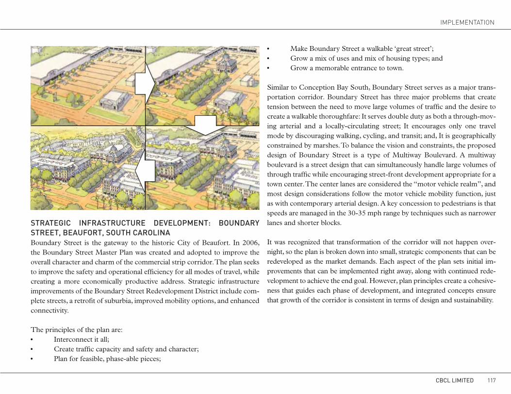
StRAtEGIc INFRAStRUctURE DEVELOPMENt: BOUNDARY StREEt, BEAUFORt, SOUtH cAROLINABoundary Street is the gateway to the historic City of Beaufort. In 2006, the Boundary Street Master Plan was created and adopted to improve the overall character and charm of the commercial strip corridor. The plan seeks to improve the safety and operational efficiency for all modes of travel, while creating a more economically productive address. Strategic infrastructure improvements of the Boundary Street Redevelopment District include com-plete streets, a retrofit of suburbia, improved mobility options, and enhanced connectivity.
The principles of the plan are:• Interconnect it all;• Create traffic capacity and safety and character;• Plan for feasible, phase-able pieces;
• Make Boundary Street a walkable ‘great street’;• Grow a mix of uses and mix of housing types; and• Grow a memorable entrance to town.
Similar to Conception Bay South, Boundary Street serves as a major trans-portation corridor. Boundary Street has three major problems that create tension between the need to move large volumes of traffic and the desire to create a walkable thoroughfare: It serves double duty as both a through-mov-ing arterial and a locally-circulating street; It encourages only one travel mode by discouraging walking, cycling, and transit; and, It is geographically constrained by marshes. To balance the vision and constraints, the proposed design of Boundary Street is a type of Multiway Boulevard. A multiway boulevard is a street design that can simultaneously handle large volumes of through traffic while encouraging street-front development appropriate for a town center. The center lanes are considered the “motor vehicle realm”, and most design considerations follow the motor vehicle mobility function, just as with contemporary arterial design. A key concession to pedestrians is that speeds are managed in the 30-35 mph range by techniques such as narrower lanes and shorter blocks.
It was recognized that transformation of the corridor will not happen over-night, so the plan is broken down into small, strategic components that can be redeveloped as the market demands. Each aspect of the plan sets initial im-provements that can be implemented right away, along with continued rede-velopment to achieve the end goal. However, plan principles create a cohesive-ness that guides each phase of development, and integrated concepts ensure that growth of the corridor is consistent in terms of design and sustainability.
CASE STUDIES
ROAD DIETS IN WHEAT RIDGE, COLORADOThe primary recommendation from the City of Wheat Ridge’s 38th Avenue Corridor Plan was to reduce the number of vehicular lanes from four and five lanes, to three lanes, utilizing the additional space for a combination of on-street parking and enhanced sidewalks with amenity zones (ex: outdoor seating areas). This is often called a “road diet”. Road diets have been found to help reduce traffic speeds, create more pedestrian friendly streets, increase sales revenue and property values for adjacent businesses, and increase safety by reducing vehicle and pedestrian accidents.
The city determined that even with a 15% growth rate in traffic volume over 20 years, the corridor could be reduced to three lanes. The road diet was implemented as a pilot project over a period of 18-24 months. The removal of traffic lanes has created room for a pedestrian and bike friendly street, temporary outdoor seating areas (called pop-up cafes), on-street parking, and temporary planters. In some cases the planters have been used reduce large curb cuts and to clearly define access points. Throughout this time the city will collect data to assess the success of the project which will inform any permanent changes made to the street in the future.
RIGHT-SIZING IN POUGHKEEPSIE, NEW YORKSimilar to Route 60 in Conception Bay South, Raymond Avenue borders residences, a business district, open space and an elementary school. Raymond Avenue felt like a highway because the road was initially designed for high speeds, rather than safety and access. In 1999, the city set out to reconfigure Raymond Avenue to calm traffic, improve pedestrian experience and safety, increase aesthetic appeal and support a vibrant business district. By resizing the street, the four lane arterial road was reduce to two lanes, three roundabouts were constructed in order to slow traffic without impeding traffic flow, sidewalks are parking were made more consistent along the corridor, a centre median with plantings and tress was built, pedestrian infrastructure was added (textured sidewalks, district specific street lights) and a safer crossing at the elementary school was established. Phase 1 of the project was completed in 2007. As a result, by comparing traffic data from before and after the redesign, it was found that accidents decreased more than 50%, and vehicle speeds declined by about 24%, yet corridor travel time increased by 7% and traffic delays decreased by 56% at the roundabouts. Furthermore, many new businesses have opened or expanded in the district since the project was implemented.
STRATEGIC INFRASTRUCTURE DEVELOPMENT INBEAUFORT, SOUTH CAROLINA
Similar to Conception Bay South, Boundary Street serves as a major transportation corridor. Boundary Street has three major problems that create tension between the need to move large volumes of traffic and the desire to create a walkable thoroughfare: It serves double duty as both a through-moving arterial and a locally-circulating street; It encourages only one travel mode by discouraging walking, cycling, and transit; and, It is geographically constrained by marshes. To balance the vision and constraints, the proposed design of Boundary Street is a type of Multiway Boulevard with the center lanes sued for the “motor vehicle realm”. A key concession to pedestrians is that speeds are managed in the 30-35 mph range by techniques such as narrower lanes and shorter blocks.
It was recognized that transformation of the corridor will not happen overnight, so the plan is broken down into small, strategic components that can be redeveloped as the market demands. Each aspect of the plan sets initial improvements that can be implemented right away, along with continued redevelopment to achieve the end goal.
THE BLVD IN LANCASTER, CALIFORNIABefore the redevelopment of Lancaster Boulevard, Lancaster was in decline, both socially and economically. In response to the recession, the Lancaster Redevelopment Agency chose to invest in a major redevelopment of the Lancaster Boulevard. The plan aimed to increase the mix of uses, create better walking environment for pedestrians, and restore the Boulevard’s historical place as a cultural and commercial corridor. To accomplish this, the city used form-based code. The project focused on a complete reconstruction of the street, which incorporated traffic calming, pedestrian amenities and locally appropriate landscaping. Collaborations with the private sector resulted in several unique projects, including affordable housing projects, commercial complexes, an athletic facility, an expanded space for the Lancaster Museum of Art and History, and redeveloping an unused hotel to a residence for seniors & disabled people.
The speed of implementation is particularly worthy of note: the Downtown Specific Plan was approved in late 2008, the project broke ground in March 2010, and the construction was completed by November 2010. The redevelopment resulted in an estimated 48 new businesses, 1,900 new jobs, and a $273.3 million economic output for a $41 million initial investment.Photo Credits (left to right):
City of Wheat Ridge, Projects for Public Spaces, City of Beaufort, theblvdlancaster.com
ii |
InfraCycle
CBCL LIMITED 117
IMPLEMENTaTION

APPENDIX B: PUBLIC MEETING PaNELS
ii |
InfraCycle
DESIGN CHARRETTE WEEK SCHEDULETHE PROJECTSince its incorporation in 1973, the Town of Conception Bay South has experienced growth and development that today, with a population of ap-proximately 25,000 residents, the largest town, and the second largest municipality in the province. Development of the community has been largely of a suburban residential nature with a disproportionate ratio of residential to commercial/industrial tax base. Despite the presence of over 500 businesses, there is no cohesive, readily identifiable business district in the community. Instead, commercial development is spread out along the high- way with concentrations of commercial uses in Long Pond/Man-uels (around Villa Nova Plaza) and in Kelligrews.
In a 2001 review of the Municipal Plan, these areas were identified as needing further study and improvement. A Main Street Improvement Plan was recommended to concentrate on methods to calm traffic flow, improve vehicle access, parking and pedestrian circulation. Between 2001 and 2012, the Town’s Capital Works in- vestment strategy focused on complet-ing installation of water and sewer services throughout the community. No plan for the main street area was completed, but the need was again identified in a review of the 2001 Municipal Plan (completed in 2012). The 2001 policy to undertake a Main Street Improvement Plan is also included in the new Plan.
The Town of Conception Bay South recognizes that its downtown commer-cial district is one of the most visible indicators of the community’s eco-nomic and social health. With a number of other priorities addressed, the Town now finds itself in a position to define and improve the appearance and amenity of its Main Street, and to seize on the potential to significantly advance the Town’s position as a progressive and vibrant community.
STEPS TO A SUCCESSFUL DOWNTOWNEach downtown and main street is unique. Lessons learned in one place cannot simply be applied in another. However, what many downtowns have in common is that deterioration has typically happened slowly. Re-vitalization processes are also accomplished slowly and incrementally, without sudden change forced on the community. As slow as it may be, the revitalization process needs a strong footing, a basis on which resi-dents, businesses and decision makers move forward. A common overall theme and restoration visualization as will be the foundation and starting point for revitalizing Main Street.
STUDY AREA .
PROJECT OVERVIEW
ST. JOhn’SCBS MAIn STREET
MAIn STREETSTUDY AREA
MONDAYFebruary 25
MOR
NING
LUNC
HAF
TERN
OON
EVEN
ING
TUESDAYFebruary 26
WEDNESDAYFebruary 27
THURSDAYFebruary 28
FRIDAYMarch 1
12-2 PM
Public Walking
Tour
7-9 PM
Public Design
Charrette
12-2 PM
Public Drop-InSession
12-2 PM
Public Drop-InSession
2-4 PM
StakeholderMeeting
9-12 AM
StakeholderMeeting
2-4 AM
StakeholderMeeting
2-4 AM
Concept Design
2-4 AM
Concept Design
9-2 PM
ConceptDesign
12-4 PM
ConceptDesign
9-12 AM
StakeholderMeeting
9-12 AM
StakeholderMeeting
Stakeholder MeetingsPublic EventConcept Design
CBS MAIN STREET IMPROVEMENT PLAN118

AERIAL PhOTOGRAPh
Stick green dots on your
favourite places Main Street
Stick red dots on places along Main Street that need improvements
Write your thoughts on post-it notes
and stick them to the map.
ii |
InfraCycle
CBCL LIMITED 119
IMPLEMENTaTION

CONCEPTIO
NBAY HWY
CHERR
YLAN
E
MINERALS ROAD
CONC
EPTI
ONBA
YBY
PASS
HIGHW
AY
ANCHORAGE ROAD
TER
MIN
ALRO
AD
EASON
SR
OAD
CHU
RC H
ROA
D
COUN
TRY
PATHR
OAD
TOBINS ROAD
POCKET ROAD
DAWSONS RUN
TOPSAILROAD
BISHOPSR
OAD
ATKINS
ROAD
CHUTE
PLAC
E
VILLA
NOVAROAD
MANUELS ARTERIAL RD
GREENSLADESROAD
STONEY HILL PARK
STANLEY S ROAD
RID
EOU
T SR
OAD
TALCVILLEROAD
E
HICKORY PLACE
MAIn STREET MAPS
Label your favourite places
along Main Street.
CIRCULATIOn
BUILDInG COVERAGE
ii |
InfraCycle
CBS MAIN STREET IMPROVEMENT PLAN120
PhOTOGRAPhS
Record any thoughts or
observations on a sticky note
ii |
InfraCycle
CBCL LIMITED 121
IMPLEMENTaTION

AnALYSISGEOGRAPHICAL ANALYSIS
0.0 Very high (-1.5)
100.0
High (1.5-2.0)
Moderate (2.0-2.5)
200.0
Low (2.5+)
SEA LEVEL RISE (m)Every year, the sea level rises approximately 3-5 mm on the Avalon Peninsu-la and is expecting to climb to over a metre by 2099. The Long Pond beach jetty protects low-lying areas from storm surge, however, future sea level rise, plus storm surge, could breach the system and leaved developed areas along Main Street vulnerable.
ELEVATION (m)The study area is tucked between the coastline of Conception Bay and the leeside of the Avalon Plateau. Within the study area, elevations reach approx-imately 38 metres, however, the steep banks of the adjacent Plateau quickly reach over 200 metres. Recent residential development has worked its way up the slope of the plateau, taking advantage of the stable foundations and great views.
CBS MAIN STREET IMPROVEMENT PLAN20
17+
0-1
2-4
5-10
10-17
CLImATEAreas that are sloped toward the south/southwest receive the most solar expo-sure on an annual basis. There are several “solar hotspots” throughout Main Street, particularly in and around the Villa Nova Plaza area. The uplands of the Avalon Plateau protect Main Street from predominantly west-southwest winds, however, strong northeasterly winds are also common which can gen-erate strong wind tunnels along Main Street.
SLOPE CHANGE (%)Slopes under 1% do not drain well unless they are paved and carefully fin-ished. Slopes over 10% are more expensive to build on, requiring more com-plicated foundations and utility connections. Roads are ideally kept between 1 and 10%. A 17% slope approaches the limit that an ordinary loaded vehicle can climb, for any sustained period. The normal limit of climb for pedestri-ans is 20 to 25% without resorting to stairs.
CBCL LIMITED 21
ANALYSIS
LAnD UTILIZATIOn
USERS OF MAIn STREET
OPEn AREAS 61.3%
PARKInG11.1%
ROADS 9.2%
SIDEWALKS0.5%
RECREATIOn5.8%
BUILDInGS7.2%
DRIVEWAYS4.9%BREAKDOWN OF
LAND UTILIZATIONMIXED USE1.4%
COMMERCIAL45.1%
InDUSTRIAL1.7%
InSTITUTIOnAL6.4%
RESIDEnTIAL45.4%
BREAKDOWN OFBUILDING USES
How will climate change
affect Main Street?
Where are the warmest and
coldest areas of Main Street?
How many people will live
in CBS in 2016? ... in 2021?
35,000
30,000
25,000
20,000
15,000
10,000
1986 1991 1996 2001 2006 2011 2016 2021
5,000
0
?
85+80-8475-7970-7465-6960-6455-5950-5445-4940-4435-3930-3425-2920-2415-1910-14
5-9
0-4
4 %4 %
FemaleMale
2006
POPULATIOn PROJECTIOnS POPULATIOn PYRAMID
Use dots to predict future
population trends on the
chart...
What types of building uses should occur along
Main Street?
How will future generations want to use Main Street?
ii |
InfraCycle
CBS MAIN STREET IMPROVEMENT PLAN122
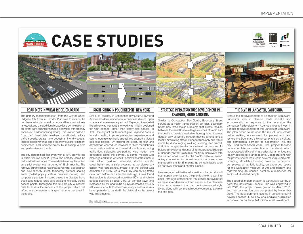
CASE STUDIES
ROAD DIETS IN WHEAT RIDGE, COLORADOThe primary recommendation from the City of Wheat Ridge’s 38th Avenue Corridor Plan was to reduce the number of vehicular lanes from four and five lanes, to three lanes, utilizing the additional space for a combination of on-street parking and enhanced sidewalks with amenity zones (ex: outdoor seating areas). This is often called a “road diet”. Road diets have been found to help reduce traffic speeds, create more pedestrian friendly streets, increase sales revenue and property values for adjacent businesses, and increase safety by reducing vehicle and pedestrian accidents.
The city determined that even with a 15% growth rate in traffic volume over 20 years, the corridor could be reduced to three lanes. The road diet was implemented as a pilot project over a period of 18-24 months. The removal of traffic lanes has created room for a pedestrian and bike friendly street, temporary outdoor seating areas (called pop-up cafes), on-street parking, and temporary planters. In some cases the planters have been used reduce large curb cuts and to clearly define access points. Throughout this time the city will collect data to assess the success of the project which will inform any permanent changes made to the street in the future.
RIGHT-SIZING IN POUGHKEEPSIE, NEW YORKSimilar to Route 60 in Conception Bay South, Raymond Avenue borders residences, a business district, open space and an elementary school. Raymond Avenue felt like a highway because the road was initially designed for high speeds, rather than safety and access. In 1999, the city set out to reconfigure Raymond Avenue to calm traffic, improve pedestrian experience and safety, increase aesthetic appeal and support a vibrant business district. By resizing the street, the four lane arterial road was reduce to two lanes, three roundabouts were constructed in order to slow traffic without impeding traffic flow, sidewalks are parking were made more consistent along the corridor, a centre median with plantings and tress was built, pedestrian infrastructure was added (textured sidewalks, district specific street lights) and a safer crossing at the elementary school was established. Phase 1 of the project was completed in 2007. As a result, by comparing traffic data from before and after the redesign, it was found that accidents decreased more than 50%, and vehicle speeds declined by about 24%, yet corridor travel time increased by 7% and traffic delays decreased by 56% at the roundabouts. Furthermore, many new businesses have opened or expanded in the district since the project was implemented.
STRATEGIC INFRASTRUCTURE DEVELOPMENT INBEAUFORT, SOUTH CAROLINA
Similar to Conception Bay South, Boundary Street serves as a major transportation corridor. Boundary Street has three major problems that create tension between the need to move large volumes of traffic and the desire to create a walkable thoroughfare: It serves double duty as both a through-moving arterial and a locally-circulating street; It encourages only one travel mode by discouraging walking, cycling, and transit; and, It is geographically constrained by marshes. To balance the vision and constraints, the proposed design of Boundary Street is a type of Multiway Boulevard with the center lanes sued for the “motor vehicle realm”. A key concession to pedestrians is that speeds are managed in the 30-35 mph range by techniques such as narrower lanes and shorter blocks.
It was recognized that transformation of the corridor will not happen overnight, so the plan is broken down into small, strategic components that can be redeveloped as the market demands. Each aspect of the plan sets initial improvements that can be implemented right away, along with continued redevelopment to achieve the end goal.
THE BLVD IN LANCASTER, CALIFORNIABefore the redevelopment of Lancaster Boulevard, Lancaster was in decline, both socially and economically. In response to the recession, the Lancaster Redevelopment Agency chose to invest in a major redevelopment of the Lancaster Boulevard. The plan aimed to increase the mix of uses, create better walking environment for pedestrians, and restore the Boulevard’s historical place as a cultural and commercial corridor. To accomplish this, the city used form-based code. The project focused on a complete reconstruction of the street, which incorporated traffic calming, pedestrian amenities and locally appropriate landscaping. Collaborations with the private sector resulted in several unique projects, including affordable housing projects, commercial complexes, an athletic facility, an expanded space for the Lancaster Museum of Art and History, and redeveloping an unused hotel to a residence for seniors & disabled people.
The speed of implementation is particularly worthy of note: the Downtown Specific Plan was approved in late 2008, the project broke ground in March 2010, and the construction was completed by November 2010. The redevelopment resulted in an estimated 48 new businesses, 1,900 new jobs, and a $273.3 million economic output for a $41 million initial investment.Photo Credits (left to right):
City of Wheat Ridge, Projects for Public Spaces, City of Beaufort, theblvdlancaster.com
ii |
InfraCycle
CBCL LIMITED 123
IMPLEMENTaTION

AppearancePedestrian Connectivity
Trees & LandscapingAdvertising SignsWayfinding SignsTraffic Circulation
BenchesStreet Cleaning / Maintenance
Street LightingPublic Spaces
Bike LanesSidewalks
ParkingCultural Facilities
1 15 20 25 30 05
PRIORITIZInG ChAnGESTRENGTHS AND WEAKNESSES OF MAIN STREET... NOTES
Write your own priorities in these spaces.
Write more thoughts
on a post-it or in the
space below.
NEEDS HELP!! COULD BE BETTER... NO IMPROVEMENT NEEDED
ii |
InfraCycle
CBS MAIN STREET IMPROVEMENT PLAN124

APPENDIX c: PER METRE COSTS FOR STREET IMPROVEMENTS
Per metre Cost of Street Construction
Main Street BoulevardItem Quantity Units Unit Cost Cost
Demolition 1 lump sum $ 50 $ 50Curb and Gutter both sides road 2 lm $ 75 $ 150Curb and Gutter both sides median 2 lm $ 75 $ 150Asphalt road paving including grading & sub-base 12 sm $ 45 $ 540sod in median 3 sm $ 12 $ 36Brick utility strip both sides 1.6 sm $ 150 $ 240Concrete sidewalk both sides 3.4 sm $ 95 $ 323Lamp Standard (includes electrical) 1 per 12m each $ 14,000 $ 1,167Catchbasin 1 per 25m each $ 2,500 $ 100Reinstatement of asphalt 1 sm $ 60 $ 60Reinstatement of soft landscape 1 sm $ 15 $ 15
Total 2,840
Secondary RoadsItem Quantity Units Unit Cost Cost
Grading 10 m3 $ 30 $ 300Curb and Gutter both sides road 2 lm $ 75 $ 150Asphalt road paving including grading & sub-base 7 sm $ 45 $ 315Concrete sidewalk both sides 3 sm $ 95 $ 285Lamp Standard (includes electrical) 1 per 12m each $ 5,960 $ 497Catchbasin 1 per 25m each $ 2,500 $ 100Storm Sewer 1 lm $ 115 $ 115
Total 1,762
CBCL LIMITED 125
IMPLEMENTaTION

CBCL Limited1489 Hollis Street
Halifax, Nova ScotiaB3J 3M5