Castello 2008 - Lateral Migration of Ag in Floodplains
9
Lateral migration of Arapaima gigas in floodplains of the Amazon Introduction Fi sh mi gr at ion opti mi se s the us e of resour ces in temporally and spatially heterogeneous environments by investing energy in movements that bring larger energy returns (Hall 1972). Moreover, it ensures the survival of fish populations, and enhances the yields of fishe ri es and the st ruct ur e and func ti on of enti re ecos ystems (Har den Jones 1968 ; Welco mme 1979 ). Yet, the spatial and temporal scales of fish migration in floodplains are poorly understood (Junk et al. 1989; Wi nemill er & Jep sen 199 8). The sub jec t des erves att ent ion bec aus e floo dpl ain s are amo ng the most thre aten ed ecosy stems (T ockne r & Stan ford 2002 ), and seve ra l floodpl ain fis hes are threat ened wi th extinction (Allan et al. 2005). Floodplain fishes migrate in two main ways: longi- tudinally, along the main river channel, and laterally, between the main river channel and the floodplain (Lowe-McConne ll 1987) . The under stan ding of the latter, the ‘lateral migration’ , is so limited that a general sch eme pro pos ed in 197 1 (La gle r et al. 1971) and slig htly modi fied in 1987 (Lowe-Mc Conn ell 1987) remains uncontested. The subject has been addressed onl y by a few det ail ed stu die s (Wine mil ler 1990; Fer nan dez 199 7). Most stu die s hav e foc uss ed on sea son al and tempor al var iat ion s of floo dpl ain fish ass emb lag es and commun iti es (Lo we- McConn ell 1964; Mago-Leccia 1970; Rodriguez & Lewis 1997; Saint-Paul et al. 2000; Silvano et al. 2000; Petry et al. 2003; Galacatos et al. 2004). The late ral migr ation of flood plain fishes foll ows clos ely the dynamic ‘pul sing’ of wate r leve ls (Jun k et al. 1989). The ‘flood-pulse’ creates a moving littoral zone that advances into and over ‘terrestrial’ habitats wh en wa te r le ve ls ri se , gr adua ll y tr ansf or mi ng ‘t erre st ri al ’ habi tat into ‘a quat ic ’; the pr ocess is re ve rs ed when wa ter levels decline (J unk et al . 1989). In river-floodplain systems, many fish species spawn during rising water levels, as inputs of nutrients and suspended solids promote maximum availability and pro duction rat es of aqu ati c veg eta tio n (Ba yle y 198 9). Y oun g-o f-t he- yea r and pre dat ors mig rate wit h the movi ng litt oral , colo nizi ng the flood plain s in a timely fashion (Bayley 1988). The flooded forest ge ne ra tes an en vi ro nmen t wi th re la ti ve ly lo w Ecology of Freshwater Fish 2008: 17: 38–46 Printed in Malaysia Æ All rights reserved Ó 2007 The Authors Jour nal comp ilat ion Ó 2007 Blackwell Munksgaar d ECOLOGY OF FRESHWATER FISH 38 doi: 10.1111/j.1600-0633.2007.00255.x Castello L. Lateral migration of Arapaima gigas in floodplains of the Amazon. Ecology of Freshwater Fish 2008: 17: 38–46. Ó 2007 The Author. Journal compilation Ó 2007 Blackwell Munksgaard Abstract – This study deduced in detail the lateral migration –those between river channels and floodplain habitats – of the pirarucu ( Arapaima gigas), a giant, obligate air-breathing species of the Amazon Basin. Over a thousand samples of the pirarucu were taken through counts of the individuals performed at the moment of aerial breathing; these samples were taken in eight habitats of a floodplain near the Amazon River every week throughout an entire flood cycle. The lateral migration of the pirarucu accompanied water level fluctuations closely. As water levels rose, the pirarucu migrated to increasingly higher habitats in flooded forests and remained there during high water levels. As water levels declined, the pirarucu migrated first back to lower habitats of flooded forests, then to communicating channels, and, eventually, to the lakes, where they remained during low water levels. These results allow for a conceptual model of lateral migration of floodplain fishes. L. Castello Mamiraua ´ Sustainable Development Institute, Tefe ´ , Amazonas, CEP 69.470.000, Brazil Key words: Brazil; flood-pulse; habitat and temporal heterogeneity; va ´ rzea L. Castello, Forestry Drive, Department of Forest Biology, College of Environmental Science and Forestry, State University of New York, Syracuse, 13210, New York, USA; e-mail: [email protected] Accepted for publication 9 May, 2007
Transcript of Castello 2008 - Lateral Migration of Ag in Floodplains

7/29/2019 Castello 2008 - Lateral Migration of Ag in Floodplains
http://slidepdf.com/reader/full/castello-2008-lateral-migration-of-ag-in-floodplains 1/9
Lateral migration of Arapaima gigas infloodplains of the Amazon
Introduction
Fish migration optimises the use of resources intemporally and spatially heterogeneous environments
by investing energy in movements that bring larger energy returns (Hall 1972). Moreover, it ensures thesurvival of fish populations, and enhances the yields of fisheries and the structure and function of entireecosystems (Harden Jones 1968; Welcomme 1979).Yet, the spatial and temporal scales of fish migration in
floodplains are poorly understood (Junk et al. 1989;Winemiller & Jepsen 1998). The subject deservesattention because floodplains are among the most threatened ecosystems (Tockner & Stanford 2002),and several floodplain fishes are threatened withextinction (Allan et al. 2005).
Floodplain fishes migrate in two main ways: longi-tudinally, along the main river channel, and laterally,
between the main river channel and the floodplain(Lowe-McConnell 1987). The understanding of thelatter, the ‘lateral migration’, is so limited that a generalscheme proposed in 1971 (Lagler et al. 1971) and
slightly modified in 1987 (Lowe-McConnell 1987)
remains uncontested. The subject has been addressedonly by a few detailed studies (Winemiller 1990;Fernandez 1997). Most studies have focussed onseasonal and temporal variations of floodplain fishassemblages and communities (Lowe-McConnell1964; Mago-Leccia 1970; Rodriguez & Lewis 1997;Saint-Paul et al. 2000; Silvano et al. 2000; Petry et al.2003; Galacatos et al. 2004).
The lateral migration of floodplain fishes followsclosely the dynamic ‘pulsing’ of water levels (Junk
et al. 1989). The ‘flood-pulse’ creates a moving littoralzone that advances into and over ‘terrestrial’ habitatswhen water levels rise, gradually transforming‘terrestrial’ habitat into ‘aquatic’; the process isreversed when water levels decline (Junk et al.1989). In river-floodplain systems, many fish speciesspawn during rising water levels, as inputs of nutrientsand suspended solids promote maximum availabilityand production rates of aquatic vegetation (Bayley1989). Young-of-the-year and predators migratewith the moving littoral, colonizing the floodplainsin a timely fashion (Bayley 1988). The flooded forest
generates an environment with relatively low
Ecology of Freshwater Fish 2008: 17: 38–46
Printed in Malaysia Æ All rights reserved
Ó 2007 The Authors
Jour nal comp ilat ion Ó 2007 Blackwell Munksgaard
ECOLOGY OF
FRESHWATER FISH
38 doi: 10.1111/j.1600-0633.2007.00255.x
Castello L. Lateral migration of Arapaima gigas in floodplains of theAmazon.Ecology of Freshwater Fish 2008: 17: 38–46. Ó 2007 The Author.Journal compilation Ó 2007 Blackwell Munksgaard
Abstract – This study deduced in detail the lateral migration –those between river channels and floodplain habitats – of the pirarucu ( Arapaima gigas), a giant, obligate air-breathing species of the Amazon Basin. Over athousand samples of the pirarucu were taken through counts of theindividuals performed at the moment of aerial breathing; these sampleswere taken in eight habitats of a floodplain near the Amazon River everyweek throughout an entire flood cycle. The lateral migration of the pirarucuaccompanied water level fluctuations closely. As water levels rose, the pirarucu migrated to increasingly higher habitats in flooded forests andremained there during high water levels. As water levels declined, the pirarucu migrated first back to lower habitats of flooded forests, then tocommunicating channels, and, eventually, to the lakes, where theyremained during low water levels. These results allow for a conceptualmodel of lateral migration of floodplain fishes.
L. Castello
Mamiraua Sustainable Development Institute,
Tefe, Amazonas, CEP 69.470.000, Brazil
Key words: Brazil; flood-pulse; habitat and
temporal heterogeneity; varzea
L. Castello, Forestry Drive, Department of Forest
Biology, College of Environmental Science and
Forestry, State University of New York, Syracuse,
13210, New York, USA; e-mail: [email protected]
Accepted for publication 9 May, 2007
7/29/2019 Castello 2008 - Lateral Migration of Ag in Floodplains
http://slidepdf.com/reader/full/castello-2008-lateral-migration-of-ag-in-floodplains 2/9
predation pressure upon fishes, as the great increase inflooded area lowers animal densities (Lowe-McConn-ell 1987). Food is generally abundant, and many fishesfeed on the abundant detritus available in the newlyflooded areas and on pollen, fruits, seeds, and someinsects that drop into the water from the canopy forest
(Goulding 1980). During high water levels, decom- position processes tend to increase relative to produc-tion, generally resulting in decreased dissolved oxygenlevels (Junk et al. 1989). Many fishes possessadaptations to live in deoxygenated areas (Junk et al.1983). During low water levels, only a few of theformerly flooded habitats contain water. Of those, thelakes and connecting channels tend to have hightemperatures and low oxygen levels (Junk et al. 1983);the main river channels are exceptional in maintainingmore moderate temperature and oxygen during lowwater levels. During declining water levels, most fish
are forced to migrate out of the floodplains and intomain river channels in search of conditions in whichthey can survive (Welcomme 1979). Only fishes withadaptations to deoxygenated environments migrate tothe lakes and connecting channels, and the others go tothe river channels (Lowe-McConnell 1987). Duringlow water levels, many fishes show marked decreasesin feeding activity (Junk 1985).
Despite this understanding, however, most studieson lateral migration have not analysed how fishesutilise the spatial heterogeneity of relatively pristinefloodplains over an entire flooding cycle (Winemiller 1990, being an exception). This is critical because in
pristine floodplains not only do water levels changedaily, and sometimes dramatically, but the ‘flood pulse
produces and maintains a highly diverse and dynamichabitat structure’ (Junk et al. 1989). Here, the lateralmigration of the pirarucu ( Arapaima gigas Shinz) in a
pristine floodplain of the Amazon Basin was studied indetail. The following research questions were asked:(1) What are the main drivers of the migration of the
pirarucu in floodplains? (2) What habitats are usedthe most? (3) To what extent and in what ways is thediversity of habitat structure of floodplains used by the
pirarucu?
The pirarucu is an important fish of the Amazon andEssequibo Basins. By being piscivores (Sanchez 1969)and attaining sizes of up to 3 m in length and 200 kgin weight (Queiroz 2000), they probably play a keyrole in regulating energy and nutrient flows of aquaticecosystems. As they possess tasty meat and anobligatory air-breathing system, they move to thesurface to breath every 5 to 15 min, and they can beharpooned easily to develop important fisheries (Ver-ıssimo 1895; Martinelli & Petrere Jr. 1999). Pirarucufisheries are so important that the few data availableindicate they are overfished in most of the Amazon
(Isaac et al. 1998; Queiroz & Sardinha 1999), have
been extirpated in some regions (Goulding et al.1996), and consequently are even vulnerable toextinction (World Conservation Monitoring Centre1996).
Despite this situation, virtually no informationexists on the migration patterns of the pirarucu,
making it difficult to assess and manage the popula-tions. The pirarucu are characterised as being ‘seden-tary’, meaning they do not conduct long migrations(Isaac et al. 1993). Only a very minimal outline of thelateral migration of the pirarucu was speculated fromtheir annual cycle of events in an unpublished study(Queiroz 2000). Queiroz (2000) speculated that the
pirarucu inhabit the lakes during the dry season, wherethey feed and the adults develop gonads, court, buildnests, and mate. During rising water levels, the water
previously concentrated in the lakes and some chan-nels (including the river itself) spreads to much greater
areas. The pirarucu appears to migrate to the floodedforests where males care for the offspring. During theinitial and rapid declining of water levels, parental careceases and the pirarucu migrate back to the river,connecting channels, or lakes where they are fished.The cycle then repeats itself. Little is known about thelateral migration of the pirarucu, or of other fishes,
because of the practical difficulties of obtainingstatistically reliable data using conventional method-ologies, such as gillnets or sonar for example. Duringhigh water levels, the forested habitats of floodplainsare densely vegetated, and fish population densities arelow, especially when they are overexploited as the
pirarucu (Queiroz & Sardinha 1999).
Materials and methods
This study deduced the lateral migration of the pirarucu by detecting their per-effort presence period-ically in all habitats of a river floodplain systemthroughout an entire flood cycle. For this, the presenceof the pirarucu was determined by counts, performed
by two fishers, of the individuals at the moment of obligate aerial breathing. Water levels, current velo-city, and transparency were measured simultaneously.
Sampling occurred between 29 March 1999 and 21May 2000, yielding a total of 1035 samples of
pirarucu.
Study area and physical variables sampled
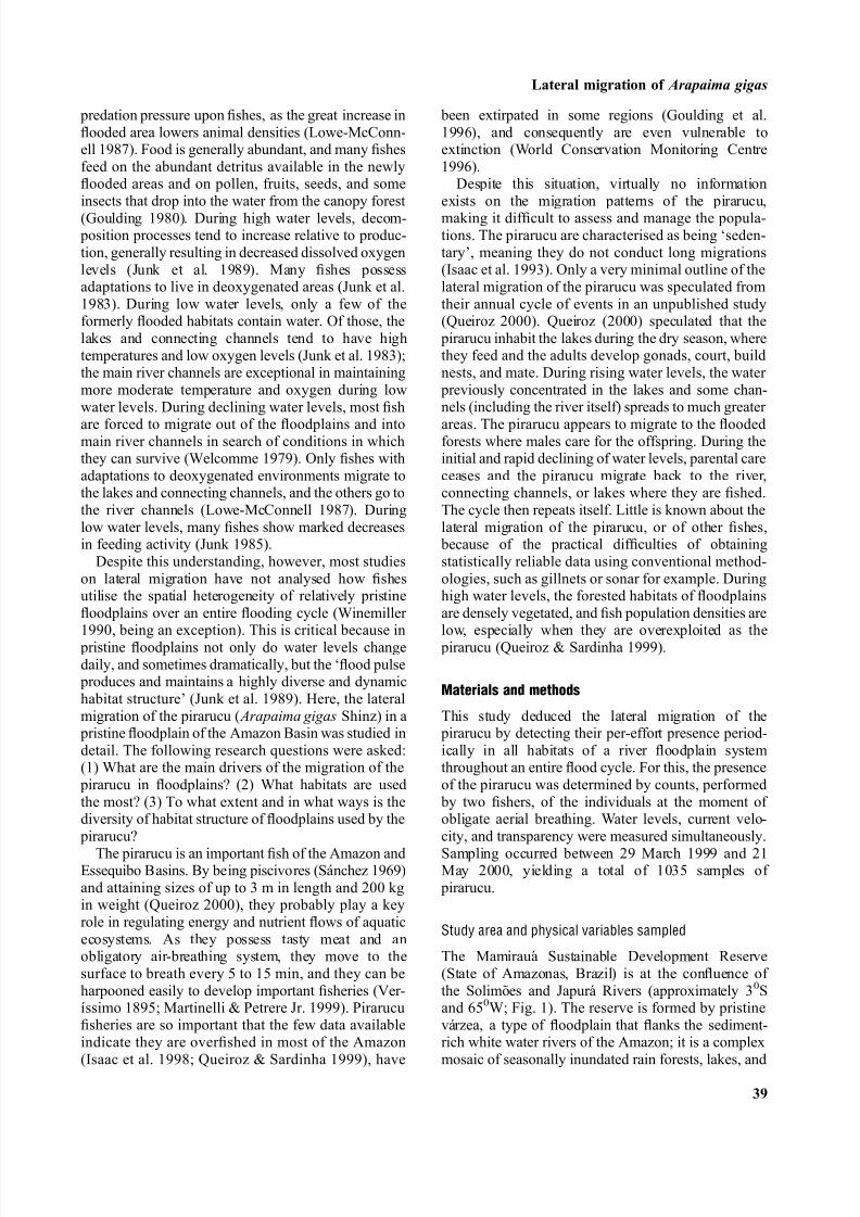
The Mamiraua Sustainable Development Reserve(State of Amazonas, Brazil) is at the confluence of the Solimoes and Japura Rivers (approximately 30Sand 650W; Fig. 1). The reserve is formed by pristinevarzea, a type of floodplain that flanks the sediment-rich white water rivers of the Amazon; it is a complex
mosaic of seasonally inundated rain forests, lakes, and
Lateral migration of Arapaima gigas
39
7/29/2019 Castello 2008 - Lateral Migration of Ag in Floodplains
http://slidepdf.com/reader/full/castello-2008-lateral-migration-of-ag-in-floodplains 3/9
winding channels (Irion et al. 1997). The study area isof the holocenic type (Ayres 1995), being completelyflooded annually. Seasonal water temperatures vary
between 27 and 31 °C (Sociedade Civil Mamiraua1996).
A total of eight habitats of the varzea were sampled(Table 1). This stratification of habitats comprises allmajor types and is consistent with the literature and
local knowledge. At each habitat, three transects 1 k Æmin length were established. The specific locations of the transects (Fig. 1) depended on their representa-tiveness of major habitat types, similarity to thecharacteristics described by the literature and localknowledge, and the possibility of sampling by canoe(in some places that would be impossible). Also, theyhad to be close enough to each other and to the fieldstation to allow weekly visits to every site.
The specific locations of the transects depended,also, on the existing variation within the rio andchavascal habitat types. In the rio habitat, all transectswere established near and parallel to the shore
because, according to the fishers, the pirarucu is never found in the middle of the rio where depth and water current velocity tend to be much greater. Two of therio transects were established in relatively fast-flowingareas, and one (indicated in Fig. 1) near a slow-flowing area where a sandy beach is exposed during
low water levels. As the water level declined, the beach emerged and the rio became narrower, so that the location of this transect moved towards the middleof the rio, but it always remained near and parallel tothe shore, roughly in the same position. As water levels rose, the location of this transect moved back towards its original position.
For each transect, we measured water current velocity and transparency. Current velocity wasmeasured using a floating piece of wood attached toa line of known length. The line was attached to thecanoe used for sampling work, which was attached to
objects fixed on land (e.g., trees, branches). The
Fig. 1. The study area and the locations of
the sampled transects. This satellite image
was taken a few months before the start of
this study, in 1999, during the dry season.
The study area represents a typical pristine
section of varzea floodplain. The large
(light-blue) channel is the Japura River
(rio) with its white waters. The smaller
(dark blue) channels and water bodies are
the parana, cano, ressaca, and lago habitats
(see Table 1 for habitat definitions and
Fig. 2 for schematic descriptions); most of
them containing ‘black waters’ at the time
the image was taken because of carbon-rich
humic substances. The land between these
channels and water bodies are the chavascal
(light green), and restinga baixa, and rest-
inga alta forest habitats (both are dark gre-
en). In many places, floating meadows
(pink) abound during both the flood anddry seasons. The image comprises an area of
about 450 km2 of varzea floodplain; in
Brazil, this ecosystem spans over an area
of 107,000 km2.
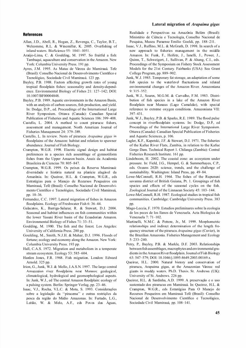
Table 1. Sampled habitats of the varzea floodplain and their descriptions.
Habi tat type Description
Entirely or mainly aquatic
Rio The main r iver channel. The r io is wide (up to 3 km),
deep (up to 50 m) and swift flowing (Junk, 1984);
the Japura River was sampled.
Parana Channels transporting river waters and crossing
sections of varzea. Both ends connect to the rio
(Junk, 1984; Crampton, 1998).
Lago Lakes of various sizes and shapes (Junk, 1984).
Lagos hold water throughout the flood cycle.
Ressaca A shallow type of lago with a large and open mouth.
Most ressacas dry up during the dry season (Local
classification).
Cano Channels connecting lagos to any other water body.
Canos may dry up during dry sason, making lagos
physically isolated (Crampton, 1998).
Mainly terrestrial
Chavascal Low swampy woodland. Usually, chavascal forests
are located behind levees (Ayres, 1995).
Restinga Baixa Silt-heightened riverbanks and bars on which grows
tall forest (Ayres, 1995).
Restinga Alta Like the restinga baixa, but riverbanks and bars are
higher and the forests are taller, older, and more
diverse (Ayres, 1995).
Castello
40

7/29/2019 Castello 2008 - Lateral Migration of Ag in Floodplains
http://slidepdf.com/reader/full/castello-2008-lateral-migration-of-ag-in-floodplains 4/9
wooden piece was put in the water, and the time takenfor the line to stretch was measured. Care was taken toavoid potential bias in the measurements that could becreated by the canoe. This methodology measuressurface flow accurately (W. G. R. Crampton, Univer-sity of Central Florida, Orlando, USA, personal
communication). Transparency was measured using asecchi disk. On the day in which the flood cyclereached its maximum during the study period, we took 10 measurements of the depth of all transects using asounding line. We measured water levels daily at thefield station (Fig. 1), and used the data to calculate themean depth of each transect we ran.
Sampling the pirarucu
To sample the pirarucu, two local fishers used amodified version of the counting method described by
Castello (2004). Castello (2004) demonstrated that experienced fishers can count the number of pirarucuaccurately, by comparing counts made by the fishers (of
pirarucu longer than 1 m) with independent estimatesof abundance (calculated using total catches and mark-recapture methods). The two fishers and the author
paddled silently along all transects every week in analuminium canoe 5 m in length looking for breathing
pirarucu. Two exceptions were made. The first was that during the dry season some habitats were dry; soobviously they were not sampled. The second regardsthe lago habitat. The cano habitat, which is the only
type of habitat that connects the lago to any other water body during low water levels (Table 1; Fig. 2a), isshallower than the lago. So, when the cano dries up, thelago becomes disconnected from all other water bodies,making it impossible for fish to migrate in or out of thelago. This made, also, our access to some of the lagotransects very difficult. Thus, during the period whenthe lago was physically isolated, the lago was sampledonly in the first week after it became isolated. In doingthis, it was assumed that the abundance of pirarucu inthe lago was constant throughout that period. This is areasonable assumption because two of the lago tran-
sects were in areas where fishing is prohibited and protected by paid guards, and the pirarucu is too large to be predated on. The third lago transect was in a lago of large size that received little fishing pressure. Samplingthe lago transects was resumed in the first week whenthe cano transects connecting to them were flooded.
Habitats(a) (b) Presence of pirarucu
In no sampleIn 1/3 of samplesIn 2/3 of samplesIn all samples
Restinga alta
Water level
-3.5
-5.5
-7.5
-9.5 D e p t h ( m )
-10.7
-11.7
-13.8
-16.1
Restinga baixa
Chavascal
Cano
Lago
Ressaca
Parana
Rio
Apr. Apr.Aug.
1999 2000
Sep. Oct. Nov. Dec. Jan. Feb. Mar.Jun. Jul.May May
Fig. 2. (a) Schematic description of the sampled habitats of the varzea floodplain. (b) Seasonal variation of the relative abundance of the
pirarucu in the sampled habitats and the pulsing water cycle. The vertical axis represents the average depth of all sampled habitats relative to
the maximum level reached by the water. Daily water levels measured at the field station are indicated by the solid curve. Note that the lago
habitat contained water at levels higher than the field station because it was isolated during dry season. Tick marks on lago habitat samples
indicate samples that were assumed to equal the sample taken in the first week after the lago became physically isolated; see text for details.
Lateral migration of Arapaima gigas
41

7/29/2019 Castello 2008 - Lateral Migration of Ag in Floodplains
http://slidepdf.com/reader/full/castello-2008-lateral-migration-of-ag-in-floodplains 5/9
The speed of the canoe was regulated at a nearlyconstant speed, 0.3 mÆs)1, using a geographical posi-tion system. No transect was run under conditions of rain or wind. In the study area, rains tend to be heavy
but short in time. Wind speeds tend to be near zero,usually less than 1 knot; stronger winds tend to
accompany the rains. At every transect ran, the fisherscounted the number of pirarucu they heard or observed. In this study, no size limits were appliedto the counts of pirarucu. However, pirarucu smaller than 1 m are difficult to hear and observe; so themajority of pirarucu counted were longer than that length.
To analyse the collected data, four issues wereconsidered. First, not all three replicate transects of agiven habitat could be run in some weeks because oneor two of the transects were dry; these transects wereexcluded from all analyses performed. Second, the
methodology developed here assumes that the twofishers were capable of (i) detecting the presence of theindividuals of pirarucu, and (ii), when more than oneindividual were in the area, of distinguishing amongdifferent surfacing individuals. In this regard, there isreason to believe that double- or no-counts of pirarucuare unlikely, although entirely possible. In 1999, bothfishers together possessed over 50 years of profes-sional and continual experience with the pirarucu. Theexperiments performed by Castello (2004) showedthat the counts of the pirarucu performed by these twofishers varied 10% around the true value (compareTable 1 with Table 3 in Castello 2004). Third, in thestudy of Castello (2004) the fishers counted the
pirarucu using the equivalent of quadrat-plots, whichallow the estimation of absolute population densities.In the present study, the fishers counted the pirarucuusing line-transects in which the length of the sampledarea is known (1 km) but the width is not; so absolute
population densities for the entire area sampled couldnot be estimated. Fourth, it was impossible to estimatethe width of the line-transect samples, i.e., the distancereached by the senses of the fishers (vision andhearing) while running the transects. This was so
because of the combined influences of: (i) differences
among habitats, such as vegetation cover and floatingmeadows; (ii) constantly changing differences withinhabitats, such as sunlight intensity and noise made bymoving tree branches and animals (e.g., fishes, frogs,
birds); and (iii) the impossibility of determining the precise locations of most surfacing pirarucu in forestedhabitats (because of the dense vegetation).
These considerations imply that the collected dataset would not allow determining whether one habitat was, say 50%, more densely inhabited by the
pirarucu than another. Nevertheless, the data set was appropriate for deducing migration patterns of
the pirarucu, if considered as an indicator of the
presence or absence, and if it was analysed withregard to temporal changes. For example, if at agiven point in time the pirarucu were found only inthe lago habitat and nowhere else, and if at a later
point in time, the pirarucu were no longer found inthe lago but only in the rio, then it would be
reasonable to infer that migration occurred. Animplicit assumption is that the effect of migrationin and out of the entire study area was negligible interms of migration between and among habitats. It isthrough the use of this qualitative analysis of the dataset that this study deduced the lateral migration of the
pirarucu. Thus, the counts of pirarucu performed at each of the three transects established at each habitat type were used to determine an average index of the
presence of the pirarucu for each sampled week.
Results
The main results of this study are: (i) the pirarucu werefound in all of the surveyed habitats at distinct parts of the annual cycle; (ii) preferred habitats are the lago(i.e., lakes) and chavascal, restinga baixa, and restingaalta (i.e., forest habitats); (iii) the main physical driversof the lateral migration of the pirarucu appear to below depth and low current velocity.
Lateral migration of the pirarucu
The lateral migration of the pirarucu accompaniedwater level fluctuations closely (Fig. 2a,b). As water levels rose, the pirarucu migrated to increasinglyhigher habitats in flooded forests, and as water levelsdeclined, the pirarucu migrated first back to lower habitats of flooded forests, then to communicatingchannels, and eventually to the lakes. Between Apriland June 1999, virtually all pirarucu were found inthe seasonally flooded forests, the habitats of chav-ascal, restinga baixa, and restinga alta (Fig. 2a,b).Pirarucu over 1.5 m in length were observed swim-ming in very shallow water (0.5 m). Eighteen
pirarucu were observed caring for the young in theflooded forests, guiding the off-spring that followed
them near their head. Mouth-brooding was not observed. Between July and August 1999, the
pirarucu were found in the cano, ressaca, parana,and lago (Fig. 2a,b). Between August 1999 andFebruary 2000, when the lago remained physicallyisolated, most pirarucu were in the lago (Fig. 2a,b).In mid-September, however, some pirarucu wereobserved in that transect of the rio located near a
beach where current velocity tend to be slow (Figs 1and 2a,b). In mid-December, during a small flood
pulse, some pirarucu were found in the cano andressaca (Fig. 2a,b). After February 2000, when the
lago was no longer physically isolated, the pirarucu
Castello
42

7/29/2019 Castello 2008 - Lateral Migration of Ag in Floodplains
http://slidepdf.com/reader/full/castello-2008-lateral-migration-of-ag-in-floodplains 6/9
were found first in the chavascal and then in restinga baixa forests.
Relation to physical variables
The relative abundance of the pirarucu in the habitats
(measured in terms of the proportion of the transect samples in which the pirarucu were found, i.e., 0, 1 ⁄ 3,2 ⁄ 3, and 1) was not related to any of the physicalvariables measured (Kruskal-Wallis, n0 = 229,n1 ⁄ 3 = 64, n2 ⁄ 3 = 28, and n1 = 13, P > 0.1). But the
presence or absence of the pirarucu in any givenhabitat was related to current velocity and depth(Table 2). The pirarucu selected generally shallow,slow flowing habitats (Table 2). Water transparency inthe samples in which the pirarucu were present duringthe reproductive period of the species (around 67 cm,from December to May; Queiroz 2000) was signifi-
cantly lower than during the rest of the year (around115 cm; Mann-Whitney U -test, nreproductive = 109,nnonreproductive = 212, P < 0.0001).
Discussion
The lateral migration of the pirarucu appears to be avery cost-effective strategy for optimising the spatialand temporal heterogeneity of resources of the varzea.The migrations to and through the habitats of chav-ascal, restinga baixa, and restinga alta appear to havefunctions related to feeding and reproduction (nest
building, mating, and parental care). The migrations toand through the habitats of parana, cano, lago, ressaca,and rio appear to have functions related to survival(i.e., avoidance of unfavourable conditions), feeding,and reproduction (courting and pairing; Fig. 2a,b).The habitats of the varzea are arranged in such a wayspatially that in most instances the distances amongthem are very small, rarely over 1 km (the rio being anexception, Fig. 1). So, the pirarucu appear to benefit from, and fulfil the ecosystem roles of, migration withonly modest investments compared with that of thelongitudinal migrations of other fishes. These results
serve as a conceptual model for understanding thelateral migration of other floodplain fishes.
Lateral migration of pirarucu
During rising and high water levels (April–June 1999),
the pirarucu were found in the flooded forest habitatsof chavascal, restinga baixa, and restinga alta(Fig. 2a,b). The pirarucu migrated into these habitatsright after they were flooded. This was enabled by theair-breathing system of the pirarucu, which allowsthem to inhabit hypoxic environments of floodedforest, and by their elongated body, which allows themto swim in very shallow water (0.5 m).
There are two advantages for the pirarucu to inhabit the flooded forests and, in particular, to migrate intothem immediately after they are flooded: feeding and
parental care. The pirarucu aged about 1 year and
older feed primarily on fish (Sanchez 1969; Queiroz2000). Four fish families comprise about half of allingested food in weight; these are species of thefamilies Callichthyidae, Loricariidae, Pimelodidae,and Heptapteridae, in order of decreasing importance(Queiroz 2000). Most such fishes are detritivorous or omnivorous, and several species of Callichthyidae andLoricariidae are adapted to hypoxic conditions, tend to
be nonmigratory, and inhabit these floodplainsthroughout their life cycles (Crampton 1999). Withexception of the Callichthyidae, the three other preygroups are reported to inhabit the flooded forestsduring high water levels (Crampton 1999). Thus, theyare likely to constitute constant food sources for the
pirarucu. This is especially so early in the flood whenthese prey species find generally higher oxygen levels(Winemiller & Jepsen 1998).
All 18 observations of parental care occurred in theflooded forests, and half of them near floating mead-ows. The flooded forests offer many species of insects,fish larvae, and other small organisms (Junk et al.1989) for the offsprings of the pirarucu to eat. Indeed,the young pirarucu has a very diverse diet (Queiroz2000). In addition, floating meadows constitute ‘animportant nursery habitat for a great number, perhaps
the great majority, of fishes’ in the varzea (Winemiller & Jepsen 1998). Food-rich conditions like these helpexplain the fast growth of the young pirarucu, whichmay grow to 0.5 m in total length by the end of theflood, i.e., 3 months (personal observations).
During low water levels (August 1999–February2000), most of the pirarucu were observed in the lagoin population densities that were obviously muchgreater than during the rest of the year when they weredispersed in much greater forested areas (Fig. 2a,b).This is consistent with all previous reports (Verıssimo1895; Queiroz & Sardinha 1999; Martinelli & Petrere
Jr. 1999). During this time, inhabiting the lago may
Table 2. Medians and first and third quartiles (in parentheses) of the three
physical variables measured, for all samples, and for samples in which the
pirarucu were present and absent.
Variable
All Pirarucu
(n=1002) Present (n=321) Absent (n=681)
Depth (m) 5.8 (2.13–10.75) 3.08 (1.40–5.20)* 7.92 (4.86–11.11)*
Current velocity
(mÆs-1)
0.14 (0.05–0.41) 0.12 (0.04–0.18)* 0.15 (0.06–0.41)*
Transparency
(cm)
103 (47–138) 120 (56–143)** 93 (39–146)**
* P < 0.0001
** Non-significant
Lateral migration of Arapaima gigas
43

7/29/2019 Castello 2008 - Lateral Migration of Ag in Floodplains
http://slidepdf.com/reader/full/castello-2008-lateral-migration-of-ag-in-floodplains 7/9
provide the pirarucu with three advantages. The first isincreasing survival rates. Low water levels are asso-ciated with higher fish mortality (Welcomme 1979).Because the lago may, and usually does, become
physically isolated, inhabiting them provides safetyagainst extreme drought, e.g., El Nino years. The
second is maintaining adequate feeding rates. Duringlow water levels, oxygen levels in the lago tend to below (Junk et al. 1983). While most fish species in thelago are stressed, some even die, the pirarucu do fineand predate actively. The pirarucu show very smallseasonal variations in fat content (Junk 1985). Thethird is promoting reproduction. By inhabiting ahabitat in high population densities, the chances of engaging in courtship and mating activities areincreased. Indeed, the end of the low water period(December–March) coincides with the reproductive
period of the pirarucu (November–December; Queiroz
2000). Thus, courting activities must have occurred inthe lago. Also, a study in this same area showed that
preferred nesting habitats are the flooded banks of ressaca, lago, and parana (Castello, in review). Thusnest building must have occurred at the time of thethird and fourth flood pulses, December and February,respectively. At that time, the water levels flooded thecano and the banks surrounding the lago, ressaca, and
parana (Fig. 2a,b), allowing the pirarucu to migrateout of the lago and into the ressaca and parana.
Relation of migration to physical variables
Shallow depth (3 m) and low current velocity(0.12 mÆs)1) are the best predictors of the presenceof the pirarucu in any given habitat (Table 2). Therelation between the migration of the pirarucu anddepth is clear. Water levels varied over 13 m in thevarzea (Fig. 2a,b); but, lateral migration maintaineddepth at locations where the pirarucu were between1.4 and 5.2 m (Table 2). The relation between themigration of the pirarucu and current velocity is lessclear, however. The difference between current velo-city of the samples in which the pirarucu were present and those in which they were absent is small (0.12 and
0.15 mÆs)
1, respectively; Table 2).The pirarucu tend to prefer the more elevated
habitats (Fig. 2a,b), namely the flooded forests and thelago. There may be two reasons for their preference for shallow habitats. First, full exploration of the columnof water (e.g. to inspect for prey and predators)depends on the capacity of the pirarucu to swim
between the bottom and the surface to breath. Thus,deeper habitats may involve greater energy costs.Second, fish abundance is directly correlated withshallow depth in many ecosystems. In floodplains, thisis evidenced by the migration of fish to flooded forests
during high water levels, and to lakes and river
channels during low water levels (Lowe-McConnell1987). In creeks, total ecosystem metabolism per unit of volume increases with decrease in depth, perhapsdue to concentration of food resources and the smaller energy the fish expend searching for food (Hall 1972).In the oceans, the association of fishes with shallow
depths and their high biological productivity there has been well-documented (e.g., Lindeboom 2002).
But no relation was found between water transpar-ency and the lateral migration of a visual predator likethe pirarucu (Table 2). The only relation found wasseasonal: the lowest transparencies occurred during thereproductive period of the species, from December toMay. Low transparency may, thus, reduce predation
pressure on the offspring by birds or other fishes, for example, and increase reproductive success.
Understanding lateral migration of other fishes
This study lends support to a conceptual model of lateral migration of floodplain fishes (Fig. 2a,b).Obviously, the validity of this model varies dependingon the species in question as well as habitat structureand flooding cycles of the region. However, this modelillustrates clearly the type of intricate interplay that exists in pristine floodplains between fish migrations,dynamic water levels, and heterogeneous habitat structure. For example, the omnivorous tambaqui(Colossoma macropomum Cuvier) migrate laterallyin the varzea (Araujo-Lima & Goulding 1997),following among other things the ripening order of their preferred fruits and seeds. Local fishers know thisorder and benefit from it. This model implies that detailed understanding of lateral migration can only beobtained through careful consideration of the spatialand temporal heterogeneity of floodplains.
Note
The author has just found out the studied fish is anun-described species.
Acknowledgements
This study benefited greatly from the expertise and dedication
of the fishermen Raimundo Cordeiro ‘Cabecinha’ and Jorge
Carvalho ‘Tapioca’, who live in the study area. Thanks go to M.
Petrere, J. P. Castello, and T. Polachek who helped develop the
sampling scheme, R. Busoli, X. Castello, and H. Bongghi who
helped produce Fig. 2, the advisors D. J. Stewart and C. A. S.
Hall who improved the manuscript greatly, and M. Pinedo-
Vasquez, S. Stehman and V. Luzadis who reviewed the
manuscript. This study was funded by the Sociedade Civil
Mamiraua and the Conselho Nacional de Pesquisa (Brazil), the
Department for International Development (England), and the
Wildlife Conservation Society and the Overbrook Foundation
(United States).
Castello
44
7/29/2019 Castello 2008 - Lateral Migration of Ag in Floodplains
http://slidepdf.com/reader/full/castello-2008-lateral-migration-of-ag-in-floodplains 8/9
References
Allan, J.D., Abell, R., Hogan, Z., Revenga, C., Taylor, B.T.,
Welcomme, R.L. & Winemiller, K. 2005. Overfishing of
inland waters. BioScience 55: 1041–1051.
Araujo-Lima, C. & Goulding, M. 1997. So fruitful a fish:
Tambaqui, aquaculture and conservation in the Amazon. NewYork: Columbia University Press. 191 pp.
Ayres, J.M. 1995. As Matas de Varzea do Mamiraua. Tefe
(Brasil): Conselho Nacional de Desenvolvimento Cientıfico e
Tecnologico, Sociedade Civil Mamiraua. 123 pp.
Bayley, P.B. 1988. Factors affecting growth rates of young
tropical floodplain fishes: seasonality and density-depend-
ence. Environmental Biology of Fishes 21: 127–142; DOI:
10.1007/BF00004848.
Bayley, P.B. 1989. Aquatic environments in the Amazon Basin,
with an analysis of carbon sources, fish production, and yield.
In: Dodge, D.P., ed. Proceedings of the International Large
River Symposium. Ottawa (Canada): Canadian Special
Publication of Fisheries and Aquatic Sciences 106: 399–408.
Castello, L. 2004. A method to count pirarucu: fishers,assessment and management. North American Journal of
Fisheries Management 24: 379–389.
Castello, L. In review. Nests of pirarucu Arapaima gigas in
floodplains of the Amazon: habitat and relation to spawner
abundance. Journal of Fish Biology.
Crampton, W.G.R. 1998. Electric signal design and habitat
preferences in a species rich assemblage of gymnotiform
fishes from the Upper Amazon basin. Anais da Academia
Brasileira de Ciencias 70: 805–847.
Crampton, W.G.R. 1999. Os peixes da Reserva Mamiraua:
diversidade e historia natural na planıcie alagavel da
Amazonia. In: Queiroz, H.L. & Crampton, W.G.R., eds
Estrategias para o Manejo de Recursos Pesqueiros emMamiraua, Tefe (Brasil): Conselho Nacional de Desenvolvi-
mento Cientıfico e Tecnologico, Sociedade Civil Mamiraua,
pp. 10–36.
Fernandez, C.C. 1997. Lateral migration of fishes in Amazon
floodplains. Ecology of Freshwater Fish 6: 36–44.
Galacatos, K., Barriga-Salazar, R. & Stewart, D.J. 2004.
Seasonal and habitat influences on fish communities within
the lower Yasuni River basin of the Ecuadorian Amazon.
Environmental Biology of Fishes 71: 33–51.
Goulding, M. 1980. The fish and the forest. Los Angeles:
University of California Press. 280 pp.
Goulding, M., Smith, N.J.H. & Mahar, D.J. 1996. Floods of
fortune; ecology and economy along the Amazon. New York:
Columbia University Press. 193 pp.Hall, C.A.S. 1972. Migration and metabolism in a temperate
stream ecosystem. Ecology 53: 585–604.
Harden Jones, F.R. 1968. Fish migration. London: Edward
Arnold. 325 pp.
Irion, G., Junk, W.J. & Mello, J.A.S.N. 1997. The large central
Amazonian river floodplains near Manaus: geological,
climatological, hydrological and geomorphological aspects.
In: Junk, W.J., ed The central Amazon floodplain: ecology of
a pulsing system. Berlin: Springer Verlag, pp. 23–46.
Isaac, V.J., Rocha, V.L.C. & Mota, S. 1993. Consideracoes
sobre a legislacao da ‘‘piracema’’ e outras restricoes da
pesca da regiao do Medio Amazonas. In: Furtado, L.G.,
Leitao, W. & Melo, A.F., eds Povos das Aguas,
Realidade e Perspectivas na Amazonia Belem (Brasil):
Ministerio de Ciencia e Tecnologia, Conselho Nacional de
Pesquisa, Museu Paraense Emilio Goeldi, pp. 188–211.
Isaac, V.J., Ruffino, M.L. & McGrath, D. 1998. In search of a
new approach to fisheries management in the middle
Amazon. In: Funk, F., Heifetz, J., Ianelli, J., Power, J.,
Quinn, T., Schweigert, J., Sullivan, P. & Ahang, C.I., eds.Proceedings of the Symposium on Fishery Stock Assessment
Models for the 21st Century. Fairbanks (USA): Sea Grant
College Program, pp. 889–902.
Junk, W.J. 1985. Temporary fat storage, an adaptation of some
fish species to the waterlevel fluctuations and related
environmental changes of the Amazon River. Amazoniana
9: 315–352.
Junk, W.J., Soares, M.G.M. & Carvalho, F.M. 1983. Distri-
bution of fish species in a lake of the Amazon River
floodplain near Manaus (Lago Camaleao), with special
reference to extreme oxygen conditions. Amazoniana VII:
397–431.
Junk, W.J., Bayley, P.B. & Sparks, R.E. 1989. The flood pulse
concept in riverfloodplain systems. In: Dodge, D.P., edProceedings of the International Large River Symposium.
Ottawa (Canada): Canadian Special Publication of Fisheries
and Aquatic Sciences, p. 106.
Lagler, K.F., Kapetski, J.F. & Stewart, D.J. 1971. The fisheries
of the Kafue River Flats, Zambia, in relation to the Kafue
Gorge Dam. Technical Report 1. Chilanga (Zambia): Central
Fisheries Research Institute. 161 pp.
Lindeboom, H. 2002. The coastal zone: an ecosystem under
pressure. In: Field, J.G., Hempel, G. & Summerhayes, C.P.,
eds. Oceans 2020: science, trends, and the challenge of
sustainability. Washington: Island Press, pp. 49–84.
Lowe-McConnell, R.H. 1964. The fishes of the Rupununi
savanna district of British Guiana, Pt. 1. Groupings of fishspecies and effects of the seasonal cycles on the fish.
Zoological Journal of the Linnaean Society 45: 103–144.
Lowe-McConnell, R.H. 1987. Ecological studies in tropical fish
communities. Cambridge: Cambridge University Press. 383
pp.
Mago-Leccia, F. 1970. Estudios preliminares sobre la ecologia
de los peces de los llanos de Venezuela. Acta Biologica de
Venezuela 7: 71–102.
Martinelli, N.M.C. & Petrere, Jr., M. 1999. Morphometric
relationships and indirect determination of the length fre-
quency structure of the pirarucu Arapaima gigas (Cuvier), in
the Brazilian Amazonia. Fisheries Management and Ecology
5: 233–240.
Petry, P., Bayley, P.B. & Markle, D.F. 2003. Relationships between fish assemblages, macrophytes and environmental gra-
dients in the Amazon River floodplain. Journal of Fish Biology
63: 547–579; DOI: 10.1046/j.1095-8649.2003.00169.x.
Queiroz, H.L. 2000. Natural history and conservation of
pirarucu, Arapaima gigas, at the Amazonian Varzea: red
giants in muddy waters. Ph.D. Thesis. St. Andrews (UK):
University of St. Andrews. 226 pp.
Queiroz, H.L. & Sardinha, A.D. 1999. A preservacao e o uso
sustentado dos pirarucus em Mamiraua. In: Queiroz, H.L. &
Crampton, W.G.R., eds Estrategias Para O Manejo de
Recursos Pesqueiros em Mamiraua Tefe (Brasil): Conselho
Nacional de Desenvolvimento Cientıfico e Tecnologico,
Sociedade Civil Mamiraua, pp. 108–141.
Lateral migration of Arapaima gigas
45

7/29/2019 Castello 2008 - Lateral Migration of Ag in Floodplains
http://slidepdf.com/reader/full/castello-2008-lateral-migration-of-ag-in-floodplains 9/9
Rodriguez, A.M. & Lewis, Jr., W.M. 1997. Structure of fish
assemblages along environmental gradients in floodplain lakes
of the Orinoco River. Ecological Monographs 67: 109–128.
Saint-Paul, U., Zuanon, J., Correa, M.A.V., Garcia, M., Fabre,
N.N., Berger, U. & Junk, W.J. 2000. Fish communities in
central Amazonian white- and blackwater floodplains. Envi-
ronmental Biology of Fishes 57: 235–250.Sanchez, J.R. 1969. ‘‘El paiche’’ aspectos de su hitstoria natural
y aprovechamiento. Revista de Caza y Pesca (Lima, Peru) 10:
17–61.
Silvano, R.A.M., Amaral, B.D. & Oyakawa, O.T. 2000. Spatial
and temporal patterns of diversity and distribution of the
Upper Jurua River fish community (Brazilian Amazon).
Environmental Biology of Fishes 57: 25–35.
Sociedade Civil Mamiraua. 1996. Mamiraua Management Plan.
Tefe (Brasil): Conselho Nacional de Desenvolvimento Cient-
ıfico e Tecnologico, Sociedade Civil Mamiraua. 96 pp.
Tockner, K. & Stanford, J.A. 2002. Riverine flood plains:
present state and future trends. Environmental Conservation
29: 308–330.
Verıssimo, J. 1895. A Pesca no Amazonia. Rio de Janeiro
(Brasil): Livraria Classica Alves and Companhia. 130 pp.
Welcomme, R.L. 1979. Fisheries Ecology of Floodplain Rivers.
Second edition. London: Longman Press. 317 pp.Winemiller, K.O. 1990. Spatial and temporal variation in
tropical fish trophic networks. Ecological Monographs 60:
331–367.
Winemiller, K.O. & Jepsen, D.B. 1998. Effects of seasonality
and fish movement on tropical river food webs. Journal of
Fish Biology 53(Suppl A): 267–296; DOI: 10.1111/j.1095-
8649.1998.tb01032.x.
World Conservation Monitoring Centre. 1996. Arapaima gigas.
In 2004 IUCN Red List of Threatened Species. http://
www.iucnredlist.org. Downloaded on 20 March 2006.
Castello
46