Caracoles UIS ANTAMARÍA NDY REEN ** ICARDO ÍAZ ELGADO ... · drainage system of permeable pipes...
5
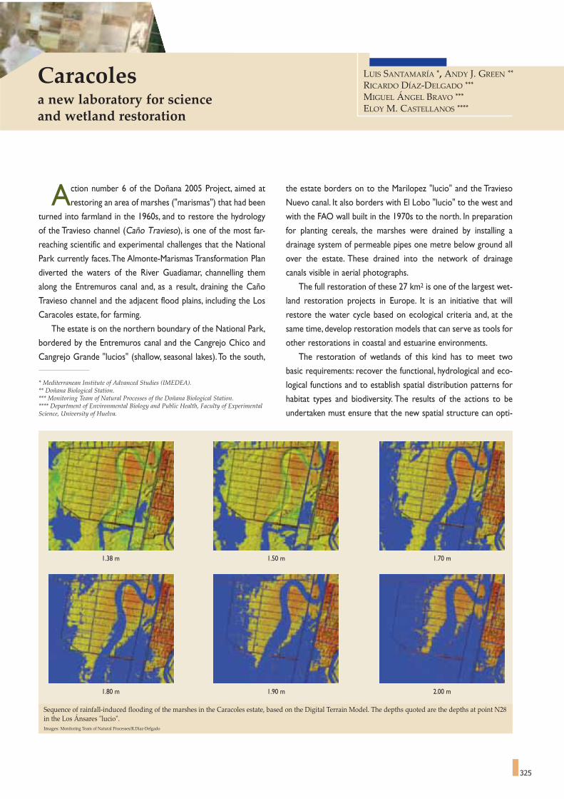
325 A ction number 6 of the Doñana 2005 Project, aimed at restoring an area of marshes ("marismas") that had been turned into farmland in the 1960s, and to restore the hydrology of the Travieso channel (Caño Travieso), is one of the most far- reaching scientific and experimental challenges that the National Park currently faces.The Almonte-Marismas Transformation Plan diverted the waters of the River Guadiamar, channelling them along the Entremuros canal and, as a result, draining the Caño Travieso channel and the adjacent flood plains, including the Los Caracoles estate, for farming. The estate is on the northern boundary of the National Park, bordered by the Entremuros canal and the Cangrejo Chico and Cangrejo Grande "lucios" (shallow, seasonal lakes).To the south, the estate borders on to the Marilopez "lucio" and the Travieso Nuevo canal. It also borders with El Lobo "lucio" to the west and with the FAO wall built in the 1970s to the north. In preparation for planting cereals, the marshes were drained by installing a drainage system of permeable pipes one metre below ground all over the estate. These drained into the network of drainage canals visible in aerial photographs. The full restoration of these 27 km 2 is one of the largest wet- land restoration projects in Europe. It is an initiative that will restore the water cycle based on ecological criteria and, at the same time, develop restoration models that can serve as tools for other restorations in coastal and estuarine environments. The restoration of wetlands of this kind has to meet two basic requirements: recover the functional, hydrological and eco- logical functions and to establish spatial distribution patterns for habitat types and biodiversity. The results of the actions to be undertaken must ensure that the new spatial structure can opti- 1.38 m 1.50 m 1.70 m 1.80 m 1.90 m 2.00 m Sequence of rainfall-induced flooding of the marshes in the Caracoles estate, based on the Digital Terrain Model. The depths quoted are the depths at point N28 in the Los Ánsares "lucio". Images: Monitoring Team of Natural Processes/R.Díaz-Delgado Caracoles a new laboratory for science and wetland restoration * Mediterranean Institute of Advanced Studies (IMEDEA). ** Doñana Biological Station. *** Monitoring Team of Natural Processes of the Doñana Biological Station. **** Department of Environmental Biology and Public Health, Faculty of Experimental Science, University of Huelva. LUIS SANTAMARÍA * , ANDY J. GREEN ** RICARDO DÍAZ-DELGADO *** MIGUEL ÁNGEL BRAVO *** ELOY M. CASTELLANOS ****
Transcript of Caracoles UIS ANTAMARÍA NDY REEN ** ICARDO ÍAZ ELGADO ... · drainage system of permeable pipes...
325
Action number 6 of the Doñana 2005 Project, aimed at
restoring an area of marshes ("marismas") that had been
turned into farmland in the 1960s, and to restore the hydrology
of the Travieso channel (Caño Travieso), is one of the most far-
reaching scientific and experimental challenges that the National
Park currently faces.The Almonte-Marismas Transformation Plan
diverted the waters of the River Guadiamar, channelling them
along the Entremuros canal and, as a result, draining the Caño
Travieso channel and the adjacent flood plains, including the Los
Caracoles estate, for farming.
The estate is on the northern boundary of the National Park,
bordered by the Entremuros canal and the Cangrejo Chico and
Cangrejo Grande "lucios" (shallow, seasonal lakes).To the south,
the estate borders on to the Marilopez "lucio" and the Travieso
Nuevo canal. It also borders with El Lobo "lucio" to the west and
with the FAO wall built in the 1970s to the north. In preparation
for planting cereals, the marshes were drained by installing a
drainage system of permeable pipes one metre below ground all
over the estate. These drained into the network of drainage
canals visible in aerial photographs.
The full restoration of these 27 km2 is one of the largest wet-
land restoration projects in Europe. It is an initiative that will
restore the water cycle based on ecological criteria and, at the
same time, develop restoration models that can serve as tools for
other restorations in coastal and estuarine environments.
The restoration of wetlands of this kind has to meet two
basic requirements: recover the functional, hydrological and eco-
logical functions and to establish spatial distribution patterns for
habitat types and biodiversity. The results of the actions to be
undertaken must ensure that the new spatial structure can opti-
1.38 m 1.50 m 1.70 m
1.80 m 1.90 m 2.00 m
Sequence of rainfall-induced flooding of the marshes in the Caracoles estate, based on the Digital Terrain Model. The depths quoted are the depths at point N28in the Los Ánsares "lucio".Images: Monitoring Team of Natural Processes/R.Díaz-Delgado
Caracolesa new laboratory for science and wetland restoration
* Mediterranean Institute of Advanced Studies (IMEDEA).** Doñana Biological Station.*** Monitoring Team of Natural Processes of the Doñana Biological Station.**** Department of Environmental Biology and Public Health, Faculty of ExperimentalScience, University of Huelva.
LUIS SANTAMARÍA *, ANDY J. GREEN **
RICARDO DÍAZ-DELGADO ***
MIGUEL ÁNGEL BRAVO ***
ELOY M. CASTELLANOS ****

326
to prevent a repetition of the mistakes made in the past, the
underlying philosophy behind this restoration should be that the
restoration per se is a challenge full of uncertainties.These uncer-
tainties encompass how the water behaves in the marshes, the
dynamics of the sediments and the new role that the different
species will play in this restored area.
To strike this balance, both the design of the restoration and
the posterior management of the restored area have to take into
account the basic functional features that characterise marsh
ecosystems. The aquatic ecosystems of the Doñana Marshes
oscillate in an instable fashion between two alternative states of
equilibrium: "turbid waters" (caused by sediment in suspension
and the development of phytoplankton) and "clear waters", when
there is sufficient submerged vegetation to prevent the suspen-
sion of sediments in the waters9.The water cycles modulate the
relative dominance of each of these states in the different marsh
wetlands, as both excessive depth and early desiccation will
encourage the persistence of turbid water states. The spatial
mosaic of wetlands, with varying depths and sizes, guarantees the
large scale resilience of the system from this locally unpredictable
factor by allowing some of the wetlands to remain in a clear
water state at all times. Herbivorous waterfowl are another key
element in the dynamics of these aquatic ecosystems because, by
eating the water plants at the beginning of the spring cycle, they
can destabilise the clear water state10; whereas, by dispersing plant
propagules and aquatic invertebrates, they foster the re-colonisa-
tion of the wetlands when these are in a turbid water state11,12. For
all these reasons, any attempt to identify an "optimal" flood cycle
for these marshes in general is a mistake.
Current knowledge suggests that maintaining a highly diversi-
fied spatial structure and guaranteeing exchange and connection
between the wetlands that make up the marshes is the best way
to optimise the resilience, diversity and ecological function of the
Historic transformation of Caracoles in a series of photographs taken in October 1956 (first American flight), May 1972 (panchromatic images from the CORO-NA satellite) and July 1999. This short history shows the process of clearing the original marshes for farming and the channelling of the Guadiamar River, withthe consequent elimination of the Travieso channel. In the 1972 image, the start of construction work on the perimeter wall around the estate and theEntremuros Canal can be seen. Fifty years later, the waters are starting to return to their original channel.Images kindly supplied by Laboratorio de SIG y Teledetección-EBD/R. Díaz-Delgado.
Photogrammetric reconstruction of vegetation and topography in 1956 byESPN/M.A. Bravo, based on the first American flight.Source: Teledetection as a tool for restoration (Ricardo Díaz-Delgado, 2004).
Vetas (small sandy elevations) Bulrush formationsPaciles (pastures) with saltworts Lucios (shallow ponds)Areas between quebradas and pacil Travieso channel outlineQuebradas (depressions) Channels
0.90 - 0.95 a.s.l.
0.95 - 1.00 a.s.l.
1.00 - 1.05 a.s.l.
1.05 - 1.10 a.s.l.
1.10 - 1.15 a.s.l.
1.15 - 1.20 a.s.l.
1.20 - 1.25 a.s.l.
1.25 - 1.30 a.s.l.
1.30 - 1.35 a.s.l.
1.35 - 1.40 a.s.l.
1.40 - 1.45 a.s.l.
1.45 - 1.50 a.s.l.
1.50 - 1.55 a.s.l.
1.55 - 1.60 a.s.l.
1.60 - 1.65 a.s.l.
1956 1972 1999
mise the ecological function and the biodiversity of the aquatic
ecosystems, while at the same time minimising the need to fur-
ther manipulate the hydrological function in the future. Moreover,
Localisation of the new pools with different shapes and sizes. The imagehas been superimposed on the Digital Terrain Model of the marshes.The topographic variation along the transversal profile is of about 20 cm.Source: Carlos Urdiales. Doñana National Park.

327
aquatic ecosystems of the Doñana marshes.
Bearing in mind this available knowledge, the restoration faces
uncertainties like deciding the best combination of sizes and
depths of the restored wetlands, and the most appropriate spatial
structure to foster the dispersal of propagules by different vec-
tors (birds, water or wind). The range of uncertainties also
includes dimensions that we do not know enough about and that
we cannot control sufficiently, such as the possible effect of fish
entering from the estuary, exotic species, herbivores (waterfowl,
livestock, horses, deer, hares) and flamingos on the stability of
clear water states. Work on a restoration design of this kind
includes aspects that are in their first steps of development, such
as determining ideal wetland profiles (size, depth, bank morphol-
ogy) that will attract waterfowl in order to accentuate their dis-
persal function.
For all these reasons, the research team and scientific institu-
tions responsible for the design of this project recognised the
need to adopt an "adaptive management approach", avoiding iden-
tifying an optimum design a priori and then monitoring the result.
Instead, they opted for a robust and flexible design that seeks to
clarify present uncertainties experimentally and progressively
optimise the restoration work. In practise, this approach trans-
lates into the need for a broad diversity of sizes and shapes of
wetlands, distributed over the spatial gradient of the area being
restored. During the restoration, apart from monitoring the
ecosystem of the restored area, experiments will also be carried
out (for example, manipulating the colonisation rates or exclud-
ing herbivores).These criteria are also applicable to the emerging
vegetation and to the marshes, for instance by creating structures
that make it easier for species to disperse and to settle, or by
manipulating the residual drainage structures.
The hydrological analysis necessary for designing the restora-
tion has been hard work, in which the images provided by remote
satellite sensing over the last fifty years have played an essential
part. To evaluate the flooding regime, a time series of Landsat
satellite images was used (1973-2003) provided by the Doñana
Biological Station Remote Sensing Laboratory, aerial photos from
a 1956 American flight, images from a range of panchromatic cam-
eras installed aboard the CORONA satellite (used by U.S.A. in
the early seventies as a spy satellite, whose picture have recently
been declassified) and all the different images and orthopho-
tographs taken over the last ten years13. This material, together
with a Digital Terrain Model constructed for Doñana with a hor-
izontal spatial resolution of 2 m and a Numeric Hydrodynamic
Model for the Marshes, has made it possible to develop a broad
range of scenarios, providing a solid foundation for designing the
restoration and experimental work.
What was initially an unjustifiable encroachment on the
Marshes has become a vitally important laboratory for the future
of Doñana and similar areas. It should not be forgotten that one
of the objectives of the Caracoles project was to ensure that
whatever actions were taken should provide systematic informa-
tion on the ecology of both the natural and restored wetlands in
the Doñana Marshes, i.e., to learn as much as possible as as to
benefit many future restoration and management actions.
Before connecting the Caracoles area with the rest of the National Park,pools that will provide the foundation for much of its future diversity andwill act as a laboratory to enhance our knowledge of the marshes havebeen built. At the same time, work began on the task of eliminating theeffect of the drainage systems that were installed to prepare the land forfarming..Source: ESPN/Hector Garrido
Flooding as shown by a radar image from the RADARSAT satellite(December 1996). The blue shows the levels of flooding in the Caracolesfarm in this exceptionally wet year, where the original bed of the Traviesochannel is clearly visible. The average maximum flood levels are in greenand the minimum levels in red.Source: LAST/R.Díaz-Delgado and Aurensa.

337
1. BAYÁN, B., CASAS, J., RUÍZ DE LARRAMENDI, A., SAURA,J.,URDIALES, A., 2001. Documento Marco de Desarrollo del ProyectoDoñana 2005. Regeneración Hidrológica de las cuencas y cauces ver-tientes al Parque Nacional de Doñana. Ministerio de Medio Ambiente.
2. BAYÁN, B., 2001. La Diálisis de los Arroyos. Revista Doñana 2005.Noviembre nº 1. Ministerio de Medio Ambiente.
3. BAYÁN, B., 2002. El agua de El Rocío: Claves de la actuación nº2:Depuración de las aguas residuales de El Rocío. Revista Doñana 2005.Abril nº 2. Ministerio de Medio Ambiente.
4. BAYÁN JARDIN, B., CASAS GRANDE, J., RUIZ DE LARRAMENDI,A., SAURA MARTÍNEZ, J., URDIALES ALONSO, C., 2001. ProyectoDoñana 2005: Restauración hidrológica de las marismas y cuencas ver-tientes a Doñana. Ed. Ministerio de Medio Ambiente.
5. BAYÁN, B., 2002. La Marisma al Natural: Claves de la actuación nº 4:Restauración de la Marisma Gallega. Revista Doñana 2005. Noviembrenº 3. Ministerio de Medio Ambiente.
6. BAYÁN, B., 2003. Fase I. Frenar las arenas: Claves de la actuación nº3.Restauración del Arroyo del Partido. Revista Doñana 2005. Abril nº 4.Ministerio de Medio Ambiente.
7. BAYÁN, B., 2003. Claves de la actuación nº 6: Restauración del CañoTravieso. Fase 1. Revista Doñana 2005. Noviembre nº 5. Ministerio deMedio Ambiente.
8. RESOLUCIÓN de 6 de febrero de 2004, del Organismo AutónomoParques Nacionales, por la que se hace público el Acuerdo del Consejo deMinistros de 6 de febrero de 2004, por el que se amplían los límites del ParqueNacional de Doñana por incorporación de terrenos al mismo. BOE nº47, de 24de febrero de 2004.
CARACOLESA NEW LABORATORY FOR SCIENCEAND WETLAND RESTORATION
9. SANTAMARÍA, L., 1995. Ecology of Ruppia drepanensis Tineo in aMediterranean Brackish Marsh (Doñana National Park, SW Spain). ABasis for the Management of Semiarid Floodplain Wetlands. Balkema,Rotterdam, the Netherlands, 243 p.
10. SANTAMARÍA, L., MONTES,C., HOOTSMANS, M.J.M. 1996.Influence of Environmental Parameters on the Biomass Development ofRuppia drepanensis Populations in Doñana National Park: TheImportance of Conditions Affecting the Underwater Light Climate.International Journal of Salt Lake Research 5: 157-180.
11. FIGUEROLA, J., GREEN, A.J. AND SANTAMARÍA, L., 2002.Comparative dispersal effectiveness of wigeongrass seeds by waterfowlwintering in south-west Spain: quantitative and qualitative aspects.Journal of Ecology 90: 989-1001.
12. FIGUEROLA J., GREEN A.J., SANTAMARIA L., 2003. Passive internaltransport of aquatic organisms by waterfowl in Doñana, south-west Spain.Global Ecology and Biogeography 12: 427-436.
13. DÍAZ-DELGADO, R., GREEN, A., SANTAMARÍA, L., GRILLAS,P.,FERNÁNDEZ-DELGADO, C., CHANS, J.J., BRAVO, M.A.,CASTELLANOS, E., URDIALES, C., BAYÁN, B., 2003. La teledetec-ción como herramienta de restauración en la Actuación Nº 6 del ProyectoDoñana 2005 (Finca de Los Caracoles). En: Actas de las VII Jornadas dela Asociación Española de Ecología Terrestre. Ed. CREAF. UniversidadAutónoma de Barcelona.
MONITORING AND EVALUATIONTHE KEY TO THE DOÑANA 2005 RESTORATION PROJECT
14. ALONSO-ANDICOBERRY, C., GARCÍA-VILLADA, L., LÓPEZ-RODAS, V., COSTAS, E., 2002. Catastrophic mortality of flamingos in aSpanish national park caused by cyanobacteria. Veterinary Record 151:706-707.
15. ARAMBURU, P., CABRERA, F., GONZÁLEZ, R., 1996. Quality evalu-ation of the surface waters entering the Doñana National Park (SWSpain). The Science of the Total Environment 191: 185-196.
16. BAOS R. BLAS, J. HIRALDO, F. GÓMEZ, G., JIMÉNEZ, G.,GONZÁLEZ, M.J., BENITO, V. VÉLEZ, D., MONTORO, R., 2003.
Niveles de metales pesados y arsénico en las aves de Doñana y su entornotras el vertido de las minas de Aznalcóllar. Efecto a nivel de individuo eimpacto en las poblaciones. En Corredor Verde de Guadiamar, 2003.Ciencia y Restauración del Río Guadiamar. Consejería de MedioAmbiente.
17. BAYÁN, B., DELIBES, M., 1986. Doñana, con el agua al cuello. Cauce2000, 5: 72-77.
18. CALDERÓN, J., RAMO, C., CHANS, J.J., GARCÍA, L., 1996. Plan degestión cinegética para el ánsar común en las marismas delGuadalquivir. Convenio Cooperación IARA-CSIC, 224 p.
19. CARRILLO, E.; FERRERO, L.M.; ALONSO-ANDICOBERRY, C.;BASANTA, A.; MARTIN, A.; LÓPEZ RODAS, V., COSTAS, E., 2003.Interstrain variability in toxin production in populations of the cyanobac-terium Microcystis aeruginosa from water-supply reservoirs of Andalusiaand lagoons of Doñana National Park (southern Spain). Phycologia42(3).
20. CASAS, J., URDIALES, C., 1995. Introducción a la gestión hidraúlicade las marismas del Parque Nacional de Doñana (SO de España). En:Bases ecológicas para la restauración de humedales en la cuenca mediter-ránea. Consejería de Medio Ambiente, J.A.:165-189.
21. CASTELLS M. (Coordinator), CRUZ J., CUSTODIO E., GARCIANOVO F.,GAUDEMAR J.P., GONZALEZ VALLVE J.L., GRANADOSV., MAGRANER A., ROMAN C., SMART, M., VAN DER MAAREL, E.(International Commission of Experts appointed by the President ofAnadalusia Regional Government), Dictamen sobre estrategias para eldesarrollo socioeconómico sostenible del entorno de Doñana.1992. E.,131 p.
22. DELIBES, M., JIMÉNEZ, B., RIVILLA, J.C., ALÍS, S., GONZÁLEZ,M.J., 2003. Metales pesados y arsénico en heces de Nutria (Lutra lutra)del Río Guadiamar tras el Vertido Tóxico. En Corredor Verde deGuadiamar, 2003. Ciencia y Restauración del Río Guadiamar. Consejeríade Medio Ambiente.
23. FERNÁNDEZ-DELGADO, C., DRAKE, P., ARIAS, A.M., GARCÍA, D.,2000. Peces de Doñana y su Entorno. Organismo autónomo de ParquesNacionales. Ministerio de medio Ambiente.
24. FERNÁNDEZ-DELGADO, C., DRAKE, P., ARIAS, A.M., GARCÍA-GONZÁLEZ,O., BALDÓ, F., MORENO, R., GORDILLO, M.J.,SÁNCHEZ, GARCÍA, P.J., C., ARRIBAS, C., GARCÍA, D. 2000.Efectos del vertido tóxico de las minas de Aznalcóllar sobre la fauna pis-cícola del río Guadiamar y Estuario del Guadalquivir. En Programa deinvestigación del Corredor Verde del Guadiamar. PICOVER 1999-2002.Junta de Andalucía.
25. GAVALA Y LABORDE, J., 1931-1952. Memoria explicativa de la hojanº 1002 (Dos Hermanas), 1017 (El Asperillo), 1018 (El Rocío), 1033(Palacio de Doñana-Las Marismillas) del Mapa Geológico de España1:50.000. IGME, Madrid 1-23; 1-48; 1-68;
26. GREEN, A.J., 1998. Clutch size, brood size and brood emergence in theMarbled Teal Marmaronetta angustirostris in the Marismas delGuadalquivir; southwestern Spain. Ibis 140: 670-675.
27. HAVENS, K., BARRY, H., 1999. Draft Lake Okeechobee conceptualmodel. En Central and Southern Florida project comprehensive Reviewstudy.
28. HIRALDO, F., TABLADO, Z., 2003. Efectos del Cangrejo americano sobre lascomunidades de Vertebrados de Doñana. Informe final. Octubre 2003.
29. Instituto de la Juventud, 1988. Recuperación del patrimonio cultural deDoñana y su entorno. Ministerio de Cultura.
30. KITCHELL, J., SCHINDLER, D., HERWING, B., POST, D., OLSON,M., 1999 Nutrient cycling at landscape scale: The role of diel foragingmigrations by geese at the bosque del Apache national Wildlife Refuge,New Mexico.Limnol. Oceanogr., 44 (3, part 2):828-836.
31. MANNY, B.A., JOHNSON, W.C., WETZEL, R.G., 1994. Nutrient addi-tions by waterfowl to lakes and reservoirs: predicting their effects on pro-ductivity and water quality. Hydrobiologia 279/280: 121-132.
32. MERINO, J.A., MURILLO, J.M., CABRERA, F., MARAÑÓN, T.,LÓPEZ, R., MADEJÓN, P., MARTÍNEZ, F. & LAZO, O. 2000.Evaluación de los efectos del vertido de las minas de Aznalcóllar sobre laconcentración de metales pesados en las especies más significativasdesde el punto de vista trófico. En Programa de investigación del CorredorVerde del Guadiamar. PICOVER 1999-2002. Junta de Andalucía.
33. MONTES, C. Y OTROS, 1998. Reconocimiento Biofísico de EspaciosNaturales Protegidos. Doñana. Consejería de Medio Ambiente.
NOTES AND REFERENCES

338
34. PRAT, N., TOJA, J., SOLÁ, C., BURGOS, M.D., PLANS, M., RIER-ADEVALL, M., 1999. Effect of dumping and cleaning activities on theaquatic ecosystems of the Guadiamar River following a toxic flood; TheScience of the Total Environment 242 (1-3). Special Issue: The environ-mental impact of the mine tailing accident in Aznalcóllar (south-westSpain): 231-248.
35. PERSSON, H., 2003. Anser anser, Greylag Goose. BWP Update Vol. 4No. 3: 181-216.
36. POST, D., TAYLOR, P., KITCHELL, J., OLSON, M., SCHINDLER, D.,HERWIG, B., 1998. The role of Migratory Waterfowl as Nutrient Vectorsin a Managed Wetland. Conservation Biology: 910-920.
37. ROMÁN, J., FERRERAS, P., DELIBES, M., 2001. ¿Puede ser el excesode ganado un condicionante para la presencia de la rata de agua enDoñana?. V Jornadas de la Sociedad Española de Conservación y Estudiode los Mamíferos (SECEM).
38. SÁNCHEZ, A., 1974. Sobre la Reproducción de la Focha Común (Fulicaatra, L.) en Las Marismas del Guadalquivir. Boletín Central de Ecología.
39. SAURA, J., BAYÁN, B., CASAS, J., RUIZ DE LARRAMENDI, A.,URDIALES, C., 2001. Documento Marco para el desarrollo del proyectoDoñana 2005. Regeneración hídrica de las cuencas y cauces vertientesalas marismas de Doñana. Ministerio de Medio Ambiente.
40. TEJEDO, M., REQUES, R., 2003. Evaluación de los efectos del veridoTóxico de las minas de Aznalcóllar sobre la comunidad de anfibios delRío Guadiamar. En Corredor Verde de Guadiamar, 2003. Ciencia yRestauración del Río Guadiamar. Consejería de Medio Ambiente.
41. TOMAS VIVES P., (ed). 1996. Monitoring Mediterranean Wetlands: AMethodological Guide. MedWet Publication; Wetlands International,Slimbridge, UK and ICN, Lisbon. 150 p.
42. URDIALES C., 1999. El sistema de la Montaña del Río en la Marismadel Parque Nacional de Doñana: Función, estado y propuestas deactuación. Parque Nacional de Doñana. Junio 1999.
43. VALVERDE, J.A., 1960. Vertebrados de la Marisma del Guadalquivir.Archivos del Instituto de Aclimatación de Almería.
44. VALVERDE, J.A., 1967. Estructura de una Comunidad de VertebradosTerrestres. Monografías de Ciencia Moderna 76; Monografía de la EBD.CSIC, Madrid. 219 p.
NOTES AND REFERENCES