Call for Innovation Smart Cities Challenge Addendum III ...€¦ · PART A INSTRUCTIONS AND...
24
Call for Innovation Smart Cities Challenge Addendum III – Corridor Vision Issue Date: September 20th, 2018 Issued by: City of Vancouver and City of Surrey (the “Cities”)
Transcript of Call for Innovation Smart Cities Challenge Addendum III ...€¦ · PART A INSTRUCTIONS AND...

Call for Innovation Smart Cities Challenge Addendum III – Corridor Vision
Issue Date: September 20th, 2018
Issued by: City of Vancouver and City of Surrey (the “Cities”)
PART A
INSTRUCTIONS AND INFORMATION
1.0 BACKGROUND
1.1 This Addendum III is being issued by the City of Vancouver and the City of Surrey (the “Cities”) pursuant to the Smart Cities Challenge Call for Innovation issued by the Cities on February 2, 2018 (the “CFI”). Through this Addendum III, the Cities are interested in selecting an entity (each in this Addendum, a “Proponent”) that submits a proposal (each in this Addendum, a “Proposal”) with the capability and experience to efficiently and cost-effectively meet the requirements described in this Addendum III.
1.2 The Cities expects to select a Proponent to enter into contract negotiations. However, the Cities may: (i) decline to select any Proponent; (ii) decline to enter into any agreement; (iii) select multiple Proponents for negotiation; or (iv) enter into one or more agreements respecting the subject matter of Addendum III with one or more Proponents or other entities at any time. The Cities may also terminate Addendum III at any time.
2.0 INSTRUCTIONS
2.1 Proponents should submit their proposals on or before 3:00pm on the 15th day of November, 2018 (the “Closing Time”). Proponents must submit proposals through the online submission form at the following link: www.smartertogether.ca/submit and follow the prescribed format.
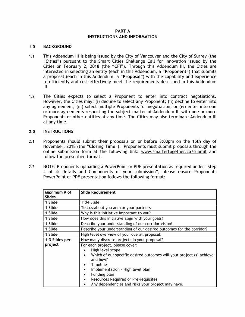
2.2 NOTE: Proponents uploading a PowerPoint or PDF presentation as required under “Step 4 of 4: Details and Components of your submission”, please ensure Proponents PowerPoint or PDF presentation follows the following format:
Maximum # of Slides
Slide Requirement
1 Slide Title Slide
1 Slide Tell us about you and/or your partners
1 Slide Why is this initiative important to you?
1 Slide How does this initiative align with your goals?
1 Slide Describe your understanding of our corridor vision?
1 Slide Describe your understanding of our desired outcomes for the corridor?
1 Slide High level overview of your overall proposal.
1-3 Slides per project
How many discrete projects in your proposal?
For each project, please cover:
High level scope
Which of our specific desired outcomes will your project (s) achieve and how?
Timeline
Implementation – High level plan
Funding plan
Resources Required or Pre-requisites
Any dependencies and risks your project may have.

How would you replicate this across other Canadian Cities?
Lifespan of project and ongoing operating model (if applicable)
Strategy for measurement and monitoring performance
1 Slide Have any of your projects been implemented elsewhere?
1 Slide How is your proposal unique and innovative?
1 Slide Have you collaborated with any other firms that may be also submitting?
1 Slide Have you collaborated with any other public bodies on innovative projects?
1 Slide Description of any contributions you are willing to make to take this proposal forward.
1 Slide How does this proposal benefit your firm(s)?
1-3 slides Any other guidance you would like to provide.
2.3 Amendments to a Proposal may be submitted via the same methods, at any time prior to the Closing Time. Proposals are revocable and may be withdrawn at any time before or after the Closing Time.
2.4 All enquiries regarding the RFP must be addressed to [email protected]
2.5 Proposals that are submitted after the Closing Time or that otherwise do not comply in full with the terms hereof may or may not be considered by the Cities and may or may not be returned to the Proponent, in the Cities sole discretion.
3.0 CHANGES TO ADDENDUM III AND FURTHER INFORMATION
3.1 The Cities may amend Addendum III or make additions to it at any time. It is the sole responsibility of Applicants to check regularly for amendments, addenda, and questions and answers in relation to Addendum III.
3.2 An information session (the “Information Session”) will be held to enable the Cities to review and clarify the requirements of Addendum III with Proponents, outline the expectations of Proponents proposal and allow Proponents to seek clarification with respect to any aspect of Addendum III in a group forum. The Information Session will be scheduled between September 28th and October 9th and will be located in Vancouver. The specific date, time and location will be posted on www.smartertogether.ca/submit once confirmed.
3.3 Potential Proponents interested in attending the Information Session should email [email protected] at their earliest convenience.
4.0 EVALUATION OF PROPOSALS
4.1 All Proposals submitted will be evaluated to determine overall best value to the Cities. The Cities expect to evaluate: (i) financial terms; (ii) Proponents’ skills, knowledge, reputations and previous experience(s), including experience(s) with the Cities (if any); and (iii) Proponents’ approach to meeting the Cities requirements.
5.0 CITIES DISCRETION
5.1 For the avoidance of doubt, notwithstanding any other provision in Addendum III, the Cities have in their sole discretion, the unfettered right to: (a) accept any Proposal;
(b) reject any Proposal; (c) reject all Proposals; (d) accept a Proposal which is not the lowest-price proposal; (e) accept a Proposal that deviates from the Requirements or the conditions specified in Addendum III; (f) reject a Proposal even if it is the only Proposal received by the Cities; (g) accept all or any part of a Proposal; (h) split the Requirements between one or more Proponents; and (i) enter into one or more agreements respecting the subject matter of Addendum III with any entity or entities at any time. Without limiting the foregoing, the Cities may reject any Proposal by a Proponent that has a conflict of interest, has engaged in collusion with another Proponent or has otherwise attempted to influence the outcome of Addendum III other than through the submission of its Proposal.
6.0 LEGAL TERMS AND CONDITIONS
6.1 The legal obligations of a Proponent that will arise upon the submission of its Proposal are as set out in the CFI under the heading “Legal Terms and Conditions of CFI”.
PART B
CITIES REQUIREMENTS
1. Project proposals for the Smart Cities Challenge The Cities of Vancouver and Surrey have the opportunity to design the future of smart and safe urban mobility. Our joint Smart Cities Challenge first stage application was chosen out of 130 submissions to be among the 20 finalists vying for federal funding of smart city projects designed to improve the quality of life of city residents. We are among the five finalists vying for funding in the $50 million category. We are now in the process of composing our final application, which is to be submitted by March 5th, 2019. The preparation of our application provides us with the opportunity to design Vancouver’s South False Creek Innovation Corridor and Surrey’s University Drive Pilot and Innovation Boulevard Corridor. Together, these innovations have the potential to turn our cities into the global epicenter of smart mobility technology and to establish new global best practices in urban transportation planning. We are seeking qualified companies to submit smart city technology project proposals that will support the development of the corridors and pilot through the implementation and coordination of smart city technology and data projects. This Addendum III is not intended to prescribe project types or specifications. It is requesting that respondents study our Challenge Statement and conceptual designs, and submit project proposals that will inform our Cities regarding the technology necessary to achieve the outcomes that we have defined. Responses should include any financial or in-kind contribution that your organization can provide to leverage the Smart Cities Challenge funding, as this will be important evaluation criteria for our final application. 2. Project proposal requirements
All project proposals must include validated technologies, and respondents shall label the
proprietary and non-proprietary elements of their technologies.
Proposals should also provide a description of how the solution is:
replicable;
interoperable;
scalable; and
in alignment with our open data principle. Replicability is a key principle of the Smart Cities Challenge. Projects must be replicable for
other cities that wish to develop their own collision-free multi-modal transportation corridors
with autonomous shuttles/vehicles and smart technologies.
Interoperability among devices, sensors, and systems is key to creating functioning zero-
collision corridors. Interoperable systems enable all modes of transportation to interact with
infrastructure and communicate conditions in the corridors.

Scalability is a requirement since our corridors are intended to serve as pilots for potential
wider-scale deployment of smart mobility technology throughout the region and across
Canada.
Alignment with our open-by-default principle ensures that corridor data is accessible. This
data, available through APIs, will provide opportunities for application developers and
innovators to create new products and services that can leverage the technology deployed in
the corridors.
Respondents should also become familiar with the implementation phase requirements
articulated by Infrastructure Canada. These must be addressed by each city submitting a
proposal for the Smart City Challenge. The requirements can be found in section 5.10 of the
Smart Cities Challenge Finalist Guide.
We plan to work with industry to further identify and define the technical requirements, essential components, and appropriate architecture for the corridors. This will include communication of current city systems and planned technology related to the corridors. 3. The Challenge Statement
Our application for the first stage of the Smart Cities Challenge included a Challenge
Statement, defined as “a single sentence that defines the outcome or outcomes a community
aims to achieve by implementing its smart cities proposal.”1
The Vancouver-Surrey Smart Cities Challenge Statement is:
Surrey and Vancouver will implement Canada’s first two collision-free multi-modal transportation corridors, leveraging autonomous vehicles and smart technologies to demonstrate the path to safer, healthier and more connected communities while reducing emissions, improving transportation efficiency and enhancing livability in the face of rapid growth and traffic congestion. #SmarterTogether
4. Additional priorities All selected projects will ultimately contribute to reducing the number of collisions in the corridor to zero. In addition to this, we expect projects to contribute to achieving one or more of the following:
improved safety
increased availability of mobility options
reduced emissions
increased accessibility
healthier communities
more socially connected communities
higher people-moving capacity (improved transportation efficiency)
enhanced travel experience
1 https://impact.canada.ca/en/challenges/smart-cities/applicant-guide

5. Potential solutions
Our application for the first stage of the Smart Cities Challenge identified four potential project categories. We emphasize that this Addendum III is not prescribing project specifications. Project proposals are not required to fit in the categories identified in our first-stage application. These categories are listed here only for reference. The four categories included in our first-stage application are:
autonomous shuttles
smart mobility infrastructure
advanced data and analytics
enhanced user experience Autonomous shuttles: These projects may include autonomous vehicles, autonomous vehicle electric charging infrastructure, and autonomous vehicle connectivity infrastructure that enables communication between vehicles and sensors embedded in traffic infrastructure. Smart mobility infrastructure projects: These projects may include sensors (deployed in traffic signals, lighting, and other roadway infrastructure) that generate data that support autonomous shuttle operation and real-time traffic signal adjustments. Advanced data and analytics projects: These projects may include technologies related to the real-time monitoring, analysis, synthesis, and visualization of data from disparate sources. Insights derived from this data can inform corridor design, signaling, and autonomous shuttle movement. Enhanced user experience projects: These projects may include technologies that enable wayfinding, smart crossings, shared mobility options, and optimized trip planning that increase the seamlessness of travel while enhancing the safety, accessibility, fairness, and equity of the transportation system. More detailed explanations of each category can be found under Question 6.3 of the Vancouver-Surrey Smart Cities Challenge Application, which is available on the smartertogether.ca website. 6. Guiding principles of our application All respondents should be mindful of the principles guiding the design of our corridors. The corridors must:
o be scalable, inclusive and open; o contribute to achieving targets and goals set forth in existing City policies, described
in section 8 of this Addendum III; o respond to the needs of populations that have traditionally not benefitted from
technological innovation. These include: financially disadvantaged seniors, people with disabilities, members of vulnerable populations, etc.; and

o respect the context, character, and planning principles of areas adjacent to the corridors.
Respondents should also be familiar with Infrastructure Canada’s Smart City Challenge principles, found in Section 1.2 of the Smart Cities Challenge Finalist Guide. 7. City policy references
Respondents must ensure that their proposed projects align with the goals set forth in relevant city strategies. 7.1 The City of Vancouver strategies
Transportation 2040: Transportation 2040 is a long-term strategic vision for Vancouver that helps to guide transportation, land use, and public investment decisions to develop a smart and efficient transportation system that supports a thriving economy and increases affordability. The plan sets three long-term targets and includes high-level policies and specific actions to achieve this vision by 2040. The targets are:
1. Zero traffic-related fatalities. Vancouver’s ultimate safety goal is to eliminate all fatalities and serious injuries from its transportation system.
2. Increased mode share. At least two-thirds of all trips will be made by foot, bike, and transit by 2040.
3. Decreased driven distances. The average distance per resident will decrease by 20% from 2007 levels by 2020.
City of Vancouver Digital Strategy:
The Digital Strategy is designed to enhance digital connections among all city stakeholders and advance the City’s internal and external digital maturity through projects in connectivity, access to data, and interoperability. The Strategy is designed to increase economic opportunities, improve services, and lay the foundation to transform Vancouver into a smart city through projects related to:
1. Engagement & access: enabling citizens and businesses to easily interact with the city through digital channels.
2. Infrastructure & assets: creating a robust digital infrastructure built through strategic investments and partnerships.
3. Digital economy: making Vancouver a global leader in supporting innovation and the digital ecosystem.
4. Organizational digital maturity: unifying the city’s digital and technology agendas, and preparing internal agencies for service delivery requiring cross-functional collaboration enabled by data.
The Strategy has three stages. The first stage of the strategy was foundational, focusing on digital maturity and early business transformation. The second stage, currently underway, involves technology transformation and focuses on increasing
connectivity and gathering data. The third stage, beginning in 2019, focuses on interoperability, and sets the stage for city services and initiatives that are informed by data gathered from disparate sources.
Congestion Management Strategy: The Congestion Management Strategy provides direction on identifying and monitoring congestion and developing strategies to address areas impacted by congestion. It includes five priority action areas with dedicated targets. These include:
1. Improving the monitoring of traffic conditions and trends; 2. Improving road safety; 3. Ensuring a smart and efficient transportation system; 4. Coordinating street use; 5. Prioritizing the movement of people and goods.
7.2 The City of Surrey strategies
Smart Surrey Strategy: The Smart Surrey Strategy fosters sustainable economic development and high quality
of life by leveraging innovation and technological advancements in decision making,
strategies, and investment to improve services and increase the effectiveness of city
resources amid rapid growth and increasing demands. The Strategy includes initiatives
related to smart transportation, open data, and connectivity to meet the city’s
increasing transportation demands. The Strategy’s four pillars are:
1. Social engagement & connectivity: enabling residents to actively participate in decision making.
2. Service delivery innovation: providing residents with digital services and digital channels to the City.
3. Economic growth: supporting the city’s innovation ecosystem, knowledge workforce, and economic diversity.
4. Smart city infrastructure: preparing the city for broadband and smart
buildings, transportation, and utility management.
Surrey’s Vision Zero Safe Mobility Plan (upcoming) The City of Surrey is the first municipality in B.C. with a dedicated road safety team. The City’s upcoming Vision Zero Safe Mobility Plan will emphasize that collisions are preventable, and that their prevention requires a change in mindset to understand safety as a precondition for mobility. The plan will have four focus areas: pedestrians, cyclists, motorcycles, and intersections. The plan includes the following vision statement: “Surrey has zero people killed and seriously injured on its roads, and human life is valued above all else in the transportation network.”
Sustainability Charter 2.0

Surrey's Sustainability Charter 2.0 is an ambitious 40-year vision for a thriving, green, and inclusive city. The Charter guides all City decisions and outlines eight themes of sustainability. Key strategic directions that support the Smart Cities Challenge application include:
o Continuing to plan and develop a transportation and mobility network (including active transportation) that supports safety, place making, and integration of neighbourhoods;
o Ensuring all public infrastructure is built and maintained to ensure community safety and well-being for all ages and abilities;
o Addressing traffic safety in a holistic way, particularly around schools and critical accident locations;
o Supporting the development and growth of key sectors including health technology, clean technology, advanced manufacturing, agri-innovation, and the creative economy.
8. The Vancouver South False Creek Innovation Corridor 8.1 Overview Vancouver’s collision-free South False Creek Innovation Corridor will employ information and communication technologies that ensure the safe movement of people using various modes of transportation on three routes in one of the city’s busiest and most scenic areas. Autonomous shuttles will be a central feature in the collection of smart mobility technologies that make up the corridor. These will serve as a pilot for wider-scale deployment of the technology throughout the region as a ‘first-mile/last-mile’ transit-supporting solution, and accelerate our transportation system’s advance toward electrification and enhanced safety. The City of Vancouver has identified specific mobility challenges in the proposed corridor that can be addressed through smart mobility technologies. Respondents are welcome to address these in their proposals. However, it is important to note that project proposals can include solutions that address common challenges beyond those identified in this Addendum III. 8.2 Location & notable features The three-kilometer South False Creek Innovation Corridor will be located south of False Creek, extending between popular tourist destinations Granville Island and Science World, and connecting with the False Creek South and Olympic Village communities. Three routes will comprise the corridor. These are:
1. West 4th, West 6th, and West 2nd Avenues [multi-lane vehicle and transit arterials] 2. The Seaside Bypass [a local street comprised of Lamey’s Mill Road, Charleson Park, Moberly Road, Commodore Road, and West 1st Avenue] 3. The Seaside Greenway/Seawall between Granville Island and Science World

[a waterfront walking and cycling path] The location is adjacent to an emerging technology innovation hub and includes three major commercial districts [Granville Street, Cambie Street, and Olympic Village], popular destinations for tourists and residents, and a major health precinct and hospital site. Major annual events occur in this area, including the Sun Run and Dragon Boat Festival. Graphic 1.1. Existing Systems and Destinations in Appendix 1 illustrates the existing transportation infrastructure within and adjacent to the corridor. Graphic 1.2. Concept Plan in Appendix 1 illustrates the new smart mobility routes. 8.3 Existing challenges Significant opportunities exist in the corridor to improve safety and enhance the experience of moving through the area. Graphic 1.3. Opportunities and Challenges in Appendix 1 illustrates some of the challenges that currently contribute to collisions in the proposed corridor. West 4th, West 6th, and West 2nd Avenues
This arterial route provides connections to Granville Street, Cambie Street, and Main Street
north-south arterials. The only cycling infrastructure along the route is in a small area around
Olympic Village SkyTrain Station. The experience for pedestrians varies considerably along
the route. In some segments, particularly those adjacent to new developments, the sidewalk
is wide and a boulevard provides a buffer from the street. In other segments, sidewalks are
narrow. A long segment of West 6th Avenue between Alder Crossing and Moberly Road lacks a
north sidewalk. Due to the volume and average speed of vehicles travelling on arterials,
safety at crosswalks and bike crossings is a key concern.
The Seaside Bypass route (Lamey’s Mill Road, Charleson Park, Moberly Road, Commodore Road, and West 1st Avenue) This local street provides connections to the False Creek South and Olympic Village
neighbourhoods, and provides a faster and more direct cycling alternative to the Seawall.
Cycling infrastructure exists primarily in the form of a traffic-calmed shared roadway with
signs and painted markings, including painted bike lanes between the parking lane and travel
lane on the West 1st Avenue segment. Safety in these bike lanes is a concern as there is a risk
of ‘dooring’ and a need for cyclists to move into the traffic lane to maneuver around illegally
stopped vehicles.
The walking experience on this route varies considerably. Many segments of the route are
missing sidewalks on one side (segments of Lamey’s Mill Road, Moberly Road, and Commodore
Road) or both sides (Charleson Park). Many segments have narrow sidewalks which are further
constrained by posts, transit shelters, and driveway curb cuts. Inconsistent lighting is also a
problem.
Some intersections on the route are irregular and can be challenging to navigate for all
modes. There are also some weak connections to key locations, including inadequate access
to Olympic Village Station and an unclear cycling connection to Cambie Street.

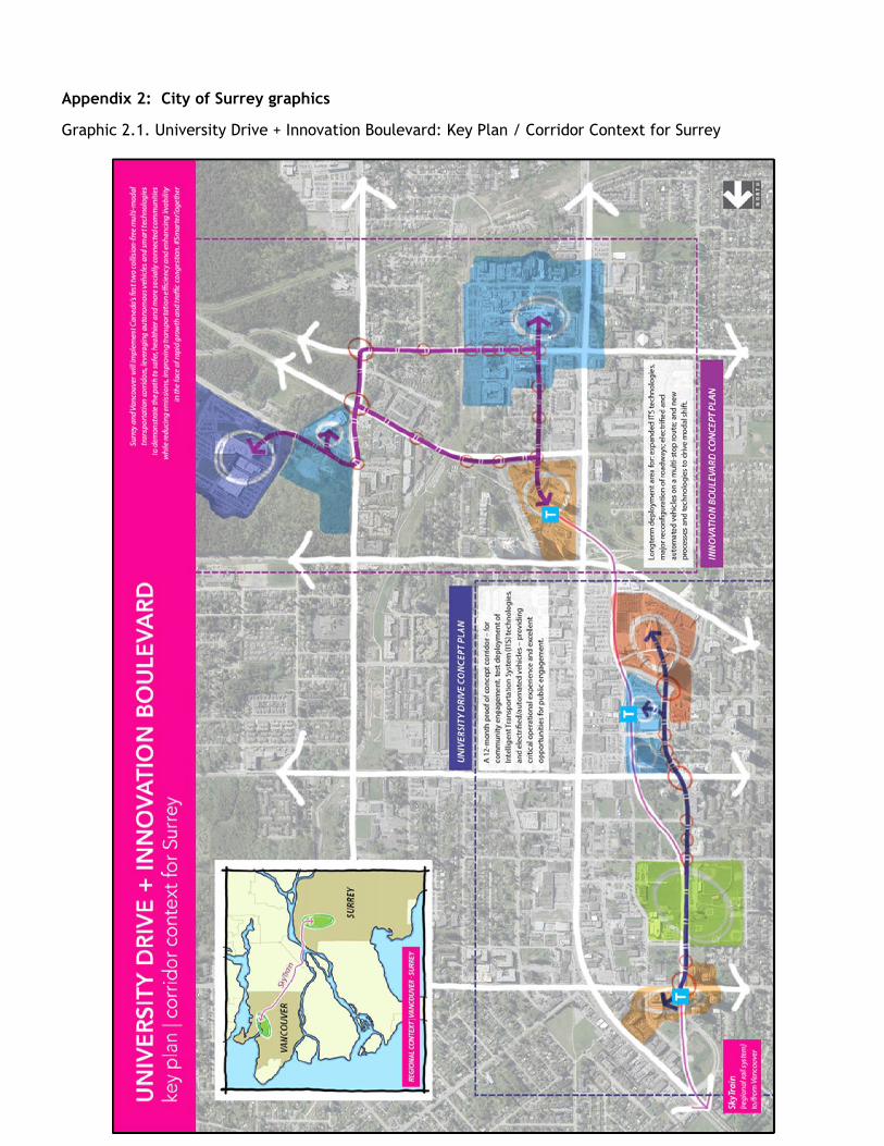
Seaside Greenway/The Seawall Vancouver’s Seaside Greenway (The Seawall) is a safe 28-kilometer walking and cycling route connecting the Vancouver Convention Centre to Spanish Banks Park. The Seawall connects key waterfront destinations. Recent upgrades and separated paths have improved safety, but conflicts between pedestrians and cyclists remain a concern at busy multi-modal nodes, crossing, and connections to other routes. 8.4 Prioritized strategies The City of Vancouver has identified some strategies that can contribute to achieving our desired outcomes. Graphic 1.4. Prioritized Strategies in Appendix 1 illustrates these strategies and appropriate locations for their execution. 9. The Surrey University Drive Pilot and Innovation Boulevard Corridor 9.1 Overview Surrey City Centre is undergoing a bold transformation from a suburban town centre to a walkable, high density, and transit-oriented downtown. The improved safety resulting from a smart mobility transportation network — catalyzed by the Smart Cities Challenge — will accelerate this transformation and serve as a model that can be replicated across Canada and the world. The City of Surrey is implementing its collision-free corridor in two stages:
Stage 1: The one-year University Drive Pilot will test technologies, build public acceptance before full implementation, and deploy automated shuttles in exclusive rights-of-way to allow time for changes in legislation that will permit on-road deployment of automated vehicles. Stage 2: The Innovation Boulevard Corridor will follow the University Drive Pilot and feature full deployment of smart city technology, infrastructure, and strategies, incorporating the learnings from the Pilot.
Roadway infrastructure, energy distribution, and fibre optic networks are being significantly upgraded to transform these areas from their current focus on single family residential use to a new focus on high density, high technology, and high efficiency. These areas will be further transformed in the next five years with the addition of new light rail transit lines. The evolving suburban context gives technology providers the opportunity to demonstrate how smart mobility technology can be built into a city’s developing infrastructure instead of overlaid upon an existing urban inner-city. The two-stage approach provides the opportunity for respondents to demonstrate the replicability and scalability of their proposed projects. The City of Surrey has identified specific mobility challenges in the proposed pilot and corridor areas that can be addressed through smart mobility technologies. Respondents are

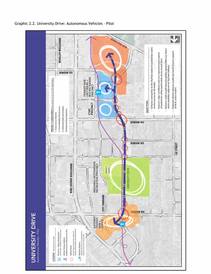
welcome to consider these. However, respondents may submit proposals with solutions that address common challenges beyond those identified in this Addendum III. Graphic 2.1. University Drive + Innovation Boulevard: Key Plan / Corridor Context for Surrey in Appendix 2 illustrates the University Drive Pilot and Innovation Boulevard Corridor areas. 9.2 University Drive 9.2.1 Location and notable features The University Drive Pilot area will include a 1.2-kilometer off-road autonomous vehicle demonstration route in the heart of Surrey City Centre, linking Surrey Central SkyTrain Station with Gateway SkyTrain Station.2 This area is embedded in one of the region’s largest infill areas, involving the transformation of a collection of strip-oriented retail stores and single detached homes into an area of high-density residential towers and a concentration of educational centres and supporting services. Significant development is scheduled to occur adjacent to this area over the next five years. University Drive’s south terminus is anchored by Simon Fraser University’s Surrey campus and a new Sustainable Energy Environmental Engineering Centre, as well as Kwantlen Polytechnic University’s new campus in Civic Plaza. In addition to post-secondary institutions, the route also includes several important regional destinations including:
Central City Mall, the Fraser Health Authority headquarters, and a 560,000 square foot commercial office complex;
City Hall, City Centre Library, and Civic Plaza;
A regional multi-modal transportation hub that includes Surrey Central SkyTrain Station, car-share sites, a dedicated Fraser Health employee shuttle, the region’s second busiest bus exchange, and areas with high pedestrian volume.
Graphic 2.2. University Drive: Autonomous Vehicles - Pilot in Appendix 2 illustrates the University Drive Pilot area. 9.2.2 Pilot objectives The University Drive Pilot has the following target outcomes:
Capitalize on opportunities to pilot enhanced safety technologies;
Familiarize City operations with autonomous vehicle technology;
Engage the community, seek stakeholder feedback, and address concerns;
Pilot Community Employee Benefit (CEB) partnerships;
Deploy baseline measurement technology;
Resolve autonomous vehicle interaction with general traffic;
Co-ordinate schedules of autonomous vehicle deployment with multiple capital works and roadway projects;
Adapt Health District deployment plans based on operational experience;
2 The University Drive Pilot location replaces the UBC test bed referenced in our application for phase one of the Smart Cities
Challenge

9.3 Innovation Boulevard 9.3.1 Locations and notable features The Innovation Boulevard corridor is also the focus of intense redevelopment, as it is transforming from a mid-century residential area with single detached homes to a high density health technologies innovation precinct.3 There is significant development scheduled for this area in the next five years. Surrey’s Innovation Boulevard Corridor will be developed along a 4.5-kilometer route comprised of a mix of local and collector streets along with high volume arterials. Important features along the Innovation Boulevard Corridor route include:
Surrey Memorial Hospital, the second largest hospital in B.C. and site of the province’s busiest emergency department;
Jim Pattison Outpatient Surgery Centre, a $237 million facility that includes over 50 clinics and services;
10 additional Fraser Health Authority facilities;
RCMP E-division, the headquarters of the RCMP in British Columbia. Graphic 2.3. Innovation Boulevard: Technology and Infrastructure Strategies in Appendix 2 illustrates the Innovation Boulevard Corridor area. 9.3.2 Corridor objectives Smart mobility technology in the corridor will achieve a number of outcomes in addition to eliminating collisions. For instance, autonomous shuttles will:
provide critical first and last-mile transportation between King George SkyTrain Station and prominent employment and health care centres; and
provide connectivity between Innovation Boulevard, a major health and technology cluster, and E-Division, the RCMP head office.
The Innovation Boulevard Corridor has the following target outcomes:
improved safety
increased availability of mobility options
reduced emissions
increased accessibility
healthier communities
more socially connected communities
higher people-moving capacity (improved transportation efficiency)
enhanced travel experience
3 For more information, visit https://www.innovationboulevard.ca/

9.4 Important challenges in the University Drive Pilot and Innovation Boulevard Corridor General challenges related to the University Drive Pilot and Innovation Boulevard Corridor include: Safety
Addressing vehicular-autonomous vehicle/shuttle conflicts through smart city technologies that work in conjunction with promising collision mitigation practices including extensive use of signage, graphics, and public engagement processes.
Addressing vehicular-autonomous vehicle/shuttle conflicts through smart city technologies that work in conjunction with emergency vehicle response protocols and practices.
Sustainability
Reducing greenhouse gases and increasing the use of sustainable transportation modes.
Incentivizing modal shift and new transit customers through citizen use of the TransLink mobile app and by leveraging mobility app data.
Mobility and Accessibility Options
Ensuring all people (regardless of age, demographics, income levels, etc.) have the same opportunity to access sustainable transportation options.
Providing persons with limited mobility with excellent access to transit to meet their daily needs and participate in civic life.
Developing interactive technology at the street level to provide an on-demand shuttle call for individuals with reduced mobility.
For a list of specific challenges in the University Drive Pilot and Innovation Boulevard Corridor, see Graphic 2.4. University Drive: Detailed Enhancement Plan and Graphic 2.5. Innovation Boulevard: Detailed Enhancement Plan in Appendix 2. 9.5 Potential solutions Respondents can study the four project categories identified in Section 6 of this Addendum III
to explore potential solutions. Please note that the project categories are for reference, and
that project proposals can include technology that does not fall into these categories.

Appendix 1: City of Vancouver graphics Graphic 1.1: Existing Systems and Destinations

Graphic 1.2: Concept Plan
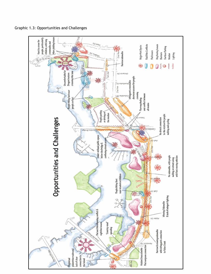
Graphic 1.3: Opportunities and Challenges

Graphic 1.4: Prioritized Strategies
Appendix 2: City of Surrey graphics
Graphic 2.1. University Drive + Innovation Boulevard: Key Plan / Corridor Context for Surrey
Graphic 2.2. University Drive: Autonomous Vehicles - Pilot

Graphic 2.3. Innovation Boulevard: Technology and Infrastructure Strategies

Graphic 2.4. University Drive: Detailed Enhancement Plan

Graphic 2.5. Innovation Boulevard: Detailed Enhancement Plan