Headspace, Volatile and Semi-Volatile Organic Compounds Diversity
Upload
truongdiepCategory
view
224download
1
period greater than 96 hours without the required permits ... Oil Operators allowed hazardous waste to be stored for a period up to one year without the required permits ... F urthermore they mix numerous waste streams at the facility without the required permits.,."
6. The LARWQCB has provided little information to BP regarding the operations at the 001 property. Publically available files recently obtained by BP at the Long Beach Health Department indicate the following (in addition to 001 operations information previously provided by BP to the LARWQCB):
Sludge from sumps on the 001 operations was spread onto the northern 001 site.° The excessive odors from this activity resulted in resident complaints. Measurements of ambient air by the Health Department recorded up to 50 ppmv volatile organic compounds (VOCs) in the neighborhood.' Removal of sludge from the sump located near Brycon -MW1 was reportedly spread on the northern 001 site (i.e., north of 1 -405).
BP requests that the LARWQCB fully investigate the history, uses, and contributions of 001 operations to Site Impacts and provide all available information to BP for use in preparation of a Conceptual Site Model and associated source identification required in the tentative CAO.
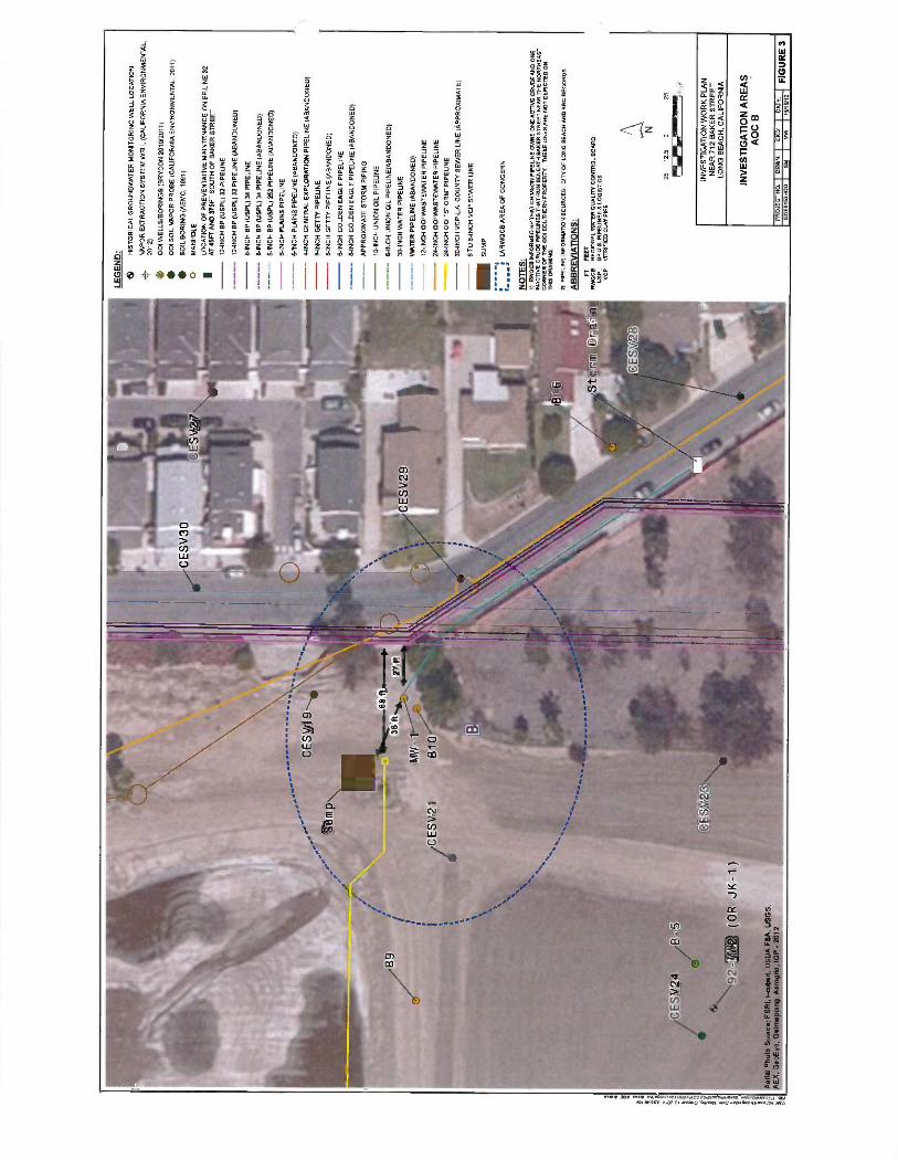
7.d. Significant potential sources of benzene and other contaminants exist in the vicinity of 712 Baker Street other than the BP pipeliness
Seven pipelines owned by others have been identified along Golden Avenue and Baker Street. The LARWQCB has not provided information related to the uses, history of operation, release and repair history, etc., for these lines. Also, many other lines that could provide conduits for plume migration traverse the 001 site from the area north of Baker Street along Golden Avenue,
The LARWQCB has not considered the potential contribution of lines beneath Baker Street, indicating that the lines are "away from the primary area of concern along Golden Avenue." 001 reports present data showing detectable concentrations of dissolved phase petroleum hydrocarbon compounds in water samples from the well MW -3, which is part of the 001 Site, as described in the tentative CAO. Well MW -3 is located approximately 50 feet from Baker Street.
In addition, substantial evidence from the California Environmental soil vapor study9 and other historical and forensics analysis demonstrates that deep impacts along Golden Avenue extend north of Baker Street and that the greatest surface impacts at the site are found in the vicinity of Baker Street, Methane data throughout 001 indicate contaminants likely originated on 001 property, with the highest concentrations north of Baker Street.10
° Statewide Investors, Inc. July 1986, Site Characterization Study, Long Beach. Long Beach Department of Health and Human Services files, Background Readings - with OVA,
Excavation Area - not covered with clean soil cover or foam, 10/02/89. ° BP, December 4, 2012. p.7 ° Brycon, September 30, 2011. Report on Additional Site Characterization Oil Operators, Inc. 712 Baker Street Long Beach, CA SCP Case No. 0093, SCPID No. 2044M00. Prepared for Oil Operators, Inc. Newport Beach, CA. ° Brycon, September 30, 2011.
3
7.e,i. Soil vapor concentrations increase with depth, Including within AOC A, which suggests a deeper,
separate source for the hydrocarbon Impacts beneath the pipelines, and not a current shallow source
such as the pipelines.'
7.e.li. AOC A is not located near two recent pipeline repair locations. The northerly asphalt patch is
located approximately 250 feet north of 3742 Countryside Lane. Furthermore, the asphalt patches are not indicative of a pipeline release, and as previously documented, no "repairs" were made to ARCO lines. The patches are a result of preventive maintenance due to testing anomalies. In addition, field log
records show no evidence of leaks during the excavations for maintenance.12
7.f 1.1. BP did not make the stated claim that subsurface samples lacked iso- octane and therefore did not
originate from gasoline, as iterated in BP's December 4, 2012 letter. BP's previous statements regarding the lack of iso -octane were in reference to the soil vapor sample from VES -A, not the LNAPL sample13
collected from well Brycon -MW1 (in Area AOC B).
7.f.iii. The statement that the LNAPL sample lacked evidence of heavier hydrocarbons overstates Zymax's conclusions. Chemical fingerprint data do not show a consistent forensic signature, which would
be expected if the only source of contaminants was a pipeline release. In addition, Zymax did not
analyze the heavier carbon range and, therefore, does not have the data to draw this conclusion. Analyses were limited to C3 -C10 and oxygenates. Per Zymax, "There is not evidence of any heavier petroleum products in the sample. This could be confirmed by analysis in the C3 -C44 carbon range."
7.f.iv. It appears that the LARWQCB is using benzene as an indicator chemical for gasoline- sourced
contamination. However, It is documented in several reports, including those footnoted below, that 001 influent14 and effluent15 contained benzene.
7.g. The leaded gasoline scavenger, 1,2- Dichloroethane (1,2 -DCA), has not been detected in any
sample locations except those on the 001 property. 1,2 -DCA was not detected in any soil vapor or soil
samples above 30 feet below ground surface (bgs). Higher concentrations of 1,2 -DCA in groundwater were detected on the northern portion of the 001 property (i.e., north of Baker Street) away from the ARCO pipelines.16
7.h. Benzene has been detected in groundwater on the 001 property, with concentrations increasing significantly along its eastern boundary after a shift in groundwater flow direction toward the southeast in
2005. This could suggest a source on the 001 property, not a source beneath Golden Avenue. In
addition, iso -concentration maps of benzene and other compounds produced by Brycon are far- reaching and misleading (see for example Figure 5 of the October 15, 2012 Brycon quarterly groundwater monitoring letter).17
11 BP, December 4, 2012, p.10.
12 BP, December 4, 2012, p. 5.
13 BP, December 4, 2012 p. 12.
14 Jack K. Bryant and Associates, Inc., August 11, 1992. Investigation of Groundwater /Soil Contamination at the Oil Operators South Site, 712 Baker Street, Long Beach, California .
15 Oil Operators, Inc., 1993. Letter from Sheri Johnson to Diana Shinn, City of Long Beach Health Department, October 11, referencing Certified Testing Laboratories, Inc., 1993, laboratory report for Oil Operators, Inc. effluent wastewater sample collected October 1.
16 BP, December 4, 2012, p. 12 -13. 17 Brycon, October 15, 2012. September 2012 - Quarterly Groundwater Monitoring at the Oil Operators Property, 712 West Baker Street, Long Beach, California.
4

In the Brycon 2006 October Groundwater Monitoring Report, Brycon noted "The concentration of benzene increased In ESE -MW1 relative to the April 2006 sampling event (from 1,800 ugh to 2,600 ugtl). This is a fairly significant increase. In April 2005, the benzene level in this well was 1,400 ugh and in October 2005, it was only 19 ugh. The first large increase observed during recent monitoring events was in April 2005, which represents the first reported time that the change in gradient and flow direction from northwesterly to northeasterly was observed, The benzene levels measured in ESE -MW 1 appear to be related to water flow direction and elevation. In this well, several other VOCs also increased in
concentration during the recent (October 2006) monitoring event. These included 1,2 -DCA, ethyibenzene, toluene and xylenes. In Emcon -MW3 the VOCs did not change very significantly however, more VOCs were detected than In April 2006,"
Also, in their 2006 report conclusions, Brycon noted the following: "This northeasterly flow direction may be responsible for the noticeable increase in benzene levels detected in Weil ESE -MW 1 in three out of the four monitoring events conducted since April 2005.... The increase in benzene levels observed in Well ESE -MW1 seems to be related to the change in groundwater flow direction in which ESE -MW1 now has a downgradient component relative to Basin 1. Although soil and sludge in Basin 1 was blended to facilitate bioremediation in recent years, seepage and partitioning of substances present in the Basin 1
sludges may have occurred over numerous years in the past, impacting nearby shallow groundwater. "t8
Further, the data provided to BP by the LARWQCB via reports uploaded to GeoTracker are insufficient to allow depictions of chemical iso- concentration lines east of the 001 property. The three wells along the eastern side of 001 property are each situated approximately 600 feet apart, and there are no wells to the east that would allow depiction of the contouring shown. Prior Brycon maps, which included more data, show distinct areas of contamination rather than a single continuous plume.19 Additionally, gasoline -range hydrocarbons have been detected on OO1's former northerly -most parcel (i.e., a current driving range located north of 1-405) in sump sludge 30 feet bgs, further indicating the potential contribution of gasoline compounds by 001 operations.20
9.a. CHHSLs for vapor screening are applied in the top 5 feet - the 390 ug /L benzene vapor result was detected at a depth of 20 feet bgs. This is an incorrect and misleading application of the state standards and the Cal EPA January 2005 guidance.
10. No reference was made to the December 4, 2012 letter or the December 5, 2012 meeting and BP's anticipated response from the LARW QCB to discussions held during that meeting.
The LARWQCB states that "To date, the Regional Board has not received a revised work plan from BP." BP had not refused to submit a work plan but understood that the LARWQCB would respond to the technical and legal bases presented at the December 5, 2012 meeting.
21. "... are or will pose a potential human health threat to occupants of the nearby Wrigley Heights residents through direct contact exposure to contaminated soil and /or groundwater ... "
Groundwater is located 30 to 50 feet bgs. Direct contact by residents is not currently a viable risk pathway. In addition, there have been no shallow soil impacts identified above 10 feet bgs in
18 Brycon, October 20, 2006. October 2006 Semi -Annual Groundwater Monitoring at the Oil Operators
Property, 712 Baker Street, Long Beach, California. 19 Brycon, January 15, 2011. December 2011- Quarterly Groundwater Monitoring at the Oil Opertors [ski Property, 712 West Baker Street, Long Beach, California, ° LFR, Inc., April 4, 2006. Characterization Data Report, former Oil Operators North Site, 3701 Pacific
Place, Long Beach, Prepared for CRG Properties.
5
Investigations by others along Golden Avenue, There is no currently defined risk due to direct contact with impacted soil along Golden Avenue.
Required Actions 3. "Completely delineate the extent of ... in soil, soil vapor, ...discharged at or from the Site." BP requests "the Site" be changed to "ARCO pipelines". ARCO has no liability for impacts by others, such as 001 and other pipelines in the Site.
Exhibit D - Schedule items
BP requests a sequence revision: A human health risk assessment will be conducted following implementation of the Master Work Plan and evaluation of the data associated with the investigation required in the tentative CAO. BP requests an additional sequence revision: A conceptual site model will be prepared following implementation of the Master Work Plan and evaluation of the data associated with the investigation required in the tentative CAO.
Groundwater monitoring - Monitoring wells to be sampled per this requirement will be identified in
the Work Plan. ARCO will not be responsible for reporting of data collected by others (e.g., reporting on the monitoring period for January through June 2013 or thereafter depending upon the timing of issuance of the final CAO).
RAP - Due to the egregious errors in Brycon's 2013 vapor extraction system monitoring report21
recently uploaded to Geotracker, BP considers the basis for the system and its operation to be suspect. The errors overstate the benzene recovery, by a factor of at least several thousands.22 This is part of a pattern of errors In Brycon reports, as indicated to the LARWQCB during discussions and meetings in 2012. Vadose zone data along Golden Avenue support the low levels of benzene recovered by the 001 vapor extraction system. Following implementation of the Master Work Plan and evaluation of the data associated with the investigation required in the tentative CAO, BP will prepare a RAP if the data and human health risk assessment confirm that one is necessary.
The schedule timeline in unrealistic. A Master Work Plan will be submitted to the LARWQCB by BP within six weeks of the issuance of the Final CAO.
Legal Comments
The tentative CAO lacks a sufficient evidentiary basis that conforms to Water Code standards and recent case law. For the reasons set forth below, we urge the Board to rescind the Order and allow BP to conclude its response to the 13267 Order. Alternatively, we urge the Board to delay issuance of the order until BP obtains a State Board decision on the June 8, 2012 Petition.
The tentative CAO repeats the evidentiary and legal flaws associated with the May 11, 2012 13267 Order. Water Code Section 13267 authorized the Regional Board to issue the 13267 Order to those who have discharged, or are suspected of having discharged, wastes. There was and continues to be a lack of evidence of that any BP line discharged gasoline in the vicinity of the Site. There is strong evidence showing BP has not caused or contributed to a release. BP
has cooperated with every request and order from the LARWQCB thus far but would be forced again to petition the state board for review of any clean -up abatement order in this matter.
21 Brycon, April 15, 2013. Quarterly Monitoring Report, Soil Vapor Extraction, Oil Operators Inc. 712 Baker Street, Long Beach, California. 22 BP, May 24, 2013. Letter to LARWQCB, Mr. Pinaki Guha -Niyogi, Subject: Oil Operators, Mc., April 15, 2013 Quarterly Monitoring Report, Soil Vapor Extraction.
6
A dean-up and abatement order may be issued only to a person "who has caused or permitted, causes or permits, or threatens to cause or permit any waste to be discharged or deposited where it is, or probably will be, discharged into the waters of the state and creates, or threatens to create, a condition of pollution of nuisance." (Water Code § 13304.) Section 13304 liability attaches only where a party "took affirmative steps directed toward the improper discharge' of waste or has either directly spilled or released the contaminants into the environment or affirmatively and knowingly caused or permitted the contamination to migrate. Redevelopment Agency of the City of Stockton v. BNSF Railway Co., 643 F.3d 668, 674 -674, 678 (9th Clr. 2011) (applying the law of nuisance to Water Code 13304). Here, there is no evidence that a BP line in
the vicinity of the Site "caused or permitted, causes or permits, or threatens to cause or permit any waste to be discharged or deposited." Based on the foregoing, the LARWQCB lacks a basis to name BP in a clean -up and abatement order.
Further, Resolution 92 -49 requires that the LARWQCB use the most cost -effective methods for detecting contamination or pollution and ensuring clean up. The draft CAO Is not a cost -effective means for many of the same reasons described in the June 8, 2012 Petition. It imposes unreasonable costs on BP where the evidence supports that parties other than BP should bear those costs.
In light of the foregoing, we urge the Board to rescind tentative CAO. Alternatively, we urge the Board to delay issuance of the order until BP obtains a State Board decision on the June 8, 2012 Petition.
7

EXHIBIT 3
DE
TA
IL 1
----
OE
N EX
PLO
R-4
1NC
HA
BA
NO
.--
UN
AN
64N
CH
OE
TfY
AN
CH
UN
ION
14
1NC
H
WA
TE
R 2
6IN
CH
-OO
LD
EN
'EA
OL
E11
4NC
H-
---0
0C0E
N E
AO
LE
'64N
CH
4AB
AN
D'--
DE
TA
IL 2
UN
ION
'6:I
NC
H.B
AN
O
GE
TT
Y'6
:IN
CN
Yi.B
AN
D
PIPE
CIN
E=
62
'PIP
EgN
E=
4TN
CN
iflX
'671
VE
IP
FPIN
Er2
7 P
IPE
EIN
Eai
00C
DE
NE
AO
CE
'64N
CH
--G
EN
E XP
LO
R,I
NC
HA
BA
ND
-
Pen
al P
hoto
Sou
rce
ES
PI,
,cub
e .'.
SD
A
AE
X,
Goo
Eye
. G
ettn
(G
P -
uS
GS,
_.:0
`
Sou
rr
(=.,I
I,
Di
Ii11
1
,GeI
II
apV
lr\y
.A2,
rog
-. -- L
' 71
1
'+'-y
...
ti.9,
, -
11C
,'rl"
nñiV
47
t0:
l''I,
ss
t -r
n1IT
-.
sgn
LE
GE
ND
:
1 LO
CA
TIO
N O
F
PR
EV
EN
TA
TIV
E M
AIN
TE
NA
NC
E O
N B
P U
NE
32
AT
45F
T A
ND
375
FT
SO
UT
H O
F
BA
KE
R S
TR
EE
T
12
INC
H B
P (
US
PL)
32
PIP
ELI
NE
12 -I
NC
H B
P (U
SP
L) 3
2 P
IPE
LIN
E (
AB
AN
DO
NE
D)
8-IN
CH
BP
(U
SP
L) 3
4 P
IPE
LIN
E
8-IN
CH
BP
(U
SP
L) 3
4 P
IPE
LIN
E (
AB
AN
DO
NE
D)
6-IN
CH
BP
(U
SP
L) 2
52
PIP
ELI
NE
(AB
AN
DO
NE
D)
6-IN
CH
P
LAIN
S P
IPE
LIN
E
6-IN
CH
PLA
INS
PIP
ELI
NE
(AB
AN
DO
NE
D)
4-IN
CH
GE
NE
RA
L E
XP
LOR
AT
ION
PIP
ELI
NE
(A
BA
ND
ON
ED
) &
INC
H
GE
TT
Y P
IPE
UN
E
8-IN
CH
GE
TT
Y P
IPE
LIN
E (
AB
AN
DO
NE
D)
6-IN
CH
GO
LDE
N E
AG
LE P
IPE
LIN
E
8-IN
CH
GO
LDE
N E
AG
LE P
IPE
LIN
E (
AB
AN
DO
NE
D)
AP
PR
OX
IMA
TE
ST
OR
M P
IPIN
G
10 -I
NC
H U
NIO
N O
IL P
IPE
LIN
E
&IN
CH
UN
ION
OIL
PIP
ELI
NE
(AB
AN
DO
NE
D)
30 -I
NC
H W
AT
ER
PIP
ELI
NE
WA
TE
R P
IPE
LIN
E (
AB
AN
DO
NE
D)
12 -I
NC
H 0
01 W
AS
TE
WA
TE
R P
IPE
LIN
E
24 -I
NC
H 0
01 W
AS
TE
WA
TE
R P
IPE
LIN
E
24 -I
NC
H 0
01 "
ST
OR
M P
IPE
LIN
E
O
MA
NH
OLE
30 -I
NC
H V
CP
L.A
. C
OU
NT
Y S
EW
ER
LI
NE
(A
PP
RO
XIM
AT
E)
6 T
O 8
-IN
CH
VC
P S
EW
ER
LIN
E
- SUMP
i LA
RW
OC
B A
RE
A O
F C
ON
CE
RN
NOTES:
1)
RW
OC
B
INF
OR
ME
D B
P T
HA
T C
RIM
SO
N P
IPE
UN
E O
WN
S O
NE
AC
TIV
E
CR
UD
E A
ND
ON
E
INA
CT
IVE
CR
UD
E
PIP
EU
N E
S T
HA
T R
UN
BE
NE
AT
H B
AK
ER
ST
RE
ET
N
EA
R T
HE
NO
RT
HE
AS
T
CO
RN
ER
OF
TH
E
001
SO
UT
HE
RN
PR
OP
ER
TY
. T
HE
SE
UN
ES
AR
E N
OT
DE
PIC
TE
D O
N
TH
IS
DR
AW
ING
.
2)
PIP
ELI
NE
IN
FO
RM
AT
ION
SO
UR
CE
S:
CIT
Y O
F L
ON
G
BE
AC
H A
ND
AR
C
RE
CO
RD
S
200
100
0 20
0 Fee
t
INV
ES
TIG
AT
ION
WO
RK
PLA
N
NE
AR
712
BA
KE
R S
TR
EE
T
LON
G B
EA
CH
, C
ALI
FO
RN
IA
SIT
E V
ICIN
ITY
MA
P
PR
OJE
CT
NO
. D
RW
N
6026
8152
-420
S
M
C
C
D
1 D
AT
E
I F
IGU
RE
1
MW
116/12

LEG
EN
D:
. H
IST
OR
ICA
L G
RO
UN
DW
AT
ER
MO
NIT
OR
ING
WE
LL L
OC
AT
ION
4_
VA
PO
R E
XT
RA
CT
ION
SY
ST
EM
WE
LL (
CA
LIF
OR
NIA
EN
VIR
ON
ME
NT
AL,
20
12)
001
WE
LLS
/BO
RIN
GS
(B
RY
CO
N 2
010/
2011
) 00
1 S
OIL
VA
PO
R P
RO
BE
(C
ALI
FO
RN
IA E
NV
IRO
NM
EN
TA
L, 2
011)
S
OIL
BO
RIN
G (
AE
MC
, 19
91)
O
MA
NH
OLE
LOC
AT
ION
OF
PR
EV
EN
TA
TIV
E M
AIN
TE
NA
NC
E O
N B
P U
NE
32
AT
45F
T A
ND
375
FT
SO
UT
H O
F B
AK
ER
ST
RE
ET
12
IN
CH
BP
(U
SP
L) 3
2 P
IPE
LIN
E
12 -I
NC
H B
P (U
SP
L) 3
2 P
IPE
UN
E (
AB
AN
DO
NE
D)
8-IN
CH
BP
(U
SP
L) 3
4 P
IPE
LIN
E
8-IN
CH
BP
(US
PL)
34
PIP
ELI
NE
(A
BA
ND
ON
ED
) 6-
INC
H
BP
(US
PL)
252
P
IPE
LIN
E (A
BA
ND
ON
ED
) 6-
INC
H P
LAIN
S P
IPE
LIN
E
6-IN
CH
PLA
INS
PIP
ELI
NE
(A
BA
ND
ON
ED
) 4-
INC
H G
EN
ER
AL
EX
PLO
RA
TIO
N P
IPE
LIN
E (A
BA
ND
ON
ED
) 8-
INC
H G
ET
TY
PIP
ELI
NE
8-
INC
H G
ET
TY
PIP
ELI
NE
(A
BA
ND
ON
ED
)
6-IN
CH
GO
LDE
N E
AG
LE P
IPE
LIN
E
8-IN
CH
GO
LDE
N E
AG
LE P
IPE
LIN
E (A
BA
ND
ON
ED
) A
PP
RO
XIM
AT
E S
TO
RM
PIP
ING
10 -I
NC
H U
NIO
N
OIL
PIP
ELI
NE
6-IN
CH
UN
ION
OIL
PIP
ELI
NE
(AB
AN
DO
NE
D)
30 -I
NC
H W
AT
ER
PIP
ELI
NE
WA
TE
R P
IPE
LIN
E (
AB
AN
DO
NE
D)
12 -I
NC
H 0
01 W
AS
TE
WA
TE
R P
IPE
LIN
E
24 -I
NC
H 0
01 W
AS
TE
WA
TE
R P
IPE
LIN
E
24 -I
NC
H 0
01 "
ST
OR
M"
PIP
ELI
NE
30 I
NC
H V
CP
L.A
. C
OU
NT
Y
SE
WE
R L
INE
(A
PP
RO
XIM
AT
E)
6 T
O 8
-IN
CH
VC
P S
EW
ER
LIN
E
- SUMP
LAR
WQ
CB
AR
EA
OF
CO
NC
ER
N
NO
TE
S:
1)
RW
OC
B I
NF
OR
ME
D B
P T
HA
T C
RIM
SO
N P
IPE
UN
E
OW
NS
ON
E A
CT
IVE
CR
UD
E A
ND
ON
E
INA
CT
IVE
CR
UD
E P
IPE
UN
ES
T
HA
T R
UN
BE
NE
AT
H B
AK
ER
ST
RE
ET
NE
AR
TH
E N
OR
TH
EA
ST
C
OR
NE
R O
F
TH
E 0
01 S
OU
TH
ER
N
PR
OP
ER
TY
. T
HE
SE
U
NE
S A
RE
NO
T D
EP
ICT
ED
ON
T
HIS
D
RA
WIN
G.
2)
PIP
ELI
NE
IN
FO
RM
AT
ION
SO
UR
CE
S
CIT
Y O
F L
ON
G B
EA
CH
AN
D A
RC
RE
CO
RD
S
AB
BR
EV
IAT
ION
S:
FT
F
EE
T
RW
OC
B
RE
GIO
NA
L W
AT
ER
QU
ALI
TY
C
ON
TR
OL
BO
AR
D
US
PL
BP
U.S
. PIP
EU
NE
S S
LO
GIS
TIC
S
VC
P
VIT
RIF
IED
CLA
Y
PIP
E
25
12.5
0
25
MaT
GI F
eet
INV
ES
TIG
AT
ION
WO
RK
PLA
N
NE
AR
712
BA
KE
R S
TR
EE
T
LON
G B
EA
CH
, C
ALI
FO
RN
IA
INV
ES
TIG
AT
ION
AR
EA
S
AO
C A
PR
OJE
CT
NO
.
I
OR
WI
6026
8152
-420
S
M
cKD
:
I
DA
TE
: F
IGU
RE
2
!1W
11
/16/
12
I
Ì .$
9'-_
(I
/e
ii10E
SV30
\
r
--*.
- .
-ÿ\'
,.
CE
SV19
,' S
u ni
p
I
CE
SV21
1 ,
41
...
----
----
- St
orm
D
- n
aI P
hoto
Sou
rce:
ES
RI,
I- cu
bed,
US
DA
FS
A,
US
ES
, ' oEye
, G
etm
appI
ng,
Aer
ngrid
, IG
P -
201
2
LEG
EN
D: H
IST
OR
ICA
L G
RO
UN
DW
AT
ER
MO
NIT
OR
ING
WE
LL L
OC
AT
ION
VA
PO
R E
XT
RA
CT
ION
SY
ST
EM
WE
LL (
CA
LIF
OR
NIA
EN
VIR
ON
ME
NT
AL,
20
12)
001
WE
LLS
/BO
RIN
GS
(B
RY
CO
N 2
010/
2011
) 00
1 S
OIL
VA
PO
R P
RO
BE
(CA
LIF
OR
NIA
E
NV
IRO
NM
EN
TA
L, 2
011)
SO
IL B
OR
ING
(A
EM
C,
1991
) O
M
AN
HO
LE
LOC
AT
ION
OF
PR
EV
EN
TA
TIV
E M
AIN
TE
NA
NC
E O
N B
P L
INE
32
AT
45
FT
AN
D 3
75F
T S
OU
TH
OF
BA
KE
R S
TR
EE
T
12
INC
H B
P (U
SP
L) 3
2 P
IPE
LIN
E
12 -I
NC
H B
P (U
SP
L) 3
2 P
IPE
LIN
E
(AB
AN
DO
NE
D)
&IN
CH
B
P (
US
PL)
34
PIP
ELI
NE
8-IN
CH
BP
(U
SP
L) 3
4 P
IPE
LIN
E (A
BA
ND
ON
ED
) 6-
INC
H B
P (
US
PL)
252
PIP
ELI
NE
(A
BA
ND
ON
ED
)
6-IN
CH
PLA
INS
PIP
ELI
NE
6-IN
CH
PLA
INS
PIP
ELI
NE
(A
BA
ND
ON
ED
)
4-IN
CH
GE
NE
RA
L E
XP
LOR
AT
ION
PIP
ELI
NE
(A
BA
ND
ON
ED
)
&IN
CH
GE
TT
Y P
IPE
UN
E
8-IN
CH
GE
TT
Y P
IPE
UN
E (
AB
AN
DO
NE
D)
6-IN
CH
GO
LDE
N E
AG
LE P
IPE
LIN
E
8-IN
CH
GO
LDE
N E
AG
LE P
IPE
LIN
E (
AB
AN
DO
NE
D)
AP
PR
OX
IMA
TE
ST
OR
M P
IPIN
G
10 -I
NC
H U
NIO
N O
IL P
IPE
UN
E
6-IN
CH
UN
ION
OIL
PIP
ELI
NE
(AB
AN
DO
NE
D)
30 -I
NC
H W
AT
ER
PIP
ELI
NE
WA
TE
R P
IPE
LIN
E (
AB
AN
DO
NE
D)
12 -I
NC
H 0
0) W
AS
TE
WA
TE
R P
IPE
LIN
E
24 -I
NC
H 0
01 W
AS
TE
WA
TE
R P
IPE
LIN
E
24 -I
NC
H 0
0) "
ST
OR
M"
PIP
EU
NE
30
INC
H V
CP
L.A
. C
OU
NT
Y S
EW
ER
LIN
E (
AP
PR
OX
IMA
TE
)
6 T
O 8
-IN
CH
VC
P S
EW
ER
LIN
E
INS
UM
P
1. -
- - LA
RW
QC
B A
RE
A O
F C
ON
CE
RN
NO
TE
S:
1)
RW
QC
B I
NF
OR
ME
D
BP
TH
AT
CR
IMS
ON
PIP
EU
NE
OW
NS
ON
E A
CT
IVE
CR
UD
E A
ND
ON
E
INA
CT
IVE
CR
UD
E P
IPE
UN
ES
T
HA
T R
UN
BE
NE
AT
H B
AK
ER
ST
RE
ET
NE
AR
TH
E N
OR
TH
EA
ST
C
OR
NE
R O
F T
HE
001
SO
UT
HE
RN
PR
OP
ER
TY
. T
HE
SE
UN
ES
A
RE
NO
T D
EP
ICT
ED
O
N
TH
IS D
RA
WIN
G.
2)
PIP
ELI
NE
IN
FO
RM
AT
ION
SO
UR
CE
S:
CIT
Y O
F L
ON
G B
EA
CH
AN
D A
RC
RE
CO
RD
S
AB
BR
EV
IAT
ION
S:
FT
F
EE
T
RW
QC
B
RE
GIO
NA
L W
AT
ER
QU
ALI
TY
CO
NT
RO
L B
OA
RD
U
SP
L S
P U
.S.
PIP
ELI
NE
S
E L
OG
IST
ICS
V
CP
V
ITR
IFIE
D C
LAY
PIP
E
N
25
12.5
0
25 F
eet
INV
ES
TIG
AT
ION
WO
RK
PLA
N
NE
AR
712
BA
KE
R S
TR
EE
T
LON
G B
EA
CH
, CA
LIF
OR
NIA
INV
EST
IGA
TIO
N A
RE
AS
AO
C B
PR
OJE
CT
NO
. I
DR
WN
C
:
I D
AT
E
6026
8152
420
SM
11
!161
12
FIG
UR
E 3

EXHIBIT 4
bp
July 11, 2012
BP Pipelines (North America) Inc. 5905 Paramount Blvd. Long Beach, CA 90805 Phone 562 728 -2265 Fax 562 728 -2760
Mr. Pinaki Guha -Niyogi Case Manager California Regional Water Quality Control Board Los Angeles Region 320 W. 4"' Street Los Angeles, CA 90013
Subject: Requirement for Technical Report, Pursuant to California Water Code Section 13267 Order - Transmittal of Technical Report
Site /Case: Near 712 Baker Street Long Beach, California
Dear Mr. Guha -Niyogi:
BP Pipelines (North America) Inc. ( "BP ") is in receipt of the subject Regional Water Quality Control Board ( "LARWQCB ") Order, dated May 11, 2012 (the "Order "). The LARWQCB provided an extension through July 11, 2012 for BP to respond to the Order. Last week on July 6, 2012, BP verbally requested an additional extension because more time was needed to review data received June 29, 2012. Although additional time was not granted, we determined with you that it would be appropriate to meet to review this new data. Please let us know what days are convenient for a meeting.
The Order pertains to an investigation "near 712 Baker Street in Long Beach, California" ( "Site "). Oil Operators Incorporated ("OOP) has been conducting environmental investigation and cleanup since 1981 at its property located at 712 Baker Street, Long Beach, California. According to the Order, OOI's consultant, California Environmental, reported to the LARWQCB that it observed "elevated gasoline type hydrocarbon contamination" in soil and soil vapor during installation of a vapor extraction well (VES -A), which 001 was installing to mitigate a benzene soil vapor plume in this area. The extraction well was reported as being in proximity to an asphalt patch above BP -owned Pipeline No. 32 ( "Line 32 "). Atlantic Richfield Company ( "ARC "), the entity that manages remediation activities for BP, and BP disagree with the assertions in the Order. On June 8, 2012, BP filed a petition with the State Water Resources Control Board to seek review of the Order.
BP information does not support the assertion that Line 32 is a source of a release of "gasoline type hydrocarbons." On March 8, 2012, BP submitted a pipeline inventory to the LARWQCB, as required per a January 13, 2012 Order. The March 8, 2012 submittal indicated the following regarding Line 32:

Page 2 of 3
Line 32 is an idled 12 -inch diameter carbon steel crude and refined darkprochtct line. Work is currently underway to re- activate this line. Line 32 wets hydrotested (and passed) in 2012, and was inspected internally via "Smart 'fool" in June 2011. During the Smart Tool inspection, some anomalies (dents) were identified in the vicinity of'Ba /cer Street and Golden Avenue, and those areas of the Line were subsequently bolstered with approved pipeline repair methods. BP was not able to locate any documentation indicating that a release has occurred from Line 32.
Please note that BP records for Line 32 indicate that the pipeline has not been used for the conveyance of gasoline. In addition, BP records indicate no evidence of leaks from Line 32. On March 4, 2012, BP completed preventative maintenance in two areas of Line 32 beneath Golden Avenue at locations 45 feet south of Baker Street and 375 feet south of Baker Street which consisted of re- coating dents. No corrosion or metal loss was observed at the dented areas, and no indications of leaks were noted. The line passed hydrotests in 2004 and most recently on November 2, 2011, BP disagrees that the Order's reference to "the pipeline release" from Line 32 is an appropriate conclusion and basis. As stated previously, there is no evidence of a release from Line 32.
BP Line 34 also travels beneath Golden Avenue, and, as reported in the March 8, 2012 letter, the 8 -inch line conveys diesel and refined products. Line 34 passed hydrotests in 1990, 1992, 1994, 1997, 1998, 2004, 2007, and most recently in February 2010. There is also no evidence of a release from Line 34,
A former BP Line 6 was also located beneath Golden Avenue, adjacent to the 001 site. BP records indicate that the line is currently owned by Plains All American Pipeline, L.P. (PAA). The line is identified as Line 052 in a PAA March 2, 2012 letter sent to the LARWQCB. PAA reports that Line 052 is a 6 -inch pipeline that is currently inactive but was previously used for the transport of crude oil.
Additionally, the Order is based largely upon data OO1's consultant shared with the LARWQCB. Those data identify photoionization detector (PID) readings obtained from vapor extraction system well VES -A (which is located on the 00I property) as the basis for the LARWQCB conclusion of a Golden Avenue pipeline release of "gasoline type hydrocarbons" in the area. BP disagrees that PID readings can be used to conclude the presence of gasoline in the absence of additional laboratory data.
To attempt to determine if the PID readings were due to gasoline contamination, BP requested from 00I on June 1, 2012 the total petroleum hydrocarbons (TPFI) chromatograms for the vapor samples from well VES -A and from selected soil gas samples analyzed in July 2011. All of the information was not received until just recently, on June 29, 2012. BP's brief review of these data does not support the conclusion that gasoline contamination exists. So far, the chromatogram data suggest that a hydrocarbon source different from gasoline or "gasoline type hydrocarbons" exists at these locations. For example, neither the VES -A samples nor the soil gas samples contain the triplet of peaks due to ethylbenzene, m &p- xylene, and o- xylene expected in a gasoline source. Additionally, the VES -A vapor sample was predominantly cyclic hydrocarbons, and iso- octane (the gasoline fingerprint) was absent.
During our telephone conversation on July 6, 2012, I shared BP's belief that an extension is warranted to allow more than seven business days (June 29 to July 11) to evaluate the significance of these initial findings. BP's understanding is that the LARWQCB was not amenable to an extension but instead would consider the Order satisfied (and therefore BP's and ARC's involvement complete) upon preparation and implementation of a work plan designed to demonstrate that BP is not the source of "gasoline type hydrocarbons" at the Site.

Page 3 of 3
Based on the information received and reviewed to date, BP believes that the rationale and conclusions presented as the bases for the Order are unsubstantiated for all the reasons explained here. However, to meet the requirements of the Order, BP has prepared the attached investigation Work Plan for your review and approval. The report has been transmitted to you electronically; if you would like a paper copy, please contact me, and we will be happy to provide one. An additional electronic copy has been forwarded to Mr. Samuel Unger of the LARWQCB. If you have any questions regarding the enclosed investigation report, please feel free to contact me at 562 -728 -2265.
I, Stephen D. Comley, do hereby declare that I am the Environmental Coordinator for BP Pipelines (North America) Inc. primarily responsible for BP's response to the Order, and am authorized to submit the enclosed Work Plan, which based on belief and information provided to me, is true and correct.
Executed this 11th day of July 2012 at Long Beach, California.
Sincerely,
At91)1ArN
Stephen D. Comley Environmental Coordinator
Enclosure: {BP US Pipelines & Logistics, Investigation Work Plan, Near 712 Baker Street, Long Beach, California. AECOM, July 11, 2012]
cc: Mr. Samuel Unger, P.E., LARWQCB Mr. Darrel K. Fah, Atlantic Richfield Company Mr, Frank Muramoto, P.G., AECOM Ms. Mary Jo Anzia, AECOM

AECOMEnvironment Submitted to: Prepared by: LARWQCB AECOM Los Angeles, CA Long Beach, CA
60268152 July 11, 2012
BP Pipelines (North America) Inc. Investigation Work Plan Near 712 Baker Street Long Beach, California
Prepared for: Atlantic Richfield Company Carson, California
AECOM Environment Submitted to: Submitted by: LARWQCB AECOM Los Angeles, CA Long Beach, CA
60268152 July 11, 2012
BP Pipelines (North America) Inc. Investigation Work Plan Near 712 Baker Street Long Beach, California
_, 71(1CCt.L\
i . NO ty cC
Prepared Mary Jo An ia Project M aer
Reviewed By: Frank Muramoto, P.G., C.HG. Senior Program Manager

AECOM Environment Submitted to: Submitted by: LARWQCB AECOM Los Angeles, CA Long Beach, CA
60268152 July 11, 2012
Professional Certification
BP Pipelines (North America) Inc. Investigation Work Plan Near 712 Baker Street Long Beach, California
The staff of AECOM Environment has prepared this report under the professional supervision of the person whose seál and signature appear hereon.
Frank Muramoto, P.G., C.HG. Senior Program Manager California Professional Geologist #4248

AECOM
Contents
Investigation Work Plan Environment
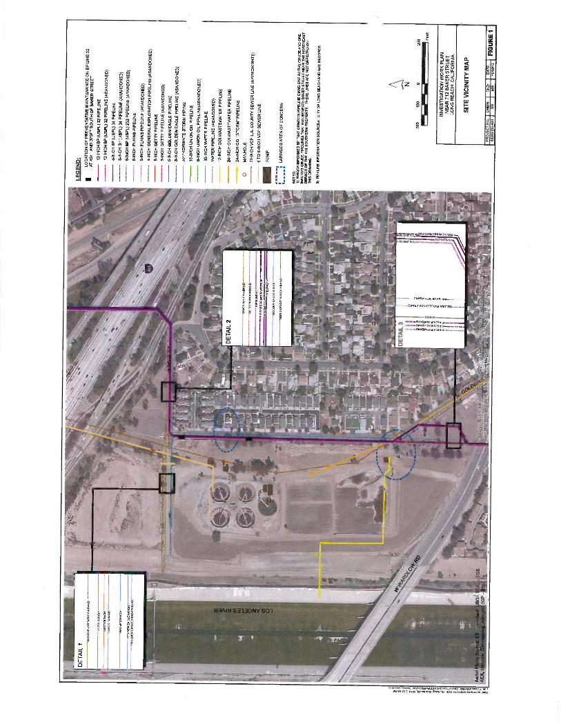
1.0 Introduction 1 -1
1.1 Site Background and Adjacent Surroundings 1 -1
1.2 Site Geology and Hydrogeology 1 -2
1.3 Site Pipelines 1 -2
2.0 Investigation Activities 2 -1
2.1 Forensic Data Evaluation - Phase 1 2 -1
2.2 Vertical Profile of Soil Vapor & Lithology - Phase 2 2 -2 2.2.1 Pre -field Activities 2 -2 2.2.2 Proposed Soil Boring and Soil Vapor Sampling at VES -A 2 -2 2.2.3 Health & Safety 2 -3
3.0 Reporting and Schedule 3 -1
4.0 References 4 -1
P: \BPBP - British Petroleum \Golden-Baker Investigetlon \Work Plan \FINAL - BP Golden Baker WP.doox July 2012

AECOM Investigation Work Plan Environment
List of Figures
Figure 1 Site Location Map
Figure 2 Proposed Soil Vapor Sampling and Soil Boring Location
List of Appendices
Appendix A LARWQCB Order (May 11, 2012)
Appendix B BP Pipeline Summary Letter (March 8, 2012)
Appendix C BP Line 32 SCAQMD 1166 Monitoring (November 2011)
PBPBP - Brifish Petroleum\Gclden -Baker Investigation \Work Plan\FINAL - BP Golden Baker WP tlocx July 2012

AECOM
1.0 Introduction
Investigation Work Plan Environment
On behalf of BP Pipelines (North America) Inc. ( "BP ") and the Atlantic Richfield Company ("ARC "), which manages remediation activities for BP, AECOM has prepared this Investigation Work Plan ( "Work Plan ") in response to the May 11, 2012 order from the Los Angeles Regional Water Quality Control Board (LARWQCB) to BP (the "Order "), attached in Appendix A. The purpose of the Work Plan is to investigate the source of potential impacts to soil and soil vapor along Golden Avenue between Baker Street and Wardlow Road (the "Site "), near BP Pipeline No. 32 ( "Line 32 "), in Long Beach, California (Figure 1, Site Location Map). The Site is located near 712 Baker Street in Long Beach, California. Oil Operators Incorporated ( "001 ") has been conducting environmental investigation and cleanup at its property located at 712 Baker Street, Long Beach, California. The 001 property covers about 20 acres and is bounded on the east by Golden Avenue. BP "Line 32" runs beneath Golden Avenue along the eastern boundary of the 001 property.
1 -1
According to the Order, "elevated gasoline type hydrocarbon contamination" was observed in soil and soil vapor during installation of vapor extraction well VES -A, which 001 was installing to mitigate a benzene soil vapor plume in this area. The extraction well was reported as being in proximity to an asphalt patch above BP -owned Line 32. Information reviewed to date does not support the assertion that Line 32 is a source of a release of "gasoline type hydrocarbons." BP has petitioned the State Water Resources Control Board to review the Order.
The Order identifies photoionization detector (PID) readings obtained from vapor extraction system well VES -A, which is located on the 001 property These PID readings are referenced as the basis for the LARWQCB conclusion of a Golden Avenue pipeline release of "gasoline type hydrocarbons" in the area. On June 1, 2012, ARC requested supporting raw laboratory analytical results and vapor sample chromatograms for VES-A and all 2011 data from 001, and has conducted preliminary reviews of these data in consultation with expert scientists since it was received on June 29, 2012. The preliminary evaluation of these data and other information received to date serve as the basis for the response actions proposed in this Work Plan.
The locations, history of use, and maintenance details for BP -owned pipelines in the vicinity of the Site were presented in a March 8, 2012 letter to the LARWQCB (Appendix B) and are further described in Section 1.3 and in the BP cover letter to this Work Plan.
1.1 Site Background and Adjacent Surroundings
The Site is generally comprised of the area surrounding Line 32 along Golden Avenue between Baker and Wardlow Streets. The Site is bounded by Baker Street and the 405 freeway to the north, residences to the east, Wardlow Road to the south, and the Oil Operators Inc., (001) property and the Los Angeles River to the west. The adjacent 001 facility treated oil brine and wastewater from oil production using clay lined evaporation basins beginning in 1926. The facility is now closed and many of the structures have been demolished. Numerous investigations and remedial activities have been conducted on the adjacent 001 property since 1981 (California Environmental, 2012).
P'.\BPBP - British Petroleum Golden -Baker Investigation \Work Plan \FINAL - BP Golden Baker WP.docx July 2012
AECOM Investigation Work Plan Environment
1.2 Site Geology and Hydrogeology
1 -2
Regionally, the Site is located within the West Coast sub -basin of the Los Angeles Basin. Commonly referred to as the "West Coast Basin," the Basin is an elongated northwest- trending coastal plain bounded on the north by the Ballona Escarpment, an abandoned erosional channel from the Los Angeles River, on the east by the Newport- Inglewood fault zone, and on the south and west by the Pacific Ocean and consolidated rocks of the Palos Verdes Hills (CDWR, 1961). The Cherry Hill Fault, part of the Newport- Inglewood Fault Zone, passes approximately one -quarter mile east of the Site, and reportedly disrupts regional hydrological flow patterns to the west -southwest (EMCON, 1981).
Geology underlying the Site consists of unconsolidated and semi -consolidated marine and alluvial deposits of the Lakewood Formation, which includes the Gage aquifer. Within the underlying San Pedro Formation are the Lynwood and Silverado water -bearing units. The Silverado aquifer, found more than 400 feet below mean sea level, produces 80 to 90 percent of groundwater extracted annually from the West Coast Basin (DWR, 1961).
According to 001 documents available on the GeoTracker Web site, depth to groundwater in the vicinity of the Site ranged between 30 and 65 feet below ground surface (bgs) over the last 30 years (Brycon, 2011; EMCON, 1981).
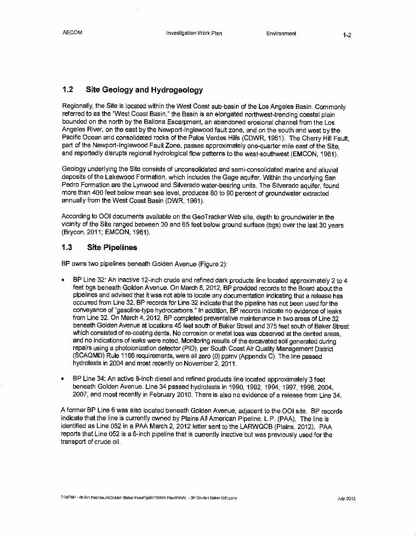
1.3 Site Pipelines
BP owns two pipelines beneath Golden Avenue (Figure 2):
BP Line 32: An inactive 12 -inch crude and refined dark products line located approximately 2 to 4 feet bgs beneath Golden Avenue. On March 8, 2012, BP provided records to the Board about the pipelines and advised that it was not able to locate any documentation indicating that a release has occurred from Line 32. BP records for Line 32 indicate that the pipeline has not been used for the conveyance of "gasoline -type hydrocarbons." In addition, BP records indicate no evidence of leaks from Line 32. On March 4, 2012, BP completed preventative maintenance in two areas of Line 32 beneath Golden Avenue at locations 45 feet south of Baker Street and 375 feet south of Baker Street which consisted of re- coating dents. No corrosion or metal loss was observed at the dented areas, and no indications of leaks were noted. Monitoring results of the excavated soil generated during repairs using a photoionization detector (PID), per South Coast Air Quality Management District (SCAQMD) Rule 1166 requirements, were all zero (0) ppmv (Appendix C). The line passed hydrotests in 2004 and most recently on November 2, 2011.
BP Line 34: An active 8 -inch diesel and refined products line located approximately 3 feet beneath Golden Avenue. Line 34 passed hydrotests in 1990, 1992, 1994, 1997, 1998, 2004, 2007, and most recently in February 2010. There is also no evidence of a release from Line 34.
A former BP Line 6 was also located beneath Golden Avenue, adjacent to the 001 site. BP records indicate that the line is currently owned by Plains All American Pipeline, L.P. (PAA). The line is identified as Line 052 in a PM March 2, 2012 letter sent to the LARWQCB (Plains, 2012). PM reports that Line 052 is a 6 -inch pipeline that is currently inactive but was previously used for the transport of crude oil.
P: \BPBP- British Petroleum \Golden -Baker Investigation \Work Plan \FINAL - BP Golden BakerWP.docx July 2012

AECOM Investigation Work Plan Environment 2 -1
2.0 Investigation Activities
Based on the need to evaluate existing data, and to avoid duplication of data, BP has developed a phased investigation approach that will provide information related to whether Line 32 could be associated with the total petroleum hydrocarbons as gasoline (TPHg) referenced in the Order. The assessment activities proposed by ARC are presented in the following subsections.
2.1 Forensic Data Evaluation - Phase 1
The Order requires that BP prepare and submit a Work Plan for soil and soil vapor investigations to assess and delineate the extent of contamination in soil and soil vapor, if any, attributable to Line 32. BP cannot reasonably determine the scope of necessary investigation activities without first completing an evaluation of chromatograms and other raw data associated with the findings referenced in the Order. The Order identifies PID readings, grey discoloration of sediments, and odors observed during 001's installation of VES -A, as the basis for the LARWQCB conclusion of a release of "gasoline type hydrocarbons" in the area. BP's initial review of these data (since receipt of the data on June 29, 2012) does not support this conclusion. Specifically, BP's findings to date include the following:
Interpretation of the TPH chromatograms suggests that a hydrocarbon source different from gasoline exists at VES -A and surrounding 001 sample locations. The VES -A samples and all of the soil gas samples showed characteristics not present in the gasoline calibration samples or the gasoline headspace sample.
Neither the VES -A samples nor the soil gas samples contained the triplet of ethylbenzene, m &p- xylene, and o- xylene expected in a gasoline source.
- Two soil gas samples (CESV2 -40' and CESV7 -33') very closely match VES -A. CESV2 is in the northern part of the 001 property, north of Baker Street and away from BP Line 32. CESV7 also lies on the 001 property, approximately 80 to 100 feet from the pipeline.
Several soil vapor samples on the 001 property resembled each other but not gasoline. These samples (CESV2, CESV7, CESV10, and CESV15) had similar compositions, characterized by the predominance of cyclic hydrocarbons, and the absence of iso- octane (a gasoline fingerprint).
Similarly, the VES -A vapor sample was predominantly cyclic hydrocarbons and iso -octane was absent.
The findings indicate that the samples collected by 001 are not gasoline and are not related to Line 32. To further establish whether the hydrocarbons observed during installation of VES -A could be potentially connected with known groundwater contamination from the 001 site or with a potential pipeline release, BP will request to obtain and then evaluate chromatograms and additional raw laboratory data of laboratory analyzed groundwater samples which were collected during recent groundwater monitoring activities by 001. If these data further support the conclusion that Line 32 is not the source of "gasoline type hydrocarbons," BP will submit a report of its findings; and Phase 2 (Section 2.2) will not be conducted.
P: \BPBP - British Petroleum \Golden -Baker Investigetlon \Work Plan \ FINAL - BP Golden Baker WP.dacx July 2012

AECOM Investigation Work Plan Environment
2.2 Vertical Profile of Soil Vapor & Lithology - Phase 2
2 -2
If Phase 2 of the proposed investigation is necessary, Phase 2 will include developing a vertical profile at the location adjacent to VES -A to verify the nature and vertical extent of soil vapor contaminants observed during installation of VES -A. Soil gas sampling with corresponding soil boring advancement will be conducted. In general, the soil gas samples will be collected every 2 to 5 feet bgs to 30 or more feet bgs.
2.2.1 Pre -field Activities
Prior to subsurface investigation activities, and in accordance with BP pre -drilling clearance protocols, the proposed borehole location will be cleared to ensure the safe advancement of a subsurface boring. At the soil vapor and boring location, the upper 4 feet will be cleared of utilities using hand - auger equipment. In accordance with BP's ground disturbance protocols, a variance will be required to discontinue clearance by hand auger at 4 feet rather than 6 feet, so that a high resolution profile can be developed closer to the depth of the pipelines. Underground Service Alert service will be used to mark and check all known underground utilities near the proposed location of the soil boring. Additionally, a third party locator, SubSurface Surveys, Inc. of Carlsbad, California, will be used to identify and mark subsurface structures /utilities detected near the location. Site access will be requested from 001, the owner of the property.
2.2.2 Proposed Soil Boring and Soil Vapor Sampling at VES -A
The proposed investigation includes a soil boring used for discrete depth soil vapor sampling advanced in proximity to 001's well VES -A on its southeast side between the well and the location of the pipeline repair on Line 32, if practicable (Figure 2). The final soil boring location will be selected following Site reconnaissance and utility clearance.
A truck -mounted direct push rig will be used to advance the soil boring and multi -depth soil vapor sampling will be conducted utilizing post run tubing (PRT). PRT involves inserting a disposable steel vapor tip to the desired depth, then pulling a vapor sample through tubing that runs down the center of the driving rod. Soil vapor samples will be collected at 2 -foot intervals between 4 and 16 feet bgs, and then at 5 -foot intervals from 20 feet bgs to the total depth. Total depth is anticipated at 30 feet bgs, but will be decided based on field observations.
Soil vapor samples will be analyzed by a mobile laboratory for the parameters listed below:
Fixed gases (02, CO2, and CH4) using the mobile laboratory or with a calibrated portable field meter, and TPH using EPA Method 8015M.
Following completion of the soil vapor sampling, a direct push soil boring will be advanced in proximity of the soil vapor borehole for lithological characterization. A truck -mounted direct push rig will be used to advance the soil boring. Continuous soil sampling will be conducted to an anticipated depth of 30 feet bgs. Field screening of soils for vapors will be conducted using a PID and the headspace technique. Soil will be logged by an AECOM geologist in accordance with the Unified Soil Classification System (USCS). Observations of the presence of hydrocarbon and soil moisture/ saturation will also be noted on the logs.
P:\BPBP - British Petroleum \Golden -Baker Investigation \Work Plan \FINAL - BP Golden Baker WP.docx July 2012
AECOM Investigation Work Plan Environment 2 -3
Solid waste derived from the soil borings will be contained in sealed 55- gallon drums; the solid waste will be tested and ultimately transported to an ARC -approved disposal facility.
A California- licensed surveyor will survey the northing and easting coordinates of each soil boring and soil vapor probe location and the elevation of the ground surface at each location.
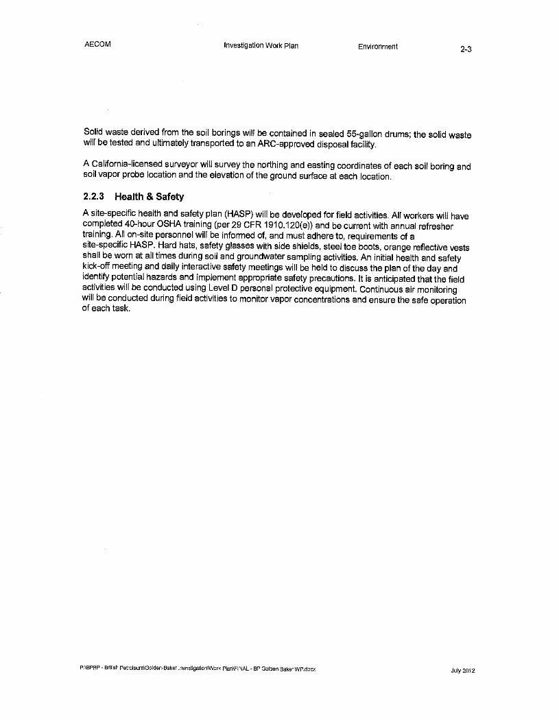
2.2.3 Health & Safety
A site -specific health and safety plan (HASP) will be developed for field activities. All workers will have completed 40 -hour OSHA training (per 29 CFR 1910.120(e)) and be current with annual refresher training. All on -site personnel will be informed of, and must adhere to, requirements of a site -specific HASP. Hard hats, safety glasses with side shields, steel toe boots, orange reflective vests shall be worn at all times during soil and groundwater sampling activities. An initial health and safety kick -off meeting and daily interactive safety meetings will be held to discuss the plan of the day and identify potential hazards and implement appropriate safety precautions. It is anticipated that the field activities will be conducted using Level D personal protective equipment. Continuous air monitoring will be conducted during field activities to monitor vapor concentrations and ensure the safe operation of each task.
P: \BPBP - British Petroleum \Golden -Baker Investigetlon\Wark Plan \FINAL -BP Golden Baker WP.docx July 2012

AECOM Investigation Work Plan Environment 3 -1
3.0 Reporting and Schedule
Phase I will be completed within 30 days of receipt of requested chromatograms and raw laboratory data from selected 001 groundwater monitoring wells. If Phase 2 work is required, BP will notify the LARWQCB 5 days in advance of implementing the proposed field work.
P'.\BPBP - British Petroleurn\Golden -Baker Investlgetlon\WOB Plan FINAL - BP Golden Baker WP.docx July 2012
AECOM
4.0 References
Investigation Work Plan Environment 4 -1
Brycon, 2011. Report on Additional Site Characterization Oil Operators, Inc. 712 Baker Street Long Beach, CA SCP Case No. 0093, SCPID No. 2044M00. Prepared for Oil Operators, Inc. September 30. Newport Beach, CA.
California Department of Water Resources (CDWR), 1961. Planned Utilization of the Groundwater Basins of the Coastal Plain of Los Angeles County, Appendix A - Groundwater Geology, CDWR Bulletin No. 104, p. 116.
California Environmental Geologists and Engineers, 2012. Email Correspondence from Mr. Charles I.
Buckley, P.G. (California Environmental) to Mr. Pinaki Guha -Niyogi (LARWQCB), Subject: 001 Update April 25.
EMCON, 1981. Hydrogeologic Investigation, Industrial Waste Transfer Station, Long Beach, California. Prepared for Chemical Waste Management, Inc. February 1981. San Jose, CA.
LARWQCB, 2012. Letter from Mr. Samuel Unger, P.E. (LARWQCB) to Ms. Donna Diracco (BP Pipelines), Subject: Requirement for Technical Report on Soil and Soil Vapor Investigations - Pursuant to California Water Code Section 13267 Order, May 11.
Plains, 2012. Letter from Mr. Jordan R. Janak (Plains West Coast Terminals LLC) to Mr. Pinaki Guha -Niyogi (LARWQCB), Subject: Technical Report on Pipeline Inventory (Order No. R4- 2010 -0010), March 2.
P'.\BPBP - British Petroleum \Goltlen -Baker Investigation\Work Plen \FINAL - BP Golden Baker W P,docx July 2012
AECOM Environment
Figures
P: \BPBP - British Petroleum \Goltlen -Baker Investigatlon\Wark Plan \FINAL - BP Golden Baker W P.tlocx July 2012
SCALE 1:24,000 o
1 MILE
GJ N
1000 0 1 h-i 1000 2000 3000 4000 5000 6000
.5 0 (--I I-i I-I
Portion of 7.5- minute Series (Topographic) Map United States Department of the Interior
Geological Survey Long Beach, California Quadrangle 1981
7000 FEET
1 KILOMETER
QUADRANGLE LOCATION
NORTH GOLDEN AVENUE
INVESTIGATION WORK PLAN INTERSECTION OF BAKER STREET AND
LONG BEACH, CALIFORNIA
A:WM
SITE LOCATION MAP 12345678 SM MW 5/31/12
PROJECT NO DRWN: CKD: DATE
FIGURE 1
LEG
EN
D:
o P
RO
PO
SE
D S
OIL
VA
PO
R S
AM
PLI
NG
AN
D S
OIL
BO
RIN
G L
OC
AT
ION
VA
PO
R E
XT
RA
CT
ION
SY
ST
EM
WE
LLA
LOC
AT
ION
OF
P
RE
VE
NT
AT
IVE
MA
INT
EN
AN
CE
ON
BP
LIN
E 3
2 A
T 45
FT
AN
O 3
75F
T S
OU
TH
OF
BA
KE
R S
TR
EE
T
a 15
0 75
0
150 F
eet
INV
ES
TIG
AT
ION
WO
RK
P
LAN
N
EA
R 7
12
BA
KE
R S
TR
EE
T
LON
G B
EA
CH
. C
ALI
FO
RN
IA
AZ
CO
M
PR
OP
OS
ED
SO
IL V
AP
OR
SA
MP
LIN
G
AN
D S
OIL
BO
RIN
G L
OC
AT
ION
PR
OJE
CT
NO
. D
RW
N
6026
8152
410
SM
I
CK
D
MW
G
AT
E
6 2
FIG
UR
E 2
AECOM Environment
Appendix A
LARWQCB Order (May 11, 2012)
PABPBP - British Petroleum Golden-Baker Investigation \Work Plen \FINAL - BP Golden Baker WP.docx July 2012

rutP:ausigo" Water Boards
Los Angeles Regional Water Quality Control Board
May 11 2012
1,1
Ms. Donna DiRocco BP Pipelines (North America) Inc. /Atlantic Richfield Company CERTIFIED MAIL 1300 Pier B Street RETURN RECEIPT REQUESTED Long Beach, CA 90813 7001 2510 0002 2221 6115
SUBJECT: REQUIREMENT FOR TECHNICAL REPORT ON SOIL AND SOIL, VAPOR INVESTIGATIONS - PURSUANT TO CALIFORNIA WATER CODE SECTION 13267 ORDER
SITE /CASE: NEAR 712 BAKER STREET, LONG BEACH, CALIFORNIA
Dear Ms. DiRocco:
The California Regional Water Quality Control Board, Los Angeles Region (Regional Board) is the public agency with primary responsibility for the protection of groundwater and surface water quality for all beneficial uses within major portions of Los Angeles and Ventura counties, including the referenced Site. To accomplish this, the Regional Board oversees the investigation and cleanup of discharges of waste adversely affecting the State's water, authorized by the Porter -Cologne Water Quality Control Act (California Water Code [CWC], Division 7).
Under the oversight of this Regional Board and the Long Beach Health and Human Services Department, Oil Operators Incorporated (001) has been conducting environmental investigation and cleanup at its property located at 712 Baker Street, Long Beach. The 00I property covers approximately 20 -acres and is located south of the 405 Freeway, east of the 710 Freeway and the Los Angeles River, in the City of Long Beach. It is bounded on the south by Wardlow Road and on the east by Golden Avenue. A residential development is present to the east of the property, across Golden Avenue.
The Regional Board has evidence from recent site assessment activities conducted in the vicinity of the subject location that indicates that there is or has been a discharge of waste from a pipeline that runs beneath the western portion of Golden Avenue, outside the eastern perimeter of the 001 property (Line 32). BP Pipelines (North America) Inc. /Atlantic Richfield Company (BP) owns and operates this crude and refined products pipeline.
In order to determine the impact to soil resulting from the pipeline release, and to protect human health and the waters of the state for their beneficial uses, a work plan for soil and soil vapor investigations on both sides of Line 32 along Golden Avenue is required.
Enclosed is a Regional Board Order requiring, pursuant to section 13267 of the CWC, that you provide this Regional Board with a work plan for soil and soil vapor investigations on both sides of Line 32, along Golden Avenue, to determine the extent of wastes in soil in the vapor and adsorbed phases.
tinM,,« Uh'+JEA nXvU'IYC Orl CR
let, Wanl Air it 5..w:11A lG1a A-,pwlaö rA cIOL'1 «wa 4+s,o,n10r011 C+ r¡I,y»,.,IN,aalpv
ö

Ms. Donna DiRocco May 11, 2012 BP Pipelines (North America) Inc. /Atlantic Richfield Company
Should you have any questions, please contact Mr. Pinaki R. Guha- Niyogi, of my staff at (213) 576- 6731 (mu ha(Fewaterboards.ca.2ov).
Sincerely,
t
rf/ Samuel Umger, P.E. Executive Officer
n rr 1
Attachment: Requirement to Provide Technical Report
cc: Councilman James Johnson, City of Long Beach Ms. Nelson Kerr, City of Long Beach, Health and Human Services Department Ms. Carmen Piro, City of Long Beach, Health and Human Services Department Ms. Tracy Barreau, California Department of Public Health Ms. Marylyn C. Underwood, California Department of Public Health Ms. Joan Greenwood, Wrigley Area Neighborhood Alliance Mr. Kevin Laney, Oil Operators, Inc. Mr. George B. Paspalof, Brycon LLC Mr. Bob Sinclair, Plaines Pipeline

J. 11 Y
. .-.L..
cat-..w..r. Mlt.-rv r. Nt...c-,
. .... Water Boards
Los Angeles Regional Water Quality Control Board
REQUIREMENT TO PROVIDE A TECHNICAL REPORT ON SOIL AND SOIL VAPOR INVESTIGATIONS
CALIFORNIA WATER CODE SECTION 13267 ORDER NO. R4- 2012 -0085
DIRECTED TO BP PIPELINES (NORTH AMERICA) INC. /ATLANTIC RICHFIELD COMPANY
SOIL AND SOIL VAPOR INVESTIGATIONS IN THE VICINITY OF GOLDEN AVENUE AND BAKER STREET
LONG BEACH, CALIFORNIA
The California Regional Water Quality Control Board, Los Angeles Region (Regional Board) makes the following findings and issues this Order pursuant to California Water Code section 13267.
1. Under the oversight of this Regional Board and the Long Beach Health and Human Services Department, Oil Operators Incorporated (00I) has been conducting environmental investigations and cleanup at its property, located at 712 Baker Street, Long Beach. The 001 property covers approximately 20 acres and is located south of the 405 Freeway, east of the 710 Freeway and the Los Angeles River, in the City of Long Beach. It is bounded on the south by Wardlow Road and on the east by Golden Avenue. A residential development is present to the east of the property, across Golden Avenue.
2. California Water Code section 13267(b) states, in part: In conducting an investigation..., the regional board may require that any person who has discharged, discharges, or is suspected of having discharged or, discharging, or who proposes to discharge waste within its region ...shall furnish, under penalty of perjury, technical or monitoring program reports which the regional board requires. The burden, including costs, of these reports shall bear a reasonable relationship to the need for the report and the benefits to be obtained from the reports. In requiring those reports, the regional board shall provide the person with a written explanation with regard to the need for the reports, and shall identify the evidence that supports requiring that person to provide the reports.
3. The Regional Board has evidence from recent site assessment activities conducted in the vicinity of the subject location by California Environmental that indicates that there is or has been a discharge of waste from a pipeline that runs beneath the western portion of Golden Avenue, outside the eastern perimeter of the 00I property (Line 32). BP Pipelines (North America) Inc. /Atlantic Richfield Company (BP) owns and operates this crude and refined products pipeline. The evidence supporting this requirement includes data provided by Charles Buckley of California Environmental on April 25, 2012, that elevated gasoline type hydrocarbon contamination was observed in soil vapor and soil during installation of vapor extraction well A. Vapor extraction well A was installed along with four other vapor extraction wells (B, C, D & E)
. `,M! - C..1r,lli I sAt1'1L Ut\uttt, C1CCf't'G Ji: ':JIt
!tíu t/y.4ry1 tltY !11 tttt tall dtlft t LV 4,Npeta2 CA tlíuu, 4WHJ4 y.Alptti{iP,Mtr áY WM t.Vlll IUItF.
..
Ms. Donna DiRocco 13P Pipelines (North America) Ine. Atlantic Richfield Company
2_ May I I, 2012
to mitigate the benzene soil vapor plume, present beneath the northern portions of the 001 site, beneath portions of Golden Avenue and beneath some residential homes on the east side of Golden Avenue, Very, ;strong gasoline -type odors and grey discoloration was observed in the sediments in well A, from a depth of B feet to 28 feet below grade. Photo Ionization Detector (Pall) readings taken during installation of well A ranged from 500- 2000 parts per million parts by volume (ppmv). High concentrations of Total Petroleum Hydrocarbon as gasoline (TPi:=I -g) were found in sod vapor extracted from well A ( >18,000 ppmv via PID). Well A is in close proximity to an asphalt patch present directly above Line 32, on the west side of Golden Avenue. Review of building permit records at the City of Long. Beach revealed that BP applied for a Discretionary Permit on September 19, 2011, to excavate at two locations on Golden Avenue along Line 32, in order to expose the piping at these two locations and perform necessary repairs to maintain the integrity of Line 32, The location of the northern excavation, indicated in the permit, matched the asphalt patched area near well A, confirming that a potential release occurred in the pipeline that caused the soil discoloration resulting in high PID readings.
4. This Order identifies BP Pipelines (North America) Inc (Atlantic Richfield Company as the entity suspected of being responsible for the discharges of waste identified in paragraph 3, because it owns or operates pipelines in the vicinity of Golden Avenue.
5. This Order requires the persons named herein to prepare and submit a work plan for soil and soil vapor investigations on both sides of Line 32 along Golden Avenue to determine the impact to soil resulting from the pipeline release:
6. The burdens, including Costs, of these reports bear a reasonable relationship to the need for the reports and the benefits to be obtained from the reports. The information is necessary to determine the extent of waste detected in the soil beneath Golden Avenue in Long Beach, and to protect human health and the waters of the state.
7. The issuance of this Order is an enforcement action by ,a regulatory agency and is categorically exempt from the provisions of the California Environmental Quality Act (CEQA) pursuant to section 15321(a)(2), Chapter 3, 'Title 14 of the California Code of Regulations This Order requires submittal of and /or momtorïng reports that will not have adverse impacts on the environment. If the implementation results in significant impacts to the environment, the appropriate lead agency will address the CEQA requirements prior to implementing any work.
8. Any person aggrieved by this action of the Regional Water Board may petition the State Water Resources Control Board (State Water Board) to review the action in accordance with Water Code section 13320 and California Code of Regulations, title 23, sections 2050 and following. The State. Water Board must receive the petition by 5.00 p.m., 30 days after the date of this Order, except that if the thirtieth day following the date of this Order falls on a Saturday,. Sunday, or state holiday, the petition must be received by the State Water Board by 5 00 p.m. on the next business day. Copies of the law and regulations applicable to filing petitions may be found on the Internet at birp: / /www.watethoards,ca.eov /public ,polices /petitions /wateLlualin, or will be provided upon request.
THEREFORE, IT TS HEREBY ORDERED that BP Pipelines (North America) Inc. /Atlantic Richfield Company, pursuant to section 13267(b) of the California Water Code, is required to submit the following
Ms. Donna Dikocco -3 - May 11, 2012 BP PiPelines (North America) Inc. Atlantic Richfield: Company
L. By June 11, 2012, prepare and submit a work plan for a soil (soil vapor and soil matrirt) investigation to assess and delineate the lateral and vertical extent of contamination in the vapor and adsorbed phase, on both sides of Line 32 along Golden Avenue,
Item 1 "shall be sent via electronic mail to;
Mr. Pinaki Guha- Nayogi Case Manager California Regional Water Quality Control Board -Los Angeles Region 320 W. 4th Street, Los Angeles, CA 90013 213- 576.6731 pgulig ®wateriroards ca gov
The technical repdtt is required to be submitted under the CWC section 13267 Order. Pursuant to' 13267(a) of the CWC, any person who fails to submit reports in accordance with the Order is guilty of a misdemeanor; Pursuant to section 13268(b) of the 'CWC, failure to submit the te.qúued technical rep*rt desciibed above by the specified due date(S) may result in the imposition of administrative civil liability by the Regional Board in an amount up to one thousand drillers ($1,000) per day for each day the technical report is inot received after the above due date These civil liabilities may be assessed by the Regional Board for failure to comply, beginning with the date that the violations first occurred, and Without further waning,
The Regional Board, under the authority given by California Water Code '(CWC) section 13267, subdivision ,(b), requires you td include a perjury :statement in all reports submitted under the 13267 Order. The perjury statement shall be signed by a senior authorized BP Pipelines (North America) Inc,(_Atlentic Richfield Company representative (riot by a consultant) The perjutÿ statement shall be in the föllowing format:
[JQ4]a f, certtfl under penalty of law that this document and all attachments were prepared':by ins, or under my direction or supervis`tan, in accordance with a systerii designed to tissue that qualifrerj personnel properly gathered and evaluated the information submitted. Based on my inquiry of the person or persons who manage the syftenr, or thus? persons dewily responsible for gathering the information, the information submitted is, to the hest of my , nowledge and belief true, accurate, and complete, I am aware that there are slgrrifrcant penalties for submitting f alce information, including the posstbtllty of fine and imprisonment fir knowing violations,"
The, State Water Resources Control Board (State Wate, Board) adopted regulations requiring the electronic submittals of information over The Internet using the State Water Board GeoTracker data management system. You are required not only to submit electronic copy reports required in tins Order, but also to comply .by uploading all reports and correspondence prepared to date on to the GeoTraçker data management system. The text of the regulations can be found at the 'tiRL,

Ms. Donna DiRocco 4 May 11, 2012 BP Pipelines (North America) Inc. Atlantic Richfield Company
http:// www. waterboards. ca. gov/ water_ issues / programs /ust/electron ic_submittal
SO ORDERED.
íJ
/I, Samuel Uriger, P.E. Executive Officer
May 11, 2012

AECOM Environment
Appendix B
BP Pipeline Summary Letter (March 8, 2012)
Pn8PBP - British Petraleum \Golden -Baker Investigetton \Work Plan \FINAL - BP Golden Baker WP,docx July 2012
March 8, 2012
BP Pipelines (North America) Ince
5905 Paramount Blvd. Long Beach, CA 90805 Phone 562 728 -2265 Fax 562 72.8 -2760
Mr. Samuel Unger, P.E. Executive Officer California Regional Water Quality Control Board Los Angeles Region 320 W. 41h Street, Suite 200 Los Angeles, CA 90013
Subject: Transmittal of Technical Report on Pipeline Inventory Requirement for Technical Report - Pursuant to California Water Code Section 13267 Order No R4 -2012 -0009
Site /Case: Near 712 Baker Street Long Beach, California
Dear Mr. Unger:
BP Pipelines (North America) Inc. ( "BP ") is in receipt of the subject Regional Water Quality Control Board ( "LARWQCB ") Order, dated January 13, 2012. The Order stems from the detection of volatile organic compounds (VOCs) and/ or petroleum hydrocarbons associated with environmental investigations conducted by others at the former Oil Operators Incorporated (001) site located at 712 Baker Street, in Long Beach, California. According to Geotracker, the 001 site operated from 1926 to approximately 1998 as treatment facility for water and other fluids recovered during oil production. Reportedly oil and sediment was removed from the water, allowing the treated water to be disposed of offsite. Low -grade oil that was recovered in the process was reportedly sent elsewhere for recycling. Environmental investigations have been ongoing at the 001 site since the early 1980s.
The Order states that subsurface investigations conducted by 001 have discovered concentrations of light -end total petroleum hydrocarbons (TPH; 05 -C11), benzene, and 1,2- dichloroethane (1,2 -DCA) along Golden Avenue, which the Order alleges is where BP owns and operates a pipeline. The Order requires BP to submit an inventory of all pipelines ever owned or operated that are located within one mile of the intersection of Baker Street and Golden Avenue in Long Beach, California. The Order also requires BP to submit a number of specific pieces of information for each pipeline and a scaled map clearly identifying the location of each pipeline. BP understands that a similar Order was issued to Plains Pipelines, which is also alleged to have one or more pipelines in this area.
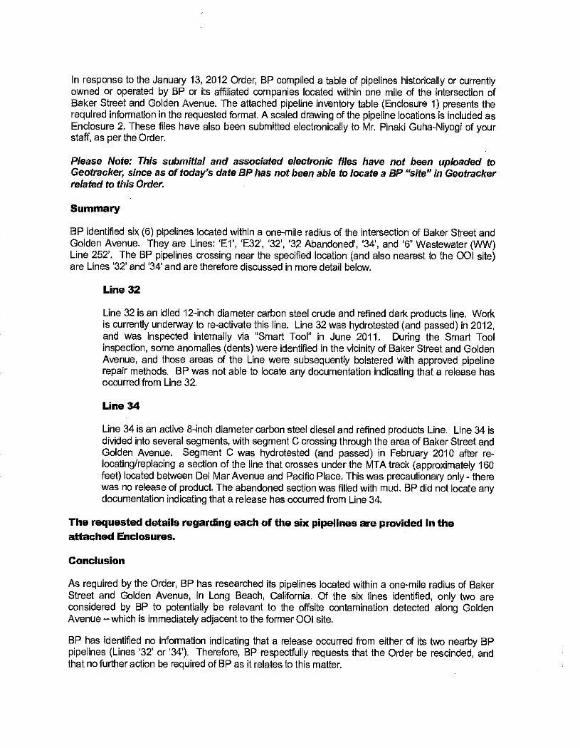
In response to the January 13, 2012 Order, BP compiled a table of pipelines historically or currently owned or operated by BP or its affiliated companies located within one mile of the intersection of Baker Street and Golden Avenue. The attached pipeline inventory table (Enclosure 1) presents the required information in the requested format. A scaled drawing of the pipeline locations is included as Enclosure 2. These files have also been submitted electronically to Mr. Pinaki Guha -Niyogi of your staff, as per the Order.
Please Note: This submittal and associated electronic files have not been uploaded to Geotracker, since as of today's date BP has not been able to locate a BP "site" in Geotracker related to this Order.
Summary
BP identified six (6) pipelines located within a one -mile radius of the intersection of Baker Street and Golden Avenue. They are Lines: 'El', 'E32', '32', '32 Abandoned', '34', and '6" Wastewater (WW) Line 252'. The BP pipelines crossing near the specified location (and also nearest to the 001 site) are Lines '32' and '34' and are therefore discussed in more detail below.
Line 32
Line 32 is an idled 12 -inch diameter carbon steel crude and refined dark products line. Work is currently underway to re- activate this line. Line 32 was hydrotested (and passed) in 2012, and was Inspected internally via "Smart Tool" in June 2011. During the Smart Tool inspection, some anomalies (dents) were identified in the vicinity of Baker Street and Golden Avenue, and those areas of the Line were subsequently bolstered with approved pipeline repair methods. BP was not able to locate any documentation indicating that a release has occurred from Line 32.
Line 34
Line 34 is an active 8 -inch diameter carbon steel diesel and refined products Line. Line 34 is divided into several segments, with segment C crossing through the area of Baker Street and Golden Avenue. Segment C was hydrotested (and passed) in February 2010 after re- locating /replacing a section of the line that crosses under the MTA track (approximately 160 feet) located between Del Mar Avenue and Pacific Place. This was precautionary only - there was no release of product. The abandoned section was filled with mud. BP did not locate any documentation indicating that a release has occurred from Line 34.
The requested details regarding each of the six pipelines are provided in the attached Enclosures.
Conclusion
As required by the Order, BP has researched its pipelines located within a one -mile radius of Baker Street and Golden Avenue, in Long Beach, California. Of the six lines identified, only two are considered by BP to potentially be relevant to the offsite contamination detected along Golden Avenue - which is immediately adjacent to the former 001 site.
BP has identified no information indicating that a release occurred from either of its two nearby BP pipelines (Lines '32' or '34'). Therefore, BP respectfully requests that the Order be rescinded, and that no further action be required of BP as it relates to this matter.

Perjury Statement:
I, Erika Harding, certify under penalty of law that this document and all attachments were prepared by me, or under my direct supervision, in accordance with a system designed to assure that qualified personnel properly gathered and evaluated the information submitted. Based on my inquiry of the person or persons who manage the system, or those persons directly responsible for gathering the information, the information submitted is, to the best of my knowledge and belief, true, accurate, and complete. I am aware that there are significant penalties for submitting false information, including the possibility of fine and imprisonment for knowing violations.
If you have any questions regarding the submitted information, please feel free to contact Mr. Steve Comley of BP at (562) 728 -2265,
Sincerely, BP Pipelines (North America) Inc.
Erika Harding Pipeline Operations Manager
Enclosures: Enclosure 1:
Enclosure 2:
Pipeline inventory Pipelines location map
cc: Councilman James Johnson, City of Long Beach Mr. Pinaki R. Guha -Niyogi, LARWQCB Ms. Tracy Barreau, California Department of Public Health Ms. Joan Greenwood, Wrigley Area Neighborhood Alliance Mr. George B. Paspalof, Brycon LLC Ms, Carmen Piro, City of Long Beach, Health and Human Services Department Mr. Bob Sinclair, Plaines Pipeline Ms. Marylyn C, Underwood, California Department of Public Health Mr, Steve Comley, BP Pipelines (North America) Inc. Mr. John Skance, BP Remediation Management
)
r !!
Ì=
600
0
1200
1
" =
1200
'
Sou
rce:
G
oogl
e E
arth
, Im
age
Dat
e 03
/07/
11
BP
PIP
ELI
NE
S (
NO
RT
H A
ME
RIC
A),
IN
C.
PIP
ELI
NE
S H
IST
OR
ICA
LLY
OR
CU
RR
EN
TLY
O
WN
ED
BY
BP
O
R I
TS
AF
FIL
IAT
ED
CO
MP
AN
IES
W
ITH
IN A
ON
E -
MIL
E R
AD
IUS
OF
TH
E
INT
ER
SE
CT
ION
OF
B
AK
ER
ST
. A
ND
N.
GO
LDE
N A
VE
. ca
er:,.
c,
cD.
DA
TE
J.]5
2ó
10
E.S
.S.r
DE
N
D.M
. (L
B
01,0
9!12
F
IGU
RE
1
March 02, 2012
PLAINS West Coast Terminals LLC
Mr. Pinaki Guha -Niyogi,
Case Manager
California Regional Water Quality Control Board - Los Angeles Region 320 W. 4th Street, Suite 200,
Los Angeles, CA 90013
RE: TECHNICAL REPORT ON PIPEPLINE INVENTORY (Order No. R4- 2010 -0010)
Dear Mr. Guha -Niyogi:
This technical report on pipelines operated by Plains All American Pipeline, L.P. (FAA) and its affiliates has been prepared to meet the requirements of the California Regional Water Quality Control Board (Regional Board) Clean Water Code (CWC) Order, Order No. R4- 2010 -0010. Copy attached.
This order has been issued because "... The Regional Board has evidence from recent site assessment activities conducted at the vicinity of the subject location that indicate that there is or has been a
discharge of waste from the site [712 Baker Street, Long Beach]. The evidence supporting this requirement is that elevated volatile organic and /or petroleum compounds in soil vapor and groundwater have been identified, mainly along the Golden Avenue where Plains All American Pipeline, L.P., allegedly, owns and operates a pipeline. The detected contaminants in the soil vapor include total petroleum hydrocarbons or TPH (C5 -C11) and benzene, among others, in concentrations up to 55,000 micrograms per liter (leg /l) and 390 Ng /l, respectively. The elevated contaminants in groundwater appear to coincide with the soil vapor plume, including benzene and 1,2- dichloroethane (l,2 -DCA) in concentrations up to 1,700 and 13 pg /l (as of September 1, 2011), respectivelly..This Order identifies Plains All American Pipeline, L, P. as the entity suspected of being responsible for the discharges of waste identified in paragraph 3, because you own or operate pipelines within the vicinity of Golden A venue."
Plains identified 7 line segments within the one -mile radius CWC Order investigation area. The line
segments are 8H, 52E, 63V, 93N, 93G, 514A, and 515A. To our knowledge all line segments have historically only been in crude oil service, and the active ones continue to remain only in crude oil
service. This is in contrast to what, based on the site contamination observed, appears to be the source of the contamination at the subject site -a refined fuel, such as gasoline.
Of the 7 line segments only segment, 52E, is in the immediate vicinity of the investigation location. A
review of the status of the line shows it to have been purged and out of service (005) for at least the
last 12 years. The line was never operated by PM or the immediate previous owner, Pacific Pipeline
System, LLC. However, PAA continues to maintain cathodic protection & conduct annual surveys on
the line, and also routinely rides the line to monitor the activities & area around the pipeline. To the best of our knowledge there has been no evidence of a leak or a failure of this line.
All the remaining (active) lines continue to be periodically evaluated as part of the PAA integrity management program, with none having failed any integrity testing.
Attached please find the pertinent records requested by this order, including a tabular pipeline inventory of the lines within a one -mile radius of the subject location with the following information: PLAINS PIPELINE RWQCB Technical Report - Pipeline Inventory Response Baker -Golden Streets 03- 02- 12.doc
5900 Cherry Avenue Long Beach, CA 90805 -4408 (562) 728 -2800 FAX (562) 728 -2860

Mr. Pinaki Guha- Niyogl
Case Manager CRWQCB - LA Region
March 02, 2012
Page - 2 -
a) ID No.
b) Owner ID (name or Identification number used by the pipeline owner) c) Current Owner (name of company currently owning the pipeline) d) Ownership History (list of all companies that ever owned the pipeline with years of ownership
noted parenthetically) e) Size (pipeline diameter in inches)
f) Material (material used for construction of pipeline - e.g., steel) g) Product" (list of all products eve r transported through the pipeline with years of transport for
each product noted parenthetically) h) Oxygenates (list of all fuel oxygenates ever transported through the pipeline with years of
transport for each oxygenate noted parenthetically) i) Status (active or inactive) j) Integrity Test Failures) (indicate "yes" or "no" 10 indicate if the pipe line has failed any integrity
tests within one mile of the Dominguez Channel and Carson Street) k) Contact (name, company name, address, telephone number. and a -mall address for the
pipeline contact) I) Notes (any other relevant Information regarding the pipeline) m) Source (source(s) of information describing the pipeline)
"I, Jordan Janak, certify under penalty of law that this document and all attachments were prepared by me, or under my direction or supervision, in accordance with a system designed to assure that qualified personnel property gathered and evaluated the information submitted. Based on my inquiry of the person or persons who manage the system, or those persons directly responsible for gathering the information, the information submitted is; to the best of my knowledge and belief, true, accurate, and complete. I am aware that there are significant penalties for submitting false information, including the possibility affine and imprisonment for knowing violations."
If you have any questions, or need additional information, please contact Ngiabi Gicuhi of my staff at (562) 728 -2024 or neicuhi e eaale.com.
Sincerely,
Jordan R. Janak Sen or Director,
E rronmental & Regulatory Compliance Plains All American Pipeline, L.P.
PLAINS PIPELINE RWQCB Technical Report - Pipeline Inventory Response Beker.Golden Sheets O2.28.12.doc
Pacific Energy Group LLC, Sole Member 5900 Cherry Avenue Long Beach, CA 90805 -4408 (562) 728.2800 FAX (562) 728 -2860

ATTACHMENTS:
CALIFORNIA REGIONAL WATER QUALITY CONTROL BOARD CWC 13267 ORDER
ORDER NO. R4- 2012 -0010
California Regional Water Quality Control Board Los Angeles Region
NMI 320 West Fourth Street, Suite 200, Los Angeles, California 90013 (213) 576 76600 FAX (213) 5766640
Matthew Rodriguez http9( www .waterboerds.ca.govllosangeles
Secretary jor Environmental Protection
January 13, 2012
Edmund G. Brown Jr. Governor
Mr. Richard Hartig Plains All American Pipeline, L.P. 5900 Cherry Avenue Long Beach, CA 90623
SUBJECT: REQUIRENEENT FOR TECHNICAL REPORT ON PIPELINE INVENTORY - PURSUANT TO CALIFORNIA WATER CODE SECTION 13267 ORDER NO. R4- 2012 -0010
SITE /CASE: NEAR 712 BAKER STREET, LONG BEACH, CALIFORNIA
Dear Mr. Hartig:
The California Regional Water Quality Control Board, Los Angeles Region (Regional Board) is the public agency with primary responsibility for the protection. of groundwater and surface water quality for all beneficial uses within major portions of Los Angeles and Ventura counties, including the referenced Site. Tó accomplish this, the Regional Board oversees the investigation and cleanup of discharges of waste adversely affecting the State's water, authorized by the Porter -Cologne Water Quality Control Act (California Water Code [CWC], Division 7).
Under the oversight' of this Regional Board and the Long Beach Health and Human Services Department, Oil Operators Incorporated (001) has been conducting environmental investigation and cleanup at its property located at 712 Baker Street, Long Beach. The COI property covers approximately 20'acres and is located south of the 405 Freeway, east of the 710 Freeway and the Los Angeles River, in. the City of Long Beach. It is bounded on the south by Wardlow Road and on the east by Golden Avenue. A residential development is present to the east of the property; across Golden Avenue.
Recent site assessment activities conducted at the vicinity of the subject location reveal elevated volatile organic and /or petroleum compounds in soil vapor and groundwater, mainly along Golden Avenue where your company, allegedly, owns and operate a pipeline. The detected contaminants in the soil vapor include total petroleum hydrocarbons or TPH (C5 -C11) and benzene, among others, in concentrations up to 55,000 micrograms per liter (µg/1) and 390 sg/l, respectively. The elevated contaminants in groundwater appear to coincide with the soil vapor plume, including benzene and 1,2- dichloroethane (1,2- DCA) in concentrations up to 1,700 and 13 gg/i, respectively.
In order to 'determine the source of the detected contaminants and to protect human health and the waters of the state for their beneficial uses, an inventory of pipelines and the layout locations is needed in the vicinity of Golden Avenue.
California Environmental Protection Agency
QRecycled Paper
Mr. Richard Hartig - 2 - January 13, 2012 Plains All American Pipeline, L.P.
Enclosed is a:Regional Board Order No. R4- 2012 -0010 requiring, pursuant to section 13267 of the CWC, that you provide this Regional Board with information regarding pipelines operated by your company or any affiliated companies for which you may have access to records in the vicinity of the Site.
Should you have any questions, please contact Mr. Pinaki R. Guha -Niyogi, of my staff at (213) 576- 6731 (pguha @waterboards.ca.gov).
Sincerely,
Samuel Uñgef, P.E. Executive Officer
cc: Councilman James Johnson, City of Long Beach Ms. Tracy Barreau, California Department of Public Health Ms. Donna DiRocco, BP Pipelines (North America) bic. /Atlantic Richfield Company Ms. Joan Greenwood, Wrigley Area Neighborhood Alliance Mr. George B. Paspalof, Brycon LLC Ms. Carmen Piro, City of Long Beach, Health and Human Services Department Ms. Marylyn C. Underwood, California Department of Public Health
California Environmental Protection Agency
gd Recycled Paper
Matthew Rodriguez Secretary for
Environmental Protection
California Regional Water Quality Control Board Los Angeles Region
320 West Fourth Street, Suite 200, Los Angeles, California 90013 (213) 576 -6600 FAX,(213) 576 -6640
http:// www .waterboards.cagovllosangeles
REQUIREMENT TO PROVIDE A TECHNICAL REPORT ON PIPELINE INVENTORY
CALIFORNIA WATER CODE SECTION 13267 ORDER NO. R4 -2010 -0010
DIRECTED TO PLAINS ALL AMERICAN PIPELINE, L.P.
PIPELINES IN THE VICINITY OF GOLDEN AVENUE AND BAKER STREET LONG BEACH, CALIFORNIA,
Edmund G. Brown Sr. Governor
The Regional Water Quality Control Board, Los Angeles Region (Regional Board) makes the following findings and issues this Order pursuant to California Water Codesection 13267.
1. Under the oversight of this Regional Board and the Long Beach Health and Human Services Department, Oil Operators Incorporated (OOI) has been conducting environmental investigation and cleanup at its property located at 712 Baker Street, Long Beach. The 001 property covers approximately 20 acres and is located south of the 405 Freeway, east of the 710 Freeway and the Los Angeles River, in the City of Long Beach. It is bounded on the south by Wardlow Road and on the east by Golden Avenue. A residential development is present to the east of the property, across Golden Avenue.
2. California Water Code section 13267(b) states, in part: In conducting an investigation..., the regional board may require that any person who has discharged, discharges, or is suspected of .
having discharged or; discharging, or who proposes to discharge waste within its region ...shall furnish, under penalty of perjury, technical or monitoring program reports which the regional board requires. The burden,'inclading costs, of these reports shall bear a reasonable relationship to the need for the report and the benefits to be obtained from the repens. In requiring those reports, the regional boatel shall provide the person with a written explanation with regard to the need for the reports, and shall identify the evidence that supports requiring that person to provide the reports.
3. The Regionál Board has evidence from recent site assessment activities conducted at the vicinity of the subject location that indicate that there is or has been a discharge of waste from the site. The evidence supporting this requirement is that elevated volatile organic and /or petroleum compounds in soil vapor and groundwater have been identified, mainly along the Golden Avenue where Plains All American Pipeline, L.P., allegedly, owns and operates a pipeline. The detected contaminants in the soil vapor include total petroleum hydrocarbons or TPH (C5 -C11) and benzene, among others, in concentrations up to 55,000 micrograms per liter (mg /1) and 390 mg/1, respectively. The elevated contaminants in groundwater appear to coincide with the soil vapor
California Environmental Protection Agency
p`a Recycled Paper
Mr. Richard Hartig Plains All American Pipeline, L.P.
- 2 - January 13, 2012
plume, including benzene and 1,2- dichloroethane (1,2 -DCA) in concentrations up to 1,700 and 13
mg /1 (as of September 1, 201 t), respectively.
4. This Order identifies Plains All American Pipeline, L.P. as the entity suspected of being responsible for the discharges of waste identified in paragraph 3, because you own or operate pipelines within the vicinity of Golden Avenue.
5. This Order requires the persons named herein to prepare and submit technical and /or monitoring reports to identify locations of the pipelines.
6. The burdens, including costs, of these reports bear a reasonable relationship to the need for the reports and the benefits to be obtained from the reports. The information is necessary to identify the sources of waste detected in the soil and groundwater beneath the Golden Avenue, Long Beach and to protect human health and the waters of the state.
7. The issuance of this Order is an enforcement action by a regulatory agency and is categorically exempt from the provisions of the California Environmental Quality Act (CEQA) pursuant to section 15321(a)(2), Chapter 3, Title 14 of the' California Code of Regulations. This Order requires submittal of technical and /or monitoring reports that will not have adverse impacts on the environment.
8. Any person aggrieved by this action of the Regional Water Board may petition the State Water Resources Control Board (State Water Board) to review the action in accordance with Water Code section 13320 and California Code of Regulations, title 23, sections 2050 and following. The State Water Board must receive the petition by 5:00 p.m., 30 days after the date of this Order, except that if the thirtieth day following the date of this Order falls on a Saturday, Sunday, or state holiday, the petition must be received by the State Water Board by 5:00 p.m. on the next business day. Copies of the law and regulations applicable to filing petitions'may be found on the Internet at: http :/ /www.waterboards.ca.gov /public notices /petitions /water quality or will be provided upon request.
THEREFORE, IT IS HEREBY ORDERED that Plains All American Pipeline, L.P., pursuant to section 13267(b) of the California Water Code, is required to submit the following:
1. By March 6, 2012, an inventory of all pipelines ever owned or operated by your company or any affiliated company that you are able to reasonably obtain records from that are located within one mile of the intersection of Baker Street and Golden Avenue in Long Beach, California. The inventory shall be in tabular format containing the following columns:
a. ID No. (sequentially from 1: e.g., 1, 2, 3, ...) b. Owner ID (name or identification number used by the pipeline owner) c. Current Owner (naine of company currently owning the pipeline) d. Ownership History (list of all companies that ever owned the pipeline with -years of
ownership noted parenthetically) e. Size (pipeline diameter in inches) f. Material (material . used for construction of pipeline - e.g., steel)
California Environmental Protection Agency
0 Recycled Paper
Mr. Richard Hartig -3 - January 13, 2012 Plains All American Pipeline, L.P.
g. Product (list of all products ever transported through the pipeline with years of transport for each product noted parenthetically)
h. Oxygenates (list of all fuel oxygenates ever transported through the pipeline with years of transport for each oxygenate noted parenthetically) '
i. Status (active or inactive) j. Integrity Test Failures' (indicate "yes" or "no" to indicate if the pipeline has failed any
integrity tests within one mile of the Dominguez Channel and Carson Street) k. Contact (name, company name, address, telephone number, and e -mail address for the
pipeline contact) 1. Notes (any other relevant information regarding the pipeline) m. Source (source(s) of information describing the pipeline)
The inventory shall be accompanied by a scaled map clearly identifying the location of each identified pipeline.
Item 1 shall be e- mailed to:
Mr. Pinalci Guha - Niyogi Case Manager -
Regional Water Quality Control Board - Los Angeles Region 320 W. 4`" Street, Los Angeles, CA 90013 (213) 576 -6727 [email protected]
The technical report is required to be submitted under the CWC section 13267 Order. Pursuant to 13267(a) of the CWC, any person who fails to submit reports in accordance with the Order is guilty of a misdemeanor. Pursuant to section 13268(b)(1) of the CWC, failure to submit the required technical report described above by the specified due date(s) may result in the imposition of administrative civil liability by the Regional Board in an amount up to one thousand dollars ($1,000) per day for each day the technical report is not received after the above due date. These civil liabilities may be assessed by the Regional Board for failure to comply, beginning with the date that the violations first occurred, and without further warning.
The Regional Board, under the authority given by California Water Code (CWC) section 13267, subdivision (b)(1), requires you to include a perjury statement in all reports submitted under the 13267 Order. The perjury statement shall be signed by a senior authorized Plains All American Pipeline, L.P. representative (not by a consultant). The perjury statement shall be in the following format:
"I, [NAME], certify under penalty of law that this document and all attachments were prepared by me, or under my direction or supervision, in accordance with a system designed to assure that qualified personnel properly gathered and evaluated the information submitted. Based on my inquiry of the person or persons who manage the system, or those persons directly responsible for gathering the information, the information submitted is; to the best of my knowledge and belief,
'If a pipeline has failed an integrity test, indicate when the integrity test failed, provide a description of the integrity test methodology, and indicate what product was transported in the pipeline both immediately prior to the integrity test failure and immediately following its failure (if the pipeline was returned to service).
California Environmental Protection Agency
0 Recycled Paper
Mr. Richard Hartig - 4 - January 13, 2012 Plains All American Pipeline, L.P.
true, accurate, and complete. I am aware that there are significant penalties for submitting false information, including the possibility of fine and imprisonment for knowing violations."
The State Water Resources Control Board (State Water Board) adopted regulations requiring the electronic submittals of information over the Internet using the State Water Board GeoTracker data management system. You are required not only to submit electronic copy reports required in this Order, but also to comply by uploading all reports and correspondence prepared to date on to the .GeoTracker data management system. The text of the regulations can be found at the URL:
http: //www.waterboards. ca. gov/ust/electronic_submittal
SO ORDERED.
far Samuel UnLer, P.E. Executive Officer
California Environmental Protection Agency
p Recycled Paper
PLAINS ALL AMERICAN PIPELINE
TABULAR PIPELINE INVENTORY
WITHIN A ONE -MILES RADIUS OF THE INTERSECTION OF
BAKER STREET & GOLDEN AVENUE
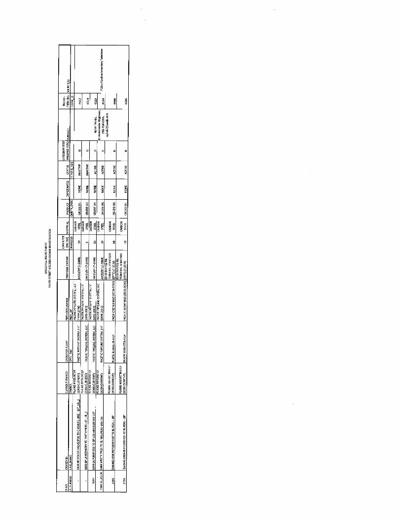
OR
DE
R
Na.
Ri2
0124
010
BA
KE
R S
TR
EE
T G
OLD
EN
AV
EN
UE
IN
VE
SIIW
nON
ID
OWNER ID
CURRENT OWNER
NA
OP
ER
AT
OR
ME
PREVIOUS OWNER
PREVIOUS OWNER
DIA
ME
TE
R
(INCHES)
MATERIAL
O
OX
YG
EN
AT
ES
MIE
GR
ITY
TF
ST
FA IW R
ES
(Y /N
) CONTACT
CUFM NO. SOURCEISI
IO
NU
MB
ER
LI
NU
_NA
ME
O
WN
ER
O
PT
O_N
M
PE
EV
_OP
D
IAM
ET
ER
O
AD
T'_
BE
SC
S
TA
TU
S_C
OE
C
IM_I
D
-
LOR
E R
ED
ON
DO
VA
LVE
RO
E T
O
CH
EM
OIL
LIN
E- 1
0 "_
1& 3
PLA
INS
!P
IPE
LIN
E LP
(]O
E-C
UR
RE
NT
) P
AC
IFIC
PIP
ELI
NE
SY
ST
EM
, IL
E
SY
ST
EM
, LL
C
(]99
3300
6)
N
AS
CO
/OP
1?
-199
9)
10
ST
EE
L C
RU
DE
OIL
N
ON
E
INA
CD
YE
N
Ngh
hl1I
P
AL
mdl
0ngl
nret
,
ER
I %
3-]3
LNtq
a ®
olhi
@ p
ulp
mm
0107
PM
Ue
MP
eGne
lmcn
tary
0ap
bass
_
LOR
I B
P L
A R
EF
INE
RY
T
O
EA
ST
HY
NE
S -
6 "_
1& 3
PLA
INS
P
INE
LP
(300
U-C
UR
UE
NT
I P
AC
IFIC
PIP
ELI
NE
SY
ST
EM
, LI
E
PA
CIF
IC P
IPE
LIN
E S
YS
TE
M,
LLC
(199
3300
6)
AR
CO
/BP
(? -1
999)
6
CA
RB
ON
ST
EE
L C
RU
DE
OIL
N
ON
E
INA
CT
IVE
N
01
14
63V
Ip
63LA
PU
MP
ST
A T
O B
P L
OS
AN
GE
LES
RE
F 14
"
PLA
INS
N
E L
P
PA
CIF
IC P
IPE
LIN
E S
YS
TE
M,
LLC
PA
CIF
IC P
IPE
LIN
E 5Y
5IF
M,L
LC
(199
4CP
IPE
gpC
O /G
P (
? -19
99)
14
GT
OO
L S
TE
EL
CR
UD
E O
IL
NO
NE
A
CT
IVE
N
O
]JS
093E
GJ,
K,4
N
1093
WE
ST
HY
N61
0 E
L E
E6U
N00
EA
ST
16
PLA
INS
LI
NE
N
(Ia4
NO
91gg
EN
i) P
AC
IFIC
PIP
EU
NE
SY
ST
EM
, LL[
P
AC
IFIC
PIP
ELI
NE
SY
ST
EM
, LL
C
(19f
fiNO
6)
ED
ISO
N P
PE
LIN
Eí
14
CA
RB
ON
ST
EE
L C
RU
DE
O
IL
NO
NE
A
LIN
E
N
0I04
S10
A
(LR
1M)
1S13
.63]
(£R
PR
OS
TO
E.
RE
AL-
16"
P
LAIN
S
ß00
G[U
RR
EIJ
O
PLA
INS
MA
PY
£IIN
G LP
P
AC
IFIC
TE
RM
INA
LS
(]01
15.2
000
ET
IMN
ALC
OM
P
CO
MP
AN
Y
(EP
TC
) 16
E
ON
S
TE
M.
CR
UD
E O
IL
NO
NE
A
CT
IVE
N
03
66
EISA
ILSISAI1S135t][ERRITOS T
O ¢ R
EA
L -16'
PIEER-
MA
RK
ET
ING
(?00
6CU
RR
EN
i1
PLA
INS
MA
RK
ET
ING
LP
P
AO
FIC
TE
R M
INA
LS R
OD
32D
06)
ED
ISO
N P
IPE
LIN
E
TE
RM
INA
L C
OM
PA
NY
(E
PIC
) ( ?
-]W
3 16
CA
RB
ON
S
TE
EL
ST
EE
L pN
DE
OIt
NO
NE
A
CT
IVE
N
03
86
SCALED MAP OF THE SUBJECT AREA
aí; . : ;i
rp7i
AECOM Environment
Appendix C
BP Line 32 SCAQMD 1166 Monitoring (November 2011)
P:\BPBP - BNish Petroleum \Goltlen-Baker InvestlgatIOn\WOrk Plan\FlNAL - BP Golden Baker W PAocx July 2012

rLe r 2164,e06(
teer ge i w4- tir s` ay- South Coast c1-7,-ta-
r Air Quality Management District 21865 Copley Drive, Diamond Bar, CA 90765 -4178 Lc 3 Q (909) 396 -2000 www.aqmd.gov
PLAN ISSUE DAl'E
APPROV,A IG1ÌÍ Dalifi Janes A_Q,A:C. sat/Thor COMPANY I.D.: Mitigation Plan /Application No Applicant
Attention: Phone
155820 525316 ARB, Inc. 26000 Commercenter Drive Lake Forest, CA 92630 Darryl Oscars (949) 454-7108
July 22, 2011
Fax (949) 595 -5544
VARIOUS LOCATIONS RULE 1166 CONTAMINATED SOIL MITIGATION PLAN
Reference is made to your application (A/N 483913) for the excavation and handling of VOC- contaminated soil at various locations within the South Coast Air Quality Management District.
In accordance with Rule 1166 (c), this approved plan is required prior to commencing excavation of any areas, sites, or locations which has previously been used to store or transfer volatile organic compounds (VOC) or during the excavation, handling, or storage of VOC- contaminated soils.
The rights and privileges granted through the issuance of this plan are restricted exclusively to the plan holder to whom it was issued, and are non -transferable, even with the written or expressed consent of the plan holder listed above.
A VARIOUS LOCATIONS PLAN can be used at a site to excavate and remove a maximum of 2000 cubic yards of VOC contaminated soil at the site. Any treatment or additional excavation of VOC contaminated soil at the site will require the issuance of a SITE SPECIFIC plan by the AQMD. Multiple use of VARIOUS LOCATIONS PLANS to excavate over 2000 cubic yards of contaminated soil for the same site is prohibited per Rule 1166.
This excavation and mitigation plan has been approved under the provisions of Rule 1166 of the Rules and Regulations of the AQMD and is subject to the following conditions.
IRIS PLAN WILL EXP TIIERII! IS NO AUTOMATIC RENEWAL P OCESSo
b ONE YEAR FROM THE ISSUE DATE AND
All Various Locations Plans expire one (1) year from the date of issuance. To apply for a new Plan, submit an Application with the filing fee at least one month prior to the Plan expiration date. For an application package and fee information please go the SCAQMD web page at http : / /www.aamd,gov /comply /formsbyrule.htm and look for Rule 1166 information. For questions call 909 -396- 2326."
Page 1
Plan #: 525316
PLAN CONDITIONS
SECTION I - GENERAL REQUIREMENTS
I. A SIGNED COPY OF THIS PLAN SHALL BE PRESENT AT EACH EXCAVATION SITE AT ALL TIMES AND SHALL BE MADE AVAILABLE TO AQMD PERSONNEL UPON REQUEST.
2. THIS PLAN IS NOT VALID FOR THE EXCAVATION OF VOC CONTAMINATED SOILS AT LANDFILLS OR SITES USED FOR DISPOSAL OF REFUSE OR OTHER TYPES OF WASTE.
3. THIS PLAN DOES NOT ALLOW THE TREATMENT OF VOC- CONTAMINATED SOIL BY THERMAL, CHEMICAL, OR MECHANICAL PROCESSES. ANY OF THE ABOVETREATMENT PROCESSES REQUIRES A PERMIT TO OPERATE FROM THE AQMD AND A SITE -SPECIFIC RULE 1166 PLAN.
4. THIS PLAN DOES NOT ALLOW BACK -FILLING OF TREATED VOC CONTAMINATED SOIL. BACK - FILLING OF TREATED VOC CONTAMINATED SOIL MAY BE ALLOWED UNDER A SITE SPECIFIC RULE 1166 PLAN.
5. A). THE TOTAL QUANTITY OF VOC CONTAMINATED SOIL EXCAVATED AND HANDLED AT EACH SITE SHALL NOT EXCEED 7,000 CUBIC YARDS. THIS TOTAL INCLUDES ANY VOC CONTAMINATED SOILS EXCAVATED FROM THIS LOCATION UNDER A VARIOUS LOCATION PLAN WITHIN THE LAST TWELVE (12) CALENDAR MONTHS. EXCAVATIONS INVOLVING QUANTITIES IN EXCESS OF 2000 CUBIC YARDS OF VOC CONTAMINATED SOIL REQUIRES THE APPLICATION SUBMITTAL FOR A SITE SPECIFIC RULE 1166 EXCAVATION PLAN.
6. THE AQMD SHALL BE IMMEDIATELY NOTIFIED OF ANY COMPLAINTS RECEIVED AS A RESULT OF ACTIVITIES CONDUCTED UNDER THIS PLAN. SUCH NOTIFICATION SHALL INCLUDE THE NATURE OF THE COMPLAINT, NUMBER OF COMPLAINANTS AND THE ACTION TAKEN BY THE PLAN HOLDER TO MITIGATE THE SOURCE OF THE COMPLAINT.
7. DURING EACH STEP OF THE PROCESS UP TO AND INCLUDING THE REMOVAL AND DISPOSAL PROCESS, ALL PRECAUTIONS AND MEASURES SHALL BE TAKEN TO MINIMIZE THE RELEASE OF VOC, ODOR AND DUST. THIS INCLUDES BUT IS NOT LIMITED TO: THE USE OF ADDITIONAL PLASTIC SHEETING ON STOCKPILES, USE OF SUPPRESSANTS ON EXPOSED SOIL SURFACES & WORK AREAS AND MAINTAINING PAVED PUBLIC STREETS FREE OF SOIL DEPOSITS.
8. FOR THE PURPOSES OF RULE 1166 AND THIS PLAN, SOIL MEASURED PURSUANT TO RULE 1166 AS VOC CONTAMINATED SOIL, IS CONSIDERED AS VOC CONTAMINATED SOIL FROM THE TIME OF MEASUREMENT ONWARD, UNTIL THE SOIL IS TREATED PURSUANT TO AN APPROVED AQMD TREATMENT PROCESS.
Page 2 Plan #: 525316
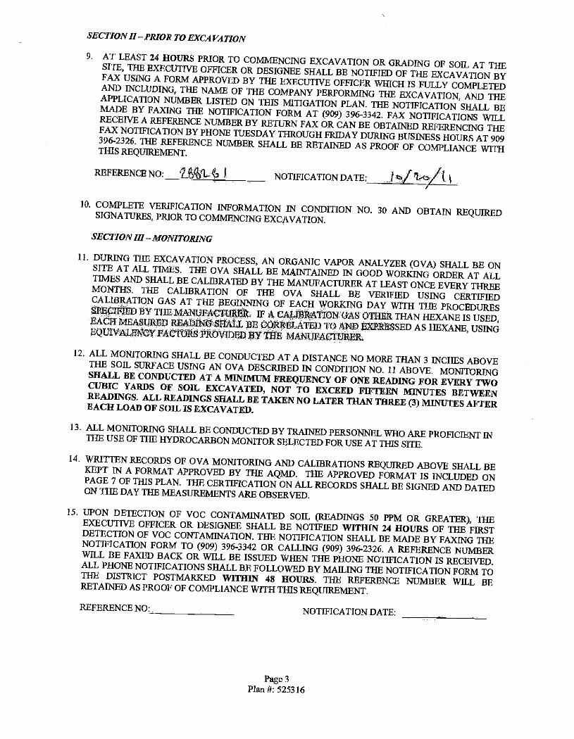
SECTION II PRIOR TO EXCAVATION
9. AT LEAST 24 HOURS PRIOR TO COMMENCING EXCAVATION OR GRADING OF SOIL AT THE SITE, THE EXECUTIVE OFFICER OR DESIGNEE SHALL BE NOTIFIED OF THE EXCAVATION BY FAX USING A FORM APPROVED BY THE EXECUTIVE OFFICER WHICH IS FULLY COMPLETED AND INCLUDING, THE NAME OF THE COMPANY PERFORMING THE EXCAVATION, AND THE APPLICATION NUMBER LISTED ON THIS MITIGATION PLAN. THE NOTIFICATION SHALL BE MADE BY FAXING THE NOTIFICATION FORM AT (909) 396 -3342. FAX NOTIFICATIONS WILL RECEIVE A REFERENCE NUMBER BY RETURN FAX OR CAN BE OBTAINED REFERENCING THE FAX NOTIFICATION BY PHONE TUESDAY THROUGH FRIDAY DURING BUSINESS HOURS AT 909 396 -2326. THE REFERENCE NUMBER SHALL BE RETAINED AS PROOF OF COMPLIANCE WITH THIS REQUIREMENT.
REFERENCE NO: 2 f` -4a Ì. NOTIFICATION DATE: O/ ,/( 10. COMPLETE VERIFICATION INFORMATION IN CONDITION NO. 30 AND OBTAIN REQUIRED SIGNATURES, PRIOR TO COMMENCING EXCAVATION.
SECTION III MONITORING
11. DURING THE EXCAVATION PROCESS, AN ORGANIC VAPOR ANALYZER (OVA) SHALL BE ON SITE AT ALL TIMES. THE OVA SHALL BE MAINTAINED IN GOOD WORKING ORDER AT ALL TIMES AND SHALL BE CALIBRATED BY THE MANUFACTURER AT LEAST ONCE EVERY THREE MONTHS. THE CALIBRATION OF THE OVA SHALL BE VERIFIED USING CERTIFIED CALIBRATION GAS AT THE BEGINNING OF EACH WORKING DAY WITH THE PROCEDURES SIIECMED 'BY THE MANUFACTURERR, IF A CA BB ATION GAS OTIIER THAN HEXANE IS USED, EACH MEASURED READING SHALL BE CORRELATED TO AND EXPRESSED AS HEXANE, USING EQUIVALENCY FACTORS PROVIDED » THE MANUFACTURER
12. ALL MONITORING SHALL BE CONDUCTED AT A DISTANCE NO MORE THAN 3 INCHES ABOVE THE SOIL SURFACE USING AN OVA DESCRIBED IN CONDITION NO. II ABOVE. MONITORING SHALL BE CONDUCTED AT A MINIMUM FREQUENCY OF ONE READING FOR EVERY TWO CUBIC YARDS OF SOIL EXCAVATED, NOT TO EXCEED FIFTEEN MINUTES BETWEEN READINGS. ALL READINGS SHALL BE TAKEN NO LATER THAN THREE (3) MINUTES AFTER EACH LOAD OF SOIL IS EXCAVATED.
13. ALL MONITORING SHALL BE CONDUCTED BY TRAINED PERSONNEL WHO ARE PROFICIENT IN THE USE OF THE HYDROCARBON MONITOR SELECTED FOR USE AT THIS SITE.
14. WRITTEN RECORDS OF OVA MONITORING AND CALIBRATIONS REQUIRED ABOVE SHALL BE KEPT IN A FORMAT APPROVED BY THE AQMD. THE APPROVED FORMAT IS INCLUDED ON PAGE 7 OF THIS PLAN. THE CERTIFICATION ON ALL RECORDS SHALL BE SIGNED AND DATED ON THE DAY THE MEASUREMENTS ARE OBSERVED.
15. UPON DETECTION OF VOC CONTAMINATED SOIL (READINGS 50 PPM OR GREATER), THE EXECUTIVE OFFICER OR DESIGNEE SHALL BE NOTIFIED WITHIN 24 HOURS OF THE FIRST DETECTION OF VOC CONTAMINATION. THE NOTIFICATION SHALL BE MADE BY FAXING THE NOTIFICATION FORM TO (909) 396 -3342 OR CALLING (909) 396 -2326. A REFERENCE NUMBER WILL BE FAXED BACK OR WILL BE ISSUED WHEN THE PHONE NOTIFICATION IS RECEIVED. ALL PHONE NOTIFICATIONS SHALL BE FOLLOWED BY MAILING THE NOTIFICATION FORM TO THE DISTRICT POSTMARKED WITHIN 48 HOURS. THE REFERENCE NUMBER WILL BE RETAINED AS PROOF OF COMPLIANCE WITH THIS REQUIREMENT.
REFERENCE NO :. NOTIFICATION DATE:
Page 3
Plan it 525316

SECTION IV- HANDLING AND STORAGE
16. ALL VOC- CONTAMINATED SOIL BELOW 1000 PPM SHALL BE STOCKPILED, COVERED WITH PLASTIC SHEETING AND STORED SEPARATELY FROM NON -VOC- CONTAMINATED SOIL, OR. IMMEDIATELY TRANSPORTED TO A TREATMENT FACILITY.
17. A STOCKPILE SHALL NOT CONTAIN MORE THAN 400 CUBIC YARDS OF SOIL.
18. IF THE OVA MEASUREMENT IS GREATER THAN 50 PPMV BUT LESS THAN 1000 PPMV A) THE AFFECTED WORK AREA AND LOAD OF SOIL SHALL BE SPRAYED WITH WATER
AND /OR APPROVED VAPOR SUPPRESSANT. B) CONTAMINATED SOIL IN STOCKPILES SHALL BE COVERED WITH PLASTIC SHEETING
WHICH OVERLAP A MINIMUM OF TWENTY -FOUR INCHES AND ARE SECURED SO THAT NO PORTION OF THE CONTAMINATED SOIL IS EXPOSED TO THE ATMOSPHERE. IN THE COURSE OF HANDLING THE STOCKPILE, ONLY THE WORKING FACE OF THE STOCKPILE MAY BE UNCOVERED.
19. IF THE OVA MEASUREMENT EQUALS OR IS GREATER THAN 1000 PPM, STOP EXCAVATION TO NOTIFY THE DISTRICT IMMEDIATELY OR WITHIN ONE HOUR OF DETECTION AND,
A) THE AFFECTED SOIL AND WORKING AREA SHALL BE IMMEDIATELY SPRAYED WITH WATER OR AN APPROVED VAPOR SUPPRESSANT, AND EITHER:
B) THE CONTAMINATED SOIL EXCAVATED SHALL BE IMMEDIATELY PLACED IN AQMD APPROVED SEALED CONTAINERS, OR
C) DIRECTLY LOADED IN TRUCKS, SPRAYED WITH ADDITIONAL WATER OR APPROVED VAPOR SUPRESSANT, COVERED, AND TRANSPORTED IMMEDIATELY OFF SITE AS PER CONDITION #25 OF. THIS PLAN, OR,
D) OTHER ALTERNATIVE STORAGE METHODS WITH PRIOR WRITTEN APPROVAL FROM THE AQMD.
20. DURING EXCAVATION, THE ONLY EXPOSED VOC CONTAMINATED SOIL SHALL BE RESTRICTED TO THE IMMEDIATE WORKING AREA OF THE SITE OR STOCKPILE. ALL OTHER PORTIONS OF THE STOCKPILE SHALL BE COVERED WITH PLASTIC SHEETING, WITH SEAMS, WHICH OVERLAP A MINIMUM OF TWENTY -FOUR INCHES AND ARE SECURED WITH DUCT TAPE. ANY EXPOSED VOC- CONTAMINATED SOIL SURFACES (WORK FACE) SHALL BE KEPT MOIST WITH WATER OR OTHER APPROVED SUPPRESSANTS AT ALL TIMES, AND SHALL BE RE- COVERED DURING PERIODS OF INACTIVITY LONGER THAN ONE (1) HOUR. AT THE END OF EACH WORKING DAY, ALL STOCKPILES SHALL BE COMPLETELY COVERED AND SECURELY ANCHORED TO PREVENT ANY EXPOSURE OF SOIL TO THE ATMOSPHERE.
21. ONCE COVERED WITH PLASTIC SHEETING, STOCKPILES SHALL REMAIN UNDISTURBED UNTIL REMOVED FROM SITE.
22. DAILY INSPECTIONS SHALL BE CONDUCTED OF ALL COVERED VOC- CONTAMINATED STOCKPILES TO ENSURE THE INTEGRITY OF THE PLASTIC COVER. SUCH INSPECTIONS SHALL INCLUDE A VISUAL INSPECTION OF ALL SEAMS AND PLASTIC COVER SURFACES. ANY HOLES, TEARS OR ANY OTHER POTENTIAL SOURCES OF FUGITIVE VOC EMISSIONS SHALL BE REPAIRED IMMEDIATELY. DAILY RECORDS SHALL BE MAINTAINED TO ENSURE COMPLIANCE WITH THIS CONDITION.
23. VOC CONTAMINATED SOIL SHALL NOT BE SPREAD ON -SITE OR OFF -SITE. THIS INCLUDES ANY UNNECESSARY MOVEMENT OR AGITATION OF SOIL THAT MAY CAUSE THE UNCONTROLLED EVAPORATION OF VOC'S INTO THE ATMOSPHERE, INCLUDING THE RESHAPING OR RELOCATION OF STOCKPILES.
Page 4 Plan #: 525316

SECTION V -SOIL REMOVAL AND DISPOSAL
24. ALL EXCAVATED VOC- CONTAMINATED SOIL SHALL BE REMOVED FROM THE SITE WITHIN THIRTY (30) DAYS OF ITS EXCAVATION.
25. ALL VOC- CONTAMINATED SOIL REMOVED FROM THE SITE SHALL COMPLY WITH THE- FOLLOWING:
A). 13E TRANSPORTED TO AN APPROVED TREATMENT/DISPOSAL FACILITY. IT SHALL BE THE RESPONSIBILITY OF THE PLAN HOLDER TO ENSURE THAT THE RECEIVING TREATMENT/DISPOSAL FACILITY HAS RECEIVED APPROVAL FROM THE APPROPRIATE ENVIRONMENTAL OVERSIGHT AGENCIES TO HANDLE AND TREAT VOC CONTAMINATED SOILS.
B). WHEN LOADING IS COMPLETED AND DURING TRANSPORTATION, NO EXCAVATED MATERIAL SHALL EXTEND ABOVE THE SIDES OR REAR OF THE TRUCK OR TRAILER.
C). PRIOR TO COVERING/TARPING, LOADED CONTAMINATED SOIL SHALL BE WETTED BY SPRAYING WITH MIST INHIBITORS.
D). THE TRUCK OR TRAILER SHALL BE COMPLETELY COVERED/TARPED PRIOR TO LEAVING THE SITE TO PREVENT PARICULATE EMISSIONS TO THE ATMOSPHERE.
E). THE EXTERIOR OF THE TRUCKS (INCLUDING THE TIRES) SHALL BE CLEANED OFF PRIOR TO THR TRUCKS LEAVING THE EXCAVATION SITE.
SECTION VI- RECORDS AND REPORTING
26. A WRITTEN REPORT SHALL BE PROVIDED TO THE AQMD WITHIN 40 DAYS OF INITIAL DETECTION OF CONTAMINATED SOIL, WHICH INCLUDES THE FOLLOWING INFORMATION.
A). THE STATUS OF THE EXCAVATION PIT, AND ANY VOC CONTAMINATED SOIL REMAINING ON SITE.
C). A BRIEF SUMMARY INDICATING IF ADDITIONAL CLEAN UP EFFORTS ARE NECESSARY, THE ADDITIONAL QUANTITY OF VOC CONTAMINATED SOILS TO BE EXCAVATED AND THE PROJECTED SCHEDULE OF THE EXCAVATION.
27. RECORDS OF DISPOSAL SHALL BE MAINTAINED FOR ALL VOC- CONTAMINATED SOIL REMOVED FROM THIS SITE. SUCH RECORDS SHALL BE CLEARLY LABELED "SCAQMD RULE 1166 -VOC CONTAMINATED SOIL" AND SHALL INCLUDE THE IDENTIFICATION AND THE LOCATION OF, 1) THE GENERATOR, 2) TRANSPORTER AND 3) RECEIVING FACILITY. IN ADDITION, SUCH RECORDS SHALL BE SIGNED AND DATED BY EACH OF THE ABOVE PARTIES INDICATING RECEIPT OR. RELINQUISHMENT OF THE VOC- CONTAMINATED SOIL AT THE TIME CUSTODY IS TRANSFERRED.
28. RECORDS OF DISPOSAL OF VOC- CONTAMINATED SOIL SHALL BE MAINTAINED ON SITE DURING THE EXCAVATION AND LATER MAINTAINED FOR A PERIOD OF TWO (2) YEARS. THE RECORDS SHALL BE MADE AVAILABLE TO AQMD PERSONNEL UPON REQUEST.
29. WITHIN THIRTY (30) DAYS AFTER THE EXCAVATION AT THE SITE IS COMPLETED, THE WRITTEN RECORDS UNDER CONDITIONS NO. 14, 22, AND 27 SHALL BE SUBMITTED TO THE AQMD AT THE FOLLOWING ADDRESS.
SOUTH COAST MR QUALITY MGMT DISTRICT ENGINEERING & COMPLIANCE DIVISION TOXICS & WASTE MANAGEMENT UNIT (RULE 1 166 COMPLIANCE) 21 S65 E. COPPEY DR. DIAMOND BAR, CA 91765 -4182
Page 5
Plan #: 525316

SECTION VII - VERIFICATION AND SIGNATURE
30, THIS PLAN IS NOT VALID UNTIL ALL PARTIES HAVE REVIEWED AND SIGNED THE VERIFICATION STATEMENT BELLOW,
Site Nome, BP PIPELINE NA, INC.(Line 32_1LI Repair SitP#4.1_ -
Typo or a%Snea
NIA
Address
Golden Ave and 32" Street
City
Long Beach Zip _.
90806
aq'llp.mwriorllÏRryttiÚlKrNM
BP Pipeline NA Phone
(562) 499 -2241
Address
1300 Pier BSL City
Long Beach, CA 90813
I CERTIFY THAT I HAVE REVIEWED AND UNDERSTAND THE CONDITIONS CONTAINED WITHIN THIS PLAN. IN SIGNING BELOW, I ACKNOWLEDGE THAT UNDER THE PROVISIONS OF RULE 1166, 1 CAN BE HELD RESPONSIBILE FOR THE REQUIREMENTS SET FORTH IN THIS PLAN. - nenpand4lePerly
BP Pipeline NA Inc IWpnndblePanya lare /yy % t / I!I
Dale Signed
11122/11 General Contralor
ARBINC. General ContraelorSigna re paleSigned
11122111. a' vanoneoneNamr
ARB INC. E anoncáduaelo alurn .. _ ....
fo Dole Signed ..
41122/11 Ens irommeniticád l,w
ARS ENC.
rtrnnmenlwcwl name i - .. _paléSigeed -_
11/22/11
DEFINITIONS
Excavation
Organic Vapor Analyzer (OVA)
Responsible Party
VOC Contaminated Soil
Volatile Organic Compound (VOC)
Is the process of digging out and removing materials including any material necessary to that process such as the digging out and removal of' asphalt or concrete necessary to expose, dig out and remove known VOC contaminated soil
For the purposes of this plan, an OVA is an hydrocarbon monitor utilizing flame ionization, photo ionization or other analytical methods complying with 40 CFR PART 60 APPENDIX A, EPA METHOD 21 SECTION 3, "DETERMINATION OF VOLATILE ORGANIC COMPOUND LEAKS, MONITORING INSTRUMENT SPECIFICATIONS. The monitor shall be capable of being calibrated using hexane at a range of 0 parts per million by volume (PPMV) to 50 PPMV, and at a detection range of at least 30 PPMV to 1100 PPMV
For the purposes of this plan, Responsible Party is the party financially responsible for initiating the excavation. This may include the property owner or the tank operator. This excludes contractors working for the property owner or operator, and any other party that lacks the direct authority to immediately treat all VOC contaminated soils generated at the excavation site.
Is soil that registers a concentration of 50 PPM or greater of volatile organic compounds as measured before suppression materials have been applied and at a distance of no more than three inches from the surface of the excavated soil with an organic vapor analyzer calibrated with hexane.
Is any volatile compound of carbon, excluding methane, carbon monoxide, carbon dioxide, carbonic acid, metallic carbides or carbonates, ammonium carbonate, and exempt compounds. Exempt compounds areas defined in Rule 102 - Definitions of Terms.
Page 6 Plan #: 525316

Once issued, this plan is subject to further review by the AQMD and may be revoked if excavation activities are found in violation of plan conditions or AQMD's Rules and Regulations. Failure to comply with one or more of the conditions contained within this plan constitutes a violation of Rules 221 and 1166.
Other governmental agencies may require approval before any excavation begins. It shall be the responsibility of the applicant to obtain that approval. The South Coast Air Quality Management District shall not be responsible or liable for any losses because of measures required or taken pursuant to the requirements of this approved Rule 1166 Contaminated Soil Mitigation Plan.
Questions regarding this plan should be directed to Ranjit Vishwanath at (909) 396 -2682.
KW 1/17/04
Page 7 Plan #: 525316

Rule 1166 Soil Monitoring Records COMPANYNAME ARB, INC
26000 COMMERCENTRE DR _LAKE FOREST, CA 92630
FaeilitylSlte Information _ _ --.. - Nana: :
BP PIPELINE NA INC Address:
Intersection of Golden Ave and 32"d Street _. ReferenceNo(s).
288281 Long Beach 90806 PLl4N#525316 GD, 155820 LINE 32 ILI Repair Di at Site#4
Monitor Info rmation Calibration Data
_-
MonitoringPersónfiel Excava8rtn9ummaiÿ Lponcamploonofeaohpsgg)
UFO Cubic Vds:'
(Thlspage)
Brand:
MSA. : _
Gas.
ISOBUTYLENE
"Name:
Mddel: - SIRIUS.
,Bate Company ...
AR6-l'NC
Tobst Cubic frig :... trodaalel- -
-,
Type
MULTIGAS DETECTOR Hy.-.. Phone. ...
.- .-
Removed-hem
Stte (ro dota
Time
Every
15 min,
VOC Concentration (PEW) @
.. Excavated Load
Comment- -
Reading Hexane Adjusted
Factor Readsg,;,'
Time VOC Concentration (PPMV@
Excavated Load __... Every ' Reading Hexane Adjusted
15 min. _Factor Reading
Comment
I certify that the Information cantened in the above document Is true and correct. I furthe certify that the above listed hydrocarbon monitor was operated in a manner consistent with the manufacturer's specification and the conditions specified within this plan. In addition, I certify that the above readings represent the actual measurements I observed and recorded during the excavation process.
SIGNATURE: DATE :.
PAGE 8
PLAN 525316
South Coast Air Quality Management District 21865 Copley Drive, Diamond Bar, CA 91765 1. 800 -CUT -SMOG www.agmd.gov
IMPORTANT NOTICE 2011 Rules 203, 1149 and 1166 Fees
July 1, 2011
TO COMPANIES AND CONTRACTORS THAT:
Operate portable soil /vapor extraction units at a location for 5 days or more (Rule 203 ) Degas storage tanks known /suspected to contain Volatile Organic Compounds (VOC) (Rule 1149) Remove tanks or transfer piping known /suspected to contain VOC ule 1166 Handle, excavate, grade, monitor or treat soil known /suspected to contain VOC (Rule 1166)
SCAQMD Regulation Ill Fee amendments for the Fiscal Years 2011 -2012 Increased notification fees 1.4 percent ( %) across- the -board. All required notifications for soil vapor extraction projects, tank degassirìg projects, and excavation of VOC soil projects, are subject to the new fee per Rule 301(x) effective July 1 ", 2011. See fee schedule below:
The fee is per notification and an additional service charge fee of $25.00 may apply for any returned check per Rule 313(i).
Initial notifications must be faxed to 909-396-3342 and the original notification and fee must be postmarked within 48 hours of the fair time,
AQMD recommends mailing your notification to save time, money, reduce traffic, conserve energy use and avoid air pollution. For your convenience please mail all notifications and fees to the following mailing address:
SCAQNO R20311149/1166 Notifications, FILE # 55641, Los Angeles, CA 90074 -5641
Notifications should be completed, signed, mailed and the fee paid by the contractor performing the project. Notifications submitted without a fee are deemed incomplete and they will be returned to sender and referred to the Air Toxics Compliance Unit.
Rules 203, 1149 and 1166 notification forms, instructions, and information can be obtained from the SCAQMD web site at http: / /www.aamd.aov
The forms are located at our home page, click on Business / Compliance Program / Recordkeeping and Reporting Forms or the Rule link below.
203 Soil Vapor Extraction (SVE) Notification Form 1166 VOC Emissions From Soil Excavation Notification Form 1149 Storage Tank Degassing Notification Form-
For any Rule 203/1149/1166 questions call the above Rules Hot Line at (909) 396 -2326.
NOTE: Rule 304(0 requires an owner operator to pay for analysis of AQMD field samples showing non compliance.
Page 9 Plan fi: 525316

Rule 203 and Rule 1166 Form Notification Instructions
Use this faun to notify of operation of a Soll Vapor Extraction unit (SVE) at any site for more than 5 days per permit condition (((203); or for notifying about 81166 projects pria to excavating soft that Is knovm or suspected to contain Volatile Organic Compounds (VOC), VOC tank excavation, discovering the presence of > 50 ppm and 1000 ppm VOC contaminated sot during soll excavation, or to notify of enslte VOC contaminated soli mitigation or treating. For questions check our webste at.www.agmd.gov or call the Hotline at (909) 396 -2326
NOTIFICATION FEES: Per Rule 301(x) any person required to submit a notification per Rule 1166 projects or Rule 203 -
Soil Vapor Extraction projects must pay a notification fee per notification.
FAX all notifications to (909) 396 -3342 and then MAIL. the fort and fee within 48 home of fax to:
SCAQ/AD Rule 1166 / 203 Notifications, File # 55641, Los Angeles, CA 90074 -5641
Notifications must include the following MANDATORY information: Faxbadk # - Provide your fax # at the top of the Notification Font If you want a Reference # faxed beck to you
Notification Type - CIRCLE the type of Notification. Original Is for new or initial Notifications. Revisions are for updating fnfomhaton on notifications in which the project End Date has not expired. Provide the most recent prior Reference # issued for Revisions or Cancellations.
Project Type - CiRCLE the type of work you are submitting a notification for. A separate notification and fee is
required for each type of work selected.
Mitigation Plan/Permit - Each Project Type requires a valid R1166 Mitigation Plan or WE Permit it (Important).
Site Contractor Information - Provide the information for the actual contractor doing the work. The AQMD ID 6, also known as Company or Facility ID f, can be found on the contractor's ACME) Mitigation Plan, Permits or Invokes.
Site Information - Provide the site name and complete address: Include the street number and name, city, zip code, and nearest cross street Give more detailed directions for site(s) difficult to locate.
Project Dates - Provide the project Start and End Dates. Any changes wIt require a Revision notification.
Tank Information -For Rf166 tank excavation spedfythe tank capacity, the VOC material stored in the tank, and if the tank is above ground (a/g) or underground (u/g). $
Information Certification -The notification must be signed and dated by the contractor doing the work or authorized representative to confirm that the information provided is complete and accurate.
SOIL/TANK EXCAVATION NOTIFICATION Dade 1166(c )(1)(8) Notify 24 hours prior of intent to Excavate known or suspected VOC storage and /or transfer equipment (includes diesel and waste oil tanks); or handling known or suspected VOL contaminated soil NOTE: Soil excavation > 5,000 cubic yards may require a (1403 Fugitive Dust Plan.
DETECTING/FINDING VOC SOIL NOTIFICATION - Rute 1166(c )(1)(0)(ii) Notify of finding VIZ contaminated soil within 1 hour of detecting VOC greater than 1000 ppm* within 24 hours of detecting VOC greater than SO ppm within 1 hour of an excavation due to a breakdown requiring a Ride 430 notification to SCAQMD
EMERGENCY NOTIFICATION Rule 1166(c )(1)(0) Notify prior to start work of any incident declared an emergency by an authorized agency requiring immediate tank removal /repairs or excavating /handing known or suspected VOC soil:
Cad 1. 800 -tiff -SMOG prior to excavating or fax the emergency notification to 909 -396-3342 and Miff the notification within 48 hours after the excavation including the agency Order or Declaration.
SOIL VAPOR EXTRACTION NOTIFICATION (WE - Rute 203 ) Notify upon the Se day after operating at a new site: notifying ofsfort -up or testing of operation of portable Soil Vapor Extraction equipment lasting 5 days or more. Provide the distance hi feet to the nearest sensitive receptor if the site is located less than tf mile from any Long-Tenn Health Care Facility, Rehabilitation Center, Convalescent Center, Retirement Home, Residence, School, Playground,
Child Care Center or Athletic Facility ( See your SW permit condition requirements).
MhTGATION/TREATING VOC SOIL NOTIFICATION (Rule 203 I) Notify per Permit condition requirements when: Notifying of on -site mitigation or treating of VOC tontaminated soil ("See your Permit condition requirements).
Revised 01!20/2011 Page 2 of 2
Page 11 Plitt #: 525316
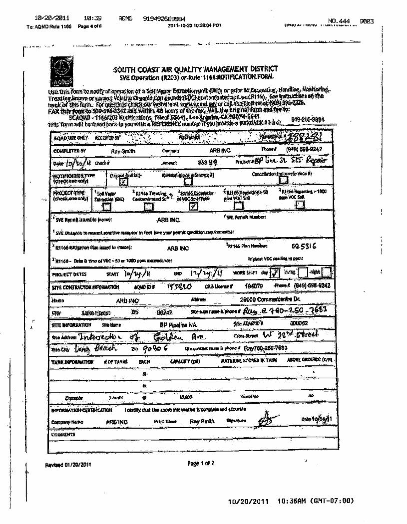
1020/2011 10:39 ROM 919492:69994 To: AOMD Rule 116G Pagel of 6 zoi 140.20 Io:20:04 poi
NO. 444 D003 Win i-cr.vo
SOUTH COAST AIR rummy MANAGEMENT DISTRICT
Slit Operation (0203) oraule 11 66 HOTIFICATION.ThRifot
Use.this Iorinia notify at operation of a Se0Artipor E4TOCUORMOti5V4; etpaar tG gsovatiag. mandlingi WoolurIng,
Treatirmtiorri.or FaRt4 VoiajiiipaggrOpppokrdvag2C1.sontallitatO.roli pee Rile@ SeeingWererre0 the
bacia tins Wit Fez atesttuat ghactair +tosAblre at Md. tar 14 tilatiOnfleit'009):396437.6. FAX1fitsfaratta 909-3H4442anif Width-4e he.ItS of theta, foliowtdietito:
SCAttrA3 11660103 NotticatioAs 435641, 11.0$ *win, -90B74,5641 Deml-20)-99°4 Tilts tom will be WO tatt,to yot *nit a REFERENCE nuittbe if yourOriiad-t EAklia0K-ittirt:
...
Afitaka ein OtC-rmu Eat ' A 1460041* guy i EosYMftít . ,.
COMPUTED fer go) Smith compor ARR INC Rowe WO) 598-9242
Dag -torte a Coer-ge Sam@ areal @Hoc age Lee- at ref
11QIIPICHION.nn tchstrune until
Ca tat; Iftee10110 , feraga$41 tayst.WAn WLenreagee el
U . _
PkOaCt ME (thee* onsixti
f SonsW 2 Ott% Vela-int. IN, anieitartione cano0011214 tantorinstad sre- , et intgetITPAIk
la 1-7 n 4M166, as, W iRaW %Wag 1.1002
ea Voc. INIMVOC SRI 0 la . 4 svg roan issuea
I SV@ CRAW* 20 MARA
4.-- (nn: NAB 1Ne.
ntiVe remote' se feel IMO Inge PenntiOrditialtreqtfratOOSH
'9.1.1tralt ;flaw
-, _ ,
Ems AtitIPticil flan WOO te (floree): ARB INC zR1146 @ten timbal n 5311 a
R1146- tute a twee afloat 5. so or tat ado eaceedantet Wishes: VOC nollegift epae
ow I It ti WM SHFr daY171 WWI elateCT WM25 11Wer Join /if t
SITE COWIRALTORMFONAARRM acm.in 1 rfiregW ras Wow 0. wie .monet (949)1984242
imam ARIA INC /muss 26000 Cts'eunedente Dr,
- nut take RUA ita MOT IMN IOW OPOrme ,a 1-4D--tio --44Si _ _
SITE tiFORLATIO0 Ote Ram BP Pipeline NA Stir in Il 800D-52 _
Ow ;item Utgrej t 0140 it. 4 & aass sank w WY -Stre4
Ike CTIW to-pp. Bari:. 0 qocO 4 comic none It phone e Ray760-250-76ea J - _ __
TAJIRINFONAA110P E OF IOC UCH WM wpm stO@Eo 1pt TAM MOW =URN WM
4) L
et
3 ankS 0 MODO &Lotto
-RIVORAIA110fifalUTION I certify mat tee be* lefeauded is vonpwasaall 44curaa A
Conspaey Nave ARE INC Pin fen, Ray Smith %ware pip 00619401
Roast@ 01120/2011 Page l Of 2
10/20/2011 10:36AM (GMT-07:00)
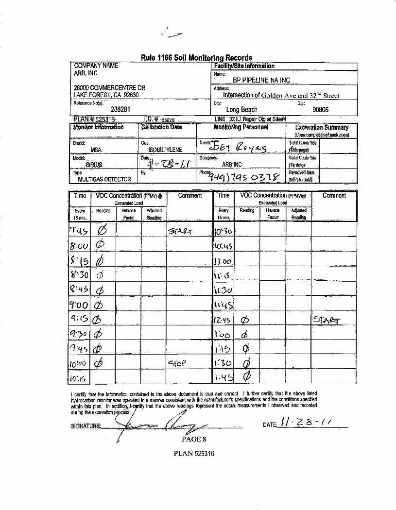
Rule 1166 Soil Monitorina.Records COMPANY NAME
ARB, INC
26000 COMMERCENTRE DR LAKE FOREST, CA 92630
Facility!SIte Information Name:
BP PIPELINE NA INC Address:
Intersection of Golden Ave and 32nd Street Reference No(s).
288281 City: Z p:
Long Beach 90806
PLAN*525316 58201 LINE 32íL1 Repair Dig at Site#4
Morn tar Information _- .-
Callbrätlon Data
. -..... .'
Monitmëfny Personnel Excavatioü:Summárÿ -. (U On re en+oreach age,
8feod:
MSA
Gas:
ISOSUTYLENE
Neme. 6 e6`(,_ TotdrJiuhlalMde'
(fhispage)
tdadeJ:,
SIRIUS tiït$ ,
;v t ( GdinpanY'
. ARB'ING
TotalCubicYds
(Todate)
Type
MULTIGAS DETECTOR
By Phone:.
Pig_ ) let $<771 Remind WI SiCe'ITadate
Time VOC Concentration (PPrdv) @ -
Excavated Loa
Every Reading Hexane Adjusted
15 min Factor -Reading ('
W'30
Comment` Time - VOC Concentration (PPMV)@
Excavated Load_..
Every
15 min,
Reading Hexane
Factor
Adjusted
Readlög
Comment
SrARr . _i
to; 45
`16:-t5
tC:5U
loAó 0 Stb
ft. y5
t:00
STAearr-
I certify hat the information conta'ned in the above document is true and correct. I furthe certify that the above listed
hydrocarbon monitor was operated in a manner consistent with the manufacturer's specifications and the conditions specified
within this plan. In addition, l rbfy that the above. readings represent the actual measurements I observed and recorded
during the excavation or Saa.. /
DATE G ¡ - 2 8- ( et SIGNATURE: - - - PAGE 8
PLAN 525316

Rule 1166 Soil Mon korlttp Records COMPANY NAME
ARB, INC
26000 COMMERCENTRE DR LAKE FOREST, CA 92630
Facility /Site, Information _
Name:
BP PIPELINE NA INC Address:
Intersection of Golden Ave and 32 "d Street Reference No(s). -.....
288281 my; Zip:
Long Beach 90806
PLATIif ,5253161 V D, '455820 LINE 32 ILI Repair Din at Sitè#4
Monitor Inforniátion Calibration Data _...- -_- _ -_ -...
Monitorlítg Personnel
- - .- -..
Excavation Seminary ',
(Upon cdmpledoaoteaclt pege).
Wand
MSA
Oàs.: -
ISO9UTYLENE
<Name:...- ¡¡ +e 1 l5 F-iE S Total Cubic Yds.I
(Thlapaga)
[Model;
SIRIUS
Date
II-i.il-L,l Company:
__ ARB'INC !
TOM CubicYds,
(To dale)
Type
MULTIGAS DETECTOR
Uy, ... Rhdil@: ( . / g 5 3 éf Removedfronl
slte,tToda)
Time VOC Concentration (PPNN)
_._ Excavated Load
Every
15 min.
Hexane., Adjusted
Factor Reading _,
Comment Time VOC Concentration (PPMV)@
Excavated Load
Every
65 mine
2'eá
Reading Hexane
Factor
Adjusted
Reading
Comment
roP
I certify that the information conta ned in the bove document is true and correct. I furthe certify that he above listed
hydrácarbon rnonitor was operated in a' manner consistent With the manufacturers specifications and the conditions -spaded within this plan In add 110 , certify that the a readings re sent the actual measurements I observed and recorded
during the excavaioryfirMÇOSS
SIGNATURE
PAGE,
PLAN 525316
DATE: I) - I

Rule 1166 Soil Monitoring' Records COMPANY NAME ARB, INC
26000 COMMERCENTRE DR
LAKE FOREST, CA 92630 _
Facility /Site Information Name:
BP PIPELINE NA INC Address:
Intersection of Golden Ave and 32nd Street _ Reference No(s).
288281 City: Zip:
Long Beach ---
90806
PLAN #52531 # tssa o LINE 32ILI lit àpalrD3q,atSlle#4_
Monitor Information Calibration Data - Monitoring Personnel ExcalratiónSümtnary ,lüponcorheteon df each page)
Brand;
NASA. _
Gas;:
ISDBUTYLENE
ndma;. TetaueuhleVds..
tThispage)
Model;:.._
SIRIUS
Data
-
Company
ARf3sINC
TalS Cubic Vds
(rodáte)
Type
MULTIGASDE7EGTOR
Hy - Phone; Renigvedrmm
site roam_-
Time VOC Concentration (PPMV)
Excavated Load
Every
15 min,
Reading Hexane Adjusted
Factor Readier
Comment '' Time -VOCConcentration (PPMV)n
Excavated Load -, Ever/
15 min, .:
Reading Hexane
Factor
Adjusted
Reading i
Comment
I certify that the information contained In the above document is true and correct. I further certify that the above listed
hydrocarbon monitor was operated in a manner consistent with the manufacturer's specifications and the conditions specified
within this plan. In addition, I cerhfy that the above readings represent the actual measurements I observed and recorded
during the excavation process.
SIGNATURE: DATÉ .
PAGE 8
PLAN 525316

EXHIBIT 5

December 4, 2012
BP Pipelines (North America) Inc. 5905 Paramount Blvd. Long Beach, CA 90805 Phone 562 728 -2265 Fax 562 728 -2760
Mr. Pinaki Guha -Niyogi Case Manager California Regional Water Quality Control Board Los Angeles Region 320 W. 4th Street Los Angeles, CA 90013
Subject: Response to Regional Water Quality Control Board Letter of November 6, 2012
Site /Case: Near 712 Baker Street Long Beach, California
Dear Mr. Guha -Niyogi:
BP Pipelines (North America) Inc. ( "BP ") and the Atlantic Richfield Company ( "ARC "), which manages remediation activities for BP, have prepared this response to a letter submitted by the Los Angeles Regional Water Quality Control Board ( "LARWQCB" or "Board ") to BP on November 6, 2012 (the "Letter "). The extensive research, technical analysis, and evaluations conducted by BP since receipt of the LARWQCB's Water Code 13267 Order dated May 11, 2012 (the "Order ") continue to demonstrate that BP is not a discharger or suspected discharger under Water Code 13267. Accordingly, we believe and request that the Order be rescinded. This letter provides evidence to support our request. We look forward to our meeting with you and your legal counsel tomorrow, December 5, 2012, to review the most important pieces of evidence that support our request. BP submits this detailed evidence to allow the Board to complete its evidentiary evaluations, as required under Water Code 13267(b) and (e).
The Order relates to property "near 712 Baker Street" ( "Site "), which is a wastewater treatment and oil recovery facility that Oil Operators Incorporated ( "OOI ") has operated since 1926.1 The Order notes the existence of a "benzene soil vapor plume, present beneath the northern portion of the 001 site." BP Pipelines 32 and 34 run beneath Golden Avenue along the eastern boundary of this property, but BP has no records of leaks that could have impacted the benzene vapor plume or other areas of OOI's
1 The south OUI property consists of approximately 15 acres, bounded on the east by Golden Avenue, on the west by the Los Angeles River, on the south by a dog park, and on the north by Baker Street. The north 001 property consists of approximately 5 acres, bounded on the east by a park, on the west by the Los Angeles River, on the south by Baker Street, and on the north by the 405 Freeway. Residences are located to the east of Golden Avenue.
Page 2of15
property and has considerable data and site operations information showing 00I's operations may be the source of benzene, unrefined product, and refined product along the relevant eastern boundary.
In the Letter, the LARWQCB states unequivocally that the "source of hydrocarbon vapors (primarily benzene) that have been detected under the BP pipelines, Golden Avenue, Wrigley Heights residences, and the 001 site is BP Line 34." BP disagrees that available data support this conclusion and appreciates the opportunity to meet with you to explain why and to ensure, among other things, that BP is not required to conduct work of other responsible parties and that the work required is within the scope of Water Code 13267.2
Large Amount of Data Shows BR Pipelines is Not a Source
BP believes that there already exists a large amount of soil, soil vapor, and groundwater data that shows, at a minimum, that:
a) soils /soil vapor are not impacted near BP pipelines in a manner that would be indicative of a top -down pipeline release of gasoline; in fact, the opposite appeals to be true;
b) data do not establish a "track of shallow ... benzene" and the forensic signature of the single instance of shallow benzene (significantly higher than laboratory detection limits) matches the forensic signature of deeper benzene on 001's property, suggesting the same source;3
e) 00I handled many materials that contain benzene, including refinery waste and possibly gas condensate, which contain benzene; and
d) chemical fingerprint data do not show a consistent forensic signature, which would be expected if the only source of contaminants was a pipeline release; instead, forensic signatures indicate (i) multiple sources of contamination, not one continuous source along Golden Avenue as stated by the Board and (ü) a release from operations such as 001, that included treatment of a variety of input streams and over decades of operation.
Shifts in the Board's Initial Investigative Focus
The Board's initial focus was to seek that BP investigate primarily one data point - known as vapor extraction system well A ( "V ES -A "), located slightly south of the northeast corner ( "NEC ") of the Site along Golden Ave, the eastern boundary of the 001 property. BP installed two asphalt patches near VES -A after successfully hydrotesting Line 32 and performing preventative maintenance. The area near VES -A continues to be the only point along Golden Avenue where shallow benzene exists at concentrations significantly above laboratory reporting limits; but the benzene concentration is hundreds of times higher at deeper levels (see data point CESV -33 near VES -A) and the benzene detected is not from gasoline, as we have shared with the Board.
2 BP's June 8, 2012 petition for review to the State Water Resources Control Board further explains how the Order is contrary to Water Code Section 13267. BP has not discharged and cannot be suspected of having discharged waste near the Site. Further, the Order does not bear a reasonable relationship to the need for requested data, in that it is duplicative of more than 40 samples of existing data relevant to the Site. 3 Most benzene detections in the shallow soil gas along the pipeline corridor (specifically samples CESV -12, CESV -25, CESV -26, CESV -28, CESV -32) were only slightly above the laboratory reporting limit of 0.10 pg/L. For frther evaluation, BP obtained and reviewed the chromatograms of the analytical blanks run each day. The blanks ranged from 0.05 sg/L to 0.089 ttg/L on the 3 days that these samples were analyzed, if the contribution from the blank is considered, the reported result would be below detection for all of these shallow soil gas samples along the pipeline.
Page 3 of 15
Since the May 2012 Order, however, the Board's focus has shifted from seeking investigations to concluding - before even one BP investigation is complete - that BP is responsible for gasoline -type hydrocarbon impacts along the eastern boundary. At this point, the Board does not think that 001 can be the source of refined product contamination and does not think that significant contamination on the 00I site has migrated to the eastern boundary where the BP pipelines are located. The Letter, in fact, seeks that BP undertake remediation activity, a request BP believes is premature and not based on substantial evidence.
The Informal Areas of Concern (ADCs) and Other Detections
The shift from seeking an investigation to concluding responsibility appears to rest on two informal areas of concern and on certain compounds detected in the subsurface [namely benzene, iso- octane, and 1,2- dichloroethane (1,2 -DCA) identified in Reasons 4, 5 and 6 of the Letter]:
AOC A, located slightly south of the NEC of the 00I site (approximately 200 feet south of the northern BP asphalt patch in Golden Avenue and approximately 75 feet north of the southern BP asphalt patch);
AOC B, located at the southeast comer ( "SEC ") of the 001 site near the bend in Golden Avenue;
The presence of benzene at AOC A, which the Board has indicated could only have originated from BP Line 34 (see Reason 4);
The presence of iso -octane in a product sample collected from Brycon -MW I (near AOC B) (see
Reason 5).
Various areas of interest where 1,2 -DCA was detected including AOC A (see Reason 6);
Thus, there are two informal AOCs - one at the SEC of the 001 site (AOC B) and one just south of the NEC (AOC A). See Figure 2 attached.
BP has invested extensive time and effort to conduct a thorough and detailed evaluation of relevant data since receipt of the Order and at each time the Board emphasis for responsibility shifted. As a result of this effort, BP has reached conclusions that differ from the Board's. The existing data related to the Site is extensive, and BP's analysis of those data consistently shows an absence of a BP pipeline release in Golden Avenue. Our responses in the following portions of this letter address the Board's concerns based on the most relevant information we have at this time.
The Letter's Omissions
BP has previously provided to the Board a considerable amount of information over the last several months, but the Letter omits several pieces of important evidence, contrary to Water Code 13276(e), namely:
(a) the absence of 1,2 -DCA in all shallow soil vapor samples (evidenced by over 40 samples), verifying that the Site is not impacted by a top -down release (see Response to Reason 6);
(b) the prevalence of high benzene and 1,2 -DCA in groundwater and in deeper soil and soil vapor samples, demonstrating bottom -up movement of vapors (see Responses to Reasons 4 and 6);

Page 4of15
(e) the existence of higher concentrations of benzene in shallow vapor on the northern 00.1 property, indicating that 00I managed and released benzene -containing materials (see Response to Reason 3);
(d) that the vapor sample signature on the 001 northern property matches the vapor sample signature at the AOC -A area, and the highest shallow vapor probe sample concentrations are found on the 001 northern property, therefore indicating a source that could originate on 001 property (see Response to Reason 4);
the presence of shallow methane above 100 volumetric parts per million (ppmv) on only the 001 property (i.e., not beneath or near Golden Avenue) with the higher concentration on the 001 northern property, suggesting a significant source of shallow hydrocarbon contamination on the 00I site; 4
(e)
(f) the absence of fingerprint data showing a simple gasoline signature, which would be evident if a pipeline released gasoline (see Response to Reason 5); and
(g) the Board's decision not to add Plains All American Pipelines, L.P., to the Order because Plains' pipelines carried only crude oil (see Response to Reason 1).
Similar to Plains, and as we explained to you on or around November 15, 2012, BP pipelines are not the likely source of gasoline -type hydrocarbons at the Site. Line 34 carried diesel product and could not be the source of gasoline -type hydrocarbons. Line 32 carded crude oil and dark refined product (not gasoline) and likewise could not be the source of gasoline -type hydrocarbons at the Site. Line 252 has not carried gasoline since 1953 and is, therefore, not a viable current source of benzene.
BP also does not believe weathered gasoline is present in the southeast corner of the Site (near AOC B), contrary to conclusions by Zymax for 00I, and we would be glad to present further information on this point if you would like. The extensive available data related to the Site demonstrates what we believe is substantial evidence that BP pipelines are not the source of gasoline -type hydrocarbons at the Site. Nonetheless, BP continues to work with the Board in its investigations of existing data.
BP's Responses Thus Far
As part of BP's cooperation with Board, despite evidence that BP's lines are not the source, BP submitted two Work Plans on July 11, 2012 and on September 12, 2012 for additional investigation in response to the Order. After BP submitted its September 2012 work plan, 001 shared new data with the Board in September and October 2012. 001 appears to have led the Board to believe that BP pipelines are impacting the eastern boundary of the 00! site (particularly at the SEC of the 00I site). Although BP believed the scopes of work presented in these plans were excessive based on the data evaluations, the LARWQCB considered the plans insufficient and did not approve either plan. Most recently, the Board has informally requested groundwater samples, which are not required in the Order and result in the need for deeper investigation than would likely be needed to identify a near -surface pipeline release.
4 Methane is generated through anaerobic degradation of organic compounds, such as benzene and other petroleum hydrocarbons.
Page 5of15
The Reasons in the Letter That Assert BP is a Discharger
The Letter presents seven reasons why BP is a "Discharger" and a "Responsible Party" for the referenced benzene contamination. The first three reasons relate to Lines 32 and 34, while the last three reasons relate to the presence of benzene, iso- octane, and 1,2 -DCA.
Facts, data, and BP conclusions associated with each of these LARWQCB reasons are presented in the following bulleted sections of this response.
LARWQCB Reason 1
I. BP operates Line 32, which has been used for transport of crude oil and dark refined product.
The Order identifies Line 32 as the source of "gasoline type hydrocarbon contamination" near the asphalt patches along Golden Avenue near 712 Baker Street. Records indicate that BP Line 32 has only been used for the transport of crude oil and dark refined product. BP Line 32 was idle from April 2007 until May 2012 and is now again used for the transport of crude and dark refined product.
a BP believes that BP Line 32 is not a source of gasoline -type hydrocarbon contamination identified in the Order because:
Records indicate that light refined product (i.e., gasoline) was not transported in Line 32. This information was previously submitted to the LARWQCB. BP records indicate that the asphalt patches in Golden Avenue associated with Line 32 were due to preventive maintenance (coating) of dents discovered during a SmartTool inspection. No leak repairs were made. This information was also previously submitted to the LARWQCB.
Line 32 has been used for transport of crude oil and dark -refined product, but BP believes that BP Line 32 is not a source of benzene at the Site because:
The LARWQCB has stated that no evidence of crude and heavy end product releases in soil, soil vapor, groundwater and/or product samples exists. The LARWQCB stated that Plains All American Pipeline, L.P., which operates a crude pipeline beneath Golden Avenue, was not issued a 13267 order similar to BP's because the contamination is not indicative of a crude release. No records of Line 32 releases beneath Golden Avenue in the area of 712 Baker Street have been identified by BP.
BP Conclusion: Records indicate that BP Line 32 is not a source of gasoline -type hydrocarbon or benzene contamination identified in the Order.
Page 6of15
LARWQCB Reason 2
2. BP operates Line 34, which has been used for the transport of diesel and other refined products (including gasoline).
BP has operated and continues to operate Line 34. BP does not believe that Line 34 is a source of contaminants at the Site because:
Initial document summaries presented by BP indicated that Line 34 was used for the transport of refined products, potentially including gasoline. However, recent records indicate that the only refined product transported in Line 34 is diesel. This recent information was submitted to the LARWQCB on November 15, 2012. BP records show no indication of a release from Line 34 in the area of 712 Baker Street, A 2- barrel Ieak of unknown material from Line 34 occurred in 1990, per BP records. Based on current information, the material was likely diesel, However, the records do not provide a location/segment number for the release. Line 34 (Segment C - the segment near 712 Baker Street) was hydrotested (and passed) in February 2010.
BP's recent investigations also located additional information about Line 252, which BP reported to the LARWQCB by BP in a March 8, 2012 pipeline information response to an LARWQCB request. Line 252 has not been identified as a potential source of contamination in the area of 712 Baker Street in the Order or other LARWQCB correspondence and discussions but BP has included this line in its investigations. Information related to Line 252 is reiterated below.
BP records indicate that Line 252 (a 6 -inch pipeline beneath Golden Avenue) was used for gasoline transport until 1953, and was then used for wastewater transport from 1953 until likely some time prior to 1977.
BP records also indicate that some piping was removed in 1977 [the location(s) of the removed piping is currently unknown]. BP records further identify Line 252 as inactive since 1995.
No hydrotest information for this line has been identified by BP to date. A 1945 (original drawing date) ARCO pipeline map identifies segments of Line 252 pipe where the installation of a 4 -inch pipe inside an existing 6 -inch pipe occurred along Baker Street and replacement beneath Golden Avenue. No reasons for the pipeline replacements are provided.
BP's recent investigations located historical information about Line 34, specifically: Some historical pipeline drawings (e.g., the 1945 ARCO pipeline map and 1970s City of Long Beach pipeline maps) refer to Line 34 as a "Caso" line, but it is BP's understanding based on its experience and the records indicating diesel use, that the term "Gas «" was historically generically applied to represent any refined fuel product.

Page 7of15
A 1945 (original drawing date) ARCO pipeline map identifies segments of Line 34 beneath Golden Avenue as having been replaced. The reason for the replacement is
unknown.
BP Conclusion: When line use and history are considered along with analytical results collected by Oil Operators, Inc. (O0I) described in subsequent sections, BP Lines 34 and 252 do not appear to be a source of benzene release identified in the Order.
LARWQCB Reason 3
3. While other company's [sic] pipelines have operated and currently operate in the area, the only pipelines identified as carrying refined products are BP's lines.
The LARWQCB presents no basis for this conclusion, with the exception that Plains reported that its line beneath Golden Avenue has only been used for crude transport. During BP conversations with the LARWQCB, the LARWQCB appeared to have been unaware of other potential sources of "gasoline type hydrocarbon contamination" beneath Golden Avenue and Baker Street or preferential pathways for contaminant migration, as it appears that requests for pipeline history and use records were not submitted to the owners of those lines. To the extent pipelines are relevant, the lines in the vicinity of 712 Baker Street identified by BP from publicly available information are shown on the attached Figure 1 and are listed below.
An abandoned 8 -inch Golden Eagle pipeline, An 8 -inch Getty pipeline, An abandoned 8 -inch Getty pipeline, A 6 -inch Golden Eagle line, A 10 -inch Union Oil line, An abandoned 6 -inch Union Oil line, An abandoned 4 -inch General Exploration line, A storm water pipeline, An abandoned water pipeline, Two 12 -inch 001 wastewater pipelines crossing Baker Street between the north 001 and the south 00I properties, Two 12 -inch 00I wastewater pipelines entering south 00I from its northeast corner and running to the former clarifiers, A 24 -inch 00I wastewater pipeline, entering 00I from its southeastern corner along Golden Avenue, A 24 -inch 001 "storm" pipe traversing the southwestern portion of 001, A 6- to 8 -inch vitrified clay pipe (VCP) sewer pipeline, and A 30 -inch VCP Los Angeles County Sewer line that runs along Golden Avenue, traversing the eastern side of the 001 property.
No data have been sought to evaluate whether these lines are a source of contamination identified by the LARWQCB.
Page 8 of 15
The approximately 70 years of OOI operations at 712 Baker Street also represent the most viable source of contamination for site -wide as well as area -specific reasons: Site -Wide or General Reasons:
001 accepted oil field brine and refinery waste for treatment at its site. Treatment generally consisted of transferring incoming waste through a series of large separation basins. Petroleum product was reportedly recovered from these basins to the extent practicable, and the remaining wastewater was discharged to the Los Angeles River and
later discharged to a sewer line(s) noted above. The basins provided a significant source of contaminant infiltration to the subsurface in the area of 712 Baker Street.
001 accepted waste fluids from refineries, and these fluids contained the contaminants identified by the LARWQCB in the areas of concern (AOCs) and elsewhere. Specifically, O0I's process influent contained measured benzene concentrations as high as 3,100 ppb in 1989. In 1991, benzene concentrations in O0I's influent pipeline were measured over a 6 -day period and ranged from 1,330 ppb to 5,110 ppb. The report indicates: "It is apparent from the samples that a significant inflow of Benzene is
occuring [sic]." Higher concentrations of benzene in shallow vapor exist on the northern 001 property, indicating that OQI managed and released benzene -containing materials. Though not yet confirmed, BP's experience is that the type of refinery waste COI handled may have included gas condensate, a material that contains benzene. According to the 1953 U.S. Department of the Interior report, in 1945, 001 processed in
excess of 2,700,000 gallons per gallons of waste fluids per day in 12 basins on the
northern and southern portions of the 001 property. The volume, duration, and waste types accepted and processed by O0I represent a viable source of past and on -going impacts in the area of 712 Baker Street. Land- farming of reproved basin sediment was reportedly conducted on COI property and ceased due to neighborhood complaints of excessive odors, suggesting significant volatile contamination in removed soil /sludge. A 1992 report by Jack K. Bryant and Associates, Inc prepared on behalf of 001, states: "The contamination of the groundwater and soil at the Oil Operators South Site by
Acetone, Benzene and 1,2 Dichloroethane appears to be caused by a combination of 1)
Contaminant inflow via the brine pipeline, and 2) Contaminant infiltration via the settling ponds."
Area -Specific Reasons Various 00I pipelines exist in proximity to AOC B (see Figure 2) on the southern portion of 001 property (see Figure 1). Information associated with the history and uses of these lines have not yet been provided on the GeoTracker website.
Sumps are also located in proximity to AOC A and AOC B on the 001 property . It is
unclear whether 001 has provided the Board information about the uses, depths, construction, line connections, etc., associated with these sumps . BP identified a 1953
U.S. Department of the Interior Geological Survey Water -Supply Paper that presents descriptions of 001 operations at that time. The document indicates that sumps on the

Page 9 of 15
O0I site were as deep as 60 feet (i.e., potentially a direct injection point to
groundwater). Benzene was detected in soil samples (including shallow soil, i.e., < 5
feet) collected on the 00I property (see Figure 3). The results indicate a shallow source
on 001 property, and may not represent migrating contribution from pipelines beneath
Golden Avenue to the 00I property. Diesel -range organics (DRO) were detected in shallow and deep samples on the 00I north property at concentrations orders of magnitude higher than detected in soil
samples collected near Golden Avenue, which indicates an COI source of DRO impact. Product and gasoline indicators also coincide with the path of the 001 wastewater line.
Forensics evaluation indicates that soil vapor from OOI sample probes located on the
north 001 property is similar to that detected in VES -A (near AOC A).
The LARWQCB also alleged that the Golden Avenue pipelines are upgradient of the
001 site contaminants. This conclusion does not take into consideration the variable
groundwater flow patterns documented in numerous 001 reports placed on GeoTracker.
The LARWQCB thinks that groundwater and contaminants are flowing from Golden
Avenue onto the 00I property (i.e., to the northwest). But, 00I's most recent
groundwater flow data show the opposite. Groundwater and contaminants are flowing
from the southern portion of the south O0I property toward the bend in Golden Avenue,
Numerous records indicate significant and frequent variations in the flow direction. This
recent groundwater flow direction and the product sources on 001 property explain best
the simultaneous appearance of product in monitoring well Brycon -MW 1.
In discussions with the LARWQCB, BP was informed that the Board views all of the
groundwater and soil /soil vapor impact along Golden Avenue as one continuous source.
The data and earlier OOI benzene groundwater plume depictions do not support that
conclusion. Groundwater iso- concentration maps for benzene prepared by 00I and
Brycon and contained in several reports, including the October 15, 2012 quarterly
groundwater report, are inaccurate. They extend iso -concentration lines to the east of the 001 property into Golden Avenue and neighborhoods farther east. There are no
groundwater data to support the depictions shown. The October 2012 iso -concentration
lines also differ significantly from September 2011 depictions included in the
001 /Brycon 2011 Report on Additional Site Characterization. Benzene iso -
concentration lines in the September 2011 report show two separate and distinct areas of groundwater benzene impact, separated by EMCON -MW3, which was reportedly since
destroyed. Significant topographic variation is present in the vicinity of Golden Avenue.
This variability is not accurately depicted on 2010 and 2011 001 and California
Environmental drawings. BP requested survey coordinates for vapor probes installed by
00I but has not yet received that information.
BP Conclusion: Significant potential sources of benzene and other contaminants in the area of 712 Baker Street, other than the BP pipelines, exist. Based on discussions and correspondence with the LARWQCB, it does not appear that a detailed evaluation of contaminant contribution by other viable sources has been conducted. In addition, data support the conclusion that past 00I operations are a

Page 10of15
source of soil, soil vapor, and groundwater contamination in the area, contrary to conclusions made by the LARWQCB.
LARWQCB Reason 4
4. Oil Operator [sic] Inc. (001) soil gas data under Golden Avenue indicates a track to shallow soil for benzene, near BP pipelines 32 and 34, where the Regional Board has informally identified Area
of Concern (AOC) "A" to exist, in discussions with BP.
a. AOCA is along the stretch of BP Pipelines 32 and 34 in Golden Avenue, approximately across the street (west of) 3743 Countryside Lane,
b. AOCA is also located near two recent BP pipeline repair locations.
The "track of shallow soil for benzene" seems to be based on inaccurate data. In September 2011, California Environmental prepared for 001 a shallow benzene in soil gas concentration "plume" map that erroneously report benzene at 5 feet at soil -gas sample location CESVIO. No
benzene was detected in the soil gas sample collected at 5 feet below ground surface (bgs) in
CESVIO in the vicinity of AOC A. Similar errors were found on other California Environmental drawings. Correct contouring of the shallow benzene results would depict
separated areas of shallow benzene, riot one continuous area as shown.
BP has identified no data that supports the assertion of a "track of shallow ... benzene." Benzene is present in shallow soil vapor samples collected from VES -A, near AOC A, but analytical data show that gasoline is not the source of the benzene. In addition, data in this area do not support a top -down pipeline release from a BP pipeline. No shallow benzene is present at
AOC B.
With the exception of soil vapor collected from CESV33 (near AOC A), soil vapor samples
collected to the south of CESV33 contain no shallow benzene or benzene at concentrations nearly equal to the detection limit.
Concentrations of benzene in soil vapor at CESV33 (near AOC A) increase significantly with depth to a maximum concentration at 20 feet bgs hundreds of times higher than benzene at 5
feet bgs. This indicates a deeper source of contamination, not a shallow pipeline source.
There is a prevalence of high benzene and 1,2 -DCA in groundwater and in deeper soil and soil
vapor samples, demonstrating a bottom -up movement of vapors (see for example, vapor probe locations CESVIO, CESV15, CESV19, CESV30, and CESV33).
A soil vapor sample collected from VES -A (i.e., in AOC A) contains predominantly cyclic
hydrocarbons, not branched hydrocarbons, which suggests that the composition of the soil vapor is of an unrefined nature. The VES -A sample chromatograms lack the triplet of ethylbenzene
and xylenes peaks present in gasoline. In addition, iso- octane was not present in this sample.
Therefore, the VES -A soil vapor is not sourced from gasoline.
BP data associated with AOC A show gasoline is not a source of benzene because: The vapor sample forensic signature on the 00I northern property matches the vapor sample signature at the AOC -A area, and the higher shallow vapor probe sample
Page 11of15
concentrations are found on the 001 northern property, therefore indicating a source that could originate on 00I property (see, for example, VES -A, CESV7, and CESV2). As indicated, the asphalt patches near AOC A are not the results of pipeline repairs; rather, preventive maintenance was conducted at these two locations. AQMD 1166 data records from the time of the maintenance excavations show no volatile organic compound (VOC) impacts from the BP lines. Hydrotest results show no releases.
In addition, no benzene was detected in shallow soil gas samples collected in the vicinity of LARWQCB AOC B (near the bend in Golden Avenue). Lastly, soil vapor probe sample results for total petroleum hydrocarbons in the gasoline range (TPHg) and benzene are lower at the 5- and 10 -foot depths, demonstrating the absence of data of a top -down release from a pipeline. Instead, with minor exceptions, TPHg and benzene are higher at deeper intervals in all 00I vapor samples, demonstrating a deeper -level of contamination migrating upward. The minor exceptions involve isolated data points:
The CESV32 (located in Golden Avenue in between AOCs A and B) sample collected at 5 feet bgs contains TPHg and benzene at concentrations just slightly above detection limits. TPHg and benzene were not detected in any of the deeper samples. The CESV5 (located near Baker Street on the 00I site west of AOC A) sample results from 5 and 10 feet bgs are numerically higher than the concentration at 20 feet bgs; however, the difference in concentration is negligible, the location is not near the BP pipelines, and the data do not indicate of a top -down release. The CESV28 (located off -site south of the bend in Golden Avenue) contains a single detection of benzene at 5 feet bgs at concentrations just slightly above the reporting limits. Benzene was not detected in any of the deeper samples.
BP Conclusion: Soil vapor data do not support a top -down pipeline release along Golden Avenue. Further, gasoline is not present in the soil vapor sample collected from VES -A (near AOC A).
LARWQCB Reason 5
5. A product sample collected from Brycon MW -1 (identified as AOC B), near the BP pipelines toward the southern portion of the 001 property, had indicators of a gasoline source product sample.
a. The sample contained 2,2,4- trimethylpentane and other trimethylpentanes (iso- octane), which are components of gasoline. i. BP previously argued to the Regional Board that subsurface samples lacked iso- octane
and, therefore, did not originate from a gasoline source. This data is contrary to BP's claim.
b. The sample contained high concentrations of n- alkanes, heptane, octane, nonane, and decane. Historic [siki leaded gasolines with high naphtha contents contained elevated n- alkane concentrations. The presence of high n- alkane concentrations suggests that this product may represent an old leaded gasoline.
e. The sample lacked evidence of heavier hydrocarbons that may indicate a crude oil source.

Page 12 of 15
During BP's presentation to and discussions with the LARWQCB on August 9, 2012, BP
described the absence of iso- octane in soil vapor samples, not the product sample referenced in
this comment. In fact, for OOI Zymax collected the product sample referenced in Reason 5 in September 2012, after BP met with Board staff on August 9.
The data related to Reason 5 relates primarily to AOC B, near the SEC of the 001 where Golden Avenue bends.
With regard to AOC B, Zymax concluded that the product in Brycon-MW1 is a weathered leaded gasoline, but BP's analysis does not support this conclusion.
Chemical fingerprint data do not show a consistent forensic signature, which would be expected if the only source of contaminants was a pipeline release.
Product appeared in Brycon-MW1 simultaneous with a change in groundwater flow - measured as from 001 (northwest) toward the bend in Golden Avenue (southeast), suggesting an on -site LNAPL source moving into the vicinity with change in flow direction, originating on the OOI
property, perhaps at the nearby sump location, the wastewater line on the OOI property, the basins on the OW property, or impacts from land-farming.
Zymax indicates that groundwater forensics for Brycon -MWI also indicate a gasoline signature,
but markedly different from the product sample, which is consistent with BP's conclusions. This suggests groundwater is impacted by a source(s) in addition to or other than the product in
the product sample.
Zymax indicates that ESE -MW 1 and Brycon -MW2 groundwater constituents are
characteristically different from the Bryson -MWI constituents; therefore, this negates the LARWQCB's earlier stated conclusion that all contaminants along Golden Avenue are related
to a single source (BP Line 34)
No soil vapor impacts were found at depths of 5 feet at locations near AOC B, which indicates that the BP pipelines are not a source of release in AOC B.
BP records indicate that its Line 252 has not transported gasoline in 55+ years and the evidence doesn't support a BP pipeline release.
BP Conclusion: Contribution from BP pipelines is not evident in AOC B due to an absence of shallow contamination in that area and records that indicate BP's lines have not been used for the transport of gasoline for 55+ years.
LARWQCB Reason 6
6. 1,2- Dichloroethane (I ,2 -DCA) is a lead scavenger that was historically added to leaded gasoline to
prevent buildup of lead oxide deposits within internal combustion engines, I,2 -DCA has been
detected along the BP pipelines in Golden Avenue.
The only known source of gasoline in the area is BP Line 34.

Page 13of15
1,2 -DCA was not detected in any 001 soil vapor probe samples, which demonstrates there is no shallow 1,2 -DCA in the pipeline corridor, This further confirms the absence of a top -down pipeline release of gasoline from Line 34 or any BP pipeline. 1,2 -DCA was not detected in 00I 2010 shallow soil samples. Only one deeper soil sample contained 1,2 -DCA: B -14, which is located near VES -A and a BP pipeline asphalt patch in Golden Avenue. In B -14, 1 ,2-DCA was detected at a depth of 30 feet bgs, and all shallower samples in that boring contained no detectable I ,2-DCA. Various data show Line 34 is not a source of gasoline:
Records indicate that BP Line 34 has been used for diesel fuel transport only. Line 32 was used for crude oil and dark refined product 1,2 -DCA is not a component of diesel, crude, or dark -refined products. The contents of BP Line 252 during its use as a wastewater line are not currently known. However, there are no indications of a Line 252 pipeline release. According to BP records, no Line 34 "repairs" were made along this section of Golden Avenue. The Board indicated that 1,2 -DCA has a similar distribution (presumably referencing groundwater concentrations) to benzene. As shown on Figure 4, historical and current groundwater data do not correlate well. For example, 1,2 -DCA was detected in only one of the seven wells sampled by 001 in September 2012; however, benzene was detected in five of the wells. Historical benzene and 1,2 -DCA groundwater concentrations also show variability and a lack direct correlation, We request clarification from the Board regarding its statement that the distributions are similar.
1,2 -DCA data do not support the conclusion that BP Line 34 is a source of gasoline (or the only source of gasoline).
1,2 -DCA was detected in 00I site groundwater samples collected along the eastern, southern, and northern portions of the OUI property. Higher concentrations of I,2 -DCA were historically detected in groundwater on the north 001 property, which suggests that 1,2 -DCA was a component of wastes handled by 001. 1,2 -DCA is also prevalent in available deeper soil vapor samples, demonstrating a bottom -up movement of soil vapor This predominant presence of 1,2 -DCA on the north 00I property suggests the likelihood of a leaded gasoline /1,2 -DCA source on the OUI north property or in/near Baker Street, suggesting the 001 operations as the likely source of 1,2 -DCA. There are possibly two separate sources of 1,2 -DCA in groundwater - one near the north property and one near AOC B, further suggesting 001 as a likely source BP's analysis indicates that the 1,2 -DCA on the 001 property near Golden Avenue is more likely due to 001 than to BP pipelines in that area.
Differences in forensics characteristics of 001 monitoring well groundwater samples suggest multiple sources of contamination, consistent with historical operations at the 001 site. BP Conclusion: 1,2- DCA has not been detected in any sample locations except on the 001 property, and 1,2 -DCA was not detected in any soil vapor probe results or in shallow soil (above 30 feet bgs). Higher concentrations of

Page 14 of 15
l,2 -DCA in groundwater were historically detected on the north 001 property. BP pipelines beneath Golden Avenue do not appear to be the source of I,2 -DCA near 712 Baker Street.
LARWQCB Reason 7
7. The Regional Board acknowledges that benzene likely existed within the crude oil production waste water processed by 001 adjacent to the BP pipelines, as BP has claimed. However, based on the distribution of maximum benzene concentrations below BP's pipelines; a similar distribution of 1,2 -DCA from a gasoline source along BP's pipelines; the presence of iso- octane and n- alkanes indicating a gasoline source adjacent to BP's pipelines; and a lack of evidence pointing to heavier end hydrocarbons indicative plea crude oil source (Brycon -MWI), all evidence indicates that BP is
a discharger and, therefore, a Responsible Party.
See bulleted items in sections above regarding LARWQCB Reasons I through 6, and see key points presented graphically on Figure 5,
Regarding "distribution of maximum benzene concentrations below BP's pipelines," the term "below" is misleading. Benzene has been detected in groundwater only on the 001 property (i.e., the location of the monitoring well network). As has been shown, data for AOC A indicate that shallow benzene detected did not originate from the BP pipelines. Shallow benzene is not present at AOC B. Thus, there is no maximum distribution of benzene beneath BP pipelines, based on available data that at most shows one significant concentration of shallow benzene that did not arise from gasoline -type hydrocarbons. Regarding "a similar distribution of 1,2 -DCA from a gasoline source along BP's pipelines," BP's data evaluation does not identify a current or historical correlation between 1,2 -DCA and benzene in groundwater. There is no shallow I,2 -DCA anywhere near the BP pipelines. Line 34 carried diesel and Line 32 carried crude oil and dark refined product; 1,2 -DCA is not a
component of diesel, crude oil, or dark refined product.
Regarding "the presence of iso- octane and n- alkanes indicating a gasoline source adjacent to
BP's pipelines," (near AOC B), iso- octane and n- alkanes are present in many other types of petroleum based, materials, so their presence is not definitive proof that refined gasoline was ever present. Further, BP records indicate that Line 252 has not transported gasoline in 55+ years and there the evidence doesn't support a BP pipeline release. Other data for AOC B
suggests different contributing sources. For example, that ESE -MW1 and 13rycon -MW2 groundwater constituents are characteristically different from the Brycon-MW1, therefore negating the LARWQCB's earlier stated conclusion that all contaminants along Golden Avenue are related to a single source (BP Line 34).
Regarding "a lack of evidence pointing to heavier end hydrocarbons indicative of a crude oil source (Brycon -MW 1)," documentation and data indicate that 00I accepted wastewater that contained benzene and 1,2 -DCA.

Page 15 of 15
BP Conclusion: Multiple lines of technical evidence indicate that BP pipelines beneath Golden Avenue are not a source of "gasoline type hydrocarbon contamination" identified by the LARWQCB in the vicinity of 712 Baker Street. Accordingly, we request the LARWQCB carefully consider this evidence in support of BP's request that the Order be rescinded.
Sincerely,
Aketwv,r, cuYnsal Stephen D. Comley Environmental Coordinator
Attachments: Figure 1 - Site Vicinity Map Figure 2 - Investigation Areas Figure 3 - Focused Soil Data Summary Figure 4 - Focused Groundwater Data Summary Figure 5 - Summary Drawing
cc: Mr. Darrel K. Fah, Atlantic Richfield Company Mr. Chris Winsor, BP Remediation Management Ms. Jennifer Fordyce, SWRCB Mr. Samuel Unger, P.E., LARWQCB Dr. Arthur Heath, LARWQCB Mr. Jeffrey Hu, LARWQCB Mr. Gregory Bishop, LARWQCB Mr. Frank Muramoto, P.G., AECOM Ms. Mary Jo Anzia, AECOM Councilman James Johnson, City of Long Beach Ms. Joan Greenwood, Wrigley Area Neighborhood Alliance Mr. George B. Paspalof, Brycon, LLC Mr. Nelson Kerr, City of Long Beach, Health and Human Services Department Ms. Carmen Piro, City of Long Beach, Health and Human Services Department Mr. Ngiabi Gicuhi, Plains Pipelines Ms. Gabriele Windgasse, California Department of Public Health
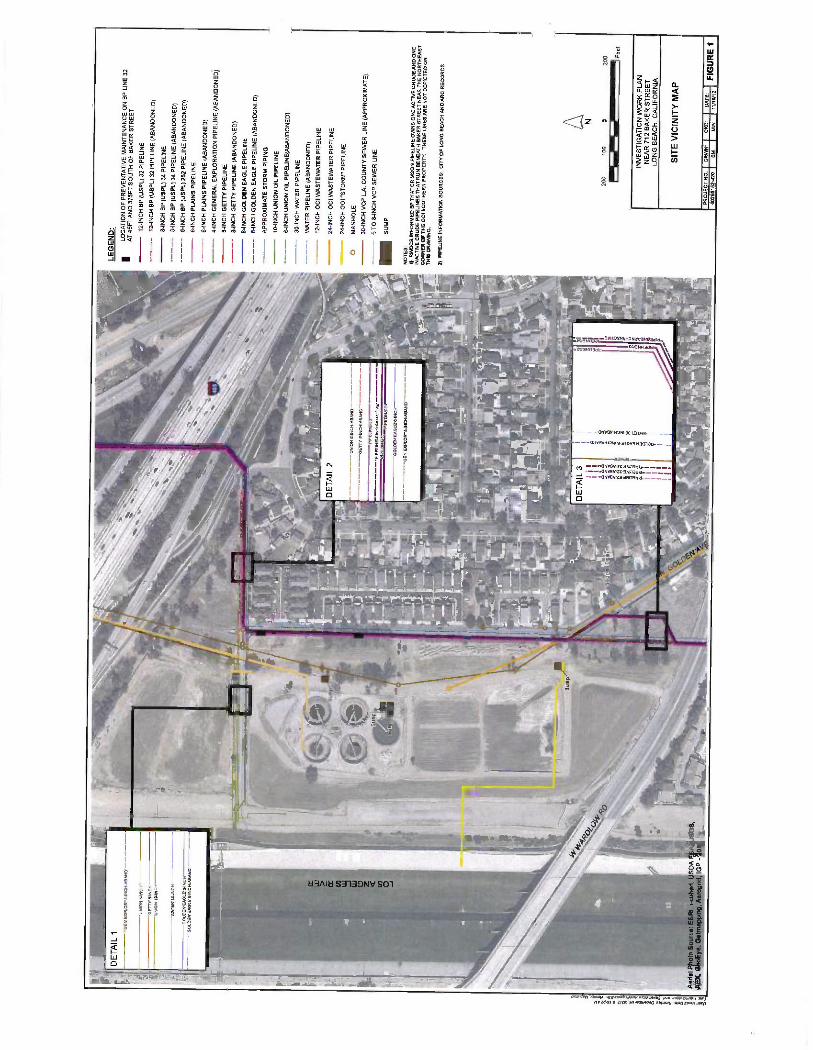
t1i
DE
TA
IL 1
GE
N E
IFL
OR
- 4,I
NC
H:A
BA
NP-
"
UN
ION
o-I
NC
H-
GE
ITY
SIN
CI-
- U
NIO
N 1
07N
C14
--
NN
TE
R50
:NC
H
OO
LDE
NE
AO
LEM
1IN
CH
--
-OO
LO
EN
EA
O[E
0.IN
CH
.AB
AN
D"-
- U
NIO
N e
INC
H:A
BA
NO
--'O
ER
Y SI
NC
H:A
BA
ND
PIPE
CIN
E:S
PIPE
[ IN
P'!-
INC
H-I
NA
CT
IVE
' P
IPE
CIN
E71
PIPE
0NE
74
- R
. ,_
.; W
S,-
..
. G
OL
OE
NE
AO
LE
6IN
CH
j
1
' '
-GE
N E
WL
OR
'61N
CN
AB
AN
D'
ri l
a '
{ P.
_
l .:
' _
_ nr
" ..a
:r
t v
c,,7
.
' .o
-'
.I!q
- ...
-
.. -
,
L
.
y
. .L
f
...%
. !
1 )
' ,
y p . e.
- k
°,
A --
' ¡I-- _
r -'
'
`=ir
-1
' --
i r
t , ,
_ r.
._
,.t."
':
i f
I_ y`
:.-_-
..-..:
: F
f
I
¡ =
' '
` '
_ r'
^;
F
_ F
,, !
IA.
, B
, b
,
y ".
'
, e
áiu_
I
_
g 'I
N' . :
.,,`
'
,
p {i
.I
1;
..L.:,
" -
- t
-rl-
-=
' ,;-:
.
f-
` ya
on
z.--
7 1
1r i
J ,:
{
' L
51.0
11m
-DI'a
tn
Aer
ial
Pho
to S
ourc
e: E
6RI.
i- cu
bed.
US
DA
I A
. U
SG
S
AE
X.
Geo
Eye
. G
etm
Rpp
ing,
Aer
ogrid
, IG
P -
2012
9L
'_..
.:-
;.
Ry.
'`
LE
GE
ND
:
LOC
AT
ION
OF
P
RE
VE
NT
AT
IVE
MA
INT
EN
AN
CE
ON
BP
LIN
E 3
2 A
T 45
FT
AN
D 3
75F
T S
OU
TH
OF
B
AK
ER
ST
RE
ET
12 -I
NC
H B
P (U
SP
L) 3
2 P
IPE
LIN
E
12 -I
NC
H B
P (
US
PL)
32
PIP
ELI
NE
(A
BA
ND
ON
ED
)
8-IN
CH
BP
(U
SP
L) 3
4 P
IPE
LIN
E
8-IN
CH
BP
(U
SP
L) 3
4 P
IPE
LIN
E
(AB
AN
DO
NE
D)
6 -I
NC
H B
P (
US
PL)
252
P
IPE
LIN
E (
AB
AN
DO
NE
D)
6-IN
CH
PLA
INS
PIP
ELI
NE
6-IN
CH
PLA
INS
PIP
ELI
NE
(A
BA
ND
ON
ED
) 4-
INC
H G
EN
ER
AL
EX
PLO
RA
TIO
N P
IPE
UN
E (A
BA
ND
ON
ED
) 8-
INC
H G
ET
TY
PIP
ELI
NE
8-
INC
H G
ET
TY
PIP
ELI
NE
(AB
AN
DO
NE
D)
6-IN
CH
GO
LDE
N E
AG
LE P
IPE
LIN
E
8 -I
NC
H G
OLD
EN
EA
GLE
PIP
ELI
NE
(A
BA
ND
ON
ED
)
AP
PR
OX
IMA
TE
ST
OR
M P
IPIN
G
10 -I
NC
H U
NIO
N O
IL P
IPE
LIN
E
6-IN
CH
UN
ION
OIL
PIP
ELI
NE
(AB
AN
DO
NE
D)
30 -I
NC
H W
AT
ER
PIP
ELI
NE
WA
TE
R P
IPE
LIN
E (
AB
AN
DO
NE
D)
12 -I
NC
H 0
01 W
AS
TE
WA
TE
R P
IPE
LIN
E
24 -I
NC
H 0
01
WA
ST
EW
AT
ER
PIP
ELI
NE
24 -I
NC
H 0
01
"ST
OR
M"
PIP
ELI
NE
O
MA
NH
OLE
30 -I
NC
H V
CP
L.A
. CO
UN
TY
SE
WE
R L
INE
(A
PP
RO
XIM
AT
E)
6 T
O 8
-IN
CH
VC
P S
EW
ER
LIN
E
- SUMP
NO
TE
S:
1)
RW
OC
B
INF
OR
ME
D B
P T
HA
T C
RIM
SO
N P
IPE
LIN
E O
WN
S O
NE
AC
TIV
E C
RU
DE
AN
D O
NE
IN
AC
TIV
E C
RU
DE
PIP
ELI
NE
S T
HA
T R
UN
BE
NE
AT
H
BA
KE
R
ST
RE
ET
NE
AR
TH
E N
OR
TH
EA
ST
C
OR
NE
R O
F T
HE
GO
I S
OU
TH
ER
N P
RO
PE
RT
Y.
TH
ES
E L
INE
S A
RE
NO
T D
EP
ICT
ED
ON
T
HIS
D
RA
WIN
G.
2)
PIP
ELI
NE
IN
FO
RM
AT
ION
SO
UR
CE
S:
CIT
Y O
F L
ON
G B
EA
CH
AN
D A
RC
RE
CO
RD
S
200
100
D
200 Fe
et
INV
ES
TIG
AT
ION
WO
RK
PLA
N
NE
AR
712
BA
KE
R S
TR
EE
T
LON
G B
EA
CH
, C
ALI
FO
RN
IA
SIT
E V
ICIN
ITY
MA
P
PR
OJE
CT
N
O.
DR
WN
: 60
2681
52 -
420
SM
cK
D:
D1/
AT
E:
16112
I F
IGU
RE
1
MW
1

á
--ü
.+ 1
ç` ̀.
^ ' A
i °
s ,
1
, .
i=l'C
C
: Y
1 ¡
.' "`
' P
_
.. .J
,
,..2
! :i.
.. .I
:<
c><
-,g`
L,
r?
. !.
-
.-
s¡`j
46r
i!
--rl
,..,
y v
, .F
_'
,.r
. li
/---
0,
` .i
li y'
q, 7
_
`,/
rl W
y
F
(17S
'(: . .T
1
.. ú
Fy 11
,.'V''
,~
. .4
4'`i
_- I :
,_i.'
d
LEG
EN
D: HIS
TO
RIC
AL
GR
OU
ND
WA
TE
R M
ON
ITO
RIN
G W
ELL
LO
CA
TIO
N
VA
PO
R E
XT
RA
CT
ION
SY
ST
EM
WE
LL (
CA
LIF
OR
NIA
EN
VIR
ON
ME
NT
AL,
20
12)
Q
001
WE
LLS
/BO
RIN
GS
(B
RY
CO
N 2
0150
011)
00
1 S
OIL
VA
PO
R P
RO
BE
(C
ALI
FO
RN
IA E
NV
IRO
NM
EN
TA
L. 2
011)
S
OIL
BO
RIN
G
(AE
MC
, 19
91)
O
MA
NH
OLE
LOC
AT
ION
OF
P
RE
VE
NT
AT
IVE
MA
INT
EN
AN
CE
ON
BP
LIN
E 3
2 A
T 4
5FT
AN
D 3
75F
T S
OU
TH
OF
BA
KE
R S
TR
EE
T
12 -I
NC
H B
P (
US
PL)
32
PIP
ELI
NE
12 -
INC
H B
P (
US
PL)
32
PIP
ELI
NE
(A
BA
ND
ON
ED
)
8-IN
CH
BP
(U
SP
L) 3
4 P
IPE
LIN
E
8-IN
CH
BP
(U
SP
L) 3
4 P
IPE
LIN
E (
AB
AN
DO
NE
D)
6-IN
CH
BP
(U
SP
L) 2
52
PIP
ELI
NE
(A
BA
ND
ON
ED
) 6-
INC
H P
LAIN
S P
IPE
LIN
E
6-IN
CH
PLA
INS
PIP
ELI
NE
(A
BA
ND
ON
ED
)
4-IN
CH
GE
NE
RA
L E
XP
LOR
AT
ION
PIP
ELI
NE
(AB
AN
DO
NE
D)
8-IN
CH
GE
TT
Y P
IPE
LIN
E
8-IN
CH
GE
TT
Y P
IPE
LIN
E (
AB
AN
DO
NE
D)
6-IN
CH
GO
LDE
N E
AG
LE P
IPE
LIN
E
8-IN
CH
GO
LDE
N E
AG
LE P
IPE
LIN
E (
AB
AN
DO
NE
D)
AP
PR
OX
IMA
TE
ST
OR
M P
IPIN
G
10 -I
NC
H U
NIO
N O
IL P
IPE
LIN
E
6-IN
CH
U
NIO
N O
IL P
IPE
LIN
E(A
BA
ND
ON
ED
)
30 -IN
CH
WA
TE
R P
IPE
LIN
E
WA
TE
R P
IPE
LIN
E (
AB
AN
DO
NE
D)
12 -I
NC
H 0
01 W
AS
TE
WA
TE
R P
IPE
LIN
E
24 -I
NC
H 0
01 W
AS
TE
WA
TE
R P
IPE
LIN
E
24 -I
NC
H 0
01 "
ST
OR
M"
PIP
ELI
NE
30
-IN
CH
VC
P L
.A.
CO
UN
TY
SE
WE
R L
INE
(A
PP
RO
XIM
AT
E)
6 T
O 8
-IN
CH
VC
P S
EW
ER
LI
NE
- SUMP
1
1 LA
RW
QC
B A
RE
A O
F C
ON
CE
RN
NO
TE
S:
1)
RW
QC
B I
NF
OR
ME
D
BP
TH
AT
CR
IMS
ON
PIP
ELI
NE
OW
NS
ON
E A
CT
IVE
CR
UD
E A
ND
ON
E
INA
CT
IVE
CR
UD
E P
IPE
LIN
ES
TH
AT
RU
N B
EN
EA
TH
B
AK
ER
ST
RE
ET
NE
AR
TH
E N
OR
TH
EA
ST
C
OR
NE
R O
F T
HE
001
SO
UT
HE
RN
P
RO
PE
RT
Y.
TH
ES
E L
INE
S A
RE
NO
T D
EP
ICT
ED
ON
T
HIS
DR
AW
ING
.
2)
PIP
ELI
NE
INF
OR
MA
TIO
N
SO
UR
CE
S:
CIT
Y O
F
LON
G
BE
AC
H A
ND
AR
C R
EC
OR
DS
AB
BR
EV
IAT
ION
S:
FT
F
EE
T
RW
OC
B
RE
GIO
NA
L W
AT
ER
QU
ALI
TY
CO
NT
RO
L B
OA
RD
U
SP
L B
P U
.S.
PIP
ELI
NE
S A
LO
GIS
TIC
S
VC
P
VIT
RIF
IED
CLA
Y P
IPE
N
200
100
200
INV
ES
TIG
AT
ION
WO
RK
PLA
N
NE
AR
712
BA
KE
R S
TR
EE
T
LON
G B
EA
CH
, C
ALI
FO
RN
IA
INV
ES
TIG
AT
ION
AR
EA
S
PR
OJE
CT
NO
. D
AW
N:
CK
D:
DA
TE
: 60
2681
52-4
20
SM
M
W
11/1
6/12
F
IGU
RE
2

äI
i4
a 1 s
, .,,
ta
r.
Pet
role
um o
dor
star
nin:
5.40
'b:s
. T
O
40'b
:s.
82
Dep
th
OV
A
GR
O
ft m
m
: k:
10
260
700
20
60
3.7
30
0 N
D<
0.14
n 20
11
DR
O
Ben
zene
T
olue
ne
Eth
ylbe
nzen
e X
ylen
es
m:
k;
m:
k:
m:
k:
m;
k;
m:
k:
0.73
0.
17
0.00
490
ND
<0.
001
0.00
110
ND
<0.
001
L80
0.01
400
0.00
084
L80
0.00
130
ND
<0.
0012
G
roun
dwat
er T
O
<
34 ft
b :s
.
Dep
th
OV
A
GR
O
DR
O
Ben
zene
T
olue
ne
Eth
ylbe
nzen
e X
ylen
es
ft m
m
: k:
m
: k:
m
: k:
m
: k:
m
: k:
m
: k:
10
20
3 56
0 63
00
0.69
0.
04
20
0 N
D<
0.14
N
D<
21
0.00
038
ND
<0.
001
30
0 N
D<
0.18
4.
9 N
D <
0.00
1 N
D<
0.00
1
Gro
undw
ater
TD
a
32ftb
:
ND
<0.
025
ND
<0.
001
ND
<0.
001
L80
ND
<0.
001
NO
<0.
001
CE
SV
-1
(Cal
iforn
ia E
nviro
nmen
tal,
2011
) P
etro
leum
odo
r @
4-4
0 b:
. T
O @
40'
b: s
.
JB&
A4
FOR
ME
R
B
n, 20
1
Dep
th
OV
A
GR
O
DR
O
ft m
m
: k:
m
: k:
10
0
0.33
20
0
20
0 0.
15
ND
<3.
5
30
0 N
O<
0.13
N
D<
3.5
40
0 90
<0.
14
ND
<3.
5
Gro
undw
ater
, T
D @
45
ft b:
s.
(Bry
con,
201
1)
Ben
zene
T
olue
ne
Eth
ylbe
nzen
e X
yren
es
m;
k;
m:
, m
: :
m;
k:
0.00
083
ND
<0.
001
ND
<0.
001
ND
<0.
001
NO
<0.
001
ND
<0.
001
ND
<0.
001
ND
<0.
001
0.00
360
ND
<0.
001
ND
<0.
001
ND
<0.
001
0.00
320
ND
.3.
001
ND
<0.
001
ND
<0.
001.
Dep
th
OV
A
GR
O
DR
O
Ben
zene
T
olue
ne
Eth
ylbe
nzen
e X
ylen
es
ft m
m
: k:
m
: k:
m
: k:
m
: k:
m
: k:
m
; k:
10
60
2.
7 54
00
0.01
00
0.00
13
20
40
94
1200
0.
0073
0 N
D <
0.00
1 30
0
ND
<0.
14
ND
<3.
5 N
O<
0.00
1 N
D .
3.00
1 G
roun
dwat
er
TD
a
33ft
b;s.
0.00
99
0.00
520
ND
<0.
001
0.00
66
ND
<0.
001
ND
<0.
001
(Bry
son,
201
1)
ND
<5
ND
<25
190
B13
Dep
th
OV
A
GR
O
ft m
m
: k:
B n
2011
O
RO
B
enze
ne
Tol
uene
E
thyl
ben
zene
X
ylen
es
m:
k:
m;
k:
m:
k:
m:
k:
m:
k:
10
0 N
D<
0.13
3.
9 N
D 4
.011
N
D<
0.00
1 N
D<
0.00
1 20
0
ND
<0.
15
ND
<3.
S
ND
<0.
031
ND
<0.
001
ND
<0.
001
30
0 N
D<
0.13
3.
7 N
D<
0.00
1 N
D<
0.00
1 N
D<
0.00
1 G
roun
dwat
er T
D
38ftb
:s.
ND
<0.
001
ND
<0.
001
ND
<0.
001
CE
SV
-9
(Cal
iforn
ia E
nviro
nmen
tal,
201
)
Cho
r @
O4,
12
-28'
b:
s. O
il @
12
-17
b: s.
T
D @
28'
b:
s
(Bry
son,
201
1)
10
90 <
10
ND
<5
20
ND
<10
N
D<
5 30
N
D<
10
ND
<5
40
ND
<10
N
D<
S
Pet
role
um o
dor
/sta
lnln
: 5-
40k:
<. T
D@
40
b:
.
:ES
V10
10
190
ND
<10
ND
<10
ND
<5
ND
<5
ND
<5
EM
CO
N 8
.5
ti FO
RM
ER
VE
S-A
(C
alifo
rnia
Env
ironm
enta
l, 20
12)
Pet
role
um o
dor
8-28
' b:
.
TD
30
' b:s
.
y-
V
M¡i
. V
ES
D
To.
.;30:
. (C
alifo
rnia
Env
ironm
enta
l, 20
12)
812
(Bry
son,
201
1)
1
Dep
th
OV
A
GR
O
DR
O
Ben
zene
T
olue
ne
Eth
ylbe
nzen
e X
ylen
es
ft m
m
: k:
m
: k:
m
: k:
m
; k;
m
: k;
m
: k;
/10
0 90
<0.
14
ND
<3.
5 N
D<
0.00
1 N
D<
0.00
1 N
D<
0.00
1 N
D o
/001
20
0
ND
<0.
16
ND
<3.
5 N
D<
0.00
1 N
D<
0.00
1 N
D<
0.00
1 N
D<
0.00
1
c 30
0
90 <
0.14
N
D<
3.5
ND
<0.
001
NO
<0.
001
ND
<0.
001
90<
0.00
1
8-3
Aer
ial P
hoto
S
ourc
e. E
SR
I, i-
cube
d, U
SD
A
FS
A.
US
ES
, A
EX
, G
eoE
ye,
Get
ntap
ping
, Aer
ogrid
, IG
P -
2012
92
-M
W4
FO
RM
ER
V
ES
-O'
-
LEG
EN
D:
9 H
IST
OR
ICA
L G
RO
UN
DW
AT
ER
MO
NIT
OR
ING
WE
LL L
OC
AT
ION
VA
PO
R E
XT
RA
CT
ION
S
YS
TE
M W
ELL
(C
ALI
FO
RN
IA E
NV
IRO
NM
EN
TA
L,
2012
)
Q
001
WE
LLS
/BO
RIN
GS
(BR
YC
ON
201
0201
1)
OO
I S
OIL
VA
PO
R P
RO
BE
(CA
LIF
OR
NIA
EN
VIR
ON
ME
NT
AL.
201
11
e S
OIL
BO
RIN
G (
AE
MC
, 19
91)
O
NO
BO
RIN
G
LOG
OR
SO
IL A
NA
LYT
ICA
L D
AT
A A
VA
ILA
BLE
1 N
O S
OIL
IM
PA
CT
S D
OC
UM
EN
TE
D IN
BO
RIN
G L
OG
AT
TH
IS L
OC
AT
ION
LO
CA
TIO
N O
F P
RE
VE
NT
AT
IVE
MA
INT
EN
AN
CE
O
N B
P L
INE
32
AT
45F
TA
ND
375
FT
SO
UT
H O
F B
AK
ER
ST
RE
ET
12 I
NC
H B
P (
US
PL)
32
PIP
ELI
NE
12
-IN
CH
BP
(U
SP
L) 3
2 P
IPE
LIN
E (
AB
AN
DO
NE
D)
8-IN
CH
BP
(U
SP
L) 3
4 P
IPE
LIN
E
8-IN
CH
BP
(U
SP
L) 3
4 P
IPE
LIN
E (
AB
AN
DO
NE
D)
6-IN
CH
BP
(U
SP
L) 2
52 P
IPE
LIN
E (
AB
AN
DO
NE
D)
6-IN
CH
P
LAIN
S P
IPE
UN
E
--
6-IN
CH
PLA
INS
PIP
ELI
NE
(A
BA
ND
ON
ED
) 4-
INC
H G
EN
ER
AL
EX
PLO
RA
TIO
N P
IPE
LIN
E (
AB
AN
DO
NE
D)
0-IN
CH
GE
TT
Y P
IPE
LIN
E
8-IN
CH
GE
TT
Y P
IPE
LIN
E (
AB
AN
DO
NE
D)
6-IN
CH
GO
LDE
N E
AG
LE P
IPE
LIN
E
8-IN
CH
GO
LDE
N E
AG
LE P
IPE
UN
E (
AB
AN
DO
NE
D)
AP
PR
OX
IMA
TE
ST
OR
M P
IPIN
G
10 -I
NC
H U
NIO
N O
IL P
IPE
LIN
E
- 6-
INC
H U
NIO
N O
IL P
IPE
LIN
E(A
BA
ND
ON
ED
) 30
-IN
CH
WA
TE
R P
IPE
LIN
E
WA
TE
R P
IPE
LIN
E
(AB
AN
DO
NE
D)
12 -I
NC
H 0
01 W
AS
TE
WA
TE
R P
IPE
LIN
E
24 -I
NC
H 0
01 W
AS
TE
WA
TE
R P
IPE
LIN
E
24 -I
NC
H 0
01 "
ST
OR
M"
PIP
ELI
NE
O
M
AN
HO
LE
30 -I
NC
H V
CP
L.A
. C
OU
NT
Y S
EW
ER
LIN
E (
AP
PR
OX
IMA
TE
) 6
TO
B
-IN
CH
VC
P S
EW
ER
LIN
E
SU
MP
NO
TE
S:
1)
RW
OC
B I
NF
OR
ME
D B
P T
HA
T C
RIM
SO
N P
IPE
LIN
E O
WN
5 O
NE
AC
TIV
E C
RU
DE
AN
D
ON
E
INA
CT
IVE
CR
UD
E P
IPE
LIN
ES
TH
AT
RU
N B
EN
EA
TH
B
AK
ER
S
TR
EE
T
NE
AR
T
HE
NO
RT
HE
AS
T
CO
RN
ER
OF
TH
E 0
0I S
OU
TH
ER
N P
RO
PE
RT
Y.
TH
ES
E L
INE
S A
RE
N
OT
DE
PIC
TE
D O
N
TH
IS
DR
AW
ING
.
2)
PIP
ELI
NE
IN
FO
RM
AT
ION
S
OU
RC
ES
: C
ITY
OF
LO
NG
BE
AC
H A
ND
AR
C R
EC
OR
DS
.
AB
BR
EV
IAT
ION
S:
BG
S
DR
O
FT
OR
' G
RO
M
G/K
G
ND
OV
A
RW
0C8
TD
T
PH
-E
TP
H-V
T
RP
H
UG
/KG
U
SP
L V
CP
BE
LOW
GR
OU
ND
SU
RF
AC
E
DIE
SE
L -R
AN
GE
OR
GA
NIC
S
FE
ET
G
AS
OLI
NE
-RA
NG
E O
RG
AN
ICS
M
ILLI
GR
AM
S
PE
R K
ILO
GR
AM
N
ON
DE
TE
CT
OR
GA
NIC
VA
PO
R A
NA
LYZ
ER
R
EG
ION
AL
WA
TE
R Q
UA
LIT
Y
CO
NT
RO
L B
OA
RD
T
OT
AL
DE
PT
H
TO
TA
L P
ET
RO
LEU
M
HY
DR
OC
AR
BO
NS
-
EX
TR
AC
TA
BLE
T
OT
AL
PE
TR
OLE
UM
HY
DR
OC
AR
BO
NS
-V
OLA
TIL
E
TO
TA
L R
EC
OV
ER
AB
LE
PE
TR
OLE
UM
HY
DR
OC
AR
BO
NS
M
ICR
OG
RA
MS
PE
R K
ILO
GR
AM
B
P U
.S.
PIP
ELI
NE
S S
LO
GIS
TIC
S
VIT
RIF
IED
CLA
Y P
IPE
150
75
0 15
0 Fee
t
NE
AR
712
B
AK
ER
ST
RE
ET
LO
NG
BE
AC
H,
CA
LIF
OR
NIA
FO
CU
SE
D S
OIL
DA
TA
SU
MM
AR
Y
NO
RT
HE
RN
GO
LDE
N A
VE
NU
E
CO
RR
IDO
R
PR
OJE
CT
NO
.
I
DR
WN
:
I
CK
D:
I
DA
TE
:
I F
IGU
RE
3a
6026
0152
.420
S
M
MW
11
/16/
12

HA
-1".
."
B5
(Bry
on,
2011
)
Dep
th
OV
A
GR
O
DR
O
Ben
zene
T
olue
ne
Eth
ylbe
nzen
e X
ylen
es
(ft)
(p
pm)
(me/
kg)
(mg/
kg)
(mg/
kg)
(mg/
kg)
(mg/
kg)
(mg/
kg)
10
170
2.4
12
ND
<0.
001
ND
<0.
001
0.01
8 N
D<
0.00
1 20
0
ND
<0.
13
ND
<3.
S
ND
<0.
001
ND
<0.
001
ND
<0.
001
ND
<0.
001
30
0 N
D <
0.14
8.
5 N
D<
0.03
1 N
D<
0.00
1 N
D<
0.00
1 N
D<
0.00
1 G
roun
dwat
er T
D
n 32
R b
: .
F 81
4 ( B
ryoo
n, 2
011)
D
epth
O
VA
G
RO
O
RO
B
enze
ne
Tol
uene
E
thyl
benz
ene
Xyl
enes
1,
2- D
ichl
oroe
than
e ft
m
m;
; m
; k:
m
; k;
m
; k;
;,
k:
m;,
k:
m:
k:
10
0 N
D<
0.15
6.
3 N
D <
0.00
1 N
D<
0.00
1 N
D <
0.00
1 N
D<
0.00
1 N
D<
0.00
1 20
0
LOO
9.
6 0.
0066
0.
0021
0.
0012
0.
0072
N
D <
0.03
1 30
-
0.17
4.
1 0.
0069
0.
0010
0.
0007
0.
007
0.00
52
40
- N
D <
016
ND
<3.
5 0.
0015
N
D<
0.00
1 N
D o
3.00
1 0.
0018
0.
0015
G
roun
dwat
er T
D (d
48ft.
b:s
.
CE
SV
-10
TD
@ 3
2 b:
s.
(Cal
iforn
ia E
nviro
nmen
tal,
2011
)
10
1200
0 N
D<
5
20
ND
<10
N
D<
5
Pet
role
um o
dor@
10
b ;s
. T
D @
20'
b:s
.
VE
S-8
(C
alifo
rnia
Env
ironm
enta
l, 20
12)
B6
- n
2011
Dep
th
OV
A
GR
O
DR
O
Ben
zene
T
olue
ne
Eth
ylbe
nzen
e X
ylen
es
ft m
m
; k;
m
: k:
m
: k:
m
: k:
m
: k:
m
; k:
10
0
ND
<0.
14
17
ND
<0.
001
ND
<0.
001
ND
<0.
001
ND
<0.
001
20
0 N
D <
0.12
N
D<
3.S
N
D<
0.00
1 N
D<
0.00
1 N
D <
0.00
1 N
D <
0.00
1
30
0 N
D <
-0.1
3 N
D<
3.5
ND
<0.
001
ND
<0.
001
ND
<0.
001
ND
<0.
001
Gro
undw
ater
, T
D @
33
ft b
s.
VE
S-E
(C
alifo
rnia
Env
iron
men
tal,
2012
) *y
1 (¡
s I;:ä
LEG
EN
D: H
IST
OR
ICA
L G
RO
UN
DW
AT
ER
MO
NIT
OR
ING
WE
LL L
OC
AT
ION
`I'
VA
PO
R E
XT
RA
CT
ION
SY
ST
EM
W
ELL
(C
ALI
FO
RN
IA E
NV
IRO
NM
EN
TA
L,
I' 20
12)
00)
WE
LLS
/B
OR
ING
S (B
RY
CO
N 2
010/
2011
)
001
SO
IL V
AP
OR
PR
OB
E (
CA
LIF
OR
NIA
EN
VIR
ON
ME
NT
AL,
201
1)
SO
IL B
OR
ING
(AE
MC
, 19
91)
o N
O B
OR
ING
LO
G O
R S
OIL
AN
ALY
TIC
AL
DA
TA
AV
AIL
AB
LE
O
NO
SO
IL IM
PA
CT
S D
OC
UM
EN
TE
D I
N
BO
RIN
G L
OG
AT
T
HIS
LO
CA
TIO
N
LOC
AT
ION
OF
P
RE
VE
NT
AT
IVE
MA
INT
EN
AN
CE
O
N
BP
LIN
E
32
AT
45F
TA
ND
375
FT
SO
UT
H O
F B
AK
ER
ST
RE
ET
12 I
NC
H B
P (
US
PL)
32
PIP
ELI
NE
--
12
-IN
CH
BP
(U
SP
L) 3
2 P
IPE
LIN
E (
AB
AN
DO
NE
D)
8-IN
CH
B
P (U
SP
L) 3
4 P
IPE
LIN
E
--
8-IN
CH
B
P (U
SP
L) 3
4 P
IPE
LIN
E
(AB
AN
DO
NE
D)
6-IN
CH
B
P (U
SP
L) 2
52
PIP
ELI
NE
(A
BA
ND
ON
ED
) 6-
INC
H
PLA
INS
PIP
ELI
NE
6-IN
CH
P
LAIN
S P
IPE
LIN
E (
AB
AN
DO
NE
D)
--
4-IN
CH
GE
NE
RA
L E
XP
LOR
AT
ION
PIP
ELI
NE
(A
BA
ND
ON
ED
) 8-
INC
H G
ET
TY
PIP
ELI
NE
8-IN
CH
GE
TT
Y P
IPE
LIN
E (
AB
AN
DO
NE
D)
6-IN
CH
G
OLD
EN
EA
GLE
PIP
ELI
NE
- --
8-
INC
H G
OLD
EN
EA
GLE
PIP
ELI
NE
(A
BA
ND
ON
ED
) A
PP
RO
XIM
AT
E S
TO
RM
PIP
ING
10 -I
NC
H U
NIO
N
OIL
PIP
ELI
NE
--
6-
INC
H
UN
ION
OIL
PIP
ELI
NE
(AB
AN
DO
NE
D)
30 -I
NC
H W
AT
ER
PIP
ELI
NE
-
WA
TE
R P
IPE
LIN
E (
AB
AN
DO
NE
D)
--
12 -I
NC
H 0
01 W
AS
TE
WA
TE
R
PIP
ELI
NE
24
-IN
CH
001
WA
ST
EW
AT
ER
PIP
ELI
NE
24
-IN
CH
001
"S
TO
RM
" P
IPE
LIN
E
O
MA
NH
OLE
30 -I
NC
H V
CP
L.A
. C
OU
NT
Y S
EW
ER
LIN
E (
AP
PR
OX
IMA
TE
) --
6
TO
8 -
INC
H V
CP
SE
WE
R L
INE
CE
SK36
T
D
20%
,. (C
alaf
amia
Env
lron
tner
ttal,
2011
)
EM
CO
N -B
S (f
orm
er)
( E
MC
ON
, 190
1)
oil
odor
47
' 55
'b: s
. G
roun
dwat
er
.
55'b
:. T
D
<
60'
Dea
th
TR
PH
m
: k:
B
enze
s
10
1700
N
D<
5
20
ND
<10
N
D<
5 30
27
0 N
D <
5
40
570
ND
<5
."00
-.
-r
----
-
r ¡
_ _-
a B
i `r
((
:'1
- a.
T
, _-)'
V
-26
(Cal
iforn
ia E
nviro
nmen
tal,
2011
) ;
Odo
r °
4-8'
:
s 16
20' b
; s.
T
D ' 3
2' b
; s.
-+
g:.c
£
a .
t, .._
T'í--
..-rr
-
1 G
_s
. - .
EM
CO
N -B
2 (f
orm
er)
(EM
CO
N,
1981
) O
d od
or @
46
' b
Gro
undw
ater
48
' b;
.
TD
60
b;s
. E
MC
ON
-MW
3-
B7
( Bry
con,
201
1)
Dep
th
OV
A
GR
O
DR
O
Ben
zene
T
olue
ne
Eth
ylbe
nzen
e X
ylen
es
ft m
m
: k:
m
: k:
m
: k:
m
: k:
m
; k:
m
: k:
10
0
ND
<0.
16
ND
<3.
5 N
D <
0.00
1 N
D <
0.00
1 N
D<
0.00
1 N
D<
0.00
1 20
0
ND
<0.
11
ND
<3.
5 N
O <
0.00
1 N
D <
0.00
1 N
D <
0.00
1 N
D<
0.00
1 30
0
ND
<0.
13
ND
<3.
5 N
D <
0.03
1 N
D <
0.00
1 N
D<
0.00
1 N
D<
0.00
1
Gro
undw
ater
, T
D @
33
ft b:
s.
92 -M
W3
DA
MA
GE
D
ES
E -M
W -1
E
SE
, 19
99
Eth
ylbe
n D
epth
O
VA
T
PH
-E
TP
H -V
B
enze
ne
Tol
uene
ie
ne
Xyl
enes
1
2 -D
CA
ftb
:s
m
m:
k;
: k:
u:
k:
u: k
: u:
k:
u
: /k
: u :k
: 10
0
ND
<5
ND
<1.
0 N
D
ND
25
90
0 N
D<
5 N
D<
1.0
ND
N
D
40
150
NO
<5
ND
<1.
0 N
D
ND
55
900
ND
<5
ND
<1.
0 18
2.
3 70
0
ND
<5
ND
<1.
0 N
D
ND
2055
'b:s
. G
roun
dwat
er
55'b
:s.
TD
74
'b:s
.
ND
N
D
ND
ND
N
D
ND
N
D
ND
3.
2
10
10.7
3.
2
ND
N
D
13
.s,Y
.*_'
...
.
45ftb
:. 89
Sum
p
/
: A
edal
Pho
to S
ourc
e: E
SR
I, i-c
ubed
, U
SD
A F
SA
. U
SG
S,
! °f
c`_'
"'=s
AE
X,
GeD
Eye
, G
etm
eppi
ng, A
ertlp
rid,
IGP
-20
12
`.
- i.
2-M
W2
(OI
,oRME'
"..!
SU
MP
NO
TE
S:
1)
RW
OC
B
INF
OR
ME
D B
P T
HA
T C
RIM
SO
N
PIP
ELI
NE
OW
NS
ON
E A
CT
IVE
CR
UD
E A
ND
ON
E
INA
CT
IVE
CR
UD
E P
IPE
LIN
ES
TH
AT
RU
N B
EN
EA
TH
BA
KE
R S
TR
EE
T N
EA
R T
HE
NO
RT
HE
AS
T
CO
RN
ER
OF
TH
E O
OI
SO
UT
HE
RN
P
RO
PE
RT
Y.
TH
ES
E L
INE
S A
RE
NO
T D
EP
ICT
ED
ON
T
HIS
D
RA
WIN
G.
2)
PIP
ELI
NE
IN
FO
RM
AT
ION
SO
UR
CE
S:
CIT
Y O
F L
ON
G
BE
AC
H
AN
D A
RC
RE
CO
RD
S.
AB
BR
EV
IAT
ION
S:
BG
S
BE
LOW
GR
OU
ND
SU
RF
AC
E
DR
O
DIE
SE
L -R
AN
GE
OR
GA
NIC
S
FT
OR
' F
EE
T
GR
O
GA
SO
LIN
E -
RA
NG
E O
RG
AN
ICS
M
G /K
G
MIL
LIG
RA
MS
P
ER
K
ILO
GR
AM
N
D
NO
N
DE
TE
CT
O
VA
O
RG
AN
IC V
AP
OR
AN
ALY
ZE
R
RW
QC
B
RE
GIO
NA
L W
AT
ER
QU
ALI
TY
CO
NT
RO
L B
OA
RD
T
D
TO
TA
L D
EP
TH
T
PH
-E
TO
TA
L P
ET
RO
LEU
M H
YD
RO
CA
RB
ON
S
EX
TR
AC
TA
BLE
T
PH
-V
TO
TA
L P
ET
RO
LEU
M
HY
DR
OC
AR
BO
NS
- V
OLA
TIL
E
TR
PH
T
OT
AL
RE
CO
VE
RA
BLE
PE
TR
OLE
UM
HY
DR
OC
AR
BO
NS
U
G/K
G
MIC
RO
GR
AM
S P
ER
K
ILO
GR
AM
U
SP
L B
P U
.S.
PIP
ELI
NE
S 8
LO
GIS
TIC
S
VC
P
VIT
RIF
IED
CLA
Y P
IPE
150
75
5 15
0 Feet
NE
AR
712
BA
KE
R S
TR
EE
T
LON
G B
EA
CH
, C
ALI
FO
RN
IA
FO
CU
SE
D S
OIL
DA
TA
SU
MM
AR
Y
CE
NT
RA
L G
OLD
EN
AV
EN
UE
C
OR
RID
OR
P
RO
JEC
T N
O.
DR
AN
: C
KD
: D
AT
E:
6026
8152
-420
S
M
MW
11
/16/
12
FIG
UR
E 3
b
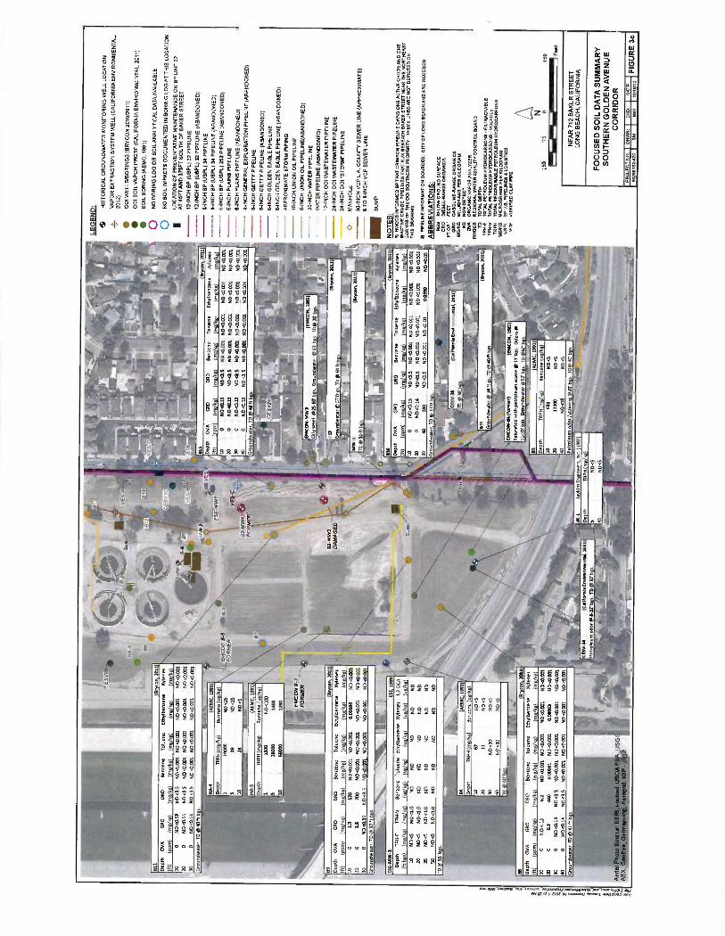
F E
MC
ON
B-2
_ F
OR
ME
R
es- 4
B11
Dep
th
OV
A
GR
O
(ft)
(p
pm)
( m
g/kg
) 10
0
ND
<0.
12
20
0 N
D <
0.14
30
0
ND
<0.
14
DR
O
(mg/
kg)
ND
<3.
5
ND
<3.
5
NO
<3.
5
HA
-4
Dep
th
Gro
undw
ater
, T
D @
40f
t bgs
.
10
HA
-5
014
(Bry
con,
201
1)
Ben
zene
T
olue
ne
Eth
ylbe
nzen
e X
ylen
es
(mg/
kg)
(mg/
kg)
(mg/
kg)
(mg/
kg)
ND
<0.
001
ND
<0.
001
ND
<0.
001
ND
<0.
001
N0<
0.00
1 N
D <
0.00
1 N
D <
0.00
1 N
D<
0.00
1
ND
<0.
001
ND
<0.
001
ND
<0.
001
ND
<0.
001
-.
u-,1
f1
(AE
MC
, 199
1)
TR
PH
(m
g/kg
) B
enze
ne (
ug/k
g)
1900
0 N
D <
25
29
ND
<25
24
ND
<S
01
(AE
MC
,199
1)
Ben
zene
(ug/
kg)
ND
<10
0
1400
I
89
(Bry
son,
201
1)
Dep
th
OV
A
GR
O
DR
O
Ben
zene
T
olue
ne
Eth
ylbe
nzen
e X
ylen
es
(fr)
(P
Pm
) ( m
g/kg
) ( m
g/kg
) ( m
g/kg
) ( m
g/kg
) ( m
g/kg
) ( m
g/kg
) 10
0
13
570
ND
<0.
001
ND
<0.
001
0.00
084
ND
<0.
001
20
0 1.
5 20
0 N
D <
0.03
1 N
D<
0.00
1 N
D<
0.00
1 N
O.0
.001
30
0
ND
<0.
15
NO
<3.
5 N
D<
0.00
1 N
O<
0.00
1 N
D <
0.00
1 N
D <
0.00
1
CE
SV 1
O
VE
S-8
-;
Gro
undw
ater
TD
u
37ftb
:s.
ES
E -M
W -2
E
SE
, 19
99 /
Dep
th
TP
H -E
T
PH
-V
B
enze
ne
Tol
uene
E
thyl
benz
ene
Xyl
enes
1,
2 -D
CA
(ft b
gs)
( mg/
kg)
(mg/
kg)
( ug/
kg)
(ug/
kg)
( ug
/kg)
( ug
/kg)
( u
g/kg
)
EM
CO
N 8
-5
T°
8 -3
F
OR
ME
R B
7
C)
\
10
20
35
SD
TD
@55
'b
ND
<5
ND
<5
ND
<S
ND
<5
ND
<1.
0
ND
<1.
0
ND
<1.
0
ND
<1.
0
ND
ND
ND
ND
ND
ND
ND
ND
ND
ND
ND
ND
ND
ND
ND
ND
ND
ND
ND
ND
VE
S -C
\ FO
RM
ER
i<l
815
Dep
th
OV
A
GR
O
DR
O
(ft)
(P
pm)
(m8/
k8)
( mg/
kg)
10
0 N
D<
0.15
N
D<
3.5
20
0 N
D<
0.15
N
D<
3.S
30
0
ND
<0.
15
ND
<3.
5 40
0
NO
<0.
15
ND
<3.
5 G
roun
dwat
er T
D
48ft
b:s.
Ben
zene
T
olue
ne
(mg/
kg)
( mg/
kg)
ND
<0.
001
ND
<O
.001
ND
<0.
001
ND
40.0
01
ND
<0.
001
ND
<0.
001
ND
4O.0
01
ND
<0.
001.
(Bry
oon,
201
1)
Eth
yl b
enze
ne
Xyl
enes
(r
n8/k
8)
(rnH
/k8)
N
D<
0.00
1 N
D <
0.00
1
ND
<0.
001
ND
<O
.CO
1
NO
00.0
01
ND
<0.
031
ND
<
0.00
1 N
D <
0.00
1
92 -M
W3
DA
MA
GE
D
Oil
smel
l @
25-6
0'b
Gro
undw
ater
63
'b:s
.TO
", 7
0' b
817
Gro
undw
ater
@57
ft: -
TD
60
ftb:s
.
MW
-1
TD
@S
Oftb
;s.
III
`,..1
72
810
LEG
EN
D: HIS
TO
RIC
AL
GR
OU
ND
WA
TE
R M
ON
ITO
RIN
G W
ELL
LO
CA
TIO
N
4_
VA
PO
R E
XT
RA
CT
ION
SY
ST
EM
W
ELL
(CA
LIF
OR
NIA
EN
VIR
ON
ME
NT
AL.
20
12)
OO
I W
ELL
S /B
OR
ING
S (
BR
YC
ON
201
0001
1)
001
SO
IL V
AP
OR
PR
OB
E (
CA
LIF
OR
NIA
EN
VIR
ON
ME
NT
AL,
20
11)
. S
OIL
BO
RIN
G
(AE
MC
, 19
91)
o N
O B
OR
ING
LO
G O
R S
OIL
AN
ALY
TIC
AL
DA
TA
AV
AIL
AB
LE
0
NO
SO
IL IM
PA
CT
S D
OC
UM
EN
TE
D IN
B
OR
ING
LO
G A
T T
HIS
LO
CA
TIO
N
LOC
AT
ION
OF
P
RE
VE
NT
AT
IVE
MA
INT
EN
AN
CE
ON
B
P LI
NE
32
AT
45F
TA
ND
375
FT
SO
UT
H O
F
BA
KE
R S
TR
EE
T
12 -I
NC
H B
P
(US
PL)
32
PIP
EU
NE
12
-IN
CH
BP
(U
SP
L) 3
2 P
IPE
UN
E (
AB
AN
DO
NE
D)
8-IN
CH
BP
(U
SP
L) 3
4 P
IPE
UN
E
8-IN
CH
BP
(U
SP
L) 3
4 P
IPE
LIN
E (A
BA
ND
ON
ED
) 6-
INC
H B
P (
US
PL)
252
PIP
ELI
NE
(AB
AN
DO
NE
D)
6-IN
CH
PLA
INS
PIP
ELI
NE
6-
INC
H P
LAIN
S P
IPE
LIN
E (
AB
AN
DO
NE
D)
4-IN
CH
GE
NE
RA
L E
XP
LOR
AT
ION
PIP
EU
NE
(A
BA
ND
ON
ED
) 8 -I
NC
H G
ET
TY
P
IPE
LIN
E
8-IN
CH
GE
TT
Y
PIP
ELI
NE
(A
BA
ND
ON
ED
) 6-
INC
H G
OLD
EN
E
AG
LE P
IPE
LIN
E
8-IN
CH
GO
LDE
N
EA
GLE
PIP
EU
NE
(A
BA
ND
ON
ED
) A
PP
RO
XIM
AT
E S
TO
RM
PIP
ING
10
-IN
CH
UN
ION
OIL
PIP
ELI
NE
6-
INC
H U
NIO
N O
IL P
IPE
LIN
E(A
BA
ND
ON
ED
) 30
-IN
CH
WA
TE
R P
IPE
LIN
E
WA
TE
R P
IPE
LIN
E (
AB
AN
DO
NE
D)
12 -I
NC
H 0
01 W
AS
TE
WA
TE
R P
IPE
LIN
E
24 -I
NC
H 0
01 W
AS
TE
WA
TE
R P
IPE
LIN
E
24 -I
NC
H 0
01 "
ST
OR
M" P
IPE
LIN
E
O
MA
NH
OLE
30
-IN
CH
VC
P L
.A.
CO
UN
TY
SE
WE
R L
INE
(A
PP
RO
XIM
AT
E)
6 T
O 8
-IN
CH
VC
P S
EW
ER
LIN
E
- SUMP
(Bry
con
2011
) N
OT
ES
: D
epth
O
VA
G
RO
D
RO
B
enze
ne
Tol
uene
E
thyl
ben
zene
X
ylen
es
ft)
(ppm
) (m
g/kg
) (m
g/kg
) (m
g/kg
) (m
g/kg
) (m
g/kg
) (m
g/kg
) 10
0
ND
<0.
13
ND
<3.
5 N
D<
0.00
1 N
D<
0.00
1 N
D<
0.00
1 N
D<
0.00
1 20
0
ND
<0.
14
ND
<3.
5 N
D<
0.00
1 N
D<
0.00
1 N
D<
0.00
1 N
D<
0.00
1 30
40
18
0 N
D <
15
ND
<0.
001
ND
<0.
03
0.03
90
ND
<0.
05
Gro
undw
ater
, T
D @
37
ft bg
s
:4',4
(AE
MC
, 19
91)
Dep
th
TR
PH
( m
g/kg
) B
enze
ne (
ug/
kg)
67
11
ND
<10
ND
<10
ND
<5
ND
<5
ND
<5
NO
<5
or
CE
S V
-38
TD
@ 3
8' b
gs.
B8 Dep
th
OV
A
GR
O
10
0 N
D
<.1
2
20
0 0.
2 30
0
ND
<0.
13
40
0 N
D<
0.14
Gro
undw
ater
TD
@ 4
1 ft
b: s
.
TO
@ 4
0' b
gs.
DR
O
Ben
zene
T
olue
ne
6.2
ND
o3.
001
ND
<0.
031
440
Q00
081
ND
<0.
031
ND
<3.
5 N
D<
0.00
1 N
D <
0.00
1
1.40
<3.
5 N
D<
0.00
1 N
D<
0.00
1
Eth
yl b
enze
ne
m;
k;
ND
<0.
001
0.00
063
ND
<0.
001
ND
<0.
001
B
con
2011
Xyl
enes
ND
<0.
001
ND
<0.
001
ND
<0.
031
ND
<0.
001
f (C
alifo
rnia
Env
ironm
enta
l, 20
11)
n:.i+
-u-
1'-'`
.V. ÌÄ
,. G
roun
dwat
er
34ft
gs,T
Ol
40ft
b4s.
9 E
MC
ON
-84
(for
mer
) (E
MC
ON
, 19
81) -h
ai~
^v
} (Bry
son,
201
1)
Sat
urat
ed w
ith p
etro
leum
was
te
@ 1
1' b
gs.
Odo
rs@
11
.50'
b: s
. G
roun
dwat
er
52'
b :s
T
D
60'
s.
BS
De
th
AE
MC
19
9
TR
PH
m
k:
B
enze
ne
10
680
ND
<5
20
1100
0 N
D <
5
40
ND
<10
N
D<
5
Pet
role
um o
dor
stai
nin:
20
1) :
s.T
Da4
0'b:
s.
CE
SV
-24
(Cal
iforn
ia E
nviro
nmen
tal,
2011
) P
etro
leum
odo
r @
632
' b:
s. T
D @
32
' b: s
.
1)
RW
OC
B I
NF
OR
ME
D B
P T
HA
T C
RIM
SO
N P
IPE
LIN
E O
WN
S O
NE
AC
TIV
E C
RU
DE
A
ND
ON
E
INA
CT
IVE
CR
UD
E
PIP
ELI
NE
S
TH
AT
RU
N B
EN
EA
TH
BA
KE
R S
TR
EE
T N
EA
R T
HE
NO
RT
HE
AS
T
CO
RN
ER
OF
TH
E 0
01 S
OU
TH
ER
N P
RO
PE
RT
Y.
TH
ES
E L
INE
S A
RE
NO
T D
EP
ICT
ED
ON
T
HIS
D
RA
WIN
G.
2)
PIP
ELI
NE
INF
OR
MA
TIO
N
SO
UR
CE
S:
CIT
Y O
F L
ON
G B
EA
CH
AN
D A
RC
RE
CO
RD
S,
A B
BR
EV
IAT
ION
S:
BG
S
BE
LOW
GR
OU
ND
SU
RF
AC
E
DR
O
DIE
SE
L -R
AN
GE
OR
GA
NIC
S
FT
OR
' F
EE
T
GR
O
GA
SO
LIN
E -
RA
NG
E O
RG
AN
ICS
M
G/K
G
MIL
LIG
RA
MS
P
ER
K
ILO
GR
AM
N
O
NO
N D
ET
EC
T
OV
A
OR
GA
NIC
VA
PO
R A
NA
LYZ
ER
R
WO
CB
R
EG
ION
AL
WA
TE
R Q
UA
LIT
Y C
ON
TR
OL
BO
AR
D
TD
T
OT
AL
DE
PT
H
TP
H -
E
TO
TA
L P
ET
RO
LEU
M H
YD
RO
CA
RB
ON
S
- E
XT
RA
CT
AB
LE
TP
H -
V
TO
TA
L P
ET
RO
LEU
M H
YD
RO
CA
RB
ON
S-
VO
LAT
ILE
T
R P
H
TO
TA
L R
EC
OV
ER
AB
LE
PE
TR
OLE
UM
H
YD
RO
CA
RB
ON
S
UG
/KG
M
ICR
OG
RA
MS
PE
R K
ILO
GR
AM
U
SP
L B
P U
.S.
PIP
ELI
NE
S d
LO
GIS
TIC
S
VC
P
VIT
RIF
IED
CLA
Y P
IPE
150
75
0l
150 F
eet
NE
AR
712
BA
KE
R S
TR
EE
T
LON
G B
EA
CH
, C
ALI
FO
RN
IA
FO
CU
SE
D S
OIL
DA
TA
SU
MM
AR
Y
SO
UT
HE
RN
GO
LDE
N A
VE
NU
E
CO
RR
IDO
R
PR
OJE
CT
NO
. I
OR
WN
60
2681
52-4
20
I S
M
CO
O:
I
DA
TE
:
I F
IGU
RE
3c
MW
11/1
012

BS
A-3
.
n 20
12
GR
O
000
Ben
zene
1.
2.00
A
ND
<0.
5 0.
13
0.30
10
<0.
28
1883
.2
8 co
n 20
12
Dat
e B
enze
ne
u:
L 1
2 -D
CA
u:
L
0.09
6 0.
74
130
N D
<0.
28
92 -M
W1
[ Bry
on,
2012
) D
ate
Ben
zene
u8
/L
1,2-
DC
A ug
h 02
/07/
1990
N
D<
1 1.
10<
1
02/0
W19
91
ND
<1
NO
<1
08/0
6/19
91
ND
6 N
D 0
6 03
/27/
1992
N
D<
1 N
D<
1
0/21
/199
9 8.
9 N
D<
2
ND
<2
ND
<2
ND
<2
ND
<I
NO
<05
N00
0.5
ND
WS
N
D<
0.5
ND
00.5
N
D <
0.5
NO
00.
5
ND
03.
5
ND
<0.
5
NO
<0.
5
NO
<0.
5
ND
<0.
5
ND
<0.
5
ND
ND
<2
ND
<2
ND
ND
ND
ND
<2
ND
<1
ND
<0.
5
ND
00.5
ND
<0.5
ND
00.
5
02/0
1/20
00
03/2
9/20
00
09/0
1/20
00
0//1
6/20
01
10/0
1/20
01
03/2
2/21
02
09/1
7/21
92
03/2
4/20
03
09/1
8/21
03
0/18
/330
4 09
/27/
2004
03
/30/
2005
10/1
4/20
5 03
/29/
206
0/28
/200
6 03
/13/
2107
0/
13/2
007
10/0
5/20
08
10/0
8/20
09
0/19/2)10
09/18/2010
03/17/2010
12/1
6/20
10
03/18/211
06/15/2011
09/01/2011
12n4/m11
03/13/2012
06/25/2012
rono
»nr1
ND
Q
ND
<2
ND
<2
ND
<1
N0<
0.5
N0<
0.5
ND
<0.
5
ND
<0.
5
ND
<0.
5
ND
<O
S
ND
00.
5
NO
<0.
5
ND
<0.
5 N
O <
0.5
ND
<O
S
ND
<0.5
ND
<0.
5
NO
ND
Q
ND
<2
ND
ND
ND
ND
Q
ND
<2
ND
<0.
5 N
D 0
0.5
ND
00.
5
ND
<0.
5
GR
O
DR
O
8enz
ene
1,2
-DC
A
L u:
l
u:
L
8/10
/CO
N M
W-3
B
on
201
2
Dat
e B
enze
ne u
: L
1 2-
0CA
u:
L
03/0
1/20
11
350
31
12/1
4/20
11
330
NO
<50
03/1
3/20
12
360
42
06/2
5/20
12
250
ND
<2.
1 09
19
2012
51
0 N
D 6
0 B
SA
-1
Bry
ce, 2
012
Dat
e B
enze
ne
ug/t
1,2 -
DC
A
ug/1
10
/2
1988
56
26
8
4 +iy
_^^°
_s.r
_ --_
G
RO
D
RO
B
enze
ne
22.0
0A
(000
/1)
(00/
2/1)
(u
g/L)
Iu
R/L
) L4
0 21
0 25
0 51
0.16
26
0.
97
ND
<0.
28
380
7.10
15
0 N
D <
11
BS
n
2010
GR
O
DR
O
Ben
zene
1,
2 -1
)CA
lme/
LI
(.01/
(ug/1)
(0/2
/10
L2
0.81
11
0 N
0<28
GR
O
DR
O
Ben
zene
12
4OC
A
m:
L m
/L
O
L
u:
t
0.72
0.
20
só
36
Dat
e B
enze
ne
1.1 ;/0
. 12
.00A
u;
0/21
/199
9 95
15
0 02
/01/
20,2
0 20
0 300
03/2
9/20
0 28
14
0
09/0
1/20
00
7.9
21
04/1
6/20
01
ND
41
170
10/0
1/20
01
28
88
03/2
2/20
32
4.7
87
09/1
7/20
02
7.1
99
03/2
4/20
03
13
90
09/1
8/20
03
I5
5.8
03/1
6/20
04
39
85
0/27
/200
4 50
44
03/3
0/20
06
140
200
10/1
4/20
05
19
15
03/2
9/20
06
180
110
09/2
6/20
06
260
130
03/1
3/20
07
210
58
09/1
3/20
07
2000
S
8
10/0
5/20
08
29
NO
10/0
8/20
09
42
NO
<2
03/1
9/20
10
30
ND
<2
06/1
8/30
10
130
5.6
09/1
7/20
10
73
ND
12/1
6/20
10
41
ND
03/1
8/20
11
46
ND
<2
06/1
5/20
11
52
ND
02
0/01
/201
1 17
0 N
13<
0.5
12/1
4/I0
11
180
N13
010
03/1
3/20
12
180
ND
025
08/2
5/20
12
1.30
0 8D
<25
0/
19 2
012
2000
N
D 6
O
NC
I 00
03
0.17
N
D<
0.28
N
D00
.28
Em
eon &
5 D
ate
Ben
zene
u:
L 12
-DC
A
991
1D05
N
DO
S
811
8 on
20
10
GO
O
OR
O
Ben
zene
1.
20C
A
m; l
u l
u:
L
130
ND
<0.
28
13
92-M
W4
en
2012
Dat
e B
enze
ne
u:
L 12
.0C
A
u:
L
02/0
7/19
90
02/0
6/19
91
06/0
6/19
91
03/2
7/19
92
01/0
9/19
96
09/2
2/19
99
02/0
1/20
0 03
19
200
2.9
ND
<1
29
110
810
730
660
720
30
NO
<5
ND
QO
33
0
ND
W
290
NO
Q
ND
<2
02/0
1/20
0 0/
29/2
00
09/0
1/ 2
00
04/1
8/20
1
10/0
1/20
01
0/22
/200
2 09
/17/
2002
03
/24/
2003
0/
18/2
00
0/16
/204
0/
27/2
004
0/30
/2IX
055
0/29
/200
0/
26/2
006
0/13
/210
7 0/
13/2
07
10 0
5/20
0
10/0
/200
9 0/
19/2
010
0/18
/331
0 09
17
/201
0
12/1
6/20
10
03
18/2
011
0 15
/201
1 0
01/2
011
12/1
4/20
11
03
13/2
012
06/2
5/20
12
rta
ND
<I
ND
<2
ND
<2
ND
01
ND
<O
S
ND
00.
5
ND
<0.
5
ND
00.
5
ND
<O
S
ND
00.
5
ND
<0.
5
ND
<0.
5
NO
<0.
5
ND
<0.
5
ND
<0.
5
ND
<0.
5
ND
ND
<2
ND
<2
ND
ND
ND
ND<2
ND
<2
14
ND
<0.5
ND
<0.
5
ND
<0.
5
ND
<2
ND
<2
ND
<2
ND
<1
ND
<0.
5
ND
<0.
5 N
D <
OS
N00
0.5
ND
<0.
5
ND
00.
5
ND
00.
5
ND
c0.5
N
D<
0.5
ND
<0.
5 N
D<
0.5
ND
01.
5
ND
NO
<2
ND
<2
NO
ND
ND
ND
<2
ND
<2
ND
<0.
5 N
D<
0.5
ND
<0.
5 N
D <
OS
BR
YC
ON
M
W -2
Dat
e B
enze
ne
u:
L
01/0
3/20
11
180
12/1
4/20
11
160
03/1
3/20
12
160
06/2
5/20
12
110
09
1. 2
012
140
BIS
20
10
GR
O
OR
O
Ben
zene
1.
2 -D
CA
m;
L m
; t
u:
L u:
L
87
(Bry
n ,
7010
GR
O
OR
O
Ben
zene
1,
2DC
A
(me/2)
(m8/0
IUWL)
(116/1/
ND
<0.
03
0.66
N
D.2
8 N
O.2
8
Em
on &
2 .
--n
2012
D
ate
Ben
zene
uR
/L
1,2
-DC
A
00/1
08
/06/
1991
N
D <5
N
D6
EM
CO
N-M
W4
(Bry
c4n,
2012
) D
ate
Ben
zene
uR
/L
1,2-
DC
A
UR
A
12/2
3/19
87
ND
<1
ND
<1
02/2
6/19
88
ND
<5
8005
05
/01/
2788
N
O05
N
D6
1991
43
N
D<
5
92 -M
W3
8 co
re
2012
Dat
e B
enze
ne
u;
L 1
2 -0
CA
u:
L
02/0
7/19
90
1470
10
30
02/0
6/19
91
20
82
0/06
/199
1 17
22
03/1
7/13
92
24
ND
<1
0/22
/199
9 92
0 N
D Q
O
02/0
1/20
0 64
0 N
0Q0
03/2
9/20
00
62
ND
02
0 0
200
NO
Q
ND
<2
B9
(Bry
on, 2
010)
G
RO
D
RO
B
enze
ne
1,2.
00A
m:
L m
:
ND
00.0
3 0.
17
ND
00.
28
ND
<02
8
01/09/2011
12/1
4/20
11
0/13
/201
2
0025
/201
2 09
/19/
2012
620
ND
W.5
530
ND
<10
700
ND
<10
410
ND
dO
800
ID O
S
12/2
3/19
87
83
ND
<5
02/2
6/19
88
SO
10
05/2
7/19
88
60
110
08/0
6/19
91
55
72
01/0
/199
6 29
133
02/0
2/20
00
350
120
03/2
9/20
1 12
0 13
0
0/01
/200
0 N
D<
2 12
04/1
6/20
01
57
92
10/0
1/20
01
320
37
03/2
2/20
02
57
73
0/17
/200
2 33
85
03/2
4/20
3 58
42
0/18
/203
0.
6 26
03/1
6/20
04
5.4
67
0/27
/200
4 14
0 26
03
/30/
2005
89
3.
7
10/1
4/20
05
17
1.4
03/2
9/10
%
7.4
ND
0/26
/206
5.
8 4.
9
03/1
3/20
07
66
4.6
0/13
/200
7 44
0 5.
5
10/0
5/20
0 1.
4 3.
5
10/0
8/20
9 N
D<
2 7.
5 03
/19/
2010
2.
2 N
D<
2 06
/18/
2010
52
25
0/17
/201
0 10
02
5.2
12/1
6/20
10
2 7.
9
0/18
/201
1 11
02
34
06/1
5/20
11
ND
02
8.8
09/0
1/20
11
15
13
12/1
4/20
11
59
37
2012
18
0 15
BB
(B
e won
, 33
10)
GR
O
DR
O
Ben
zene
12
-0C
A
(mo/
L)
(000
/1)
(ue/
LI
(4/L)
M30
0.03
0.
096
ND
.28
ND
00.2
8
, i-cubed, 1
Aw
rnnr
iA
92-M
W2
- --
n 20
D
ate
Ben
zene
u;
L
1.2
-DC
A u:
12/2
3/19
87
NO
<1
ND
<3
02/2
6/19
88
ND
d N
O <
5
05/2
7/19
88
ND
0S
N
D <
5
02/0
7/19
90
30
56
02/0
6/19
91
2.8
4.4
08/0
6/19
91
ND
6 N
D<
5
03/2
7/19
92
ND
<I
ND
<1
09/2
1/19
99
9.7
ND
Q
02/0
1/20
00
26
ND
<2
03/2
9/20
0 N
DQ
N
DQ
z
0 20
0 N
D <
2 N
DQ
1310
20
111
GR
O
DR
O
Ben
zene
1,
24O
CA
m
: l
m;
t u
t u:
L
9.3
N00
320
ND
0280
LEGEND;
HIS
TO
RIC
AL
GR
CU
NO
rSA
TE
R M
ON
ITO
RIN
G W
ELL
LO
CA
TIO
N
VA
12)
PO
R E
XT
RA
CT
ION
SY
ST
EM
WE
LL (
CA
LIF
OR
NIA
EN
VIR
ON
ME
NT
AL
20
e 00
1 W
ELL
S3O
RIN
GS
(0
0000
N 2
010/
2011
)
12 -
INC
H B
P (0
570.
) 32
PIP
ELI
NE
--
12
-IN
CH
EP
(US
PL)
32
PIP
ELI
NE
(A
BA
ND
ON
ED
)
8-IN
CH
BP
(U
SP
L) 3
4 P
IPE
LIN
E
-- 8
-IN
CH
OP
(0
871.
) 34
PIP
ELI
NE
(A
BA
ND
ON
ED
) --
- --
8-IN
CH
BP
(U
SP
L) 2
52 P
IPE
UN
E (
AB
AN
DO
NE
D)
&IN
CH
PLA
INS
PIP
ELI
NE
--
- --
&IN
CH
PLA
INS
PIP
ELI
NE
(A
BA
ND
ON
E0)
- - -
-- 4
1NC
H G
EN
ER
AL
EX
PLO
RA
TIO
N P
IPE
LIN
E (
AB
AN
DO
NE
D)
&IN
CH
GE
TT
Y
PIP
ELI
NE
&IN
CH
GE
TT
Y
PIP
ELI
NE
( A
BA
ND
ON
ED
)
&IN
CH
GO
LDE
N E
AG
LE P
IPE
LIN
E
- - -
-- 1
3-IN
CH
GO
LDE
N E
AG
LE P
IPE
LIN
E
(AB
AN
DO
NE
D)
AP
PR
OX
IMA
TE
ST
OR
M P
IPIN
G
WIN
CH
UN
ION
OIL
PI
PEL
INE
&IN
CH
UN
ION
OIL
PIP
ELI
NE
(AB
AN
OO
NE
D)
- 30 -
INC
H W
AT
ER
PIP
ELI
NE
- -
WA
TE
R P
IPE
LIN
E
(004
100
NE
0)
12.1
1CH
001
WA
ST
EW
AT
ER
PIP
ELI
NE
24 -I
NC
H
OC
1 W
AS
TE
WA
TE
R P
IPE
LIN
E
241N
CH
001
. S
TO
RM
" P
IPE
LIN
E
O
MA
NH
OLE
30 -I
NC
H V
CP
LA
CO
UN
TY
SE
WE
R U
NE
(A
PP
RO
XIM
AT
E)
8 70
13-I
NC
H V
CP
SE
WE
R L
INE
- SUMP
NOTES:
11
RW
OC
B IN
FOR
ME
D
BP
TH
AT
CR
IMSO
N P
IPE
LIN
E O
WN
S O
NE
AC
TIV
E C
RU
DE
AN
D
ON
E
tüC
TIV
E C
RU
DE
PIP
EL
INE
S T
HA
T R
UN
B
EN
EA
TH
BA
RE
R S
TR
EE
T
NE
AR
TH
E N
OR
TH
EA
ST
CO
RN
ER
O
F T
HE
001
SO
UT
HE
RN
PR
OPE
RT
Y.
TH
ESE
UN
ES
AR
E
NO
T D
EPI
CT
ED
ON
T
HIS
DR
AW
N°.
PIPE
LIN
E
INFO
RM
AT
ION
SOU
RC
ES
CR
Y O
F L
ON
G B
EA
CH
AN
D A
RC
R
EC
OR
DS.
ABBREVIATIONS:
1,N
OC
A
1,7.
01C
HL
OR
OE
NaN
E
OR
O
DIE
SEL
-RA
NG
E O
RG
AN
ICS
OR
O
GA
SOL
INE
-RA
NG
E O
RG
AN
ICS
MO
A
MIL
LIG
RA
MS
PER
L
IIE
R
ND
N
ON
D
ET
EC
T
LIG
A.
MIC
RO
GR
AM
S PE
R
LRE
R
N
150
75
0 15
0 F
NE
AR
71
2 B
AK
ER
S
TR
EE
T
LON
G B
EA
CH
. CA
LIF
OR
NIA
FO
CU
SE
D G
RO
UN
DW
AT
ER
D
AT
A S
UM
MA
RY
G
OLD
EN
AV
EN
UE
CO
RR
IDO
R
PR
OZ
EC
TN
O.
DR
rnz
j ct
m
I G
AT
E
I F
IGU
RE
4
G72
6415
5420
bM
I
MW
Ilr
tlt2

No
basi
s fo
r B
P li
ne r
elea
se:
Asp
halt
patc
hes
not
indi
cativ
e of
leak
rep
airs
. N
o re
cord
s of
leak
s fr
om B
P li
nes
alon
g G
olde
n A
venu
e.
No
evid
ence
of t
op -d
own
rele
ase;
co
nsid
erab
le e
vide
nce
of b
otto
m -u
p m
ovem
ent
of v
apor
s.
For
mer
BP
Lin
e 25
2 is
the
onl
y B
P l
ine
docu
men
ted
to h
ave
carr
ied
gaso
line
55+
yea
rs a
go
and
is
not
a vi
able
sou
rce
of
iso-
oct
ane
or n
- alk
anes
in
AO
C -B
. N
o sh
allo
w s
oil
impa
cts
docu
men
ted
alon
g G
olde
n A
venu
e.
Line
34
carr
ied
dies
el,
Line
32
carr
ied
crud
e oi
l an
d da
rk r
efin
ed
prod
uct,
and
neith
er a
re s
ourc
es
of g
asol
ine
-typ
e hy
droc
arbo
n or
be
nzen
e co
ntam
inat
ion
base
d on
rec
ords
rev
iew
ed.
001
oper
ated
for
70 y
ears
and
tr
eate
d th
e fo
llow
ing:
P
rodu
ctio
n w
ater
s/ b
rine,
G
as c
onde
nsat
e,
Ref
iner
y w
aste
, In
fluen
t co
ntai
ning
hig
h be
nzen
e an
d 1,
2 -D
CA
.
Add
ition
al v
aria
bles
to c
onsi
der:
G
roun
dwat
er f
low
dire
ctio
n
high
ly v
aria
ble.
La
ck o
f in
form
atio
n on
surr
ound
ing
pipe
lines
and
w
aste
lin
es.
Dat
a do
not
est
ablis
h a
"tra
ck o
f sh
allo
w ..
. ben
zene
" or
a "
max
imum
co
ncen
trat
ion
of b
enze
ne b
enea
th
BP
pip
elin
es"
as a
sser
ted
in
Nov
embe
r 6,
201
2 le
tter
from
the
LA
RW
QC
B.
hallo
w
ben
VE
S-A
S
oil
Vap
or
For
ensi
cs in
dica
tes
unre
fined
so
urce
Cyc
lics
(not
bra
nche
d)
Lack
s tr
iple
t of
gas
olin
e La
cks
iso-
oct
ane
addi
tive
Sim
ilar
in c
ompo
sitio
n to
CE
SV
-7
and
CE
SV
-2
92 -
10N
1
Cl Met
h.ne
E
xten
t '
OO
e /.'
1 E
nv
{
ES
E -
144
2 ,4
,
d -5
CE
SV
23-
"410
92 -
MN
2 I
OR
JK
-1)
ES
RI,
i-cu
;loya
l),
FS
A;
ppin
g, A
erob
::f
'OP
- _
Che
mic
al f
inge
rprin
t da
ta d
o no
t
show
a c
onsi
sten
t for
ensi
c
sign
atur
e si
te w
ide.
A
sim
ple
gaso
line
sign
atur
e w
ould
be
evid
ent
if a
pipe
line
rele
ased
gaso
line.
CE
SV
-33
Soi
l V
alor
S
hallo
w b
enze
ne 5
-10'
bgs
.
Ben
zene
-40
0X h
i - he
r at
20'
bgs
.
No
1,2
-DC
A d
etec
ted
abov
e 30
' bg
s at
any
loca
tion
in s
oil
or s
oil
vapo
r.
1,2
-DC
A is
not
a co
mpo
nent
of
dies
el,
crud
e oi
l, or
dar
k re
fined
pr
oduc
t, th
e pr
oduc
ts t
hat
Line
s 32
and
34 c
arrie
d.
MW
-1
Pro
duct
Pro
duct
"w
eath
ered
gas
olin
e,"
per
001.
Mea
sure
d fo
r fir
st ti
me
in 2
012,
coin
cide
nt w
ith g
roun
dwat
er fl
ow
to S
outh
east
.
AO
C
B
Soi
l an
d S
oil
Vap
or
No
benz
ene
no s
hallo
w im
pact
s in
soi
l or
soi
l va
por.
001
Pro
pert
y S
hallo
w M
etha
ne
Sha
llow
met
hane
abo
ve 1
00
volu
met
ric p
pmv
on o
nly
001
prop
erty
, su
gges
ting
a si
gnifi
cant
so
urce
of
shal
low
hyd
roca
rbon
co
ntam
inat
ion
on
the
001
site
N
LEG
EN
D: H
IST
OR
ICA
L G
RO
UN
DW
AT
ER
MO
NIT
OR
ING
WE
LL L
OC
AT
ION
VA
PO
R E
XT
RA
CT
ION
SY
ST
EM
WE
LL (
CA
LIF
OR
NIA
EN
VIR
ON
ME
NT
AL,
20
12)
001
WE
LLS
/BO
RIN
GS
(BR
YC
ON
201
0/20
11)
001
SO
IL V
AP
OR
PR
OB
E (
CA
LIF
OR
NIA
EN
VIR
ON
ME
NT
AL,
201
1)
e S
OIL
BO
RIN
G (
AE
MC
, 19
91)
O
MA
NH
OLE
o N
O S
OIL
IM
PA
CT
S D
OC
UM
EN
TE
D
IN
BO
RIN
G L
OG
AT
T
HIS
LO
CA
TIO
N
o 1,
2 -D
CA
DE
TE
CT
ED
IN
G
RO
UN
DW
AT
ER
LOC
AT
ION
OF
PR
EV
EN
TA
TIV
E M
AIN
TE
NA
NC
E O
N B
P L
INE
32
AT
45
FT
AN
D 3
75F
T S
OU
TH
OF
BA
KE
R S
TR
EE
T
12 -I
NC
H B
P (
US
PL)
32
PIP
ELI
NE
12 -I
NC
H B
P (
US
PL)
32
PIP
ELI
NE
(A
BA
ND
ON
ED
)
B-I
NC
H B
P (
US
PL)
34
PIP
ELI
NE
8-IN
CH
BP
(U
SP
L) 3
4 P
IPE
LIN
E (
AB
AN
DO
NE
D)
6-IN
CH
BP
(U
SP
L) 2
52 P
IPE
LIN
E (
AB
AN
DO
NE
D)
6-IN
CH
PLA
INS
PIP
ELI
NE
6-IN
CH
PLA
INS
PIP
ELI
NE
(A
BA
ND
ON
ED
)
4-I N
CH
G
EN
ER
AL
EX
PLO
RA
TIO
N P
IPE
LIN
E (
AB
AN
DO
NE
D)
8-IN
CH
GE
TT
Y P
IPE
LIN
E
8-IN
CH
GE
TT
Y P
IPE
UN
E (
AB
AN
DO
NE
D)
6-IN
CH
GO
LDE
N E
AG
LE P
IPE
LIN
E
8-IN
CH
GO
LDE
N E
AG
LE P
IPE
LIN
E (
AB
AN
DO
NE
D)
AP
PR
OX
IMA
TE
ST
OR
M P
IPIN
G
10 -I
NC
H U
NIO
N
OIL
PIP
ELI
NE
6-IN
CH
UN
ION
OIL
PIP
ELI
NE
(AB
AN
DO
NE
D)
30 -I
NC
H W
AT
ER
PIP
ELI
NE
WA
TE
R P
IPE
LIN
E (
AB
AN
DO
NE
D)
12 -I
NC
H 0
01 W
AS
TE
WA
TE
R P
IPE
LIN
E
24 -I
NC
H 0
01 W
AS
TE
WA
TE
R
PIP
ELI
NE
24
-IN
CH
001
"S
TO
RM
" P
IPE
LIN
E
30 -I
NC
H V
CP
L.A
. C
OU
NT
Y S
EW
ER
LIN
E (
AP
PR
OX
IMA
TE
)
6 T
O 8
-IN
CH
VC
P S
EW
ER
U
NE
SU
MP
LAR
WO
CB
AR
EA
OF
C
ON
CE
RN
NO
TE
S:
1)
RW
QC
B I
NF
OR
ME
D 8
P T
HA
T C
RIM
SO
N P
IPE
LIN
E O
WN
S O
NE
AC
TIV
E C
RU
DE
A
ND
ON
E
INA
CT
IVE
CR
UD
E
PIP
ELI
NE
S T
HA
T R
UN
BE
NE
AT
H B
AK
ER
ST
RE
ET
NE
AR
TH
E N
OR
TH
EA
ST
C
OR
NE
R O
F T
HE
OO
I S
OU
TH
ER
N P
RO
PE
RT
Y.
TH
ES
E L
INE
S A
RE
NO
T D
EP
ICT
ED
ON
T
HIS
DR
AW
ING
.
2)
PIP
ELI
NE
INF
OR
MA
TIO
N
SO
UR
CE
S:
CIT
Y O
F L
ON
G B
EA
CH
AN
D A
RC
RE
CO
RD
S
3) 1
953
DR
AW
ING
ID
EN
TIF
IES
13
BA
SIN
S O
N T
HE
001
PR
OP
ER
TY
AB
BR
EV
IAT
ION
S:
AO
C
AR
EA
OF
CO
NC
ER
N
BG
S
BE
LOW
GR
OU
ND
SU
RF
AC
E
1.2
-DC
A
1.2-
DIC
HLO
RO
ET
HA
NE
F
T O
R'
FE
ET
LA
RW
OC
B
LOS
AN
GE
LES
RE
GIO
NA
L W
AT
ER
QU
ALI
TY
CO
NT
RO
L B
OA
RD
00
1 O
IL O
PE
RA
TO
RS
. IN
C.
VC
P
VIT
RIF
IED
CLA
Y P
IPE
V
AN
TP
W
AS
TE
WA
TE
R
TR
EA
TM
EN
T P
LAN
T
US
PL
BP
U.S
. P
IPE
LIN
ES
8 L
OG
IST
ICS
200
100
o 20
0 Fee
t
NE
AR
712
BA
KE
R S
TR
EE
T
LON
G B
EA
CH
, C
ALI
FO
RN
IA
SU
MM
AR
Y O
F F
IND
ING
S
PR
OJE
CT
NO
. I
DR
IN:
I C
KD
: I
DA
TE
:
6026
8152
-020
I
SM
1
MW
I
1141
6412
F
IGU
RE
6