Building Title: Faster Under emergency Conditions...
12
Title: Building Bridges- Faster, Better, Safer Under emergency Conditions Category: Emergency Response At River Crossings Highway #10 Yukon Paper Prepared for Presentation at the structures-bridges sessions of the 2013 Conference of the Transportation Association Of Canada, Winnipeg, Manitoba Author & Co_author: Amin Abdullah, M.Eng.,P.Eng. Manager Bridges (Presenting) M.Suleman, M.Eng.,P.Eng. Project Engineer (Presenting)
Transcript of Building Title: Faster Under emergency Conditions...

Title: Building Bridges-
Faster, Better, Safer
Under emergency Conditions
Category: Emergency Response
At River Crossings
Highway #10 Yukon
Paper Prepared for Presentation at the structures-bridges sessions
of the 2013 Conference of the Transportation
Association Of Canada, Winnipeg, Manitoba
Author & Co_author:
Amin Abdullah, M.Eng.,P.Eng.
Manager Bridges (Presenting)
M.Suleman, M.Eng.,P.Eng.
Project Engineer (Presenting)

2
Abstract:
Nahanni Range Road in Yukon starts at km108 of the Robert
Campbell Highway and leads towards Northwest Territory.
Heavy rains, snow melt and the spring freshet in June 2012 wiped
out culverts at three locations on Nahanni Range Road. More than
100 miners, mill workers and exploration companies were out of
work due to the wash outs and a major mining company shut
down operations as this was the only road link to that part of the
country.
The rehabilitation of the road including the river crossings became
a priority. The tender package was prepared and advertised within
48 hours in response to the emergency situation. There were
some unknown conditions since the road was not accessible and
as a result extra work was also anticipated during construction.
Many design decisions had to be made on site during
construction.
Contractors were informed about the upcoming tender with short
closing date and as a result six companies participated in the
tender. Contract was awarded to the lowest bidder. Three modular
140’, 120’, 40’ oil field type bridges were purchased from Northern
Mat & Bridge Ltd to replace three washed out culvert locations. To
meet the emergency need, three bridges were installed on
temporary structures in about a week, and the road was opened to
the public. All bridges were reinstalled on permanent structures
during the next two months and have 50 years expected service
life.
Many challenges were faced during the construction.
This paper describes the project objectives, award process and
details that revealed to be a cost-effective solution for Yukon
Territory.
Background:
100 miners out of work due to Yukon road closure (CBC News)
Nahanni Range Road to North American Tungsten mine washed out in 3 spots
CBC News Posted: Jun 19, 2012 11:42 AM CT Last Updated: Jun 19, 2012 2:06 PM CT

3
Figure 1: The Nahanni Range Road, which leads to the mine, was washed out in three locations. (Yukon Department of Highways and Public Works)
[North American Tungsten has shut down operations while a
government contractor repairs three washouts leading to its mine
on the Yukon and N.W.T. border. A skeleton staff will keep machinery idling until more than a
hundred workers are called back. Heavy rains and snow melt wiped out culverts in three spots on
the Nahanni Range Road. Company CEO Steve Leahy said
without large supplies of fuel and food, they had to let most of
their workers go until the road re-opens.
"The balance [of workers] is waiting to hear and certainly we
appreciate their patience but on the other hand it's certainly out of
our hands," said Leahy. The government estimates it could take
up to two weeks to reopen the road.
Leahy thinks it will be sooner, and he said he is encouraged by the
government's quick response. "Also that the contractor, I
understand, is already mobilized and equipment is moving towards
the particular washouts that need to be repaired. So we are
hoping that this will be a little shy of the two-week timeframe that
everyone is talking about."
Leahy said it will take a bit of planning and time to get operations
going again once the road reopens]
History of the Road:
The Nahanni Range Road was constructed in the early 1960s.
The washout culverts were constructed during that time period

4
with some modifications done on later dates.
Figure 2: Aerial View of Highway#10 (Nahanni Range Road)
Emergency Response from Government of Yukon:
In response to the emergency washout situation, the specification
and tender package was prepared and advertised within 48 hrs.
There were some unknown conditions since the road was not
accessible and as a result, many of the design decisions had to be
made at the site during construction. Due to time constraints,
proper site survey, geotechnical investigation, hydraulic analysis
and proper design work could not be done.
Figure 3: Aerial View of Highway#10 after washout Km74

5
Project Development:
The Yukon Government held an emergency meeting on June 15,
2012 and put in place a project team to assess available options
to meet its objectives. Six companies participated in the tender
process and the contract was awarded to the lowest bidder for a
value of $845,000.00. Rip rap to be paid from provisional cost.
The challenge was to open the road in the shortest possible time
for the public and mining companies. Three modular type bridges
were supplied and were installed on temporary road structure in
about a week to open the road.
Specifications of Bridges:
1) Width 4450mm, with a running surface of 4268mm
2) Minimum 305mm splash guard
3) Maximum 915mm high guiderail
4) Design CAN/CSA S6-06
5) Loading CL625 (Ont.)
6) Deck structure to be Douglas Fir or approved equivalent, incl.
wearing strip, Modular type and prefabricated structure was
expected.
7) Support structure: single span, lock block abutments, with rip
rap and acceptable environmental protection. All bridges to be
raised by extra 1m to allow extra freeboard.
Challenges:
There was substantial public pressure to reopen the road. Many
people were laid off; miners were running out of fuel and food
supply.
Engineering decisions:
To reopen the road quickly, we agreed to stage construction.
Stage 1: Install the bridges on a temporary structure at the edge of
the existing road/abutment and open the road with limited
restriction. Stage 2: Once the road is open, construct proper
abutment, approaches, side slopes etc. and move the bridge to
the proper location.
Due to the time restrain, it was decided to procure predesigned,
modular type bridges which will be readily available.

6
Three portable, oil field type bridges were supplied by Northern
Mat & Bridge. The bridges were designed by Associated
Engineering.
Yukon Government reviewed the design to satisfy their need and
made them field fit for particular washout locations. The Contract
documents were prepared according to our need and the field
conditions. Abutments, side slopes, back walls, end supports were
designed in our office following the TAC and CSA guidelines. The
design was kept very simple using the local, easily available
material to expedite the installations keeping in mind that the
Contractor had very little experience building bridges. Side slopes
were designed with 2:1 slope. Existing road was cut down to
accommodate the girder depths during the temporary installation.
Load distribution during launching was calculated and balanced to
avoid tipping the truck during launch. To raise the bridge and for
side slopes, granular material was used from the adjacent pits and
compacted to 98% SPDD. Geofabric and rip rap was used to
mitigate future erosion.
a) Bridge launching without adequate & proper equipment:
Bridge span 120 ft. river width 155 ft. at km 38:
To assemble the substructure and assist with launching, no
crane was locally available.
Two sets of girders were spliced together using two hi boy
trucks driving back to back. Splice plates were bolted on one
set of girders on the first truck. The other set of girders were
on the second truck and were backed to fit-in. The challenge
was to align the holes to run bolts through the predrilled holes.
Once the splices were properly bolted, the truck at the back
pulled out slowly for the preparation of launching. It was
obvious that the centre of gravity would be outside the truck
bed. To counter the load and to prevent the truck from tipping,
concrete lock blocks size 750x750x1500mm were placed on
top and front end of the loaded truck. Abutments were cut
down to accommodate the girder depths at the edge (side) of
the existing road, as this was the temporary location. Truck
was backed slowly to the temporary location, overhanging the
substructure over the river. On the other abutment, two
excavators (EX400) were ready to support the cantilever ends
of the substructure, once the girders were within their reach.
The winch on the truck was released slowly while another

7
excavator pushed the substructure slowly with strict monitoring
in place. Once the cantilever end came within the reach of the
excavators at the other end, girders were anchored and
supported to complete the launch.
It was a very tense time as there was a potential of
substructure falling into the river. It should be noted; the
contractor was not experienced and had never built a bridge of
this size.
Back walls for the abutments were constructed from raw cut
trees available locally and backfilled with previously excavated
material. Deck modules were installed and the bridge was
ready to open in a controlled manner.
Bridge span 40 ft. river width 30 ft. at km 65
It was a simple installation since the span was short and road
was cut to accommodate the depth of the girders. Bridge was
installed at the edge of the road to allow abutments be built at
the appropriate alignment in stage 2.
Bridge span 140 ft. river width 130 ft. at km 74
Launching of this bridge was equally challenging as the bridge
at km 38. However, since the crew gained some experience
from the previous launch, they showed better confidence and
launching went reasonably well as planned.
Road was opened to traffic in the specified time frame.
Crew started to build the approaches, abutments, erosion
control and later moved the bridges at the appropriate
alignment and at the higher design elevation. Approach roads,
side slopes were built to the appropriate standard.
Figure 4: Two sets of girders to be spliced together on top of two trucks

8
Figure 5: A view of girder lunching
Figure 6: Bridge lunching
Figure 7: Temporary back wall made of trees

9
b) Reinstallation of bridges on permanent structures:
At km 38 (Dolly Varden), major erosion caused construction
of north and south abutments very challenging. Abutments
were to be built in fast moving water while maintaining
environmental control. A temporary earth dam was built across
the inlet of the open channel without altering stream bed or
banks to guide the flow of water. The earth dam was about 1
meter above the water elevation. We dug a test hole up
stream of the multiplates and found that the top 300mm
consisted of stone 80mm with sand and small gravels. Below
300mm was hard due to natural cementation. We also dug a
test hole near the edge of the proposed abutment location
(under the old multiplate location), it was an easy digging to a
depth of 800mm. It was hard to dewater this site sufficiently to
place and compact material. Geotextile was placed and then
rocks were used in the foundation above the water level. The
voids were filled with the locally available fine sand with water
jetting. Once backfilled above water level, granular material
was placed in equal layers and geotextile was used to avoid
any potential erosion in the future. Lifts and backfill were
placed and compacted with the smooth drum roller to achieve
the required compaction
Figure 8: Building foundation in progress

10
Figure 9: Building foundation and placing of geotextile
Construction of Lock Block abutments:
Lock blocks (750x750x1500mm and 750x750x750mm) were
installed using Geogrid, Geofabric, Weeping tiles etc. A steel
bearing plate was installed on top of the lock blocks to transfer the
load.
Figure 10: Lowering and placing of lock blocks
11
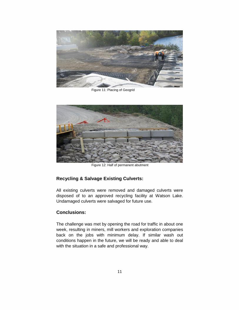
Figure 11: Placing of Geogrid
Figure 12: Half of permanent abutment
Recycling & Salvage Existing Culverts:
All existing culverts were removed and damaged culverts were
disposed of to an approved recycling facility at Watson Lake.
Undamaged culverts were salvaged for future use.
Conclusions:
The challenge was met by opening the road for traffic in about one
week, resulting in miners, mill workers and exploration companies
back on the jobs with minimum delay. If similar wash out
conditions happen in the future, we will be ready and able to deal
with the situation in a safe and professional way.

12
Figure 13: Bridge after placing on lock blocks
Figure 14: Underside view of girder and deck after permanent placement