Brixham Town Design Statement - · PDF file09.08.2017 · Brixham Town Design...
86
Brixham Town Design Statement Brixham is special because of its rich history and heritage and its community An integral part of the Brixham Peninsula Neighbourhood Plan
Transcript of Brixham Town Design Statement - · PDF file09.08.2017 · Brixham Town Design...

Brixham
Town Design Statement
Brixham is special because of its rich history and
heritage and its community
An integral part of the Brixham Peninsula Neighbourhood Plan

Document 9 of 10
Submission Document August 2017 | 3
Contents 1 Introduction ................................................................................................. 5
2 An overview of Brixham ................................................................................ 5
2.1 Education .................................................................................................... 6
2.2 Leisure centre and swimming pools ............................................................... 7
2.3 Health provision ........................................................................................... 8
2.4 Population ................................................................................................... 8
2.5 Regeneration ............................................................................................... 9
2.6 Tourism ..................................................................................................... 11
2.7 English Riviera Geopark .............................................................................. 12
2.8 Berry Head National Nature Reserve ............................................................ 12
2.9 Preservation of green spaces ...................................................................... 13
3 How history has shaped Brixham ................................................................. 14
4 What makes Brixham special? ..................................................................... 23
5 The conservation areas ............................................................................... 24
5.1 Conservation guidance ................................................................................ 27
6 Brixham’s main issues ................................................................................. 30
6.1 Housing need ............................................................................................. 30
6.2 New homes................................................................................................ 31
6.3 Cemetery ................................................................................................... 33
6.4 Provision of employment ............................................................................. 33
6.5 Road infrastructure ..................................................................................... 34
6.6 Town centre parking................................................................................... 36
6.7 Cleanliness of the town and harbour ............................................................ 38
7 Townscape analysis .................................................................................... 39
7.1 Brixham town centre .................................................................................. 39
7.2 Bolton Street and Mount Pleasant ................................................................ 42
7.3 Berry Head Road ........................................................................................ 42
7.4 New Road area .......................................................................................... 44
7.5 Furzeham .................................................................................................. 47
7.6 Battery Gardens and Oxen Cove .................................................................. 49
7.7 Copythorne and Lindthorpe Way area, Pillar Avenue and North Boundary Road
............................................................................................................. 50

Brixham Town Design Statement
4 | Submission Document August 2017
7.8 St Mary’s, Higher Brixham ........................................................................... 54
7.9 Summercombe ........................................................................................... 67
7.10 Rea Barn Road, Ranscombe Road and Penn Meadows .................................. 69
7.11 Sharkham Village ....................................................................................... 71
7.12 Harbour area ............................................................................................. 72
7.13 Conclusion ................................................................................................. 76
8 General design guidelines ........................................................................... 78
8.1 Introduction ............................................................................................... 78
8.2 Quality of the environment ......................................................................... 79
8.3 Landscape (soft and hard) .......................................................................... 79
8.4 Building design ........................................................................................... 81
8.5 Sustainability ............................................................................................. 82
8.6 Movement and transport ............................................................................. 82
8.7 Large-scale development ............................................................................ 84
8.8 General development .................................................................................. 84
9 Acknowledgements..................................................................................... 84
Document 9 of 10
Submission Document August 2017 | 5
1 Introduction
1.0.1 The purpose of a town design statement is to set out a community’s aspirations
for the design of the future development of its town based on an analysis of its
character, which will inform and amplify the policies of the Local Development
Planning Framework for Torbay. The first Brixham Town Design Statement
(2010–2015) was produced by members of the Town Design Panel with the
help of residents and organisations in the Brixham Community for the
Community. The results of their hard work were drafted and published for
consultation by the Brixham public in 2010.
1.0.2 The Design Statement gave an account of Brixham’s history, including recent
events, described the main issues faced by the town and set out principles to
guide the way in which these could be dealt with. Since this was published in
2010 the whole Peninsula community, of Brixham, Churston, Galmpton and
Broadsands, have been working together on a Neighbourhood Plan that
encompasses the whole of the Brixham Peninsula to bring a collective
community approach to deciding what is wanted in the future for the area.
1.0.3 There have been many changes in Brixham since 2010 and this refreshed
version together with statements from the “villages” will now be a part of the
final version of the Brixham Peninsula Neighbourhood Plan.
2 An overview of Brixham
2.0.1 Brixham is an ancient settlement and is mentioned in the Domesday Book. Over
time it became a large inland village and the main industry was farming, which
is why “Higher Brixham” is still known locally as “Cow Town”.
2.0.2 The village at Lower Brixham or “Brixham Quay” was about a mile further down
the valley and consisted of a small number of cottages clinging to the steep
hillsides on either side of a tidal creek on a peninsula at the southern-most
projecting point of Tor Bay, where high cliffs and Berry Head provided
protection. The small fishing village was where the fishermen built their
cottages on the steep hillsides along both sides of the inlet. The sea came up
Brixham Town Design Statement
6 | Submission Document August 2017
then as far as Bolton Cross, where it was thought to have been about 3 metres
deep and where a ferry was in use. The inlet was filled in and built over and
became “the town of Brixham Quay”.
2.0.3 Higher Brixham developed around the Parish Church of St Mary’s retreating
from the inlet up the scenic valley for more than 1½ miles in the direction of
Kingswear. The traditional dividing line between the two settlements is the
Burton Street, Greenswood Road and Rea Barn Road junction.
2.0.4 Since these early times the area has developed into the town as we know it and
Brixham today is the most important fishing port on the south coast of Devon.
2.1 Education
• Primary schools
o Brixham Church of England Primary School and Neighbourhood
Nursery
o St Margaret Clitherow Catholic Primary School
o Eden Park Primary School
o Furzeham Primary and Nursery School
• Secondary schools
o Churston Ferrers Grammar School is a selective co-educational
grammar school with Academy status, situated in the village of
Galmpton in Torbay. It is a specialist Humanities College.
o Brixham College is an average-sized secondary school (11 to 19
years). It converted to become an Academy Educational
Establishment in January 2012 and the College opened its sixth form
in September 2013. The campus is used by South Devon College for
Access to Community Education and provides educational and
therapeutic services for people with disabilities.

Document 9 of 10
Submission Document August 2017 | 7
2.1.1 The decision by pharmaceutical giants AstraZeneca to gift their Brixham
Environmental Laboratory premises to Plymouth University, when they moved
their business away from Freshwater Quarry in 2014, was a generous act and
has been welcomed by Brixham.
2.1.2 The University aims to add this latest asset to the University’s growing network
of marine enterprise facilities, a base for a multidisciplinary community of
researchers, commercial tenants and visiting scientists from higher education
and commerce.
2.1.3 It will also provide a learning centre for students, including those at nearby
South Devon College, one of the University’s academic partners. This will deliver
an opportunity for the building to become a world-class centre for collaboration
and translational research with emphasis on the marine environment and
coastal management issues.
2.2 Leisure centre and swimming pools
2.2.1 Brixham Sports Centre is set within the campus of Brixham College and is the
hub of sporting activity for the local community.
2.2.2 The Admiral Pool was built in 1975 and for over 40 years it has successfully
provided leisure, health, social and educational facilities for the people of
Brixham. In March 2016 Brixham Admiral Swim Company Ltd launched a “Buy a
Tile” fundraising scheme to contribute towards the cost of tiling the Admiral
Pool in July and August 2016.
2.2.3 Shoalstone Pool is Brixham’s outdoor seawater swimming pool or lido at
Shoalstone beach. It is one of only a few left in the country and has large open
areas to relax in and enjoy the sun. There is also a small shingle beach adjacent
to the pool. There is easy access with adequate parking at the back of the pool
and a new café with superb views across the bay. It is open in the summer
holiday months when there is lifeguard cover and at other times too for the
hardy all-year-round swimmers.
Brixham Town Design Statement
8 | Submission Document August 2017
2.3 Health provision
2.3.1 There are three medical practices in the town: Compass House Surgery, Kings
Street, which has a branch surgery in Galmpton; St Lukes, New Road; and
Greenswood Medical, Greenswood Road. These latter two surgeries have joined
together and now operate from both the New Road and Greenswood Road
sites.
2.3.2 There are several dentists in Brixham. There are also a number of care homes.
The expectation is that the demand for the provision of good quality residential
care will continue to rise, given the local demographics, and the seeming lack of
forward planning to cover any potential shortfall in the actual delivery of “Care
in the Community”.
2.3.3 The local cottage hospital is currently operating but we have been advised that
the way that care in the community is delivered is likely to be vastly different in
the future and these changes will impact on how the present hospital services
will be organised. However, it is hoped that the assurances we have been given,
that our valued local hospital will continue to have a role in Brixham’s future,
will be honoured.
2.4 Population
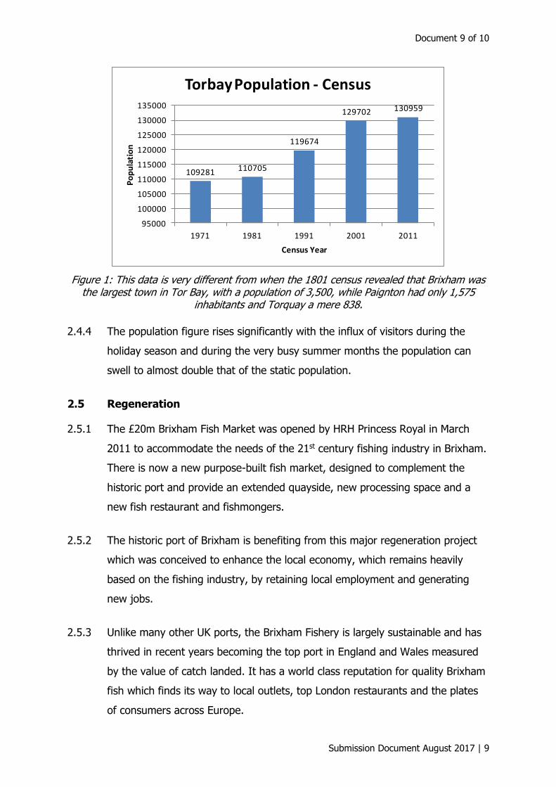
2.4.1 The number of Brixham residents in the 2011 Census was 16,693. When
compared to the region and other unitary authorities, Torbay showed the lowest
increase between the 2001 and 2011 Census at just 1%’, that is just over 1,200
people. See Figure 1.
2.4.2 Brixham has a significantly higher proportion of elderly/retired persons
compared to the national average. There are also a growing number of migrant
European workers employed within the lower paid service sector industries and
approximately 1% of the population is made up of minority ethnic groups.
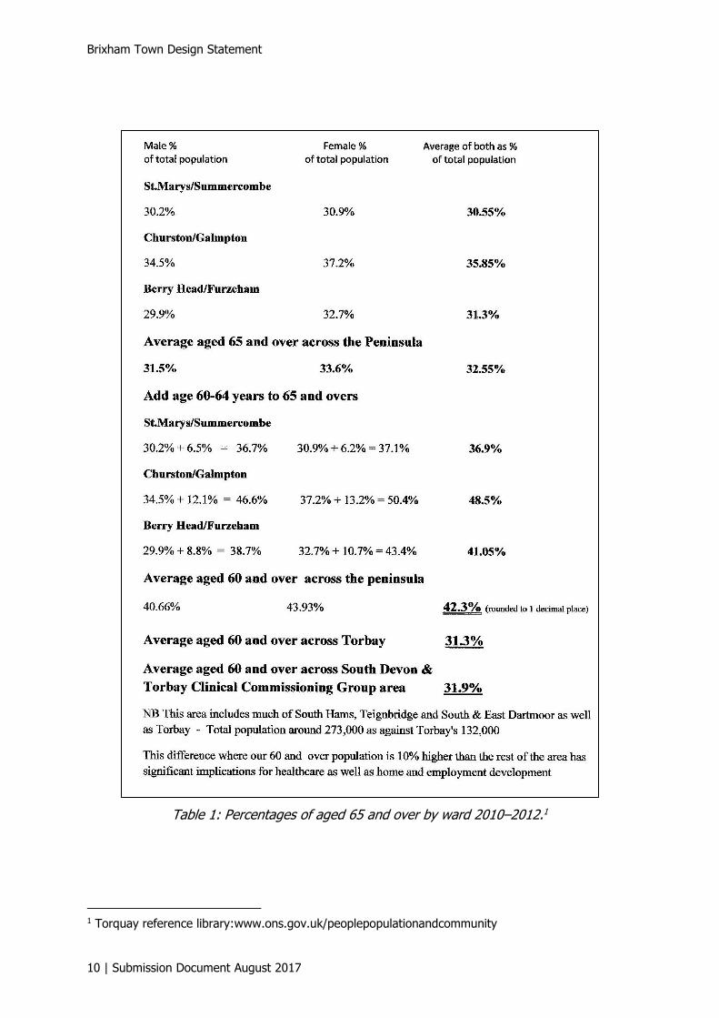
2.4.3 Table 1 gives more recent data regarding the percentages of those residents
aged 65 years and over in 2010–2012 who were living in the wards of the
Brixham Peninsula.
Document 9 of 10
Submission Document August 2017 | 9
Figure 1: This data is very different from when the 1801 census revealed that Brixham was the largest town in Tor Bay, with a population of 3,500, while Paignton had only 1,575
inhabitants and Torquay a mere 838.
2.4.4 The population figure rises significantly with the influx of visitors during the
holiday season and during the very busy summer months the population can
swell to almost double that of the static population.
2.5 Regeneration
2.5.1 The £20m Brixham Fish Market was opened by HRH Princess Royal in March
2011 to accommodate the needs of the 21st century fishing industry in Brixham.
There is now a new purpose-built fish market, designed to complement the
historic port and provide an extended quayside, new processing space and a
new fish restaurant and fishmongers.
2.5.2 The historic port of Brixham is benefiting from this major regeneration project
which was conceived to enhance the local economy, which remains heavily
based on the fishing industry, by retaining local employment and generating
new jobs.
2.5.3 Unlike many other UK ports, the Brixham Fishery is largely sustainable and has
thrived in recent years becoming the top port in England and Wales measured
by the value of catch landed. It has a world class reputation for quality Brixham
fish which finds its way to local outlets, top London restaurants and the plates
of consumers across Europe.
109281 110705
119674
129702 130959
95000
100000
105000
110000
115000
120000
125000
130000
135000
1971 1981 1991 2001 2011
Po
pu
lati
on
Census Year
Torbay Population - Census
Brixham Town Design Statement
10 | Submission Document August 2017
Table 1: Percentages of aged 65 and over by ward 2010–2012.1
1 Torquay reference library:www.ons.gov.uk/peoplepopulationandcommunity
Document 9 of 10
Submission Document August 2017 | 11
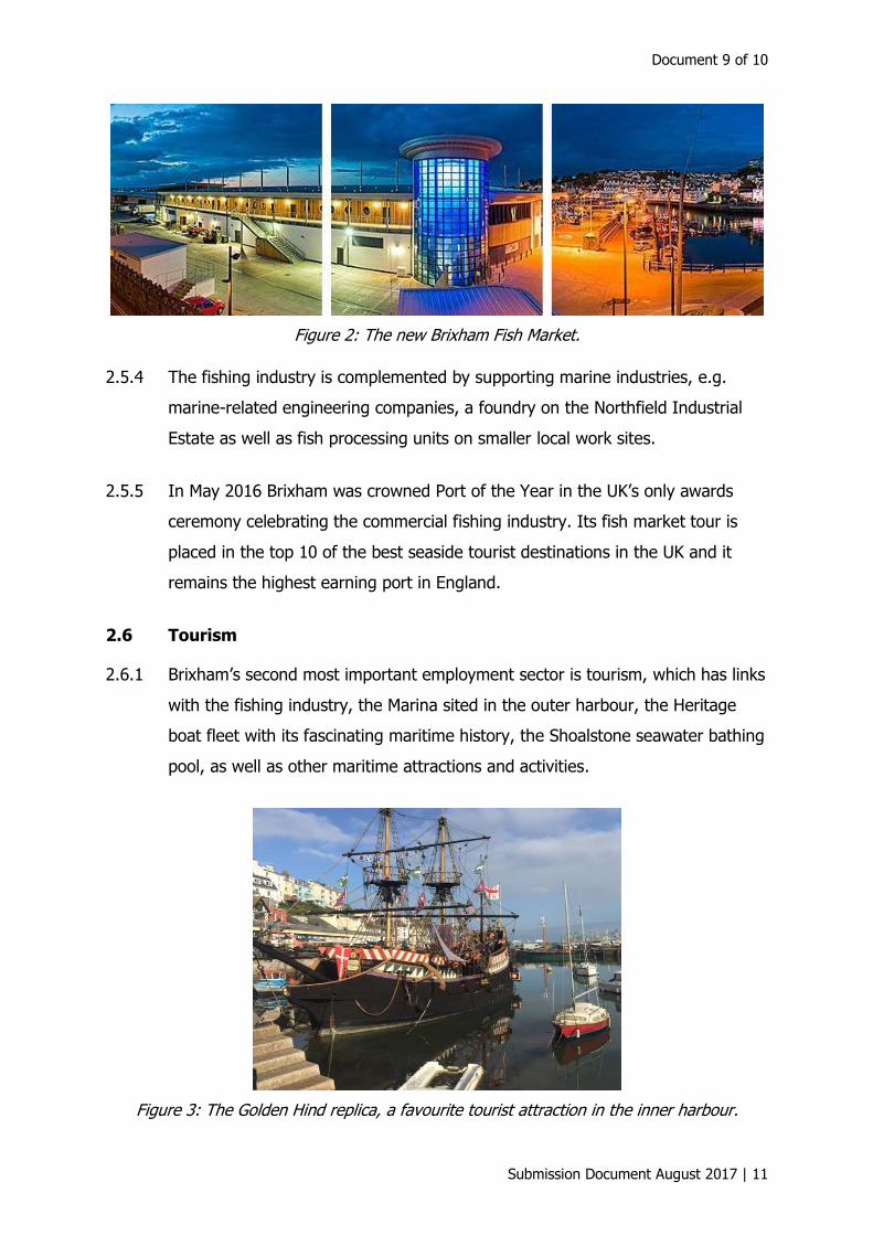
Figure 2: The new Brixham Fish Market.
2.5.4 The fishing industry is complemented by supporting marine industries, e.g.
marine-related engineering companies, a foundry on the Northfield Industrial
Estate as well as fish processing units on smaller local work sites.
2.5.5 In May 2016 Brixham was crowned Port of the Year in the UK’s only awards
ceremony celebrating the commercial fishing industry. Its fish market tour is
placed in the top 10 of the best seaside tourist destinations in the UK and it
remains the highest earning port in England.
2.6 Tourism
2.6.1 Brixham’s second most important employment sector is tourism, which has links
with the fishing industry, the Marina sited in the outer harbour, the Heritage
boat fleet with its fascinating maritime history, the Shoalstone seawater bathing
pool, as well as other maritime attractions and activities.
Figure 3: The Golden Hind replica, a favourite tourist attraction in the inner harbour.

Brixham Town Design Statement
12 | Submission Document August 2017
2.7 English Riviera Geopark
2.7.1 In September 2007 the English Riviera received international recognition for its
rich geological, historical and cultural heritage, being the first urban area
designated as a UNESCO Global Geopark. Since then the Global Geopark
Network has grown and as of September 2016 there are now 111 Geoparks in
32 countries worldwide.
2.7.2 The 7th International Conference of UNESCO Global Geoparks was held in
September 2016 at the English Riviera Centre, Torquay. It was the first time it
had been held in Great Britain and over 600 delegates concerned with the
Global Geoparks agenda attended from all over the world. Geoparks work to
develop sustainable economies and eco-tourism, and promote engagement with
local communities in areas of significant geological interest.
Figure 4: Sharkham looking towards Mansands.
2.7.3 Five particular sites of interest in Brixham are Berry Head to Sharkham Point,
Breakwater Quarry, Brixham Cavern, Churston Cove and Point, and Shoalstone.
2.8 Berry Head National Nature Reserve
2.8.1 Berry Head National Nature Reserve is one of the gateways to the English
Riviera Global Geopark. It is Torbay’s most important wildlife site, being home
to rare Greater Horseshoe Bats and the largest breeding guillemot colony on the
English Channel Coast, for which the cliffs at Berry Head are nationally
important. The waters off Berry Head are designated an Area of Special
Protection because of this.
Document 9 of 10
Submission Document August 2017 | 13
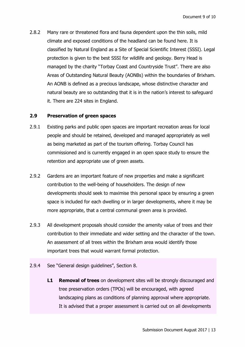
2.8.2 Many rare or threatened flora and fauna dependent upon the thin soils, mild
climate and exposed conditions of the headland can be found here. It is
classified by Natural England as a Site of Special Scientific Interest (SSSI). Legal
protection is given to the best SSSI for wildlife and geology. Berry Head is
managed by the charity “Torbay Coast and Countryside Trust”. There are also
Areas of Outstanding Natural Beauty (AONBs) within the boundaries of Brixham.
An AONB is defined as a precious landscape, whose distinctive character and
natural beauty are so outstanding that it is in the nation’s interest to safeguard
it. There are 224 sites in England.
2.9 Preservation of green spaces
2.9.1 Existing parks and public open spaces are important recreation areas for local
people and should be retained, developed and managed appropriately as well
as being marketed as part of the tourism offering. Torbay Council has
commissioned and is currently engaged in an open space study to ensure the
retention and appropriate use of green assets.
2.9.2 Gardens are an important feature of new properties and make a significant
contribution to the well-being of householders. The design of new
developments should seek to maximise this personal space by ensuring a green
space is included for each dwelling or in larger developments, where it may be
more appropriate, that a central communal green area is provided.
2.9.3 All development proposals should consider the amenity value of trees and their
contribution to their immediate and wider setting and the character of the town.
An assessment of all trees within the Brixham area would identify those
important trees that would warrant formal protection.
2.9.4 See “General design guidelines”, Section 8.
L1 Removal of trees on development sites will be strongly discouraged and
tree preservation orders (TPOs) will be encouraged, with agreed
landscaping plans as conditions of planning approval where appropriate.
It is advised that a proper assessment is carried out on all developments

Brixham Town Design Statement
14 | Submission Document August 2017
where there are trees, so as to judge the impact of the construction of
new buildings and other site works on the trees to enable any adequate
root protection and exclusion zones to be agreed. (See British Standard
BS5837:2005.)
See also:
L2 Street trees
L4 Front gardens/areas.
3 How history has shaped Brixham
3.0.1 By 1535 Brixham had established itself as a highly successful fishing port, with
the low-lying sheltered harbour area being protected by the surrounding
Devonian limestone hills. Brixham has three sites of major historical importance:
Battery Gardens, Berry Head and Brixham Cavern.
3.0.2 The unique geography of Brixham led to its major importance in the defence of
the southern coastline of Britain. The site of Battery Gardens was used as a gun
battery during the Spanish Armada (1588) and was armed in the American War
of Independence too because of its ideal, low-level vantage point across Tor
Bay.
3.0.3 Not only does Battery Gardens boast one of the most panoramic views in the
bay, Brixham Battery is also a Scheduled Monument and World War II Coastal
Defence Battery, listed by English Heritage and recognised as one of the best
preserved of its kind in the UK. The Battery Museum features much of interest
from World War II.
3.0.4 On 5 November 1688 Prince William of Orange landed in Brixham. Before
moving on to Exeter and later to London, his army camped on the high ground
around Brixham whilst William went down the hill to a Fisherman’s little house.
He later went on to be crowned King William III of England. Brixham

Document 9 of 10
Submission Document August 2017 | 15
commemorated the event 200 years later with a statue of King William on the
Strand.
3.0.5 By the mid-1700s the technique of deep-sea trawling became possible, chiefly
because boats were able to sail at greater speeds. Brixham fishermen were in
the forefront of this development and were responsible for the spread of
trawling to other ports around the coast of Britain. Many new cottages were
built on the steep slopes around the harbour to house the fishermen and sailors
and their families, who came and settled in Lower Brixham from villages nearby
and from other places further afield. The improved turnpike road system helped
to open up new markets to the sale of fresh fish and there were about 75
trawlers fishing out of Brixham in 1785.
3.0.6 Brixham was an important Royal Naval victualling and watering station and in
1781 plans were drawn up for a naval reservoir in Brixham where the Town
Hall is today. It came into use around 1800, just in time for ships engaged in
the blockade of France to have access to Tor Bay water.
3.0.7 In 1793 two forts were erected on Berry Head, built on top of pre-existing Iron
Age forts to protect against the threatened invasion by France.
3.0.8 In 1803 the fortifications were strengthened with limestone and gun batteries
were added to guard the approach to Tor Bay during the Napoleonic Wars. The
Royal Navy used Tor Bay as an anchorage during these Wars and it was here
on 24th July 1815 that a British Man-of-War brought Napoleon as a prisoner
on his way to exile.
3.0.9 In the 1800s there was significant development in Brixham. Housing stock was
added to Brixham during these years, typically classic Victorian style terraces,
which can still be seen throughout the town.
3.0.10 In 1809 Berry Head House, now the Berry Head Hotel, was built as a military
hospital, preparing for potential casualties of the Napoleonic war, but it was
never used as such. It later became the home of Reverend Henry Francis Lyte.

Brixham Town Design Statement
16 | Submission Document August 2017
3.0.11 Today on Berry Head the Guardhouse café is located in the guardhouse in Berry
Head’s Northern Fort and the attached visitor centre has details of the history of
Berry Head, its wildlife and its importance today.
Figure 5: Guardhouse café and visitor centre in Berry Head Fort.
3.0.12 In 1816 the new District Church of Lower Brixham was finished. It was built as
a Chapel of Ease to address the increasing attendances at St Mary’s Church due
to rising population numbers in Lower Brixham. Reverend Henry Francis Lyte
became the Church of England Minister Incumbent in the Lower Brixham
Church from 1824 until he died in 1847 in Nice. He is well known for
composing “Abide with Me”. The hymn became soccer’s first anthem and since
1927 has been sung before every FA Cup final.
Figure 6: All Saints Church Brixham showing the varietyof houses surrounding it.

Document 9 of 10
Submission Document August 2017 | 17
3.0.13 In 1817 Upham’s Shipyard was built. Many of the local trawlers and sailing
boats were built in the Yard in the 19th and 20th centuries. However, as Brixham
moved towards new fishing practices and modern methods and diesel-driven
vessels, traditional boat building waned and the shipyard closed in 1984.
Figure 7: J. W. & A. Upham’s Yard, 1960s with Berry Head Road in the background.
3.0.14 The area was developed creating the existing Marina with its associated
facilities, a public harbour walkway, a new coastguard station and a private
housing development with a prime waterfront location (Moorings Reach). Highly
visible, this major residential development utilised the terraced form and largely
traditional materials that are in harmony with its older surroundings.
Figure 8: Moorings Reach development.
Brixham Town Design Statement
18 | Submission Document August 2017
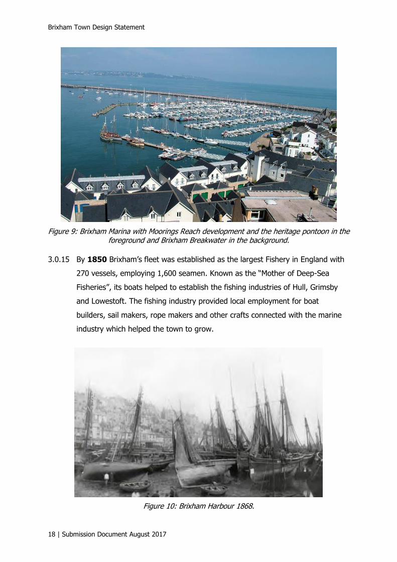
Figure 9: Brixham Marina with Moorings Reach development and the heritage pontoon in the foreground and Brixham Breakwater in the background.
3.0.15 By 1850 Brixham’s fleet was established as the largest Fishery in England with
270 vessels, employing 1,600 seamen. Known as the “Mother of Deep-Sea
Fisheries”, its boats helped to establish the fishing industries of Hull, Grimsby
and Lowestoft. The fishing industry provided local employment for boat
builders, sail makers, rope makers and other crafts connected with the marine
industry which helped the town to grow.
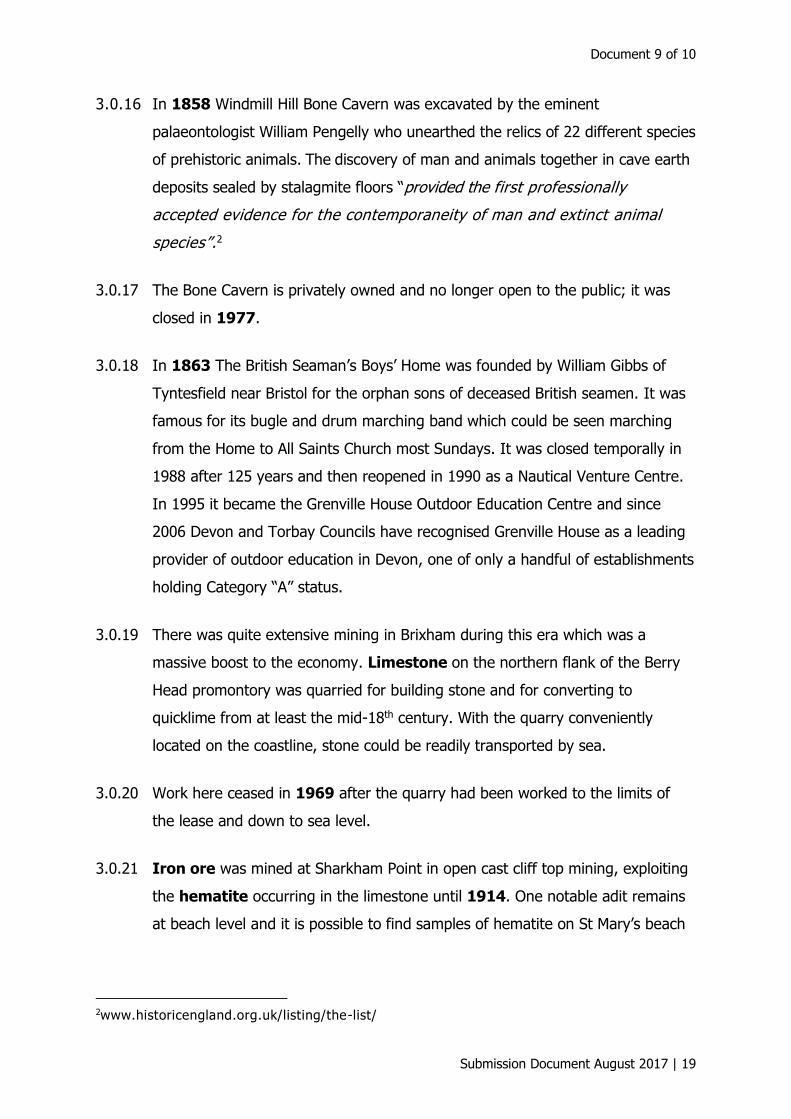
Figure 10: Brixham Harbour 1868.
Document 9 of 10
Submission Document August 2017 | 19
3.0.16 In 1858 Windmill Hill Bone Cavern was excavated by the eminent
palaeontologist William Pengelly who unearthed the relics of 22 different species
of prehistoric animals. The discovery of man and animals together in cave earth
deposits sealed by stalagmite floors “provided the first professionally
accepted evidence for the contemporaneity of man and extinct animal
species”.2
3.0.17 The Bone Cavern is privately owned and no longer open to the public; it was
closed in 1977.
3.0.18 In 1863 The British Seaman’s Boys’ Home was founded by William Gibbs of
Tyntesfield near Bristol for the orphan sons of deceased British seamen. It was
famous for its bugle and drum marching band which could be seen marching
from the Home to All Saints Church most Sundays. It was closed temporally in
1988 after 125 years and then reopened in 1990 as a Nautical Venture Centre.
In 1995 it became the Grenville House Outdoor Education Centre and since
2006 Devon and Torbay Councils have recognised Grenville House as a leading
provider of outdoor education in Devon, one of only a handful of establishments
holding Category “A” status.
3.0.19 There was quite extensive mining in Brixham during this era which was a
massive boost to the economy. Limestone on the northern flank of the Berry
Head promontory was quarried for building stone and for converting to
quicklime from at least the mid-18th century. With the quarry conveniently
located on the coastline, stone could be readily transported by sea.
3.0.20 Work here ceased in 1969 after the quarry had been worked to the limits of
the lease and down to sea level.
3.0.21 Iron ore was mined at Sharkham Point in open cast cliff top mining, exploiting
the hematite occurring in the limestone until 1914. One notable adit remains
at beach level and it is possible to find samples of hematite on St Mary’s beach
2www.historicengland.org.uk/listing/the-list/
Brixham Town Design Statement
20 | Submission Document August 2017
if the weather and the tide are “right”. The area was used as the Town Tip in
the 1950s and 1960s and much of the archaeology has been covered over.
3.0.22 Ochre, discovered in the Furzeham area in 1845, was a mineral which had
massive importance and played a major part in the industrial revolution as it
was the first substance in the world that would stop cast iron from rusting. It
was used to invent a rust resistant paint which led to huge demand and to the
founding of the Torbay Paint Company. The mineral was also painted on the
sails of trawlers to protect the canvas from seawater, giving them their
characteristic red/brown hue. There is now little evidence of the iron and ochre
mines and their significance in shaping Brixham. The Torbay Paint Company
closed in 1961.
3.0.23 In 1866, the “Great Storm” destroyed over 60 ships and 100 lives were lost in
one night. As a result of the storm, the people of Exeter raised the funds for
Brixham to have her first RNLI lifeboat, the “City of Exeter”. Since then, there
has always been an all-weather lifeboat in Brixham, which is manned by
volunteer crews from the town.
3.0.24 The formation of the Breakwater as a sea defence for Brixham became more
important after the storm. The first stone in the Breakwater’s construction had
been laid in 1843, with the original structure stretching to 427 m (1,400 ft) in
length until work ceased because of lack of funds. Over the years more
structure was added, and in 1916 the Breakwater reached its final length of
0.97 km (0.6 miles) and a lighthouse was erected on the seaward end.
3.0.25 In 1868 the short Tor Bay and Brixham railway line to Churston opened to
carry passengers and goods (mostly fish to London), which was of great benefit
to the fishing industry. Sadly, the station and the line were closed in 1963 as
part of the infamous Dr Beeching cuts.
3.0.26 In 1892 Torquay was incorporated as a Borough and in 1894 Paignton Urban
District Council and Brixham Urban District Council were established under the
terms of the Local Government Act 1894. By this time Brixham’s population had

Document 9 of 10
Submission Document August 2017 | 21
grown to over 8,000 and the settlements were brought together under the
Brixham Urban District Council.
Figure 11: Brixham Railway 1948.
3.0.27 Semaphore signalling apparatus was used on Berry Head before 1875 and
acted as the Lloyds’ Signal Station for Tor Bay. In 1906 the Berry Head
Lighthouse, an active lighthouse, was built; it was automated and converted to
run on acetylene in 1921. There is also a VOR/DME beacon used for air traffic
control in one of the woodland areas on the headland.
Figure 12: Berry Head Lighthouse – c. 200 ft above sea level.
Brixham Town Design Statement
22 | Submission Document August 2017
3.0.28 The outbreak of World War I saw a decline in the fishing industry and halted
the prosperity and development of the Victorian era, but after the war
conditions improved and housing stock increased throughout the town.
3.0.29 In 1943 the outer harbour main slipway and hard area, known as Breakwater
Hard, was built by American troops. It is now a rare example of a World War II
D-Day landing craft loading ramp. English Heritage listed the hard and slipway,
stating that “it was one of the best examples of its kind left in the UK” (grade II
listed 23rd June 2009).
3.0.30 During the war many Belgian people and their vessels came to Brixham to
escape the hostilities. They stayed after the end of the war making their homes
in Brixham and becoming part of the local community.
3.0.31 Immediately post-war, Brixham capitalised on its idyllic location, history and
heritage to become a popular holiday destination. Pontins invested heavily in
the area, at one time operating five holiday parks. The town also offered an
abundance of hotel accommodation and camping sites, with many of the larger
properties in town converted to bed & breakfast and guest house businesses.
3.0.32 In the 1960s and 1970s there were notable changes.
3.0.33 The fish quay under the covered market area was moved together with the
associated facilities to the front of the Seamen’s Mission on Overgang. This
changed the harbour dramatically. More improvements and an extension to the
Fish Quay and the addition of Southern Quay were completed by 1991, which
provided extra berthing and landing facilities for the fishing fleet.
3.0.34 A walkway between the Town and Oxen Cove was created, which linked into
the outer harbour pathway as far as the steps up to Battery Gardens and the
coastal pathway route to Paignton.

Document 9 of 10
Submission Document August 2017 | 23
3.0.35 The gas works, nearby old cottages and buildings were demolished in the late
1960s to make way for a new multi-storey car park which was built in the
centre of the town in 1969. Middle Street was also widened during this period
and the fire station and Police station were moved out of the town centre.
Figure 13: Old Multi-storey car park.
4 What makes Brixham special?
4.0.1 The top five things that people liked about living in Brixham, according to the
2008 “Who Plans Brixham For The Future?” town survey, were the neighbours,
the people, the amenities and shops, the natural beauty, and the fact that they
had friends and family living in the town.
“Brixham is special because of its rich history and heritage. I do worry though, that some of its history and warmth will be lost without
significant thought about future plans.”
Chris, 64, Berry Head
“Brixham has a unique coastal and countryside landscape, with an amazing history. My family have lived here for many generations so it
will always be special to me. I would like it taken care of for the sake of future generations”
Kerry, 62, Berry Head
Brixham Town Design Statement
24 | Submission Document August 2017
“I love Busy Bee’s and Jingle Bells on the Quay at Christmas!’”
Lilly, 3, Furzeham
“Brixham is special to me because it is a safe place to bring up my children, and has a friendly, close-knit community.”
Michele, 37, Town Centre
“I love the fact that we have so many small independent retailers in the town. This should be encouraged so that Brixham retains its character
and remains different to other small towns.”
Simone, 39, Summercombe
5 The conservation areas
5.0.1 We are very fortunate that Character Appraisals have been produced for both of
Brixham’s conservation areas. The work, which covers Higher Brixham and
Lower Brixham separately, was undertaken by Hal Bishop from Torbay Council.3
The Higher Brixham report can be down loaded from the Torbay Council
website and makes for interesting reading.
5.0.2 Our Heritage is an important asset and should be cared for, for future
generations. Development within the conservation areas should be strictly
limited and in keeping with the surrounding structures. Any developments in the
AONBs should also be strictly limited and be sympathetic to the surroundings,
adding value to its AONB status so that the level of enjoyment of the area is not
diminished and can still be appreciated by all who visit.
5.0.3 There is a great deal of evidence that heritage is not only valuable in its own
right, but also as a factor in maintaining and improving the health, economy
and cultural well-being of an area and its population.
5.0.4 There are approximately 329 Heritage category listings in Brixham, which
includes buildings and scheduled monuments. The National Heritage List for
England (NHLE) for all listed buildings, scheduled monuments, protected wrecks
and registered parks, gardens and battlefields can be searched online. The
3Higher Brixham Conservation Area Character Appraisal revised May 2011; Brixham Town Conservation Area Character Appraisal revised July 2014(draft), Hal Bishop, BA, MA, Cert Ecol & Cons,
IHBC, MIfA.
Document 9 of 10
Submission Document August 2017 | 25
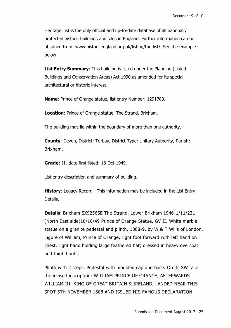
Heritage List is the only official and up-to-date database of all nationally
protected historic buildings and sites in England. Further information can be
obtained from: www.historicengland.org.uk/listing/the-list/. See the example
below:
List Entry Summary: This building is listed under the Planning (Listed
Buildings and Conservation Areas) Act 1990 as amended for its special
architectural or historic interest.
Name: Prince of Orange statue, list entry Number: 1291780.
Location: Prince of Orange statue, The Strand, Brixham.
The building may lie within the boundary of more than one authority.
County: Devon, District: Torbay, District Type: Unitary Authority, Parish:
Brixham.
Grade: II, date first listed: 18-Oct-1949.
List entry description and summary of building.
History: Legacy Record - This information may be included in the List Entry
Details.
Details: Brixham SX9256SE The Strand, Lower Brixham 1946-1/11/231
(North East side)18/10/49 Prince of Orange Statue, GV II. White marble
statue on a granite pedestal and plinth. 1888-9. by W & T Wills of London.
Figure of William, Prince of Orange, right foot forward with left hand on
chest, right hand holding large feathered hat; dressed in heavy overcoat
and thigh boots.
Plinth with 2 steps. Pedestal with moulded cap and base. On its SW face
the incised inscription: WILLIAM PRINCE OF ORANGE, AFTERWARDS
WILLIAM III, KING OF GREAT BRITAIN & IRELAND, LANDED NEAR THIS
SPOT 5TH NOVEMBER 1688 AND ISSUED HIS FAMOUS DECLARATION

Brixham Town Design Statement
26 | Submission Document August 2017
"THE LIBERTIES OF ENGLAND AND THE PROTESTANT RELIGION I WILL
MAINTAIN". Beneath this is the sculptor's name.
On the south-east face is the inscription: ERECTED BY PUBLIC
SUBSCRIPTION AND DEDICATED TO THE TOWN OF BRIXHAM.
FOUNDATION STONE LAID 5TH NOVBR 1888, BY HIS EXCELLENCY COUNT
DE BYLANDT. UNVEILED 5TH NOVEMBER 1889.
On the north-west face is the inscription: ENGELANDS VRIJHEID DOOR
ORANJE HERSTELD. Old photographs show that the land on which the
statue stands originally projected into the harbour and was protected by
an iron railing.
National Grid Reference: SX 92577 56227
Selected sources: Books and journals Gregory, C., Brixham in Devonia,
(1896–63).
Figure 14: Prince of Orange Stature, The Strand Brixham.
Document 9 of 10
Submission Document August 2017 | 27
5.1 Conservation guidance
5.1.1 Historic England is also a good source to discover current guidance on building
regulations in conservation areas and maintaining listed buildings. Working on
older buildings may require extra types of planning conditions.
5.1.2 The introduction of the Enterprise and Regulatory Act 2013 brought changes to
the way listed building consent is granted. The new provisions in the Act
make the existing listed building consent system more efficient and
effective.
5.1.3 The need for planning permission applies to all buildings. For older
buildings, it may be needed in addition to other forms of permissions.
Listed Building Consent will be needed for all work to a listed building that
involves alterations, extensions or demolition that will affect its character
as a building of special architectural or historic interest. This applies to a ll
types of work and to all parts of the building that is covered by the listing.
5.1.4 Some conservation areas are subject to special controls when protection
of particular building features, such as doors or windows, is required.
These are called “Article 4 Directions” and they restrict work that would
normally not need planning permission, such as replacing a window with
one of similar design. It is advisable to check first with the local authority
Conservation Officer whether or not consent will be needed for what is
being planned and find out whether ideas need to be adapted to make
them more likely to succeed. This simple step could save a lot of time and
money.
5.1.5 It is concerning that Brixham Town conservation area continues to appear on
Heritage England’s at risk register (2015) due to serious detrimental changes
that have occurred in past decades, such as unsympathetic alterations to
buildings and the urban environment, poorly designed dormer windows, the loss
of original doors, windows and shop fronts, and the use of inappropriate
Brixham Town Design Statement
28 | Submission Document August 2017
materials. Many of these changes are minor taken in isolation, but when added
together they amount to serious damage to the historic integrity of a
conservation area.
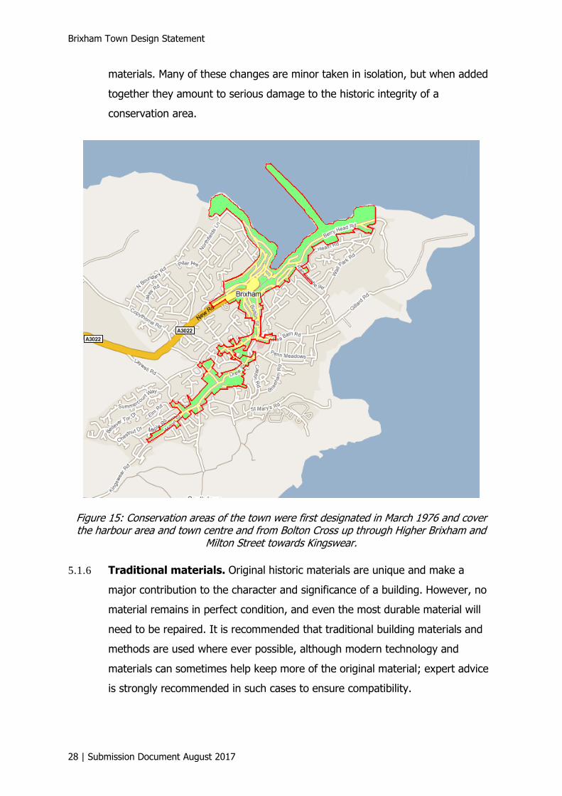
Figure 15: Conservation areas of the town were first designated in March 1976 and cover the harbour area and town centre and from Bolton Cross up through Higher Brixham and
Milton Street towards Kingswear.
5.1.6 Traditional materials. Original historic materials are unique and make a
major contribution to the character and significance of a building. However, no
material remains in perfect condition, and even the most durable material will
need to be repaired. It is recommended that traditional building materials and
methods are used where ever possible, although modern technology and
materials can sometimes help keep more of the original material; expert advice
is strongly recommended in such cases to ensure compatibility.

Document 9 of 10
Submission Document August 2017 | 29
5.1.7 It is important to protect Brixham’s built environment and its historic heritage
assets, to prevent and reverse damage that is being done by the addition of
features which are harmful and detrimental to the special character of the
townscape, especially in the conservation areas.
5.1.8 Poor replacement windows in uPVC and a large number of oversize, and often
“over-sailing”, dormers can be seen. Dormer windows are a common feature in
Brixham as they can be a cost-effective way of providing additional
accommodation. However, it is important to appreciate that not all properties
are suitable for this form of roof extension. Dormers, roof lights and solar
panels can (individually and cumulatively) have a significant effect on the
appearance of a property or area and their design needs careful consideration.
5.1.9 More attention should be paid to Brixham’s heritage assets not only to ensure
they are properly maintained, but also to review them so as to build them into
our tourism offering. Tourism plus Heritage is becoming increasingly popular
and the economy would benefit. This could also be applied to our standing as a
UNESCO Geopark. Our heritage assets are currently not being utilised to their
full potential.
5.1.10 It could well be that the time has come to adopt an “Article 4 Direction” for the
town centre conservation area to have any hope of bringing about
improvement. In view of the proposed town centre regeneration plan this would
help to lay down good guidelines for the development.
5.1.11 Carrying out unauthorised works to a listed building is a criminal offence and
individuals can be prosecuted. Also, a planning authority can insist that all work
carried out without consent is reversed. It is sensible to talk to the local
planning authority before any work is carried out to a listed building, as an
owner will have trouble selling a property which has not been granted “Listed
Building Consent” for work undertaken.4
4Historic England Conservation Area Designation, Appraisal and Management, Advice Note 1,
page 19.
Brixham Town Design Statement
30 | Submission Document August 2017
5.1.12 See “General design guidelines”, Section 8
Q3 Roofscape. Variety in roofscape as the buildings step down the hillsides
is a key characteristic of Brixham. Roofscapes appropriate to the location
and visibility of the development within the town will be required.
Additions to roofs will be of a scale and proportion appropriate to the
essential character of the neighbouring townscape.
BD3 Roof design. The shape and pitch of the roof on any new development
throughout the town should be considered in terms of its visibility and
contribution to the quality of the roofscape of the town. In addition, for
the historic core and the conservation area, the roof design should
generally reflect those of the properties nearby.
See also:
Q1 Visibility
Q2 Scale of development
L5 Materials of hard landscaping
L6 Landscape design.
6 Brixham’s main issues
6.1 Housing need
6.1.1 Torbay’s Housing Strategy 2012–2030 is to enable the provision and choice of
homes where people can thrive. This will help the local economy by offering
security and settled homes for longer, promoting health and well-being and
reducing the impact on the environment. The aim is to help communities to
recognise and tackle the inequality faced by families and the vulnerable.
6.1.2 The availability of affordable housing for young people and key workers to
purchase remains one of the main issues in Brixham. Current house prices are
Document 9 of 10
Submission Document August 2017 | 31
not affordable to people on low incomes, which means that the demand for
housing to rent is high.
6.1.3 Torbay Council is committed to providing high-quality housing for people who
are unable to access or afford market housing, which means providing homes
for local people at an affordable rent, and also low-cost home ownership
properties, which are kept at below market value in perpetuity. There are two
main categories of Affordable Housing:
• Homes for rent (social rented). Social rented housing includes
dwellings owned and managed by a Registered Provider (formerly known
as Housing Associations). Properties are let with rent levels that are set
nationally.
• Intermediate housing. Is provided at costs above social rented levels
but below market prices. It includes shared equity schemes, low-cost
homes for sale and intermediate rent.
6.1.4 In Torbay, “Devon Home Choice”, a “Choice Based Lettings” scheme, is
operated. Council or housing association homes which become vacant are
advertised on their website and applicants on the housing register can “bid” for
properties they are interested in. Each property is allocated to the bidder in the
greatest level of housing need. It is a much more open, transparent and
customer-based approach to the letting of homes.
6.1.5 Most Housing Association homes in this area are for renting.
6.2 New homes
6.2.1 The mix of building design and methods of construction used throughout the
town makes it difficult to dictate design styles for specific areas. A primary
consideration should be the scale of any proposed building. Scale is the relative
dimensions and proportions of the elements of buildings compared with each
other, and with other buildings nearby and the surrounding environment.
Brixham has buildings in a wide variety of sizes and it is important that the scale
of any new building suits its surroundings. Scale relates not only to a building,
Brixham Town Design Statement
32 | Submission Document August 2017
but also to the space between it and its neighbours. New buildings should have
the same impression of space around them as the existing surrounding
buildings.
6.2.2 See “General design guidelines”, Section 8
BD2 Architectural treatment. New development will be of high quality,
raising the standard of architectural treatment and respecting the qualities
of its surroundings, such as scale, style, materials and attention to detail.
Innovative designs and the contemporary interpretation of traditional
design and construction will be welcomed; they will be to the highest
standards and be complementary to their context.
See also:
S1 Land use
BD4 Materials
BD6 Ancillary facilities
L6 Landscape design
G1 Building styles.
6.2.3 New streets/roads created on new development sites and named by residents
of the town through Brixham Town Council would ensure that the heritage and
history of the town is acknowledged and made more relevant by being linked
with new developments.
6.2.4 When completed modern buildings or site layouts are seen not to be in keeping
with their surroundings these should not be regarded as “set precedents”. They
should be acknowledged as “unsuitable developments” and as atypical building
design in that area, and further similar development will be strongly
discouraged.

Document 9 of 10
Submission Document August 2017 | 33
Figure 16: A sympathetic well-designed example of a Mews development in Pump Street off Fore Street.
6.3 Cemetery
6.3.1 Torbay Council makes provision for cemeteries across Torbay through its
Bereavement Services department. There is a need for a Cemetery in Brixham
and this has been acknowledged by Torbay Council and Brixham Town Council.
6.3.2 Torbay Council support the principle of “green burial” and it is considered
essential that the cemeteries are so designed and managed to minimise their
environmental impact. Planting of native species and the creation of meadows
can enhance a cemetery’s value as a wildlife habitat whilst retaining the dignity
of its prime function.
6.3.3 Brixham Town Council is continuing to work towards making cemetery provision
in Brixham a reality in the future, as such provision is seen as an intrinsic part
of a viable community. The work is ongoing.
6.4 Provision of employment
6.4.1 Facilities to encourage employment for those living in the town are seen as a
vital part of making a viable community as more local jobs will generate income
and improve the economy. Groups from the Brixham Peninsula Neighbourhood
Brixham Town Design Statement
34 | Submission Document August 2017
Forum have been meeting since 2012 to discuss issues and ideas on how best
this can be achieved and there have been surveys and public consultations too.
Survey results put boat building and repair as the main type of business that
would benefit Brixham (58%), closely followed by provision of small business
workspace units (54%). It is important to support and enhance traditional
employment and skills, and encourage employment that offers apprenticeships.
6.4.2 Marine-related industry jobs have increased as a result of the completion of the
new Fish Market and it is hoped that Oxen Cove plans will provide more marine-
related employment on the harbour estate. The development of a Northern Arm
is considered a priority.
6.4.3 There is now a very successful Work Hub (Seaworks) located within the grade
II listed Town Hall built in 1886 by GS Bridgman of Torquay. Desk spaces,
offices and other facilities are provided, which are reasonably priced and flexible
to use. Superfast Broadband provision and mobile phone coverage of the town
could be better and this would also help local businesses and attract new
employment to our area.
6.4.4 A valuable report has been prepared for the Brixham Peninsula Neighbourhood
Plan which identifies many of the sites currently used for
industrial/warehousing/production in the plan area. It looks at the constraints
and identifies where other employment/industrial sites could be located, and
also lists the currently available/unoccupied units.
6.4.5 The building and opening of the “South Devon Highway” is expected to bring
lasting economic benefits and new jobs to Torbay.
6.5 Road infrastructure
6.5.1 The major road route into the South West from the rest of the UK is the M5.
This motorway is linked to Newton Abbot by dual carriageway (A38/A380) and
now the new South Devon Highway links Newton Abbot to Torbay. This major
new road was opened to traffic in December 2015. It is expected to bring
Document 9 of 10
Submission Document August 2017 | 35
lasting economic benefits to South Devon and Torbay leading to the creation of
nearly 8,000 jobs in South Devon, with around 3,500 of these in Torbay.
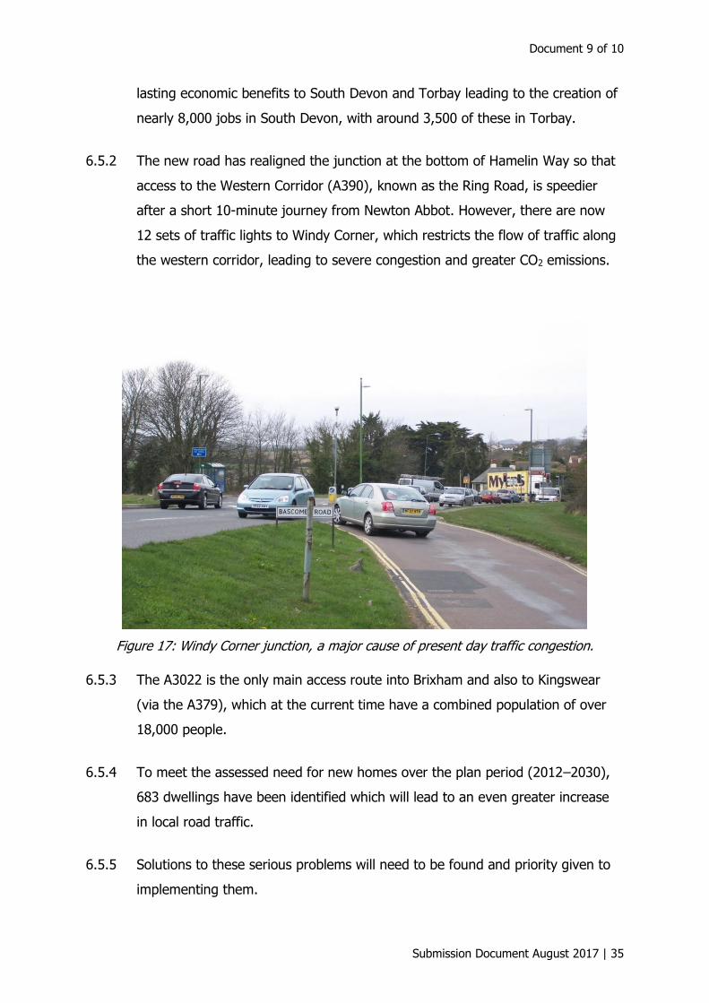
6.5.2 The new road has realigned the junction at the bottom of Hamelin Way so that
access to the Western Corridor (A390), known as the Ring Road, is speedier
after a short 10-minute journey from Newton Abbot. However, there are now
12 sets of traffic lights to Windy Corner, which restricts the flow of traffic along
the western corridor, leading to severe congestion and greater CO2 emissions.
Figure 17: Windy Corner junction, a major cause of present day traffic congestion.
6.5.3 The A3022 is the only main access route into Brixham and also to Kingswear
(via the A379), which at the current time have a combined population of over
18,000 people.
6.5.4 To meet the assessed need for new homes over the plan period (2012–2030),
683 dwellings have been identified which will lead to an even greater increase
in local road traffic.
6.5.5 Solutions to these serious problems will need to be found and priority given to
implementing them.
Brixham Town Design Statement
36 | Submission Document August 2017
6.5.6 See “General design guidelines”, Section 8.
MT4 Traffic effects of development. Assessment of the impact of increased
traffic resulting from new developments, in terms of the effect on traffic
flows generally within, throughout and on the approaches to Brixham, will
be important in helping to resolve this issue.
MT5 Park and Ride. A plan to enhance and further develop the Park and Ride
and its immediate area, to create an appropriate gateway to Brixham,
would be welcomed. Signage, information available for visitors to the
facilities in Brixham and the provision of the usual tourist facilities will be
necessary.
6.6 Town centre parking
6.6.1 The existing conflict between buses and vehicles exiting the town centre car
park is long overdue for a solution. Parking provision for any new developments
should be adequate for modern trends where ever possible and not just to meet
minimum current legislation requirements. Increased parking provision and a
coach drop-off and pick-up point in a town centre location is seen by businesses
in the town as a very necessary requirement to help boost the town economy.
6.6.2 It is hoped that current town centre regeneration plans will provide solutions to
much of what is unsatisfactory in this area and lead to outcomes we will be
proud of. These should enhance the conservation area by using design and
materials that reinforce the pattern and character of the heritage features we
already have, so as to ensure renovated or new builds are in keeping with their
place and surroundings.
6.6.3 See “General design guidelines”, Section 8.
LS1 Development brief. A development brief will be prepared for all large-
scale development sites, notably the town centre and car park area, the
Harbour area, Oxen Cove and Freshwater Quarry.
Document 9 of 10
Submission Document August 2017 | 37
Q1 Visibility. Any development will be considered in relation to its visibility
from both within and from outside the town, so that it is appropriate to its
location. Brixham lies in and on a series of valleys and hills, with both
inland view ridges and seaward views incorporating the natural
amphitheatre of the harbour. The views and vistas of the surrounding
countryside, the key landmarks of the town and the sea are important and
must be respected.
See also:
Q2 Scale of development
MT1 Legibility, signage and pedestrian crossings
MT2 Town centre “shared space”
MT3 Parking resulting from new development
BD6 Ancillary facilities.
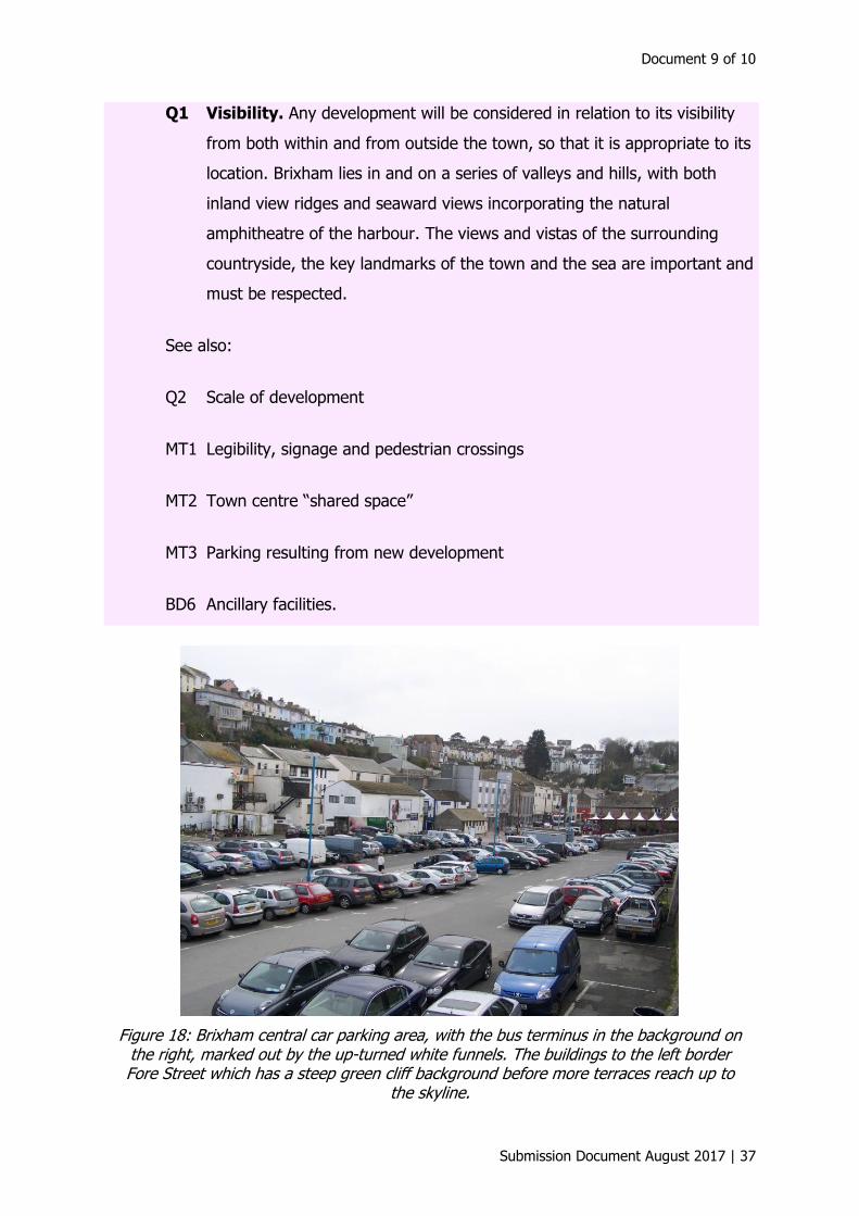
Figure 18: Brixham central car parking area, with the bus terminus in the background on the right, marked out by the up-turned white funnels. The buildings to the left border Fore Street which has a steep green cliff background before more terraces reach up to
the skyline.
Brixham Town Design Statement
38 | Submission Document August 2017
6.7 Cleanliness of the town and harbour
6.7.1 TOR2 is a ground-breaking joint partnership between Torbay Council and Kier
Group, which is responsible for delivering a wide range of essential front-line
services to the residents of Torbay.
6.7.2 The services provided by TOR2 on behalf of Torbay Council include waste and
recycling collections; the maintenance of highways, grounds, parks, car parks,
buildings and the council’s vehicle fleet; street and beach cleansing; and out of
hours call centre support.
6.7.3 The joint venture company was formed in April 2010 and took over
responsibility for services in July 2010. The partners have agreed a 10-year
contract. The delivery of a wide range of services through a single private
partner in a joint venture with a local authority is a truly innovative solution
designed to drive service improvements and value for residents – doing more
for less.
6.7.4 The town is hoping that an unfinished successful trial of solar powered rubbish
collection bins (known as Big Belly Bins) will lead to their permanent
introduction in the near future. Seagull numbers have increased over recent
years and the birds make themselves a nuisance rummaging in the collection
bins, scattering the contents which is a potential health hazard, and in some
instances their opportunist behaviour towards food is alarming to holiday
visitors. Dealing with the vast amounts of rubbish generated in the summer is a
problem, and keeping the town well-presented and looking cared for is a
number-one priority.
6.7.5 Floral displays enhance the look of the town during the summer months and for
several years now Brixham has been entered in the Britain in Bloom contest,
winning on many occasions. “Pride in Brixham” are a voluntary group who work
hard to keep the town centre and harbour area looking its best, and they care
for many of the floral displays and garden features around the harbour side and
town centre. Their work is very much appreciated by the town’s people and
much admired by our visitors, and in 2016 they were awarded several trophies.

Document 9 of 10
Submission Document August 2017 | 39
7 Townscape analysis
7.1 Brixham town centre
7.1.1 This area is defined as the former creek area infilled in the 18th century between
Middle and Fore Streets (which is the main commercial area), the 19th century
waterfront and harbour installations to the east (the piers, the former market
house on the Strand) and the earlier buildings on the Quay stretching round to
Overgang, as well as the step-ways rising from both sides (such as
Temperance, Overgang, Shinners and others).
7.1.2 This conservation area covers 50 ha (125 acres); its landward perimeter is
6½ km, with 2½ km against the sea (excluding the lengths of all piers). It
contains 133 heritage category listings extending over 190 separate properties
as well as other specific features, such as boundary walls, gates and entrances.
All are designated grade II or grade II*, and three scheduled monuments lie
within or adjacent to the conservation area.
7.1.3 The area has a very irregular shape with long arms embracing Battery Gardens
on the north and Berry Head Road on the east; on the south the Bolton Street
area adjoins the Higher Brixham conservation area at the Burton Street,
Greenswood Road and Rea Barn Road junction, the traditional line between
Higher Brixham and Lower Brixham Quay. Brixham town’s designated area is
more than just single runs of streets, as houses also range up the valley slopes
and terraces are quarried out of its sides (see the green shaded area in
Figure 15).
7.1.4 Despite the distinctive topography, the boundaries of the character areas are
not clear cut.
7.1.5 The town occupies the infilled creek and is delineated by the quarry faces of the
early 19th century town on the south side. Furzeham slopes down towards the
central area so that Church Hill East and Higher Street form the dividing line
between Furzeham and the town. King Street, North View and Ranscombe form
a compact area on the upper slopes on the south side of the harbour with
Temperance Steps forming a convenient boundary between it and the infilled
Brixham Town Design Statement
40 | Submission Document August 2017
central area. All areas, with the exception of the long northern and eastern
arms, contain buildings from the early 19th century but there is no clear
chronological cohesion within the areas, although there are distinct urban blocks
within them.
7.1.6 The buildings in Fore Street are mixed, with three-storey terraces with shops on
to the street and residential or businesses above.
7.1.7 The roadscape is two colour to mark the lack of pavement area, but the type of
flat surface overall is not wearing well and in wet weather it can be hazardous.
7.1.8 Fore Street is the primary retail trading centre of Brixham with Middle Street,
The Quay, The Strand and lower Bolton Street all contributing to a major part of
the town’s economy. More individual, unique small shops should be encouraged
and retained within this area to not only please the tourist visitor but also to
attract more locally based shoppers. The general economic situation has
unfortunately led to small business closures, and charity shops and cafes have
increased to fill some of the gaps.
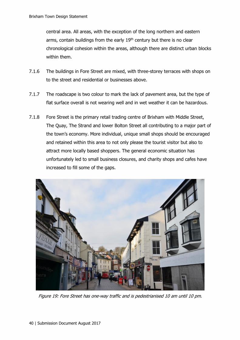
Figure 19: Fore Street has one-way traffic and is pedestrianised 10 am until 10 pm.
Document 9 of 10
Submission Document August 2017 | 41
7.1.9 All Brixham traders should be encouraged to address conservation issues when
planning any changes to their businesses, both internally and externally. Advice
should be given to stress that addressing conservation issues is part of any
planning process and should be given a high priority; financial inducement
incentives may be possible.
7.1.10 The Town Centre Redevelopment Site is an opportunity for change and the
separate proposed Town Centre Master Plan document gives information and
details on the thinking behind this initial plan.
7.1.11 See “General design guidelines”, Section 8.
BD4 Materials. Building materials will respect the traditional character of
Brixham and the immediate context of the development in particular. For
example, white or colour wash finish over stone, or natural limestone are
prevalent in many parts of the historic core and conservation areas and
the use of such locally sourced, reclaimed or recycled materials, or
appropriate modern alternatives, for new development will be encouraged.
Elsewhere the addition of more contemporary materials would be
appropriate. Materials should be sourced locally where possible.
BD5 Shop fronts: Where traditional shop fronts remain in the historic areas of
town, they will be retained and any alterations should incorporate
traditional elements and materials. Where the traditional shop front has
already been removed, the replacement of appropriate shop fronts should
be encouraged, so that they contribute to the character of the area and
building in terms of their scale and style. New shop fronts should also
contribute to the character of the area in terms of their scale and style.
See also:
L3 Boundaries
L7 Public realm
L8 Lighting.
Brixham Town Design Statement
42 | Submission Document August 2017
7.2 Bolton Street and Mount Pleasant
7.2.1 Bolton Street links the medieval Domesday village of Higher Brixham with the
town centre at Bolton Cross; it is set in a narrow valley whose former streams
fed both the corn mill and the 18th century Naval Reservoir. The west side is
largely commercial but the east side has some good 19th century and earlier
residential buildings, a number listed, set above street level and enclosed by
railings. Later 19th century streets run parallel up the valley sides with some
larger late Victorian/Edwardian seaside villas on Parkham Hill. Mount Pleasant
includes the scheduled monument of Brixham Cavern, where public access was
via No. 107.
7.2.2 There is little opportunity for new housing development of any kind in this area.
There may be the possibility of infill in garden plots on the Parkham Hill side or
infill on the steep slopes between Bolton Street and Mount Pleasant.
7.2.3 See “General design guidelines”, Section 8.
Q4 Infill development and building in gardens must respect the character
and appearance of the area and not be detrimental to the overall quality
and amenity of the neighbourhood.
BD1 Building lines. In areas where a clear historic building line has been
established, new development will generally be expected to follow the
existing line of development, whether it is along the back edge of the
pavement or set back.
S7 Building refurbishment. The energy-efficient refurbishment of existing
properties in a manner appropriate to their quality and historic origins will
be encouraged.
7.3 Berry Head Road
7.3.1 This character area includes Moorings Reach, the largest late 20th century
development in the conservation area on the site of the former shipbuilding
yards, and then extends eastwards from the King Street/Ranscombe Road
Document 9 of 10
Submission Document August 2017 | 43
junction along Berry Head Road to include the breakwater, D-Day embarkation
ramps, Shoalstone Pool and the Coastguard Cottages. The prehistoric scheduled
monument of Ash Hole Cavern lies on, but outside, the designated boundary.
The eccentric Edwardian Villa of Wolborough House and a few others lie above
the coast road.
Figure 20: The coastguard cottages on the seaward side of Berry Head Road.
7.3.2 The cottages were built in 1889 of squared rock-faced limestone with slate roofs
and stone stacks. They have projecting gabled front porches with chamfered
copings and kneelers with decorative panels and the porches house opposing
front doors. To the east opposite the Victoria Road junction the detached
former Coastguard Station, No. 12, comes first, followed by the 10-cottage
group Nos. 14–32 (designed as linked pairs). No. 34 at the far end with its
double doors was the Coastguard Rescue Station and includes walls, piers and
railings. Like the coastguard station it has been converted to residential. No. 26
was the home of James Callaghan 1914-22, but has a later front garage

Brixham Town Design Statement
44 | Submission Document August 2017
7.3.3 extension which breaks the rhythm and uniformity of the linked pairs. The
rescue station located here, a long way from the inner harbour, had excellent
views and access to open water and the houses retain, like many former
buildings in Brixham, a strong maritime link to the working 19th century town.5
7.3.4 See “General design guidelines”, Section 8.
S6 Building refurbishment. The energy-efficient refurbishment of existing
properties in a manner appropriate to their quality and historic origins will
be encouraged.
Q4 Infill development and building in gardens must respect the character
and appearance of the area and not be detrimental to the overall quality
and amenity of the neighbourhood.
See also:
S2 Building design
S3 Construction technology
BD4 Materials.
7.4 New Road area
7.4.1 The New Road area includes the rising slopes of Lower and Higher Manor Roads
and part of South Furzeham Road on the plateau edge. The civic centre of the
town lies at its east end with a very good group of buildings: the town and
market halls, library and museum. The area, like Bolton Street, is a narrow
valley with steep sides; there are good buildings groups on the north side,
including the Rock Bank pair in Higher Manor Road which are Brixham’s largest
houses, set in grounds that would not be out of place in Torquay’s Warberries
or Lincombes.
5 Brixham Town Conservation Area Character Appraisal. Architectural and Historic Qualities. Page 72,
para. 4.4.117. Hal Bishop, BA, MA, Cert Ecol & Cons, IHBC, MIfA. Revised 2014.

Document 9 of 10
Submission Document August 2017 | 45
Figure 21: Brixham Town Hall and Scala Market Hall at Bolton Cross, with the tower of All Saints Church in the background.
7.4.2 New Road is the main arterial road into the town centre of Brixham. It carries
the majority of vehicles that need to access the fish quay and the several
industrial estates, and brings tourists into the town.
Figure 22: New Road leading out of Brixham.

Brixham Town Design Statement
46 | Submission Document August 2017
7.4.3 There is a wide mix of development in this area ranging from blocks of flats to a
mid-20th century modernist butterfly roof icon house designed by Mervyn Seal.
There are some older properties in large gardens and some with a distinctive
villa and gable roof built form.
7.4.4 New Road has commercial enterprises, the job centre, a doctors’ surgery, two
churches, dentists, several bed & breakfast and guest house businesses and a
pub along a seemingly residential road leading out to the town boundary at
Monksbridge Road and the Toll House. Housing in the streets off New Road
consists of mostly modern estates of bungalows, and houses are terraced, semi-
detached and detached. Any recent development on New Road itself would
largely be infill and as there is only one open space in the area the integrity of
this space will not be compromised.
7.4.5 What characterises Brixham Town, even more than Higher Brixham, is the near
universal use of stucco or rendered finish. A few large and prominent buildings
show exposed stone: the Town Hall; All Saints Church; the former warehouse
complex off The Strand and New Quay Lane off Yachtside Court; the hall of the
former National School, now the Salvation Army Citadel on Bolton Street; and
the splendid high terrace group of 1–17 Rae Barn Road.
7.4.6 An even smaller number use brick of which the prominent examples are: the
former police station, now the Museum at Bolton Cross; the former hall on
Cavern Road; and the Late Victorian/Edwardian shop groups on Fore Street.
7.4.7 See “General design guidelines”, Section 8.
Q4 Infill development and building in gardens must respect the character
and appearance of the area and not be detrimental to the overall quality
and amenity of the neighbourhood.
See also:
Q2 Scale of development.
Document 9 of 10
Submission Document August 2017 | 47
7.5 Furzeham
7.5.1 This area extends north from the flat centre and harbour, and rises up the
northern slopes to the plateau where the railway arrived in the 1860s, so is
defined by early to mid 19th century development. All Saints, the new Church of
the period, is the most prominent building. The narrow streets are linked by
typical series of step-ways set with cream-coloured pavers. On the northeast
side, three terraces on or close to North Furzeham Road look out to sea rather
than inland. Furzeham Gardens and the early houses of Bella Vista Road lie
outside the designated area but are important visual and architectural elements
of the townscape here, and should be considered for formal inclusion within it.
Figure 23: Roof top view from Furzeham over Brixham outer harbour with the Marina and Breakwater in the background.
Figure 24: Bella Vista Road houses with many dormers and the Middle Green, Furzeham.
Brixham Town Design Statement
48 | Submission Document August 2017
7.5.2 In this area there is little scope for large-scale development. The houses have
been built on the steep hillsides overlooking the harbour and looking out to sea,
with small narrow lanes and access by steps to many of the older tucked away
terraced cottages. The cliff face supports green vegetation which coats much of
this area between the terraces of housing.
Figure 25: Furzeham terraces overlooking Oxen Cove and the outer harbour.
7.5.3 No development should impact on the open space of Furzeham Green which is
protected. It consists of three component parts, Higher, Middle and Lower
Green. Higher Green accommodates a children’s playground, tennis courts and
a bowling green, and is used by Furzeham Primary School. Nearby there are
also two statutory allotment gardens.
7.5.4 The Middle Green is bordered with a cul de sac of more recent two-storey
houses and there are many terraces in Furzeham from Victorian times which are
mostly rendered brightly coloured and where the houses open straight on to the
street. The Lower Green too is bordered by terraced properties, many of which
have a dormer extension with flat roof and they overlook the harbour area
below them. There is a mix of detached and semi-detached properties, some
later modern houses and bungalows along the Higher Green as well as
Furzeham Primary School and Nursery.
Document 9 of 10
Submission Document August 2017 | 49
7.5.5 See “General design guidelines”, Section 8.
S6 Building refurbishment. The energy-efficient refurbishment of existing
properties in a manner appropriate to their quality and historic origins will
be encouraged.
L5 Materials of hard landscaping should be of high quality and reflect the
character of adjoining buildings and areas.
See also
Q2 Scale of development
L4 Front gardens/areas
BD1 Building lines.
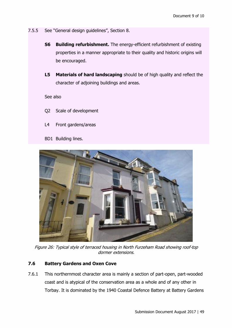
Figure 26: Typical style of terraced housing in North Furzeham Road showing roof-top dormer extensions.
7.6 Battery Gardens and Oxen Cove
7.6.1 This northernmost character area is mainly a section of part-open, part-wooded
coast and is atypical of the conservation area as a whole and of any other in
Torbay. It is dominated by the 1940 Coastal Defence Battery at Battery Gardens
Brixham Town Design Statement
50 | Submission Document August 2017
at the north end overlooking Fishcombe Cove and all of Torbay, and the site of
the previous Astra Zeneca Environmental Laboratories at the bottom of a former
quarry, Freshwater Quarry. The character area is an extension of the original
conservation area designated in September 1999 in order to protect Battery
Gardens. However, the gardens, whose military significance dates first from
1779 and was much expanded in 1940 with an integrated gunnery and
searchlight complex, was scheduled in March 2002.
7.6.2 There are no residential buildings in the sub-area, and as scheduling offers the
highest category of heritage protection it could be argued that the conservation
area no longer need stretch to include Battery Gardens, and that the designated
boundaries be withdrawn to remove it, but then Furzeham Gardens and some
of the Bella Vista Road houses could be included.6
7.7 Copythorne and Lindthorpe Way area, Pillar Avenue and North
Boundary Road
7.7.1 This area consists of a mix of modern bungalows, terraced, as well as semi-
detached and detached, and some older houses, a small industrial estate, a row
of shops and a local pub. If development is to take place here modern style
designs would be acceptable in this more recently developed area of the town.
In the immediate vicinity, open spaces are lacking and better play space
facilities are needed.
7.7.2 The interface between the town and the surrounding countryside mostly follows
the lines of former hedgerow field boundaries which pre-dated the expansion of
the town. These have generally remained as the boundaries between each new
development and the open countryside. Many of the properties which border
the urban edge on North Boundary Road, the Brixham/Churston boundary, are
bungalows of distinctive design, rendered and colourfully painted with low walls
or low hedging fronting their properties.
6Brixham Town Conservation Area Character Appraisal. Plan form and character areas. Page 15, para
3-9. Hal Bishop, BA, MA, Cert Ecol & Cons, IHBC, MIfA. Revised 2014.
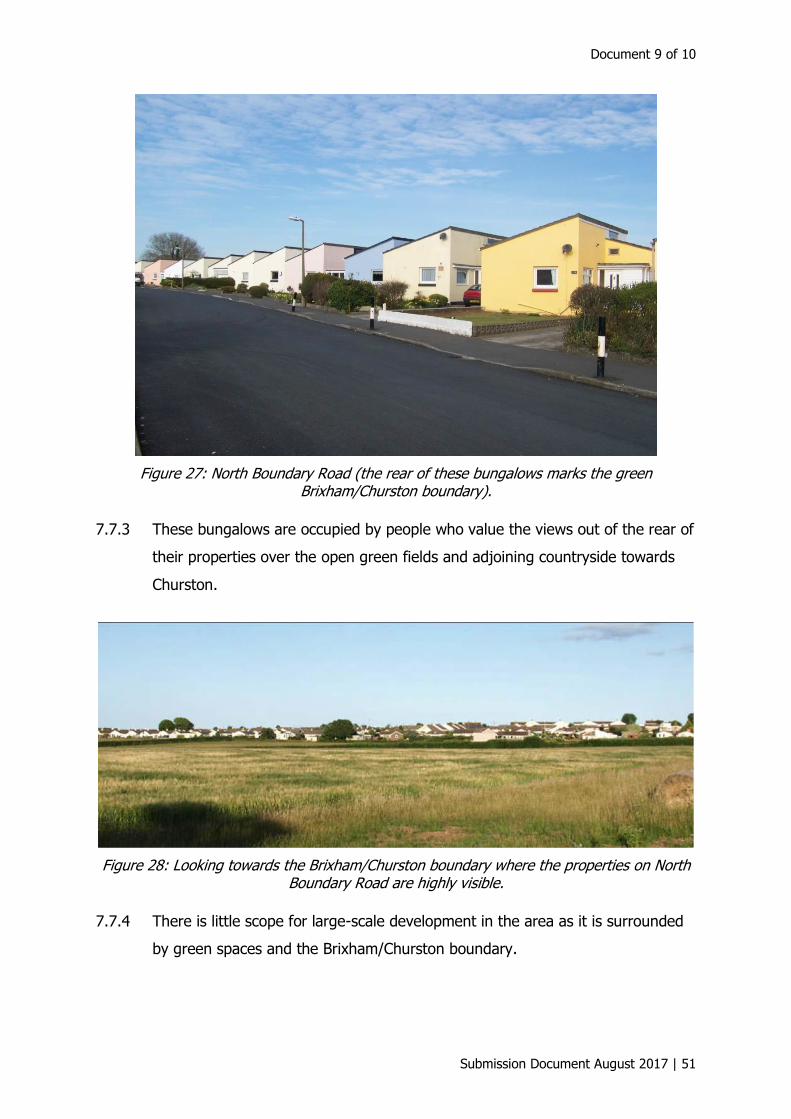
Document 9 of 10
Submission Document August 2017 | 51
Figure 27: North Boundary Road (the rear of these bungalows marks the green Brixham/Churston boundary).
7.7.3 These bungalows are occupied by people who value the views out of the rear of
their properties over the open green fields and adjoining countryside towards
Churston.
Figure 28: Looking towards the Brixham/Churston boundary where the properties on North Boundary Road are highly visible.
7.7.4 There is little scope for large-scale development in the area as it is surrounded
by green spaces and the Brixham/Churston boundary.

Brixham Town Design Statement
52 | Submission Document August 2017
7.7.5 See “General design guidelines”, Section 8.
BD2 Architectural treatment. New development will be of high quality,
raising the standard of architectural treatment and respecting the qualities
of its surroundings, such as scale, style, materials and attention to detail.
Innovative designs and the contemporary interpretation of traditional
design and construction will be welcomed; they will be to the highest
standards and be complementary to their context.
G2 Innovative design. A contemporary design approach using modern
materials will be encouraged, provided that local distinctiveness and
character are respected and enhanced.
See also:
BD6 Ancillary facilities
MT6 Pedestrian and cycle routes.
Figure 29: Cricket Club Housing Development 2010 on the site of the former Cricket ground.
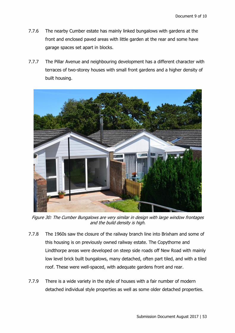
Document 9 of 10
Submission Document August 2017 | 53
7.7.6 The nearby Cumber estate has mainly linked bungalows with gardens at the
front and enclosed paved areas with little garden at the rear and some have
garage spaces set apart in blocks.
7.7.7 The Pillar Avenue and neighbouring development has a different character with
terraces of two-storey houses with small front gardens and a higher density of
built housing.
Figure 30: The Cumber Bungalows are very similar in design with large window frontages and the build density is high.
7.7.8 The 1960s saw the closure of the railway branch line into Brixham and some of
this housing is on previously owned railway estate. The Copythorne and
Lindthorpe areas were developed on steep side roads off New Road with mainly
low level brick built bungalows, many detached, often part tiled, and with a tiled
roof. These were well-spaced, with adequate gardens front and rear.
7.7.9 There is a wide variety in the style of houses with a fair number of modern
detached individual style properties as well as some older detached properties.
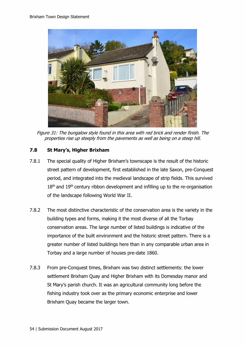
Brixham Town Design Statement
54 | Submission Document August 2017
Figure 31: The bungalow style found in this area with red brick and render finish. The properties rise up steeply from the pavements as well as being on a steep hill.
7.8 St Mary’s, Higher Brixham
7.8.1 The special quality of Higher Brixham’s townscape is the result of the historic
street pattern of development, first established in the late Saxon, pre-Conquest
period, and integrated into the medieval landscape of strip fields. This survived
18th and 19th
century ribbon development and infilling up to the re-organisation
of the landscape following World War II.
7.8.2 The most distinctive characteristic of the conservation area is the variety in the
building types and forms, making it the most diverse of all the Torbay
conservation areas. The large number of listed buildings is indicative of the
importance of the built environment and the historic street pattern. There is a
greater number of listed buildings here than in any comparable urban area in
Torbay and a large number of houses pre-date 1860.
7.8.3 From pre-Conquest times, Brixham was two distinct settlements: the lower
settlement Brixham Quay and Higher Brixham with its Domesday manor and
St Mary’s parish church. It was an agricultural community long before the
fishing industry took over as the primary economic enterprise and lower
Brixham Quay became the larger town.
Document 9 of 10
Submission Document August 2017 | 55
7.8.4 The two Brixham conservation areas, Higher Brixham and Brixham Town, adjoin
each other forming a designated area stretching 3.5 km from Milton Street to
Shoalstone. The actual Higher Brixham conservation area covers 50 acres but
because of the meandering nature of the boundary it has a perimeter of over
7 km. It covers the area of the early settlement: Milton Street, lower Summer
Lane, the junction with Southdown Hill and Upton Manor Road, Horsepool
Street up to Greenover Road, Baker’s Hill, as far as Stoneacre (the former
Vicarage), Drew Street, Knick Knack Lane and Burton Street with an extension
to lower Rea Barn Road. Gattery Lane and Guzzle Down mark the upper
boundary of Higher Brixham whilst Burton Street and Great Gate the lower one.
7.8.5 Milton Street lies west of the parish church and Drew Street north and east of
it; there is a distinct change of alignment where the two streets meet. These
main roads (a bus route) are part of the “local distributor route network”. This
through route connects the southern part of the town to the A379 Paignton to
Kingswear road at Hillhead.
7.8.6 There are spectacular views driving down the tree-lined winding narrow road
from Hillhead to Brixham, of the sea to the right, the sloping green fields on
either side and then the distant view of Brixham, the harbour and Tor Bay in
the valley bottom.
7.8.7 Brixham housing development starts on the left at Elizabeth Avenue with an
older estate of social housing, although some houses are now privately owned,
some semi-detached houses and also some shorter terraces too, with long
moderate sized back gardens, all of which are very similar except where home
owners have added extra touches to their properties.
7.8.8 The road opposite on the right of the main road is more recent, leading up the
hillside to Ocean View Drive. This development is very different, consisting of
semi-detached housing on the lower level road, with steps down to small front
gardens, and at the back small rear gardens with rough ground and bushes.
Beyond the gardens is a narrow service lane and a boundary wall dropping
Brixham Town Design Statement
56 | Submission Document August 2017
down to the main road, which has no pavement along this stretch. On the road
further up the hillside there is a long row of two-storey flats with garages
underneath and views looking out across the valley to Summercombe.
7.8.9 The main road continues, descending through high limestone walls topped with
hedges/trees fronting individual houses. Mixed ribbon development exists along
this narrow winding main road and there are strong visual contrasts leading to a
highly varied street scene. Car parking is on-street with residents keeping
voluntarily to one side of the road in the stretches where the yellow lines are
absent. Few of the older properties fronting this main route have garages.
7.8.10 The early development remains significantly unaltered, including overall
frontage detail, spatial arrangement, roof profiles, stacks and original chimney
pots, and specifically, the intricacy of detail and range of materials used. This
includes slate-hanging, roof slate-plastering, decorative stucco moulding, and
the imaginative use of natural stone and brick combinations which characterise
much of the development that took place between the early 19th to early 20th
centuries. Much period detail has survived, such as original sash windows with
glazing bars, cast-iron railings and items of street furniture, panelled doors and
reveals.
7.8.11 See “General design guidelines”, Section 8.
S6 Building refurbishment. The energy-efficient refurbishment of existing
properties in a manner appropriate to their quality and historic origins will
be encouraged.
BD1 Building lines. In areas where a clear historic building line has been
established, new development will generally be expected to follow the
existing line of development, whether it is along the back edge of the
pavement or set back.
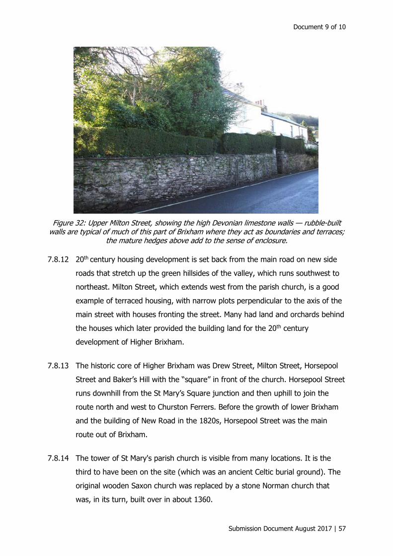
Document 9 of 10
Submission Document August 2017 | 57
Figure 32: Upper Milton Street, showing the high Devonian limestone walls — rubble-built walls are typical of much of this part of Brixham where they act as boundaries and terraces;
the mature hedges above add to the sense of enclosure.
7.8.12 20th century housing development is set back from the main road on new side
roads that stretch up the green hillsides of the valley, which runs southwest to
northeast. Milton Street, which extends west from the parish church, is a good
example of terraced housing, with narrow plots perpendicular to the axis of the
main street with houses fronting the street. Many had land and orchards behind
the houses which later provided the building land for the 20th century
development of Higher Brixham.
7.8.13 The historic core of Higher Brixham was Drew Street, Milton Street, Horsepool
Street and Baker’s Hill with the “square” in front of the church. Horsepool Street
runs downhill from the St Mary’s Square junction and then uphill to join the
route north and west to Churston Ferrers. Before the growth of lower Brixham
and the building of New Road in the 1820s, Horsepool Street was the main
route out of Brixham.
7.8.14 The tower of St Mary's parish church is visible from many locations. It is the
third to have been on the site (which was an ancient Celtic burial ground). The
original wooden Saxon church was replaced by a stone Norman church that
was, in its turn, built over in about 1360.

Brixham Town Design Statement
58 | Submission Document August 2017
i
Figure 33: St Mary’s Church, Higher Brixham.
7.8.15 Many important townspeople are buried in the churchyard, which is very large
and contains some of the mature and beautiful examples of both deciduous and
evergreen trees found in Higher Brixham. The importance of individual trees
within the streetscape of the conservation area is highlighted by many examples
of individual specimen trees located in private gardens.
7.8.16 St Mary’s Park is a large and important open space (c. 7 acres) adjoining the
southern edge of the conservation area immediately south of the churchyard,
and is bordered by trees. There are tennis courts, a bowling green, a football
pitch area, an exercise trail, a wild flower meadow in summer which is much
admired and a children’s playground.
7.8.17 The conservation area proper is largely devoid of green space, apart from
private gardens, many of which are contained or concealed by high, mostly
limestone walls.
7.8.18 Adjoining the conservation area, but outside the designated boundaries, are
allotment gardens which are entered off Drew Street.
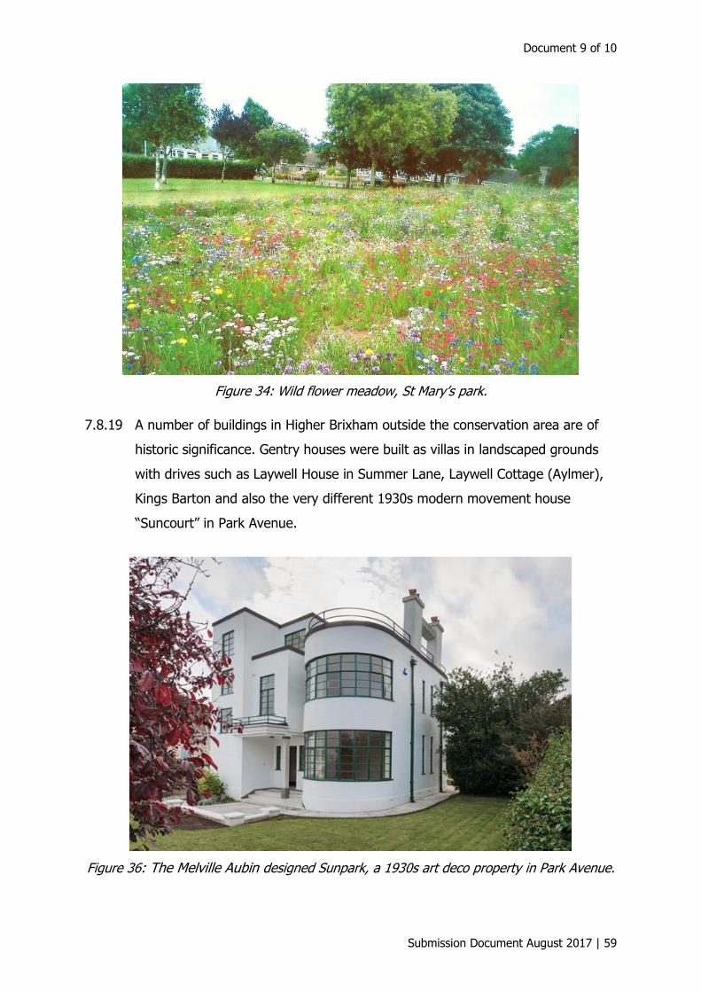
Document 9 of 10
Submission Document August 2017 | 59
Figure 34: Wild flower meadow, St Mary’s park.
7.8.19 A number of buildings in Higher Brixham outside the conservation area are of
historic significance. Gentry houses were built as villas in landscaped grounds
with drives such as Laywell House in Summer Lane, Laywell Cottage (Aylmer),
Kings Barton and also the very different 1930s modern movement house
“Suncourt” in Park Avenue.
Figure 36: The Melville Aubin designed Sunpark, a 1930s art deco property in Park Avenue.

Brixham Town Design Statement
60 | Submission Document August 2017
7.8.20 Upton Manor off Upton Manor Road was built in 1768. There have been
changes to the original building but it is still a dwelling in large grounds.
7.8.21 Set within a garden and hidden behind high walls on two sides, Aylmer
(originally Laywell Cottage) is one of the Gillard Cottages Orneés; the gothic-
revival windows are typical hallmarks. The superbly restored trellised veranda
unhappily looks out onto the house’s immediate surroundings: an ugly sea of
tarmac.
7.8.22 The building material in the conservation area is overwhelmingly the local
limestone or shale, but it is usually stuccoed or rendered over. The high
boundary and terrace walls, and the lower garden walls all use this material in a
variety of ways and are much less likely to be rendered. Some stone on
buildings has been intentionally exposed, or left exposed after repair.
Figure 35: Aylmer, originally Laywell Cottage.
7.8.23 The revised 2nd edition County series map (published 1906) showed that there
had been very little change in some parts of Higher Brixham over the previous
40 years. This was different to the northern and eastern parts of the
conservation area nearer to Lower Brixham. In the late 19th century it became
more urban in character because it had grown to accommodate its increasing
population.
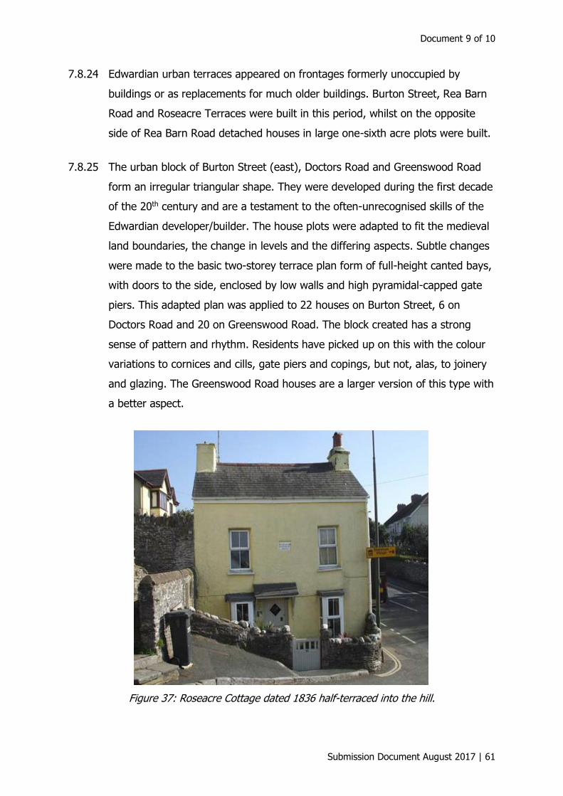
Document 9 of 10
Submission Document August 2017 | 61
7.8.24 Edwardian urban terraces appeared on frontages formerly unoccupied by
buildings or as replacements for much older buildings. Burton Street, Rea Barn
Road and Roseacre Terraces were built in this period, whilst on the opposite
side of Rea Barn Road detached houses in large one-sixth acre plots were built.
7.8.25 The urban block of Burton Street (east), Doctors Road and Greenswood Road
form an irregular triangular shape. They were developed during the first decade
of the 20th century and are a testament to the often-unrecognised skills of the
Edwardian developer/builder. The house plots were adapted to fit the medieval
land boundaries, the change in levels and the differing aspects. Subtle changes
were made to the basic two-storey terrace plan form of full-height canted bays,
with doors to the side, enclosed by low walls and high pyramidal-capped gate
piers. This adapted plan was applied to 22 houses on Burton Street, 6 on
Doctors Road and 20 on Greenswood Road. The block created has a strong
sense of pattern and rhythm. Residents have picked up on this with the colour
variations to cornices and cills, gate piers and copings, but not, alas, to joinery
and glazing. The Greenswood Road houses are a larger version of this type with
a better aspect.
Figure 37: Roseacre Cottage dated 1836 half-terraced into the hill.
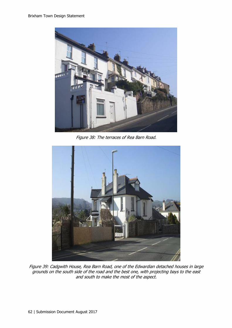
Brixham Town Design Statement
62 | Submission Document August 2017
Figure 38: The terraces of Rea Barn Road.
Figure 39: Cadgwith House, Rea Barn Road, one of the Edwardian detached houses in large grounds on the south side of the road and the best one, with projecting bays to the east
and south to make the most of the aspect.

Document 9 of 10
Submission Document August 2017 | 63
Figure 40: The Greenswood Road terraces with No. 1, the prominent three-storey building, on the corner with Burton Street at the Great Gate junction. It is an important landmark for both the Higher Brixham and Brixham Town conservation areas as this is where the historic
settlement boundaries met. Today it is a doctors’ surgery.
7.8.26 There are only two thatched houses in Higher Brixham; they face each other on
Milton Street at the bottom of Southdown Hill.
Figure 41: Hearthstone is a large through-passage early post-medieval thatched house now sub-divided. High hedges and trees above high walls enclose the lower house from public
view. Wall, arch and chimney are all in local stone; the walls are in cob and stone.
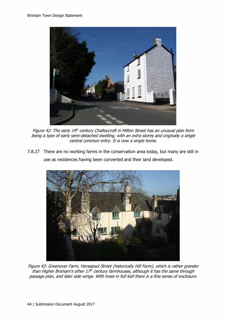
Brixham Town Design Statement
64 | Submission Document August 2017
Figure 42: The early 19th century Challeycroft in Milton Street has an unusual plan form being a type of early semi-detached dwelling, with an extra storey and originally a single
central common entry. It is now a single home.
7.8.27 There are no working farms in the conservation area today, but many are still in
use as residences having been converted and their land developed.
Figure 43: Greenover Farm, Horsepool Street (historically Hill Farm), which is rather grander than Higher Brixham’s other 17th century farmhouses, although it has the same through
passage plan, and later side wings. With trees in full leaf there is a fine sense of enclosure.
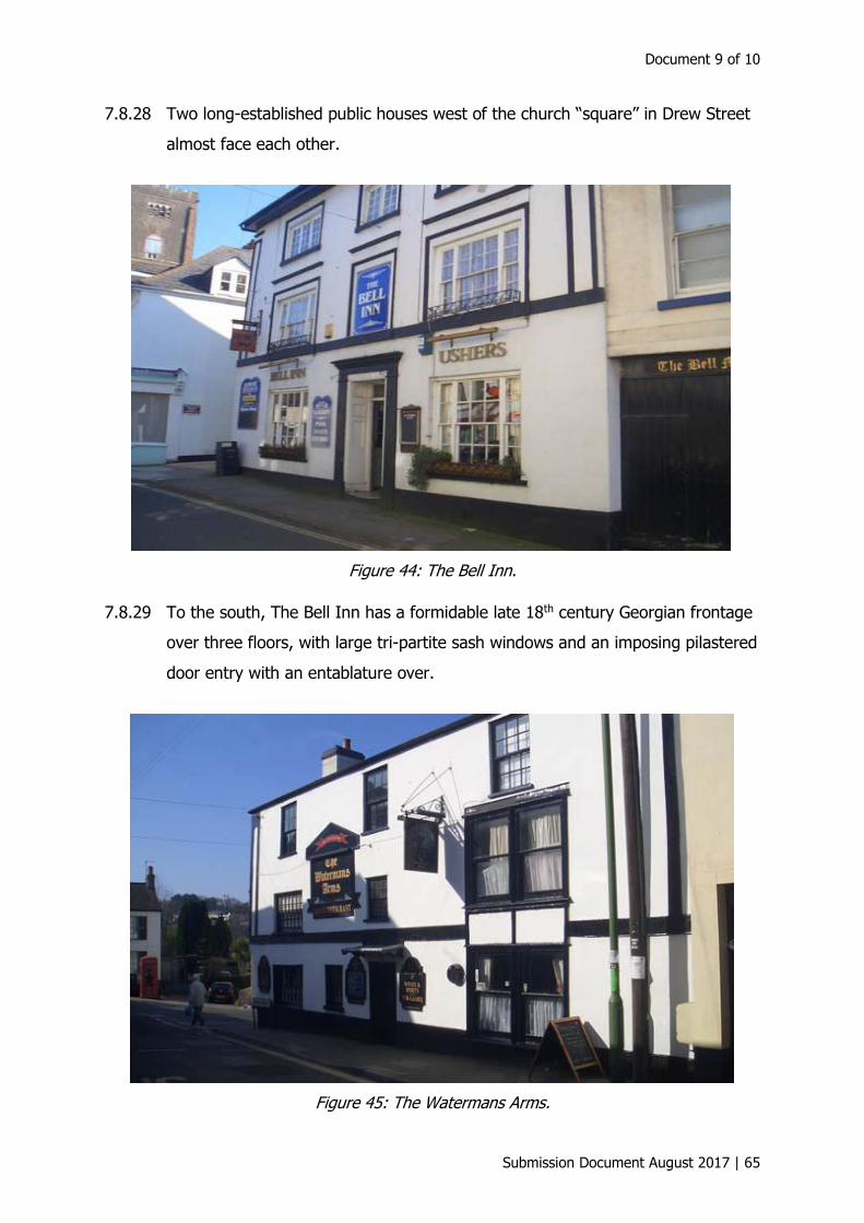
Document 9 of 10
Submission Document August 2017 | 65
7.8.28 Two long-established public houses west of the church “square” in Drew Street
almost face each other.
Figure 44: The Bell Inn.
7.8.29 To the south, The Bell Inn has a formidable late 18th century Georgian frontage
over three floors, with large tri-partite sash windows and an imposing pilastered
door entry with an entablature over.
Figure 45: The Watermans Arms.
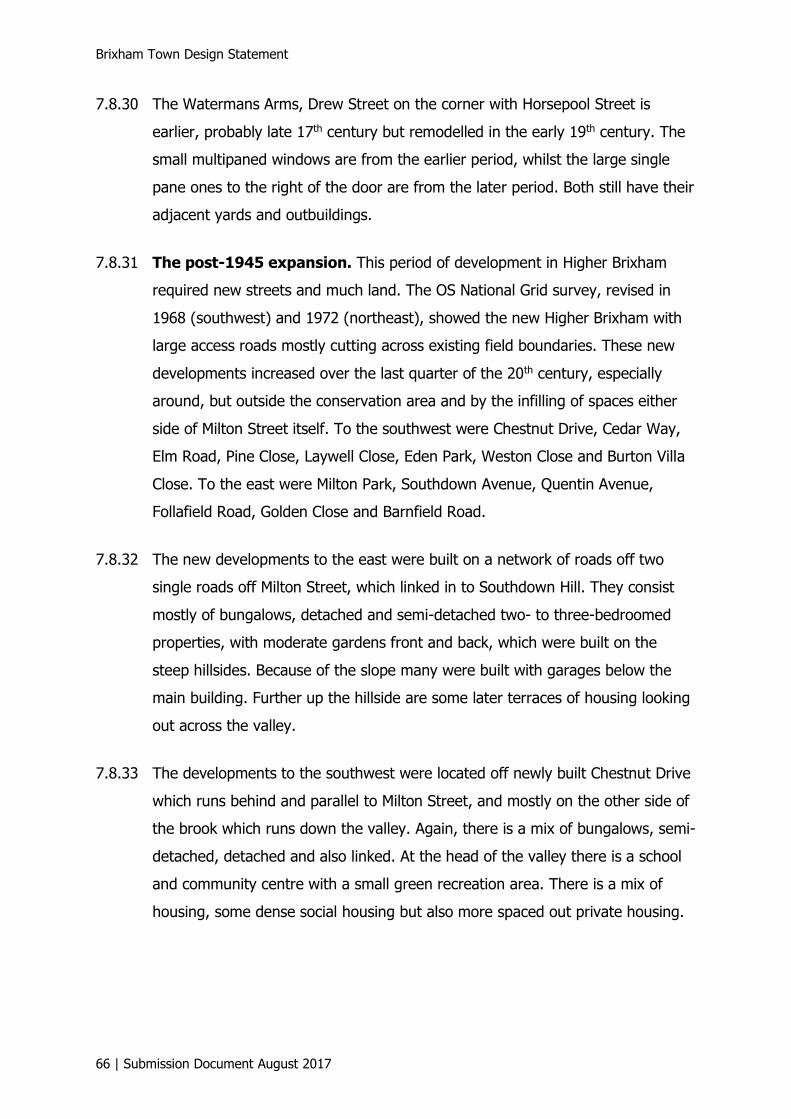
Brixham Town Design Statement
66 | Submission Document August 2017
7.8.30 The Watermans Arms, Drew Street on the corner with Horsepool Street is
earlier, probably late 17th century but remodelled in the early 19th century. The
small multipaned windows are from the earlier period, whilst the large single
pane ones to the right of the door are from the later period. Both still have their
adjacent yards and outbuildings.
7.8.31 The post-1945 expansion. This period of development in Higher Brixham
required new streets and much land. The OS National Grid survey, revised in
1968 (southwest) and 1972 (northeast), showed the new Higher Brixham with
large access roads mostly cutting across existing field boundaries. These new
developments increased over the last quarter of the 20th century, especially
around, but outside the conservation area and by the infilling of spaces either
side of Milton Street itself. To the southwest were Chestnut Drive, Cedar Way,
Elm Road, Pine Close, Laywell Close, Eden Park, Weston Close and Burton Villa
Close. To the east were Milton Park, Southdown Avenue, Quentin Avenue,
Follafield Road, Golden Close and Barnfield Road.
7.8.32 The new developments to the east were built on a network of roads off two
single roads off Milton Street, which linked in to Southdown Hill. They consist
mostly of bungalows, detached and semi-detached two- to three-bedroomed
properties, with moderate gardens front and back, which were built on the
steep hillsides. Because of the slope many were built with garages below the
main building. Further up the hillside are some later terraces of housing looking
out across the valley.
7.8.33 The developments to the southwest were located off newly built Chestnut Drive
which runs behind and parallel to Milton Street, and mostly on the other side of
the brook which runs down the valley. Again, there is a mix of bungalows, semi-
detached, detached and also linked. At the head of the valley there is a school
and community centre with a small green recreation area. There is a mix of
housing, some dense social housing but also more spaced out private housing.
Document 9 of 10
Submission Document August 2017 | 67
7.9 Summercombe
7.9.1 Chestnut Drive links into the Summercombe development at the top of the
valley by becoming Bellever Tor Drive which leads to Summercourt Way and the
main development at Summercombe. This area of Higher Brixham was
developed in the 1970s. The main road, the steep Summercourt Way, leads off
Summer Lane up to the very top of the hillside. There are side roads leading off
to the left; one of these is Bellever Tor Drive which connects to Chestnut Drive
and is the local bus route. There are roads off to the right too, one of which
leads to a row of shops, which face on to Summercourt Way. There is a
supermarket, a local branch surgery for a Paignton Vets and an award-winning
fish and chip shop.
7.9.2 This lower section has a mix of housing with small terraces adjacent to the
shops, but on the left there are distinctive individual well-spaced bungalows,
detached and semi-detached, leading up the hillside. The higher reaches have
more individual buildings in larger plots and private gardens. The whole
Summercombe area has a very open spacious feel to the development as there
are green edges to frontages rather than walls to the majority of properties, but
landscaping with shrubs has been widely used to provide privacy as well.
7.9.3 There is a well-used public open green space area on the left towards the top of
the hill which is accessed from Summercourt Way and from Bellever Tor Drive.
It is a play area for the local children, a dog walking area and a place to sit and
take in the panoramic views, across the valley to the far side of Milton Street
and Raddicombe, downhill to lower Brixham and the town, and then across
Tor Bay and out to sea and beyond.
7.9.4 The far end of Summercourt Way marks the green boundary with Brixham and
Churston, which continues down the outskirts of the development, along Mathill
Road and down Monksbridge to New Road.
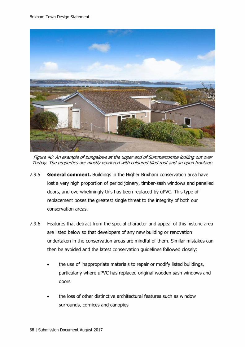
Brixham Town Design Statement
68 | Submission Document August 2017
Figure 46: An example of bungalows at the upper end of Summercombe looking out over Torbay. The properties are mostly rendered with coloured tiled roof and an open frontage.
7.9.5 General comment. Buildings in the Higher Brixham conservation area have
lost a very high proportion of period joinery, timber-sash windows and panelled
doors, and overwhelmingly this has been replaced by uPVC. This type of
replacement poses the greatest single threat to the integrity of both our
conservation areas.
7.9.6 Features that detract from the special character and appeal of this historic area
are listed below so that developers of any new building or renovation
undertaken in the conservation areas are mindful of them. Similar mistakes can
then be avoided and the latest conservation guidelines followed closely:
• the use of inappropriate materials to repair or modify listed buildings,
particularly where uPVC has replaced original wooden sash windows and
doors
• the loss of other distinctive architectural features such as window
surrounds, cornices and canopies
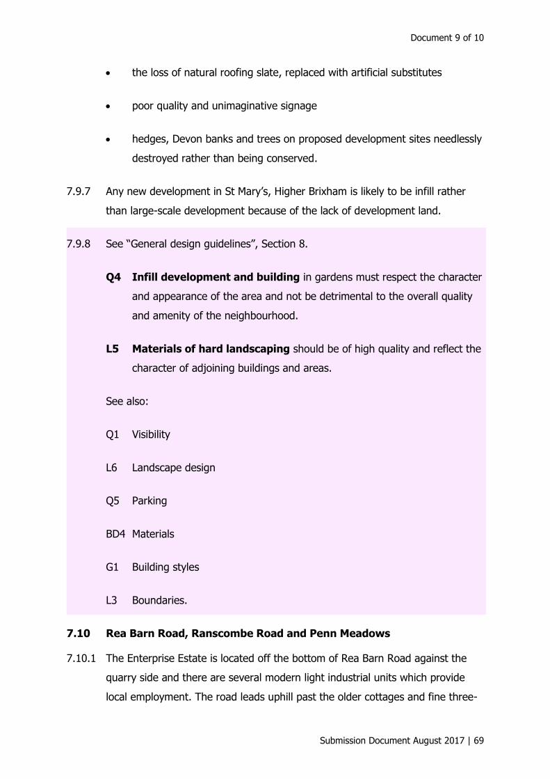
Document 9 of 10
Submission Document August 2017 | 69
• the loss of natural roofing slate, replaced with artificial substitutes
• poor quality and unimaginative signage
• hedges, Devon banks and trees on proposed development sites needlessly
destroyed rather than being conserved.
7.9.7 Any new development in St Mary’s, Higher Brixham is likely to be infill rather
than large-scale development because of the lack of development land.
7.9.8 See “General design guidelines”, Section 8.
Q4 Infill development and building in gardens must respect the character
and appearance of the area and not be detrimental to the overall quality
and amenity of the neighbourhood.
L5 Materials of hard landscaping should be of high quality and reflect the
character of adjoining buildings and areas.
See also:
Q1 Visibility
L6 Landscape design
Q5 Parking
BD4 Materials
G1 Building styles
L3 Boundaries.
7.10 Rea Barn Road, Ranscombe Road and Penn Meadows
7.10.1 The Enterprise Estate is located off the bottom of Rea Barn Road against the
quarry side and there are several modern light industrial units which provide
local employment. The road leads uphill past the older cottages and fine three-
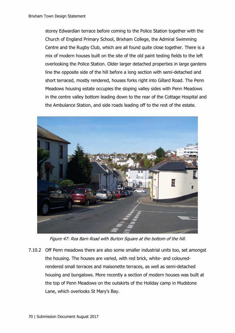
Brixham Town Design Statement
70 | Submission Document August 2017
storey Edwardian terrace before coming to the Police Station together with the
Church of England Primary School, Brixham College, the Admiral Swimming
Centre and the Rugby Club, which are all found quite close together. There is a
mix of modern houses built on the site of the old paint testing fields to the left
overlooking the Police Station. Older larger detached properties in large gardens
line the opposite side of the hill before a long section with semi-detached and
short terraced, mostly rendered, houses forks right into Gillard Road. The Penn
Meadows housing estate occupies the sloping valley sides with Penn Meadows
in the centre valley bottom leading down to the rear of the Cottage Hospital and
the Ambulance Station, and side roads leading off to the rest of the estate.
Figure 47: Rea Barn Road with Burton Square at the bottom of the hill.
7.10.2 Off Penn meadows there are also some smaller industrial units too, set amongst
the housing. The houses are varied, with red brick, white- and coloured-
rendered small terraces and maisonette terraces, as well as semi-detached
housing and bungalows. More recently a section of modern houses was built at
the top of Penn Meadows on the outskirts of the Holiday camp in Mudstone
Lane, which overlooks St Mary’s Bay.

Document 9 of 10
Submission Document August 2017 | 71
7.10.3 There is also a designated village green called Wishings Field at the top of Penn
Meadows. The residents were successful in protecting the open space from
development and have a much-needed play area and dog walking field. There
are public open spaces in the form of playing fields, sports grounds, parkland
and the coastal path nearby. Development along the coastal fringe will not be
considered as this is an AONB and is part of the infrastructure that supports the
local bat colonies.
7.11 Sharkham Village
7.11.1 Sharkham Village is a more recent development, built on the hilly site of a
former holiday camp. The houses are modern, with many different designs and
sizes set out in terraces, with garage space underneath some of them. There is
a green communal area in the centre of the development with playground
equipment. The landscaping is good with mature trees preserved, and
maintained gardens with shrubs, sculptures and green spaces. The final stage
of the development is under way and the three-storey terraces have garage
space underneath. There is a large green sloping meadow at the rear of this
latest stage, with public footpaths leading down to St Marys Bay and the coastal
footpath from Kingswear leading to Berry Head. The seaward coastal views are
very special.
Figure 48: Development at Sharkham Village.
Brixham Town Design Statement
72 | Submission Document August 2017
7.11.2 See “General design guidelines”, Section 8.
LS2 Variety of house types. A variety of house types and sizes will be
provided appropriate to the setting and character of the local area.
LS3 Grouping of houses. Groups of houses should be arranged in a manner
appropriate to the locality, whether it is in a structured street layout or in
a more organic arrangement to form variety and the appearance of
natural growth.
See also:
S2 Building design
S3 Construction technology.
7.12 Harbour area
7.12.1 The harbour area of Brixham is renowned for being quaint and picturesque as
well as being a busy working fishing port, with modern fishing industry
demands. Lower Brixham is characterised by dense development. The early
settlement was confined to the steep limestone slopes with narrow winding
streets, criss-crossed by flights of steps, which surrounded the old harbour
which extended up the valley bottom to what we know today as Bolton Cross.
The flat land in the valley bottom was then reclaimed and built over.
7.12.2 The terraced houses in short or long rows characterise the building form of the
19th century town, whether clustered around the harbour and stepped up the
slopes or ranged up the former river valleys as in Higher Brixham; Victorian in
the main, the effect is picturesque, rather than a 19th-century uniformity. New
housing development in the harbour area will be difficult, because as well as
being a conservation area there is very limited space available. Dwellings that
are approved will need to reflect the qualities of the surrounding terraced
houses and uphold all current conservation measures.
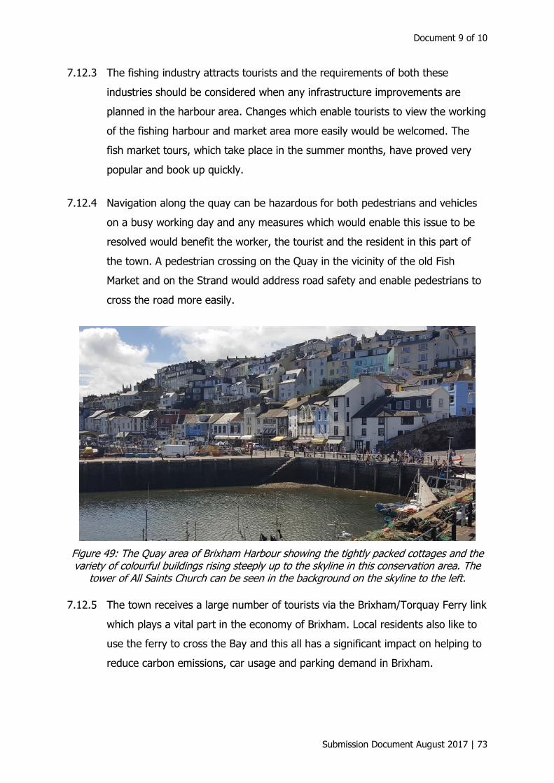
Document 9 of 10
Submission Document August 2017 | 73
7.12.3 The fishing industry attracts tourists and the requirements of both these
industries should be considered when any infrastructure improvements are
planned in the harbour area. Changes which enable tourists to view the working
of the fishing harbour and market area more easily would be welcomed. The
fish market tours, which take place in the summer months, have proved very
popular and book up quickly.
7.12.4 Navigation along the quay can be hazardous for both pedestrians and vehicles
on a busy working day and any measures which would enable this issue to be
resolved would benefit the worker, the tourist and the resident in this part of
the town. A pedestrian crossing on the Quay in the vicinity of the old Fish
Market and on the Strand would address road safety and enable pedestrians to
cross the road more easily.
Figure 49: The Quay area of Brixham Harbour showing the tightly packed cottages and the variety of colourful buildings rising steeply up to the skyline in this conservation area. The
tower of All Saints Church can be seen in the background on the skyline to the left.
7.12.5 The town receives a large number of tourists via the Brixham/Torquay Ferry link
which plays a vital part in the economy of Brixham. Local residents also like to
use the ferry to cross the Bay and this all has a significant impact on helping to
reduce carbon emissions, car usage and parking demand in Brixham.

Brixham Town Design Statement
74 | Submission Document August 2017
Figure 50: Brixham inner harbour showing the terraces of colourful cottages lining King Street on the left with the steep hillside behind and more terraces of cottages on the narrow
roads linked by steep steps reaching up to the skyline.
Figure 51: The quayside showing part of the old fish market to the left and the colourful densely packed terraces of cottages on the hillside.
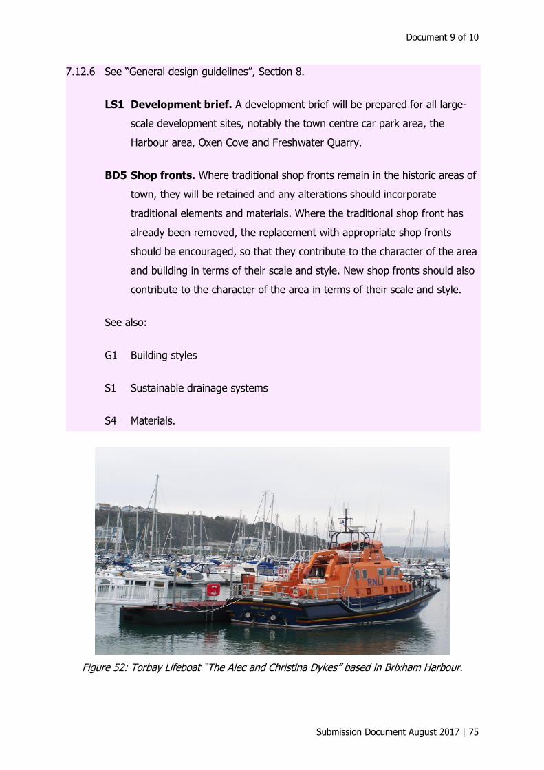
Document 9 of 10
Submission Document August 2017 | 75
7.12.6 See “General design guidelines”, Section 8.
LS1 Development brief. A development brief will be prepared for all large-
scale development sites, notably the town centre car park area, the
Harbour area, Oxen Cove and Freshwater Quarry.
BD5 Shop fronts. Where traditional shop fronts remain in the historic areas of
town, they will be retained and any alterations should incorporate
traditional elements and materials. Where the traditional shop front has
already been removed, the replacement with appropriate shop fronts
should be encouraged, so that they contribute to the character of the area
and building in terms of their scale and style. New shop fronts should also
contribute to the character of the area in terms of their scale and style.
See also:
G1 Building styles
S1 Sustainable drainage systems
S4 Materials.
Figure 52: Torbay Lifeboat “The Alec and Christina Dykes” based in Brixham Harbour.

Brixham Town Design Statement
76 | Submission Document August 2017
7.13 Conclusion
7.13.1 In a town wholly enclosed by and partly contained within an AONB, Brixham
needs to pursue what Gordon Cullen, in his book Townscape, calls “The Art of
the Environment”.7
7.13.2 This concerns itself with the right relationship between buildings, spaces, trees
and other features, creating a pleasant place for people to live. It is not just
some esoteric concept to be analysed and defined by experts, it is at the very
heart of good planning. The people of Brixham, by their responses to the Town
Plan workshop, showed that they understand this, and manifested a desire that
the “Art of the Environment” should be put into practice in any future
development of the town. It is not enough to make narrow ad-hoc decisions on
individual planning applications, but these should all be viewed in relation to
their neighbours, the preservation of the essential character of the town and its
unique place in our AONB.
7.13.3 New development should avoid the destruction of the mix of buildings and open
spaces which have emerged over the last 400 years or more to give Brixham its
character and make it “special”!
7.13.4 Over the centuries, fishing has played a major role in job creation and as a
result the town’s economy has benefited from the industry. In order to secure
the future prosperity of the town, it is crucial that the industry is supported. It is
also necessary to create alternative full-time employment opportunities,
including those that attract higher salaries, to meet the needs of residents and
sustain the town’s regeneration.
7.13.5 The important contribution made by tourism to the economy of Brixham cannot
be underestimated; therefore, it is imperative that existing tourist facilities are
protected and enhanced and new opportunities are encouraged.
7.13.6 It is recognised that buyers looking for a holiday home (non-letting) in Brixham
pose a problem that affects the town’s vitality and the viability of local
7 Gordon Cullen. Townscape. Reinhold Publishing Corporation, 1961.
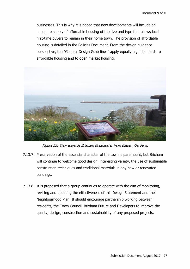
Document 9 of 10
Submission Document August 2017 | 77
businesses. This is why it is hoped that new developments will include an
adequate supply of affordable housing of the size and type that allows local
first-time buyers to remain in their home town. The provision of affordable
housing is detailed in the Policies Document. From the design guidance
perspective, the “General Design Guidelines” apply equally high standards to
affordable housing and to open market housing.
Figure 53: View towards Brixham Breakwater from Battery Gardens.
7.13.7 Preservation of the essential character of the town is paramount, but Brixham
will continue to welcome good design, interesting variety, the use of sustainable
construction techniques and traditional materials in any new or renovated
buildings.
7.13.8 It is proposed that a group continues to operate with the aim of monitoring,
revising and updating the effectiveness of this Design Statement and the
Neighbourhood Plan. It should encourage partnership working between
residents, the Town Council, Brixham Future and Developers to improve the
quality, design, construction and sustainability of any proposed projects.
Brixham Town Design Statement
78 | Submission Document August 2017
8 General design guidelines
8.1 Introduction
8.1.1 This section identifies design guidelines for Brixham that should be considered
for any new development within the town, whether it is a repair, refurbishment,
regeneration or development project. The guidelines identify a range of features
of the built and natural environment that are important if the intrinsic character
of Brixham is to be maintained and enhanced. The purpose of the guidelines is
to safeguard local character and to encourage sensitive, high-quality design
where new development occurs, through a process of development guidance
and control. As such, its purpose is to manage change and to encourage
regeneration and enhancement, and not to prevent it.
8.1.2 Not all guidelines will be applicable for all developments, but all should be
reviewed and considered for applicability to a particular project.
8.1.3 The design guidelines are grouped into the following categories:
• quality of the environment
landscape (soft and hard)
• building design
• sustainability
• transport and movement
• large-scale development
• general development.
8.1.4 Please note that the term “development” used below relates to all repair,
refurbishment, regeneration or development projects.
Document 9 of 10
Submission Document August 2017 | 79
8.2 Quality of the environment
Q1 Visibility. Any development will be considered in relation to its visibility
from both within and from outside the town, so that it is appropriate to its
location. Brixham lies in and on a series of valleys and hills, with both
inland view ridges and seaward views incorporating the natural
amphitheatre of the harbour. The views and vistas of the surrounding
countryside, the key landmarks of the town and the sea are important and
must be respected.
Q2 Scale of development. Any development should be substantially of the
same or lesser scale, height and mass of adjacent buildings, unless
proposed as a key feature or landmark, to ensure a consistent street
scene. Variation in height is acceptable, as it is a characteristic of Brixham,
but the overall heights should be respectful of those of adjoining and
nearby buildings.
Q3 Roofscape: Variety in roofscape as the buildings step down the hillsides
is a key characteristic of Brixham. Roofscapes appropriate to the location
and visibility of the development within the town will be required.
Additions to roofs will be of a scale and proportion appropriate to the
essential character of the neighbouring townscape.
Q4 Infill development and building in gardens must respect the character
and appearance of the area and not be detrimental to the overall quality
and amenity of the neighbourhood.
Q5 Parking. Intrusive car parking must be avoided, as it can lower the
quality of the street scene. Positive encouragement for undercroft parking
will be supported in new developments where feasible.
8.3 Landscape (soft and hard)
L1 Removal of trees on development sites will be strongly discouraged and
tree preservation orders (TPOs) will be rigorously enforced, with agreed
landscaping plans as conditions of planning approval where appropriate. It
Brixham Town Design Statement
80 | Submission Document August 2017
is advised that a proper assessment is carried out on all developments
where there are trees, so as to judge the impact of the construction of
new buildings and other site works on the trees to enable adequate root
protection and exclusion zones to be agreed. (See British Standard
BS5837:2005.)
L2 Street trees. Consideration should also be given to the planting of more
trees within the public realm, particularly where new streets are being
created.
L3 Boundaries. New boundaries and changes to existing boundaries, both
between properties and to the street, should make close reference to the
traditional treatment of similar boundaries in the locality, such as height,
material, planting species and style. They should be of high quality and be
appropriately durable or maintainable.
L4 Front gardens/areas. Any development should not result in frontages
being dominated by hard surfacing and parked cars. The conversion of
front gardens to hard surfaced areas should be avoided where possible.
The area of hard landscaping should be minimised to enable soft
landscaping to dominate and reduce the potential of flooding from water
run-off.
L5 Materials of hard landscaping should be of high quality and reflect the
character of adjoining buildings and areas.
L6 Landscape design. New development should have a quality landscape
scheme, which incorporates new tree planting and retains as many of the
natural landscape features as possible. The hard and soft landscape
design should successfully integrate the development into the local
environment.
L7 Public realm. High-quality, public realm materials, street furniture and
signage will be required to reflect the special character of Brixham.

Document 9 of 10
Submission Document August 2017 | 81
L8 Lighting. Street lighting furniture should be of a quality appropriate to
the area it is located within. Lighting should be designed to minimise light
spillage and to have the minimum brightness and period of illumination
necessary for its location and purpose. Energy-efficient lighting should be
used where possible in preference to conventional external lighting.
8.4 Building design
BD1 Building lines. In areas where a clear historic building line has been
established, new development will generally be expected to follow the
existing line of development, whether it is along the back edge of the
pavement or set back.
BD2 Architectural treatment. New development will be of high quality,
raising the standard of architectural treatment and respecting the qualities
of its surroundings, such as scale, style, materials and attention to detail.
Innovative designs and the contemporary interpretation of traditional
design and construction will be welcomed; they will be to the highest
standards and be complementary to their context.
BD3 Roof design. The shape and pitch of the roof on any new development
throughout the town should be considered in terms of its visibility and
contribution to the quality of the roofscape of the town. In addition, for
the historic core and the conservation area, the roof design should
generally reflect those of the properties nearby.
BD4 Materials. Building materials will respect the traditional character of
Brixham and the immediate context of the development in particular. For
example, white or colour wash finish over stone, or natural limestone are
prevalent in many parts of the historic core and conservation areas and
the use of such locally sourced, reclaimed or recycled materials, or
appropriate modern alternatives, for new development will be encouraged.
Elsewhere the addition of more contemporary materials would be
appropriate. Materials should be sourced locally where possible.

Brixham Town Design Statement
82 | Submission Document August 2017
BD5 Shop fronts. Where traditional shop fronts remain in the historic areas of
town, they will be retained and any alterations should incorporate
traditional elements and materials. Where the traditional shop front has
already been removed, the replacement with appropriate shop fronts
should be encouraged, so that they contribute to the character of the area
and building in terms of their scale and style. New shop fronts should also
contribute to the character of the area in terms of their scale and style.
BD6 Ancillary facilities. Refuse and recycling facilities, car and cycle parking
should be sufficient for the development and must not dominate the street
scene.
8.5 Sustainability
S1 Sustainable drainage systems. Environmentally friendly water
drainage systems should be promoted.
S2 Building design. Buildings should be designed to respond intelligently to
the climate through siting, orientation and form, benefiting users and
reducing overall energy bills and running costs.
S3 Construction technology. The choice of construction technology should
help reduce energy dependency over a building’s lifetime.
S4 Materials. The materials proposed should be carefully considered as
some are harmful to the environment, others benign and a few have
positive inputs. Regard should be given to locally sourced materials that
reduce transport costs and help to contribute to local identity.
S5 Building refurbishment. The energy-efficient refurbishment of existing
properties in a manner appropriate to their quality and historic origins will
be encouraged.
8.6 Movement and transport
MT1 Legibility, signage and pedestrian crossings. Provision of improved
signage within the town centre together with pedestrian routes, will

Document 9 of 10
Submission Document August 2017 | 83
improve the visitor experience and help residents too. A pedestrian
friendly town centre will need formal crossing facilities throughout the
town, situated where pedestrians routinely cross roads.
MT2 Town centre “shared space”. Consideration will be given to creating a
“shared space” in the redeveloped Town Centre area. The establishment
of a low-speed, less-regulated environment based on social protocols can
promote safety, improve traffic flow and enhance civility, as well as create
an improved street environment.
MT3 Parking resulting from new development. The impact of any
increased car parking resulting from new developments should be
assessed in terms of its effect on townscape character. Car parking
restrictions and alternative forms of accessing transport should be
considered to limit the number of car parking spaces required. Undercroft
car parking should also be considered as part of any future development
proposals.
MT4 Traffic effects of development. Assessment of the impact of increased
traffic resulting from new developments, in terms of the effect on traffic
flows generally within, throughout and on the approaches to Brixham, will
be important in helping to resolve this issue.
MT5 Park and Ride. A plan to enhance and further develop the Park and Ride
and its immediate area, to create an appropriate gateway to Brixham,
would be welcomed. Signage, information available for visitors to the
facilities in Brixham and the provision of the usual tourist facilities will be
necessary.
MT6 Pedestrian and cycle routes. Opportunities to create more safe routes
for pedestrians and cyclists will be pursued in all new development
proposals to encourage walking and cycling.
Brixham Town Design Statement
84 | Submission Document August 2017
8.7 Large-scale development
LS1 Development brief. A development brief will be prepared for all large-
scale development sites, notably the town centre car park area, the
Harbour area, Oxen Cove and Freshwater Quarry.
LS2 Variety of house types. A variety of house types and sizes will be
provided appropriate to the setting and character of the local area.
LS3 Grouping of houses. Groups of houses should be arranged in a manner
appropriate to the locality, whether it is in a structured street layout or in
a more organic arrangement to form variety and the appearance of
natural growth.
8.8 General development
G1 Building styles. The style of building should be sympathetic with and
complementary to the older buildings of the town; fussy combinations
with too many details and inappropriate use of styles foreign to the town
are to be avoided.
G2 Innovative design. A contemporary design approach using modern
materials will be encouraged, provided that local distinctiveness and
character are respected and enhanced.
G3 Demonstrating design quality. Proposals for development should
demonstrate how they relate satisfactorily to the site and its surroundings
and respond to the design guidelines set out in this design statement.
9 Acknowledgements
9.0.1 Special thanks go to the team who produced the first Brixham Town Design
Statement in 2010 and to Hal Bishop for permission to use many of the
photographs and text from his work on the Brixham Town and Higher Brixham
Conservation Area Character Appraisals. Also thanks go to Bill Bye from Eric
Lloyd & Co., one of our local Estate Agents, for his advice and help with the
photographs.


Typeset by Sunrise Setting Ltd, Brixham Submission Document August 2017