BRECKENRIDGE SKI RESORT MULTI-SEASON RECREATION...
38
BRECKENRIDGE SKI RESORT MULTI-SEASON RECREATION PROJECTS FINAL ENVIRONMENTAL IMPACT STATEMENT NOVEMBER 2015 USDA Forest Service White River National Forest Dillon Ranger District RECORD OF DECISION
Transcript of BRECKENRIDGE SKI RESORT MULTI-SEASON RECREATION...

BRECKENRIDGE SKI RESORTMULTI-SEASON RECREATION PROJECTSFINAL ENVIRONMENTAL IMPACT STATEMENT
NOVEMBER 2015
USDA Forest ServiceWhite River National Forest
Dillon Ranger District
RECORD OF DECISION

In accordance with Federal civil rights law and U.S. Department of Agriculture (USDA) civil rights regulations and policies, the USDA, its Agencies, office, and employees, and institutions participating in or administering USDA programs are prohibited from discriminating based on race, color, national origin, religion, sex, gender identity (including gender expression), sexual orientation, disability, age, marital status, family/parental status, income derived from a public assistance program, political beliefs, or reprisal or retaliation for prior civil rights activity, in any program or activity conducted or funded by USDA (not all bases apply to all programs). Remedies and complaint filing deadlines vary by program or incident. Persons with disabilities who require alternative means of communication for program information (e.g., Braille large print, audiotape, American Sign Language, etc.) should contact the responsible Agency or USDA’s TARGET Center at (202) 720-2600 (voice and TTY) or contact USDA through the Federal Relay Service at (800) 877-8339. To file a program discrimination complaint, complete the USDA Program Discrimination Complaint Form, AD-3027, found online and at any USDA office or write a letter addressed to USDA and provide in the letter all of the information requested in the form. To request a copy of the complaint form, call (866) 632-9992. Submit your completed form or letter to USDA by: (1) mail: U.S. Department of Agriculture, Office of the Assistant Secretary for Civil Rights, 1400 Independence Avenue, SW, Washington, D.C. 20250-9410; (2) fax: (202) 690-7442; or (3) email: [email protected]. USDA is an equal opportunity provider, employer, and lender.

Breckenridge Ski Resort Multi-Season Recreation Projects
FINAL ENVIRONMENTAL IMPACT STATEMENT
RECORD OF DECISION
November 2015
USDA FOREST SERVICE
ROCKY MOUNTAIN REGION (R2)
WHITE RIVER NATIONAL FOREST
DILLON RANGER DISTRICT
Summit County, Colorado
Lead Agency: USDA Forest Service
Responsible Official: Scott Fitzwilliams, Forest Supervisor
White River National Forest
For Information Contact: Roger Poirier, Project Leader
White River National Forest
900 Grand Avenue
Glenwood Springs, CO 81601


Record of Decision
Breckenridge Ski Resort Multi-Season Recreation Projects
Final Environmental Impact Statement ROD-1
RECORD OF DECISION
INTRODUCTION
This Record of Decision (ROD) documents my decision to approve proposed projects and activities
within Breckenridge Ski Resort’s (BSR) Special Use Permit (SUP) boundary on the White River National
Forest (WRNF) in Summit County, Colorado. My decision is based on, and supported by, the
Breckenridge Ski Resort Multi-Season Recreation Projects Final Environmental Impact Statement (FEIS),
the objection process, and the project file.
BACKGROUND
BSR is located on the Dillon Ranger District of the WRNF, approximately 85 miles west of Denver, the
largest metropolitan area in Colorado. BSR is accessed from the Colorado Front Range via Interstate 70
(I-70) and Colorado State Highway 9. BSR opened to the public for lift-served Alpine skiing in 1961 and
has since become one of the most frequently-visited ski resorts in the United States with skier visits
numbering over 1.6 million annually.
BSR is owned and operated by Vail Resorts, Inc. under a SUP from the Forest Service. In concert with
growing market demand and the increasing expectations of the skiing public, BSR has evolved over the
decades since its inception by adding new chairlifts, new and improved ski terrain, additional parking and
day use facilities. While the ski area has traditionally focused on winter recreation, increased attention has
been directed in recent years towards summer and multi-season activities to accommodate demand for
year-round recreation in Summit County.
PURPOSE AND NEED
Summer recreational opportunities have been offered at BSR since the 1970s. These opportunities are
important to BSR and its guests, providing outdoor recreation activities in and around the WRNF. The
current summer guest experience at BSR is primarily defined by developed activities on private lands and
dispersed activities on National Forest System (NFS) lands. Specific to the activities on NFS lands within
the BSR SUP area, guests primarily participate in both lift-served and non-lift-served hiking and
mountain biking via the Colorado SuperChair and trails dispersed across Peaks 7, 8 and 9.
Due to ongoing, year-round tourism growth, BSR is becoming a summer destination for guests primarily
from the United States, and from Colorado in particular. In both winter and summer, BSR caters to a
broad spectrum of guests of all ages, abilities, and experience with the outdoors. Since 2010 the
Breckenridge Summer Fun Park (located on private lands) has experienced approximately 18 percent
annual growth in its summer activity usage. The proposed projects would complement these current
activities by offering an even broader range of passive and active recreation opportunities to engage
visitors on NFS lands.

Record of Decision
Breckenridge Ski Resort Multi-Season Recreation Projects
Final Environmental Impact Statement ROD-2
The philosophy for BSR’s summer program on NFS lands is based on the premise that the National
Forests are, and have always been, the greatest opportunity for guests to use and enjoy public lands. The
summer program goal is to introduce guests to the WRNF and encourage outdoor recreation and
enjoyment of nature. BSR desires to provide a recreational experience that reduces the barriers that can be
associated with recreating in a mountain environment.
Over the past several decades, summer recreation activities have evolved to include a significant variety
of opportunities and user experiences. Likewise, recreational use in the National Forests has evolved
beyond the traditional activities and solitude-seeking experiences such as hunting, fishing, camping or
hiking.
There is a desire to not only provide new experiences for current Forest users but to provide opportunities
that will engage new users to visit and experience public lands. Currently at BSR, there is a lack of
recreational opportunities that provide:
1. Adventure or thrill-based experiences that require little specialized knowledge, skills, equipment
or familiarity with the mountain environment—elements which can be a barrier for visitors (e.g.,
families, the elderly/aging, or those with disabilities) desiring to engage in outdoor activities;
2. Activity-based interaction with a forested, mountain environment in a controlled setting, offering
an opportunity for users to interact with and learn about nature;
3. Human-powered, active recreational experiences that cater to all ability levels; and
4. Interpretive programs that offer an educational experience for users seeking to learn more about
the environment.
There is a need for recreational and learning opportunities on public lands that include passive, active, and
interactive forms of recreation to provide this comprehensive range of user experiences.
There is a need for adequate access and support service infrastructure (e.g., roads, support buildings,
restaurants) to meet current and anticipated summer use at BSR.
The Ski Area Recreational Opportunity Enhancement Act of 2011 (SAROEA) provides authority for
mountain resorts operating on NFS lands to offer an expanded range of outdoor recreation activities in
order to further recreational opportunities for the public, allow year-round utilization of existing resort
facilities and stimulate job creation and economic growth within local communities. The proposed
projects align with the intent of SAROEA.
DECISION
After thoroughly considering the project Purpose and Need, issues, alternatives and extensive analyses
presented in the Breckenridge Ski Resort Multi-Season Recreation Projects FEIS, as well as the public
and agency comments submitted, my decision is to approve an alternative comprised of components of

Record of Decision
Breckenridge Ski Resort Multi-Season Recreation Projects
Final Environmental Impact Statement ROD-3
Alternative 2 and Alternative 3. All of the projects approved by my decision are on NFS lands within
2002 Forest Plan Management Area 8.25 and occur within the BSR’s SUP boundary.
THE SELECTED ALTERNATIVE
My decision to approve the Selected Alternative provides BSR with the authorization to implement select
activities analyzed in detail in the FEIS. These activities will allow BSR to better meet guest expectations
and address the project Purpose and Need. Implementation of the projects in the Selected Alternative will
also respond to long-term goals and objectives of the 2002 Forest Plan and new Forest Service direction
regarding additional seasonal and year-round recreational activities at ski areas. The Selected Alternative
is depicted in the Selected Alternative Figure.
DECISION RATIONALE
The entire Breckenridge Ski Resort Multi-Season Recreation Projects analysis and public involvement
processes were both thorough and helpful in making my decision. They provided a foundation for my
decision and the project design criteria (PDC) identified in Table ROD-1. The Forest was diligent and
inclusive throughout the process.
I have carefully reviewed the FEIS and the environmental impacts of this proposal. The FEIS discloses,
using the best available science and information, the qualitative and quantitative effects on the human and
biological environment that are anticipated to result with the implementation of the approved projects.
My rationale for choosing the Selected Alternative is based on careful consideration of several key
elements addressed during the public involvement and analysis process, including consistency with: the
project Purpose and Need, the 2002 White River Forest Plan, agency direction for additional seasonal and
year-round recreational activities at ski areas, the 2008 Breckenridge Ski Resort Master Development
Plan (MDP), and the 2013 MDP Addendum.
CONSISTENCY WITH THE PROJECT PURPOSE AND NEED
I am approving the Selected Alternative because it best meets the project Purpose and Need to provide
new recreational opportunities and experiences at BSR. The overarching goal of this project is to engage a
wide audience of summer visitors—a goal that is a departure from typical ski area projects that focus on
improving the recreation experience for the winter visitor. This project is one of a few across the nation
prompting us to rethink how ski areas can provide new activities and memorable experiences to users—
many of whom are new guests or those that do not ski at our resorts in the winter season.
I’ve come to understand that people and families engage with nature and outdoor recreation in different
manners and each visitor has their own limits on comfort and exposure to the outdoor elements. I believe
this suite of approved projects will provide a blend of activities that provide a broad range of experiences
for an increasingly diverse recreating public—from those seeking unguided hikes or bike rides by
Record of Decision
Breckenridge Ski Resort Multi-Season Recreation Projects
Final Environmental Impact Statement ROD-4
themselves and a more intimate engagement with the forests and natural surroundings to those wanting
more adventure- and thrill-based activities in the mountains of the Tenmile Range. This critical mass and
mix of activities is fundamental to the success of this program. These new uses, individually and
collectively, provide an opportunity for families and guests to connect with the natural world and
appreciate nature through play. They can reduce the obstacles that some guests may associate with
recreating in the mountains. The location of these activities allows for more concentrated uses near
chairlift and restaurant hubs at Peaks 7 and 8, while allowing for more solitude the farther guests venture
out from these core activity areas. The entire spectrum of activities provides an environment that will
better encourage guests to discover the national forests.
Ski resorts do not offer the same experiences found on other NFS lands; they are unique portals that often
attract a demographic of users that are either unaware of the opportunities NFS lands offer or that would
not typically visit our campgrounds, trails and facilities. Our ski resorts on the WRNF are home to more
than seven million guests annually yet comprise a fraction of the WRNF’s land base. Because the Forest
Service serves as the primary outdoor recreation provider in Summit County, I considered the importance
of this proposal in engaging new and returning users to NFS lands. With approximately 27 acres of
ground disturbance confined primarily to Peaks 7 and 8, we can accommodate an additional 150,000
guests and get them closer to the land and closer to the mountains they see from I-70 and the Town of
Breckenridge. The views alone of the Tenmile Range from elevated vantage points will complete the
Breckenridge experience for many guests. We have few opportunities to connect so many people to the
national forests with so little environmental impact. This project is an opportunity for the public to benefit
from and one we want to take full advantage of.
I understand the concerns of individuals within the community that feel that some of these activities go
too far in changing the nature and type of activities appropriate for NFS lands and BSR in particular.
Certainly some of these activities and experiences are a clear shift from traditional ones. However, my
review of the project activities, designs, and locations over the last few years has led me to the conclusion
that this suite of projects offers an appropriate level of new experiences that are relevant to both the
Town’s and BSR’s guests while maintaining a setting and experience that is unique to NFS lands and
staying true to the Forest Service mission and our culture of multiple uses. These activities align well with
the intent of SAROEA. I believe that our national forests are neither amusement parks nor circus
attractions. They are far more valuable and unique, and this suite of projects will not change that
conviction. With these projects, the nature-based interpretive and recreation experience at our resorts is
only being heightened, not diminished.
A BALANCED APPROACH
The Selected Alternative best balances meeting the Purpose and Need for the project while having an
acceptable level of impact to the environment. I believe the proposed design not only enhances the visitor
connection with the natural environment, but does it in a way that will not degrade the setting that attracts

Record of Decision
Breckenridge Ski Resort Multi-Season Recreation Projects
Final Environmental Impact Statement ROD-5
the visitors in the first place. It is clear to even a casual observer that the greater Breckenridge area is no
longer just a skiing destination. Four-season use on the mountain combined with a line-up of events in
Town and in the County have made the area a destination for local, national, and international guests. The
correct amount and mix of activities approved in the Selected Alternative is fundamental to achieving
success with this project.
To minimize impacts on sensitive resources and reduce the overall footprint of the proposed activities, I
excluded proposed activities in the alpine zones above Peaks 7 and 8 from the Selected Alternative while
allowing for some new trail development adjacent to the Vista Haus and Peak 7 Hut core hub areas.
Adding lift-served access to the area without appropriate infrastructure and designated trails could impact
this environment and possibly pose a safety risk for guests unaccustomed to recreation at high elevations.
As with current operations, guests desiring an alpine adventure can still access the area by hiking up the
mountain but will not have lift service to access or egress from these areas.
Throughout the planning and analysis process, we also fine-tuned the design, location, and amount of
activities. For example, the Alternative 3 location of the Observation Tower will help protect the scenic
and recreation values of Horseshoe Bowl while still offering a fun, interactive experience for guests closer
to the Vista Haus area. The final network of mountain bike trails will provide a great experience for
families and guests while limiting trails in areas with wetlands and waterways or in areas like Ore Bucket
with unique ground conditions. We also developed extensive trail design standards to ensure that these
trails are sustainable in the long-term, provide the desired experience for guests, and have minimal
footprints.
Because the Sawmill Zip Line and the Ore Bucket Canopy Tour can provide unique experiences and
capacity to the overall summer program yet add only minimal impacts to resources compared to not
implementing them, they were included in the Selected Alternative. Both of these activities extend the
north-south prism of summer uses at BSR yet are designed to have minimal impact on the ground.
Sawmill Zip Line users will be high above the forested canopy for most of their ride and requires minimal
disturbance with only three stations and 0.2 acre of vegetation clearing. The mountain bike trail proposed
under the Ore Bucket Canopy Tour has been excluded from the Selected Alternative to minimize ground
disturbance and provide canopy tour guests an aerial view of a unique, intact ecosystem unencumbered by
ground development. Likewise, fencing, tower design, and construction practices for the canopy tour have
all been designed to minimize environmental impacts and soil disturbance in this area. Appendix A of this
ROD includes construction requirements and desired conditions for each tower area of the Ore Bucket
Canopy Tour. This information and requirements will minimize resource impacts within the Ore Bucket
area.
To further reduce the impacts from the suite of activities, this decision requires implementation of key
drainage and soil management measures identified in the Breckenridge Ski Resort Drainage Management

Record of Decision
Breckenridge Ski Resort Multi-Season Recreation Projects
Final Environmental Impact Statement ROD-6
Plan and bare ground restoration efforts to mitigate for new soil disturbances associated with authorized
developments. These drainage and soil restoration projects are listed in Appendix C of the FEIS. The
PDC section of this decision (Table ROD-1) includes a comprehensive set of best management practices
and implementation sideboards to ensure impacts are minimized before, during and after implementation.
CONSISTENCY WITH SAROEA AND FOREST SERVICE DIRECTION
With the passage of SAROEA and accompanying agency direction, the Forest Service is embarking on
new approaches to introduce the American public to recreational opportunities on NFS lands. While some
of these activities are novel to ski resorts and NFS lands in general, they may better engage and resonate
with younger generations and new guests.
The language chosen by Congress in the SAROEA and codified by the Forest Service at Forest Service
Manual (FSM) 2343.14 is deliberate and clearly intended to provide for local discretion in determining
the appropriateness of various summer and year-round activities at individual ski areas. Indeed, in a
Statement for the Record submitted in the U.S. Senate on March 22, 2014, Colorado Senator and primary
sponsor of SAROEA, Mark Udall, emphasized his advocacy for “a flexible directive empowering local
decision-making.”
Incorporating considerations provided to me by the Forest Service’s Rocky Mountain Region in their
review of the proposed activities, my team has completed a comprehensive screening of the proposed
activities. As disclosed in Appendix B of the FEIS, the suite of projects in the Selected Alternative fully
meets this agency direction.
In summary, projects included in the Selected Alternative:
Do not change the primary purpose of the ski area to something other than snow sports. The
approved activities will supplement existing summer visitation and will increase visitation by a
small amount when compared to winter use visits;
Are consistent with the vision, zones and uses found in the 2008 Breckenridge Ski Resort MDP,
and the 2013 MDP Addendum;
Occur within the existing SUP boundary;
Harmonize with the natural environment of the site where they would be located by: being
visually consistent with or subordinate to the ski area’s existing facilities, vegetation and
landscape; not requiring significant modifications to topography to facilitate construction or
operations; and not compromising snow sports operations or functions;
Encourage outdoor recreation by being located outdoors in a natural setting and in close
proximity to other numerous outdoor recreational opportunities;

Record of Decision
Breckenridge Ski Resort Multi-Season Recreation Projects
Final Environmental Impact Statement ROD-7
Increase utilization of snow sports facilities and not require extensive new support facilities, such
as parking lots, restaurants, and chairlifts; and
Enable visitors to engage with the natural setting and may lead them to further explore other NFS
lands.
Interpretive Opportunities
To balance the thrill- and adventure-based opportunities, the WRNF will fully engage BSR and other
partnering organizations to develop a comprehensive, world-class program offering educational and
interpretive opportunities to inspire guests and engage them with the natural world. I believe providing
educational and interpretive opportunities in partnership with the resort will play a big part in inspiring
guests to further explore the national forests and have a deeper understanding of nature. Embedding this
program into the design of the projects is essential in providing a meaningful experience and to ensure
program goals are met.
Natural Resource-Based Recreation
The criteria established for determining whether any particular activity is appropriate at a given ski area at
a particular location are much more considerate of the localized design, setting and context for the activity
rather than the activity itself. This guidance has been issued in recognition of the incredible variety of
landscapes and experiences available to visitors to the national forests, and the understanding that it is
impossible to perfectly qualify and describe the numerous ways individuals interact with and react to the
natural environment, and consequently what constitutes “natural resource-based recreation” for every
individual. My decision has focused primarily on the specific setting and context for the proposals at
BSR, rather than attempting to establish a perfect precedent that could be used to determine whether a
similar activity at another resort or in another location at BSR is inherently acceptable. Indeed, some
original proposed activity designs and locations at BSR were found to be inappropriate given their
particular context and surroundings.
After careful examination, I find that many activities commonly pursued may be appropriately considered
natural resource-based depending entirely on the local environment in which the activity is pursued. For
example, the activity of riding a bicycle is not immediately associated with natural resource-based
recreation. But consider that experience and the degree to which it varies depending on the context and
the setting. It is one experience to ride through urban streets. It is another experience entirely to ride a
scenic trail or gravel road—the Peaks Trail for example. The question of whether that activity is natural-
resource based, and whether it “is interdependent with attributes such as mountains, forests, geology,
grasslands, water bodies, flora, fauna, and natural scenery” has far more to do with the presence of and
opportunity to interact with those attributes as a setting for the activity than the activity itself.

Record of Decision
Breckenridge Ski Resort Multi-Season Recreation Projects
Final Environmental Impact Statement ROD-8
All of the activities in the Selected Alternative make use of these attributes to define the user experience
and ensure they are rooted in a natural resource-focused experience—whether the forested canopy and
steep mountain contours that deliver the thrill and exposure of the Sawmill Zip Line, or the natural
scenery and microclimate provided by the Ore Bucket Canopy Tour.
Exploration and Enjoyment of National Forests
Another point of careful consideration has been the extent to which activities and facilities could be
expected to lead to the exploration and enjoyment of other NFS lands, as required by FSM 2343.14. In
reaching my decision, I found it vital to reflect on the many ways people are initially exposed to natural
environments and outdoor recreation and to not let my personal history and experience with traditional
outdoor activities such as hunting, fishing, hiking, and camping bias my perspective. Ultimately, I have
concluded that we must be open to the reality that individuals may be just as inspired to gain a greater
appreciation of and engagement with the natural world by being exposed to the types of activities
proposed at BSR, as they would be by engaging in more traditional activities. I have observed the
potential for increased exploration and enjoyment of outdoor landscapes created through far less obvious
opportunities than these. We cannot discount the impact and importance that these encounters with nature
can provide families and children. The entire spectrum of activities we offer and promote on the WRNF
may engage and inspire families to go further into the Forest—hiking on our trails, camping at our
campgrounds or becoming agency employees and future stewards of this incredible landscape. This
perspective has led me to the belief that the proposed activities in the setting and context of BSR will lead
at least some visitors to further explore, enjoy and appreciate their public lands.
POST-DECISION REVIEW
I recognize that many of these project activities are new to the ski areas and Forest Service administrative
oversight. Because implementing these projects correctly—getting the look, the feel and ultimately, the
user experience dialed in—is essential to keeping our national forests looking and functioning like
national forests into the future, I feel it is vital that we have a system of checks and balances to ensure
these projects are consistent with agency direction and the effects analyzed in the FEIS.
The agency has established, and will rely upon, post-decision review and authorization processes to
ensure that this activity infrastructure is designed, installed and operated properly. Prior to the proposed
season of construction and operation for each activity approved in this ROD, a design package will be
submitted by BSR to the Forest Service for a Facility Design Review process. These reviews for all
construction activities will be conducted by Forest Service engineering, recreation and landscape
architecture staff to confirm that the design of each activity complies with the Forest Service’s Built
Environment Image Guide and other applicable agency criteria, and that these structures harmonize with
the surrounding environment.

Record of Decision
Breckenridge Ski Resort Multi-Season Recreation Projects
Final Environmental Impact Statement ROD-9
The agency will also work collaboratively with BSR to design and provide content for the interpretive and
educational components of this project on NFS lands.
CONSISTENCY WITH 2002 FOREST PLAN AND BRECKENRDIGE SKI RESORT MASTER DEVELOPMENT PLAN
The Selected Alternative is located within lands allocated in the 2002 Forest Plan as Management Area
8.25 – Ski Areas (Existing and Potential). The WRNF covers over 2.3 million acres of land. Within that,
the Forest Plan identified approximately 50,000 acres to be managed specifically for ski areas. These
50,000 acres accommodate over seven million skier visits on world-class resorts and ski areas each year.
The ski areas provide numerous economic benefits to communities, including among other things, direct
and indirect jobs. The ski areas also pay a fee to the U.S. Treasury for the use of these lands. Ski areas
provide a vital role in connecting the American public to their public lands.
I find that each approved activity in its specific proposed location is consistent with the land use
allocation identified in the 2002 Forest Plan and complies with the 2008 Breckenridge Ski Resort MDP
and the 2013 MDP Addendum, and that each activity complies with FSM 2343.14 direction for
evaluating seasonal and year-round recreation activities.
ENVIRONMENTAL AND SOCIAL IMPACTS
The ultimate responsibility I have as Forest Supervisor is stewardship of the natural resources held in the
public trust. Ensuring our natural resources are sustained and conserved for future generations is
something I take very seriously. I am responsible for balancing the environmental and social impacts with
the benefits the project will provide, including the conservation measures and design elements developed
to reduce impacts. I carefully reviewed the FEIS and the environmental impacts associated with all
alternatives when making my decision.
For some of the environmental resources, Alternative 3 would have resulted in fewer impacts.
Alternative 3 would not have met the Purpose and Need as comprehensively as the Selected Alternative.
In the end, I found that the steps taken to minimize impacts and the use of best practices during
construction will address the potential effects to many resources. Given the reliance on many existing
facilities and infrastructure for summer operations (e.g., existing chairlifts, parking, restaurants, and guest
service facilities), the ground disturbance associated with the projects in the Selected Alternative is
minimal compared to the opportunities and experiences that will be provided.
Effects to Recreation
As discussed in Chapter 3, Section A of the FEIS, the projects included in the Selected Alternative will
provide a broad range of experiences to meet the needs of an increasingly diverse recreating public. This
will be achieved with minimal impacts to winter operations.

Record of Decision
Breckenridge Ski Resort Multi-Season Recreation Projects
Final Environmental Impact Statement ROD-10
Effects to Visuals
Projects included in the Selected Alternative will have incremental effects on the visual characteristics of
BSR, and would “harmonize with the natural environment.” All approved projects are designed to limit
vegetation clearing and modification of the natural topography, and are subordinate to the surrounding
environment and existing infrastructure throughout the SUP area.
Effects to Social and Economic Resources
Implementation of the Selected Alternative could have both positive and negative impacts on local
businesses. I acknowledge that the projects will have incremental effects on social services including
emergency, childcare, and transportation services, as well as affordable housing in the Town and County,
but these projects would not result in significant impact to these services.
Effects to Wildlife and Aquatic Resources
The effects to wildlife and aquatic species (including Threatened, Endangered, and Proposed species;
Forest Service Region 2 Sensitive Species; Management Indicator Species; and Migratory Birds) are
disclosed in Chapter 3, Section F of the FEIS. Overall, the authorized projects will lead to incremental
changes of habitat values at BSR. However, because infrastructure is present throughout the SUP area and
some summer recreation already exists, the approved projects and activities will have minimal impacts on
wildlife. The Selected Alternative “may affect, but is not likely to adversely affect” Canada lynx.
Similarly, for all Forest Service Region 2 Sensitive Species considered in the analysis, the Selected
Alternative “may adversely impact individuals, but is not likely to result in a loss of viability in the
planning area, nor cause a trend toward federal listing.”
Effects to Watershed and Wetlands
The FEIS includes an extensive list of PDC designed to protect the health of watersheds and wetlands.
Among them:
Final mountain bike trails, hiking trails, and access paths and roads canopy tours and zip lines
will avoid all wetlands (including through the use of bridges and/or other structures);
A follow-up assessment is required once site-specific locations of activities, particularly trails, are
known. This will ensure that stream health in the Analysis Area is maintained or improved with
implementation of proposed activities; and
Implementation of BSR Drainage Management Plan projects and bare ground restoration efforts
to offset impacts associated with the proposed activities.
With the implementation of all PDC, there will be minimal adverse impacts to watersheds and no
permanent impacts to wetlands.

Record of Decision
Breckenridge Ski Resort Multi-Season Recreation Projects
Final Environmental Impact Statement ROD-11
Effects to Vegetation
There is no habitat for any federally listed threatened or endangered plant species within the Analysis
Area. Furthermore, many of the tree islands throughout the project areas have been impacted by the
Mountain Pine Beetle (MPB) epidemic.
The Selected Alternative includes approximately 27 acres of disturbance (mostly related to hiking and
biking trails), including roughly 13 acres of forest overstory removal. The majority of the vegetation
impacts will occur in disturbed ski trails and throughout MPB-affected lodgepole pine stands.
CONCLUSION
My decision for this project was multi-faceted. No single influence was the determining factor in the
selection of a final alternative; rather, the approval of the Selected Alternative is a culmination of a
detailed planning and analysis process. The Selected Alternative best meets the Purpose and Need to
better engage the summer visitor and provide a diversity of recreational opportunities while balancing
effects to natural and social resources.
DESCRIPTION OF THE SELECTED ALTERNATIVE
The Selected Alternative is depicted on the attached figure. The Selected Alternative includes the
following projects, each of which is described in detail:
Vista Haus and Independence SuperChair Site Improvements (Alternative 2 and 3)
Zip Lines:
○ Sawmill Zip Line (Alternative 2)
○ Peak 7 Zip Line (Alternative 2 and 3)
Canopy Tours:
○ Sawmill Canopy Tour (Alternative 2 and 3)
○ Ore Bucket Canopy Tour (Alternative 2)
Challenge Courses at Peak 8 (Alternative 2 and 3)
New and Realigned Mountain Bike Trails and Skills Course (Alternative 3)
Peaks Trail Connection (Alternative 2)
Hiking Trails (Alternative 2, without Lake Chutes Trail)
Off-Highway Vehicle Tours (Alternative 3)
Upper Four O’Clock Road Realignment (Alternative 2 and 3)
Vista Haus Deck and Climbing Wall, and Peak 7 Hut Expansion (Alternative 2 and 3)

Record of Decision
Breckenridge Ski Resort Multi-Season Recreation Projects
Final Environmental Impact Statement ROD-12
Observation Tower (Alternative 3)
Existing Chairlift Operations, Scenic Chairlift Rides and Activities Access (Alternative 3)
As a whole, approved projects at BSR are designed to offer guests a variety of activities that cater to a
range of ability levels, and also introduce guests to Forest Service lands. Projects have been designed to
harmonize with, and benefit from, the natural setting within BSR’s existing Forest Service-administered
SUP area. They are designed to both complement and improve the existing non-skiing recreational
opportunities that are currently offered on NFS lands at BSR. All of the approved projects rely on the
mountain forest setting, either because of the natural surroundings (such as the forest canopy and views)
or because of the natural conditions (such as topography and vertical relief). Some of the approved
projects (e.g., zip lines, canopy tours, and challenge courses) could be used year-round, but the overall
design of projects is primarily to benefit the summer user at BSR.
All authorized activities and operations are depicted on the Selected Alternative Figure.
VISTA HAUS AND INDEPENDENCE SUPERCHAIR SITE IMPROVEMENTS
The Colorado and Independence SuperChairs will become primary access points for guests participating
in multi-season recreational activities at BSR. As such, the areas surrounding the tops of these chairlifts,
including the Vista Haus and the Peak 7 Hut, will be utilized year-round. This use will be particularly
evident during the summer months. These improvements will provide guests with safer and more
organized access to activities by developing and defining access pathways, rehabilitating redundant
access roads, incorporating signage, increasing vegetative growth, and adding landscaping features. Site
improvements surrounding the Vista Haus and Independence SuperChairs are identical for alternatives 2
and 3, and approved for implementation.
ZIP LINES
Sawmill Zip Line
The Sawmill Zip Line will cross over the Sawmill Creek drainage between Peaks 8 and 9 twice. The zip
line will be approximately 5,453 feet (1.03 miles) in length from its start just south of the top terminal of
the Peak 8 SuperConnect to its end point on the Four O’Clock ski trail near the site of the Freeway
Terrain Park and Pipe. The zip line will consist of two segments: 1) top station on Peak 8 to station 2 on
the north side of Peak 9 near the Volunteer ski trail, and 2) station 2 to the bottom station next to the Four O’Clock ski trail on Peak 8. Due to the topography of this area, minimal overstory vegetation clearing
will be necessary; however, where vegetation clearing is required, the corridor will be 16 feet wide to
allow for zip line operation.
The zip line will consist of two cables spaced 8 feet apart. Because of the Sawmill Zip Line’s height
above ground level, a third, separate cable suspending aerial warning markers will be necessary above the

Record of Decision
Breckenridge Ski Resort Multi-Season Recreation Projects
Final Environmental Impact Statement ROD-13
two zip line cables, in accordance with Federal Aviation Administration (FAA) regulations. Platform
dimensions for the top and bottom stations will be approximately 10 feet by 16 feet. Because takeoff and
landing will both occur on the station 2 platform, it will measure 10 feet by 32 feet. The platforms will be
elevated 20 to 30 feet above the ground. In locations where the grade permits, platforms will be
constructed at a height level with typical maximum snow depth and situated to create a flat surface. Each
station will require road access for construction, maintenance, emergency access and power. Permanent
access roads will be constructed to an approximate width of 12 feet to accommodate construction and
maintenance vehicles and four-wheelers in case of emergency evacuation after construction is complete.
The stations will be constructed of wooden and/or natural-looking materials to the extent possible. Guy
wires from each stations will be required for structural stability. Buck and rail fencing will enclose the
areas where the guy wires tie into the ground. Fences will be primarily located on the uphill side of guy
wires and stations. The three Sawmill Zip Line stations are close to ski trails and the buck and rail fencing
will be visible; however, the stations will be set against or in tree islands and the fencing will blend with
the tree island background. A 10-foot by 10-foot shelter will be constructed adjacent to station 2 of the
Sawmill Zip Line in case of inclement weather. The disturbance area of the shelter, fencing and access
road has been incorporated into the overall activity disturbance for the analysis. Design capacity for the
Sawmill Zip Line will be 48 people per hour (pph).
The Sawmill Zip Line will be accessed by riding the Colorado SuperChair from the Peak 8 base area to
the Vista Haus and walking south to the top station. After riding the zip line, guests will return to the
Peak 8 base area by hiking, riding the zip line on private lands or taking a shuttle on existing roads.
Sawmill Zip Line is included in Alternative 2, but eliminated from Alternative 3 due to potential wildlife
concerns. Sawmill Zip Line Alternative 2 is approved by this ROD.
Peak 7 Zip Line
The Peak 7 Zip Line will be located south of the existing Independence SuperChair. The Peak 7 Zip Line
will be approximately 6,890 feet (1.3 miles) in length, starting near the top terminal of the Independence
SuperChair and ending southwest of the Peak 7 base area. The zip line will consist of three sections:
1) top station near the Independence SuperChair top terminal to station 2, located near the connector trail
between the Pioneer and Claimjumper ski trails; 2) station 2 to station 3, located on skiers-right of the
Claimjumper ski trail; 3) station 3 to the bottom station near the base of Peak 7. Overstory vegetation will
be cleared where necessary to create a 16-foot corridor for zip line operation.
The Peak 7 Zip Line consists of two cables spaced 8 feet apart. Platform dimensions for the top and
bottom stations will be approximately 10 feet by 16 feet. Where takeoff and landing are both required at
stations 2 and 3, the platform will measure 10 feet by 32 feet. The top station will be elevated 10 to
20 feet, and the remaining stations will be constructed no higher than 50 feet above ground level. Road
access to each station for construction, maintenance, and power will be necessary, utilizing existing

Record of Decision
Breckenridge Ski Resort Multi-Season Recreation Projects
Final Environmental Impact Statement ROD-14
clearings on ski trails where possible. Permanent access roads will be constructed to an approximate
width of 12 feet to accommodate construction and maintenance vehicles and four-wheelers in case of
emergency evacuation after construction is complete. The stations will be constructed of wooden and/or
natural-looking materials to the extent possible. Guy wires from each stations will be required for
structural stability. Buck and rail fencing will enclose the areas where the guy wires tie into the ground.
Fences will be primarily located on the uphill side of guy wires and stations. The four Peak 7 Zip Line
stations are close to ski trails and the buck and rail fencing will be visible; however, the stations will be
set against or in tree islands and the fencing will blend with the tree island background. In addition, a
small shelter, approximately 10 feet by 10 feet, will be constructed adjacent to station 2 of the Peak 7 Zip
Line to provide protection from inclement weather. The disturbance area of the shelter, fencing and
access road has been incorporated into the overall activity disturbance for the analysis. Design capacity
for the Peak 7 Zip Line will be 48 pph.
The Peak 7 Zip Line will be accessed from the top of the Independence SuperChair. After riding the zip
line, guests will return to the Peak 7 base area via an approved hiking trail and an existing service road
located near the bottom of the Fort Mary B ski trail.
Peak 7 Zip Line is identical in alternatives 2 and 3, and approved for implementation.
CANOPY TOURS
Sawmill Canopy Tour
The Sawmill Canopy Tour will begin south of the top terminal of the Peak 8 SuperConnect. The guided
aerial tour will follow approximately eight zip line segments connecting ten stations (one segment will be
a foot path), ending along Four O’Clock ski trail adjacent to the bottom station of the Sawmill Zip Line.
The total length of all segments will be approximately 6,338 feet (1.2 miles). Where the canopy tour
crosses the Peak 8 SuperConnect lift line, guests will walk along a foot path, rather than riding a zip line,
between stations. Natural features, such as topography and vegetation, as well as proximity to access
roads, trails, and chairlifts will determine the exact height of each individual zip line cable; however, each
station will be approximately 30 feet high. A single zip line cable will connect each station, thus an
approximately 8- to 10-foot-wide corridor will be necessary for safe travel through the canopy.
Approximate platform size at each station will be 12 feet by 12 feet. To provide for emergency,
construction and maintenance access, an approximately 8-foot-wide permanent path will be constructed to
each station. The stations will be constructed of wooden and/or natural-looking materials to the extent
possible. Guy wires from each stations will be required for structural stability. Buck and rail fencing will
enclose the areas where the guy wires tie into the ground. Fences will be primarily located on the uphill
side of guy wires and stations. The Sawmill Zip Line stations are close to ski trails and the buck and rail
fencing will be visible; however, the stations will be set against or in tree islands and the fencing will
blend with the tree island background. In addition, a small shelter, approximately 10 feet by 10 feet, will

Record of Decision
Breckenridge Ski Resort Multi-Season Recreation Projects
Final Environmental Impact Statement ROD-15
be constructed adjacent to the bottom station of the Sawmill Canopy Tour to provide protection from
inclement weather. The disturbance area of the shelter, fencing and access path has been incorporated into
the overall activity disturbance for the analysis. Design capacity for the Sawmill Canopy Tour will be
24 people per hour.
The Sawmill Canopy Tour will be accessed by riding the Colorado SuperChair from the Peak 8 base area
to the Vista Haus and walking to the top station. After completing the canopy tour, guests will return to
the Peak 8 base area by hiking or taking a shuttle on existing roads.
Sawmill Canopy Tour is identical in alternatives 2 and 3, and approved for implementation.
Ore Bucket Canopy Tour
The Ore Bucket Canopy Tour will begin northwest of the top terminal of the Independence SuperChair on
Peak 7. The guided tour will utilize a series of approximately nine zip lines connecting ten stations. From
the top station, the tour will travel through existing gladed tree skiing terrain, ending along the Angels Rest ski trail and the Peak 7/8 Access Road on Peak 7. Total length of the canopy tour will be
approximately 5,476 feet (1.1 miles). Natural features, such as topography and vegetation, as well as
proximity to access roads, trails, and chairlifts will determine the exact height of each individual zip line;
however, each station will be approximately 30 feet high. A single zip line cable will connect each
station, thus an approximately 8- to 10-foot-wide corridor will be necessary for safe travel through the
canopy. Approximate platform size at each station will be 12 feet by 12 feet. To provide for emergency,
construction and maintenance access, an approximately 8-foot-wide permanent path will constructed to
each station. Construction access information and desired conditions for each tower is included in
Appendix A of this ROD. The stations will be constructed of wooden and/or natural-looking materials to
the extent possible. Guy wires from each station will be required for structural stability. Buck and rail
fencing will enclose the areas where the guy wires tie into the ground. Fences will be primarily located on
the uphill side of guy wires and stations. The Ore Bucket Zip Line stations are close to ski trails and the
buck and rail fencing will be visible; however, the stations will be set against or in tree islands and the
fencing will blend with the tree island background. In addition, a small weather shelter, approximately 10
feet by 10 feet, will be constructed adjacent to the bottom station of the Ore Bucket Canopy Tour to
provide protection from inclement weather. The disturbance area of the shelter, fencing and access path
has been incorporated into the overall activity disturbance for the analysis. Design capacity for the Ore
Bucket Canopy Tour will be 24 pph.
The Ore Bucket Canopy Tour will be accessed by riding the Independence SuperChair from the Peak 7
base area and walking west to the top station. After completing the canopy tour, guests will return to the
Peak 7 base area by hiking or taking a shuttle on the Peak 7/8 Access Road.

Record of Decision
Breckenridge Ski Resort Multi-Season Recreation Projects
Final Environmental Impact Statement ROD-16
Ore Bucket Canopy Tour is included in Alternative 2, but eliminated from Alternative 3 due to potential
wildlife concerns. Ore Bucket Canopy Tour Alternative 2 is approved by this ROD.
CHALLENGE COURSES
Two skills-based challenge courses are approved west of the Vista Haus. One challenge course will be
designed for those under ten years of age and a second course will be designed for older guests. Each
course will be self-guided and involves a series of wooden columns, platforms and rope
walkways/bridges. Staff will be on-hand to assist guests as necessary. The challenge courses will contain
multiple route options with varying degrees of difficulty and will be designed to accommodate a range of
ages and skill levels. The combined footprint of both challenge courses will be approximately 1 acre. The
challenge courses will be designed to blend with surrounding vegetation and landscape features. A small
storage shelter constructed of wooden and/or natural-looking materials will be built adjacent to the
challenge courses. The disturbance area of shelter has been incorporated into the overall activity
disturbance for the analysis. Each tower will require concrete foundations. Upon construction completion,
disturbed ground will be revegetated.
The challenge courses are identical in alternatives 2 and 3, and approved for implementation.
NEW AND REALIGNED MOUNTAIN BIKE TRAILS AND SKILLS COURSE
As part of this project, new mountain bike trails will be constructed on Peak 7, in addition to select
improvements to the existing network of lift-served trails on Peaks 8 and 9. Existing mountain bike trails
that will be upgraded to meet current mountain bike design guidelines include Pioneer, Dwight’s, Game
Trail, Swinger Switchbacks and Frosty’s Challenge. New trails and spur routes on Peak 7 will connect to
existing trails on Peak 8. The new trails will be designed to accommodate lower ability levels, including
families and children. Both the Colorado and Independence SuperChairs will be utilized for bike and
guest transport.
Overlook areas will be constructed along trails to provide opportunities for guests to rest and provide
shelter from inclement weather. Five overlook shelters will be built within the new trail system. Each area
will include a minimal, three-sided shelter with a bench and interpretive information. The shelter footprint
will be approximately 10 feet by 10 feet. The bike overlooks have been incorporated into the overall
disturbance footprint used in the analysis.
In total, approximately 14 miles of mountain bike trails (13 miles new, 1 mile realigned) are approved.
New trails will be located primarily on Peak 7, while realigned trails will provide improvements on
Peak 8. In order to meet current recommendations for lower ability levels, all trails will be designed with
an average grade of no more than 6 to 8 percent. New mountain bike trails will be constructed using a
combination of hand tools and machinery, and will require grading and tree removal. Trails will be

Record of Decision
Breckenridge Ski Resort Multi-Season Recreation Projects
Final Environmental Impact Statement ROD-17
constructed to an average of a 6-foot width. Wetlands and/or sensitive ecological areas within the vicinity
of the trails will be avoided or crossed with bridges.
In addition to new trails, a beginner mountain bike skills course will also be developed at the top of the
Independence SuperChair. The skills course will include a short circuit trail to allow riders to become
familiar with the mountain biking equipment and terrain they could encounter as they develop their skills
and venture onto more challenging trails. The skills course will not include any buildings but will include
limited, low visibility constructed features, such as logs, rocks piles and berms necessary to develop rider
skills and confidence.
An additional trail is approved outside of BSR’s SUP area to connect to the existing Peaks Trail (Forest
Development Trail #45). The trail will leave the BSR SUP area north of the bottom terminal of the Zendo
Chairlift and will travel to the north, connecting to the Peaks Trail near its crossing of South Barton
Gulch.
The new mountain bike trails are similar in alternatives 2 and 3. The difference is the Ore Bucket area
mountain bike trail is eliminated from Alternative 3 due to potential wildlife and watershed concerns.
Alternative 3 mountain bike trails are approved. The mountain bike trail reroutes and bike skills course
are identical in alternatives 2 and 3, and approved for implementation.
HIKING TRAILS
Approximately 1.3 miles of new hiking trails are approved. These trails will provide both independent
and guided hiking opportunities and will include interpretive signage. New loop trails will be constructed
at the top of both the Colorado SuperChair and the Independence SuperChair. Hiking trails will be
constructed to a 4-foot width.
The hiking trails are similar in alternatives 2 and 3. The difference is that the Lake Chutes trail is removed
in Alternative 3 to address potential high alpine ecosystem concerns. Alternative 3 is approved for
implementation.
OFF-HIGHWAY VEHCILE TOURS
Currently, BSR staff guide OHV tours along the Peak 7/8 Access Road to the top of the Independence
and Colorado SuperChairs. OHV tours in Alternative 2 includes access to the base of 6 Chair via the Four
O’Clock Road realignment, while Alternative 3 eliminates this opportunity. Alternative 3 is approved and
OHV tours will continue to operate only on existing access routes.
UPPER FOUR O’CLOCK ROAD REALIGNMENT
The existing section of Upper Four O’Clock Road above the Vista Haus travels directly up the fall line
and presents challenges for recreational users and service/access use by BSR staff. The road also exhibits

Record of Decision
Breckenridge Ski Resort Multi-Season Recreation Projects
Final Environmental Impact Statement ROD-18
drainage and erosion problems. The road will be realigned to climb to the bottom terminal of the Imperial
Express along a more sustainable grade, resulting in 0.5 mile of new roadway approximately 25 feet wide.
Existing portions of the Upper Four O’Clock Road that will no longer be used will be rehabilitated.
Additional design to determine an exact route will be required prior to implementation. The realigned
road does not allow for OHV tours to access the bottom of 6 Chair.
The Upper Four O’Clock Road realignment is identical in alternatives 2 and 3, and approved for
implementation.
VISTA HAUS DECK AND CLIMBING WALL, AND PEAK 7 HUT EXPANSION
The existing Vista Haus will be expanded in size to better accommodate guests year-round. The approved
deck expansion will add approximately 1,500 square feet on the south side of the building. In addition, an
approximately 40-foot tall climbing wall will be constructed adjacent to the Vista Haus. The climbing
wall will be open during the summer months as weather permits and will be supervised by staff who will
provide basic training and assistance to guests. Ropes, harnesses and helmets will be required and
provided by BSR. Design capacity for the climbing wall will be 32 pph. The Vista Haus will serve as a
guest service and operations center for all upper-mountain activities on Peak 8.
Located at the top terminal of the Independence SuperChair, the Peak 7 Hut will be expanded by
approximately 500 square feet. Both the interior space and outside deck will be expanded to provide
increased space for guests and operations for all upper-mountain activities on Peak 7. The Peak 7 Hut will
continue to provide restroom facilities.
The Vista Haus deck and climbing wall, and Peak 7 Hut expansion are identical in alternatives 2 and 3,
and approved for implementation.
OBSERVATION TOWER
An observation tower will be located on Peak 8 to provide guests with elevated views of the surrounding
mountain landscape. The tower will be approximately 30 feet in height and have a footprint of 20 feet by
20 feet. The observation tower will be constructed of natural materials such as wood and/or stone. The
tower will have handrails and other safety features, will be located adjacent to the existing, previously-
disturbed bomb cache, approximately 500 feet north of the Colorado SuperChair top terminal and will
provide interpretive education opportunities for guests.
The observation tower has identical design in alternatives 2 and 3, but different locations. Alternative 2
was proposed at the base of Horseshoe Bowl, while Alternative 3 was proposed adjacent to the previously
disturbed avalanche explosive cache. The Alternative 3 location is approved.

Record of Decision
Breckenridge Ski Resort Multi-Season Recreation Projects
Final Environmental Impact Statement ROD-19
CHAIRLIFT OPERATIONS, SCENIC CHAIRLIFT RIDES AND ACTIVITIES ACCESS
While a large segment of summer guests will continue to access activities via the Colorado SuperChair,
this proposal extends summer operations to the Independence SuperChair on Peak 7. The base area
chairlifts will provide scenic rides from the base of Peaks 7 and 8, and will provide access to zip lines,
canopy tours, hiking and mountain bike trails and other activities.
Chairlift operations in Alternative 2 adds to the existing summer operating chairlifts by adding the
operation of Independence SuperChair, 6 Chair and Imperial Express. Alternative 3 only adds the
operation of Independence SuperChair and is approved.
MANAGEMENT REQUIREMENTS
All PDC that are included in Table ROD-1 are hereby incorporated into the Selected Alternative.

Record of Decision
Breckenridge Ski Resort Multi-Season Recreation Projects
Final Environmental Impact Statement ROD-20
Table ROD-1: Project Design Criteria Incorporated into the Selected Alternative
RECREATION Where appropriate, fencing, flagging, signage and other safety mechanisms will be used to alert skiers to the location of zip line and canopy tour stations, guy wires, and other infrastructure.
All mountain bike trails will have appropriate signage to direct uphill and downhill traffic and prevent user conflict. BSR and the Forest Service will determine which trails are appropriate for downhill and uphill travel and sign them as such.
Unauthorized hiking and biking trails developed by third parties shall be promptly deconstructed and reclaimed the season that they are discovered.
Partnerships to foster local/youth programs, programs for disabled individuals and opportunities for at-risk youth are encouraged.
SCENERY Prior to development of above ground structures, facilities, features, including bridges, towers, chairlift structures, zip lines, canopy tours, etc., design plans will be reviewed and approved by the Forest Service as part of the White River Design Review Process. The proposed structures must meet the Built Environment Image Guide (BEIG) guidelines. The BEIG is found at http://www.fs.fed.us/recreation/programs/beig/.
Choose structure design, scale, and color of materials, location, and orientation to meet the scenic integrity level of the Project Area.
Stumps must be cut as low as possible to the ground to avoid safety hazard and lessen scenery impact.
All structures, facilities, features including bridges, towers, chairlift structures, zip lines, canopy tours, and all other above ground features will meet color guidelines. Bright colors are inappropriate for the forest setting. The colors must be muted, subdued colors because they blend well with the natural color scheme. The Forest Service Handbook No. 617, “National Forest Landscape Management for Ski Areas, Volume 2, Chapter 7,” refers recommended colors for ski areas.
All structures, facilities, features including bridges, towers, chairlift structures, zip lines, canopy tours and all other above ground features will meet reflectivity guidelines. This includes any reflective surfaces (metal, glass, plastics, or other materials with smooth surfaces), that do not blend with the natural environment. They must be covered, painted, stained, chemically treated, etched, sandblasted, corrugated, or otherwise treated to meet the solar reflectivity standards. The specific requirements for reflectivity are as follows: Structures with exteriors consisting of galvanized metal or other reflective surfaces will be treated or painted dark non-reflective colors that blend with the forest background to meet an average neutral value of 4.5 or less as measured on the Munsell neutral scale.
Trees will be retained, where possible, to provide species and size diversity, maintain forest cover, and screen facilities.
Avoid straight edges where removing trees. The edges of the tree clearing areas, where the vegetation is removed, need to use a variable density cutting (feathering) technique applied to create a more natural edge that blends into the existing vegetative, where possible. Edges will be non-linear, and changes in tree heights along the edges of openings will be gradual rather than abrupt. Soften hard edges by selective removal of trees of different ages and heights to produce irregular corridor edges where possible.
Utilities must be buried as per Forest Plan Standard.
All facilities including trails and signs must meet Forest Service Accessibility Guidelines. Forest Service Outdoor Recreation Accessibility Guidelines: http://www.fs.fed.us/recreation/programs/accessibilty/

Record of Decision
Breckenridge Ski Resort Multi-Season Recreation Projects
Final Environmental Impact Statement ROD-21
Table ROD-1: Project Design Criteria Incorporated into the Selected Alternative
CULTURAL If undocumented historic and/or prehistoric properties are located during ground disturbing activities or planning activities associated with approved construction activities, all construction in the immediate vicinity would cease and they would be treated as specified in 36 CFR §800.11 concerning Properties Discovered During Implementation of an Undertaking.
VEGETATION Before implementing any approved project activities not included in the 2013 or 2014 botanical survey areas, the specific project areas will be surveyed using established protocol. Surveys will be conducted for Threatened, Endangered, Proposed and Candidate Species, Forest Service Sensitive Species, and Species of Local Concern (SOLC).
If any previously unknown occurrences of Forest Service Sensitive or SOLC plants are encountered within the project footprint prior to or during project implementation, a Forest Service Botany Representative will be notified to derive suitable mitigation measures to avoid or minimize impacts as appropriate.
Prior to project implementation, a Forest Service Botany representative will be contacted to ensure that no new TES species will require additional analysis.
Minimize and avoid impacts to habitat occupied by relatively common Botrychium spp. (SOLC), and that provides habitat for Forest Service Sensitive moonworts.
Use construction fencing or other barriers to delineate occupied moonwort habitat and direct construction personnel to avoid parking or storing materials in these areas.
Pretreatment of existing infestations with approved herbicides within the Project Area must be conducted prior to project implementation. Herbicide choices and application rates for treatment are available from the District/Forest Weed Program Manager.
Ensure that prior to moving on to NFS lands all off-road equipment is free of soil, seeds, vegetative matter, or other debris that could contain or hold noxious weed seeds. “Off-road equipment” includes all construction machinery or off-highway vehicles, except for trucks, service vehicles, water trucks, pickup trucks, cars, and similar vehicles. The project administrator will inspect the equipment prior to entrance onto the Forest to ensure that it is free of debris.
All disturbed ground will be re-vegetated with desirable plant species. Utilize seed mix approved by the Forest Botanist and certified to be free of weed species. Seed mixes that incorporate native plant species similar to those within the Project Area are desirable. Any mulch used in re-vegetation efforts must be certified to be free of weed species.
BSR is responsible for the successful establishment (meeting Forest Plan 8.25 ground cover standards) of desirable vegetation in disturbed areas within three years after completion of individual activities. BSR will monitor Project Area for three years after completion of individual activities for presence of invasive plants and successful establishment of desirable vegetation. Invasive plants must be retreated, as needed.
Avoid trampling of native plant communities through designation of formal paths in heavy use areas, and other appropriate means.
Adequately mark leave trees and trail clearing limits to avoid mistakes in clearing limits during construction.
Areas cleared of vegetation alongside trails will be fully reclaimed after construction.
Implement Forest Service approved re-vegetation guidelines to all disturbed sites.
Effective ground cover (mulch) upon completion of ground disturbing activities will meet minimum level of the pre-treatment habitat type.
Retain or transplant seedlings and saplings to other areas to maintain vegetation over (with regards to lodgepole pine mortality).

Record of Decision
Breckenridge Ski Resort Multi-Season Recreation Projects
Final Environmental Impact Statement ROD-22
Table ROD-1: Project Design Criteria Incorporated into the Selected Alternative
Any Engelmann spruce that is felled must be either removed from the area or treated within one year after felling to prevent the buildup of spruce bark beetle. Treatments can include burning, burying or peeling the bark off felled Engelmann spruce.
BSR will sign and educate guests about the risks of forest fires from smoking on NFS lands.
All disturbed areas associated with this project shall be re-vegetated. Re-vegetation may include planting native trees and shrubs and seeding with native grasses and forbs. Reseed with a native seed mixture recommended by the Forest Botanist. Seeding and planting will be repeated until satisfactory re-vegetation is accomplished.
A contractor, hired by BSR and approved by the WRNF, must complete a noxious weeds risk assessment, and the assessment must be approved by the Forest Service prior to implementation of any authorized ground disturbing activities. A contractor, hired by BSR and approved by the WRNF, must monitor and treat any noxious weed infestations for a minimum of three years after project completion.
FISH AND WILDLIFE Surveys for the denning/nesting of threatened, endangered, and sensitive species by a qualified biologist will be conducted prior to construction season if construction activities are proposed prior to July 15. Construction of approved projects shall occur, to the extent practicable, outside the active denning/nesting period or as otherwise approved by the Forest Service Responsible Official.
Surveys for active migratory birds’ nests must be conducted by a qualified biologist shall be conducted prior to construction season if tree cutting activities are proposed prior to July 15. Retain trees with active nests when practicable while occupied. When possible retain snags that are providing cavity nesting habitat.
If flamulated or boreal owl nests are located within project areas, direct mortality of eggs and/or nestlings shall be avoided by conducting tree removal in nesting habitat outside of the May 21 to July 15 nesting period, or as otherwise approved by the Forest Service Responsible Official.
If olive-sided flycatcher nests are located within project areas, direct mortality of eggs and/or nestlings shall be avoided by conducting tree removal in nesting habitat outside of the June 1 to July 15 nesting period, or as otherwise approved by the Forest Service Responsible Official.
Surveys for active raptor nests/cavities shall be conducted by a qualified biologist prior to construction season if construction is to occur prior to July 31. To allow for successful nesting and young rearing, no project ground disturbing activities or tree cutting shall be allowed within 0.25 mile of active raptor nests/cavities until after July 31, or if fledging has occurred (confirmed by a qualified biologist), or as otherwise approved by the Forest Service Responsible Official.
To reduce the risk for human/wildlife conflicts in areas where food or trash could be present, all trash containers must be bear proof and any locations that have food products stored outside of a building must have bear proof food containers.
During construction of the facility, contractors are required by Summit County code to provide a bear proof container on site for all edible and food related trash in order to minimize conflicts with black bears. No food products or food containers can be thrown in the larger roll-off type dumpsters.
Any new summer use developments must adhere to the Colorado Parks and Wildlife bear safety guidelines: Be Bear Aware.
All construction activities will be confined to daylight hours, excluding emergencies.
Workers will not bring dogs on site during construction.
No food or drink will be stored in construction vehicles. All windows must be kept closed and doors locked on all vehicles to prevent bear entry.
Reduce sediment sources (connected disturbed areas [CDA]) on existing and proposed trails and stream crossings to prevent impact to aquatic species.

Record of Decision
Breckenridge Ski Resort Multi-Season Recreation Projects
Final Environmental Impact Statement ROD-23
Table ROD-1: Project Design Criteria Incorporated into the Selected Alternative
SOILS AND GEOLOGY Prior to implementation, BSR shall prepare grading plans for review by an agency hydrologist or their representative for all new temporary and permanent paths/roads (according to Appendix C – Drainage and Soil Management Projects). Field-fitting of paths and roads will require a site visit by Forest Service personnel before construction may begin.
Concurrent with implementation of the approved activities, implement the Soils Management Projects listed in Appendix C – Drainage and Soil Management Projects after the required site and/or engineering designs are reviewed and approved by an agency soils scientist or their representative.
During construction, maintenance and operations, stockpile top soil to the extent possible to maintain organic matter.
Prior to construction, soil surveys will be completed within the disturbance area to ensure no net loss of soil organic matter.
Prior to construction, a detailed site erosion control plan will be prepared. This plan shall include the following components: Silt fences, straw bales, straw wattles, and other standard erosion control BMPs shall be employed to contain sediment onsite.
Jute-netting or appropriate erosion-control matting on steep fill slopes (i.e., land with a slope angle of 35% or greater) will be utilized to protect soils and enhance conditions for vegetation re-establishment.
Promptly re-vegetate disturbed areas. Seed mixtures and mulches will be free of noxious weeds. To prevent soil erosion, non-persistent, non-native perennials or sterile perennials may be used while native perennials become established. The Forest Service must approve the seed mixtures prior to implementation, unless previously approved seed mixes are employed.
Prepare detailed site plans for concentrated use sites. Design sites to be resilient to increased foot traffic and other intended uses. Incorporate existing soils and native vegetation into site plans.
Reclaim disturbed areas promptly when use ends to prevent resource damage and invasion of noxious weeds. Ensure proper drainage, rip compacted areas, and apply a Forest Service-approved seed mix and fertilizer to facilitate re-vegetation.
Use existing roads unless other options will produce less long-term sediment. Reconstruct for long-term soil and drainage stability.
Vegetative buffers will be maintained adjacent to intermittent or perennial drainages and wetlands, to the extent possible. Where avoidance of the vegetative buffer is not possible, disturbance will be minimized.
In all areas where grading or soil disturbance will occur, a reassessment of the quantity (depths) of soil A and/or organic ground cover must be made to ensure no net loss of this material.
Soil-disturbing activities will be avoided during periods of heavy rain or excessively wet soils.
Areas determined to have been compacted by construction activities may require mechanical subsoiling or scarification to the compacted depth to reduce bulk density and restore porosity.
When logging over the snow, 1 foot of packed snow must be continuous (i.e., not patchy) and competent enough so that wheeled or tracked vehicles do not break through. When logging over frozen ground, a minimum of 3 inches of continuous frozen ground must be present.
Ground cover, as a combination of re-vegetation, organic amendments and mulch applications, will restore depths of soil A and/or organic ground cover.
Disturb minimal ground for the bridges, trails and any other facility placing any excess material back to the area with grading to avoid piles of material and maintain a natural appearance. Any site grading will blend disturbance into the existing topography to achieve a natural appearance. Minimize cut and fill at the transition of proposed grading and existing terrain. Strip topsoil and save for re-vegetation.

Record of Decision
Breckenridge Ski Resort Multi-Season Recreation Projects
Final Environmental Impact Statement ROD-24
Table ROD-1: Project Design Criteria Incorporated into the Selected Alternative
WATERSHED AND WETLANDS Watershed – Mountain Bike Trails Specific Align trails using natural topography to create grade reversals or rolling dips to facilitate maintenance-free drainage. Use waterbars, ditches and cross drains only when grade reversals and rolling dips are not practical. Schedule annual maintenance of waterbars, ditches and cross drains to maintain function. Design and construct mountain bike trails to drain runoff away from wetlands and stream channels.
Minimize tree removal and excavation in the water influence zone (WIZ).
Minimize to the extent practicable grading within the WIZ for mountain bike trails, and construct mountain bike trail crossings over streams using bridges and/or boardwalks.
Avoid routing trails directly down the fall line. Place drainage structures above steep stretches of trail to minimize the amount of water that gets routed onto steeps. Increase the frequency of drainage features in steep areas. Avoid routing trails down the bottom of ephemeral draws or other low spots so that water has somewhere to drain besides the trail tread. Minimize streams crossings. If crossings cannot be avoided, use bridges, boardwalks, or other spanning structures to cross streams, wetlands and riparian areas. Locate crossings where local topography, drainage and soil conditions allow impacts to be minimized. Use rolling dips or grade reversals on the approach to streams to drain trail runoff into undisturbed soils rather than directly into streams. Manage bike trails with seasonal closures as needed to avoid the development of ruts when soils are saturated. Use specialized equipment designed for trail building where construction requires berms, banks, or other specialized trail features. Construct trails to the minimum width consistent with the intended use. Identify and mark all abandoned portions of trails on the ground and schedule rehabilitation concurrent with the construction of trail re-routes. When rehabilitating abandoned trails, ensure an adequate number of drainage features such as check dams, water-bars and sediment traps, are installed to address minor erosion problems. Re-contour slopes where trails have become entrenched or where there are major erosion problems. Install and maintain a structural perimeter (except for ingress and egress) around each skills park to contain sediment and to confine the disturbance within the approved footprint.
Watershed – General Concurrent with implementation of the approved activities, implement the following projects from the 2015 BSR Drainage Management Plan after the required engineering designs (e.g., grading plans) are reviewed and approved by an agency hydrologist or their representative: SG-9, CG-11, CG-11.01, CG-11.02, CG11.03, SG-15, SG-18 and SG-20. Refer to Appendix C – Drainage and Soil Management Projects for additional detail on these projects. Concurrent with implementation of the approved activities, implement the following projects from the 2015 Drainage Management Plan after the required pre-construction site visit by an agency hydrologist or their representative: SG-7, SG-12.01, SG-13, CG-10, SG-19 and CG-12. Refer to Appendix C – Drainage and Soil Management Projects for additional detail on these projects. BSR will be required to prepare grading plans for Forest Service approval prior to implementation.
In the water influence zone next to perennial and intermittent streams, lakes and wetlands, allow only those land treatments that maintain or improve long-term stream health and riparian ecosystem condition.
Ore Bucket Canopy Tour construction, maintenance and operations shall follow requirements listed in Appendix A of this ROD. Forest Service approval of appropriate construction equipment listed in Appendix A is required before construction may begin.
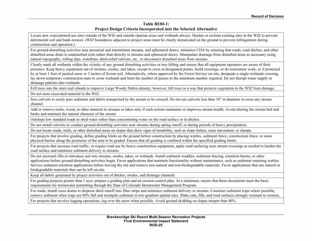
Record of Decision
Breckenridge Ski Resort Multi-Season Recreation Projects
Final Environmental Impact Statement ROD-25
Table ROD-1: Project Design Criteria Incorporated into the Selected Alternative
Locate new concentrated-use sites outside of the WIZ and outside riparian areas and wetlands always. Harden or reclaim existing sites in the WIZ to prevent detrimental soil and bank erosion. (WIZ boundaries adjacent to project areas must be clearly demarcated on the ground to prevent infringement during construction and operation.)
For ground-disturbing activities near perennial and intermittent streams, and ephemeral draws, minimize CDA by ensuring that roads, road ditches, and other disturbed areas drain to undisturbed soils rather than directly to streams and ephemeral draws. Manipulate drainage from disturbed areas as necessary using natural topography, rolling dips, waterbars, ditch-relief culverts, etc., to disconnect disturbed areas from streams.
Clearly mark all wetlands within the vicinity of any ground disturbing activities or tree felling and ensure that all equipment operators are aware of their presence. Keep heavy equipment out of streams, swales, and lakes, except to cross at designated points, build crossings, or do restoration work, or if protected by at least 1 foot of packed snow or 3 inches of frozen soil. Alternatively, where approved by the Forest Service on-site, designate a single wetlands crossing, lay down temporary construction mats to cross wetlands and limit the number of passes to the minimum number required. Do not disrupt water supply or drainage patterns into wetlands.
Fell trees into the inter-trail islands to improve Large Woody Debris density; however, fell trees in a way that protects vegetation in the WIZ from damage.
Do not store excavated material in the WIZ.
Size culverts to easily pass sediment and debris transported by the stream to be crossed. Do not use culverts less than 18” in diameter to cross any stream channel.
Add or remove rocks, wood, or other material in streams or lakes only if such actions maintains or improves stream health. Avoid altering the stream bed and banks and maintain the natural character of the stream.
Outslope low standard roads to shed water rather than concentrating water on the road surface or in ditches. Do not install culverts or conduct ground-disturbing activities near streams during spring runoff, or during periods of heavy precipitation. Do not locate roads, trails, or other disturbed areas on slopes that show signs of instability, such as slope failure, mass movement, or slumps. For projects that involve grading, define grading limits on the ground before construction by placing wattles, sediment fence, construction fence, or some physical barrier along the perimeter of the area to be graded. Ensure that all grading is confined within the specified grading limits. For projects that increase road traffic, or require road use by heavy construction equipment, apply road surfacing near stream crossings as needed to harden the road surface and minimize sediment delivery to streams. Do not encroach fills or introduce soil into streams, swales, lakes, or wetlands. Install sediment waddles, sediment fencing, retention basins, or other applications before ground-disturbing activities begin. Favor applications that maintain functionality without maintenance, such as sediment retaining wattles. Service sediment retention applications before leaving the site and remove non-natural and non-biodegradable materials. Favor applications that use natural or biodegradable materials that can be left on-site. Keep all debris generated by project activities out of ditches, swales, and drainage channels. For grading projects greater than 1 acre, prepare a grading plan and an erosion control plan. At a minimum, ensure that these documents meet the basic requirements for stormwater permitting through the State of Colorado Stormwater Management Program. For roads, install cross drains to disperse ditch runoff into filter strips and minimize sediment delivery to streams. Construct sediment traps where possible, remove sediment when traps are 80% full and stockpile sediment in low-gradient upland sites. Make cuts, fills, and road surfaces strongly resistant to erosion. For projects that involve logging operations, log over the snow when possible. Avoid ground skidding on slopes steeper than 40%.

Record of Decision
Breckenridge Ski Resort Multi-Season Recreation Projects
Final Environmental Impact Statement ROD-26
Table ROD-1: Project Design Criteria Incorporated into the Selected Alternative
A drainage management plan will be completed prior to construction of projects.
Clearly mark proposed trail alignments and ground disturbance on the ground and schedule a field review with Forest Service specialists prior to initiating construction. AIR QUALITY Site improvements will be installed promptly in order to reduce the potential for dust emissions.
The area disturbed by clearing, earth moving, or excavation activities will be kept to a minimum at all times, allowing improvements to be implemented in sections.
SUSTAINABILITY Shuttle services to the ski area/other recreational areas are encouraged to reduce traffic and vehicle emission.

Record of Decision
Breckenridge Ski Resort Multi-Season Recreation Projects
Final Environmental Impact Statement ROD-27
PUBLIC INVOLVEMENT
In February 2014 a scoping notice was mailed to community residents, interested individuals, public
agencies, and other organizations. The scoping package provided a brief description of the Proposed
Action, the Purpose and Need for action, preliminary issues raised and an illustrative map. This notice
was designed to elicit comments, concerns and issues pertaining to the Proposed Action. A legal notice
was published in the Glenwood Springs Post Independent, and a Notice of Intent (NOI) to prepare an
Environmental Impact Statement was published in the Federal Register, on February 10, 2014. A public
open house was held on March 5, 2014. The open house began with an on-mountain tour to the proposed
project sites, then continued with a formal meeting at the Mountain Thunder Lodge in the Town of
Breckenridge. Following media coverage of the proposal, other individuals obtained copies of the scoping
package at the open house or sent requests to the Dillon District Ranger for information. In addition, the
scoping package was posted on the WRNF website with a link to an online comment form. An e-mail
address was provided for submitting electronic comments.
On January 16, 2015, a Notice of Availability was published in the Federal Register for the DEIS. The
DEIS was released for public review and comment for a 45-day comment period which extended through
March 2, 2015. In response to the DEIS 111 comments were received from interested individuals,
agencies and organizations. From these letters, substantive comments were extracted and entered into a
database; comments were linked to specific commenters and resource issues. Substantive comments are
addressed in the FEIS Appendix E – Response to Comments on the Draft EIS.
On August 14, 2015, a Notice of Availability was published in the Federal Register for the Final EIS and
draft Record of Decision. On August 14, 2015, a legal notice was also published in the Glenwood Post
Independent. This initiated a 45-day pre-decisional objection period under 36 CFR 218. Objections were
received from Summit County Government and BSR on the draft Record of Decision. Summit County
Government and BSR each provided correspondence to the WRNF withdrawing their objection to the
decision.
CONSIDERATION OF OTHER ALTERNATIVES
NEPA requires that a range of reasonable alternatives to the Proposed Action be developed and analyzed.
By definition, alternatives must meet the Purpose and Need while responding to issues identified during
scoping.1 Therefore, in response to internal and external scoping, the Forest Service Interdisciplinary (ID)
Team considered issues that would generate alternatives to the Proposed Action. Both CEQ Regulations
and Forest Service Handbook direction emphasize that alternatives must meet the “reasonableness”
criteria in order to warrant detailed analysis.
1 USDA Forest Service. 2012. Forest Service Handbook 1909.15: National Environmental Policy Act Handbook, Chapter 10, Section 12.33 and 14.

Record of Decision
Breckenridge Ski Resort Multi-Season Recreation Projects
Final Environmental Impact Statement ROD-28
Three resource issues raised during the scoping process that warranted consideration of alternatives to the
Proposed Action included potential wildlife, high alpine ecosystem and scenery impacts. Alternative 3
was created in response to these potential impacts. They are discussed below under “Alternative 3.”
I am confident that the ID Team considered a reasonable range of alternatives early in the NEPA process,
and that the two alternatives, in addition to the required No Action Alternative, analyzed in the FEIS are
adequate for the scope and scale of this project.
ALTERNATIVE 1 – NO ACTION
As required by NEPA, a No Action Alternative was included in this analysis for review alongside the
action alternatives.2 By definition, the No Action Alternative represents a continuation of existing
management practices without changes, additions, or upgrades to existing conditions. The No Action
Alternative is depicted in Figure 2 of the FEIS.
The No Action Alternative provides a baseline for comparing the effects of the action alternatives. The
No Action Alternative essentially reflects a continuation of existing management practices without
changes, additions, or upgrades. No new facilities or recreational activities are included.
ALTERNATIVE 2 AND 3 PROJECTS NOT APPROVED
Three resource issues were raised during public or internal scoping that drove the consideration of an
alternative to the Proposed Action. These resource issues include potential impacts to wildlife, high alpine
ecosystem and scenery. To mitigate the potential impacts to these resources, a number of modifications to
the Proposed Action were developed and analyzed. The modifications focused on concentrating the
activities into the developed portion of BSR, minimizing disturbance to large habitat blocks or fragile
ecosystems and moving components to be less visible or blend with the background.
Alternative 2 and 3 projects not approved include:
Claimjumper Canopy Tour
Ore Bucket area mountain bike trail
Lake Chutes hiking trail
OHV tour use on Four O’Clock Road realignment
Proposed Action observation tower location in Horseshoe Bowl
Operation of Imperial Express and 6 Chair
Alternatives 2 and 3 are depicted in Figures 3 and 4 of the FEIS.
2 40 CFR 1502.14(d). 1978. Regulations for Implementing the Procedural Provisions of the National Environmental Policy Act, as amended July 1, 1986.

Record of Decision
Breckenridge Ski Resort Multi-Season Recreation Projects
Final Environmental Impact Statement ROD-29
ENVIRONMENTALLY PREFERABLE ALTERNATIVE
In accordance with CEQ regulations, I am required to identify the alternative or alternatives that could be
considered environmentally preferable (40 CFR 1505.2[b]). Forest policy (FSH 1909.15, Section 05)
defines “environmentally preferable” as:
“An alternative that best meets the goals of Section 101 of NEPA… Ordinarily this is the alternative that causes the least damage to the biological and physical environment and best protects, preserves, and enhances historic, cultural and natural resources.”
Based on the review of the alternatives, Alternative 1 (the No Action Alternative) is the environmentally
preferable alternative. Alternative 1 is identified as the environmentally preferable alternative because, by
its nature, it is not accompanied by any of the acknowledged impacts to the human or biological
environment associated with alternatives 2 or 3.
FINDINGS REQUIRED BY LAWS, REGULATIONS AND AGENCY POLICY
This approval is consistent with the intent of the 2002 Forest Plan’s long term goals and objectives.3 The
project was designed in conformance with 2002 Forest Plan Forest-wide management direction and
incorporates appropriate Forest Plan guidance for ski areas—existing and potential.
As Forest Supervisor for the WRNF, I am required to manage the Forest in accordance with applicable
laws and regulations. This authority, which includes approval of ski area projects, is delegated to me
through agency policy described in FSM 1200. In reviewing the FEIS, I have concluded that my decision
is consistent with all relevant laws, regulations and requirements. This includes, but is not limited to:
2011 Ski Area Recreation Opportunity Enhancement Act of 2011
Americans with Disabilities Act (ADA) of 1990
American Indian Religious Freedom Act of 1978
Archaeological Resource Protection Act of 1978
Clean Air Act of 1990, as amended
Clean Water Act of 1977, as amended
Endangered Species Act of 1973, as amended, including consultation resulting in a Biological
Opinion signed April 27, 2012.
3 USDA Forest Service. 2002. White River National Forest Land and Resource Management Plan 2002 revision. White River National Forest, Glenwood Springs. CO.

Record of Decision
Breckenridge Ski Resort Multi-Season Recreation Projects
Final Environmental Impact Statement ROD-30
Fish and Wildlife Coordination Act of 1934, as amended
Forest and Rangeland Renewable Resources Planning Act of 1974
Multiple-Use Sustained Yield Act of 1960
National Environmental Policy Act of 1969, as amended
National Forest Management Planning Act of 1976
National Forest Ski Area Permit Act of 1986, as amended
National Historic Preservation Act of 1966, as amended
Organic Administration Act of 1897, as amended
Protection of Wetlands Executive Order 11990
In addition to requisite Forest Service approvals, consultation with the following entities, or permits, may
be required to implement any approved projects:
U.S. Fish and Wildlife Service, Endangered Species Act Section 7 Consultation
U.S. Army Corps of Engineers, Section 404 of the Clean Water Act Permit
Summit County Construction Permit
Federal Aviation Administration Compliance
Colorado Department of Public Health and Environment, Construction Stormwater Discharge
Permit. Colorado stormwater regulations s (5CCR 1002-61) require a permit for construction
activity that disturbs 1 acre or more during the life of the project.
OBJECTION PROVISIONS AND IMPLEMENTATION DATE
As discussed previously under Public Involvement, the draft Record of Decision was subject to the pre-
decisional objection process pursuant to 36 CFR 218. Objections were received from Summit County
Government and BSR during the 45-day pre-decisional objection period, but those objections were
officially withdrawn. This decision may be implemented immediately upon signing of the Record of
Decision.

Record of Decision
Breckenridge Ski Resort Multi-Season Recreation Projects
Final Environmental Impact Statement ROD-31
CONTACT PERSON
For additional information concerning this Record of Decision, the FEIS, or the Forest Service objection
process, contact:
Roger Poirier, Project Leader
White River National Forest
900 Grand Avenue
Glenwood Springs, CO 81601
Responsible Official:
Scott Fitzwilliams, Forest Supervisor Date
White River National Forest

Private
BSR SUP
Nordic SUP
Private
USFS
PrivateUSFS
Color
ado S
uperC
hair
Indep
ende
nce S
uper
Chair
SawmillCanopy Tour
Peak 7Zip Line
Peak 7 HutVista Haus
Not For OHV Tours
Peaks Trail Connection
Ore BucketCanopy Tour
a .O b s e r v a t i o n t o w e r sCo
lorad
o Sup
erCha
ir
5 Cha
ir
Rip's Ride
Peak 9 Road
SawmillZip Line
Wanderlust Ski Trail/Ore Bucket Access
Peak 7/8 Road
Proposed Projects:Zip Line StationsZip Line CablesCanopy Tour StationsCanopy Tour Cables
") Deck/Building ExpansionsAlternative Lookout TowerVista Haus Challenge Courses AreaVista Haus and Indep. Chair Site WorkBike Skills CourseMountain Biking TrailsMountain Biking Trail ReroutesHiking Trails4 O'Clock Road RealignmentUtilitiesConstr/Operations Access PathConstr/Operations Access RoadSummer Lift Operations
Existing:LiftsTenmile Flyer Zip LineAlpine CoasterAlpine SlideMountain Biking TrailsPeaks TrailHiking TrailsRoadsPrimary Maintenance RoadsSUP Boundary
0 1,100550 Feet
²
Created by:November 2015
Selected Alternative
BRECKENRIDGE SKI RESORTMULTI-SEASON
RECREATION PROJECTS ENVIRONMENTAL IMPACT STATEMENT
WHITE RIVER NATIONAL FORESTDILLON RANGER DISTRICT

Appendix A

Appendix A: Construction Access Path and Logistics Matrix for the Ore Bucket Canopy Tour
Breckenridge Ski Resort Multi-Season Recreation Projects Final Environmental Impact Statement
Record of Decision A-1
APPENDIX A: CONSTRUCTION ACCESS PATH AND LOGISTICS MATRIX FOR THE ORE BUCKET CANOPY TOUR Tower
Location Access Purpose Length Construction width
Final Desired Path width
Suitable Construction Equipment
Estimated Number of Trips with Equipment Site Activity Future Desired Long Term Condition
Tower 1 Construction
pathway and guest operations access
~700LF ~8’ 2’–4’
Tracked excavator, backhoe, Spider-hoe, per USFS approval,
for excavation/drilling equipment; ATV, material transport trailers.
8–10 round trips for construction.
Construction may include excavation, drilling/excavation for pier supports, erection of towers and platforms, concrete and grout installation, installation of guy wires and protective fencing.
The path will be utilized for construction and then maintained by resort for guest and operations access.
Tower 2 Construction ~600LF ~8’ NA
Tracked excavator, backhoe, Spider-hoe, per USFS approval,
for excavation/drilling equipment; ATV, material transport trailers.
8–10 round trips for construction using
similar access paths to Tower 1.
Construction may include excavation, drilling/excavation for pier supports, erection of towers and platforms, concrete and grout installation, installation of guy wires and protective fencing.
Construction sites and access routes will be revegetated per PDC’s. Maintenance and emergency access is minimal and will be over-ground travel. Visual pathways resulting from maintenance and emergency access will be minimal.
Tower 3 Construction ~100LF ~8’ NA
Tracked excavator, backhoe, Spider-hoe, per USFS approval,
for excavation/drilling equipment; ATV, material transport trailers.
8–10 round trips for construction.
Construction may include excavation, drilling/excavation for pier supports, erection of towers and platforms, concrete and grout installation, installation of guy wires and protective fencing.
Construction sites and access routes will be revegetated per PDC’s. Maintenance and emergency access is minimal and will be over-ground travel. Visual pathways resulting from maintenance and emergency access will be minimal.
Tower 4 Construction ~300LF ~8’ NA
Tracked excavator, backhoe, Spider-hoe, per USFS approval,
for excavation/drilling equipment; ATV, material transport trailers.
8–10 round trips for construction.
Construction may include excavation, drilling/excavation for pier supports, erection of towers and platforms, concrete and grout installation, installation of guy wires and protective fencing.
Construction sites and access routes will be revegetated per PDC’s. Maintenance and emergency access is minimal and will be over-ground travel. Visual pathways resulting from maintenance and emergency access will be minimal.
Tower 5 Construction ~900LF ~8’ NA
Tracked excavator, backhoe, Spider-hoe, per USFS approval,
for excavation/drilling equipment; ATV, material transport trailers.
8–10 round trips for construction using
similar access paths to Tower 2.
Construction may include excavation, drilling/excavation for pier supports, erection of towers and platforms, concrete and grout installation, installation of guy wires and protective fencing.
Construction sites and access routes will be revegetated per PDC’s. Maintenance and emergency access is minimal and will be over-ground travel. Visual pathways resulting from maintenance and emergency access will be minimal.
Tower 6 Construction ~1,000LF ~8’ NA
Spider-hoe or other balloon-tired vehicle, per USFS approval, for excavation/ drilling equipment; ATV, material transport trailers.
8–10 round trips for construction using
similar access paths to Tower 7.
Construction may include excavation, drilling/excavation for pier supports, erection of towers and platforms, concrete and grout installation, installation of guy wires and protective fencing.
Construction sites and access routes will be revegetated per PDC’s. Maintenance and emergency access is minimal and will be over-ground travel. Visual pathways resulting from maintenance and emergency access will be minimal.
Tower 7 Construction ~150LF ~8’ NA
Spider-hoe or other balloon-tired vehicle, per USFS approval, for excavation/ drilling equipment; ATV, material transport trailers.
8–10 round trips for construction.
Construction may include excavation, drilling/excavation for pier supports, erection of towers and platforms, concrete and grout installation, installation of guy wires and protective fencing.
Construction sites and access routes will be revegetated per PDC’s. Maintenance and emergency access is minimal and will be over-ground travel. Visual pathways resulting from maintenance and emergency access will be minimal.
Tower 8 Construction ~700LF ~8’ NA
Tracked excavator, backhoe, Spider-hoe, per USFS approval,
for excavation/drilling equipment; ATV, material transport trailers.
8–10 round trips for construction.
Construction may include excavation, drilling/excavation for pier supports, erection of towers and platforms, concrete and grout installation, installation of guy wires and protective fencing.
Construction sites and access routes will be revegetated per PDC’s. Maintenance and emergency access is minimal and will be over-ground travel. Visual pathways resulting from maintenance and emergency access will be minimal.
Tower 9 Construction ~3,200LF ~8’ NA
Spider-hoe or other balloon-tired vehicle, per USFS approval, for excavation/ drilling equipment; ATV, material transport trailers.
8–10 round trips for construction.
Construction may include excavation, drilling/excavation for pier supports, erection of towers and platforms, concrete and grout installation, installation of guy wires and protective fencing.
Construction sites and access routes will be revegetated per PDC’s. Maintenance and emergency access is minimal and will be over-ground travel. Visual pathways resulting from maintenance and emergency access will be minimal.
Tower 10
Construction, emergency access and egress trail for
participants
~200LF ~8’ 3’–4’
Tracked excavator, backhoe, Spider-hoe, per USFS approval,
for excavation/drilling equipment; ATV, material transport trailers.
8–10 round trips for construction.
Construction may include excavation, drilling/excavation for pier supports, erection of towers and platforms, concrete and grout installation, installation of guy wires and protective fencing.
The path will be utilized for construction and then maintained by resort for guest and operations access.