Biological Assessment Deisobutanizer Project Chambers ...
110
Transcript of Biological Assessment Deisobutanizer Project Chambers ...

Biological Assessment Mont Belvieu Eagleford Fractionation and Deisobutanizer Project Chambers County, Texas Prepared for Enterprise Products Operating, LLC Prepared by Whitenton Group, Inc. June 2012
3413 Hunter Road • San Marcos, Texas 78666 • office 512-353-3344 • fax 512-392-3450
www.whitentongroup.com
Biological Assessment Mont Belvieu Eagleford Fractionation and Deisobutanizer Project
Chambers County, Texas
Prepared for
Enterprise Products Operating, LLC Mont Belvieu, Texas
Prepared by
Whitenton Group, Inc. 3413 Hunter Road
San Marcos, Texas 78666
WGI Project No. 1234
June 2012
Mont Belvieu Eagleford Fractionation and Deisobutanizer Project – Biological Assessment ii
TABLE OF CONTENTS
TABLE OF CONTENTS ............................................................................................................................ ii ACRONYMS .............................................................................................................................................. iv 1.0 EXECUTIVE SUMMARY .................................................................................................................... 1 2.0 INTRODUCTION ................................................................................................................................ 3 3.0 AGENCY REGULATIONS ................................................................................................................. 5
3.1 REGULATIONS AND STANDARDS ........................................................................................... 5 3.2 ENDANGERED SPECIES ACT ..................................................................................................... 6 3.3 MIGRATORY BIRD TREATY ACT ............................................................................................... 7 3.4 BALD AND GOLDEN EAGLE PROTECTION ACT ................................................................. 7 3.5 MARINE MAMMAL PROTECTION ACT .................................................................................. 8
4.0 PROJECT DESCRIPTION ................................................................................................................... 8 4.1 PROJECT PURPOSE AND LOCATION ...................................................................................... 8 4.2 CONSTRUCTION INFORMATION ............................................................................................. 9
4.2.1 CONSTRUCTION DESCRIPTION ........................................................................................ 9 4.2.2 CONSTRUCTION ACTIVITIES AND SCHEDULE ............................................................ 9 4.2.3 CONSTRUCTION EQUIPMENT REQUIRED ................................................................... 10 4.2.4 CONSTRUCTION NOISE LEVELS ..................................................................................... 11
4.3 OPERATION AND MAINTENANCE INFORMATION ........................................................ 12 4.3.1 OPERATION DESCRIPTION ............................................................................................... 12 4.3.2 WATER USE............................................................................................................................ 13 4.3.3 WASTEWATER ...................................................................................................................... 13 4.3.4 OPERATION NOISE LEVELS .............................................................................................. 14 4.3.5 EMISSION CONTROLS ........................................................................................................ 14
5.0 BACKGROUND INFORMATION .................................................................................................. 17 5.1 GENERAL ENVIRONMENTAL INFORMATION .................................................................. 17
5.1.1 GENERAL REGION INFORMATION ................................................................................ 17 5.1.2 LAND USE .............................................................................................................................. 18 5.1.3 CLIMATE ................................................................................................................................ 18 5.1.4 TOPOGRAPHY ...................................................................................................................... 19 5.1.5 GEOLOGY ............................................................................................................................... 20 5.1.6 SOILS ........................................................................................................................................ 20 5.1.7 WATER RESOURCES ............................................................................................................ 21 5.1.8 VEGETATION ........................................................................................................................ 22
5.2 PROTECTED SPECIES .................................................................................................................. 22 5.2.1 THREATENED OR ENDANGERED SPECIES LIST ........................................................ 22 5.2.2 THREATENED OR ENDANGERED SPECIES DESCRIPTIONS .................................... 23 5.2.3 TEXAS NATURAL DIVERSITY DATABASE RESULTS .................................................. 30 5.2.4 MARINE MAMMAL HABITAT .......................................................................................... 30
6.0 PROTECTED SPECIES HABITAT EVALUATION....................................................................... 30 6.1 PLANT COMMUNITIES OBSERVED ........................................................................................ 31
Mont Belvieu Eagleford Fractionation and Deisobutanizer Project – Biological Assessment iii
6.2 PROTECTED SPECIES HABITAT ANALYSIS ......................................................................... 32 7.0 AIR QUALITY ANALYSIS RESULTS ............................................................................................. 35
7.1 ESTIMATED TOTAL ANNUAL EMISSION RATE OVERVIEW .......................................... 35 7.2 AREA OF IMPACT DISPERSION MODELING RESULTS ..................................................... 37
7.2.1 DISPERSION MODELING METHODS .............................................................................. 37 7.2.2 DISPERSION MODELING RESULTS ................................................................................. 42
8.0 EFFECTS OF THE PROPOSED ACTION ....................................................................................... 43 8.1 AIR POLLUTION EFFECTS BACKGROUND RESEARCH ................................................... 44 8.2 AIR QUALITY EFFECTS .............................................................................................................. 44
8.2.1 EMISSIONS ............................................................................................................................. 44 8.2.2 FUGITIVE DUST .................................................................................................................... 45 8.2.3 IMPACTS OF AIR POLLUTION SOURCES ON FLORA AND FAUNA ...................... 45
8.3 WATER QUALITY EFFECTS ....................................................................................................... 47 8.3.1 WASTEWATER ...................................................................................................................... 47 8.3.2 SURFACE WATER ................................................................................................................. 48
8.4 NOISE EFFECTS ............................................................................................................................ 48 8.5 INFRASTRUCTURE-RELATED EFFECTS ................................................................................ 48 8.6 HUMAN ACTIVITY EFFECTS .................................................................................................... 49 8.7 FEDERALLY-PROTECTED SPECIES EFFECTS ....................................................................... 49
8.7.1 FEDERALLY-LISTED SPECIES............................................................................................ 49 8.7.2 MIGRATORY BIRDS ............................................................................................................. 59 8.7.3 BALD AND GOLDEN EAGLES .......................................................................................... 60 8.7.4 MARINE MAMMALS ........................................................................................................... 61
9.0 CONCLUSIONS ................................................................................................................................. 61 9.1 DETERMINATION OF EFFECT ................................................................................................. 62 9.2 INTERDEPENDENT AND INTERRELATED ACTIONS ....................................................... 62 9.3 CUMULATIVE EFFECTS ............................................................................................................. 62 9.4 CONSERVATION MEASURES ................................................................................................... 63
10.0 REFERENCES ................................................................................................................................... 64 11.0 LIST OF PREPARERS ...................................................................................................................... 68 APPENDIX A FLOW DIAGRAMS APPENDIX B FIGURES APPENDIX C PHOTOGRAPHS APPENDIX D FIELD SURVEY DATA SUMMARY
Mont Belvieu Eagleford Fractionation and Deisobutanizer Project – Biological Assessment iv
ACRONYMS AHPS Advanced Hydrologic Prediction Service BGEPA Bald and Golden Eagle Protection Act BACT Best Available Control Technology BA Biological Assessment CO Carbon Monoxide DIB Deisobutanizer ESL Effects Screening Levels EO Element of Occurrence ESA Endangered Species Act EPA Environmental Protection Agency FEMA Federal Emergency Management Agency Frac Fractionator/Fractionation GHG Greenhouse Gas GPM Gallons per Minute H2S Hydrogen Sulfide Pb Lead LDAR Leak Detection and Repair LAER Lowest Achievable Emission Rate LBB Louisiana Black Bear MMPA Marine Mammal Protection Act MAOI Maximum Area of Impact MBTA Migratory Bird Treaty Act NAAQS National Ambient Air Quality Standards NCDC National Climatic Data Center NLCD National Land Cover Data NMFS National Marine Fisheries Service NOAA National Oceanic and Atmospheric Administration NPDES National Pollutant Discharge Elimination System NWS National Weather Service NWI National Wetland Inventory NGL Natural Gas Liquids NRCS Natural Resources Conservation Service NSPS New Source Performance Standards NO2 Nitrogen Dioxide NOx Nitrogen Oxide NNSR Nonattainment New Source Review O3 Ozone PM Particulate Matter PSD Prevention of Significant Deterioration RBLC RACT/BACT/LAER Clearinghouse SIL Significant Impact Level SO2 Sulfur Dioxide TCEQ Texas Commission on Environmental Quality TNDD Texas Natural Diversity Database

Mont Belvieu Eagleford Fractionation and Deisobutanizer Project – Biological Assessment v
TPWD Texas Parks and Wildlife Department TPDES Texas Pollutant Discharge Elimination System TDS Total Dissolved Solids US United States USFWS US Fish and Wildlife Service USGS US Geological Survey VOC Volatile Organic Compound WGI Whitenton Group, Inc.

Mont Belvieu Eagleford Fractionation and Deisobutanizer Project – Biological Assessment 1
1.0 EXECUTIVE SUMMARY
Enterprise Products Operating LLC (Enterprise) currently operates an oil and gas production
facility, known as the Mont Belvieu Complex, in Mont Belvieu, Chambers County, Texas. Enterprise proposes to expand the existing facility and increase the production capacity with
the construction of two fractionation (Frac) process units and one deisobutanizer (DIB) unit, immediately adjacent to three existing Frac facilities (two in operation and one under
construction). The proposed project is located approximately 0.6 miles north of the intersection
of Hatcherville Road and Farm to Market 1942. The project is subject to Prevention of Significant Deterioration (PSD) review for greenhouse gases (GHG) by the United States (US)
Environmental Protection Agency (EPA). PSD review is also triggered for carbon monoxide (CO) for the proposed project. A State National Ambient Air Quality Standards (NAAQS)
analysis is required for nitrogen dioxide (NO2), sulphur dioxide (SO2), particulate matter (PM)10,
and PM2.5. The proposed emissions of SO2 and hydrogen sulfide (H2S) are also subject to review under 30 TAC Chapter 112. Speciated volatile organic compounds (VOC) compounds require a
health effects evaluation and comparison to the Texas Commission on Environmental Quality (TCEQ) Effects Screening Levels (ESL). The TCEQ is responsible for review of the State NAAQS
analysis, 30 TAC Chapter 112 analysis, and health effects evaluation and comparison to ESLs.
This Biological Assessment (BA) is a complete evaluation of the potential environmental
impacts the proposed project may have on federally-protected species and/or their potential
habitat. Protected species evaluated in this document include threatened, endangered, and candidate species, migratory birds, bald and golden eagles, and marine mammals. This BA
includes a field survey and an evaluation of potential environmental impacts based on air quality modeling results, construction information, and National Pollutant Discharge
Elimination System (NPDES) information provided by Enterprise and RPS, Enterprise’s air
quality permitting consultant for the project.
Construction of the proposed two new Frac units and DIB unit will take place within the
existing facility in an area approximately 20 acres in size. No additional earth disturbance will be required outside of this 20-acre area. The proposed project location has historically been
disturbed. The northwest corner of the project area is maintained pastureland. The northeast
corner is an active flare stack and adjacent pit. The remainder of the project area is currently being utilized as a staging area for the construction of Fractionator VI. The staging area consists
of road base, temporary buildings, vehicles, and equipment. No vegetation was observed in the
Mont Belvieu Eagleford Fractionation and Deisobutanizer Project – Biological Assessment 2
staging area. No new outfall structures will be required for this project. The project will utilize existing staging areas for construction.
Federally-protected species considered in this BA include the piping plover, Sprague’s pipit, smalltooth sawfish, green sea turtle, hawksbill sea turtle, Kemp’s ridley sea turtle, leatherback
sea turtle, loggerhead sea turtle, Louisiana black bear, red wolf, bald and golden eagles,
migratory birds, and marine mammals. The field surveys included a pedestrian protected species habitat evaluation of the proposed project area and the portions of the surrounding
facility that are not restricted by stringent safety requirements, a windshield habitat evaluation of all publicly-accessible habitats within a 3-mile radius of the project area, an aerial habitat
evaluation of all areas within a 3-mile radius. Data were collected to describe resident
vegetation communities and assess the potential for occurrence of protected species. Six habitat types were observed in the areas surrounding the Mont Belvieu Complex: wetland,
pastureland, mixed woodland, open water, riverine, and canals.
RPS performed dispersion modeling of air pollutants that will be emitted by the proposed
project in accordance with the PSD Permit requirements. All of the predicted concentrations due to the project are less than the Significant Impact Levels (SIL) designated by the EPA and
TCEQ for each pollutant and averaging period; therefore, the project emissions will not cause or
contribute to an exceedance of any applicable NAAQS.
The action area for the project is a circle that encompasses the Mont Belvieu Complex, the
proposed project construction area, and the wastewater outfall location. The action area has a maximum radius of approximately 0.5 mile. Five low quality habitat types were observed
within the action area: pastureland, woodland, wetland, open water, and canal. Migratory birds
have the potential to utilize these habitat types. No additional federally-protected species are likely to utilize the action area.
The maximum predicted concentrations of all modeled pollutants is well below the respective TCEQ ESLs and also well below the first screening level of 10% of the ESLs. Accordingly, no
adverse welfare impacts are expected to occur within the action area as the result of the
additional emissions of these pollutants.
The construction of the proposed project will have no direct or indirect impact on federally-
protected species habitat. Enterprise will utilize the best available control technology (BACT) to control emissions and thus minimize impacts to the surrounding environment to the maximum
Mont Belvieu Eagleford Fractionation and Deisobutanizer Project – Biological Assessment 3
extent practicable. The controls proposed for each pollutant are consistent with both the TCEQ BACT guidance and the most stringent limits in the RACT/BACT/LAER Clearinghouse (RBLC).
Based on the background research described in Section 8.1 and the determinations described in Section 8.2.3, the proposed project will likely have no direct or indirect impact on federally-
protected species habitat.
Based on the information gathered for this BA, Whitenton Group, Inc. (WGI) biologists recommend that a finding of no effect be accepted for all ten federally-protected species. The
take of migratory birds, bald or golden eagles, or marine mammals is not anticipated as a result of this project.
Note: The term “take” represents the more specific language of the Migratory Bird Treaty Act,
the Bald and Golden Eagle Protection Act, and the Marine Mammal Protection Act described below in Sections 3.3 - 3.5, respectively.
2.0 INTRODUCTION
Enterprise currently operates an oil and gas production facility , known as the Mont Belvieu Complex, in Mont Belvieu, Chambers County, Texas. The Mont Belvieu Complex is a key hub
of the domestic and international natural gas liquids (NGL) industry with a gross capacity of 380 MBPD and growing. This facility receives NGLs from several major supply basins in North
America, including the Mid-Continent, Permian Basin, San Juan Basin, Rocky Mountains, East Texas, and the Gulf Coast1. Enterprise proposes to expand the existing Mont Belvieu Complex
by adding two new Frac process units and one DIB unit immediately adjacent to the three
existing Frac facilities (two in operation and one under construction). These five Frac facilities will be located within the North Plant of the Mont Belvieu Complex. The new Frac and DIB
units will help accommodate NGL volumes from the Eagle Ford Shale basin, as well as other producing areas.
PSD review is triggered for CO for the proposed project. A State NAAQS analysis is also
required for NO2, SO2, PM10, and PM2.5. The proposed emissions of SO2 and H2S are also subject to review under 30 TAC Chapter 112. Speciated VOC compounds require a health effects
evaluation and comparison to the TCEQ ESLs.
Mont Belvieu Eagleford Fractionation and Deisobutanizer Project – Biological Assessment 4
This BA is a complete evaluation of the potential environmental impacts the proposed project may have on federally-protected species and/or their potential habitat. Protected species
evaluated in this document include threatened, endangered, and candidate species, migratory birds, bald and golden eagles, and marine mammals. Federal agency regulations for protected
species evaluated in this BA are described in Section 3.0.
The purpose of this BA is to research, evaluate, analyze, and document the potential for direct and indirect effects, interdependent and interrelated actions, and cumulative effects on
federally-protected species as a result of the proposed project. This BA includes a pedestrian protected species habitat evaluation of the proposed construction area, a windshield and aerial
assessment of all publicly-accessible habitats in the surrounding areas, and an evaluation of
potential environmental impacts based on air quality modeling results, construction information, operation information, and NPDES information provided by Enterprise and RPS.
The conclusion of this BA will include a recommended determination of effect on federally-protected species and their habitat. Three possible determinations offered by the US Fish and
Wildlife Service (USFWS) for the purpose of Biological Assessments and Evaluations are described (verbatim) below2.
1. No effect – A “no effect” determination means that there are absolutely no effects from the
proposed action, positive or negative, to listed species. A “no effect” determination does not
include effects that are insignificant (small in size), discountable (extremely unlikely to occur), or
beneficial. “No effect” determinations do not require written concurrence from the Service unless
the National Environmental Policy Act analysis is an Environmental Impact Statement. However,
the Service may request copies of no effect assessments for our files.
2. May affect, not likely to adversely affect – A “may affect, not likely to adversely affect”
determination may be reached for a proposed action where all effects are beneficial, insignificant,
or discountable. Beneficial effects have contemporaneous positive effects without any adverse
effects to the species or habitat (i.e., there cannot be a “balancing,” where the benefits of the
proposed action would be expected to outweigh the adverse effects – see below). Insignificant
effects relate to the size of the effects and should not reach the scale where take occurs.
Discountable effects are those that are extremely unlikely to occur. This conclusion is usually
reached through the informal consultation process, and written concurrence from the Service
exempts the proposed action from formal consultation. The federal action agency’s written
request for Service concurrence should accompany the biological assessment/biological
evaluation.

Mont Belvieu Eagleford Fractionation and Deisobutanizer Project – Biological Assessment 5
Note: A conclusion or finding of “may affect, but is not likely to adversely affect” by an action
agency and the USFWS, consultation with the USFWS is considered complete. This is known as
“informal consultation”.
3. May affect, likely to adversely affect - A “may affect, likely to adversely affect” determination
means that all adverse effects cannot be avoided. A combination of beneficial and adverse effects
is still “likely to adversely affect” even if the net effect is neutral or positive. Section 7 of the
Endangered Species Act require that the federal action agency request initiation of formal
consultation with the Service when a “may affect, likely to adversely affect” determination is
made. A written request for formal consultation should accompany the biological
assessment/biological evaluation.
Note: A conclusion or finding of “may affect, likely to adversely affect” by an action agency and
the USFWS; or if USFWS does not concur with an action agency’s finding of “not likely to
adversely affect” determination, then “formal consultation” is required between the action
agency and the USFWS. Formal consultation results in the USFWS issuing a biological opinion as
to whether or not the action, as proposed, will jeopardize the continued existence of any listed
species.
3.0 AGENCY REGULATIONS
3.1 REGULATIONS AND STANDARDS
The Clean Air Act requires air quality standards be maintained to protect public health and the environment. These standards are the NAAQS and are regulated by the US EPA and the TCEQ.
Ambient air is the air to which the general public has access, as opposed to air within the boundaries of an industrial facility. The NAAQS are concentration limits of pollutants in
ambient air within specific averaging time. The averaging time is the time period over which
the air pollutant concentrations must be met to comply with the NAAQS. The NAAQS are classified into two categories: primary and secondary standards. Primary standards are set to
protect public health, including “sensitive” populations. Secondary standards are set to protect public welfare, including the environment3.
The EPA sets NAAQS for six principal air pollutants, also referred to as criteria air pollutants.
These six criteria air pollutants are NO2, ozone (O3), SO2, PM, CO, and lead (Pb)3. A geographic area whose ambient air concentration for a criteria pollutant is equal to or less than the primary
standard is an attainment area. A geographic area with an ambient air concentration greater
Mont Belvieu Eagleford Fractionation and Deisobutanizer Project – Biological Assessment 6
than the primary standard is a nonattainment area. A geographic area will have a separate designation for each criteria pollutant4.
The Clean Air Act also requires the EPA to establish regulations to prevent significant deterioration of air quality in attainment areas. The EPA established PSD Increments to satisfy
this requirement. A PSD Increment is a measure of the maximum allowable increase in ambient
air concentrations of a criteria pollutant from a baseline concentration after a specified baseline date. An SIL is a concentration that represents a de minimis, or insignificant, threshold applied
to PSD permit applicants. The SIL is a measurable limit above which a source may cause or contribute to a violation of a PSD Increment for a criteria pollutant5. Before a PSD permit can be
issued, the applicant must demonstrate that the proposed emissions from a project will not
cause or contribute to a violation of a NAAQS or to an increase above a PSD Increment for each pollutant emitted in significant amounts by the project6.
The air quality analysis to demonstrate compliance with NAAQS and PSD Increments is performed using computer models to simulate the dispersion of the emitted pollutants into the
atmosphere and predict ground level concentrations at specified receptor locations in the area around the source of emissions. If the modeled concentration for a given pollutant and
averaging period is less than the EPA-specified SIL, the project is determined to have no
significant impact on ambient air quality and no further analysis is required for that pollutant and averaging period. If the SIL is predicted by the model to be exceeded for a given pollutant,
further modeling of the project emissions combined with existing emission sources in the area is required to estimate total ambient concentrations. The modeling must demonstrate that the total
concentration, including an appropriate background, does not exceed the applicable NAAQS
and PSD Increment.
3.2 ENDANGERED SPECIES ACT
The USFWS and the National Oceanic and Atmospheric Administration - National Marine Fisheries Service (NOAA-NMFS) regulate the Endangered Species Act (ESA) of 1973. “The
purpose of the ESA is to protect and recover imperiled species and the ecosystems on which
they depend.” Imperiled species specifically includes those listed by the USFWS as threatened or endangered7. Candidate species are those “the FWS has enough information to warrant
proposing them for listing but is precluded from doing so by higher listing priorities8.”
Candidate species are not specifically protected by the ESA, but will be included for the
purposes of this BA.

Mont Belvieu Eagleford Fractionation and Deisobutanizer Project – Biological Assessment 7
Section 9 of the ESA prohibits the “take” of threatened and endangered species. "Take" is defined as "harass, harm, pursue, hunt, shoot, wound, kill, trap, capture, or collect, or attempt to
engage in any such conduct." “Harm” is defined as “an act which actually kills or injures wildlife. Such an act may include significant habitat modification or degradation where it
actually kills or injures wildlife by significantly impairing essential behavioral patterns,
including breeding, feeding, or sheltering9.”
3.3 MIGRATORY BIRD TREATY ACT
All migratory birds are protected under the Migratory Bird Treaty Act (MBTA) of 1918, which is regulated in the US by the USFWS. The MBTA prohibits the following: "pursue, hunt, take,
capture, kill, attempt to take, capture or kill, possess, offer for sale, sell, offer to purchase,
purchase, deliver for shipment, ship, cause to be shipped, deliver for transportation, transport, cause to be transported, carry, or cause to be carried by any means whatever, receive for
shipment, transportation or carriage, or export, at any time, or in any manner, any migratory bird . . . for the protection of migratory birds . . . or any part, nest, or egg of any such bird10".
“A migratory bird is any species or family of birds that live, reproduce, or migrate within or
across international borders at some point during their annual life cycle.” According to the USFWS, there are approximately 836 bird species protected by the MBTA10.
3.4 BALD AND GOLDEN EAGLE PROTECTION ACT
Bald and golden eagles are protected under the Bald and Golden Eagle Protection Act (BGEPA)
of 1940, which is regulated by the USFWS. The BGEPA prohibits the following: ‘‘take, possess,
sell, purchase, barter, offer to sell, purchase, or barter, transport, export or import, at any time or any manner, any Bald Eagle (or Golden Eagle), alive or dead, or any part, nest, or egg
thereof.’’ “Take” is defined as ‘‘pursue, shoot, shoot at, poison, wound, kill, capture, trap, collect, or molest or disturb.’’ ‘‘Disturb’’ is defined as: ‘‘to agitate or bother a bald or golden
eagle to a degree that causes, or is likely to cause, based on the best scientific information available, (1) injury to an eagle, (2) a decrease in its productivity, by substantially interfering
with normal breeding, feeding, or sheltering behavior, or (3) nest abandonment, by
substantially interfering with normal breeding, feeding, or sheltering behavior11.’’
Mont Belvieu Eagleford Fractionation and Deisobutanizer Project – Biological Assessment 8
3.5 MARINE MAMMAL PROTECTION ACT
The USFWS and NOAA-NMFS regulate the Marine Mammal Protection Act (MMPA) of 1972.
The MMPA prohibits the “take” of marine mammals in US waters or by US Citizens outside US waters and the importation of marine mammals or marine mammal products into the US.
“Take” is defined as “hunt, harass, capture, or kill.” 12
4.0 PROJECT DESCRIPTION
4.1 PROJECT PURPOSE AND LOCATION
The purpose of the project is to expand the existing Enterprise Mont Belvieu Complex by
adding two new Frac units and one DIB unit immediately adjacent to the three existing Frac
units (two in operation and one under construction). These five Frac units will be located within the North Plant of the Mont Belvieu Complex.
The two new Frac units will be used to separate a NGL feed into separate ethane, propane, butane, and gasoline fractions. The DIB unit will be used to separate isobutane and normal
butane from mixed butane streams. Simplified process flow diagrams for the Frac and DIB units are provided in Figures 4-1 and 4-2 (Appendix A). The additional Frac and DIB units are
necessary to process the NGL currently being produced out of the Eagle Ford Shale, as well as
other producing areas.
The proposed project is located approximately 0.6 miles north of the intersection of Hatcherville
Road and Farm to Market 1942 (Figure 1 - Appendix B).
Project location information:
USGS Quad Latitude/Longitude Sheeks
Mont Belvieu 29.865620 -94.915959
Mont Belvieu Eagleford Fractionation and Deisobutanizer Project – Biological Assessment 9
4.2 CONSTRUCTION INFORMATION
4.2.1 CONSTRUCTION DESCRIPTION
Construction of the proposed two new Frac units, one DIB unit will take place within the existing facility in an area approximately 20 acres in size. No additional earth disturbance will
be required outside of this 20-acre area. The proposed project location has historically been
disturbed. The northwest corner of the project area is maintained pastureland. The northeast corner is an active flare stack and adjacent pit. The remainder of the project area is currently
being utilized as a staging area for the construction of Frac VI. The staging area consists of road base, temporary buildings, vehicles, and equipment. No vegetation was observed in the staging
area. The proposed construction activities include the installation of approximately 66 steel-
reinforced concrete piles, 414 drill shafts, and 5 acres of concrete paving (facility and access road). No new outfall structures will be required for this project. The project will utilize existing
staging areas for construction. The construction area is shown on Figure 2 and 3 (Appendix B).
The new facilities will include:
• Two Frac Unit deethanizer distillation columns
• Two Frac Unit depropanizer distillation columns • Two Frac Unit debutanizer distillation columns
• Two natural gas fired hot oil heaters • Two natural gas fired regenerant gas heaters
• Cooling towers • New flare to treat process vents from the Frac and DIB units
• Ancillary tanks
• One DIB distillation column • New DIB unit’s contribution to the flare
The projected construction start date (pending necessary permit approvals) is 01 November 2012. The projected operation start date is 01 November 2013.
4.2.2 CONSTRUCTION ACTIVITIES AND SCHEDULE
The total time estimated to complete the construction of the project is approximately 79 weeks and includes the following list of general construction activities. The construction schedule will
Mont Belvieu Eagleford Fractionation and Deisobutanizer Project – Biological Assessment 10
be 12 hours a day, seven days a week until completion. The schedule may increase, as needed, to meet the project deadline.
• site work • install piles
• pour concrete
• erect structural steel • install equipment
• install piping and tie-ins • install instruments & electrical
• install insulation
• paint
The estimated number of personnel required for construction of the Frac units is 400 for a
maximum timeframe of 79 weeks. Any emissions resulting from the additional construction personnel would be insignificant and temporary.
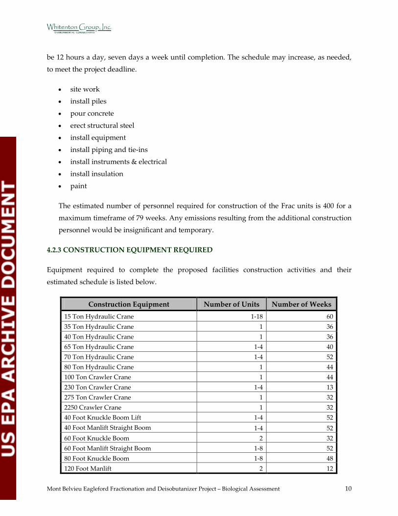
4.2.3 CONSTRUCTION EQUIPMENT REQUIRED
Equipment required to complete the proposed facilities construction activities and their
estimated schedule is listed below.
Construction Equipment Number of Units Number of Weeks 15 Ton Hydraulic Crane 1-18 60 35 Ton Hydraulic Crane 1 36 40 Ton Hydraulic Crane 1 36 65 Ton Hydraulic Crane 1-4 40 70 Ton Hydraulic Crane 1-4 52 80 Ton Hydraulic Crane 1 44 100 Ton Crawler Crane 1 44 230 Ton Crawler Crane 1-4 13 275 Ton Crawler Crane 1 32 2250 Crawler Crane 1 32 40 Foot Knuckle Boom Lift 1-4 52 40 Foot Manlift Straight Boom 1-4 52 60 Foot Knuckle Boom 2 32 60 Foot Manlift Straight Boom 1-8 52 80 Foot Knuckle Boom 1-8 48 120 Foot Manlift 2 12
Mont Belvieu Eagleford Fractionation and Deisobutanizer Project – Biological Assessment 11
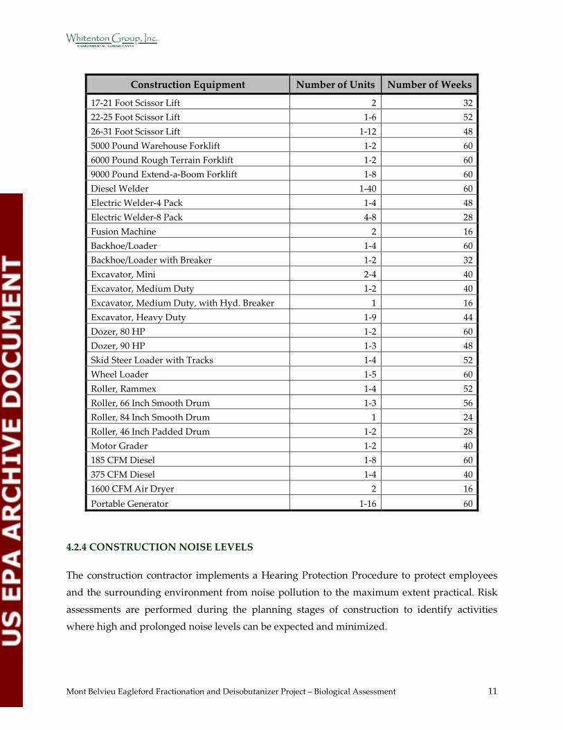
Construction Equipment Number of Units Number of Weeks
17-21 Foot Scissor Lift 2 32 22-25 Foot Scissor Lift 1-6 52 26-31 Foot Scissor Lift 1-12 48 5000 Pound Warehouse Forklift 1-2 60 6000 Pound Rough Terrain Forklift 1-2 60 9000 Pound Extend-a-Boom Forklift 1-8 60 Diesel Welder 1-40 60 Electric Welder-4 Pack 1-4 48 Electric Welder-8 Pack 4-8 28 Fusion Machine 2 16 Backhoe/Loader 1-4 60 Backhoe/Loader with Breaker 1-2 32 Excavator, Mini 2-4 40 Excavator, Medium Duty 1-2 40 Excavator, Medium Duty, with Hyd. Breaker 1 16 Excavator, Heavy Duty 1-9 44 Dozer, 80 HP 1-2 60 Dozer, 90 HP 1-3 48 Skid Steer Loader with Tracks 1-4 52 Wheel Loader 1-5 60 Roller, Rammex 1-4 52 Roller, 66 Inch Smooth Drum 1-3 56 Roller, 84 Inch Smooth Drum 1 24 Roller, 46 Inch Padded Drum 1-2 28 Motor Grader 1-2 40 185 CFM Diesel 1-8 60 375 CFM Diesel 1-4 40 1600 CFM Air Dryer 2 16 Portable Generator 1-16 60
4.2.4 CONSTRUCTION NOISE LEVELS
The construction contractor implements a Hearing Protection Procedure to protect employees and the surrounding environment from noise pollution to the maximum extent practical. Risk
assessments are performed during the planning stages of construction to identify activities where high and prolonged noise levels can be expected and minimized.
Mont Belvieu Eagleford Fractionation and Deisobutanizer Project – Biological Assessment 12
The contractor will consider, when feasible and possible, alternative work methods, which lessen or eliminate the use of noisy equipment. The equipment utilized is well maintained and
chosen based on low noise output. Sound attenuation equipment is fitted and in good working order. Construction activities are positioned and arranged at reasonable distances from noise-
producing plant activities. When a number of machines are in use, arrangement of these
machines is strategically staged or grouped with barriers and absorbent material.
When exposure to noise cannot be prevented, the construction contractor will institute a noise
monitoring program.
Few pieces of equipment required for construction have the potential to exceed 85 decibels at 50
feet from the source (crane derrick, jack hammer, paver, pile driver, rail saw, rock drill, and
scraper). The best available technology will be used to maintain noise levels during construction below 85 decibels measured at a distance of 50 feet from the source as much as practical.
4.3 OPERATION AND MAINTENANCE INFORMATION
4.3.1 OPERATION DESCRIPTION
Two new Frac units and one DIB unit will be constructed immediately adjacent to the three
existing Frac units (two in operation and one under construction). These five Frac units will be located within the North Plant of the Mont Belvieu Complex.
The two new Frac units will separate NGL feed into separate ethane, propane, butane, and gasoline fractions. The DIB unit will separate isobutane and normal butane from mixed butane
streams13.
The maximum operating schedule is 24 hours a day, 7 days a week, and 52 weeks a year13.
No new personnel will be required for operation.
Maintenance activities include preventative and routine maintenance on critical mechanical, electrical, and air pollution control systems. Maintenance activities include, but are not limited
to, Leak Detection and Repair (LDAR) on fugitive components, daily walk throughs, routine tank inspections, and infrequent complete unit turnarounds completed once every 10-15 years.
Any and all emissions generated from maintenance activities are included in the air permit
amendment application, or will otherwise be permitted or reported. No additional
Mont Belvieu Eagleford Fractionation and Deisobutanizer Project – Biological Assessment 13
environmental impacts are anticipated as a result of maintenance activities required for the Frac and DIB units13.
4.3.2 WATER USE
The Mont Belvieu Complex purchases water from the City of Houston and the City of Mont
Belvieu. The facility also has its own ground water well. Based on the 2011 Industrial Water Use
Survey submitted to the Texas Water Development Board, the total water consumption averaged 1765 gallons per minute (gpm). The design basis for each Frac unit is 370 gpm,
primarily for cooling water. The total water demand for the two additional Frac units will be 740 gpm. That represents a 42% increase in water use for the entire facility.
4.3.3 WASTEWATER
The new Frac units will be located within the North Plant of the Mont Belvieu Complex. The North Plant currently discharges wastewater and stormwater under Texas Pollutant Discharge
Elimination System (TPDES) Permit Number 03499. The process wastewater from the new Fracs will be combined with that from other Frac units in the North Plant and will be treated in the
North Plant’s existing wastewater treatment system. The non-process wastewater (i.e., cooling water) will be discharged with only pH adjustment (no biological treatment). The non-process
wastewater will be routed to the North Plant Outfall 001, which discharges into the Hatcherville
Road Ditch and ultimately into Cedar Bayou.
The new Frac units are expected to generate a combined flow of 146.4 gpm, which includes
process wastewater (30 gpm), first flush storm water from process units (3.4 gpm), and non-process utility flows (113 gpm). The existing North Plant Outfall 001 receives an estimated 367
gpm. The new Frac units combined represent a flow increase of approximately 40%. No changes
to the wastewater discharge (i.e., temperature change, pH change, pollutant concentration, etc.) other than an increase in flow rate are anticipated.
At the request of the TCEQ, Enterprise will submit a revised TPDES amendment application for the South Plant permit (Number 02940), which will consolidate the North Plant and the South
Plant into one TPDES permit and terminate TPDES Permit Number 03499. The outfalls at the
North Plant will be added to the combined TPDES permit. The North Plant Outfall 001 will become Outfall 004 in the consolidated permit.
Mont Belvieu Eagleford Fractionation and Deisobutanizer Project – Biological Assessment 14
The first flush storm water from process area sumps will be routed to the wastewater treatment system. Excess storm water from the sumps and from other paved areas will be routed to two
retention ponds that will be constructed. The ponds will be used for sedimentation and oil retention, if needed. A new stormwater outfall will be permitted to authorize the discharge
from the new ponds.
Best Management Practices will be utilized in accordance with Section 401 of the Clean Water Act and Chapter 279 of the Texas Water Code. If the project falls within the criteria for the
TCEQ General Permit for Storm Water Discharges Associated with Construction Activities, a Stormwater Pollution Prevention Plan will be prepared. The facility has a Spill Prevention,
Control, and Countermeasure Plan for the storage of oil and oil products.
4.3.4 OPERATION NOISE LEVELS
Project engineers estimate that noise levels during operation should be comparable to noise
levels from maintenance activities that currently take place at the plant.
4.3.5 EMISSION CONTROLS
Per 30 TAC §116.111(a)(2)(c), new or modified facilities must utilize BACT, with consideration given to the technical practicability and economic reasonableness of reducing or eliminating the
emissions from the facility. The new and modified facilities associated with the project are four
heaters, four cooling towers, process fugitives, flare (contribution from new Fracs and DIB), and six tanks13.
4.3.5.1 NOx
Nitrogen oxides (NOx) emissions from natural gas-fired combustion sources, including heaters,
result from either the combination of elemental nitrogen with oxygen in the combustion air
within the combustion device (thermal NOx) or from the oxidation of organically-bound nitrogen contained in the fuel (fuel NOx). Natural gas, which will be used as fuel for the
proposed Hot Oil Heaters and Regenerant Heaters, does not contain significant amounts of organic nitrogen; therefore, most of the NOx emission are considered thermal NOx13.
NOx emissions from the flare are the result of thermal NOx formation due to elemental nitrogen
in the air. The flared gas streams will not contain any significant nitrogen compounds other than elemental nitrogen; therefore, no “fuel NOx“ will be produced. NOx emissions will be
minimized primarily by minimizing the amount of flaring to the extent possible13.

Mont Belvieu Eagleford Fractionation and Deisobutanizer Project – Biological Assessment 15
BACT guidance on the TCEQ website at the time of preparation of the permit application states that BACT for NOx from process furnaces and heaters less than 300 MMBtu/hr is burners with
the best available NOx performance for the given burner application. Enterprise proposes to use ultra-low NOx burners that will limit annual average NOx emissions to less than or equal to
0.025 lb/MMBtu on both the Hot Oil Heaters (140 MMBtu/hr each) and the Regenerant Heaters
(28.5 MMBtu/hr each). This level of NOx emissions is the lowest emission rate that heater vendors have indicated that they can meet with burners used for this configuration and
therefore meets TCEQ’s BACT guidelines13.
4.3.5.2 CO and VOC
CO and VOC emissions from gas-fired heaters are the result of incomplete fuel combustion caused by conditions such as low temperature, insufficient residence time, or insufficient
oxygen in the residence zone. Proper fuel-to-air ratio and a design that provides the necessary residence time, temperature, and turbulence within the combustion zone ensure good
combustion to minimize the emission of CO and VOC13.
With proper combustion technology and design, generation of CO is minimized by maintaining good combustion efficiency in a gas-fired heater. Combustion efficiency in heaters is a function
of both design and operation. Proper fuel-to-air ratio and a design that provides the necessary residence time, temperature, and turbulence within the combustion zone ensure good
combustion. BACT guidance on the TCEQ website at the time of preparation of the permit
application states that BACT for CO from Hot Oil Heaters and Regenerant Heaters is an exhaust concentration of 50 ppmvd at 3% oxygen, which is equivalent to about 0.035 lb/MMBtu13.
Good combustion practices and design are the only control methods identified in the RBLC database for CO control. The RBLC emission limit will be met on an annual average basis13.
CO will be the primary pollutant emitted by the flare as CO is produced from incomplete combustion of carbon compounds. Enterprise proposes to minimize CO emissions through the
use of a well-designed elevated flare capable of achieving a high VOC destruction efficiency
that will also ensure that CO production is minimized. The RBLC database search results indicate no control strategies for minimizing CO from flares other than proper flare design and
operation in accordance with Section 60.18 of Subpart A of New Source Performnce Standards (NSPS) (Section 4.2.3.4) 13.

Mont Belvieu Eagleford Fractionation and Deisobutanizer Project – Biological Assessment 16
Enterprise will maintain the flame integrity through the implementation of good combustion practices and flame detection monitoring with an automatic re-ignition. Since the combustion
efficiency (i.e., destruction/removal efficiency) of a flare is primarily influenced by temperature, residence time, and the mixing of air and process gases in the combustion zone, implementation
of these design considerations and use of a natural gas/syngas-fired pilot flame will support a
flare design that maximizes efficiency and minimizes incomplete combustion. These design requirements satisfy BACT13.
The proposed project is subject to NNSR for VOC; therefore, VOC emissions from the heaters and flare must meet Lowest Achievable Emission Rate (LAER) requirements. TCEQ does not
specify a BACT/LAER guideline for VOC emissions from gas-fired heaters or flares. The RBLC
data indicates that no VOC control strategies other than proper design and good combustion practices have been applied to gas-fired heaters or flares. Reported and calculated emission
rates range from 0.0004 lb/MMBtu to 0.011 lb/MMBtu. Given the low level of emissions, further control is not warranted or available; and, efficient combustion is proposed as LAER to meet an
emission limit equivalent to 0.002 lb/MMBtu for the proposed heaters. VOC emissions will also be minimized by minimizing the amount of flaring to the extent possible13.
4.3.5.3 PM/PM10/PM2.5
Emissions of PM, which includes particulate matter less than 10 microns in diameter (PM10) and
less than 2.5 microns in diameter (PM2.5), from gas-fired heaters result from inert solids in the
fuel and combustion air and from unburned fuel hydrocarbons that agglomerate to form particles that are emitted in the exhaust. PM/PM10/PM2.5 emissions from gas-fired heaters are
inherently low because they achieve high combustion efficiencies and usually burn clean fuels13.
TCEQ does not specify a BACT guideline for PM emissions from gas-fired heaters. The RBLC
data indicates that no PM/PM10/PM2.5 control strategies other than good combustion and use of clean fuels have been applied to gas-fired heaters. Reported and calculated emission rates range
from 0.0009 lb/MMBtu to 0.013 lb/MMBtu. Given the low level of emissions, further control is
not warranted or available for gaseous fuel combustion, and efficient combustion of clean fuel is proposed as BACT to meet an emission limit equivalent to 0.004 lb/MMBtu13.
The proposed cooling towers are sources of PM/PM10/PM2.5 from drift sources. For facilities for which drift loss rates were reported, the rates ranged from 0.0005% to 0.008%. The PM control
for all towers was listed as either drift/mist eliminators or no control was listed. No other
control technologies were identified13.
Mont Belvieu Eagleford Fractionation and Deisobutanizer Project – Biological Assessment 17
Total dissolved solids (TDS) in the circulating water also determine the amount of particulate emissions in the drift. Therefore, limiting the TDS concentration is also considered to be a
potentially viable control option. Drift eliminators with a design efficiency of 0.001% of the circulating water will be used on both cooling towers. This technology and the design efficiency
are among the most efficient identified in the RBLC and available from vendors. The TDS in the
cooling towers will also be maintained at or below about 3,500 ppmw to further minimize emissions. This TDS level and the design drift lost from the main cooling tower will be equal to
the lowest rates found in the RBLC database, and therefore represents BACT13.
4.3.5.4 SO2
Emissions of SO2 from the heaters will be controlled by burning natural gas with minimal sulfur content. Given the low level of SO2 emissions, further control is not warranted, and use of clean
gaseous fuels is proposed as BACT 13.
The flare converts sulfur compounds in the waste gas streams to SO2; therefore, proper
operation of the flare inherently results in SO2 emissions due to the intended destruction of the
reduced sulfur compounds. This destruction efficiency will be met by operating the flare in accordance with the specifications for flares in NSPS, Subpart A, 60.18. These design and
operating methods satisfy BACT for SO213.
5.0 BACKGROUND INFORMATION
5.1 GENERAL ENVIRONMENTAL INFORMATION
This section provides applicable environmental characteristics for the general region in which
the project is located.
5.1.1 GENERAL REGION INFORMATION
The proposed construction site is located within the Western Gulf Coastal Plain eco-region of Texas14 which is in the Gulf Coastal Plain physiographic province of North America15. The area
in which the project is located is typical for the Western Gulf Coastal Plain eco-region.
This region borders the Gulf Coast within the state of Texas. The Gulf Coast influence creates
multiple dynamic ecosystems within this ecoregion including bays, estuaries, salt marshes, and
Mont Belvieu Eagleford Fractionation and Deisobutanizer Project – Biological Assessment 18
tidal flats. These ecosystems are home to an abundance and variety of wildlife including mammals, birds, reptiles, amphibians, fish, and invertebrates. This region is prime nesting and
wintering grounds for migratory birds. The bays and estuaries provide Essential Fish Habitat for several federally managed marine fish species 16, 17.
The majority of the river basins of Texas drain towards the Gulf of Mexico. This ecoregion also
receives more rainfall than many other ecoregions in Texas. As a result, this region is ecologically diverse inland as well as immediately adjacent to the coastline. Freshwater
wetlands, marshes, and swamps as well as hardwood bottomlands, prairies, and oak mottes are common throughout this region18.
The Gulf Coast Prairies and Marshes eco-region spans the Texas. Because of the abundant water
resources, the rich soils, and the proximity to the coast, this area is commonly converted to cropland, ranchland, and industrial development17. These land uses have reduced and
fragmented the critical protected species habitat throughout the region.
The proposed project is located in Chambers County, which is the second eastern-most coastal
county in Texas.
5.1.2 LAND USE
Most of the native coastal prairie is now planted pastureland for beef cattle grazing or cropland
for rice, sugarcane, forage, and grain crops17. Other land uses throughout Chambers County include residential, urban, commercial, and other agricultural development18.
Based on the background review, the land use within the proposed project area is currently industrial development. Land use types within the surrounding areas include agricultural,
residential, and industrial development.
5.1.3 CLIMATE
Mean daily temperatures in nearby Baytown, Texas, range from approximately 52°F in January
with an average daily minimum of 42°F to 84°F in July with an average daily maximum of 92°F. Prevailing winds are typically out of the southeast with an average speed of 10-15 miles per
hour. Average annual precipitation is 54 inches. The mean annual growing season is 261 days.
The average relative humidity in the afternoon is about 64 percent, increasing overnight18.

Mont Belvieu Eagleford Fractionation and Deisobutanizer Project – Biological Assessment 19
At the time of the field survey, the US Drought Monitor19 indicated the survey area does not currently have drought conditions. According to the National Weather Service/Advanced
Hydrologic Prediction Service (NWS/AHPS), the area has received approximately 2 – 4 inches of rain within the 30 days prior to the field survey and has had normal rainfall for the previous
90 days20.
The NOAA – National Climatic Data Center (NCDC) Standardized Precipitation Index21 reported results for Chambers County, east Texas (the river basins that contribute to the water
resources in Chambers County and surrounding areas), and the State of Texas are shown in Table 1 below.
Table 1. Standardized Precipitation Index Summary21
Year Chambers County East Texas Texas
2005 moderately dry moderately dry to exceptionally dry near normal to exceptionally dry 2006 extremely moist mid-range to very moist moderately dry to very moist 2007 moderately moist moderately moist to extremely moist moderately moist to extremely moist 2008 near normal near normal to moderately dry near normal to extremely dry 2009 near normal near normal to abnormally moist near normal to abnormally moist 2010 near normal near normal to extremely dry extremely dry to moderately moist 2011 severely dry severely dry to exceptionally dry severely dry to exceptionally dry
The NOAA – NCDC Standardized Precipitation Index indicates that, while Chambers County
has been impacted by drought only two of the past seven years, the majority of Texas has been impacted by significant drought conditions for five out of the past seven years. The river basins
that contribute to the water resources in Chambers County in east Texas have been impacted by significant drought for four out of the past seven years. Long-term drought conditions have
weakened many ecosystems across Texas. While the coastline has not experienced as severe a
deficiency in direct precipitation as have other areas of Texas, it is directly affected by the limited influx of freshwater from Texas’ river basins21.
5.1.4 TOPOGRAPHY
Chambers County has low and flat terrain, with elevations ranging from sea level to
approximately 50 feet18. The topography of the project area is flat with an approximate elevation
of 40 feet above sea level22 (Figure 4 – Appendix B).
Mont Belvieu Eagleford Fractionation and Deisobutanizer Project – Biological Assessment 20
According to the Federal Emergency Management Agency (FEMA) flood insurance rate map, the proposed project site is not located within the designated 100-year floodplain. Portions of
the surrounding areas are located within the designated 100-year floodplain. FEMA floodplain designation is demonstrated in Figure 5 (Appendix B)23.
5.1.5 GEOLOGY
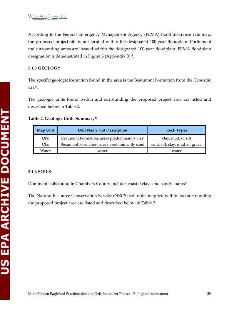
The specific geologic formation found in the area is the Beaumont Formation from the Cenozoic Era24.
The geologic units found within and surrounding the proposed project area are listed and described below in Table 2.
Table 2. Geologic Units Summary25
Map Unit Unit Name and Description Rock Types
Qbc Beaumont Formation, areas predominantly clay clay, mud, or silt Qbs Beaumont Formation, areas predominantly sand sand, silt, clay, mud, or gravel
Water water water
5.1.6 SOILS
Dominant soils found in Chambers County include: coastal clays and sandy loams18.
The Natural Resource Conservation Service (NRCS) soil units mapped within and surrounding
the proposed project area are listed and described below in Table 3.
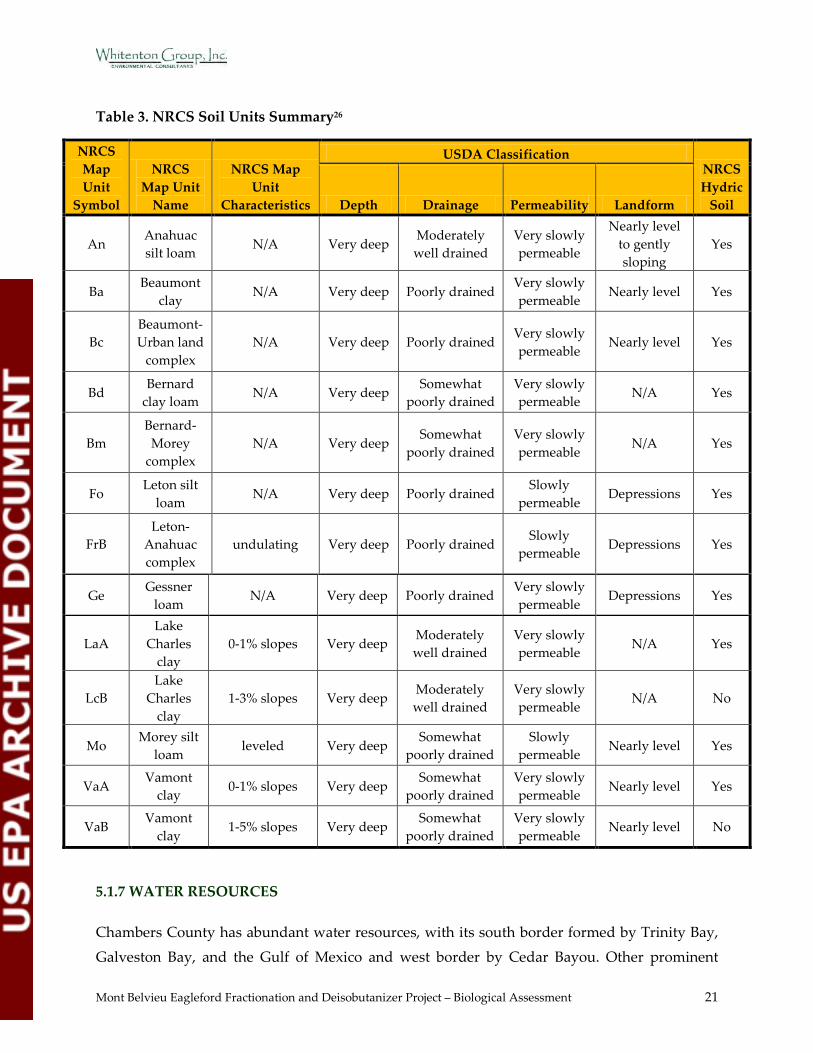
Mont Belvieu Eagleford Fractionation and Deisobutanizer Project – Biological Assessment 21
Table 3. NRCS Soil Units Summary26
NRCS Map Unit
Symbol
NRCS Map Unit
Name
NRCS Map Unit
Characteristics
USDA Classification NRCS Hydric
Soil Depth Drainage Permeability Landform
An Anahuac silt loam
N/A Very deep Moderately well drained
Very slowly permeable
Nearly level to gently sloping
Yes
Ba Beaumont
clay N/A Very deep Poorly drained
Very slowly permeable
Nearly level Yes
Bc Beaumont-Urban land
complex N/A Very deep Poorly drained
Very slowly permeable
Nearly level Yes
Bd Bernard
clay loam N/A Very deep
Somewhat poorly drained
Very slowly permeable
N/A Yes
Bm Bernard-Morey
complex N/A Very deep
Somewhat poorly drained
Very slowly permeable
N/A Yes
Fo Leton silt
loam N/A Very deep Poorly drained
Slowly permeable
Depressions Yes
FrB Leton-
Anahuac complex
undulating Very deep Poorly drained Slowly
permeable Depressions Yes
Ge Gessner
loam N/A Very deep Poorly drained
Very slowly permeable
Depressions Yes
LaA Lake
Charles clay
0-1% slopes Very deep Moderately well drained
Very slowly permeable
N/A Yes
LcB Lake
Charles clay
1-3% slopes Very deep Moderately well drained
Very slowly permeable
N/A No
Mo Morey silt
loam leveled Very deep
Somewhat poorly drained
Slowly permeable
Nearly level Yes
VaA Vamont
clay 0-1% slopes Very deep
Somewhat poorly drained
Very slowly permeable
Nearly level Yes
VaB Vamont
clay 1-5% slopes Very deep
Somewhat poorly drained
Very slowly permeable
Nearly level No
5.1.7 WATER RESOURCES
Chambers County has abundant water resources, with its south border formed by Trinity Bay,
Galveston Bay, and the Gulf of Mexico and west border by Cedar Bayou. Other prominent
Mont Belvieu Eagleford Fractionation and Deisobutanizer Project – Biological Assessment 22
water features in the area include Dutton Lake, Old River Lake, Lake Charlotte, Lake Anahuac, the Lost River, and the Trinity River. The low, flat topography invites freshwater and tidal
influence to create a variety of aquatic ecosystems mentioned above in Section 5.1.1 General Region Information18.
The watersheds or river basins that contribute water resources into the areas adjacent to the
survey area are the San Jacinto, Trinity San Jacinto, and the Trinity. The proposed project site is located within the Trinity San Jacinto, and the Trinity27.
According to the Texas Parks and Wildlife Department (TPWD) available digital data, Old River (0.5 mile east of the survey area) and the Trinity River (seven miles east of the survey
area) are designated as Ecologically Unique River and Stream Segments28.
Based on the background review, the water resources in the survey area include wetlands, irrigation and drainage canals, ponds, and streams. The San Jacinto River is approximately 6.5
miles west of the survey area. The Trinity River is approximately seven miles east of the survey area. Alligator Bayou, Cedar Bayou, Cotton Lake, Lake Anahuac, Lake Charlotte, Lost Lake,
Lost River, Old River Lake, Scott Bay and Trinity Bayou occur within 10 miles of the survey area.
The USFWS National Wetland Inventory (NWI) data within, and immediately adjacent to, the
proposed project area is demonstrated in Figure 5 (Appendix B)29.
5.1.8 VEGETATION
Historically, the native plant community of the region was Coastal Prairie, which is a tallgrass prairie with scattered trees. Most of the native coastal prairie is now pastureland, cropland, or
residential, urban, commercial, and industrial development16.
According to the Texas State Historical Association, common plant communities in the county include tallgrasses, live oaks, cypress, pine, and bottomland hardwoods18.
5.2 PROTECTED SPECIES
5.2.1 THREATENED OR ENDANGERED SPECIES LIST
Threatened, endangered, and candidate species listed by the USFWS and TPWD as having the
potential to occur in Chambers County30, 31 are provided in Table 4.
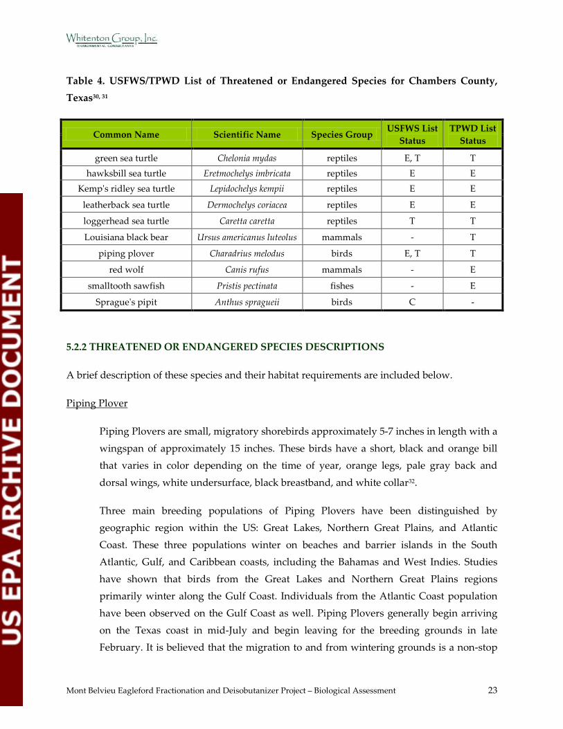
Mont Belvieu Eagleford Fractionation and Deisobutanizer Project – Biological Assessment 23
Table 4. USFWS/TPWD List of Threatened or Endangered Species for Chambers County, Texas30, 31
Common Name Scientific Name Species Group USFWS List
Status TPWD List
Status
green sea turtle Chelonia mydas reptiles E, T T hawksbill sea turtle Eretmochelys imbricata reptiles E E
Kemp's ridley sea turtle Lepidochelys kempii reptiles E E
leatherback sea turtle Dermochelys coriacea reptiles E E
loggerhead sea turtle Caretta caretta reptiles T T
Louisiana black bear Ursus americanus luteolus mammals - T
piping plover Charadrius melodus birds E, T T
red wolf Canis rufus mammals - E
smalltooth sawfish Pristis pectinata fishes - E
Sprague's pipit Anthus spragueii birds C -
5.2.2 THREATENED OR ENDANGERED SPECIES DESCRIPTIONS
A brief description of these species and their habitat requirements are included below.
Piping Plover
Piping Plovers are small, migratory shorebirds approximately 5-7 inches in length with a
wingspan of approximately 15 inches. These birds have a short, black and orange bill that varies in color depending on the time of year, orange legs, pale gray back and
dorsal wings, white undersurface, black breastband, and white collar32.
Three main breeding populations of Piping Plovers have been distinguished by geographic region within the US: Great Lakes, Northern Great Plains, and Atlantic
Coast. These three populations winter on beaches and barrier islands in the South Atlantic, Gulf, and Caribbean coasts, including the Bahamas and West Indies. Studies
have shown that birds from the Great Lakes and Northern Great Plains regions primarily winter along the Gulf Coast. Individuals from the Atlantic Coast population
have been observed on the Gulf Coast as well. Piping Plovers generally begin arriving
on the Texas coast in mid-July and begin leaving for the breeding grounds in late February. It is believed that the migration to and from wintering grounds is a non-stop
Mont Belvieu Eagleford Fractionation and Deisobutanizer Project – Biological Assessment 24
effort. Few birds remain on the Texas coast year round, but they are thought to be non-breeders32.
Wintering habitat includes foraging and roosting habitat types. Preferred foraging habitat includes wet sand in the wash zone, bare to sparsely vegetated, intertidal ocean
beaches, wrack lines, shorelines of streams, ephemeral ponds, lagoons, salt marshes,
emergent seagrass beds, wash-over passes, mudflats, sandflats, or algal flats. Most preferred foraging habitats are dynamic systems that fluctuate with the tide and wind.
Preferred roosting habitat includes sandy beaches, often with cover such as driftwood, seaweed clumps, small dunes, and debris. Spoil islands along the Intracoastal Waterway
are known to be utilized by this species. Piping Plovers are known to occupy similar
habitats as other shorebirds such as Willets, Ruddy Turnstones, Dowitchers, Sandpipers, American Oystercatchers, and other plovers32,33.
These shorebirds forage on exposed beach substrates, pecking for prey at or just below the substrate surface. They feed on marine worms, beetles, flies, spiders, aquatic
invertebrates, crustaceans, and mollusks, as well as their eggs and larvae32.
Sprague’s Pipit
Sprague’s pipits are small, migratory passerines with a slender shape and relatively
narrow bill. Their underparts are brown with broad black streaks. Legs are yellowish to pale brown. The upper mandible is dark and contrasts with the pale lower mandible34.
The only population of Sprague’s pipit occurs within North America. Known breeding sites are located in Canada, Montana, North and South Dakota, and Minnesota.
Wintering grounds are located in Arizona, New Mexico, Texas, Oklahoma, Arkansas,
Mississippi, Louisiana, and northern Mexico. Migration occurs in April to May and September to November34.
Preferred habitat includes well drained, open grasslands with native midgrasses of intermediate thickness and with moderate litter depths. Preferred grasslands are
undisturbed. Grazing, prescribed burning, or mowing can be tolerated after one year.
Food primarily consists of arthropods, but occasionally seeds. Nests are a cup shape on the ground, made of woven dried grasses. Average clutch size is 4.5 and young are
cared for by the female for approximately 25 days until fledging34.

Mont Belvieu Eagleford Fractionation and Deisobutanizer Project – Biological Assessment 25
Smalltooth Sawfish
Smalltooth sawfish are large elasmobranchs. They have a body similar to shark with
ventral gill slits like a ray. Most notable is the long, flat snouts with pairs of teeth along the edges. Smalltooth sawfish can grow up to 25 feet in length35.
The toothed snout is used to locate, stun, and kill fish and crustaceans. These sawfish are
ovoviviparous, usually with litters of 15-20 pups35.
Preferred habitat includes shallow coastal seas and estuaries with muddy and sandy
bottoms. They are typically found close to shore, in sheltered bays and on shallow banks35.
The US population of smalltooth sawfish is found in the Gulf of Mexico and Atlantic
Ocean. Historically, these sawfish could be found throughout the Gulf of Mexico. Today, their range has shrunk to peninsular Florida35.
Hawksbill Sea Turtle
The USFWS describes the hawksbill sea turtle as a small to medium-sized marine turtle
with a reddish-brown carapace. The head is relatively small with a distinctive hawk-like beak. The adult hawksbill is commonly 2.5 feet in length and weighs between 95 to 165
pounds36.
Hawksbill hatchlings live in a pelagic environment, specifically in the weedlines that accumulate at convergence zones. Juveniles will return to a coastal environment when
their carapace reaches approximately 20-25 centimeters in length. Juveniles and adults will spend most of their time in their primary foraging habitat, coral reefs. The hawksbill
feeds primarily on sponges36.
Hawksbill turtle nesting occurs sometime between April and November. Nesting is nocturnal and occurs every 2 to 3 years, 4 to 5 times per season, approximately every 14
days. Preferred nesting habitat includes low and high energy beaches in tropical oceans. Nesting habitat is often shared with green sea turtles. Hawksbills can traverse beaches
limited to other species of sea turtles with their ability to traverse fringe reefs.
Hawksbills have a tolerance for a variety of nesting substrates and often build their nests under vegetation36.

Mont Belvieu Eagleford Fractionation and Deisobutanizer Project – Biological Assessment 26
The hawksbill is found in tropical and subtropical waters of the Atlantic, Pacific, and Indian Oceans. Hawksbills are typically associated with rocky areas and coral reefs in
water less than 65 feet. Mexico is now considered the most important region for hawksbills in the Caribbean yielding 3,000 to 4,500 nests/year. The Hawksbill is an
occasional visitor to the Texas coast36.
Loggerhead Sea Turtle
The loggerhead sea turtle is reddish-brown marine turtle characterized by a large head
with blunt jaws. Adults can be up to 500 pounds and 4 feet in length. Adult loggerheads feed on jellyfish, floating egg clusters, flying fishes, mollusks, crustaceans, and other
marine animals37.
Loggerheads occupy three ecosystems according to lifestage: terrestrial zone, neritic zone, and oceanic zone. The terrestrial zone is occupied briefly during nesting and
hatching activities. Hatchlings move out to the oceanic zone until their carapace reaches approximately 40-60 centimeters in length. Juveniles and adults primarily occupy the
neritic zone (nearshore marine environment)37.
The nesting season in the US is May through August. Nesting occurs every 2 to 3 years
and is mostly nocturnal. Females can nest up to 5 times per season at intervals of
approximately 14 days. Hatchling emergence is mostly nocturnal. Loggerheads nest on oceanic beaches between the high tide line and dune fronts and occasionally on
estuarine shorelines with suitable sand. Females prefer narrow, steeply sloped, coarse-grained beaches37.
Distribution of the loggerhead includes the temperate and tropical regions of the
Atlantic, Pacific, and Indian Oceans. Although the majority (~80%) of the US nesting activity occurs in south Florida, loggerheads nest along the Gulf and Atlantic coastlines
from Texas to Virginia. Loggerheads are considered an occasional visitor to Texas37.
Kemp’s Ridley Sea Turtle
The Kemp’s ridley sea turtle is considered the smallest sea turtle with an olive-gray
carapace and a triangular shaped head and a hooked beak. Adults can grow to about 2 feet in length and weigh up to 100 pounds. This turtle is a shallow water benthic feeder

Mont Belvieu Eagleford Fractionation and Deisobutanizer Project – Biological Assessment 27
with a diet consisting primarily of shrimp, jellyfish, snails, sea stars, and swimming crabs38.
Kemp’s ridleys, similar to loggerhead sea turtles, occupy three ecosystems according to lifestage: terrestrial zone, neritic zone, and oceanic zone. The terrestrial zone is occupied
briefly during nesting and hatching activities. Hatchlings move out to the oceanic zone
for an average of 2 years. Juveniles and adults primarily occupy the neritic zone (nearshore marine environment)38.
Most nesting occurs on the eastern coast of Mexico, however a small number consistently nest at Padre Island National Seashore in Texas and various other locations
along the Gulf and lower Atlantic coasts. Nesting occurs from May to July during
daylight hours. Large numbers of females emerge for a synchronized nesting event referred to as “arribada”. Arribadas are thought to be caused by female pheromone
release, offshore winds, and/or lunar cycles. Females nest up to 4 times per season at intervals of 10 to 28 days. The preferred nesting beaches are adjacent to extensive
swamps or large bodies of open water38.
The Kemp’s ridley turtles range includes the Gulf coasts of Mexico and the US, and the
Atlantic coast of North America as far north as Nova Scotia and Newfoundland38.
Green Sea Turtle
The green sea turtle can grow to 4 feet in length and reported weights vary from 350-850
pounds. The carapace is smooth and keelless, and the color varies with shades of black, gray, green, brown, and yellow. Adults are herbivorous. Hatchlings are omnivorous39.
Greens occupy three ecosystems according to lifestage: terrestrial zone, neritic zone, and
oceanic zone. The terrestrial zone is occupied briefly during nesting and hatching activities. Hatchlings move out to the oceanic zone until their carapace reaches
approximately 20-25 centimeters in length. Juveniles and adults primarily occupy benthic feeding grounds in shallow, protected waters. Preferred feeding grounds
include pastures of seagrasses and/or algae39.
Green turtles have a worldwide distribution in tropical and subtropical waters. The nesting season in the southeastern US is June through September. Nesting is nocturnal
and occurs in 2, 3, or 4-year intervals. Females nest an average of 5 times per season at 14
Mont Belvieu Eagleford Fractionation and Deisobutanizer Project – Biological Assessment 28
day intervals. Hatchlings typically emerge at night. Approximately 200 to 1,100 females are estimated to nest on US beaches. Nesting occurs on high energy oceanic beaches,
primarily on islands with minimal disturbance. Green turtles return to the same nesting sight and are known to travel long distances between foraging areas and nesting
beaches39.
Leatherback Sea Turtle
The leatherback sea turtle is the largest sea turtle. The adult leatherback can get up to 8
feet in length and up to 2000 pounds. The turtle lacks a “normal” turtle shell and is covered by firm, rubbery skin that is approximately 4 inches thick. Coloration is
predominantly black with varying degrees of pale spotting; including a notable pink
spot on the dorsal surface of the head in adults. Diet is primarily jellyfish and salp, but it is also known to feed on sea urchins, squid, crustaceans, tunicates, fish, blue-green algae,
and floating seaweed40.
Leatherbacks are highly migratory and the most pelagic of all sea turtles. Females prefer
high energy, sandy beaches with vegetation immediately upslope and a beach sloped sufficiently so the crawl to dry sand is not too far. Preferred beaches have deep,
unobstructed oceanic access on continental shorelines40.
In the United States, nesting occurs from March to July. Females nest on average 6 times per season at 10 day intervals. Most leatherbacks return to their nesting beaches at 2 to 3-
year intervals40.
Distribution is worldwide in tropical and temperate waters of the Atlantic, Pacific, and
Indian Oceans. The leatherback is also found in small numbers as far north as British
Columbia, Newfoundland, and the British Isles and as far south as Australia and Argentina. The leatherback has a small presence in the US with most nesting occurring
on the Florida east coast, Sandy Point, US Virgin Islands, and Puerto Rico40.
Louisiana Black Bear
The Louisiana black bear (LBB) is a large mammal with long black hair and a short tail.
The facial profile is blunt, eyes small, and a broad nose pad with large nostrils. The muzzle of the LBB is yellowish-brown. Some bears have a white patch on the lower

Mont Belvieu Eagleford Fractionation and Deisobutanizer Project – Biological Assessment 29
throat and chest. Adult males are typically larger, ranging from 300-400 pounds. Adult females range in weight from 120-180 pounds. The LBB is 4 to 7 feet in length41.
Originally, LBB were known to occur in the forests of eastern Texas, Louisiana, and Mississippi. They typically inhabit bottomland hardwood forests. Other habitat types
the LBB utilizes include brackish and freshwater marshes, salt domes, and agricultural
fields. These bears require large, remote tracts of land with minimal human disturbance. The last known populations in eastern Texas were in the swamps and thickets of the Big
Thicket region of southeast Texas. Today, LBBs primarily occur within the boundaries of the state of Louisiana. The largest concentration exists in the Atchafalaya River and
Tensas River Basins41.
LBBs are opportunistic feeders with a diet that may consist of acorns, berries, carrion, and insect larvae. In addition the bears may feed on agricultural products such as corn,
wheat, and sugarcane41.
The breeding period for LBBs is the summer. Females begin breeding around 3 years of
age and have a gestation period of 7 or 8 months. Litter size ranges from 1 to 4 being born every other year in January or February41.
Red Wolf
The red wolf is one of only two wolf species in the world. Their fur is a reddish color and they are smaller in size than the gray wolf. The average adult red wolf grows up to
4 feet in length and 50-80 pounds42.
Originally, the red wolves were found throughout the southeastern US. The USFWS
declared the red wolf extinct in the wild in 1980. In 1987, captive individuals were
released to the wild in North Carolina. This reintroduced population is reportedly thriving and growing42.
Red wolves feed on rabbits, deer, raccoons, and rodents. They live in packs of 5-8, which typically consists of one breeding pair and their offspring42. Little information is
available describing red wolf preferred habitat characteristics.
According to the USFWS, there is no designated critical habitat for any of the federally-listed threatened and endangered species within at least 15 miles of the survey area43.
Mont Belvieu Eagleford Fractionation and Deisobutanizer Project – Biological Assessment 30
5.2.3 TEXAS NATURAL DIVERSITY DATABASE RESULTS
A records review of the Texas Natural Diversity Database (TNDD) was completed for the
proposed project area and surrounding areas by the TPWD on 20 February 2012. No elements of occurrence (EO) are located within the proposed project area. The EO closest to the proposed
project area (EO ID 1808) is approximately 8.3 miles to the east and is listed as a bald eagle last
observed in 199644.
5.2.4 MARINE MAMMAL HABITAT
Marine mammals are ecologically restricted to marine and estuarine habitats. The closest marine or estuarine habitat to the project area (Trinity Bay) is approximately 10 miles to the
south. Marine mammals with the potential to occur in Trinity Bay, as well as the entire
Galveston Bay system, include bottlenose dolphins and West Indian manatees. Bottlenose dolphins are fairly common within the Galveston Bay system. West Indian manatees are a rare
occurrence. The last known occurrence found was in 199545.
6.0 PROTECTED SPECIES HABITAT EVALUATION
WGI completed a protected species habitat evaluation on 1 May 2012 to determine if habitat
within the project area was likely to support any of the federally-protected species potentially occurring in Chambers County. The field surveys included a pedestrian survey of the proposed
project area and the portions of the surrounding facility that are not restricted by stringent
safety requirements. The field surveys also included a windshield survey of all terrestrially accessible habitats visible from public areas within a three-mile radius of the project area. The
majority of the lands within the three-mile radius are privately-owned and not visible or accessible from public areas. An aerial survey was conducted of the three-mile radius to observe
the inaccessible areas and survey for the presence of bald or golden eagles or evidence of their
nests. Data were collected to describe resident vegetation communities and assess the potential for occurrence of protected species. The dominant habitats observed are described below and
demonstrated in Figure 6 (Appendix B). Photographs of the proposed project area and accessible surrounding areas are included as Appendix C. A summary of the field survey data
is provided in Appendix D.
Mont Belvieu Eagleford Fractionation and Deisobutanizer Project – Biological Assessment 31
6.1 PLANT COMMUNITIES OBSERVED
The proposed project area is previously disturbed by industrial activities. The northwest corner
of the project area is maintained pastureland. The northeast corner is an active flare stack and adjacent pit. The remainder of the project area is currently being utilized as a staging area for
the construction of Frac VI. The staging area consists of road base, temporary buildings,
vehicles, and equipment. No vegetation was observed in the staging area.
Immediately to the east of the project area is a brine pond. Immediately to the south are
Fractionator VI (under construction) and Fracs IV and V. To the north are drainage canals, industrial ponds, and an industrial facility. To the west are agricultural fields. The majority of
the Mont Belvieu Complex is industrial infrastructure, concrete, caliche, or asphalt.
Cedar Bayou has been straightened in this area and is not likely tidal within the three-mile radius. The remaining oxbows from the previous Cedar Bayou channel appear to have little to
no hydrologic connection to the current Cedar Bayou channel. These oxbows appear to be functioning as open waters or wetlands. Cedar Bayou is approximately 1.95 miles to the south-
southwest of the project area at its closest point.
The dominant habitats observed in the areas surrounding the Mont Belvieu Complex include: wetland, pastureland, mixed woodland, open water, and canals. A significant portion of these
habitats have historically been manipulated or impacted by industrial and agricultural development.
Wetland – This habitat is a mosaic of emergent, scrub-shrub, and forested wetlands. This habitat includes some Cedar Bayou oxbows. Dominant species observed within the
wetland mosaic included Fraxinus pennsylvanica (green ash), Juncus effusus (common
rush), Saccharum giganteum (sugarcane plumegrass), Triadica sebifera (Chinese tallow), Baccharis halimifolia (eastern baccharis), Typha latifolia (broadleaf cattail), and Panicum
repens (torpedo grass). Dominant species observed within or on the banks of some Cedar Bayou oxbows included Taxodium distichum (bald cypress), Quercus nigra (water oak),
Liquidambar styraciflua (sweetgum), Nuphar lutea (yellow pond-lily), Rhynchospora
corniculata (shortbristle horned beaksedge), Cyperus odoratus (fragrant flatsedge), and Cephalanthus occidentalis (buttonbush).
Pastureland – This habitat is primarily maintained and dominated by non-native species. Dominant species observed included Cynodon dactylon (bermudagrass), Verbena
Mont Belvieu Eagleford Fractionation and Deisobutanizer Project – Biological Assessment 32
brasiliensis (Brazilian vervain), Paspalum dilatatum (dallisgrass), Rubus trivialis (southern dewberry), and Coreopsis basalis (coreopsis).
Mixed woodland – This habitat is includes woodland communities dominated by Chinese tallow, willow oak, or loblolly pine. Woodlands observed are small to medium,
fragmented tracts subject to disturbance from utility lines and industrial and agricultural
development. Dominant species observed collectively include Chinese tallow, Quercus phellos (willow oak), Pinus taeda (loblolly pine), Celtis laevigata (sugar hackberry), Melia
azedarach (Chinaberry), Quercus falcata (southern red oak), Campsis radicans (trumpet creeper), Ligustrum sinense (Chinese privet), Sabal minor (dwarf palmetto), and Smilax
rotundifolia (common greenbrier).
Open water – This habitat includes man-made retention ponds, brine ponds, irrigation ponds, and some Cedar Bayou oxbows. Dominant species observed along the banks of
ponds (if vegetated) included bermudagrass, Cyperus entrerianus (woodrush flatsedge), and Stenotaphrum secundatum (St. Augustine grass). Dominant species observed along
the banks of the Cedar Bayou oxbows included bermudagrass, Carex cherokeensis (Cherokee sedge), Sorghum halepense (Johnsongrass), water oak, sweetgum, Chinese
tallow, Acer negundo (boxelder), green ash, and dwarf palmetto.
Riverine – This habitat includes Cedar Bayou. Dominant species observed included bermudagrass, Cherokee sedge, Johnsongrass, Chinese tallow, boxelder, green ash, and
dwarf palmetto.
Canals – This habitat includes man-made drainage, flood control, and irrigation canals.
The banks of these canals are maintained and dominated by bermudagrass, woodrush
flatsedge, and St. Augustine grass.
6.2 PROTECTED SPECIES HABITAT ANALYSIS
The green, hawksbill, Kemp’s ridley, leatherback, loggerhead sea turtles, smalltooth sawfish, as well as marine mammals, are restricted to marine or estuarine environments. There are no
marine or estuarine environments within at least 10 miles of the project area. Habitat with the
potential to support any of these species does not exist in or near the project area.

Mont Belvieu Eagleford Fractionation and Deisobutanizer Project – Biological Assessment 33
The proposed project area consists of maintained pastureland, roadbase, temporary buildings, and a flare stack and pit. The potential exists for migratory birds to utilize the maintained
pastureland. This area does not possess habitat with the potential to support any additional federally-protected species. Land use and habitat types outside the proposed project area
include industrial and agricultural development, wetland, pastureland, mixed woodland, open
water, riverine, and canals. The areas surrounding the project location have historically been impacted by industrial and agricultural activities.
Industrial development areas are typically comprised of mainly impervious cover with minimal vegetation on site. Therefore, these areas are not likely to support any federally-protected
species.
Agricultural areas have the potential to support migratory birds. Habitat to support federally-protected species other than migratory birds is not likely to occur in agricultural areas.
The wetland habitat observed is a mosaic of emergent, scrub-shrub, and forested wetlands. This habitat also includes some Cedar Bayou oxbows, which are inundated emergent wetlands with
scattered trees or shrubs. Based on the historic aerial photography and the pedestrian survey, this habitat has historically been impacted by utilty lines, industrial development, and stream
channelization. The observable quality of this habitat ranges from low to moderate. The
wetland habitat areas have the potential to support migratory birds, bald or golden eagles, and other wildlife. Various migratory birds, including songbirds and hawks, were observed in or
near this habitat. No bald or golden eagles or their nests were observed in or near this habitat.
The pastureland habitat is primarily maintained and dominated by non-native species. The
observable quality of this habitat ranges from low to moderate. The potential exists for
migratory birds, bald or golden eagles, and other wildlife to utilize this habitat. The potential exists for Sprague’s pipit to utilize this habitat during winter months. However, the potential is
minimal as these birds prefer undisturbed native grasslands. Various migratory birds, including songbirds and hawks, were observed in or near this habitat. No bald or golden eagles or their
nests were observed in or near this habitat.
The woodland habitat includes communities dominated by Chinese tallow, willow oak, or loblolly pine. Woodlands observed are small to medium, fragmented tracts subject to
disturbance from utility lines and industrial and agricultural development. The observable quality of this habitat ranges from low to moderate. The potential exists for migratory birds,
bald or golden eagles, and other wildlife to utilize the mixed woodland habitat. Although some

Mont Belvieu Eagleford Fractionation and Deisobutanizer Project – Biological Assessment 34
characteristics of these mixed woodlands meet the qualifications for LBB habitat, these woodlands are not large enough, not continuous, and are frequently subject to human
disturbance. These woodlands would not likely support LBB. Various migratory birds, including songbirds and hawks, were observed in or near this habitat. No bald or golden eagles
or their nests were observed in or near this habitat.
The open water habitat includes man-made retention ponds, brine ponds, irrigation ponds, and some Cedar Bayou oxbows. Many of these ponds support adjacent industrial facilities. The
observable quality of these open water habitats ranges from low to moderate. The potential exists for migratory birds, bald or golden eagles, and other wildlife to utilize this habitat. The
potential exists for Sprague’s pipit to utilize this habitat during winter months. However, the
potential is minimal as these birds prefer undisturbed native grasslands, which are not present in this area. Various migratory birds, including songbirds and hawks, were observed in or near
this habitat. No bald or golden eagles or their nests were observed in or near this habitat.
The riverine habitat includes Cedar Bayou. Based on the historic aerial photography and
topographic maps, this stream has been straightened and has been historically impacted by industrial and agricultural development. Multiple outfall structures exist along this stream. The
observable quality of this habitat ranges from low to moderate. Cedar Bayou is neither tidal nor
a designated navigable water of the US within at least 3 miles of the project area. The potential exists for migratory birds, bald or golden eagles, and other wildlife to utilize this habitat.
Various migratory birds, including songbirds and hawks, were observed in or near this habitat. No bald or golden eagles or their nests were observed in or near this habitat.
The canal habitat includes man-made drainage, flood control, and irrigation canals. The
observable quality of this habitat ranges from low to moderate. The potential exists for migratory birds, bald or golden eagles, and other wildlife to utilize this habitat. Various
migratory birds, including songbirds and hawks, were observed in or near this habitat. No bald or golden eagles or their nests were observed in or near this habitat.

Mont Belvieu Eagleford Fractionation and Deisobutanizer Project – Biological Assessment 35
7.0 AIR QUALITY ANALYSIS RESULTS
7.1 ESTIMATED TOTAL ANNUAL EMISSION RATE OVERVIEW
PSD review is triggered for CO. A State NAAQS analysis is required for NO2, SO2, PM10, and PM2.5. The proposed emissions of SO2 and H2S are also subject to review under 30 TAC Chapter
112. Speciated VOC compounds require a health effects evaluation and comparison to the TCEQ ESL.
RPS completed detailed pollutant emission calculations for the Enterprise project in accordance
with the PSD and State NAAQS analysis requirements. This BA does not include detailed estimated emission rates. Estimated emission rates and descriptions of emission calculation
methods are available upon request.
A summary, provided by RPS, of the total estimated annual emission for PSD criteria pollutants
that would be emitted by the proposed project are provided in Table 5.
Table 5. Emission Point Summary
Emission Point Description Air Pollutant Name Air Pollutant Emission Rate
(Tons per Year)
Hot Oil Heater (2)
NOx 15.33
SO2 1.52
PM 2.45
CO 27.36
VOC 1.23
Regenerant Heater (2)
NOx 3.12
SO2 0.31
PM 0.62
CO 5.57
VOC 0.25
Refrigerant Condenser (2)
PM 1.44
PM10 0.99
PM2.5 0.38
Frac A Process Fugitives VOC 2.00
Frac B Process Fugitives VOC 2.00
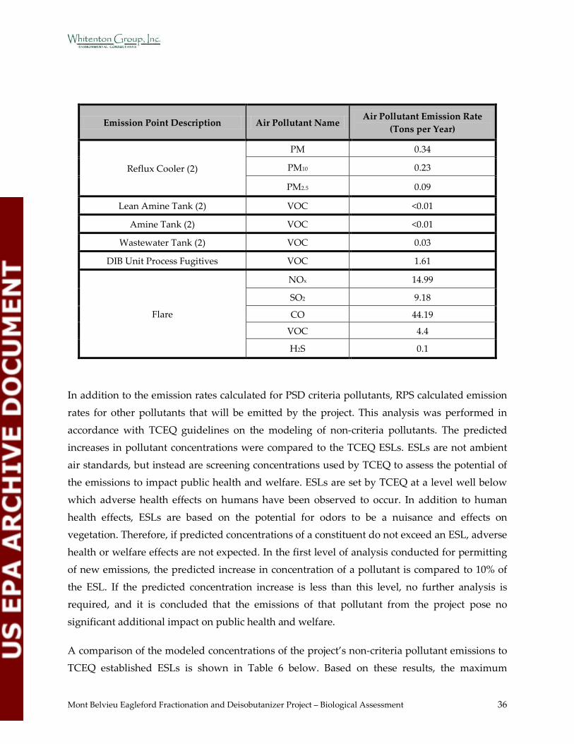
Mont Belvieu Eagleford Fractionation and Deisobutanizer Project – Biological Assessment 36
Emission Point Description Air Pollutant Name Air Pollutant Emission Rate
(Tons per Year)
Reflux Cooler (2)
PM 0.34
PM10 0.23
PM2.5 0.09
Lean Amine Tank (2) VOC <0.01
Amine Tank (2) VOC <0.01
Wastewater Tank (2) VOC 0.03
DIB Unit Process Fugitives VOC 1.61
Flare
NOx 14.99
SO2 9.18
CO 44.19
VOC 4.4
H2S 0.1
In addition to the emission rates calculated for PSD criteria pollutants, RPS calculated emission
rates for other pollutants that will be emitted by the project. This analysis was performed in
accordance with TCEQ guidelines on the modeling of non-criteria pollutants. The predicted increases in pollutant concentrations were compared to the TCEQ ESLs. ESLs are not ambient
air standards, but instead are screening concentrations used by TCEQ to assess the potential of the emissions to impact public health and welfare. ESLs are set by TCEQ at a level well below
which adverse health effects on humans have been observed to occur. In addition to human
health effects, ESLs are based on the potential for odors to be a nuisance and effects on vegetation. Therefore, if predicted concentrations of a constituent do not exceed an ESL, adverse
health or welfare effects are not expected. In the first level of analysis conducted for permitting of new emissions, the predicted increase in concentration of a pollutant is compared to 10% of
the ESL. If the predicted concentration increase is less than this level, no further analysis is required, and it is concluded that the emissions of that pollutant from the project pose no
significant additional impact on public health and welfare.
A comparison of the modeled concentrations of the project’s non-criteria pollutant emissions to TCEQ established ESLs is shown in Table 6 below. Based on these results, the maximum
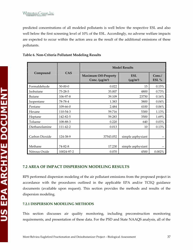
Mont Belvieu Eagleford Fractionation and Deisobutanizer Project – Biological Assessment 37
predicted concentrations of all modeled pollutants is well below the respective ESL and also well below the first screening level of 10% of the ESL. Accordingly, no adverse welfare impacts
are expected to occur within the action area as the result of the additional emissions of these pollutants.
Table 6. Non-Criteria Pollutant Modeling Results
Compound CAS
Model Results
Maximum Off-Property Conc. (µg/m3)
ESL (µg/m3)
Conc./ ESL %
Formaldehyde 50-00-0 0.022 15 0.15% Isobutane 75-28-5 35.007 4800 0.73% Butane 106-97-8 39.109 23750 0.16% Isopentane 78-78-4 1.383 3800 0.04% Pentane 109-66-0 2.484 4100 0.06% Hexane 110-54-3 59.716 5300 1.13% Heptane 142-82-5 59.283 3500 1.69% Toluene 108-88-3 0.220 640 0.03% Diethanolamine 111-42-2 0.013 10 0.13%
Carbon Dioxide 124-38-9 37543.052 simple asphyxiant --
Methane 74-82-8 17.230 simple asphyxiant -- Nitrous Oxide 10024-97-2 0.070 4500 0.002%
7.2 AREA OF IMPACT DISPERSION MODELING RESULTS
RPS performed dispersion modeling of the air pollutant emissions from the proposed project in accordance with the procedures outlined in the applicable EPA and/or TCEQ guidance
documents (available upon request). This section provides the methods and results of the dispersion modeling.
7.2.1 DISPERSION MODELING METHODS
This section discusses air quality monitoring, including preconstruction monitoring requirements, and presentation of these data. For the PSD and State NAAQS analysis, all of the
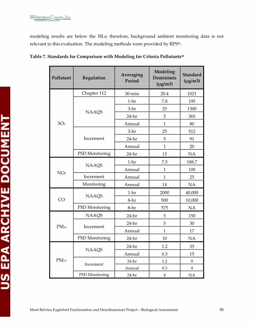
Mont Belvieu Eagleford Fractionation and Deisobutanizer Project – Biological Assessment 38
modeling results are below the SILs; therefore, background ambient monitoring data is not relevant to this evaluation. The modeling methods were provided by RPS46.
Table 7. Standards for Comparison with Modeling for Criteria Pollutants46
Pollutant Regulation Averaging Period
Modeling Deminimis
(µg/m3)
Standard (µg/m3)
SO2
Chapter 112 30-min 20.4 1021
NAAQS
1-hr 7.8 195 3-hr 25 1300
24-hr 5 365 Annual 1 80
Increment 3-hr 25 512
24-hr 5 91 Annual 1 20
PSD Monitoring 24-hr 13 NA
NO2 NAAQS
1-hr 7.5 188.7 Annual 1 100
Increment Annual 1 25 Monitoring Annual 14 NA
CO NAAQS
1-hr 2000 40,000 8-hr 500 10,000
PSD Monitoring 8-hr 575 NA
PM10
NAAQS 24-hr 5 150
Increment 24-hr 5 30
Annual 1 17 PSD Monitoring 24-hr 10 NA
PM2.5
NAAQS 24-hr 1.2 35
Annual 0.3 15
Increment 24-hr 1.2 9
Annual 0.3 4 PSD Monitoring 24-hr 4 NA
Mont Belvieu Eagleford Fractionation and Deisobutanizer Project – Biological Assessment 39
The model parameters specified for the modeled location, such as meteorological data and receptor grids, are discussed below. The remaining modeled parameters were determined by
the EPA-recommended “regulatory default option,” which includes the use of stack-tip downwash, the effects of elevated terrain, and calms and missing data processing routines46.
7.2.1.1 AERMOD
Modeling was performed using the Advanced Monitoring Systems/EPA Regulatory Model (AERMOD) (version number 12060). The AERMOD model was chosen because it is approved
by the EPA as a Preferred/Recommended model and is approved by the TCEQ modeling staff46.
AERMOD is a steady-state plume dispersion model for assessment of pollutant concentrations
from a variety of sources. AERMOD determines concentrations from multiple point, area, or
volume sources based on an up-to-date characterization of the atmospheric boundary layer. The model employs hourly sequential preprocessed (AERMET) meteorological data to estimate
concentrations. The Oris Solutions, LLC software program, "BEEST for Windows", was used to set up the model inputs and used to perform the model runs46.
7.2.1.2 Meteorological Data
The meteorological data used in the models includes observed hourly wind speed, wind
direction, temperature and numerous other parameters. This data is used, along with other
inputs, by the models to determine the dispersion of the emissions from sources in the model input46.
AERMOD requires input from a preprocessor (AERMET) that organizes and processes meteorological data and estimates the necessary boundary layer parameters for dispersion
calculations. Several parameters are used to describe the character of the modeled domain,
including surface roughness length, albedo and Bowen ratio. These parameters are incorporated into the surface meteorological data set used by AERMOD. TCEQ has developed three separate
AERMOD-ready meteorological data sets for each county in the state. The different data sets correspond to three categories of surface roughness length46:
• Category 1 – LOW
Appropriate for flat areas with surface roughness lengths of 0.001 m - 0.1 m • Category 2 – MEDIUM
Appropriate for rural/suburban areas with surface roughness lengths of 0.1 m – 0.7 m
Mont Belvieu Eagleford Fractionation and Deisobutanizer Project – Biological Assessment 40
• Category 3 – HIGH Appropriate for urban/industrial areas with surface roughness lengths of 0.7 m - 1.5 m
To determine which land use category is appropriate, the recently released AERSURFACE preprocessor was used. As discussed in the EPA’s AERSURFACE User’s Guide (EPA-454/B-08-
001), the surface roughness length is related to the height of obstacles to the wind flow and is, in
principle, the height at which the mean horizontal wind speed is zero based on a logarithmic profile. The surface roughness length influences the surface shear stress and is an important
factor in determining the magnitude of mechanical turbulence and the stability of the boundary layer. AERSURFACE utilizes land use data available from the 1992 National Land Cover Data
(NLCD). A 1 km radius, the default, was used to determine the appropriate surface roughness
value46.
Given that the surface roughness calculated from AERSURFACE (Zo = 0.124) is within the
TCEQ’s medium roughness range, per background information document ftp://ftp.tceq.state.tx.us/pub/OPRR/APD/AERMET/AERMETv06341/BackgroundInformation/ae
rmet.pdf, the pre-processed TCEQ AERMET data corresponding to medium roughness was used46.
The preprocessed (via AERMET) meteorological data sets for 1987, 1988, 1989, 1990, and 1991
were obtained from the TCEQ. Although all pollutants evaluated besides CO are a State NAAQS analysis, the five years of meteorological data are being used due to the nature of 1-hr
NO2, 1-hr SO2, and 24-hr PM2.5 NAAQS standard, in which the preliminary impact analysis uses the highest of the 5-year averages of the maximum modeled 1-hr or 24-hr concentrations
predicted each year at each receptor, based on 5 years of National Weather Service data. To be
consistent, five years of meteorological data was used for all the criteria pollutants. For the health effects analysis and state property line analysis of H2S, the preprocessed meteorological
data for 1988 was obtained from the TCEQ. Surface meteorological data was collected from the NWS station in Houston Intercontinental (IAH), Texas (Station Number 12960) for all years to
be used in the analysis. The upper air meteorological data was obtained from the NWS station
in Lake Charles (LCH), Louisiana (Station Number 3937) for all years to be used in the analysis. The meteorological files used in the modeling are available upon request46.
7.2.1.3 Terrain
The terrain height difference between the modeled source and each receptor can vary. For each
source/receptor combination, the relationship may be characterized as flat terrain, simple

Mont Belvieu Eagleford Fractionation and Deisobutanizer Project – Biological Assessment 41
terrain, intermediate or complex terrain. This variation affects the dispersion and the relative plume height of modeled sources46.
The terrain surrounding the site is described as generally flat with some minor elevation changes. AERMAP is a preprocessor program which processes the terrain information to
provide inputs to AERMOD. AERMAP was used to process the terrain data in conjunction with
the receptor grids, downwash structures, and sources to be used in AERMOD input files46.
The receptor, source, and building base elevations were determined using data from USGS
National Elevation Dataset (NED) files and the AERMAP processing program. The output from AERMAP provides not only base elevations for the receptors, but also an effective “hill height”
that enables AERMOD to make more realistic simple to complex terrain concentration
calculations46.
7.2.1.4 Building Wake Effects
Building wake effects occur when the air flow around buildings influences the dispersion from sources in the model input, resulting in variations to air concentrations46.
A building wake (downwash) analysis was performed to determine appropriate downwash parameters for the major structure at the facility. Downwash parameters were calculated using
the Oris Software’s BPIP-PRIME (Dated: 04112) Program. Only structures that are solid all the
way to ground level were included in the downwash analysis. The emission point locations and heights for downwash structures are available upon request46.
7.2.1.5 Receptor Grid
The receptor grid defines the locations at which the concentrations are calculated based on the
dispersion of the emissions from the sources in the model input46.
The receptor grid used to determine maximum off-property concentrations is an array of receptors with spacing of 25 and 100 meters. The modeling receptor grid was designed to
sufficiently capture the maximum predicted concentrations and any exceedances at those locations. The modeling receptor grids were designed following TCEQ AQMG. The modeled
sources are stacks affected by building wakes and other low level fugitive sources, which
dictates the minimum 25-meter spacing of receptors. The receptor grid used for the modeling analyses was as follows46:
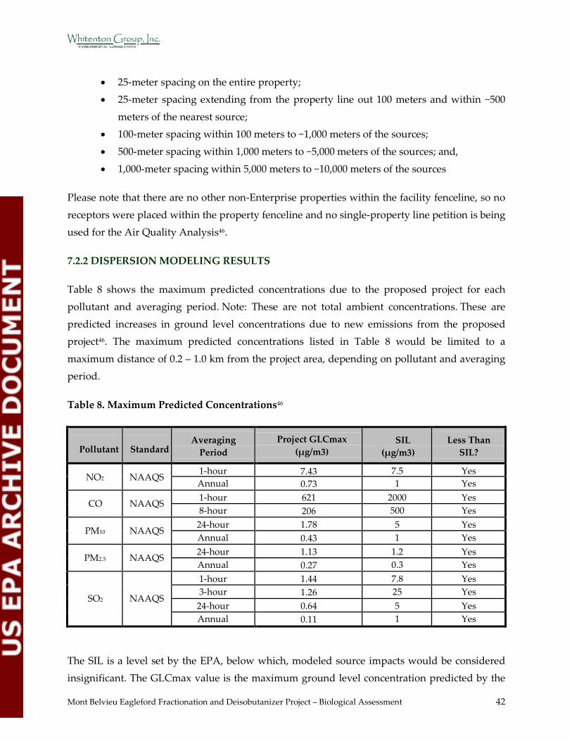
Mont Belvieu Eagleford Fractionation and Deisobutanizer Project – Biological Assessment 42
• 25-meter spacing on the entire property; • 25-meter spacing extending from the property line out 100 meters and within ~500
meters of the nearest source; • 100-meter spacing within 100 meters to ~1,000 meters of the sources;
• 500-meter spacing within 1,000 meters to ~5,000 meters of the sources; and,
• 1,000-meter spacing within 5,000 meters to ~10,000 meters of the sources
Please note that there are no other non-Enterprise properties within the facility fenceline, so no
receptors were placed within the property fenceline and no single-property line petition is being used for the Air Quality Analysis46.
7.2.2 DISPERSION MODELING RESULTS
Table 8 shows the maximum predicted concentrations due to the proposed project for each pollutant and averaging period. Note: These are not total ambient concentrations. These are
predicted increases in ground level concentrations due to new emissions from the proposed project46. The maximum predicted concentrations listed in Table 8 would be limited to a
maximum distance of 0.2 – 1.0 km from the project area, depending on pollutant and averaging period.
Table 8. Maximum Predicted Concentrations46
Pollutant
Standard
Averaging Period
Project GLCmax (µg/m3)
SIL (µg/m3)
Less Than SIL?
NO2
NAAQS 1-hour 7.43 7.5 Yes Annual 0.73 1 Yes
CO
NAAQS 1-hour 621
2000 Yes 8-hour 206
500 Yes
PM10
NAAQS 24-hour 1.78 5 Yes Annual 0.43 1 Yes
PM2.5
NAAQS 24-hour 1.13 1.2 Yes Annual 0.27 0.3 Yes
SO2
NAAQS
1-hour 1.44 7.8 Yes 3-hour 1.26 25 Yes
24-hour 0.64 5 Yes Annual 0.11 1 Yes
The SIL is a level set by the EPA, below which, modeled source impacts would be considered insignificant. The GLCmax value is the maximum ground level concentration predicted by the
Mont Belvieu Eagleford Fractionation and Deisobutanizer Project – Biological Assessment 43
model for each pollutant and averaging period resulting from this project. If a GLCmax value is less than the SIL, the modeled source impacts are considered insignificant and are not
considered to cause or contribute to a violation of a NAAQS or PSD Increment for that pollutant and averaging period. If a GLCmax is greater than the SIL, additional analysis is required to
demonstrate that the project would not cause or contribute to a violation of the NAAQS or PSD
Increment for that pollutant and averaging period.
All twelve of the project GLCmax values are less than the SIL: 1-Hour CO, 8-Hour CO, 24-Hour
PM10, annual PM10, 24-Hour PM2.5, annual PM2.5, 1-Hour NO2, annual NO2, 1-Hour SO2, 3-Hour SO2, 24-Hour SO2, and annual SO2. These twelve source impacts are considered insignificant
based on stringent limits set to protect the most sensitive human populations. Therefore, these
twelve source impacts are not expected to impact federally-protected species and will be excluded from further analysis.
Based on the methods and inputs described in Section 7.2.1, the dispersion model predicts concentrations at specific downwind receptor locations for pollutant averaging periods. Since
all pollutants and averaging periods were below the SIL at all locations outside of the Mont Belvieu Complex, the action area was determined based on the limits of other potential impacts
including the existing Mont Belvieu Complex boundaries, the proposed project construction
area, and the existing wastewater outfall structure. The construction area is demonstrated in Figure 2 (Appendix B). The outfall structure is located immediately north of the construction
area. A circle with a 0.5 mile radius completely encompasses the Complex, the project construction area, and the outfall structure. The action area is conservatively defined as the
area within this circle and is demonstrated in Figure 7 (Appendix B).
The action area was utilized to analyze the potential impacts to protected species and/or their habitat by the proposed project. The results of the analysis of potential impacts to protected
species are presented in Section 8 below.
8.0 EFFECTS OF THE PROPOSED ACTION
This section presents the results of the analysis of potential impacts to federally-protected
species as a result of the proposed project. The following impact sources are included in the analysis: air quality, water quality, noise pollution, infrastructure-related disturbance, human-
related disturbance, and federally-protected species effects. This analysis is based on total

Mont Belvieu Eagleford Fractionation and Deisobutanizer Project – Biological Assessment 44
emissions and dispersion modeling data provided by RPS, field survey and background review data collected by WGI, and literature review and research of potential effects of known
pollutants on flora and fauna.
8.1 AIR POLLUTION EFFECTS BACKGROUND RESEARCH
Resources were searched extensively for data, documentation, or research regarding the
potential effects of pollutants on flora and fauna. WGI biologists also specifically searched for concentrations and length of time of exposure at which flora and/or fauna are impacted.
However, very little information was located that included specific concentrations at which impacts occur on a long-term or short-term basis. A list of research resources is available upon
request.
According to EPA’s “A Screening Procedure for the Impacts of Air Pollution Sources on Plants, Soils, and Animals,” the data presented in Table 9 (Section 8.2.3) indicate the level, at or above
which, airborne pollutant concentrations are known to cause significant impacts on flora and fauna. Concentrations at, or in excess of, any of the screening concentrations would indicate that
the source emission may have adverse impacts on plants or animals. The estimation of potential
impacts on flora and fauna is highly variable and dependent upon site-specific conditions47.
8.2 AIR QUALITY EFFECTS
8.2.1 EMISSIONS
RPS completed detailed pollutant emission calculations for the Enterprise project in accordance
with the Air Permit Application requirements. A summary of the total proposed annual emissions of each pollutant that would be emitted by the project are provided in Table 5
(Section 7.1).
RPS also performed dispersion modeling of the emissions of air pollutants from the proposed Enterprise project in accordance with the PSD Permit requirements. The results of the modeling
are provided as a summary of the maximum predicted concentrations in Table 8 (Section 7.2.2).
The new facilities associated with the project primarily include two Frac units and one DIB unit.
PSD review is triggered for CO. A State NAAQS analysis is required for NO2, SO2, PM10, and
PM2.5. The proposed emissions of SO2 and H2S are also subject to review under 30 TAC Chapter 112. Speciated VOC compounds require a health effects evaluation and comparison to the
TCEQ ESLs.
Mont Belvieu Eagleford Fractionation and Deisobutanizer Project – Biological Assessment 45
Enterprise will utilize the BACT to control emissions from the project and thus minimize impacts to the surrounding environment to the maximum extent practicable. The proposed
emissions limits of each pollutant are consistent with both the TCEQ BACT guidance and the most stringent limits in the RBLC; and, are considered to be the top level of control available for
the new facilities.
Emissions resulting from gasoline and diesel-fueled vehicles and equipment during construction and maintenance are considered negligible. The project will not require a
significant increase in vehicle and equipment use compared to current daily emissions for the Mont Belvieu Complex.
8.2.2 FUGITIVE DUST
Dust will be emitted during the site work phase of the project. This emission will be minimal and temporary. Dust emissions are expected to be negligible after the site work activities are
completed.
8.2.3 IMPACTS OF AIR POLLUTION SOURCES ON FLORA AND FAUNA
Since SILs are concentrations that represent thresholds of insignificant modeled source impacts, the pollutant concentrations predicted to be less than or equal to the SILs are expected to have
no significant impact on flora and fauna.
The data presented in Table 9 below is taken directly from EPA’s “A Screening Procedure for the Impacts of Air Pollution Sources on Plants, Soils, and Animals.” The concentrations
presented in Table 9 reflect vegetation sensitivity only. Vegetation sensitivity was determined based on visible damage or growth effects. For the purposes of this BA, only the screening
concentrations for vegetation with the highest sensitivity are included for comparison with
predicted project concentrations in Table 9. By focusing on the most sensitive species, we are thereby comparing the lowest level concentrations at which potential impacts may occur. The
pollutants screened in the EPA document for direct and indirect sensitivity to animals did not include any of the pollutants subject to PSD review for this project47.
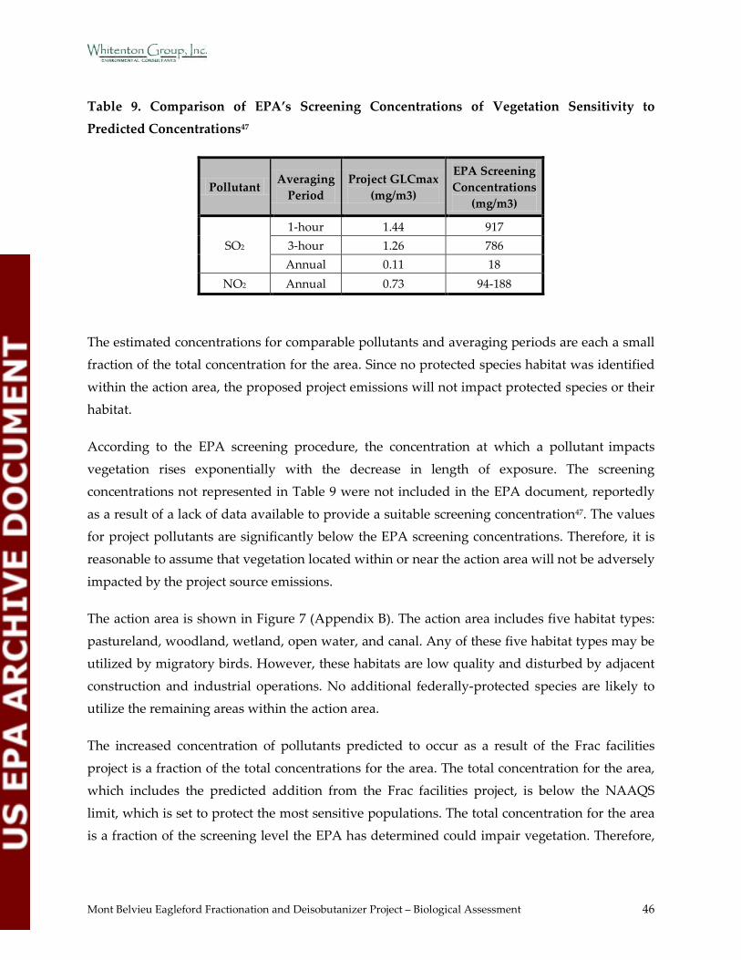
Mont Belvieu Eagleford Fractionation and Deisobutanizer Project – Biological Assessment 46
Table 9. Comparison of EPA’s Screening Concentrations of Vegetation Sensitivity to Predicted Concentrations47
Pollutant Averaging
Period Project GLCmax
(mg/m3)
EPA Screening Concentrations
(mg/m3)
SO2 1-hour 1.44 917 3-hour 1.26 786 Annual 0.11 18
NO2 Annual 0.73 94-188
The estimated concentrations for comparable pollutants and averaging periods are each a small fraction of the total concentration for the area. Since no protected species habitat was identified
within the action area, the proposed project emissions will not impact protected species or their habitat.
According to the EPA screening procedure, the concentration at which a pollutant impacts
vegetation rises exponentially with the decrease in length of exposure. The screening concentrations not represented in Table 9 were not included in the EPA document, reportedly
as a result of a lack of data available to provide a suitable screening concentration47. The values for project pollutants are significantly below the EPA screening concentrations. Therefore, it is
reasonable to assume that vegetation located within or near the action area will not be adversely
impacted by the project source emissions.
The action area is shown in Figure 7 (Appendix B). The action area includes five habitat types:
pastureland, woodland, wetland, open water, and canal. Any of these five habitat types may be utilized by migratory birds. However, these habitats are low quality and disturbed by adjacent
construction and industrial operations. No additional federally-protected species are likely to utilize the remaining areas within the action area.
The increased concentration of pollutants predicted to occur as a result of the Frac facilities
project is a fraction of the total concentrations for the area. The total concentration for the area, which includes the predicted addition from the Frac facilities project, is below the NAAQS
limit, which is set to protect the most sensitive populations. The total concentration for the area is a fraction of the screening level the EPA has determined could impair vegetation. Therefore,
Mont Belvieu Eagleford Fractionation and Deisobutanizer Project – Biological Assessment 47
any migratory birds with the potential to occur within the action area will not likely be directly impacted by the proposed project.
Since it has been determined that the potential indirect effects are unlikely to occur as a result of the proposed project, migratory birds with the potential to occur within the action area will not
likely be indirectly impacted by the proposed project.
8.3 WATER QUALITY EFFECTS
8.3.1 WASTEWATER
The new Frac units will be located within the North Plant of the Mont Belvieu Complex. The North Plant currently discharges wastewater and stormwater under TPDES Permit Number
03499. The process wastewater from the new Fracs will be combined with that from other Frac
units in the North Plant and will be treated in the North Plant’s existing wastewater treatment system. The non-process wastewater (i.e., cooling water) will be discharged with only pH
adjustment (no biological treatment). The non-process wastewater will be routed to the North Plant Outfall 001, which discharges into the Hatcherville Road Ditch and ultimately into Cedar
Bayou.
The two new Frac units combined represent a flow increase of approximately 40%. No changes to the wastewater discharge (i.e., temperature change, pH change, pollutant concentration, etc.)
other than an increase in flow rate are anticipated.
Best Management Practices will be utilized in accordance with Section 401 of the Clean Water
Act and Chapter 279 of the Texas Water Code. Excess storm water from the sumps and from other paved areas will be routed to two retention ponds that will be constructed. The ponds will
be used for sedimentation and oil retention, if needed. A new stormwater outfall will be
permitted to authorize the discharge from the new ponds.
No stormwater effects to wildlife are expected as a result of the infrastructure construction or
operation of the Frac facilities project. Although an increase in wastewater flow rate is expected, the Frac facilities wastewater is discharged into an upland drainage system, which will reduce
the flow velocity before the discharge water reaches waters of the US. No wastewater effects to
wildlife are expected as a result of the infrastructure construction or operation of the Frac facilities project.

Mont Belvieu Eagleford Fractionation and Deisobutanizer Project – Biological Assessment 48
8.3.2 SURFACE WATER
The action area is shown in Figure 7 (Appendix B). The two surface waters located within the
action area are industrial ponds. These ponds are built to support adjacent industrial facilities and are not typically utilized by wildlife. Surface waters utilized by wildlife will not be
impacted by air emissions from the proposed project. Federally protected species will not be
directly or indirectly affected by surface water impacts from the proposed project.
8.4 NOISE EFFECTS
The contractor will consider, when feasible and possible, alternative work methods, which lessen or eliminate the use of noisy equipment. When exposure to noise cannot be prevented,
the construction contractor will institute a noise monitoring program.
Few pieces of equipment required for construction have the potential to exceed 85 decibels at 50 feet from the source. The best available technology will be used to maintain noise levels during
construction below 85 decibels measured at a distance of 50 feet from the source as much as practical.
Project engineers estimate that noise levels during operation should be comparable to noise
levels from maintenance activities that currently take place at the plant.
No noise effects to wildlife are expected as a result of the infrastructure construction or
operation of the Frac facilities project.
8.5 INFRASTRUCTURE-RELATED EFFECTS
Construction of the proposed project involves the addition of two Frac units and one DIB unit
to the existing three Frac facilities within the North Plant. The proposed project area is currently maintained pastureland and a construction staging area surrounded by industrial
infrastructure. The majority of the Mont Belvieu Complex is industrial infrastructure, concrete, caliche, or asphalt. A portion of the maintained pastureland will be impacted by the
construction activities. This habitat is low quality. No species were observed in this habitat during the field survey. No impacts to wildlife as a result of the infrastructure construction of
the Frac facilities project are anticipated.

Mont Belvieu Eagleford Fractionation and Deisobutanizer Project – Biological Assessment 49
8.6 HUMAN ACTIVITY EFFECTS
Construction and operation of the proposed project will not require significant additional
human activity compared to typical maintenance activities that occur at the plant on a regular basis.
No additional effects to wildlife are expected as a result of the increase in human activity
associated with the Frac facilities project.
8.7 FEDERALLY-PROTECTED SPECIES EFFECTS
8.7.1 FEDERALLY-LISTED SPECIES
8.7.1.1 Piping Plover
Potential to Occur in the Action Area
Piping Plovers are migratory birds and their breeding habitat is known to be the northern US and Canada. Therefore, the consideration of potential nesting habitat was excluded from this
analysis. Potential habitat within the action area would be limited to wintering habitat (foraging and roosting). Preferred foraging habitat includes bare to sparsely vegetated beaches, salt
marshes, emergent seagrass beds, wash-over passes, mudflats, sandflats, or algal flats. Most
preferred foraging habitats are dynamic systems that fluctuate with the tide and wind. Preferred roosting habitat includes sandy beaches, often with cover such as driftwood, seaweed
clumps, small dunes, and debris32.
No habitat with the potential to support the Piping Plover was observed within the Mont
Belvieu Complex.
Cedar Bayou is approximately 2 miles from the project area, at its closest point, and is not tidally-influenced in this area. Cedar Bayou does not have shorelines with adequate roosting or
foraging habitat for the piping plover in this area. No other areas with adequate roosting or foraging habitat for the piping plover are located within at least 3 miles of the project area. No
sources have been found to indicate the piping plover has been observed within the survey area.
Piping Plovers are known to prefer areas immediately adjacent to the coastline. The action area
is located approximately 33 miles inland from the coast. The closest UFWS designated critical

Mont Belvieu Eagleford Fractionation and Deisobutanizer Project – Biological Assessment 50
habitat for the Piping Plover is approximate 35 miles south and southeast of the action area41. The closest, and most recent, recorded observations of Piping Plovers found occurred in 2008
(pre and post Hurricane Ike) in Apfel Park, Bolivar Flats, and Bolivar Penisula (approximately 35 miles south of the action area)48.
Potential foraging and roosting habitat for the Piping Plover does not exist within the action
area or within the 3-mile survey area. Piping Plovers are not known to occur, and are unlikely to occur, within the action area for this project.
Potential Effects to Piping Plovers
Potential foraging and roosting habitat for the Piping Plover does not exist within the action
area or within the 3-mile survey area. Piping Plovers are not known to occur, and are unlikely
to occur, within the action area for this project.
The Piping Plover will not be directly impacted by construction activities associated with the
completion of the Frac facilities project, noise pollution, or human disturbance. All wastewater associated with construction and operation of the Frac facilities project will be treated onsite
and will not impact the Piping Plover.
Determination of Effect
The proposed action will have no effect on the Piping Plover.
8.7.1.2 Green Sea Turtle
Potential to Occur in the Project Area
Nesting occurs on high energy oceanic beaches, primarily on islands with minimal disturbance. Juveniles and adults primarily occupy benthic feeding grounds in shallow, protected waters.
Preferred feeding grounds include pastures of seagrasses and/or algae39.
No habitat with the potential to support the green sea turtle was observed within the Mont Belvieu Complex.
No habitats with the potential to support the green sea turtle are located within at least 7 miles of the project area. The USFWS designated critical habitat for the green sea turtle is Culebra
Island, Puerto Rico and its surrounding waters43. The closest known observations of green sea
turtles found occurred in Galveston Bay (approximately 25 miles south of the project area)49.

Mont Belvieu Eagleford Fractionation and Deisobutanizer Project – Biological Assessment 51
Potential foraging and nesting habitat for the green sea turtle does not exist within the action area or within the 3-mile survey area. Green sea turtles will not occur within the action area for
this project.
Potential Effects to Green Sea Turtles
Potential foraging and nesting habitat for the green sea turtle does not exist within the action
area or within the 3-mile survey area. Green sea turtles will not occur within the action area for this project.
The green sea turtle will not be directly impacted by construction activities associated with the completion of the Frac facilities project, noise pollution, or human disturbance. All wastewater
associated with construction and operation of the Frac facilities project will be treated onsite
and will not impact the green sea turtle.
Determination of Effect
The proposed action will have no effect on the green sea turtle.
8.7.1.3 Hawksbill Sea Turtle
Potential to Occur in the Action Area
Preferred nesting habitat includes low and high energy, vegetated beaches in tropical oceans
with a variety of substrates. Juveniles and adults primarily occupy their primary foraging
habitat, coral reefs36.
No habitat with the potential to support the hawksbill sea turtle was observed within the Mont
Belvieu Complex.
No habitats with the potential to support the hawksbill sea turtle are located within at least 7
miles of the project area. The USFWS designated critical habitat for the hawksbill sea turtle are
the Mona and Monito Islands, Puerto Rico and their surrounding waters43. The most recent recorded observations of hawksbill sea turtles found occurred in in 1984 at an unknown
location in Texas50.
Potential foraging and nesting habitat for the hawksbill sea turtle does not exist within the
action area or within the 3-mile survey area. Hawskbill sea turtles will not occur within the
action area for this project.
Mont Belvieu Eagleford Fractionation and Deisobutanizer Project – Biological Assessment 52
Potential Effects to Hawksbill Sea Turtles
Potential foraging and nesting habitat for the hawksbill sea turtle does not exist within the
action area or within the 3-mile survey area. Hawskbill sea turtles will not occur within the action area for this project.
The hawksbill sea turtle will not be directly impacted by construction activities associated with
the completion of the Frac facilities project, noise pollution, or human disturbance. All wastewater associated with construction and operation of the Frac facilities project will be
treated onsite and will not impact the hawksbill sea turtle.
Determination of Effect
The proposed action will have no effect on the hawksbill sea turtle.
8.7.1.4 Kemp’s Ridley Sea Turtle
Potential to Occur in the Action Area
Nesting occurs on high energy oceanic beaches, primarily adjacent to extensive swamps or large bodies of open water. This turtle is a shallow water benthic feeder with a diet consisting
primarily of shrimp, jellyfish, snails, sea stars, and swimming crabs38.
No habitat with the potential to support the Kemp’s ridley sea turtle was observed within the
Mont Belvieu Complex.
No habitats with the potential to support the Kemp’s ridley sea turtle are located within at least 7 miles of the project area. USFWS designated critical habitat is not yet designated for this
species43. The closest known observations of Kemp’s ridley sea turtles found occurred in Galveston Bay (approximately 25 miles south of the project area)49. The closest, and most recent,
known observations of Kemp’s ridley sea turtle nests found occurred on the Bolivar Peninsula
in 2010 (approximately 35 miles south of the project area)51.
Potential foraging and nesting habitat for the Kemp’s ridley sea turtle does not exist within the
action area or within the 3-mile survey area. Kemp’s ridley sea turtles will not occur within the action area for this project.

Mont Belvieu Eagleford Fractionation and Deisobutanizer Project – Biological Assessment 53
Potential Effects to Kemp’s Ridley Sea Turtles
Potential foraging and nesting habitat for the Kemp’s ridley sea turtle does not exist within the
action area or within the 3-mile survey area. Kemp’s ridley sea turtles will not occur within the action area for this project.
The Kemp’s ridley sea turtle will not be directly impacted by construction activities associated
with the completion of the Frac facilities project, noise pollution, or human disturbance. All wastewater associated with construction and operation of the Frac facilities project will be
treated onsite and will not impact the Kemp’s ridley sea turtle.
Determination of Effect
The proposed action will have no effect on the Kemp’s ridley sea turtle.
8.7.1.5 Leatherback Sea Turtle
Potential to Occur in the Action Area
Preferred nesting habitat includes high energy, sandy beaches with vegetation immediately upslope and a beach sloped sufficiently so the crawl to dry sand is not too far. Preferred beaches
have deep, unobstructed oceanic access on continental shorelines. Juveniles and adults are pelagic and primarily occupy deep water habitat40.
No habitat with the potential to support the leatherback sea turtle was observed within the
Mont Belvieu Complex.
No habitats with the potential to support the leatherback sea turtle are located within at least 7
miles of the project area. The USFWS designated critical habitat for the leatherback sea turtle include the coastal waters adjacent to Sandy Point, St. Croix, the US Virgin Islands, and the US
West Coast43. The most recent recorded observations of hawksbill sea turtles found occurred in
in 1957 at an unknown location in Texas52.
Potential foraging and nesting habitat for the leatherback sea turtle does not exist within the
action area or within the 3-mile survey area. Leatherback sea turtles will not occur within the action area for this project.

Mont Belvieu Eagleford Fractionation and Deisobutanizer Project – Biological Assessment 54
Potential Effects to Leatherback Sea Turtles
Potential foraging and nesting habitat for the leatherback sea turtle does not exist within the
action area or within the 3-mile survey area. Leatherback sea turtles will not occur within the action area for this project.
The leatherback sea turtle will not be directly impacted by construction activities associated
with the completion of the Frac facilities project, noise pollution, or human disturbance. All wastewater associated with construction and operation of the Frac facilities project will be
treated onsite and will not impact the leatherback sea turtle.
Determination of Effect
The proposed action will have no effect on the leatherback sea turtle.
8.7.1.6 Loggerhead Sea Turtle
Potential to Occur in the Action Area
Nesting occurs on oceanic beaches between the high tide line and dune fronts and occasionally on estuarine shorelines with suitable sand. Females prefer narrow, steeply sloped, coarse-
grained beaches. This turtle is a shallow water benthic feeder with a diet consisting primarily of shrimp, jellyfish, snails, sea stars, and swimming crabs37.
No habitat with the potential to support the loggerhead sea turtle was observed within the
Mont Belvieu Complex.
No habitats with the potential to support the loggerhead sea turtle are located within at least 7
miles of the project area. USFWS designated critical habitat is not yet designated for this species43. The closest known observations of loggerhead sea turtles found occurred in Galveston
Bay (approximately 25 miles south of the project area)49. The closest, and most recent, known
observations of loggerhead sea turtle nests found occurred on the Bolivar Peninsula in 2008 (approximately 35 miles south of the project area)51.
Potential foraging and nesting habitat for the loggerhead sea turtle does not exist within the action area or within the 3-mile survey area. Loggerhead sea turtles will not occur within the
action area for this project.
Mont Belvieu Eagleford Fractionation and Deisobutanizer Project – Biological Assessment 55
Potential Effects to Loggerhead Sea Turtles
Potential foraging and nesting habitat for the loggerhead sea turtle does not exist within the
action area or within the 3-mile survey area. Loggerhead sea turtles will not occur within the action area for this project.
The loggerhead sea turtle will not be directly impacted by construction activities associated
with the completion of the Frac facilities project, noise pollution, or human disturbance. All wastewater associated with construction and operation of the Frac facilities project will be
treated onsite and will not impact the loggerhead sea turtle.
Determination of Effect
The proposed action will have no effect on the loggerhead sea turtle.
8.7.1.7 Smalltooth Sawfish
Potential to Occur in the Action Area
Preferred habitat includes shallow coastal seas and estuaries with muddy and sandy bottoms. They are typically found close to shore, in sheltered bays and on shallow banks35.
No habitat with the potential to support the smalltooth sawfish was observed within the Mont Belvieu Complex.
No habitats with the potential to support the smalltooth sawfish are located within at least 7
miles of the project area. USFWS designated critical habitat is not yet designated for this species43. No known observations of smalltooth sawfish in or near Galveston Bay have been
found (approximately 25 miles south of the project area).
Potential habitat for the smalltooth sawfish does not exist within the action area or within the 3-
mile survey area. Smalltooth sawfish will not occur within the action area for this project.
Potential Effects to Smalltooth Sawfish
Potential habitat for the smalltooth sawfish does not exist within the action area or within the 3-
mile survey area. Smalltooth sawfish will not occur within the action area for this project.
Mont Belvieu Eagleford Fractionation and Deisobutanizer Project – Biological Assessment 56
The smalltooth sawfish will not be directly impacted by construction activities associated with the completion of the Frac facilities project, noise pollution, or human disturbance. All
wastewater associated with construction and operation of the Frac facilities project will be treated onsite and will not impact the smalltooth sawfish.
Determination of Effect
The proposed action will have no effect on the smalltooth sawfish.
8.7.1.8 Louisiana Black Bear
Potential to Occur in the Action Area
Louisiana black bears typically inhabit bottomland hardwood forests. Other habitat types the
Louisiana black bear utilizes include brackish and freshwater marshes, salt domes, and
agricultural fields. These bears require large, remote tracts of land with minimal human disturbance41.
No habitat with the potential to support the Louisiana black bear was observed within the Mont Belvieu Complex.
Although some characteristics of the mixed woodlands habitat type meet the qualifications for LBB habitat, these woodlands are not large enough, not continuous, and are frequently subject
to human disturbance. These woodlands would not likely support LBB. The USFWS designated
critical habitat for the Louisiana black bear is located in fifteen counties in Louisiana43. No known observations of the Louisiana black bear in or near the project area have been found.
Potential habitat for the Louisiana black bear does not exist within the action area or within the 3-mile survey area. Louisiana black bear will not occur within the action area for this project.
Potential Effects to Louisiana Black Bears
Potential habitat for the Louisiana black bear does not exist within the action area or within the 3-mile survey area. Louisiana black bears will not occur within the action area for this project.
The Louisiana black bear will not be directly impacted by construction activities associated with the completion of the Frac facilities project, noise pollution, or human disturbance. All
wastewater associated with construction and operation of the Frac facilities project will be
treated onsite and will not impact the Louisiana black bear.

Mont Belvieu Eagleford Fractionation and Deisobutanizer Project – Biological Assessment 57
Determination of Effect
The proposed action will have no effect on the Louisiana black bear.
8.7.1.9 Sprague’s Pipit
Potential to Occur in the Action Area
Sprague’s pipits are migratory birds and their breeding habitat is known to be the northern US
and Canada. Therefore, the consideration of potential nesting habitat was excluded from this analysis. Potential habitat within the action area would be limited to wintering habitat (foraging
and roosting). Preferred foraging habitat includes undisturbed midgrasslands with intermediate thickness34.
No habitat with the potential to support the Sprague’s pipit was observed within the Mont
Belvieu Complex. The pastureland within the project area is consistently maintained and disturbed by industrial activity.
Sprague’s pipits are known to prefer undisturbed grasslands. No undisturbed grasslands were identified within at least 3 miles of the action area. USFWS designated critical habitat is not yet
designated for this species43. The closest recorded observations of Sprague’s pipit found occurred in the Anahuac National Wildlife Refuge (approximately 28 miles southeast of the
action area)53.
Potential foraging and roosting habitat for the Sprague’s pipit does not exist within the action area or within the 3-mile survey area. Sprague’s pipits are not known to occur, and are unlikely
to occur, within the action area for this project.
Potential Effects to Sprague’s Pipits
Potential foraging and roosting habitat for the Sprague’s pipit does not exist within the action
area or within the 3-mile survey area. Sprague’s pipits are not known to occur, and are unlikely to occur, within the action area for this project.
The Sprague’s pipit will not be directly impacted by construction activities associated with the completion of the Frac facilities project, noise pollution, or human disturbance. All wastewater
associated with construction and operation of the Frac facilities project will be treated onsite
and will not impact the Sprague’s pipit.
Mont Belvieu Eagleford Fractionation and Deisobutanizer Project – Biological Assessment 58
Determination of Effect
The proposed action will have no effect on the Sprague’s pipit.
8.7.1.10 Red Wolf
Potential to Occur in the Action Area
Red wolves are a very rare species in the wild. Only one known population exists in the wild
and is located in North Carolina42. Little information is available describing red wolf habitat characteristics.
Habitat with the potential to support the red wolf was not observed within the Mont Belvieu Complex.
Red wolves are known to be limited in the wild to select locations in North Carolina42. No
known observations of the red wolf in or near the project area have been found.
Potential habitat for the red wolf does not exist within the action area or within the 3-mile
survey area. Red wolves are not known to occur, and are unlikely to occur, within the action area for this project.
Potential Effects to Red Wolves
Potential habitat for the red wolf does not exist within the action area or within the 3-mile
survey area. Red wolves are not known to occur, and are unlikely to occur, within the action
area for this project.
The red wolf will not be directly impacted by construction activities associated with the
completion of the Frac facilities project, noise pollution, or human disturbance. All wastewater associated with construction and operation of the Frac facilities project will be treated onsite
and will not impact the red wolf.
Determination of Effect
The proposed action will have no effect on the red wolf.
Mont Belvieu Eagleford Fractionation and Deisobutanizer Project – Biological Assessment 59
8.7.2 MIGRATORY BIRDS
Potential to Occur in the Action Area
The maintained pastureland within the Mont Belvieu Complex has the potential to support migratory birds. However, this area does not offer significant resources and is surrounded by
industrial activity. Use of this habitat would be minimal. No nests were observed within the
project area.
As described in Section 6.2, a variety of migratory birds have the potential to utilize the habitats
surrounding the proposed project area, including the residential areas. A variety of species of migratory birds were observed in select habitats surrounding the project location, including
wading birds, raptors, and songbirds. The habitats surrounding the facility range in quality
from low to moderate and have historically been subject to agricultural and industrial activities.
Select migratory birds are likely to occur in all observed habitats surrounding the proposed
project area, excluding existing industrial facilities. The frequency of occurrence and species of migratory birds in each habitat is dependent upon habitat characteristics and quality.
Potential Effects to Migratory Birds
Low quality habitat with minimal potential to support migratory birds was observed within the
Mont Belvieu Complex. A variety of migratory birds have the potential to and currently do
utilize the habitats surrounding the proposed project area, excluding existing industrial facilities.
Migratory birds will not be directly impacted by construction activities associated with the completion of the Frac facilities project, noise pollution, or human disturbance. All wastewater
associated with construction and operation of the Frac facilities project will be treated onsite
and will not impact migratory birds.
Determination of Effect
The take of migratory birds is not anticipated as a result of this project.
Note: The term “take” represents the more specific language of the Migratory Bird Treaty Act
described above in Section 3.3.
Mont Belvieu Eagleford Fractionation and Deisobutanizer Project – Biological Assessment 60
8.7.3 BALD AND GOLDEN EAGLES
Potential to Occur in the Action Area
No habitat with the potential to support bald or golden eagles was observed within the Mont Belvieu Complex.
Select areas surrounding the project area are potential feeding habitats for bald or golden
eagles. Select wooded areas are potential nesting habitats for bald eagles. However, these wooded areas would be considered low quality nesting sites. The areas surrounding the project
site are impacted by agricultural and industrial development.
No bald or golden eagles or eagle nests were observed during the windshield or aerial survey of
the 3-mile radius around the project area.
No sources have been found to indicate bald or golden eagles have been observed near the proposed project area. No occurrences of bald or golden eagles have been recorded within at
least 8 miles of the project site44. Bald or golden eagles are unlikely to occur within the action area for this project.
Potential Effects to Bald and Golden Eagles
The potential exists for bald eagles to utilize the select habitats surrounding the Mont Belvieu
Complex. However, no bald or golden eagles or eagle nests were observed during the aerial
survey and no occurrences of bald or golden eagles have been recorded within at least 8 miles of the project site44.
Bald or golden eagles will not be directly impacted by construction activities associated with the completion of the Frac facilities project, noise pollution, or human disturbance. All wastewater
associated with construction and operation of the Frac facilities project will be treated onsite
and will not impact these eagles.
Determination of Effect
The take of bald or golden eagles is not anticipated as a result of this project.
Note: The term “take” represents the more specific language of the Bald and Golden Eagle
Protection Act described above in Section 3.4.

Mont Belvieu Eagleford Fractionation and Deisobutanizer Project – Biological Assessment 61
8.7.4 MARINE MAMMALS
Potential to Occur in the Action Area
Marine mammals are ecologically restricted to marine or estuarine habitats.
No habitats with the potential to support marine mammals are located within at least 10 miles
of the project area.
Potential marine mammal habitat does not exist within the action area or within the 3-mile survey area. Marine mammals will not occur within the action area for this project.
Potential Effects to Marine Mammals
Potential marine mammal habitat does not exist within the action area or within the 3-mile
survey area. Marine mammals will not occur within the action area for this project.
Marine mammals will not be directly impacted by construction activities associated with the completion of the Frac facilities project, noise pollution, or human disturbance. All wastewater
associated with construction and operation of the Frac facilities project will be treated onsite and will not impact marine mammals.
Determination of Effect
The take of marine mammals is not anticipated as a result of this project.
Note: The term “take” represents the more specific language of the Marine Mammal Protection
Act described above in Section 3.5.
9.0 CONCLUSIONS
This section is a summary of WGI’s recommended determination of effect for all federally-
protected species, a description of any interdependent and interrelated actions, and a description of any anticipated cumulative effects resulting from the proposed project.
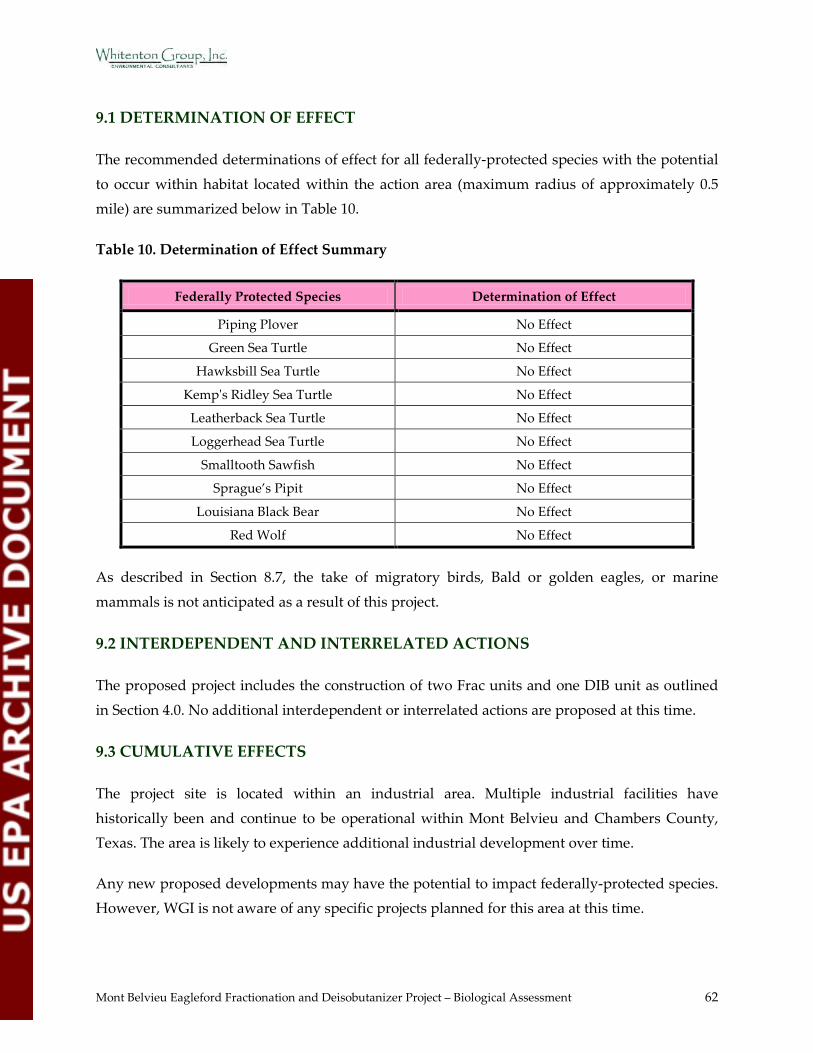
Mont Belvieu Eagleford Fractionation and Deisobutanizer Project – Biological Assessment 62
9.1 DETERMINATION OF EFFECT
The recommended determinations of effect for all federally-protected species with the potential
to occur within habitat located within the action area (maximum radius of approximately 0.5 mile) are summarized below in Table 10.
Table 10. Determination of Effect Summary
Federally Protected Species Determination of Effect
Piping Plover No Effect
Green Sea Turtle No Effect
Hawksbill Sea Turtle No Effect
Kemp's Ridley Sea Turtle No Effect
Leatherback Sea Turtle No Effect
Loggerhead Sea Turtle No Effect
Smalltooth Sawfish No Effect
Sprague’s Pipit No Effect
Louisiana Black Bear No Effect
Red Wolf No Effect
As described in Section 8.7, the take of migratory birds, Bald or golden eagles, or marine
mammals is not anticipated as a result of this project.
9.2 INTERDEPENDENT AND INTERRELATED ACTIONS
The proposed project includes the construction of two Frac units and one DIB unit as outlined
in Section 4.0. No additional interdependent or interrelated actions are proposed at this time.
9.3 CUMULATIVE EFFECTS
The project site is located within an industrial area. Multiple industrial facilities have
historically been and continue to be operational within Mont Belvieu and Chambers County, Texas. The area is likely to experience additional industrial development over time.
Any new proposed developments may have the potential to impact federally-protected species. However, WGI is not aware of any specific projects planned for this area at this time.
Mont Belvieu Eagleford Fractionation and Deisobutanizer Project – Biological Assessment 63
No additional actions with the potential to impact federally-protected species are planned for the Mont Belvieu Complex at this time.
9.4 CONSERVATION MEASURES
The construction of the proposed project will likely have no direct or indirect impact on
federally-protected species habitat.
Enterprise plans to utilize the BACT to control the project emissions and thus minimize impacts to the surrounding environment to the maximum extent practicable. The proposed emissions of
each pollutant subject to PSD review are consistent with both the TCEQ BACT guidance and the most stringent limit in the RBLC; and, are considered to be the top level of control available for
the new facilities.
Mont Belvieu Eagleford Fractionation and Deisobutanizer Project – Biological Assessment 64
10.0 REFERENCES
1Enterprise Products Operating LLC. Operations. http://www.enterpriseproducts.com/ operations/nglfrac.shtm
2US Fish and Wildlife Service. Biological Assessment/Biological Evaluation Contents. http://www.fws.gov/daphne/section7/BA-BE_Contents.pdf
3US Environmental Protection Agency. National Ambient Air Quality Standards (NAAQS). http://www.epa.gov/ttn/naaqs/
4US Environmental Protection Agency. Air Quality Management - National Ambient Air Quality Standards (NAAQS) for Criteria Pollutants. http://www.epa.gov/eogapti1/
course422/apc4a.html
5US Environmental Protection Agency. Fact Sheet--Prevention of Significant Deterioration For Fine Particle Pollution-Increments, Significant Impact Levels, and Significant
Monitoring Concentration. http://www.epa.gov/NSR/fs20070912.html
6US Environmental Protection Agency. Overview of the Prevention of Significant Deterioration Program. http://www.epa.gov/region9/air/permit/psd-public-part.html
7US Fish and Wildlife Service. Endangered Species Act - Overview. http://www.fws.gov/ endangered/laws-policies/
8US Fish and Wildlife Service. The Endangered Species Act and Candidate Species. http://library.fws.gov/Pubs9/esa_cand01.pdf
9US Fish and Wildlife Service. ESA Basics. http://www.fws.gov/endangered/esa- library/pdf/ESA_basics.pdf
10US Fish and Wildlife Service. Migratory Bird Treaty Act. http://www.fws.gov/pacific/ migratorybirds/mbta.htm
11US Fish and Wildlife Service. Bald and Golden Eagle Protection Act. http://www.fws.gov/ migratorybirds/Baldeagle.htm
12 National Oceanic and Atmospheric Administration Fisheries. Marine Mammal Protection Act (MMPA) of 1972. http://www.nmfs.noaa.gov/pr/laws/mmpa/
13RPS. 2011. TCEQ Air Permit Application. Permit application submitted to the Texas Commission on Environmental Quality.
14Texas Parks and Wildlife Department. Level III Eco-regions of Texas. http://www.tpwd. state.tx.us/publications/pwdpubs/media/pwd_mp_e0100_1070z_08.pdf
Mont Belvieu Eagleford Fractionation and Deisobutanizer Project – Biological Assessment 65
15US Geological Survey. Physiographic Regions of the Lower 48 United States. http://tapestry. usgs.gov/physiogr/physio.html
16Texas Parks and Wildlife Department. Oak-Prairie Wildlife Management, Historical Perspective. http://www.tpwd.state.tx.us/landwater/land/habitats/oak_prairie/
17Texas Parks and Wildlife Department. Plant Guidance by Ecoregions, Ecoregion 2 – Gulf Coast Prairies and Marshes. http://www.tpwd.state.tx.us/huntwild/wild/wildscapes/
guidance/plants/ecoregions/ecoregion_2.phtml
18University of Texas. Chambers County Statistics and Information. http://www.tsha.utexas. edu/ handbook/online/articles/LL/ hcc09.html
19US Department of Agriculture. US Drought Monitor. http://www.drought.unl.edu/ dm/DM_south.htm 20National Weather Service/Advanced Hydrologic Prediction Service. Precipitation Analysis. http://water.weather.gov/precip/
21National Oceanic and Atmospheric Administration Satellite and Information Service. State of the Climate, Drought. http://www.ncdc.noaa.gov/sotc/drought/
22National Weather Service. Your National Weather Service Forecast – 3 Miles ENE Groves TX. http://forecast.weather.gov/MapClick.php?lat=29.96861682100166&lon=-
93.8671875&site=lch&unit=0&lg=en&FcstType=marine
23Federal Emergency Management Agency. FEMA Flood Insurance Rate Map. http://www.msc. fema.gov/webapp/wcs/stores/servlet/FemaWelcomeView?storeId=10001&catalogId=10001&langId=-1
24Bureau of Economic Geology. 1992. Geology of Texas. http://www.lib.utexas.edu/geo/pics/ texas92a.jpg
25Bureau of Economic Geology. Texas Geologic Map Data. http://tin.er.usgs.gov/geology/ state/state.php?state=TX
26US Department of Agriculture. Natural Resources Conservation Service Web Soil Survey. http://websoilsurvey.nrcs.usda.gov/app/WebSoilSurvey.aspx
27Texas Parks and Wildlife Department. GIS Lab Data Downloads, River Basins. http://www.tpwd.state.tx.us/landwater/land/maps/gis/data_downloads/
28Texas Parks and Wildlife. 2011. Ecologically Significant Stream Segments. http://www.tpwd. state.tx.us/landwater/water/environconcerns/water_quality/sigsegs/
29US Fish and Wildlife Service. National Wetlands Inventory. http://137.227.242.85/
Mont Belvieu Eagleford Fractionation and Deisobutanizer Project – Biological Assessment 66
wetland/wetland.html
30US Fish and Wildlife Service. Endangered Species of Chambers County. http://ifw2es.fws.gov/ EndangeredSpecies/Lists/ListSpecies.cfm
31Texas Parks and Wildlife Department. Rare, Threatened, and Endangered Species of Texas. http://www.tpwd.state.tx.us/gis/ris/es
32Texas Parks and Wildlife. 2007. Piping Plover. http://www.tpwd.state.tx.us/publications/ pwdpubs/media/pwd_bk_w7000_0013_piping_plover.pdf
33US Fish and Wildlife Service. 2003. Recovery Plan for the Great Lakes Piping Plover. http://ecos.fws.gov/docs/recovery_plan/030916a.pdf
34NOAA Fisheries. Sprague’s Pipit. http://www.birds.audubon.org/species/sprpip
35National Audubon Society. Smalltooth Sawfish (Pristis pectinata). http://www.nmfs.noaa.gov/pr/species/fish/smalltoothsawfish.htm
36Texas Parks and Wildlife Department. 2009. Hawksbill Sea Turtle (Eretmochelys imbricata).http://www.tpwd.state.tx.us/huntwild/wild/species/seaturtle/
37Texas Parks and Wildlife Department. 2009. Loggerhead Sea Turtle (Caretta caretta). http://www.tpwd.state.tx.us/huntwild/wild/species/logghead/
38Texas Parks and Wildlife Department. 2009. Kemp’s Ridley Sea Turtle (Lepidochelys kempii). http://www.tpwd.state.tx.us/huntwild/wild/species/ridley/
39Texas Parks and Wildlife Department. 2009. Green Sea Turtle (Chelonia mydas). http://www.tpwd.state.tx.us/huntwild/wild/species/greentur/
40Texas Parks and Wildlife Department. 2009. Leatherback Sea Turtle (Derochelys coriacea). http://www.tpwd.state.tx.us/huntwild/wild/species/lethback/
41US Fish and Wildlife Service. 1995. Recovery Plan for the Louisiana Black Bear. http://ecos.fws.gov/docs/recovery_plan/950927.pdf
42National Parks. Red Wolf. http://www.eparks.org/wildlife_protection/ wildlife_facts/redwolf.asp
43US Fish and Wildlife Service. Critical Habitat Portal. http://criticalhabitat.fws.gov/crithab/
44Texas Parks and Wildlife Department. 20 February 2012. Texas Natural Diversity Database Search.
45Houston Chronicle. 1995. “Misplaced Manatee Visits Bayou”. http://www.chron.com/CDA/
Mont Belvieu Eagleford Fractionation and Deisobutanizer Project – Biological Assessment 67
archives/archive.mpl/1995_1310356/misplaced-manatee-visits-bayou.html
46RPS. 23 May 2012. Modeling Methodology. Unpublished document.
47A. E. Smith and J. B. Levenson. A Screening Procedure for the Impacts of Air Pollution on Plants, Soils, and Animals. (Argonne, IL: Argonne National Laboratory, 1980).
48Texas Parks and Wildlife Department. 2009. A Survey of Upper Texas Coast Critical Habitats for Migratory and Wintering Piping Plover and Associated “Sand” Plovers.
http://www.gcbo.org/html/PIPLFinalReport.pdf
49Galveston Bay Estuary Program. About Galveston Bay - Reptiles. http://www.gbep.state.tx.us/about-galveston-bay/reptiles.asp
50US Fish and Wildlife Service. Hawksbill Sea Turtle. http://www.fws.gov/verobeach/ MSRPPDFs/HawksbillSeaTurtle.pdf
51Duke University. The State of the World’s Sea Turtles Interactive Map. http://seamap.env.duke.edu/swot
52Texas Turtles. Texas Turtle Information. http://www.texasturtles.org/Dermochelyidae.html
53David Sarkozi. Birds of the Upper Texas Coast. http://www.texasbirding.net/location.htm
Mon Belvieu Eagle Ford Fractionation and Deisobutanizer Project – Biological Assessment 68
11.0 LIST OF PREPARERS
Jayme A. Shiner, Ecologist PWS, B.S. General Biology
Scott W. Jecker, Senior Scientist CWB, PWS, M.S. Wildlife Biology
Cimagaroon Howell B.S. Microbiology

Mon Belvieu Eagle Ford Fractionation and Deisobutanizer Project – Biological Assessment
APPENDIX A
FLOW DIAGRAMS
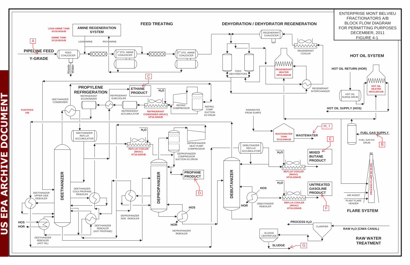
HOSHOR
ETHANE PRODUCT
PROPANE PRODUCT
HOS
HOR
HOS
HOR
MIXED BUTANEPRODUCT
Was
te
Wat
er
FEED TREATING
PIPELINE FEED
DEHYDRATION / DEHYDRATOR REGENERATION
DEP
RO
PAN
IZER
DEB
UTA
NIZ
ER
ENTERPRISE MONT BELVIEU FRACTIONATORS A/B
BLOCK FLOW DIAGRAMFOR PERMITTING PURPOSES
DECEMBER, 2011
HOT OIL RETURN (HOR)
H2O UNTREATED GASOLINEPRODUCT
RAW H2O (CIWA CANAL)
PROCESS H2O
SLUDGE
HOT OIL SYSTEM
RAW WATER TREATMENT
Y-GRADEFEED
COALESCER1st STG. AMINE COALESCER
2nd STG. AMINE COALESCER
FEED DEHYDRATORS
REGENERANT COALESCER
REGENERANT HEATER
HR15.002A/B
REGENERANT COOLER
REGENERANT INTERCHANGER
CLARIFIER
SLUDGE CENTRIFUGE
REFLUX COOLER (WSAC)
HT16.029A/B
H2O
REFLUX COOLER (WSAC)
HT16.029A/B
REFLUX COOLER (WSAC)
HT16.029A/B
H2O
H2O
REFRIGERANT CONDENSER (WSAC)
HT16.028A/B
REFRIG. COMPRESSOR REFRIG.
COMP. SUCTION KO DRUM
REFRIGERANT ECONOMIZER
REFRIGERANT ACCUMULATOR
REFRIGERANT SUBCOOLERDEETHANIZER
CONDENSER
DEETHANIZER REFLUX
ACCUMULATOR
DEETHANIZER UPPER SIDE REBOILER
DEETHANIZER COLD PROPANE
REBOILER
DEETHANIZER REBOILER (HOT OIL)
DEETHANIZER REBOILER
(HOT PROPANE)
DEPROPANIZER HEAT PUMP
COMPRESSOR
PROPYLENE REFRIGERATION
DEPROPANIZER SIDE REBOILER
DEPROPANIZER REBOILER
DEBUTANIZER REBOILER
DEBUTANIZER REFLUX
ACCUMULATORDEPROPANIZER COMPRESSOR
SUCTION KO DRUM
HOT OIL SUPPLY (HOS)
HOT OIL SURGE DRUM
HOT OIL HEATER
HR15.001A/B
AMINE REGENERATION SYSTEM
RICH AMINELEAN AMINE
FUEL GAS KO DRUM
FUEL GAS SUPPLY
FLARE SYSTEM
PRO
CES
S FL
AR
E SK
.25.
001
AIR ASSIST
PLANT FLARE HEADER
DEE
THA
NIZ
ER
FUGITIVESA/B
LEAN AMINE TANKSV19.003A/B
AMINE TANKSV19.002A/B
WASTEWATER TANK
SV19.006A/B
RAINWATER FROM SUMPS
WASTEWATER
A
B
C
D
E
F
G
H, I
FIGURE 4-1
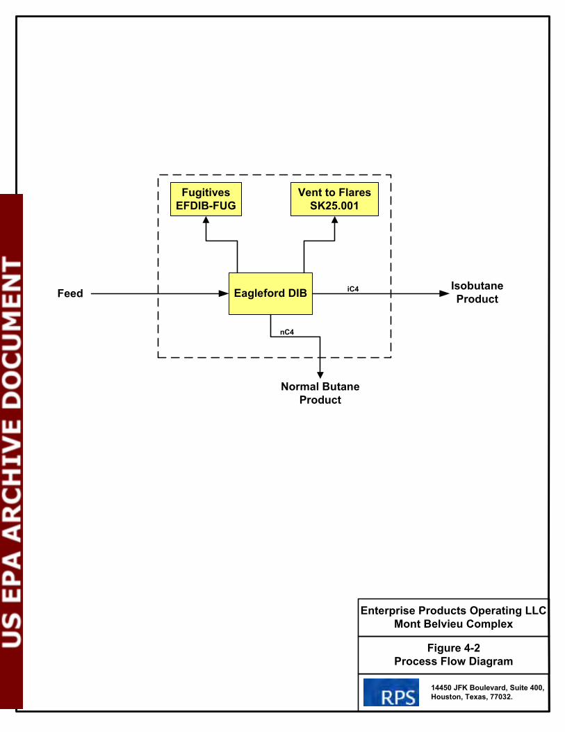
Figure 4-2
Process Flow Diagram
Enterprise Products Operating LLC
Mont Belvieu Complex
Feed
14450 JFK Boulevard, Suite 400,
Houston, Texas, 77032.
Eagleford DIB
Vent to Flares
SK25.001
Fugitives
EFDIB-FUG
Normal Butane
Product
Isobutane
ProductiC4
nC4

Mon Belvieu Eagle Ford Fractionation and Deisobutanizer Project – Biological Assessment
APPENDIX B
FIGURES
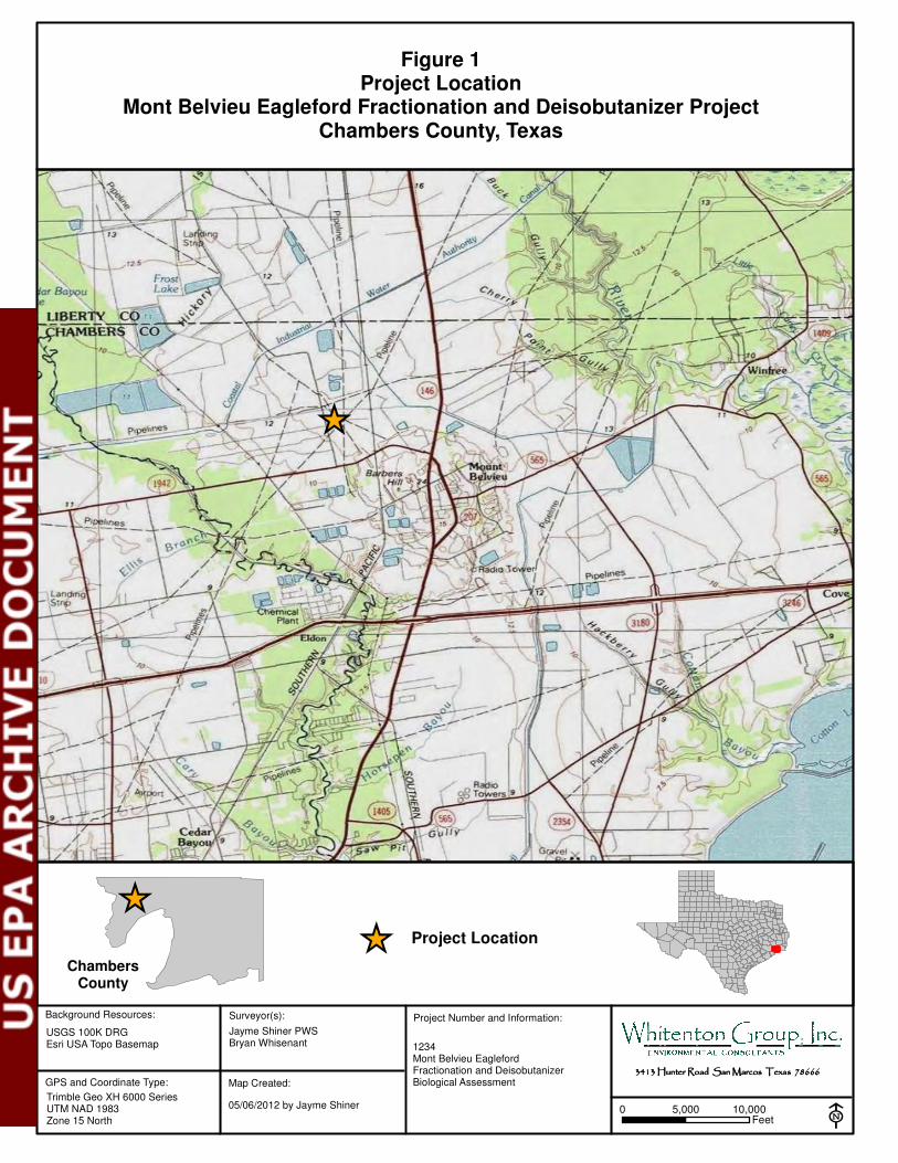
Background Resources:
USGS 100K DRGEsri USA Topo Basemap
GPS and Coordinate Type:
Trimble Geo XH 6000 SeriesUTM NAD 1983Zone 15 North
Surveyor(s):
E
Project Number and Information:
Jayme Shiner PWSBryan Whisenant 1234
Mont Belvieu Eagleford Fractionation and DeisobutanizerBiological Assessment
3413 Hunter Road San Marcos Texas 786663413 Hunter Road San Marcos Texas 786663413 Hunter Road San Marcos Texas 786663413 Hunter Road San Marcos Texas 78666
[�
Map Created:
05/06/2012 by Jayme Shiner
Figure 1Project Location
Mont Belvieu Eagleford Fractionation and Deisobutanizer ProjectChambers County, Texas
0 10,0005,000Feet
[� Project Location
[�
ChambersCounty
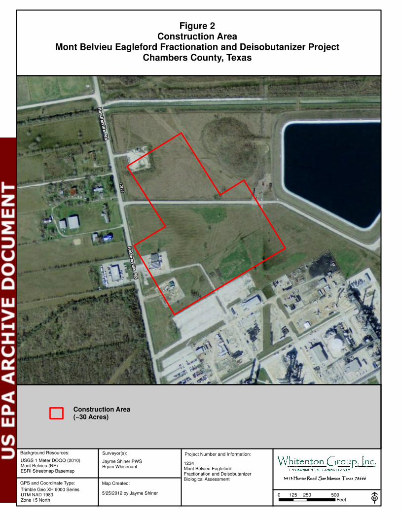
Background Resources:
USGS 1 Meter DOQQ (2010)Mont Belvieu (NE)ESRI Streetmap Basemap
GPS and Coordinate Type:
Trimble Geo XH 6000 SeriesUTM NAD 1983Zone 15 North
Surveyor(s):
E
Project Number and Information:
Jayme Shiner PWSBryan Whisenant
1234Mont Belvieu EaglefordFractionation and DeisobutanizerBiological Assessment 3413 Hunter Road San Marcos Texas 786663413 Hunter Road San Marcos Texas 786663413 Hunter Road San Marcos Texas 786663413 Hunter Road San Marcos Texas 78666
Map Created:
5/25/2012 by Jayme Shiner
Construction Area(~30 Acres)
Figure 2Construction Area
Mont Belvieu Eagleford Fractionation and Deisobutanizer ProjectChambers County, Texas
0 250 500125Feet
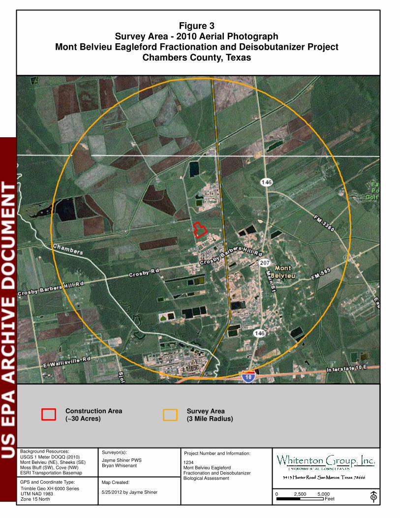
Background Resources:
USGS 1 Meter DOQQ (2010)Mont Belvieu (NE), Sheeks (SE)Moss Bluff (SW), Cove (NW)ESRI Transportation Basemap
GPS and Coordinate Type:
Trimble Geo XH 6000 SeriesUTM NAD 1983Zone 15 North
Surveyor(s):
E
Project Number and Information:
Jayme Shiner PWSBryan Whisenant
1234Mont Belvieu EaglefordFractionation and DeisobutanizerBiological Assessment 3413 Hunter Road San Marcos Texas 786663413 Hunter Road San Marcos Texas 786663413 Hunter Road San Marcos Texas 786663413 Hunter Road San Marcos Texas 78666
Map Created:
5/25/2012 by Jayme Shiner
Survey Area(3 Mile Radius)
Figure 3Survey Area - 2010 Aerial Photograph
Mont Belvieu Eagleford Fractionation and Deisobutanizer ProjectChambers County, Texas
0 5,0002,500Feet
Construction Area(~30 Acres)
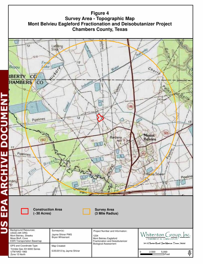
Background Resources:
USGS 24K DRG Mont Belvieu, SheeksMoss Bluff, CoveESRI Transportation Basemap
GPS and Coordinate Type:
Trimble Geo XH 6000 SeriesUTM NAD 1983Zone 15 North
Surveyor(s):
E
Project Number and Information:
Jayme Shiner PWSBryan Whisenant
1234Mont Belvieu EaglefordFractionation and DeisobutanizerBiological Assessment 3413 Hunter Road San Marcos Texas 786663413 Hunter Road San Marcos Texas 786663413 Hunter Road San Marcos Texas 786663413 Hunter Road San Marcos Texas 78666
Map Created:
5/25/2012 by Jayme Shiner
Survey Area(3 Mile Radius)
Figure 4Survey Area - Topographic Map
Mont Belvieu Eagleford Fractionation and Deisobutanizer ProjectChambers County, Texas
0 5,0002,500Feet
Construction Area(~30 Acres)
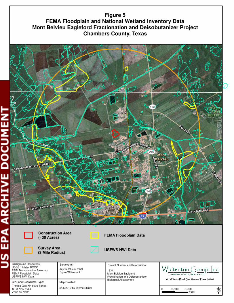
Background Resources:
USGS 1 Meter DOQQESRI Transportation BasemapFEMA Floodplain DataUSFWS NWI Data
GPS and Coordinate Type:
Trimble Geo XH 6000 SeriesUTM NAD 1983Zone 15 North
Surveyor(s):
E
Project Number and Information:
Jayme Shiner PWSBryan Whisenant
1234Mont Belvieu EaglefordFractionation and DeisobutanizerBiological Assessment 3413 Hunter Road San Marcos Texas 786663413 Hunter Road San Marcos Texas 786663413 Hunter Road San Marcos Texas 786663413 Hunter Road San Marcos Texas 78666
Map Created:
5/25/2012 by Jayme Shiner
Survey Area(3 Mile Radius)
Figure 5FEMA Floodplain and National Wetland Inventory Data
Mont Belvieu Eagleford Fractionation and Deisobutanizer ProjectChambers County, Texas
0 5,0002,500Feet
Construction Area(~30 Acres)
FEMA Floodplain Data
USFWS NWI Data
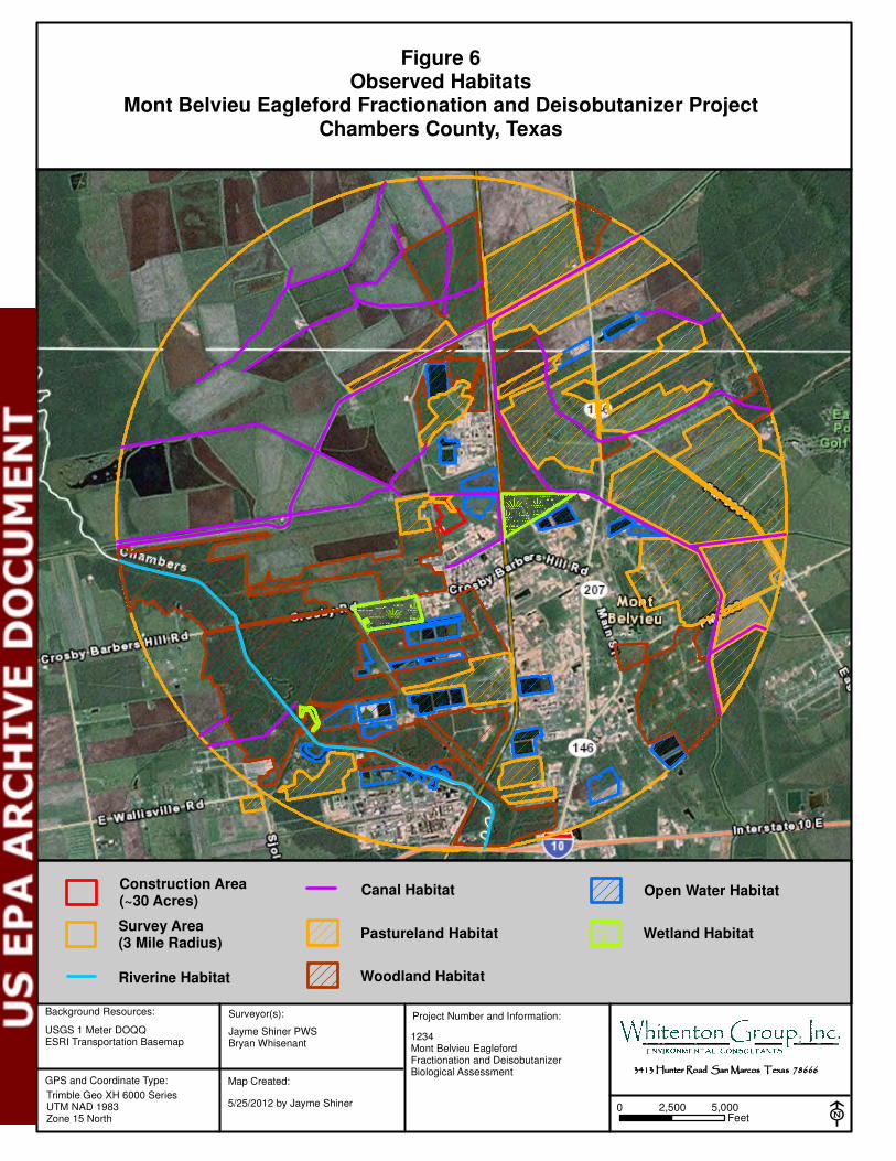
Background Resources:
USGS 1 Meter DOQQESRI Transportation Basemap
GPS and Coordinate Type:
Trimble Geo XH 6000 SeriesUTM NAD 1983Zone 15 North
Surveyor(s):
E
Project Number and Information:
Jayme Shiner PWSBryan Whisenant
1234Mont Belvieu EaglefordFractionation and DeisobutanizerBiological Assessment 3413 Hunter Road San Marcos Texas 786663413 Hunter Road San Marcos Texas 786663413 Hunter Road San Marcos Texas 786663413 Hunter Road San Marcos Texas 78666
Map Created:
5/25/2012 by Jayme Shiner
Survey Area(3 Mile Radius)
Figure 6Observed Habitats
Mont Belvieu Eagleford Fractionation and Deisobutanizer ProjectChambers County, Texas
0 5,0002,500Feet
Construction Area(~30 Acres)
Canal Habitat
Pastureland Habitat
Open Water Habitat
Wetland Habitat
Riverine Habitat Woodland Habitat
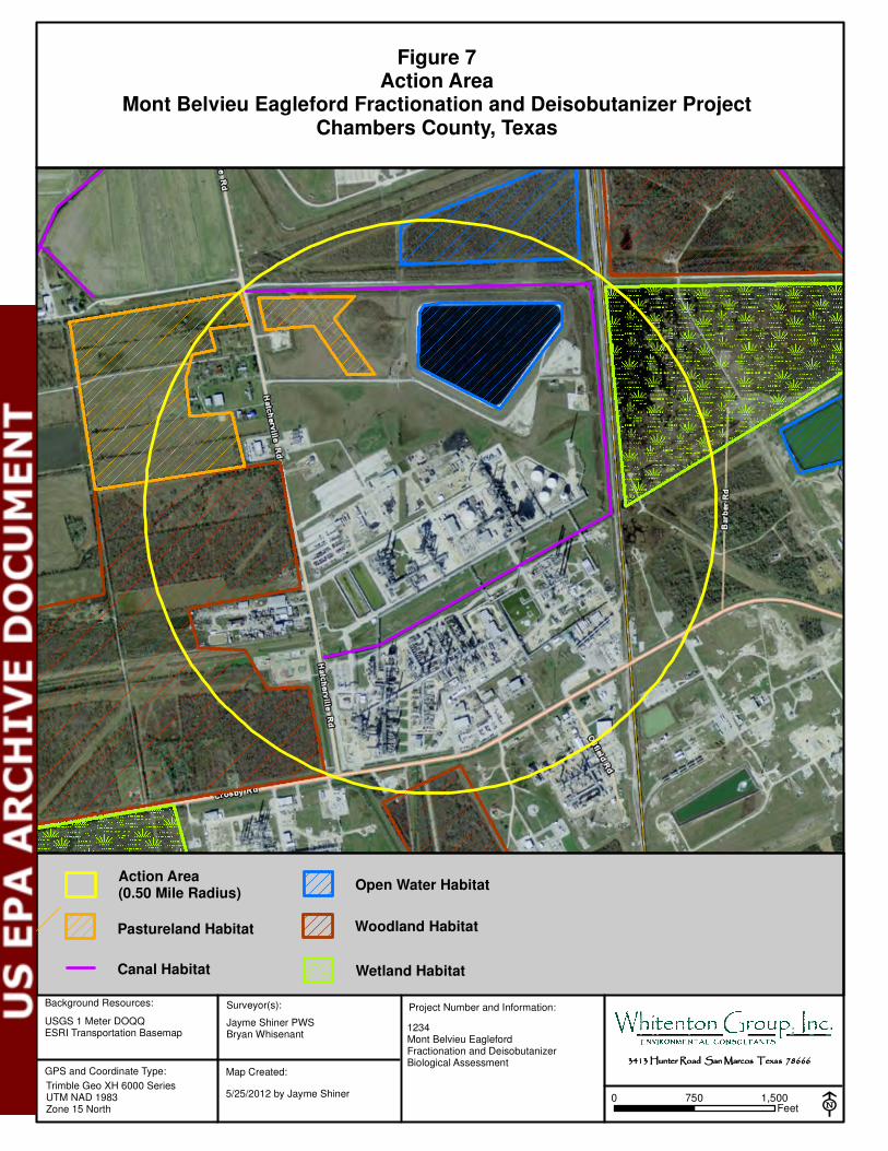
Background Resources:
USGS 1 Meter DOQQESRI Transportation Basemap
GPS and Coordinate Type:
Trimble Geo XH 6000 SeriesUTM NAD 1983Zone 15 North
Surveyor(s):
E
Project Number and Information:
Jayme Shiner PWSBryan Whisenant
1234Mont Belvieu EaglefordFractionation and DeisobutanizerBiological Assessment 3413 Hunter Road San Marcos Texas 786663413 Hunter Road San Marcos Texas 786663413 Hunter Road San Marcos Texas 786663413 Hunter Road San Marcos Texas 78666
Map Created:
5/25/2012 by Jayme Shiner
Pastureland Habitat
Figure 7Action Area
Mont Belvieu Eagleford Fractionation and Deisobutanizer ProjectChambers County, Texas
0 1,500750Feet
Action Area(0.50 Mile Radius)
Open Water Habitat
Wetland HabitatCanal Habitat
Woodland Habitat
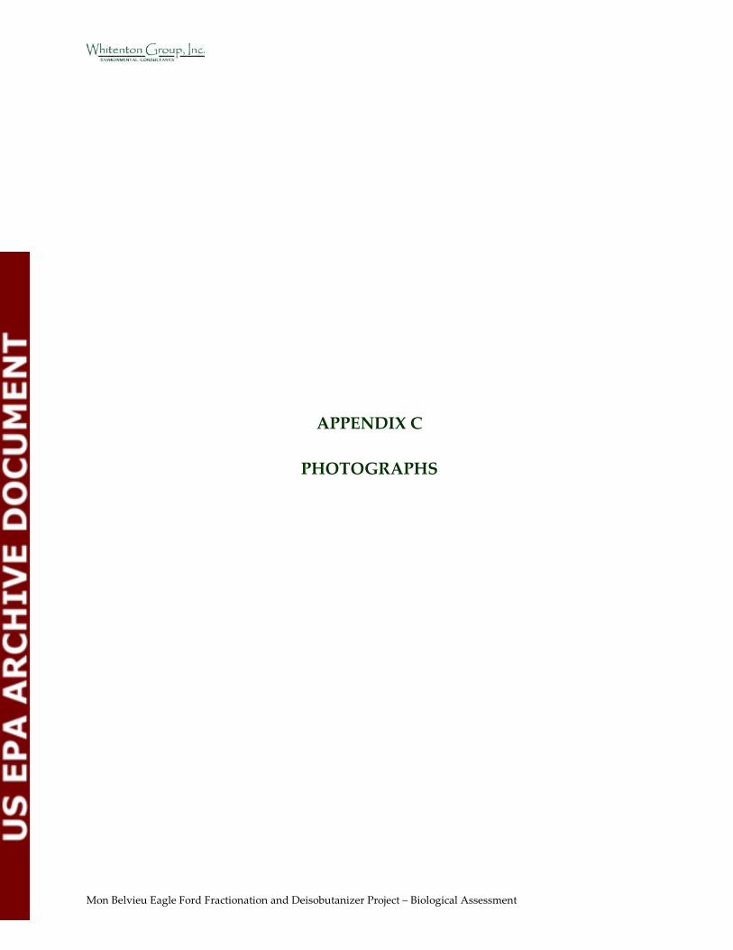
Mon Belvieu Eagle Ford Fractionation and Deisobutanizer Project – Biological Assessment
APPENDIX C
PHOTOGRAPHS
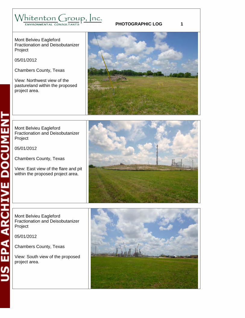
PHOTOGRAPHIC LOG 1 Mont Belvieu Eagleford Fractionation and Deisobutanizer Project 05/01/2012 Chambers County, Texas View: Northwest view of the pastureland within the proposed project area.
Mont Belvieu Eagleford Fractionation and Deisobutanizer Project 05/01/2012 Chambers County, Texas View: East view of the flare and pit within the proposed project area.
Mont Belvieu Eagleford Fractionation and Deisobutanizer Project 05/01/2012 Chambers County, Texas View: South view of the proposed project area.
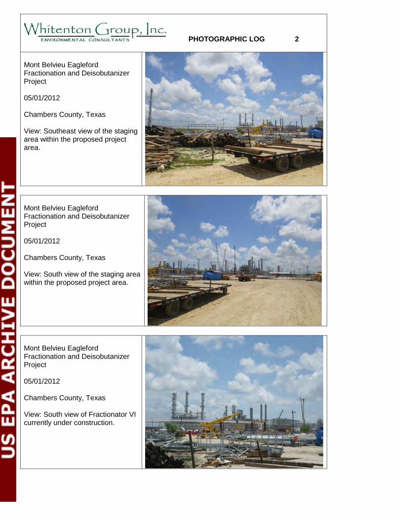
PHOTOGRAPHIC LOG 2 Mont Belvieu Eagleford Fractionation and Deisobutanizer Project 05/01/2012 Chambers County, Texas View: Southeast view of the staging area within the proposed project area.
Mont Belvieu Eagleford Fractionation and Deisobutanizer Project 05/01/2012 Chambers County, Texas View: South view of the staging area within the proposed project area.
Mont Belvieu Eagleford Fractionation and Deisobutanizer Project 05/01/2012 Chambers County, Texas View: South view of Fractionator VI currently under construction.
PHOTOGRAPHIC LOG 3 Mont Belvieu Eagleford Fractionation and Deisobutanizer Project 05/01/2012 Chambers County, Texas View: East view of the canal immediately north of the project area.
Mont Belvieu Eagleford Fractionation and Deisobutanizer Project 05/01/2012 Chambers County, Texas View: East view of the wetland habitat southwest of the project area.
Mont Belvieu Eagleford Fractionation and Deisobutanizer Project 01/16/2012 Chambers County, Texas View: Northeast view of a wetland complex southwest of the project area.
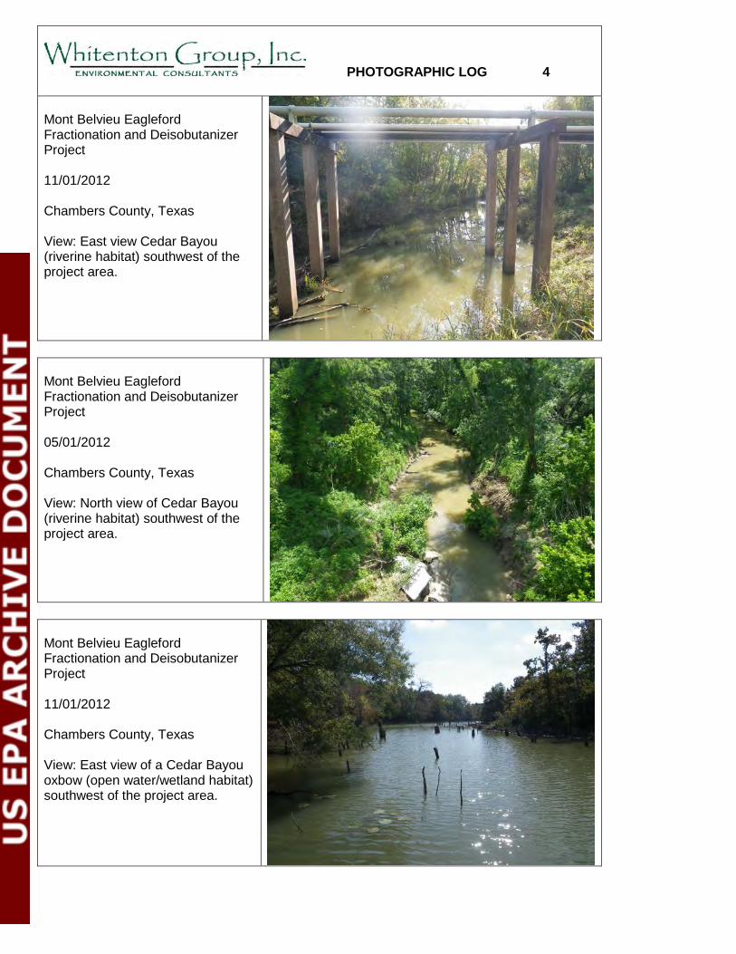
PHOTOGRAPHIC LOG 4 Mont Belvieu Eagleford Fractionation and Deisobutanizer Project 11/01/2012 Chambers County, Texas View: East view Cedar Bayou (riverine habitat) southwest of the project area.
Mont Belvieu Eagleford Fractionation and Deisobutanizer Project 05/01/2012 Chambers County, Texas View: North view of Cedar Bayou (riverine habitat) southwest of the project area.
Mont Belvieu Eagleford Fractionation and Deisobutanizer Project 11/01/2012 Chambers County, Texas View: East view of a Cedar Bayou oxbow (open water/wetland habitat) southwest of the project area.
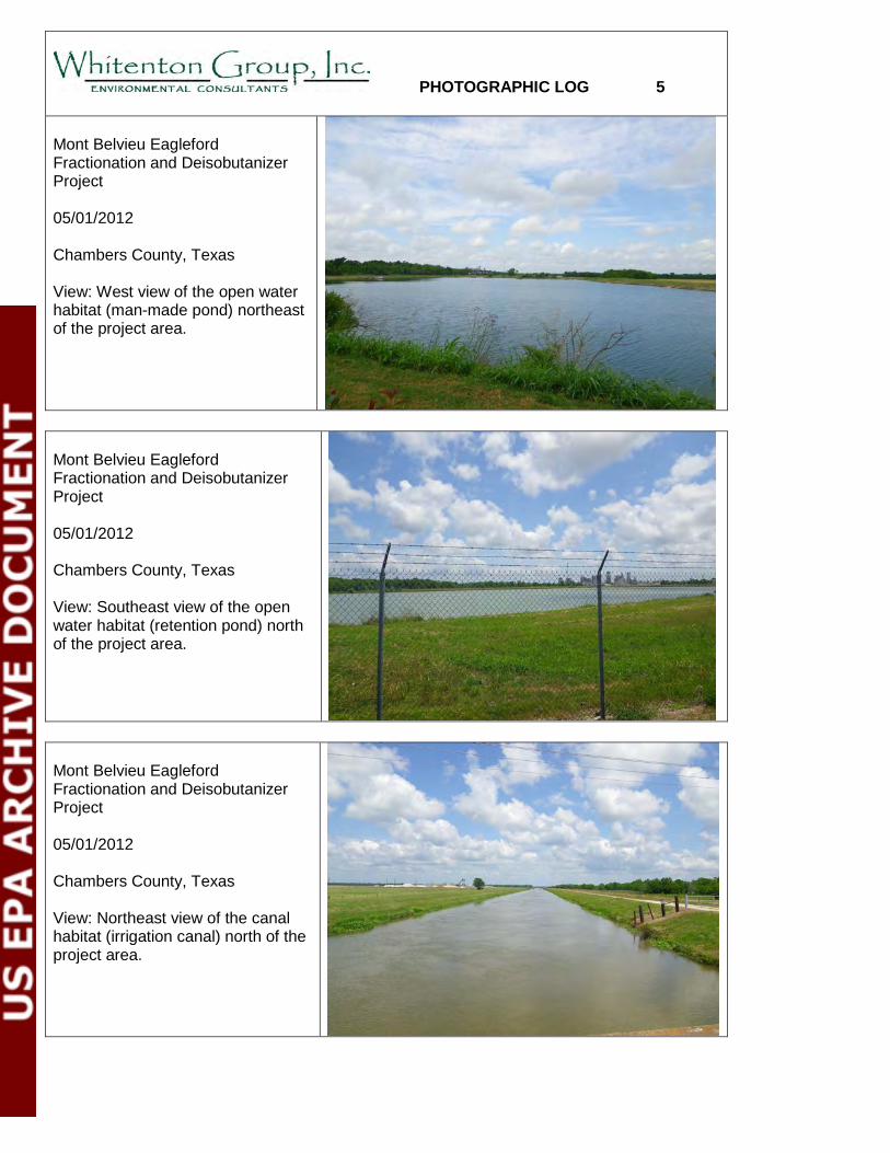
PHOTOGRAPHIC LOG 5 Mont Belvieu Eagleford Fractionation and Deisobutanizer Project 05/01/2012 Chambers County, Texas View: West view of the open water habitat (man-made pond) northeast of the project area.
Mont Belvieu Eagleford Fractionation and Deisobutanizer Project 05/01/2012 Chambers County, Texas View: Southeast view of the open water habitat (retention pond) north of the project area.
Mont Belvieu Eagleford Fractionation and Deisobutanizer Project 05/01/2012 Chambers County, Texas View: Northeast view of the canal habitat (irrigation canal) north of the project area.

PHOTOGRAPHIC LOG 6 Mont Belvieu Eagleford Fractionation and Deisobutanizer Project 05/01/2012 Chambers County, Texas View: West view of the pastureland (maintained) southeast of the project area.
Mont Belvieu Eagleford Fractionation and Deisobutanizer Project 05/01/2012 Chambers County, Texas View: East view of the pastureland (maintained) habitat northeast of the project area.
Mont Belvieu Eagleford Fractionation and Deisobutanizer Project 05/01/2012 Chambers County, Texas View: West view of the pastureland and woodland habitats north of the project area.
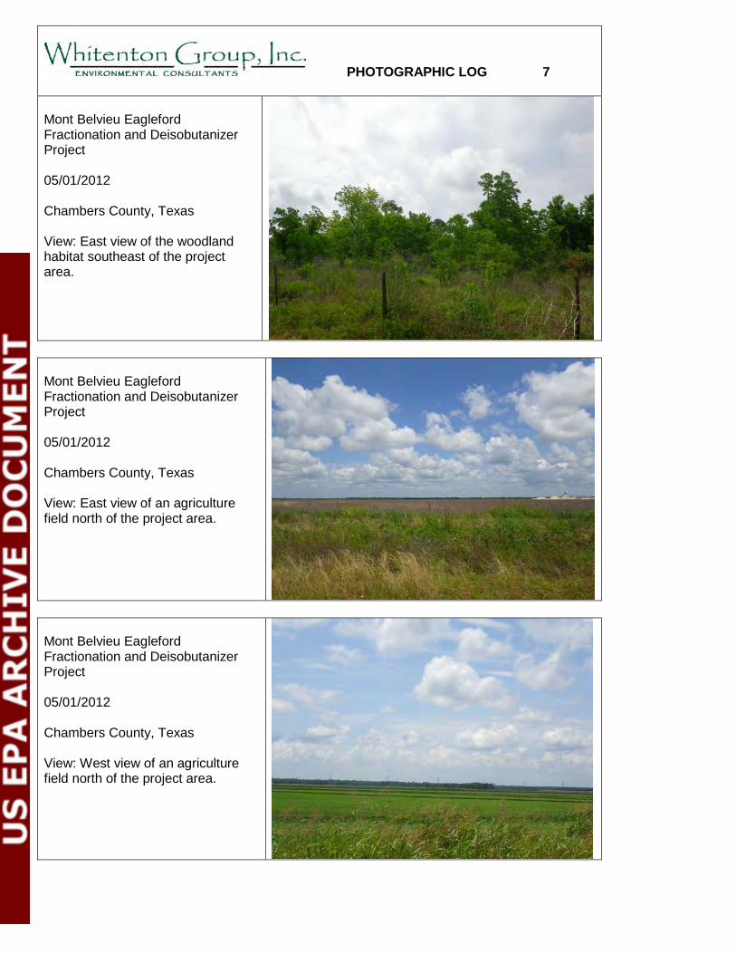
PHOTOGRAPHIC LOG 7 Mont Belvieu Eagleford Fractionation and Deisobutanizer Project 05/01/2012 Chambers County, Texas View: East view of the woodland habitat southeast of the project area.
Mont Belvieu Eagleford Fractionation and Deisobutanizer Project 05/01/2012 Chambers County, Texas View: East view of an agriculture field north of the project area.
Mont Belvieu Eagleford Fractionation and Deisobutanizer Project 05/01/2012 Chambers County, Texas View: West view of an agriculture field north of the project area.

PHOTOGRAPHIC LOG 8 Mont Belvieu Eagleford Fractionation and Deisobutanizer Project 05/01/2012 Chambers County, Texas View: West view of an industrial area southeast of the project area.
Mont Belvieu Eagleford Fractionation and Deisobutanizer Project 01/16/2012 Chambers County, Texas View: West view of an industrial area southeast of the project area.
Mont Belvieu Eagleford Fractionation and Deisobutanizer Project 05/01/2012 Chambers County, Texas View: East view of the open water and woodland habitats south of the project area.
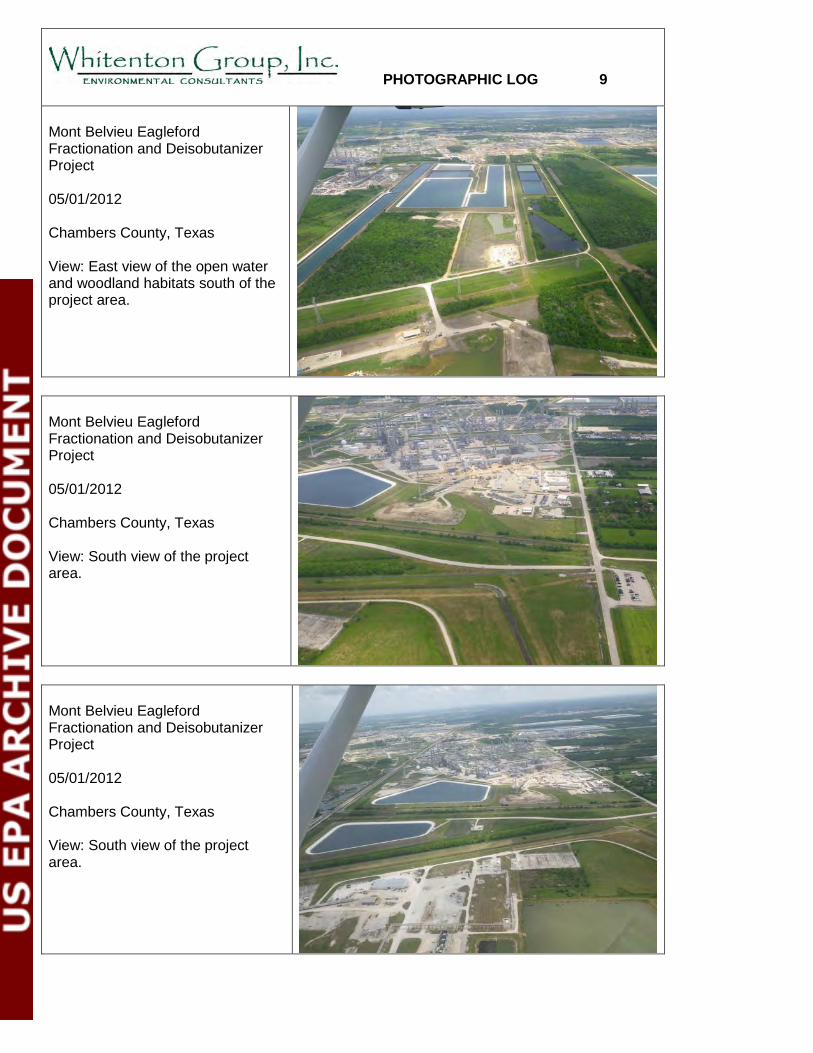
PHOTOGRAPHIC LOG 9 Mont Belvieu Eagleford Fractionation and Deisobutanizer Project 05/01/2012 Chambers County, Texas View: East view of the open water and woodland habitats south of the project area.
Mont Belvieu Eagleford Fractionation and Deisobutanizer Project 05/01/2012 Chambers County, Texas View: South view of the project area.
Mont Belvieu Eagleford Fractionation and Deisobutanizer Project 05/01/2012 Chambers County, Texas View: South view of the project area.
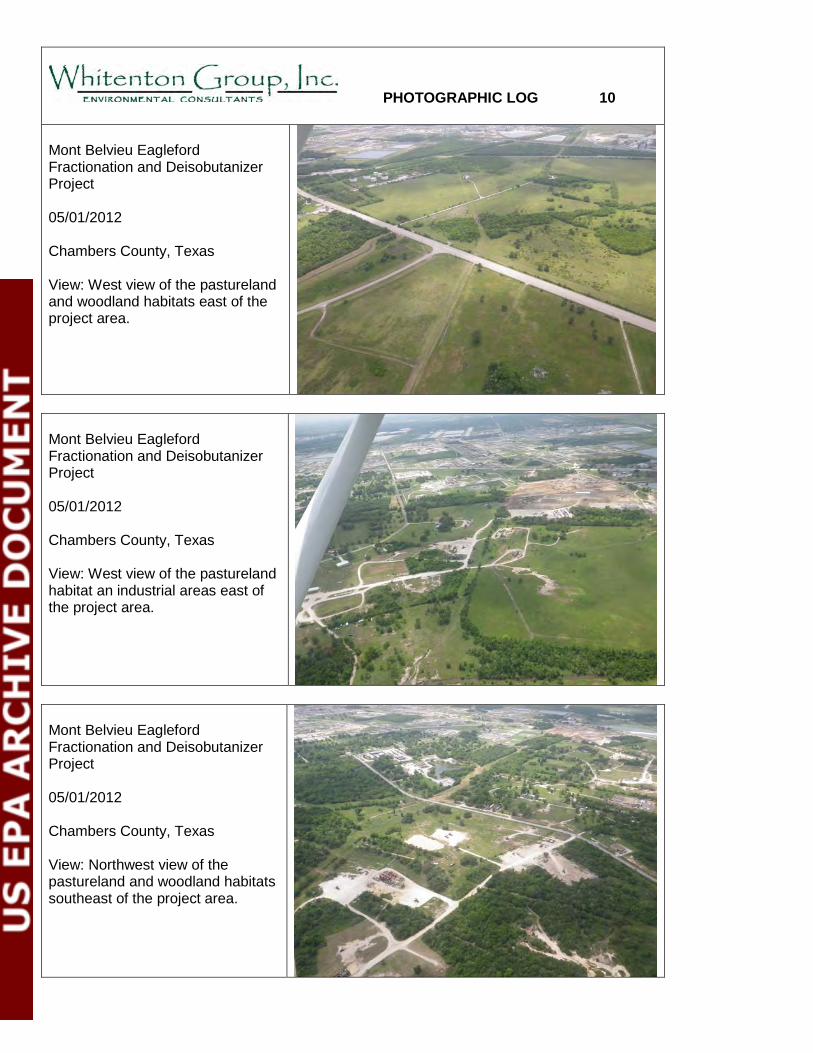
PHOTOGRAPHIC LOG 10 Mont Belvieu Eagleford Fractionation and Deisobutanizer Project 05/01/2012 Chambers County, Texas View: West view of the pastureland and woodland habitats east of the project area.
Mont Belvieu Eagleford Fractionation and Deisobutanizer Project 05/01/2012 Chambers County, Texas View: West view of the pastureland habitat an industrial areas east of the project area.
Mont Belvieu Eagleford Fractionation and Deisobutanizer Project 05/01/2012 Chambers County, Texas View: Northwest view of the pastureland and woodland habitats southeast of the project area.
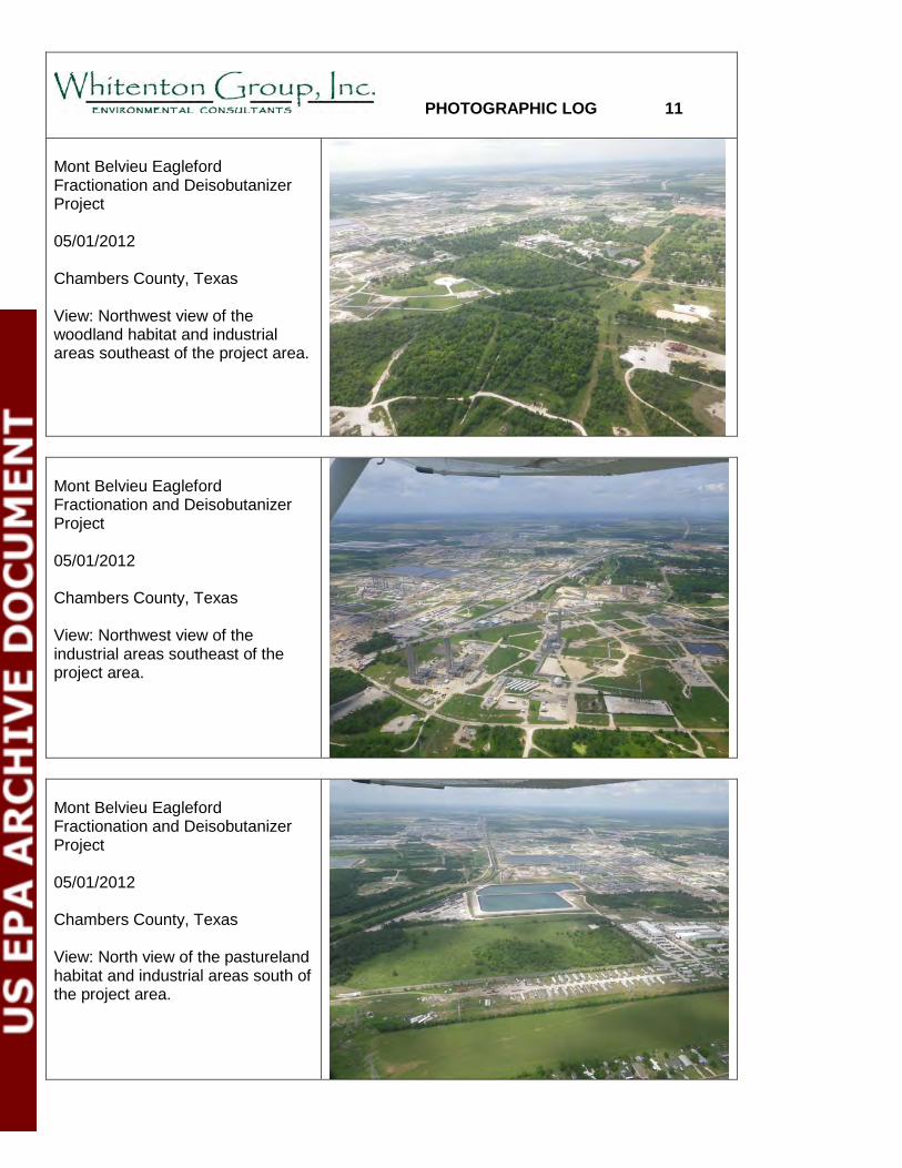
PHOTOGRAPHIC LOG 11 Mont Belvieu Eagleford Fractionation and Deisobutanizer Project 05/01/2012 Chambers County, Texas View: Northwest view of the woodland habitat and industrial areas southeast of the project area.
Mont Belvieu Eagleford Fractionation and Deisobutanizer Project 05/01/2012 Chambers County, Texas View: Northwest view of the industrial areas southeast of the project area.
Mont Belvieu Eagleford Fractionation and Deisobutanizer Project 05/01/2012 Chambers County, Texas View: North view of the pastureland habitat and industrial areas south of the project area.
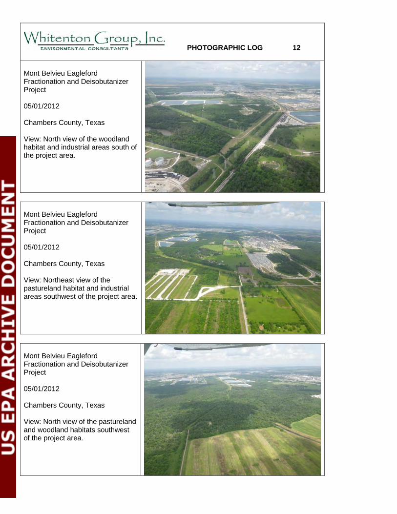
PHOTOGRAPHIC LOG 12 Mont Belvieu Eagleford Fractionation and Deisobutanizer Project 05/01/2012 Chambers County, Texas View: North view of the woodland habitat and industrial areas south of the project area.
Mont Belvieu Eagleford Fractionation and Deisobutanizer Project 05/01/2012 Chambers County, Texas View: Northeast view of the pastureland habitat and industrial areas southwest of the project area.
Mont Belvieu Eagleford Fractionation and Deisobutanizer Project 05/01/2012 Chambers County, Texas View: North view of the pastureland and woodland habitats southwest of the project area.
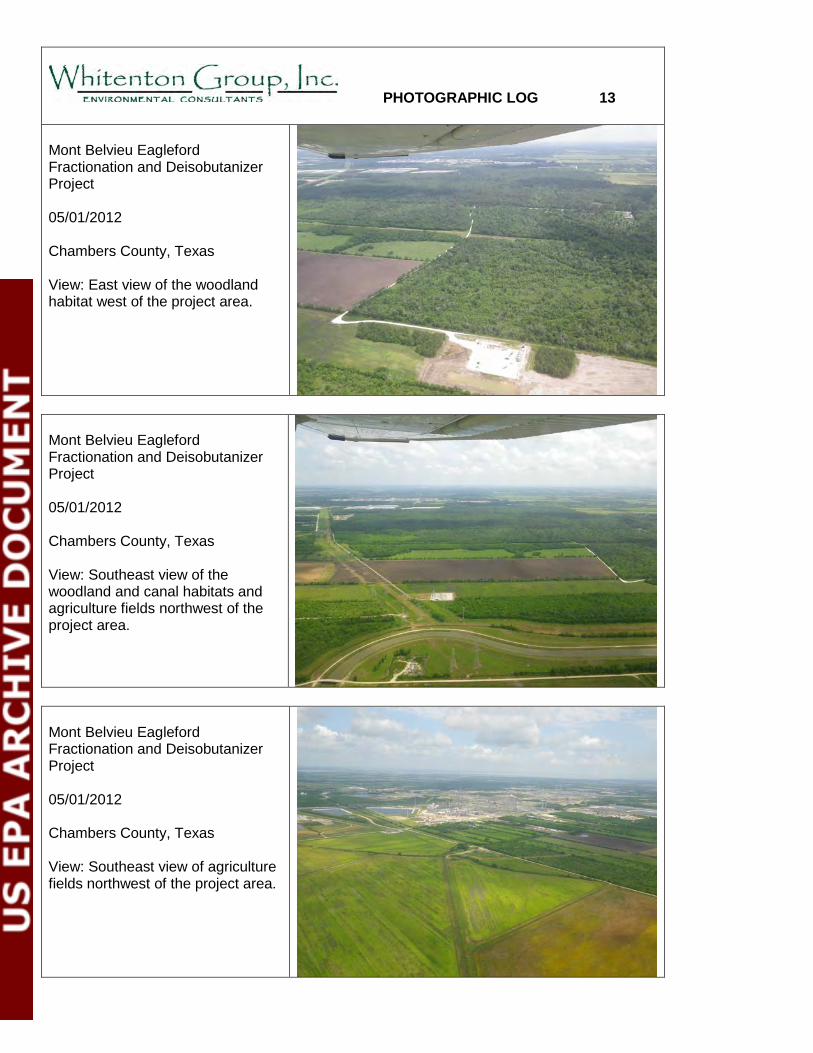
PHOTOGRAPHIC LOG 13 Mont Belvieu Eagleford Fractionation and Deisobutanizer Project 05/01/2012 Chambers County, Texas View: East view of the woodland habitat west of the project area.
Mont Belvieu Eagleford Fractionation and Deisobutanizer Project 05/01/2012 Chambers County, Texas View: Southeast view of the woodland and canal habitats and agriculture fields northwest of the project area.
Mont Belvieu Eagleford Fractionation and Deisobutanizer Project 05/01/2012 Chambers County, Texas View: Southeast view of agriculture fields northwest of the project area.

PHOTOGRAPHIC LOG 14 Mont Belvieu Eagleford Fractionation and Deisobutanizer Project 05/01/2012 Chambers County, Texas View: Southeast view of the agriculture field north of the project area.
Mont Belvieu Eagleford Fractionation and Deisobutanizer Project 05/01/2012 Chambers County, Texas View: South view of the woodland and pastureland habitats north of the project area.
Mont Belvieu Eagleford Fractionation and Deisobutanizer Project 05/01/2012 Chambers County, Texas View: South view of the agriculture fields north of the project area.

Mon Belvieu Eagle Ford Fractionation and Deisobutanizer Project – Biological Assessment
APPENDIX D
FIELD SURVEY DATA SUMMARY
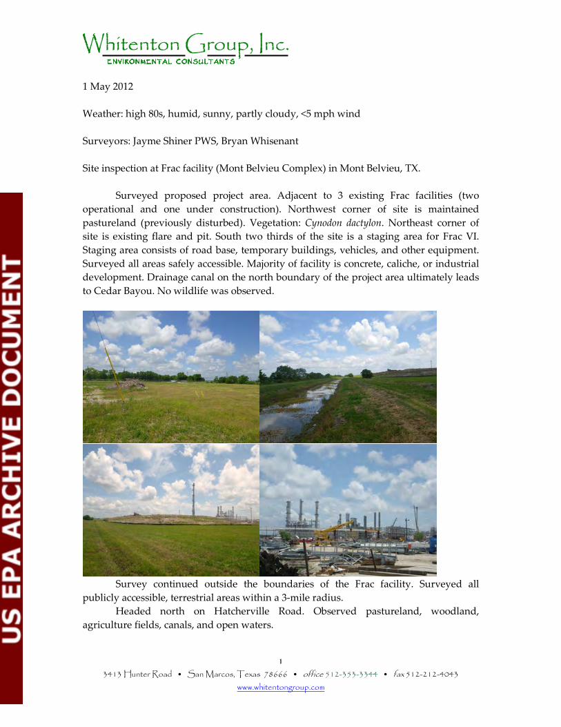
1 3413 Hunter Road • San Marcos, Texas 78666 • office 512-353-3344 • fax 512-212-4043
www.whitentongroup.com
1 May 2012 Weather: high 80s, humid, sunny, partly cloudy, <5 mph wind Surveyors: Jayme Shiner PWS, Bryan Whisenant Site inspection at Frac facility (Mont Belvieu Complex) in Mont Belvieu, TX.
Surveyed proposed project area. Adjacent to 3 existing Frac facilities (two operational and one under construction). Northwest corner of site is maintained pastureland (previously disturbed). Vegetation: Cynodon dactylon. Northeast corner of site is existing flare and pit. South two thirds of the site is a staging area for Frac VI. Staging area consists of road base, temporary buildings, vehicles, and other equipment. Surveyed all areas safely accessible. Majority of facility is concrete, caliche, or industrial development. Drainage canal on the north boundary of the project area ultimately leads to Cedar Bayou. No wildlife was observed.
Survey continued outside the boundaries of the Frac facility. Surveyed all publicly accessible, terrestrial areas within a 3-mile radius. Headed north on Hatcherville Road. Observed pastureland, woodland, agriculture fields, canals, and open waters.
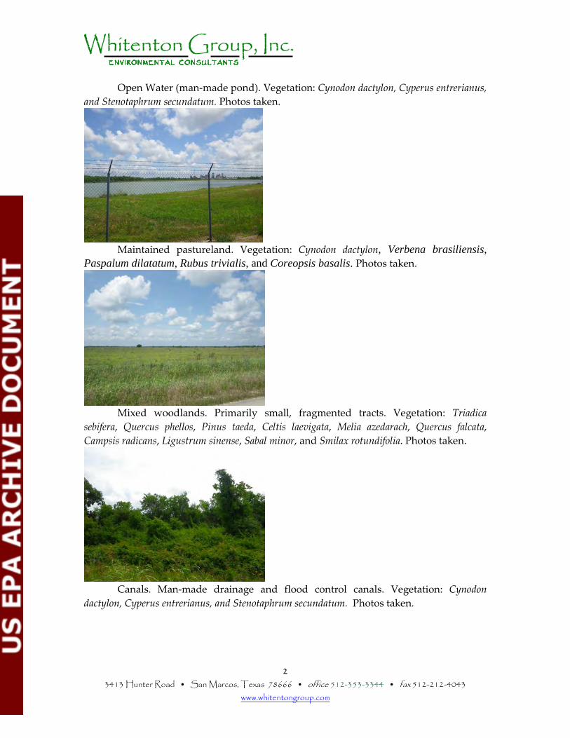
2 3413 Hunter Road • San Marcos, Texas 78666 • office 512-353-3344 • fax 512-212-4043
www.whitentongroup.com
Open Water (man-made pond). Vegetation: Cynodon dactylon, Cyperus entrerianus, and Stenotaphrum secundatum. Photos taken.
Maintained pastureland. Vegetation: Cynodon dactylon, Verbena brasiliensis, Paspalum dilatatum, Rubus trivialis, and Coreopsis basalis. Photos taken.
Mixed woodlands. Primarily small, fragmented tracts. Vegetation: Triadica
sebifera, Quercus phellos, Pinus taeda, Celtis laevigata, Melia azedarach, Quercus falcata, Campsis radicans, Ligustrum sinense, Sabal minor, and Smilax rotundifolia. Photos taken.
Canals. Man-made drainage and flood control canals. Vegetation: Cynodon
dactylon, Cyperus entrerianus, and Stenotaphrum secundatum. Photos taken.
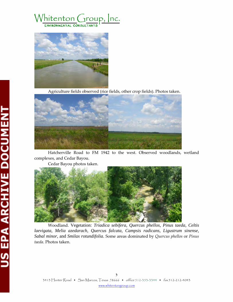
3 3413 Hunter Road • San Marcos, Texas 78666 • office 512-353-3344 • fax 512-212-4043
www.whitentongroup.com
Agriculture fields observed (rice fields, other crop fields). Photos taken.
Hatcherville Road to FM 1942 to the west. Observed woodlands, wetland complexes, and Cedar Bayou.
Cedar Bayou photos taken.
Woodland. Vegetation: Triadica sebifera, Quercus phellos, Pinus taeda, Celtis laevigata, Melia azedarach, Quercus falcata, Campsis radicans, Ligustrum sinense, Sabal minor, and Smilax rotundifolia. Some areas dominated by Quercus phellos or Pinus taeda. Photos taken.
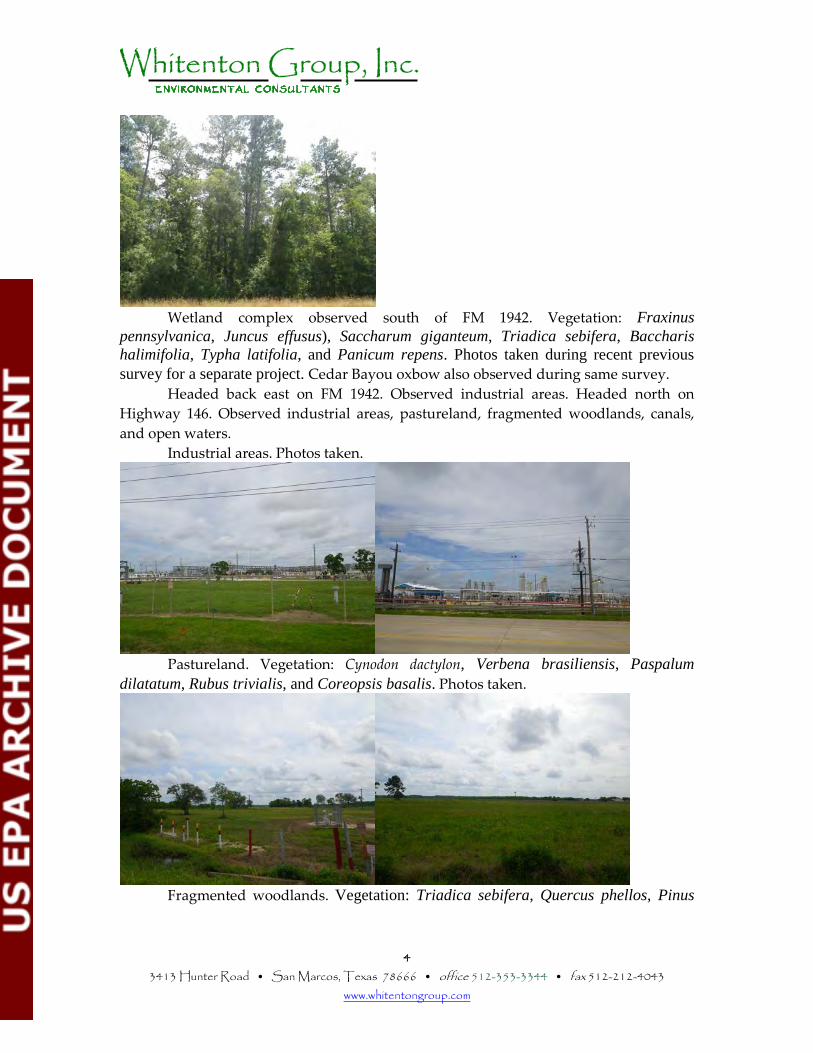
4 3413 Hunter Road • San Marcos, Texas 78666 • office 512-353-3344 • fax 512-212-4043
www.whitentongroup.com
Wetland complex observed south of FM 1942. Vegetation: Fraxinus pennsylvanica, Juncus effusus), Saccharum giganteum, Triadica sebifera, Baccharis halimifolia, Typha latifolia, and Panicum repens. Photos taken during recent previous survey for a separate project. Cedar Bayou oxbow also observed during same survey. Headed back east on FM 1942. Observed industrial areas. Headed north on Highway 146. Observed industrial areas, pastureland, fragmented woodlands, canals, and open waters. Industrial areas. Photos taken.
Pastureland. Vegetation: Cynodon dactylon, Verbena brasiliensis, Paspalum
dilatatum, Rubus trivialis, and Coreopsis basalis. Photos taken.
Fragmented woodlands. Vegetation: Triadica sebifera, Quercus phellos, Pinus
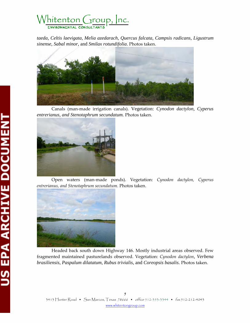
5 3413 Hunter Road • San Marcos, Texas 78666 • office 512-353-3344 • fax 512-212-4043
www.whitentongroup.com
taeda, Celtis laevigata, Melia azedarach, Quercus falcata, Campsis radicans, Ligustrum sinense, Sabal minor, and Smilax rotundifolia. Photos taken.
Canals (man-made irrigation canals). Vegetation: Cynodon dactylon, Cyperus entrerianus, and Stenotaphrum secundatum. Photos taken.
Open waters (man-made ponds). Vegetation: Cynodon dactylon, Cyperus
entrerianus, and Stenotaphrum secundatum. Photos taken.
Headed back south down Highway 146. Mostly industrial areas observed. Few fragmented maintained pasturelands observed. Vegetation: Cynodon dactylon, Verbena brasiliensis, Paspalum dilatatum, Rubus trivialis, and Coreopsis basalis. Photos taken.
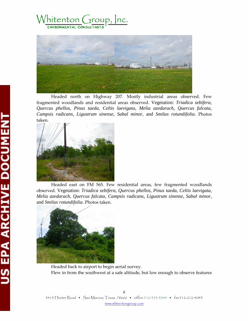
6 3413 Hunter Road • San Marcos, Texas 78666 • office 512-353-3344 • fax 512-212-4043
www.whitentongroup.com
Headed north on Highway 207. Mostly industrial areas observed. Few fragmented woodlands and residential areas observed. Vegetation: Triadica sebifera, Quercus phellos, Pinus taeda, Celtis laevigata, Melia azedarach, Quercus falcata, Campsis radicans, Ligustrum sinense, Sabal minor, and Smilax rotundifolia. Photos taken.
Headed east on FM 565. Few residential areas, few fragmented woodlands observed. Vegetation: Triadica sebifera, Quercus phellos, Pinus taeda, Celtis laevigata, Melia azedarach, Quercus falcata, Campsis radicans, Ligustrum sinense, Sabal minor, and Smilax rotundifolia. Photos taken.
Headed back to airport to begin aerial survey. Flew in from the southwest at a safe altitude, but low enough to observe features
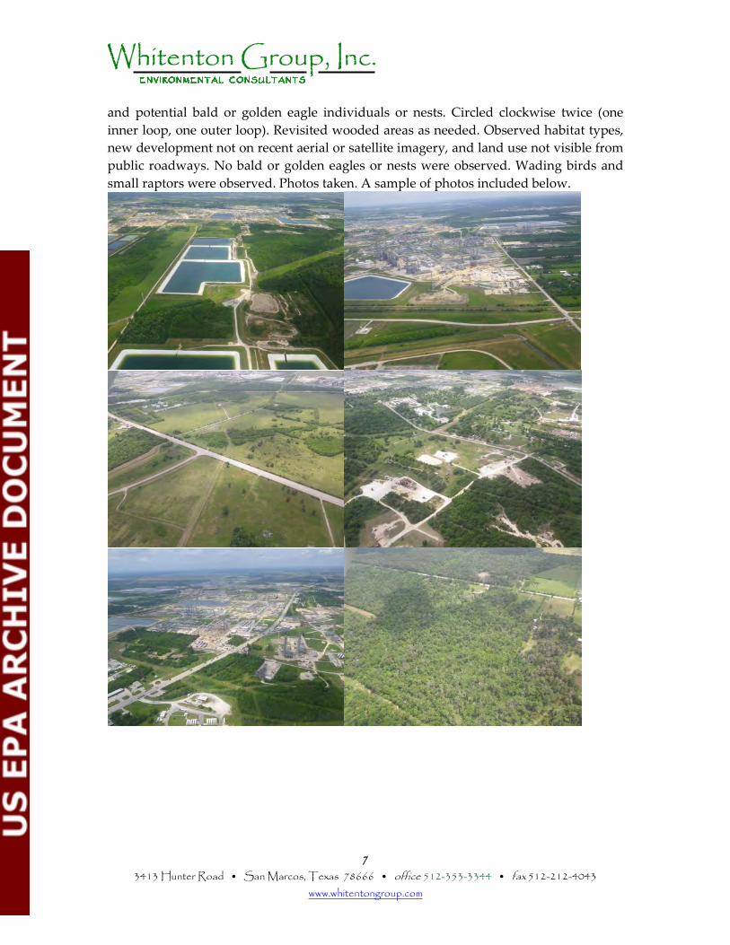
7 3413 Hunter Road • San Marcos, Texas 78666 • office 512-353-3344 • fax 512-212-4043
www.whitentongroup.com
and potential bald or golden eagle individuals or nests. Circled clockwise twice (one inner loop, one outer loop). Revisited wooded areas as needed. Observed habitat types, new development not on recent aerial or satellite imagery, and land use not visible from public roadways. No bald or golden eagles or nests were observed. Wading birds and small raptors were observed. Photos taken. A sample of photos included below.
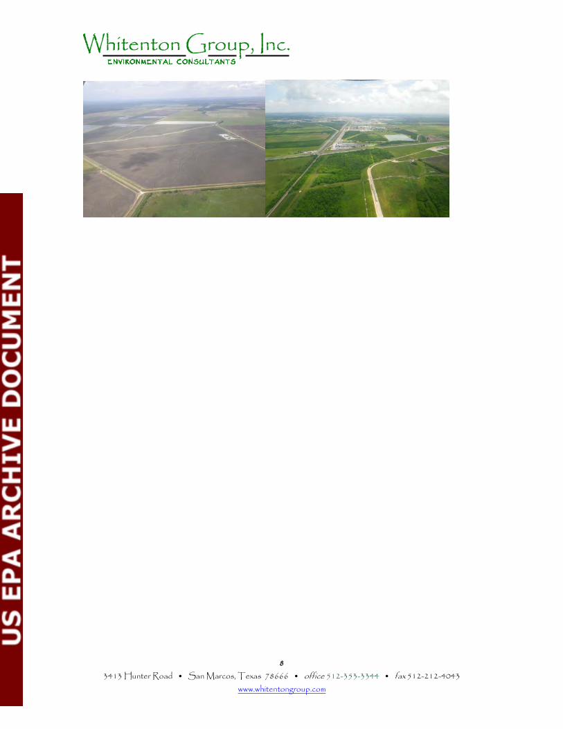
8 3413 Hunter Road • San Marcos, Texas 78666 • office 512-353-3344 • fax 512-212-4043
www.whitentongroup.com