BIOLOGICAL ASSESSMENT Ruby Pipeline Project
51
Office of Energy Projects January 2010 BIOLOGICAL ASSESSMENT Ruby Pipeline Project Ruby Pipeline L.L.C. Docket No. CP09-54-000 Washington, DC 20426 20100219-4001 FERC PDF (Unofficial) 02/19/2010
Transcript of BIOLOGICAL ASSESSMENT Ruby Pipeline Project
Office ofEnergy Projects
January 2010
BIOLOGICAL ASSESSMENT
Ruby Pipeline Project
Ruby Pipeline L.L.C. Docket No. CP09-54-000
Washington, DC 20426
20100219-4001 FERC PDF (Unofficial) 02/19/2010

TABLE OF CONTENTS
1.0 INTRODUCTION.......................................................................................................................... 1
2.0 DESCRIPTION OF THE PROJECT FACILITIES .................................................................. 3
2.1 PROPOSED FACILITIES .......................................................................................................32.1.1 Pipeline Facilities.............................................................................................. 32.1.2 Aboveground Facilities..................................................................................... 4
2.2 LAND IMPACTS.....................................................................................................................42.2.1 Pipeline Facilities.............................................................................................. 62.2.2 Aboveground Facilities..................................................................................... 8
2.3 VEGETATION IMPACTS....................................................................................................10
3.0 DESCRIPTION OF THE PROPOSED ACTION .................................................................... 12
3.1 GENERAL PIPELINE CONSTRUCTION PROCEDURES...............................................133.1.1 Survey and Staking ......................................................................................... 133.1.2 Clearing and Grading...................................................................................... 133.1.3 Trenching........................................................................................................ 173.1.4 Pipe Stringing, Bending, and Welding............................................................ 173.1.5 Lowering-in and Backfilling........................................................................... 183.1.6 Hydrostatic Testing......................................................................................... 193.1.7 Cleanup and Restoration ................................................................................. 19
3.2 SPECIAL PIPELINE CONSTRUCTION PROCEDURES .................................................203.2.1 Wetland Crossings .......................................................................................... 203.2.2 Waterbody Crossings ...................................................................................... 213.2.3 Steep Terrain................................................................................................... 253.2.4 Blasting ........................................................................................................... 26
3.3 ABOVEGROUND FACILITY CONSTRUCTION.............................................................27
4.0 SPECIES AND CRITICAL HABITAT CONSIDERED ......................................................... 28
5.0 EFFECTS ANALYSIS AND DETERMINATIONS OF EFFECT ......................................... 32
5.1 BLACK-FOOTED FERRET .................................................................................................335.2 LAHONTAN CUTTHROAT TROUT..................................................................................345.3 LOST RIVER SUCKER, MODOC SUCKER, SHORTNOSE SUCKER, AND WARNER
SUCKER.................................................................................................................................415.4 ENDANGERED COLORADO RIVER BASIN FISH.........................................................445.5 UTE LADIES’-TRESSES......................................................................................................46
6.0 REFERENCES............................................................................................................................. 48
20100219-4001 FERC PDF (Unofficial) 02/19/2010

1
1.0 INTRODUCTION
On January 27, 2009, Ruby Pipeline, L.L.C. (Ruby) filed an application with the Federal EnergyRegulatory Commission (FERC or Commission) in Docket Number CP09-54-000 under Section 7 of theNatural Gas Act (NGA), as amended, and parts 157 and 284 of the Commission’s regulations. Ruby isseeking a Certificate of Public Convenience and Necessity (Certificate) for its Ruby Pipeline Project,which would include the construction and operation of pipeline, compression, and ancillary facilities inWyoming, Utah, Nevada, and Oregon. In Docket Number CP09-54-000 Ruby is also seeking a BlanketCertificate to perform routine activities in connection with the future construction and operation of certaineligible facilities and services. The environmental staff of the FERC prepared an Environmental ImpactStatement (EIS) to assess the environmental impact associated with the construction and operation of thefacilities proposed by Ruby, in accordance with the requirements of the National Environmental PolicyAct (NEPA). The draft EIS was published in the Federal Register on June 26, 2009. The FERC thenprepared a final EIS based on comments received during the draft EIS comment period and additionalinformation submitted by Ruby. A Notice of Availability was issued by the FERC on January 8, 2010.The final EIS is available for review on the FERC website (www.ferc.gov).1 Copies of the final EIS werealso sent to the applicable U.S. Fish and Wildlife Service (FWS) offices serving the project area.
Specifically, the Ruby Pipeline Project would involve the construction and operation of about677.8 miles of 42-inch-diameter pipeline and about 160,500 horsepower (hp) of new compression. Theproposed facilities would be capable of transporting up to 1.5 million dekatherms per day (Dth/d) ofnatural gas, which is the equivalent of about 1.5 billion cubic feet (bcf) of natural gas per day. Rubyproposes to begin construction in February 2010 and place the pipeline in service by March 2011,although the actual schedule would be determined according to the timing of the NEPA review, thecompleteness of information submitted by Ruby, and various permitting processes. A detailed discussionof the proposed project is presented in sections 2 and 3.
In accordance with Section 7 of the Endangered Species Act of 1973 (ESA), the lead federalagency (in this case, the FERC) in coordination with the FWS must ensure that any action authorized,funded, or carried out by the agency does not jeopardize the continued existence of a federally listedthreatened or endangered species or result in the adverse modification of the designated critical habitat ofa federally listed species. The lead federal agency also must prepare a Biological Assessment (BA) foractions involving major construction activities with the potential to affect listed species or designatedcritical habitat. The lead agency must submit its BA to the FWS and, if it is determined that the action islikely to adversely affect a listed species, the lead federal agency must submit a request for formalconsultation to comply with Section 7 of the ESA. The FWS would then issue a Biological Opinion as towhether or not the federal action would likely jeopardize the continued existence of a listed species orresult in the destruction or adverse modification of designated critical habitat. The FWS would issue aconference opinion as to whether or not the federal action would likely jeopardize the continued existenceof a species proposed for listing or result in the destruction or adverse modification of proposed criticalhabitat. As the lead federal agency for the Ruby Pipeline Project, we have determined that the RubyPipeline Project could affect federally listed species and their designated critical habitats and aresubmitting this BA to assess the project’s impacts on federally listed species and their critical habitats.
Although the FERC is the lead federal agency for the Ruby Pipeline Project, other federalagencies that have various permitting authorities for the project have provided data that assisted FERCstaff in developing its effects determinations and other analyses, and have suggested measures tominimize project effects to listed species or critical habitat. The U.S. Department of the Interior, Bureau
1 Using the “eLibrary” link, select “General Search” from the eLibrary menu, enter the selected date range and DocketNumber (i.e., CP09-54), and follow the instructions.
20100219-4001 FERC PDF (Unofficial) 02/19/2010
2
of Land Management (BLM); U.S. Department of Interior, Bureau of Reclamation (Reclamation); U.S.Department of Agriculture, Forest Service (USFS); and the FWS (because of access road improvementson the Sheldon National Wildlife Refuge) are required to comply with Section 7 of the ESA for the RubyPipeline Project because lands administered under their jurisdictions are crossed by the project. Thecompletion of Section 7 between the FERC (as lead agency) and the FWS would satisfy these agencies’obligation for Section 7 compliance. The analysis and measures provided in this BA were developed inpart from information provided by these cooperating federal agencies. Additional measures or mitigationnot described in this BA may be required in other federal permits or agreements made between Ruby andfederal agencies.
The project would cross FWS Regions 1, 6, and 8. The FWS typically designates a lead officefor project review and ESA consultation in the case of a multiregional project such as the Ruby PipelineProject. The FWS’s Field Office in Portland, Oregon will coordinate the Section 7 review for the project.
20100219-4001 FERC PDF (Unofficial) 02/19/2010

3
2.0 DESCRIPTION OF THE PROJECT FACILITIES
2.1 PROPOSED FACILITIES
The Ruby Pipeline Project would involve the construction and operation of buried natural gaspipeline and related aboveground facilities. An overview map showing the project location is provided asfigure 2-1. Detailed maps of the project facilities are not provided with this document due to the length ofthe proposed pipeline. However, detailed maps showing the proposed pipeline route, abovegroundfacility, access roads, temporary extra workspaces, staging areas, yards, and housing/construction campsare available on the FERC website and are provided as Appendix B of the final EIS.
2.1.1 Pipeline Facilities
Ruby proposes to construct and operate a total of about 675.2 miles of 42-inch-diameter mainlinepipeline. The mainline pipeline would begin near the Opal Hub in Lincoln County, Wyoming at milepost(MP) 0.0 and proceed westerly through Wyoming, Utah, Nevada, and Oregon, terminating near theOregon-California state line in Klamath County, Oregon at MP R672.6.2 Ruby also proposes to constructand operate about 2.6 miles of 42-inch-diameter lateral3 pipeline in Oregon. The lateral would begin nearthe Oregon-California state line at MP 0.0ℓ
4 and proceed northerly to a meter station at MP 2.6ℓ. Themainline and lateral would have a uniform design pressure and maximum allowable operating pressure(MAOP) of 1,440 pounds per square inch gauge (psig). Table 2.1.1-1 lists the pipeline facilities byfacility type, milepost range, county and length.
TABLE 2.1.1-1
Pipeline Facilities for the Ruby Pipeline Project
State/Facility Type MP Range County Length (miles)
WYOMING
Mainline 0.0 – 21.1 Lincoln 21.1
Mainline 21.1 – 48.1 Uinta 27.0
Subtotal 48.1
UTAH
Mainline 48.1 – 73.1 Rich 25.0
Mainline 73.1 – 101.0 Cache 27.9
Mainline 101.0 – 230.6 Box Elder 129.6
Subtotal 182.5
NEVADA
Mainline 230.6 – R396.7 Elko 166.1
Mainline R396.7 – 536.0 Humboldt 139.3
Mainline 536.0 – 588.2 Washoe 52.2
Subtotal 357.6
2 Mileposts proceeded by an “R” identify locations where Ruby modified its pipeline route after the draft EIS was issued.The physical distance between two consecutive mileposts may not be exactly 1 mile because of these route modifications.
3 A lateral is a shorter pipeline that takes natural gas from the main pipeline system to a customer, such as a local distributioncompany or another natural gas pipeline system.
4 Mileposts on the lateral pipeline are identified by a subscript “ℓ” throughout this BA.
20100219-4001 FERC PDF (Unofficial) 02/19/2010

4
TABLE 2.1.1-1
Pipeline Facilities for the Ruby Pipeline Project
State/Facility Type MP Range County Length (miles)
OREGON
Mainline 588.2 – R647.3 Lake 59.1
Mainline R647.3 – R672.6 Klamath 25.3
Lateral 0.0ℓ – 2.6ℓ Klamath 2.6
Subtotal 87.0
Grand Total 675.2
2.1.2 Aboveground Facilities
Ruby proposes to construct and operate four compressor stations as part of the Ruby PipelineProject. The Roberson Creek Compressor Station would be located at MP 5.7, near the beginning of thepipeline in Lincoln County, Wyoming. This compressor station would utilize three 23,000 hp drivecompressor units for a total of up to 69,000 hp. Under International Organization for Standardization(ISO) operating conditions, the compressor station would utilize up to its entire 69,000 hp output.
The Wildcat Hills Compressor Station would be located at MP 172.5, near the quarter point of thepipeline in Box Elder County, Utah. This compressor station would utilize two 15,000 hp Solar Mars 100natural gas turbine units for a total of up to 30,000 hp. Under ISO operating conditions, the compressorstation would utilize about 28,668 hp output.
The Wieland Flat Compressor Station would be located at MP 330.2, near the halfway point ofthe pipeline in Elko County, Nevada. This compressor station would utilize two 20,500 hp Solar Titan130 natural gas turbine compressor units for a total of up to 41,000 hp. Under ISO operating conditions,the compressor station would utilize about 39,662 hp output.
The Desert Valley Compressor Station would be located at MP 476.4, near the three-quarter pointof the pipeline in Humboldt County, Nevada. This compressor station would utilize one 20,500 hp SolarTitan 130 natural gas turbine compressor unit. Under ISO operating conditions, the compressor stationwould utilize about 19,831 hp output.
In addition to compressor stations, Ruby would construct and operate meter stations (to receivegas from interconnections with other pipeline systems in Wyoming and deliver gas to interconnectionswith other pipeline systems in Nevada and Oregon), mainline valves (MLVs) (to control the flow of gaswithin the pipeline), pig launchers and receivers (to insert and remove pigging tools into and from thepipeline), and communication towers up to 50 feet tall (to facilitate communication and operation of thepipeline system). All aboveground facilities are shown in Appendix B of the final EIS. Some of theaboveground facilities are collocated at the same sites.
2.2 LAND IMPACTS
Construction of the proposed project would affect a total of about 16,829.7 acres of land,including 13,725.6 acres of open land, 1,257.7 acres of forested land, 1,046.0 acres of agricultural land,605.1 acres of developed land, and 195.4 acres of open water. Land use impacts resulting from theconstruction of the pipeline and aboveground facilities are discussed below.
20100219-4001 FERC PDF (Unofficial) 02/19/2010

5
2.2.1
20100219-4001 FERC PDF (Unofficial) 02/19/2010

6
2.2.1 Pipeline Facilities
Ruby would use a 115-foot-wide construction right-of-way for a majority of the pipeline route.Ruby would use a narrower right-of-way when crossing most wetlands (as described in section 3.2.1),forested riparian areas (as described in section 4.4.3 of the final EIS), and playas (as described in section4.2.2.3 of the final EIS). However, in limited, non-wetland areas, the construction right-of-way widthmay be expanded by up to 25 feet to accommodate full construction right-of-way topsoil segregation or toensure safe construction where required by topographic conditions (such as steep side-slopes) or soillimitations.5 The extra width could also be used for temporary storage of timber, slash, stumps, surfacerock, or snow; or in non-wetland, non-forested areas for truck turn-arounds where no reasonablealternative access exists. Ruby’s proposal, as written, would allow expanding the construction right-of-way width for temporary storage of timber, stumps, surface rock, and snow in wetlands, playas, andforested areas (including forested riparian areas) without the need for additional regulatory approval. Wedo not concur with this proposal and have included a recommendation in section 4.2.4 of the final EISthat would require Ruby to revise its Upland Erosion Control, Revegetation, and Maintenance Plan (Plan)to require agency authorization before expanding the construction right-of-way width in wetlands, playas,and forested areas (including forested riparian areas) for temporary storage of timber, slash, stumps,surface rock, or snow. Following construction, Ruby would retain a 50-foot-wide permanent right-of-wayto operate the pipeline. In total, the pipeline construction right-of-way would temporarily disturb about9,349.5 acres of land. The permanent right-of-way would encompass about 4,109.1 acres of land.
About 402.2 miles (59.6 percent) of the pipeline right-of-way would be collocated with (i.e.,overlap or abut) other existing road or utility rights-of-way, or would be offset from other existing road orutility rights-of-way. Other existing utility rights-of-way include pipelines, electric transmission lines,and fiber optic cables. Appendix V of the final EIS lists the locations where the construction right-of-waywould be collocated with or parallel to other existing rights-of-way.
Ruby would use a number of temporary extra workspaces, staging areas, and water appropriationsites totaling about 3,135.6 acres during construction. Temporary extra workspace typically would belocated along the construction right-of-way on both sides of wetland, waterbody, road, and utility linecrossings, and in areas of exceptionally rugged terrain. Most temporary extra workspaces would add 80feet onto the 115-foot-wide construction right-of-way, effectively creating a 195-foot-wide work area.The BLM believes that 80 feet may be excessive for temporary extra workspaces and stated that it wouldnot authorize the extra width in all requested areas on federal lands. Staging areas are similar to extraworkspaces except that they may be located on or off the construction right-of-way. Staging areas wouldvary in size and, in many instances, would widen the construction right-of-way beyond temporary extraworkspaces for short distances. Water appropriation sites, like staging areas, would be located on and offthe construction right-of-way to facilitate well drilling and water appropriation for hydrostatic testing,dust abatement, and equipment cleaning. Appendix E in the final EIS lists each proposed temporary extraworkspace, staging area, and water appropriation site for the project. The use of temporary workspacesand staging areas in or near waterbodies, wetlands, and woody riparian areas is discussed in sections3.1.2, 3.2.1, and 3.2.2.
Ruby would use 7 contractor construction yards, 16 pipe storage/staging/stringing yards, 1construction camp, and 1 temporary housing facility totaling about 1,058.6 acres to support pipelineconstruction. Contractor and pipe yards typically would be located away from the construction right-of-way and would be used for stockpiling pipe, storing materials, staging work, fabricating accessories,repairing equipment, housing mobile offices, and parking vehicles. The Vya Construction Camp, as itsname implies, would provide temporary housing and food service for non-local workers in northwestern
5 The BLM would require full topsoil segregation on all BLM-administered lands in Humboldt and Washoe counties, Nevada.
20100219-4001 FERC PDF (Unofficial) 02/19/2010

7
Nevada where adequate facilities are not readily available. The Vya camp would provide housing for upto 650 workers. Camp components would include up to 425 temporary modular-type housing units, up to200 camper and recreation vehicle parking pads, as well as access to support facilities such as potablewater, a food service hall, waste treatment, fuel storage, and electrical power.
The Lakeview Temporary Housing Facility would be similar to the Vya Construction Campexcept that it would not include a food service hall or fuel storage facilities. The Lakeview facility wouldbe located in the town of Lakeview, Oregon and would be comprised of seven temporary dormitorybuildings capable of accommodating up to 350 workers. The buildings would include provisions forlaundry, showers, and toilets and would be served by municipal sewer, water, and power.
Ruby would use existing public and private roads to gain access to the project area. Many of theexisting county and state roads are presently in a condition that can accommodate construction trafficwithout significant modification or improvement. Some roads, however, are small or impassable and arenot currently suitable for construction traffic. Ruby has proposed to improve unsuitable access roadsthrough grading, filling, and/or widening. About 585 roads totaling about 3,702.9 acres would need to begraded or widened up to a total road width of 30 feet, with extra width of up to 25 feet beyond theexisting road edge at sharp turns. Additionally, Ruby would construct new roads where existing roads donot provide adequate access. A total of 5 new dirt and gravel roads totaling about 2.5 acres would beconstructed up to 15 feet wide to respond to a landowner request and to gain access to an abovegroundfacility (a MLV at MP 109.0).6
Ruby has evaluated the need for access roads in California and determined that certain Californiaroads would be required to access portions of its project in Oregon. Ruby identified 22.5 miles of accessroads in Modoc County, California, of which about 5.9 miles are on federal lands administered by theBLM and USFS (Modoc National Forest). Ruby has stated it would not need to improve any of the roadsin California and there would be no vegetative or soil disturbance associated with their use. Ruby wouldobtain the necessary authorizations to use the roads from the BLM, USFS, and Modoc County. Newaccess roads proposed by Ruby would be limited to approximately 2.5 miles in Utah and 6.0 miles inOregon.
Ruby does not know exactly how or where road improvements would be required along anygiven road identified as potentially needing improvements. This information will not be available untilafter Ruby’s construction contractor identifies which roads it prefers to use, how it prefers to use theroads, and the weather at the time of use. Therefore, for the purpose of our analysis of potential projectimpacts, we have conservatively estimated that all roads needing improvement would need to beimproved up to 30 feet wide over their entire length. This undoubtedly is an overestimation. Appendix Eof the final EIS identifies each new or to-be-improved access road on the project.
Ruby has agreed to restore all roads to their preconstruction condition except upon request. Rubyhas stated that some private landowners have indicated an interest in leaving roads in their improvedcondition, but are reserving the right to make that final decision when they see the road’s condition at orclose to the end of construction. The BLM has stated that all BLM-administered roads in Humboldt andWashoe counties, Nevada would be required to be restored to their preconstruction condition and thatsome roads may need to be closed. Where roads are closed, closure activities may include, but would notbe limited to, scarifying the roadway and revegetating the entire length and width of the road used by
6 Ruby continued evaluating its need for new access roads and access road improvements after issuance of the draft EIS. Thisadditional evaluation resulted in more accurate information about the locations and lengths of new and to-be-improvedaccess roads, including a substantial reduction in impact acreages.
20100219-4001 FERC PDF (Unofficial) 02/19/2010

8
Ruby. Road closures on BLM-administered land would be completed in accordance with the BLM’sresource management use plans and other standards.
Because Ruby does not know specifically where road improvements would be needed, thevolumes of locations where gravel fill would be required also are not known. Ruby estimates that lessthan 5 percent of the access roads would require some gravel for maintenance or improvement. Toprovide some perspective on the amount of gravel that may be needed, if Ruby were to place a 30-foot-wide, 6-inch-deep gravel cap across 5 percent of all access roads, about 160,150 cubic yards of gravel fillwould be needed. This equates to about 16,015 10-yard dump truck loads, or 7 to 8 loads per work dayper spread. The assumption of a 6-inch cap over each access road that Ruby has estimated would needsome gravel is clearly an overestimation and represents a “worst-case” scenario. Some access roadswould only require placement of gravel at specific locations such as where potholes or ruts currentlyexist. Ruby indicated that it would seek gravel locally from existing commercial sand and gravel pits orother retailers. Ruby would not establish its own borrow pits for this project.
2.2.2 Aboveground Facilities
Aboveground facilities associated with the Ruby Pipeline Project include compressor stations,meter stations, MLVs, pig launchers and receivers, and communication towers. Land requirements foraboveground facilities would involve about 173.9 acres during construction and operation. Table 2.2.2-1summarizes aboveground facility site land requirements.
TABLE 2.2.2-1
Aboveground Facility Land Requirements for the Ruby Pipeline Project a
Facility Type Construction Area(acres)
Permanent Area(acres)
WYOMING
Roberson Creek Compressor Station and Associated Facilities 47.6 47.6
Meter Stations and Associated Facilities 13.6 8.3
MLVs Only 1.0 0.4
Subtotal 62.2 56.3
UTAH
Wildcat Hills Compressor Station and Associated Facilities 29.3 29.3
MLVs with Launchers and/or Receivers 3.4 0.9
MLVs Only 10.0 2.0
Subtotal 42.7 32.2
NEVADA
Wieland Flat & Desert Valley Compressor Stations and AssociatedFacilities 50.6 50.6
Meter Stations and Associated Facilities 5.5 5.5
MLVs with Launchers and/or Receivers 13.6 3.6
MLVs Only 7.0 2.8
Subtotal 76.7 62.5
OREGON
Meter Stations and Associated Facilities 9.4 9.4
MLVs Only 3.0 1.2
Subtotal 12.4 10.6
Grand Total 194.0 161.6
─────────────────────────
a Aboveground facilities may overlap the construction work area and/or permanent right-of-way.
20100219-4001 FERC PDF (Unofficial) 02/19/2010
9
According to Ruby, local utility companies would be required to provide electric service to theRoberson Creek and Desert Valley compressor stations. Rocky Mountain Power would be required toconstruct electric power lines from its electric transmission grid to the proposed Roberson CreekCompressor Station at MP 5.7 in Lincoln County, Wyoming. These facilities would include about 1.5miles of 230-kilovolt (kV) electric transmission line, 1.0 mile of 25-kV electric distribution line, 16associated pylons (14 wood “H” frame structures and 2 steel poles, each about 70-feet tall and 645-feetapart with associated guy wires), a switching station (on a 400-by-550-foot site), a meter (on a 50-by-70-foot site), an access road (about 30 feet wide and 1,300 feet long), and other related components. RockyMountain Power would be seeking a 150-foot-wide right-of-way for the line. About half the line wouldbe located on BLM-administered land and the remainder would be located on private land.
Harney Electric Cooperative would be required to construct an approximate 4.5-mile-long, 25-kV electric distribution line that would extend from Harney Electric Cooperative’s existing electrictransmission grid to the proposed Desert Valley Compressor Station at MP 476.4 in Humboldt County,Nevada. The distribution line would be sited along Harney Electric Cooperative’s existing power lineright-of-way, which is located entirely on BLM-administered land. The line would be installed within theeasterly 35 feet of Harney Electric Cooperative’s existing 75-foot-wide right-of-way. The facilities wouldconsist of about 60 single wood poles with appropriate guy anchors.
No federally listed threatened or endangered species were identified along the Rocky MountainPower and Harney Electric Cooperative electric transmission and distribution line routes. However,biologists recorded six pygmy rabbit complexes (a petitioned species) along the proposed RockyMountain Power route. Twenty-one burrows were counted within the complexes, seven burrows of whichwere not entirely intact (e.g., enlarged by a predator). All other burrow entrances were usable and locatedat the bases of sagebrush shrubs. Twelve of the burrows were associated with fresh pellets. Older, graypellets were found near the entrances of nine other burrows.
As appropriate, Rocky Mountain Power would implement one or more of the followingmitigation measures to minimize impacts on the pygmy rabbit:
• identify densely growing, large-stature sagebrush plants with deep, loamy soils;• micro-realign the H-frame structures to avoid appropriate habitat;• neck-down the construction right-of-way through known, active pygmy rabbit colonies;• trap and relocate pygmy rabbits if the area is unavoidable;• use best management practices (BMPs) to rehabilitate disturbed soil and sagebrush steppe
vegetation;• haul topsoil off-site to keep the construction right-of-way narrow;• plant container sagebrush and monitor sites for pygmy rabbit return and usage; and• avoid identified pygmy rabbit breeding areas from February to March.
The Rocky Mountain Power and Harney Electric Cooperative power lines do not come under thejurisdiction of the FERC. Should a listing of any current candidate and petitioned species be made beforeor during construction of these facilities, the BLM would be required to initiate Section 7 consultation forthat species. Since these projects would be required to restore their respective construction rights-of-wayand adhere to all applicable laws and regulations regarding special status species and habitats, we believethat impacts on special status species and their habitats along the Rocky Mountain Power and HarneyElectric Cooperative electric transmission and distribution line routes would not be significant.
20100219-4001 FERC PDF (Unofficial) 02/19/2010

10
2.3 VEGETATION IMPACTS
The Ruby Pipeline Project would cross nine upland vegetation cover types: sagebrush steppe, saltdesert scrub, juniper woodland, mixed conifer forest, North Pacific wooded volcanic flowage, riparianforest, grasslands, mountain meadow/brush, and pasture and agricultural land.
Ruby has completed survey and vegetation classification on approximately 96 percent of theproject area, including the Vya Construction Camp and Lakeview Temporary Housing Facility sites.Project areas that have not been surveyed include some staging areas, contractor yards, and access roads.We have conducted an aerial photo assessment of the proposed contractor yards and have determined thatthe majority of the yards (which account for 78 percent of the unsurveyed project area) are located inindustrial parks that have been formally disturbed or developed, or are located in areas that were used aspipeline contractor or pipe storage yards during previous pipeline construction projects.
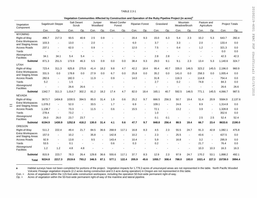
Table 2.3-1 identifies acreages of the vegetation types that would be directly affected byconstruction and operation of pipeline facilities, as identified through field surveys conducted by Rubyand its environmental contractor. Construction of the project within surveyed areas would impact about9,224.8 acres of sagebrush steppe, 2,519.6 acres of salt desert scrub, 346.5 acres of juniper woodland,577.1 acres of mixed conifer forest, 2.2 acres of North Pacific wooded volcanic flowage, 205.9 acres ofriparian forest, 1,055.7 acres of grassland, 788.0 acres of mountain meadow brush, and 1,021.4 acres ofpasture and agricultural land. These vegetation impacts identify the quantity of habitat that would beimpacted by the project.
20100219-4001 FERC PDF (Unofficial) 02/19/2010
11
TABLE 2.3-1
Vegetation Communities Affected by Construction and Operation of the Ruby Pipeline Project (in acres)a
Sagebrush Steppe Salt DesertScrub
JuniperWoodland
Mixed ConiferForest
Riparian Forest Grassland MountainMeadow/Brush
Pasture andAgriculture
Project TotalsVegetationComponent
Con. Op. Con. Op. Con. Op. Con. Op. Con. Op. Con. Op. Con. Op. Con. Op. Con. Op.
WYOMINGRight-of-Way 496.7 217.3 93.5 40.9 2.5 0.9 - - 20.4 9.3 15.0 6.3 5.4 2.3 10.2 5.3 643.7 282.4Extra Workspacesand Staging Areas
103.3 - 13.0 - 2.0 - - - 6.0 - 3.7 - 3.3 - 2.0 - 133.4 0.0
Access Roads 237.1 - 62.0 - 0.9 - - - 12.0 - 7.5 - 0.4 - 1.2 - 321.3 0.0Yards - - - - - - - - - - - - - - - - 0.0 0.0AbovegroundFacilities
34.1 34.1 5.4 5.4 - - - - - - 2.8 2.8 - - - - 42.3 42.3
Subtotal 871.3 251.5 173.9 46.3 5.5 0.9 0.0 0.0 38.4 9.3 29.0 9.1 9.1 2.3 13.4 5.3 1,140.6 324.7UTAHRight-of-Way 723.4 311.3 625.8 275.6 41.4 18.2 9.8 4.7 42.2 18.4 95.4 40.7 335.0 146.5 323.2 145.5 2,196.0 960.9Extra Workspacesand Staging Areas
331.5 0.0 178.8 0.0 27.9 0.0 6.7 0.0 25.8 0.0 35.2 0.0 141.0 0.0 258.3 0.0 1,005.4 0.0
Access Roads 282.6 - 182.0 - 11.9 - 0.9 - 14.0 - 31.8 - 116.3 - 114.8 - 754.4 0.0Yards 5.2 - 1.5 - - - - 2.7 - 0.2 - 74.8 - 84.3 0.0AbovegroundFacilities
- - 26.6 26.6 - - - - - - - - - - - - 26.6 26.6
Subtotal 1342.7 311.3 1,014.7 302.2 81.2 18.2 17.4 4.7 82.0 18.4 165.1 40.7 592.5 146.5 771.1 145.5 4,066.7 987.5
NEVADA
Right-of-Way 3673.7 1404.8 1030.5 394.5 85.0 31.4 1.9 0.6 25.2 9.7 666.5 256.3 50.7 19.4 51.4 20.9 5584.9 2,137.6Extra Workspacesand Staging Areas
1,078.2 - 52.0 - 33.5 - 1.7 - 6.9 - 109.1 - 24.6 - 8.9 - 1,314.8 0.0
Access Roads 1,138.7 - 73.3 - 11.5 - 0.6 - 15.5 - 72.1 - 13.2 - 3.9 - 1,328.8 0.0Yards 278.4 - 73.2 - - - - 1.0 - - - 352.6 0.0AbovegroundFacilities
26.0 26.0 23.7 23.7 - - - - - - 0.1 0.1 - - 2.5 2.5 52.4 52.4
Subtotal 6194.9 1430.9 1252.8 418.2 130.0 31.4 4.1 0.6 47.7 9.7 848.8 256.4 88.5 19.4 66.7 23.4 8633.6 2190.0OREGONRight-of-Way 511.2 222.4 49.4 21.7 84.5 36.6 268.9 117.1 16.8 8.3 4.5 2.3 55.5 24.7 91.3 42.8 1,082.1 475.8Extra Workspacesand Staging Areas 157.0 - 10.2 - 35.8 - 142.8 - 10.2 - 2.3 - 25.5 - 43.6 - 427.5 0.0
Access Roads 92.9 - 13.8 - 9.5 - 143.4 - 10.4 - 5.9 - 16.8 - 3.2 - 295.9 0.0Yards 53.5 - 0.1 - - - 0.6 - 0.3 - 0.2 - - - 21.7 - 76.4 0.0AbovegroundFacilities 1.2 1.2 4.8 4.8 - - - - - - - - - - 10.3 10.3 16.3 16.3
Subtotal 815.9 223.7 78.3 26.4 129.8 36.6 555.6 117.1 37.7 8.3 12.9 2.3 97.9 24.7 170.2 53.1 1,898.2 492.1
Total 9224.8 2217.3 2519.6 793.2 346.5 87.1 577.1 122.4 205.9 45.6 1055.7 308.4 788.0 193.0 1021.4 227.3 15739.0 3994.4
─────────────────────────a Habitat surveys have not been completed for portions of the project. Vegetation impacts for 1,779.3 acres of unsurveyed areas are not represented in the table. North Pacific Wooded
Volcanic Flowage vegetation impacts (2.2 acres during construction and 0.3 acre during operation) in Oregon are not represented in this table.Con. = Acres of vegetation within the 115-foot-wide construction workspace, including the operation 50-foot-wide permanent right-of-way.Op. = Acres of vegetation within the 50-foot-wide permanent right-of-way of the mainline and lateral pipeline.
20100219-4001 FERC PDF (Unofficial) 02/19/2010

12
3.0 DESCRIPTION OF THE PROPOSED ACTION
The following section provides a general overview of the construction procedures Ruby hasproposed to implement during construction of the Ruby Pipeline Project. Not all of the constructionprocedures presented in this section would impact listed species. Construction-related impacts that wouldaffect listed species are discussed in detail in section 5.
Ruby would design, construct, test, and operate its pipeline in accordance with U.S. Departmentof Transportation (DOT) regulations specified in 49 Code of Federal Regulations (CFR) 192,“Transportation of Natural and Other Gas by Pipeline: Minimum Federal Safety Standards.” 49 CFR 192specifies pipeline material and qualification, minimum design requirements, and protection from internal,external, and atmospheric corrosion, in addition to other design standards. Ruby also would be subject toother applicable federal and state regulations, including U.S. Department of Labor, Occupational Safetyand Health Administration requirements. These regulations are intended to ensure adequate protection forthe public, pipeline workers, contractors, and employees and to prevent natural gas pipeline accidents andfailures.
Ruby has prepared a Plan and Wetland and Waterbody Construction and Mitigation Procedures(Procedures) for this project. These documents are based on the Plan and Procedures developed by theFERC, with certain modifications that Ruby believes are appropriate to this specific project.Additionally, Ruby has developed several construction and restoration plans (e.g., Restoration andRevegetation Plans, Hydrostatic Test Plan, Blasting Plan, Waste and Spill Management SpecificationPlan [Spill Plan], Noxious and Invasive Weed Control Plan, etc.) to minimize construction impacts andfacilitate land restoration. We believe that Ruby’s Plan, Procedures, and construction and restorationplans are generally adequate and would minimize impacts on the environment. However, we haveidentified several site-specific and resource-specific circumstances that we believe require additionalenvironmental protection measures. These measures, along with any additional recommendations by theFERC, are discussed in the appropriate section of this BA. Ruby’s Plan, Procedures, and other variousplans discussed in this BA are included in the final EIS and can also be accessed at the FERC website (seefootnote 1, page 1).
The conclusions and recommendations presented in this BA are those of the FERC environmentalstaff. Our conclusions and recommendations were developed with input from the BLM, Reclamation,FWS, USFS, Natural resources Conservation Service, U.S. Army Corps of Engineers (COE), State ofUtah Public Lands Policy Coordination Office, and the Board of County Commissioners in LincolnCounty, Wyoming as cooperating agencies in the preparation of the EIS. However, the BLM,Reclamation, FWS, and USFS would present their own conclusions and recommendations in theirrespective Record of Decisions, and would adopt the EIS per 40 CFR 1506.3 if, after an independentreview of the document, they conclude that their permitting requirements have been satisfied; or, theywould conduct their own supplemental environmental analysis.
We have determined that construction and operation of the Ruby Pipeline Project would result insome adverse environmental impacts. Effects to all environmental resources were evaluated to determinewhether any significant impacts would remain after application of the mitigation or conservationmeasures proposed by Ruby. We then developed practical, appropriate, and reasonable measures whichwould further reduce project-related impacts. These recommendations are presented in the final EIS andalso presented as bolded text throughout this BA. These are not recommendations to Ruby, but rather areto the Commission. If adopted, these recommendations would be converted to enforceable conditions toany Certificate issued to Ruby by the Commission. Our analysis and effects determinations for federallylisted species are then based on Ruby’s proposed action and additional proposed mitigation, as well asimplementation of our recommendations.
20100219-4001 FERC PDF (Unofficial) 02/19/2010
13
3.1 GENERAL PIPELINE CONSTRUCTION PROCEDURES
Ruby would construct the pipeline by following several sequential pipeline constructiontechniques, which include survey and staking; clearing and grading; trenching; pipe stringing, bending,and welding; lowering-in and backfilling; hydrostatic testing; commissioning; and cleanup andrestoration. These construction techniques would proceed in an assembly line fashion and constructioncrews would move down the construction right-of-way as work progresses.
Many pipeline projects are divided into several distinct segments called spreads. Each spread isassigned a different construction team or contractor so that work may commence in several areassimultaneously. Ruby would utilize a total of 7 to 10 construction spreads on the Ruby Pipeline Project,with some spreads as short as 25 to 35 miles in length and some as long as 80 to 120 miles in length. Inthis manner, Ruby would be able to construct the project in multiple locations at the same time and couldcomplete the project much quicker and more efficiently than if it were using just one spread.
Many workers would drive personal vehicles to contractor yards each day before the start of workand would be bused from the contractor yards to the spread. Travel time to the spread typically would bebetween 30 minutes and 2 hours, depending on housing, yard, and spread location. In inclement weather,the travel time could double if road conditions deteriorate. Ruby contends that increased travel time dueto inclement weather would not significantly challenge the project schedule, and that it expects to be ableto complete construction within one season. We note that inclement weather could reduce productivity ofpersonnel and equipment on the construction right-of-way and believe that Ruby is being overlyoptimistic with regard to its construction schedule, the potential for inclement weather being one reason.
Ruby states that it would thoroughly clean construction equipment prior to use to prevent theimportation of invasive plant species to the project area from other areas where the equipment maypreviously have been used. Ruby would establish equipment cleaning sites at known infestation locationsand would clean equipment in infested areas before moving to other locations. Ruby has developed aNoxious and Invasive Weed Control Plan (see Appendix T of the final EIS) in cooperation with federaland state agencies to prevent the introduction and spread of invasive plant species during construction andoperation of the pipeline.
3.1.1 Survey and Staking
The first step of construction involves survey crews staking the limits of the construction right-of-way, the centerline of the proposed trench, temporary extra workspaces, and other approved work areas.Ruby would clearly mark access roads using temporary signs or flagging. Ruby also would markwetlands and other environmentally sensitive areas where appropriate. Ruby would brace and cut fencesand would install temporary gates and fences to contain livestock in active allotments and grazed areas.Ruby would be allowed to use only approved construction work areas and access roads; use of other areasor roads would not be allowed without prior authorization.
3.1.2 Clearing and Grading
Clearing and grading would remove trees, shrubs, brush, roots, and large rocks from theconstruction work area and level the right-of-way surface to allow operation of construction equipment.Vegetation generally would be cut or scraped flush with the surface of the ground, leaving rootstock inplace where possible. Cut and scraped vegetation would be stored at the edge of the right-of-way duringconstruction. After construction, scraped vegetation would be spread back across the right-of-way withtopsoil. Large shrubs and trees cut during clearing would be hauled away for disposal, burned in
20100219-4001 FERC PDF (Unofficial) 02/19/2010
14
accordance with local burning permits, or spread back across the right-of-way with landowner or land-managing agency approval.
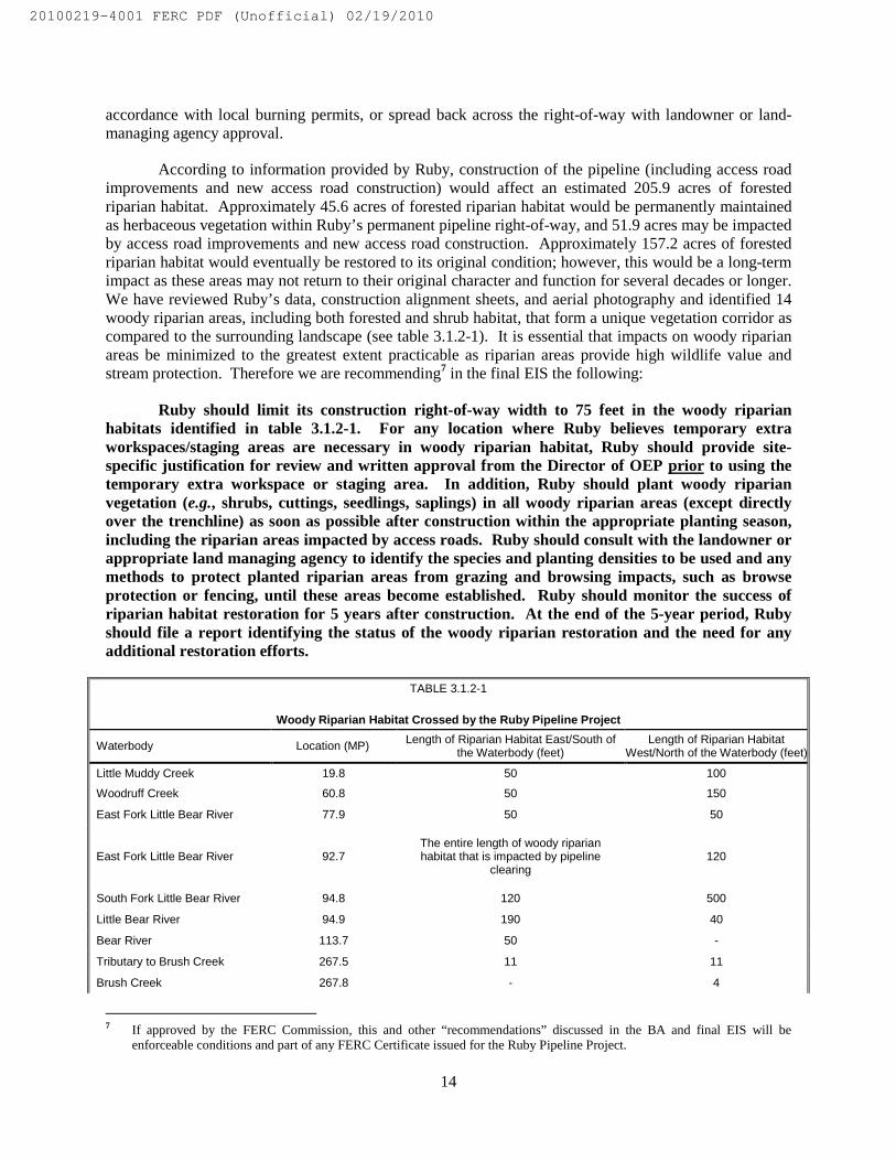
According to information provided by Ruby, construction of the pipeline (including access roadimprovements and new access road construction) would affect an estimated 205.9 acres of forestedriparian habitat. Approximately 45.6 acres of forested riparian habitat would be permanently maintainedas herbaceous vegetation within Ruby’s permanent pipeline right-of-way, and 51.9 acres may be impactedby access road improvements and new access road construction. Approximately 157.2 acres of forestedriparian habitat would eventually be restored to its original condition; however, this would be a long-termimpact as these areas may not return to their original character and function for several decades or longer.We have reviewed Ruby’s data, construction alignment sheets, and aerial photography and identified 14woody riparian areas, including both forested and shrub habitat, that form a unique vegetation corridor ascompared to the surrounding landscape (see table 3.1.2-1). It is essential that impacts on woody riparianareas be minimized to the greatest extent practicable as riparian areas provide high wildlife value andstream protection. Therefore we are recommending7 in the final EIS the following:
Ruby should limit its construction right-of-way width to 75 feet in the woody riparianhabitats identified in table 3.1.2-1. For any location where Ruby believes temporary extraworkspaces/staging areas are necessary in woody riparian habitat, Ruby should provide site-specific justification for review and written approval from the Director of OEP prior to using thetemporary extra workspace or staging area. In addition, Ruby should plant woody riparianvegetation (e.g., shrubs, cuttings, seedlings, saplings) in all woody riparian areas (except directlyover the trenchline) as soon as possible after construction within the appropriate planting season,including the riparian areas impacted by access roads. Ruby should consult with the landowner orappropriate land managing agency to identify the species and planting densities to be used and anymethods to protect planted riparian areas from grazing and browsing impacts, such as browseprotection or fencing, until these areas become established. Ruby should monitor the success ofriparian habitat restoration for 5 years after construction. At the end of the 5-year period, Rubyshould file a report identifying the status of the woody riparian restoration and the need for anyadditional restoration efforts.
TABLE 3.1.2-1
Woody Riparian Habitat Crossed by the Ruby Pipeline Project
Waterbody Location (MP) Length of Riparian Habitat East/South ofthe Waterbody (feet)
Length of Riparian HabitatWest/North of the Waterbody (feet)
Little Muddy Creek 19.8 50 100
Woodruff Creek 60.8 50 150
East Fork Little Bear River 77.9 50 50
East Fork Little Bear River 92.7The entire length of woody riparianhabitat that is impacted by pipeline
clearing120
South Fork Little Bear River 94.8 120 500
Little Bear River 94.9 190 40
Bear River 113.7 50 -
Tributary to Brush Creek 267.5 11 11
Brush Creek 267.8 - 4
7 If approved by the FERC Commission, this and other “recommendations” discussed in the BA and final EIS will beenforceable conditions and part of any FERC Certificate issued for the Ruby Pipeline Project.
20100219-4001 FERC PDF (Unofficial) 02/19/2010

15
TABLE 3.1.2-1
Woody Riparian Habitat Crossed by the Ruby Pipeline Project
Waterbody Location (MP) Length of Riparian Habitat East/South ofthe Waterbody (feet)
Length of Riparian HabitatWest/North of the Waterbody (feet)
Pole Creek 280.2 20 -
Mary’s River 300.0 50 150
Tributary to Indian Creek 315.1 200 -
North Fork Humboldt River 316.3 40 40
Gance Creek 329.2 50 50
Unnamed stream R350.0 12 -
Tributary to Willow Creek 358.1 50 50
Tributary to Willow Creek 358.4 50 50
Soldier Creek 359.3 50 50
Unnamed a R378.6 50 -
Unnamed a 413.5 - 20
Twelvemile Creek a 588.3 100 100
Unnamed a R105.1 100 -
Unnamed a R105.6 40 -
Brush Creek a 269.6 4 -
West Brush Creek a 270.3 2 -
Pole Creek a 279.4 - 100
Pole Creek a 279.6 - 100
Pole Creek a 280.0 - 50
Pole Creek a 280.2 - 50
Hot Springs Creek a 301.8 100 -
Unnamed a 505.9 10 -
Unnamed a 514.2 - 50
Unnamed a 514.4 - 25
Unnamed a 573.6 - 6
Dry Creek a 630.0 - 20
Unnamed a R671.9 10 -
─────────────────────────
a Woody riparian habitats that would be impacted by access road improvements
Grading would be conducted where necessary to provide a reasonably level work surface. Moreextensive grading would be required in uneven terrain and where the right-of-way traverses steep slopesand side slopes. Ruby would separate topsoil from subsoil from the trench and subsoil storage areas overthe entire length of the project with several exceptions, such as in saturated wetlands, in rocky soils,where the topsoil layer is less than 2 inches thick, etc. Ruby would segregate at least the top 12 inches oftopsoil where more than 12 inches of topsoil is present. In soils with less than 12 inches of topsoil, Rubywould segregate the entire topsoil layer. During backfilling, subsoil would be returned to the trench first.Topsoil would follow and would be returned to its original horizon.
Where necessary, Ruby would grade an approach across the entire construction workspace atintermittent and dry waterbodies to the flow line of the stream where steep or cut banks exist. Ruby
20100219-4001 FERC PDF (Unofficial) 02/19/2010

16
would grade a 50- to 60-foot-wide approach on the working side of the construction workspace atperennial waterbodies to the flow line of the stream where steep or cut banks exist. Ruby would theninstall temporary equipment bridges, mats, and pads across waterbodies less than 25 feet wide to supportequipment that must cross the waterbody. Ruby also would limit the use of construction equipment inwaterbodies greater than 25 feet wide that do not contain special status species as specified in itsProcedures.
Ruby would cut most trees near the bank at ground level to aid in maintaining bank stability,except those trees in the trench line. Roots would be removed over the trench line or from any steambanks that would need to be cut down or graded to accomplish the pipeline crossing.
Ruby would install sediment barriers, such as silt fence and straw/hay bales, across the right-of-way at the edge of waterbodies throughout construction except for short periods when the removal ofthese sediment barriers would be necessary to dig the trench, install the pipe, pass vehicles, and/or restorethe right-of-way. Ruby would immediately stabilize the construction site, including stream banks,following completion of construction. If circumstances require a construction delay Ruby would employsite stabilization measures in accordance with its Procedures and other permit conditions. Ruby hascommitted to employing Environmental Inspectors (EIs) during construction to help determine the needfor and ensure that erosion controls are properly installed. The EIs also would be responsible for:
• ensuring compliance with the requirements of the Plan and Procedures, the environmentalconditions of the Certificate authorization, the mitigation measures proposed by Ruby (asapproved and/or modified by the Certificate), other environmental permits and approvals,and environmental requirements in landowner easement agreements;
• verifying the location of signs and highly visible flagging marking the boundaries ofsensitive resource areas, waterbodies, wetlands, or areas with special requirements alongthe construction work area;
• ensuring that the location of dewatering structures and slope breakers do not direct waterinto known cultural resources sites or locations of sensitive species;
• verifying that trench dewatering activities do not result in the deposition of sand, silt,and/or sediment near the point of discharge into a wetland or waterbody. If suchdeposition is occurring, the dewatering activity would be stopped and the design of thedischarge would be changed to prevent reoccurrence;
• determining the need for and ensuring that erosion controls are properly installed, asnecessary, to prevent sediment flow into wetlands, waterbodies, sensitive areas, and ontoroads;
• keeping records of compliance with the environmental conditions of the FERCCertificate, and the mitigation measures proposed by the project sponsor in theapplication submitted to the FERC, and other federal or state environmental permitsduring active construction and restoration; and
• identifying areas that should be given special attention to ensure stabilization andrestoration after the construction phase.
20100219-4001 FERC PDF (Unofficial) 02/19/2010
17
3.1.3 Trenching
Trenching involves the removal of soil and bedrock to create a trench into which the pipeline isplaced. A trench would be excavated to a depth that would provide sufficient depth for the pipeline inaccordance with DOT requirements. Typically, the trench would be about 6 feet wide and at least 6 feetdeep. Less cover would be provided in rocky areas and additional cover would be provided at road andwaterbody crossings. Additional cover (above DOT requirements) could be negotiated at a landowner’srequest to accommodate land use practices such as deep tilling.
The trenching crew would use a wheel trencher or backhoe to dig the pipeline trench. When rockor rocky formations are encountered, tractor-mounted mechanical rippers or rock trenchers would be usedto fracture the rock prior to excavation. Blasting would be required in areas where mechanical equipmentcould break up or loosen the bedrock. Ruby would be required to use explosives in accordance withfederal and state guidelines and permits to ensure a safe and controlled blast.
To minimize the impact open trenches and spoil piles could have on wildlife and livestockmovement across the construction right-of-way, Ruby would install ramps at least every 0.5 mile in andacross the pipeline trench and leave 10-foot-wide gaps in spoil piles in big game migration corridors,within winter range areas, and in herd management areas to allow for wildlife and livestock movementacross the construction right-of-way. Ruby also would leave crossovers at 1,200-foot intervals, nearwater sources, at existing roads or two-tracks, and at visible livestock/wildlife trails to serve as routes forbig game to cross the construction right-of-way until the pipe is ready to be installed. Ruby would alsoleave crossovers on each side of stream water sources. Each crossover would be sloped on each side toact as an escape ramp for any livestock/wildlife that happens to become trapped in the trench. Ruby alsowould inspect the open ditch line daily to ensure that livestock/wildlife is not trapped in the open trench.Details regarding trenching impacts on listed species are discussed in section 5.
3.1.4 Pipe Stringing, Bending, and Welding
After trenching, sections of pipe between 40 and 80 feet long (also referred to as “joints”) wouldbe transported to the right-of-way by truck and strung beside the trench in a continuous line. The pipewould be delivered to the job site with a protective coating of epoxy or mastic that would inhibitcorrosion by preventing moisture from coming into direct contact with the steel.
Individual sections of pipe would be bent to conform to the contours of the ground after the jointsof pipe sections are strung along side the trench. Workers would use a track-mounted, hydraulic pipe-bending machine to bend the pipe. Where multiple or complex bends are required, bending would beconducted at the pipe fabrication factory, and the pipe would be shipped to the project area pre-bent.
Welding is the process that joins the individual joints of pipe together into one continuous string.After the pipe joints are bent they would be aligned, welded together into a long segment, and placed ontemporary supports at the edge of the trench. Ruby would only use experienced welders who are highlyproficient in pipeline welding and are qualified according to applicable standards. Ruby has indicated itwould use automated welding equipment to complete the welding process. Automated welding would becompleted in accordance with strict specifications which require qualified welders to oversee the process.
Welder qualification would take place before the project begins. Each welder would be requiredto pass a qualification test to work on the Ruby Pipeline Project as part of the quality assurance process.In addition, each weld procedure would be approved for use on the job in accordance with federallyadopted welding standards. Each welder would complete several welds using the same type of pipe thatwould be used on the project. The welds would be evaluated by placing the welded material in a machine
20100219-4001 FERC PDF (Unofficial) 02/19/2010
18
and measuring the force required to pull apart the weld. Because the weld has a greater tensile strengththan the pipe, the pipe must break before the weld.
One hundred percent of the welds on the pipeline would undergo radiographic (x-ray) orultrasonic inspection. Qualified technicians would ensure that the welds meet federally prescribed qualitystandards. If a technician detects a flaw, the weld would be repaired or a new weld made.
All pre-coated pipes have uncoated areas 3 to 6 inches from each end of the pipe to prevent thecoating from interfering with the welding process. Once the welds are made a coating crew would coatthe area around the weld before the pipeline is lowered into the trench. Pipeline companies use severaldifferent types of coating in the field, the most common being fusion-bonded epoxy. Prior to application,the coating crew would thoroughly clean the bare pipe with a power wire brush or sandblast machine toremove dirt, mill scale, and debris. The crew would then apply the coating and allow the coating to dry.The pipeline would be inspected electronically (also referred to as “jeeped”) for faults or voids in thecoating and would be visually inspected for scratches or other defects. Ruby would repair damage to thecoating before the pipeline is lowered into the trench. Ruby would handle pipe coating material inaccordance with its Spill Plan, which is provided as Appendix J of the final EIS. We do not anticipatestringing, bending, welding, or coating activities would impact listed species.
3.1.5 Lowering-in and Backfilling
The trench would be inspected to be sure it is free of rocks and other debris that could damage thepipe or protective coating before the pipe would be lowered into the trench. Trench dewatering may benecessary to inspect the bottom of the trench in areas where water has accumulated. Trench waterdischarges would be directed to well-vegetated upland areas or to sediment filtration devices to minimizethe potential for runoff and sedimentation. The pipeline would then be lowered into the trench by a seriesof side-boom tractors (tracked vehicles with hoists on one side and counterweights on the other) whichwould carefully lift the pipeline and place it on the bottom of the trench.
Trench breakers (stacked sand bags or polyurethane foam) would then be installed in the trenchon slopes at specified intervals to prevent subsurface water movement along the pipeline. The trenchwould then be backfilled using the excavated material. At locations where topsoil had been separatedfrom subsoil during the clearing process, subsoil would be returned to the trench first, followed bytopsoil. A mound of soil about the width of the trench and 1 foot high may be left over the trench inupland areas to compensate for settling. Appropriately spaced breaks would be left in the mounded soil toprevent interference with groundwater runoff and irrigation.
Padding material such as sand or fine grain soil or gravel would be placed in the bottom of thetrench in rocky areas to protect the pipeline. If the excavated material is rocky, the pipeline would becovered with more suitable fill. About 1 cubic yard of suitable fill (also referred to as padding) would beneeded per linear foot of pipeline. Ruby would obtain padding by screening excavated trench material toseparate fine soil from rocky soil, crushing rock to an acceptable size, exchanging spoil from one locationon the right-of-way to another, and/or importing new material from a commercial source (the most costlyoption). Ruby has not yet identified the specific volume of pipe padding that would be needed for theproject. Such information is typically not known until after trenching is completed. Based on previousexperience, Ruby estimates that less than 3 percent of the route would require imported padding from acommercial source (e.g., an existing sand or gravel pit). Ruby also may elect to minimize the need forpipe padding by installing rock shield around the pipeline. Rock shield is a flexible pipeline wrapdesigned to protect the pipeline where rocky backfill is unavailable. Once the pipe is sufficiently coveredwith suitable material or wrapped in rock shield, the excavated rocky soil would be used for backfillwithin the original rocky soil horizon.
20100219-4001 FERC PDF (Unofficial) 02/19/2010

19
3.1.6 Hydrostatic Testing
Ruby would hydrostatically test the pipeline after backfilling to ensure the system is capable ofwithstanding the operating pressure for which it was designed (Ruby’s Hydrostatic Test Plan is providedas Appendix K of the final EIS). Hydrostatic testing involves filling the pipeline with water to adesignated test pressure and maintaining that pressure for about 8 hours. Actual test pressures anddurations would be consistent with the requirements of 49 CFR 192. Leaks would be repaired and thesection of pipe retested until the required specifications were met.
The pipeline would be partitioned into about 90 to 100 separate test segments. The location of atest segment is dependent on water availability and elevation changes. Water for hydrostatic testingwould be obtained from a combination of groundwater and surface waters through specific agreementswith landowners and in accordance with federal, state, and local regulations and permits. No surfacewaters would be used for hydrostatic testing in Nevada or Oregon; hydrostatic test water would beobtained from groundwater sources in Nevada and Oregon. Hydrostatic test water would be obtainedfrom surface waters within the Colorado River drainage system. Potential water depletion impacts onlisted Colorado River fishes are discussed in section 5.4.
3.1.7 Cleanup and Restoration
Ruby would complete final cleanup, including final grading and the installation of erosion controldevices, within 20 days of backfilling, weather and soil conditions permitting. Construction debris wouldbe cleaned up and taken to a disposal facility, and work areas would be restored to preconstructioncontours to the extent practical except as otherwise directed by the landowner or land managing agency.Permanent erosion control devices, such as slope breakers and riprap, would be installed to reduce the riskof erosion, and straw bales would be spread over the right-of-way.
Ruby would seed the right-of-way after final grading in accordance with the specificationsoutlined in its state-specific Restoration and Revegetation Plans (provided as Appendix L of the finalEIS). Ruby developed separate Restoration and Revegetation Plans for Oregon, Nevada, Utah, andWyoming based on recommendations from state resource and land managing agencies. Ruby wouldmake every effort to seed disturbed areas within 6 working days of final grading, except where writtenconcurrence from the local soil conservation authority, land owner, or land managing agency requires adifferent timeframe (such as on some BLM-administered land where seeding would be allowed onlybetween October and December). After seeding, all slopes along the right-of-way would be stabilized,where necessary, by applying 2 tons per acre of weed-free straw or hay (or functional equivalent), exceptwhere written concurrence from the local soil conservation authority, landowner, or land managingagency has been obtained for a different standard (such as on BLM-administered land where the use ofmulch is not desired). Ruby would install and maintain additional temporary erosion control devices,such as silt fence or straw bales, in the project area until permanent vegetation is established. Ruby hasagreed to develop grazing deferment and cost reimbursement arrangements with willing landowners,grazing permittees, and land managing agencies to address grazing disruption from construction and tominimize disturbance to newly reseeded areas during restoration.
Ruby would install gates or other barriers (e.g., rock berms, log barricades, roughened right-of-way) within the construction work area where requested by landowners or land managing agencies tominimize unauthorized entry by off-highway vehicles (OHVs). The BLM has indicated that it wouldrequire Ruby to gate and fence disturbed areas on BLM-administered land in western Box Elder County,Utah to keep livestock and OHVs off restored areas until vegetation has become established. BLM gatingand fencing requirements would be addressed in Ruby’s right-of-way grant and Plan of Development.Ruby would install markers to show the location of the pipeline at fence and road crossings in order to
20100219-4001 FERC PDF (Unofficial) 02/19/2010

20
identify the owner of the pipeline and convey emergency information in accordance with applicablegovernmental regulations, including DOT safety requirements. Ruby would also install special markersto provide information and guidance for aerial patrol pilots.
Ruby would monitor areas disturbed by construction, including access roads, until revegetationthresholds are met and temporary erosion control devices are removed. Ruby would monitor upland areasaffected by construction for at least two growing seasons after construction for issues such as vegetationcover, invasive species, crop productivity, soil settling, soil compaction, excessively rocky soils, anddrainage problems. Ruby stated it would monitor the success of wetland revegetation annually for thefirst 5 years after construction or until revegetation is successful. After 5 years of annual monitoring,Ruby would file a report with the FERC identifying the status of wetland revegetation efforts, and wouldcontinue filing an annual report until wetland revegetation is successful. If revegetation is not successfulat the end of 5 years, Ruby would develop and implement (in consultation with a professional wetlandecologist) a remedial plan to actively revegetate wetland areas until revegetation is successful. Rubystated it would employ maintenance measures to ensure successful wetland restoration, includingirrigation system repair, plant replacement, non-native plant control, water structure repair, fertilization,erosion control, wildlife protection, trash removal, and/or any other related activities. Dead plants wouldbe replaced during the growing season in which they are identified and/or immediately in the beginning ofthe next growing season (i.e., replacement would occur at the earliest feasible period based on seasonallimitations). All plant material would be replaced in-kind with native material, consisting of potted,nursery stock and/or native cuttings collected from local sources.
3.2 SPECIAL PIPELINE CONSTRUCTION PROCEDURES
Special construction techniques are typically required when constructing across wetlands,waterbodies, roads, railroads, foreign utilities, steep slopes, geologic faults, and when constructing in thewinter. Temporary extra workspaces adjacent to the construction right-of-way would be utilized at mostof these areas for staging construction, storing materials, maneuvering equipment, fabricating pipe, andstockpiling spoil.
3.2.1 Wetland Crossings
Pipeline construction across wetlands would be similar to typical conventional upland cross-country construction procedures, with several modifications and limitations as described in Ruby’sProcedures to reduce the potential impact on wetland hydrology and soil structure. Ruby’s Proceduresinclude the following wetland mitigation and restoration measures:
• limit the construction right-of-way to 75 feet in wetlands and located temporary extraworkspaces at least 50 feet from wetlands unless approved by the FERC and otherapplicable resource agencies;
• install sediment barriers adjacent to wetlands and within temporary extra workspaces asnecessary to minimize the potential for sediment runoff;
• limit the operation of construction equipment within wetlands to equipment essential forclearing, excavation, pipe installation, backfilling, and restoration;
• limit grading to directly over the trench line, except where necessary to ensure safety;• limit grading by using low ground weight construction equipment, or by operating
equipment from prefabricated timber mats in saturated or standing-water wetlands;• segregate topsoil from the trench line in non-saturated wetlands;• minimize the time the trench is open in wetlands;
20100219-4001 FERC PDF (Unofficial) 02/19/2010

21
• use the push-pull crossing method in wetlands, where possible;• install trench breakers at the boundaries of wetlands as needed to prevent draining of a
wetland and to maintain original wetland hydrology;• prohibit storage of hazardous materials, chemicals, fuels, and lubricating oils within 100
feet of a wetland boundary (150 feet in Oregon) unless infeasible;• prohibit the refueling of equipment within 100 feet of wetlands, and 500 feet of wetlands
on BLM-administered lands, unless the EI finds no reasonable alternative;• seed the construction right-of-way in accordance with the recommendations of the land
managing agencies and local soil conservation authorities in non-agricultural wetlandswhere no standing water is present (no seeding would be conducted in agriculturalwetlands or wetlands with standing water);
• restrict annual maintenance of vegetation to a 10-foot-wide strip centered over thepipeline to trees greater than 15 feet in height within 15 feet of the pipeline centerline;
• consult with the appropriate land managing or state agencies to develop plans torevegetate wetlands, and, where necessary, prevent the invasion or spread of undesirableexotic and invasive vegetation;
• monitor the success of wetland revegetation annually for a period of at least 5 years afterconstruction, or until the wetland is successfully revegetated; and
• comply with the COE’s Section 404 permit conditions and state-issued Section 401 waterquality certifications or waivers.
Our discussion of construction procedures in wetland areas provides a general overview ofimpacts that could occur from construction of the project. We do not anticipate that construction impactson wetland areas would affect listed species.
3.2.2 Waterbody Crossings
The Ruby Pipeline Project would cross numerous perennial, intermittent, and ephemeralwaterbodies. Prior to construction, Ruby would install temporary bridges across flowing waterbodies toallow for equipment passage. Bridges would include clean rock fill over culverts, timber mats supportedby flumes, railcar flatbeds, or other types of spans. Construction equipment would use bridges at alltimes, except for the equipment used by the initial clearing crew, which would be allowed one passthrough the waterbody before the bridge is installed. Reclamation indicated that it would not allow theinitial clearing crew to pass through waterbodies under Reclamation jurisdiction. Bridges and supportswould be removed as soon as possible after permanent seeding.
Ruby has proposed to use several different waterbody crossing methods depending on site- andwaterbody-specific conditions. The majority of the waterbodies that would be crossed by the pipeline areintermittent drainages and washes that are expected to be dry at the time of construction. Thesewaterbodies do not typically support fisheries or provide critical aquatic habitat or migratory passage foraquatic organisms. Ruby has proposed to cross waterbodies and canals that are dry at the time of thecrossing using conventional upland construction methods (see section 3.1).
Ruby would utilize the open-cut crossing method at waterbodies that are inundated or flowing atthe time of construction and do not contain special status species. Based on Ruby’s data, roughly 75streams would be crossed using this method. An open-cut crossing involves trenching through thewaterbody while water continues to flow through the trenched area. Prior to initiating an open cutcrossing, Ruby would pre-fabricate pipe segments in adjacent temporary extra workspaces. Trackhoes orother excavating equipment staged on one or both sides of the waterbody would be used to dig a trench inthe flowing waterbody. Where the waterbody is too wide to excavate the trench from the banks,
20100219-4001 FERC PDF (Unofficial) 02/19/2010
22
equipment would operate from within the waterbody. Equipment operating in the waterbody would belimited to that needed to construct the crossing. Spoil excavated from the trench would be placed aminimum of 10 feet from the edge of the waterbody or further where required by federal land managingagencies on federal land.
Earthen trench plugs would be left in place on both banks of the waterbody until immediatelybefore pipe installation. This would separate the waterbody trench from the upland trench and preventstream flow from being diverted into the upland portions of the pipeline trench, and prevent any muddywater accumulated in the upland trench from flowing into the waterbody.
Once the trench is excavated across the waterbody, a pre-fabricated segment of pipe would beplaced in the trench. Most pipe installed under waterbodies would be coated with concrete or equippedwith set-on weights to provide negative buoyancy. The trench would then be backfilled with nativestreambed spoil. Ruby would complete all in-stream work within 24 hours in minor waterbodies (10 feetwide or less) and 48 hours in intermediate waterbodies (10 to 100 feet wide). Ruby has proposed severalmeasures that would minimize impacts on waterbodies during open-cut construction as described insection 4.3.2.4 of the final EIS.
Ruby has stated that it would cross all flowing waterbodies with the potential to contain specialstatus fish species using a dry-ditch crossing method. Dry-ditch waterbody crossing methods generallyresult in less sedimentation and turbidity in and downstream of the project area. The dry-ditch crossingmethod involves diverting the flow of water across the work area using water pumps (dam-and-pumpmethod) or through flume pipes (flume method). The dry-ditch methods are generally restricted towaterbodies less than 30 feet wide as it is typically considered infeasible to use such methods on widercrossings; the wider the waterbody the more difficult it is to get a good seal for the dam or around theflume pipes.
The first step in a dry-ditch crossing involves diverting water around the in-stream work area byplacing a sufficient number of flume pipes in the waterbody or by using adequately sized hoses and high-capacity pumps to pump the stream flows around the work area. Ruby would install energy dissipationdevices (e.g., plywood boards) at the discharge points of flumes or hoses to prevent streambed scour.Ruby would place sand or pea gravel bags, water bladders, or metal wing deflectors in the waterbodyupstream and downstream of the proposed trench. These devices would serve to dam the stream anddivert the stream flow through the flume pipes or through the hoses and pumps, thereby isolating thewater flow from the construction area between the dams. Such devices also would help to stabilize theflume pipes where flumes are used.
A portable pump may be used to pump standing water from between the dams into well-vegetatedupland areas or energy dissipation/sediment filtration devices (e.g., geotextile filter bags or straw balestructures) after installing the dams, thereby creating a “dry” construction area. Leakage from the damsor subsurface flow from below the waterbody bed may cause water to accumulate in the isolated areabetween the upstream and downstream dams. Water that accumulates in this area would be periodicallypumped out.
Ruby would use trackhoes staged on both banks of the waterbody to excavate a trench under theflume pipe or hoses in the dewatered streambed. Spoil excavated from the waterbody trench would beplaced or stored a minimum of 10 feet from the edge of the waterbody or further required by federal landmanaging agencies on federal land. Once the trench is excavated, a prefabricated segment of pipe wouldbe installed beneath the flume pipes. The trench would then be backfilled with native spoil previouslyexcavated from the waterbody bed. The banks would be stabilized before removing the dams, flumepipes, hoses, and pumps and returning flow to the waterbody channel.
20100219-4001 FERC PDF (Unofficial) 02/19/2010

23
In-stream construction would be restricted to the timing windows in table 3.2.2-1 to minimize thepossibility of interference with fish migration and spawning. These timing windows were developedfrom specific agency comments on Ruby’s proposed construction activities.
TABLE 3.2.2-1
In-Stream Construction Timing Windows for the Ruby Pipeline Project for Streams that Contain Section 7 FishesTiming Window for Construction Fishery Type Source Agency
NEVADA
July 1 – December 31 Lahontan Cutthroat Trout Fisheries FWS
OREGON
July 15 – September 30 Fisheries in the Warner Valley & Goose Lake Basins ODFW b
July 1 – January 31 Fisheries in the Lost River Basin Above Bonanza a ODFW b
─────────────────────────
a The Ruby Pipeline Project would not cross fisheries in the Lost River Basin below Bonanza.b Oregon Department of Fish and Wildlife
Ruby stated it would cross the Hams Fork River and the two Bear River crossings using thehorizontal direction drill (HDD) method. Ruby states it would consider using HDD in other locations ifconstruction were required outside an in-stream work window and Ruby were unable to obtain a waiverof the timing extension from the jurisdictional resource agency, and if physical conditions wereappropriate. The HDD method involves drilling a hole under the waterbody and installing a pre-fabricated pipe segment through the hole. The first step in an HDD is to drill a small diameter pilot holefrom one side of the crossing to the other using a drill rig. As the pilot hole progresses, segments of drillpipe are inserted into the hole to extend the length of the drill. The drill bit would be steered andmonitored throughout the process until the desired pilot hole had been completed. The pilot hole thenwould be enlarged using several passes of successively larger reaming tools. Once reamed to a sufficientsize, a pre-fabricated segment of pipe would be attached to the drill string on the exit side of the hole andpulled back through the drill hole toward the drill rig.
Ideally, there would be no disruption to the waterbody during the HDD process. However, theHDD method requires large volumes of water to manufacture drilling mud (a non-toxic mixture of waterand bentonite clay that is pumped into the drill hole throughout the drilling process). Water for drillingtypically is obtained from the waterbody being crossed and can contribute to water depletions. Ruby hascommitted that such water withdrawals would be approved and permitted through negotiations with waterrights holders and the appropriate water authorities. Further, if a natural fracture or weak area in theground is encountered during drilling, drilling mud may be released to the environment (sometimesreferred to as a “frac-out”). It is common to encounter weak areas in the ground where pressurizeddrilling mud can escape into the surrounding matrix. If the mud moves laterally, the release may not beevident on the ground. For a release to be evident there must be a fault extending vertically from the drillhole to the surface of the ground. The volume of mud released is dependent on a number of factors,including the size of the fault, the permeability of the geologic material, the viscosity of the drilling mud,and the pressure of the hydraulic drilling system. Pits or containment structures could be constructed tocontain the drilling mud in the event that the mud is released to the surface of the ground. A pump maybe required to transfer the drilling mud from the pit or the structure to a containment vessel. A releaseinto the river or a release underground would be more difficult to contain and would be addressed bythickening the drilling mud or stopping drilling all together.
20100219-4001 FERC PDF (Unofficial) 02/19/2010
24
When drilling mud is released into a waterbody it is usually quickly dispersed and carrieddownstream by the current; however, the amount and timing of dispersal is affected by the nature of thewaterbody (e.g., stream size, flow rate). The effects of releasing drilling mud to a waterbody could rangefrom localized turbidity and sedimentation which would be quickly diluted by the river’s flow tosignificant turbidity and sedimentation which could be carried several miles downstream. Small or slowmoving streams may exhibit minimal dispersal of drilling mud and thus increased sedimentation at therelease point. Large scale drilling mud releases could be capable of killing fish, altering water chemistry,changing water temperature, and altering habitat.
Ruby would be required to submit to the FERC for review and approval a site-specific plan of thecrossing in accordance with Ruby’s Procedures. Because of the potential for adverse impacts from theHDD method, we would expect that the site-plan would include water appropriation specifications, frac-out containment procedures, and contingency crossing methods, for each location where HDD would beused. We would further expect that the frac-out containment procedures identify, based on fieldinvestigations, potential subsurface features that would be encountered during drilling and what Rubywould do if a void were encountered to limit the amount of mud lost and successfully complete the drill.
Temporary extra workspace is generally required at waterbody crossings to store excavatedtrench material from the waterbody. Ruby’s Procedures state that all temporary extra workspaces couldgenerally be located at least 50 feet from waterbody edges, but site-specific conditions may require thatextra workspaces be located in or within waterbodies. Ruby submitted site-specific construction plansand a temporary extra workspace table (see table E-1 in Appendix E of the final EIS) that identifies extraworkspaces and staging areas in and within 50 feet of waterbodies. We have reviewed the plans andtemporary extra workspace table and have determined that Ruby has not provided sufficient site-specificjustification to allow us at this time to approve Ruby’s use of temporary extra workspaces and stagingareas in or within 50 feet of waterbodies. Therefore, we are recommending that Ruby locate alltemporary extra workspaces and staging areas at least 50 feet from waterbodies and limit theconstruction right-of-way to 115 feet wide in waterbodies.
We will reconsider Ruby’s waterbody crossing plans prior to issuing a Notice to Proceed if Rubyprovides reasonable site-specific justification for each temporary extra workspace and staging area within50 feet of a waterbody and each instance where the construction right-of-way width would exceed 115feet in a waterbody. We have also recommended that Ruby revise and submit various site-specificwaterbody crossing plans for review and written approval (see section 5.3).
In general, equipment refueling and lubricating would take place in upland areas at least 100 feetfrom the edges of waterbodies. The BLM, USFS, and Reclamation may require setbacks greater than 100feet on federal land. There may be certain instances where equipment refueling and lubrication may benecessary in or near waterbodies. For example, stationary equipment (e.g., water pumps for dry-ditchconstruction) may need to be operated continuously on the banks of waterbodies and may requirerefueling in-place. Ruby’s Spill Plan addresses the handling of fuel and other potentially hazardousmaterials (e.g., pipe coating epoxy or mastic) in or near waterbodies.
Vegetation clearing adjacent to waterbodies would involve the removal of trees and brush fromthe construction right-of-way and temporary extra workspaces as described in section 3.1.2. Duringclearing, Ruby would install and maintain sediment barriers across the right-of-way adjacent towaterbodies and within temporary extra workspaces to minimize the potential for sediment runoff. Siltfence or straw bales across the working side of the right-of-way may be removed during the day whenvehicle traffic is present, but would be replaced each night. Alternatively, Ruby may install and maintaindrivable berms across the right-of-way in lieu of silt fence or straw bales.
20100219-4001 FERC PDF (Unofficial) 02/19/2010
25
Waterbody restoration would begin immediately after the pipeline is installed beneath thewaterbody. Waterbody banks would be restored to preconstruction contours or to a stable angle ofrepose. Rock riprap or gabion baskets (rock enclosed in wire bins) may be installed on steep waterbodybanks to reduce stream bank erosion in accordance with permit requirements. More stable banks wouldbe seeded with native grasses and mulched or covered with erosion control fabric. Waterbody bankswould be temporarily stabilized within 24 hours of completing in-stream construction. Sediment barriers,such as silt fence and/or straw bales or drivable berms would be maintained across the right-of-way at allwaterbody approaches until permanent vegetation is established. Temporary equipment bridges would beremoved following the completion of pipeline construction. Stream and riparian habitat restoration isfurther discussed in section 5.
As stated above, Ruby would monitor the success of vegetation restoration annually for a periodof at least 5 years after construction, or until the waterbody banks are successfully revegetated. Afterrestoration, Ruby would conduct periodic aerial and ground inspections of the pipeline to identify erosionproblems or streambed scour that may expose the pipe or require maintenance or repairs. Ruby would berequired to implement corrective actions to remediate these problems as required by the FERC and byDOT safety regulations.
3.2.3 Steep Terrain
The proposed route crosses approximately 40.9 miles of terrain in excess of 15 percent slope,including nine locations near Brigham City, Utah and elsewhere in excess of 40 percent slope (see section4.1.1 of the final EIS). Steep terrain presents unique challenges to pipeline construction. Frequently, asignificant amount of grading is required in rugged topography and slopes need to be reduced to a gentlergrade to accommodate pipe bending limitations. In such areas, the slopes would be cut away and, afterthe pipeline is installed, reconstructed to their original contours to the greatest extent possible.Temporary extra workspace is typically required in areas where extensive cutting and grading is required.
In areas where the pipeline route would cross laterally along the side of a slope, cut-and-fillgrading may be required to obtain a safe, flat work terrace. Cut-and-fill grading would involveexcavating soil from the high side of the right-of-way and moving the soil to the low side of the right-of-way to create a safe and level work terrace. After the pipeline is installed, the soil from the low side ofthe right-of-way would be returned to the high side, and the slope’s original contours would be restored.
Temporary sediment barriers such as silt fence and straw bales would be installed in steep terrainduring clearing to prevent the movement of disturbed soil off the right-of-way. Temporary slope breakersconsisting of mounded and compacted soil would be installed across the right-of-way during grading, andpermanent slope breakers would be installed during cleanup. Following construction, seed would beapplied to steep slopes and the right-of-way would be mulched in accordance with Ruby’s Plan.Sediment barriers would be maintained across the right-of-way until permanent vegetation is established.
We received several comments on the draft EIS expressing concern about soil erosion and mudslides in areas of steep terrain. Areas of steep slopes (such as those found in South Canyon and ScarceCanyon, Utah) would require the use of specific measures to prevent soil erosion and mud slides duringand after construction. Ruby would avoid stockpiling grading and trench materials in areas of steepslopes and would shuttle spoil to temporary extra workspaces and staging areas further back along thepipeline route. Slope breakers would be used to divert runoff from disturbed areas on slopes to morestable areas. Erosion control measures would include trench breakers at proper spacing, sedimentbarriers, slope breakers, wattles, erosion control blankets, and mulching as detailed in Ruby's Plan.Trench breakers would prevent the flow of water along the pipeline, divert excess water off the right-of-way, and would help anchor the trench.
20100219-4001 FERC PDF (Unofficial) 02/19/2010

26
3.2.4 Blasting
Ruby anticipates that blasting would be required at certain locations to fracture bedrock andenable equipment to excavate the trench. Blasting would be required where the route crosses a sheerterrain drop of 10 to 15 feet at the south side of Twelvemile Creek near MP 588. Ruby would blast or ripa trench through the rock walls at this location to a depth sufficient to bury the pipeline.
Blasting is conducted with two goals in mind: 1) fragmentation of rock to sizes suitable forremoval from the trench, while 2) minimizing effects to nearby features and people. Fragmentationestimates are based on the strength of the rock. Effects to nearby features and people are governed by a“design” peak particle velocity (PPV). PPV is a measurement of vibration at a given location. Vibrationcan cause varying degrees of damage to structures and affect personal comfort and safety. PPV iscontrolled by the amount of explosive agent used in a blast. A typical blast design calculation is iterative.The first step is to calculate the amount of explosive agent that can be placed into a conventional blasthole drilled to the appropriate depth for the requirements of the excavation. The second step is tocalculate the spacing between blast holes needed to fragment the rock in the shape of the trench. Thethird step is to calculate the PPV generated by detonation of the explosive agent at a relevant distance toimportant features, such as a nearby well, spring, or underlying cavern. If the PPV exceeds a specifiedlevel, then the diameter of the blast holes or the time between detonating successive blast holes ismodified and the PPV is recalculated. In this way blasting is “designed” so that a specified PPV at aparticular distance is not exceeded during the process of achieving suitable fragmentation of the rock.
Ruby’s Blasting Plan requires that blasting be conducted and monitored by a licensed blaster.The blaster would be responsible for planning the shot pattern and load to account for site-specificgeologic conditions and to minimize or eliminate any ground cracking (overbreak). During blasting, theblaster would monitor the area to determine if the blast caused any kind of ground displacement oroverbreak. These measures would reduce the risk of slope failure in areas of elevated landslide incidence.Ruby’s Blasting Plan also includes the following information:
• identification and compliance with applicable blasting regulations;• provisions for pre-blast geotechnical investigations;• determination of appropriate charge type, weight, and configuration;• depth and spacing of charges;• detonation delays;• procedures for notifying and evacuating nearby residents;• procedures for pre- and post-blasting monitoring; and• blast mat placement.
Ruby would adhere to strict safety precautions during blasting and would exercise care to preventdamage to nearby structures, utilities, wells, springs, waterbodies, and other important resources. Rubywould conduct blasting only during daylight hours and would not begin blasting until landowners andtenants have been provided sufficient advanced notice to protect property or livestock. Blasting mats orpadding would be used where necessary to prevent fly rock from scattering. All blasting activities wouldbe performed in compliance with federal, state, and local codes, ordinances, and permits; manufacturers’prescribed safety procedures; and industry practices.
20100219-4001 FERC PDF (Unofficial) 02/19/2010

27
3.3 ABOVEGROUND FACILITY CONSTRUCTION
Aboveground facilities for the Ruby Pipeline Project would include 4 compressor stations, 5meter stations, 44 MLVs, 4 communication towers, and 20 pig launchers/receivers. Construction crewsseparate from those building the pipeline would be employed to construct each of the four compressorstations.
The first step of compressor station construction would involve the removal of vegetation fromthe station site and leveling of the terrain for buildings and other structural foundations. Ruby wouldinstall silt fence and/or straw bales during clearing and grading to minimize the potential for sedimentrunoff.
Structural foundations would be excavated where necessary. Forms would be set, rebar installed,and concrete poured and cured. Concrete would be randomly sampled to verify compliance withminimum strength requirements. Backfill would be compacted around foundations and excess soil wouldbe distributed around the site.
Building construction would commence after foundations are completed. Typically, the steelframes of buildings would be erected first, followed by the installation of the roof, exterior finish,insulation, and interior finish. Air inlet and exhaust accessories would be added, and cut-outs in thesiding for inlet and exhaust accessories would be flashed to ensure that buildings would be weather-tight.Compressor buildings would be acoustically treated to absorb sound and conserve energy. Constructionof structures outside of buildings, such as coolers and condensers, would begin after concrete footings andfoundations had been prepared.
Underground piping would be installed at aboveground facilities as necessary. Piping generallywould consist of welded steel with flanged or screwed connections. Some piping would be fabricated atan offsite assembly shop while some would be fabricated onsite. Where offsite fabrication would beused, pre-fabricated pieces would be shipped to the site and installed in place. All underground pipingwould be coated and equipped with cathodic protection to prevent corrosion.
Ruby would construct communication towers up to 40 feet in height at each of compressorstations, except the Roberson Creek Compressor Station where the tower would up to 50 feet in height.
Before placing aboveground facilities in service, the pipeline system, including station piping,would be pressure-tested. All critical and non-critical controls and safety devices such as emergencyshutdown systems; relief valves; gas and fire detection systems; and overspeed, vibration, and other on-and off-engine protection and safety devices would be rigorously checked and tested during thecommissioning phase of construction. Compressors would be operated for a performance test aftercommissioning is completed. Following the test, the controls and safety devices would be verified andrechecked by the manufacturer and Ruby.
Upon the completion of start-up and testing, or as soon as weather permits, disturbed areas withinthe facility sites would be graded and either paved, graveled, or seeded. A security fence would beerected around the perimeter of all new aboveground facilities.
20100219-4001 FERC PDF (Unofficial) 02/19/2010

28
4.0 SPECIES AND CRITICAL HABITAT CONSIDERED
Ruby identified 30 federally threatened or endangered species that may potentially occur in theproject region through informal consultation with the FWS, BLM, and USFS (see table 4-1). Ouranalysis of these 30 federally listed species indicated that 19 species are highly unlikely to occur in theproject area or would otherwise not be affected by project activities. Thus, the Ruby Pipeline Projectwould have no effect to these 19 species and these species have therefore been removed from furtherconsideration in this BA. Comments and rationale for our determination regarding these 19 species areincluded in table 4-1. Section 5 identifies the potential impacts and effects that the proposed project couldhave on the remaining 11 federally threatened or endangered species that have the potential to be affectedby the project (general comments and rationale for our determination regarding these 11 species are alsoincluded in table 4-1).
We determined, through informal consultation with the FWS, that candidate and petitionedspecies do not need to be evaluated in this BA. Specific conservation and mitigation measures forcandidate and petitioned species are provided in the final EIS. However, should a listing of any currentcandidate and petitioned species be made during construction of this project, we will initiate Section 7consultation for that species.
Critical habitat was designated for the Warner sucker in September of 1985 in Lake County,Oregon (50 FR 39117). The proposed pipeline would traverse designated Warner sucker critical habitatat Twelvemile Creek (MP 588.3) and Twentymile Creek (MP 596.0). Critical habitat was proposed forthe Lost River sucker and shortnose sucker in 1994, but has not been finalized (59 Federal Register [FR]61744). This proposed critical habitat is located at the South Arm of East Willow Creek (MPs 639.2 and639.3) and at the North Fork Willow Creek (MP 642.6).
TABLE 4-1
Federally Threatened and Endangered Species for the Ruby Pipeline Project
Species FederalStatus
Determination ofEffect
Justification for Determination of Effects
BIRDS
Northern spottedowl(Strix occidentaliscaurina)
Threatened No effect
Prefers old growth mixed-conifer forests. Nests in broken tree tops, cliff ledges,tree cavities, and abandoned hawk nests. Potential habitat is not present near theproject, and the project is outside of the species' known range. This species hasbeen eliminated from further consideration.
MAMMALS
Black-footedferret(Mustelanigripes)
Endangered
May affect, butwould be unlikely
to adverselyaffect
Suitable habitat consists of black-tailed and white-tailed prairie dog townscomposed of short- to mid- grass prairies, and semi-desert areas with grass andshrubs intermingled. The project would cross potential habitat within large prairiedog colonies in Wyoming and Utah.
Canada lynx(Lynxcanadensis)
Threatened No effect
Suitable habitat consists of boreal and montane regions made up of coniferous ormixed forests with thick undergrowth at 3,500 to 7,000 feet. The project wouldcross a travel corridor and potential secondary habitat in the Cache NationalForest. However, agency data and personnel indicate that Canada lynx are notknown to occur in the project area. A chance encounter by project activities,though unlikely, would not result in any noticeable effects to the Canada lynx. Thisspecies has been eliminated from further consideration.
20100219-4001 FERC PDF (Unofficial) 02/19/2010

29
TABLE 4-1
Federally Threatened and Endangered Species for the Ruby Pipeline Project
Species FederalStatus
Determination ofEffect
Justification for Determination of Effects
Gray wolf(Canis lupis)
Endangered(Non-essential,experimentalpopulation inWyoming)
No effect
Occupies a wide range of habitat dependent upon the presence of the species'primary prey (big game). The project crosses potential habitat in the CacheNational Forest and Fremont National Forest. However, the species is not knownto occur in either area. The gray wolf is a wide ranging species. There is a lowpossibility that gray wolves could occur in the project area; however, becauseconstruction windows would be planned outside big game winter range andmigration periods, the project would have no effect on gray wolves. A chanceencounter by project activities, though unlikely, would not result in any noticeableeffects to the gray wolf. This species has been eliminated from furtherconsideration.
FISH
Bonytail(Gila elegans) Endangered Likely to
adversely affect
Known in the Colorado River and limited larger tributaries. Inhabits deep water ofmid to large rivers and reservoirs. Found in isolated populations in the YampaRiver, Green River, Colorado River at the Colorado/Utah border, confluence of theGreen and Colorado Rivers, and in Lake Mohave in Arizona. This species has notexisted in the Green River drainage of Wyoming since the closure of FlamingGorge Dam in 1964. Upper Colorado River System water withdrawals may affectthis species.
Bull trout(Salvelinusconfluentus)
Threatened No effect
Found in deep water of cold rivers and streams, and large coldwater lakes andreservoirs in the Jarbidge River, Nevada, whose headwaters are located 25 milesnorth of the project area. May also occur in Lake County, Oregon. However, anODFW 1997 report (Status of Oregon’s Bull Trout) did not list any historic orcurrent presence of bull trout within any Oregon portion of the project area,including Lake County. This species has been eliminated from furtherconsideration.
Clover Valleyspeckled dace(Rhinichthysosculus oli-goporus)
Endangered No effect
Restricted to reservoirs and outflows of three spring systems in Clover Valley inElko County, Nevada. Habitats vary from cold streams and rivers to small thermalsprings. The project is outside of the species' known range. This species hasbeen eliminated from further consideration.
Coloradopikeminnow(Ptychocheiluslucius)
Endangered Likely toadversely affect
Restricted to the Upper Colorado River basin, with populations in the Green Riverand Little Snake River systems in Wyoming. Inhabits deep areas of medium tolarge rivers that maintain high spring flows. Upper Colorado River System waterwithdrawals may affect this species.
Cui-ui(Chasmistescujus)
Endangered No effectEndemic to Pyramid Lake, Nevada and spawns in Truckee River in early Aprilthrough mid-May. The project is outside of the species' known range. Thisspecies has been eliminated from further consideration.
Desert dace(Eremichthysacros)
Threatened No effectRestricted to thermal springs and their associated outflows in Soldier Meadows inHumboldt County, Nevada. The project is outside of the species' known range.This species has been eliminated from further consideration.
Foskett speckleddace(Rhinichthysosculus ssp.)
Threatened No effect
Known in Foskett Spring in Lake County, Oregon. Inhabits shallow waters withgrass overhangs. This isolated spring is 100 meters long and subsides into dryColeman Lake. The project is outside of the species' known range. This specieshas been eliminated from further consideration.
Humpback chub(Gila cypha) Endangered Likely to
adversely affect
Known sparingly in the Colorado River system. Inhabits deep, turbid water ofrivers. This species has not existed in the Green River drainage of Wyoming sincethe closure of Flaming Gorge Dam in 1964. Upper Colorado River System waterwithdrawals may affect this species.
Hutton tui chub(Gila bicolor ssp.)
Threatened No effect
Restricted to Hutton Spring in Lake County, Oregon. Inhabits deep springsranging from 20 to 40 feet in width, and about 15 feet in depth at the center,surrounded by herbaceous cover. The project is outside of the species' knownrange. This species has been eliminated from further consideration.
20100219-4001 FERC PDF (Unofficial) 02/19/2010

30
TABLE 4-1
Federally Threatened and Endangered Species for the Ruby Pipeline Project
Species FederalStatus
Determination ofEffect
Justification for Determination of Effects
IndependenceValley speckleddace(Rhinichthysosculuslethoporus)
Endangered No effect
Restricted to Independence Valley in Elko County, Nevada. Habitat varies fromcold streams and rivers to small thermal springs. The project is outside of thespecies' known range. This species has been eliminated from furtherconsideration.
June sucker(Chasmistesliorus)
Endangered No effect
Endemic to Utah Lake, migrates to Provo River for spawning. Introducedpopulations have been established in parts of Utah. The project is outside of thespecies' known range. This species has been eliminated from furtherconsideration.
Lahontancutthroat trout(introduced,refugiapopulation)(Oncorhynchusclarkii henshawii)
Threatened Likely toadversely affect
Inhabits cool, well-oxygenated waters of saline and alkaline lakes and streams.The project would cross known habitat in Elko and Humboldt counties, Nevada;potential, but unlikely, habitat in Box Elder County, Utah; and a number of dry andintermittent streams that pass near downstream waterbodies with knownpopulations.
Lost River sucker(Deltistesluxatus)
Endangered Likely toadversely affect
Inhabits lakes in the Upper Klamath Basin. Spawns from March through May insprings and tributary streams over gravel or cobble. The project would crossproposed critical habitat at the South Arm of East Willow Creek and North Fork ofWillow Creek in Lake County, Oregon.
Modoc sucker(Catostomusmicrops)
Endangered Likely toadversely affect
Known in the Pit River system in Modoc and Lassen Counties, California and theGoose Lake basin in Oregon. Inhabits intermittent headwater streams flowingthrough meadows and dry forests between 4,219 and 5,141 feet. The projectwould cross potential habitat at Thomas Creek in Lake County, Oregon. The FWShas indicated that Twentymile Creek and Twelvemile Creek may provide habitat,although the species’ presence there has not been established.
Razorbacksucker(Xyrauchentexanus)
Endangered Likely toadversely affect
Known in the Colorado River system. Inhabits large clear to turbid rivers. Thisspecies has not existed in the Green River drainage of Wyoming since the closureof Flaming Gorge Dam in 1964; remnant populations exist in the Green River basinsouth of the project area. Upper Colorado River System water withdrawals mayaffect this species.
Shortnose sucker(Chasmistesbrevirostis)
Endangered Likely toadversely affect
Known in Klamath Basin. Inhabits deep water of lakes, spawn in springs andtributary streams. The project would cross proposed critical habitat at the SouthArm of East Willow Creek and North Fork of Willow Creek in Lake County, Oregon.
Warner sucker(Catostomuswarnerensis)
Threatened Likely toadversely affect
Known in Warner Basin. Use pools of streams as adults and backwater as larvae.The project would cross designated critical habitat at Twentymile Creek andTwelvemile Creek.
INVERTEBRATES
Carsonwanderingskipper (Pseudo-copaeodeseunus obscurus)
Endangered No effect
Suitable habitat consists of salt grass, nectar sources, and open areas nearsprings. Known populations are located in Washoe, Carson City, and Douglascounties, Nevada and Lassen County, California. The project is outside of thespecies' known range. This species has been eliminated from furtherconsideration.
VASCULAR PLANTS
Applegates milk-vetch(Astragalusapplegatei)
Endangered No effect
Endemic to the lower Klamath Basin near the city of Klamath Falls in south-centralOregon. Occurs in flat, seasonally moist remnants of alkaline floodplaingrasslands at about 4,000 feet. Almost all known plants occur on a single site inan urbanized area. The project is outside the species' known range. This specieshas been eliminated from further consideration.
20100219-4001 FERC PDF (Unofficial) 02/19/2010

31
TABLE 4-1
Federally Threatened and Endangered Species for the Ruby Pipeline Project
Species FederalStatus
Determination ofEffect
Justification for Determination of Effects
Blowoutpenstemon(Penstemonhaydenii)
Endangered No effect
Found in sparsely vegetated, early successional habitats of sand dune blowoutscreated by wind erosion, primarily on the rim of the leeward slopes of a blowout.Occurs on sand dunes in the Ferris Mountains of Wyoming approximately 160miles east of Opal. The project is outside the species' known range. This specieshas been eliminated from further consideration.
Gentner's fritillary(Fritillariagentneri)
Endangered No effect
Suitable habitat consists of openings in oak woodlands, conifer stands, andconifer-deciduous forests. Known from Jackson and Josephine Counties, Oregon.The project is outside the species' known range. This species has beeneliminated from further consideration.
Greene's tuctoria(Tuctoriagreenei)
Endangered No effect8
Inhabits vernal pools in California. The nearest extant population is approximately80 miles south of the proposed route in Shasta County, California. Ruby surveyedthe project area in Oregon in the summer of 2009 and did not identify suitablehabitat for the species. This species has been eliminated from furtherconsideration.
Maguire'sprimrose(Primulamaguirei)
Threatened No effect
Prefers north-facing, moss-covered limestone cliffs at or near the canyon bottom,at 5,100 to 5,500 feet. Restricted to Logan Canyon in Cache County, Utahapproximately 15 miles north of the project. This species has been eliminatedfrom further consideration.
Slender orcuttgrass(Orcuttia tenius)
Threatened No effect8
Inhabits vernal pools in California. The closest known population to Ruby’sproposed route is approximately 35 miles south of the Oregon portion of thepipeline in Modoc County, California. Ruby surveyed the project area in Oregon inthe summer of 2009 and did not identify suitable habitat for the species. Thisspecies has been eliminated from further consideration.
Steamboatbuckwheat(Eriogonumovalifolium var.williamsiae)
Endangered No effect
Known from the Steamboat Hot Springs area of Washoe County, Nevada. Growsin young soils deposited by thermal spring flows. The project is outside thespecies' known range. This species has been eliminated from furtherconsideration.
Ute ladies'-tresses(Spiranthesdiluvialis)
Threatened
May affect, butwould be unlikely
to adverselyaffect
Known to occur in Converse, Goshen, Laramie, and Niobrara counties, Wyoming.Known along the Wasatch front in Utah; however, no documentations have beenreported in counties crossed by the project in Utah. Grows in the moist soils ofperennial rivers, streams, wet meadows, springs, seeps, and suitable excavations.Field surveys conducted by Ruby in 2008 did not locate the species along theright-of-way, although the species is known to occur in the vicinity. Ruby’s surveysidentified 18 areas as having potential habitat for this species.
8 Our draft EIS identified these species as having potential to occur in the project area. Surveys conducted by Rubydetermined that preferred habitat for these species is not present in the project area. Therefore, we have removed thesespecies from consideration in this BA. However, we include these species in our evaluation in the final EIS and concludethe project will not affect these species.
20100219-4001 FERC PDF (Unofficial) 02/19/2010
32
5.0 EFFECTS ANALYSIS AND DETERMINATIONS OF EFFECT
Ruby has proposed several measures to minimize impacts on federally listed species and theirhabitats. We have summarized these primary measures to provide a context for our discussion of impacts.This BA includes recommendations and measures we believe are necessary to prevent adverse impacts onfederally listed species and adverse modifications to designated critical habitat (see footnote 7). Theserecommendations and measures are included in the discussion below.
Ruby’s primary measures to minimize impacts on federally listed species andproposed/designated critical habitat have been developed in consultation with applicable resourceagencies, and include:
• restoration of preconstruction topography at waterbody crossings to the greatest extentpracticable;
• revegetation of disturbed areas at waterbody crossings with appropriate seed mixes thatwould eventually restore habitat characteristics, including native grasses, shrubs, andtrees;
• replanting trees and shrubs within riparian areas;• control of noxious weeds;• blocking or discouraging unauthorized post-construction access to the right-of-way with
boulders or timber debris;• incorporating route realignments around certain habitat features;• utilizing dry-crossing methods for flowing waterbodies that contain special status fish;• abiding by seasonal, agency-specified, in-water work windows;• developing site-specific waterbody crossing plans for several waterbodies in Oregon that
contain special status fish;• limiting water withdrawal to 10 percent of a waterbody’s base flow and no more than
2,500 gallons per minute;• screening water withdrawal intake hoses to prevent fish entrapment; and• maintaining experienced biologists at sensitive habitats during construction activities to
report any impacts on black-footed ferrets, Ute ladies’-tresses, and fish that may becomeentrapped during waterbody crossings, and to initiate conservation measures asnecessary.
Ruby has additionally agreed to implement and/or fund measures that are clearly beneficial tolisted species and their habitats and that assist with recovery of these species. The conservation actions inthe ESA Conservation Action Plan have been extracted from listed species recovery plans, other ESAaction plans, or recovery team activities, and reflect high priority actions for these listed species andcritical habitats. The current version of the ESA Conservation Action Plan is provided in Appendix A ofthis BA. The ESA Conservation Action Plan is expected to be finalized and signed in early 2010. Ruby’sESA Conservation Action Plan is separate from, and in addition to, any reasonable and prudent measuresthat the FWS may impose as part of the Section 7 consultation associated with the proposed action.Likewise, the actions in the ESA Conservation Action Plan are not required for, or a part of, the RubyPipeline Project that is currently being reviewed under this BA. To the extent that any of the conservationactions identified in the ESA Conservation Action Plan require a NEPA analysis, such analysis would beconducted separately from the NEPA process. Additionally, the project could proceed without theconservation actions in the ESA Conservation Action Plan, and, conversely, conservation actionsidentified in the ESA Conservation Action Plan could proceed regardless of whether the project wasauthorized.
20100219-4001 FERC PDF (Unofficial) 02/19/2010

33
NEPA requires that federal agencies consider the cumulative impacts of proposals under theirreview. Cumulative impacts are defined in the Council of Environmental Quality regulations at 40 CFR1508.7 as “…the impact on the environment that results from the incremental impact of the action whenadded to other past, present, and reasonably foreseeable actions regardless of what agency…or personundertakes such other actions.” These actions can include previously approved or conducted actions aswell as pending actions with the FERC or other federal, state, and local agencies, plus privately financedprojects when they have overlapping impacts with the environmental resources that the Ruby PipelineProject would impact. However, the concept of cumulative effects is frequently misunderstood as itrelates to Section 7 consultation and determining the likelihood of jeopardy or adverse modification. Theconcept of cumulative effects, as it relates to a BA, includes all non-federal actions that are reasonablycertain to occur within the action area under consideration. Future federal actions requiring separateconsultation are not discussed in this BA (FWS, 1998).
We requested information from cooperating agencies regarding reasonably foreseeable projectsduring our NEPA review. Ruby consulted county planning and zoning departments that would be crossedby the project to identify future planned projects, and submitted information regarding known projects inits Certificate Application. Ruby and various commenters also submitted information regarding futureplanned projects during the draft EIS comment period. The majority of the projects that were identifiedare federal projects that would be reviewed through separate consultations. Non-federal, reasonablyforeseeable projects identified to date include two residential development projects in Box Elder County,Utah and a habitat restoration project on retired ranch land in the Willow Creek watershed in ElkoCounty, Nevada. We do not anticipate that these projects, as proposed, would have cumulative effects toany of the federally listed species discussed below because 1) none of these species are known to occur inBox Elder County, Utah, and 2) we do not believe that the habitat restoration project would bedetrimental to Lahontan cutthroat trout known to occur in the area. The habitat restoration project isbeing undertaken and designed to enhance greater sage-grouse, mule deer, and Lahontan cutthroat trouthabitats.
5.1 BLACK-FOOTED FERRET
The black-footed ferret is a federally listed endangered species and a BLM sensitive species inWyoming. Black-footed ferrets have been reintroduced in large prairie dog colonies or complexes inWyoming, Utah, Colorado, Montana, South Dakota, Kansas, New Mexico, Arizona, and Mexico (FWS,2008). There are no other known wild populations of black-footed ferret. However, white-tailed prairiedog colonies or complexes greater than 200 acres with an average intact burrow density of 8 burrows peracre are considered potential suitable habitat unless they have been “block-cleared” for ferret presence(i.e., the FWS has determined that black-footed ferrets do not occur in the area) (FWS, 1989). Black-tailed prairie dog towns greater than 80 acres are also considered potential suitable habitat for the black-footed ferret (FWS, 1989). Critical habitat has not been designated for the black-footed ferret.
The black-footed ferret is an endangered carnivore with a black face mask, black legs, and ablack-tipped tail. It is approximately 18 to 24 inches long and weighs approximately 2.5 pounds. Theblack-footed ferret’s historical range, based on specimens collected since its identification, includes 12U.S. states (Montana, North Dakota, South Dakota, Wyoming, Utah, Colorado, Nebraska, Kansas,Oklahoma, Texas, New Mexico, and Arizona) and the Canadian Provinces of Alberta and Saskatchewan.There is prehistoric evidence of the black-footed ferret from the Yukon Territory, Canada, to NewMexico and Texas (Anderson et al., 1986). Since black-footed ferrets depend almost exclusively onprairie dogs (Cynomys spp.) for food and shelter (Henderson et al., 1969; Hillman and Linder, 1973; andForrest et al., 1985); and, given that black-footed ferret range overlaps that of certain prairie dog species
20100219-4001 FERC PDF (Unofficial) 02/19/2010

34
(Anderson et al., 1986), it is believed that black-footed ferrets were historically endemic to the entireblack-tailed prairie dog range.
Widespread poisoning of prairie dogs, conversion of prairie dog habitat to agricultural cultivation,and sylvatic plague dramatically reduced prairie dog abundance and distribution by 95 to 98 percent overthe last century (FWS, 1988). The severe decline of the prairie dog resulted in the near extinction of theblack-footed ferret; however, the decline of the black-footed ferrets is also attributable to other factors,such as secondary poisoning from prairie dog toxicants or high susceptibility to canine distemper andsylvatic plague.
Black-footed ferrets could be impacted by the project if occupied habitat were crossed or ifhabitat suitable for black-footed ferret reintroduction were negatively affected. Ruby conducted surveysfor white-tailed prairie dog colonies and black-footed ferrets within 0.5 mile of the pipeline right-of-waybetween MPs 12 and 29 in Wyoming and MPs 48 and 60 in Utah. The pipeline right-of-way betweenMPs 0 and 12 and MPs 29 and 48 has been previously block-cleared by the FWS (BLM, 2008); therefore,surveys were not conducted in these areas. White-tailed prairie dog surveys were conducted in July 2009and black-footed ferret surveys were conducted in August and September 2009. All surveys wereconducted using protocol described in the FWS’s Guidelines for Black-Footed Ferret Surveys (FWS,1989).
A total of 34 white-tailed prairie dog towns were located within a 0.5-mile of the right-of-way inWyoming. Total acreage for these 34 towns was 1,024.05 acres. One white-tailed prairie dog town was450 acres in size and had about 300 active burrows. The burrow density of this town does not meet thepreferred habitat requirements for the black-footed ferret. The remaining towns in Wyoming were lessthan 200 acres in size. No black-footed ferrets were observed during the 9-day nocturnal survey inWyoming.
A total of 25 white-tailed prairie dog towns were located within 0.5 mile of the right-of-way inUtah. Total acreage for these 25 towns was 522.29 acres. The largest town was 134 acres in size withabout 500 active burrows. No towns in Utah meet the preferred habitat requirements for the black-footedferret. No black-footed ferrets were observed during the 6-day nocturnal survey in Utah.
As outlined in the ESA Conservation Action Plan, Ruby has proposed to assess or fundassessment of the white-tailed prairie dog colonies located within the Cumberland Complex in Lincolnand Uinta counties, Wyoming.
Construction would destroy some white-tailed prairie dog burrows; however, none of the townsare considered preferred habitat for the black-footed ferret, and no black-footed ferrets were observedduring surveys for the species. Additionally, the conservation actions proposed by Ruby would assist inmanaging and preserving white-tailed prairie dog colonies. Based on the above analysis (primarily thecrossing of prairie dog habitat), we conclude that the project may affect, but would be unlikely toadversely affect the black-footed ferret.
5.2 LAHONTAN CUTTHROAT TROUT
The Lahontan cutthroat trout was federally listed as endangered on October 13, 1970 (35 FR13520), and was subsequently reclassified as threatened on July 16, 1975 (40 FR 29863). No criticalhabitat has been designated for this species. On September 9, 2008, the FWS determined that delistingthe Lahontan cutthroat trout is not warranted (73 FR 52257).
20100219-4001 FERC PDF (Unofficial) 02/19/2010

35
The Lahontan cutthroat trout is a unique subspecies of cutthroat trout that is endemic to theLahontan basin of northeastern California, southeastern Oregon, and northern Nevada (FWS, 1995). Aspart of the species recovery efforts, the Lahontan cutthroat trout has been reintroduced into a number ofwaters within the species historic range. Additionally, the species has introduced and become establishedin waters outside the Lahontan basin.
The Lahontan cutthroat trout is adapted to live in saline and alkaline lakes and streams. Thespecies inhabits a wide variety of cold-water habitats including large terminal alkaline lakes (e.g.,Pyramid and Walker lakes), alpine lakes (e.g., Lake Tahoe and Independence Lake), slow meanderingrivers (e.g., Humboldt River), mountain rivers (e.g., Carson and Truckee Rivers), and small headwatertributary streams (e.g., Donner and Prosser Creeks). Generally, Lahontan cutthroat trout occur in coolflowing water with available cover of well-vegetated and stable stream banks, in areas where there arestream velocity breaks, and in relatively silt free, rocky riffle-run areas (FWS, 1995). Spawning typicallypeaks in May and June, and occurs from March to July depending on water conditions.
The primary threats to Lahontan cutthroat trout include isolation of populations, loss andalteration of spawning habitat, competition with nonnative fish, and hybridization with non-native troutspecies.
Ruby, the FWS, and the Nevada Department of Wildlife (NDOW) identified 22 perennial orintermittent waterbodies that have the potential to support Lahontan cutthroat trout. These waterbodiesare all located in Elko County, Nevada and are provided in table 5.2-1.
TABLE 5.2-1
Waterbodies that May Contain Lahontan Cutthroat Trout for the Ruby Pipeline Project
Waterbody name Crossing Location(MP)
Waterbody Flow Width at Crossing(feet)
Unnamed tributary to Marys River R296.8 Perennial 4.5
Unnamed tributary to Marys River R297.4 Perennial 5.0
Marys River 300.1 Perennial 20.0
Badger Creek 327.2 Intermittent 16.0
Pie Creek 327.8 Perennial 21.0
Tributary to Pie Creek 328.0 Intermittent 12.0
Tributary to Gance Creek 328.8 Intermittent 3.0
Gance Creek 329.3 Perennial 12.0
Spring Branch Creek 333.1 Perennial 15.0
Pie Creek 333.9 Perennial 10.0
Pie Creek 333.9 Perennial 4.0
Maggie Creek 342.1 Perennial 4.0
Maggie Creek 342.4 Intermittent 3.0
Maggie Creek 342.8 Intermittent 4.0
Unnamed tributary to Maggie Creek 342.9 Intermittent 3.0
Maggie Creek 343.0 Intermittent 3.0
Unnamed tributary to Maggie Creek 343.8 Intermittent 3.0
Tributary to Maggie Creek 344.6 Intermittent 2.0
Unnamed tributary to Maggie Creek 344.8 Intermittent 3.0
Unnamed tributary to Maggie Creek 345.8 Intermittent 2.0
Unnamed tributary to Maggie Creek 345.8 Intermittent 2.0
Unnamed tributary to Maggie Creek 346.1 Intermittent 1.0
20100219-4001 FERC PDF (Unofficial) 02/19/2010

36
Construction of the project could affect Lahontan cutthroat trout fisheries through sedimentationand turbidity, habitat alteration, stream bank erosion, fuel and chemical spills, water depletions,entrainment or entrapment due to water withdrawals or construction crossing operations, blasting,unsuccessful habitat restoration, and operational pipeline failure. The extent of impact on these fisheriesfrom pipeline construction would depend on the waterbody crossing method, the existing conditions ateach crossing location, the restoration procedures and mitigation measures employed, and the timing ofconstruction. Impacts could either be short-term or long-term. Most short-term impacts would beassociated with the immediate crossing activity itself (e.g., trenching and laying of the pipe and substratesediment being redeposited downstream) and would dissipate within a few days of the crossing beingcompleted. Other short-term impacts could last from the initiation of construction up to 3 years afterconstruction ends, as streambank restoration efforts become established. Long-term degradation ofhabitats could occur if stream contours are modified in the area of the crossing (effectively changing theflow patterns) and if erosion of the bed or banks introduces sediment that becomes deposited in thestream.
Ruby has agreed to cross the 22 waterbodies known to contain Lahontan cutthroat trout using adry-ditch crossing method (see section 3.2.2). Although Ruby has not specifically identified which drycrossing method would be used, Ruby has committed to maintain fish passage across the constructionwork area at all times. Therefore, we believe that Ruby would use the flume method rather than the dam-and-pump method. Sedimentation and turbidity impacts associated with dry-ditch methods are generallylimited to: 1) installation and removal of the upstream and downstream dams used to isolate theconstruction area; 2) water leaking through the upstream dam and collecting sediment as it flows acrossthe work area and continues through the downstream dam; 3) movement of in-stream rocks and bouldersto allow proper alignment and installation of the flume and dams; and 4) when streamflow is returned tothe construction work area after the crossing is complete and the dams and flume are removed. Both thedam-and-pump and flume crossing methods produce much less sediment in the water than a traditional“wet” open-cut method (Reid and Anderson, 1999; Reid et al., 2002; Reid et al., 2004). Dry methodshave been reported to produce at least seven times less suspended sediment in streams than wet methods(Reid et al., 2002).
Increased sediment loads and water turbidity can affect fish behavior and physiological processessuch as blood chemistry, gill trauma, and immune system resistance, all of which can result in mortality.Sediment stirred into the water column can be redeposited on downstream substrates and could buryaquatic macro-invertebrates and other fish food sources. Additionally, downstream sedimentation couldaffect spawning habitat, spawning activities, eggs, larvae, and juvenile fish survival, as well as benthiccommunity diversity and health. The duration of these effects would usually be relatively short as theeffects of increased sedimentation and turbidity are often limited to the period of in-stream work.However, specific site characteristics including flow, substrate composition, relative disturbance, andother factors could make the duration of construction effects last longer. For example, rapidrecolonization of benthic organisms has been documented within 30 days following pipeline construction(Gartman, 1984). Pipeline stream crossings in coldwater streams have documented a return topreconstruction conditions 2 to 4 years after construction (Blais and Simpson, 1997).
Ruby would minimize sedimentation and turbidity impacts on surface waters and aquaticresources by implementing the waterbody crossing and erosion and sediment control measures in itsProcedures and by using a dry-ditch crossing method as discussed above. Construction acrosswaterbodies would be completed as quickly as possible (generally within 2 to 3 days) to shorten theduration of sedimentation and turbidity. Ruby would stabilize the construction site, including thestreambanks, immediately following installation of the pipeline. Ruby also would install and maintainsediment barriers (e.g., silt fence, straw/hay bales) throughout construction to prevent sedimentation fromsurface run-off from entering waterbodies. Ruby would employ site stabilization measures in accordance
20100219-4001 FERC PDF (Unofficial) 02/19/2010

37
with its Procedures and permit conditions in the event that circumstances required a construction delay.Ruby has committed to avoiding construction within designated Lahontan cutthroat trout streams fromMarch 1 to July 31 to minimize project impacts during spawning periods.
Dry-ditch crossing methods may result in some fish being trapped between the upstream anddownstream dams of the waterbody crossing. Consequently, a direct take of Lahontan cutthroat troutduring salvage activities would occur in the form of harassment or harm associated with removaloperations. If fish are missed during the salvage operations, they likely would suffer harm or mortality.The number of fish missed during the salvage operations would be minimized by Ruby’s commitment touse experienced biologists who are familiar with protocols designed to optimize removal efficiency for allconditions expected to be encountered at the crossing sites. These experienced biologists would relocateany fish trapped within the isolated work area along the entire project. All collected fish would berelocated immediately to an appropriate area within the same stream. Accurately estimating the amountof take due to fish salvage is impossible because of the large number of variables and unknowns,including the patchiness of fish distribution (both geographic and temporal), the volume of water presentat the time of construction, and the variable stream morphology at each crossing location. Because mostof the streams that would be crossed are small and many have minimal water flows, the total number ofindividuals removed is expected to be small. Implementation of proper fish handling techniques and theobservance of BMPs would minimize the negative effects to individual fish and should limit “take” toharassment, avoiding mortality. Effects to individual fish would be small, and effects to the speciespopulation as a whole would be biologically insignificant.
The entrainment of small fish by water pumps used during the dam-and-pump process,dewatering, or water appropriations for hydrostatic testing or dust abatement could occur during pipelineconstruction. However, none of the surface water sources known to contain Lahontan cutthroat trout areproposed as hydrostatic test water and dust control sources and it does not appear that the dam-and-pumpmethod would be used during the project (Ruby would maintain fish passage as discussed above).Therefore, no entrainment impacts are anticipated during the project. Additionally, because no surfacewaterbodies in Nevada would be used for hydrostatic testing or dust control, no cumulative waterdepletions would impact the population status or recovery of this species.
The physical alteration of instream habitat would have both direct effects (which occur at the timeof construction) and indirect effects (which occur later in time). While direct “take” from habitatalteration would be limited through isolation of the work area and fish salvage (as discussed above), thephysical disturbance of instream habitat has the potential to affect the substrate, large woody debris, poolfrequency and quality, presence of off-channel habitat and refugia, the width-depth ratio, and disturbancehistory. With proper channel reconstruction techniques, changes to the instream morphology would beprimarily short-term (only during active construction). The goal for bank and channel restoration wouldbe to return the banks and channels to preconstruction conditions or better. This goal would be achievedthrough proper pipeline alignment, burial depth, construction BMPs, channel and bank restoration, andpost-construction monitoring.
Changes to the streambed over time (rather than the immediate construction effects) at thepipeline crossing locations could also lead to negative effects to instream habitat. These effects couldresult from subsidence, scour, and lateral stream movement due to increased bank erosion (channelmigration). The potential for vertical scour is based on characteristics such as stream segment slope,channel confinement, and entrenchment. Lateral channel migration potential is generally based on valleywidth, channel width, and gradient of each stream. Streams with elevated potential for vertical scourgenerally have little potential for lateral channel migration. This is because streams with elevated scourpotential are generally located in higher-energy environments with more unconfined channels incomparatively narrower valleys. Those streams with higher channel migration potential have wider
20100219-4001 FERC PDF (Unofficial) 02/19/2010
38
valleys, finer sediments, and gradients above 2 percent but less than 4 percent, resulting in an increasedlikelihood of bank erosion. Streams with a 4 percent or greater gradient do not have a functionalfloodplain and therefore have no, or little, potential for lateral channel migration at the reach scale(Rosgen, 1996).
Seasonal and flash flooding hazards are a potential concern where the pipeline would cross or isnear major streams, lakes, and small watersheds. Although flooding itself does not present a risk topipeline facilities, bank erosion and/or scour could expose the pipe or cause sections of pipe to becomeunsupported. The FWS indicated it has had preliminary discussions with Ruby regarding stream scour.Additionally, Ruby has committed to discussing natural stream restoration techniques with the FWS andstate resource agencies. All stream crossings would be conducted according to Ruby’s Plan andProcedures and would be designed and constructed in accordance with 49 CFR 192, at a minimum.These specifications ensure that pipeline facilities are designed and constructed in a manner to provideadequate protection from washouts and floods and installed at a sufficient depth to avoid possible scour atwaterbody crossings. Ruby would monitor all streams disturbed by construction for at least 5 years afterconstruction, and would conduct aerial and pedestrian surveys of the pipeline right-of-way throughout thelife of the pipeline to identify issues such as streambed scouring or potential pipe exposure. The FERCand the BLM (on BLM-managed lands) would also monitor restoration and revegetation success andwould ultimately determine if restoration is successful. Should bank erosion or stream scour issues beidentified, Ruby would be required to remediate the problems.
Any large construction project presents the potential for spills of fuel or other hazardous liquidsfrom storage containers, equipment working in or near streams, and fuel transfers. Any spill of fuel orother hazardous liquid that reaches a waterbody would be detrimental to water quality. The chemicalspotentially released during spills could have acute, direct effects to fish, or could have indirect effectssuch as altered behavior, changes in physiological processes, or changes in food sources. Fish also couldbe killed if a large volume of hazardous liquid is spilled into a waterbody. Ingestion of large numbers ofcontaminated fish could affect primary and secondary fish predators in the food chain.
Ruby would implement its Spill Plan to minimize the likelihood of and impacts related to spills.The Spill Plan specifies preventive measures such as personnel training, equipment inspection, andrefueling procedures to reduce the likelihood of spills, as well as mitigation measures such as containmentand cleanup to minimize potential impacts should a spill occur. Adherence to the Spill Plan wouldprevent a large spill from occurring near surface waters because construction equipment fueling would beprohibited within 100 feet of the waterbody banks, and hazardous material storage would be prohibitedwithin 100 feet of waterbodies. Ruby has agreed to a 500-foot setback on BLM-managed lands, whereappropriate. If a small spill were to occur, adherence to measures in the Spill Plan would decrease theresponse time for control and cleanup, thus avoiding or minimizing the effects to aquatic resources.Training and lines of communication to facilitate the prevention, response, containment, and cleanup ofspills during construction activities also are described in the Spill Plan.
Construction of a pipeline across a waterbody has the potential to suspend contaminated sedimentinto the water column. The effect of contaminated sediment suspension would be similar to thatdescribed above for a spill. None of the 22 waterbodies identified above are known to containcontaminated sediment; therefore, no impacts from contaminated sediment suspension are expected.
Blasting may be required within or near waterbodies that have the potential to support Lahontancutthroat trout. All applicable state, county, and local blasting permits would be obtained. Blastingcontractors licensed by the state or local regulatory agency would conduct the work. All blasting workwould be performed according to Ruby’s Blasting Plan, and blasting charges would be kept at theminimum required to break up rock.
20100219-4001 FERC PDF (Unofficial) 02/19/2010
39
The best way to reduce or eliminate blasting effects to fish where blasting is required is to keepfish out of regions where pressure waves could be harmful. Several techniques have been implementedduring similar pipeline construction projects to remove fish from the construction area or reduce the effectof blasting to fish, including strobe lighting, low frequency sound (e.g., pneumatic propellers),fishpulsers, scare charges, and bubble curtains. Proper use of these techniques could significantly reducethe number of fish in the blasting area. Therefore, we are recommending the following in the final EIS:
Ruby should coordinate with the FWS, NDOW, and ODFW to determine if and how fishdeterrence practices should be implemented before blasting takes place in any waterbody that hasthe potential to contain special status fish species. Ruby should file the results of its consultationswith these agencies prior to crossing the affected waterbody.
We understand that these techniques could possibly result in a direct take of Lahontan cutthroattrout in the form of harassment by moving them out of the project area prior to blasting. However, webelieve that this impact is far less significant than the impact of not moving fish out of a blast zone.Explosives detonated near or within water produce shock waves that can be lethal to fish, eggs, larvae,and other aquatic species by rupturing swim bladders and addling egg sacs (British Columbia Ministry ofTransportation, 2000). While the use of fish deterrence practices during blasting, as described above,may affect the Lahontan cutthroat trout, not using these practices could have substantially greater impactson the species. We request that the FWS consider this impact in its review of the project.
The project would have the potential to spread invasive aquatic organisms, such as the NewZealand mud snail, whirling disease, European ear snail, Quagga mussels, and Zebra mussels. Suchspecies degrade aquatic ecosystem functions and in some cases completely alter aquatic systems bydisplacing native species, degrading water quality, altering trophic dynamics, and restricting beneficialuses.
Ruby conducted a database search and consulted with state resource agencies to identify surfacewater sources that may contain pathogens and/or non-native aquatic species (NAS). None of the 22Lahontan cutthroat trout-occupied waterbodies have documented occurrences of pathogens or NAS.Ruby would implement various procedures to ensure pathogens or NAS are not spread betweenwaterbodies, such as:
• discharge of surface waters within the same 8-digit Hydrologic unit Code (HUC)watershed in which it was appropriated;
• use of screen intakes with 0.25-inch screens or screens necessary to comply with ODFWfish screen requirements to prevent NAS fish entrainment; and
• discharge of surface waters to upland areas and ensuring that discharge waters do notreach other surface waters, or treatment of discharges that may contain NAS withbiocides as discussed below.
Ruby has identified a number of biocides and chemicals that could be used to neutralizepathogens and NAS, (i.e., GreenClean Pro, CO2, Formula 409, bleach, copper sulfate, quaternaryammonium salts, potassium permanganate, hydrogen peroxide, THPS). Ruby has identified pros andcons for each biocide in Appendix K of the final EIS. Should treatment be necessary, Ruby wouldconduct a bench test to determine dose and contact time for the chosen biocide in relation to the pathogenand/or NAS that is being treated. Additionally, should biocide treatment be required, an appropriatebiocide would be selected in consultation with agency partners.
20100219-4001 FERC PDF (Unofficial) 02/19/2010

40
Ruby proposes to implement disinfection measures for vehicles, construction equipment, handtools, boots, and other equipment used in waterbodies or permanently inundated wetlands to minimize thespread of the New Zealand mud snail, as deemed appropriate by a suitable qualified EI. The disinfectionmeasures proposed by Ruby (which are included in the recommendation below) are standard disinfectionmeasures recommended by agencies such as the Utah Department of Agriculture and Food, the ColoradoDivision of Wildlife, and the USDA. We find these disinfection measures generally acceptable; however,Ruby only proposed these measures for the New Zealand mud snail. In addition, we believe that thesemeasures should not be implemented solely at the discretion of an EI, and therefore we are recommendingthe following in the final EIS:
Ruby should implement an equipment disinfection plan to incorporate one or more of thefollowing measures during construction as equipment enters and exits each of the 25 HUCwatersheds crossed by the project, as equipment exits the Little Bear River, and as equipment exitswaterbodies known to contain pathogens and nonnative aquatic species that can be spread bycontact with construction equipment. Ruby should remove mud and debris from equipment andeither:
a. keep the equipment dry for at least 10 days prior to use; orb. spray or soak the equipment with; 1) a 10-percent chlorine bleach solution; 2) a 1:1
solution of Formula 409 household cleaner; or 3) a 1:15 solution of Sparquat 256institutional cleaner; making sure to keep the equipment moist with the cleaner forat least 10 minutes; or
c. spray or soak the equipment with steam or water greater than 130 °F for at least 10minutes.
Additionally, if Ruby identifies any invasive water organism on any equipment as it leaves awaterbody or wetland, Ruby should report the sighting to the appropriate state conservation officeand implement disinfection measures on all equipment as it leaves the infected waterbody orwetland.
The pipeline would be designed, installed, tested, and maintained such that the chance of apipeline rupture would be extremely remote. However, if a pipeline rupture were to occur beneath awaterbody crossing, natural gas would percolate through the soil and sediments underlying the stream,rise through the water column of the stream, and rapidly dissipate into the atmosphere. The potentialoutcome would depend on the volume of natural gas released and whether an ignition source is available.A pipeline break could result in soil, sediment, and debris being thrown from the area of the break,destruction of streambank vegetation, and, in the case of ignition, explosion, or fire potentially resultingin a severe impact on nearby fisheries and habitat. For a less severe release, natural gas would displaceoxygen within the interstitial water of the sediments, resulting in temporary hypoxia within the sediments.As natural gas ascended through the water column, it would displace oxygen, possibly producing hypoxicconditions in the immediate vicinity of the release and for some distance downstream. Fish in the vicinityof a natural gas release could be impacted by temporary hypoxia. Considering the narrow width of themajority of the waterbodies that would be crossed and their relatively shallow depth, most of the naturalgas would be rapidly released to the atmosphere, and any change in water chemistry or quality would beminor. Because fish are mobile, most would have the ability to avoid or leave the areas with unfavorableenvironmental conditions resulting from such a release. We believe the chance for a pipeline rupture toaffect aquatic resources is extremely remote.
Under the ESA Plan, Ruby would implement several conservation actions for Lahontan cutthroattrout. On the Marys River, Ruby has proposed to replace an irrigation diversion to allow fish passage andprevent fish entrainment. To protect Pie and Gance Creek Lahontan cutthroat trout populations, Ruby is
20100219-4001 FERC PDF (Unofficial) 02/19/2010

41
proposing to construct a fish migration barrier on the Upper North Fork Humboldt River to protect thenative Lahontan cutthroat trout population from invading, non-native trout. Ruby is also proposingstream improvement and restoration along portions of Rock and Willow Creeks. Finally, Ruby isproposing the installation of a fish screen on a private landowner’s irrigation system to prevententrainment of fish.
We received comments expressing concern that the project could affect Lahontan cutthroat troutpopulations in Mahogany Creek near the Summit Lake Indian Reservation and the Lahontan CutthroatTrout Natural Area. None of the waterbodies that would be crossed by the project are tributaries toMahogany Creek. Waterbodies that would be crossed near the Summit Lake Indian Reservation eitherflow north and are tributaries to Craine Creek or drain to Fivemile Flat. No indirect downstream impactson Manogany Creek or Summit Lake would occur as a result of the project and the project would notaffect Lahontan cutthroat trout populations in this area.
By constructing outside of the spawning season, crossing Lahontan cutthroat streams using a dry-ditch crossing method, avoiding water withdrawals from Lahontan cutthroat streams, and implementingnumerous other conservation measures (above), the project would minimize impacts on the Lahontancutthroat trout to the greatest extent practical. However, by modifying streamside vegetation, modifyingthe bed and banks of streams inhabited by Lahontan cutthroat trout, and by possibly salvaging Lahontancutthroat trout from the project area, we conclude that the project may affect, and is likely to adverselyaffect the Lahontan cutthroat trout. We are requesting to initiate formal consultation with the FWSregarding Lahontan cutthroat trout. Ruby would not be authorized to begin construction until formalconsultation with the FWS is complete.
5.3 LOST RIVER SUCKER, MODOC SUCKER, SHORTNOSE SUCKER, ANDWARNER SUCKER
The Lost River sucker, Modoc sucker, shortnose sucker, and Warner sucker are known to occurin southeastern Oregon streams, rivers, and lakes. The Warner sucker is a federally threatened species;the three other species are federally endangered. These fish occur in relatively shallow lakes and theirtributaries in the Upper Klamath, Warner Basin, and Goose Lake watersheds. The Warner sucker hasbeen documented in Twelvemile Creek in an area less than 1 mile upstream and downstream of theproposed pipeline crossing. Each species was historically abundant but has declined substantially in thepast 50 to 100 years due to the combined effects of dam construction, wetland and lake draining anddredging, stream channelization and sedimentation, overgrazing by livestock, removal of natural streambank vegetation, and predation by non-native fish. Critical habitat has been designated for the Warnersucker in Twelvemile Creek and Twentymile Creek. Critical habitat for the Lost River sucker andshortnose sucker was proposed in 1994; however, the proposed rule was never finalized. Table 5.3-1 presents locations where the pipeline will cross waterbodies known to contain these listed fish andproposed and designated critical habitat for these fish species.
20100219-4001 FERC PDF (Unofficial) 02/19/2010

42
TABLE 5.3-1
Waterbodies Known to Contain the Lost River Sucker, Modoc Sucker, Shortnose Sucker, and Warner Suckerfor the Ruby Pipeline Project
Species Waterbody Approximate MP Critical Habitat
Lost River Sucker South Arm of East Willow Creek 639.3 Proposed
North Fork Willow Creek 642.6 Proposed
Lost River R665.2 None
Modoc Sucker Thomas Creek 619.9 None
Shortnose Sucker South Arm of East Willow Creek 639.3 Proposed
North Fork Willow Creek 642.6 Proposed
Lost River R665.2 None
Warner Sucker Twelvemile Creek 588.3 Designated
Twentymile Creek 596.0 Designated
The ODFW provided Ruby with basin-specific, in-water work windows to limit impacts on listedfish (see table 3.2.2-1) and Ruby has agreed to implement these timing restrictions. Ruby has committedto crossings all waterbodies that have flow at the time of construction and are known to support specialstatus species using a dry-ditch crossing method. However, the Lost River (MP R665.2), which is 360feet wide at the proposed pipeline crossing location, would likely be crossed using the wet open-cutcrossing method, although Ruby has not indicated how it proposes to cross the waterbody. Ruby has filedsite-specific waterbody crossing plans for Twelvemile Creek, Twentymile Creek, Thomas Creek, andLost River. Although Ruby has not developed site-specific plans for the North Fork Willow Creek andthe South Arm of East Willow Creek, we have reviewed Ruby’s construction alignment sheets anddetermined that Ruby would use a nominal 115-foot-wide construction right-of-way when crossing thesewaterbodies and would not locate temporary extra workspace within 50 feet of these waterbodies orassociated riparian wetland habitats. The site-specific crossing plans that Ruby has filed fail to identifythe in-stream work windows agreed to by Ruby, do not state that a dry-ditch crossing method must beused at these waterbodies, and do not provide justification for locating temporary extra work space in andwithin 50 feet of these waterbodies and associated wetland and woody riparian areas. Therefore, we arerecommending the following in the final EIS:
Ruby should revise the site-specific waterbody crossing plans for Twelvemile Creek,Twentymile Creek, Thomas Creek, and Lost River. These plans should include the proposedcrossing method, seasonal timing restrictions, Ruby’s proposed construction procedures, and anyother measure that would minimize impacts on the Lost River sucker, Modoc sucker, shortnosesucker, and Warner sucker. In addition, Ruby should file the results of any consultation with theFWS, Reclamation, and ODFW regarding the crossing method and conservation measures for theLost River. Ruby should not begin any construction activities until:
a. FERC staff receives the requested information as well as any comments from theFWS, Reclamation, and ODFW;
b. staff completes Section 7 consultation with the FWS; andc. Ruby has received written notification from the Director of OEP that construction
or use of mitigation may begin.
20100219-4001 FERC PDF (Unofficial) 02/19/2010
43
Ruby would utilize fish handling techniques as discussed in section 5.2. Additionally, in Oregon,Ruby has committed to contacting the ODFW prior to fish handling to allow the ODFW to conduct fishhandling or identify proper techniques for fish handling.
Twelvemile Creek, Twentymile Creek, and Thomas Creek are identified on Oregon 303(d) list ofimpaired waters and could have the potential to contain contaminated sediments (arsenic in Twelvemileand Twentymile Creeks and iron in Thomas Creek). Release of these contaminants could have acute,direct effects to fish, or could have indirect effects such as altered behavior, changes in physiologicalprocesses, or changes in food sources. Ruby has proposed to use a dry-ditch crossing method in thesethree waterbodies to limit in-stream activity and therefore minimize resuspension of any potentiallycontaminated sediment. Ruby stated it would stockpile excavated material in adjacent upland temporaryextra workspace, install erosion control devices to minimize or eliminate spoil from entering thewaterbodies, and return the streambed profiles to preconstruction conditions. Ruby would incorporateany special COE or state conditions and adhere to all permit stipulations when handling potentiallycontaminated sediments.
None of the surface water sources identified in table 5.3-1 are proposed as hydrostatic test waterand dust control sources and the flume crossing method would likely be used at all stream crossings.Therefore, no entrainment impacts are anticipated during the project and no cumulative water depletionswould impact the population status or recovery of these species.
As discussed in section 5.2, impacts such as sedimentation and turbidity, habitat alteration, streambank erosion, fuel and chemical spills, water depletions, blasting, and operational pipeline failure areexpected to impact the Lost River sucker, Modoc sucker, shortnose sucker, and Warner sucker. Thedegree of impact, the measures Ruby would implement to minimize these impacts, and the effects of theseimpacts would be similar to those discussed in section 5.2.
As discussed above, critical habitat for the Warner sucker would be crossed where the proposedproject crosses Twentymile Creek and Twelvemile Creek. A 50-foot riparian zone on each side of thesecreeks is also designated as critical habitat. The FWS has determined that the maintenance of this riparianzone is essential to protect the integrity of the stream ecosystem and to the conservation of the Warnersucker.
The FWS has identified certain activities which may adversely modify critical habitat for theWarner sucker or affect their designation. These activities are: 1) overgrazing by livestock, which wouldeliminate riparian vegetation and lead to streambank erosion and subsequent siltation of the stream andlake environment; 2) introduction of exotic fishes into streams or lakes of the Warner Valley, whichmight compete with or prey on Warner suckers; 3) construction of additional diversion dams withoutadequate fish passage facilities, on streams inhabited by the Warner sucker; 4) channelization or diversionof streams inhabited by the Warner sucker; 5) application of herbicide or insecticide along stream coursesor lakes inhabited by the Warner sucker, which could be toxic to the species or its food; 6) pollution ofstream or lake habitat by silt or other pollutants; and 7) removal of natural vegetation within or alongstreams. For the Ruby Pipeline Project, activities 5, 6, and 7 have the potential to adversely affect criticalhabitat and adversely affect the Warner sucker.
Proposed critical habitat for the Lost River sucker and shortnose sucker would be crossed wherethe proposed project crosses the South Arm of East Willow Creek (MP 639.3) and the North Fork WillowCreek (MP 642.6). The FERC is required to confer with the FWS on any action that is likely to result indestruction or adverse modification of the proposed critical habitat. Similar to the discussion of theWarner sucker, we have determined that activities 5, 6, and 7 have the potential to adversely affect ormodify proposed critical habitat and adversely affect the Lost River sucker and shortnose sucker.
20100219-4001 FERC PDF (Unofficial) 02/19/2010

44
We have previously addressed the degree of impact of sedimentation and the measures Ruby hasproposed to reduce these impacts. Ruby has proposed to apply herbicides as part of the project, and hasdeveloped a Noxious and Invasive Weed Control Plan (see Appendix T in the final EIS) to prescribemethods to prevent, mitigate, and control the spread of noxious weeds during and following constructionof the project. Ruby would implement these methods in accordance with existing regulations andjurisdictional land managing agency or landowner agreements. Ruby would consult with the BLM,USFS, Reclamation, and state Department of Agriculture Noxious Weed Control Programs or localCounty Weed Programs for additional support regarding noxious weed control issues that may occurduring pipeline operations. Only those herbicides approved by the relevant agencies would be used fornoxious weed infestations that are located in the immediately adjacent of wetlands or waterbodies. Rubywould employ manual or mechanical weed removal methods if no herbicides were approved for use nearwetland and waterbody features.
The construction of the project across Twentymile Creek, Twelvemile Creek, the South Arm ofEast Willow Creek, and the North Fork Willow Creek (along with associated riparian habitats at all ofthese crossings) would affect critical habitat. Ruby has proposed several measures to minimize impactson these streams and associated riparian habitats as discussed throughout this BA, which includeconstructing the project across these sensitive streams and their associated critical habitat during agencyrecommended periods, restricting water appropriations from these waterbodies, restoring stream beds andbanks to preconstruction conditions, using appropriate short- and long-term erosion control measures,replanting woody riparian habitats after construction, implementing monitoring programs to identifyrestoration problems, and implementing remedial actions when restoration problems are identified. Wehave recommended additional measures that would minimize impacts on these water features and criticalhabitat, which include restricting temporary extra workspaces within 50 feet of these waterbodies andlimiting the construction right-of-way width to 115 feet across waterbodies (see section 3.2.2).
Conservation actions outlined in the ESA Conservation Action Plan for the Lost River sucker,Modoc sucker, shortnose sucker, and Warner sucker include stream and habitat enhancements,construction of fish ladders to promote fish passage, funding studies to determine the location anddistribution of the shortnose and Lost River sucker, and reducing sedimentation caused by a failing road.
The measures proposed by Ruby in addition to our recommendations would minimize impacts onthe Lost River sucker, Modoc sucker, shortnose sucker, and Warner sucker. However, by modifyingstreamside vegetation, modifying the bed and banks of streams, and by possibly salvaging these speciesfrom the project area, we conclude that the project may affect, and is likely to adversely affect the LostRiver sucker, Modoc sucker, shortnose sucker, and Warner sucker. Additionally, we conclude thatcritical habitat designated for the Warner sucker is likely to be adversely modified by the proposed projectand proposed critical habitat for the Lost River sucker and shortnose sucker is likely to be adverselymodified by the proposed project. We are requesting to initiate formal consultation with the FWSregarding these four species and designated critical habitat for the Warner sucker and request formalconference on proposed critical habitat for Lost River sucker and shortnose sucker. Ruby would not beauthorized to begin construction until formal consultation and conference with the FWS is complete.
5.4 ENDANGERED COLORADO RIVER BASIN FISH
Four federally endangered fish species occur within the upper Colorado River system; theColorado pikeminnow, humpback chub, razorback sucker, and bonytail chub. All four species have beennegatively impacted by dam construction, water withdrawal, and introduction of non-native fish into theColorado River system.
20100219-4001 FERC PDF (Unofficial) 02/19/2010

45
Colorado pikeminnow were once abundant in the Colorado River and several tributaries inColorado, Wyoming, Utah, New Mexico, Arizona, Nevada, California, and Mexico. The speciescurrently occurs in the Colorado River from Palisade downstream to Lake Powell and several majortributaries such as the Duchesne, Gunnison, Little Snake, and Green rivers. Its preferred habitat includesdeep pools with a rocky or sandy substrate within medium or large rivers.
The humpback chub historically inhabited canyons of the Colorado River and the Green, Yampa,White, and Little Colorado rivers. Today the species is restricted to the Little Colorado River in theGrand Canyon and the Colorado River near the Colorado/Utah border. Its preferred habitat includescanyon white water within larger rivers.
The razorback sucker was once widespread throughout most of the Colorado River Basin.Colorado River Basin populations are currently found in the upper Green River in Utah, above LakePowell in the Colorado River Basin, and in lakes Mead, Mohave, and Havasu in the lower Colorado Riverbasin in Arizona. Preferred habitat includes deep, clear to turbid waters within large canyons. Wetlandfringes and backwaters are critical to young survival.
The bonytail chub historically inhabited portions of the upper and lower Colorado River Basin.Small, isolated populations currently exist in limited sections of the Yampa, Green, and Colorado rivers.Its preferred habitat includes flowing pools, backwaters, and swift runs, usually over mud or rock.
Construction and operation of the Ruby Pipeline Project would not directly impact any waterbodyoccupied by these four species or any waterbody that supports suitable habitat. However, the FWSindicated to us in a letter dated May 9, 2008, that any federal action resulting in water depletions to theColorado River system would adversely affect these species.
Ruby proposes to withdraw water from one waterbody within the Colorado River system, theHams Fork River, near MP 0.8. As stated in section 4.3.2.5 of the final EIS, Ruby has proposed a one-time appropriation of 16,132,371 gallons (about 49.5 acre-feet) of water from the Hams Fork River forhydrostatic testing of the pipeline and dust control. Water used for dust abatement would be applied tothe construction right-of-way and generally lost to evaporation (i.e., consumptive use). Ruby woulddischarge water used for hydrostatic testing to five locations within the Hams Fork/Upper Green Riverwatershed. A small amount of the discharged test water would evaporate; however, the majority of thewater used would permeate into the local groundwater system (i.e., not lost from the basin). Withdrawaland discharge of the hydrostatic test water would likely occur between August 1, 2010 and March 31,2011.
The FWS defines a “depletion” as consumptive loss plus evaporative loss of surface orgroundwater within the affected basin. Any water depletion would represent an adverse impact on habitatfor the Colorado pikeminnow, humpback chub, razorback sucker, and bonytail chub and must beconsidered in formal Section 7 consultation. Factors to consider in determining downstream effects tolisted fishes include: what time of the year water is withdrawn, whether the water has been treated, otherwater uses at the time of withdrawal (cumulative impacts), and how close to the withdrawal source thewater is returned (i.e., a source location return versus. a “basin return”).
The FWS has established a Recovery Program which has established conservation measures tominimize adverse affects to the endangered Colorado River Basin fish species and their critical habitatcaused by a project’s water depletions. Depletion impacts would be offset by the accomplishment ofactivities necessary to recover the endangered Colorado River Basin fish species as specified under theRecovery Implementation Program Recovery Action Plan and the water project’s proponent’s one-time
20100219-4001 FERC PDF (Unofficial) 02/19/2010
46
contribution to the Recovery Program for new depletions greater than 100-acre feet per year. The FWShas indicated that there would be no charge for existing depletions or for new depletions less than 100acre-feet, such as the Ruby Pipeline Project. Although depletion impacts would be offset by the RecoveryProgram, the FERC would retain discretionary federal authority for the project, consistent with applicableregulations and Recovery Program provisions.
Under the ESA Conservation Action Plan, Ruby would implement or provide funding for theenhancement of riparian habitats in the Green River basin. Enhancement would include the removal oftamarisk and planting of appropriate native vegetation. The ESA Conservation Action Plan also includesprovisions for monitoring and follow-up spot treatments, as necessary. These actions are intended toimprove stream morphology, enhance habitat, and minimize water loss due to the high transpiration rateof tamarisk.
Although Ruby’s proposed water withdrawal from the Colorado River Basin is considerably lessthan 100 acre-feet per year, the withdrawal would still represent a substantial quantity of water that maycontribute to depletion effects to Colorado River Basin listed fishes. Consequently, we have determinedthe proposed project is likely to adversely affect the Colorado pikeminnow, humpback chub, razorbacksucker, and bonytail chub. We are requesting to initiate formal consultation with the FWS on depletion-related effects to these four species. Ruby would not be authorized to appropriate water from theColorado River Basin until formal consultation with the FWS is complete.
5.5 UTE LADIES’-TRESSES
The Ute ladies’-tresses is a federally listed threatened orchid species that grows in moist,seasonally flooded soils near wetland meadows, springs, lakes, and streams. Plants typically inhabit pointbars, floodplains, and streambanks with low-growing, relatively sparse grass or forbs. Ute ladies’-tressesoccur in several western states including parts of southwestern Wyoming, north-central and western Utah,and extreme eastern Nevada. The closest known population to Ruby’s proposed route is approximately20 to 25 miles south of the Utah portion of the pipeline. Suitable habitat was determined throughinformal consultation with the FWS, conversations with state heritage botanists, and literature review. In2008, Ruby completed surveys for the Ute ladies’-tresses at 35 areas in Wyoming and Utah according toFWS guidelines between mid-July and August. No Ute ladies’-tresses were identified during the 2008surveys. Seventeen sites were determined to have no or low potential for Ute ladies’-tresses based on theabsence of suitable habitat. The other eighteen sites provided moderate potential for Ute ladies’-tresses.No sites provided high potential for Ute ladies’-tresses.
Ruby conducted additional protocol surveys for the Ute ladies’-tresses in August and September2009. Sites visited in 2009 include 21 wetland areas crossed by proposed access road corridors; onewetland area within the proposed Glencoe Junction pipe storage and staging yard; one wetland areawithin the proposed contractor/construction yard north of Corinne, Utah; and two wetland areas crossedby proposed reroutes of the pipeline corridor. In addition, 14 of the 18 sites that were characterized asexhibiting moderate quality habitat potential for the orchid species during the survey in 2008 wererevisited to search for individuals or populations of the species. The four sites exhibiting moderatehabitat quality in 2008 were not revisited in 2009 because pipeline reroutes now avoid these wetlandareas. No Ute ladies’-tresses were identified during the 2009 surveys.
Ruby would retain a botanist to conduct surveys for Ute ladies’-tresses prior to clearing in areasof potential habitat along the project to ensure that no Ute ladies’-tresses populations were overlooked
20100219-4001 FERC PDF (Unofficial) 02/19/2010

47
during the initial surveys and no new colonies have established9. Ruby would require this botanist toreport any populations of Ute ladies’-tresses found during pipeline construction. Should Ute ladies’-tresses be identified during the preconstruction surveys, Ruby would implement measures such asinstalling signs or temporary fencing to prevent pipeline construction personnel from traversingpopulations of Ute ladies’-tresses.In addition to Ruby’s proposed measures, we are recommending thefollowing in the final EIS:
Ruby should not start construction in any area where Ute ladies’-tresses are identifiedduring preconstruction surveys until:
a. FERC staff receives the survey report for the Ute ladies’-tresses sighting, as well asany comments from the FWS regarding project impacts on this species;
b. staff completes any necessary Section 7 consultation with the FWS; andc. Ruby has received written notification from the Director of OEP that construction
or use of mitigation may begin.
Under the ESA Conservation Action Plan, Ruby has proposed to acquire and preserve the onlyknown population of Ute ladies’-tresses in Cache County, Utah. A conservation easement would beestablished for the property and an adjacent property.
On the basis of current data (including negative survey results and the limited, marginal- tomoderate-quality habitat for this species crossed by the project), conducting preconstruction surveys, andimplementing our recommendation, we conclude that the project may affect, but would be unlikely toadversely affect the Ute ladies’-tresses.
9 This may have limited effectiveness as it is difficult to identify this species outside the late-summer flowering period.
20100219-4001 FERC PDF (Unofficial) 02/19/2010

48
6.0 REFERENCES
Anderson, E., S.C. Forrest, T.W. Clark, and L. Richardson. 1986. Paleobiology, biogeography, andsystematics of the black-footed ferret (Mustela nigripes) (Audubon and Bachman) 1851. GreatBasin Nat. Mem. 8:11-62.
Forrest, S.C., T.W. Clark, L. Richardson, and T.M. Campbell III. 1985. Black-footed ferret habitat:some management and reintroduction considerations. Wyoming Bur. Land Mgt., Wildl. Tech.Bull. No. 2. 49 pp.
Henderson, F.R., P.F. Springer, and R. Adrian. 1969. The black-footed ferret in South Dakota. SouthDakota Dept. Game, Fish and Parks, Tech. Bull. 4:1-37.
Hillman, C.N., and R.L. Linder. 1973. The black-footed ferret. PP. 10-20, In Proceedings of the black-footed ferret and prairie dog workshop, Sept. 4-6, 1973. (R.L. Linder and C.N. Hillman, eds.).South Dakota State Univ., Brookings. 208 pp.
Rosgen, Dave. 1996. Applied River Morphology. Copyright 1996 by Wildland Hydrology, PagosaSprings, Colorado.
U.S. Department of the Interior, Bureau of Land Management (BLM). 2008. Black-footed ferret block-cleared areas in the Ruby PPLN ROW. Received from Chris Crews at the Wyoming BLMKemmerer Field Office on February 1, 2008. Sent to Jennifer D’Avanzo at Ecology andEnvironment, Inc.
U.S. Department of Interior, Fish and Wildlife Service (FWS). 1988. Black-footed ferret recovery plan.U.S. Fish and Wildlife Service, Denver, Colorado. 154 pp.
U.S. Department of Interior, Fish and Wildlife Service (FWS). 1989. Black-footed ferret surveyguidelines for compliance with the Endangered Species Act. Available at: http://www.fs.fed.us/r2/Nebraska/gpng/reports/ferret_guidelines.html. Accessed July 2008.
U.S. Department of Interior, Fish and Wildlife Service (FWS). 1998. Endangered Species ConsultationHandbook. U.S. Fish and Wildlife Service and National Marine Fisheries Service. March 1998Final.
U.S. Department of Interior, Fish and Wildlife Service (FWS). 1999. Final Programmatic BiologicalOpinion for the Bureau of Reclamations Operations and Depletions, Other Depletions, andFunding and Implementation of Recovery Program Actions inthe Upper Colorado River abovethe Confluence with the Gunnison River. December 1999
U.S. Department of the Interior, Fish and Wildlife Service (FWS). 2008. Black-footed ferret (Mustelanigripes) 5-year status review: summary and evaluation. 38 pp.
U.S. Department of Interior, Fish and Wildlife Service (FWS). 2009. Sacramento Fish and WildlifeOffice. Species Account: Slender Orcutt Grass. Available online at: http://www.fws.gov/sacramento/es/plant_spp_accts/slender_orcutt_grass.html. Accessed June 2009.
U.S. Environmental Protection Agency (EPA). 2009. Mitigation Banking Factsheet. Available online at:http://www.epa.gov/owow/wetlands/facts/fact16.html. Accessed December 2009.
20100219-4001 FERC PDF (Unofficial) 02/19/2010

Document Content(s)
Ruby_BA.DOC...........................................................1-50
20100219-4001 FERC PDF (Unofficial) 02/19/2010


![Ruby on Rails [ Ruby On Rails.ppt ] - [Ruby - [Ruby-Doc.org ...](https://static.fdocuments.us/doc/165x107/5491e450b479597e6a8b57d5/ruby-on-rails-ruby-on-railsppt-ruby-ruby-docorg-.jpg)