Biogeographic Areas of Keralaforest.kerala.gov.in/images/abc/bgareaskerala.pdf · Biogeographic...
15
Biogeographic Areas of Kerala Published by the Wildlife Wing of the Forest Department of Kerala
Transcript of Biogeographic Areas of Keralaforest.kerala.gov.in/images/abc/bgareaskerala.pdf · Biogeographic...

Biogeographic Areas of Kerala
Published by the Wildlife Wing of the Forest Department of Kerala

India’s Rich Biodiversity
India ranks sixth among the 12 mega biodiversity countries of the world. Indian biodiversity is unique
not so much for its numerical species diversity as for the range of biodiversity attributable to a variety
of biogeographics and physical environment situations. Our numerous mountain chains in extensive
continuum are repositories of invaluable forest wealth. A traditional feature of our wilderness has been
an intimate interspersion of human inhabitation with people dependent on the biomass resources for
their bonafide use. Notwithstanding this continuous onslaught on our forest wealth, the overall range
of India biodiversity is still unmatched.
The Planning of Wildlife Protected Areas
At the Fourth World Congress on National Parks held at Bali, Indonesia in 1982, it was decided that the
planning of rational conservation strategies for Countries and Regions should be based on Biogeographic
knowledge and concepts. The Bali Action Plan stated that steps should be taken to "further develop and
distribute a Biogeographical Classification System for use in the global analysis of Protected Area
coverage." Such concepts were incorporated into India's own National Wildlife Action Plan of 1983. It is
stated in the Plan: Establish a network of scientifically managed Protected Areas such as National
Parks, Sanctuaries and Biosphere Reserves to cover representative and viable samples of all significant
Biogeographic Sub-divisions within the country. Such Protected Areas should have an adequate
geographic distribution." These goals were further endorsed at the Working Session of the ICUN
Commission on National Parks and Protected Areas held in Corbett Park in India in 1985. The Corbett
Action Plan gave the objective of conservation for South and East Asia as follows:
"The establishment of a representative network of Protected Areas within the Indo-malayan realm."
"To use modem biogeographic concepts to prepare reviews of natural habitats and ecological
communities within each nation and determine the adequacy of Protected Area coverage of these
habitats and communities."
In order to fulfill the objectives of the National Wildlife Action Plan, a team of the Wildlife Institute of
India was entrusted with the responsibility of preparing a biogeographic classification and background
information on the biogeography of India and a standardised format for the use of personnel assigned
the task of data collection. The preparation of an acceptable classification was a difficult job.
However, the resulting classification was based on the premise that without a planning framework for
conservation not much could be accomplished. It was finally decided that any area with distinctive
faunal and floral features was recognised as a separate biogeographic unit.

The Biogeographic Classification
The Wildlife Institute of India (WII) classification used four levels of planning unit:
a) The Biogeographic Zone:
Large distinctive units of similar ecology, biome representation, community and species like the
Himalayas and the Western Ghats.
b) The Biotic Province
Secondary units within a zone, giving weight to particular communities separated by dispersal barriers
or gradual change in environmental factors eg North-West Himalaya either side of the Sutlej River.
c) The sub division or Region
A tertiary set of units within a province, indicating different land forms e.g. Aravalli Mountains.
d) The Biome
This is an ecological unit, not a biogeographic unit. A biome such as wetland could be found in several
biogeographic zones.
Within India the classification recognises ten Zones, divided into 25 Provinces. The Zones are:
1. Trans-Himalayas with 1 province
2. The Himalayas with 4 provinces
3. The Indian Desert with 2 provinces
4. The Semi-Arid Zone with 2 provinces
5. The Western Ghats with 2 provinces
6. The Deccan Peninsula with 5 provinces
7. The Gangetic Plain with 2 provinces
8. North East India with 2 provinces
9. The Island with 3 provinces
10. The Coasts with 2 provinces
Provinces may have one or more subdivisions
The Biogeographical Regions of the Western Ghats
One of the major Tropical Evergreen Forest regions of the country, the Western Ghats occupies an
enviable position in our eco system. It is estimated that two-thirds of India's endemic plants are found
here! In addition to the immense biological values these forests claim, they also play an essential role
in maintaining water supply to energy generation and irrigation schemes and to the huge river systems
- the Krishna, Godavari and Cauvery. The biological communities are genetic store houses and have

tremendous untapped potential for biological and chemical development in the fields of medicine,
chemistry and industry.
The Western Ghats enjoy high rainfalls and have good soil resources facilitating the cultivation of cash
crops like tea, coffee, cocoa, rubber, cardamom, quinine etc. However, these crops have caused
intensive pressure on the remaining forest lands. The total area of the Western Ghats zone is about
160,000 sq. km of which forests constitute roughly one-third. Of this the evergreen forests of principal
conservation interest cover some 15,000 sq. km. or 9% of the zone. The forest zone stretches from the
hills south of the Tapti River in the north to Kanyakumari in the south. In the west the zone is bounded
by the coast. The zone has great physical diversity. Elevation ranges from 500 m to 2700 m from sea
level. There are areas that receive 5000 mm rainfall per annum as well as areas with much less
rainfall, as low as 600 mm per annum with prolonged dry seasons. This gradient produces a change
from evergreen to semi-evergreen to moist deciduous to dry deciduous formations. The altitude
imposes additional factors of cold and exposure, leading to the development of 'stunted montane'
communities. There are major biogeographic barriers or forest gaps such as the Moyar Gorge, Palghat
Gap and Shenkottah Gap, which separate the Nilgiri, Anamalai and Agastyamalai mountain blocks.
Plant Values
4000 of the 15,000 higher plant species of India occur in the Western Ghats, which is only 5% of the
total land area. Of these 1800 are endemic. The evergreen forest area has the richest formation with
3000 species compared to 850 species in the Moist Deciduous forests. The forests in the Western Ghats
have great ecological similarity with those in North East India and Andamans, but are very different in
terms of species composition. For example, the family Dipterocarpaceae is possibly the most distinctive
group of south east Asian timber trees of evergreen forests. India has 29 species of which 13 are in the
Western Ghats and are found nowhere else. Of these, four are highly localised endemics of worrying
conservation status, but constitute an important genetic resource for timber development.
Major regions with endemic species are Nilgiri, Anamalai, Palani, Cardamom, Varushanad and
Agastyamali- Thirunelveli hills of the southern ghats. The Botanical· survey of India has listed 518 rare
or endangered species, endemic in nature, for peninsular India. Most of them are in the Western Ghats.
Of these the Agastyamalai zone has 109 species; Nilgiri 93; Thirunelveli 52; and Anamalai 39 species.
Animal Values
Most of the vertebrate species found in peninsular India are found in the Western Ghats. There are also
a few endemic species. The only large mammal communities missing are the more arid bovid group of
gazelle, blackbuck and nilgai with associated lesser fauna, and the moist grassland fauna of swamp
deer and buffalo. The region is also rich with freshwater fish fauna, several reptile species as well as
birds. The Travancore tortoise and cane turtle are two endangered species restricted to small area of

central Western Ghats (Coorg-Travancore). There are 62 mammal genera in the zone, one of which, a
rodent, is endemic. There are several linkages of bio-geographic interest: to the Himalayas, North-East
India and Sri Lanka.
Significant species and species groups restricted to the Ghats include:
Primates : Nilgiri Langur and Lion Tailed Macaque.
Rodents : Plataconthomys, an endemic monotypic genus, the spiny dormouse of the southern
ghats.
Squirrels : Distinctive sub speciation has taken place in Ratufa indica, with separate forms in
Maharastra, Mysore, Malabar and Tamil Nadu ghats. The Grizzled squirrels restricted to
two localities in the drier TN forests and Chinnar
Carnivores : Malabar civet - southern evergreen forests. Rusty spotted cat - northern deciduous
forests.
Ungulates : Nilgiri tahr - Nilgiri to Agastyamlai montane grassland.
Hornbills : Malabar grey hornbill.
In addition, the Western Ghats have potentially viable populations of other species of conservation
significance such as the tiger, leopard, dhole, sloth bear, Indian elephant and gaur.
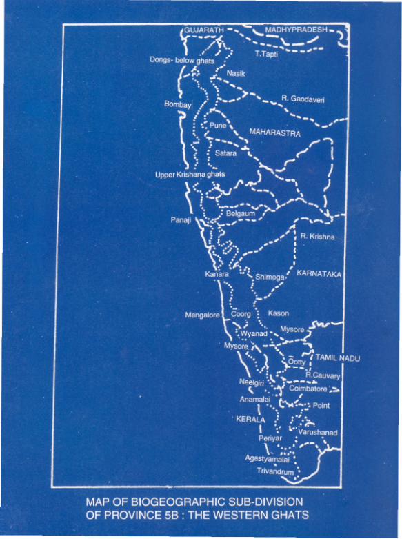
Biogeographical Sub-divisions of the Western Ghats
The Western Ghats can be mainly divided into two distinct zones: Costal plains and Western Ghats
mountains. The plains are a small unit, separated from the uplifted ghats in all geological and
geographical classifications of India. The plains are totally deforested and have no protected areas.
The Ghats are subdivided into 12 latitudinal regions as follows:
Dangs - Below Ghats Areas Surat and North Maharastra
Upper Krishna Drainage Central and South Maharastra, Goa and North Karnataka
Kanara North-Central Karnataka
Coorg South-Central Karnataka
Mysore-Lower Nilgiri South Karnataka - North Tamil Nadu
Wayanad Plateau North Kerala

Nilgiri North Kerala and Tamil Nadu
Anamalai N-Central Kerala and Tamil Nadu
Palani An easterly spur in Tamil Nadu
Periyar-Cardamom S-Central Kerala and Tamil Nadu
Varushanad- Andipatty an easterly spur in Tamil Nadu
Agastyamalai South Kerala and Tamil Nadu
These sub-divisions have physical differences in geology, land form and climate which are reflected in
differing communities of evergreen forests with distinctive assemblages of endemic taxa.
As already mentioned, Kerala falls within two biogeographic zones: 5, the Western Ghats and 10, the
Coasts. The Malabar coastal region of biotic province 10 A, Western Coasts, The Malabar plains region
of biotic province 5A, Coastal Plains and five regions of biotic province 5B, Western Ghats.
Approximate areas are:
10 A Coast - 70 sq km or 0.2% of the state
5 A Coastal Plain - 23,500 sq km or 60.5%
5B Western Ghats - 15,300 sq km or 39.3%
A further sub-division is used in the Western Ghats province, with five regions recognised for
conservation management. They are Wayanad, Upper Nilgiri, Anamalai, Periyar and Agastyamalai.
Kerala with a total area of 38,870 sq km is one of the most important forest areas of India. High
rainfalls on the Ghats have blessed the state with tremendous biological values of great variety.
However, the pressures of a fast developing economy have caused loss of vast areas of forest cover and
consequently, legal forest land now covers only 24% of the total land area. Though small in size, Kerala
has considerable ecological diversity. The peculiar topography of the state created spatial variation in
climate and soil parameters. The high levels of local endemism can be attributed to biogeographic
barriers provided by the large valleys. Today Kerala has 15 Protected Areas totaling 2,308 sq km or
5.9% of the total land area, which is inadequate to protect the great biological wealth of the forests.

Biological Values
The coastline largely degraded. Most biological values are found in the Western Ghat province. And
Kerala part of the Ghats has the Wettest, most tropical and most biologically diverse forests. Of the
seven evergreen forest types recognised in the region, Kerala has four:
Cullenia-Mesua; Persea - Dipterocarpus; Dipercarpus-Mesua; and montane shola. Major biogeographic
barriers separate the Wayanad-Nilgiri areas from Anamalai-Periyar and that form the southern
Agastyamalai hills. Extreme levels of localised endemism are borne out of the fact that the Kerala area
of Agastyamalai has some 109 totally endemic plants, Nilgiri another 95 and Anamalai 39.
The area's biological diversity is equally true of animal life. More than half of the country's amphibians
are restricted to the Western Ghats. These are endemic reptiles like the Travancore tortoise, birds like
the Grey Malabar Hornbill and mammals like the Malabar civet. The forests in Kerala have significant
populations of tiger, leopard, elephant, gaur and many lesser ungulates. The Nilgiri Tahr is
characteristic of higher mountain grasslands. There are two primates endemic to the area: the Nilgiri
Langur and the Lion - tailed macaque. The Silent Valley National Park with its diverse flora and fauna is
an excellent example of evergreen forest of immense biological values.
The Wayanad Evergreen Forests.
Spread across Kerala and Karnataka, this region is the transition zone between the southern Cullenia
dominated forest and the drier Dipterocarpus of the north. Floristically very rich, the tract has two
small Sanctuaries: while Aralam WLS with an extent of 55 sq km is in Kerala, the Brahmagiri WLS is in
Karnataka. Located on the western slopes of the Ghats, Aralam is rich in wildlife. Elephant, deer, bison
are common. The plant life is typical of evergreen and semi-evergreen forests of the Ghats. The
altitude varies from 50m to 1145m from MSL. Temperature varies at the foothills from 21°c to 40°c
whereas on the higher reaches it is between 8°c and 25°c. The average rainfall is about 300 mm. June
to August are the wettest months.
Adjacent to the three contiguous protected areas of Nagarhole, Bandipore and Mudumalai is the
Wayanad Wildlife Sanctuary of Kerala with an extent of 144 sq km. It is also an integral part of the
Nilgiri Biosphere Reserve which was established for the conservation of the biological diversity of the
region. There is a large elephant population. In addition, there are different kinds of deer, monkeys
and birds. Tree species and plants common to South Indian moist deciduous forests and West coast
semi-evergreen forests are seen. Altitude varies from 650 m to 1150 m. And temperature varies from
13°c to 32°c. Average rainfall is 2000 mm.

The Upper Nilgiri of Kerala
The Nilgiri plateau and western slopes contain some of the finest forest Wildlife habitat in India. Two
small partially adjacent Protected Areas are located here. One is the Silent Valley National Park of
Kerala and the other is the Nilgiri Tahr WLS in Tamil Nadu. Only 89 sq km in extent, the Silent Valley
NP is the Core of the Nilgiri Biosphere Reserve and claims a long unbroken ecological history. The
forests belong to the biogeographical class of the Malabar Rain Forests, and relic of the ancient India-
Malayan continuum and harbour a thousand species of plants.
The Valley has a fair representation of all peninsular mammals. There are also several species of birds,
butterflies and moths.
The Anamalai Hills of Kerala
The Anamalai Hills face the Nilgiri plateau across the Palghat Gap. The topography is complex and
causes a great diversity of climate and vegetation type. Anamudi (2700m) is the highest peak in the
entire Western Ghats. The Palghat Gap has isolated the Anamalai Hills resulting in extensive speciation
in several plant and animal groups. Elevation ranges between 150 m and 2500m. Forests extending
from lowland Dipterocarp communities to wet temperate shola forests to moist and dry deciduous
formations contain the most varied set of habitats and animal and plant species of any region in
peninsular India.
The existing Protected Area covers one National Park and four Sanctuaries in Kerala, and one large
Sanctuary in Tamil Nadu.
They are:
Eravikulam NP - 77 sq km
Chinnar WLS - 90 sq km
Parambikulam - 285 sq km
Peechi – Vazhani - 125 sq km
Chimmony - 90 sq km
The first three protected areas are interconnected with the Anamalai WLS in Tamil Nadu.
Peechi- Vazhani WLS remains more or less buffer to the better Protected Areas. Both Chimmony and
Parambikkulam WLS's a have major management problems with constant exploitation, plantation, fire,
tribals and new access roads. There are of course, good quality evergreen forests in the reserve area
bordering these sanctuaries.

The Upper Pooyankutty forest, in the Eravikulam-Chinnar area, comprising part of Malayattor and
Anamudi RFs, is in one of the highest rainfall areas of Kerala, and has the only extensive low altitude
forests (200-500m) in the Malabar Ghats. It is the most likely place to maintain a viable Malabar civet
population in Kerala. Chinnar WLS has some of the driest and steepest forest in the state, rising from
500 m to 2300 m in a few kilometers.
Periyar - Cardamom Hills in Kerala.
The Periyar Tiger Reserve with and extent of 777 sq km is the most well known Protected Area in
Kerala. It has a core area of 350 sq km, which has the status of a National Park. Unfortunately, many of
its conservation values have been threatened by the rapidly deteriorating status of forest lands on the
adjacent Tamil Nadu border.
There are vast tracts of Tropical Evergreen Forests (305 sq km) in addition to Semi-Evergreen Forests,
Moist Deciduous Forests and Savannah Grasslands. At the higher altitudes Montane Sub-tropical and
Montane Temperate Forests are also seen. The altitude varies from 900 m to over 2000 m. The area
receives abundant rainfall, the average being 2500 mm. One of India's major wildlife preserves, Periyar
is noted for its geomorphology, wild life and scenic beauty. The tract supports a variety of plant and
animal species.
Agastyamalai in Kerala.
The Agastyamalai Hills are the extreme south of the Western Ghats. Covered with typical evergreen
forests, the Hills are separated from the northern hill forests by the Shenkottah Gap and thus the flora
and lesser fauna have many endemic taxa. There is a strong biological link to the Sri Lankan forests. At
least 150 endemic species have been noted in the area.
The altitude varies from 100 m to 2000 m. There are several small Sanctuaries in the region; some are
contiguous and some are isolated. In the Tamil Nadu part there are two WLS and in the Kerala part
there are three.
Neyyar WLS 128 sq km
Peppara WLS 53 sq km
Shenduruney WLS 100 sq km
Conservation Proposals
According to the wildlife Institute of India, most of the existing Protected Areas in the Western Ghats
are not large enough for long-term conservation of biological values. It has been suggested that
Protected Areas in Tropical Evergreen Forest Zones (5B) should be enlarged as much as possible so that

they will remain relatively undisturbed conservation units. A target figure often suggested is 100 sq Ian
in order to safeguard both low density species and high levels of community diversity. Such a target is
possible to achieve if contiguous protected Areas in each of the Biogeographic Regions of Kerala, Tamil
Nadu and Karnataka are conveniently regrouped to form large enough units for long term management,
which alone can ensure efficiency.
A brief description of each new proposal made by the Wildlife Institute of India is reproduced
below.
5B Western Ghats Mountains
1) Wayanad.
No new proposal for Kerala. The two fragmented portions of Wayanad
WLS need tighter management if wildlife values are to survive.
2) Nilgiri
Karimpuzha NP 225 sq km Excellent stands of varied evergreen and semi-evergreen forest
communities from 300 m to 2554 m - an extremely important
altitudinal variation (much greater than that of neighboring Silent
Valley.) Karimpuzha has similar large mammal values e.g. tiger,
elephant, gaur, Nilgiri langur, Lion-tailed macaque etc. This new area
will create a large enough unit to give long-term protection to these
unique forest values. Karimpuzha is used by a hunter gatherer tribe.
Full park status therefore will take time and care to implement. WLS
status should be sought initially.
Palamala WLS 100 sq km
Kurathimalai WLS 100 sq km Both proposals will protect further examples of the range of Evergreen
Forests in the Nilgiri. Kurathimalai goes from 1000m - 2000 m in
altitude. Both areas have Montane Shola Grassland values. Palamala
has Nilgiri Tahr.
3) Anamalai
Chimmony WLS Extension
to 130 sq km Chimmony WLS can be extended to form a protected corridor with
Parambikkulam WLS by the inclusion of 40 sq km of Kodasseri RF on the
western borders. This is fairly undisturbed evergreen forest.

Parambikkulam WLS Extension
to 405 sq km Two extensions are proposed, both of which. Will add good evergreen
forest, which will help compensate for Parambikulam's loss of forest
due to reservoir creation. These are in the north, incorporating 70 sq
km of Nelliampathy Plateau RF to the Sholayar River.
The Peechi- Vazhani to Chimmony to Parambikkulam WLS block is thus
a continuous area of 660 sq km which in turn joins Anamalai WLS in TN.
Anamudi NP 300 sq km
Anamudi WLS 207 sq km Kerala has a small NP, Eravikulam and a small WLS, Chinnar on the
southern flanks of the Anamalai ranges. These can be made more
effective by incorporating 300 sq km of Upper Pooyankutty forest. This
area, part of Malayattoor and Anamudi RFs receives on of the highest
rainfalls in Kerala and has excellent low altitude hill forests below
500m.
Chinnar WLS is in a rain shadow zone and has some of Kerala's direst
forests. Incorporating an estimated 40 sq km Kudakkadu RF and
isolated shola forest blocks in the south will increase the effectiveness
of PA boundaries.
The complete unit Pooyankutty-Eravikulam-Chinnar of 507 sq km should
be redesignated as Anamudi NP in the north, bordering Anamalai in TN
and a buffer zone, anamudi WLS in the south.
Note that the contiguous Protected Area on the Anamalai Range will be 2007 sq km in Kerala and Tamil
Nadu.
4) Periyar
Periyar NP Extended
to 400 sq km Periyar NP, the Core area of Periyar Tiger Reserve is presently 350 sq
km. Intensive visitor use in the reservoir area of Theakkady and temple
area of Sabarimala are reducing conservation value and effectiveness.
In corporation of 50 sq km undisturbed forest in Gundakkal RF in Ranni
Division will counteract genetic loss.

5) Agastyamalai
Agastyamalai NP 200 sq km
Agastyamalai WLS 181 sq km Kerala has three small WLSs (Total 281 sq km) in this hill range -
Schedurney, Peppara and Neyyaar; the latter two being contiguous,
The upper part of Ponmudi RF area (100 sq km) should be incorporated
as a corridor between Shendurney and Peppara-Neyyar. (The lower half
of Ponmudi, 100 sq. km, is considered as part of province 5A). The new
area of 381 sq km should be designated as Agastyamalai Park in the
higher reaches, bordering Mundathurai and Kalakadu in TN, and as
Agastyamalai WLS in the lower reaches.
Agastyavanam Biological Park
This is a unique scheme of ecorestoration and conservation initiated by the Government of Kerala, the
first of its kind in India.
The Western Ghats guarding the eastern boundary of Kerala has always been considered a rare abode
of rich biodiversity with an abundance of endemic flora and fauna. Unfortunately, however, over the
years, owing to excessive biotic interference and pressure from adjoining habitations for firewood,
fodder and charcoal, forests in several areas have been destroyed or degraded. One such area is in the
southern most part of the Ghats close to the Neyyar and Peppara WLSs. Several endemic species of
plants and animals have either been exterminated or are on the verge of total extinction.
A live to the situation, the Govt of Kerala appointed an expert committee of eminent scientists in 1992
to study the feasibility of setting up a Biological Park in the Agastyamalai region with a view to
ecorestoration, afforestation and conservation. The forest area chosen for the park, the Kottor Reserve
lies in the Paruthipally Forest Range of Thiruvananthapuram district. Located on the western slopes of
the Western Ghats at South-east corner in Nedumangad taluk, the Kottoor Reserve touches the outer
limits of the Neyyar WLS in the south-west and borders the outer limits of the Peppara WLS in the
north-east. The area is thoroughly denuded and has very little biological values. But the availability of
water resource, good soil and equable climate can sustain a vastly enhanced stock of vegetation and
wildlife. The existing flora and fauna exhibit a remarkable variety and range promising distinct
prospects of regeneration, propagation and preservation of these values. After making a thorough and
scientific study of all aspects of this ambitious project, the committee strongly recommended the
scheme. The first phase of the project is likely to be completed by the end of the 8th five year plan in
1997.
The basic objectives of the Biological Park are:
1. the re-afforestation of the highly degraded Kottoor Reserve area ;
2. the re-introduction of animals and birds which have disappeared from the area and
3. the creation of a splendid store-house of the immense variety and diversity of the unique flora and
fauna of the Western Ghats.
Covering an extent of 23 sq km, the project site is about 35 km from Thiruvananthapuram city. The
famous Agastyakudam Peak (1866m) is only I5 km from the eastern boundary of the project area. The
project has been named Agastyavanam Biological Park after the great saint Agastya Muni who had his
permanent abode in the Agastyakudam Hill deep inside the Kottoor forest. The Biological Park, when
completed, will be an exquisite Nature Reserve of incomparable biological values, a centre of
education capable of providing a wealth of information to researchers and the general public.