Bilby 2D Multi-Client Marine Seismic Survey, 2015 · Searcher currently anticipates acquiring...
70
P: +61 8 9327 0300 E: [email protected] W: searcherseismic.com Bilby 2D Multi-Client Marine Seismic Survey, 2015 Environment Plan Summary
Transcript of Bilby 2D Multi-Client Marine Seismic Survey, 2015 · Searcher currently anticipates acquiring...

P: +61 8 9327 0300 E: [email protected] W: searcherseismic.com
Bilby 2D Multi-Client Marine Seismic Survey, 2015 Environment Plan Summary

Contents 1 Introduction 3
2 Activity Description 3
2.1 Location 3 2.2 Activity Details 6 2.3 Schedule 6
3 Existing Environment 7
3.1 Physical Environment 7 3.1.1 Meteorology and Oceanography 7 3.1.2 Bathymetry, Geomorphology and Sedimentology 8 3.2 Ecological Environment 8 3.2.1 Plankton Communities 8 3.2.2 Benthic Assemblages 8 3.2.3 Macrofauna 9 3.3 Socio-Economic and Cultural Environment 13
4 Stakeholder Consultation 17
5 Environmental Impacts, Risks and Controls 35
5.1 Assessment Approach and Method 35 5.2 Physical Presence 48 5.2.1 Entanglement or Collision with Large Marine Fauna 48 5.2.2 Disruption/Interference with Other Users of the Operational Area 48 5.3 Noise Emissions 49 5.3.1 Potential Impacts on Marine Mammals 50 5.3.2 Potential Impacts on Marine Turtles 51 5.3.3 Potential Impacts on Fish, Sharks and Rays 51 5.3.4 Potential Impacts on Invertebrates 52 5.3.5 Potential Impacts on Commercial Fisheries (Excluding Pearl Oyster
Fishery) 53 5.3.6 Potential Impacts on the Pearl Oyster Fishery 53
6 Response Arrangements in the Event of a Spill 61
7 Management Framework and Implementation Strategy 62
7.1 Audits 62 7.2 Monitoring 63 7.3 Review of Environmental Performance 63

8 Titleholder’s Nominated Liaison Person 64
9 References 64
List of Tables
Table 3.1 Threatened and Migratory Species that May Occur Within the Operational Area (Including 10 km Buffer) 9
Table 3.2 Key Regional Sensitive Receptors 13 Table 3.3 Commonwealth and State Managed Fisheries with reported fishing
effort in the Operational Area during the Bilby 2D Survey period 15 Table 4.1 Relevant Stakeholders Consulted 17 Table 4.2 Summary of Stakeholder Key Issues Raised 19 Table 4.3 Schedule for Ongoing Consultation 33 Table 5.1 Environmental Impacts, Risks and Controls 38 Table 5.2 Summary of Basis for Underwater Noise Impact Assessment for the
Pearl Oyster Fishery Presented in the EP 56
List of Figures
Figure 2.1 Survey Location 5 Figure 5.1 Searcher Risk Matrix 37 Figure 5.2 Overlap of Survey Area with Pearl Oyster Habitat 60

3
1 Introduction Searcher Seismic Pty Ltd (Searcher) proposes to undertake a two-dimensional marine seismic survey (Bilby 2D Survey) in Commonwealth waters of the Offshore Roebuck Basin, Western Australia, commencing in March 2015 for a period of up to four months. The survey will be undertaken in an area of the North West Shelf located approximately 95 km north of Port Hedland and approximately 160 km west/south-west of Broome (Figure 2.1).
An Environment Plan (EP) was prepared to meet the requirements of the Offshore Petroleum and Greenhouse Gas Storage Act 2006 (OPGGS Act) and the Offshore Petroleum and Greenhouse Gas Storage (Environment) Regulations 2009 (OPGGS (E) Regulations). The EP was submitted to NOPSEMA on 17 November 2014 and accepted on 5 March 2015.
This EP Summary has been prepared in accordance with the OPGGS (E) Regulations to summarise Searcher’s commitment to undertake the Bilby 2D Survey in a manner consistent with the principles of ecologically sustainable development and to ensure environmental impacts and risks will be reduced to as low as reasonably practicable (ALARP) and acceptable levels.
2 Activity Description
2.1 Location and Survey Design
The area (including boundary coordinates) within which the Bilby 2D Survey will be undertaken is shown in Figure 2.1.
Searcher currently anticipates acquiring approximately 12,290 line km of 2D seismic data within the survey area outlined in Figure 2.1. A broader operational area of approximately 55,000 km2 will accommodate those vessel manoeuvring and ancillary activities (i.e. additional area for the purpose of in-water equipment deployment, recovery and maintenance etc.) that are required to occur outside of the survey acquisition area. The operational area lies approximately 95 km north of Port Hedland and approximately 160 km west/south-west of Broome.
A phased approach to data acquisition is planned, which will reduce the intensity of data acquisition within the 100 m isobath. Data acquisition has been planned to occur in two phases, separated by a period of 2-3 weeks in April when Bilby 2D Survey activities will cease and the survey vessel will conduct data acquisition elsewhere:
• Phase 1 of data acquisition to initially focus on areas deeper than 100 m, using a minimum of 4 x 4 km line density grid, followed thereafter by data collection in a 4 x 8 km grid over the held acreage further south, in shallower waters.

4
• Phase 2 of data acquisition to focus on ‘infilling’ the line density over the held acreage in the centre of the survey area. Line density during this Phase 2 has been planned to a minimum of 8 x 4 km and a maximum of 8 x 8 km.
In the event phasing is no longer feasible operationally, Searcher will still commit to avoiding acquisition of any consecutive, parallel and adjacent lines any closer than 4 km, to maintain the EP commitment to reduce the intensity of data gathering within the 100 m isobath; i.e. whereas the overall line grid density across held acreage is 2 x 4 km, this will be acquired by skipping every second line to temporally reduce grid density, before returning to infill the remainder of the grid at a later stage in the activity.
The survey design has been dictated by Searcher’s client requirements and the objectives of the survey. However, to the extent possible, the design and execution of the survey has been refined over time to ensure impacts and risks are reduced to ALARP and acceptable levels while still meeting the survey objectives. In particular, Searcher has:
• Reduced the overall operational area from 127,000 km2 to 55,000 km2 by excising areas to the north and east of the survey area and reducing the length of survey lines such that there is now a 5 km buffer to the boundary of the Eighty Mile Beach Commonwealth Marine Reserve from all full fold line end points which had originally been included to provide flexibility at a time when client requirements were less clear;
• Reduced the scale of seismic data acquisition from 20,300 line km to 12,290 line km by excising some areas from the design and reducing line density across parts of the survey area; and
• Reduced the intensity of data acquisition by adopting a two-phased approach as described above.
Through the selection of the survey window, implementation of a phased approach and adoption of the controls outlined in Section 5.1, Searcher has avoided the most environmentally sensitive receptors and reduced the potential impacts and risks to ALARP.

5
Figure 2.1 Survey Location

ENVIRONMENTAL RESOURCES MANAGEMENT AUSTRALIA 000//26 MARCH 2015
6
2.2 Activity Details
The Bilby 2D Survey will be undertaken by a specialist geophysical contractor (BGP) using a specifically-converted seismic survey vessel, the BGP Explorer (hereafter referred to as the survey vessel). The vessel measures 64 m in length and is fuelled using marine gas oil.
The survey vessel will tow an underwater seismic source immediately behind it, plus one cable or ‘streamer’ containing ‘hydrophones’. The seismic source consists of an array of ‘airguns’ that discharge downward-propagating pressure waves (at around 2,000 pound per square inch) at approximately 7 - 10 second intervals. The survey vessel will travel at a speed of approximately 4.5 knots along pre-determined survey lines in waters seaward of the 30 m isobath, and at a minimum distance of 17 km from any land (including emergent islands such as Bedout Island). The planned seismic source has a total volume of 3,480 cubic inches (in3) with a calculated peak sound pressure level (peak SPL) of 266 dB re 1 μPa at 1 m (source level) at a frequency of less than 500 Hz. The peak SPL equates to a sound exposure level (SEL) of 238.2 dB re 1μPa2.s at 1 m.
The pressure wave generated by the airguns penetrates the seafloor and is reflected from subsurface features back to the hydrophones in the towed streamer. When analysed, these data establish a broad picture of the subsurface geology. The towed streamer will be up to approximately 8.5 km in length. A tail buoy will be used to maintain position and clearly indicate the streamer end. Depth monitor and control devices (‘birds’) positioned along the streamer are used to maintain the preferred tow depth.
Crew changes, refuelling and reprovisioning are planned to be conducted in port (Broome or Port Hedland) and will be undertaken approximately every 35 days during the survey period. In the event that at-sea refuelling of the survey vessel is needed due to operational requirements, it will only take place during daylight hours and will only be carried out according to strict weather limit guidelines.
2.3 Schedule
The Bilby 2D Survey is scheduled to be conducted between March and June 2015. Actual start and finish dates are dependent on regulatory approvals, vessel availability, weather conditions and scope completion, but the Bilby 2D Survey is not planned to extend past the end of June 2015.
The timing of the survey enables Searcher to avoid seismic acquisition in water depths shallower than 100 m until the end of March, such that seismic acquisition will not coincide with the secondary spawning event of the pearl oyster off Eighty Mile Beach in February/March. This will also result in shallower parts of the survey area being avoided during flatback turtle nesting at Eighty Mile Beach between late November and March (peaking in January).

ENVIRONMENTAL RESOURCES MANAGEMENT AUSTRALIA 000//26 MARCH 2015
7
3 Existing Environment The operational area lies within the Northwest Shelf Province and the Northwest Transition bioregions of the North-west Marine Region (the region) (SEWPaC 2012 and DEWHA 2008). The Northwest Shelf Province is located primarily on the continental shelf between North West Cape and Cape Bougainville and includes important sites for migrating humpback whales and breeding seabirds such as Eighty Mile Beach and the Lacepede Islands, as well as for the petroleum industry and commercial fishing operations (DEWHA 2008). The Northwest Transition includes shelf break, continental slope and the majority of the region’s Argo Abyssal Plain.
A key feature for the Northwest Transition is the Rowley Shoals (approximately 18 km to the north of the operational area), which comprises the Mermaid, Clerke and Imperieuse Reefs marine reserves (DEWHA 2008).
3.1 Physical Environment
3.1.1 Meteorology and Oceanography
The operational area is characterised by an arid, subtropical climate that experiences monsoonal patterns characterised by a wet season during the summer months of October to March and a dry season during the winter months of May to August (DEWHA 2008). The wet season is characterised by winds, primarily from the south-west, that can generate thunderstorm activity, high rainfall and pronounced cyclones. During the dry season, winds are predominantly from the east and rainfall is sparse. On average, about five cyclones occur each year, of which two typically make landfall and one is typically severe (category 3 or higher having wind gusts of at least 170 km/h) (BOM 2014; DEWHA 2008). The chance of a severe cyclone occurring is highest in March and April (BOM 2014).
Swell heights in the operational area typically range up to 2 m (but are primarily below 1.2 m) with periods of six to eight seconds (Pearce et al. 2003; Margvelashvili et al. 2006). Apart from cyclonic events, sea states tend to be heaviest (i.e. >1 m wave heights) in winter and lightest in the summer (Pearce et al. 2003).
The operational area is dominated by surface currents heavily influenced by ocean (the Indonesian Throughflow) and tidal currents. Current modelling conducted for the operational area showed that the surface currents predominantly flow along the northwest to southeast axis, with some frequent northeast directionality. The maximum and highest average surface current speeds for the survey period were 1.02 m/s (April) and 0.38 m/s (April), respectively (RPS-APASA 2014).

ENVIRONMENTAL RESOURCES MANAGEMENT AUSTRALIA 000//26 MARCH 2015
8
The waters of the operational area are generally low in nutrient levels. Exceptions within or near the operational area include:
• potentially localised upwelling at the Rowley Shoals; and • sporadic and short-lived upwellings as a result of internal wave, cyclonic or
tidal activity (DEWHA 2008).
3.1.2 Bathymetry, Geomorphology and Sedimentology
Water depths across the operational area increase towards the continental slope to the north-west, with water depths gradually increasing from approximately 30 m in the south and east, to approximately 300 m in the north-west.
The operational area is located within the continental shelf, with seafloor features including banks, shoals, valleys, terraces and steps (Baker et al. 2008). The most prominent terraces and steps occur at approximately 125 m depth and are believed to be an important migratory pathway for cetaceans and whale sharks (DEWHA 2008).
Approximately 18 km north of the operational area are the Rowley Shoals, a series of three coral atolls. Each of the atolls are approximately 10 nautical miles in diameter and rise 400 m from the ocean floor almost vertically (DEWHA 2008). Sediments in the Northwest Shelf Province are dominated by sands, with a transition to sandy and muddy substrate in the Northwest Transition (DEWHA 2008).
3.2 Ecological Environment
3.2.1 Plankton Communities
In the operational area, higher plankton concentrations generally occur during the winter months (dry season), from June to August (Hayes et al. 2005). Spatial distribution of plankton is irregular, both vertically and horizontally. Aggregations can result from temperature and salinity gradients, water motion, light intensity or organic matter in the water column (Omori and Hamner 1982). Sporadic/short-lived and potentially localised episodes of nutrient upwelling that occur in the operational area will influence higher plankton concentrations.
3.2.2 Benthic Assemblages
The sandy substrates of the Northwest Shelf Province that cover the majority of the operational area are considered to support low density benthic communities of bryozoans, molluscs and echinoids (DEWHA 2008). Benthic fish communities are depth-related, which indicate a strong correlation between fish communities and benthic habitats (Brewer et al. 2007). Other benthic species abundant in the Northwest Shelf Province include sea cucumbers, prawns and squid.

ENVIRONMENTAL RESOURCES MANAGEMENT AUSTRALIA 000//26 MARCH 2015
9
The sandy and muddy substrates of the Northwest Transition support sparsely distributed epibenthic communities (Brewer et al. 2007). Mobile benthic species (deepwater sea cucumbers, crabs and polychaetes) are presumed to be associated with the seafloor and sparse populations of bentho-pelagic fish and cephalopods are supported in low densities (DEWHA 2008).
3.2.3 Macrofauna
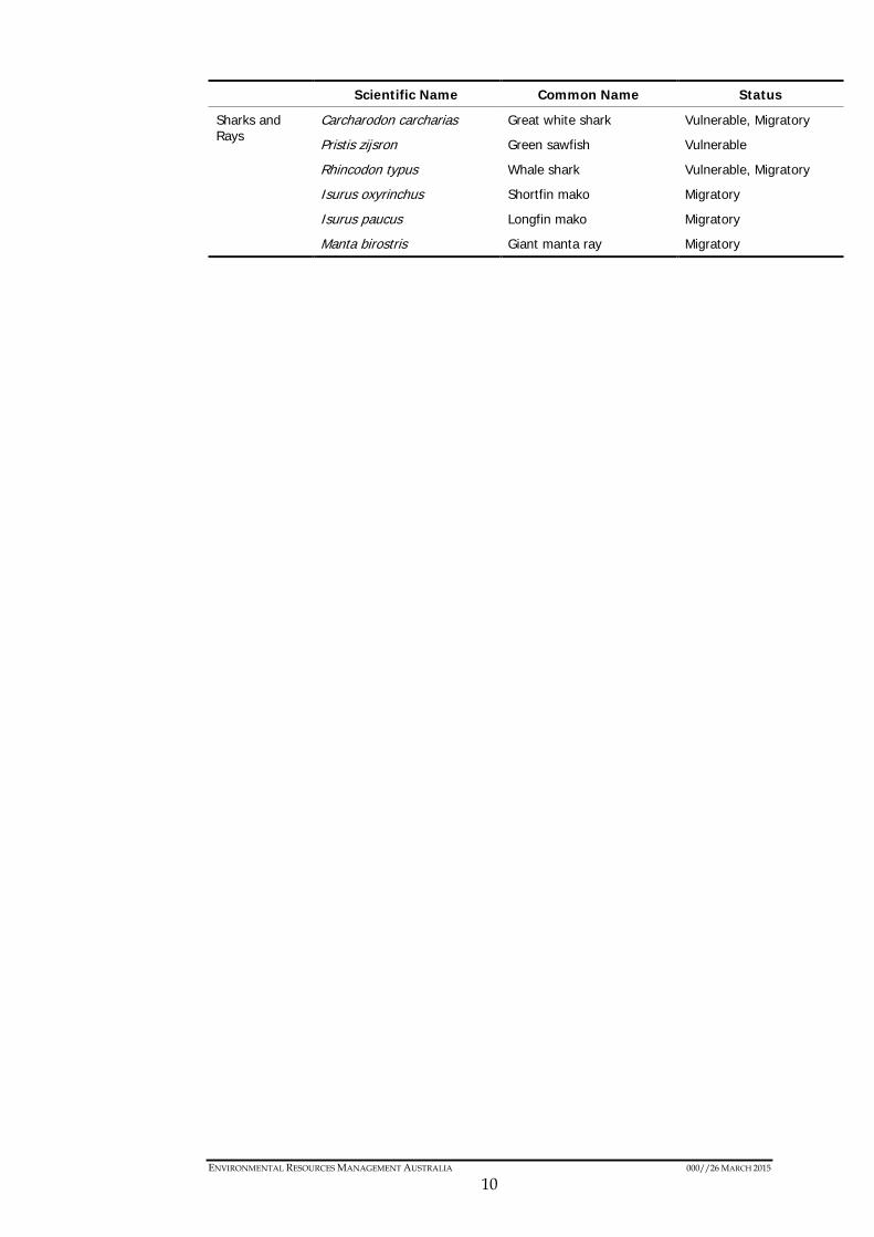
A search of the EPBC Act Protected Matters database was undertaken for the operational area (including a 10 km buffer) to identify the likelihood of fauna listed under the EPBC Act occurring within the operational area. The search identified 11 threatened species and 27 migratory species (which is inclusive of nine of the threatened species) (Table 3.1). No Threatened Ecological Communities were identified.
Table 3.1 Threatened and Migratory Species that May Occur W ithin the Operational Area (Including 10 km Buffer)
Scientific Name Common Name Status
Birds Calonectris leucomelas/ Puffinus leucomelas
Streaked shearwater Migratory
Fregata ariel Lesser frigatebird Migratory
Phaethon lepturus White-tailed tropicbird Migratory
Sterna albifrons Little tern Migratory
Sterna bengalensis Lesser crested tern Migratory
Sterna dougallii Roseate tern Migratory
Sula leucogaster Brown booby Migratory
Reptiles Aipysurus apraefrontalis Short-nosed sea snake Critically Endangered
Caretta caretta Loggerhead turtle Endangered, Migratory
Chelonia mydas Green turtle Vulnerable, Migratory
Dermochelys coriacea Leatherback turtle Endangered, Migratory
Eretmochelys imbricata Hawksbill turtle Vulnerable, Migratory
Natator depressus Flatback turtle Vulnerable, Migratory
Mammals Balaenoptera musculus Blue whale Endangered, Migratory
Megaptera novaeangliae Humpback whale Vulnerable, Migratory
Balaenoptera bonaerensis Antarctic minke whale Migratory
Balaenoptera edeni Bryde's whale Migratory
Dugong dugon Dugong Migratory
Orcinus orca Killer whale Migratory
Physeter macrocephalus Sperm whale Migratory
Sousa chinensis Indo-Pacific humpback dolphin
Migratory
Tursiops aduncus Spotted bottlenose dolphin (Arafura/Timor Sea populations)
Migratory
ENVIRONMENTAL RESOURCES MANAGEMENT AUSTRALIA 000//26 MARCH 2015
10
Scientific Name Common Name Status
Sharks and Rays
Carcharodon carcharias Great white shark Vulnerable, Migratory
Pristis zijsron Green sawfish Vulnerable
Rhincodon typus Whale shark Vulnerable, Migratory
Isurus oxyrinchus Shortfin mako Migratory
Isurus paucus Longfin mako Migratory
Manta birostris Giant manta ray Migratory
ENVIRONMENTAL RESOURCES MANAGEMENT AUSTRALIA 000//26 MARCH 2015
11
Birds
Many shorebird (including those frequenting offshore islands), migratory bird and seabird species are known to occur in the region. The majority of migratory bird species forage and rest in the region on their way between Northern Hemisphere breeding grounds and Northern Australian feeding grounds (i.e. East Asian–Australasian Flyway). Important areas for birds in proximity to the operational area include:
• Bedout Island (approximately 17 km away from the operational area);
• Roebuck Bay and Eighty Mile Beach (approximately 160 km and 35 km away from the operational area, respectively); and
• Rowley Shoals (approximately 18 km away from the operational area).
Most bird species in the region north of 20 °S (which includes the operational area) breed in autumn (March – May), which coincides with the survey period (DEWHA 2008).
Generally summer is the period when most birds occur in the region and near the operational area, especially due to the large populations of migratory birds at Eighty Mile Beach during that time (DOE 2014a).
Due to the wide distribution and range of these bird species, many can be expected to occur in the operational area; however due to the water depths over the majority of the operational area, and the lack of seabed features with which prey aggregations may be associated, numbers are not expected to be significant.
Reptiles
Turtle nesting occurs along the north-west coast of WA and some coastal islands between October and March, with peak nesting periods generally from October – January. Eighty Mile Beach, approximately 35 km south east of the operational area is the closest notable nesting site for marine turtles (specifically flatback turtles). The nearest turtle nesting beach to the operational area is Bedout Island (approximately 17 km south), and while some flatback turtles are known to nest there, it is not considered to be a regionally-important nesting area (DEWHA 2008). The De Grey River to Bedout Island area and the Eighty Mile Beach Commonwealth Marine Reserve are also noted as being foraging sites for green, hawksbill and flatback turtles.
During the nesting period, the highest densities of internesting turtles are expected in close proximity to the coast, with lower numbers expected to occur out to around 50 km based on a satellite tracking study of internesting flatback turtles at the Lacepede Islands over the 2009-2010 nesting season (RPS 2011). Marine turtle hatchlings may be present in the region, as they migrate to deeper waters post-hatching, but will be widely dispersed.

ENVIRONMENTAL RESOURCES MANAGEMENT AUSTRALIA 000//26 MARCH 2015
12
There is extensive evidence that when hatchlings disperse offshore, sea surface currents have considerable effects on the dispersal process (Frick 1976; Salmon and Wykenen 1987; Liew and Chan 1995; Witherington 1995; Okuyama et al. 2009).
At least 20 species of sea snake occur within the region of the operational area, some of which are endemic (DEWHA 2008). However, most sea snake species tend to be found in the shallower parts of the region (DEWHA 2008) and are therefore not expected to be common in the operational area.
Mammals
Marine mammals have wide distributions and may be present in the operational area and broader region. The area is not known to represent biologically important habitat such as significant feeding or breeding habitat for low frequency mammals (whales). Humpback whales pass through the area with some predictability during the annual migration to and from breeding grounds in Camden Sound. However, the main seasonal migration is outside the timing of the survey period, with the northern migration peaking in mid-late July. Pygmy blue whales also migrate along the WA coast with some predictability from southern feeding grounds to breeding grounds in Indonesian waters, generally within the biologically important area (BIA). They pass the latitude of the operational area in April and May on their northern migration. However, the BIA is located more than 10 km north-west of the operational area. Therefore only low numbers of pygmy blue whales are likely to be present in the vicinity of the operational area (Double et al. 2014; McCauley 2011). Other whale species may pass through the operational area but are also not expected in significant numbers.
A number of nearshore dolphin species and dugongs occur in the shallow waters along Eighty Mile Beach.
Sharks and Rays
Six species of shark and ray listed as threatened and/or migratory under the EPBC Act may occur in the operational area. Given that the great white shark, longfin mako shark and shortfin mako shark are wide-ranging in offshore waters and occasionally frequent coastal areas, they are not expected to be commonly encountered during the survey (DOE 2014b). Whale sharks and manta rays may also occur in low numbers in the operational area, but the area does not contain critical habitat for these species (DOE 2014b). Whale sharks are known to aggregate in the waters around Ningaloo Reef to the south of the operational area between March and June and are therefore more likely to migrate through the region around this period (DOE 2014b).
ENVIRONMENTAL RESOURCES MANAGEMENT AUSTRALIA 000//26 MARCH 2015
13
Commercial Fish and Shellfish Species
A number of fish species are targeted by commercial fisheries within or near the operational area including the blacktip shark, goldband snapper, rankin cod, red emperor, pink snapper, sandbar shark, spanish mackerel, pearl oyster, and southern bluefin tuna.
The planned marine seismic survey will coincide with the spawning periods of some of the above species. However, the preferred spawning habitats for the majority of those species include hard/rocky substrates, reefs, and/or shallow coastal waters, which are not commonly found within the operational area. Water depths over the majority of the survey area are anticipated to preclude the presence of spawning adults.
Pearl oyster primary spawning occurs between mid-October and December, with a smaller secondary spawning occurring in February and March (DOF 2006 and 2014). Pearl oysters may occur in water depths up to approximately 100 m off the coast, with principal fishing areas along Eighty Mile Beach and to a lesser extent off Port Hedland. Fishing occurs in areas where the pearl oysters are at appropriate depths to accommodate safe diving and concentrations sufficient for harvesting to occur at economically viable levels (Fletcher et al 2006). Diving operations are reported to occur in depths of less than 23 m for oysters harvested for pearl culture. Diving to slightly deeper depths may occur for collection of mother-of-pearl, for which there is a limited quota. There is therefore not expected to be any direct overlap of the operational area for the Bilby 2D Survey with the area harvested for oysters.
3.3 Socio-Economic and Cultural Environment
The operational area is located within the North-west Commonwealth Marine Reserves Network and in proximity to areas in State waters that are protected under the WA Conservation and Land Management Act 1984 (CALM Act). Table 3.2 lists the key sensitive receptors, including protected areas, in and around the operational area.
Table 3.2 Key Regional Sensitive Receptors
Receptor Approximate Distance
Eighty Mile Beach Commonwealth Marine Reserve Adjacent
Eighty Mile Beach Ramsar Site 30 km
Rowley Shoals Marine Park 18 km
Mermaid Reef Commonwealth Marine Reserve 55 km
Argo-Rowley Terrace Commonwealth Marine Reserve 3 km
Roebuck Commonwealth Marine Reserve 180 km
Kimberley Commonwealth Marine Reserve 112 km
Montebello Commonwealth Marine Reserve 178 km

ENVIRONMENTAL RESOURCES MANAGEMENT AUSTRALIA 000//26 MARCH 2015
14
Receptor Approximate Distance
Dampier Commonwealth Marine Reserve 103 km
Bedout Island 17 km
North Turtle Islet 44 km
Little Turtle Islet 58 km
Glomar Shoals 79 km
Lacepede Islands and Reef 180 km
Dampier Archipelago and surrounding islands (including Legendre and Delambre)
145 km
Kimberley Coast 180 km
Broome Coast 196 km
Port Hedland Coast 90 km
Dampier Coast 138 km
The operational area is located approximately 390 km to the north-east of the nearest World Heritage and National Heritage Site (the Ningaloo Coast); and approximately 25 km to the west of the nearest confirmed historic shipwreck (named 19 Mile Unidentified), as listed on the Australian National Shipwreck Database (DOE 2014c). A search of the National Native Tribunal Register identified that Ngarla and Ngarla #2 (Determination Area A) overlaps a small section (approximately 27 km2) of the operational area. Native title is present in parts of the determination area; however, all areas seaward of the lowest astronomical tide are classified as “areas where native title does not exist” (NNTT 2014). Therefore, no native titles exist in the determination area that intercepts the operational area.
Consultation undertaken to date indicates that the operational area is used mainly for commercial shipping operations, transiting to and/or from the Port of Dampier and Port of Port Hedland. A number of Commonwealth and State managed fisheries occur in the region. Commonwealth and State managed commercial fisheries that intersect the operational area are listed in Table 3.3.

ENVIRONMENTAL RESOURCES MANAGEMENT AUSTRALIA 000//26 MARCH 2015
15
Table 3.3 Commonwealth and State Managed Fisheries w ith reported fishing effort in the Operational Area during the Bilby 2D Survey period
Fishery Estimated Catch (tonnes per season)*
Commonwealth-managed
Western Tuna and Billfish Fishery 415
North West Slope Trawl Fishery 68
Southern Bluefin Tuna Fishery 453
Western Skipjack Fishery 0
State-managed
Beche-de-mer Fishery 13
Mackerel Managed Fishery (Area 1 and 2) 318
Pearl Oyster Managed Fishery (Zones 2 and 3) 685,888 individuals
Northern Demersal Scalefish Fishery 1,107
Pilbara Fish Trawl Fishery 1,312
Pilbara Trap Managed Fishery 416
Pilbara Developing Crab Fishery Blue swimmer crabs: 12 Mud crabs: 1.3
Pilbara Line Fishery 77
North Coast Prawn Managed Fishery (Nickol Bay and Broome)
Nickol Bay: 129 Broome: 12
Marine Aquarium Fish Managed Fishery 22,780 fish
Northern Shark Fisheries 0
Specimen Shell Managed Fishery 16,148 shells
West Coast Deep Sea Crustacean Managed Fishery Crystal crabs: 140 Champagne crabs: 5.4
The seasonal catch is for the entire fishery, including areas that may be outside the Bilby 2D Survey operational area.
Source: AFMA 2014, Fletcher and Santoro 2013.
The region currently supports a number of industries including petroleum exploration and production, as well as minerals extraction. Eighteen active petroleum exploration permits are wholly or partially in the operational area. The closest active production licences to the operational area are located north of the Dampier Archipelago approximately 60 km west of the operational area and are operated by Santos Limited.
Polarcus Seismic Limited (Polarcus) has applied for a Special Prospecting Authority and Access Authority to acquire three-dimensional (3D) data over an area of approximately 25,000 km2 via the Capreolus 3D MSS. Indicative survey plans for the Capreolus 3D Survey indicate that data acquisition activities could overlap by approximately 5,150km2. The Capreolus 3D Survey commenced in January 2015.
ENVIRONMENTAL RESOURCES MANAGEMENT AUSTRALIA 000//26 MARCH 2015
16
Given their overlapping and concurrent activities, Polarcus and Searcher have coordinated their survey planning including undertaking joint stakeholder consultation, running a combined environmental risk assessment workshop and planning their respective activities to reduce any potential cumulative effects to ALARP and acceptable levels.
CGG Multi-client and New Ventures (CGG) has also proposed to acquire approximately 11,056 km2 of 3D seismic data via the Davros Multi-client 3D Marine Seismic Survey (Davros 3D Survey) approximately 50 km west of the Bilby 2D Survey operational area at its closest point. Given a separation distance of at least 50 km between the Bilby and Davros operational areas (and a far greater distance between data acquisition activities), cooperation similar to that adopted for the Capreolus 3D Survey has not been necessary.
Searcher is also aware that PGS Australia Limited (PGS) have received acceptance of their EP to conduct the Titan multi-client 3D MSS, which covers the same title blocks as those of the Capreolus 3D MSS and its operational area is therefore broadly similar to that of the Capreolus survey. However, given that a petroleum block titleholder is unlikely to purchase data from more than one multi-client MSS operator and Polarcus have reached commercial agreements with the petroleum titleholder for data acquisition, the Titan survey is not likely to proceed.
Interactions between tourism and recreational activities in the operational area are considered unlikely as the majority of activities are carried out within WA State waters. The peak season for recreational fishing at Rowley Shoals (between September and December) (DPAW 2013) does not overlap with the timing of the Bilby 2D Survey.

ENVIRONMENTAL RESOURCES MANAGEMENT AUSTRALIA 000//26 MARCH 2015
17
4 Stakeholder Consultation
4.1 Relevant Stakeholders
Relevant stakeholders were identified by considering the interests and activities that occur within or around the operational area, taking into account the survey activities, timing, and potential environmental impacts and risks (of both planned activities and potential unplanned events) (Table 4.1).
Table 4.1 Relevant Stakeholders Consulted
Commonwealth Government
• Australian Customs and Border Protection Service
• Australian Hydrographic Office • Australian Maritime Safety Authority • Australian Fisheries Management
Authority • Department of Agriculture
• Department of Communications • Department of Defence • Department of Industry • Native Title Tribunal • Federal Member for Durack
State Government
• Department of Mines and Petroleum • Office of the Environmental Protection
Authority • Department of Environmental Regulation • Department of Transport • Department of Fisheries
• Department of Parks and Wildlife • Member for Pilbara • Member for Kimberly • Shire of Broome • Town of Port Hedland
Fisheries
• Relevant Commonwealth Fisheries • Relevant State Fisheries • Commonwealth Fisheries Association • Western Australian Fishing Industry
Council (WAFIC) • Australian Southern Bluefin Tuna Industry
Association • Australian Council of Prawn Fisheries
• Australian Fishing Trade Association • Pearl Producers Association (PPA) • Western Australian Northern Trawl
Owners Association • RecfishWest • Western Australian Game Fishing
Association
Tourism
• Kimberly Marine Tourism Association • Recreational Fishing and Marine Charter Operators
Environmental Non-Governmental Organisations
• Australian Marine Conservation Society • Australian Conservation Foundation • Wilderness Society
• Conservation Council of WA • World Wildlife Fund • International Fund for Animal Welfare
Ports and Shipping
• Dampier Port Authority • Pilbara Ports Authority
• Broome Port Authority
ENVIRONMENTAL RESOURCES MANAGEMENT AUSTRALIA 000//26 MARCH 2015
18
Industry
• APPEA • Broome Chamber of Commerce and
Industry • Port Hedland Chamber of Commerce
• Telstra • Nextgen
4.2 Consultation Approach and Results
An information fact sheet, including a map, was prepared and distributed by email to each relevant stakeholder on the 4th October 2014. Where no response was received, a follow up request was made. Where feedback was received, this was acknowledged in writing, information was provided (where requested) or subsequent engagement arranged to seek a resolution to valid concerns. A summary of key issues and concerns raised by stakeholders during consultation for the EP, and how Searcher has addressed these, is provided in Table 4.2. In addition, a summary of the assessment of the merits of any objections or claims made by stakeholders during consultation for the EP is provided in Table 4.3. Given the volume of engagement undertaken with the PPA and WAFIC, a more detailed assessment of claims is provided in Section 4.2.1 below.
It is noted that since initiating stakeholder consultation for the Bilby 2D Survey, the survey area and design have been refined (refer to Section 2.1). The area and intensity of seismic acquisition has been reduced to ensure impacts and risks are reduced to ALARP and acceptable levels while still meeting the survey objectives.

EN
VIR
ON
MEN
TAL R
ESOU
RCES M
AN
AG
EMEN
T AU
STRA
LIA 000//26 M
ARC
H 2015
19
Table 4.2 Summary of Stakeholder Key Issues Raised
Theme Key Issues Raised How Addressed
Communication Stakeholders requested certain notifications and updates to be made to them or other organisations before, during and after the survey.
Searcher has included notification requirements (e.g. to the AHO and AMSA) as Environmental Performance Standards of the EP.
Interactions with other vessels
AMSA provided shipping traffic-related information (e.g. vessel track charts) and requirements (e.g. communication, speed and navigation).
The information provided and requirements indicated were acknowledged as relevant and useful to the survey. The information and requirements provided by AMSA have been used to define controls to reduce risks to other users of the area to ALARP (refer Table 5.1).
Biological Sensitivities Concern was raised about the potential for the seismic survey to affect key periods of biological significance.
The survey has been planned to avoid as far as possible key periods of biological significance.
The survey will be scheduled to begin after the peak turtle nesting season in the region and the primary pearl oyster spawning period and will be completed prior to the peak migration period for humpback whales.
The operational area will not encroach into the pygmy blue whale BIA.
Concern was raised (specifically by PPA and WAFIC) regarding the Bilby 2D Survey’s potential to affect the Pearl Oyster Managed Fishery.
The survey will be scheduled to begin after the primary pearl oyster spawning period.
Data acquisition was substantially reduced and survey execution redesigned to reduce as far as practicable remaining risks to pearl oyster spawn and larvae settlement. As a result, seismic acquisition in water depths shallower than 100 m will be avoided until the end of March, such that seismic acquisition will also not coincide with the secondary spawning event of the pearl oyster off Eighty Mile Beach in February/March.
The assessment of impacts and risks of the Bilby 2D Survey on the pearl oyster fishery off Eighty Mile Beach has been based on available scientific evidence that is considered to be robust and conservative (refer to Section 5.3 of this EP Summary).
Given the nature of the survey and the evidence available, the worst case consequence to the pearl oyster fishery is considered to be minor, i.e. temporary and localised effects to individuals rather than to the population. The overall risk to the fishery is determined to be low.
Searcher has made considerable effort to refine the design and execution of the survey to address the concerns of the pearl oyster fishery.

EN
VIR
ON
MEN
TAL R
ESOU
RCES M
AN
AG
EMEN
T AU
STRA
LIA 000//26 M
ARC
H 2015
20
Theme Key Issues Raised How Addressed
As a result of these design refinements and other controls, Searcher considers it has reduced impacts and risks to the pearl oyster fishery off Eighty Mile Beach to levels that are demonstrably ALARP and acceptable. In doing so, Searcher has also applied the precautionary principle to a level it considers is fair and proportionate to the interests of the PPA.
Searcher is not able to fully accommodate all of the PPA’s requests as doing so would render the Bilby 2D Survey commercially non-viable and would be contrary to the expectations placed on petroleum titleholders in the release of petroleum exploration permits.
Searcher will maintain communication with PPA and WAFIC as necessary, maintain a record of these communications and assess any further claims for their merit.

EN
VIR
ON
MEN
TAL R
ESOU
RCES M
AN
AG
EMEN
T AU
STRA
LIA 000//26 M
ARC
H 2015
21
Table 4.3 Summary of Consultation Results by Stakeholder
Relevant Stakeholder
Consultation Undertaken Stakeholder Response Assessment of Claims Status
Commonwealth Government
Australian Customs and Border Protection Service
Email with Information Fact Sheet and Map sent on 4th October 2014
Responded on 14th October that no comments or concerns at this time but requested to be kept informed of future developments.
N/A Fair consultation completed and closed. Requirement for pre-mobilisation update has been included in ongoing consultation.
Australian Hydrographic Office (AHO)
Email with Information Fact Sheet and Map sent on 4th October 2014 with follow phone call on 26th November 2014
AHO confirmed that they must be contacted no less than two working weeks before operations commence for the promulgation of related Notice to Mariners.
Requirement to contact AHO prior to survey commencement has been included as an Environmental Performance Standard in the EP.
Fair consultation completed and closed. Requirement to contact AHO pre-commencement has been included in ongoing consultation and included as a performance standard.
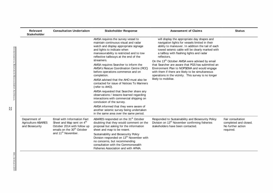
AMSA - Marine Operations Division
Email with Information Fact Sheet and Map sent on 4th October 2014 Further correspondence took place on the 10th, 13th and 19th of October
AMSA responded by email on the 10th October and provided vessel track data, requesting these be provided to the Searcher Vessel Master, noting the shipping fairways. AMSA requested Pilbara Ports Harbour Master to be kept informed so that Pilots/MPX, Agents and Shipping can be advised of activities well in advance. AMSA requested exceptional communications be maintained with commercial shipping encountered during survey activities, noting the speed difference between commercial shipping and the survey vessel.
Searcher acknowledged AMSA’s advice in a response on the 13th October advising that the points raised in AMSA’s email were noted and addressed in the EP, namely: • Searcher will engage with the Pilbara Ports
Harbour Master, AHO and AMSA RCC as advised, and provide AMSA with any lessons learned after the survey – this has been incorporated into Table 4.4.
• Vessel Masters would receive a project induction and be briefed on the context within which the survey will be undertaken, including other ship traffic that may be encountered.
• Requirements for visual and radar watches will be conducted at all times and the survey vessel
Fair consultation completed and closed. Requirement to notify Pilbara Ports Harbour Master, AHO and AMSA RCC pre-mobilisation and on survey completion included in ongoing consultation.
EN
VIR
ON
MEN
TAL R
ESOU
RCES M
AN
AG
EMEN
T AU
STRA
LIA 000//26 M
ARC
H 2015
22
Relevant Stakeholder
Consultation Undertaken Stakeholder Response Assessment of Claims Status
AMSA requires the survey vessel to maintain continuous visual and radar watch and display appropriate signage and lights to indicate when manoeuvrability is restricted and to tow reflective tailbouys at the end of the streamers. AMSA requires Searcher to inform the AMSA’s Rescue Coordination Centre (RCC) before operations commence and on completion. AMSA advised that the AHO must also be contacted for issue of Notices To Mariners (refer to AHO). AMSA requested that Searcher share any observations / lessons learned regarding interactions with commercial shipping on conclusion of the survey. AMSA informed that they were aware of another seismic survey being undertaken in the same area over the same period.
will display the appropriate day shapes and navigation lights for vessels limited in their ability to maneuver. In addition the tail of each towed seismic cable will be clearly marked with a tallboy with flashing lights and radar reflectors.
On the 13th October AMSA were advised by email that Searcher are aware that PGS has submitted an Environment Plan to NOPSEMA and would engage with them if there are likely to be simultaneous operations in the vicinity. This survey is no longer likely to mobilise.
Department of Agriculture-ABARES and Biosecurity
Email with Information Fact Sheet and Map sent on 4th October 2014 with follow up emails on the 30th October and 11th November.
ABARES responded on the 31st October doubting that they would comment on the proposal but asking for the information sheet and map to be resent. Sustainability and Biosecurity Policy Division responded on 13th November with no concerns, but recommending consultation with the Commonwealth Fisheries Association and with AFMA.
Responded to Sustainability and Biosecurity Policy Division on 13th November confirming fisheries stakeholders have been contacted.
Fair consultation completed and closed. No further action required.

EN
VIR
ON
MEN
TAL R
ESOU
RCES M
AN
AG
EMEN
T AU
STRA
LIA 000//26 M
ARC
H 2015
23
Relevant Stakeholder
Consultation Undertaken Stakeholder Response Assessment of Claims Status
State Government
Department of Mines and Petroleum (DMP)
Email with Information Fact Sheet and Map sent on 4th October 2014.
Response received by email on the 15th October. Noting the location of the Bilby survey in Commonwealth jurisdiction, the Department of Mines and Petroleum does not require any further information at this time. However, should the surveys change significantly in size or duration DMP request to be advised. DMP recommended that key periods of biological significance be considered when planning the timing of acquisition, and where possible plan the timing to minimise environmental impacts. DMP requested to be provided pre-start and cessation notifications confirming the start and completion dates for the surveys.
Advised DMP by email on the 19th October that their feedback had been noted and that DMP will be informed prior to the start, and on completion of the surveys (included into ongoing consultation). DMP were also advised that the surveys had been planned to avoid as far as possible key periods of biological activity. The Bilby 2D Survey has been planned to avoid as far as practicable key periods of biological productivity.
Fair consultation completed and closed. Requirement to notify DMP pre-start, on completion and in the event scope, size or duration of the survey changes significantly has been included in ongoing consultation.
Department of Fisheries (DOF)
Email with Information Fact Sheet and Map sent on 6th October 2014. Further correspondence by email on the 14h, 16th, 23rd and 31st October
DOF responded by email followed by letter on the 23rd October. DOF noted the potential for the surveys to affect fish populations and the operations of fishers who harvest these resources and requested feasible mitigation strategies be implemented, including using the minimum acoustic capacity to achieve survey objectives. DOF provided information on State commercial fishing interests in the bioregion and requested that license holders in these fisheries, and Recfishwest and WAFIC be consulted.
Searcher has noted and responded to DOF’s correspondence on 31st October and the 3rd November. License holders of fisheries that intersect the operational area, or may be affected by survey activities have been engaged, as have the PPA, Recfishwest and WAFIC. Information provided by DOF on spawning locations and time periods has been used to inform the risk assessment on commercial fisheries. Potential impacts on commercial fisheries has been informed by reference to DOF’s Guidance Statement on “undertaking seismic surveys in Western Australian waters” (DOF, 2013) and has considered
Fair consultation completed and closed. No further action required.

EN
VIR
ON
MEN
TAL R
ESOU
RCES M
AN
AG
EMEN
T AU
STRA
LIA 000//26 M
ARC
H 2015
24
Relevant Stakeholder
Consultation Undertaken Stakeholder Response Assessment of Claims Status
DOF advised that Eighty Mile Beach is of concern to the pearling industry and as such the Pearl Producers Association should be engaged. DOF noted seismic surveys may alter fish behaviour during spawning and pre-spawning periods and provided information on spawning / aggregation times. DOF requested consideration be given to minimise the impacts on fish spawning, including soft starts, sound and exposure time minimisation or avoidance of spawning periods. DOF expressed concerns about biosecurity and requested that vessel operators minimise the risk of translocation marine pests and organisms to WA water.
the potential for the Bilby 2D Survey to: • Reduce catches because of changes in fish
behaviour; • Disrupt fishing operations; and • Result in long term impacts. Potential impacts have been reduced to levels considered ALARP and acceptable through adoption of the controls requested by DOF, to the extent practicable. Biosecurity risks are examined in the EP and will be managed in accordance with current regulatory requirements and industry guidelines.
Department of Transport
Email with Information Fact Sheet and Map sent on 7th October 2014. Further correspondence by email on the 7th, 30th and 31st October
Information sheet and map forwarded internally to Maritime Environmental Emergency Response, Department of Transport on the 7th October. In response to the follow up email on the 30th October the Manager, Environmental Emergency Response sent a link to the DoT’s Consultation Guideline notes.
Searcher has noted the requirement to update the DoT’s Maritime Environmental Emergency Response group prior to survey mobilisation. This has been included into ongoing consultation.
Fair consultation completed and closed. Requirement to update the DoT’s Maritime Environmental Emergency Response group prior to survey mobilisation has been included into ongoing consultation.
Department of Parks and Wildlife (Parks and Wildlife)
Email with Information Fact Sheet and Map sent on 4th October 2014. Further communication by email on the
Parks and Wildlife requested by phone on the 22nd October for the information sheet and map to be resent. Parks and Wildlife then responded by email on 29th October:
Further information to respond to the queries and concerns of Parks and Wildlife was provided by email on the 31st October, 6th and 11th November, including: • Confirmation of the distance of the survey from
Fair consultation completed and closed. No further action required.

EN
VIR
ON
MEN
TAL R
ESOU
RCES M
AN
AG
EMEN
T AU
STRA
LIA 000//26 M
ARC
H 2015
25
Relevant Stakeholder
Consultation Undertaken Stakeholder Response Assessment of Claims Status
7th,,20th,22nd,29th,31st October, 6th and 11th November , phone calls on the 20th and 22nd October, the 6th and 11th November and on 15th December 2014 with Senior Environmental Officer-Marine.
• Requesting additional information on the proximity of data acquisition to Bedout Island and the intensity of noise emissions (in sound exposure levels)
• Providing a copy of the standard advice note, which explains the department’s interests and expectations.
• Recommending that in addition to considering impacts on marine mammals, potential impacts on marine turtles should also be addressed given turtle rookeries on offshore islands; nesting times; and internesting habitats in the surrounding waters.
• Assuming that no personnel will land on island nature reserves.
Following receipt of the additional information provided to them on 31st October, 6th and 11th November, Parks and Wildlife confirmed by email on 15th December that they had no further comment on the proposed seismic survey and trusted that the issues identified in their correspondence of 6 November would be suitably addressed in the EP.
Bedout Island (operational area is 17 km distant)
• A technical note regarding anticipated sound exposure levels at Bedout Island
• Confirmation that no personnel will be landing on island nature reserves during the conduct of the surveys.
• Confirmation that potential impacts on marine turtles have been assessed, and measures to mitigate the potential impacts included in the EP.
Potential impacts on marine mammals and also on marine turtles, including on marine turtle nesting sites and internesting habitats, associated with physical interaction, noise, light and spills are addressed in the EP and summarised in Section 5. Controls and performance measures relevant to these potential impacts are also summarised in Section 5. The assessment concludes that impacts and risks to marine turtles have been reduced to levels that are ALARP and are acceptable.
Fisheries
Western Australian Fishing Industry Council (WAFIC)
Email with Information Fact Sheet and Map sent on 4th October 2014 with follow up email on the 30th October. Alongside the PPA, Searcher met with WAFIC on 3rd
WAFIC has indicated through its collaboration with the PPA during this consultation, that it shares the concerns of the PPA regarding the Bilby 2D Survey’s potential to affect the Pearl Oyster Managed Fishery. Refer to Section 4.2.1
Refer to Section 4.2.1 for further detail. Consultation with WAFIC is ongoing, as indicated under PPA in this table. Searcher will maintain communication with WAFIC as necessary,

EN
VIR
ON
MEN
TAL R
ESOU
RCES M
AN
AG
EMEN
T AU
STRA
LIA 000//26 M
ARC
H 2015
26
Relevant Stakeholder
Consultation Undertaken Stakeholder Response Assessment of Claims Status
December and again on 19th January 2015.
for further detail. maintain a record of these communications and assess any further claims for their merit (Table 4.4).
Pearl Producers Association
Email with Information Fact Sheet and Map sent on 4th October 2014 with follow up email on the 30th October Resent Information Fact Sheet and Map at request of PPA on the 30th October Met with PPA (and WAFIC) on 3rd December and again on 19th January 2015. Further written correspondence was also exchanged in the intervening period. Searcher was also copied on correspondence about the Bilby Survey between the PPA, WAFIC and NOPSEMA. On 22nd January, Searcher couriered four copies of large scale survey maps to WAFIC and the PPA, as promised during the 19th January meeting. As agreed during the meeting, these maps included the current Bilby 2D survey design overlaid on an AHO hydrographic chart, with colour coded lines showing
PPA has objected to the Bilby 2D Survey proceeding. Refer to Section 4.2.1 for further detail.
Refer to Section 4.2.1 for further detail.
Consultation with the PPA will continue as indicated in Table 4.4. As documented in Section 4.2.1, Searcher considers it has reduced the impacts and risks to the pearl oyster fishery off Eighty Mile Beach to levels that are demonstrably ALARP and acceptable. In doing so, Searcher has also applied the precautionary principle to a level it considers is fair and proportionate to the interests of the PPA, particularly given the absence of scientific evidence to support the PPA’s claims.

EN
VIR
ON
MEN
TAL R
ESOU
RCES M
AN
AG
EMEN
T AU
STRA
LIA 000//26 M
ARC
H 2015
27
Relevant Stakeholder
Consultation Undertaken Stakeholder Response Assessment of Claims Status
Phase 1 and Phase 2 line inclusions, plus the lines deleted from the original proposed Bilby survey design. The original and revised survey operational areas were also plotted. These maps were requested by the PPA for distribution to the pearl oyster operators that work the Eighty Mile Beach fishery. Note that the engagement reported here for PPA has also involved WAFIC.
Recreational Fishing, Charters, Marine Tourism Operators
Kimberly Marine Tourism Association
Email with Information Fact Sheet and Map sent on 10th October 2014
Responded by email on the 11th October asking to be kept informed closer to the start of the surveys.
The request to provide an update prior to surveys commencing will be met.
Fair consultation completed. Requirement for pre-mobilisation update has been included into ongoing consultation.
Recreational Fishing and Marine Charter Operators
Email with Information Fact Sheet and Map sent on 10th October 2014 with follow up email on the 30th October
No response other than from Absolute Ocean Charters –no concerns Reel Teaser Charters- asked to be kept informed both by email on 31st October Unreel Adventure Safaris – no concerns
The request to provide an update prior to surveys commencing will be met.
Fair consultation completed. Requirement for pre-mobilisation update has been included into ongoing consultation.

EN
VIR
ON
MEN
TAL R
ESOU
RCES M
AN
AG
EMEN
T AU
STRA
LIA 000//26 M
ARC
H 2015
28
Relevant Stakeholder
Consultation Undertaken Stakeholder Response Assessment of Claims Status
Environmental NGOs
International Fund for Animal Welfare (IFAW)
Searcher was made aware of IFAW’s potential interest in the Bilby 2D Survey in December 2014 by NOPSEMA. On 1st January 2015, IFAW were sent a map and tailored information describing the Bilby 2D Survey in the context of claims IFAW have publically made about seismic activity in the North-west Shelf (IFAW 2011). This was subsequently followed up by phone calls on 13th and 20th January. The original email was then resent at their request on 20th January. In this 20th January correspondence, IFAW were advised that since Searcher’s initial correspondence, the survey design and schedule had been revised and they were provided the more recent survey map.
IFAW responded on 22nd January 205 welcoming their engagement and the manner in which concerns raised by IFAW around the risks to marine life from noise had been addressed. IFAW acknowledged that the Bilby 2D Survey has been timed to avoid humpback whale presence and the proposed area is outside of the blue whale migration BIA. However, IFAW noted that given the proximity of the survey to Rowley Shoals, other cetacean species are likely to be present in the area. IFAW requested to be kept informed of any further changes to the survey and any future surveys proposed in Australian waters.
Potential impacts of the Bilby 2D Survey on cetaceans are addressed in the EP and summarised in Section 5. This assessment, and the associated controls to be implemented, reflect that a number of cetacean species could be encountered during the survey, including during activities in the vicinity of Rowley Shoals. The cetacean species identified as having the potential to be present in the area during the survey are described in the EP and summarised in Section 3.2.3. Searcher have acknowledged IFAW’s response and confirmed that an update will be provided should further changes be made to the survey.
Fair consultation completed and closed. Requirement for an update in the event that the survey area or timing changes again has been included into ongoing consultation.
Note: Information on stakeholders that responded with no issues or did not provide a response during the consultation process is not included in this table.

29
4.2.1 Assessment of the Merits of Claims and Objections of the PPA and WAFIC
This subsection provides a summary of the claims and objections made by PPA and WAFIC and an assessment of their merits.
Summary of Claims and Objections from PPA & WAFIC
On behalf of its members, the PPA has expressed significant concerns about the potential impacts of the Bilby 2D Survey on the pearl oyster fishery and its potential to result in catastrophic consequences to the industry and the livelihoods of its members.
In particular, the PPA argues that in the absence of scientific data on the impact of seismic activity specifically on P. maxima and an incomplete understanding of P. maxima ecology off Eighty Mile Beach, the impacts and risks of the Bilby 2D Survey cannot be assessed to levels that are acceptable. The PPA has been requesting industry to improve this situation. Because of the unique ‘use’ of the oyster in pearl cultivation, the PPA considers that evidence on the nature and extent of seismic impacts on other invertebrate species is not an acceptable proxy for impacts to the pearl industry.
The PPA highlights the potential for seismic activity to significantly impact pearl oyster stocks, especially the potential for the survey to impact spawning and larval phases, growth and recruitment to the fishery, and the ability of the pearl oysters to produce the quality pearls that the industry is internationally renowned for. Concerns are also raised regarding the potential for the Bilby 2D Survey to impact the foodweb and overall ecosystem of P. maxima.
PPA claim that pearl oyster stocks that feed the fishery may exist out to the 100m depth contour and possibly beyond. They also claim that the fishery is sustained by the unfished ‘brood’ stock that occurs in deeper waters. Therefore, the PPA’s concern is especially heightened around the Bilby 2D Survey because of its extensive overlap and comprehensive coverage of this assumed habitat and brood stock; and because of the sustained duration of impact oysters in this area will be exposed to. They note that the wild-catch South Sea Pearl fishery in Australia – which is wholly reliant on the fishery off Eighty Mile Beach – is the last remaining fishery of this type in the world.
Given the lack of scientific evidence, PPA considers the risk level to the pearl industry to be ‘high’ and unacceptable. As such, PPA state they cannot support the Bilby 2D Survey in its current form and request that all seismic activities within the 100 m isobath off Eighty Mile Beach be suspended until such time that data become available.
The PPA’s opposition to the Bilby 2D Survey does not relate to the potential for the survey to interfere with fishing activities. Noting the survey location in waters > 30 m, the PPA have, during consultation, acknowledged that risks to fishing activities can be managed to acceptable levels through the controls Searcher proposes to adopt.
During consultation, PPA also raised concern that Searcher had not provided sufficient information (about the survey design, execution arrangements, and the impacts and risks to the fishery etc) to enable the PPA to understand the full extent of potential impacts on its interests.

30
The PPA furthermore proposed that given its level of uncertainty on the nature and extent of impacts, an inclusive risk assessment should be undertaken between the seismic industry and the pearl producers.
Assessment of the Merits of Claims and Objections from PPA & WAFIC
Potential impacts of the Bilby 2D Survey on the pearl oyster fishery have been assessed in relation to impacts on fishing activities and the potential for noise to affect the productivity of the fishery (as summarised in Section 5).
Searcher has acknowledged the PPAs concerns on behalf of its members and has proactively and constructively engaged with the PPA in an attempt to address these concerns. Furthermore, during its last meeting with the PPA and WAFIC on 19 January 2015, Searcher also offered to brief the pearl producers directly; a web-supported teleconference was suggested as a simple way of enabling Searcher’s material to be shared and explained to the producers. Searcher is awaiting the PPA’s response on whether this would be of value to its members.
As part of the research for the EP, Searcher has identified and used a substantial body of available scientific literature to support its assessment of potential impacts on the pearl oyster fishery. This evidence covers both the ecology of P. maxima in the Eighty Mile Beach area specifically, as well as evidence of seismic and/or other noise and stress-inducing impacts on the fishery and on other invertebrate species.
Searcher recognises that there is never complete certainty in an impact and risk assessment. However, any uncertainty in the assessment is addressed through the method adopted (see Section 5), which amongst other things, includes assessing risk based on the worst-case credible scenario; making conservative assumptions on which to draw impact conclusions and adopting a precautionary approach in the selection and definition of controls. For example, the likely spatial extent of potential impacts of seismic noise on all stages of the pearl oyster’s lifecycle has been based on evidence from motile invertebrate species that are known to be more sensitive to noise stressors than bivalve molluscs such as P. maxima. Another example is that in refining the survey design pearl oyster stocks relevant to the fishery off Eighty Mile Beach have been assumed to extend to the 100 m isobath. Importantly, these refinements have been made in the absence of any scientific evidence that supports the PPA’s key concerns.
Searcher is therefore confident that the assessment of impacts and risks on the pearl oyster fishery presented in the EP and summarised in Section 5 is conservative and robust and that the management approach proposed is precautionary and ALARP.
Regarding the PPA’s claims that pearl oyster stocks that feed the fishery may exist out to the 100 m depth contour and that the fishery is sustained by the unfished ‘brood’ stock that occurs in these deeper waters; Searcher has not been able to locate scientific literature that supports this. The evidence available indicates the main habitat of P. maxima off Eighty Mile Beach is within the 50 m isobath (Fletcher et al 2006). The evidence also indicates that the fishery’s stocks (in waters less than approximately 23 m) are largely self-seeding (Condie et al 2006).

31
Given that the research on which these conclusions are based is dated (2006 and earlier), Searcher engaged with the Department of Fisheries (Dr Anthony Hart) on 20th January 2015 to determine whether these interpretations remain current. While acknowledging that field evidence to support or counter these interpretations is limited by the dive-methods of the fishery, and that there are numerous complex variables that influence P. maxima ecology, Dr Hart confirmed that these interpretations remain current within the scientific community (Pers comm, Hart A, 2015).
During the meeting of 19th January 2015, Searcher sought to address the PPA’s questions regarding survey design, execution arrangements and the risks to the fishery. Searcher explained how the survey design had been revised as a precautionary measure in response to the concerns of the pearl oyster fishery to the extent practicable. These refinements are determined by Searcher to be at the limit of practicability in terms of meeting the survey’s objectives and assuring its commercial viability. The reasons why Searcher is unable to meet the PPA’s request to exclude data acquisition within the 100 m isobath were also discussed.
Searcher also explained how the survey would be executed and therefore how, amongst other things, potential stressors such as noise on pearl oyster individuals are limited in extent (metres) and time (minutes or hours). Evidence to support this assessment was shared with the PPA. Potential impacts on fishing activities were also discussed and PPA agreed that these impacts and risks were acceptable.
However, because PPA expressed little confidence in the evidence behind the assessment (either on the ecology of P. maxima, the applicability of research on other invertebrates or on the historical evidence of industry co-existence), Searcher’s assessment was not accepted during the 19th January meeting. In short, PPA acknowledged that without absolute certainty, no risk is acceptable.
Recognising the PPA’s concerns over the lack of data, and that the PPA is seeking absolute certainty in impact evaluation, Searcher has offered to provide logistical and (potentially) financial support for further baseline study research on the effects of its seismic activity on the pearl oyster fishery off Eighty Mile Beach. Furthermore, through its close association with industry representative bodies, in particular the International Association of Geophysical Contractors (IAGC), Searcher has taken a proactive role in helping raise awareness on the concerns of the pearl fishery to IAGC member companies and the opportunity the geophysical industry has to contribute to future research efforts. While welcoming Searcher’s offer, the PPA has rejected it because they do not support the Bilby 2D Survey proceeding in its proposed form.
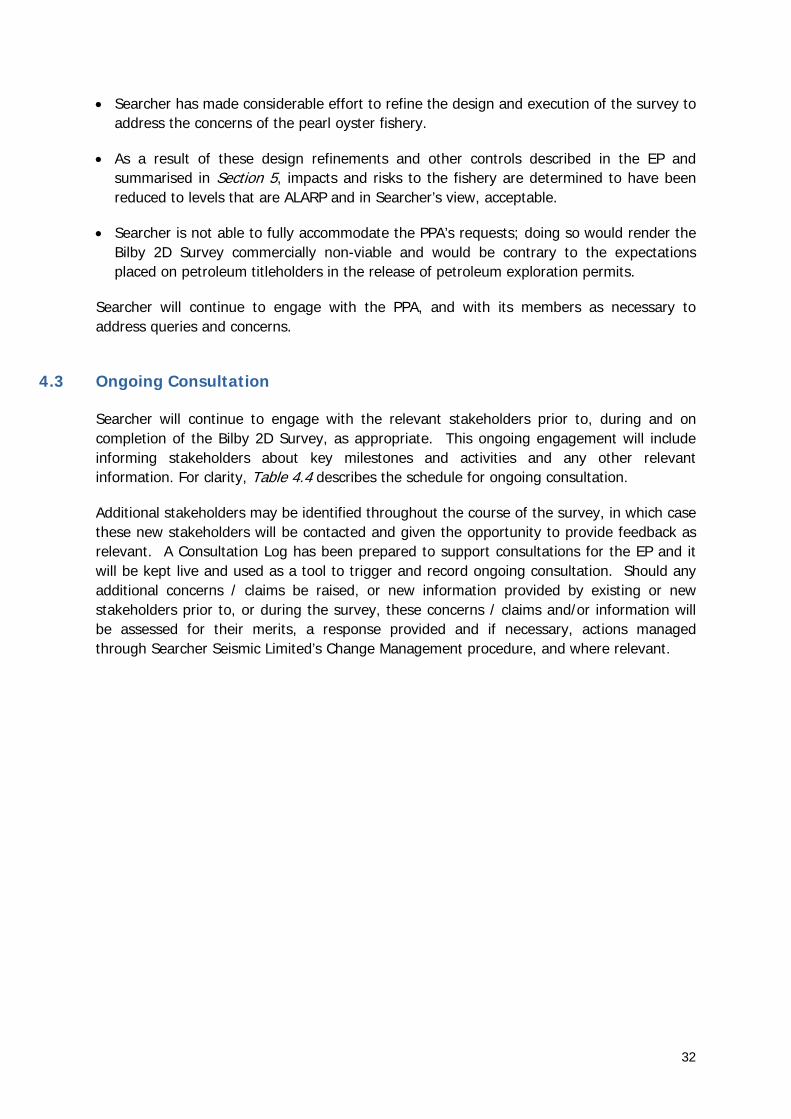
In summary:
• The assessment of impacts and risks of the Bilby 2D Survey on the pearl oyster fishery off Eighty Mile Beach presented in the EP and summarised in Section 5 has been based on available scientific evidence that is considered to be robust and conservative.
• Given the nature of the survey and the evidence available, the worst case consequence to the pearl oyster fishery is considered to be minor, i.e. temporary and localised to individuals rather than to the population. The overall risk to the fishery is determined to be low.
32
• Searcher has made considerable effort to refine the design and execution of the survey to address the concerns of the pearl oyster fishery.
• As a result of these design refinements and other controls described in the EP and summarised in Section 5, impacts and risks to the fishery are determined to have been reduced to levels that are ALARP and in Searcher’s view, acceptable.
• Searcher is not able to fully accommodate the PPA’s requests; doing so would render the Bilby 2D Survey commercially non-viable and would be contrary to the expectations placed on petroleum titleholders in the release of petroleum exploration permits.
Searcher will continue to engage with the PPA, and with its members as necessary to address queries and concerns.
4.3 Ongoing Consultation
Searcher will continue to engage with the relevant stakeholders prior to, during and on completion of the Bilby 2D Survey, as appropriate. This ongoing engagement will include informing stakeholders about key milestones and activities and any other relevant information. For clarity, Table 4.4 describes the schedule for ongoing consultation.
Additional stakeholders may be identified throughout the course of the survey, in which case these new stakeholders will be contacted and given the opportunity to provide feedback as relevant. A Consultation Log has been prepared to support consultations for the EP and it will be kept live and used as a tool to trigger and record ongoing consultation. Should any additional concerns / claims be raised, or new information provided by existing or new stakeholders prior to, or during the survey, these concerns / claims and/or information will be assessed for their merits, a response provided and if necessary, actions managed through Searcher Seismic Limited’s Change Management procedure, and where relevant.

33
Table 4.4 Schedule for Ongoing Consultation
Stakeholder Communication Required and Schedule
Commonwealth Government
Australian Customs and Border Protection Service
Provide advance notice of survey mobilisation in the operational area, including final survey location and timing.
Provide advice of survey completion following vessel demobilisation from the operational area.
AHO Provide final survey location, vessel details and timing 2 weeks prior to survey commencement for issue of Notice to Mariners.
Provide update should any details of area or timing change during the course of the survey.
Provide notice of survey completion following completion
AMSA Advise AMSA RCC of survey commencement prior to survey commencement (via [email protected]).
Provide daily reports to RCC during data acquisition or ensure daily position information is provided via an operational Automatic Identification System on board the survey vessels.
Provide notice of survey completion following completion
NOPSEMA Provide notice of start and end of the Bilby 2D Survey within the prescribed periods using Regulation 29 Notification Form.
Provide monthly and incident reports during the survey and Environmental Performance Report within 2 months of completing the survey.
WA Government
Department of Mines and Petroleum Provide advance notice of survey commencement, including final survey location and timing.
Engage again if the scope of the survey changes significantly in size or duration.
Provide advice of survey completion following demobilisation.
Department of Transport (Maritime Environmental Emergency Response)
Provide advance notice of survey commencement, including final survey location and timing.
Provide advice of survey completion following demobilisation.
Fisheries
Individual fisheries licence holders in the following fisheries who may be active in or near the operational area during the survey:
North West Slope Trawl Fishery
Pearl Oyster Managed Fishery
Northern Demersal Scalefish Fishery
Pilbara Fish Trawl Fishery
Pilbara Trap Managed Fishery
Pilbara Line Fishery
Send a courtesy follow up advising them of the final survey location and timing prior to survey commencement, reminding them of the limited manoeuvrability of the survey vessel, asking them to respond if they may be operating in the operational area during the survey.
Depending on the responses received, provide further information to licence holders who indicate they may be operating in the operational area during the survey, such as survey location reports, progress status and activity look-ahead reports.
Western Australian Fishing Industry Council (WAFIC)
Maintain relations through ongoing communication as necessary

34
Stakeholder Communication Required and Schedule
Pearl Producers Association (PPA) Maintain relations through ongoing communication as necessary
Send a courtesy follow up advising them of the final survey location and timing prior to survey commencement.
Tourism and Recreation
Kimberly Marine Tourism Association Advise of survey commencement including final survey location and timing. Recreational Fishing and Marine
Charter Operators
Environmental Non-Governmental Organisations
International Fund for Animal Welfare Engage again if the scope of the survey changes significantly in size or duration.
Ports and Shipping
Dampier Port Authority Provide advance notice of survey commencement, including final survey location and timing.
Pilbara Ports Authority
Broome Port Authority

35
5 Environmental Impacts, Risks and Controls
5.1 Assessment Approach and Method
To identify and evaluate the environmental impacts and risks of the Bilby 2D Survey, a comprehensive risk assessment was undertaken for all planned activities and potential unplanned events. The risk assessment was undertaken in accordance with Searcher’s Integrated Management System Procedure: Risk and Hazard Management and used the Searcher Risk Matrix. The Searcher Risk and Hazard Management Procedure is aligned with the International Standards Organisation, ISO 31000:2009 – Risk Management.
The identification and evaluation of potential adverse impacts was informed by:
• Experienced environmental and social practitioners and subject-matter experts (e.g. in the effects of underwater noise on marine fauna);
• Experienced specialist environmental consultants (e.g. for oil spill modelling);
• Knowledge of the existing environment, its values, sensitivities, and regional importance;
• Predictive modelling (e.g. for oil spills); and
• Available scientific and research literature.
Each risk was evaluated using the Searcher Risk Matrix (Figure 5.1).
Controls were developed to reduce the likelihood of the impact occurring (i.e. preventative) and/or reduce the consequence of the impact (i.e. mitigation) to in turn reduce the risk to ALARP. In accordance with the Searcher Risk and Hazard Management Procedure, the following hierarchy of controls was applied:
• Eliminate: the complete elimination of the hazard;
• Substitute: replace the material or process with a less hazardous one;
• Engineer: redesign the equipment (design out the hazard), isolating by guarding or enclosing hazard;
• Administrate: providing controls such as training, procedures, signage, etc.; and
• Personal protective equipment (PPE): use properly fitted PPE when other controls are not practical or have not totally removed the hazard.

36
To ensure the potential environmental impacts identified through the risk assessment are managed to reduce the residual risks to ALARP and acceptable levels, Searcher has committed to a range of performance standards (controls) that will be implemented throughout the Bilby 2D Survey.
The following criteria were used to determine whether impacts and risks were ALARP:
• No reasonably practicable alternatives/substitutes to the activity are available that could eliminate, isolate or provide a net reduction in the risk to environmental values or sensitivities; and
• No reasonably practicable additional controls (e.g. engineering, administrative or procedural controls) are available that could provide a net reduction in the risk to environmental values or sensitivities.
In making this determination, consideration was given to trade-offs of implementing the alternatives or additional controls in terms of cost, technical, environmental, safety and logistical implications.
The following criteria were then used to determine whether impacts and risks were acceptable:
• The impact and risk was demonstrably ALARP;
• The activities and/or the identified impact and risk is compliant with applicable legislation, relevant regulatory or industry guidelines and standards and corporate policies, standards and procedures; and
• The level of residual risk is determined to be low or medium (Figure 5.1).
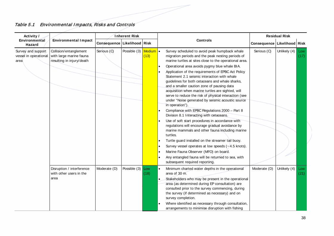
A summary of the environmental hazards, impacts and controls determined through risk assessment is provided in Table 5.1. In order to demonstrate the range of issues considered and provide additional detail on those aspects of the seismic survey considered to be of greatest interest to stakeholders, further detail on impacts associated with physical presence and underwater noise emissions has been provided thereafter.

37
Unacceptable Stop operations and rectify immediately. Director’s approval required to continue.
Tolerable Senior management decision to accept or reject risk and for operation to continue.
Acceptable With continuous review by user management and application of controls.
Figure 5.1 Searcher Risk Matrix
38
Table 5.1 Environmental Impacts, R isks and Controls
Activity / Environmental
Hazard Environmental Impact
Inherent Risk Controls
Residual Risk
Consequence Likelihood Risk Consequence Likelihood Risk
Survey and support vessel in operational area
Collision/entanglement with large marine fauna resulting in injury/death
Serious (C) Possible (3) Medium (13)
• Survey scheduled to avoid peak humpback whale migration periods and the peak nesting periods of marine turtles at sites close to the operational area.
• Operational area avoids pygmy blue whale BIA. • Application of the requirements of EPBC Act Policy
Statement 2.1 seismic interaction with whale guidelines for both cetaceans and whale sharks, and a smaller caution zone of pausing data acquisition when marine turtles are sighted, will serve to reduce the risk of physical interaction (see under “Noise generated by seismic acoustic source in operation”).
• Compliance with EPBC Regulations 2000 – Part 8 Division 8.1 Interacting with cetaceans.
• Use of soft start procedures in accordance with regulations will encourage gradual avoidance by marine mammals and other fauna including marine turtles.
• Turtle guard installed on the streamer tail buoy. • Survey vessel operates at low speeds (~4.5 knots). • Marine Fauna Observer (MFO) on board. • Any entangled fauna will be returned to sea, with
subsequent required reporting.
Serious (C) Unlikely (4) Low (17)
Disruption / interference with other users in the area
Moderate (D) Possible (3) Low (18)
• Minimum charted water depths in the operational area of 30 m.
• Stakeholders who may be present in the operational area (as determined during EP consultation) are consulted prior to the survey commencing, during the survey (if determined as necessary) and on survey completion.
• Where identified as necessary through consultation, arrangements to minimise disruption with fishing
Moderate (D) Unlikely (4) Low (21)

39
Activity / Environmental
Hazard Environmental Impact
Inherent Risk Controls
Residual Risk
Consequence Likelihood Risk Consequence Likelihood Risk
activities will be agreed with trap and line fishery licence holders; e.g. providing them with survey location reports, progress status and activity look ahead reports.
• Implement actions as per the Diving Medical Advisory Committee (DMAC) Guidance Note on Safe Diving Distance from Seismic Surveying Operations (DMAC, 2011) if seismic activities and pearl oyster diving activities are likely to occur simultaneously within 10 km of each other (as identified through pre-mobilisation consultation).
• Notice to Mariners prior to commencement. • Automatic Identification System operable on survey
vessel or daily reporting to AMSA RCC. • Adherence with requirements of the International
Regulations for Preventing Collisions at Sea 1972 (COLREGS) and Chapter 5 of Safety of Life at Sea as implemented in Commonwealth Waters through the Navigation Act 2012 and associated Marine Orders Parts 21, 30, 59 - navigation, collision, support vessels, including:
o Appropriate lighting, navigation and communication to inform other users.
o Use of radar and 24/7 watch. • Separation distance during data acquisition of
minimum 40 km agreed with operator of Capreolus 3D seismic survey.
• Streamer end marked with a tail buoy.

40
Activity / Environmental
Hazard Environmental Impact
Inherent Risk Controls
Residual Risk
Consequence Likelihood Risk Consequence Likelihood Risk
Planned / routine discharge of domestic wastes (treated sewage, grey water, putrescible waste)
Temporary and localised reduction in water quality (increase in nutrient levels) resulting in impacts on marine biota
Moderate
(d)
Likely
(2)
Medium
(14)
• No discharge of untreated sewage to the marine environment from the survey vessel.
• Discharges in accordance with relevant regulatory requirements (MARPOL).
• Approved Sewage Treatment Plant. • No discharge of treated sewage or food waste
within marine reserves, within 12 Nm from land, or when survey vessel is travelling at less than 4 knots.
• Vessel Garbage Management Plan. • Marine Orders – Part 95 (Marine pollution
prevention — garbage); and Part 96 (Marine pollution prevention — sewage).
Minor (E)
Unlikely (4)
Low (24)
Deck drainage and oily wastes
Temporary and localised reduction in water quality resulting in impacts on marine biota
Moderate
(d)
Possible
(3)
Low
(18)
• Approved oil water separator used prior to discharge (hydrocarbons less than 15 ppm).
• Preventative/Planned Maintenance System. • No discharge of oily water (<15 ppm) within marine
reserves or within 12 Nm from land). • Current International Oil Pollution Prevention
Certificate. • Vessel waste log books.
Minor (E)
Possible (3)
Low (22)
Routine solid hazardous and non-hazardous waste management
Incorrect disposal leading to onshore impacts
Moderate
(d)
Possible
(3)
Low
(18)
• Waste segregation on board. • Use of appropriate waste transfer, management
and disposal companies. • Vessel waste log books.
Moderate (D)
Unlikely (4)
Low (21)
Noise generated by seismic acoustic source in operation
Physiological damage to marine fauna Disruption to behaviour patterns of marine fauna
Serious (C) Likely
(2)
Medium (9)
• Schedule avoids peak migration periods of the humpback whale (July and end September), the peak nesting periods of marine turtles at sites close to the operational area (i.e. January for flatback turtles), and the primary pearl oyster spawning period (October to December).
• Data acquisition substantially reduced and survey execution redesigned to reduce as far as practicable
Serious (C) Unlikely (4) Low (17)
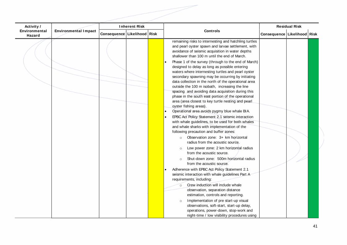
41
Activity / Environmental
Hazard Environmental Impact
Inherent Risk Controls
Residual Risk
Consequence Likelihood Risk Consequence Likelihood Risk
remaining risks to internesting and hatchling turtles and pearl oyster spawn and larvae settlement, with avoidance of seismic acquisition in water depths shallower than 100 m until the end of March.
• Phase 1 of the survey (through to the end of March) designed to delay as long as possible entering waters where internesting turtles and pearl oyster secondary spawning may be occurring by initiating data collection in the north of the operational area outside the 100 m isobath, increasing the line spacing and avoiding data acquisition during this phase in the south east portion of the operational area (area closest to key turtle nesting and pearl oyster fishing areas).
• Operational area avoids pygmy blue whale BIA. • EPBC Act Policy Statement 2.1 seismic interaction
with whale guidelines, to be used for both whales and whale sharks with implementation of the following precaution and buffer zones:
o Observation zone: 3+ km horizontal radius from the acoustic source.
o Low power zone: 2 km horizontal radius from the acoustic source.
o Shut-down zone: 500m horizontal radius from the acoustic source.
• Adherence with EPBC Act Policy Statement 2.1 seismic interaction with whale guidelines Part A requirements, including:
o Crew induction will include whale observation, separation distance estimation, controls and reporting.
o Implementation of pre start-up visual observations, soft-start, start-up delay, operations, power-down, stop-work and night-time / low visibility procedures using

42
Activity / Environmental
Hazard Environmental Impact
Inherent Risk Controls
Residual Risk
Consequence Likelihood Risk Consequence Likelihood Risk
the precaution zones defined above. o Maintaining accurate sighting records and
completion of post-survey report. • A voluntary mitigation zone for turtles to be
implemented around the operational airgun array. • MFO on board the survey vessel during all activities. • Avoid data acquisition inside the 30 m isobath. • Minimum 40 km separation between the operating
survey vessel and the operating survey vessels for the Capreolus 3D Survey.
• Size of the seismic source (airgun array) reduced to the minimum operating requirements.
Noise generated by vessel thrusters/engine operation
Disruption to behaviour patterns of marine fauna
Minor (E)
Almost certain
(1)
Medium (15)
• Surveys will be conducted outside peak humpback whale migration season.
• Operational area avoids pygmy blue whale BIA. • Vessel activities will be undertaken in accordance
with EPBC Regulations 2000 – Part 8 Division 8.1 Interacting with cetaceans (taking into account the limited manoeuvrability of the survey vessel).
• MFO on board the survey vessel during all activities. • Crew induction will include whale observation,
separation distance estimation, controls and reporting.
• Propulsion systems to be maintained in good working order (manufacturer's specifications).
Minor (E)
Likely (2)
Low (19)

43
Activity / Environmental
Hazard Environmental Impact
Inherent Risk Controls
Residual Risk
Consequence Likelihood Risk Consequence Likelihood Risk
Noise generated by helicopters transferring crew
Disruption to behaviour patterns of marine fauna
Moderate (D) Possible (3)
Low (18)
• Base-case is to undertake crew transfers in port, negating the need for helicopter transfers.
• Surveys will be conducted outside peak humpback whale migration season.
• Helicopters movements to be undertaken in accordance with EPBC Regulations 2000 – Part 8 Division 8.1 Interacting with cetaceans.
• Helicopters to avoid identified sensitive areas for birds and maintain minimum altitudes where practicable.
Moderate (D) Unlikely (4) Low (21)
Navigational and safety lighting for survey vessel
Disruption to behaviour patterns of marine fauna
Moderate
(D)
Possible
(3)
Low
(18)
• Reduce lighting as far as practicable, whilst not jeopardising safety (e.g. non-essential lighting to be turned off when not in use).
• Identify opportunities to further reduce lighting.
Moderate (D)
Unlikely (4)
Low (21)
Air emissions associated with power generation for vessel and equipment operation
Temporary and localised reduction in air quality
Minor
(E)
Almost Certain
(1)
Medium
(15)
• Vessel engines and incinerator to be maintained and operated in accordance with manufacturer specification.
• Survey vessel has valid International Air Pollution Prevention (IAPP) certificate.
• Survey vessel will use low sulfur MGO as a preference, where available.
• Marine Orders – Part 97 (Marine pollution prevention - air pollution).
Minor (E)
Likely (2)
Low (19)
Increased greenhouse gases in atmosphere
Minor
(E)
Almost Certain
(1)
Medium
(15)
• Limited emissions volumes and survey duration - volumes from surveys not expected to contribute significantly to global greenhouse gas load.
• Marine Orders – Part 97 (Marine pollution prevention - air pollution).
Minor (E)
Likely (1)
Low (19)
Waste incinerator Temporary and localised reduction in air quality
Minor
(E)
Almost Certain
(1)
Medium
(15)
• MARPOL 73/78 Annex VI (Prevention of Air Pollution from Ships) requirements.
• Survey vessel has valid IAPP certificate.
Minor (E)
Likely (2)
Low (19)
Biofouling of vessel hull
Introduction of IMS resulting in alterations to
Serious Possible Medium • IMS inspection prior to mobilisation into Australian waters and confirmed free of potential IMS.
Serious Unlikely Low

44
Activity / Environmental
Hazard Environmental Impact
Inherent Risk Controls
Residual Risk
Consequence Likelihood Risk Consequence Likelihood Risk
local ecosystems (C) (3) (13) • Compliance with the National Biofouling Management Guidance for the Petroleum Production and Exploration Industry guidelines.
• Valid hull anti-fouling certificate that meets the requirements of Annex 1 of the International Convention on the Control of Harmful Anti-Fouling Systems on Ships and the requirements of the Protection of the Sea (Harmful Antifouling Systems) Act 2006.
(C) (4) (17)
Biofouling of in-water survey equipment
Introduction of IMS resulting in alterations to local ecosystems
Moderate
(D)
Possible
(3)
Low
(18)
• Regular cleaning and maintenance of equipment during deployment, retrieval or in-water during operations.
Moderate (D)
Unlikely (4)
Low (21)
Ballast water exchange
Introduction of IMS resulting in alterations to local ecosystems
Serious
(C)
Possible
(3)
Medium
(13)
• No planned ballast water exchange during the survey.
• Compliance with Australian Ballast Water Management Requirements.
Serious (C)
Unlikely (4)
Low (17)
Fuel tank rupture from vessel collision leading to release of MGO
Acute and chronic toxic effects to marine biota from exposure to surface, entrained and shoreline hydrocarbons Oiling of marine mammals, reptiles and seabirds Oiling of islands and emergent coral reefs/submerged shoals Disruption to commercial and coastal fishing and shipping activities
Serious (C) Possible
(3)
Medium
(13)
Prevention Controls • Controls in place to avoid as far as possible key
periods and areas of biological sensitivity also serve to reduce the likelihood and consequence of impacts to migrating humpback whales, pearl oyster spawn and larvae and flatback turtle adults and hatchlings associated with hydrocarbon spills.
• Controls in place to avoid disrupting other marine users also serve to reduce the potential for a collision.
• Fuel stored in multiple segregated tanks on-board the survey vessel.
• Adherence with requirements of the International Regulations for Preventing Collisions as Sea 1972 (COLREGS) and Chapter 5 of Safety of Life at Sea as implemented in Commonwealth Waters through the Navigation Act 2012 and associated Marine Orders Parts 21, 30, 59 - navigation, collision,
Serious (C) Unlikely (4)
Low (17)

45
Activity / Environmental
Hazard Environmental Impact
Inherent Risk Controls
Residual Risk
Consequence Likelihood Risk Consequence Likelihood Risk
support vessels, including: o Appropriate lighting, navigation and
communication to inform other users. o Use of radar and 24/7 watch.
Response Measures • Source control measures in accordance with the
vessel Ship Oil Pollution Emergency Plan (SOPEP).
• Implement response procedures in accordance with Oil Pollution Emergency Plan (OPEP).
• Spill kits and scupper plugs are available on board survey vessel.
Refuelling spill leading to release of MGO
Toxic effects to marine biota
Moderate (D) Possible (3) Low
(18)
Prevention Controls • Refuelling within the operational area (or outside
the control of a port authority) will be avoided as far as practicable. If refuelling within the operational area is undertaken:
o No refuelling at sea within 25 km of land, shoals, islands or protected areas (excepting areas of Commonwealth Marine Reserves designated as Multiple Use Zones).
o At sea refuelling during daylight hours and in suitable weather conditions.
• Relevant to all refuelling associated with the survey (i.e. regardless of refuelling location):
o Use of dry-break couplings for refuelling. o Adherence with the acquisition contractor’s
Bunkering Procedure, including ensuring that pollution prevention equipment is ready, scuppers are plugged before bunkering commences and good communications are maintained throughout bunkering.
Moderate (D) Unlikely (4)
Low (21)
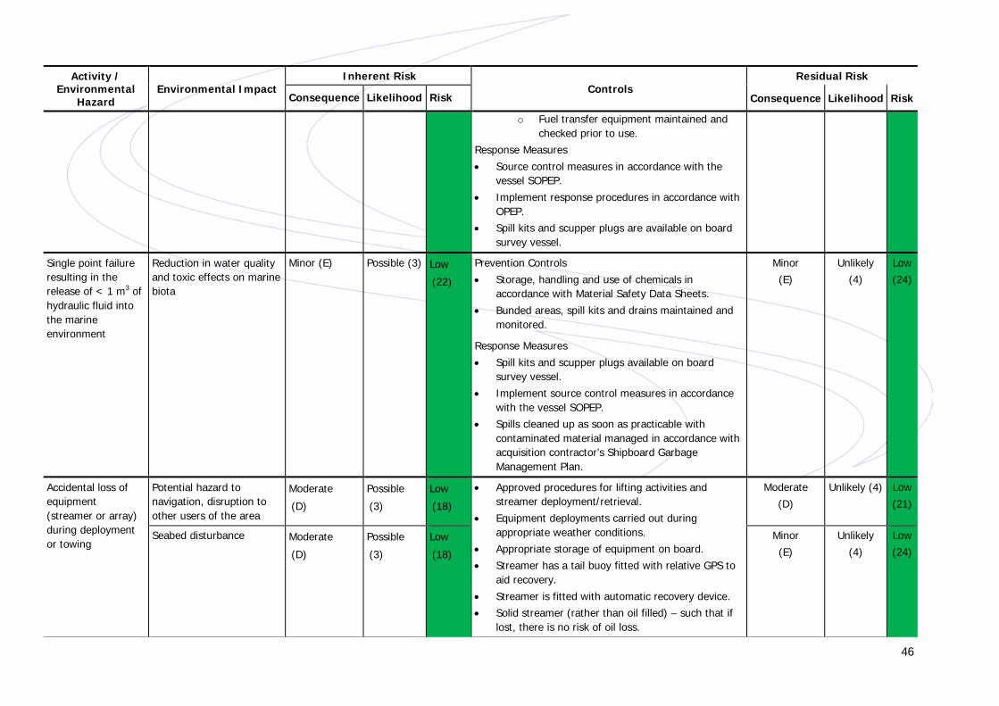
46
Activity / Environmental
Hazard Environmental Impact
Inherent Risk Controls
Residual Risk
Consequence Likelihood Risk Consequence Likelihood Risk
o Fuel transfer equipment maintained and checked prior to use.
Response Measures • Source control measures in accordance with the
vessel SOPEP. • Implement response procedures in accordance with
OPEP. • Spill kits and scupper plugs are available on board
survey vessel.
Single point failure resulting in the release of < 1 m3 of hydraulic fluid into the marine environment
Reduction in water quality and toxic effects on marine biota
Minor (E) Possible (3) Low
(22)
Prevention Controls • Storage, handling and use of chemicals in
accordance with Material Safety Data Sheets. • Bunded areas, spill kits and drains maintained and
monitored.
Response Measures • Spill kits and scupper plugs available on board
survey vessel. • Implement source control measures in accordance
with the vessel SOPEP. • Spills cleaned up as soon as practicable with
contaminated material managed in accordance with acquisition contractor’s Shipboard Garbage Management Plan.
Minor (E)
Unlikely (4)
Low (24)
Accidental loss of equipment (streamer or array) during deployment or towing
Potential hazard to navigation, disruption to other users of the area
Moderate
(D)
Possible
(3)
Low
(18)
• Approved procedures for lifting activities and streamer deployment/retrieval.
• Equipment deployments carried out during appropriate weather conditions.
• Appropriate storage of equipment on board. • Streamer has a tail buoy fitted with relative GPS to
aid recovery. • Streamer is fitted with automatic recovery device. • Solid streamer (rather than oil filled) – such that if
lost, there is no risk of oil loss.
Moderate (D)
Unlikely (4) Low (21)
Seabed disturbance Moderate
(D)
Possible
(3)
Low
(18)
Minor (E)
Unlikely (4)
Low (24)

47
Activity / Environmental
Hazard Environmental Impact
Inherent Risk Controls
Residual Risk
Consequence Likelihood Risk Consequence Likelihood Risk
• Lifting gear to be load rated as appropriate for the working load.
• AMSA notified in the event of equipment loss to provide a warning to shipping.
Accidental loss of solid non-hazardous and hazardous waste
Temporary and localised reduction in water quality resulting in impacts on marine biota Physiological damage to marine fauna
Moderate
(D)
Possible
(3)
Low
(18)
• No overboard disposal. • Waste will be stored, handled and transferred on
board in accordance with the acquisition contractor’s Garbage Management Plan which also requires compliance with regulatory requirements (i.e. Protection of the Sea (Prevention of Pollution from Ships) Act 1983 and Marine Orders – Part 94 (Marine pollution prevention - packaged harmful substances)).
• If safe to do so, recovery of lost overboard material will be carried out.
Minor (E)
Unlikely (4)
Low (24)
Unplanned anchoring or seabed snagging
Seabed disturbance Minor
(E)
Unlikely
(4)
Low
(24)
• No anchoring planned. • Propulsion redundancy.
Minor (E)
Unlikely (4)
Low (24)

48
5.2 Physical Presence
5.2.1 Entanglement or Collision with Large Marine Fauna
Large marine fauna (i.e. marine mammals, turtles, whale sharks) occurring in the operational area have the potential to become entangled in seismic equipment or collide with the survey or the support vessel, which can lead to injury or death. However, marine mammals and whale sharks are not expected to be present in the operational area in large numbers at the time of the survey. The survey is proposed to be completed outside of the peak migration periods for humpback whales and whale sharks in the region. The survey will coincide with the northerly migration for pygmy blue whales (April and May); however, it is unlikely that pygmy blue whales will be encountered, or be in the vicinity of the operational area during the survey due to the operational area lying at least 10 km inshore of the pygmy blue whale BIA. Other mega-fauna species that may be present in low numbers in the shallower waters of the southern and south-eastern part of the operational area during the survey include flatback turtles (internesting and post-nesting females and hatchlings) and foraging hawksbill and green turtles. However, seismic acquisition in water depths shallower than 100 m will be avoided until the end of March, which will minimise the risk of interaction with flatback turtles nesting at Eighty Mile Beach between late November and March (peaking in January).
Despite the low numbers of marine fauna expected, several key management measures will be implemented to reduce the likelihood of the seismic equipment physically interacting with marine fauna individuals and therefore reduce the risk of impact to ALARP, as listed in Table 5.1.
Given the circumstances within which the survey will be undertaken and the controls that will be implemented by Searcher (Table 5.1), impacts and risks to marine fauna from the physical presence of vessels and equipment were determined to be low and reduced to levels that are ALARP and acceptable.
5.2.2 Disruption/Interference with Other Users of the Operational Area
A range of other activities, including commercial and recreational fishing operators, commercial shipping, tourism and defence activities, have the potential to interact with the survey. Consultation undertaken to date indicates that the operational area is used mainly for commercial shipping operations, transiting to and/or from the Port of Dampier and Port of Port Hedland. In addition, a number of Commonwealth and State managed fisheries overlap the operational area. However given the seasonality of fishing, reported fishing effort, range of targeted species and water depths, only five fisheries have the potential to be active in the operational area during the Bilby 2D Survey (North West Slope Trawl, Pilbara Fish Trawl, Northern Demersal Scalefish, Pilbara Line and Pilbara Trap Managed Fisheries). These fisheries use trawl, line and trap fishing methods.

49
No significant disruptions to fishing operations are anticipated for the following reasons:
• The fisheries active within the operational area (see Table 3.3) cover wide spatial areas with only a portion of the fishing area falling within the operational area of the Bilby 2D Survey.
• Based on current survey design, data acquisition will be limited to approximately 12,290 km2 of seismic lines and only a fraction of these lines (less than 1%) will be surveyed in any 24 hour period.
• The transient nature of trawl vessels and the seismic survey vessel means that an area is only temporarily unavailable to trawling.
• No concerns were raised to Searcher by fishery licence holders during consultation for the EP.
• Ongoing consultation with licence holders will enable them to plan fishing activities to avoid disruption.
Any potential disruption to fishing activities occurring in the operational area during the Bilby 2D Survey is expected to be temporary, with fishers able to rapidly return to the fishing grounds once the vessel has passed.
Despite any physical interaction with the fishing / diving activities of pearl oyster fishery licence holders being unlikely, the controls listed in Table 5.1 will serve to reduce any potential for diving activities to be disrupted as a result of the survey to ALARP. As confirmed through engagement with the Pearl Producers Association, it is not expected that the Bilby 2D Survey will physically disrupt fishing / diving activities of the Pearl Oyster Managed Fishery, given water depths in the operational area of > 30 m (oyster divers dive primarily in waters 23 m deep or less), and due to the limited duration and timeframes associated with diving activities for this fishery.
Given the circumstances within which the survey will be undertaken and the controls that will be implemented by Searcher (Table 5.1), impacts and risks to other users of the operational area from the physical presence of vessels and equipment were determined to be low and reduced to levels that are ALARP and acceptable.
5.3 Noise Emissions
Underwater noise will be associated with operation of the seismic source, general vessel activities (including engine noise and operation of thrusters) and, if required, helicopter movements. The seismic source, being the most significant noise contributor of the proposed activity, has been calculated to have a sound exposure level (SEL) of 238.2 dB re 1μPa2.s at 1 m, with a frequency of less than 500 Hz (SVT 2014).

50
The assessment of noise emissions presented in the EP also considered the potential cumulative effects of exposure to multiple seismic sources over a similar area and timeframe, namely from the two Capreolus vessels, and concurrently with any other 2D or 3D marine seismic survey occurring in the same area over a similar timeframe.
Impacts and risks associated with noise on key environmental and social receptors as a result of the Bilby 2D Survey are summarised below.
5.3.1 Potential Impacts on Marine Mammals
Marine mammals, in particular cetaceans, are the receptor most susceptible to impacts from seismic activity. Evidence from McCauley 1994, Southall et al 2007, DEWHA 2008, McCauley et al 1998 and Richardson et al 1995 has been used to inform the assessment of impacts and risks.
Underwater noise levels from the seismic source are anticipated to drop below sound pressure levels that may result in damage to hearing (as determined by Southall et al 2007) within 500 m of the source, which is consistent with the shut-down zone control proposed for the Bilby 2D Survey (see Table 5.1). Implementation of the low power zone at 2 km from the source will further protect individuals from hearing damage as a result of cumulative exposure to multiple pulses from the seismic source.
Noise levels at which behavioural disturbance could occur may extend over a much larger area (tens of km). Behavioural changes as a result of noise can include cessation of normal activities such as regular diving patterns and commencement of avoidance or ‘startle’ behaviour, particularly when the noise source is intermittent. Startle behaviour as a result of noise from the Bilby 2D MSS is unlikely given the implementation of precaution zones, pre-survey visual observations and soft-start procedures (see Table 5.1). Avoidance of the survey vessel and/or other behavioural responses by marine mammals may be expected over a wide area. However, as described in Sections 3.2.3 and 5.2.1, marine mammals are not expected to be encountered frequently in the operational area given the location and timing of the survey programme. Furthermore, the survey area is at least 10 km inshore of the pygmy blue whale BIA, where pygmy blue whales are most likely to occur during their migration in April and May. As such, behavioural disturbance to migrating whales is unlikely.
Given that a minimum separation distance of 40 km will be maintained between the Bilby survey vessel and any third party seismic vessel, a worst case situation of an animal being positioned equidistant from multiple seismic vessels was assessed in the EP. A worst case cumulative received level for an animal exposed to multiple seismic courses was calculated to be well below the level at which impacts to hearing in marine mammals and other fauna are known to occur. The main effect would be that individuals passing through the region may exhibit a wider area of avoidance as a result of the concurrent activities. This area of avoidance could potentially extend to a few tens of kilometres around each seismic source vessel and would not be significantly increased by the proximity of more than one source vessel at a minimum distance of 40 km. Given the absence of critical habitats such as feeding, breeding or resting areas in proximity to the operational area, such avoidance is not expected have long-term implications for either individuals or populations.

51
Despite the evaluated low likelihood of encountering significant numbers of marine mammals during the survey, Searcher will implement a number of controls consistent with regulatory requirements and industry good practice to reduce impacts and risks to marine mammals to levels that are low, ALARP and acceptable. These controls are summarised previously in Table 5.1.
5.3.2 Potential Impacts on Marine Turtles
Marine turtles are generally considered to be less sensitive to noise than marine mammals as they do not have an external hearing organ. Nevertheless, marine turtles can detect sound through bone-conducted vibration in the skull and by using their shell as a receiving surface (Lenhardt et al. 1985). The assessment of noise impacts on marine turtles has drawn on the work of Bartol and Musick (2003), Moein et al. (1994), Moein et al. (1995) and McCauley et al. (2000) to understand the extent to which marine turtles may be influenced by the Bilby 2D Survey and other concurrent seismic surveys in the area. Based on the available evidence, potential avoidance and behavioural responses by marine turtles to the Bilby 2D Survey are determined to be possible up to approximately 20 km from the survey vessels.
The potential for interactions with marine turtles (including adult and hatchlings) is likely to be highest during the initial phase of the survey which overlaps with the very end of the nesting period for flatback turtles (November to March, peaking in January). However, seismic acquisition in water depths shallower than 100 m will be avoided until the end of March, thus minimising the risk of disturbance to nesting turtles.
Given the location of the operational area, timing of the survey and the distance to critical nesting and foraging habitats for turtles (see Section 3.2.3), the risk of significant impacts from seismic noise disturbance to turtles as a result of the Bilby 2D Survey has been assessed to be low. There is also not expected to be a cumulative impact on turtles as a result of concurrent surveys for the Bilby 2D Survey and Capreolus 3D MSS given the separation distance between vessels and the limited spatial extent of impact to turtles from each vessel.
5.3.3 Potential Impacts on Fish, Sharks and Rays
The assessment of noise impacts on fish, sharks and rays considered impacts on all life-stages, including eggs, larvae, juveniles and adults. The assessment made reference to the work of Popper et al. (2014), McCauley and Cato (2000), Ladich (2000), Finneran and Hastings (2000), Hastings et al. (2008), McCauley et al. (2000), Wardle et al. (2001), Simmonds and MacLennan (2005), Pearson et al (1992), McCauley (1994), DNV Energy (2007), Payne et al (2004) and Myberg (2001).
A comprehensive review of scientific studies into the impact of seismic activity on fish and the fisheries industry concluded that physical damage to fish caused by sound emitted by seismic sources would only occur within less than a few metres of the source (DNV Energy, 2007). Adult fish would typically move away from the sound, but eggs and larvae, which are not actively mobile, may be affected by the signals within a similar distance.

52
Research by Payne el al (2004) suggests a range of 5 – 6 m as the maximum range for potential injury, and hence longer term effects to fish eggs, larvae and fry in response to peak pressure.
The assessment determined that mainly pelagic species are likely to be found in the open waters of the operational area, which are highly mobile, and are likely to move away from the source if the received sound levels become uncomfortable, particularly with the implementation of the agreed soft-start procedures (McCauley et al. 2000). Therefore, physiological impacts to pelagic species are unlikely to occur, but temporary changes to behaviour may arise.
Behavioural effects of noise on fish may include changes to schooling behaviour and avoidance of the noise source (Simmonds and MacLennan 2005). However, once acoustic disturbances are removed, fish are expected to return to normal behaviour within as little as an hour (Wardle et al. 2001; Pearson et al. 1992).
Whale sharks may show avoidance behaviour to the seismic source and are unlikely to remain close enough to the source to suffer physiological trauma. Given the protected status of the whale shark and the tendency of individuals to be present in surface waters where they may be detected through visual observation, the precaution zones in EPBC Policy Statement 2.1 that will be implemented for whales during the Bilby 2D Survey will also be applied for whale sharks, thereby reducing the risk of potential impact to this species.
5.3.4 Potential Impacts on Invertebrates
Generally, marine invertebrates are considered to have poorly developed mechano-sensory systems and are considered little affected by noise generated by seismic surveys. The assessment examined evidence from a variety of invertebrate species including crayfish (Tautz and Sandeman 1980); clams (La Bella et al. 1996); shrimp (Heinisch and Wiese 1987; and Andriguetto-Filho et al. 2005); prawns (Steffe and Murphy 1992); commercial scallops (Harrington et al. 2010); rock lobsters (Parry and Gason 2006); and squid (Fewtrell and McCauley 2012). Overall, research indicates that the majority of marine benthic invertebrates will only respond to seismic sources at extremely close range (McCauley 1994) and more sensitive pelagic species, such as squid, may demonstrate avoidance of the source. The risk of significant impacts from seismic noise disturbance to invertebrates as a result of the Bilby 2D Survey has therefore been assessed as low; however in response to stakeholder concerns a more detailed assessment of the potential impacts to pearl oysters in the context of the pearl oyster fishery off Eighty Mile Beach is provided below.
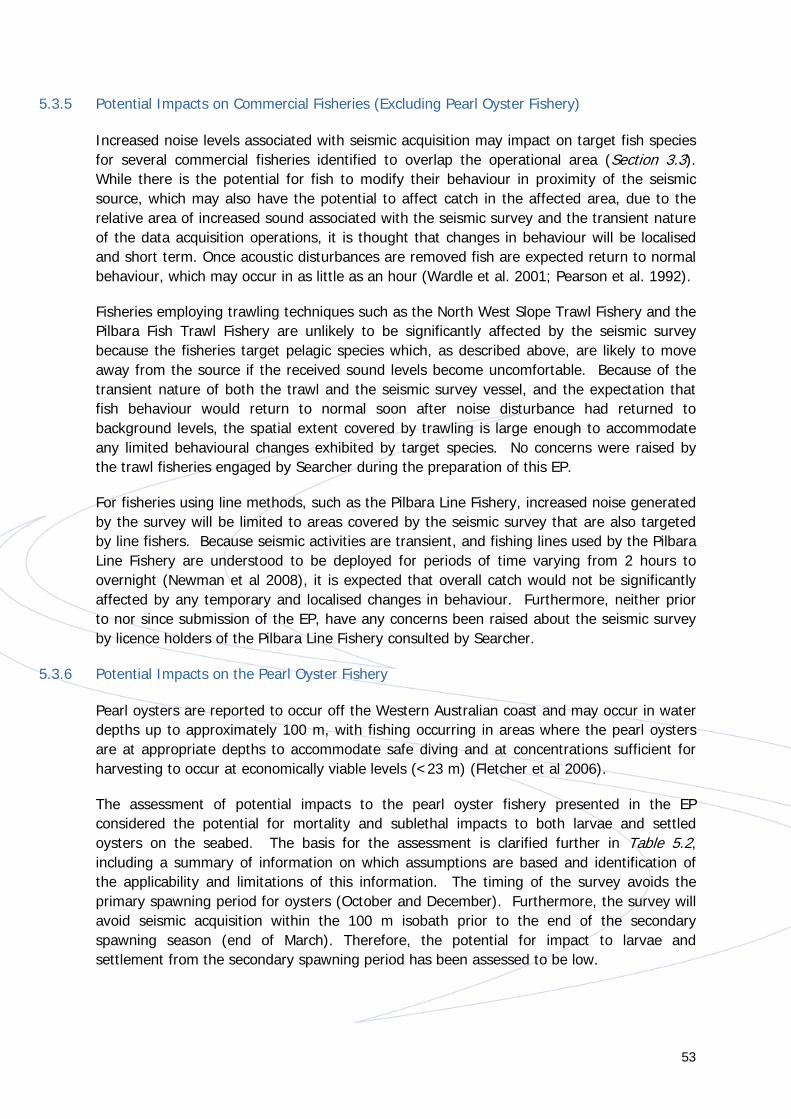
53
5.3.5 Potential Impacts on Commercial Fisheries (Excluding Pearl Oyster Fishery)
Increased noise levels associated with seismic acquisition may impact on target fish species for several commercial fisheries identified to overlap the operational area (Section 3.3). While there is the potential for fish to modify their behaviour in proximity of the seismic source, which may also have the potential to affect catch in the affected area, due to the relative area of increased sound associated with the seismic survey and the transient nature of the data acquisition operations, it is thought that changes in behaviour will be localised and short term. Once acoustic disturbances are removed fish are expected return to normal behaviour, which may occur in as little as an hour (Wardle et al. 2001; Pearson et al. 1992).
Fisheries employing trawling techniques such as the North West Slope Trawl Fishery and the Pilbara Fish Trawl Fishery are unlikely to be significantly affected by the seismic survey because the fisheries target pelagic species which, as described above, are likely to move away from the source if the received sound levels become uncomfortable. Because of the transient nature of both the trawl and the seismic survey vessel, and the expectation that fish behaviour would return to normal soon after noise disturbance had returned to background levels, the spatial extent covered by trawling is large enough to accommodate any limited behavioural changes exhibited by target species. No concerns were raised by the trawl fisheries engaged by Searcher during the preparation of this EP.
For fisheries using line methods, such as the Pilbara Line Fishery, increased noise generated by the survey will be limited to areas covered by the seismic survey that are also targeted by line fishers. Because seismic activities are transient, and fishing lines used by the Pilbara Line Fishery are understood to be deployed for periods of time varying from 2 hours to overnight (Newman et al 2008), it is expected that overall catch would not be significantly affected by any temporary and localised changes in behaviour. Furthermore, neither prior to nor since submission of the EP, have any concerns been raised about the seismic survey by licence holders of the Pilbara Line Fishery consulted by Searcher.
5.3.6 Potential Impacts on the Pearl Oyster Fishery
Pearl oysters are reported to occur off the Western Australian coast and may occur in water depths up to approximately 100 m, with fishing occurring in areas where the pearl oysters are at appropriate depths to accommodate safe diving and at concentrations sufficient for harvesting to occur at economically viable levels (<23 m) (Fletcher et al 2006).
The assessment of potential impacts to the pearl oyster fishery presented in the EP considered the potential for mortality and sublethal impacts to both larvae and settled oysters on the seabed. The basis for the assessment is clarified further in Table 5.2, including a summary of information on which assumptions are based and identification of the applicability and limitations of this information. The timing of the survey avoids the primary spawning period for oysters (October and December). Furthermore, the survey will avoid seismic acquisition within the 100 m isobath prior to the end of the secondary spawning season (end of March). Therefore, the potential for impact to larvae and settlement from the secondary spawning period has been assessed to be low.

54
Based on studies of pearl oysters and other bivalve species, it is well established that the potential for mortality in oysters on the seabed as a result of seismic noise is limited to several metres from the source (Harrington et al. 2010; La Bella et al. 1996; LeProvost, Semeniuk and Chalmer 1986; Parry et al. 2002; Parry and Gason 2006)( Table 5.2). The EP assessment assumed a conservative range for mortality of approximately 15 m either side of the survey line. Given that the survey vessel will not acquire data in water depths less than 30 m, and that the array is towed 6 m below the surface, the minimum distance between the source and any individual oyster will be at least 24 m. As such, there is no credible potential for lethal impacts to pearl oysters.
Available information in the literature suggests that the spatial extent for sub-lethal impacts of seismic noise is also restricted (Harrington et al. 2010; La Bella et al. 1996; McCauley 1994; Parry et al. 2002). However, availability of supporting studies on sub-lethal impacts is more limited. Therefore in order to further demonstrate that potential impacts to the pearl oyster fishery are ALARP and acceptable, the assessment in the EP assumed a potentially wider area of sub-lethal impact based on more sensitive species such as fish (approximately 100 m either side of the survey line), which is considered to provide a highly conservative approach.
Diving operations are reported to occur in depths of less than 23 m for harvesting of oysters for pearl culture. The majority of the survey acquisition area for the Bilby 2D Survey is located in water depths greater than 50 m, and a minimum of approximately 10 km from the 23 m depth contour (Figure 5.2). Therefore, even with some uncertainty as to the spatial extent for potential sub-lethal impacts it is not credible that sub-lethal impacts could occur to individuals that may be harvested.
Any sub-lethal impacts to pearl oysters in deeper waters (mostly >50 m) are not expected to have implications for the fishery as only a very small proportion of potential pearl oyster habitat would be affected as follows:
• Based on a conservative 100 m radius of impact from the seismic source (considered more appropriate for fish in comparison to the less sensitive pearl oyster), sub-lethal impacts are shown to potentially occur over a total area of 1,415 km2 within the 100 m isobath. This area represents approximately 0.6% of the waters inside the 100 m isobath within which pearl oyster habitat may occur.
• With regard to water depths <50 m, which are considered to support higher densities of pearl oysters, only 0.1% of the 30 – 50m water depth habitat has the potential to receive noise at a level that may cause sub-lethal impacts.
Based on this analysis, it is shown that even adopting a very conservative set of assumptions, potential sublethal effects are only plausible over a very small percentage (0.6%) of the total area of known pearl oyster habitat in the region, and therefore the risk of environmental impact to pearl oysters and the associated fishery is deemed ALARP and acceptable.

55
To support this conclusion, Searcher notes that seismic activity has been occurring in the vicinity of the Eighty Mile Beach Pearl Oyster fishery for decades. Based on data reported by the Western Australian Department of Fisheries (Fletcher et al 2006) the total catch from the main fishing grounds of the Pearl Oyster Fishery (i.e. Zone 2/3) reported over a 10 year period preceding the report remained stable, varying by less than 10%. Over the same time period as the reported catch data, 7,900 line kilometres of seismic data has been acquired within water depths of less than 100 m in the area off the Eighty Mile Beach Fishery (from Port Hedland to Cape Leveque). Therefore, based on historic evidence and consistent with available scientific research, it is thought that seismic acquisition has not had any significant negative impacts on pearl oyster settlement and growth due to increased noise emissions, thereby not affecting the long term productivity of the fishery.

56
Table 5.2 Summary of Basis for Underwater Noise Impact Assessment for the Pearl Oyster Fishery Presented in the EP Basis of Assessment
Summary of Key Supporting Information Applicability and Limitations of Key Supporting Information
The assessment presented in the EP is based on the assumption that the potential for lethal impacts to pearl oysters is limited to several metres of the source, and therefore within a conservative range of approximately 15 m either side of the survey line. Sub-lethal impacts are similarly understood to be limited to a range of approximately 15 m either side of the survey line based on available information.
The range for potential lethal and sub-lethal impacts is primarily based on information presented in an independent scientific review of the environmental implications of seismic surveys in Australia on behalf of the Australian Petroleum Exploration Association (APPEA) and the Energy Research and Development Corporation (ERDC) by McCauley (1994). This review particularly considered the physiology of marine invertebrates and their likely capability of detecting sound from seismic surveys given the paucity of specific information on noise impacts.
According to McCauley (1994) it is likely that the mechano-sensory system of many invertebrates will perceive the sound of airgun shots close to a seismic source. However, for most invertebrates such stimulation would only occur within the near-field or closer:
“It is probable that most invertebrates only perceive ‘shots’ in the near-field, possibly less than 20 m from an array, which implies surveys must be run in very shallow water to have an effect.”
McCauley (1994) proposes zones of effect for invertebrates as follows:
• Audible zone – approximately 20 m from the source array
• Response zone – approximately 10 m from the source array
• Pathological zone – approximately 2 m from the source array
In the context of the zones outlined above and given a maximum audible zone of 20 m is predicted, a zone of potential impact for lethal and sub-lethal effects of 15 m is considered reasonable.
The zone of potential impacts proposed is further supported by the results of studies into seismic impacts on pearl oysters and other bivalve species presented in the EP and
The range for potential lethal and sub-lethal effects of seismic noise for marine invertebrates suggested by McCauley (1994) was based on consideration of anatomical features related to hearing mechanisms and a review of available studies. However, the author acknowledges the lack of conclusive experiments to support the suggested range of effects, which were based on expert opinion.

57
listed below.
A study was undertaken into the effect of underwater seismic explosions on pearl oysters (Pinctada maxima) in the Lowendal/Montebello Islands region in 1985/1986 in order to establish the potential for impacts to oysters at nearby pearl farm locations (approximately 1.5 km from the nearest seismic line) (LeProvost, Semeniuk and Chalmer, 1986). An initial experimental trial was conducted with explosions detonated at distances of 1 m, 10 m, 100 m, 1,000 m and 2,000 m from a series of pearl oyster samples, with mortality recorded up to seven months after the explosions. A further test was conducted in conjunction with the seismic line closest to the pearl farm areas in which mortality of oysters at distances of 50 m, 500 m and 1,000 m from the seismic line was recorded over the following 4.5 months. Along the seismic line, explosions were detonated every 25 m. The preliminary trial showed that three out of five pearl oysters within 1 m of the seismic explosion died shortly afterwards. Those that were 10 m or more away (25 individuals) showed no signs of mortality over the subsequent seven months. During the seismic programme, the test pearl oysters set up between the nearest seismic line and the pearl farm areas showed no mortality of oysters over the subsequent 4.5 months that could be attributed to the seismic activities.
This study is directly applicable to impacts of high intensity noise on pearl oysters in relation to the potential for lethal impacts. It was a controlled study that monitored affected pearls over a period of up to 7 months following exposure. While the study relates to impacts from seismic explosions as opposed to seismic airguns, this is considered to be a conservative measure as modern airguns are understood to cause less impact on marine fauna than explosives. Modern airguns generate a lower maximum pressure, and cause a lower rate of pressure change compared to the near-instantaneous signal rise produced by explosives (McCauley 1994; Parry and Gason 2006).
Harrington et al. (2010) conducted a “before and after” control impact study examining the short term effects of seismic acquisition on health and abundance of adult scallops (Pecten fumatus) between February and June 2010. The health parameters considered were gonad and meat condition to represent sub-lethal impacts. The study was based on a 3 month seismic acquisition programme, using a 4130 in3 seismic source to acquire 8,000 line kilometres. The study found no change in the condition and abundance of live scallops in the impacted site compared to a control site, with gonad condition, meat size and meat texture remaining relatively unchanged. There was also no observable change in the size frequency distribution of scallops in the impacted and semi-impacted sites following the seismic survey. The conclusion was that no short-term (< two months) impacts on the survival of adult commercial scallops were detected after the seismic survey.
The results of the study apply to both lethal and sub-lethal effects and support the basis for assessment. They are somewhat conservative in that a larger seismic source was used than proposed for the Bilby 2D MSS, passing directly over scallop beds. While not directly applicable to pearl oysters, scallops as a bivalve mollusc may be considered a reasonable proxy.
Parry et al. (2002) conducted a study between December 2001 and February 2002 to investigate impacts of seismic acquisition on adult scallops. In their experiment, adult
This study addresses the potential for lethal impacts to scallops and uses adductor muscle
58
scallops were suspended in lantern nets, with the base of the lantern net approximately 0.5 m off the seafloor, at both an impacted site, where they were exposed to regular seismic airgun discharge, and a control location 20 km away from the seismic source. The study concluded that seismic acquisition had no effect on the mortality rate of scallops or the strength of aductor muscles (a possible indicator of sub-lethal effects).
strength as an indicator of sub-lethal impacts. Adductor muscle strength is related to scallop condition and may therefore be affected by sub-lethal stress responses. While not directly applicable to pearl oysters, scallops as a bivalve mollusc may be considered a reasonable proxy.
The results of the study support the basis of assessment, with no effect on mortality rate or sub-lethal effects to adductor muscle strength observed. However, the size of the seismic source is not known. Additionally, adult scallops were suspended approximately 0.5m off the seafloor and may therefore not have been exposed to the same intensity of seismic discharge compared to scallops on the seafloor due to seismic wave interaction with the sediment.
Parry and Gason (2006) conducted a study that analysed catch data of rock lobster following the acquisition of 28 2D seismic surveys and 5 3D seismic surveys conducted between 1978 and 2004 in western Victoria. Seismic acquisition for these surveys was conducted in water depths ranging between 10-150 m, using seismic sources varying from 762 to 4,454 in3. The study concluded there was no evidence that catch rates of rock lobsters were affected by seismic surveys in the weeks or years following the surveys and that “the apparent lack of impact of seismic surveys on catch rates of rock lobsters is consistent with the limited information available on the physiological effects of seismic surveys on invertebrates, including rock lobsters”.
The study analyses catch rates per unit effort rather than investigating directly mortality and sub-lethal effects. However, it can be inferred that the seismic surveys studied did not have significant lethal (or sub-lethal effects later resulting in mortality) effects. The results of the study therefore support the basis of assessment.
The study is based on rock lobsters rather than bivalves, but crustaceans are considered to be potentially more sensitive to noise than benthic molluscs (refer to Section 7.3.3 Invertebrates of the EP) and the results of the study are therefore likely to be conservative for pearl oysters.
Comparisons of catch rates were made by La Bella et al. (1996) both pre- and post- This study is relevant to lethal and sub-lethal

59
seismic acquisition using one air gun array with a total volume of approximately 2,500 in3 and a source level of 210 dB re 1Pa at 1m. Six profiles totalling 42.82 km were covered by approximately 4 hours of firing with 25 second intervals of shooting at water depth of 15 m. A total of 14 stations were sampled pre- and post- survey for comparison.
The study reported that no apparent changes in trawl catches were found in hydraulic clam dredge catches of two bivalve species, golden carpet shell (Paphia aurea) and the inaequivalvis ark shell (Anadara inaequivalvis). The study also compared hydrocortisone, glucose and lactate levels in the hepatopancreas and muscle of Paphia aurea and reported that the difference of the results between test and control animals indicated an evident response to acoustic stress.
impacts in bivalves. The authors state that no dead or damaged specimens were collected in the dredge samples and supports. This evidence and the absence of impact to catch rates supports the basis of assessment for lethal impacts.
This is the only study available that indicates some response of a bivalve to acoustic noise from a seismic survey, through elevated hydrocortisone, glucose and lactate levels. However, these levels were only measured shortly after the survey and it is therefore unknown whether levels remained elevated or returned to normal soon after. Furthermore, the significance of the results to the overall health of the bivalves was not explored.

60
Figure 5.2 Overlap of Survey Area w ith Pearl Oyster Habitat

61
6 Response Arrangements in the Event of a Spill The EP includes an Oil Pollution Emergency Plan (OPEP) that encompasses multiple levels of planning and response capability in order to encompass the nature and scale of a spill and respond to the identified credible spill scenarios (as identified in Table 5.1). The overall survey OPEP is therefore represented by various levels of emergency plan, which comprise:
• Vessel(s) Ship OPEP (SOPEP) – for spills contained on the vessel or spills overboard that can be managed by the vessel. The Vessel Master is responsible for activating and implementing the vessel SOPEP. The shipboard crew is responsible for both prevention and response activities with detailed instructions for the team being listed in the vessel specific SOPEP;
• The National Plan for Maritime Environmental Emergencies (National Plan) (AMSA, 2014) - AMSA is the jurisdictional authority and control agency for spills from vessels which affect Commonwealth waters i.e. outside of 3 nm from the coast. For Commonwealth waters initial actions will be undertaken by the vessel with subsequent actions determined in consultation with the regulatory authorities (AMSA) under the National Plan, having regard to the potential impacts posed by the spill. AMSA will respond in accordance with its Marine Pollution Response Plan as approved by the AMSA Executive. Upon notification of an incident, AMSA will assume control of the incident; and
• The Western Australian State Emergency Management Plan for Marine Oil Pollution (WestPlan-MOP; DOT, 2010a) and associated Marine Oil Spill Contingency Plan (DOT, 2010b) – for spills from vessels which affect WA State waters. If surface slicks appear likely to enter WA State waters, subsequent actions will be determined in consultation with the DOT under WestPlan–MOP and the MOSCP. The DOT is the designated Combat Agency for oil spills from vessels in WA State jurisdiction.
Notification arrangements have been documented to activate any required involvement from relevant combat agencies.
Given the offshore location of the operational area, the preferred strategy for MGO spills will be to allow small spills to disperse and evaporate naturally, and to monitor the position and trajectory of any surface slicks. Physical break up by repeated transits through the slick may be considered for larger slicks (following consultation with the Combat Agency – AMSA or DOT, as appropriate).
62
7 Management Framework and Implementation Strategy The Bilby 2D Survey will be undertaken in accordance with the NOPSEMA-accepted EP, applicable legislation and Searcher’s integrated health, safety and environment management system (Integrated Management System). The Integrated Management System was developed to align with the systems and approaches of International Standards Organization’s 14001:2004 Environmental Management System standard and comprises a cyclical Plan-Do-Check-Act process, encompassed by Leadership.
The Searcher Integrated Management System provides a structured process for the identification and assessment of health, safety and environmental (HSE) risks and sets out strategies to eliminate or, where elimination is not possible, to reduce these risks to levels that are ALARP. In addition, the Integrated Management System is structured to facilitate continual improvement through review and improvement, measurement and evaluation.
The implementation strategy presented in the Bilby 2D Survey EP describes the organisational structure, roles/responsibilities and competency/training requirements for all personnel involved in the survey relevant to the controls described in Table 5.1. It also describes processes to meet the monitoring, auditing and reporting requirements defined in the EP and to manage non-conformance, incidents and emergency situations, including oil spills. These processes are underpinned by Searcher’s Integrated Management System. The types of monitoring and auditing that will be undertaken, the reporting requirements for environmental incidents and reporting on overall compliance of the Bilby 2D Survey with the EP are also detailed.
7.1 Audits
Searcher will prepare an Environmental Compliance Register (ECR) that will serve as an audit tool for the Bilby 2D Survey. The Environmental Compliance Register will include:
• The environmental performance outcomes, environmental performance standards and measurement criteria set out in the EP;
• The person/party responsible for implementing the performance standard to meet the environmental performance outcome;
• Space to record whether compliance is achieved; and • Space to record evidence and supporting information.
Searcher will use this ECR tool to complete an environmental compliance audit prior to survey commencement (pre-survey environmental compliance audit) as well as completing checks weekly, on crew changes and for specific events (e.g. a refuelling event or an incident). Issues and actions will be recorded as part of these environmental compliance audits.

63
Any required remedial actions will be followed up and corrective actions tracked to completion. Records of the ECR completed for the Bilby 2D Survey will be forwarded to NOPSEMA upon request. Lessons learned will be included in the Survey Environmental Performance Report.
7.2 Monitoring
The following aspects will be monitored and recorded during the conduct of the Bilby 2D Survey:
• Emissions to air (based on fuel consumption figures); • Discharges to water (including oily water discharges, macerated food waste and
sewage and grey water discharges); • Waste types and quantities transferred to shore for reuse, recycling or disposal; • Marine fauna sightings; and • Interactions with any third party vessels.
The corresponding parameters, records and responsibilities of such monitoring are detailed in the EP.
7.3 Review of Environmental Performance
On completion of the Bilby 2D Survey, Searcher will undertake an internal review of environmental performance. The following items will be reviewed:
• An evaluation of environmental compliance audit findings (from the ECR); • Improvements to components of the EP, including implementation strategy,
environmental management controls and performance outcomes; • Compliance with the Searcher Integrated Management System; • The management of non-conformances identified during the survey, including
reportable and recordable incidents; and • Concerns identified by stakeholders during and after completion of the survey,
followed by appropriate liaison as required.
The outcomes of the review will be circulated to relevant Searcher and acquisition contractor personnel, and to other stakeholders as appropriate. The outcomes of the review will be incorporated into environmental management measures applied to future activities to further improve Searcher’s environmental performance, and will be included in the Environmental Performance Report.

64
8 Titleholder’s Nominated Liaison Person The titleholders nominated liaison person, who can be contacted for further information about the Bilby 2D Survey, is:
Paul Miller, Operations Manager
PO Box 844
West Perth WA 6872
Tel: +61 8 9327 0330
Email: [email protected]
9 References Andriguetto-Filho JM, Ostrensky A, Pie MR, Silva UA and Boeger WA (2005). Evaluating the impact of seismic prospecting on artisanal shrimp fisheries. Continental Shelf Research 25: 1720–1727.
Australian Fisheries Management Authority (AFMA). 2014. Fisheries A to Z Index, viewed 1 October 2014, http://www.afma.gov.au/managing-our-fisheries/fisheries-a-to-z-index/
AMSA. 2014. The National Plan for Maritime Environmental Emergencies (National Plan). Australian Maritime Safety Authority, Canberra, Australian Capital Territory.
Baker, C, Potter, A, Tran, M and Heap, AD, 2008, Sedimentology and Geomorphology of the North West Marine Region of Australia, Geoscience Australia, Canberra.
Bartol, SM and Musick, JA. 2003. ‘Sensory biology of sea turtles’, In: Lutz, PL, Musick, JA and Wyneken, J, The biology of sea turtles. CRC Press, Boca Raton, Florida, USA, vol. 2, pp. 79–102.
Brewer D, Lyne V, Skewes T and Rothlisberg P. 2007. Trophic Systems of the Northwest Marine Region, Report to the Department of the Environment and Water Resources, CSIRO Marine and Atmospheric Research, Cleveland.
Bureau of Meteorology (BOM). 2014. Climatology of Tropical Cyclones in Western Australia, viewed on 28 October 2014, http://www.bom.gov.au/cyclone/climatology/wa.shtml
Condie SA, Mansbridge JV, Hart AM and Andrewartha JR (2006) Transport and Recruitment of Silver-lip Pearl Oyster Larvae on Australia’s North West Shelf. In Journal of Shellfish Research, Vol. 25, No. 1. pp 179 – 185.
Department of Fisheries, WA (DOF). 2006. ESD Report Series No. 5 – Pearl Oyster Fishery.

65
Department of Fisheries, WA (DOF). 2014. Pearl oyster. Viewed 29 October 2014, http://www.fish.wa.gov.au/Species/Pearl-Oyster/Pages/default.aspx
Department of Parks and Wildlife (DPAW). 2013. Rowley Shoals Marine Park, viewed 29 October 2014, http://parks.dpaw.wa.gov.au/park/rowley-shoals
Department of Sustainability, Environment, Water, Population and Communities (SEWPaC). 2012. North-west Marine Region Bioregional Plan. Prepared under the Environment Protection and Biodiversity Conservation Act 1999.
Department of the Environment (DOE). 2014a. Australian Wetlands Database - Ramsar wetlands – Eighty Mile Beach, viewed 5 November 2014, http://www.environment.gov.au/cgi-bin/wetlands/ramsardetails.pl?refcode=34
Department of the Environment (DOE). 2014b. Species Profile and Threats Database, viewed 6 October 2014, http://www.environment.gov.au/sprat
Department of the Environment (DOE). 2014c. Australian National Shipwreck Database, viewed 30 September 2014, http://www.environment.gov.au/topics/heritage/historic-shipwrecks/australian-national-shipwreck-database
Department of the Environment, Water, Heritage and the Arts (DEWHA). 2008. North-west Marine Bioregional Plan Bioregional Profile: A Description of the Ecosystems, Conservation Values, and Uses of the North West Marine Region, viewed 26 September 2014, http://www.environment.gov.au/coasts/mbp/publications/north-west/bioregional-profile.html
Department of Transport. 2010a. WestPlan – Marine Oil Pollution. Government of Western Australia, Perth, Western Australia.
Department of Transport. 2010b. Oil Spill Contingency Plan. Government of Western Australia, Perth, Western Australia.
Diving Medical Advisory Committee (DMAC) 2011. Guidance Note on Safe Diving Distance from Seismic Surveying Operations. DMAC 12 Rev. 1 – July 2011. http://www.dmac-diving.org/guidance/DMAC12.pdf
DNV Energy. 2007. Effects of seismic surveys on fish, fish catches and sea mammals. Report for Cooperation group - Fishery Industry and Petroleum Industry, 29 pp. https://www.norskoljeoggass.no/PageFiles/6574/Effects%20of%20seismic%20surveys%20on%20fish,%20fish%20catches%20and%20sea%20mammals.pdf?epslanguage=no
Double, MC, Andrews-Goff, V, Jenner, KCS, Jenner, M-N, Laverick, SM, Branch, TA & Gales, NJ. 2014. Migratory Movements of Pygmy Blue Whales (Balaenoptera musculus brevicauda) Between Australia and Indonesia as Revealed by Satellite Telemetry.
Fewtrell, JL and McCauley, RD. 2012. Impact of air gun noise on the behaviour of marine fish and squid. Marine Pollution Bulletin, vol. 64, iss. 5, pp. 984-993.

66
Finneran, JJ and Hastings, MC. 2000. A mathematical analysis of the peripheral auditory system mechanics in the goldfish (Carassius auratus), Journal of the Acoustical Society of America, vol. 108, iss. 3, pp. 3035–3043.
Fletcher, W., Friedman, K., Weir, V., McCrea, J. and Clark, R.2006. Pearl Oyster Fishery. ESD Report Series No. 5. Published by the Department of Fisheries, Western Australia. Available online at: http://www.fish.wa.gov.au/Documents/esd_reports/esd005.pdf [Accessed on 17 December 2014].
Fletcher, WJ and Santoro, K (eds). 2013. Status Reports of the Fisheries and Aquatic Resources of Western Australia 2012/13: The State of the Fisheries. Department of Fisheries, Western Australia.
Frick, J. 1976. ‘Orientation and Behaviour of Hatchling Green Turtles in the Sea’, Animal Behaviour, vol. 24, pp. 849-857.
Harrington, JJ, Mcallister, J and Semmens, JM. 2010. Assessing the short-term impact of seismic surveys on adult commercial scallops (Pecten fumatus) in Bass Strait. TAFI November 2010.
Hastings, MC, Reid, CA, Grebe, CC, Hearn, RL and Colman, JG. 2008. The effects of seismic airgun noise on the hearing sensitivity of tropical reef fishes at Scott Reef, Western Australia. Underwater Noise Measurement, Impact and Mitigation, Proceedings of the Institute of Acoustics, vol. 30, iss. 5.
Hayes, D, Lyne, V, Condie, S, Griffiths, B, Pigot, S and Hallegraeff, GM. 2005. Collation and Analysis of Oceanographic Datasets for National Marine Bioregionalisation. Report produced for the Australian Government, National Oceans Office.
Heinisch, P and Wiese, K. 1987. Sensitivity to movement and vibration of water in the North Sea shrimp Crangon crangon L. Journal of Crustacean Biology, vol. 7, iss. 3, pp. 401-413. La Bella G, Cannata S, Froglia C, Modica A, Ratti S and Rivas G (1996). First assessment of effects of air-gun seismic shooting on marine resources in the central Adriatic Sea. In: Society of Petroleum Engineers International Conference on Health, Safety and Environment, New Orleans, Louisiana, 9-12 June 1996, pp: 227-238.
Ladich, F. 2000. Acoustic communication and the evolution of hearing in fishes, Philosophical Transactions of the Royal Society of London B, vol. 355, pp. 1285-1288.
Lenhardt, ML, Klinger, RC and Musick, JA. 1985. Marine turtle middle-ear anatomy. Journal of Auditory Research, vol. 25, pp. 66–72.
LeProvost Semeniuk & Chalmer, 1986. Harriet Oilfield Marine Biological Monitoring Programme. Report to Apache Energy Ltd; reference no. H9; Document no. EAA-60-RH-001.
Liew, HC & Chan, EH. 1995. ‘Radio-tracking Leatherback Hatchlings During Their Swimming Frenzy’ in Proc. 12th Annual Workshop on Sea Turtle Biology and Conservation, NOAA, Tech. Memo. NMFSSEFSC- 361, Comps JJ Richardson & TH Richardson, pp. 67-68.

67
Margvelashvili N, Andrewartha J, Condie S, Herzfeld M, Parslow J, Sakov P and Waring J. 2006. Modelling Suspended Sediment Transport on Australia’s North West Shelf. North West Shelf Join Environmental Management Study. Technical Report No. 7.
McCauley, R. D. 1994. ‘‘Seismic surveys,’’ in Environmental Implications of Offshore Oil and Gas Development in Australia—The Findings of an Independent Scientific Review, edited by J. M. Swan, J. M. Neff, and P. C. Young ~Australian Petroleum Exploration Association, Sydney!, pp. 19–122.
McCauley, RD. 2011. Woodside Kimberley Sea Noise Logger Program, Sept-2006 to June-2009: Whales, Fish and Man-made noise. Report produced for Woodside Energy Ltd, 86 pp.
McCauley, RD and Cato, DH. 2000. Patterns of fish calling in a nearshore environment in the Great Barrier Reef. Phil. Trans. R. Soc. Lond. vol. 355, pp. 1289-1293.
McCauley, RD, Jenner, MN, Jenner, C, McCabe, KA and Murdoch, J. 1998. The response of humpback whales (Megaptera novaeangilae) to offshore seismic survey noise: preliminary results of observations about a working seismic vessel and experimental exposures. APPEA Journal, vol. 38, pp. 692–707.
McCauley, RD, Fertrell, J, Duncan, AJ, Jenner, C, Jenner, MN, Penrose, JD, Prince, RIT, Adihyta, A, Murdoch, J and McCabe, K. 2000. Marine seismic surveys: analysis and propagation of air gun signals, and effects of exposure on humpback whales, sea turtles, fishes and squid. Perth: Prepared for the Australian Petroleum Exploration and Production Association from the Centre for Marine Science and Technology, Curtin University.
Moein SE, Musick, JA and Lenhardt, ML. 1994. Auditory behavior of the loggerhead sea turtle (Caretta caretta). In: Bjorndal, KA, Bolten, AB, Johnson, DA and Eliazar, PJ (compilers), Proceedings of 14th Annual Sea Turtle Symposium on Sea Turtle Biology and Conservation. NOAA Technical Memorandum NMFS-SEFSC-351. pp. 323.
Moein, SE, Musick, JA, Keinath JA et al. 1995. Evaluation of seismic sources for repelling sea turtles from hopper dredges. In: Hales LZ (ed) Sea turtle research program: summary report. Prepared for US Army Engineer Division, South Atlantic, Atlanta, GA, and US Naval Submarine Base, Kings Bay, GA. Technical Report CERC-95, 90, pp. 75–78.
Myberg, AA. 2001. ‘The acoustical biology of elasmobranchs’, Environmental Biology of Fishes, vol. 30, pp. 31-45.
National Native Title Tribunal (NNTT). 2014. National Native Title Register Details, viewed 8 October 2014, http://www.nntt.gov.au/searchRegApps/NativeTitleRegisters/Pages/NNTR_details.aspx?NNTT_Fileno=WCD2007/003
Newman SJ, Smith KA, Skepper CL and Stephenson PC 2008. Northern Demersal Scalefish Managed Fishery. Department of Fisheries, Western Australia. ESD Report Series No. 6, June 2008. ISSN: 1448 - 3599 ISBN: 1 921258 20 9.

68
OGP – IPIECA. 2014. Operating Management System Framework for controlling risk and delivering high performance in the oil and gas industry. OGP Report No. 510. June 2014.
Okuyama, J, Abe, O, Nishizawa, H, Kobayashi, M, Yoseda, K & Arai, N. 2009. ‘Ontogeny of the Dispersal Migration of Green Turtle (Chelonia mydas) Hatchlings’, Journal of Experimental Marine Biology and Ecology, vol. 379, pp. 43-50.
Omori, M and Hamner, WM 1982. ‘Patchy Distribution of Zooplankton: Behaviour, Population Assessment and Sampling Problems’. Marine Biology. Vol. 72, pp. 193-200.
Parry, G.D. and Gason, A. (2006) The effect of seismic surveys on catch rates of rock lobsters in western Victoria, Australia. Marine Freshwater Systems. Department of Primary Industries: Queenscliff).
Parry, G.D., Heislers, S., Werner, G.F., Asplin, M.D. and Gason, A. (2002) Assessment of environmental effects of seismic testing on scallop fisheries in Bass Strait. Marine and Freshwater Resources Institute Report No. 50. Marine and Freshwater Resources Institute: Queenscliff
Payne, J, Brickman, D and Ouellet, P. 2004. Potential Effect of Seismic Surveys on Fish Eggs, Larvae and Zooplankton. CSAS Research Document 2004/125. Canadian Science Advisory Secretariat, Department of Fisheries and Oceans, Canada.
Pearce A, Buchan S, Chiffings T, D’Adamo N, Fandry C, Fearns P, Mills D, Phillips R and Simpson C. 2003. A review of the oceanography of the Dampier Archipelago, Western Australia. F.E. Wells, D.I. Walker and D.S. Jones (eds) 2003. The Marine Flora and Fauna of Dampier, Western Australia. Western Australian Museum, Perth.
Pearson, W.H., Skalski, J.R., Malme, C.I., 1992. Effects of sounds from a geophysical survey device on behaviour of captive rockfish (Sebates spp.). Canadian Journal of Aquatic Science 49, 1343–1356.
Popper, AN, Hawkins, AD, Fay, RR, Mann, DA, Bartol, S, Carlson, TJ, Coombs, S, Ellison, WT, Gentry, RL, Halvorsen, MB, Løkkeborg, S, Rogers, PH, Southall, BL, Zeddies, DG and Tavolga, WN. 2014. Sound Exposure Guidelines for Fishes and Sea Turtles: A Technical Report prepared by ANSI-Accredited Standards Committee S3/SC1 and registered with ANSI. ASA S3/SC1.4 TR-2014. pp. 73.
Richardson, J, Greene, C, Malme, C and Thomson, D. 1995. Marine Mammals and Noise. Academic Press, Waltham.
RPS APASA 2014. Searcher Seismic Surveys Offshore Roebuck Basin - Oil Spill Modelling Study. Prepared for ERM. Q0330; Rev3/7 November 2014
Salmon, M & Wyneken, J. 1987. ‘Orientation and Swimming Behavior of Hatchling Loggerhead Turtles Caretta caretta L. During Their Offshore Migration’, Journal of Experimental Marine Biology and Ecology, vol. 109, pp. 137-153.
Simmonds, JE and MacLennan, D. 2005. Fisheries acoustics: theory and practice, Blackwell Publishing. pp. 456.

69
Southall, BL, Bowles, AE, Ellison, WT, Finneran, JJ, Gentry, RL, Greene Jr., CR, Kastak, D, Ketten, DR, Miller, JH, Nachtigall, PE, Richardson, WJ, Thomas, JA and Tyack, PL. 2007. Marine mammal noise exposure criteria: Initial scientific recommendations. Aquatic Mammals, vol. 33, iss. 4, pp. 411-509.
Standards Australia/Standards New Zealand. 2009. AS/NZS ISO 31000:2009 Risk management – Principles and guidelines. Standards Australia Limited/Standards New Zealand, Sydney, New South Wales/Wellington, New Zealand.
Standards Australia/Standards New Zealand. 2012. Handbook 203:2012 Managing environment-related risk. Standards Australia Limited/Standards New Zealand, Sydney, New South Wales/Wellington, New Zealand.
SVT. 2014. Rosemary Seismic Survey Underwater Noise Assessment. Report written for RPS Group.
Tautz, J and Sandeman, DC. 1980. The detection of waterborne vibration by sensory hairs on the chelae of the crayfish. Journal of Experimental Biology, vol. 88, pp. 351-356.
Wardle, CS, Carter, TJ, Urquhart, GG, Johnstone, ADF, Ziolkowski, AM, Hampson, G, Mackie, D. 2001. Effects of seismic air guns on marine fish. Continental Shelf Research, vol. 21, pp. 1005–1027
Witherington, BE. 1995. ‘Observations of Hatchling Loggerhead Turtles During the First Few Days of the Lost Year(s)’ in Proc. 12thAnnual Workshop on Sea Turtle Biology and Conservation, NOAA, Tech. Memo, Comps JI Richardson and TH Richardson, NMFS-SEFSC-361, pp. 154-157.