BASIC ASSESSMENT REPORT Basic Assessment Report in … · SECOND DRAFT BASIC ASSESSMENT REPORT...
66
1 SECOND DRAFT BASIC ASSESSMENT REPORT (AUGUST 2010) Basic Assessment Report in terms of the NEMA Environmental Impact Assessment Regulations, 2010 AUGUST 2010 Kindly note that: 1. This Basic Assessment Report is the standard report required by DEA&DP in terms of the EIA Regulations, 2010 and must be completed for all Basic Assessment applications. 2. This report must be used in all instances for Basic Assessment applications for an environmental authorisation in terms of the National Environmental Management Act, 1998 (Act No. 107 of 1998) (NEMA), as amended, and the Environmental Impact Assessment Regulations, 2010, and/or a waste management licence in terms of the National Environmental Management: Waste Act, 2008 (Act 59 of 2008) (NEM: WA), and/or an atmospheric emission licence in terms of the National Environmental Management: Air Quality Act, 2004 (Act No. 39 of 2004) (NEM: AQA). 3. This report is current as of 2 August 2010. It is the responsibility of the Applicant / EAP to ascertain whether subsequent versions of the report have been published or produced by the competent authority. 4. The required information must be typed within the spaces provided in the report. The sizes of the spaces provided are not necessarily indicative of the amount of information to be provided. It is in the form of a table that will expand as each space is filled with typing. 5. Incomplete reports will be rejected. A rejected report may be amended and resubmitted. 6. The use of “not applicable” in the report must be done with circumspection. Where it is used in respect of material information that is required by the Department for assessing the application, this may result in the rejection of the report as provided for in the regulations. 7. While the different sections of the report only provide space for provision of information related to one alternative, if more than one feasible and reasonable alternative is considered, the relevant section must be copied and completed for each alternative . 8. Unless protected by law all information contained in, and attached to this report, will become public information on receipt by the competent authority. If information is not submitted with this report due to such information being protected by law, the applicant and/or EAP must declare such non-disclosure and provide the reasons for the belief that the information is protected. 9. This report must be submitted to the Department at the postal address given below or by delivery thereof to the Registry Office of the Department. No faxed or e-mailed reports will be accepted. Please note that for waste management licence applications, this report must be submitted for the attention of the Department’s Waste Management Directorate (tel: 021-483-2756 and fax: 021-483-4425) at the same postal address as the Cape Town Office Region A. 10. Unless indicated otherwise, two electronic copies (CD/DVD) and three hard copies of this report must be submitted to the Department. DEPARTMENTAL DETAILS CAPE TOWN OFFICE REGION A (Cape Winelands, City of Cape Town: Tygerberg and Oostenberg Administrations) CAPE TOWN OFFICE REGION B (West Coast, Overberg, City of Cape Town: Helderberg, South Peninsula, Cape Town and Blaauwberg Administrations GEORGE OFFICE (Eden and Central Karoo) Department of Environmental Affairs and Development Planning Attention: Directorate: Integrated Environmental Management (Region A2) Private Bag X 9086 Cape Town, 8000 Registry Office 1 st Floor Utilitas Building 1 Dorp Street, Cape Town Queries should be directed to the Directorate: Integrated Environmental Management (Region A2) at: Tel: (021) 483-4793 Fax: (021) 483-3633 Department of Environmental Affairs and Development Planning Attention: Directorate: Integrated Environmental Management (Region B) Private Bag X 9086 Cape Town, 8000 Registry Office 1 st Floor Utilitas Building 1 Dorp Street, Cape Town Queries should be directed to the Directorate: Integrated Environmental Management (Region B) at: Tel: (021) 483-4094 Fax: (021) 483-4372 Department of Environmental Affairs and Development Planning Attention: Directorate: Integrated Environmental Management (Region A1) Private Bag X 6509 George, 6530 Registry Office 4 th Floor, York Park Building 93 York Street George Queries should be directed to the Directorate: Integrated Environmental Management (Region A1) at: Tel: (044) 805 8600 Fax: (044) 874-2423 View the Department’s website at http://www.capegateway.gov.za/eadp for the latest version of this document.
Transcript of BASIC ASSESSMENT REPORT Basic Assessment Report in … · SECOND DRAFT BASIC ASSESSMENT REPORT...

1
SECOND DRAFT BASIC ASSESSMENT REPORT (AUGUST 2010)
Basic Assessment Report in terms of the NEMA Environmental Impact Assessment Regulations, 2010
AUGUST 2010 Kindly note that: 1. This Basic Assessment Report is the standard report required by DEA&DP in terms of the EIA Regulations, 2010 and must be
completed for all Basic Assessment applications. 2. This report must be used in all instances for Basic Assessment applications for an environmental authorisation in terms of the
National Environmental Management Act, 1998 (Act No. 107 of 1998) (NEMA), as amended, and the Environmental Impact Assessment Regulations, 2010, and/or a waste management licence in terms of the National Environmental Management: Waste Act, 2008 (Act 59 of 2008) (NEM: WA), and/or an atmospheric emission licence in terms of the National Environmental Management: Air Quality Act, 2004 (Act No. 39 of 2004) (NEM: AQA).
3. This report is current as of 2 August 2010. It is the responsibility of the Applicant / EAP to ascertain whether subsequent
versions of the report have been published or produced by the competent authority.
4. The required information must be typed within the spaces provided in the report. The sizes of the spaces provided are not necessarily indicative of the amount of information to be provided. It is in the form of a table that will expand as each space is filled with typing.
5. Incomplete reports will be rejected. A rejected report may be amended and resubmitted. 6. The use of “not applicable” in the report must be done with circumspection. Where it is used in respect of material
information that is required by the Department for assessing the application, this may result in the rejection of the report as provided for in the regulations.
7. While the different sections of the report only provide space for provision of information related to one alternative, if more
than one feasible and reasonable alternative is considered, the relevant section must be copied and completed for each alternative.
8. Unless protected by law all information contained in, and attached to this report, will become public information on
receipt by the competent authority. If information is not submitted with this report due to such information being protected by law, the applicant and/or EAP must declare such non-disclosure and provide the reasons for the belief that the information is protected.
9. This report must be submitted to the Department at the postal address given below or by delivery thereof to the Registry
Office of the Department. No faxed or e-mailed reports will be accepted. Please note that for waste management licence applications, this report must be submitted for the attention of the Department’s Waste Management Directorate (tel: 021-483-2756 and fax: 021-483-4425) at the same postal address as the Cape Town Office Region A.
10. Unless indicated otherwise, two electronic copies (CD/DVD) and three hard copies of this report must be submitted to the
Department.
DEPARTMENTAL DETAILS
CAPE TOWN OFFICE REGION A (Cape Winelands, City of Cape Town: Tygerberg and Oostenberg
Administrations)
CAPE TOWN OFFICE REGION B (West Coast, Overberg, City of Cape Town: Helderberg, South Peninsula, Cape Town
and Blaauwberg Administrations
GEORGE OFFICE (Eden and Central Karoo)
Department of Environmental Affairs
and Development Planning Attention: Directorate: Integrated Environmental Management (Region
A2) Private Bag X 9086 Cape Town,
8000 Registry Office
1st Floor Utilitas Building 1 Dorp Street, Cape Town
Queries should be directed to the Directorate: Integrated Environmental
Management (Region A2) at: Tel: (021) 483-4793 Fax: (021) 483-3633
Department of Environmental Affairs and
Development Planning Attention: Directorate: Integrated Environmental Management (Region B)
Private Bag X 9086 Cape Town, 8000
Registry Office 1st Floor Utilitas Building
1 Dorp Street, Cape Town
Queries should be directed to the Directorate: Integrated Environmental Management (Region B) at:
Tel: (021) 483-4094 Fax: (021) 483-4372
Department of Environmental Affairs
and Development Planning Attention: Directorate: Integrated Environmental Management (Region
A1) Private Bag X 6509 George,
6530 Registry Office
4th Floor, York Park Building 93 York Street George
Queries should be directed to the Directorate: Integrated Environmental
Management (Region A1) at: Tel: (044) 805 8600 Fax: (044) 874-2423
View the Department’s website at http://www.capegateway.gov.za/eadp for the latest version of this document.

2
DEPARTMENTAL REFERENCE NUMBER(S) File reference number (EIA): E12/2/4/1-B4/37-1003/12 File reference number (Waste): File reference number (Other):
PROJECT TITLE
PROPOSED REZONING AND RESIDENTIAL DEVELOPMENT ON PORTIONS 6 & 7 OF FARM 1159, WATERFALL IN FRANSCHHOEK, WESTERN CAPE.
DETAILS OF THE ENVIRONMENTAL ASSESSMENT PRACTITIONER (EAP)
Environmental Assessment Practitioner (EAP):
Guillaume Nel Environmental Consultants cc (GNEC)
Contact person: Dietmar de Klerk / Guillaume Nel
Postal address: P.O. Box 2632
Paarl Postal code: 7620
Telephone: ( 021) 870 1874 Cell: 083 424 7836
E-mail: [email protected] Fax: (021) 870 1873
EAP Qualifications
MSc En Man (PUK), B(Hons) EN Man (US), B Geography (US), Certificate- Environmental Law (PUK), Certificate – EIA (PUK), Certificate– EMS 14000 (PUK), Certificate– Air Quality Management (PUK), Certificate– Environmental Auditing (SABS). Guillaume Nel has twelve years relevant experience as an Environmental Assessment Practitioner
EAP Registrations/Associations SAATCA Certified Environmental Auditor, No. (EMA 375) (2003). Member of IAIA: ID2406
Details of the EAP’s expertise to carry out Basic Assessment procedures
Qualifications: MSc En Man (PUK), B(Hons) EN Man (US), B Geography (US), Certificate- Environmental Law (PUK), Certificate – EIA (PUK), Certificate– EMS 14000 (PUK), Certificate– Air Quality Management (PUK), Certificate– Environmental Auditing (SABS). Guillaume Nel has twelve years relevant experience as an Environmental Assessment Practitioner.
EXECUTIVE SUMMARY OF THE CONTENT OF THE BASIC ASSESSMENT REPORT: The Chasmon Family Trust proposes the rezoning and construction of a low density residential development on portions 6 & 7 of Farm No. 1159, Waterfall in Franschhoek. The properties are located south of the R45 towards Franschhoek, on the north facing slopes of the Groot Drakenstein mountain range at between 320m and 380m. The properties adjoin the Hottentots Holland Nature Reserve and lies on a steep, convex debris slope with a few drainage lines but no deep ravines, except to the west of the site where there is a deep kloof with a perennial stream and waterfall which gives the farm its name. The total size of the properties is approximately 43.5 hectares in size and zoned for agricultural purposes. The development areas will cover approximately 0.02% of the total site. Existing gravel road will be upgraded to a surfaced road of approximately 3.5m wide. The upper slopes of the Groot Drakenstein Mountains comprise of quartzitic sandstone of the Peninsula formation of the Table Mountain Group, whilst the mid and lower slopes are comprised of granites of the Cape Granite Suite. The colluvial overburden consists of a mix of sandstone and granite boulders, with the colluvial soil lacking structure and in a general soil classification described as “rock with limited soil” with very low agricultural potential. According to the National Vegetation Map of South Africa (Mucina & Rutherford 2006) the site falls within the boundary of the Boland Granite Fynbos. Most of the site is still covered in the naturally occurring indigenous vegetation. Boland Granite Fynbos is an ENDANGERED vegetation type according to the rating of the National Biodiversity Assessment (Rouget et al. 2004) and as such should be conserved wherever possible. More recently it has been classified as Vulnerable D1 in the National List of Threatened Ecosystems. The site is currently covered in fairly dense 1-2m tall closed shrubland with occasional low, gnarled trees dotted through the landscape. Please refer to the attached Botanical Impact Assessment. The natural Boland Granite Fynbos vegetation is similar over most of the site and specifically in the areas proposed for residential subdivision. It is species-rich and has high conservation value. However, it has been disturbed in the past by the growth of pine trees which have now mostly been felled. The exceptions are young pine trees that have established and continue to invade the site. In addition alien Hakea sericea is abundant in places and is vigorously invading the fynbos. There is no doubt that if not controlled soon, the problem will become extreme. Australian wattles, notably Acacia longifolia (long leaved wattle) form dense impenetrable stands in places. These trees are also vigorously invading the site, specifically towards the western end. They are seriously negatively impacting the fynbos which is cause for major concern. There are two Non-Perennial streams on the subject property which needs to be crossed by the proposed road upgrade. The property is flanked to the west and north by the Waterfall stream, and a second unnamed stream bisects the property from south to north on the eastern side. Please refer to the Aquatic Constrains Analysis as compiled by Dr. William R Harding attached The Developer (Chasmon Family Trust) is proposing the construction of upmarket, single residential houses on PTNS 6 & 7 of

3
Farm 1159, Waterfall, Stellenbosch. The development will target high-income investors, that want to experience the tranquillity of “farmstyle” living, without having to worry about the maintenance and day-to-day administrative tasks involved in running a working farm. The proposed property is approx. 43 hectares in size, and much thought has been put into preserving the natural environment, with the overall construction footprint being only approx. 0.5 hectares in size. Portions 6 & 7 of Farm No. 1159 is proposed to be consolidated with a 2000m2 Erf defined around each unit, rezoned to Resort Zone 2 (in total 2.4ha) and the remainder of the property (41.1ha) will be rezoned Open Space 3 (Nature Reserve). The latter and will be managed in a Stewardship agreement with CapeNature as part of the adjoining Hottentots Holland nature Reserve by the Property Owners Association once established. The residential units will have a maximum footprint of 400m2
which may be developed. The remainder of the erf will be undisturbed and must remain totally natural. The requirements of the developer had to be balanced with the environmental constraints of the proposed site, as the site is totally covered with Fynbos vegetation. The end goal is to develop residential housing on the proposed property that will have as little as possible negative effect on the indigenous Fynbos vegetation, and once construction is complete to manage the property as an environmentally conscious “green” concern. The proposed houses will also incorporate elements of the natural vegetation into the design. The houses will be constructed below ground level to minimize the visual impact of the development on the surroundings. Natural vegetation and boulders will be incorporated into the design of the buildings, as to “mimic” the natural veldt. Furthermore neutral colours and environmentally friendly building materials will be utilized as far as possible to minimize the overall negative impact on natural systems. Indigenous plant species will also be planted on top of the roof structures of the houses to conceal the visual aspect of the buildings and to act as insulation. The houses were also designed with the threat of veldt fires in mind, by constructing the structure below ground level and by planting indigenous vegetation on top of the roof structures. This will serve to protect the residence during fires, by allowing the fire to burn across the top of the structure, whilst the majority of the structure is situated below ground level. Please refer to the attached Architectural Guidelines compiled by Jan Hanekom Partnership. The extensive process followed to date in order to finalize the residential layouts of the proposed houses, are explained below with each layout representing a different phase of the decision-making process: 1: Original Developer’s Layout: The originals layout proposed for the residential erven on the proposed property, was laid out in accordance with inputs from the Developer, Engineer, Architect and Town planners and the layouts was chosen purely from a sales viewpoint. The erven was laid out to ensure that each Erf had the best possible view over the adjacent landscapes and mountains. Eighteen erven was selected at several points alongside the gravel path that would be utilized to gain access to the properties. It must be noted that the location of these erven was selected without any specialist inputs and biodiversity considerations on these erven. It was decided that the need arose to obtain specialist input with regard to the erven locations, and Botanical and Freshwater specialists were consulted to scrutinise the location of these 18 chosen erven with respect to any environmental constraints. Please find below the locality map for the originally proposed 18 erven on PTNS 6 & 7 of Farm 1159.

4
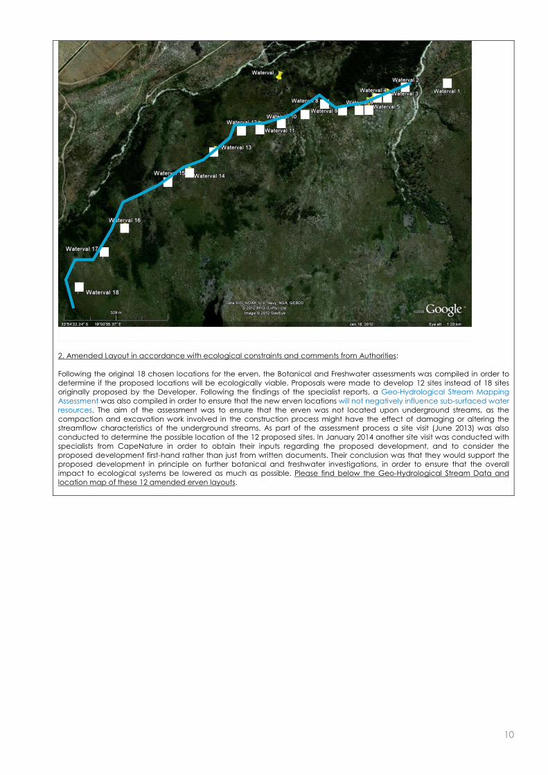
2. Amended Layout in accordance with ecological constraints and comments from Authorities: Following the original 18 chosen locations for the erven, the Botanical and Freshwater assessments was compiled in order to determine if the proposed locations will be ecologically viable. Proposals were made to develop 12 sites instead of 18 sites originally proposed by the Developer. Following the findings of the specialist reports, a Geo-Hydrological Stream Mapping Assessment was also compiled in order to ensure that the new erven locations will not negatively influence sub-surfaced water resources. The aim of the assessment was to ensure that the erven was not located upon underground streams, as the compaction and excavation work involved in the construction process might have the effect of damaging or altering the streamflow characteristics of the underground streams. As part of the assessment process a site visit (June 2013) was also conducted to determine the possible location of the 12 proposed sites. In January 2014 another site visit was conducted with specialists from CapeNature in order to obtain their inputs regarding the proposed development, and to consider the proposed development first-hand rather than just from written documents. Their conclusion was that they would support the proposed development in principle on further botanical and freshwater investigations, in order to ensure that the overall impact to ecological systems be lowered as much as possible. Please find below the Geo-Hydrological Stream Data and location map of these 12 amended erven layouts.
3. Final Proposed Erven Layout: In addition to the Botanical and Freshwater Assessment that was compiled in 2012, an additional field-exercise was conducted in April 2014, with the aim to investigate the 12 proposed sites in order to determine if there would be any botanical or freshwater constraints. Each of the 12 proposed erven sites was evaluated by determining the vegetation (community and condition characteristics) as well as the freshwater (drainage) attributes. Outcome of the investigation by the Specialists: Site 1: It was determined that overall the site was not ecological sensitive, but that the location of the site is moved to an area with all-season drier conditions. Site 2: The proposed location of the second site was not approved by the specialists as the site was situated above a slope wetland and the negative impact of construction on this wetland area would have been highly negative. A new location was proposed for this site. Site 3: It was determined that this site was situated on a well-drained detrital slope with a high percentage of ericoid-restioid vegetation. The location of the site was not botanically sensitive, and the site was suitable for construction. However it was recommended by the specialists that the site be moved further westward in order to accommodate the repositioning of Site 2 on similar well-drained terrain. Site 4: This site was determined to have a high percentage of Stoebe plumose (slangbos) and thus not ecologically sensitive. It was recommended by the specialists that he site be moved marginally westward (similar terrain) in order to accommodate the repositioning of Site 1 on the same slope.

5
Site 5: This site was located between two watercourses, and it was determined that the site should be repositioned by repositioning Site 8 (westwards) and locating Site 5 between the new location of Site 8 and the watercourse to the west. Site 6: It was determined that this site had a low ecological sensitivity and that the proposed site should be maintained at its current location. Site 7: Site 7 was found to be similar to Site 6 with an additional high abundance of the invasive Hakea sericea, and that the site was suitable for construction. Site 8: This site was found to have a low-medium ecological sensitivity with invading Hakea sericea, and was deemed to be developable, however it was suggested that the location of the site be moved to the west, in order to accommodate the repositioning of Site 5. Site 9: Site 9 was found to have coarse, shrubby Fynbos of low sensitivity, with no botanical constraints. However the location of the site was suggested to be moved 10 meters to the west in accordance with the freshwater assessment that identified the site to be located in close proximity to wet slopes. Site 10: This site was also found not to be ecologically sensitive, but also lied in close proximity to a shallow seasonal watercourse, and it was also suggested that the location of the site be moved 10 meters to the west. Site 11: The site was found to be a low ericoid-restioid shrubland and aggressively being invaded by Hakea sericea, with no constraints and suitable for development. Site 12: This site was found to be similar to Site 11, with no constraints and suitable for development. Please find below the locality map of the erven, showing the original 12 layout locations and the new proposed locations in accordance with the specialists.
The 12 new locations of the erven where compiled through inputs received from the Botanical and Freshwater Specialists, in accordance with the Geo-Hydrological Stream Mapping data, and are considered to be the best locations on the proposed property for the construction of the 12 proposed residential dwellings. No existing structures are located on the property except for an old abandoned water pipe, and no existing services are located on the property either. The estimated daily water demand for similar residential houses is expected to be between 1500 – 2500 litres per day. Given the fact that the residential dwellings will be situated within a natural environment, with limited gardens and no irrigation, the expected water demand per unit will be in the region of 1500 – 200 litres/unit/day. Hence the daily water demand for the entire development is therefore expected to be 18 – 24 kilolitres. The closest external potable water system in the form of a 63mm diameter HDPE pipe, is located close to Bridge House School approximately 3 kilometres north of the property. Connection for the development can be provided from the pipeline, but this

6
not preferred due to costs. It is proposed to abstract water from the existing perennial stream on the property. This water will be treated with some basic filtering and disinfection. A small reservoir in the form of six interconnected 10 000 litre tanks will be provided with a combined storage volume of 60 000 litres. This is sufficient for 48 hours of supply on full occupation. From the storage reservoir, water will be fed with a constant pressure pump system via an underground pipe system to the individual dwellings. The average daily sewer flow per dwelling unit is expected to be 800litres/day. On full occupation the expected daily sewer flow generated by the entire development will be 9,60kl. The expected peak flow is 0,45l/s. The development is proposed as with a split grey and black water system. Plumbing from the residential units will be completely separated for each system. Greywater is the leftover water from baths, showers, hand basins and washing machines, excluding kitchen sinks. This is expected to be approximately 70% of the total sewerage generated by the development. Grey water will be collected in a separate conservancy tank to be provided at each unit. These tanks will be emptied on a regular basis by the municipality or by private contractor(s). With full occupation of the units it is expected that the tanks will have a minimum storage capacity of 10 days. The expected occupation for the development is 50% which equates to storage capacity of 20 days minimum. Black water from each residential unit will be collected with a main 160 diameter gravity sewer pipe to discharge into a central black water conservancy tanks of 30 000 litres. This tank will be emptied on a regular basis by the municipality or by private contractor(s). With full occupation of the units it is expected that the tanks will have a minimum storage capacity of 10 days. The expected occupation for the development is 50%, which equates to storage capacity of 20 days minimum. The mountainous and rural character of the terrain lends it to the use of an open stormwater channel system alongside the main access road. For steep gradients these channels will be stone or grass block lined for erosion and scouring protection. Small weirs/steps will be introduced into these channels to dissipate the energy and reduce the flow velocities. The intension is to discharge the water from these channels into the existing natural drainage routes on the site. Erosion protection measures will be used at steep slopes and at all outlets. Litter, silt and debris traps will be strategically placed to reduce pollution. Water from the houses will be surface discharged, and collected in the stormwater channels along the road where necessary. All necessary steps will be taken to avoid soil erosion at the outlets and along drainage routes. Access to the proposed development is from the access of the R45 to Bridge House School. An existing gravel access road, through a series of servitudes on neighbouring properties, is the main access road to the site. On the site it is the intention to construct a 3,5m wide paved road (upgrade the existing gravel road) with passing lanes at 300m minimum spacing. For the stream-crossings two low water bridges, constructed with precast concrete culverts is proposed. Typically 600mm high x 1500mm wide portal culverts could be combined to cross the existing stream widths. Low balustrade or barrier will be provided along the edge of the crossing. In extreme storm events the structures could overtop periodically, but it is expected that the water level will subside quickly due to the small catchment and short time of concentration. Please refer to the attached civil services report, civil services layout plan and bridge design technical drawing Potential Traffic and Noise impacts: It is expected that there will be a traffic and noise impact during both the construction and operational phase of the development. The traffic and noise impacts during the construction phase will however only be temporary in nature and will only last for a couple of months during construction. GNEC is also of the opinion that the legally binding environmental management plan will be sufficient to mitigate any potential impacts with regard to noise and traffic impacts during the construction phase. Given that application is only made for 12 low density residential units, it is not expected that any significant noise and traffic impacts will occur during the operational phase of the activity. Potential impacts on Biological and Physical aspects: There will be an impact on biological and physical aspects during both the construction and operational phases of the activity. It is the opinion of GNEC however that this will be adequately mitigated through long term management and improvement of habitat quality as explained below: The layout of the development was carefully chosen with input from these specialists to have as minimal of an impact to the surrounding area and sub-surfaced water resources as possible. Please refer to the attached Geo-Hydrological Stream Mapping Assessment, Freshwater Impact Assessment and Botanical Assessments. The layout of the development was carefully chosen with input from these specialists to have as minimal of an impact to the surrounding area as possible. The residential units have been designed to have an absolute minimal impact of the surrounding environment, including the use of green building materials, the incorporation of indigenous vegetation into the physical design of the residential units, the low visual profile of the units by sinking the units into the landscape etc. Please refer to the Architectural Guidelines compiled by Jan Hanekom Partnership - specifically drafted for the proposed development with regard to lowering environmental and visual impacts. Furthermore more than 80% of the property will be rezoned, conserved in a stewardship agreement with CapeNature
7
(currently lacking) and managed as part of the adjacent Hottentots Holland Nature Reserve. This will ensure than the remainder of the property is adequately managed with respect to fire regimes and alien invasive control. This will cause a biodiversity increase through environmental management practises, and improve the overall habitat quality. The Western Cape Department of Agriculture has also already confirmed that they will not oppose the proposed development and the rezoning of agricultural land, on condition that a stewardship agreement is reached with CapeNature in terms of Open Space 3 for the remaining property. Potential impacts on Cultural and Historical aspects: It is not expected that any significant impacts will occur with respect to cultural and historical aspects. A Notification of Intent to develop was submitted to Heritage Western Cape for the proposed development, and formal correspondence was received, stating he need for a Heritage and Visual impact assessment. The conclusions of these specialist reports were the following: The conclusions of the HIA are as follows: “In summary, the proposal addresses the indicators adequately and the mitigation proposals have already been incorporated” “On the basis of this assessment, it is proposed to be recommended that, in terms of section 38(8) of the NHRA, HWC support the proposed development and allow the development to proceed to the next phase” The conclusions of the VIA are as follows: “The property is barely and intermittently visible from the R45 travelling east towards Franschoek. Travelling west on the R45 the property is visible from the R301 intersection however, due to the distance from this viewpoint (approximately 5km) the property is barely visible. The R45 & R301 have been identified as view corridors and the intersection the only significant viewpoint. There are no view cones from significant cultural or heritage precincts” “It should be noted that agriculture has been considered on this site and it was found to be not viable. In addition, the Department of Agriculture, Forestry and Fisheries has given written notice that they have no objection to the proposed development. Should the development not occur, it is expected that the integrity of the vulnerable Boland Granite Fynbos, partially infested with alien invasive plant species, (and thus the integrity of the visual character of the site) will deteriorate incrementally. A well placed and designed low density residential development with an agreed stewardship program with Cape Nature (to manage the vulnerable Boland Granite Fynbos character) is therefore, in our view, the best practicable option for this property. It is recommended that with the implementation of the mitigation measures set out above and, the development of well considered landscape & architectural guidelines, this development be approved by Heritage Western Cape.” Potential impacts on Social aspects: It is the opinion of GNEC that the proposed development will not significantly impact on Social aspects for the reasons stated above and below: Development on the site will create new employment opportunities during both the construction (temporary) and operational (temporary and permanent) phases of the proposed development. The Winelands/Boland area is also a very popular area to live in and there is a demand for similar low-density ECO residential developments in the area, the proposed development will provide for this demand. Furthermore more than 80% of the property will be rezoned and conserved in a stewardship agreement with CapeNature (currently lacking). This will ensure than the remainder of the property is adequately managed with respect to fire regimes and alien invasive control. This will cause a biodiversity increase through adequate environmental management practises, and improve the overall habitat quality. The Stellenbosch Municipal Spatial Development Framework (Draft Strategies Report March 2010) guides land use management decisions. Although primarily aimed at developing strategies related to the growth of settlements, it acknowledges the important role of agriculture in driving the local economy. Of relevance to the proposed development are the following proposals:
Promote the use of land outside of existing and proposed urban settlements for agricultural production, bio-diversity conservation (GNEC is of the opinion that the proposed development will promote biodiversity conservation in the direct area through the stewardship agreement with CapeNature. The remaining 41.1ha of the property will be rezoned Open Space 3 – Nature Reserve, the latter is to be managed as part of the adjoining Hottentots Holland Nature Reserve by the Property Owners Association in a Stewardship agreement with CapeNature.) , scenic quality (The proposed development will not detract from the visual character of the surrounding areas, as defined in the compiled Visual Impact Assessment) and agri tourism.
Encourage the use of currently fallow land for agricultural or biodiversity conservation purposes (GNEC is of the opinion that the proposed development will promote biodiversity conservation in the direct area through the stewardship agreement with CapeNature. The remaining 41.1ha of the property will be rezoned Open Space 3 – Nature Reserve, the latter is to be managed as part of the adjoining Hottentots Holland Nature Reserve by the Property Owners Association in a Stewardship agreement with CapeNature.) including land reform projects.
Please note that numerous specialist studies have been compiled for the proposed development, with input from experts in various fields of expertise. The layout of the development was carefully chosen with input from these specialists to have as minimal of an impact to the surrounding area as possible. The residential units have been designed to have an absolute minimal impact of the surrounding environment, including the use of green building materials, the incorporation of indigenous vegetation into the physical design of the residential units, the low visual profile of the units by sinking the units into the

8
landscape etc. Please refer to the Architectural Guidelines compiled by Jan Hanekom Partnership - specifically drafted for the proposed development with regard to lowering environmental and visual impacts. GNEC, in our professional capacity as experienced and qualified environmental consultants believe that the proposed project be issued a positive environmental authorization; however this authorization must be accompanied with the following requirements:
Appointment of an Environmental Control Officer (ECO) to oversee Full Compliance with the Environmental Management Plan (EMP).
Bi-monthly site audits to ensure compliance and to advise on any mitigation measures necessary to negate any environmental degradation.
The ECO must compile monthly ECO Audit Reports on the state of the environment and areas of compliance and non-compliance with the EMP. These reports must be made available to DEA&DP. Fines should be included in the EMP to ensure full compliance to the EMP.
Full implementation of the ARCHITECTURAL GUIDELINES compiled by Jan Hanekom Partnership Full implementation of ALL recommendation/guidelines defined in the Specialist Reports (attached) The remainder of the property after construction of the residential development (41.1ha) is to be rezoned Open
Space 3 (Nature Reserve) and managed as part of the adjoining Hottentots Holland Nature Reserve by the Property Owners Association in a Stewardship agreement with CapeNature.
All domestic waste, effluent and sewerage is to be removed at regular intervals by a accredited service provider and transported for processing to a registered municipal landfill/processing facility.
9
SECTION A: ACTIVITY INFORMATION 1. PROJECT DESCRIPTION
(a) Is the project a new development? YES NO
(b) Provide a detailed description of the development project and associated infrastructure.
The Chasmon Family Trust proposes the rezoning and construction of a low density residential development on portions 6 & 7 of Farm No. 1159, Waterfall in Franschhoek. The properties are located south of the R45 towards Franschhoek, on the north facing slopes of the Groot Drakenstein mountain range at between 320m and 380m. The properties adjoin the Hottentots Holland Nature Reserve and lies on a steep, convex debris slope with a few drainage lines but no deep ravines, except to the west of the site where there is a deep kloof with a perennial stream and waterfall which gives the farm its name. The total size of the properties is approximately 43.5 hectares in size and zoned for agricultural purposes. The upper slopes of the Groot Drakenstein Mountains comprise of quartzitic sandstone of the Peninsula formation of the Table Mountain Group, whilst the mid and lower slopes are comprised of granites of the Cape Granite Suite. The colluvial overburden consists of a mix of sandstone and granite boulders, with the colluvial soil lacking structure and in a general soil classification described as “rock with limited soil” with very low agricultural potential. The dominant vegetation type on the properties is Boland Granite Fynbos with a high degree on invasion by Acacia, Pines and Hakea. The Boland Granite Fynbos is species rich with a high conservation value. It is classified as Endangered and rated as 100% irreplaceable where it occurs. Please refer to the attached Botanical Impact Assessment The Developer (Chasmon Family Trust) is proposing the construction of upmarket, single residential houses on PTNS 6 & 7 of Farm 1159, Waterfall, Stellenbosch. The development will target high-income investors, that want to experience the tranquillity of “farmstyle” living, without having to worry about the maintenance and day-to-day administrative tasks involved in running a working farm. The proposed property is approx. 43 hectares in size, and much thought has been put into preserving the natural environment, with the overall construction footprint being only approx. 0.5 hectares in size. Portions 6 & 7 of Farm No. 1159 is proposed to be consolidated with a 2000m2 Erf defined around each unit, rezoned to Resort Zone 2 (in total 2.4ha) and the remainder of the property (41.1ha) will be rezoned Open Space 3 (Nature Reserve). The latter and will be managed in a Stewardship agreement with CapeNature as part of the adjoining Hottentots Holland nature Reserve by the Property Owners Association once established. The residential units will have a maximum footprint of 400m2
which may be developed. The remainder of the erf will be undisturbed and must remain totally natural. The requirements of the developer had to be balanced with the environmental constraints of the proposed site, as the site is totally covered with Fynbos vegetation. The end goal is to develop residential housing on the proposed property that will have as little as possible negative effect on the indigenous Fynbos vegetation, and once construction is complete to manage the property as an environmentally conscious “green” concern. The proposed houses will also incorporate elements of the natural vegetation into the design. The houses will be constructed below ground level to minimize the visual impact of the development on the surroundings. Natural vegetation and boulders will be incorporated into the design of the buildings, as to “mimic” the natural veldt. Furthermore neutral colours and environmentally friendly building materials will be utilized as far as possible to minimize the overall negative impact on natural systems. Indigenous plant species will also be planted on top of the roof structures of the houses to conceal the visual aspect of the buildings and to act as insulation. The houses were also designed with the threat of veldt fires in mind, by constructing the structure below ground level and by planting indigenous vegetation on top of the roof structures. This will serve to protect the residence during fires, by allowing the fire to burn across the top of the structure, whilst the majority of the structure is situated below ground level. Please refer to the attached Architectural Guidelines compiled by Jan Hanekom Partnership. The extensive process followed to date in order to finalize the residential layouts of the proposed houses, are explained below with each layout representing a different phase of the decision-making process: 1: original Developer’s Layout: The originals layout proposed for the residential erven on the proposed property, was laid out in accordance with inputs from the Developer, Engineer, Architect and Town planners and the layouts was chosen purely from a sales viewpoint. The erven was laid out to ensure that each Erf had the best possible view over the adjacent landscapes and mountains. Eighteen erven was selected at several points alongside the gravel path that would be utilized to gain access to the properties. It must be noted that the location of these erven was selected without any specialist inputs and biodiversity considerations on these erven. It was decided that the need arose to obtain specialist input with regard to the erven locations, and Botanical and Freshwater specialists were consulted to scrutinise the location of these 18 chosen erven with respect to any environmental constraints. Please find below the locality map for the originally proposed 18 erven on PTNS 6 & 7 of Farm 1159.
10
2. Amended Layout in accordance with ecological constraints and comments from Authorities: Following the original 18 chosen locations for the erven, the Botanical and Freshwater assessments was compiled in order to determine if the proposed locations will be ecologically viable. Proposals were made to develop 12 sites instead of 18 sites originally proposed by the Developer. Following the findings of the specialist reports, a Geo-Hydrological Stream Mapping Assessment was also compiled in order to ensure that the new erven locations will not negatively influence sub-surfaced water resources. The aim of the assessment was to ensure that the erven was not located upon underground streams, as the compaction and excavation work involved in the construction process might have the effect of damaging or altering the streamflow characteristics of the underground streams. As part of the assessment process a site visit (June 2013) was also conducted to determine the possible location of the 12 proposed sites. In January 2014 another site visit was conducted with specialists from CapeNature in order to obtain their inputs regarding the proposed development, and to consider the proposed development first-hand rather than just from written documents. Their conclusion was that they would support the proposed development in principle on further botanical and freshwater investigations, in order to ensure that the overall impact to ecological systems be lowered as much as possible. Please find below the Geo-Hydrological Stream Data and location map of these 12 amended erven layouts.

11
3. Final Proposed Erven Layout: In addition to the Botanical and Freshwater Assessment that was compiled in 2012, an additional field-exercise was conducted in April 2014, with the aim to investigate the 12 proposed sites in order to determine if there would be any botanical or freshwater constraints. Each of the 12 proposed erven sites was evaluated by determining the vegetation (community and condition characteristics) as well as the freshwater (drainage) attributes. Outcome of the investigation by the Specialists: Site 1: It was determined that overall the site was not ecological sensitive, but that the location of the site is moved to an area with all-season drier conditions. Site 2: The proposed location of the second site was not approved by the specialists as the site was situated above a slope wetland and the negative impact of construction on this wetland area would have been highly negative. A new location was proposed for this site. Site 3: It was determined that this site was situated on a well-drained detrital slope with a high percentage of ericoid-restioid vegetation. The location of the site was not botanically sensitive, and the site was suitable for construction. However it was recommended by the specialists that the site be moved further westward in order to accommodate the repositioning of Site 2 on similar well-drained terrain. Site 4: This site was determined to have a high percentage of Stoebe plumose (slangbos) and thus not ecologically sensitive. It was recommended by the specialists that he site be moved marginally westward (similar terrain) in order to accommodate the repositioning of Site 1 on the same slope. Site 5: This site was located between two watercourses, and it was determined that the site should be repositioned by repositioning Site 8 (westwards) and locating Site 5 between the new location of Site 8 and the watercourse to the west. Site 6: It was determined that this site had a low ecological sensitivity and that the proposed site should be maintained at its current location. Site 7: Site 7 was found to be similar to Site 6 with an additional high abundance of the invasive Hakea sericea, and that the site was suitable for construction. Site 8: This site was found to have a low-medium ecological sensitivity with invading Hakea sericea, and was deemed to be developable, however it was suggested that the location of the site be moved to the west, in order to accommodate the repositioning of Site 5. Site 9: Site 9 was found to have coarse, shrubby Fynbos of low sensitivity, with no botanical constraints. However the location of the site was suggested to be moved 10 meters to the west in accordance with the freshwater assessment that identified the site to be located in close proximity to wet slopes.

12
Site 10: This site was also found not to be ecologically sensitive, but also lied in close proximity to a shallow seasonal watercourse, and it was also suggested that the location of the site be moved 10 meters to the west. Site 11: The site was found to be a low ericoid-restioid shrubland and aggressively being invaded by Hakea sericea, with no constraints and suitable for development. Site 12: This site was found to be similar to Site 11, with no constraints and suitable for development. Please find below the locality map of the erven, showing the original 12 layout locations and the new proposed locations in accordance with the specialists.
The 12 new locations of the erven where compiled through inputs received from the Botanical and Freshwater Specialists, in accordance with the Geo-Hydrological Stream Mapping data, and are considered to be the best locations on the proposed property for the construction of the 12 proposed residential dwellings. No existing structures are located on the property except for an old abandoned water pipe, and no existing services are located on the property either. The estimated daily water demand for similar residential houses is expected to be between 1500 – 2500 litres per day. Given the fact that the residential dwellings will be situated within a natural environment, with limited gardens and no irrigation, the expected water demand per unit will be in the region of 1500 – 200 litres/unit/day. Hence the daily water demand for the entire development is therefore expected to be 18 – 24 kilolitres. The closest external potable water system in the form of a 63mm diameter HDPE pipe, is located close to Bridge House School approximately 3 kilometres north of the property. Connection for the development can be provided from the pipeline, but this not preferred due to costs. It is proposed to abstract water from the existing perennial stream on the property. This water will be treated with some basic filtering and disinfection. A small reservoir in the form of six interconnected 10 000 litre tanks will be provided with a combined storage volume of 60 000 litres. This is sufficient for 48 hours of supply on full occupation. From the storage reservoir, water will be fed with a constant pressure pump system via an underground pipe system to the individual dwellings. The average daily sewer flow per dwelling unit is expected to be 800litres/day. On full occupation the expected daily sewer flow generated by the entire development will be 9,60kl. The expected peak flow is 0,45l/s. The development is proposed as with a split grey and black water system. Plumbing from the residential units will be completely separated for each system.

13
Greywater is the leftover water from baths, showers, hand basins and washing machines, excluding kitchen sinks. This is expected to be approximately 70% of the total sewerage generated by the development. Grey water will be collected in a separate conservancy tank to be provided at each unit. These tanks will be emptied on a regular basis by the municipality or by private contractor(s). With full occupation of the units it is expected that the tanks will have a minimum storage capacity of 10 days. The expected occupation for the development is 50% which equates to storage capacity of 20 days minimum. Black water from each residential unit will be collected with a main 160 diameter gravity sewer pipe to discharge into a central black water conservancy tanks of 30 000 litres. This tank will be emptied on a regular basis by the municipality or by private contractor(s). With full occupation of the units it is expected that the tanks will have a minimum storage capacity of 10 days. The expected occupation for the development is 50%, which equates to storage capacity of 20 days minimum. The mountainous and rural character of the terrain lends it to the use of an open stormwater channel system alongside the main access road. For steep gradients these channels will be stone or grass block lined for erosion and scouring protection. Small weirs/steps will be introduced into these channels to dissipate the energy and reduce the flow velocities. The intension is to discharge the water from these channels into the existing natural drainage routes on the site. Erosion protection measures will be used at steep slopes and at all outlets. Litter, silt and debris traps will be strategically placed to reduce pollution. Water from the houses will be surface discharged, and collected in the stormwater channels along the road where necessary. All necessary steps will be taken to avoid soil erosion at the outlets and along drainage routes. Access to the proposed development is from the access of the R45 to Bridge House School. An existing gravel access road, through a series of servitudes on neighbouring properties, is the main access road to the site. On the site it is the intention to construct a 3,5m wide paved road with passing lanes at 300m minimum spacing. For the stream-crossings two low water bridges, constructed with precast concrete culverts is proposed. Typically 600mm high x 1500mm wide portal culverts could be combined to cross the existing stream widths. Low balustrade or barrier will be provided along the edge of the crossing. In extreme storm events the structures could overtop periodically, but it is expected that the water level will subside quickly due to the small catchment and short time of concentration. Please refer to the attached civil services report, civil services layout plan and bridge design technical drawing.
(c) List all the activities assessed during the Basic Assessment process:
GN No. R. 544 Activity No(s):
Describe the relevant Basic Assessment Activity(ies) in writing as per Listing Notice 1 (GN No. R. 544)
Describe the portion of the development as per the project description that relates to the applicable listed activity.
Activity No. 11 The construction of (i) canals, (ii) channels, (iii) bridges, (iv) dams, (v) weirs, (vi) bulk storm water outlet structures, (vii) marinas, (viii) jetties exceeding 50m2 in size, (ix) slipways exceeding 50m2 in size, (x) buildings exceeding 50m2 in size or (xi) infrastructure or structures covering 50m2 in size or more where such construction occurs within a watercourse or within 32m of a watercourse, measured from the edge of a watercourse, excluding where such construction will occur behind the development setback line.
Two bridges will be built to cross two streams present on the site.
Activity No. 18 The infill or depositing of any material of more than 5m3 into, or the dredging, excavation, removal or moving of soil, sand, shell grit, pebbles or rock from (i) a watercourse, (ii) the sea, (iii) the seashore, (iv) the littoral active zone, an estuary or a distance of 100, inland of the high-water mark of the sea or an estuary, whichever distance is the greater but excluding where such infill, depositing, dredging, excavation, removal or moving (i) is for maintenance purposes undertaken in accordance with a management plan agreed to by the relevant environmental authority or (ii) occurs behind the development setback line.
Two bridges will be built to cross to streams present on the site.
Activity No. 22 The construction of a road, outside urban areas (i)
With a reserve wider than 13,5m or (ii) Where no
reserve exists where the road is wider than 8m or
(iii) For which an environmental authorization was
obtained for the route determination in terms of
activity 5 in Government Notice 387 of 2006 or
activity 18 in Notice 545 of 2010.
On the site it is the intention to construct a 3,5m wide paved road with passing lanes at 300m minimum spacing.

14
Activity No.23 The transformation of undeveloped, vacant or derelict land to (i) residential, retail, commercial, recreational, industrial or institutional use, inside an urban area and where the total area to be transformed is 5ha or more, but the less than 20ha or (ii) residential, retail, commercial, recreational, industrial or institutional use, outside an urban area and where the total area to be transformed is bigger than 1ha but less than 20ha, except where such transformation takes place for linear activities.
The site to be developed is outside the urban area and is larger than 1ha.
GN No. R. 546 Activity No(s):
Describe the relevant Basic Assessment Activity(ies) in writing as per Listing Notice 3 (GN No. R. 546)
Describe the portion of the development as per the project description that relates to the applicable listed activity.
Activity No. 4 The construction of a road wider than 4m with a
reserve less than 13,5m. (d) In Western Cape (i) (i)
In an estuary, (ii) (ii) All areas outside urban areas;
(iii) (iii) In urban areas (aa) Areas zoned for use as
public open space within urban areas and (bb)
Areas designated for conservation use in Spatial
Development Frameworks adopted by the
competent authority or zoned for a conservation
purpose.
On the site it is the intention to construct a 3,5m wide paved road with passing lanes at 300m minimum spacing.
GN No. R. 983 Activity No(s):
Describe the relevant Basic Assessment Activity(ies) in writing as per Listing Notice 1 (GN No. R. 983)
Describe the portion of the development as per the project description that relates to the applicable listed activity.
Activity No. 9 The development of infrastructure exceeding 1000 metres in length for the bulk transportation of water or storm water- (i) with an internal diameter of 0,36 metres or more; or (ii) with a peak throughput of 120 litres per second or more; excluding where- (a) such infrastructure is for bulk transportation of water or storm water or storm water drainage inside a road reserve; or (b) where such development will occur within an urban area.
This activity may be triggered with the construction of bulk water pipelines
Activity No. 10 The development and related operation of infrastructure exceeding 1000 metres in length for the bulk transportation of sewage, effluent, process water, waste water, return water, industrial discharge or slimes – (i) with an internal diameter of 0,36 metres or more; or (ii) with a peak throughput of 120 litres per second or more; excluding where- (a) such infrastructure is for bulk transportation of sewage, effluent, process water, waste water, return water, industrial discharge or slimes inside a road reserve; or (b) where such development will occur within an urban area.
This activity may be triggered with the construction of bulk sewage pipelines to the tanks
Activity No. 12 The development of- (i) canals exceeding 100 square metres in size; (ii) channels exceeding 100 square metres in size; (iii) bridges exceeding 100 square metres in size; (iv) dams, where the dam, including infrastructure and water surface area, exceeds 100 square metres in size; (v) weirs, where the weir, including infrastructure and water surface area, exceeds 100 square metres in size; (vi) bulk storm water outlet structures exceeding 100 square metres in size; (vii) marinas exceeding 100 square metres in size; (viii) jetties exceeding 100 square metres in size;
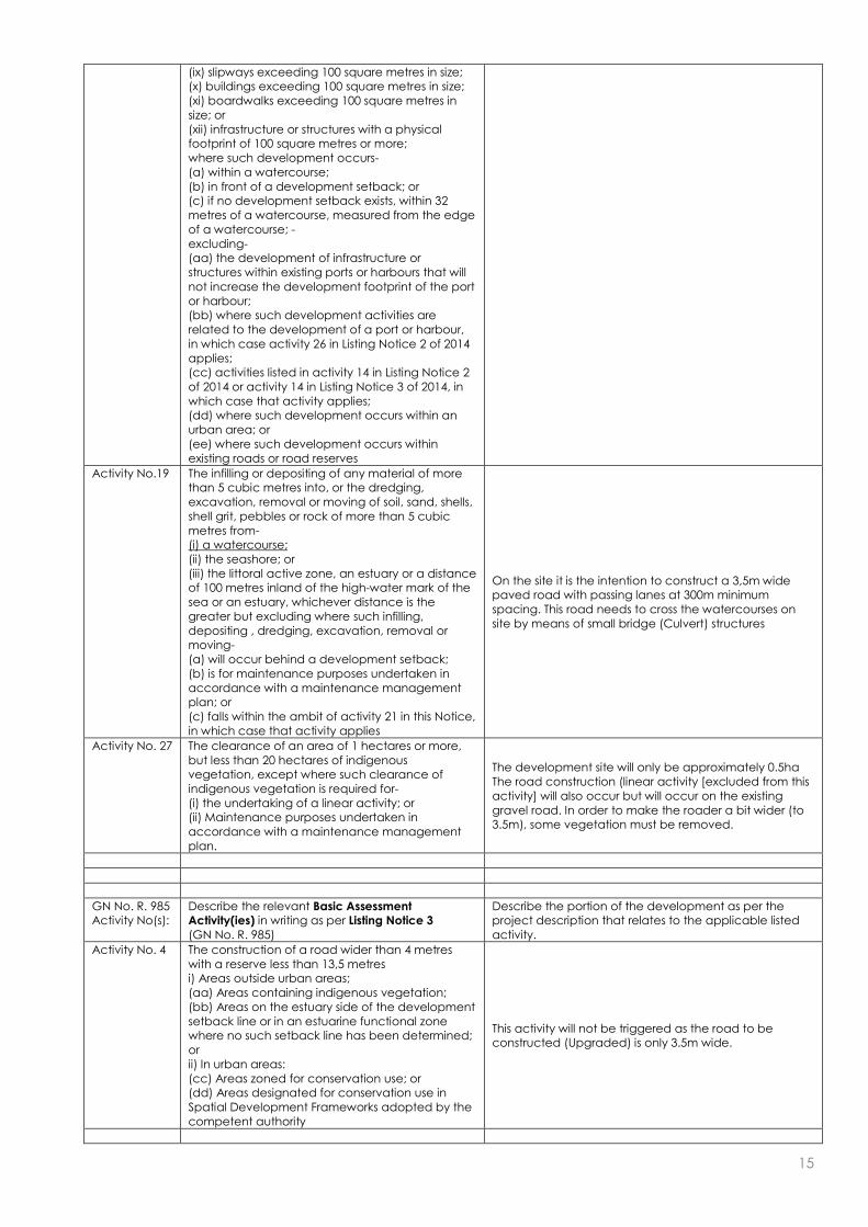
On the site it is the intention to construct a 3,5m wide paved road with passing lanes at 300m minimum spacing. This road needs to cross the watercourses on site by means of small bridge (Culvert) structures
15
(ix) slipways exceeding 100 square metres in size; (x) buildings exceeding 100 square metres in size; (xi) boardwalks exceeding 100 square metres in size; or (xii) infrastructure or structures with a physical footprint of 100 square metres or more; where such development occurs- (a) within a watercourse; (b) in front of a development setback; or (c) if no development setback exists, within 32 metres of a watercourse, measured from the edge of a watercourse; - excluding- (aa) the development of infrastructure or structures within existing ports or harbours that will not increase the development footprint of the port or harbour; (bb) where such development activities are related to the development of a port or harbour, in which case activity 26 in Listing Notice 2 of 2014 applies; (cc) activities listed in activity 14 in Listing Notice 2 of 2014 or activity 14 in Listing Notice 3 of 2014, in which case that activity applies; (dd) where such development occurs within an urban area; or (ee) where such development occurs within existing roads or road reserves
Activity No.19 The infilling or depositing of any material of more than 5 cubic metres into, or the dredging, excavation, removal or moving of soil, sand, shells, shell grit, pebbles or rock of more than 5 cubic metres from- (i) a watercourse; (ii) the seashore; or (iii) the littoral active zone, an estuary or a distance of 100 metres inland of the high-water mark of the sea or an estuary, whichever distance is the greater but excluding where such infilling, depositing , dredging, excavation, removal or moving- (a) will occur behind a development setback; (b) is for maintenance purposes undertaken in accordance with a maintenance management plan; or (c) falls within the ambit of activity 21 in this Notice, in which case that activity applies
On the site it is the intention to construct a 3,5m wide paved road with passing lanes at 300m minimum spacing. This road needs to cross the watercourses on site by means of small bridge (Culvert) structures
Activity No. 27 The clearance of an area of 1 hectares or more, but less than 20 hectares of indigenous vegetation, except where such clearance of indigenous vegetation is required for- (i) the undertaking of a linear activity; or (ii) Maintenance purposes undertaken in accordance with a maintenance management plan.
The development site will only be approximately 0.5ha The road construction (linear activity [excluded from this activity] will also occur but will occur on the existing gravel road. In order to make the roader a bit wider (to 3.5m), some vegetation must be removed.
GN No. R. 985 Activity No(s):
Describe the relevant Basic Assessment Activity(ies) in writing as per Listing Notice 3 (GN No. R. 985)
Describe the portion of the development as per the project description that relates to the applicable listed activity.
Activity No. 4 The construction of a road wider than 4 metres with a reserve less than 13,5 metres i) Areas outside urban areas; (aa) Areas containing indigenous vegetation; (bb) Areas on the estuary side of the development setback line or in an estuarine functional zone where no such setback line has been determined; or ii) In urban areas: (cc) Areas zoned for conservation use; or (dd) Areas designated for conservation use in Spatial Development Frameworks adopted by the competent authority
This activity will not be triggered as the road to be constructed (Upgraded) is only 3.5m wide.
16
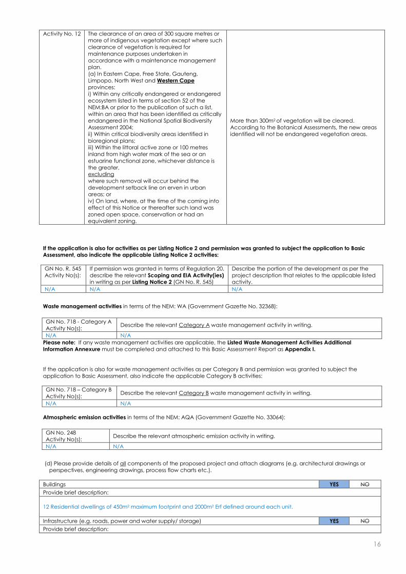
Activity No. 12 The clearance of an area of 300 square metres or more of indigenous vegetation except where such clearance of vegetation is required for maintenance purposes undertaken in accordance with a maintenance management plan. (a) In Eastern Cape, Free State, Gauteng, Limpopo, North West and Western Cape provinces: i) Within any critically endangered or endangered ecosystem listed in terms of section 52 of the NEM:BA or prior to the publication of such a list, within an area that has been identified as critically endangered in the National Spatial Biodiversity Assessment 2004; ii) Within critical biodiversity areas identified in bioregional plans; iii) Within the littoral active zone or 100 metres inland from high water mark of the sea or an estuarine functional zone, whichever distance is the greater, excluding where such removal will occur behind the development setback line on erven in urban areas; or iv) On land, where, at the time of the coming into effect of this Notice or thereafter such land was zoned open space, conservation or had an equivalent zoning.
More than 300m2 of vegetation will be cleared. According to the Botanical Assessments, the new areas identified will not be endangered vegetation areas.
If the application is also for activities as per Listing Notice 2 and permission was granted to subject the application to Basic Assessment, also indicate the applicable Listing Notice 2 activities:
GN No. R. 545 Activity No(s):
If permission was granted in terms of Regulation 20, describe the relevant Scoping and EIA Activity(ies) in writing as per Listing Notice 2 (GN No. R. 545)
Describe the portion of the development as per the project description that relates to the applicable listed activity.
N/A N/A N/A
Waste management activities in terms of the NEM: WA (Government Gazette No. 32368):
GN No. 718 - Category A Activity No(s):
Describe the relevant Category A waste management activity in writing.
N/A N/A
Please note: If any waste management activities are applicable, the Listed Waste Management Activities Additional Information Annexure must be completed and attached to this Basic Assessment Report as Appendix I. If the application is also for waste management activities as per Category B and permission was granted to subject the application to Basic Assessment, also indicate the applicable Category B activities:
GN No. 718 – Category B Activity No(s):
Describe the relevant Category B waste management activity in writing.
N/A N/A
Atmospheric emission activities in terms of the NEM: AQA (Government Gazette No. 33064):
GN No. 248 Activity No(s):
Describe the relevant atmospheric emission activity in writing.
N/A N/A
(d) Please provide details of all components of the proposed project and attach diagrams (e.g. architectural drawings or
perspectives, engineering drawings, process flow charts etc.).
Buildings YES NO
Provide brief description:
12 Residential dwellings of 450m2 maximum footprint and 2000m2 Erf defined around each unit.
Infrastructure (e.g. roads, power and water supply/ storage) YES NO
Provide brief description:

17
A small reservoir in the form of six interconnected 10 000 litre tanks will be provided with a combined storage volume of 60 000 litres. From the storage reservoir, water will be fed with a constant pressure pump system via an underground pipe system to the individual dwellings. Grey water will be collected in a separate conservancy tank to be provided at each unit. Black water from each residential unit will be collected with a main 160 diameter gravity sewer pipe to discharge into a central black water conservancy tanks of 30 000 litres. On the site it is the intention to construct a 3,5m wide paved road with passing lanes at 300m minimum spacing intervals (currently an existing gravel road). For the stream-crossings two low water bridges, constructed with precast concrete culverts is proposed. Typically 600mm high x 1500mm wide portal culverts could be combined to cross the existing stream widths.
Processing activities (e.g. manufacturing, storage, distribution) YES NO
Provide brief description:
N/A
Storage facilities for raw materials and products (e.g. volume and substances to be stored)
Provide brief description YES NO
A small potable water reservoir in the form of six interconnected 10 000 litre tanks will be provided with a combined storage volume of 60 000 litres. From the storage reservoir, water will be fed with a constant pressure pump system via an underground pipe system to the individual dwellings
Storage and treatment facilities for solid waste and effluent generated by the project YES NO
Provide brief description
Grey water will be collected in a separate conservancy tank to be provided at each unit. Black water from each residential unit will be collected with a main 160 diameter gravity sewer pipe to discharge into a central black water conservancy tanks of 30 000 litres
Other activities (e.g. water abstraction activities, crop planting activities) Yes NO
Provide brief description
N/A
2. PHYSICAL SIZE OF THE ACTIVITY
Size of the property:
(a) Indicate the size of the property (cadastral unit) on which the activity is to be undertaken. 43.5 ha ~ 435 000m2
Size of the facility:
(b) Indicate the size of the facility (development area) on which the activity is to be undertaken.
Approx. 10 000 m2
Size of the activity:
(c) Indicate the physical size (footprint) of the activity together with its associated infrastructure: Approx. 9 000m2
(d) Indicate the physical size (footprint) of the activity: Approx. 5400m2
(e) Indicate the physical size (footprint) of the associated infrastructure: Approx 3600m2
and, for linear activities:
Length of the activity:
(f) Indicate the length of the activity: N/A
3. SITE ACCESS
(a) Is there an existing access road? YES NO
(b) If no, what is the distance over which a new access road will be built? N/A
(c) Describe the type of access road planned:
Access to the proposed development is from the access of the R45 to Bridge House School. An existing gravel access road, through a series of servitudes on neighbouring properties, is the main access road to the site. The access road is a dirt road and approximately 4.4km in length.
Please Note: indicate the position of the proposed access road on the site plan.

18
4. DESCRIPTION OF THE PROPERTY ON WHICH THE ACTIVITY IS TO BE UNDERTAKEN AND THE
LOCATION OF THE ACTIVITY ON THE PROPERTY
(a) Provide a description of the property on which the activity is to be undertaken and the location of the activity on the
property.
The Chasmon Family Trust proposes the rezoning and construction of a low density residential development on portions 6 & 7 of Farm No. 1159, Waterfall in Franschhoek. The properties are located south of the R45 towards Franschhoek, on the north facing slopes of the Groot Drakenstein mountain range at between 320m and 380m. The properties adjoin the Hottentots Holland Nature Reserve and lies on a steep, convex debris slope with a few drainage lines but no deep ravines, except to the west of the site where there is a deep kloof with a perennial stream and waterfall which gives the farm its name. The total size of the properties is approximately 43.5 hectares in size and zoned for agricultural purposes. The upper slopes of the Groot Drakenstein Mountains comprise of quartzitic sandstone of the Peninsula formation of the Table Mountain Group, whilst the mid and lower slopes are comprised of granites of the Cape Granite Suite. The colluvial overburden consists of a mix of sandstone and granite boulders, with the colluvial soil lacking structure and in a general soil classification described as “rock with limited soil” with very low agricultural potential. The dominant vegetation type on the properties is Boland Granite Fynbos with a high degree on invasion by Acacia, Pines and Hakea. The Boland Granite Fynbos is species rich with a high conservation value. It is classified as Endangered and rated as 100% irreplaceable where it occurs. For details regarding the location of the 12 proposed residential dwellings on the subject property, please refer to Section 1 above.
(b) Please provide a location map (see below) as Appendix A to this report which shows the location of the property and the
location of the activity on the property; as well as a site map (see below) as Appendix B to this report; and if applicable all alternative properties and locations.
Locality map:
The scale of the locality map must be at least 1:50 000. For linear activities of more than 25 kilometres, a smaller scale e.g. 1:250 000 can be used. The scale must be indicated on the map. The map must indicate the following: an accurate indication of the project site position as well as the positions of the alternative sites, if any; road names or numbers of all the major roads as well as the roads that provide access to the site(s) a north arrow; a legend; the prevailing wind direction (during November to April and during May to October); and GPS co-ordinates (Indicate the position of the activity using the latitude and longitude of the centre
point of the site for each alternative site. The co-ordinates should be in degrees and decimal minutes. The minutes should have at least three decimals to ensure adequate accuracy. The projection that must be used in all cases is the WGS84 spheroid in a national or local projection).
Site Plan:
Detailed site plan(s) must be prepared for each alternative site or alternative activity. The site plan must contain or conform to the following: The detailed site plan must be at a scale preferably at a scale of 1:500 or at an appropriate scale. The
scale must be indicated on the plan. The property boundaries and numbers of all the properties within 50m of the site must be indicated on
the site plan. The current land use (not zoning) as well as the land use zoning of each of the adjoining properties must
be indicated on the site plan. The position of each element of the application as well as any other structures on the site must be
indicated on the site plan. Services, including electricity supply cables (indicate above or underground), water supply pipelines,
boreholes, sewage pipelines, storm water infrastructure and access roads that will form part of the development must be indicated on the site plan.
Servitudes indicating the purpose of the servitude must be indicated on the site plan. Sensitive environmental elements within 100m of the site must be included on the site plan, including (but
not limited to): o Rivers. o Flood lines (i.e. 1:10, 1:50, year and 32 meter set back line from the banks of a river/stream). o Ridges. o Cultural and historical features. o Areas with indigenous vegetation (even if it is degraded or infested with alien species).
Whenever the slope of the site exceeds 1:10, then a contour map of the site must be submitted.
(c) For a linear activity, please also provide a description of the route.

19
N/A
Indicate the position of the activity using the latitude and longitude of the centre point of the site. The co-ordinates must be in degrees, minutes and seconds. The minutes should be given to at least three decimals to ensure adequate accuracy. The projection that must be used in all cases is the WGS84 spheroid in a national or local projection.
Latitude (S): Longitude (E):
33o 54‘ 12.71“ 19o 00‘ 46.18“
(d) or:
For linear activities: N/A Latitude (S): Longitude (E):
Starting point of the activity o ‘ “ o ‘ “
Middle point of the activity o ‘ “ o ‘ “
End point of the activity o ‘ “ o ‘ “
Please Note: For linear activities that are longer than 500m, please provide and addendum with co-ordinates taken every 100 meters along the route.
5. SITE PHOTOGRAPHS Colour photographs of the site and its surroundings (taken of the site and from the site) with a description of each photograph.
The vantage points from which the photographs were taken must be indicated on the site plan, or locality plan as applicable. If
available, please also provide a recent aerial photograph. Photographs must be attached as Appendix C to this report. It
should be supplemented with additional photographs of relevant features on the site. Date of photographs must be included.
Please note that the above requirements must be duplicated for all alternative sites.
20
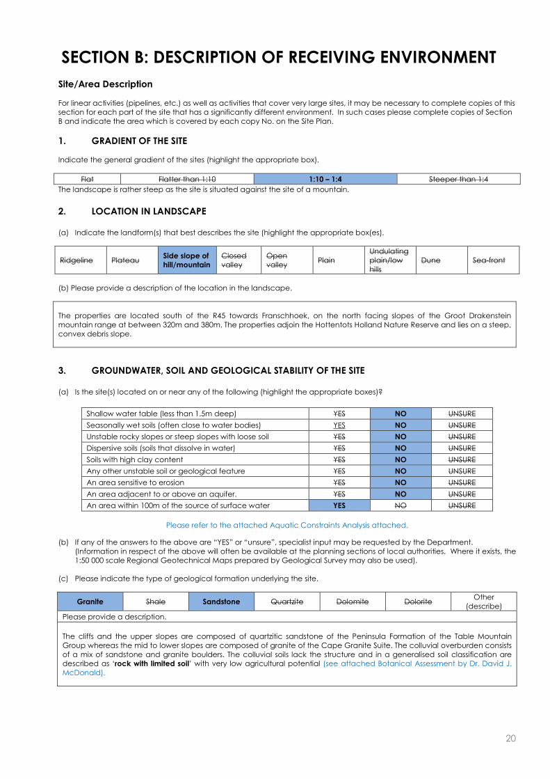
SECTION B: DESCRIPTION OF RECEIVING ENVIRONMENT Site/Area Description For linear activities (pipelines, etc.) as well as activities that cover very large sites, it may be necessary to complete copies of this section for each part of the site that has a significantly different environment. In such cases please complete copies of Section B and indicate the area which is covered by each copy No. on the Site Plan.
1. GRADIENT OF THE SITE Indicate the general gradient of the sites (highlight the appropriate box).
Flat Flatter than 1:10 1:10 – 1:4 Steeper than 1:4
The landscape is rather steep as the site is situated against the site of a mountain.
2. LOCATION IN LANDSCAPE (a) Indicate the landform(s) that best describes the site (highlight the appropriate box(es).
Ridgeline Plateau Side slope of hill/mountain
Closed valley
Open valley
Plain Undulating plain/low hills
Dune Sea-front
(b) Please provide a description of the location in the landscape.
The properties are located south of the R45 towards Franschhoek, on the north facing slopes of the Groot Drakenstein mountain range at between 320m and 380m. The properties adjoin the Hottentots Holland Nature Reserve and lies on a steep, convex debris slope.
3. GROUNDWATER, SOIL AND GEOLOGICAL STABILITY OF THE SITE (a) Is the site(s) located on or near any of the following (highlight the appropriate boxes)?
Shallow water table (less than 1.5m deep) YES NO UNSURE
Seasonally wet soils (often close to water bodies) YES NO UNSURE Unstable rocky slopes or steep slopes with loose soil YES NO UNSURE Dispersive soils (soils that dissolve in water) YES NO UNSURE Soils with high clay content YES NO UNSURE Any other unstable soil or geological feature YES NO UNSURE An area sensitive to erosion YES NO UNSURE An area adjacent to or above an aquifer. YES NO UNSURE An area within 100m of the source of surface water YES NO UNSURE
Please refer to the attached Aquatic Constraints Analysis attached.
(b) If any of the answers to the above are “YES” or “unsure”, specialist input may be requested by the Department. (Information in respect of the above will often be available at the planning sections of local authorities. Where it exists, the 1:50 000 scale Regional Geotechnical Maps prepared by Geological Survey may also be used).
(c) Please indicate the type of geological formation underlying the site.
Granite Shale Sandstone Quartzite Dolomite Dolorite Other
(describe)
Please provide a description.
The cliffs and the upper slopes are composed of quartzitic sandstone of the Peninsula Formation of the Table Mountain Group whereas the mid to lower slopes are composed of granite of the Cape Granite Suite. The colluvial overburden consists of a mix of sandstone and granite boulders. The colluvial soils lack the structure and in a generalised soil classification are described as ‘rock with limited soil’ with very low agricultural potential (see attached Botanical Assessment by Dr. David J. McDonald).

21
Figure 2. Soils of the Western Cape with the study area shown by a pink dot. (Enviro-Info 2001).
4. SURFACE WATER (a) Indicate the surface water present on and or adjacent to the site and alternative sites (highlight the appropriate boxes)?
Perennial River YES NO UNSURE
Non-Perennial River YES NO UNSURE
Permanent Wetland YES NO UNSURE
Seasonal Wetland YES NO UNSURE
Artificial Wetland YES NO UNSURE
Estuarine / Lagoonal wetland YES NO UNSURE
(b) Please provide a description.
There are two Non-Perennial streams on the subject property. The property is flanked to the west and north by the Waterfall stream, and a second unnamed stream bisects the property from south to north on the eastern side. Please refer to the Aquatic Constrains Analysis as compiled by Dr. William R Harding attached.
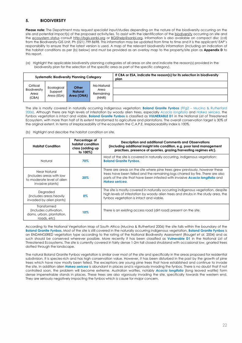
22
5. BIODIVERSITY Please note: The Department may request specialist input/studies depending on the nature of the biodiversity occurring on the site and potential impact(s) of the proposed activity/ies. To assist with the identification of the biodiversity occurring on site and the ecosystem status consult http://bgis.sanbi.org or [email protected]. Information is also available on compact disc (cd) from the Biodiversity-GIS Unit, Ph (021) 799 8698. This information may be updated from time to time and it is the applicant/ EAP’s responsibility to ensure that the latest version is used. A map of the relevant biodiversity information (including an indication of the habitat conditions as per (b) below) and must be provided as an overlay map to the property/site plan as Appendix D to this report.
(a) Highlight the applicable biodiversity planning categories of all areas on site and indicate the reason(s) provided in the
biodiversity plan for the selection of the specific area as part of the specific category).
Systematic Biodiversity Planning Category If CBA or ESA, indicate the reason(s) for its selection in biodiversity plan
Critical Biodiversity
Area (CBA)
Ecological Support
Area (ESA)
Other Natural
Area (ONA)
No Natural Area
Remaining (NNR)
The site is mostly covered in naturally occurring indigenous vegetation: Boland Granite Fynbos (FFg2 – Mucina & Rutherford 2006). Although there are high levels of infestation by woody alien trees, especially Acacia longifolia and Hakea sericea, the Fynbos vegetation is intact and viable. Boland Granite Fynbos is classified as VULNERABLE D1 in the National List of Threatened Ecosystem, with more than half of its extent transformed to agriculture and plantations. The overall conservation target is 30% of the original extent. In terms of irreplaceability of the ecosystem the C.A.P.E. Irreplaceability index is 100%.
(b) Highlight and describe the habitat condition on site.
Habitat Condition
Percentage of habitat condition class (adding up
to 100%)
Description and additional Comments and Observations (including additional insight into condition, e.g. poor land management
practises, presence of quarries, grazing/harvesting regimes etc).
Natural 70% Most of the site is covered in naturally occurring, indigenous vegetation: Boland Granite Fynbos.
Near Natural (includes areas with low
to moderate level of alien invasive plants)
20%
There are areas on the site where pine trees grew previously, however these trees have been felled and the remaining logs charred by fire. There are also parts of the site that have been infested with invasive Acacia longifolia and Hakea sericea.
Degraded (includes areas heavily
invaded by alien plants) 0%
The site is mostly covered in naturally occurring indigenous vegetation, despite high levels of infestation by woody alien trees and shrubs in the study area, the fynbos vegetation is intact and viable.
Transformed (includes cultivation,
dams, urban, plantation, roads, etc)
10% There is an existing access road (dirt road) present on the site.
According to the National Vegetation Map of South Africa (Mucina & Rutherford 2006) the site falls within the boundary of the Boland Granite Fynbos. Most of the site is still covered in the naturally occurring indigenous vegetation. Boland Granite Fynbos is an ENDANGERED vegetation type according to the rating of the National Biodiversity Assessment (Rouget et al. 2004) and as such should be conserved wherever possible. More recently it has been classified as Vulnerable D1 in the National List of Threatened Ecosystems. The site is currently covered in fairly dense 1-2m tall closed shrubland with occasional low, gnarled trees dotted through the landscape. The natural Boland Granite Fynbos vegetation is similar over most of the site and specifically in the areas proposed for residential subdivision. It is species-rich and has high conservation value. However, it has been disturbed in the past by the growth of pine trees which have now mostly been felled. The exceptions are young pine trees that have established and continue to invade the site. In addition alien Hakea sericea is abundant in places and is vigorously invading the fynbos. There is no doubt that if not controlled soon, the problem will become extreme. Australian wattles, notably Acacia longifolia (long leaved wattle) form dense impenetrable stands in places. These trees are also vigorously invading the site, specifically towards the western end. They are seriously negatively impacting the fynbos which is cause for major concern.

23
R45
Hel
sho
og
te R
oad
Figure 2. Portion of a vegetation map of Southern Africa showing the location of the proposed development in an area that
is mostly covered in Boland Granite Fynbos (FFg2) (dark purple) with the study site (black dot) indicated on the
map.
(c) Complete the table to indicate:
(i) the type of vegetation, including its ecosystem status, present on the site; and (ii) whether an aquatic ecosystem is present on site.
Terrestrial Ecosystems Aquatic Ecosystems
Ecosystem threat status as per the National Environmental
Management: Biodiversity Act (Act No. 10 of 2004)
Critical Wetland (including rivers, depressions, channelled
and unchanneled wetlands, flats, seeps
pans, and artificial wetlands)
Estuary Coastline Endangered
Vulnerable
Least Threatened
YES NO UNSURE YES NO YES NO

24
(d) Please provide a description of the vegetation type and/or aquatic ecosystem present on site, including any important biodiversity features/information identified on site (e.g. threatened species and special habitats)
There are two Non-Perennial streams on the subject property. The property is flanked to the west and north by the Waterfall stream, and a second unnamed stream bisects the property from south to north on the eastern side. Please refer to the Aquatic Constrains Analysis as compiled by Dr. William R Harding attached. The study area has course-grained but clay-rich granitic soils derived from the underlying granite rocks and sandstone rock debris from the upper slopes. Outside the property on the upper mountain slopes beyond the southern boundary, the geological contact between sandstone and granite supports vegetation that is transitional or ecotonal between fynbos found on sandstone-derived soils and that found on granite-derived soils. The ecotonal vegetation grades into the Boland Granite Fynbos which is found on the study site on the mid-slopes. According to the National Vegetation Map of South Africa (Mucina & Rutherford 2006) the site falls within the boundary of the Boland Granite Fynbos. Most of the site is still covered in the naturally occurring indigenous vegetation. Boland Granite Fynbos is an ENDANGERED vegetation type according to the rating of the National Biodiversity Assessment (Rouget et al. 2004) and as such should be conserved wherever possible. More recently it has been classified as Vulnerable D1 in the National List of Threatened Ecosystems. The site is currently covered in fairly dense 1-2m tall closed shrubland with occasional low, gnarled trees dotted through the landscape. The natural Boland Granite Fynbos vegetation is similar over most of the site and specifically in the areas proposed for residential subdivision. It is species-rich and has high conservation value. However, it has been disturbed in the past by the growth of pine trees which have now mostly been felled. The exceptions are young pine trees that have established and continue to invade the site. In addition alien Hakea sericea is abundant in places and is vigorously invading the fynbos. There is no doubt that if not controlled soon, the problem will become extreme. Australian wattles, notably Acacia longifolia (long leaved wattle) form dense impenetrable stands in places. These trees are also vigorously invading the site, specifically towards the western end. They are seriously negatively impacting the fynbos which is cause for major concern. Please refer to the Botanical Impact Assessment as compiled by Dr. Dave McDonald attached
6. LAND USE OF THE SITE Please note: The Department may request specialist input/studies depending on the nature of the land use character of the area and potential impact(s) of the proposed activity/ies.
Untransformed area Low density residential
Medium density residential
High density residential
Informal residential
Retail Commercial & warehousing
Light industrial Medium industrial Heavy industrial
Power station Office/consulting
room Military or police
base/station/compound Casino/entertainment
complex Tourism &
Hospitality facility
Open cast mine Underground
mine Spoil heap or slimes dam
Quarry, sand or borrow pit
Dam or reservoir
Hospital/medical center School Tertiary education facility Church Old age home
Sewage treatment plant Train station or shunting yard
Railway line Major road (4 lanes or
more) Airport
Harbour Sport facilities Golf course Polo fields Filling station
Landfill or waste treatment site Plantation Agriculture River, stream or
wetland Nature
conservation area
Mountain, koppie or ridge Museum Historical building Graveyard Archeological site
Other land uses (describe):
(a) Please provide a description.
The site is mostly covered in naturally occurring indigenous Boland Granite Fynbos vegetation and a dirt road. There are two Non-Perennial streams on the subject property. The property is flanked to the west and north by the Waterfall stream and a second unnamed stream bisects the property from south to north on the eastern side.

25
7. LAND USE CHARACTER OF SURROUNDING AREA
(a) Highlight the current land uses and/or prominent features that occur within +/- 500m radius of the site and neighbouring properties if these are located beyond 500m of the site.
Please note: The Department may request specialist input/studies depending on the nature of the land use character of the area and potential impact(s) of the proposed activity/ies.
Untransformed area Low density residential
Medium density residential
High density residential
Informal residential
Retail Commercial & warehousing
Light industrial Medium industrial Heavy industrial
Power station Office/consulting
room Military or police
base/station/compound Casino/entertainment
complex Tourism &
Hospitality facility
Open cast mine Underground
mine Spoil heap or slimes dam
Quarry, sand or borrow pit
Dam or reservoir
Hospital/medical center School Tertiary education facility Church Old age home
Sewage treatment plant Train station or shunting yard
Railway line Major road (4 lanes or
more) Airport
Harbour Sport facilities Golf course Polo fields Filling station
Landfill or waste treatment site Plantation Agriculture River, stream or
wetland Nature
conservation area
Mountain, koppie or ridge Museum Historical building Graveyard Archeological site
Other land uses (describe):
(b) Please provide a description, including the distance and direction to the nearest residential area and industrial area.
To the south of the site is the Groot Drakenstein Mountains. This area is completely untransformed. Further north, east and west of the site the land is used for agricultural purposes. The Franschhoek residential area is approximately 9km east of the site with an informal residential development approximately 8km north-east. Bridge House School is approximately 2.6km north-east of the site. There are two rivers present on the site and three dams on the property to the north of the site (all three dams are approximately 500m from the site). There are several Franschhoek wine estates in close proximity to the property.
8. SOCIO-ECONOMIC ASPECTS Describe the existing social and economic characteristics of the community in order to provide baseline information.
Portions 6 & 7 of Farm 1159, Waterfall lies south of the R45. The site is bounded by land used for agricultural purposes to the north, east and west. The land on the southern boundary of the site is standing vacant. The nearest dense human settlements are Franschhoek (±9km east of the site), Stellenbosch (±12km south-west of the site), Wemmershoek (3.34km north-east) and an informal residential settlement (±8.3km north-east of the site). The proposed site is situated within the Franschhoek and Stellenbosch wine farm area. Most of the residential developments in Franschhoek and Stellenbosch are large single residential developments. The proposed residential development will provide employment opportunities during both the construction (temporary) and operational (temporary and permanent) phases.

26
9. HISTORICAL AND CULTURAL ASPECTS (a) Please be advised that if section 38 of the National Heritage Resources Act, 1999 (Act No. 25 of 1999), is applicable to your
proposed development, then you are requested to furnish this Department with written comment from Heritage Western Cape as part of your public participation process. Section 38 of the Act states as follows: “38. (1) Subject to the provisions
of subsections (7), (8) and (9), any person who intends to undertake a development categorised as- (a) the construction of a road, wall, power line, pipeline, canal or other similar form of linear development or barrier
exceeding 300m in length;
(b) the construction of a bridge or similar structure exceeding 50m in length; I any development or other activity which will change the character of a site- (i) exceeding 5 000 m2 in extent; or
(ii) involving three or more existing erven or subdivisions thereof; or (iii) involving three or more erven or divisions thereof which have been consolidated within the past five years; or (iv) the costs of which will exceed a sum set in terms of regulations by SAHRA or a provincial heritage resources
authority; (d) the re-zoning of a site exceeding 10 000 m2 in extent; or (e) any other category of development provided for in regulations by SAHRA or a provincial heritage resources
authority, must at the very earliest stages of initiating such a development, notify the responsible heritage resources authority and furnish it with details regarding the location, nature and extent of the proposed development.”
(b) The impact on any national estate referred to in section 3(2), excluding the national estate contemplated in section
3(2)(i)(vi) and (vii), of the National Heritage Resources Act, 1999 (Act No. 25 of 1999), must also be investigated, assessed
and evaluated. Section 3(2) states as follows: “3(2) Without limiting the generality of subsection (1), the national estate may include—
(a) places, buildings, structures and equipment of cultural significance;
(b) places to which oral traditions are attached or which are associated with living heritage; I historical settlements and townscapes; (d) landscapes and natural features of cultural significance;
(e) geological sites of scientific or cultural importance; (f) archaeological and palaeontological sites; (g) graves and burial grounds, including—
(i) ancestral graves; (ii) royal graves and graves of traditional leaders; (iii) graves of victims of conflict;
(iv) graves of individuals designated by the Minister by notice in the Gazette; (v) historical graves and cemeteries; and (vi) other human remains which are not covered in terms of the Human Tissue Act, 1983 (Act No. 65 of 1983);
(h) sites of significance relating to the history of slavery in South Africa; (i) movable objects, including— (i) objects recovered from the soil or waters of South Africa, including archaeological and palaeontological objects
and material, meteorites and rare geological specimens; (ii) objects to which oral traditions are attached or which are associated with living heritage; (iii) ethnographic art and objects;
(iv) military objects; (v) objects of decorative or fine art; (vi) objects of scientific or technological interest; and
(vii) books, records, documents, photographic positives and negatives, graphic, film or video material or sound recordings, excluding those that are public records as defined in section 1(xiv) of the National Archives of South Africa Act, 1996 (Act No. 43 of 1996).”
Is section 38 of the National Heritage Resources Act, 1999, applicable to the development? YES NO
UNCERTAIN
If YES, explain:
A Notification of Intent to Develop was submitted to Heritage Western Cape (HWC) in 2013, and formal comment was received from HWC on 3 July 2013 stating the following: “Since there is reason to believe that heritage resources will be impacted upon, HWC requires an HIA in terms of S. 38(3) of the NHRA 9Act 25 of 1999) consisting of a visual study and impacts on the natural and cultural landscapes, including the comments of Franschhoek Valley Trust, Municipality. An integrated set of recommendations needs to be included and the completed studies appended in full” Subsequently a comprehensive Heritage Impact Assessment (HIA) and Visual Impact Assessment (VIA) was compiled for the proposed development. The conclusions of the reports are as follows: The conclusions of the HIA are as follows: “In summary, the proposal addresses the indicators adequately and the mitigation proposals have already been incorporated” “On the basis of this assessment, it is proposed to be recommended that, in terms of section 38(8) of the NHRA, HWC support the proposed development and allow the development to proceed to the next phase”
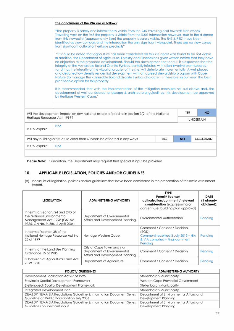
27
The conclusions of the VIA are as follows: “The property is barely and intermittently visible from the R45 travelling east towards Franschoek. Travelling west on the R45 the property is visible from the R301 intersection however, due to the distance from this viewpoint (approximately 5km) the property is barely visible. The R45 & R301 have been identified as view corridors and the intersection the only significant viewpoint. There are no view cones from significant cultural or heritage precincts” “It should be noted that agriculture has been considered on this site and it was found to be not viable. In addition, the Department of Agriculture, Forestry and Fisheries has given written notice that they have no objection to the proposed development. Should the development not occur, it is expected that the integrity of the vulnerable Boland Granite Fynbos, partially infested with alien invasive plant species, (and thus the integrity of the visual character of the site) will deteriorate incrementally. A well placed and designed low density residential development with an agreed stewardship program with Cape Nature (to manage the vulnerable Boland Granite Fynbos character) is therefore, in our view, the best practicable option for this property. It is recommended that with the implementation of the mitigation measures set out above and, the development of well considered landscape & architectural guidelines, this development be approved by Heritage Western Cape.”
Will the development impact on any national estate referred to in section 3(2) of the National Heritage Resources Act, 1999?
YES NO
UNCERTAIN
If YES, explain: N/A
Will any building or structure older than 60 years be affected in any way? YES NO UNCERTAIN
If YES, explain: N/A
Please Note: If uncertain, the Department may request that specialist input be provided.
10. APPLICABLE LEGISLATION, POLICIES AND/OR GUIDELINES
(a) Please list all legislation, policies and/or guidelines that have been considered in the preparation of this Basic Assessment
Report.
LEGISLATION ADMINISTERING AUTHORITY
TYPE Permit/ license/
authorisation/comment / relevant consideration (e.g. rezoning or
consent use, building plan approval)
DATE (if already obtained):
In terms of sections 24 and 24D of the National Environmental Management Act, 1998 (GN. No. R385, GN No. R. 386, 6 April 2006)
Department of Environmental Affairs and Development Planning
Environmental Authorization Pending
In terms of section 38 of the National Heritage Resource Act No. 25 of 1999
Heritage Western Cape
Comment / Consent / Decision (ROD) Comment received 3 July 2013 – HIA & VIA compiled – Final comment Pending
Pending
In terms of the Land Use Planning Ordinance 15 of 1985
City of Cape Town and / or Department of Environmental Affairs and Development Planning
Comment / Consent / Decision Pending
Subdivision of Agricultural Land Act 70 of 1970
Department of Agriculture Comment / Consent / Decision Pending
POLICY/ GUIDELINES ADMINISTERING AUTHORITY
Development Facilitation Act 67 of 1995 Stellenbosch Municipality
Provincial Spatial Development Framework Western Cape Provincial Government
Stellenbosch Spatial Development Framework Stellenbosch Municipality
Integrated Development Plan Stellenbosch Municipality
DEA&DP NEMA EIA Regulations Guideline & Information Document Series Guideline on Public Participation July 2006
Department of Environmental Affairs and Development Planning
DEA&DP NEMA EIA Regulations Guideline & Information Document Series Guidelines on specialist input
Department of Environmental Affairs and Development Planning

28
DEA&DP NEMA EIA Regulations Guideline & Information Document Series Guideline on Alternatives July 2006
Department of Environmental Affairs and Development Planning
DEA&DP Guideline for environmental decision-making by municipalities in the Western cape
Department of Environmental Affairs and Development Planning
(b) Please describe how the legislation, policies and/or guidelines were taken into account in the preparation of this Basic
Assessment Report.
LEGISLATION / POLICY / GUIDELINE DESCRIBE HOW THE LEGISLATION / POLICY / GUIDELINE WERE TAKEN INTO ACCOUNT
(e.g. describe the extent to which it was adhered to, or deviated from, etc).
Guidelines on specialist input
Guidelines were taken into account in order to assess the need for specialists. The following specialist studies has been compiled to date for the proposed residential development: a) Botanical Impact Assessment b) Aquatic Constraints Analysis c) Botanical and Aquatic Re-Assessment for alternative layout d) Geo-Hydrological Stream Mapping e) Heritage Impact Assessment d) Visual Impact Assessment
Other policies and legislation
All other policies and legislation was taken into account in order to assess the proposed low density residential development in detail.
Please note: Copies of any permit(s) or licences received from any other organ of state must be attached this report as Appendix E.

29
SECTION C: PUBLIC PARTICIPATION
The public participation process must fulfil the requirements outlined in NEMA, the EIA Regulations, and if applicable the NEM:
WA and/or the NEM: AQA. This Department’s Guideline on Public Participation (August 2010) and Guideline on Exemption
Applications (August 2010), both of which are available on the Department’s website (http://www.capegateway.gov.za/eadp),
must also be taken into account.
Please highlight the appropriate box to indicate whether the specific requirement was undertaken or whether there was a
deviation that was agreed to by the Department.
1. Were all potential interested and affected parties notified of the application by –
(a) fixing a notice board at a place conspicuous to the public at the boundary or on the fence of -
(i) the site where the activity to which the application relates is to be undertaken; and YES DEVIATED
(ii) any alternative site mentioned in the application; YES DEVIATED
(b) giving written notice to –
(i) the owner or person in control of that land if the applicant is not the owner or person in control of the land;
YES N/A
(ii) the occupiers of the site where the activity is to be undertaken and to any alternative site where the activity is to be undertaken;
YES DEVIATED
(iii) owners and occupiers of land adjacent to the site where the activity is to be undertaken and to any alternative site where the activity is to be undertaken;
YES DEVIATED
(iv) the municipal councillor of the ward in which the site and alternative site is situated and any organisation of ratepayers that represent the community in the area;
YES DEVIATED
(v) the municipality which has jurisdiction in the area; YES DEVIATED
(vi) any organ of state having jurisdiction in respect of any aspect of the activity; and YES DEVIATED
(vii) any other party as required by the competent authority; YES DEVIATED
I placing an advertisement in -
(i) one* local newspaper; and YES DEVIATED
(ii) any official Gazette that is published specifically for the purpose of providing public notice of applications or other submissions made in terms of these Regulations;
YE S DEVIATED N/A
(d) placing an advertisement in at least one* provincial newspaper or national newspaper,
if the activity has or may have an impact that extends beyond the boundaries of the metropolitan or local municipality in which it is or will be undertaken.
YE S DEVIATED N/A
* Please note: In terms of the NEM: WA and NEM: AQA a notice must be placed in at least two newspapers circulating in the
area in which the activity applied for is to be carried out.
3. Please provide an overall summary of the Public Participation Process that was followed. (The detailed outcomes of this process must be included in a comments and response report to be attached to the final Basic Assessment Report (see note below) as Appendix F).
1st round 42 day Public Participation Process: An advertisement was placed in a local newspaper, Eikestad Nuus, informing Interested and Affected Parties
(I&APs) of the proposed development. Site notices was erected on the entrance to the property and on the property itself. Background Information Documents (notification letters) were hand delivered to the residents within a 100m
radius of the proposed development. Letters were also be sent via registered post to governmental and non-governmental commenting authorities. Concerns raised by I&APs during the public participation process will be documented in the Comments and
Response Report.
2. Provide a list of all the state departments that were consulted:
Department of Water and Sanitation
Stellenbosch Municipality
Winelands District Municipality
Heritage Western Cape
Western Cape Department of Agriculture
CapeNature

30
Please note:
Should any of the responses be “No” and no deviation or exemption from that requirement was
requested and agreed to /granted by the Department, the Basic Assessment Report will be rejected.
A list of all the potential interested and affected parties, including the organs of State, notified and a list
of all the register of interested and affected parties, must be submitted with the final Basic Assessment
Report. The list of registered interested and affected parties must be opened, maintained and made
available to any person requesting access to the register in writing.
The draft Basic Assessment Report must be submitted to the Department before it is made available to
interested and affected parties, including the relevant organs of State and State departments which
have jurisdiction with regard to any aspect of the activity, for a 40-day commenting period. With regard
to State departments, the 40-day period commences the day after the date on which the Department
as the competent/licensing authority requests such State department in writing to submit comment. The
applicant/EAP is therefore required to inform this Department in writing when the draft Basic Assessment
Report will be made available to the relevant State departments for comment. Upon receipt of the Draft
Basic Assessment Report and this confirmation, this Department will in accordance with Section 24O(2)
and (3) of the NEMA request the relevant State departments to comment on the draft report within 40
days.
All comments of interested and affected parties on the draft Basic Assessment Report must be recorded,
responded to and included in the Comments and Responses Report included as Appendix F to the final
Basic Assessment Report. If necessary, any amendments in response to comments received must be
effected in the Basic Assessment Report itself. The Comments and Responses Report must also include a
description of the public participation process followed.
The final Basic Assessment Report must be made available to registered interested and affected parties
for comment before submitting it to the Department for consideration. Unless otherwise indicated by the
Department, a final Basic Assessment Report must be made available to the registered interested and
affected parties for comment for a minimum of 21-days. Comments on the final Basic Assessment Report
does not have to be responded to, but the comments must be attached to the final Basic Assessment
Report.
The minutes of any meetings held by the EAP with interested and affected parties and other role players
which record the views of the participants must also be submitted as part of the public participation
information to be attached to the final Basic Assessment Report as Appendix F.
Proof of all the notices given as indicated, as well as of notice to the interested and affected parties of
the availability of the draft Basic Assessment Report and final Basic Assessment Report must be submitted
as part of the public participation information to be attached to the final Basic Assessment Report as
Appendix F.

31
SECTION D: NEED AND DESIRABILITY Please Note: Before completing this section, first consult this Department’s Guideline on Need and Desirability (August 2010) available on the Department’s website (http://www.capegateway.gov.za/eadp).
1. Is the activity permitted in terms of the property’s existing land use rights? YES NO Please explain
The proposed site is currently zoned for Agricultural purposes. The property is to be rezoned Resort Zone 2 (2000m2 erven around each of the 12 units), and the remainder of the property will be zoned Open Space 3 (Nature Reserve).
2. Will the activity be in line with the following?
(a) Provincial Spatial Development Framework (PSDF) YES NO Please explain
The proposed site is not within the Stellenbosch Urban Edge and is currently zoned for Agricultural purposes.
(b) Urban edge / Edge of Built environment for the area YES NO Please explain
The proposed site is not within the Stellenbosch Urban Edge and is bounded by land used for agricultural purposes on three sides and untransformed land on the fourth side.
(c) Integrated Development Plan and Spatial Development Framework of the Local Municipality (e.g. would the approval of this application compromise the integrity of the existing approved and credible municipal IDP and SDF?).
YES NO Please explain
The Stellenbosch Municipal Spatial Development Framework (Draft Strategies Report March 2010) guides land use management decisions. Although primarily aimed at developing strategies related to the growth of settlements, it acknowledges the important role of agriculture in driving the local economy. Of relevance to the proposed development are the following proposals:
Promote the use of land outside of existing and proposed urban settlements for agricultural production, bio-diversity conservation (GNEC is of the opinion that the proposed development will promote biodiversity conservation in the direct area through the stewardship agreement with CapeNature. The remaining 41.1ha of the property will be rezoned Open Space 3 – Nature Reserve, the latter is to be managed as part of the adjoining Hottentots Holland Nature Reserve by the Property Owners Association in a Stewardship agreement with CapeNature.) , scenic quality (The proposed development will not detract from the visual character of the surrounding areas, as defined in the compiled Visual Impact Assessment) and agri tourism.
Encourage the use of currently fallow land for agricultural or biodiversity conservation purposes (GNEC is of the opinion that the proposed development will promote biodiversity conservation in the direct area through the stewardship agreement with CapeNature. The remaining 41.1ha of the property will be rezoned Open Space 3 – Nature Reserve, the latter is to be managed as part of the adjoining Hottentots Holland Nature Reserve by the Property Owners Association in a Stewardship agreement with CapeNature.) including land reform projects.
(d) Approved Structure Plan of the Municipality YES NO Please explain
The Stellenbosch Municipal Spatial Development Framework (Draft Strategies Report March 2010) guides land use management decisions. Although primarily aimed at developing strategies related to the growth of settlements, it acknowledges the important role of agriculture in driving the local economy. Of relevance to the proposed development are the following proposals:
Promote the use of land outside of existing and proposed urban settlements for agricultural production, bio-diversity conservation (GNEC is of the opinion that the proposed development will promote biodiversity conservation in the direct area through the stewardship agreement with CapeNature. The remaining 41.1ha of the property will be rezoned Open Space 3 – Nature Reserve, the latter is to be managed as part of the adjoining Hottentots Holland Nature Reserve by the Property Owners Association in a Stewardship agreement with CapeNature.) , scenic quality (The proposed development will not detract from the visual character of the surrounding areas, as defined in the compiled Visual Impact Assessment) and agri tourism.
Encourage the use of currently fallow land for agricultural or biodiversity conservation purposes (GNEC is of the opinion that the proposed development will promote biodiversity conservation in the direct area through the stewardship agreement with CapeNature. The remaining 41.1ha of the property will be rezoned Open Space 3 – Nature Reserve, the latter is to be managed as part of the adjoining Hottentots Holland Nature Reserve by the Property Owners Association in a Stewardship agreement with CapeNature.) including land reform projects.
(e) An Environmental Management Framework (EMF) adopted by the Department (e.g. Would the approval of this application compromise the integrity of the existing environmental management priorities for the area and if so, can it be justified in terms of sustainability considerations?)
YES NO Please explain
The project proposes the construction of 12 luxury chalets clustered at approximately 100 meter intervals along the existing gravel road on portion 6 only. Portions 6 & 7 are proposed to be consolidated with a 2000m2 Erf defined around each residential unit rezoned to Resort Zone 2 (in total 2.4ha) and the remainder of the property (41.1ha) will be rezoned Open Space 3- Nature Reserve. The latter is to be managed as part of the adjoining Hottentots Holland Nature Reserve by the

32
Property Owners Association in a Stewardship agreement with CapeNature. According to the Stellenbosch Municipal Spatial Development Framework (Draft Strategies Report – March 2010, the site falls with the Buffer Zone of the bio-regional planning zones identified, between the Core Zone (situated upslope of the property) and Agricultural Zone (situated down-slope of the property). The Stellenbosch Municipal Spatial Development Framework (Draft Strategies Report March 2010) guides land use management decisions. Although primarily aimed at developing strategies related to the growth of settlements, it acknowledges the important role of agriculture in driving the local economy. Of relevance to the proposed development are the following proposals:
Promote the use of land outside of existing and proposed urban settlements for agricultural production, bio-diversity conservation (GNEC is of the opinion that the proposed development will promote biodiversity conservation in the direct area through the stewardship agreement with CapeNature. The remaining 41.1ha of the property will be rezoned Open Space 3 – Nature Reserve, the latter is to be managed as part of the adjoining Hottentots Holland Nature Reserve by the Property Owners Association in a Stewardship agreement with CapeNature.) , scenic quality (The proposed development will not detract from the visual character of the surrounding areas, as defined in the compiled Visual Impact Assessment) and agri tourism.
Encourage the use of currently fallow land for agricultural or biodiversity conservation purposes (GNEC is of the opinion that the proposed development will promote biodiversity conservation in the direct area through the stewardship agreement with CapeNature. The remaining 41.1ha of the property will be rezoned Open Space 3 – Nature Reserve, the latter is to be managed as part of the adjoining Hottentots Holland Nature Reserve by the Property Owners Association in a Stewardship agreement with CapeNature.) including land reform projects.
Please note that numerous specialist studies have been compiled for the proposed development, with input from experts in various fields of expertise. The layout of the development was carefully chosen with input from these specialists to have as minimal of an impact to the surrounding area as possible. The residential units have been designed to have an absolute minimal impact of the surrounding environment, including the use of green building materials, the incorporation of indigenous vegetation into the physical design of the residential units, the low visual profile of the units by sinking the units into the landscape etc. Please refer to the Architectural Guidelines compiled by Jan Hanekom Partnership - specifically drafted for the proposed development with regard to lowering environmental and visual impacts. Furthermore more than 80% of the property will be rezoned and conserved in a stewardship agreement with CapeNature (currently lacking). This will ensure than the remainder of the property is adequately managed with respect to fire regimes and alien invasive control. This will cause a biodiversity increase through adequate environmental management practises, and improve the overall habitat quality.
(f) Any other Plans (e.g. Guide Plan) YES NO Please explain
N/A
3. Is the land use (associated with the activity being applied for) considered within the timeframe intended by the existing approved Spatial Development Framework (SDF) agreed to by the relevant environmental authority (i.e. is the proposed development in line with the projects and programmes identified as priorities within the credible IDP)?
YES NO Please explain
The Stellenbosch Municipal Spatial Development Framework (Draft Strategies Report March 2010) guides land use management decisions. Although primarily aimed at developing strategies related to the growth of settlements, it acknowledges the important role of agriculture in driving the local economy. Of relevance to the proposed development are the following proposals:
Promote the use of land outside of existing and proposed urban settlements for agricultural production, bio-diversity conservation (GNEC is of the opinion that the proposed development will promote biodiversity conservation in the direct area through the stewardship agreement with CapeNature. The remaining 41.1ha of the property will be rezoned Open Space 3 – Nature Reserve, the latter is to be managed as part of the adjoining Hottentots Holland Nature Reserve by the Property Owners Association in a Stewardship agreement with CapeNature.) , scenic quality (The proposed development will not detract from the visual character of the surrounding areas, as defined in the compiled Visual Impact Assessment) and agri tourism.
Encourage the use of currently fallow land for agricultural or biodiversity conservation purposes (GNEC is of the opinion that the proposed development will promote biodiversity conservation in the direct area through the stewardship agreement with CapeNature. The remaining 41.1ha of the property will be rezoned Open Space 3 – Nature Reserve, the latter is to be managed as part of the adjoining Hottentots Holland Nature Reserve by the Property Owners Association in a Stewardship agreement with CapeNature.) including land reform projects.
4. Should development, or if applicable, expansion of the town/area concerned in terms of this land use (associated with the activity being applied for) occur here at this point in time?
YES NO Please explain
The Stellenbosch Municipal Spatial Development Framework (Draft Strategies Report March 2010) guides land use management decisions. Although primarily aimed at developing strategies related to the growth of settlements, it acknowledges the important role of agriculture in driving the local economy. Of relevance to the proposed development are the following proposals:
Promote the use of land outside of existing and proposed urban settlements for agricultural production, bio-diversity conservation (GNEC is of the opinion that the proposed development will promote biodiversity conservation in the direct area through the stewardship agreement with CapeNature. The remaining 41.1ha of the property will be rezoned Open Space 3 – Nature Reserve, the latter is to be managed as part of the adjoining Hottentots Holland
33
Nature Reserve by the Property Owners Association in a Stewardship agreement with CapeNature.) , scenic quality (The proposed development will not detract from the visual character of the surrounding areas, as defined in the compiled Visual Impact Assessment) and agri tourism.
Encourage the use of currently fallow land for agricultural or biodiversity conservation purposes (GNEC is of the opinion that the proposed development will promote biodiversity conservation in the direct area through the stewardship agreement with CapeNature. The remaining 41.1ha of the property will be rezoned Open Space 3 – Nature Reserve, the latter is to be managed as part of the adjoining Hottentots Holland Nature Reserve by the Property Owners Association in a Stewardship agreement with CapeNature.) including land reform projects.
The natural occurring Boland Granite Fynbos vegetation is similar over most of the site and specifically in the areas proposed for residential subdivision. It is species-rich and has high conservation value. However, it has been disturbed in the past by the growth of pine trees which have now mostly been felled. The exceptions are young pine trees that have established and continue to invade the site. In addition alien Hakea sericea is abundant in places and is vigorously invading the Fynbos. There is no doubt that if not controlled soon, the problem will become extreme. Australian wattles, notably Acacia longifolia (long leaved wattle) form dense impenetrable stands in places. These trees are also vigorously invading the site, specifically towards the western end. They are seriously negatively impacting the Fynbos which is cause for major concern.
5. Does the community/area need the activity and the associated land use concerned (is it a societal priority)? (This refers to the strategic as well as local level (e.g. development is a national priority, but within a specific local context it could be inappropriate.)
YES NO Please explain
Development on the site will create new employment opportunities during both the construction (temporary) and operational (temporary and permanent) phases of the proposed development. The Winelands/Boland area is also a very popular area to live in and there is a demand for similar low-density ECO residential developments in the area, the proposed development will provide for this demand. Furthermore more than 80% of the property will be rezoned and conserved in a stewardship agreement with CapeNature (currently lacking). This will ensure than the remainder of the property is adequately managed with respect to fire regimes and alien invasive control. This will cause a biodiversity increase through adequate environmental management practises, and improve the overall habitat quality.
6. Are the necessary services with adequate capacity currently available (at the time of application), or must additional capacity be created to cater for the development? (Confirmation by the relevant Municipality in this regard must be attached to the final Basic Assessment Report as Appendix E.)
YES NO Please explain
The estimated daily water demand for similar residential houses is expected to be between 1500 – 2500 litres per day. Given the fact that the residential dwellings will be situated within a natural environment, with limited gardens and no irrigation, the expected water demand per unit will be in the region of 1500 – 200 litres/unit/day. Hence the daily water demand for the entire development is therefore expected to be 18 – 24 kilolitres. The closest external potable water system in the form of a 63mm diameter HDPE pipe, is located close to Bridge House School approximately 3 kilometres north of the property. Connection for the development can be provided from the pipeline, but this not preferred due to costs. It is proposed to abstract water from the existing perennial stream on the property. This water will be treated with some basic filtering and disinfection. A small reservoir in the form of six interconnected 10 000 litre tanks will be provided with a combined storage volume of 60 000 litres. This is sufficient for 48 hours of supply on full occupation. From the storage reservoir, water will be fed with a constant pressure pump system via an underground pipe system to the individual dwellings. The average daily sewer flow per dwelling unit is expected to be 800litres/day. On full occupation the expected daily sewer flow generated by the entire development will be 9,60kl. The expected peak flow is 0,45l/s. The development is proposed as with a split grey and black water system. Plumbing from the residential units will be completely separated for each system. Greywater is the leftover water from baths, showers, hand basins and washing machines, excluding kitchen sinks. This is expected to be approximately 70% of the total sewerage generated by the development. Grey water will be collected in a separate conservancy tank to be provided at each unit. These tanks will be emptied on a regular basis by an accredited/registered service provider under management of the Home Owners Association. With full occupation of the units it is expected that the tanks will have a minimum storage capacity of 10 days. The expected occupation for the development is 50% which equates to storage capacity of 20 days minimum. Black water from each residential unit will be collected with a main 160 diameter gravity sewer pipe to discharge into a central black water conservancy tanks of 30 000 litres. This tank will be emptied on a regular basis by an accredited/registered service provider under management of the Home Owners Association. With full occupation of the units it is expected that the tanks will have a minimum storage capacity of 10 days. The expected occupation for the development is 50%, which equates to storage capacity of 20 days minimum. Solid Domestic Waste will be collected by an accredited/registered service provider under management of the Home Owners Association, and transported to a licensed landfill facility.

34
Electricity will be provided by ESKOM – This is still to be confirmed.
7. Is this development provided for in the infrastructure planning of the municipality, and if not what will the implication be on the infrastructure planning of the municipality (priority and placement of services and opportunity costs)? (Comment by the relevant Municipality in this regard must be attached to the final Basic Assessment Report as Appendix E.)
YES NO Please explain
Although no confirmation has yet been received, it is understood that adequate capacity exists to accommodate the proposed development – This will be confirmed during final submission of the Basic Assessment Report.
8. Is this project part of a national programme to address an issue of national concern or importance?
YES NO Please explain
N/A
9. Do location factors favour this land use (associated with the activity applied for) at this place? (This relates to the contextualisation of the proposed land use on this site within its broader context.)
YES NO Please explain
The Stellenbosch Municipal Spatial Development Framework (Draft Strategies Report March 2010) guides land use management decisions. Although primarily aimed at developing strategies related to the growth of settlements, it acknowledges the important role of agriculture in driving the local economy. Of relevance to the proposed development are the following proposals:
Promote the use of land outside of existing and proposed urban settlements for agricultural production, bio-diversity conservation (GNEC is of the opinion that the proposed development will promote biodiversity conservation in the direct area through the stewardship agreement with CapeNature. The remaining 41.1ha of the property will be rezoned Open Space 3 – Nature Reserve, the latter is to be managed as part of the adjoining Hottentots Holland Nature Reserve by the Property Owners Association in a Stewardship agreement with CapeNature.) , scenic quality (The proposed development will not detract from the visual character of the surrounding areas, as defined in the compiled Visual Impact Assessment) and agri tourism.
Encourage the use of currently fallow land for agricultural or biodiversity conservation purposes (GNEC is of the opinion that the proposed development will promote biodiversity conservation in the direct area through the stewardship agreement with CapeNature. The remaining 41.1ha of the property will be rezoned Open Space 3 – Nature Reserve, the latter is to be managed as part of the adjoining Hottentots Holland Nature Reserve by the Property Owners Association in a Stewardship agreement with CapeNature.) including land reform projects.
The natural occurring Boland Granite Fynbos vegetation is similar over most of the site and specifically in the areas proposed for residential subdivision. It is species-rich and has high conservation value. However, it has been disturbed in the past by the growth of pine trees which have now mostly been felled. The exceptions are young pine trees that have established and continue to invade the site. In addition alien Hakea sericea is abundant in places and is vigorously invading the Fynbos. There is no doubt that if not controlled soon, the problem will become extreme. Australian wattles, notably Acacia longifolia (long leaved wattle) form dense impenetrable stands in places. These trees are also vigorously invading the site, specifically towards the western end. They are seriously negatively impacting the Fynbos which is cause for major concern.
10. How will the activity or the land use associated with the activity applied for, impact on sensitive natural and cultural areas (built and rural/natural environment)?
YES NO Please explain
Please note that numerous specialist studies have been compiled for the proposed development, with input from experts in various fields of expertise. The layout of the development was carefully chosen with input from these specialists to have as minimal of an impact to the surrounding area as possible. The residential units have been designed to have an absolute minimal impact of the surrounding environment, including the use of green building materials, the incorporation of indigenous vegetation into the physical design of the residential units, the low visual profile of the units by sinking the units into the landscape etc. Please refer to the Architectural Guidelines compiled by Jan Hanekom Partnership - specifically drafted for the proposed development with regard to lowering environmental and visual impacts. Furthermore more than 80% of the property will be rezoned and conserved in a stewardship agreement with CapeNature (currently lacking). This will ensure than the remainder of the property is adequately managed with respect to fire regimes and alien invasive control. This will cause a biodiversity increase through adequate environmental management practises, and improve the overall habitat quality.
11. How will the development impact on people’s health and wellbeing (e.g. in terms of noise, odours, visual character and sense of place, etc)?
YES NO Please explain
A Freshwater Impact Assessment, Geo-Hydrological Stream Mapping Assessment and Botanical Assessments have been compiled for the proposed residential development. Please note that numerous specialist studies have been compiled for the proposed development, with input from experts in various fields of expertise. The layout of the development was carefully chosen with input from these specialists to have as minimal of an impact to the surrounding area and sub-surfaced water resources as possible. Please refer to the attached Geo-Hydrological Stream Mapping Assessment, Freshwater Impact Assessment and Botanical Assessments. The layout of the development was carefully chosen with input from these specialists to have as minimal of an impact to the

35
surrounding area as possible. The residential units have been designed to have an absolute minimal impact of the surrounding environment, including the use of green building materials, the incorporation of indigenous vegetation into the physical design of the residential units, the low visual profile of the units by sinking the units into the landscape etc. Please refer to the Architectural Guidelines compiled by Jan Hanekom Partnership - specifically drafted for the proposed development with regard to lowering environmental and visual impacts. Furthermore more than 80% of the property will be rezoned, conserved in a stewardship agreement with CapeNature (currently lacking) and managed as part of the adjacent Hottentots Holland Nature Reserve. This will ensure than the remainder of the property is adequately managed with respect to fire regimes and alien invasive control. This will cause a biodiversity increase through environmental management practises, and improve the overall habitat quality. The Western Cape Department of Agriculture has also already confirmed that they will not oppose the proposed development and the rezoning of agricultural land, on condition that a stewardship agreement is reached with CapeNature in terms of Open Space 3 for the remaining property. Additionally a comprehensive Heritage Impact Assessment (HIA) and Visual Impact Assessment (VIA) have been compiled for the proposed development, to assess the potential social and cultural impacts. The conclusions of the HIA are as follows: “In summary, the proposal addresses the indicators adequately and the mitigation proposals have already been incorporated” “On the basis of this assessment, it is proposed to be recommended that, in terms of section 38(8) of the NHRA, HWC support the proposed development and allow the development to proceed to the next phase” The conclusions of the VIA are as follows: “The property is barely and intermittently visible from the R45 travelling east towards Franschoek. Travelling west on the R45 the property is visible from the R301 intersection however, due to the distance from this viewpoint (approximately 5km) the property is barely visible. The R45 & R301 have been identified as view corridors and the intersection the only significant viewpoint. There are no view cones from significant cultural or heritage precincts” “It should be noted that agriculture has been considered on this site and it was found to be not viable. In addition, the Department of Agriculture, Forestry and Fisheries has given written notice that they have no objection to the proposed development. Should the development not occur, it is expected that the integrity of the vulnerable Boland Granite Fynbos, partially infested with alien invasive plant species, (and thus the integrity of the visual character of the site) will deteriorate incrementally. A well placed and designed low density residential development with an agreed stewardship program with Cape Nature (to manage the vulnerable Boland Granite Fynbos character) is therefore, in our view, the best practicable option for this property. It is recommended that with the implementation of the mitigation measures set out above and, the development of well considered landscape & architectural guidelines, this development be approved by Heritage Western Cape.”
For mitigation measures for the possible lighting impacts please refer to the attached Architectural Guidelines as compiled by Jan Hanekom Partnership.
12. Will the proposed activity or the land use associated with the activity applied for, result in unacceptable opportunity costs?
YES NO Please explain
Development on the site will create new employment opportunities during both the construction (temporary) and operational (temporary and permanent) phases of the proposed development. The Winelands/Boland area is also a very popular area to live in and there is a demand for similar low-density ECO residential developments in the area, the proposed development will provide for this demand. Furthermore more than 80% of the property will be rezoned and conserved in a stewardship agreement with CapeNature (currently lacking). This will ensure than the remainder of the property is adequately managed with respect to fire regimes and alien invasive control. This will cause a biodiversity increase through adequate environmental management practises, and improve the overall habitat quality. Therefore it is not expected that the opportunity costs will be unacceptable.
13. What will the cumulative impacts (positive and negative) of the proposed land use associated with the activity applied for, be?
YES NO Please explain
Potential Traffic and Noise impacts: It is expected that there will be a traffic and noise impact during both the construction and operational phase of the development. The traffic and noise impacts during the construction phase will however only be temporary in nature and will only last for a couple of months during construction. GNEC is also of the opinion that the legally binding environmental management plan will be sufficient to mitigate any potential impacts with regard to noise and traffic impacts during the construction phase. Given that application is only made for 12 low density residential units, it is not expected that any significant noise and traffic impacts will occur during the operational phase of the activity.

36
Potential impacts on Biological and Physical aspects: There will be an impact on biological and physical aspects during both the construction and operational phases of the activity. It is the opinion of GNEC however that this will be adequately mitigated through long term management and improvement of habitat quality as explained below: The layout of the development was carefully chosen with input from these specialists to have as minimal of an impact to the surrounding area and sub-surfaced water resources as possible. Please refer to the attached Geo-Hydrological Stream Mapping Assessment, Freshwater Impact Assessment and Botanical Assessments. The layout of the development was carefully chosen with input from these specialists to have as minimal of an impact to the surrounding area as possible. The residential units have been designed to have an absolute minimal impact of the surrounding environment, including the use of green building materials, the incorporation of indigenous vegetation into the physical design of the residential units, the low visual profile of the units by sinking the units into the landscape etc. Please refer to the Architectural Guidelines compiled by Jan Hanekom Partnership - specifically drafted for the proposed development with regard to lowering environmental and visual impacts. Furthermore more than 80% of the property will be rezoned, conserved in a stewardship agreement with CapeNature (currently lacking) and managed as part of the adjacent Hottentots Holland Nature Reserve. This will ensure than the remainder of the property is adequately managed with respect to fire regimes and alien invasive control. This will cause a biodiversity increase through environmental management practises, and improve the overall habitat quality. The Western Cape Department of Agriculture has also already confirmed that they will not oppose the proposed development and the rezoning of agricultural land, on condition that a stewardship agreement is reached with CapeNature in terms of Open Space 3 for the remaining property. Potential impacts on Cultural and Historical aspects: It is not expected that any significant impacts will occur with respect to cultural and historical aspects. A Notification of Intent to develop was submitted to Heritage Western Cape for the proposed development, and formal correspondence was received, stating he need for a Heritage and Visual impact assessment. The conclusions of these specialist reports were the following: The conclusions of the HIA are as follows: “In summary, the proposal addresses the indicators adequately and the mitigation proposals have already been incorporated” “On the basis of this assessment, it is proposed to be recommended that, in terms of section 38(8) of the NHRA, HWC support the proposed development and allow the development to proceed to the next phase” The conclusions of the VIA are as follows: “The property is barely and intermittently visible from the R45 travelling east towards Franschoek. Travelling west on the R45 the property is visible from the R301 intersection however, due to the distance from this viewpoint (approximately 5km) the property is barely visible. The R45 & R301 have been identified as view corridors and the intersection the only significant viewpoint. There are no view cones from significant cultural or heritage precincts” “It should be noted that agriculture has been considered on this site and it was found to be not viable. In addition, the Department of Agriculture, Forestry and Fisheries has given written notice that they have no objection to the proposed development. Should the development not occur, it is expected that the integrity of the vulnerable Boland Granite Fynbos, partially infested with alien invasive plant species, (and thus the integrity of the visual character of the site) will deteriorate incrementally. A well placed and designed low density residential development with an agreed stewardship program with Cape Nature (to manage the vulnerable Boland Granite Fynbos character) is therefore, in our view, the best practicable option for this property. It is recommended that with the implementation of the mitigation measures set out above and, the development of well considered landscape & architectural guidelines, this development be approved by Heritage Western Cape.” Potential impacts on Social aspects: It is the opinion of GNEC that the proposed development will not significantly impact on Social aspects for the reasons stated above and below: Development on the site will create new employment opportunities during both the construction (temporary) and operational (temporary and permanent) phases of the proposed development. The Winelands/Boland area is also a very popular area to live in and there is a demand for similar low-density ECO residential developments in the area, the proposed development will provide for this demand. Furthermore more than 80% of the property will be rezoned and conserved in a stewardship agreement with CapeNature (currently lacking). This will ensure than the remainder of the property is adequately managed with respect to fire regimes and alien invasive control. This will cause a biodiversity increase through adequate environmental management practises, and improve the overall habitat quality.

37
(17) Please describe how the general objectives of Integrated Environmental Management as set out in section 23 of NEMA have been taken into account:
The impact assessment process conforms to the principles of Integrated Environmental Management. The process is attempting to identify all potential impacts as well as identify practical means in which the client can develop the necessary mitigation measures to manage such impacts. The proposed EIA process is structured in such a manner as to identify environmental risks, lessen community conflict by actively promoting public participation, propose the means to minimise adverse environmental effects and inform all relevant government decision makers. The impact assessment will ensure that all environmental assessments are integrated into all aspects of the proposed residential development’s life cycle, construction/operation and decommissioning.
14. Is the development the best practicable environmental option for this land/site?
YES NO Please explain
The Stellenbosch Municipal Spatial Development Framework (Draft Strategies Report March 2010) guides land use management decisions. Although primarily aimed at developing strategies related to the growth of settlements, it acknowledges the important role of agriculture in driving the local economy. Of relevance to the proposed development are the following proposals:
Promote the use of land outside of existing and proposed urban settlements for agricultural production, bio-diversity conservation (GNEC is of the opinion that the proposed development will promote biodiversity conservation in the direct area through the stewardship agreement with CapeNature. The remaining 41.1ha of the property will be rezoned Open Space 3 – Nature Reserve, the latter is to be managed as part of the adjoining Hottentots Holland Nature Reserve by the Property Owners Association in a Stewardship agreement with CapeNature.) , scenic quality (The proposed development will not detract from the visual character of the surrounding areas, as defined in the compiled Visual Impact Assessment) and agri tourism.
Encourage the use of currently fallow land for agricultural or biodiversity conservation purposes (GNEC is of the opinion that the proposed development will promote biodiversity conservation in the direct area through the stewardship agreement with CapeNature. The remaining 41.1ha of the property will be rezoned Open Space 3 – Nature Reserve, the latter is to be managed as part of the adjoining Hottentots Holland Nature Reserve by the Property Owners Association in a Stewardship agreement with CapeNature.) including land reform projects.
Also note that numerous specialist studies have been compiled for the proposed development, with input from experts in various fields of expertise. The layout of the development was carefully chosen with input from these specialists to have as minimal of an impact to the surrounding area as possible. The residential units have been designed to have an absolute minimal impact of the surrounding environment, including the use of green building materials, the incorporation of indigenous vegetation into the physical design of the residential units, the low visual profile of the units by sinking the units into the landscape etc. Please refer to the Architectural Guidelines compiled by Jan Hanekom Partnership - specifically drafted for the proposed development with regard to lowering environmental and visual impacts. Development on the site will create new employment opportunities during both the construction (temporary) and operational (temporary and permanent) phases of the proposed development. The Winelands/Boland area is also a very popular area to live in and there is a demand for similar low-density ECO residential developments in the area, the proposed development will provide for this demand. Furthermore more than 80% of the property will be rezoned and conserved in a stewardship agreement with CapeNature (currently lacking). This will ensure than the remainder of the property is adequately managed with respect to fire regimes and alien invasive control. This will cause a biodiversity increase through adequate environmental management practises, and improve the overall habitat quality.
15. What will the benefits be to society in general and to the local communities? Please explain
Development on the site will create new employment opportunities during both the construction (temporary) and operational (temporary and permanent) phases of the proposed development. The Winelands/Boland area is also a very popular area to live in and there is a demand for similar low-density ECO residential developments in the area, the proposed development will provide for this demand. Furthermore more than 80% of the property will be rezoned and conserved in a stewardship agreement with CapeNature (currently lacking). This will ensure than the remainder of the property is adequately managed with respect to fire regimes and alien invasive control. This will cause a biodiversity increase through adequate environmental management practises, and improve the overall habitat quality.
16. Any other need and desirability considerations related to the proposed activity? Please explain
The ground conditions, soils and gradient complement the development potential of the site.
38
The EIA process identified all possible impacts. These impacts were evaluated to determine the actual impact on the environment. The triple bottom line approach was taken whereby the socio, economic and environmental impacts were assessed. This also ensured that Section 2 (3) of NEMA was adhered to. Section 2 (4) of NEMA was further taken into consideration to ensure that ecosystems and loss of biological diversity are avoided, or, where they cannot be altogether avoided, are minimised and remedied. The development will be conducted in such a way as to ensure that pollution and degradation is avoided by the enforcing of the attached Environmental Management Plan (EMP), all recommendation/guidelines defined by the Specialist reports and the implementation of the Architectural Guidelines. Although few, the alternatives were also assessed as required by Section 23 (2) (b). A full public participation as per Section 54 is being undertaken as part of this assessment. The effects of the activities were assessed to ensure the environment receive adequate consideration before construction actions are taken.
(18) Please describe how the principles of environmental management as set out in section 2 of NEMA have been taken into account:
The EIA process identified all possible impacts. These impacts were evaluated to determine the actual impact on the environment. The triple bottom line approach was taken whereby the socio, economic and environmental impacts were assessed. This also ensured that Section 2 (3) of NEMA was adhered to. Section 2 (4) of NEMA was further taken into consideration to ensure that ecosystems and loss of biological diversity are avoided, or, where they cannot be altogether avoided, are minimised and remedied. The development will be conducted in such a way as to ensure that pollution and degradation is avoided by the enforcing of the attached EMP. It is not expected that any National and Cultural heritage will not be disturbed by the proposed development. Waste will be minimized by the implementation of the attached Waste Minimization plan which forms part of the project Environmental Management Plan (EMP). The proper use of a resource is therefore promoted with is a positive impact to the environment. Although few, the alternatives were also assessed as required by Section 23 (2) (b). A full public participation as per Section 54 is being undertaken as part of this assessment.
SECTION E: ALTERNATIVES Please Note: Before completing this section, first consult this Department’s Guideline on Alternatives (August 2010) available on the Department’s website (http://www.capegateway.gov.za/eadp). “Alternatives”, in relation to a proposed activity, means different means of meeting the general purposes and requirements of the activity, which may include alternatives to –
(a) the property on which, or location where, it is proposed to undertake the activity; (b) the type of activity to be undertaken; I the design or layout of the activity; (d) the technology to be used in the activity; (e) the operational aspects of the activity; and (f) the option of not implementing the activity.
The NEMA prescribes that the procedures for the investigation, assessment and communication of the potential consequences or impacts of activities on the environment must, inter alia, with respect to every application for environmental authorisation –
ensure that the general objectives of integrated environmental management laid down in NEMA and the National Environmental Management Principles set out in NEMA are taken into account; and
include an investigation of the potential consequences or impacts of the alternatives to the activity on the environment and assessment of the significance of those potential consequences or impacts, including the option of not implementing the activity.
The general objective of integrated environmental management is, inter alia, to “identify, predict and evaluate the actual and potential impact on the environment, socio-economic conditions and cultural heritage, the risks and consequences and
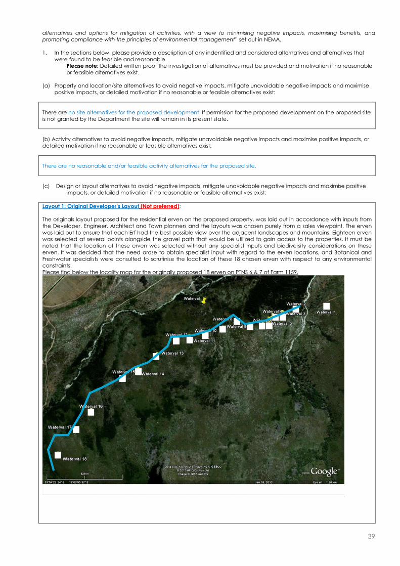
39
alternatives and options for mitigation of activities, with a view to minimising negative impacts, maximising benefits, and promoting compliance with the principles of environmental management” set out in NEMA. 1. In the sections below, please provide a description of any indentified and considered alternatives and alternatives that
were found to be feasible and reasonable. Please note: Detailed written proof the investigation of alternatives must be provided and motivation if no reasonable or feasible alternatives exist.
(a) Property and location/site alternatives to avoid negative impacts, mitigate unavoidable negative impacts and maximise
positive impacts, or detailed motivation if no reasonable or feasible alternatives exist:
There are no site alternatives for the proposed development. If permission for the proposed development on the proposed site is not granted by the Department the site will remain in its present state.
(b) Activity alternatives to avoid negative impacts, mitigate unavoidable negative impacts and maximise positive impacts, or detailed motivation if no reasonable or feasible alternatives exist:
There are no reasonable and/or feasible activity alternatives for the proposed site.
(c) Design or layout alternatives to avoid negative impacts, mitigate unavoidable negative impacts and maximise positive
impacts, or detailed motivation if no reasonable or feasible alternatives exist:
Layout 1: Original Developer’s Layout (Not preferred): The originals layout proposed for the residential erven on the proposed property, was laid out in accordance with inputs from the Developer, Engineer, Architect and Town planners and the layouts was chosen purely from a sales viewpoint. The erven was laid out to ensure that each Erf had the best possible view over the adjacent landscapes and mountains. Eighteen erven was selected at several points alongside the gravel path that would be utilized to gain access to the properties. It must be noted that the location of these erven was selected without any specialist inputs and biodiversity considerations on these erven. It was decided that the need arose to obtain specialist input with regard to the erven locations, and Botanical and Freshwater specialists were consulted to scrutinise the location of these 18 chosen erven with respect to any environmental constraints. Please find below the locality map for the originally proposed 18 erven on PTNS 6 & 7 of Farm 1159.
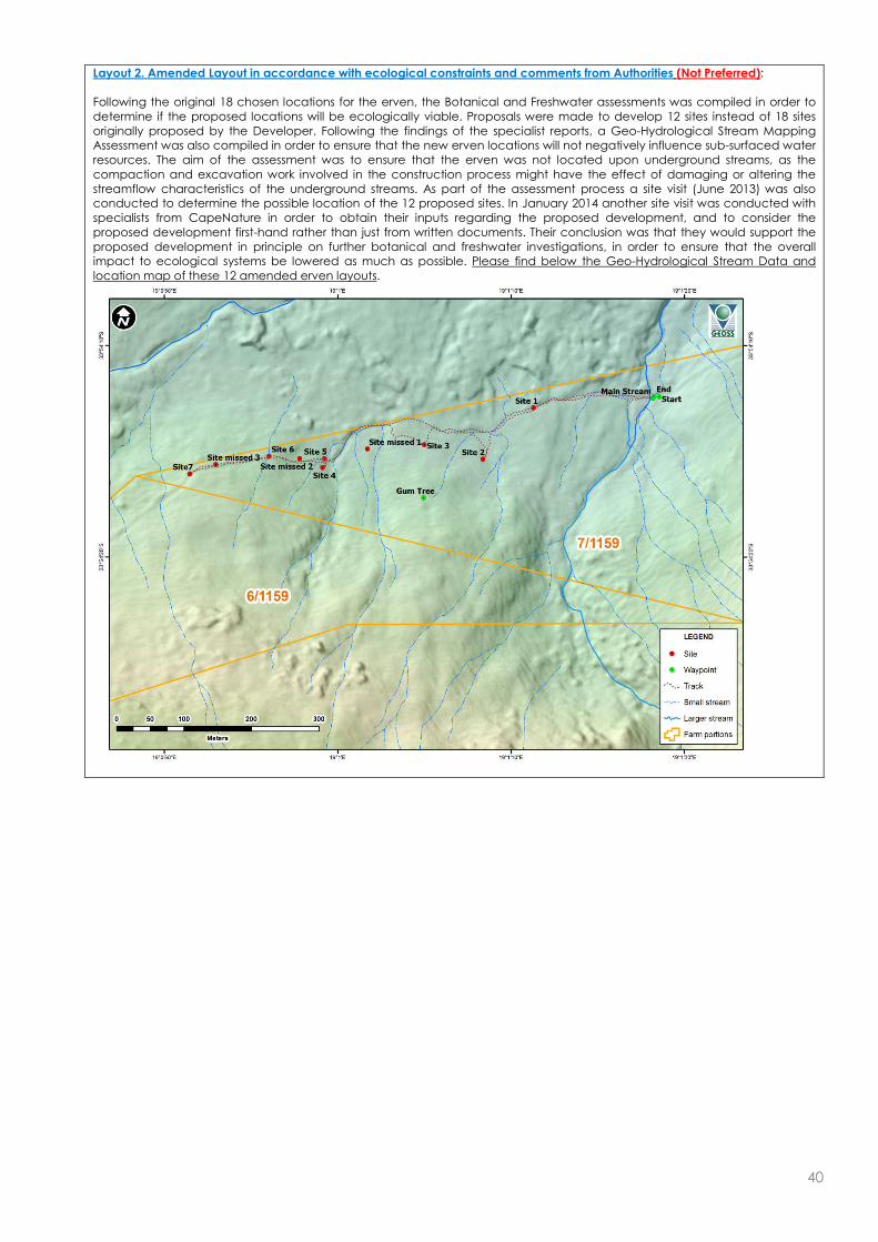
40
Layout 2. Amended Layout in accordance with ecological constraints and comments from Authorities (Not Preferred): Following the original 18 chosen locations for the erven, the Botanical and Freshwater assessments was compiled in order to determine if the proposed locations will be ecologically viable. Proposals were made to develop 12 sites instead of 18 sites originally proposed by the Developer. Following the findings of the specialist reports, a Geo-Hydrological Stream Mapping Assessment was also compiled in order to ensure that the new erven locations will not negatively influence sub-surfaced water resources. The aim of the assessment was to ensure that the erven was not located upon underground streams, as the compaction and excavation work involved in the construction process might have the effect of damaging or altering the streamflow characteristics of the underground streams. As part of the assessment process a site visit (June 2013) was also conducted to determine the possible location of the 12 proposed sites. In January 2014 another site visit was conducted with specialists from CapeNature in order to obtain their inputs regarding the proposed development, and to consider the proposed development first-hand rather than just from written documents. Their conclusion was that they would support the proposed development in principle on further botanical and freshwater investigations, in order to ensure that the overall impact to ecological systems be lowered as much as possible. Please find below the Geo-Hydrological Stream Data and location map of these 12 amended erven layouts.

41
Layout 3. Final Proposed Erven Layout following several Specialist studies and re-assessments (Preferred Layout): In addition to the Botanical and Freshwater Assessment that was compiled in 2012, an additional field-exercise was conducted in April 2014, with the aim to investigate the 12 proposed sites in order to determine if there would be any botanical or freshwater constraints. Each of the 12 proposed erven sites was evaluated by determining the vegetation (community and condition characteristics) as well as the freshwater (drainage) attributes.
Outcome of the investigation by the Specialists: Site 1: It was determined that overall the site was not ecological sensitive, but that the location of the site is moved to an area with all-season drier conditions. Site 2: The proposed location of the second site was not approved by the specialists as the site was situated above a slope wetland and the negative impact of construction on this wetland area would have been highly negative. A new location was proposed for this site. Site 3: It was determined that this site was situated on a well-drained detrital slope with a high percentage of ericoid-restioid vegetation. The location of the site was not botanically sensitive, and the site was suitable for construction. However it was recommended by the specialists that the site be moved further westward in order to accommodate the repositioning of Site 2 on similar well-drained terrain. Site 4: This site was determined to have a high percentage of Stoebe plumose (slangbos) and thus not ecologically sensitive. It was recommended by the specialists that he site be moved marginally westward (similar terrain) in order to accommodate the repositioning of Site 1 on the same slope. Site 5: This site was located between two watercourses, and it was determined that the site should be repositioned by repositioning Site 8 (westwards) and locating Site 5 between the new location of Site 8 and the watercourse to the west. Site 6: It was determined that this site had a low ecological sensitivity and that the proposed site should be maintained at its current location. Site 7: Site 7 was found to be similar to Site 6 with an additional high abundance of the invasive Hakea sericea, and that the site was suitable for construction. Site 8: This site was found to have a low-medium ecological sensitivity with invading Hakea sericea, and was deemed to be developable, however it was suggested that the location of the site be moved to the west, in order to accommodate the repositioning of Site 5. Site 9: Site 9 was found to have coarse, shrubby Fynbos of low sensitivity, with no botanical constraints. However the location of the site was suggested to be moved 10 meters to the west in accordance with the freshwater assessment that identified the site to be located in close proximity to wet slopes. Site 10: This site was also found not to be ecologically sensitive, but also lied in close proximity to a shallow seasonal watercourse, and it was also suggested that the location of the site be moved 10 meters to the west. Site 11: The site was found to be a low ericoid-restioid shrubland and aggressively being invaded by Hakea sericea, with no constraints and suitable for development. Site 12: This site was found to be similar to Site 11, with no constraints and suitable for development. Please find below the locality map of the erven, showing the original 12 layout locations and the new proposed locations in accordance with the specialists.
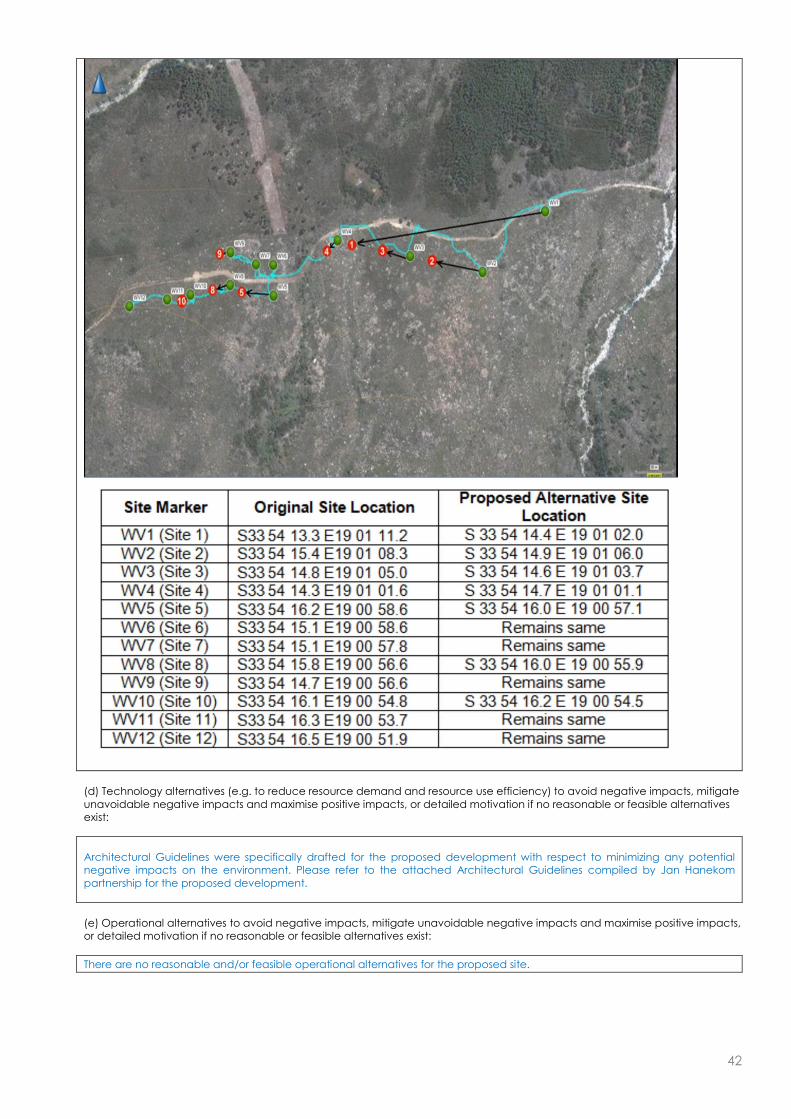
42
(d) Technology alternatives (e.g. to reduce resource demand and resource use efficiency) to avoid negative impacts, mitigate unavoidable negative impacts and maximise positive impacts, or detailed motivation if no reasonable or feasible alternatives exist:
Architectural Guidelines were specifically drafted for the proposed development with respect to minimizing any potential negative impacts on the environment. Please refer to the attached Architectural Guidelines compiled by Jan Hanekom partnership for the proposed development.
(e) Operational alternatives to avoid negative impacts, mitigate unavoidable negative impacts and maximise positive impacts, or detailed motivation if no reasonable or feasible alternatives exist:
There are no reasonable and/or feasible operational alternatives for the proposed site.
43
(f) the option of not implementing the activity (the No-Go Option):
No-Go Alternative: Should the activity not be approved the site will remain in its current state. This will result in no development on this site and the probability that the invasive vegetation will be cleared in this case is very small. The proposed development addresses a need for low density ECO residential “estates” in the Winelands area. Numerous Specialist studies were compiled to evaluate the feasibility of the proposed development on the subject properties. All possible mitigation measures were analysed and will form part of the development. It is the opinion of GNEC that the proposed development will have a net positive impact with respect to biological, physical, cultural, historical and social aspects.
(g) Other alternatives to avoid negative impacts, mitigate unavoidable negative impacts and maximise positive impacts, or detailed motivation if no reasonable or feasible alternatives exist:
N/A - All potential mitigations were considered.
(h) Please provide a summary of the alternatives investigated and the outcomes of such investigation: Please note: If no feasible and reasonable alternatives exist, the description and proof of the investigation of alternatives, together with motivation of why no feasible or reasonable alternatives exist, must be provided.
Location/Site Alternatives: There are no site alternatives for the proposed development. If permission for the proposed development on the proposed site is not granted by the Department the site will remain in its present state. Activity Alternatives: There are no reasonable and/or feasible activity alternatives for the proposed site. Layout Alternatives: Please refer to Section E – c above Technology Alternatives: Architectural Guidelines were specifically drafted for the proposed development with respect to minimizing any potential negative impacts on the environment. Please refer to the attached Architectural Guidelines compiled by Jan Hanekom partnership for the proposed development. Operational Alternatives: There are no reasonable and/or feasible operational alternatives for the proposed site. No-Go Alternative: Should the activity not be approved the site will remain in its current state. This will result in no development on this site and the probability that the invasive vegetation will be cleared in this case is very small. The proposed development addresses a need for low density ECO residential “estates” in the Winelands area. Numerous Specialist studies were compiled to evaluate the feasibility of the proposed development on the subject properties. All possible mitigation measures were analysed and will form part of the development. It is the opinion of GNEC that the proposed development will have a net positive impact with respect to biological, physical, cultural, historical and social aspects.
SECTION F: IMPACT ASSESSMENT, MANAGEMENT, MITIGATION AND MONITORING MEASURES
Please note: The information in this section must be duplicated for all the feasible and reasonable alternatives (where relevant).
1. PLEASE DESCRIBE THE MANNER IN WHICH THE DEVELOPMENT WILL IMPACT ON THE FOLLOWING
ASPECTS:
44
(a) Geographical and physical aspects:
Potential impacts on Biological and Physical aspects: There will be an impact on biological and physical aspects during both the construction and operational phases of the activity. The impact will arise from the construction of the 12 low density residential units together with the associated infrastructure (pipelines, conservancy tank, road, two small bridges and small reservoir). The overall construction footprint of the residential units together with all the associated infrastructure will be approximately 10 000m2. It is the opinion of GNEC however that this will be adequately mitigated through long term management and improvement of habitat quality as explained below: The layout of the development was carefully chosen with input from these specialists to have as minimal of an impact to the surrounding area and sub-surfaced water resources as possible. Please refer to the attached Geo-Hydrological Stream Mapping Assessment, Freshwater Impact Assessment and Botanical Assessments. The layout of the development was carefully chosen with input from these specialists to have as minimal of an impact to the surrounding area as possible. The residential units have been designed to have an absolute minimal impact of the surrounding environment, including the use of green building materials, the incorporation of indigenous vegetation into the physical design of the residential units, the low visual profile of the units by sinking the units into the landscape etc. Please refer to the Architectural Guidelines compiled by Jan Hanekom Partnership - specifically drafted for the proposed development with regard to lowering environmental and visual impacts. Furthermore more than 80% of the property will be rezoned, conserved in a stewardship agreement with CapeNature (currently lacking) and managed as part of the adjacent Hottentots Holland Nature Reserve. This will ensure than the remainder of the property is adequately managed with respect to fire regimes and alien invasive control. This will cause a biodiversity increase through environmental management practises, and improve the overall habitat quality. The Western Cape Department of Agriculture has also already confirmed that they will not oppose the proposed development and the rezoning of agricultural land, on condition that a stewardship agreement is reached with CapeNature in terms of Open Space 3 for the remaining property.
(b) Biological aspects:
Will the development have an impact on critical biodiversity areas (CBAs) or ecological support areas (CSAs)? YES NO
If yes, please describe:
N/A – Please refer to statement above.
Will the development have an impact on terrestrial vegetation, or aquatic ecosystems (wetlands, estuaries or the coastline)?
YES NO
If yes, please describe:
There will be an impact on terrestrial vegetation and aquatic systems during the construction phase of the activity. The impact will arise from the construction of the 12 low density residential units together with the associated infrastructure (pipelines, conservancy tank, road, two small bridges and small reservoir). The overall construction footprint of the residential units together with all the associated infrastructure will be approximately 10 000m2. It is the opinion of GNEC however that this will be adequately mitigated through long term management and improvement of habitat quality as explained below: The layout of the development was carefully chosen with input from these specialists to have as minimal of an impact to the surrounding area and sub-surfaced water resources as possible. Please refer to the attached Geo-Hydrological Stream Mapping Assessment, Freshwater Impact Assessment and Botanical Assessments. The layout of the development was carefully chosen with input from these specialists to have as minimal of an impact to the surrounding area as possible. The residential units have been designed to have an absolute minimal impact of the surrounding environment, including the use of green building materials, the incorporation of indigenous vegetation into the physical design of the residential units, the low visual profile of the units by sinking the units into the landscape etc. Please refer to the Architectural Guidelines compiled by Jan Hanekom Partnership - specifically drafted for the proposed development with regard to lowering environmental and visual impacts. Furthermore more than 80% of the property will be rezoned, conserved in a stewardship agreement with CapeNature (currently lacking) and managed as part of the adjacent Hottentots Holland Nature Reserve. This will ensure than the remainder of the property is adequately managed with respect to fire regimes and alien invasive control. This will cause a biodiversity increase through environmental management practises, and improve the overall habitat quality.
Will the development have an impact on any populations of threatened plant or animal species, and/or on any habitat that may contain a unique signature of plant or animal species?
YES NO
If yes, please describe:

45
According to the National Vegetation Map of South Africa (Mucina & Rutherford 2006) the site falls within the boundary of the Boland Granite Fynbos. Most of the site is still covered in the naturally occurring indigenous vegetation. Boland Granite Fynbos is an ENDANGERED vegetation type according to the rating of the National Biodiversity Assessment (Rouget et al. 2004) and as such should be conserved wherever possible. More recently it has been classified as Vulnerable D1 in the National List of Threatened Ecosystems. The site is currently covered in fairly dense 1-2m tall closed shrubland with occasional low, gnarled trees dotted through the landscape. The natural Boland Granite Fynbos vegetation is similar over most of the site and specifically in the areas proposed for residential subdivision. It is species-rich and has high conservation value. However, it has been disturbed in the past by the growth of pine trees which have now mostly been felled. The exceptions are young pine trees that have established and continue to invade the site. In addition alien Hakea sericea is abundant in places and is vigorously invading the fynbos. There is no doubt that if not controlled soon, the problem will become extreme. Australian wattles, notably Acacia longifolia (long leaved wattle) form dense impenetrable stands in places. These trees are also vigorously invading the site, specifically towards the western end. They are seriously negatively impacting the fynbos which is cause for major concern. Please refer to the Botanical Impact Assessment as compiled by Dr. Dave McDonald attached It must be noted however that if the proposed development is authorised, more than 80% (41.1ha) of the property will be rezoned, conserved in a stewardship agreement with CapeNature (currently lacking) and managed as part of the adjacent Hottentots Holland Nature Reserve. This will ensure than the remainder of the property is adequately managed with respect to fire regimes and alien invasive control. This will cause a biodiversity increase through environmental management practises, and improve the overall habitat quality.
Please describe the manner in which any other biological aspects will be impacted:
Any development on the site will impact on the naturally occurring indigenous vegetation present on the site. Since there is a small stream, the Small Waterval River, crossing the site in close proximity to the some of the proposed new houses, the proposed development could have an impact on the river, especially any concrete used in close proximity to the river for the construction of the two bridges crossing the watercourses. However it is the opinion of GNEC that this could be adequately mitigated through the implementation of the legally binding Environmental Management Plan (EMP) for the proposed development.
(c) Socio-Economic aspects:
What is the expected capital value of the activity on completion? ±R60 Million
What is the expected yearly income or contribution to the economy that will be generated by or as a result of the activity?
Unknown at this stage.
Will the activity contribute to service infrastructure? YES NO
How many new employment opportunities will be created in the construction phase of the activity? ±50
What is the expected value of the employment opportunities during the construction phase? Not known at this stage.
What percentage of this will accrue to previously disadvantaged individuals? >80%
How will this be ensured and monitored (please explain):
The contractor to build the buildings and related infrastructure will be chosen on the basis of a tender and only contractors with the appropriate credentials will be invited to tender for the work.
How many permanent new employment opportunities will be created during the operational phase of the activity?
±10
What is the expected current value of the employment opportunities during the first 10 years? Not known at this stage.
What percentage of this will accrue to previously disadvantaged individuals? >80%
How will this be ensured and monitored (please explain):
Not known at this stage.
Any other information related to the manner in which the socio-economic aspects will be impacted:
N/A

46
(d) Cultural and historic aspects:
A Notification of Intent to Develop was submitted to Heritage Western Cape (HWC) in 2013, and formal comment was received from HWC on 3 July 2013 stating the following: “Since there is reason to believe that heritage resources will be impacted upon, HWC requires an HIA in terms of S. 38(3) of the NHRA 9Act 25 of 1999) consisting of a visual study and impacts on the natural and cultural landscapes, including the comments of Franschhoek Valley Trust, Municipality. An integrated set of recommendations needs to be included and the completed studies appended in full” Subsequently a comprehensive Heritage Impact Assessment (HIA) and Visual Impact Assessment (VIA) was compiled for the proposed development. The conclusions of the reports are as follows: The conclusions of the HIA are as follows: “In summary, the proposal addresses the indicators adequately and the mitigation proposals have already been incorporated” “On the basis of this assessment, it is proposed to be recommended that, in terms of section 38(8) of the NHRA, HWC support the proposed development and allow the development to proceed to the next phase” The conclusions of the VIA are as follows: “The property is barely and intermittently visible from the R45 travelling east towards Franschoek. Travelling west on the R45 the property is visible from the R301 intersection however, due to the distance from this viewpoint (approximately 5km) the property is barely visible. The R45 & R301 have been identified as view corridors and the intersection the only significant viewpoint. There are no view cones from significant cultural or heritage precincts” “It should be noted that agriculture has been considered on this site and it was found to be not viable. In addition, the Department of Agriculture, Forestry and Fisheries has given written notice that they have no objection to the proposed development. Should the development not occur, it is expected that the integrity of the vulnerable Boland Granite Fynbos, partially infested with alien invasive plant species, (and thus the integrity of the visual character of the site) will deteriorate incrementally. A well placed and designed low density residential development with an agreed stewardship program with Cape Nature (to manage the vulnerable Boland Granite Fynbos character) is therefore, in our view, the best practicable option for this property. It is recommended that with the implementation of the mitigation measures set out above and, the development of well considered landscape & architectural guidelines, this development be approved by Heritage Western Cape.”
47
2. WASTE AND EMISSIONS (a) Waste (including effluent) management
Will the activity produce waste (including rubble) during the construction phase? YES NO
If yes, indicate the types of waste (actual type of waste, e.g. oil, and whether hazardous or not) and estimated quantity per type?
30M3
Building rubble; Domestic waste;
None of this waste will be Hazardous.
Will the activity produce waste during its operational phase? YES NO
If yes, indicate the types of waste (actual type of waste, e.g. oil, and whether hazardous or not) and estimated quantity per type?
Domestic waste Approx. 5m3 per month
Sewage 9.60kl
Where and how will the waste be treated / disposed of (describe)?
The average daily sewer flow per dwelling unit is expected to be 800litres/day. On full occupation the expected daily sewer flow generated by the entire development will be 9,60kl. The expected peak flow is 0,45l/s. The development is proposed as with a split grey and black water system. Plumbing from the residential units will be completely separated for each system. Greywater is the leftover water from baths, showers, hand basins and washing machines, excluding kitchen sinks. This is expected to be approximately 70% of the total sewerage generated by the development. Grey water will be collected in a separate conservancy tank to be provided at each unit. These tanks will be emptied on a regular basis by an accredited/registered service provider under management of the Home Owners Association. With full occupation of the units it is expected that the tanks will have a minimum storage capacity of 10 days. The expected occupation for the development is 50% which equates to storage capacity of 20 days minimum. Black water from each residential unit will be collected with a main 160 diameter gravity sewer pipe to discharge into a central black water conservancy tanks of 30 000 litres. This tank will be emptied on a regular basis by an accredited/registered service provider under management of the Home Owners Association. With full occupation of the units it is expected that the tanks will have a minimum storage capacity of 10 days. The expected occupation for the development is 50%, which equates to storage capacity of 20 days minimum. Solid Domestic Waste, effluent and sewerage will be collected by an accredited/registered service provider under management of the Home Owners Association, and transported to a licensed landfill/processing facility.
If yes, indicate the types of waste (actual type of waste, e.g. oil, and whether hazardous or not) and estimated quantity per type per phase of the development?
N/A
Has the municipality or relevant authority confirmed that sufficient capacity exist for treating / disposing of the waste to be generated by this activity (ies)? If yes, provide written confirmation from Municipality or relevant authority Confirmation Pending
YES NO
Will the activity produce waste that will be treated and/or disposed of at another facility other than into a municipal waste stream?
YES NO
If yes, has this facility confirmed that sufficient capacity exist for treating / disposing of the waste to be generated by this activity(ies)? Provide written confirmation from the facility and provide the following particulars of the facility:
YES NO
Does the facility have an operating license? (If yes, please attach a copy of the license.) YES NO
Facility name:
Contact person:
Postal address:
Postal code:
Telephone: Cell:
E-mail: Fax:
Describe the measures that will be taken to reduce, reuse or recycle waste:
Please refer to the WASTE, WATER USE AND ELECTRICITY CONSUMPTION MINIMIZATION PLAN AS PART OF THE EMP.
(b) Emissions into the atmosphere
Will the activity produce emissions that will be disposed of into the atmosphere? YES NO

48
If yes, does it require approval in terms of relevant legislation? YES NO
Describe the emissions in terms of type and concentration and how it will be treated/mitigated:
N/A
3. WATER USE
Please indicate the source(s) of water for the activity by ticking the appropriate box(es)
Municipal Water board Groundwater River, Stream, Dam or Lake
Other The activity will not use water
If water is to be extracted from a groundwater source, river, stream, dam, lake or any other natural feature, please indicate
the volume that will be extracted per month: m3
Please provide proof of assurance of water supply (e.g. Letter of confirmation from municipality / water user associations, yield of borehole)
Does the activity require a water use permit / license from DWAF? YES NO
If yes, please submit the necessary application to Department of Water Affairs and attach proof thereof to this application.
Describe the measures that will be taken to reduce water demand, and measures to reuse or recycle water:
Please refer to the WASTE, WATER USE AND ELECTRICITY CONSUMPTION MINIMIZATION PLAN AS PART OF THE EMP and the ARCHITECTURAL GUIDELINES compiled by Jan Hanekom Partnership.
4. POWER SUPPLY Please indicate the source of power supply eg. Municipality / Eskom / Renewable energy source
Eskom – still to be confirmed
If power supply is not available, where will power be sourced from?
N/A
5. ENERGY EFFICIENCY
Describe the design measures, if any, that have been taken to ensure that the activity is energy efficient:
Please refer to the WASTE, WATER USE AND ELECTRICITY CONSUMPTION MINIMIZATION PLAN AS PART OF THE EMP.
Describe how alternative energy sources have been taken into account or been built into the design of the activity, if any:
Please refer to the ARCHITECTURAL GUIDELINES compiled by Jan Hanekom Partnership.
6. DESCRIPTION AND ASSESSMENT OF THE SIGNIFICANCE OF IMPACTS PRIOR TO AND AFTER
MITIGATION
Please note: While sections are provided for impacts on certain aspects of the environment and certain impacts, the sections should also be copied and completed for all other impacts.
(a) Impacts that may result from the planning, design and construction phase (briefly describe and compare the potential
impacts (as appropriate), significance rating of impacts, proposed mitigation and significance rating of impacts after mitigation that are likely to occur as a result of the planning, design and construction phase.
Potential impacts on geographical and physical aspects:
Nature of impact: The physical appearance of the site due to residential units to be constructed.
Extent and duration of impact: Long term
Probability of occurrence: Definite
Degree to which the impact can be reversed: Low
Degree to which the impact may cause irreplaceable loss of resources:
N/A – Please refer to attached Visual Impact Assessment
Cumulative impact prior to mitigation: medium
Significance rating of impact prior to mitigation medium

49
(Low, Medium, Medium-High, High, or Very-High)
Degree to which the impact can be mitigated: Medium - High
Proposed mitigation: Full compliance with ARCHITECTURAL GUIDELINES compiled by Jan Hanekom Partnership.
Cumulative impact post mitigation: Low
Significance rating of impact after mitigation (Low, Medium, Medium-High, High, or Very-High)
Low
Potential impact on biological aspects:
Nature of impact:
The site is mostly covered in naturally occurring, indigenous vegetation. Parts of this vegetation will be removed for the proposed development.
Extent and duration of impact: Long term
Probability of occurrence: Definite
Degree to which the impact can be reversed: Medium - High
Degree to which the impact may cause irreplaceable loss of resources:
Low
Cumulative impact prior to mitigation: Medium - High
Significance rating of impact prior to mitigation (Low, Medium, Medium-High, High, or Very-High)
Medium
Degree to which the impact can be mitigated: High
Proposed mitigation:
The layout of the development was carefully chosen with input from these specialists to have as minimal of an impact to the surrounding area and sub-surfaced water resources as possible. Please refer to the attached Geo-Hydrological Stream Mapping Assessment, Freshwater Impact Assessment and Botanical Assessments. The layout of the development was carefully chosen with input from these specialists to have as minimal of an impact to the surrounding area as possible. The residential units have been designed to have an absolute minimal impact of the surrounding environment, including the use of green building materials, the incorporation of indigenous vegetation into the physical design of the residential units, the low visual profile of the units by sinking the units into the landscape etc. Please refer to the Architectural Guidelines compiled by Jan Hanekom Partnership - specifically drafted for the proposed development with regard to lowering environmental and visual impacts. Furthermore more than 80% of the property will be rezoned, conserved in a stewardship agreement with CapeNature (currently lacking) and managed as part of the adjacent Hottentots Holland Nature Reserve. This will ensure than the remainder of the property is adequately managed with respect to fire regimes and alien invasive control. This will cause a biodiversity increase through environmental management practises, and improve the overall habitat quality.
Cumulative impact post mitigation: Low
Significance rating of impact after mitigation (Low, Medium, Medium-High, High, or Very-High)
Low
Potential impacts on socio-economic aspects:
Nature of impact: Provision of temporary jobs opportunities.
Extent and duration of impact: Short term – construction – temporary employment. Long term – operation – permanent employment
Probability of occurrence: Definite
Degree to which the impact can be reversed: N/A, do not want to mitigate positive impacts.
Degree to which the impact may cause irreplaceable loss of resources:
N/A
Cumulative impact prior to mitigation: N/A Do not want to mitigate a positive impact
Significance rating of impact prior to mitigation (Low, Medium, Medium-High, High, or Very-High)
MEDIUM Positive
Degree to which the impact can be mitigated: N/A, do not want to mitigate a positive impact.
Proposed mitigation: N/A, do not want to mitigate a positive impact.
Cumulative impact post mitigation: MEDIUM Positive
Significance rating of impact after mitigation MEDIUM Positive

50
(Low, Medium, Medium-High, High, or Very-High)
Potential impacts on cultural-historical aspects:
Nature of impact: Impacts related to the visibility & visual intrusiveness of the development, archaeological & historical artefacts and the impact on botanical resources.
Extent and duration of impact: Long term
Probability of occurrence: Definite
Degree to which the impact can be reversed: Medium
Degree to which the impact may cause irreplaceable loss of resources:
Improbable
Cumulative impact prior to mitigation: Low-Medium
Significance rating of impact prior to mitigation (Low, Medium, Medium-High, High, or Very-High)
Low-Medium
Degree to which the impact can be mitigated: Medium - High
Proposed mitigation:
Should any archaeological artefacts be exposed during construction activities, work on the area where the artefacts were found shall cease immediately and the ECO as well as the Local Council shall be notified within 24 hours.
Upon receipt of such notification, the ECO will arrange for the excavation to be examined by an Archaeologist.
Under no circumstances shall archaeological artefacts be removed, destroyed or interfered with.
Any archaeological sites exposed during demolition or construction activities must not be disturbed prior to authorisation by the Heritage Western Cape and/or the South African Heritage Resources Agency on the appropriate provincial heritage resource agency.
The architecture and colour of the structures will minimise the visual impact of the proposed development.
There will be a conservation offset for the botanical losses incurred.
Full compliance with all recommendations/guidelines defined in the compiled Heritage Impact Assessment (HIA) and Visual Impact Assessment (VIA).
Full compliance with the ARCHITECTURAL GUIDELINES compiled by Jan Hanekom Partnership.
Cumulative impact post mitigation: Low
Significance rating of impact after mitigation (Low, Medium, Medium-High, High, or Very-High)
Low
Potential noise impacts:
Nature of impact: Noise emitted during Construction and Operational activities.
Extent and duration of impact: Short term – Construction activities Long term – Operational activities
Probability of occurrence: Definite
Degree to which the impact can be reversed: Low to Medium
Degree to which the impact may cause irreplaceable loss of resources:
Low
Cumulative impact prior to mitigation: Low
Significance rating of impact prior to mitigation (Low, Medium, Medium-High, High, or Very-High)
Low
Degree to which the impact can be mitigated: Medium
Proposed mitigation:
All construction vehicles must be in a good working order to reduce possible noise pollution. Work hours during the construction phase shall be strictly enforced unless permission is given (07H00 – 18H00). Permission shall not be granted without consultation with the local industries and businesses by the EO. No work to be done on Sundays. Since the proposed development is surrounded by similar light industrial developments it is not expected that the noise impacts during the operational phase will be significant.

51
Full compliance with Environmental Management Plan (EMP).
Cumulative impact post mitigation: Low
Significance rating of impact after mitigation (Low, Medium, Medium-High, High, or Very-High)
Low
Potential visual impacts:
Nature of impact: Construction activities and operational activities. During the operational phase there will be new structures constructed on the site that is currently standing vacant.
Extent and duration of impact: Construction – short term Operational – Long Term
Probability of occurrence: Definite
Degree to which the impact can be reversed: Medium - High
Degree to which the impact may cause irreplaceable loss of resources:
N/A – Please refer to the attached Visual Impact Assessment (VIA)
Cumulative impact prior to mitigation: Low - medium
Significance rating of impact prior to mitigation (Low, Medium, Medium-High, High, or Very-High)
Medium
Degree to which the impact can be mitigated: Medium - High
Proposed mitigation:
Full compliance with Environmental Management Plan (EMP) and
ARCHITECTURAL GUIDELINES compiled by Jan Hanekom Partnership.
Full compliance with recommendations/guidelines defined in the Visual Impact Assessment (VIA)
Cumulative impact post mitigation: Low
Significance rating of impact after mitigation (Low, Medium, Medium-High, High, or Very-High)
Low
(b) Impacts that may result from the operational phase (briefly describe and compare the potential impacts (as appropriate),
significance rating of impacts, proposed mitigation and significance rating of impacts after mitigation that are likely to occur as a result of the operational phase.
Potential impacts on the geographical and physical aspects:
Nature of impact: The physical and geographical impacts on the site due to residential units and associated infrastructure constructed.
Extent and duration of impact: Permanent
Probability of occurrence: Definite
Degree to which the impact can be reversed: N/A
Degree to which the impact may cause irreplaceable loss of resources:
N/A- as there are no geographical resources available on site.
Cumulative impact prior to mitigation: Low
Significance rating of impact prior to mitigation (Low, Medium, Medium-High, High, or Very-High)
Low
Degree to which the impact can be mitigated: N/A
Proposed mitigation: N/A
Cumulative impact post mitigation: Low
Significance rating of impact after mitigation (Low, Medium, Medium-High, High, or Very-High)
Low

52
Potential impact on biological aspects:
Nature of impact: Impacts on the naturally occurring fauna and flora on the site.
Extent and duration of impact: Long term
Probability of occurrence: Definitely
Degree to which the impact can be reversed: Medium
Degree to which the impact may cause irreplaceable loss of resources:
Highly Unlikely
Cumulative impact prior to mitigation: Medium - High
Significance rating of impact prior to mitigation (Low, Medium, Medium-High, High, or Very-High)
Medium
Degree to which the impact can be mitigated: High
Proposed mitigation:
The layout of the development was carefully chosen with input from these specialists to have as minimal of an impact to the surrounding area and sub-surfaced water resources as possible. Please refer to the attached Geo-Hydrological Stream Mapping Assessment, Freshwater Impact Assessment and Botanical Assessments. The layout of the development was carefully chosen with input from these specialists to have as minimal of an impact to the surrounding area as possible. The residential units have been designed to have an absolute minimal impact of the surrounding environment, including the use of green building materials, the incorporation of indigenous vegetation into the physical design of the residential units, the low visual profile of the units by sinking the units into the landscape etc. Please refer to the Architectural Guidelines compiled by Jan Hanekom Partnership - specifically drafted for the proposed development with regard to lowering environmental and visual impacts. Furthermore more than 80% of the property will be rezoned, conserved in a stewardship agreement with CapeNature (currently lacking) and managed as part of the adjacent Hottentots Holland Nature Reserve. This will ensure than the remainder of the property is adequately managed with respect to fire regimes and alien invasive control. This will cause a biodiversity increase through environmental management practises, and improve the overall habitat quality. Full compliance with the Environmental Management Plan (EMP)
Cumulative impact post mitigation: Low
Significance rating of impact after mitigation (Low, Medium, Medium-High, High, or Very-High)
Low
Potential impacts on the socio-economic aspects:
Nature of impact: Positive impacts, as this project will provide temporary and permanent employment opportunities during the operational phase.
Extent and duration of impact: Short and long term
Probability of occurrence: Definite
Degree to which the impact can be reversed: N/A - do not want to mitigate positive impacts
Degree to which the impact may cause irreplaceable loss of resources:
N/A
Cumulative impact prior to mitigation: Low Positive
Significance rating of impact prior to mitigation (Low, Medium, Medium-High, High, or Very-High)
Low Positive
Degree to which the impact can be mitigated: N/A - do not want to mitigate a positive impact.
Proposed mitigation: N/A - do not want to mitigate a positive impact.
Cumulative impact post mitigation: Low Positive
Significance rating of impact after mitigation (Low, Medium, Medium-High, High, or Very-High)
Low Positive
Potential impacts on the cultural-historical aspects:
Nature of impact: The potential visual impact. It is not expected that any artefacts of historical or archaeological significance will be found on the site.
Extent and duration of impact: Long term
Probability of occurrence: Definite
Degree to which the impact can be reversed: Medium - High
Degree to which the impact may cause irreplaceable loss of resources:
Highly Unlikely
Cumulative impact prior to mitigation: Low
Significance rating of impact prior to mitigation Low
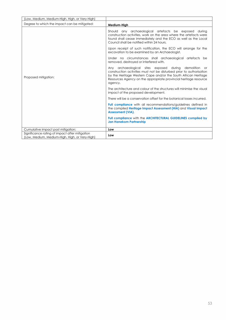
53
(Low, Medium, Medium-High, High, or Very-High)
Degree to which the impact can be mitigated: Medium-High
Proposed mitigation:
Should any archaeological artefacts be exposed during construction activities, work on the area where the artefacts were found shall cease immediately and the ECO as well as the Local Council shall be notified within 24 hours.
Upon receipt of such notification, the ECO will arrange for the excavation to be examined by an Archaeologist.
Under no circumstances shall archaeological artefacts be removed, destroyed or interfered with.
Any archaeological sites exposed during demolition or construction activities must not be disturbed prior to authorisation by the Heritage Western Cape and/or the South African Heritage Resources Agency on the appropriate provincial heritage resource agency.
The architecture and colour of the structures will minimise the visual impact of the proposed development.
There will be a conservation offset for the botanical losses incurred.
Full compliance with all recommendations/guidelines defined in the compiled Heritage Impact Assessment (HIA) and Visual Impact Assessment (VIA).
Full compliance with the ARCHITECTURAL GUIDELINES compiled by Jan Hanekom Partnership
Cumulative impact post mitigation: Low
Significance rating of impact after mitigation (Low, Medium, Medium-High, High, or Very-High)
Low

54
Potential noise impacts:
Nature of impact: Potential residential noise pollution.
Extent and duration of impact: Permanent
Probability of occurrence: Definite
Degree to which the impact can be reversed: Low
Degree to which the impact may cause irreplaceable loss of resources:
Low
Cumulative impact prior to mitigation: Low
Significance rating of impact prior to mitigation (Low, Medium, Medium-High, High, or Very-High)
Low
Degree to which the impact can be mitigated: Low
Proposed mitigation:
Since the site is located in a mostly rural area there are limited receptors for the noise pollution during the operational phase. GNEC is of the opinion that the proposed low density residential development (12 units) will not contribute to a significant noise impact during the operational phase.
Cumulative impact post mitigation: Low
Significance rating of impact after mitigation (Low, Medium, Medium-High, High, or Very-High)
Low
Potential visual impacts:
Nature of impact: Residential units and associated infrastructure constructed as part of the residential development application.
Extent and duration of impact: Long term
Probability of occurrence: Definite
Degree to which the impact can be reversed: Low
Degree to which the impact may cause irreplaceable loss of resources:
Unlikely
Cumulative impact prior to mitigation: Medium
Significance rating of impact prior to mitigation (Low, Medium, Medium-High, High, or Very-High)
Medium
Degree to which the impact can be mitigated: Low
Proposed mitigation:
Residential development to be constructed whilst adhering to the ARCHITECTURAL GUIDELINES compiled by Jan Hanekom Partnership and any recommendations/guidelines as defined in the Visual Impact Assessment (VIA).
Cumulative impact post mitigation: Low
Significance rating of impact after mitigation (Low, Medium, Medium-High, High, or Very-High)
Low
(c) Impacts that may result from the decommissioning and closure phase (briefly describe and compare the potential impacts
(as appropriate), significance rating of impacts, proposed mitigation and significance rating of impacts after mitigation that are likely to occur as a result of the decommissioning and closure phase.
Potential impacts on the geographical and physical aspects:
N/A
Nature of impact: N/A
Extent and duration of impact: N/A
Probability of occurrence: N/A
Degree to which the impact can be reversed: N/A
Degree to which the impact may cause irreplaceable loss of resources:
N/A
Cumulative impact prior to mitigation: N/A
Significance rating of impact prior to mitigation (Low, Medium, Medium-High, High, or Very-High)
N/A
Degree to which the impact can be mitigated: N/A
Proposed mitigation: N/A
Cumulative impact post mitigation: N/A
Significance rating of impact after mitigation (Low, Medium, Medium-High, High, or Very-High)
N/A
Potential impact biological aspects: N/A
Nature of impact: N/A
Extent and duration of impact: N/A

55
Probability of occurrence: N/A
Degree to which the impact can be reversed: N/A
Degree to which the impact may cause irreplaceable loss of resources:
N/A
Cumulative impact prior to mitigation: N/A
Significance rating of impact prior to mitigation (Low, Medium, Medium-High, High, or Very-High)
N/A
Degree to which the impact can be mitigated: N/A
Proposed mitigation: N/A
Cumulative impact post mitigation: N/A
Significance rating of impact after mitigation (Low, Medium, Medium-High, High, or Very-High)
N/A
Potential impacts on the socio-economic aspects: N/A
Nature of impact: N/A
Extent and duration of impact: N/A
Probability of occurrence: N/A
Degree to which the impact can be reversed: N/A
Degree to which the impact may cause irreplaceable loss of resources:
N/A
Cumulative impact prior to mitigation: N/A
Significance rating of impact prior to mitigation (Low, Medium, Medium-High, High, or Very-High)
N/A
Degree to which the impact can be mitigated: N/A
Proposed mitigation: N/A
Cumulative impact post mitigation: N/A
Significance rating of impact after mitigation (Low, Medium, Medium-High, High, or Very-High)
N/A
Potential impacts on the cultural-historical aspects: N/A
Nature of impact: N/A
Extent and duration of impact: N/A
Probability of occurrence: N/A
Degree to which the impact can be reversed: N/A
Degree to which the impact may cause irreplaceable loss of resources:
N/A
Cumulative impact prior to mitigation: N/A
Significance rating of impact prior to mitigation (Low, Medium, Medium-High, High, or Very-High)
N/A
Degree to which the impact can be mitigated: N/A
Proposed mitigation: N/A
Cumulative impact post mitigation: N/A
Significance rating of impact after mitigation (Low, Medium, Medium-High, High, or Very-High)
N/A
Potential noise impacts: N/A
Nature of impact: N/A
Extent and duration of impact: N/A
Probability of occurrence: N/A
Degree to which the impact can be reversed: N/A
Degree to which the impact may cause irreplaceable loss of resources:
N/A
Cumulative impact prior to mitigation: N/A
Significance rating of impact prior to mitigation (Low, Medium, Medium-High, High, or Very-High)
N/A
Degree to which the impact can be mitigated: N/A
Proposed mitigation: N/A
Cumulative impact post mitigation: N/A
Significance rating of impact after mitigation (Low, Medium, Medium-High, High, or Very-High)
N/A
Potential visual impacts: N/A
Nature of impact: N/A
Extent and duration of impact: N/A
Probability of occurrence: N/A

56
Degree to which the impact can be reversed: N/A
Degree to which the impact may cause irreplaceable loss of resources:
N/A
Cumulative impact prior to mitigation: N/A
Significance rating of impact prior to mitigation (Low, Medium, Medium-High, High, or Very-High)
N/A
Degree to which the impact can be mitigated: N/A
Proposed mitigation: N/A
Cumulative impact post mitigation: N/A
Significance rating of impact after mitigation (Low, Medium, Medium-High, High, or Very-High)
N/A
(d) Any other impacts:
Potential impact: N/A
Nature of impact: N/A
Extent and duration of impact: N/A
Probability of occurrence: N/A
Degree to which the impact can be reversed: N/A
Degree to which the impact may cause irreplaceable loss of resources:
N/A
Cumulative impact prior to mitigation: N/A
Significance rating of impact prior to mitigation (Low, Medium, Medium-High, High, or Very-High)
N/A
Degree to which the impact can be mitigated: N/A
Proposed mitigation: N/A
Cumulative impact post mitigation: N/A
Significance rating of impact after mitigation (Low, Medium, Medium-High, High, or Very-High)
N/A
7. SPECIALIST INPUTS/STUDIES AND RECOMMENDATIONS
Please note: Specialist inputs/studies must be attached to this report as Appendix G. Also take into account the Department’s Guidelines on the Involvement of Specialists in EIA Processes available on the Department’s website (http://www.capegateway.gov.za/eadp).
Specialist inputs/studies and recommendations:
Guidelines were taken into account in order to assess the need for specialists. The following specialist studies has been compiled to date for the proposed residential development: a) Botanical Impact Assessment b) Aquatic Constraints Analysis c) Botanical and Aquatic Re-Assessment for alternative layout d) Geo-Hydrological Stream Mapping e) Heritage Impact Assessment d) Visual Impact Assessment Please note that numerous specialist studies have been compiled for the proposed development, with input from experts in various fields of expertise. The layout of the development was carefully chosen with input from these specialists to have as minimal of an impact to the surrounding area as possible. The residential units have been designed to have an absolute minimal impact of the surrounding environment, including the use of green building materials, the incorporation of indigenous vegetation into the physical design of the residential units, the low visual profile of the units by sinking the units into the landscape etc. Please refer to the Architectural Guidelines compiled by Jan Hanekom Partnership - specifically drafted for the proposed development with regard to lowering environmental and visual impacts. A Notification of Intent to Develop was submitted to Heritage Western Cape (HWC) in 2013, and formal comment was received from HWC on 3 July 2013 stating the following: “Since there is reason to believe that heritage resources will be impacted upon, HWC requires an HIA in terms of S. 38(3) of the NHRA 9Act 25 of 1999) consisting of a visual study and impacts on the natural and cultural landscapes, including the comments of Franschhoek Valley Trust, Municipality. An integrated set of recommendations needs to be included and the completed studies appended in full” Subsequently a comprehensive Heritage Impact Assessment (HIA) and Visual Impact Assessment (VIA) was compiled for the proposed development. The conclusions of the reports are as follows:

57
The conclusions of the HIA are as follows: “In summary, the proposal addresses the indicators adequately and the mitigation proposals have already been incorporated” “On the basis of this assessment, it is proposed to be recommended that, in terms of section 38(8) of the NHRA, HWC support the proposed development and allow the development to proceed to the next phase” The conclusions of the VIA are as follows: “The property is barely and intermittently visible from the R45 travelling east towards Franschoek. Travelling west on the R45 the property is visible from the R301 intersection however, due to the distance from this viewpoint (approximately 5km) the property is barely visible. The R45 & R301 have been identified as view corridors and the intersection the only significant viewpoint. There are no view cones from significant cultural or heritage precincts” “It should be noted that agriculture has been considered on this site and it was found to be not viable. In addition, the Department of Agriculture, Forestry and Fisheries has given written notice that they have no objection to the proposed development. Should the development not occur, it is expected that the integrity of the vulnerable Boland Granite Fynbos, partially infested with alien invasive plant species, (and thus the integrity of the visual character of the site) will deteriorate incrementally. A well placed and designed low density residential development with an agreed stewardship program with Cape Nature (to manage the vulnerable Boland Granite Fynbos character) is therefore, in our view, the best practicable option for this property. It is recommended that with the implementation of the mitigation measures set out above and, the development of well considered landscape & architectural guidelines, this development be approved by Heritage Western Cape.” Please refer to these Specialist studies attached to this report. GNEC, in our professional capacity as experienced and qualified environmental consultants believe that the proposed project be issued a positive environmental authorization; however this authorization must be accompanied with the following requirements:
Appointment of an Environmental Control Officer (ECO) to oversee Full Compliance with the Environmental Management Plan (EMP).
Bi-monthly site audits to ensure compliance and to advise on any mitigation measures necessary to negate any environmental degradation.
The ECO must compile monthly ECO Audit Reports on the state of the environment and areas of compliance and non-compliance with the EMP. These reports must be made available to DEA&DP. Fines should be included in the EMP to ensure full compliance to the EMP.
Full implementation of the ARCHITECTURAL GUIDELINES compiled by Jan Hanekom Partnership Full implementation of ALL recommendation/guidelines defined in the Specialist Reports (attached) The remainder of the property after construction of the residential development (41.1ha) is to be rezoned Open
Space 3 (Nature Reserve) and managed as part of the adjoining Hottentots Holland Nature Reserve by the Property Owners Association in a Stewardship agreement with CapeNature.
All domestic waste, effluent and sewerage is to be removed at regular intervals by a accredited service provider and transported for processing to a registered municipal landfill/processing facility.
8. IMPACT SUMMARY
Please provide a summary of all the above impacts.
Potential Traffic and Noise impacts: It is expected that there will be a traffic and noise impact during both the construction and operational phase of the development. The traffic and noise impacts during the construction phase will however only be temporary in nature and will only last for a couple of months during construction. GNEC is also of the opinion that the legally binding environmental management plan will be sufficient to mitigate any potential impacts with regard to noise and traffic impacts during the construction phase. Given that application is only made for 12 low density residential units, it is not expected that any significant noise and traffic impacts will occur during the operational phase of the activity. Potential impacts on Biological and Physical aspects: There will be an impact on biological and physical aspects during both the construction and operational phases of the activity. It is the opinion of GNEC however that this will be adequately mitigated through long term management and improvement of habitat quality as explained below: The layout of the development was carefully chosen with input from these specialists to have as minimal of an impact to the surrounding area and sub-surfaced water resources as possible.
58
Please refer to the attached Geo-Hydrological Stream Mapping Assessment, Freshwater Impact Assessment and Botanical Assessments. The layout of the development was carefully chosen with input from these specialists to have as minimal of an impact to the surrounding area as possible. The residential units have been designed to have an absolute minimal impact of the surrounding environment, including the use of green building materials, the incorporation of indigenous vegetation into the physical design of the residential units, the low visual profile of the units by sinking the units into the landscape etc. Please refer to the Architectural Guidelines compiled by Jan Hanekom Partnership - specifically drafted for the proposed development with regard to lowering environmental and visual impacts. Furthermore more than 80% of the property will be rezoned, conserved in a stewardship agreement with CapeNature (currently lacking) and managed as part of the adjacent Hottentots Holland Nature Reserve. This will ensure than the remainder of the property is adequately managed with respect to fire regimes and alien invasive control. This will cause a biodiversity increase through environmental management practises, and improve the overall habitat quality. The Western Cape Department of Agriculture has also already confirmed that they will not oppose the proposed development and the rezoning of agricultural land, on condition that a stewardship agreement is reached with CapeNature in terms of Open Space 3 for the remaining property. Potential impacts on Cultural and Historical aspects: It is not expected that any significant impacts will occur with respect to cultural and historical aspects. A Notification of Intent to develop was submitted to Heritage Western Cape for the proposed development, and formal correspondence was received, stating he need for a Heritage and Visual impact assessment. The conclusions of these specialist reports were the following: The conclusions of the HIA are as follows: “In summary, the proposal addresses the indicators adequately and the mitigation proposals have already been incorporated” “On the basis of this assessment, it is proposed to be recommended that, in terms of section 38(8) of the NHRA, HWC support the proposed development and allow the development to proceed to the next phase” The conclusions of the VIA are as follows: “The property is barely and intermittently visible from the R45 travelling east towards Franschoek. Travelling west on the R45 the property is visible from the R301 intersection however, due to the distance from this viewpoint (approximately 5km) the property is barely visible. The R45 & R301 have been identified as view corridors and the intersection the only significant viewpoint. There are no view cones from significant cultural or heritage precincts” “It should be noted that agriculture has been considered on this site and it was found to be not viable. In addition, the Department of Agriculture, Forestry and Fisheries has given written notice that they have no objection to the proposed development. Should the development not occur, it is expected that the integrity of the vulnerable Boland Granite Fynbos, partially infested with alien invasive plant species, (and thus the integrity of the visual character of the site) will deteriorate incrementally. A well placed and designed low density residential development with an agreed stewardship program with Cape Nature (to manage the vulnerable Boland Granite Fynbos character) is therefore, in our view, the best practicable option for this property. It is recommended that with the implementation of the mitigation measures set out above and, the development of well considered landscape & architectural guidelines, this development be approved by Heritage Western Cape.” Potential impacts on Social aspects: It is the opinion of GNEC that the proposed development will not significantly impact on Social aspects for the reasons stated above and below: Development on the site will create new employment opportunities during both the construction (temporary) and operational (temporary and permanent) phases of the proposed development. The Winelands/Boland area is also a very popular area to live in and there is a demand for similar low-density ECO residential developments in the area, the proposed development will provide for this demand. Furthermore more than 80% of the property will be rezoned and conserved in a stewardship agreement with CapeNature (currently lacking). This will ensure than the remainder of the property is adequately managed with respect to fire regimes and alien invasive control. This will cause a biodiversity increase through adequate environmental management practises, and improve the overall habitat quality.
9. OTHER MANAGEMENT, MITIGATION AND MONITORING MEASURES
(a) Over and above the mitigation measures described in Section 6 above, please indicate any additional management,
mitigation and monitoring measures.
See the attached EMP for additional mitigation measures for the proposed developments pre-construction, construction and operational phases.

59
The EMP which is to be submitted along with the Basic Assessment Report for Environmental Authorisation from DEA&DP will become a binding and legal document on the issuing of an Environmental Authorisation from DEA&DP. This EMP is a comprehensive document containing all relevant possible mitigation measures which is to be enforced on the contractor by including it as part of the tender contract document. In the recommendations section of the BAR it is further recommended that Conditions be included in the Environmental Authorisation. It is further recommended that the developer must appoint, at his own cost, an ECO and full time EO (as part of the construction team) who will oversee the implementation of the EMP. The ECO shall conduct independent environmental audits. Monthly Audit reports are to verify the projects compliance with the EMP and conditions of the Environmental Authorisation (EA). The independent ECO is responsible for Monthly audits on compliance to relevant environmental legislation, conditions of the Environmental Auhtorisation (EA) and the EMP for the project. An ECO must further be appointed to monitor the environmental compliance of the activity during the operational phase every two years.
(b) Describe the ability of the applicant to implement the management, mitigation and monitoring measures.
The applicant is to appoint a suitably qualified experienced contractor for the construction of the proposed residential development and associated infrastructure. The EMP will be included as part of the tender document in order to ensure that all prescribed mitigation measures forms part of the contractors proposed construction activities and methods. Independent monitoring is to be done by the ECO appointed. The applicant should thus have no problems in managing and ensuring environmental awareness and compliance during the lifetime of the project.
Please note: A draft ENVIRONMENTAL MANAGEMENT PROGRAMME must be attached this report as Appendix H.
SECTION G: ASSESSMENT METHODOLOGIES AND CRITERIA, GAPS IN KNOWLEDGE, UNDERLAYING ASSUMPTIONS AND UNCERTAINTIES
(a) Please describe adequacy of the assessment methods used.
The assessment methods used for the proposed development were adequate as all possible impacts were assessed in detail.
(b) Please describe the assessment criteria used.
The criteria for the description and assessment of environmental impacts were drawn from the National Environmental Management Act, 1998 (Act No.107 of 1998). The level of detail was somewhat fine-tuned by assigning specific values to each impact. In order to establish a coherent framework within which all impacts could be objectively assessed it is necessary to establish a rating system, which is consistent throughout all criteria. For such purposes each aspect was assigned a value, ranging from 1-5, depending on its definition.
Potential Impact
This is an appraisal of the type of effect the proposed activity would have on the affected environmental component. Its description should include what is being affected and how it is being affected.
Extent
The physical and spatial scale of the impact is classified as: Local
The impacted area extends only as far as the activity, e.g. a footprint.
Site The impact could affect the whole, or a measurable portion of the site.
Regional The impact could affect the area including the neighbouring erven, the transport routes and the adjoining towns.
Duration
The lifetime of the impact, which is measured in relation to the lifetime of the proposed base. Short term
The impact will either disappear with mitigation or will be mitigated through a natural process in a period shorter than any of the phases.

60
Medium term The impact will last up to the end of the phases, where after it will be entirely negated.
Long term The impact will continue or last for the entire operational lifetime of the Development, but will be mitigated by direct human action or by natural processes thereafter.
Permanent This is the only class of impact, which will be non-transitory. Mitigation either by man or natural process will not occur in such a way or in such a time span that the impact can be considered transient.
Intensity
The intensity of the impact is considered here by examining whether the impact is destructive or benign, whether it destroys the impacted environment, alters its functioning, or slightly alters the environment itself. These are rated as: Low
The impact alters the affected environment in such a way that the natural processes or functions are not affected.
Medium The affected environment is altered, but functions and processes continue, albeit in a modified way.
High Function or process of the affected environment is disturbed to the extent where it temporarily or permanently ceases.
This will be a relative evaluation within the context of all the activities and the other impacts within the framework of the project.
Probability
This describes the likelihood of the impacts actually occurring. The impact may occur for any length of time during the life cycle of the activity, and not at any given time. The classes are rated as follows: Improbable
The possibility of the impact occurring is none, due either to the circumstances, design or experience.
Possible The possibility of the impact occurring is very low, due either to the circumstances, design or experience.
Likely There is a possibility that the impact will occur to the extent that provisions must therefore be made.
Highly Likely It is most likely that the impacts will occur at some stage of the Development. Plans must be drawn up before carrying out the activity.
Definite The impact will take place regardless of any prevention plans, and only mitigation actions or contingency plans to contain the effect can be relied on.
Determination of Significance – Without Mitigation
Significance is determined through a synthesis of impact characteristics, and is an indication of the importance of the impact in terms of both physical extent and time scale. The significance of the impact “without mitigation” is the prime determinant of the nature and degree of mitigation required. Where the impact is positive, significance is noted as “positive”. Significance is rated on the following scale: No significance
The impact is not substantial and does not require any mitigation action.
Low The impact is of little importance, but may require limited mitigation.
Medium The impact is of importance and is therefore considered to have a negative impact. Mitigation is required to reduce the negative impacts to acceptable levels.
High The impact is of great importance. Failure to mitigate, with the objective of reducing the impact to acceptable levels, could render the entire development option or entire project proposal unacceptable. Mitigation is therefore essential.
Determination of Significance – With Mitigation
Significance is determined through a synthesis of impact characteristics. It is an indication of the importance of the impact in terms of both physical extent and time scale, and therefore indicates the level of mitigation required. In this case the

61
prediction refers to the foreseeable significance of the impact after the successful implementation of the suggested mitigation measures. Significance with mitigation is rated on the following scale: No significance
The impact will be mitigated to the point where it is regarded to be insubstantial.
Low The impact will be mitigated to the point where it is of limited importance.
Low to medium The impact is of importance, however, through the implementation of the correct mitigation measures such potential impacts can be reduced to acceptable levels.
Medium Notwithstanding the successful implementation of the mitigation measures, to reduce the negative impacts to acceptable levels, the negative impact will remain of significance. However, taken within the overall context of the project, the persistent impact does not constitute a fatal flaw.
Medium to high The impact is of great importance. Through implementing the correct mitigation measures the negative impacts will be reduced to acceptable levels.
High
The impact is of great importance. Mitigation of the impact is not possible on a cost-effective basis. The impact continues to be of great importance, and, taken within the overall context of the project, is considered to be a fatal flaw in the project proposal. This could render the entire development option or entire project proposal unacceptable.
(c) Please describe the gaps in knowledge.
It is currently uncertain exactly how many new job opportunities will be created by the proposed development during both the construction and operational phases.
(d) Please describe the underlying assumptions.
Assumptions were made that the site is suitable for the construction of a residential development. It was assumed that no cultural and/or heritage aspects will be impacted upon. This is now confirmed in the compiled Heritage Impact Assessment (HIA) and Visual Impact Assessment (VIA).
(e) Please describe the uncertainties.
The exact owners of the new houses are not yet known. It is also unknown exactly how many short term and long term employees will be appointed during the construction and operational phases of the proposed development.
SECTION H: RECOMMENDATION OF THE EAP
In my view (EAP), the information contained in this application form and the documentation attached hereto is sufficient to make a decision in respect of the activity applied for. YES NO
If “NO”, list the aspects that should be further assessed through additional specialist input/assessment or whether this application must be subjected to a Scoping & EIR process before a decision can be made:
N/A
If “YES”, please indicate below whether in your opinion the activity should or should not be authorised:
Activity should be authorised: YES NO
Please provide reasons for your opinion
The layout of the development was carefully chosen with input from these specialists to have as minimal of an impact to the surrounding area and sub-surfaced water resources as possible. Please refer to the attached Geo-Hydrological Stream Mapping Assessment, Freshwater Impact Assessment and Botanical Assessments. The layout of the development was carefully chosen with input from these specialists to have as minimal of an impact to the surrounding area as possible. The residential units have been designed to have an absolute minimal impact of the surrounding environment, including the use of green building materials, the incorporation of indigenous vegetation into the physical design of the residential units, the low visual profile of the units by sinking the units into the landscape etc. Please refer to the
62
Architectural Guidelines compiled by Jan Hanekom Partnership - specifically drafted for the proposed development with regard to lowering environmental and visual impacts. Furthermore more than 80% of the property will be rezoned, conserved in a stewardship agreement with CapeNature (currently lacking) and managed as part of the adjacent Hottentots Holland Nature Reserve. This will ensure than the remainder of the property is adequately managed with respect to fire regimes and alien invasive control. This will cause a biodiversity increase through environmental management practises, and improve the overall habitat quality. Development on the site will create new employment opportunities during both the construction (temporary) and operational (temporary and permanent) phases of the proposed development. The Winelands/Boland area is also a very popular area to live in and there is a demand for similar low-density ECO residential developments in the area, the proposed development will provide for this demand. It is the professional opinion of Guillaume Nel Environmental Consultants that the proposed low density residential development will have a net positive impact with respect to all factors involved.
If you are of the opinion that the activity should be authorised, then please provide any conditions, including mitigation measures that should in your view be considered for inclusion in an authorisation.
Appointment of an Environmental Control Officer (ECO) to oversee Full Compliance with the Environmental Management Plan (EMP).
Bi-monthly site audits to ensure compliance and to advise on any mitigation measures necessary to negate any environmental degradation.
The ECO must compile monthly ECO Audit Reports on the state of the environment and areas of compliance and non-compliance with the EMP. These reports must be made available to DEA&DP. Fines should be included in the EMP to ensure full compliance to the EMP.
Full implementation of the ARCHITECTURAL GUIDELINES compiled by Jan Hanekom Partnership Full implementation of ALL recommendation/guidelines defined in the Specialist Reports (attached) The remainder of the property after construction of the residential development (41.1ha) is to be rezoned Open
Space 3 (Nature Reserve) and managed as part of the adjoining Hottentots Holland Nature Reserve by the Property Owners Association in a Stewardship agreement with CapeNature.
All domestic waste, effluent and sewerage is to be removed at regular intervals by a accredited service provider and transported for processing to a registered municipal landfill/processing facility.
Duration and Validity: Environmental authorisations are usually granted for a period of three years from the date of issue. Should a longer period be required, the applicant/EAP is requested to provide a detailed motivation on what the period of validity should be.
N/A

63
SECTION I: APPENDICES
The following appendices must be attached to this report:
Appendix Tick the box if Appendix is attached
Appendix A: Locality map
Appendix B: Site plan(s)
Appendix C: Photographs
Appendix D: Biodiversity overlay map
Appendix E: Permit(s) / license(s) from any other organ of state including service letters from the municipality
Appendix F:
Public participation information: including a copy of the register interested and affected parties, the comments and responses report, proof of notices, advertisements and any other public participation information as required in Section C above.
Appendix G: Specialist Report(s)
Appendix H : Environmental Management Progamme
Appendix I: Additional information related to listed waste management activities (if applicable)
Appendix J: Any Other (if applicable) (describe)

64
DECLARATIONS
THE APPLICANT
I …………………………………., in my personal capacity or duly authorised (please circle the applicable
option) by ……………..................................………………… thereto hereby declare that I:
regard the information contained in this report to be true and correct, and
am fully aware of my responsibilities in terms of the National Environmental Management Act of 1998 (“NEMA”) (Act No. 107 of 1998), the Environmental Impact Assessment Regulations (“EIA Regulations”) in terms of NEMA (Government Notice No. R. 543 refers), and the relevant specific environmental management Act, and that failure to comply with these requirements may constitute an offence in terms of the environmental legislation;
appointed the environmental assessment practitioner as indicated above, which meet all the requirements in terms of regulation 17 of GN No. R. 543, to act as the independent environmental assessment practitioner for this application;
have provided the environmental assessment practitioner and the competent authority with access to all information at my disposal that is relevant to the application;
will be responsible for the costs incurred in complying with the environmental legislation including but not limited to –
o costs incurred in connection with the appointment of the environmental assessment practitioner or any person contracted by the environmental assessment practitioner;
o costs incurred in respect of the undertaking of any process required in terms of the regulations; o costs in respect of any fee prescribed by the Minister or MEC in respect of the regulations; o costs in respect of specialist reviews, if the competent authority decides to recover costs; and o the provision of security to ensure compliance with the applicable management and
mitigation measures;
am responsible for complying with the conditions that might be attached to any decision(s) issued by the competent authority;
have the ability to implement the applicable management, mitigation and monitoring measures;
hereby indemnify, the government of the Republic, the competent authority and all its officers, agents and employees, from any liability arising out of, inter alia, the content of any report, any procedure or any action for which the applicant or environmental assessment practitioner is responsible; and
am aware that a false declaration is an offence in terms of regulation 71 of GN No. R. 543.
Please Note: If acting in a representative capacity, a certified copy of the resolution or power of attorney must be attached.
Signature of the applicant:
Name of company:
Date:

65
THE INDEPENDENT ENVIRONMENTAL ASSESSMENT PRACTITIONER (EAP)
I ……………………………………, as the appointed independent environmental practitioner (“EAP”)
hereby declare that I:
act/ed as the independent EAP in this application;
regard the information contained in this report to be true and correct, and
do not have and will not have any financial interest in the undertaking of the activity, other than remuneration for work performed in terms of the NEMA, the Environmental Impact Assessment Regulations, 2010 and any specific environmental management Act;
have and will not have no vested interest in the proposed activity proceeding;
have disclosed, to the applicant and competent authority, any material information that have or may have the potential to influence the decision of the competent authority or the objectivity of any report, plan or document required in terms of the NEMA, the Environmental Impact Assessment Regulations, 2010 and any specific environmental management Act;
am fully aware of and meet the responsibilities in terms of NEMA, the Environmental Impact Assessment Regulations, 2010 (specifically in terms of regulation 17 of GN No. R. 543) and any specific environmental management Act, and that failure to comply with these requirements may constitute and result in disqualification;
have ensured that information containing all relevant facts in respect of the application was distributed or made available to interested and affected parties and the public and that participation by interested and affected parties was facilitated in such a manner that all interested and affected parties were provided with a reasonable opportunity to participate and to provide comments;
have ensured that the comments of all interested and affected parties were considered, recorded and submitted to the competent authority in respect of the application;
have kept a register of all interested and affected parties that participated in the public participation process;
have provided the competent authority with access to all information at my disposal regarding the application, whether such information is favourable to the applicant or not; and
am aware that a false declaration is an offence in terms of regulation 71 of GN No. R. 543.
Note: The terms of reference must be attached.
Signature of the environmental assessment practitioner:
Name of company:
Date:
66
THE INDEPENDENT PERSON WHO COMPILED A SPECIALIST REPORT OR UNDERTOOK A SPECIALIST PROCESS
I ……………………………………, as the appointed independent specialist hereby declare that I:
act/ed as the independent specialist in this application;
regard the information contained in this report as it relates to my specialist input/study to be true and correct, and
do not have and will not have any financial interest in the undertaking of the activity, other than remuneration for work performed in terms of the NEMA, the Environmental Impact Assessment Regulations, 2010 and any specific environmental management Act;
have and will not have no vested interest in the proposed activity proceeding;
have disclosed, to the applicant, EAP and competent authority, any material information that have or may have the potential to influence the decision of the competent authority or the objectivity of any report, plan or document required in terms of the NEMA, the Environmental Impact Assessment Regulations, 2010 and any specific environmental management Act;
am fully aware of and meet the responsibilities in terms of NEMA, the Environmental Impact Assessment Regulations, 2010 (specifically in terms of regulation 17 of GN No. R. 543) and any specific environmental management Act, and that failure to comply with these requirements may constitute and result in disqualification;
have ensured that information containing all relevant facts in respect of the specialist input/study was distributed or made available to interested and affected parties and the public and that participation by interested and affected parties was facilitated in such a manner that all interested and affected parties were provided with a reasonable opportunity to participate and to provide comments on the specialist input/study;
have ensured that the comments of all interested and affected parties on the specialist input/study were considered, recorded and submitted to the competent authority in respect of the application;
have ensured that the names of all interested and affected parties that participated in terms of the specialist input/study were recorded in the register of interested and affected parties who participated in the public participation process;
have provided the competent authority with access to all information at my disposal regarding the application, whether such information is favourable to the applicant or not; and
am aware that a false declaration is an offence in terms of regulation 71 of GN No. R. 543.
Note: The terms of reference must be attached.
Signature of the specialist:
Name of company:
Date: